guide to the subway construction photograph file …...pr 069 1 guide to the subway construction...
TRANSCRIPT

PR 069 1
Guide to the Subway Construction Photograph File 1900-1950
PR 69
The New-York Historical Society 170 Central Park West New York, NY 10024
Descriptive Summary
Title: Subway Construction Photograph Collection
Dates: 1900-1950
Abstract: The Subway Construction Photograph Collection contains photographs taken by various New York City transportation agencies during the construction of the New York City underground subways. Photographs depict the streets as they appeared before construction as well as actual construction shots.
Quantity: 102 linear feet (245 hollinger boxes)
Call Phrase: PR 69
Note: This is a PDF version of a legacy finding aid that has not been updated recently and is
provided “as is.” It is key-word searchable and can be used to identify and request materials
through our online request system (AEON).

PR 069
2
The New-York Historical Society Library
Department of Prints, Photographs, and Architectural Collections
PR 069
SUBWAY CONSTRUCTION PHOTOGRAPH COLLECTION
1900-1950
Series I. Contract One (1900-1932, Bulk 1900-1904)
Series II. Contract Two (1903-1921)
Series III. Dual Contracts (1907-1941)
Series IV. Independent City Lines (1924-1947)
Series V. Miscellaneous (1913-1950)

PR 069
3
Provenance
Gift of New York City Board of Transportation, 1950.
Access
The collection is open to qualified researchers. Portions of the collection that have been
photocopied or microfilmed will be brought to the researcher in that format; microfilm can be made available
through Interlibrary Loan.
Photocopying
Photocopying will be undertaken by staff only, and is limited to twenty exposures of stable, unbound
material per day. Researchers may not accrue unused copy amounts from previous days. On-site researchers
may print out unlimited copies from microfilm reader-printer machines at a per-exposure rate; see guidelines
in the reading room for details.
Copyright
The copyright law of the United States governs the making of photocopies and protects unpublished
materials as well as published materials. Unpublished materials created before January 1, 1978, cannot be
quoted in publication without permission of the copyright holder.
Permission to reproduce or quote in publication
Application to use images from this collection for publication should be made in writing to the
Department of Rights and Reproductions, The New-York Historical Society, 2 West 77th Street, New York,
NY 10024-5194. Permission to reproduce or quote text from this collection in a publication must be
requested from and granted in writing by the Library Director, The New-York Historical Society, 2 West 77th
Street, New York, NY 10024-5194.
Citation
This collection should be cited as: Subway Construction Photograph Collection, PR 069,
Department of Prints, Photographs, and Architectural Collections, The New-York Historical Society.

PR 069
4
Historical Notes
As the nineteenth century drew to a close, New York City public officials realized that metropolitan
growth called for a larger system of public transit than the elevated railroads that much of the population
depended on at the time. The idea of an underground subway system took hold, modeled after successful
systems in London and in Boston. City officials began planning routes for an underground system and
accepting bids from companies to undertake the gargantuan job of underground construction.
In 1900, New York City awarded the construction of Contract One to the Rapid Transit Subway
Construction Company. In 1902 the company formed the Interborough Rapid Transit Company (IRT) to
manage the subway once it was constructed. Contract One began at City Hall in downtown Manhattan,
extended north along Lexington Avenue to 42nd St., then traveled west along 42nd St. to Times Square, from
which point it went north along Broadway until 242nd Street. Another branch separated above 96th Street and
traveled under Lenox Avenue to 180th Street. Service along Contract One began in October 1904, although
work was not totally completed, especially along the northern end of the line, until August of 1908.
In 1902, the City decided to extend the work of Contract One south from City Hall and into
Brooklyn. This project became known as Contract Two, and was also awarded to the IRT. This contract also
was completed in parts. Service from City Hall to South Ferry opened in July 1905. Work on the tunnel was
completed, and service to Brooklyn began in January of 1908. By May of 1908 service to the
Flatbush/Atlantic Avenue station, was open and Contract Two was completed. Neither Contract One or
Two was ever divided into route numbers.
In 1913 the City again contracted to have more subway lines built. This time the Brooklyn Rapid
Transit Company (BRT) also bid, and the city decided to split the work and award Contract Three to the IRT
and Contract Four to the BRT. These became widely known as the Dual Contracts. Contract Three was
basically an extension of Contracts One and Two to create what we know today as the IRT lines (1,2,3,4,5,6,
Times Square Shuttle, and 7). The IRT also constructed the track for what is now the N line from
Queensborough Plaza to Ditmars Boulevard. Contract Four was a combination of new construction and
renovation of existing elevated lines in Brooklyn and Queens. It included the Broadway line (now N/R) from
Brooklyn through Manhattan to Queensborough Plaza, the F line from Coney Island north to Ditmas
Avenue in Brooklyn, the entire L line, the J/M/Z lines, and the Q line in Brooklyn. In 1923 the BRT
changed its name to the Brooklyn Manhattan Transit Corp. (BMT). Work on the Dual Contract lines began
in 1913 and continued until approximately 1928. Some BMT construction begun under separate contract as
early as 1907, particularly the Centre Street Loop connecting the East River bridges, was subsumed under the
conditions of, and added to under, the Dual Contracts. The first lines to open were the Queensborough line
(now the 7) and the Fourth Avenue Subway extension from Brooklyn over the Manhattan Bridge (now a
combination of the N/R and the Q lines) in 1915.
Each line in the Dual Contracts and the Independent line work was divided into Route numbers.
Sometimes the Route number referred to all the trackwork on a line (as in the L train), and other times to
merely a small portion of the total work.
In 1922 New York City mayor John Hylan proposed a new, municipally owned and operated subway
system. Although he at first encountered a storm of criticism, in December of 1924 the New York City
Board of Transportation adopted a list of new subway lines to be built by the city. Ground was broken for
the Independent City-Owned Rapid Transit Railroad (IND) by April of 1925. IND lines include the A, C,
and E lines, the F line north from Ditmas Avenue, the B and D lines, and the G. The first IND line to open
was the Eighth Avenue (A/C) line in 1932. Work continued on these lines until after 1940.
In June 1940 the two privately owned companies were bought by the city and united with the IND
system to create one municipal subway system, to be called The New York City Transit System. This deal
also spelled the death for most of the remaining elevated lines in the city.

PR 069
5
Scope and Content Notes
The Subway Construction Photograph Collection spans the period from 1900 to 1947 and contains
photographs taken by various New York City transportation agencies during the construction of the New
York City underground subways. The collection is divided into four series: Contract One; Contract Two;
Dual Contracts; and Independent City Line.
The photographs were primarily taken for insurance purposes; probably in the case that buildings
shown would be damaged during construction. Most photographs show street scenes along the subway
routes, some show ground-level construction (in the form of holes in the street) as well. Other pictures are of
sewers, subway tunnels, or other scenes that do not have a visible above-ground address. In general, these
underground images have not been individually cataloged as part of the processing of the collection, but have
been marked as “below-ground.”
For construction purposes, each Contract was divided into Route numbers that corresponded to part
of, or an entire, subway line. Route numbers were often further divided into sections, numbered
consecutively from south to north in Manhattan and the Bronx, and from West to East in Brooklyn and
Queens. Each section was about half a mile, and was further divided for surveying purposes into stations of
100 feet each (these “stations” do NOT correspond to subway stops.) Most photos contain a code (along
with a date and often an address) in the lower left corner. The codes look like this: “(51) R105 – S1 1108 +
75” where 51 is the photograph number, R105 is the route number, S1 is the section number, 1108 is the
station number, and 75 is the number of feet past the station to the scene of the photo. These codes can
potentially be used to identify photos if a street address is not given. While often the boundaries of sections
can be correctly defined, most usually by the use of an MTA construction map, no way to accurately match
station numbers with sites has been found.
The photographs are organized by contract or route number, and then filed by photo numbers,
which were assigned by the MTA, in a chronological, but not geographical, order. For example, the first 50
photos in Contract One are all dated 1900, but are a random mixture of images from all over the large area
covered under Contract One. Because this randomness is vexing to researchers looking for images of a
specific location, a database was created to track the addresses and general areas of groups of photographs.
The later groups of photos filed by their route numbers may be a little more comprehensible to researchers,
as routes were much shorter sections of a track line.
Modern lines that correspond to the original contracts and route numbers are noted in the container
list.
Series I. Contract One includes photographs from 1900 to 1932, with the bulk from 1900 to 1904.
These photographs, which show the first construction on the New York City subway system, are numbered
chronologically from 1 to 8000, with considerable gaps in numbering. Most photographs are views along the
main arteries of the lines being constructed; that is, Fourth Avenue from City Hall north to 42nd Street and
Broadway from 42nd Street north to the Bronx. What is now Lafayette St. was referred to for most of the
construction of Contract One as “Elm St.” and researchers should be aware of this. Several runs of numbers
show the interiors of completed stations, one set in the first months of 1904 just before the public opening
of the subway, another in the early months of 1905. Most photographs after 1908 show the northern stations
on the line, which opened after 1904 as construction was completed traveling north along the line.
Series II. Contract Two includes photographs from 1903 to 1921, with the bulk from 1904 to 1907.
These photographs show the extended construction of the New York City subway system from lower
Manhattan (City Hall) into Brooklyn. There are many photographs of buildings along Joralemon Street in
Brooklyn Heights, where construction of the tunnel begins and connects to lower Manhattan at Battery Park.
There are several runs of numbers that show completed station interiors in downtown Brooklyn before being

PR 069
6
opened to the public. Many photographs show the subway being constructed beneath the elevated tracks
along main arteries, such as Flatbush Avenue. These photographs also show the shopping districts of
Downtown Brooklyn including major department stores.
Series III. Dual Contracts consists of Contracts Three and Four, both of which were awarded by
New York City in 1913. The IRT constructed the Routes in Contract Three, continuing the work from
Contracts One and Two. The BMT constructed the Routes in Contract Four.
Contract Three is further divided by route numbers (which correspond to a part of or entire
modern subway line.) In addition, there are general photographs without an assigned route number. These
general photographs are numbered from 7551-7950, and date from 1918 to 1926. They show the train yard
expansion on the west side of Manhattan at 148th St. and Lenox Avenue near the Harlem River.
Route 12 dates from 1914-1923. These photographs are numbered chronologically from 1-
1750, (sections 1-3) and show construction of the IRT line in Brooklyn (now the 2, 3 & 4 lines). Section (1)
starts at Atlantic and Flatbush Avenues to St. Marks Ave. Section (1A) continues along Flatbush from Park
Pl. to Eighth Avenue. Section (1B) covers the area between Fulton Street and the corners of Atlantic and
Flatbush Avenues. Section (2) from Plaza Street and Eastern Parkway to Nostrand Avenue. Section (3)
continues on Eastern Parkway from New York to Utica Avenue.
Most views in this route show the excavation and construction of the IRT subway lines along
Flatbush Avenue and Eastern Parkway. Other views include Brownstones along St. Felix and Hanson Pl.
near the Brooklyn Academy of Music. There are several views of the Prospect Park Reservoir located on the
corner of Plaza Street and Eastern Parkway (where the main branch of the Brooklyn Public Library now
stands). Landmarks include the Brooklyn Botanic Gardens, and the Brooklyn Museum.
Route 4 & 38 includes photographs from 1914-1921, the bulk from 1914-1915. These
photographs are numbered chronologically from 1-3571, and show the construction of the IRT line on the
west side of Manhattan. Most photographs are views along the main arteries of the lines being constructed;
including Varick Street from Franklin to Canal, Seventh Avenue from 11th Street to 45th Street, (including
Times Square), and 30th street from Eighth Avenue to Twelfth Avenue. These photographs also show
building demolition sites in the west village.
Route 5 dates from 1911 to 1925. These photographs are numbered chronologically from
1-6350, and show the construction of the east side IRT line from Manhattan into the Bronx, (now the #s 4, 5
& and 6 lines). There are large gaps as indicated on the folders, where photographs from Route 5, Contract
Four (sections 1-5) were removed and can be found in Contract Four (#s879-6160). Most photographs are
views along Lexington Avenue from 28th street to 145th street in Manhattan, and from 138th Street to 149th
Street and Third Ave in the Mott Haven section of the Bronx. These photographs cover sections 6-15, and
are divided as follows: Section six runs from the east 20s-30s, section seven from the 30s-40s, section 8 runs
through the 50s, section 9 from the 60s-77th Street, section 10 from 77th- mid-90s, section 11 from the mid-
90s to 110th, section 12 from 110th-116th, section 13 from 116th-129th, section 14 from 129th-Harlem River,
and Section 15 in the Bronx. Section 14 includes views along the Harlem River. Other photographs include
views of residential neighborhoods in East Harlem, including a lively Jewish neighborhood spanning from
approximately 90th street to 125th street along Lexington Avenue. There are also several photographs in the
Bronx that show large Victorian wood-frame houses alongside extensive excavation work between 144th -
146th streets and Mott Avenue, and others with views of the Grand Concourse.
Route 26 dates from 1914 to 1925. These photographs are numbered chronologically from
1-149, and show the construction of the IRT line from Grand Central Station in Manhattan to Vernon Blvd.-
Jackson Avenue in Long Island City, Queens, (now the #7 line). Many of the photographs numbered from 1-
50 are underground views, and include the construction of the Steinway tunnel. Other photographs include
views in Queens along 4th Street and Vernon Avenue, depicting the shopping district, including the
neighborhood theatre.

PR 069
7
Route 29 dates from 1914-1921. These photographs are numbered chronologically from 1-
1203, (sections 1 & 2) and show construction of the IRT line between Crown Heights and Flatbush
Brooklyn, (now the 2 & 5 lines). Section (1) runs from Nostrand Avenue and President Street to Clarkson
Street. Section (2) continues along Nostrand Avenue from Lenox Street to Flatbush Avenue. Views include
the residential and commercial stretch of Nostrand Avenue. There are several detached wood frame cottages,
as well as wooden row houses. Early photographs in this route include Trolleys running along the tracks.
Route 31 dates from 1916-1933. These photographs, numbered chronologically from 1-500,
show the construction of the IRT line between Brownsville and the East New York sections of Brooklyn
(now the 3 line). This route also includes construction of the IRT Canarsie line (now the L) from Livonia to
Flatlands Avenues.
Most views are of the Livonia Avenue commercial district between Howard and Van Sicklen
Avenues in Brownsville, a Jewish neighborhood with many shop signs written in Hebrew. As indicated on
the photographs, construction of the elevated line to this area resulted in a number of class action lawsuits
between shop owners and The City of New York. The damage to these businesses is not apparent, however,
there is a very close proximity between the storefronts and the elevated line. One movie house marquee
almost butts up against the edge of the outer structure of the station.
Other views include construction of the train yards at the end of the line at Livonia and Elton
Avenues. The surrounding area, on New Lots Avenue between Elton and Linwood Avenues, is mainly
undeveloped, vacant plots of land, with a few detached frame and carriage houses. An image of cows and
what appears to be a small cornfield, suggest that this area may have been farmland.
Route 35 & 67 includes photographs from 1922 to 1926. These photographs are numbered
chronologically from 1-450, and show the construction of the IRT line from Grand Central Station to Times
Square, (now the #7). Many of the photographs numbered from 251-350 are underground views. Other
photographs include Bryant Park, The New York Public Library, and the Ziegfield Follies.
Route 43 dates from 1914 to 1925. These photographs are numbered chronologically from
1-650, and show the construction of the Park Avenue Tunnel. Many of the photographs show views along
Park Avenue from the 34th street to 42nd street. Photographs include Park Avenue views showing excavation
work outside of Grand Central Station.
Route 48 dates from 1912 to 1924. These photographs are numbered chronologically from
1-1800, and cover the areas between Clark Street and Borough Hall in Brooklyn to areas between Cortlandt
and Chambers Streets in Manhattan. Note: The first set of photographs numbered 1-50 do not specify the
Section number, and largely cover William Street between Exchange Place and Maiden Lane. The second set
of photographs numbered 1-50 begin the series of sectioned photographs, and includes sections 1-3. A few
of the later photos show the interior of several completed downtown Manhattan stations in 1914. A lengthy
series of photos from 1919 (#s 1616-1701) shows the interior of the East River tunnel in fifty-foot sections.
Contract Four is further divided by route numbers (which correspond to an entire or part of a
modern subway line.)
Route 4 & 36 dates from 1913 to 1928, numbered 1-1650. Most of these show Broadway
above Union Square to Times Square. Several aerial and elevated views of Union Square are included. Other
views include expanses along East 60th Street, and the southern border of Central Park.
Route 5 includes photographs taken from 1912 to 1929, and numbered from 850-6200
(sections 1-5). There are large gaps in the numbering, as these photographs were originally housed with those
from the Route 5 constructed under Contract Three, and were later separated according to section and
contract. Most of these are views along Broadway from Vesey Street to Union Square. Views include the
graveyards at Trinity and St. Paul’s Church, Washington Square Park, and excavation work at Union Square.
Route 8 includes photographs from 1915 to 1932. These photographs are numbered from
1-4200, and show the construction of the 14th Street BMT line from Manhattan into Brooklyn, (now the “L”

PR 069
8
line). These photographs follow the construction of the line in Manhattan from West 14th Street and Eighth
Avenue to East 14th Street and Avenue D, and then extending into Brooklyn. Most of the views in Brooklyn
are in the Williamsburg neighborhood, along North 7th Street between the East River and Union Avenue, and
then from Metropolitan Avenue between Union Avenue and Bushwick Avenue, following Bushwick Avenue
into the Ridgewood section at Chauncey Street where the line runs next to Trinity Cemetery and Cemetery of
the Evergreens. The photos often show the same views at different phases of construction. The route was
divided into sections 1A-8, which correspond to location as follows: Section 1A runs on the west side of 14th
street from Eighth Ave. to Sixth Ave., Section 2 runs along 14th Street from Sixth Ave. to First Ave., Section
3 runs from Avenue D in Manhattan, and into Brooklyn at the foot of North 7th Street, Sections 4-5 run
from North 7th across Metropolitan Avenue, Sections 6-8 run along Bushwick Avenue.
Photographs in this route show many children playing on the streets beginning in Manhattan
between First Avenue and Avenue C, (where street signs reveal an Italian neighborhood), and into the
Williamsburg section of Brooklyn. Many of the children appear to be playing without adult supervision in the
dirt piles and holes that resulted from the construction of the subway.
Route 9-0 includes photographs from 1907 to 1937, numbered from 1-1450 (sections 1-5).
These photographs show the construction of the BMT line from Chambers Street to Duane Street along
Centre Street, (section 1), continuing up Centre Street from Duane to Canal Street (section 2), and from
Grand Street to Broome Street (section 3). Section 4 runs along Delancey from Mulberry Street to the
Bowey. Section 5 runs along Delancey Street from Christie to Essex Streets. There are several photographs
from 1907 that show people sitting on benches that ran along the center of Delancey Street prior to the
excavation of that street. Other photos show pushcart peddlers near Delancey Street.
Route 9-C shows construction in Brooklyn on the Ashland Place Loop along Fulton Street
and Flatbush Avenue, and around the intersection of the two. Several theaters are shown.
Route 11 dates from 1909 to 1928, and shows the construction of the BMT line (now the
N/R) from Flatbush and Fourth Avenues to 95th street in Bay Ridge, Brooklyn. These photographs are
numbered from 1-3750 (sections AE-1, A1-A4, B-1-B-2).
Section AE-1 encompasses Lafayette Avenue and Ashland Place and shows the excavation and
construction of the areas around The Brooklyn Academy of Music. Section (A-1) runs from Fourth and
Atlantic Avenues to Sackett Street. Section (A-2) runs from Fourth Avenue and Union Street to 3rd Street.
Section (A-3) runs from 4th to 25th Streets. Section (A-4) runs from 26th –36th streets. Section (B-1) runs from
the mid-40s to 56th street. Section (B-2) runs from 73rd to 82nd street.
Most of the views are along Fourth Avenue, and include dramatic, birds-eye view shots of the
excavation work that affected the neighborhoods of Park Slope, Sunset Park and Bay Ridge.
*Box #s118-123 have already been entered into the database. There are four remaining boxes in this route to
be processed. The contents of those boxes cover the areas from 82nd to 95th Streets.
Route 20 dates from 1914-1917, and photographs are numbered from 1-200 (sections 2-3).
These photographs show the construction of the BMT line from Broadway to the Bowery, (now the N & R.
line). The majority of the photographs are of section 2.
Route 45 dates from 1928 to 1931, and contains photographs numbered from 1-300
(sections 1-2). These photographs show the construction of the BMT line (now the J, M, Z line). Section (1)
runs from Park Row, (near the Brooklyn Bridge elevated station), down Nassau Street to Wall Street. Section
(2) runs down Broad Street from Wall Street to South Street. There are views of the following buildings: J.P.
Morgan, The Wall Street Journal, Federal Reserve Bank of New York, Municipal Building, and the U.S. Sub
Treasury.
Route 61 dates from 1916 to 1924 and shows the construction of a tunnel under the East
River along the base of the Queensboro (59th Street) Bridge. A majority of the photographs in box 143 are
underground views. Other views include construction on Blackwell Island in Manhattan (now Roosevelt
Island).

PR 069
9
Series IV. Independent City Lines contains photographs of lines constructed by the city beginning in
1925. These lines were meant to supplement those built by the IRT and the BMT.
Route 78 dates from 1924 to 1945, and contains photographs numbered from 1-3050
(sections 1-8). These photographs show the construction of the west side Independent line (now the A/C)
and include construction views from 59th Street and Central Park West to 192nd Street and Bennett Avenue
in the Washington Heights neighborhood of Manhattan.
Section (1) runs from the 60s to approximately 71st Street, Section (2) runs through the 80s, Section
(2A) picks up in the mid-90s, Section (3) runs from the lower 100s to approx 116th street and Eighth Ave and
includes Cathedral Parkway Circle, Sections (4-6) follow St. Nicholas Ave. from approximately 124th street to
168th Street and includes Broadway and 173rd Street, Section (7) runs along Fort Washington Ave. from 181st-
187th Street, Section (8) spans Bennett Ave. from 190th-192nd Streets.
The following landmarks can be seen along Central Park West: the Ethical Culture School between
63rd and 64th Streets, the Dakota apartment building on 72nd Street, the New York Historical Society on 79th
Street (a sign outside posts the hours of operation), and the Museum of Natural History between 80th-81st
Streets. There are also several shots of Central Park interiors.
Photographs of Riverside Drive near Broadway and 145th Street include views of the Hudson River
and nearby train tracks. Views along St. Nicholas Ave. include Meyer and McKenna Squares between 165th-
167th streets. Fort Washington Avenue includes views of the Cloisters, and Barnard School.
There are two large gaps where photographs seem to have been removed from the collection. The
first gap is from 1980-2000, the second from 2250-2262. Box # 153 contains several photographs that do not
have section numbers.
Route 101 dates from 1926 to 1944, and contains photographs numbered from 1-7225
(Sections 1-5). These photographs show construction of the continuation of the west side Independent line
(now the A/C), and run from Greenwich Village south to the Fulton Market, and into Brooklyn Heights and
Downtown Brooklyn.
Section (5) consists of views along Greenwich Avenue from Seventh Avenue and West 11th Street to
Sixth Avenue, Section (4) follows Sixth Avenue from West 9th Street to Broome Street. Section (3) begins at
Canal Street and runs along Church Street to Chambers Street. Sections marked “3 & 4” are views along
West Broadway from approximately White Street to Barclay Street, Section (1) runs along Fulton Street from
Pearl Street to South Street, and continues into Brooklyn at the foot of Furman Street with views of piers,
warehouses, and the Brooklyn Bridge. There are also underground views of the tunnel construction under
the East River. Section (1) continues into downtown Brooklyn to High Street from between Adams and Jay
Streets. (There are no photographs marked “section 2”).
Views of Greenwich Village include: the Sheridan Theatre, Jefferson Market Jail (and the Jefferson
Market), and St. Vincent’s Hospital. Many of the photographs in sections 3 & 4 refer to the buildings
depicted as “parcels”, (i.e. parcel #s 75-78). These photographs are followed by shots of demolition sites,
indicating that the many of the shots, taken from rooftops and rearview fire escapes, were documented in
preparation for demolition. Photographs numbered from 950-1250 contain many views of tombstones in St.
Paul’s Chapel. In some cases, cards with numbers were placed in front of the tombstones.
Photographs #s 2364-2375, and 3095-4898 (Sections 8-11) are views along Sixth Avenue from West
32nd Street to West 53rd Street, (now the F line). There are large gaps in the later group.
Route 102 dates from 1925 to 1937, and contains photographs numbered from 1-1352,
(Sections 1-6). These photographs show the construction of the Eighth Avenue Independent line (now the
A/C). Most views are of excavation and construction along Eighth Avenue from Bank Street to West 59th
Street and Columbus Circle, and from Central Park West and 60th Street to 68th Street.
Section (1) runs from Bank Street to West 20th Street, Section (2) from 21st Street to approximately
26th Street, Section (3) from 27th street to 38th Street, Section (4) from 40th Street to 48th Street between

PR 069
10
Eighth and Eleventh Avenues., Section (5) from 48th Street to 59th Street, Section (6) runs from 59th Street
and Central Park West to 68th Street.
Views in Chelsea include the Grand Opera House, as well as several Burlesque theatres. There are
several photographs in section (5) with rooftop and rear views of buildings that are labeled “parcels”. These
buildings were most likely demolished to aid the construction of the subway.
Route 103 dates from May 1929 to July 1941, and contains photographs numbered from 1-
1875, (Sections 1-4). These photographs show construction of the Independent line from Manhattan into
Brooklyn, (now the F line).
Section (1) runs from the east side to the west side of Houston Street from Sixth Ave. to Mott
Street. Section (2) runs from Houston and Elizabeth streets to Ludlow Street. Section (3) runs down Essex
Street to Canal and Rutgers streets. Section (4) in Manhattan covers the areas around the east river from
Rutgers Slip to South Street, and in Brooklyn along Jay Street to the Piers at John Street.
There are many views of excavation and construction along Houston Street from the west side to the
east side. There are several Italian specialty shops on the west side of Houston Street. The east side of
Houston Street from Chrystie to Essex Streets reveals the large Jewish neighborhood of the Lower East Side.
Photographs include vendors and crowds along Orchard Street and Houston, and many signs in Hebrew
along Rivington Street. Other landmarks along Houston Street include The Puck building, and the Sunshine
Theatre. Photographs of buildings on Houston Street and First Ave. are labeled “parcels”. These buildings,
later demolished, appear to be located near designated subway entrances.
Other views include Seward Park, located between Hester and Canal Streets. The areas around the
East River in Manhattan and Brooklyn show tunnel work.
Route 104 dates from March 1927 to January 1947 and contains photographs numbered
from 1-1000 (Sections 1-3). These photographs show construction of the Independent Queensboro Line
(now the E & F lines).
Section (1) runs along 53rd Street from Eighth Avenue to Sixth Avenue, Section (2) from Fifth
Avenue to Third Avenue, Section (3) from Second Avenue to Sutton Place, on to Welfare (Roosevelt)
Island, and along Nott Avenue and East Avenue in Queens. Most views are of 53rd Street from the west to
east sides. There are many underground views of tunnel construction in Queens. Landmarks include: St.
Patrick’s Cathedral, and the Museum of Modern Art.
Route 105 dates from December 1927 to August 1933 and contains photographs numbered
from 1-730 (Sections 1-3). These photographs show construction of the west side Independent Line to the
Inwood section of Manhattan (now the A/C lines).
Section (1) runs along Fort Washington Avenue, Section (2) from runs up Broadway from Dyckman
Street to 215th Street, Section (3) runs along 207th Street between Vermilyea and Post Avenues. There are also
views of the train yards by the Harlem River that are not marked by section.
Other views include the Isham Park Dump, and a small shopping district along Dyckman Street, including
the Dyckman Theatre.
Route 106 dates from February 1928 to December 1936 and contains photographs
numbered from 1-2354 (Sections 1-7). These photographs show construction of the 8th Ave.-Concourse
Independent Line (now the B/D lines) from W. 155th Street in Manhattan to E. 205th Street in the Bronx.
Section (1) spans from W. 155th and Eighth Ave. to the Harlem River, and from W. 161st to W. 209th
from St. Nicholas Ave. to Ninth Ave. in Manhattan. Section (1) extends into the Bronx at 161st Street from
Ogden to Jerome Avenues. Section (2) from runs E. 161st to E. 165th streets between River Avenue and the
Grand Concourse. Section (3) runs along the Grand Concourse from 167th to Mt. Eden Avenue. Section (4)
continues along the Grand Concourse from approximately Burnside Ave. to East Tremont. Section (5)
Grand Concourse between 188th-192nd, including Fordham Road. Section (6) Grand Concourse from
Kingsbridge Road to E. 206th Street. Section (7) from the intersection of Mosholu Parkway and Van
Cortlandt Ave. to E. 206th Street and Bainbridge Ave. in the Bedford Park section of the Bronx.

PR 069
11
The majority of the photographs in this route are of sections #s 6 & 7. Most views are of the
excavation and construction of the subway line running along the upper portion of the Grand Concourse to
the last stop on the subway line at E. 205th street and Bainbridge Avenue. In addition to the numerous court-
style apartment buildings on the Grand Concourse, there are also several large detached wood-frame houses.
There are a number of buildings located between 205th-206th streets from Rochambeau to Perry Avenues
(section #7) that were designated for demolition, as indicated by “parcel” numbers.
The views in Manhattan show a residential neighborhood running along St. Nicholas Avenue. Other
Manhattan views include the McCombs Dam Viaduct and the Harlem River Speedway.
Series V. Miscellaneous includes photographs that are not organized or identified by a specific
Contract or Route number. In many cases it is difficult to determine what the titles on these photographs
mean. Some of these photographs do not appear to have anything to do with subway construction, but were
probably taken for other projects the Public Transit Commission was working on. Others have dates after
the original gift of the collection, but are clearly photographs from the same source.
One folder holds photographs taken as evidence for the legal case “8th and 9th Avenue Railroad vs.
NY et al.” Photographs are of train tracks embedded in the street. “57th ST. D. L. [Duct Line] Job 620”
contains photographs taken along 57th street from Eleventh Avenue to Third Avenue. “59th Street Power
House” shows the exterior of the modern powerhouse in 1958 with views of the East River.
“Central Methodist Episcopal Church” on St. Felix Street and Hanson Place in Brooklyn shows
interior and exterior views of the church in 1929, when the building was condemned by the city as unsafe.
Later photographs show the demolition of the church. It seems possible that this was happening as work on
some IND lines in Brooklyn was going on, and the subway photographer took these pictures as part of his
job. “Delancey Street Widening” contains a few photographs from the 1950 street widening at Essex Street.
Photographs in folders marked “E.I.B.” show electrical equipment and wires. They also show power
plants belonging to other corporate entities, such as the Long Island Rail Road Company and the xx. Several
IRT substations are also shown. “I.B” folder contains photos of steel pressing instruments and scientific labs.
“Job 559” contains 3 photographs from 1917. Job 559 had something to do with the 149th Street
tunnel; these photographs are of exposed rock at Spencer Place.
“M4” is photographs of Church Ave. Station, Prospect Park Station, and Parkside Ave. Station – on
the modern D/Q line, which is otherwise not represented in the collection. “M6” and “M21” are
photographs of the Myrtle Avenue elevated railroad tracks. “M7” is photographs of the Fresh Pond Road
Yards, Fresh Pond Road Station and Forest Avenue Station on the modern M line. “M8” shows the route of
the “Sea Beach line,” a train service out to Coney Island. This is now the far end of the modern F line along
West 8th Street – King’s Highway. “M9” shows building of the subway track at Coney Island along Neptune
Avenue. The interior of the Brighton Beach Station is pictured. “M14” contains 4 photographs that show
the laying of foundations for elevated rail lines. “M20” and “M23” show construction to the elevated tracks
along Fulton Street in Brooklyn. These tracks would later be dismantled and an underground line built.
“M24” contains a few photographs of elevated tracks on the “Liberty Avenue Line,” which is now the
Lefferts Blvd. Terminus of the A train.
“Q.S.R.R. Duct Line” contains photographs of the laying of the airduct for the Queens Surface Rail
Road (which may be equivalent to the number 7 Train.) The views are in Manhattan, on 44th Street and First
and Second Avenues. These photographs have a lot of children and onlookers in them. “Queens Vehicular
Tunnel” shows the drilling in preparation for the construction of the Midtown Tunnel at 38th Street.
Photographs show the Queens waterfront along Long Island City. Several photos show children swimming
in the East River.
“RI-10” contains photographs showing the Third Avenue elevated railroad and the construction of a
new Harlem River el bridge. “RI-11” shows the Ninth Avenue el. “RI-13” and “RI-15” contain photos
showing the shoring of tracks along Sedgewick and Jerome Avenues in the Bronx.

PR 069
12
“Southern Boulevard D. L.” shows views under elevated railroad tracks along Southern Boulevard in
the Bronx. “Subway Station Sites – IND System” contains photos that show the exterior [usually the rear
view] of buildings sitting on the sites of proposed subway stations on the Independent Lines. There are few
clues as to which stations or on which line these are.

PR 069
13
DATABASE INFORMATION
In order to facilitate access to the collection, photographs were entered into a database. Often a
group of photographs show the same intersection or street, and each group taken on the same date was
entered as one entry. For example, 10 photographs showing construction on Fourth Avenue from 14th to
22nd Streets were entered as one range. Researchers should be able to search or browse the database in order
to find more specific intersections or neighborhoods.
Photographs of underground construction were not indexed by location, but were noted (by a
checkbox) as being “underground” and are ordered by date as are the other photographs. In many cases,
these photographs are the most detailed in terms of workers pictured, and researchers interested in those
men who built the subway will want to look at these photographs. However, as the main use of the collection
is to find street scenes or the built environment, the underground photographs were not the cataloging
priority. Any views of interiors or exteriors of subway stations have been noted as such in the “Notes”
column of the database.
For ease of use, separate database tables were created for each borough. As many of the routes
described above reached into more than one borough, it is often the case that photographs from one
Contract or Route can be found in two databases.
Street names were entered as they appeared on the photographs. In some cases, the street names
have changed. For example, Elm Street is now Lafayette Street. No attempt was made to correct or update
these antiquated names. Researchers should be sure to take this into consideration when looking for
photographs.
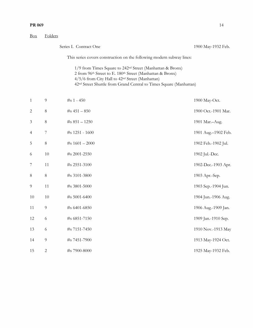
PR 069
Box Folders
14
Series I. Contract One 1900 May-1932 Feb.
This series covers construction on the following modern subway lines:
1/9 from Times Square to 242nd Street (Manhattan & Bronx)
2 from 96th Street to E. 180th Street (Manhattan & Bronx)
4/5/6 from City Hall to 42nd Street (Manhattan)
42nd Street Shuttle from Grand Central to Times Square (Manhattan)
1 9 #s 1 - 450 1900 May-Oct.
2 8 #s 451 – 850 1900 Oct.-1901 Mar.
3 8 #s 851 – 1250 1901 Mar.–Aug.
4 7 #s 1251 - 1600 1901 Aug.–1902 Feb.
5 8 #s 1601 – 2000 1902 Feb.-1902 Jul.
6 10 #s 2001-2550 1902 Jul.-Dec.
7 11 #s 2551-3100 1902-Dec.-1903 Apr.
8 8 #s 3101-3800 1903 Apr.-Sep.
9 11 #s 3801-5000 1903 Sep.-1904 Jun.
10 10 #s 5001-6400 1904 Jun.-1906 Aug.
11 9 #s 6401-6850 1906 Aug.-1909 Jan.
12 6 #s 6851-7150 1909 Jan.-1910 Sep.
13 6 #s 7151-7450 1910 Nov.-1913 May
14 9 #s 7451-7900 1913 May-1924 Oct.
15 2 #s 7900-8000 1925 May-1932 Feb.

PR 069
Box Folders
15
Series II. Contract Two 1903 Mar-1921 Jan.
This series covers construction on the following modern subway lines:
4/5 from City Hall to Atlantic Avenue (Manhattan and Brooklyn)
16 10 #s 1-500 1903 Mar-1904 May
17 10 #s 501-1000 1904 Jun-1905 Feb.
18 10 #s 1001-1050 1905 Feb.-1905 Aug.
19 9 #s 1501-1950 1905 Aug.-1906 Dec.
20 9 #s 1951-2400 1906 Dec.-1907 Dec.
21 9 #s 2401-2850 1907 Dec.-1911 Jan.
22 3 #s 2851-3002 1911 Jan.-1921 Jan.

PR 069
Box Folders
16
Series III. Dual Contracts 1907 Jun.-1941 Oct.
CONTRACT THREE
General
23 8 #s 7551-7950 1918 Dec.-1926 Jun
Rte 4 & 38 (Manhattan)
1 from Vesey Street to Times Square
24 7 #s 1-350 1913 Dec.-1914 Mar.
25 7 #s 351-700 1914 Mar.-1914 May
26 6 #s 701-1000 1914 May- 1914 Jun.
27 6 #s 1001-1300 1914 Jun.-1914 Aug.
28 7 #s 1301-1650 1914 Aug.-1914 Oct.
29 6 #s 1651-1950 1914 Oct.-1915 Jan.
30 7 #s 1951-2275 1915 Jan. -1915 Apr.
31 7 #s2276-2550 1915 Apr.-1915 Sep.
32 7 #s2551-2800 1915 Oct.-1916 Apr.
33 7 #s 2801-3150 1916 Apr.-1917 Feb.
34 7 #s 3151-3450 1917 Feb.-1918 Mar
35 3 #s 3451-3571 1918 Mar-1921 Apr.
Rte 5, Sections 6-15 (Manhattan and Bronx)
6 from 28th Street to Pelham Bay
4 from 42nd to Woodlawn, 5 from 42nd to Eastchester
36 7 #s 1-350 1911 Aug.-Nov.
37 7 #s 351-700 1911 Nov.-Dec.
38 8 #s 701-1100 1911 Dec.-1912 Mar.
39 8 #s 1101-1500 1912 Mar.-Apr.

PR 069
Box Folders
17
Series III. Dual Contracts (cont.)
CONTRACT THREE (cont.)
Rte 5, Sections 6-15 (Manhattan and Bronx) (cont.)
40 9 #s 1501-1950 1912 Apr.–Jun.
41 10 #s 1951-2450 1912 Jun.–Oct.
42 8 #s 2451-3000 1912 Oct.–1913 Mar.
43 8 #s 3001-3400 1913 Mar.–Jun.
44 9 #s 3401-3850 1913 June–Oct.
45 10 #s 3851-4350 1913 Oct.–1914 Mar.
46 8 #s 4351-4750 1914 Mar.-Jul.
47 7 #s 4751-5100 1914 July-Oct.
48 10 #s5101-5600 1914 Oct.–1915 May
49 7 #s5601-5950 1915 May–1917 Sep.
50 8 #s 5951-6350 1917 Sep.-1940 Apr.
Rte 12 (Brooklyn)
1 from Atlantic Ave. to between Utica Ave. & Sutter Stns
51 7 #s 1-350 1914 May-1915 Mar.
52 7 #s 351-700 1915 Mar.-Sep.
53 7 #s 701-1050 1915 Sep.-1916 Jul.
54 7 #s 1051-1400 1916 Jul-1917 Sep.
55 7 #s 1401-1750 1917 Sep.-1923 Apr.

PR 069
Box Folders
18
Series III. Dual Contracts (cont.)
CONTRACT THREE (cont.)
Rte 16 (Bronx)
4 from 157th St. to Woodlawn
56 7 #s 1-350 1913 Dec.-1916 Mar.
57 7 #s 351-700 1916 Mar.-1925 Apr.
Rte 18 (Bronx)
2/5 from E. 180th St. to 241st St.
58 6 #s 1-300 1913 Dec.-1915 Apr.
59 6 #s 301-600 1915 Apr.-1925 Oct.
Rte 19-22 (Bronx)
6 from above 138th St. to Pelham Bay Pkwy
60 7 #s 1-350 1912 Nov.-1913 Jun.
61 6 #s 351-650 1913 Jun.-1914 May
62 6 #s 651-950 1914 May-1915 Jun.
63 6 #s 951-1250 1915 Jun.-1916 Sep.
64 6 #s 1251-1550 1916 Sep.-1925 Sep.
Rte 26 (Manhattan & Queens)
7 from Grand Central to after Vernon-Jackson
65 3 #s 1-149 1914 Feb.-1925 Sep.
Rte 27 (Bronx)
66 2 #s 1-100 1917-1918

PR 069
Box Folders
19
Series III. Dual Contracts (cont.)
CONTRACT THREE (cont.)
Rte 29 (Brooklyn)
2/5 from President St. to Flatbush Ave.
67 6 #s 1-300 1914 Mar-1916 Feb.
68 6 #s 301-600 1916 Feb.-May
69 6 #s 601-900 1916 May-Sep.
70 7 #s 901-1203 1916 Sep.-1921 Feb.
Rte 31 (Brooklyn)
3 (along Livonia) from between Hopkinson and Elton Avenues
L to Canarsie from between Livonia and Flatlands Avnues
71 6 #s 1-300 1916 Mar.-1920 Sep.
72 4 #s 301-500 1920 Sep.-1933 Jun.
Rte 35 & 67 (Manhattan)
7 down 42nd Street from Grand Central to Times Square
73 6 #s 1-300 1922 May-1924 Apr.
74 3 #s 301-450 1924 Apr.-1926 Nov.
Rte 36 & 37 (Queens)
7 from Queensborough Plaza to Alburtis Ave.
N from Queensborough Plaza to Ditmars Blvd
75 7 #s 1-350 1913 Mar-1917 Jan.
76 2 #s 351-450 1917 Jan.-1933 Jun.
Rte 43 (Manhattan)
Park Avenue tunnel
77 6 #s 1-300 1914 Jul.-1915 Dec.
78 7 #s 301-650 1915 Dec.-1925 Feb.

PR 069
Box Folders
20
Series III. Dual Contracts (cont.)
CONTRACT THREE (cont.)
Rte 48 (Manhattan and Brooklyn)
2/3 from btwn Clark & Borough Hall to btwn Cortlandt & Chambers
79 7 #s 1-300 1912 Nov.-1914 Dec.
80 6 #s 301-600 1914 Dec.-1915 Apr.
81 6 #s601-900 1915 Apr.-Jul.
82 6 #s901-1200 1915 Jul.-1916 Mar.
83 6 #s1201-1500 1916 Mar.-1917 Jul.
84 6 #s1501-1800 1917 Jul.-1924 Aug.
Rte 50 (Queens)
Completion of Steinway tunnel
85 3 #s 1-150 1913 Jan.-1925 Nov.
Rte 52 (Queens)
7 from Alburtis Ave. to Main St., Flushing
86 8 #s 1-400 1923 Apr.-1939 Apr.

PR 069
Box Folders
21
Series III. Dual Contracts (cont.)
CONTRACT FOUR
Rte 4 & 36 (Manhattan)
N/R from Union Square to 60th St. and East River tunnel
87 7 #s 1-350 1913 Aug.-1914 Oct.
88 6 #s 351-650 1914 Oct.-1915 Jun.
89 7 #s 651-1000 1915 Jun.-1916 Jan.
90 6 #s 1001-1300 1916 Jan.-1917 May
91 7 #s 1301-1650 1917 May-1928 May
Rte 5, Sections 1-5 (Manhattan)
N/R from Morris Street to Union Square
92 9 #s 851-2100 1912 Feb.–Jul.
93 10 #s 2126-3003 1912 Aug.–1913 Mar.
94 14 #s3017-3950 1913 Mar.–Nov.
95 12 #3983-5258 1913 Dec.–1914 Dec.
96 11 #5297-6160 1914 Dec.–1929 Mar.
Rte 8 (Manhattan and Brooklyn)
L train, entire line
97 7 #s 1-350 1915 Jan-1916 Jun.
98 7 #s 351-700 1916 Jun.-Sep.
99 6 #s 701-1000 1916 Sep.-Dec.
100 6 #s 1001-1300 1916 Dec.-1917 Sep.
101 6 #s 1301-1600 1917 Sep.-1918 Jul.
102 6 #s 1601-1900 1918 Jul.-1920 Apr.
103 7 #s 1901-2250 1920 Apr.-1922 June

PR 069
Box Folders
22
Series III. Dual Contracts (cont.)
CONTRACT FOUR (cont.)
Rte 8 (Manhattan and Brooklyn) (cont.)
104 7 #s 2251-2600 1922 June-1924 Nov.
105 7 #s 2601-2950 1924 Nov.-1925 Jan.
106 7 #s 2951-3300 1925 Jan.-Mar.
107 7 #s 3301-3650 1925 Mar.-1926 Aug.
108 6 #s3651-3950 1926 Aug.-1928 Sep.
109 5 #s 3951-4200 1928 Sep.-1932 May
Rte 9-0 (Manhattan)
J/M/Z from Delancey Street to Chambers, “Centre Street Loop”
110 7 #s 1-350 1907 Jun.-Sep.
111 7 #s 351-700 1907 Sep.- 1908 Jul.
112 7 #s 701-1050 1908 Jul.-1909 Jul.
113 7 #s 1051-1400 1909 Feb.-1910 Feb.
114 6 #s 1401-1700 1909 Feb.-1937 Oct.
Rte 9-C (Brooklyn)
N/R along Flatbush from Willoughby to Ashland Place
115 19 #s 1-1800 1909 Nov.-1911 Oct.
116 14 #s 1801-3150 1911 Dec.-1913 Nov.
117 4 #s 3150-3550 1913 Nov.-1921 Nov.

PR 069
Box Folders
23
Series III. Dual Contracts (cont.)
CONTRACT FOUR (cont.)
Rte 11 (Brooklyn)
N/R from Atlantic Avenue and Fourth Avenue to 95th Street
118 8 #s 1-400 1909 Dec.-1910 Mar.
119 8 #s 401-800 1910 Mar.-Jun.
120 8 #s 801-1200 1910 Jun.-Nov.
121 8 #s 1201-1600 1910 Nov.-1911 Jul.
122 8 #s 1601-2000 1911 Jul.-1912 May
123 8 #s 2001-2400 1912 May-Nov.
124 8 #s 2401-2800 1912 Nov.-1913 Apr.
125 8 #s 2801-3200 1913 Apr.-1914 Feb.
126 7 #s 3201-3550 1914 Feb.-1923 Nov.
127 4 #s 3551-3750 1923 Nov.-1928 Apr.
Rte 20 (Manhattan)
Canal Street from Broadway to Bowery
128 4 #s 1-200 1914 Aug.-1917 Mar.
Rte 33 (Brooklyn)
Connects J/M/Z and N/R tunnels to Flatbush Avenue
129 7 #s 1-350 1914 May-1915 Jan.
130 6 #s 351-650 1915 Jan.-Jun.
131 7 #s 651-1000 1915 Jun.-Dec.
132 6 #s 1001-1300 1915 Dec.-1916 May
133 7 #s 1301-1650 1916 May-1918 May
134 6 #s 1651-1950 1918 May-1931 Apr.
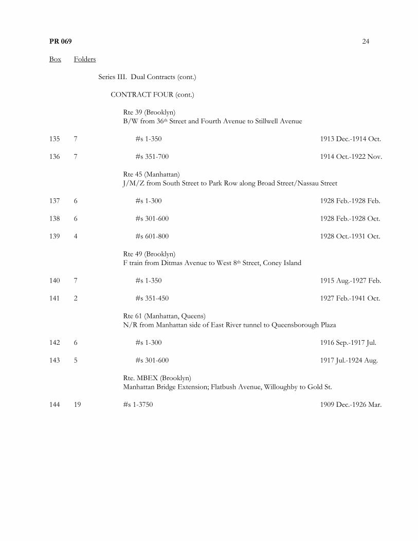
PR 069
Box Folders
24
Series III. Dual Contracts (cont.)
CONTRACT FOUR (cont.)
Rte 39 (Brooklyn)
B/W from 36th Street and Fourth Avenue to Stillwell Avenue
135 7 #s 1-350 1913 Dec.-1914 Oct.
136 7 #s 351-700 1914 Oct.-1922 Nov.
Rte 45 (Manhattan)
J/M/Z from South Street to Park Row along Broad Street/Nassau Street
137 6 #s 1-300 1928 Feb.-1928 Feb.
138 6 #s 301-600 1928 Feb.-1928 Oct.
139 4 #s 601-800 1928 Oct.-1931 Oct.
Rte 49 (Brooklyn)
F train from Ditmas Avenue to West 8th Street, Coney Island
140 7 #s 1-350 1915 Aug.-1927 Feb.
141 2 #s 351-450 1927 Feb.-1941 Oct.
Rte 61 (Manhattan, Queens)
N/R from Manhattan side of East River tunnel to Queensborough Plaza
142 6 #s 1-300 1916 Sep.-1917 Jul.
143 5 #s 301-600 1917 Jul.-1924 Aug.
Rte. MBEX (Brooklyn)
Manhattan Bridge Extension; Flatbush Avenue, Willoughby to Gold St.
144 19 #s 1-3750 1909 Dec.-1926 Mar.
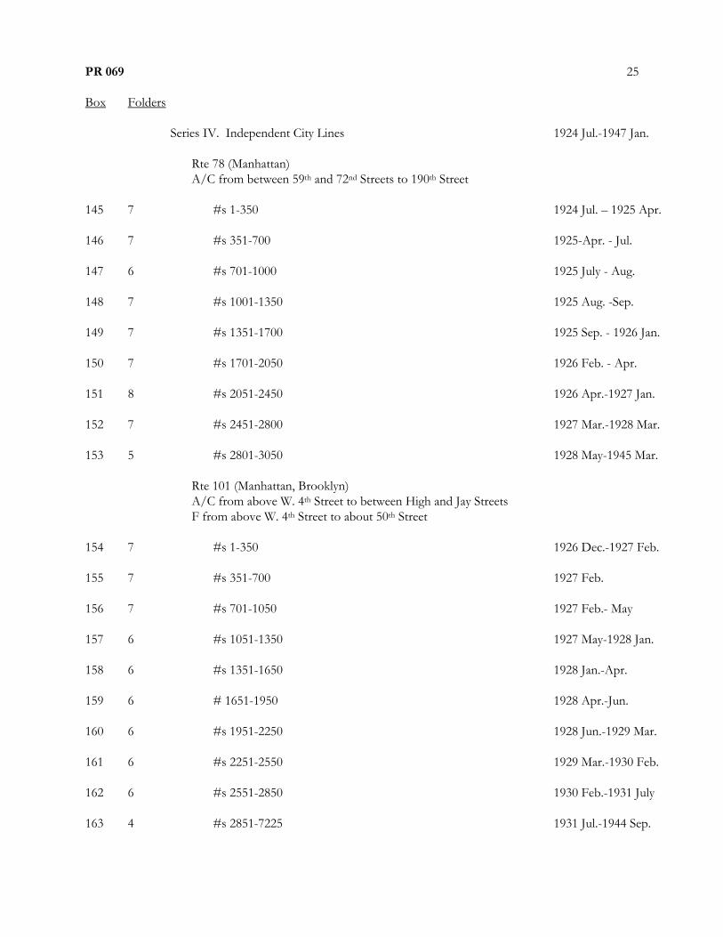
PR 069
Box Folders
25
Series IV. Independent City Lines 1924 Jul.-1947 Jan.
Rte 78 (Manhattan)
A/C from between 59th and 72nd Streets to 190th Street
145 7 #s 1-350 1924 Jul. – 1925 Apr.
146 7 #s 351-700 1925-Apr. - Jul.
147 6 #s 701-1000 1925 July - Aug.
148 7 #s 1001-1350 1925 Aug. -Sep.
149 7 #s 1351-1700 1925 Sep. - 1926 Jan.
150 7 #s 1701-2050 1926 Feb. - Apr.
151 8 #s 2051-2450 1926 Apr.-1927 Jan.
152 7 #s 2451-2800 1927 Mar.-1928 Mar.
153 5 #s 2801-3050 1928 May-1945 Mar.
Rte 101 (Manhattan, Brooklyn)
A/C from above W. 4th Street to between High and Jay Streets
F from above W. 4th Street to about 50th Street
154 7 #s 1-350 1926 Dec.-1927 Feb.
155 7 #s 351-700 1927 Feb.
156 7 #s 701-1050 1927 Feb.- May
157 6 #s 1051-1350 1927 May-1928 Jan.
158 6 #s 1351-1650 1928 Jan.-Apr.
159 6 # 1651-1950 1928 Apr.-Jun.
160 6 #s 1951-2250 1928 Jun.-1929 Mar.
161 6 #s 2251-2550 1929 Mar.-1930 Feb.
162 6 #s 2551-2850 1930 Feb.-1931 July
163 4 #s 2851-7225 1931 Jul.-1944 Sep.

PR 069
Box Folders
26
Series IV. Independent City Lines (cont.)
Rte 102 (Manhattan)
A/C from above West. 4th Street to between 59th and 72nd Streets
164 7 #s 1-350 1925 Oct.-1926 Jan.
165 6 #s 351-650 1926 Jan.-Mar.
166 6 #s 651-950 1926 Mar.-May
167 6 #s 951-1250 1926 May-1929 Apr.
168 3 #s 1251-1350 1929 Jun.-1937 Jun.
Rte 103 (Manhattan, Brooklyn)
F from below West 4th Street to between High and Clark Streets
169 6 #s 1-300 1929 May-1929 Jun.
170 6 #s 301-600 1929 Jun.-Sep.
171 6 #s 601-900 1929 Jun.-1930 May
172 6 #s 901-1200 1930 May-Jul.
173 6 #s 1201-1500 1930 July-Aug.
174 5 #s 1501-1750 1930 Aug.-1931 Dec.
175 3 #s 1751-1875 1931 Dec.–1941 Jul.
Rte 104 (Manhattan, Queens)
E along 53rd Street west to east
Welfare (Roosevelt) Island and Nott Ave in Queens
176 7 #s 1 – 350 1927 Mar.-Apr.
177 7 #s 351-700 1927 Apr.-Oct.
178 6 #s 701-1000 1927 Oct.-1947 Jan.

PR 069
Box Folders
27
Series IV. Independent City Lines (cont.)
Rte 105 (Manhattan)
A/C from 190th Street to 207th Street
179 6 #s 1-300 1925 Dec.-1926 Nov.
180 6 #s 301-600 1926 Nov.-1928 Jul.
181 3 #s 601-730 1928 Jul.-1933 Aug.
Rte 106 (Manhattan, Bronx)
B/D from above 145th Street to 205th Street
182 6 #s 1-300 1928 Feb.- 1928 Nov.
183 6 #s 301-600 1928 Nov.-1929 Jan.
184 6 #s 602-900 1929 Jan.- Mar.
185 6 #s 901-1200 1929 Mar.-Jun.
186 6 #s 1200-1500 1929 Jun.-Sep.
187 6 #s 1501-1800 1929 Aug.-1930 Nov.
188 6 #s 1801-2100 1930 Nov.-1931 Jul.
189 6 #s 2101-2354 1931 Jul.-1936 Dec.
Rte 107 (Brooklyn, Queens)
G from Court and Bergen Streets to above Court Square
190 6 #s 1-300 1927 Dec.-1928 Jan.
191 6 #s 301-600 1928 Jan.-Feb.
192 6 #s 601-900 1928 Feb.-Mar.
193 6 #s 901-1200 1928 Mar.-Jul.
194 6 #s 1201-1500 1928 Jul.-Oct.
195 6 #s 1501-1800 1928 Oct.
196 6 #s 1801-2100 1928 Oct.-1929 Nov.

PR 069
Box Folders
28
Series IV. Independent City Lines (cont.)
Rte 107 (Brooklyn, Queens) (cont.)
G from Court and Bergen Streets to above Court Square
197 6 #s 2101-2400 1929 Nov.-Dec.
198 6 #s 2401-2700 1929 Dec.-1930 Jan.
199 6 #s 2701-3000 1930 Jan.-Jun.
200 6 #s 3001-3300 1930 Jun.-1931 Jan.
201 6 #s 3301-3600 1931 Jan.-Feb.
202 6 #s 3601-3900 1931 Feb.-Mar.
203 6 #s 3901-4200 1931 Mar.
204 6 #s 4201-4500 1931 Mar.-Apr.
205 #s 4500-4800 1931 Apr.-1932 Jun.
Rte 108 (Queens)
G/F from above Court Square to 169th Street
206 6 #s 1-300 1928 Dec.-1929 Jan.
207 6 #s 301-600 1929 Jan.-Feb.
208 6 #s 601-900 1929 Feb.-Mar.
209 7 #s 901-1250 1929 Mar.-Jun.
210 6 #s 1251-1550 1929 Jun.-Aug.
211 7 #s 1551-1900 1929 Aug.-1930 Jan.
212 6 #s 1901-2200 1930 Jan.-May
213 6 #s 2201-2500 1930 May-Oct.
214 6 #s 2501-2800 1930 Oct.-Dec.
215 6 #s 2801-3100 1930 Dec.-1931 Feb.
216 8 #s 3101-3600 1931 Feb.-Apr.

PR 069
Box Folders
29
Series IV. Independent City Lines (cont.)
Rte 108 (Queens) (cont.)
G/F from above Court Square to 169th Street
217 8 #s 3601-4000 1931 Apr.-Jul.
218 8 #s 4001-4400 1931 Jul.-1932 Dec.
219 7 #s 4401-4750 1932 Dec.-1941 Apr.
Rte 109 (Brooklyn)
F from between High and Clark Streets to Ditmas Avenue
220 6 #s 1-300 1927 Nov.-1928 Apr.
221 6 #s 301-600 1928 Apr.-May
222 6 #s 601-900 1928 May
223 6 #s 901-1200 1928 May-Sep.
224 6 #s 1201-1500 1928 Sep.-Oct.
225 6 #s 1501-1800 1928 Oct.-Dec.
226 6 #s 1801-2100 1928 Dec.
227 6 #s 2101-2400 1928 Dec.-1929 Apr.
228 6 #s 2401-2700 1929 Apr.-1930 Mar.
229 6 #s 2701-3000 1930 Mar.-May
230 6 #s 3001-3300 1930 May-Oct.
231 6 #s 3301-3600 1930 Oct.-1931 Oct.
232 4 #s 3601-3800 1931 Oct.-1938 Feb.

PR 069
Box Folders
30
Series IV. Independent City Lines (cont.)
Rte 110 (Brooklyn)
A/C from between Lafayette and Fulton Streets to Euclid Avenue
233 6 #s 1-300 1929 Mar.-Apr.
234 6 #s 301-600 1929 Apr.
235 6 #s 601-900 1929 Apr.-May
236 6 #s 901-1200 1929 May-1930 Mar.
237 6 #s 1201-1500 1930 Mar.
238 6 #s 1501-1800 1930 Mar.-Apr.
239 6 #s 1801-2100 1930 Apr.-Jul.
240 6 #s 2101-2400 1930 Jul.-Aug.
241 6 #s 2401-2700 1930 Aug.-1931 Aug.
242 5 #s 2701-2950 1931 Aug.-1938 Sep.

PR 069
Box Folders
31
Series V. Miscellaneous 1913-1950
243 1 8th and 9th Avenue Railroad vs. NYC 1928
2 57th St. D. L. Job 620 1917-18
1 59th St. Power House 1958
1 Central Methodist Episcopal Church 1929
1 Delancey Street Widening 1950
3 E.I.B. 1917-18, undated
1 I.B. undated
1 Job 559 1917
244 1 M4 1916-18
1 M6 1913-14
1 M7 1914-15
2 M8 1914-20
1 M9 1916-23
1 M14 1916
1 M20 1914-15
1 M21 1915
1 M23 1915-19
1 M24 1914
1 M25 1916-17
245 1 Q.S.R.R. Duct Line 1916
1 Queens Vehicular Tunnel 1930
1 RI-10 1914-15

PR 069
Box Folders
32
Series V. Miscellaneous (cont.)
[245] 1 RI-11 1914-20
1 RI-12 1918
1 RI-13 1916-18
1 RI-15 1916
1 RM-I-T 1914
1 Southern Boulevard D. L. 1917
1 Subway Station Sites – IND System 1929
1 Miscellaneous undated