guide to ozrox: agso's field geology database … · guide to ozrox agso's field geology...
TRANSCRIPT

GUIDE TO OZROX
AGSO's FIELD GEOLOGY
DATABASE
By
RJ. RYBURN, L.D. BOND & M.S. HAZELL
RECORD 1995/79
• • • • • • • • • • • • • • • • • • • • • • • • • • • • • • •
GUIDE TO OZROX
AGSO's FIELD GEOLOGY DATABASE
Record 1995/79
R.J. Ryburn, L.D. Bond and M.S. Hazell
AUSTRALIAN GEOLOGICAL SURVEY ORGANISATION
• • ~'"I~II~I~I • R9507901*
DEPARTMENT OF PRIMARY INDUSTRIES AND ENERGY
Minister for Resources: Hon. David BeddalI, MP Secretary: Greg Taylor
AUSTRALIAN GEOLOGICAL SURVEY ORGANISATION
Executive Director: Neil Williams
© Commonwealth of Australia 1995
ISSN: 1039-0073 ISBN: 0 642 22387 4
This work is copyright. Apart from any fair dealings for the purposes of study, research, criticism or review, as permitted under the Copyright Act 1968, no part may be reproduced by any process without written permission. Copyright is the responsibility of the Executive Director, Australian Geological Survey Organisation. Requests and inquiries concerning reproduction and rights should be directed to the Principal Information Officer, Australian Geological Survey Organisation, GPO Box 378, Canberra City, ACT, 2601.
• • • • • • • • • • • • • • • • • • • • • • • • • • • • • • • • • •
• • • • CONTENTS
• • • ABSTRACT ii
• • 1 INTRODUCTION 1
• 2 HARDWARE AND SOFTWARE ENVIRONMENT 1
• 3 AGSO's GEOLOGICAL DATABASE SYSTEM 1
4 STRUCTURE OF OZROX 3 • 5 SECURITY AND ACCESS 5
• 6 CONSTRAINTS AND TRIGGERS 8
• 7 SITE AND SAMPLE IDENTIFICATION 9
• 8 OZROXMENUS 10
• 9 SITES FORM 13
• 10 OUTCROPS FORM 22
• 11 MEASURED SECTIONS AND DRILL HOLES FORM 26
• 12 ROCKS AND STRUCTURES FORM 36
• 13 STRUCTURES FORM 46
• 14 STRATIGRAPIDC LEXICON FORM 47
• 15 GEOLOGICAL PROVINCES FORM 52
16 GEOLOGICAL TIME SCALE FORM 54 • 17 LITHOLOGY NAMES FORM 57
• 18 1:100000 MAPS FORM 59
• 19 ACKNOWLEDGMENTS 61
• 20 BmLIOGRAPHY 61
• • APPENDIX A - OZROX DATABASE DEFINITIONS 66
• APPENDIX B - RULES AND TRIGGERS 82
• • • • • © Australian Geological Survey Organisation 1995 - Guide to OZROX
ABSTRACT
OZROX is a corporate AGSO Oracle database designed to accommodate five main categories of field geological infonnation - site location data, outcrop infonnation, measured sections and drill-holes, lithologies and rock samples, and structural geology observations. OZROX acts as the hub for a number of sample-centred laboratory databases, such as petrography, whole-rock geochemistry and isotopic age determinations. Other databases, like mineral deposits, regolith-terrain mapping and streamsediment geochemistry, link to the sites component of the field database. In addition, links have been set up to the National Petroleum Database, the STRATDAT biostratigraphic database, and the new Rock Store Database.
Wherever possible, the data entered are controlled by the means of lookup tables or databases, to facilitate the presentation of data with geographic infonnation systems and other computer applications. For example, fonnation names are tied to the Australian Stratigraphic Names Database, geological time terms are validated by a GEOTIME table, and mineral names are validated by an AGSO list of mineral names and abbreviations. Without such rigorous validation of input data it is difficult to use the database for automated analysis and presentation of data.
This guide presents an overview of the database, and describes in detail the menus and screen fonns used to input and view the data. In particular, the definitions of most fields in the database are given in some depth under descriptions of the screen forms -providing, in effect, a data dictionary of the database. The database schema, with all definitions of tables, views and indexes is contained in Appendix A.
© Australian Geological Survey Organisation 1995 - Guide to OZROX ii
• • • • • • • • • • • • • • • • • • • • • • • • • • • • • • • • • •

• • • • • • • • • • • • • • • • • • • • • • • • • • • • • • • • • •
1 . INTRODUCTION
The OZROX Field Geology Database accommodates five main categories of field geological data - site locations, outcrops, measured sections and drill holes, lithologies and samples, and structural geology readings. It records much of what AGSO geologists normally write in their field notebook, but in an organised way that lends itself to automated methods of data manipulation and presentation. Structured notebooks for use with the database have been printed (Blewett 1993). The database has also been designed to mesh with geographic information systems (GIS) such as AGSO's ArclInfo system (Chopra & Ryburn 1993, 1994a, b).
This guide describes the infrastructure of the OZROX Field Geology Database. It supersedes an earlier guide to the 'NGMA Field Database' (Ryburn et al. 1993). Details of the structure and workings of the database, its main screen forms and the purpose of all fields are given. The full OZROX schema is listed in Appendix A.
2· HARDWARE AND SOFTWARE ENVIRONMENT
Together with the majority of AGSO's attribute geoscience databases, OZROX is implemented on AGSO's corporate database management system, which is Oracle 7 running on a DG AViiON 6250 server under the UNIX 5.4 operating system. It is accessible throughout AGSO via a TCPIIP Ethernet backbone, which is bridged to seven local Novell PC LANs. At the PC level Novell's 'LAN Workplace for DOS' provides VT220 terminal emulation. Database entry and query forms are generated centrally from the A ViiON server via Oracle Forms 3. This system is now changing to graphical client/server applications in Oracle Forms 4.5, or later, running on PCs with Microsoft Windows, Apple Macintoshes and UNIX X-Windows workstations.
AGSO's Oracle system has been set up with two instances - 'Test' and 'Production'. The Test environment is used mainly for development purposes, and has only a small subset of the OZROX dataset. OZROX users are' only concerned with the Production version of the database. Full explanations of the hardware and software environment were presented for users by Lenz et al. (1993), and for developers by Kucka (1994).
3· AGSO's GEOLOGICAL DATABASE SYSTEM
AGSO's Geological Database System (Fig. 1) consists of a number of field and laboratory databases that surround the OZROX Field Geology Database and share resources such as the Australian Stratigraphic Names Database (Ryburn et al. 1995) and the AGSOREFS Bibliographic Reference Database (Ryburn & Bond 1995). Originally set up by what is now the Division of Regional Geology and Minerals
© Australian Geological Survey Organisation 1995 - Guide to OZROX

(RGM) in collaboration with Information Services Division (ISD) (Ryburn et al. 1993), the system is increasingly used by other divisions in AGSO. The system was designed and constructed by the National Geoscience Database Development Project, which is a part of lSD's National Geoscience Information System (NGIS) Program.
OZROX acts as the nucleus of the Geological Database System. Some databases, like OZMIN mineral deposits (Ewers & Ryburn 1993), RTMAP regolith landform mapping (Hazell et al. 1995) and STREAMCHEM stream sediment geochemistry link directly to point location data in the SITES table in OZROX. Other databases, like PETROG petrography (Ryburn et al. 1994c), OZCHRON geochronology (Ryburn et al. 1993b) ROCKCHEM whole-rock geochemistry (Ryburn 1990, Hazell et al. 1995) and Rock Store are linked to OZROX via data in the ROCKS table.
Figure 1. Simplified diagram of AGSO's Geological Database System
The rationale for establishing a corporate geological database system is to ensure that all field and laboratory data are stored in a manner that is secure, ordered, accessible and cost-effective, and in a form that will be compatible with future methods of data analysis, distribution and presentation. Ways of distributing such data are currently undergoing a revolution, with the rapid acceptance of the Internet and the World Wide Web as the de-facto standards for on-line public access. By using a mainstream corporate relational database management system (RDBMS) like Oracle we can be confident that secure public access will be easily provided in future systems. We anticipate that most data in OZROX will soon be publicly accessible on AGSO's World Wide Web server, and in spatial formats. We expect that the user will be able to generate in real time, and at different scales, maps with site and sample information. These, in tum, will point to laboratory data that can be purchased -eventually via the Web, using automated charging methods.
© Australian Geological Survey Organisation 1995 - Guide to OZROX 2

4 - STRUCTURE OF OZROX
The OZROX Field Geology Database now has seven main data tables - SITES, OUTCROPS, SECTHOLES, INTERIZONS, ROCKS, LITHDATA and STRUCTURES. All other tables indicated in Figure 2 below are lookup or authority tables used to validate the classifications and nomenclature used in the main tables :-
Figure 2. The structure of OZROX showing relationships between tables, with 'crows' feet' at the many end of many-to-one linkages. The rounded boxes represent databases used to validate the data in OZROX.
The hub of the field database is the SITES table, which standardises the way point location data are recorded and ensures that the accuracy and lineage of coordinates are noted. This is logically linked to the OUTCROPS and ROCKS tables via the Originator Number and Site ID (see Section 5). The OUTCROPS table stores data at the outcrop level, including links to the STRATDAT biostratigraphic database. The SECTHOLES table has data on measured sections and drill holes and INTERIZONS (intervals and horizons) their columnar geological logs. The ROCKS and LITHDATA tables record lithologies and samples taken. LITHDATA is the
© Australian Geological Survey Organisation 1995 - Guide to OZROX 3

•••
expandable attributes table for ROCKS - linked, via an automatically generated keyknown as Rockno. Validation of stratigraphic units and geological provinces isaccomplished by links to the Australian Stratigraphic Names Database and theGEOPROVS table. Descriptions of the screen forms associated with these objects areincluded in this manual. The main data tables in OZROX are owned by the Oracleuser 'NGMA'. The ownership of all tables is indicated in full table names by a prefixoccurring before the period. The main NGMA data tables are as follows :-
TABLE NAMENGMA.SITESNGMA.OUTCROPSNGMA.SECTHOLESNGMAINTERIZONSNGMA.ROCKSNGMALITHDATANGMA.STRUCTURES
CONTENTS ground sites location, accuracy & lineageoutcrop-related data, plus biostratigraphymeasured section and drill hole datacolumnar geological logs for SECTHOLESrock samples and lithological dataextendable attributes for the ROCKS tablemesoscopic structures at a site or outcrop
There are also views of these tables for authorised users to add, update and delete theirdata. These views, called US11t,S, UOUTCROPS, USECTHOLES, UNTERIZONS,UROCKS, ULITHDATA and USTRUCTURES, are described more fully in section 4on security and access. In addition to the above main data tables there are a number ofauthority tables and one view, not all of which belong to NGMA
TABLE NAME NGMA.OZROX_USERSNGMA.ORIGINATORSNGMA.AGSOCOUNTRIESNGMA.AGSOSTATESNGMA.GEOREGIONSNGMA.QMAPSNGMA.HMAPSNGMA.LOCMETHODSQUATDB.VEGETRTMAP.LANDFNGMA.SECTYPESNGMAJZ_RECTYPESNGMA.CONTACTSNGMA.ROCKTYPESNGMALITHOLOGIESNGMA.LITHDATATYPESNGMA.AGSOM1NERALSNGMA.LITHUNITSNGMA.STRUCTYPESSTRATA.GEOPROVSGEODX.STRATNAMESSTRATA.GEOTIME
CONTENTS record-level security tablecontributors of datalist of countrieslist of Australian Stateslist of geological region polygonsAustralian 1:250000 map sheetsAustralian 1:100 000 map sheetsspatial location methodsAustralian vegetation classificationAustralian landform classificationmeasured section/drill hole typesinterval & horizon record typeslist of lithology contacts typesbasic classification of rock typesEthological names & qualifiersextendable lithological attributesAGSO mineral nameslithological units & map symbolsextendable structure attributesAustralian geological provincesAustralian stratigraphic namesgeological time scale
CUSTODIANMurray HazellMurray HazellRod RyburnRod RyburnMurray HazellMurray HazellMurray Hazel!Richard BlewettGeoff HuntColin PainMurray HazellRod RyburnMurray HazellLesley WybomJan KnutsonMurray Hazel!Morrie DugganMurray HazellRichard BlewettDavid PalfreymanCathy BrownJohn Laurie
© Australian Geological Survey Organisation 1995 -^Guide to OZROX^
4

•
As a general rule, only the designated custodians are permitted to change the data in• these tables. Full definitions of all tables, indexes and views used by the NGMA Field
Database are given in Appendix A.0
5- SECURITY AND ACCESS
Select-Only Database Access•
The Oracle production environment allows all Oracle users, including external users,• select-only access to nearly all tables in the OZROX Field Database. The menu
system provides 'read-only' versions of the forms that allow users to retrieve most ofthe data, but not to insert, update or delete data. In the SQL*Plus command-line
• environment, all users may select data from any of these tables provided they includethe owner's name plus a full stop in the full name of the table or view, e.g. :-
•
SELECT SITEID FROM NGMA.OUTCROPS WHERE ORIGNO = 56;
Not all of the tables in OZROX are owned by NGMA. Tables from the AustralianStratigraphic Authority Database are owned by STRATA or GEODX, while RTMAPowns the Landforms Table, and QUATDB owns the Vegetation Table.
Insert, Update and Delete Access
OZROX users wishing to enter new data or update existing data must use the'insert/update' versions of the data forms. With these forms they only get to see theirown data, or data belonging to other users for which they have specifically been giveninsert/update/delete privileges. The same security arrangement applies to the insert/update views of all the main data tables in OZROX.
Insert, update and delete privileges on OZROX's data tables are now controlled at therecord level by the following Database Security Form (Fig. 3), which corresponds tothe OZROX_USERS table (see Appendix A). Only a few people are able to add, alteror remove records in this table. The form is accessible from screen 2 of the MainGeological Databases Menu (Item 9 in Fig. 4). The security data in this table arevisible to internal AGSO users, who are the only people allowed to insert, update ordelete records in OZROX data tables.
For a user to enter data into OZROX there must be a record in OZROX_USERS inwhich the user's Oracle ID occurs in both User 1 and User 2, with an 'X' in theOZROX (`DB1') column. In Figure 3, JSMITH can enter data into OZROX, as wellas into ROCKCHEM, RTMAP and OZM1N. In the second record shown in Figure 3,JSMITH has also been given update privileges on all records belonging to
© Australian Geological Survey Organisation 1995 -^Guide to OZROX^5

••`BBROWN' in all four databases. In the third record, JSMITH's update privilegesover JJONES' records extend only to the OXROX database. The `R' used in place ofan 'X' in Figure 3 indicates the users in question can access all restricted records inROCKCHEM or OZMIN. Most users only get to see restricted records that theythemselves have entered. The OZROX database does not have any restricted records.
VT220 Terminal to AVii ONSECURITY TABLEDATABASE
User 1 has update& delete privilegeson all records ownedby User 2 in thedatabases with an'X'^or an
If User 1 = User 2and if ROCKCHEM orOZHIN marked 'R',User 1 can view allrestricted records.
Otherwise, internalusers can view onlyunrestricted recordsin read-only forms.
OZ^ROCK^RI^OZM^DB5^0B6User 1^User 2^ROX^CHEM^MAP^MINJSMITH^JSMITHJSMITH^BBROWNJSMITH^JJONESBBROWN^BBROWNBBROWN^JSMITHBBROWN^JJONESBBROWN^GGREENJJONES^JJONESGGREEN^GGREENGGREEN^JSMITH
MXXXXXXXXX
If checked.^insert/u)date )rivileces a) lv to the OZROX DatabaseCount. *R^ <Reslace>NV1220 - Novell, Inc.^192.104.43.110^(1)^Rep^16:09
Figure 3. The Geological Databases Security Form. The entries in this formdetermine who is able to insert, update or delete records belonging to whom andin what database. These security data are not visible to users external to AGSO.
The insert/update/delete security imposed with the help of the above form is achievedvia special insert/update views of the main data tables in OZROX. All OZROX datatables have an ENTEREDBY column in which the Oracle ID of the user entering therecord is automatically recorded. This establishes the ownership of all data records,and allows the following type of insert/update view of each table to be set up :-
CREATE VIEW USITES ASSELECT * FROM SITES WHERE ENTEREDBY IN
( SELECT USER2 FROM NGMA.OZROX USERSWHERE DRI = 'X' AND USER = USER]);
The word USER in the above statement is an Oracle function that returns the currentusername. This scheme guarantees that the users see only the records to which theyhave been specifically granted access in the OZROX_USERS table. It applies equallyto screen forms and the SQL*Plus command-line environment. The main OZROXdata tables and their corresponding insert/update views are as follows :-
•© Australian Geological Survey Organisation 1995 -^Guide to OZROX^6
^•
••••
••••••
•••••••
•
••••••
•

••0
BASE TABLE NGMA.SITESNGMA.OUTCROPSNGMA.SECTHOLESNGMAJNTERIZONSNGMA.ROCKSNGMALITHDATANGMA.STRUC'TURES
INSERT/UPDATE VIEWNGMA.USITESNGMA.UOUTCROPSNGMA.USECTHOLESNGMA.UlNTERIZONSNGMA.UROCKSNGMA.ULITHDATANGMA.USTRUCTURES
00
All views in the above list are defined similarly to the USITES view. Insert/updateversions of the main screen forms refer to the insert/update views, not the base tables.Users wishing to use SQL*Plus to insert, update or delete records in the main datatables (or SQL*Loader to load records from an ASCII file) must use the above views.Only the owner `NGMA' has insert/update/delete privileges on the main base tables.
Custodians' Access Privileges
Custodians have appropriate access privileges to the data or authority tables that theyadminister. They may select, insert, update and delete all data in these tables viascreen forms or from SQL*Plus. They cannot drop or alter tables or table constraints.Custodians can use 'read-only' forms to insert, update and delete records.
Owner's Access Rights
NGMA has complete privileges on all the tables it owns in the OZROX FieldDatabase, as does STRATA and GEODX in the Stratigraphic Authority Database, andRTMAP and QUATDB on all tables in their databases.
0
-
© Australian Geological Survey Organisation 1995 -^'^Guide to OZROX^
7

••6- CONSTRAINTS AND TRIGGERS
Increasingly, relational databases are not just collections of tabular data, but theyinclude a potentially vast range of rules and procedures to help the users enter andmaintain clean data sets. There are two ways such rules can be applied to databases.Traditionally, the rules were coded into 'triggers' in the screen forms that control theentry and maintenance of data. This had the advantage that the user was warned aboutrule violations as soon as the data were entered, and the disadvantage that it did notapply to data entered or updated via the back door - that is, via SQL*Plus commands,or by loading ASCII files into the database using Oracle's SQL*Loader program.Many data problems encountered in the earlier `NGMA Field Database' (Rybum et al.1993) could be traced to data loaded directly into the database from ASCII files.
The second method, now possible in Oracle Version 7, is to build the rules into thedatabase itself by inserting column constraints, triggers and procedures into thedatabase kernel. This eliminates the back door, but the user normally does not findout about violations until an attempt is made to commit the changes to the database.Also, the resulting Oracle error messages are generally quite cryptic to the user. Toovercome these objections, a "belt-and-braces" solution is often applied, with bothimmediate, 'user-friendly' notification of rule violations in the screen forms andabsolute enforcement of rules in the database kernel.
With the advent of Oracle Version 7, columns that point to the primary keys of othertables (technically known as 'foreign keys') can be set up to automatically rejectentries that do not correspond to existing records in the relevant lookup table. Forexample, there is no point in inserting an Originator Number into the SITES table thatdoes not correspond to an existing Originator in ORIGINATORS. Conversely, youcannot delete a record from ORIGINATORS until all pointers to it from the SITEStable (and many other tables) have been removed. This type of data checking isknown as referential integrity enforcement and it is being progressively applied to allof AGSO's geoscience databases. Within OZROX, referential-integrity constraintshave been set up between most tables belonging to NGMA. However, referentialintegrity has not been applied between tables of heterogeneous ownership, as themaintenance problems this causes often outweigh the benefits. In such cases, though,the job is still done by triggers in the screen forms.
OZROX includes many data checks in addition to referential integrity constraints.For example, whenever a new record is inserted in the OUTCROPS, SECTHOLES,ROCKS or STRUCTURES tables, database kernel triggers ensure that 'X's areautomatically added to the relevant dataset flags in the Sn'ES table. Examples ofform triggers include triggers in the Sites Form that ensure that a 1:100 000 map sheetarea is nominated if the country is Australia, and that the geographic coordinates -which must be given - actually lie within the stated 1:100 000 map sheet. Most of theimportant OZROX constraints and triggers are listed in Appendix B. This does notinclude the referential integrity constraints, which appear as foreign key constraintsafter the definition of each table in Appendix A.
•••
•
0••
© Australian Geological Survey Organisation 1995 -^Guide to OZROX^8

•IIII^7- SITE AND SAMPLE IDENTIFICATION
0With the help of an Originator Number OZROX data tables maintain original sitefib^and sample identification. In most cases the sample ID will be the same as the site ID,
•perhaps with an appended letter to distinguish several samples at the one site, butsample IDs can be unrelated to site IDs. If all sites and samples were from AGSO,
• and had unique registered numbers, then the site and sample numbers would besufficient on their own. However, the SITES and ROCKS tables are also intended for
• data provided by universities, State geological surveys, companies and privateindividuals, all of whom use their own numbering systems. The Originator Number is
O required to maintain uniqueness amongst diverse numbering systems. Originator
• numbers are recorded against names in the ORIGINATORS authority table. AnOriginator Number of 93, for example, corresponds to SADME - the South Australian
• Department of Mines and Energy.
• A site in the SITES table is fully identified by a unique combination of Originator
• Number and Site ID, the latter being any sequence of up to 16 digits and letters. Theuniqueness of an Originator Number and Site ID combination is enforced by a unique
• index covering these fields. Similarly, a sample in the ROCKS table is fully identifiedby a unique combination of Originator Number and Sample ID, which is protected by
• a trigger in the ROCKS form - it is not possible to enter a combination already in the
• ROCKS table. All analytical tables in laboratory databases record both the OriginatorNumber and Sample ID. Although a sample number on its own is usually sufficient to
• retrieve the required sample, do not forget that sample numbers on their own are notnecessarily unique.
0•
The originator of a site or sample is the person or organisation primarily responsiblefor the data. This could be the person who observed the site or collected the sample, a
• laboratory worker, or an author of published results - someone who might reasonablybe expected to know about the sample and perhaps be able to supply further
• information. Note that the name of the Originator is recorded only once in thedatabase. All other references to the Originator use the Originator Number, which is
• listed against the name in the ORIGINATORS table.e
A consequence of the way OZROX has been structured is that Site and Sample IDs• are not meant to be changed once they have been entered. Allocating temporary Site
IDs, for example, is not a good idea. Although it is possible to update Site andS Sample ]Ds, there are so many other tables with foreign keys pointing to these IDs that• it can be a major task to change all references.
•
•
•
0I
O Australian Geological Survey Organisation 1995 -^Guide to OZROX^9•
8- OZROX MENUS
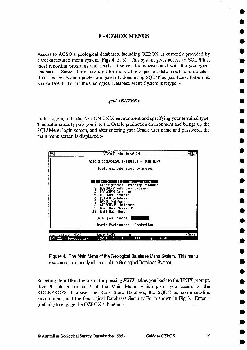
Access to AGSO's geological databases, including OZROX, is currently provided bya tree-structured menu system (Figs 4, 5, 6). This system gives access to SQL*Plus,most reporting programs and nearly all screen förms associated with the geologicaldatabases. Screen forms are used for most ad-hoc queries, data inserts and updates.Batch retrievals and updates are generally done using SQL*Plus (see Lenz, Rybum &Kucka 1993). To run the Geological Database Menu System just type :-
geol <ENTER>
- after logging into the AViiON UNIX environment and specifying your terminal type.This automatically puts you into the Oracle production environment and brings up theSQL*Menu login screen, and after entering your Oracle user name and password, themain menu screen is displayed :-
AGSO'S GEOLOGICAL DATABASES - MAIN MENU
Field and Laboratory Databases
1. OZROX Field Geoloc Database2.Stratigraphic Authority Database3.AGSOREFS Reference Database4.ROCKCHEM Database5.OZCHRON Database6.PETROG Database7.OZMIN Database8.STREAMCHEM Database9.Main Menu Screen 2
10. Exit Main Menu
Enter your choice:
Oracle Environment : Production
A..lication: NGMATNVT220 - Novell. .Inc.
Menu: NGMA192.104.43.110^(1)^Rep^16:01^A
<Re.>
Figure 4. The Main Menu of the Geological Database Menu System. This menugives access to nearly all areas of the Geological Database System.
Selecting item 10 in the menu (or pressing EXIT) takes you back to the umx prompt.Item 9 selects screen 2 of the Main Menu, which gives you access to theROC1CPROPS database, the Rock Store Database, the SQL*Plus command-lineenvironment, and the Geological Databases Security Form shown in Fig 3. Enter 1(default) to engage the OZROX submenu
•
Guide to OZROX^100 Australian Geological Survey Organisation 1995 -

SITES-RELATED FORMS
For the Sites Table & all Lookup Tables
1.Sites Form - Read Only2.Originators3.World Countries4.Australian States5.Geological Regions6.1:250,000 Maps7.1:100,000 Maps8.Location Methods9.AGSOREFS Reference Database10. Exit Submenu
Enter your choice: 10
•
•
VT220TenMnalto/MON
OZROX FIELD DATABASE
AGSO's Field Geological Mapping Database
1. Sites Form - Read Onl2.3.4.5.6.7.8.9.
10.
Sites Form - Insert/UpdateSites-Related FormsOutcrops FormsMeasured Sections & Drill Holes FormsRocks FormsStructures FormsCombined Field Data FormReports and auxilary programsExit Submenu
Enter your choice: 1
A..lication: NGMANVT220 - Novell. Inc.
Menu: FIELD^u192.104.43.110^(1)^Rep^16:11
<Re.>C
Figure 5. The OZROX Database Menu.
Selecting item 10 returns you to the Main Menu. This menu allows you to run theSITES form, or to enter further menus covering other forms used in the OZROX FieldGeology Database. For example, if you select item 3, the 'Sites-Related' submenuappears :-
lication: MGMA Menu: SITESREL <Re>NVT220 - Novell, Inc.^192.104.43.110^(1)^Rep^16:26
Figure 6. The Submenu for Sites-Related Forms.
© Australian Geological Survey Organisation 1995 -^Guide to OZROX^11
••••••••
••
••••••
•

This submenu repeats the read-only version of the S1 1 ES form and includes all screenforms covering authority tables used for validation of data in the SITES table.Selecting item 10 takes you back to the previous menu. Other submenus give accessto forms and reporting programs in the OUTCROPS, STRUCTURES and ROCKSgroups. All areas of the Geological Database System may be accessed from theGeological Database Menu System.
In what follows each of the main screen forms of the OZROX Field Geology Databaseis described in detail. The purpose and definitions of all displayed fields are described- where necessary, in some detail. In most instances the name of the table columncorresponding to the field is given in brackets and capital letters following a moredescriptive field name. In addition, some of the more important or complex formscovering authority tables are also described, including the Stratigraphic Lexicon andGeological Provinces and Geological Timescale Forms from the StratigraphicAuthority Database. Forms covering simple lookup tables, the ORIGINATORS formfor example, are not described individually as they are basically similar to oneanother, and the 1:100 000 Maps Form is a good example of how they all function. Inmost cases the relevant fields in these lookup tables are well covered in thedescriptions of the equivalent fields in the main tables.
•
0 Australian Geological Survey Organisation 1995 -^Guide to OZROX^12
byEntered PPIETERS10-JRN-94
- OZROX DATABASE - SITES FORM -- READ ONLY ---- Oracle Environ. PRODUCTION
Originator 156 >Pieters. P.E.
Site ID^1778123^Field IDCountry^>RUS State >NT Geol ReGeog. Area Mitchell RangeLoc. Descr. upper Koolatong River1:100K Map 60710KOOLATONG^1:250K SD53071BLUE MUD BRYMetres East 554500 North 8554800^Lat. 13.0723891S Long.135.502714IEOr lat. & lon., in de. min & sec ^ d144 n20.6^135,30 9.77Loc'n Meth. 3 >GPS observation (0110-84)^Abs. Recur. m) 10Biblio. Ref^Airphoto RRNHEM HW 15E/28 Height (m)^+/-
Related Data Sets ^OC SH RO ST PE RC OZ ON SC RI RP SP RSEli/MIMI III II'X indicates related data is present
PP91123^Date 26-RUG-91 Time•ion 52^1Mc1lrthur Basin
'NEXT-KEY' function converts AMGcoords to lats & longs & vice versadepending on what fields are empty.
•••9- SITES FORM•VT220 Terminal to AViiON
OC=Outcrop . SH=SectHole RO=Rock ST=Structure PE=PETROG RC=ROCKCHEM OZ=OZCHRONOM=OZMIN SC=STREAMCHEM RT=RTMAP RP=ROCKPROPS SP=SPECPROPS RS=ROCSTORPress PREVIOUS BLOCK for Outrro s form or NEXT BLOCK for Rocks form
he Site ID must be unitue to the Ori.inatorCount:TNVT220 - Novell, Inc.^192.104.43.110^(1)^Rep^14:10
<Re.lace>
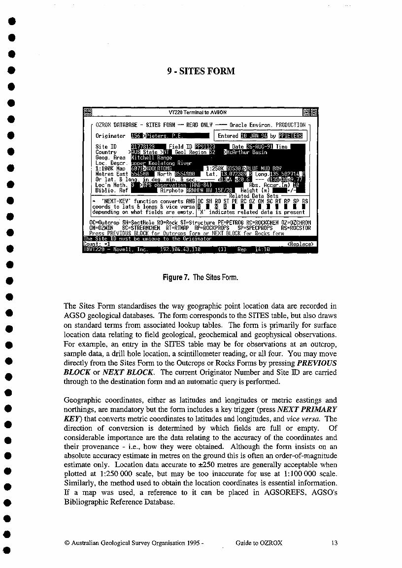
Figure 7. The Sites Form.
The Sites Form standardises the way geographic point location data are recorded in• AGSO geological databases. The form corresponds to the SITES table, but also draws
• on standard terms from associated lookup tables. The form is primarily for surfacelocation data relating to field geological, geochemical and geophysical observations.
• For example, an entry in the SITES table may be for observations at an outcrop,sample data, a drill hole location, a scintillometer reading, or all four. You may move
• directly from the Sites Form to the Outcrops or Rocks Forms by pressing PREVIOUSBLOCK or NEXT BLOCK. The current Originator Number and Site ID are carried
• through to the destination form and an automatic query is performed.
Geographic coordinates, either as latitudes and longitudes or metric eastings and• northings, are mandatory but the form includes a key trigger (press NEXT PRIMARY
KEY) that converts metric coordinates to latitudes and longitudes, and vice versa. The• direction of conversion is determined by which fields are full or empty. Of• considerable importance are the data relating to the accuracy of the coordinates and
their provenance - i.e., how they were obtained. Although the form insists on an• absolute accuracy estimate in metres on the ground this is often an order-of-magnitude
estimate only. Location data accurate to ±250 metres are generally acceptable when• plotted at 1:250 000 scale, but may be too inaccurate for use at 1:100 000 scale.
• Similarly, the method used to obtain the location coordinates is essential information.If a map was used, a reference to it can be placed in AGSOREFS, AGSO's
• Bibliographic Reference Database.
•
© Australian Geological Survey Organisation 1995 -^Guide to OZROX^13•
••
The Sites Form has fields for Country, State, Geological Region, 1:250 000 and 1:100000 map sheet areas, and Airphoto. Some of these fields could be eliminated by usingSQL joins between geographic coordinates in the SUES and other tables, but theprocedures are cumbersome and slow in practice, and the inclusion of these attributesin the SUES table is in the interest of speed and simplicity. The need for a countryfield is underlined by the existence in OZROX of data from Antarctica, New Zealand,Papua New Guinea, the Solomon Islands and Sri Lanka.
In the following field definitions (and those of subsequent forms), the true name ofeach field is given in round brackets following the name used in the form. To savescreen space the field names are often abbreviated in the forms.
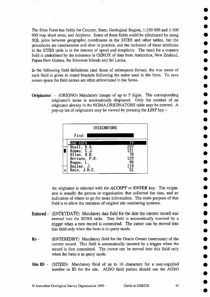
Originator - (ORIGNO) Mandatory integer of up to 5 digits. The correspondingoriginator's name is automatically displayed. Only the number of anoriginator already in the NGMA.ORIONATORS table may be entered. Apop-up list of originators may be viewed by pressing the LIST key :-
ORIGINATORS
Find:
ANU RSES 77-- Abell,^R.S. 2371 Adams,^C.J. 121
Allen,^A.R. 78Arriens,^P.A. 129Bagas,^L. 98
-- Bailey,^J. 118v Bain,^J.H.C. 51
•An originator is selected with the ACCEPT or ENTER key. The origin-ator is usually the person or organisation that collected the data, and anindication of where to go for more information. The main purpose of thisfield is to allow the retention of original site numbering systems.
Entered- (ENTRYDATE) Mandatory date field for the date the current record wasentered into the SITES table. This field is automatically inserted by atrigger when a new record is committed. The cursor can be moved intothis field only when the form is in query mode.
By -^(ENTEREDBY) Mandatory field for the Oracle Owner (username) of thecurrent record. This field is automatically inserted by a trigger when therecord is first committed. The cursor can be moved into this field onlywhen the form is in query mode.
Site ID - (SITEID) Mandatory field of up to 16 characters for a user-suppliednumber or ID for the site. AGSO field parties should use the AGSO
•Australian Geological Survey Organisation 1995 -^Guide to OZROX^14
•••
•••••••••••••
•••
•••••••
•

••
registered number system. Otherwise, any combination of numbers andletters may be used but the Site ID must be unique to the originator. Thisis enforced by a validation trigger on the field as well as a unique index onORIGNO plus SITED. Even in SQL*Plus, attempts to insert recordswith duplicate Site ]Ds for the same Originator will result in the Oracleerror 'duplicate value in index'.
Observation Date - (OBSDATE) The date that the field site was visited orobserved - in the standard Oracle date format of DD-MMM-YY - e.g. '23-JUL-92'. This is not always known for old sites, but should always besupplied with new site data.
Observation Time - (OBSTIME) The time that the field site was observed - inOracle's 24-hour format of HH:MM - e.g. '14:47'. Although often notrecorded, this field is essential for gravity and ground spectralmeasurements.•
Field ID - (FIELDlD) An optional field of up to 16 characters for an alternative sitenumber or ID. In the past, some AGSO field parties used field numberingsystems that were later translated in the office to AGSO registerednumbers. The field numbers were marked on the back of airphotos. Thisfield is not indexed and field numbers 'need not be unique.
• Country - (COUNTRYID) Mandatory 3 capital characters indicating the country orcontinent. Defaults to AUS for Australia. Valid codes are those in the
• AGSOCOUNTRIES table, which is visible as a pop-up list (see below).• With a few minor additions, the countries and abbreviations used in this
table are taken from Australian Standard 2632-1983 (Standards• Association of Australia 1983). The abbreviation for Antarctica is ATA,
not 'ANT' as before. INT may be used for international waters.
COUNTRIES OF THE WORLD
Find:
--1
--v
Af hanistanAlbaniaAlgeriaAmerican SamoaAndoraAngolaAntarcticaAntigua
AFGALBIRAASHANDAGOATAATO
•State -^(STATE) Two or three capital letters indicating the Australian state in
which the site lies. A validation trigger makes this field mandatory if• Country is AUS, or null if some other country is given. A pop-up list of
••
0 Australian Geological Survey Organisation 1995 -^Guide to OZROX^15
•••
0
0
•••
••411
•
•
•

••
valid states is available. Valid States are those in the AGSOSTATES^•
table, which has the following values (and UNK for unknown) :-^ •
•
•
••••••
Geological Region - (REGNO) An integer of up to 5 digits pointing to a geologicalregion in the GEOREGIONS authority table. This field must be entered if
••the country is Australia.^Although similar to geological provinces, geo-
logical regions are just the two-dimensional surface polygons on the mapof Australia. A pop-up list of valid geological regions is available :-
411
•GEOLOGICAL REGIONS
Find:^A
Adavale Basin 1-- Adelaide Fold Belt 2
Albany-Fraser Province 31 Amadeus Basin 4Arafura Basin 5Arckaringa Basin 6
-- Arnhem Block 7v Arrowie Basin 8
Geographic Area - (GEOGAREA) An optional descriptive field of 64 characters forthe geographic area (e.g. - valley, plain, mountain range) the site is in.Examples include 'Hay Plain', 'Tuggeranong Valley' and 'Selwyn Range'.It should not be used for the names of geological provinces or features. •
Location Description - (LOCDESC) An optional 64-character field for additionalinformation relating to the site's location - e.g., '5 km SE of Brown's Bore'.This kind of information is an aid to relocating a site in the field.
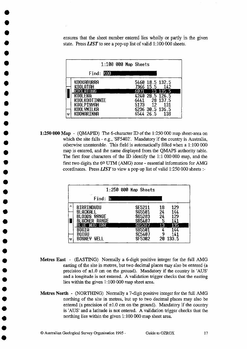
1:100 000 Map - (HMAPNO) A 4-digit integer identifying the 1:100 000 mapsheet-area on which the site falls. Mandatory if country is Australia,optional if PNG. The name is automatically displayed from the HMAPStable, which has over 3000 Australian 1:100 000 maps. A valid entry willautomatically insert the correct 1:250 000 Map ID. A validation trigger •
•@ Australian Geological Survey Organisation 1995 -^Guide to OZROX^16
AUSTRALIAN STATES
Find:
ACT Australian Ca ital Territor-- NSW New South Wales
NT Northern Territory
1 OLD QueenslandSA South AustraliaTAS Tasmania
-- VIC Victoriav WA Western Australia
••••••••••••••
•
•ensures that the sheet number entered lies wholly or partly in the given
• state. Press LIST to see a pop-up list of valid 1:100 000 sheets.•1:100 000 Map Sheets
Find: KOO
--I
--v
KOOKABURRA^5460 18.5 132.5KOOLATAH^7366 15.5^142KOOLATONG^6071^13 135.5KOOLENA^4240 28.5 126.5KOOLKOOTINNIE^6441^28 137.5KOOLPINYAH^5173^12^131KOOLYMILKA^6236 30.5 136.5KOOMARINNA^6544 26.5^138•
• 1:250 000 Map - (QMAPID) The 6-character ID of the 1:250000 map sheet-area onwhich the site falls - e.g., 'SF5402'. Mandatory if the country is Australia,
• otherwise unenterable. This field is automatically filled when a 1:100 000
• map is entered, and the name displayed from the QMAPS authority table.The first four characters of the ID identify the 1:1 000 000 map, and the
• first two digits the 60 UTM (AMG) zone - essential information for AMGcoordinates. Press LIST to view a pop-up list of valid 1:250 000 sheets :-
•
•-Find:
1:250 000 Map Sheets
b
- BIRRINDUDU SE5211 18 129-- BLACKALL SG5501 24 144
BLOODS RANGE 505203 24 1291 BLUCHER RANGE SB5407 5 141
_BLUE MUD BAY SD5307 13 135BOGIA SB5501 4 144
-- BOIGU SC5407 9 141v BONNEY WELL SF5302 20 133.5
•• Metres East - (EASTING) Normally a 6-digit positive integer for the full AMG
easting of the site in metres, but two decimal places may also be entered (a• precision of *1.0 cm on the ground). Mandatory if the country is 'AUS'
and a longitude is not entered. A validation trigger checks that the easting• lies within the given 1:100000 map sheet area.
Metres North - (NORTHING) Normally a 7-digit positive integer for the full AMG• northing of the site in metres, but up to two decimal places may also be
entered (a precision of -±1.0 cm on the ground). Mandatory if the country• is 'AUS' and a latitude is not entered. A validation trigger checks that the
• northing lies within the given 1:100000 map sheet area.
•© Australian Geological Survey Organisation 1995 -^Guide to OZROX^17
fb••••
••••••
•
•

Decimal Latitude - (DLAT) A positive numeric field with up to 2 digits in frontof the decimal point, and up to 6 digits after. All latitudes and longitudesmust be entered in decimal degrees and must not be negative. Mandatoryif an AMG northing is not entered. A validation trigger ensures that thelatitude given must lie within the given 100 000 map sheet area.
N/S - (NS) A single character field that can take the values 'N', 'n', 'S', or 's'.Defaults to 'S' for southern hemisphere. Uppercase values flag the latitudeas the primary datum, and that the northing was calculated from thelatitude. Lowercase letters mark the northing as the primary datum.
Decimal Longitude - (DLONG) A positive numeric field with up to 3 digits in frontof the decimal point and up to 6 digits after the decimal point. Mandatoryif an AMG easting is not entered. A validation trigger ensures that thelongitude given must lie within the given 100 000 map sheet area.
E/W - (EW) A single character field that can take the value 'E', `e', 'W' or 'w'.Defaults to 'E' for eastern hemisphere. Uppercase values flag the longitudeas the primary datum, and that the easting was calculated from thelongitude. Lowercase letters mark the easting as the primary datum.There are no sites yet from the western hemisphere in the SITES table.
Lat. & Long. in Degrees, Minutes and Seconds - Non-database fields thatautomatically display in degrees, minutes and seconds the latitude andlongitude from the decimal fields immediately above them. Seconds aredisplayed at a precision of up to two decimal places. Conversely, alatitude and longitude pair entered into the degree, minute and secondfields is automatically converted and displayed in the equivalent decimalfields. Only decimal values are stored in the database.
Location Method - (METHOD) A mandatory integer of up to 3 digits pointing to arecord in the LOCMETHODS table showing the method used to obtainthe geographic coordinates of the site. Most entries automatically insert adefault estimate in the Absolute Accuracy field. If a standard series mapis indicated, the map used is assumed to be the most up-to-date edition atthe time the observation was made. Current standard-series maps use theAGD-66 or AGD-84 spheroids, which for most practical purposes areessentially the same. If this is not the case then a specific map, report orpublication can be referenced via the Bibliographic Reference field.
Location methods based on the Global Positioning System (GPS) allow avariety of spheroids to be used. However, by the year 2000 Australia iscommitted to the world geocentric datum, known in Australia as theGeocentric Datum of Australia (GDA-94), and this should now be usedwherever possible (Steed 1995). This differs from the older AGDspheroids by approximately 200 metres horizontally.
Press LIST to see a list of valid location methods :-
•
•© Australian Geological Survey Organisation 1995 -^Guide to OZROX^18

VT220 Terminal to AVii 0 NAGSOREFS - AGSO'S SHARED BIBLIOGRAPHIC DATABASE - SINGLE-AUTHOR QUERY FORM
Author^Seq Ref.ID Rlt.ID Year Titleieters, P.E.
ters, P.E.Pieters P.E. 1111111
1994 Katheri46 1975 Stratigraphic and structural deve906 1969 Geolo ical reconnaissance for a )
- AuthorsKruse, P.D..Sweet, I.P.StUart-Smith, P.G.Wygralak, A.S.Pieters, P.E.
I.H.
Seq Reference DetailsYear1994TitleKatherine SD5379
Entered21-FEB-95 JLAURIE
Ref. Id-12403
123456
You MUST query the Sourcedatabase before adding Northern Territory Geological Survey, 1:250 000 Map Ser
a new reference.^ies, Explanatory NotesTo add a new referencemove to the Ref Detailblock and then press
Insert Record.^Vol/Part^ Pa eN1-69
FRM-40100: At first record.Count: 47^
<List><Re.lace>TAVT220 - Novell, Inc.^192.104.43.110
^(1)^Rep^15:09
•••
LOCATION METHODS
Find:
- CPS observation (AGD-84)-- UPS observation (000 -94) Geocentric Datum 41 astronomical observation 5
surveyed from ground control 6published report 7unpublished report 8
-- non-standard topographic map 10v 1:25 000 topographic map 11
Bibliographic Reference - (BIBREF) A 9-character field for the ID of a biblio-• graphic reference in the corporate AGSOREFS database (Rybum & Bond
1995) that locates or refers to the site. With the cursor in the field, press• LIST to view the full reference belonging to an ID, or, in the absence of
• an ID, to obtain the AGSOREFS form for selecting/entering a reference :-
•
The ID of the selected or entered reference is returned to this field onleaving the AGSOREFS form with the EXIT function. The referencecould be to a locality diagram in a publication, a non-standard publishedmap or a map from a PhD thesis or company report. This field is providedprincipally as a means of recording the lineage or provenance of data thathave come from another source. Note that almost any map can be treatedas a bibliographic reference using the standard 'Harvard-style' of referencenotation. GEODX IDs in AGSO's Reference Database are various - e.g.,'79/20055', 'R156', 'G0LD239'. User-entered reference IDs are always anumber with a asterisk prefix - e.g. '*2156'.
•••
@ Australian Geological Survey Organisation 1995 -^Guide to OZROX^19•
•••••
•
••••••••••••••

Absolute Accuracy in Metres - (ACCURACY) Mandatory. An integer of up to 4 digits for the absolute accuracy of the given coordinates in metres on the ground. For many pre-existing sites the locational accuracy is an order of magnitude figure, but this is better than no estimate. For example, points measured on a map at 1 :250 000 scale are generally accurate to ± 1 mm on the face of the map or ± 250 metres on the ground. Estimates like this are automatically supplied by the trigger in the Location Method field but they may need to be refined, depending on the circumstances. This field is important for assessing if a point can be plotted at particular scales - it provides the table with a degree of scale independence.
The accuracy estimate is not the reproducibility of measurement on a map, as this is of little value in comparing results obtained by different methods. It is assumed that the field worker has located the point on the map as accurately as possible with respect to surrounding topographic details. Non-statistical errors, such as a point located in the wrong drainage, can only be detected - if at all - by ,tedious manual inspection. GPS measurements are increasingly used to obtain geographic coordinates in the field and these always include precise accuracy estimates, but the map spheroid should always be specified via the location method field.
Although 1: 100 000 geological maps are commonly compiled at 1 :50 000 scale, points located on the compilation sheets are in many cases no more accurate than they would be at 1: 100 000 scale, because the topography on the compilation sheets was enlarged from original 1: 100 000 bases.
Airphoto - (AIRPHOTO) An optional field of 36 characters to identify the airphoto on which the site is located and/or was plotted. The field is for the name of the airphoto series, the run number and the photo number - for example, 'Cloncurry 8/2134'. It is not intended to be a comprehensive reference to a major national airphoto database, as this is beyond any reasonable AGSO role at present. AGSO geologists sometimes wish to re-Iocate and reinspect airphotos on which sites occur.
Height in Metres - (HEIGHT) An integer of up to 5 digits for the height of the site in metres above mean sea level. Beco,mes negative for sites located below mean sea level. This information is not often supplied for points on the ground surface, but it is essential for some purposes - for example, gravity readings. The field may also be needed for subsurface mine information.
± Metres - (HEIGHT ACC) A positive integer of up to 3 digits for the absolute error in metres of the height entered in the previous field.
Related Data Sets - (OC, SH, RO, ST, PE, RC, OZ, OM, SC, RT, RP, SP, RS) Thirteen single-character fields showing what data sets join to the site. Two values are allowed, null or capital 'X'. 'X' indicates the related data set exists.
© Australian Geological Survey Organisation 1995 - Guide to OZROX 20
• • • • • • • • • • • • • • • • • • • • • • • • • • • • • • • • • •

•••• ID RELATED DATA SET
OC OUTCROPS - outcrop information• SH SECTHOLES - measured sections and drill holes• RO ROCKS - lithology & sample information
ST STRUCTURE - structural geology observations• PE PETROGRAPHY - thin section database
RC ROCKCHEM - whole-rock chemistry database• OZ OZCHRON - geochronology database• OM OZMIN Mineral - deposits database
SC STREAMCHEM - exploration geochemical database• RT RTMAP - regolith-landform database
RP ROCKPROPS - geophysical rock properties database• SP SPECPROPS - spectral properties database
• RS ROCSTOR - a sample exists in the Rock Store database
Although SQL can be used to determine what sites relate to what data sets,• the exercise is complicated and slow, and these fields are needed for the
• immediate identification of related data. However, SQL*Plus can be usedto update these fields via joins to the appropriate tables. In the case of the
• OZCHRON Geochronology Database, though, 6 tables need to besearched. These fields can be brought up to date with the help of a
• SQL*Plus script called 'ADDX.SQL'. This can be run from item 5 in theSITES submenu, but it takes some time to run to completion and is best
• run early or late in the day, when other Oracle activities are at a low level.•
•••••••••411
••
0 Australian Geological Survey Organisation 1995 -^Guide to OZROX^21•
EnteredBy
16-OCT-9NONA
VT220 Terminal to AVHONOZROX DATABASE OUTCROPS TABLE READ ONLY FORM ^
Originator 1 > nknown^Site ID 5091234Rock Rerns Calcareous siltstone bed within slatey shaleSketchesPhotographsVegetationDescriptionLandformDescription
— STRATDAT Links (Outcrop ID =Datum HL Ilcie^Datum Name
photo of outcrop11 COpen woodland with low trees
R30Clow hillstreamside outcro
I> >>
>>
Code References
iltt Remarks
1111
Proconodontus posterocostatus
Jones, B.C., 1995. Conodonts from the Ordovician rocks in the Bendigo reg
Press NEXT PRIMARY KEY for ROCKS FormPick list available - •ress LISTCount:^ <List><Re lace>TAVT220 - Novell Inc.^192.104.43.110^(1)^Re.^17:44^A
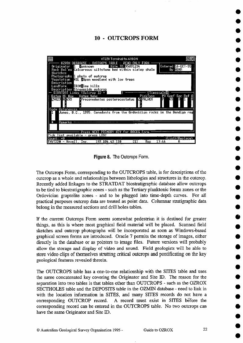
10 - OUTCROPS FORM
Figure 8. The Outcrops Form.
The Outcrops Form, corresponding to the OUTCROPS table, is for descriptions of theoutcrop as a whole and relationships between lithologies and structures in the outcrop.Recently added linkages to the STRATDAT biostratigraphic database allow outcropsto be tied to biostratigraphic zones - such as the Tertiary planktonic foram zones or theOrdovician graptolite zones - and to be plugged into time-depth curves. For allpractical purposes outcrop data are treated as point data. Columnar stratigraphic databelong in the measured sections and drill holes tables.
If the current Outcrops Form seems somewhat pedestrian it is destined for greaterthings, as this is where most graphical field material will be placed. Scanned fieldsketches and outcrop photographs will be incorporated as soon as Windows-basedgraphical screen forms are introduced. Oracle 7 permits the storage of images, eitherdirectly in the database or as pointers to image files. Future versions will probablyallow the storage and display of video and sound. Field geologists will be able tostore video clips of themselves strutting critical outcrops and pontificating on the keygeological features revealed therein.
The OUTCROPS table has a one-to-one relationship with the SIIES table and usesthe same concatenated key covering the Originator and Site ID. The reason for theseparation into two tables is that tables other than OUTCROPS - such as the OZROXSECTHOLES table and the DEPOSITS table in the OZMIN database - need to link inwith the location information in SITES, and many SUES records do not have acorresponding OUTCROP record. A record must exist in SIfES bEfore thecorresponding record can be entered in the OUTCROPS table. No two outcrops canhave the same Originator and Site ID.
Australian Geological Survey Organisation 1995 -^Guide to OZROX^22

•• Information on individual lithologies, samples and structures belongs in the ROCKS
and STRUCTURES tables - both of which have a many-to-one relationship with• OUTCROPS. The fields for drill holes data that used to reside in the OUTCROPS
• table (Rybum et al. 1993, p17) are now incorporated into the SECTHOLES table.
111^Entry of outcrop data is not mandatory. There are many thousands of sites in OZROXthat relate to records in the ROCKS table, but have no corresponding records in the
• OUTCROPS table.
•
• OUTCROPS BLOCK
• Originator - (ORIGNO) As for the Sites Form.
• Site ID - (SITED) As for the Sites Form. A trigger ensures that only Originator-• Site ID combinations that are already in the SITES table can be entered.
• Entered - (ENTRYDATE) As for the Sites Form.
By -^(ENTEREDBY) As for the Sites Form.•
Rock Relations - (ROCKRELS) An optional field of 128 characters for a description• of the rock relations in the outcrop.
• Sketches - (SKETCH) An optional field of 64 characters noting any sketches made• at the outcrop.
• Photographs - (PHOTO) An optional field of 64 characters noting any photos takenat the outcrop.
•
• Vegetation - (VEGCODE) An optional field of up to 4 characters for the vegetationtype code in the QUATDB.VEGET table. This is part of the QUATDB
• Quaternary Climates Database (custodian - Geoff Hunt) and is based onthe vegetation map of Australia (AUSLIG 1990). The name of the
• vegetation type is automatically displayed. With the cursor in this field
• press LIST to view a pop-up list of vegetation types.
• Description - (VEGETATION) An optional 64-character field for a text descriptionof the vegetation at the site of the outcrop. Important for remote sensing.
•
• Landform - (LANDCODE) An optional field of up to 4 characters for the landformin the RTMAP.LANDF table. This is part of the RTMAP Regolith Land-
• form Mapping Database (custodian - Cohn Pain). The landform's name isautomatically displayed. When the cursor is in this field press LIST to
• view a pop-up list of valid landforms from the LANDF table.
Description - (LANDFORM) An optional 64-character field for a text description of• the landform at the site of the outcrop.
•© Australian Geological Survey Organisation 1995 -^Guide to OZROX^23

STRATDAT LINKS BLOCK
All but one of the fields in the STRATDAT Links Block (Fig. 8) correspond toattributes residing in the STRATDAT database (in the tables STD_DAT,STD_RMKS and STD_REFS). To be able to enter data into this part of the formyou must have specific update privileges for STRATDAT (see the custodian - JohnBradshaw). Otherwise, you will be unable to commit any data entered in the fields ofthis block. Several STRATDAT datum records can be attached to a single outcrop.For example, a 'palaeo' zone and a key horizon could easily occur in the sameoutcrop. Refer to Wyatt (1994) for detailed descriptions of the fields, columns andtables that go to make up the STRATDAT database.
Outcrop ID - (STD_ID) A field of up to 7 characters for a unique ID belonging tothe outcrop record. It consists of an '0' followed by an integer of up to 6digits. This field in the OUTCROPS table is equivalent to the 'UNO'unique identifier used in the STRATDAT and NPD databases as theprimary key for petroleum wells. However, in this case it is used toidentify an outcrop, and is distinguished from well UNOs by the initialletter '0'. This ID is automatically generated whenever STRATDAT dataentered into the form is committed.
Timescale - A single-character field indicating the time scale being applied to thedata. Generally B to indicate the AGSO (BMR) timescale. Press LIST toview the options.
Datum - An 8-character field that identifies the STRA'TDAT datum - commonly afossil or fossil assemblage zone, sequence boundary, timeslice boundary,formation, condensed interval, etc. In the example illustrated the datumreferred to is a conodont zone.
High/Low - A single-character field for the level in the datum - high (H), medium(M) or low (L) - indicating whether it is the highest or lowest occurrencein the section. This commonly affects the age estimate.
Age -^A derived field that displays the age in millions of years for the indicateddatum, level and time scale. An age estimate can only be displayed if atimescale has been nominated and if an age pointer exists in thecorresponding record in the STRATDAT datum lookup table. Formationsare not assigned ages as they are diachronous.
Datum Name - A derived field that displays the name of the datum indicated by theDatum field.
Pick Type - A field for a single upper-case character indicating the 'pick type'.Some examples include formation (F), key horizon (K), paleo zoneboundary (Z) and unconformity (U). The following field automaticallydisplays an abbreviated pick description. Press LIST to obtain a pop-uplist of pick types.
•
•••
C:) Australian Geological Survey Organisation 1995 -^Guide to OZROX^24

••Preferred or Alternate (PA) - A single-character field that assumes the values P for
• preferred, or A for alternate. These codes, which are used only for the Zor PALAEO pick type, refer to the preferred and alternate depth for adatum. Closely tied to the confidence rating. Usually set to preferred (P).
• However, when this is based on a sample of low confidence, if a higherconfidence sample exists within the depth range of the zone, then it is
• called an alternate (A) pick.
• Confidence Rating - An upper-case letter, followed by a single digit, representing• the sample type (core, sidewall core, etc.) and the interpreter's confidence
in the correctness of the data (see Wyatt 1994, p'7-8). Press LIST to see a• pop-up list of permissible letters and their meanings.
• Reference Code - An integer pointing to the relevant reference sequence code in thereference records below.
Active Flag - If set to A, the data are regarded as active or current. If null, the dataare regarded as old, or 'archived'
References - References to published or unpublished reports can be entered as textstrings of up to 240 characters. Each reference record is preceded by asequence code (number) that starts at 1 at each outcrop. This is what ispointed to by the reference code in the datum record.•
Remarks - Any number of remarks, each up to 220 characters long, can be inserted.• Each remark record is preceded by a sequence number. These remarks
•apply to the STRATDAT-related aspects of the outcrop as a whole.Unlike the reference records, they are not attached to specific datum
• records.
•
•
••
Security Rating - An optional single upper-case letter that is 0 for open file, C forconfidential.
•••••
@ Australian Geological Survey Organisation 1995 -^Guide to OZROX^25

[EUVT220 Terminal to AVii014
ERN DATABASE MEASURED SECTIONS AND DRILL HOLES - READ ONLY FORMMS/DH No 7064 On inator ii >Glikson, R.Y.^Entered 06-MRR-95Site ID 69200380^T )e S>Surface Measured PEDIN
8400 Perp-to-BedDH ID
Total MetresDH CmpnyAzimuth 260 Inclinat'n 5
Count: -.1INV1220 - Novell Inc.^192.104.43.110^(1)^Re.^16:29
<List><Re)lace>II
Oracle Environment:I .e of section or drill hole - .ress LIST for allowable letters.
2
T^e From(m)^lo(m)^ INTERVALS AND HORIZONS ^TR 2760 28571 Bedding (facing 70
LT 2760 2810 100 amphiboliteIi 2810 2486 Toole Creek Volc 12978
LT 2810 4230 55 quartziteLT 2810 4230 30 schist arenaceous
2810 4230 10 chertLT 2810 4230 5 siltstone silicifiedSTR 3520 28572 Foliation dippin 225ST 4032 28574 Bedding (facing 65CON 4230 1 fault
4230 4315 100 basalt metaLT 4315 4400 60 quartziteTH 4315 4400 40 phyllite
LTH 4400 5540 65 .uartzite
80
Mount Norna
8580
11- MEASURED SECTIONS & DRILL HOLES FORM
Figure 9. The Measured Sections and Drill Holes (Sectholes) Form.
The ability to handle columnar geological logs obtained from measured sections anddrill holes is a major recent addition to OZROX - one that allows links to beestablished with the National Petroleum Database (PEDIN) and the STRATDATBiostratigraphic Database. The Australian Stratigraphic Names Database also makesuse of this facility to store information on the type sections of formations. The newdata structures are designed so that all of the required information can be displayed ina single-screen form (Ryburn 1995).
Linear geological logs obtained from surface measured sections are essentially thesame as those obtained from sub-surface drill holes, and the term SECTHOLE hasbeen coined for the combined entity. The top block of the above form corresponds tothe SECTHOLES table. Along-section or down-hole information relating to specificintervals or horizons belongs in the second block corresponding to the INTERIZONStable. Intervals have both 'from' and 'to' distance measurements from the `secthole'origin, whereas horizons have only a 'from' entry. Apart from the two distance fields,a lithology percentage field and comments (not seen in Fig. 9 - the form must behorizontally scrolled to the right), the various types of record in the INTERIZONStable are essentially just pointers to other records in the ROCKS, STRUCTURES,STRATLEX and STRATDAT tables. The data displayed in the other columns in theform are borrowed from those primary sources.
0 Australian Geological Survey Organisation 1995 -^Guide to OZROX^26
•
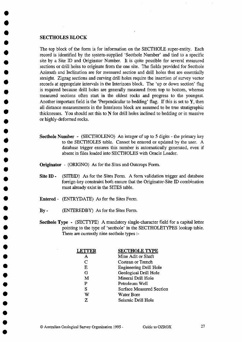
•••SECTHOLES BLOCK•The top block of the form is for information on the SECTHOLE super-entity. Each
O record is identified by the system-supplied `Secthole Number' and tied to a specific
• site by a Site II) and Originator Number. It is quite possible for several measuredsections or drill holes to originate from the one site. The fields provided for Secthole
• Azimuth and Inclination are for measured section and drill holes that are essentiallystraight. Zigzag sections and curving drill holes require the insertion of survey vector
• records at appropriate intervals in the Interizons block. The 'up or down section' flag
410^is required because drill holes are generally measured from top to bottom, whereasmeasured sections often start in the oldest rocks and progress to the youngest.
• Another important field is the 'Perpendicular to bedding' flag. If this is set to Y, thenall distance measurements in the Interizons block are assumed to be true stratigraphic
• thicknesses. You should set this to N for drill holes inclined to bedding or in massive
• or highly-deformed rocks.
•Secthole Number - (SECTHOLENO) An integer of up to 5 digits - the primary key
to the SECTHOLES table. Cannot be entered or updated by the user. A
•database trigger ensures this number is automatically generated, even ifabsent in files loaded into SECTHOLES with Oracle Loader.•
Originator - (ORIGNO) As for the Sites and Outcrops Form.
Site ID - (SITED) As for the Sites Form. A form validation trigger and databaseforeign-key constraint both ensure that the Originator-Site ID combinationmust already exist in the SITES table.
Entered - (ENTRYDATE) As for the Sites Form.
By -^(ENTEREDBY) As for the Sites Form.
Secthole Type - (SECTYPE) A mandatory single-character field for a capital letterpointing to the type of `secthole' in the SECTHOLETYPES lookup table.There are currently nine secthole types :-
LETTER^SECTHOLE TYPEA^Mine Adit or Shaft
Costean or TrenchEngineering Drill HoleGeological Drill HoleMineral Drill HolePetroleum WellSurface Measured SectionWater BoreSeismic Drill Hole
© Australian Geological Survey Organisation 1995 -^Guide to OZROX^27
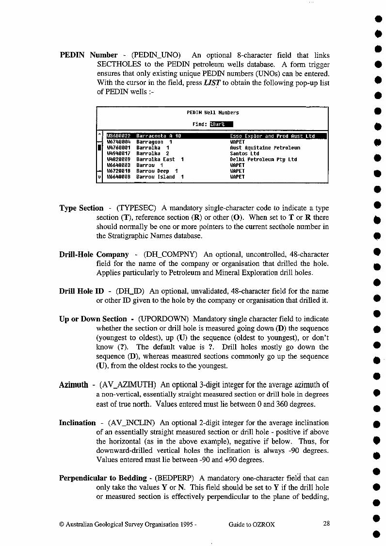
PEDIN Number - (PEDIN_UNO) An optional 8-character field that linksSECTHOLES to the PEDIN petroleum wells database. A form triggerensures that only existing unique PEDIN numbers (UN0s) can be entered.With the cursor in the field, press LIST to obtain the following pop-up listof PEDIN wells :-
PEDIN Well Numbers
Find: 4Bar%
^ W3680022 Barracouta A 10 Esso Exilor and Prod Aust Ltd-- W6740004, Barragoon^1 WAPETI W4760001 Barrolka^1 Aust Aquitaine Petroleum
W4940017 Barrolka^2 Santos LtdW4820009 Barrolka East 1 Delhi Petroleum Pty LtdW6640003 Barrow^1 WAPET
-- W6720018 Barrow Deep^1 WAPETu W6640008 Barrow Island 1 WAPET
Type Section - (TYPESEC) A mandatory single-character code to indicate a typesection (T), reference section (R) or other (0). When set to T or R thereshould normally be one or more pointers to the current secthole number inthe Stratigraphic Names database.
Drill-Hole Company - (DH_COMPNY) An optional, uncontrolled, 48-characterfield for the name of the company or organisation that drilled the hole.Applies particularly to Petroleum and Mineral Exploration drill holes.
Drill Hole ID - (DH_ID) An optional, unvalidated, 48-character field for the nameor other ID given to the hole by the company or organisation that drilled it.
Up or Down Section - (UPORDOWN) Mandatory single character field to indicatewhether the section or drill hole is measured going down (D) the sequence(youngest to oldest), up (U) the sequence (oldest to youngest), or don'tknow (?). The default value is ?. Drill holes mostly go down thesequence (D), whereas measured sections commonly go up the sequence(U), from the oldest rocks to the youngest.
Azimuth - (AV_AZIMUTH) An optional 3-digit integer for the average azimuth ofa non-vertical, essentially straight measured section or drill hole in degreeseast of true north. Values entered must lie between 0 and 360 degrees.
Inclination - (AV_INCLIN) An optional 2-digit integer for the average inclinationof an essentially straight measured section or drill hole - positive if abovethe horizontal (as in the above exarriple), negative if below. Thus, fordownward-drilled vertical holes the inclination is always -90 degrees.Values entered must lie between -90 and +90 degrees.
Perpendicular to Bedding - (BEDPERP) A mandatory one-character field that canonly take the values Y or N. This field should be set to Y if the drill holeor measured section is effectively perpendicular to the plane of bedding,
0 Australian Geological Survey Organisation 1995 -^Guide to OZROX^28
•
••••••••••40
•••••••••••
•••••

•
otherwise it is set to N. If set to Y, all distances (thicknesses) in theInterizons block can be taken as stratigraphically true distances.
Reference ID - (REM) An optional 9-character field for the ID of a reference in the• AGSOREFS bibliographic reference database (Ryburn & Bond 1995) with
further information on the current section or drill hole. The reference can• be seen by pressing LIST whenever the cursor is in this field - as
described for the Reference ID field in the Sites Form (see page 19).
INTERIZONS BLOCK
This block corresponds to the INTERIZONS table and displays all along-section ordown-hole information ordered according to distance from the origin. The origin of ameasured section must be at one end of the section. The origin of a drill hole isnormally the natural ground level (the point to which the altitude field in the SITESrecord refers), but could also be the point at which an upwards-drilled hole enters theroof of a tunnel (in which case vector inclination measurements will be positive). TheINTERIZONS table currently caters for 6 types of record, which include pointers todata in the indicated tables, views or databases :-
M NAME^INTERVAL/HORIZON POINTS TOLTH Lithology (and sample) interval ROCKS tableCON Contact type horizon nullSTD STRADAT datum horizon STRATDAT databaseRUB Rock unit boundary horizon STRATLEX viewSTR Structure horizon STRUCTURES tableSVY Survey vector horizon STRUCTURES table
As the cursor is moved up or down between records in the Interizons Block, thecolumn headings in a different colour change to reflect the type of data stored in eachrecord. The record types and their corresponding column headings are held in theIZ_TYPES table, and may be viewed in the Interval/Horizon Record Types Form :-
V1220 Terminal to AViiON^ FEE
OZROX DATABASE - LOOKUP TABLE FOR INTERVAL/HORIZON RECORD TYPES ->>>>--
ecord T^*e Pct Header Lth Header Ii Header 2 Header^13 Header PtLTH Lithology Lithology Qualifier Qualifier2 Qualifier3 NSTR Structure Str# Struc.Typ Azimuth Inclin. generation LiSTD STRATDAT Datum Pick Type Datum Nam Hi/Low Pref/AltRUB RockUnitBoundary 0 Strat# Overlying U StratH UnderlyingSVY Survey Seq Azimuth nclinat'nCON Contact type Contact
Other record types may yet be added to this table, as the secthole part of OZROX isnew and needs more use before we can say that the present data models and forms are
•••
29Guide to OZROX0 Australian Geological Survey Organisation 1995 -

•••••••••
••
optimal. The lNTERIZONS table has been deliberately generalised so that all
^
secthole data can be displayed on the one form. A consequence of this is that records^•in the Interizons Block behaves differently, depending on record type. However, fourcolumns do not change and these are now described :-
411^Record Type - (RECTYPE) A mandatory 3-capital character field for the 1D of the^•
Record Type. A form validation trigger and database foreign-key con-straint both ensure that the ID entered exists in the IZ_RECTYPES table.Press LIST (cursor in field) to see a pop-up list of record types.
From Distance - (D1) A mandatory number field for the distance in metres from theorigin of the secthole to a horizon or near boundary of an interval. Up to9999.99 metres may be entered with a precision of up to one centimetre. •
•To Distance - (D2) An optional number field for the distance in metres from thesecthole origin to the far boundary of an interval. Capacity and precisionare the same as for Dl. Cannot be entered for horizons. Because rock
^
samples are often noted to a single distance only, the 'To' distance is not^•required for lithology records, but it should always be entered if known.
Comments - (COMMENTS) Up to 64 characters of comments on the current record.Note that this field should not be used for comments that should otherwisebe placed in the ROCKS, STRUCTURES or STRATDAT tables. On an80 char x 25 line screen the form must be scrolled horizontally to the rightin order to see this field.
The purpose of other columns in the Interizons Block change according to record type,and for this reason they are described below under their record-type sub-headings.
Lithology Records
Whenever the cursor is in a lithology (LTH) record, the Rocks Form (Fig. 11) with thelinked lithology data may be displayed by pressing the NEXT PRIMARY KEYfunction key (The `ROCKNO' pointing to the relevant record in the ROCKS table isheld in the DETAIL_PTR column of the INTEREONS table). The followingdescriptions are of the fields displayed in lithology records in the Interizons Block.
Percentage - (PERCENT) Optional - the percentage of the stated interval made upof the given lithology. The Rocks Form is automatically displayed whenthe cursor is moved to the next field - enter the relevant ROCKS data,save the record, then exit that form to return to the Sectholes Form. Thecorrect secthole number (return pointer) is automatically added into thecorresponding record in the ROCKS table. By entering more than onerecord with the same 'From' and 'To' distances, various percentages ofdifferent lithologies can be ascribed to the same interval. The percentagesshould add up to 100%.
0 Australian Geological Survey Organisation 1995 -^Guide to OZROX^30 •

DRILL HOLE / MEASURED SECTION STRUCTURE ^Subtyse^kWh Incl DefliSurf#
Beddin^
Beddin (facinc 70^
80^
0^
0
•••
•
•
Lithology - A non-database field that displays the lithology term from the linkedrecord in the ROCKS table.
Structure Records
When the cursor is in a structure (STR) record, a sub-form on the STRUCTUREStable can be viewed by pressing the NEXT PRIMARY KEY function key :-
When entering data into structure records, this sub-form pops up after the 'From'distance has been entered. Enter the structure data into this subform, commit it, andpress EXIT to return to the Sectholes Form. Refer to the Structures Form (Fig. 15) fordetailed descriptions of the fields corresponding to those in the above pop-up form.The following descriptions are of the fields displayed in structure records in theInterizons Block.
Structure No. - (DETAIL_PTR) This field displays the 'structure number' - aforeign key pointer to the primary key (STRUCNO) of the correspondingstructure record in the STRUCTURES table. The structure number isautomatically allocated by the Structure Subform and returned to theSectholes Form.
Structure Type - A non-database field that displays the structure type (eg, bedding,facing unknown) from the linked record in the STRUCTURES table.
Azimuth - A non-database field that displays the 'azimuth' (dip direction if planar,trend if linear) of the structure from the linked record in theSTRUCTURES table.
Inclination - A non-database field that displays the structure's 'inclination' (plungeif linear, dip if planar) from the linked record in the STRUCTURES table.
Generation - A non-database field that displays the generation of the structure fromthe linked record in the STRUCTURES table.
••
© Australian Geological Survey Organisation 1995 -^Guide to OZROX^31

Rock Unit Boundary Records
When the cursor is in a rock unit boundary (RUB) record, the appropriate subform canbe invoked by pressing the NEXT PRIMARY KEY function key :-
ROCK UNIT BOUNDARY
StateOverlying Unit
Underlying Unit
OLDToole Creek VolcanicsMount Norna uartzite_
Alternatively, when entering data into rock unit boundary records this subform popsup as soon as the 'From' distance has been entered. Enter the abbreviation for thestate and the names of the overlying and underlying rock units into this subform,commit it, then press EXIT to return to the Sectholes Form. Only the names of rockunits already in the Stratigraphic Lexicon may be entered. The following descriptionsare of the fields displayed in rock unit boundary records in the Interizons Block.
Overlying Unit No. - (PERCENT) This field contains the stratigraphic unit numberof the overlying unit. This must be a valid pointer to a stratigraphic unit inthe National Stratigraphic Names Database.
Overlying Unit Name - A non-database field that displays the name of the overlyingstratigraphic unit from the National Stratigraphic Names Database.
Underlying Unit No. - (DETAIL_PTR) This field contains the stratigraphic unitnumber of the underlying unit. This must be a valid pointer to astratigraphic unit in the National Stratigraphic Names Database.
Underlying Unit Name - A non-database field that displays the name of the under-lying stratigraphic unit from the National Stratigraphic Names Database.
••••••••••••
•
0 Australian Geological Survey Organisation 1995 -^Guide to OZROX^32
OZROX DRTRBASE - LITHOLOGY CONTACTS
ContactID Nameconformable
2 uncomformable3 disconformable4. nonconformable5 gradational.6 abrupt7 fault8 thrust9 intrusive10 erosional11 alteration12 weathering13 stylolitic14, sutured
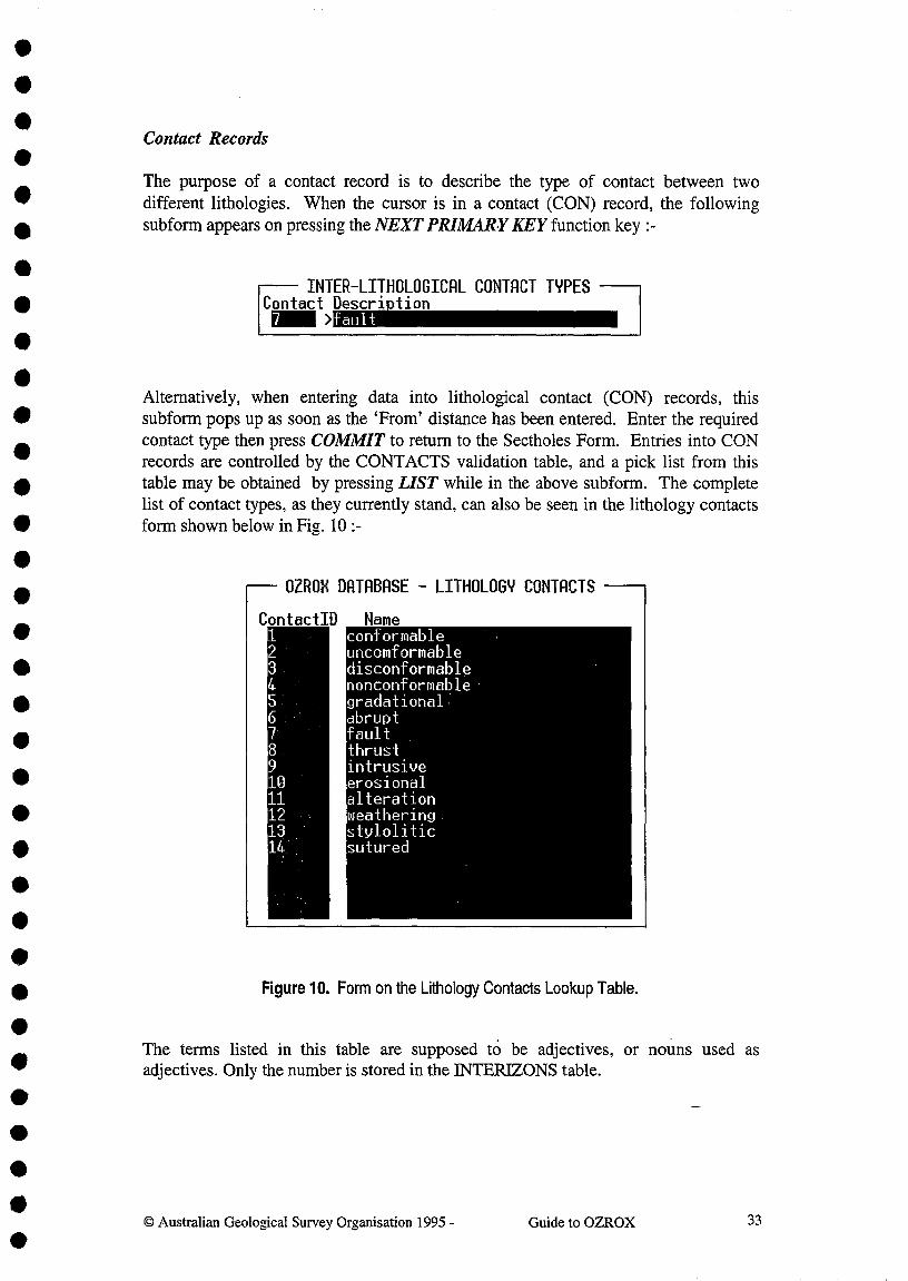
••Contact Records
The purpose of a contact record is to describe the type of contact between twodifferent lithologies. When the cursor is in a contact (CON) record, the followingsubform appears on pressing the NEXT PRIMARY KEY function key :-
^ INTER-LITHOLOGICRL CONTACT TYPES -----Contact Descri.tion
7^
fault
Alternatively, when entering data into lithological contact (CON) records, thissubform pops up as soon as the 'From' distance has been entered. Enter the requiredcontact type then press COMMIT to return to the Sectholes Form. Entries into CONrecords are controlled by the CONTACTS validation table, and a pick list from thistable may be obtained by pressing LIST while in the above subform. The completelist of contact types, as they currently stand, can also be seen in the lithology contactsform shown below in Fig. 10 :-
•
Figure 10. Form on the Lithology Contacts Lookup Table.
The terms listed in this table are supposed to be adjectives, or nouns used asadjectives. Only the number is stored in the INTERIZONS table.
© Australian Geological Survey Organisation 1995 -^Guide to OZROX^
33••

•••
•Ill 0
STRATDAT DATABASEUNO
Datum Name PA Conf Sec Ref AHisfiodella holodentata
Jones, B., 1987 Fauna of the Timbuktu No. 1 Well. Australian Geological
Remarks
••STRATDAT Records
The STRATDAT (STD) records link lithological logs in the INTERIZONS table todata in the STRATDAT biostratigraphic database. These records typically recordfossil zones, but a great variety of horizons or zones can be attributed, and an absolutetime scale attached for the purposes of time-depth analysis. When the cursor is in aSTRATDAT (STD) record, the following sub-form relating to the STRATDATdatabase is invoked by pressing the NEXT PRIMARY KEY function key. Note thatthe data shown are fictitious and that a UNO number is normally mandatory. At thetime of writing no STRATDAT records had been entered into INTERIZONS.
For a description of this sub-form, refer to the very similar STRATDAT-Links Blockof the Outcrops Form. The only field not covered under the Outcrops Form is :-
Unique Well Number - (UNO) A mandatory 8-character foreign key pointing to theprimary key for petroleum wells in the National Petroleum Database(NPD). This number must already occur in the NPD database - it cannotbe assigned in this form. This field is the same as the PEDIN #' field inthe SECTHOLES Block. Strictly speaking, it is redundant.
•••••
0 Australian Geological Survey Organisation 1995 -^Guide to OZROX^34
^•
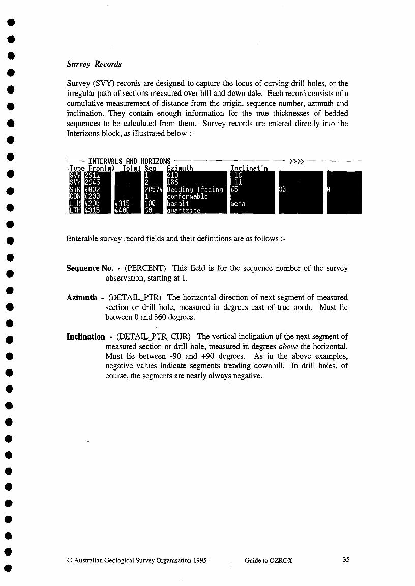
•••••
e From(m) To(m) Se,1228574110060
SW 2911svY 2945STR 4032CON 4230LTFI 4230 4315LTH 4315 4400
•••
Survey Records
Survey (SVY) records are designed to capture the locus of curving drill holes, or theirregular path of sections measured over hill and down dale. Each record consists of acumulative measurement of distance from the origin, sequence number, azimuth andinclination. They contain enough information for the true thicknesses of beddedsequences to be calculated from them. Survey records are entered directly into theInterizons block, as illustrated below :-
INTERVALS AND HORIZONS
observation, starting at 1.
Azimuth^Inclinat'n210186Bedding (facingconformablebasaltquartzite
-16-1165
met a
80 0
Enterable survey record fields and their definitions are as follows :-
Sequence No. - (PERCENT) This field is for the sequence number of the survey•
•Azimuth - (DETAIL_PTR) The horizontal direction of next segment of measured
• section or drill hole, measured in degrees east of true north. Must liebetween 0 and 360 degrees.
•
• Inclination - (DETAIL_PTR_CHR) The vertical inclination of the next segment ofmeasured section or drill hole, measured in degrees above the horizontal.
• Must lie between -90 and +90 degrees. As in the above examples,negative values indicate segments trending downhill. In drill holes, of
• course, the segments are nearly always negative.
•
••
Guide to OZROX^350 Australian Geological Survey Organisation 1995 -
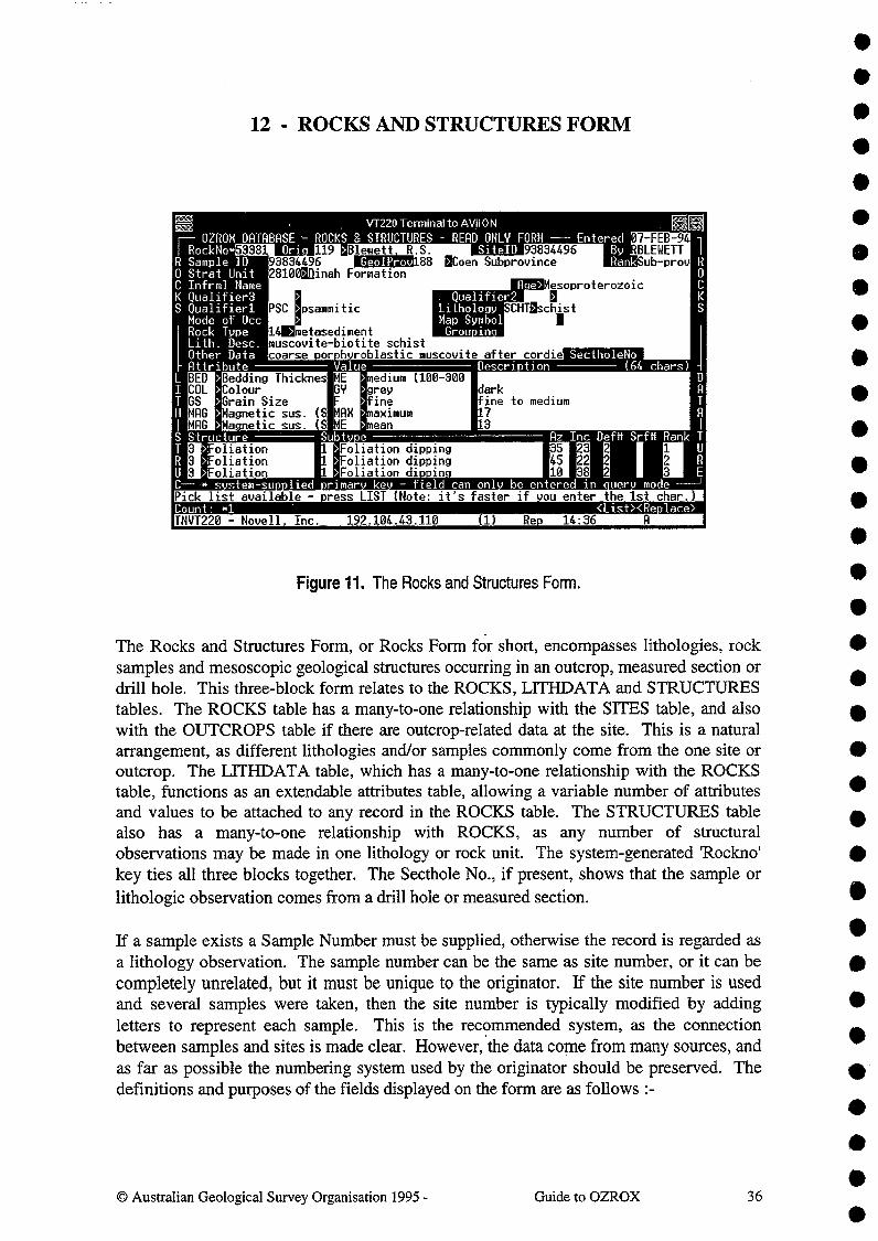
. Qualifier2LithologyMap SymbolGrou in
•••
PSC Psammitic
oliationoliationoliation
rimar ke field can on! be
1Count: <List><Re)lace>
-E4
R Sample ID0 Strat UnitC Infrml NameK Qualifier3S Qualifierl
Mode of OccRock Type 14 metasediment
I RockNo..^Ori- READ ONLY FORM --- Entered 07 -FEB-94
SiteID 93834496^By RBLEWETTaCoen Subprovince^Rank ub-prov
VT220 Terminal to AYH° N
F-- OZROH DATABASE - ROCKS & STRUCTURES53381^119 >Blewett R.S.
93834496^GeolProv1888100aflinah Formation
Lith. Desc. muscovite-biotiteOther Data^oarse •or h roblastic
schistmuscovite after cordie Sec tholeNo
Attribute ^ Value Descri tion^(64 chars)edium (100-300BED Bedding Thicknes ME
COL Colour GV rey^arkGS Grain Size fine^fine to mediumMAG Magnetic sus.^(S MRM aximum^7^ AMAO Ma.netic sus.^(S ME ean^3Structure ^ Subt Az Inc Deftt Srfil Rank T
Foliation dippingFoliation dippingFoliation dip.in.
liedPick list available - press LIST (Note: it's faster if ou enter the 1st char.)
Ace>
INVT220 - Novell Inc.^192.104.43.110^(1)^Re^14:36
12 - ROCKS AND STRUCTURES FORM
Figure 11. The Rocks and Structures Form.
The Rocks and Structures Form, or Rocks Form for short, encompasses lithologies, rocksamples and mesoscopic geological structures occurring in an outcrop, measured section ordrill hole. This three-block form relates to the ROCKS, LITHDATA and STRUCTUREStables. The ROCKS table has a many-to-one relationship with the SITES table, and alsowith the OUTCROPS table if there are outcrop-related data at the site. This is a naturalarrangement, as different lithologies and/or samples commonly come from the one site oroutcrop. The LITHDATA table, which has a many-to-one relationship with the ROCKStable, functions as an extendable attributes table, allowing a variable number of attributesand values to be attached to any record in the ROCKS table. The STRUCTURES tablealso has a many-to-one relationship with ROCKS, as any number of structuralobservations may be made in one lithology or rock unit. The system-generated 'Rockno'key ties all three blocks together. The Secthole No., if present, shows that the sample orlithologic observation comes from a drill hole or measured section.
If a sample exists a Sample Number must be supplied, otherwise the record is regarded asa lithology observation. The sample number can be the same as site number, or it can becompletely unrelated, but it must be unique to the originator. If the site number is usedand several samples were taken, then the site number is typically modified by addingletters to represent each sample. This is the recommended system, as the connectionbetween samples and sites is made clear. However, the data come from many sources, andas far as possible the numbering system used by the originator should be preserved. Thedefinitions and purposes of the fields displayed on the form are as follows :-
0 Australian Geological Survey Organisation 1995 -^Guide to OZROX^36

•• Rockno - (ROCICNO) A mandatory positive integer of up to 6 digits which is theprimary key for the ROCKS table, and is what links ROCKS to LITHDATAand STRUCTURES. This number is automatically inserted when a newROCKS record is committed. Users can access this field only in query mode.•^Originator - (ORIGNO) As for the Sites Form.•••
Site ID - (SITEID) As for the Sites and Outcrops Form. A validation trigger ensuresthat Originator and Site ID must already exist in the SITES table. When a newrecord is entered the Site ID is automatically copied to the Sample ID field.
•^Entered - (ENTRYDATE) As for the Sites Form.
By -^(ENTEREDBY) As for the Sites Form.
Sample ID - (SAMPLED) An optional field of 16 characters for the ID of a sample.• Leave blank if no sample exists. The Sample ID must be unique to the
• the Site ID is automatically copied into this field, as the Sample ID is usuallyOriginator, but it need not be related to the Site ID. During data entry, though,
the same as the Site ID, sometimes with a letter appended. AGSO originators•^should use AGSO registered numbers with up to two letters added (two letters• needed only if more than 26 samples from one site).
Geological Province - (GEOLPROVNO) An optional integer of up to 3 digits pointingto a geological province in the STRATA.GEOPROVS table (see Section 15).This link can be made at any level in the province hierarchy, from Super-Province to Sub-domain. The name corresponding to the number is auto-matically displayed in the form. A pop-up list of valid provinces is obtainedby pressing LIST when the cursor is in this field :-
GEOLOGICAL PROVINCES
Find:
--1
--v
,Adavale Basin 1 ProvinceAdelaide Fold BeltAlbany-Fraser ProvinceAlpine Dyke SwarmAmadeus BasinArafura BasinArckaringa BasinArnhem Block
.^2 Province3 Province
371 Sub-province4 Province5 Province6 Province7 Province•
Stratigraphic Unit - (STRATNO) An optional integer of up to 5 digits pointing to aunit in the Stratigraphic Lexicon. The corresponding name is automaticallydisplayed in the following name field. Alternatively, with the cursor in thename field, enter the first two or three letters of the required unit's name (loweror upper case) then press LIST. All units starting with the supplied letters willthen be displayed in the resulting pop-up list (see below). Position thehighlighted bar on the correct unit and press ACCEPT to insert the name andnumber in the form This is much quicker than an open list (no letters
•^© Australian Geological Survey Organisation 1995 -^Guide to OZROX^37
••
•••••••••••••••

••
supplied), which is quite slow due to the size of the Stratigraphic Lexicon.The linkage to the GEODX.STRATNAMES table remains valid even if thename is superseded, and therefore no longer visible in the Lexicon view.
STRATIGUIPHIC LEXICON
Find:
Roach Island Tuff 24473 Formation. Defined-- Road Creek 29375 Formation, Reserved1 Roadside Bore granite 16156 Formation, Mentioned
Roaring Bore Siltstone 16157 Formation, MentionedRoaring Formation 16159 Formation, Briefly dRoaring Formation shales 16158 Formation, Mentioned
-- Roaring Nag Member 16160 Member Briefly dv Roaring flag Siltstone Member 16162 Member Briefly d
Informal Stratigraphic Name - (INFORMAL) Up to 64 characters for an informalstratigraphic name - in the absence of a registered name from the StratigraphicLexicon. This field may be used for new units, not yet in the Lexicon, or forgeological mapping units that will always be informal units. If the namesupplied is in the Lexicon, and the Stratigraphic Unit field is empty, this fieldis cleared and the correct number and name placed in the previous two fields.
Age- (AGE) Up to 54 characters for an entered geological age. If present in theStratigraphic Lexicon, the minimum and/or maximum ages of a stratigraphicunit are automatically inserted in this field, but otherwise the age of a rock canbe stated independently, either as an absolute age or as a Period, Stage etc. Allnon-numeric entries are validated against the STRATA.GEOTIME table in theStratigraphic Authority Database. A pop-up list of valid time terms from thistable may be viewed by pressing LIST. This rather long list may be shortenedby entering a letter or two in the age field before pressing LIST :-
Geological Time Terms
Find:
Ralenian-- Adelaidean1 Reronian
AktastinianAlbianAldanian
-- Aldinganv Algonkian
Lithology Qualifier 1 -3 - (QUALIKER1, 2 & 3) 20-character optional field for thequalifying term before the Lithology Name field that follows. An abbreviationmay be entered in the associated short field that automatically retrieves the fullterm. The full term is what is stored in the ROCKS table. The terms enteredare validated against the LITHNAMES view, which is a union of the qualifier
•••••
••••••••••••••••••
••••
@ Australian Geological Survey Organisation 1995 -^Guide to OZROX^38

terms in the LITHOLOGIES table and the common minerals in theAGSOMINERALS table. A trigger ensures that single qualifiers always endup in field one, or dual qualifiers in fields one and two. Valid lithologyqualifiers may be selected from a pop-up list obtained by pressing LIST :-
LITHOLOGY QUALIFIERS
Find:
ACT actinolite-- ADC adcumulate1 AGAL agal
AB albiteALK alkaliALN allanite
-- ALM almandinev ALT altered
•
• Lithology Name - (LITHNAME) A 32-character optional field for a lithology name. Anabbreviation may be entered in the associated short field to fetch the full term,
• but the full term is what is stored in the ROCKS table. Only names already in• the LITHNAMES authority table, and classified as Type of 'I', 'M' or 'S'
(igneous, metamorphic, sedimentary), may be entered. Valid lithology names• may be selected from a pop-up list obtained by pressing LIST :-
•LITHOLOGIES
Find:
- CRNL carnieule-- CHLK chalk1 CHAR charnockite
CHRT chertCHT chromititeCLAS clast
-- CLY clav CLST cla stone
•• Mode of Occurrence - (MODEOCC) A field of up to 4 characters for an abbreviation
indicating the mode of occurrence of a lithology or sample - for example `XE'• for 'xenolith'. The following field displays the full name of the occurrence• mode. These fields are validated against values for the SOM (Sedimentary
Occurrence Mode) and IOM (Igneous Occurrence Mode) attributes in the• LITHDATATYPES table. These data used to be entered into the LITHDATA
table. However, our petrologist friends staged a revolt, and insisted that they• be placed in the ROCKS table to facilitate data extraction for GIS purposes.
• A point in their favour is that any lithology or sample at a site should have onlyone mode of occurrence. We bowed to user pressure. With the cursor in this
• field all valid modes of occurrence may be viewed by pressing LIST :-
••^© Australian Geological Survey Organisation 1995 -^Guide to OZROX^39
•••
••••••
•••4111••
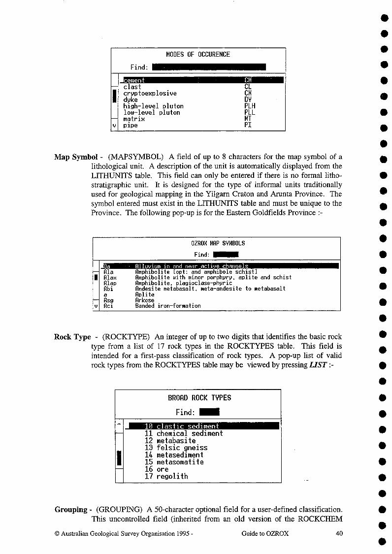
MODES OF OCCURENCE
Find:^•
--I
--v
cement^ CMclast^ CLcryptoexplosive^CHdyke^ DYhigh-level pluton^PLHlow-level pluton^PLLmatrix^ MTpipe^ PI
•••••••
Map Symbol - (MAPSYMBOL) A field of up to 8 characters for the map symbol of alithological unit. A description of the unit is automatically displayed from theLITHUNITS table. This field can only be entered if there is no formal litho-stratigraphic unit. It is designed for the type of informal units traditionallyused for geological mapping in the Yilgarn Craton and Arunta Province. Thesymbol entered must exist in the LITHUNITS table and must be unique to theProvince. The following pop-up is for the Eastern Goldfields Province :-
OZROX MRP SYMBOLS
Find:
a Alluvium in and near active channels-- Ala Amphibolite [opt: and amphibole schist]1 Alex Amphibolite with minor porphyry, aplite and schist
Alap Amphibolite, plagioclase-phyricAbi Andesite metabasalt, meta-andesite to metabasalt
Aplite-- ?Isg Arkosev Aci Banded iron-formation
Rock Type - (ROCKTYPE) An integer of up to two digits that identifies the basic rocktype from a list of 17 rock types in the ROCKTYPES table. This field isintended for a first-pass classification of rock types. A pop-up list of validrock types from the ROCKTYPES table may be viewed by pressing LIST :-
BROAD ROCK TYPES
Find:
---
1
10 clastic sediment11 chemical sediment12 metabasite13 felsic gneiss14 metasediment15 metasomatite16 ore17 regolith
Grouping - (GROUPING) A 50-character optional field for a user-defined classification.This uncontrolled field (inherited from an old version of the ROCKCHEM
© Australian Geological Survey Organisation 1995 -^Guide to OZROX^40
••••••••••••••••••••••••••

VT220 Terminal to AViiONDATA TYPES
- seeValue
OZROX DATABASE^LITHOLOGY(excludes 'MI'^& 'CM' minerals
Attribute & Descri lion
AUTHORITY TABLEAGSOMINERALS table)
& Descri lionULT SK skarnALT ZE zeoliticBED Bedding Thickness LA laminated (<10 mm)BED ME medium (100-300 mm)BED TK thick (300-1000 mm)BED IN thin (30-100 mm)BED VTK very thick (>1000 mm)BED VTN very thin (10-30 mm)CON Coherence PO porousCOH CP compactCON CON consolidatedCON Fl fissleCON FR friableCON HD hardCOH IN induratedCON UN unconsolidatedCOL Colour BK blackCOL BL blue
Count: 33TNVT220 - Novell. Inc.^192.104.43.110
<Re lace>(1)^Re.^12:16^A
••• Database) is used to classify suites of rocks from particular regions into classes• other than those used by other fields on the form. The values entered here are
up to the users and have no global significance.
Lithology Description - (DESCRIPTION) An optional 64-character field for adescription of the lithology. If lithology is insufficiently characterised by theprevious controlled fields then this field should be used for additionalinformation on lithology.
Other Data - (OTHERINFO) A 64-character optional field that may be used for anydata the user feels are relevant that are not covered by the above fields.
Secthole Number - (SECTHOLENO) An integer of up to 5 digits that links the ROCKSrecord to a measured section or drill hole in the SECTHOLES table. This fieldis automatically filled when entering a geological log from the Sectholes Form.
THE LITHDATA BLOCK
The Lithdata Block allows a variety of other attributes to be added to the description of alithology or rock sample - for example, sample purposes, minerals, colour, alteration andmetamorphic grade. Although not displayed in this block, all LITHDATA records auto-matically receive the Rock No. shown at the top-left of the Rocks Form. The attributesand descriptors (values) entered here are controlled by lookup data in the ROCK-DATATYPES view, which is a union of the LITHDATATYPE and AGSOM1NERALStables (see Appendix A). The form relating to the LITHDATATYPES table, accessiblefrom the 'Rocks Forms' submenu, is shown below in Fig 12.
Figure 12. The Lithology Datatypes Form corresponds to the LTHDATATYPES table,defining attributes and values (except minerals) that can be used in the Lithdata Block.
@ Australian Geological Survey Organisation 1995 -^Guide to OZROX^41
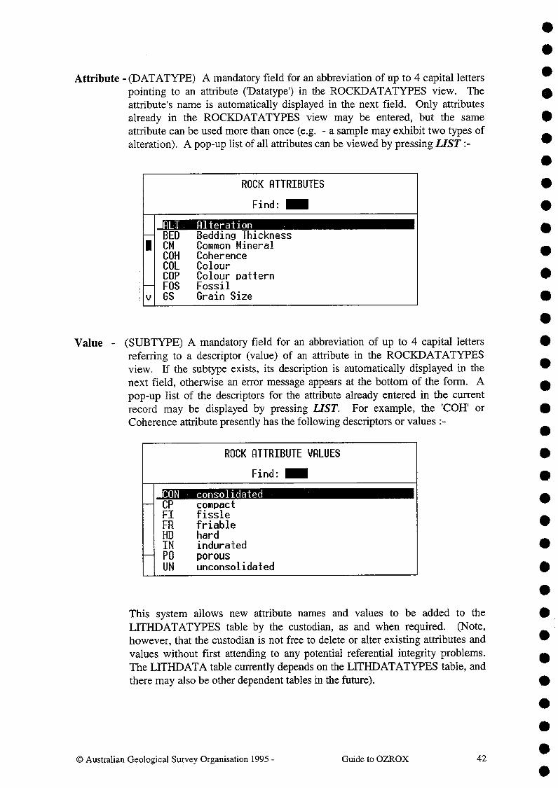
40
•Attribute - (DATATYPE) A mandatory field for an abbreviation of up to 4 capital letters
pointing to an attribute ('Datatype') in the ROCICDATATYPES view. Theattribute's name is automatically displayed in the next field. Only attributesalready in the ROCKDATATYPES view may be entered, but the sameattribute can be used more than once (e.g. - a sample may exhibit two types ofalteration). A pop-up list of all attributes can be viewed by pressing LIST :-
ROCK ATTRIBUTES
Find:
ALT Alteration^ BED Bedding Thickness1 CM Common Mineral
COH CoherenceCOL ColourCOP Colour patternFOS Fossil
v GS Grain Size
Value - (SUBTYPE) A mandatory field for an abbreviation of up to 4 capital lettersreferring to a descriptor (value) of an attribute in the ROCKDATATYPESview. If the subtype exists, its description is automatically displayed in thenext field, otherwise an error message appears at the bottom of the form. Apop-up list of the descriptors for the attribute already entered in the currentrecord may be displayed by pressing LIST. For example, the 'COH' orCoherence attribute presently has the following descriptors or values :-
ROCK ATTRIBUTE VALUES
Find:
CON consolidated-- CP compact
Fl fissleFR friableHD hardIN indurated
-- PO porousUN unconsolidated
This system allows new attribute names and values to be added to theLITHDATATYPES table by the custodian, as and when required. (Note,however, that the custodian is not free to delete or alter existing attributes andvalues without first attending to any potential referential integrity problems.The LITHDATA table currently depends on the LITHDATATYPES table, andthere may also be other dependent tables in the future).
••••411
•••••••••
•••••••••••••
0 Australian Geological Survey Organisation 1995 -^Guide to OZROX^42
••••

AR
MRSISCLV
REFGSISSFTEC
ReferenceGrain SizeInternal StratifSampled forTectonic Feature
ttri uteRGSOREFS RefIDfinemassivethin sectioncleaved
escri)tion ^cars95/28088_
Blewett R.S-Blewett R.S.Blewett R.- Authors
Entered^
Ref.Id27-APR-95
GEODX
95/28088
metamorphic rocks of the Ebagoola 1in Cape York Peninsula, north Queen
SourceAustralian Geological Survey Organisation. Record.
Vol/Part 1992/74
Page-51
Description or Reference - (DESCRIPTION) An optional 64-character field for anydescriptive information relating to the lithdata attribute. However, magneticsusceptability ('MAG') and gamma ray spectrometry CRAM attributes usethis field for the appropriate numeric values. In the case of bibliographicreferences ('REF') attribute, the field is used for a pointer to a reference in theAGSOREFS database (Rybum & Bond 1995). To attach a reference to a rocksample or lithology, a 'REF' attribute and 'AR' value (for AGSOREFS) areplaced in the Lithdata Block, with an AGSOREFS Ref. ID in this field :-
A validation trigger prevents the entry of Ref. IDs not already in AGSOREFS.To view the corresponding reference, just press the LIST function key with thecursor in the description field. The reference is displayed in the AGSOREFSSingle-Author Query form (see Fig. 13 below). Press EXIT to return to theRocks Form. Multiple references may be attached by inserting several 'REF'records in the Lithdata Block. If you press LIST without a Ref. ID in thedescription field the empty Single-Author Query form is displayed. Use it toquery AGSOREFS before attaching a reference to a sample. On returning tothe Lithdata Block, the ID of the selected reference is automatically insertedinto this field.
VT220 Terminal to AVii 0 NRGSOREFS - AGSO'S SHARED BIBLIOGRAPHIC DATABASE - SINGLE-AUTHOR QUERY FORM
Author^Seq Ref.ID Alt.ID Year Title95/28088^
1992 The stratigraphy of metamorphic rRC91/014^
1991 Mineral Provinces No 1. Geology oRC91/031^
1991 Re ional main field databaseiRSeq Reference Details
1992Title
Blewett R.S.^•Trail D.S. .von Gnielinski F.E.
You MUST query thedatabase before adding
a new reference.To add a new referencemove to the Ref Detailblock and then press
Insert Record.
i Year
The stratigraphy of:250 000 sheet aerasland
ick list available. Enter a search clue (e.g. 'Gerono') then ress LIST.Count. .»
<List><Re.lace>TNVT220 - Novell, Inc.
192.104.43.110
(1)
Rep^09:22
Figure 13. Single-Author Query Form from the AGSOREFS database,displaying a reference pointed to from the above Lithdata Block.
43© Australian Geological Survey Organisation 1995 -^Guide to OZROX

•
••••••
••
THE STRUCTURES BLOCK
The Structures Block, corresponding to the STRUCTURES table, allows observations ofmesoscopic to macroscopic geological structures to be related to the lithologies andstratigraphic units in which they are found. This occurs via the Rockno, which, althoughnot displayed, is automatically added to every record entered via this Form. However, notall records in the STRUCTURES table have a RocImo, and the Structures Form (Fig. 15)must be used to access these records. Structural data entered here are controlled by theSTRUCTYPES table, the form for which is shown below in Fig 14.
••••••
Structure - (TYPE) A mandatory integer of up to 2 digits pointing to the structure name(type) in the STRUCTYPES authority table (see Fig. 14). The description ofthe structure type is automatically displayed in the following field - forexample, '1' is for Bedding'. A pop-up list of all Structure Types may beobtained by pressing LIST when the cursor is in the field :-
STRUCTURES
Find:
0 Vector-- 1 Beddin
12 Cleavage3 Foliation4 Igneous Layering5 Axial Surface
-- 6 Fault Planev 7 Vein
••••••••••
Subtype - (SUBTYPE) An integer of up to 2 digits pointing to the structure subtype inthe STRUCTYPES table (see Fig. 14). The description of the subtype isautomatically displayed in the following field - for example, if the StructureType is 1 for Bedding, then a subtype of 14 specifies overturned bedding. Apop-up list of all Subtypes belonging to the Structure Type entered in the firstcolumn may be obtained by pressing LIST :-
STRUCTURE SUBTYPES
Find: •13 Beddin.^horizontal
-- 14 Beddin^overturned12 Bedding^vertical13 Bedding^gen. horizontal4 Bedding^gen. overturned
21 Bedding (facing unknown)-- 1 Bedding (gen. dipping)v 2 Bedding (gen. vertical)
© Australian Geological Survey Organisation 1995 -^Guide to OZROX^44
•••
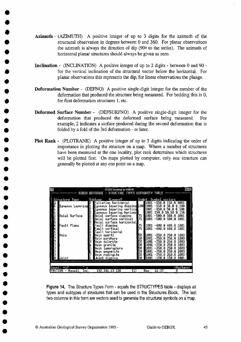
W1220TerminaltoNOWNDATABASE^STRUCTURE TYPES AUTHORITY
Subtv.e^( Le end^Endpt
OZROX
Structure T .
TABLE
S mbol vectorsFoliation horizontal 1001 -150,0 150,0 1001
Igneous Layering 1 Igneous layering dipping 100 1001 -150,0 50,0 0,1004 2 Igneous layering vertica 1001 -150,0 50,0 0,100
4 Igneous layering horizon 1001 150,0 50,50 0,1505 Axial Surface Axial surface dipping 75 1001 -500,0 500,0 10015 2 Axial surface vertical 75 1.001 -500,0 500,0 10015 3 Axial surface horizontal6 Fault Plane 1 Fault dipping 75 1001 -600,0 600,0 10016 2 Fault vertical 75 1001 -600,0 600,0 10016 4 Fault horizontal7 Vein 1 Vein quartz 50 1001 -250,0 250,0 10037 2 Vein porphyry 50 1001 -250,0 250,0 10037 Vein dolerite 50 1001 -250,0 250,0 10037 4 Vein granite 50 1001 -250,0 250,0 10037 Vein lamprophyre 50 1001 -250,0 250,0 10037 6 Vein pegmatite 50 1001 -250,0 250,0 10037 7 Vein rodingite 50 1001 -250,0 250,0 10038 Joint 1 Joint di^in 50 1001 -150 0 150 0 1001
Count: •67^ <Re)lace>INVT220 - Novell^Inc.^192.104.43.110^(1)^Re.^14:37^Fl
Azimuth - (AZIMUTH) A positive integer of up to 3 digits for the azimuth of thestructural observation in degrees between 0 and 360. For planar observationsthe azimuth is always the direction of dip (900 to the strike). The azimuth ofhorizontal planar structures should always be given as zero.
Inclination - (INCLINATION) A positive integer of up to 2 digits - between 0 and 90 -for the vertical inclination of the structural vector below the horizontal. Forplanar observations this represents the dip, for linear observations the plunge.
Deformation Number - (DEFNO) A positive single-digit integer for the number of thedeformation that produced the structure being measured. For bedding this is 0,for first deformation structures 1, etc.
Deformed Surface Number - (DEFSURFNO) A positive single-digit integer for thedeformation that produced the deformed surface being measured. Forexample, 2 indicates a surface produced during the second deformation that isfolded by a fold of the 3rd deformation - or later.
Plot Rank - (PLOTRANK) A positive integer of up to 3 digits indicating the order ofimportance in plotting the structure on a map. Where a number of structureshave been measured at the one locality, plot rank determines which structureswill be plotted first. On maps plotted by computer, only one structure cangenerally be plotted at any one point on a map.
Figure 14. The Structure Types Form - equals the STRUCTYPES table - displays alltypes and subtypes of structures that can be used in the Structures Block. The lasttwo columns in this form are vectors used to generate the structural symbols on a map.
© Australian Geological Survey Organisation 1995 -^Guide to OZROX^
45
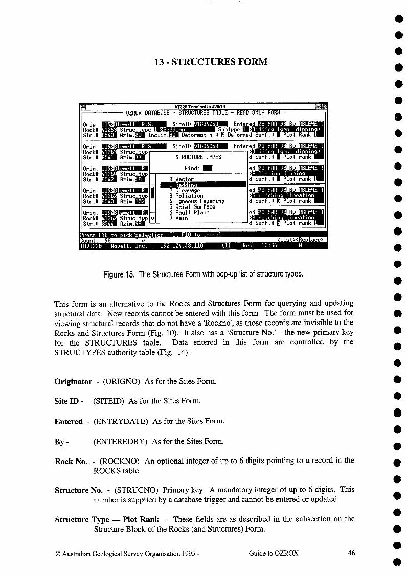
•••
13- STRUCTURES FORM
VT220 Terminal to /APRON^ 1^4STRUCTURES TABLE^READ ONLY FORMOZROX DATABASE
Orig. 119>Blewett. RS.^SiteID 91834050^Entered 23-MAR-93 B^RBLEMETTRock# 41263 Struc-tYPe 1^Beddin^Subtype 1 >Beddin^( en. di^ing)Str.# 8540^Azim.E1 Inclin.80^Deformat'n # 0 Deformed Surf.#^Plot Rank 1
Orig. 119 Blewett. R.S.^SiteID 91834050^Entered 23-MAR-93 B^RBLEMETTRock# 41263 Struc,tmpStr.# 8541^Flzim.filA STRUCTURE TYPES
Find:
>Beddin^(^en.^di) ing)d Surf.*^Plot rank
Orig.^119>Blewett.^R.Rock# 41260 Struc,typStr.# 8542^Azim.ggl
ed 23-11118-93 B^RBLEWETT>Foliation di) inmd Surf.#^Plot rank 1
ed 23-11118-93 B^RBLEWETT>Stretchin^lineationd Surf.# 5 Plot rank
0 Vector1 Beddin2 Cleavage3 Foliation4 Igneous Layering5 Axial Surface6 Fault Plane7 Vein
Orig.^119>B1ewett.• R.Rock# 41262 Struc,typStr.# 8543^Azimiall
II
--v
Orig.^119>Bleviett.^R.Rock# 41262 Strucztyp
ed 23-11118-93 B^RBLEMETT>Stretchin^lineation
5 Plot^1Str.# 8544^Azim.EI^ d Surf.#^rank
ress F10 to^ick'selection. Alt F10 to cancel.Count:^98^v^ <List><Re.lace>T11V1220.- Novell,^Inc..^192.104.43.110^(1)-^Rep^10:36^A
•Figure 15. The Structures Form with pop-up list of structure types.^ •
This form is an alternative to the Rocks and Structures Form for querying and updating^S
structural data. New records cannot be entered with this form. The form must be used forviewing structural records that do not have a 'Rockno', as those records are invisible to theRocks and Structures Form (Fig. 10). It also has a 'Structure No.' - the new primary keyfor the STRUCTURES table. Data entered in this form are controlled by theSTRUCTYPES authority table (Fig. 14).
•Originator - (ORIGNO) As for the Sites Form.
Site ID - (SITED) As for the Sites Form.^ ••
Entered - (ENTRYDATE) As for the Sites Form.^ •By -^(ENTEREDBY) As for the Sites Form.^ •Rock No. - (ROCKNO) An optional integer of up to 6 digits pointing to a record in the
ROCKS table.
Structure No. - (STRUCNO) Primary key. A mandatory integer of up to 6 digits. Thisnumber is supplied by a database trigger and cannot be entered or updated.
Structure Type — Plot Rank - These fields are as described in the subsection on theStructure Block of the Rocks (and Structures) Form.^ •
•
•••
•
•
•
© Australian Geological Survey Organisation 1995 -^Guide to OZROX^46

12978■ .ount Norna luartzite
79/19701 Rank M> Formation. bed
in QLD
2150Max Thick. (m)
Comments Type section follows Weatherly Creek on the east side of Snake Creek Anticline. Cloncurrv 1:100.000 ma) sheet.
TYPE AREA DATA ^SiteIDType State ME Orig.UNI> Glikson.
Count: . <Re.lace>
Parent U.During U.Undlng U.
7064Secthole#
Relationshi
AUSTRALIAN STRATIGRAPHIC LEXICONINSERT/UPDATE and QUERY
Stratno system supplied - query only
Oracle Environment PRODUCTION -
Entered by GEODX on 01-JRN-88Updated by STRATA on 05-SEP-95
.Stratno
Def.Ref.
Age from Offil>Province ppl>
Defined
Palaeo roterozoic
Mount Isa Inlier
Soldiers Cap GroupToole Creek VolcanicsLlewell n Creek Formation
ress LIST to enter the Stratigra)hic Names Form
69200380
Palaeo roterozoic
Status 111>
to ggeu
conformityconformity
•••^
14 - STRATIGRAPHIC LEXICON FORM••
NVT220 - Novell. Inc.^192.104.43.110^(1)^Rep^10:54
Figure 16. The Stratigraphic Lexicon Form.•• AGSO's Stratigraphic Lexicon Form corresponds to the GEODX.STRATLEX view (a
• STRATLEX synonym also exists under STRATA) of the Australian Stratigraphic NamesDatabase (Lenz et al. in prep.), formerly called GEODX (Lenz & Modrak 1992). This
• view includes all stratigraphic names in the GEODX .STRATNAMES table that areclassed as current, and hides from view all names flagged as no longer current.
• Nevertheless, the full Stratigraphic Names Form may still be invoked with the LIST
• function key whenever the cursor is in the Stratigraphic Name field of the above form.Except for a few trusted users, most users are not able to enter new units into STRATLEX.
• Descriptions of the fields in this form are as follows : -
•Entered By - (ENTEREDBY) As for the Sites Form.
•
• On (1) - (ENTRYDATE) As for the Sites Form.
• Updated By - (UPDATED) The Oracle ID of the person who last updated the record.
•^On (2) - (LASTCHANGED) The date the record was last updated.•
Stratno - (UNITNO) System-supplied integer of up to 6 digits that is the primary key of• the GEODX.STRATNAMES table. It is automatically inserted on committing
•^new records to that table. The cursor can enter this field only in query mode.
••
•••••••••••
•^© Australian Geological Survey Organisation 1995 -^Guide to OZROX^47

••
Strat. Name - (UNITNAME) Mandatory 64-character field for the name of a strati-graphic unit, including rank terms that are part of a name - e.g. 'Soldiers CapGroup'. Use initial capitals and lower case letters, except where the rank termis deliberately used with a lower case letter to signify an informal term - e.g.'Corella beds'. The name must be unique. In rare cases, identical names havepreviously been used for different units in different States, and the State isappended in brackets after the name e.g., 'Lake George Formation (NSW)').
in (State) - (STATE) Two or three capital letters indicating the Australian state in whichthe stratigraphic unit falls. This is the only field in the form from theGEODX.STRATSTATES table. Note that `ATA', for Australian Antarcticterritory, is a valid 'State' in this form. About 300 units occur in more thanone state, so several states can be entered here. A pop-up list of valid state IDsmay be seen by pressing LIST.
Defining Reference - (DEFREF) An 8-character ID pointing to the GEODX referencethat defines or redefines the unit. This is normally the bibliographic referencefrom which the information in the current record was taken. Can sometimesbe a map. When the cursor is in this field, pressing LIST invokes a formsimilar to that shown in Fig. 13, automatically displaying the full reference.
Rank - (RANK) A one-digit numeric field indicating the stratigraphic rank of the unit- e.g., Group, Formation, Member, etc. The rank name is automaticallydisplayed from the GEODX.STRATRANK lookup table when a valid numberis entered. A pop-up list of stratigraphic ranks is obtained by pressing theLIST key when the cursor is in the field :-
STRATIGRAPHIC RANK
Find:
1 Su er rou-- 2 Group
3 Subgroup4 Formation, beds5 Member6 Bed
-- 7 unknown
•••••41•••••••••
••••••••
0 Australian Geological Survey Organisation 1995 -^Guide to OZROX^48
••••••
•
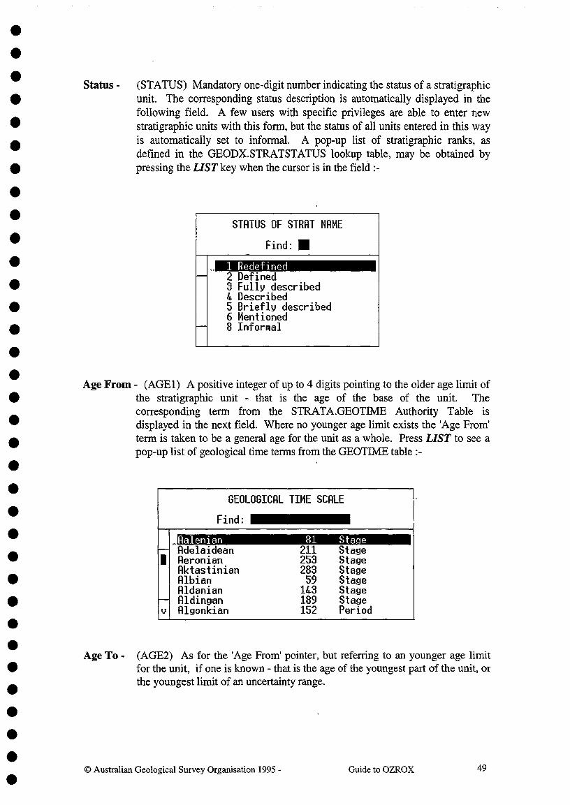
••
Status - (STATUS) Mandatory one-digit number indicating the status of a stratigraphic• unit. The corresponding status description is automatically displayed in the
following field. A few users with specific privileges are able to enter new• stratigraphic units with this form, but the status of all units entered in this way
is automatically set to informal. A pop-up list of stratigraphic ranks, asdefined in the GEODX.STRATSTATUS lookup table, may be obtained by
• pressing the LIST key when the cursor is in the field :-
•STATUS OF SINT NAME
Find:
--
--
1 Redefined2 Defined3 Fully described4 Described5 Briefly described6 Mentioned8 Informal
Age From - (AGE 1) A positive integer of up to 4 digits pointing to the older age limit of• the stratigraphic unit - that is the age of the base of the unit. The
corresponding term from the STRATA.GEOT1ME Authority Table is• displayed in the next field. Where no younger age limit exists the 'Age From'
• term is taken to be a general age for the unit as a whole. Press LIST to see apop-up list of geological time terms from the GEOTIME table :-•
GEOLOGICAL TIME SCALE
Find:
_Ralenian 81 Sta e-- Adelaidean 211 Stage1 Aeronian 253 Stage
Aktastinian 283 StageAlbian 59 StageAldanian 143 Stage
-- Aldingan 189 Stagev Algonkian 152 Period
•Age To - (AGE2) As for the 'Age From' pointer, but referring to an younger age limit
• for the unit, if one is known - that is the age of the youngest part of the unit, orthe youngest limit of an uncertainty range.
•
•••
••
••••••••
•••••••
•^Australian Geological Survey Organisation 1995 -^Guide to OZROX^49

••
Geological Province - (GEOLPROV) An integer of up to 4 digits pointing to the geo-logical province in the STRATA.GEOPROVS table. The name is automatic-ally displayed in the next field. Press LIST to see a list of valid geologicalprovinces. You can also enter a name in the name field and the correspondingnumber is automatically supplied.
GEOLOGICAL PROVINCES OF AUSTRALIA
Find:
Adavale Basin 1 Basin defined-- Adelaide Fold Belt 2 defined1 Albany-Fraser Province 3 defined
Amadeus Basin 4 Basin definedArafura Basin 5 Basin definedArckaringa Basin 6 Basin defined
-- Arnhem Block 7 definedv Arrowie Basin 8 Basin defined
Max. Thickness - (MAXTHICKNESS) An optional number of up to 99999.99 for themaximum known thickness of the stratigraphic unit in metres. The maximumthickness is often from outside the type area.
Comments - (COMMENTS) A scrolling field of 240 characters for comments on theunit, particularly those on any synonymy and the history of definition andnomenclature. Any conflicts with other stratigraphic names in STRATLEXshould also be noted.
TYPE AREA DATA
The part of the form below the horizontal line is for information from the stratigraphicunit's type area or type section. It does not necessarily apply to the unit as a whole.^•
••
Originator - (ORIGNO) As for the Sites Form. The Originator and Site ID fields pointto a record in the SITES table giving the location of the type area or typesection. A Sn'ES record with this Originator and Site "ID must already exist.For type areas to be plotted on maps, sites must be assigned to type areas.
Site ID - (SilbID) As for the Sites Form. See the description of the Originator field.^•••••
© Australian Geological Survey Organisation 1995 -^Guide to OZROX^50
•••••••••••••••••••
Type State - (TYPESTATE) Two or three capital letters indicating the State in Australia(plus `ATA' for Antarctica). A pop-up validation list of states is available bypressing LIST. This field is used to subdivide the database into State subsets. •
••
•

•••Parent Unit - (PARENT) An integer of up to 6 digits pointing to the parent stratigraphic
• unit - i.e., the related unit normally one rank higher. For example, the parentunit for a member would always be a formation, while the parent unit for a
• formation could be a group or a subgroup. The name is automatically shown
• in the following field. A pop-up list of units can be seen by pressing LIST, butan unconstrained listing is very slow owing to the size of the STRATNAMES
• table. A much quicker listing is achieved by entering the first two or threeletters of the name in the following name field and then pressing LIST.
•
• Underlying Unit - (UNDERLYING) An integer of up to 6 digits for the unit number ofthe stratigraphically underlying unit. The name of this unit is automatically
• shown. Only valid Unit Numbers may be entered. A pop-up list of units canbe obtained as described above under Parent Unit.
•• Overlying Unit - (OVERLYING) An integer of up to 6 digits for the Unit Number of the
stratigraphically overlying unit. The name of this unit is automatically shown.• Only valid Unit Numbers may be entered. A pop-up list of units can be
obtained as described above under Parent Unit.
••
Boundary Relationships - (OVEREL, UNDEREL) Two two-digit integer fieldsindicating relationships to the overlying and underlying units. The associated
• terms are automatically displayed from the Stratigraphic Relations Table(STRATA.STRATRELS). Press LIST to obtain a list of terms :-•
RELATIONSHIP TO OVERLYING UNIT
Find:
1 unknown-- 2 not exposed
3 conformity4 unconformity5 disconformity6 nonconformity
-- 7 paraconformity8 diastem
•••••
•••••
0 Australian Geological Survey Organisation 1995 -^Guide to OZROX^51
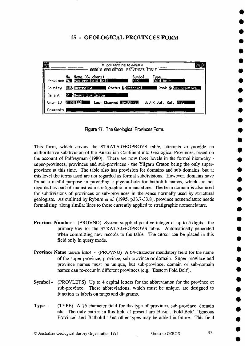
15 - GEOLOGICAL PROVINCES FORM
No. Name (64 chars) Province a Eastern Fold Belt
Country rDml> Status fj> informal Rank ~> Sub- rovince
Parent g> Mount Isa Inlier
User ID STRRTLEX Last Changed irOllllU GEODX Def. Ref. iu:1:t..M!!ri!!UCI:.II __
Comments
Figure 17. The Geological Provinces Form.
This form, which covers the STRAT A.GEOPROVS table, attempts to provide an authoritative subdivision of the Australian Continent into Geological Provinces, based on the account of Palfreyman (1980). There are now three levels in the formal hierarchy -super-provinces, provinces and sub-provinces - the Yilgarn Craton being the only superprovince at this time. The table also has provision for domains and sub-domains, but at this level the terms used are not regarded as formal subdivisions. However, domains have found a useful purpose in providing a pigeon-hole for batholith names, which are not regarded as part of mainstream stratigraphic nomenclature. The term domain is also used for subdivisions of provinces or sub-provinces in the sense normally used by structural geologists. As outlined by Ryburn et at. (1995, p33.7-33.8), province nomenclature needs formalising along similar lines to those currently applied to stratigraphic nomenclature.
Province Number - (PROVNO) System-supplied. positive integer of up to 5 digits - the primary key for the STRATA.GEOPROVS table. Automatically generated when committing new records to the table. The cursor can be placed in this field only in query mode.
Province Name (sensu lata) - (PROVNO) A 64-character mandatory field for the name of the super-province, province, sub-province or domain. Super-province and province names must be unique, but sub-province, domain or sub-domain names can re-occur in different provinces (e.g. 'Eastern Fold Belt').
Symbol- (PROVLETS) Up to 4 capital letters for the abbreviation for the province or sub-province. These abbreviations, which must be unique, are designed to function as labels on maps and diagrams.
Type- (TYPE) A 16-character field for the type of province, sub-province, domain etc. The only entries in this field at present are 'Basin', 'Fold Belt', 'Igneous Province' and 'Batholith', but other types may be added in future. This field
© Australian Geological Survey Organisation 1995 - Guide to OZROX 52
• • • • • • • • • • • • • • • • • • • • • • • • • • • • • • • • • •
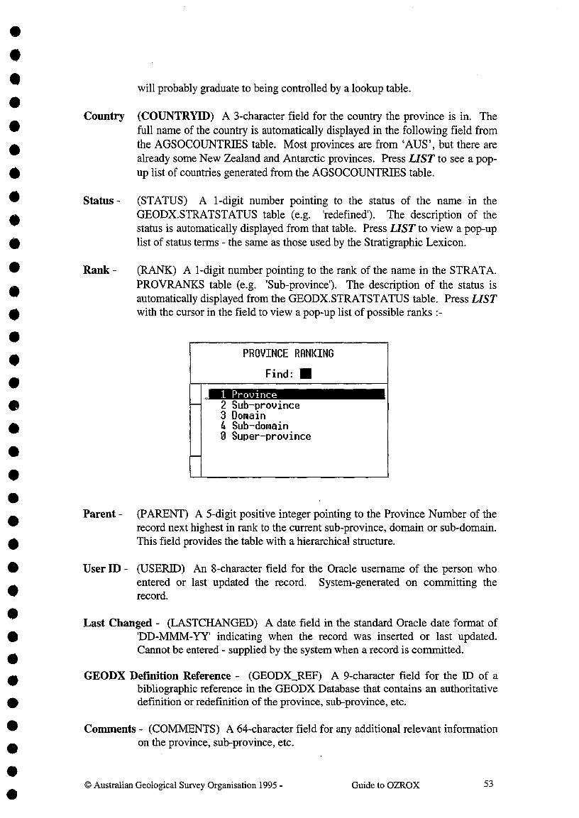
•••^will probably graduate to being controlled by a lookup table.•Country (COUNTRYID) A 3-character field for the country the province is in. The
• full name of the country is automatically displayed in the following field from
• the AGSOCOUNTRIES table. Most provinces are from `AUS', but there arealready some New Zealand and Antarctic provinces. Press LIST to see a pop-
• up list of countries generated from the AGSOCOUNTRIES table.•^Status - (STATUS) A 1-digit number pointing to the status of the name in the
• GEODX.STRATSTATUS table (e.g. 'redefined'). The description of thestatus is automatically displayed from that table. Press LIST to view a pop-up
• list of status terms - the same as those used by the Stratigraphic Lexicon.
Rank - (RANK) A 1-digit number pointing to the rank of the name in the STRATA.PROVRANKS table (e.g. 'Sub-province'). The description of the status isautomatically displayed from the GEODX.STRATSTATUS table. Press LISTwith the cursor in the field to view a pop-up list of possible ranks :-
PROVINCE RANKING
Find:
--
--
1 Province2 Sub-province3 Domain4 Sub-domain0 Super-province
Parent - (PARENT) A 5-digit positive integer pointing to the Province Number of therecord next highest in rank to the current sub-province, domain or sub-domain.This field provides the table with a hierarchical structure.
• User ID - (USERID) An 8-character field for the Oracle usemame of the person whoentered or last updated the record. System-generated on committing the
• record.•^Last Changed - (LASTCHANGED) A date field in the standard Oracle date format of• 'DD-MMM-YY' indicating when the record was inserted or last updated.
•^ Cannot be entered - supplied by the system when a record is committed.
• GEODX Definition Reference - (GEODX_REF) A 9-character field for the ID of abibliographic reference in the GEODX Database that contains an authoritative
• definition or redefinition of the province, sub-province, etc.
• Comments - (COMMENTS) A 64-character field for any additional relevant informationon the province, sub-province, etc.
•••••••••••
•••^© Australian Geological Survey Organisation 1995 -^Guide to OZROX^53

16- THE GEOLOGICAL TIME SCALE FORM
•
••
•Figure 18. The Geological,Time Scale.
The Geological Time Scale Form covers the STRATA.GEOTIME table and displays all •valid geological time terms, one at a time. The table is used to validate appropriate fieldsin the Rocks Form and the Stratigraphic Lexicon Form. It uses a system-supplied number,the Age Number, as its primary key. Like the Stratigraphic Lexicon it is hierarchical, witha Rank field and a pointer to the time term next highest in rank. For example, a sub-stagewould normally have a pointer to the stage to which it belongs. The Time Scale usesGEODX for its bibliography and the form has a field for the GEODX reference lD of theprimary reference for the time term. The fields in this form are as follows :-
Age Number - (AGENO) A mandatory integer of up to 4 digits - the primary key to theGEOTIME table. Automatically allocated when new records are committed.The cursor can enter this field only in query mode.
Age Name - (AGENAME) Mandatory field of 24 characters for the name of thegeological age or time term - e.g. 'Permian'. All words entered should have^•initial capital letter followed by lower, case letters - e.g. 'Early Ordovician'.
•Since this table is meant exclusively for time terms rather than stratigraphicterms, 'Early' and 'Late' should always be used in place of 'Lower' and 'Upper'.^5
Rank -
^
^(RANK) Mandatory single-digit field indicating the Rank of the time term.The Rank Name is automatically displayed from the STRATA.TWIERANK
•lookup table. Alternatively the Name may be entered and the Numberautomatically found. The form covering the TIMERANK lookup table may be •viewed by pressing LIST when the cursor is in either of these fields. Thecurrent contents of the TIMERANK table are as follows :-^ •
© Australian Geological Survey Organisation 1995 -^Guide to OZROX^54

GEOTIME STATUS TERMS
Find: •
1 Current2 Obsolete3 Deleted
GEOTIME RANK TERMS
Find: •--
--
1 Eon2 Erathem3 Period4 Epoch5 Series6 Stage7 Substage8 Unknown
I• Scope - (SCOPE) Mandatory 2-digit integer field indicating the areal scope of the time
term - i.e., to what region does the term apply. For example, the Australian• Ordovician Stage names are used in New Zealand, so the Scope Description is
'Australasian'. The Scope Description is automatically displayed from the• STRATA.TEVIESCOPE lookup table. Alternatively the Description is entered• and the Number automatically selected. The form covering the TINIESCOPE
lookup table may be viewed by pressing LIST when the cursor is in either of• these fields. The following values are currently in TIMESCOPE :-•
GEOTIME SCOPE TERMS
Find:
--
--
1 International2 Australia3 Australasia4 New Zealand5 United Kingdom6 North America7 China
•Status - (STATUS) Mandatory 1-digit field pointing to the Status of a time term. The
Status Description is automatically selected from the STRATA.TIIVIESTATUSlookup table. Alternatively, the Description may be entered and the Number
• automatically retrieved. The form covering the TIMESTATUS lookup tablemay be viewed by pressing LIST when the cursor is in either of these fields.
III^There are only three entries in TIMESTATUS at present :-•
••I^© Australian Geological Survey Organisation 1995 -^Guide to OZROX^55
II••S••
•••S••••
••••

191you art89/32
RC89/032article Noauthors
2.0rdovician. BiostratigrAustralian Phanerozoic timescales:aphic chart and explanatory notes.
56Australian Geological Survey Organisation 1995 -^Guide to OZROX
••Parent - (PARENT) An integer of up to 4 digits that points to the Age Number of the
term next higher in Rank in the GEOTIME table. For example, the parent agefor the Ordovician Period is the Palaeozoic Era. The Age Name of the parentis automatically displayed. Alternatively, the Name may be entered and theNumber automatically displayed. It is possible to view a second copy of theTime Scale Form (i.e., the current form) by pressing LIST when the cursor isin either of these fields. In this way you can query GEOTIME to obtain theParent age term while entering data into the same table.
GEODX Reference ID - (GEODXID) Up to 6 characters for the GEODX lD of theprimary reference to the time term. This is usually the most authoritativereference to the absolute age boundaries of the unit. With the cursor in thisfield, press LIST to view a form with the reference displayed. Most timeterms are referenced by the Records put out by the AGSO Time Scale Project.
Last Altered - (LASTALT) A date field in which the current date is automaticallyinserted whenever a new record is entered or an old one updated. It is notpossible to enter this field, except in query mode. Since the owner STRATAof the GEOTIME table is the only person allowed to enter, update or deletedata, there is no point in recording the ORACLE user ID.
Absolute age Boundaries - To and From - (OLDBOUND, YNGBOUND) These twonumeric fields record the best estimates the custodians can supply of the olderand younger age boundaries for the age term - in millions of years. Thehighest value that can be entered is 99999.999 My. The values entered hereare based on AGSO's Time Scale Project and are subject to continuousrefinement. As far as possible, the ages given are internally consistent, andallow retrievals to be made on the basi of absolute time range, regardless ofthe ranking of the terms. They allow retrievals of the type - 'Get me allsamples aged between Bendigonian and Early Devonian, inclusive'.
Comments - (COMMENTS) A 64-character field for any comments on the age term, orits inferred age boundaries.
•
•••
•••se title
11
•
V1220 Terminal to AViiON
Webby B.D.Nicoll R.S. .
1989
Bureau of Mineral Resources. Australia. Record•a.ination
Australian Stratigraphicpub'n year
ReferencesNames Database11654 13-DEC-89source ID entry date
ublication name

LITHOLOGY NAMES AUTHORITY TABLE
Parent Rock T
17 - LITHOLOGY NAMES FORM
VT220 Terminal to AViiON ffr^ OZROH FIELD DATABASE
•TycleAbbr^Litholo^NameSLT siltARNT areniteAGLT argilliteARKS arkoseBHRK beachrockBIOC biocarbonateBIOM biomicriteBIOS bioSoariteBNBD bone bedBLD boulder'BDST boundstoneCRNL carnieuleCHLK chalk^' •CURT chertCLST clavstoneCOAL coal
7 regolith10 clastic sediment10 clastic sediment10 clastic sediment10 clastic sediment11 chemical sediment11 chemical sediment11 chemical sediment11 chemical sediment10 clastic sediment11 chemical sediment11 chemical sediment11 chemical sediment11 chemical sediment10 clastic sediment
Note - common mineral qualifiers now come from AGSOHINERALS, not this table
O 4lualifier^I=I neous^
S=Sedimentar^H=Hetamor hic^R=Re olith
Count: .*402
<List><Re • lace>TNVT220 - Novell, Inc.^192.104.43.110
Rep^16:53
Figure 19. The Lithology Names Form.
The LITHOLOGIES table corresponding to this form provides a classification oflithologies and their qualifying terms. Although not yet used by any other tables in theOZROX Database, the LITHOLOGIES table includes a pointer to the 'parent' lithologywhen this is appropriate, and a pointer to the ROCKTYPES table. The abbreviations usedin this table, as well as speeding entry of data into the ROCKS form, can be used toannotate computer-generated graphs and maps - where space is often at a premium. Thetable also has a single-letter field indicating the basic class to which each term belongs -igneous (I), sedimentary (S), metamorphic (M), regolith (R), hybrid (H) or qualifier (Q).
Since the original account of this field database (Ryburn et al. 1993a), common mineralnames in the AGSOMMERALS table have been made available as qualifying terms. Thishas been done by setting up the following LITHNAMES view, which is what is actuallyused by the Rocks Form to validate lithological terms and qualifiers :-
CREATE VIEW LITHNAMES AS (SELECT LITHID, QUALIFIER, LITHWAME, PAREIVT, ROCKTYPEFROM LITHOLOGIES
UNIONSELECT MINABBREV, 'Q', MINATAIVE, NULL, TO NUMBER (NULL)FROM AGSOMINERALS WHERE COMMON = ' C ' ) ;
57@ Australian Geological Survey Organisation 1995 -^Guide to OZROX

This LITHOLOGIES table was originally conceived to provide a simple field classificationof lithological names that could be applied in the absence of laboratory data. All terms inthe LITHNAME column were supposed to be single words. However, the tablecustodians, in their wisdom, decided to include all terms from the TUGS classification ofigneous rocks, many of which require a thin section examination or chemical analysis toapply. Unfortunately, multi-word terms like 'volcanic sandstone' and `nepheline syenite'now occur as single-record entries in the table, but can also be expressed as a qualifier(e.g., volcanic) plus a single-word name (e.g., sandstone). Thus, there are often two ormore ways of saying the same thing, and the uniqueness of the lithology terms used hasbeen corrupted. This situation may be solved in the future by introducing into the ROCKStable a separate validated field for TUGS classification. However, screen real estate iscurrently at a premium in the Rocks Form, and such a change must wait until a graphicalclient version of the Rocks Form is developed.
Abbreviation - (LITHID) Up to four capital letters for a unique abbreviation for theEthology or qualifying term. This mandatory field is the primary key to theLITHNAMES table. The shorter abbreviations are supposed to be used for themore common lithological terms. When entering new terms some trial anderror may be needed to find an unused mnemonic abbreviation.
Type -^(QUALIELER) A mandatory single capital letter indicating the basic class ofthe term - qualifier (Q), igneous (I), sedimentary (S), metamorphic (M) orregolith (R). Terms with a Q here are used as an authority list for the Qualifierfield in the ROCKS table. An example of a qualifier term is 'volcanic'. Theother classes provide validation for the Lithname field in the same table.
Lithology Name - (LITHNAME) A mandatory field of up to 32 characters for the litho-logical name or term - e.g. 'shale'. The lithology names entered here aresupposed to be single words. For example, the term 'volcanic sandstone' ismade up of a 'volcanic' qualifier term and 'sandstone' as a sedimentary name.Synonyms should not be entered. For example, the table includes 'dolerite' butnot the equivalent (but less commonly used) term 'diabase'.
Parent - (PARENT) An abbreviation pointing to the related term that is higher in thehierarchy. For example, the term 'norite' points to the parent term 'gabbro'.As indicated by the 'greater-than' symbols in the form, the descriptions of theparent terms do not come from a separate column in the LITHNAMES table,but are merely copied from the Lithology Name field by a form trigger. It isnot possible to enter a parent abbreviation that is not already in the table.Qualifiers and some lithologies do not have parent pointers.
Rock Type - (ROCKTYPE) A two-digit integer pointing to the corresponding basicrocktype in the ROCKTYPES table. The name of the rock type isautomatically displayed in the following field.
•••S••
•••
@ Australian Geological Survey Organisation 1995 -^Guide to OZROX^58

VICVICVICVICNSWNSWNSWNSWNSWNSWNSWNSWNSWNSWNSWNSWNSW
3736.53635.53534.53433.53332.53231.53130.53029.529
•143.5143.5143.5143.5143.5143.5143.5143.5143.5143.5143.5143.5143.5143.5143.5143.5143.5
18 - 1:100 000 MAPS FORM
VT220 Terminal to AViiONMOM FIELD DATABASE 1:100 000 NAPS AUTHORITY TABLE
State^NW Corner^ANG Ref. SW Cnr100K 1M 250K 100KNo. ID No. Name7623 SJ54 8 CRESWICK7624 SJ54 DUNOLLY7625 SJ54 4 WEDDERBURN7626 SI56 16 KERANG7627 5154 16 SWAN HILL7628 8154 12 BALRANALD^•762976307631
SI54SI548154
1288
PRIKAHATFIELD
NE RED7632 SI54 4 DRRNICK7633 SI54 4 MEW7634 SH54 16 MURTEE^•^•7635 SH54. 16 CALLINDRA7636 SH54 12 YANTRBANGEE7637 SH54 12 TONGO7638 SH54 8 URISINO7639 SH54 8 BERAWINNIA DOWNS
m East m North720994 5846708722460 5902191723909 5957671725342 6013147726757 6068619728154 6124087729535 6179552730898 6235013732243 6290470733570 6345924734880 6401374736172 6456820737446 6512263738701 6567703739939 6623139741158 6678571742359 6734000
Count: 21 <Re lace>NVT220'- Novell.. Inc.^192.104.43.110^(1)^Rep^12:23
Figure 20. The 1:100000 Maps Form.
The 1:100 000 Maps Form is included in this guide primarily as an example of a multi-• record form for a straightforward lookup or authority table (HMAPS). Other simple
lookup tables like ORIGINATORS, AGSOCOUNTRIES, QMAPS, LOCMETHODS and• ROCKTYPES have similar forms showing many records, one per line. Most users have• select privileges only on these lookup tables. Attempts to insert new records will elicit the
Oracle error - 'insufficient privileges'. Only the custodians may update these tables. Most• of these forms do an automatic query on start up, so that some data are initially displayed.
• 100K Map Number - (HMAPNO) The four digit number that identifies the 1:100 000map sheet from about 3000 covering Australia. Primary key.
1M Map ID - (MMAND) The 1:1 000 000 map sheet in which the 1:100 000 sheet lies.• This ID consists of two capital letters followed by two numbers - e.g., 'SF54'.
• The two digits are the UTM zone, which is needed to convert metric referencesto latitude and longitude.
250K Map Number - (QMAPID) Up to 2 digits identifying the 1:250 000 map sheet• from 16 covering each 1:1 000 000 map area. The full 1:250 000 map lD is
obtained by joining the 1:1 000 000 map ID to this number - e.g., SF54-12,which is the Winton 1:250 000 map sheet, in Queensland. Note that the 1:250
• 000 map sheets in Tasmania are the theoretical ones, not the ones actuallypublished, which are shifted east-west by 15 minutes.
•
0 Australian Geological Survey Organisation 1995 - Guide to OZROX^59

100K Map Name - (HIvIAPNA.ME) Up to 22 capital letters for the name of the 1:100000 map sheet identified by the 100K Map Number. There are many offshoresheets which are named 'UNNAMED'.
State - Major & Minor - (STATE 1, STATE2) Two fields of 3 characters for the state inwhich the 1:100 000 sheet lies. If only Statel has a value then the sheet isentirely within that state. If the sheet crosses state boundaries then State2indicates the state encompassing the lesser area on the sheet. In Fig. 20, the'SWAN HILL' sheet occurs mainly in NSW, but also partly in VIC. Only 37sheets out of 3000 fall in more than one state. We have deliberately ignoredthe 50 metre discrepancy in the border between VIC and SA.
100K Map NW Corner Lat. & Long. - (N_LAT, W_LONG) The decimal latitude andlongitude of the northwest corner of the 1:100 000 map sheet. It is possible,using a single SQL*Plus command, to make use of these fields to select thename of a 1:100000 map sheet for any given latitude and longitude, e.g. :-
SELECT HMAPNAME, HMAPNO FROM NGMA BMA PSWHERE 21.66 >= N LAT AND 21.66 < N LAT +0.5AND 140.66 >= P1_LONG AND 140.66 < P1_LONG +0.5 ;
The values returned by this example will be 'CLONCURRY' and '7056'.
Another important function of these two fields is to validate new recordsentered into the SITES table. All given latitudes and longitudes can bechecked to see that they fall within the stated 1:100000 map sheet area.
100K Map AMG Ref. SW Corner Easting and Northing - (MEAST, MNORTH) Themetric easting and northing of the southwest comer of the 1:100 000 mapsheet. These values can be used convert a 6-digit grid reference obtained froma 1:100000 map to the full Australian Map Grid metres east and metres north. ••
© Australian Geological Survey Organisation 1995 -^Guide to OZROX^60

••• 19 - ACKNOWLEDGMENTS
•
•Many people have contributed to OZROX during its development - particularly Richard
• Blewett, Lesley Wyborn, Jan Knutson, Peter Stuart-Smith and John Sheraton of AGSO' sRegional Geology and Minerals Division. Linkages to the STRATDAT database were
O^coordinated with John Bradshaw of Marine Petroleum and Sedimentary Resources
• Division. The custodians of the data in OZROX authority tables have already beenmentioned elsewhere in this Record. Some of the ideas incorporated in OZROX stem
O
^
^from discussions between Rod Rybum and staff at the South Australian Department ofMines and Energy, in particular Brian Clough. We also wish to acknowledge the
• assistance of Mirek Kucka and David Walton in the area of Oracle systems and security,
• and their idea of setting up a table to control access to individual data records.
• This Record has benefited greatly from reviews by Sonja Lenz, Richard Blewett and JohnBradshaw.
•
20 - BIBLIOGRAPHY
AUSLIG, 1990. Atlas of Australian Resources. 3rd Series, volume 6, Vegitation.• Australian Surveying and Land Information Group, Canberra.•
Berman, D.M.L., Wood, G.A. & Rybum, R.J., 1994. The development of standards for• Australian geoscience data attributes and their transfer. Proceeding of GeoInfo V,
Prague, Czech Republic, July 20-24, 1994.•
• Blewett, R.S., 1993. The AGSO field geological notebooks - a user's guide. AustralianGeological Survey Organisation, Record, 1993/46.
•Blewett, R.S. & Rybum, R.J., 1992. Recent developments in field-geoscience databases
• in BMR. In: Geographic Information Systems, Cartographic and Data Standards,Workshop Proceedings. Bureau of Mineral Resources, Record, 1992/27, 155-163.
O^Chopra, P. & Ryburn, R.J. 1993 - Linking continental databases in the Oracle RDBMSwith project data in the Arc/Info GIS. Australian Geological Survey Organisation,
• Record, 1993/12.
Chopra, P. & Ryburn, R.J., 1994a. The benefits of linking GIS and RDBMS data sets.
• Proceeding of GeoInfo V, Prague, Czech Republic, July 20-24, 1994.
• Chopra, P. & Ryburn, R.J., 1994b. Integration of GIS and relational databases.Geologicartography, 52, 21-29.
•
•© Australian Geological Survey Organisation 1995 -^Guide to OZROX^61
•
Ewers, G.R. & Ryburn, R.J. 1993. User's guide to the OZMIN mineral deposits database.Australian Geological Survey Organisation, Record, 1993/94.
Ewers, G.R. & Ryburn, R.J., 1994a. OZMIN, AGSO's new mineral deposits database.Geological Society of Australia, 12th Australian Geological Convention, Perth,Western Australia, 26-30 September, 1994, 105.
Ewers, G.R. & Ryburn, R.J., 1994b. OZMIN documentation: AGSO's national mineraldeposits database. Australian Geological Survey Organisation, Record, 1994/43.
Hazel!, M., Kilgour, B., Wyborn, L.A.I., Sheraton, J.W. & Ryburn, R.J., 1995. RockChemdocumentation: AGSO's national whole-rock geochemistry database. AustralianGeological Survey Organisation, Record 1995/26.
Haze11, M.S, Lenz, S. & Ryburn, R.J. 1995. Users' guide to RTMAP regolith landformmapping database. Australian Geological Survey Organisation, Record, 1995/22.
Jaques, A.L., 1992. Second generation maps and the National Geoscience MappingAccord. In: Geographic Information Systems, Cartographic and Data Standards,Workshop Proceedings. Bureau of Mineral Resources, Record, 1992/27, 3-31.
Kucka, M., 1994. AGSO's Oracle Developers' Guide. Australian Geological SurveyOrganisation, Record, 1994/4.
Lenz, S., Ryburn, R.J., Brown, C.E. & Bond L.D., in prep. Guide to the AustralianStratigraphic Names Database. Australian Geological Survey Organisation, Record.
Lenz, S. & Modrak, K., 1990. The Stratigraphic Index Database, GEODX - User Manual.Bureau of Mineral Resources, Australia, Record, 1990/16.
Lenz, S.L. & Pain C., 1992. Categorising descriptive data with reference to the regolithand environmental geoscience databases. In: Geographic Information Systems,Cartographic and Data Standards, Workshop Proceedings. Bureau of MineralResources, Australia, Record, 1992/27, 173-179.
Lenz, S.L., Ryburn, R.J. & Kucka, M., 1993. Users' Guide to AGSO's Oracle DatabaseSystem. Australian Geological Survey Organisation, Record, 1993/81.
Page, R.W., Wyborn, L.A.I., Hazell, M.S., & Ryburn, R.J., 1993. OZCHRONdocumentation. Australian Geological Survey Organisation, Record, 1993/44.
Palfreyman, W.D., 1984. Guide to the geology of Australia. Bureau of MineralResources, Australia, Bulletin 181.
Radke, S.G., 1991. Paper to mass storage - Evolution of digital petroleum databases atBMR. Proceedings of the National Conference on the Management of GeoscienceInformation and Data, Adelaide. 22-25 July, 1991, 59-73.
Ryburn, R.J., 1990. Users' Guide to the PetChem Database. Bureau of MineralResources, Australia, Record 1990/19.
© Australian Geological Survey Organisation 1995 -^Guide to OZROX^
62
•
•••Rybum, R.J., 1992. Relational databases for continent-wide data. In: Geographic
Information Systems, Cartographic and Geoscience Data Standards, WorkshopProceedings. Bureau of Mineral Resources, Record, 1992/27, 139-147.
Rybum, R.J., 1995. Simplifying relational geological databases by generalisation. In:Second National Forum on GIS in the Geosciences, Proceedings. AustralianGeological Survey Organisation, Record 1995/46.
Rybum, R.J., Blewett, R.S., Stuart-Smith, P.G., & Williams, P.R., 1993. Users' guide tothe NGMA Field Database. Australian Geological Survey Organisation, Record,1993/47.
Rybum, R.J. & Bond, L.D., 1995. Guide to AGSOREFS: AGSO's shared bibliographicreference database. Australian Geological Survey Organisation, Record, 1995/6.
• Ryburn, R.J., Ewers, G.R., Knutson, J. & Cruikshank, B.I., 1994b. New developments in• AGSO's geoscientific databases. Geological Society of Australia, 12th Australian
Geological Convention, Perth, Western Australia, 26-30 September, 1994, 392.•
Rybum, R.J., Knutson, J., Duggan, M.B., Bond, L.D. & Haze11, M.S., 1994c. Users'• guide to PETROG, AGSO's petrography database. Australian Geological Survey• Organisation, Record, 1994/36.
• Rybum, R.J. & Lenz, S., 1991. Geoscientific relational databases in BMR and the client-server method. Proceedings of the National Conference on the Management of
• Geoscience Information and Data, Adelaide, 1991, (7) 1 - 15.
Ell Rybum, R.J., Lenz, S., Brown, C.E. & Bond, L.D., 1995. The new national stratigraphic• names database. In: Third National Conference on the Management of Geoscience
Information and Data, Proceedings. Australian Mineral Foundation, Adelaide, July• 18-20, 1995.
•^Rybum, R.J., Page, R.W. & Richards, J.R. 1993b. Users' Guide to the OZCHRON• Database of Australian Geochronology. Australian Geological Survey Organisation,
Record, 1993/11.
Standards Association of Australia 1983 Australian standard 2632-1983: Codes for therepresentation of names of countries. Standards Association of Australia, Sydney.
Steed, J., 1995. The geocentric datum of Australia - a coordinate system for the 21stcentury. In: Second National Forum on GIS in the Geosciences, Proceedings.Australian Geological Survey Organisation, Record 1995/46.
Wyatt, B., 1994. Australian Geological Survey Organisation national biostratigraphicdatabase: STRATDAT user's guide. Version 2, May 1994. Wyatt & Associates,Canberra.
Wyborn, L.A.I. & Rybum, R.J., 1989. PetChem data set: Australia and Antarctica -Documentation. Bureau of Mineral Resources, Record, 1989/19.
© Australian Geological Survey Organisation 1995 -^Guide to OZROX^63
•
APPENDIX A - OZROX DATABASE DEFINITIONS
REM ****************************************************************************
REM *** OZROX FIELD GEOLOGY DATABASE - OWNER IS NGMA UNLESS OTHERWISE SHOWN ***
REM *** FOR SIMPLICITY, ALL STORAGE SPECIFICATIONS ARE OMITTED FROM SCHEMA ***REM ****************************************************************************
REM **************************************************************************
REM *** OZROX_USERS TABLE CONTROLS RECORD-LEVEL SECURITY OF GEOL DATABASES ***REM **************************************************************************
CREATE TABLE OZROX_USERS (
USER1^VARCHAR2(8) NOT NULL,
USER2^VARCHAR2(8) NOT NULL,
DB1^VARCHAR2(1),^/* CORRESPONDS WITH OZROX^*/DB2^VARCHAR2(1),^/* CORRESPONDS WITH ROCKCHEM */DB3^VARCHAR2(1),^/* CORRESPONDS WITH RTMAP^*/DB4^VARCHAR2(1),^/* CORRESPONDS WITH OZMIN^*/DB5^VARCHAR2(1).^/* NOT YET ALLOCATED^*/
DB6^VARCHAR2(1),
DB7^VARCHAR2(1),
DES^VARCHAR2(1),
DB9^VARCHAR2(1),
DB10^VARCHAR2(1) );
ALTER TABLE OZROX_USERS ADD CONSTRAINT PK_OZROX_USERS
PRIMARY KEY ( USER1, USER2 );
GRANT SELECT ON OZROX_USERS TO INTERNAL;
REM *************************************************************************
REM *** THE MAXNOS TABLE IS USED TO KEEP TRACK OF SYSTEM-GENERATED KEYS ***REM *************************************************************************
CREATE TABLE MAXNOS (
IDMAXNO^VARCHAR2 (6)^NOT NULL,
NANO^NUMBER (6,0) NOT NULL );
ALTER TABLE MAXNOS ADD CONSTRAINT PKLMAXNOS PRIMARY KEY ( IDMAXNO );
GRANT SELECT, UPDATE ON MAXNOS TO INTERNAL;
REM *****************************************************************
REM *** THE FOLLOWING LOOKUP TABLES ARE USED BY THE SITES TABLE ***REM *****************************************************************
REM ORIGINATORS IS THE AUTHORITY TABLE FOR ORIGINATORS
CREATE TABLE ORIGINATORS (
OR/GNO^NUMBER (5,0) NOT NULL,
ORIGINATOR VARCHAR2 (22) NOT NULL,
OWNER^VARCHAR2 (8) );
0 Australian Geological Survey Organisation 1995 -^Guide to OZROX^64^•

ALTER TABLE ORIGINATORS ADD CONSTRAINT PK_ORIGINATORS
PRIMARY KEY ( ORIGNO );
CREATE UNIQUE INDEX ORIGINATORS_ORIGINATOR ON ORIGINATORS ( ORIGINATOR );
GRANT SELECT ON ORIGINATORS TO EXTERNAL;
REM AGSOCOUNTRIES IS THE AUTHORITY TABLE FOR COUNTRIES
CREATE TABLE AGSOCOUNTRIES (
COUNTRYID^VARCHAR2 (3)^NOT NULL,
COUNTRYNAME VARCHAR2 (32)^NOT NULL );
ALTER TABLE AGSOCOUNTR/ES ADD CONSTRAINT PK_AGSOCOUNTRIES
PR/MARY KEY ( COUNTRYID
GRANT SELECT ON AGSOCOUNTRIES TO EXTERNAL;
REM AGSOSTATES IS THE AUTHORITY TABLE FOR AUSTRALIAN STATES
CREATE TABLE AGSOSTATES (
STATEID^VARCHAR2 (3)^NOT NULL,
STATENAME^VARCHAR2 (32)^NOT NULL );
ALTER TABLE AGSOSTATES ADD CONSTRAINT PK_AGSOSTATES
PRIMARY KEY ( STATEID );
GRANT SELECT ON AGSOSTATES TO EXTERNAL;
REM^LOOKUP TABLE FOR GEOLOGICAL REGIONS, AS DISTINCT FROM PROVINCES
CREATE TABLE GEOREGIONS (REGNO NUMBER (3,0) NOT NULL,PROVNO NUMBER (3,0) NOT NULL,REGNAME VARCHAR2 (64) NOT NULL,REGLETS VARCHAR2 (4),COUNTRY/D VARCHAR2 (3) NOT NULL,COMMENTS VARCHAR2 (64),ENTEREDBYENTRYDATE
VARCHAR2DATE
(5) NOT NULL,NOT NULL)
ALTER TABLE GEOREGIONS ADD CONSTRAINT PK_GEOREGIONS
PRIMARY KEY ( REGNO );
ALTER TABLE GEOREGIONS ADD CONSTRAINT FK_GEOREGIONLCOUNTRYID
FOREIGN KEY ( COUNTRYID ) REFERENCES AGSOCOUNTRIES ( COUNTRYID );
REM QMAPS IS THE AGSO 1:250,000 MAP SHEET AUTHORITY TABLE
CREATE TABLE QMAPS (MAPNO^VARCHAR2 (6,0)^NOT NULL,MAPNAME^VARCHAR2 (22),
N_LAT^NUMBER (3,1),
W_LONG^NUMBER (4,1) );
ALTER TABLE QMAPS ADD CONSTRAINT PK_QMAPS
PRIMARY KEY ( MAPNO );
0 Australian Geological Survey Organisation 1995 -^Guide to OZROX^
65

CREATE UNIQUE INDEX QMAPNAMES ON QMAPS ( MAPNAME );
GRANT SELECT ON QMAPS TO EXTERNAL;
REM^HMAPS IS THE AGSO 1:100,000 MAP
CREATE TABLE HMAPS (
SHEET AUTHORITY TABLE
HMAPNO NUMBER (4,0) NOT NULL,
MMAPID VARCHAR2 (4),QMAPNO NUMBER (2,0),
HMAPNAME VARCHAR.2 (22),
N_LAT NUMBER (3,1),W_LONG NUMBER (4,1),
MEAST NUMBER (8),MNORTH NUMBER (7),
STATE1 VARCHAR2 (3), /* STATE WITH THE MAJOR MAP PORTION */STATE2 VARCHAR2 (3)^); /* STATE WITH THE MINOR MAP PORTION */
ALTER TABLE HMAPS ADD CONSTRAINT PK_HMAPS PRIMARY KEY ( HMAPNO );
CREATE INDEX HMAPNAMES ON HMAPS ( HMAPNAME );
CREATE INDEX HMAPLATS ON HMAPS ( N_LAT );
CREATE INDEX HMAPLONGS ON HMAPS ( W_LONG );
GRANT SELECT ON HMAPS TO EXTERNAL;
REM LOCMETHODS IS THE AUTHORITY TABLE FOR LOCATION METHODS
CREATE TABLE LOCMETHODS (
LOCMETHNO^NUMBER (3,0) NOT NULL,
LOCMETHOD^VARCHAR2 (64) NOT NULL,
ACCURACY^NUMBER (4) );
ALTER TABLE LOCMETHODS ADD CONSTRAINT PK_LOCMETHODS PRIMARY KEY ( LOCMETHNO );
GRANT SELECT ON LOCMETHODS TO EXTERNAL;
REM ***********************************
REM *** THE MAIN SITES DATA TABLE ***REM ***********************************
CREATE TABLE SITES (ORIGNO NUMBER (5,0) NOT NULL,SITEID VARCHAR2 (16) NOT NULL,FIELDID
OBSDATE
OBSTIME
VARCHAR2
DATE,
NUMBER
(16),
(4,2),
COUNTRYID VARCHAR2 (3) NOT NULL,
STATE VARCHAR2 (3).REGNO NUMBER (5,0),
GEOGAREA VARCHAR2 (64),
LOCDESC VARCHAR2 (64),
HMAPNO NUMBER (4,0),
QMAPID VARCHAR2 (6),
EASTING NUMBER (8,2),
© Australian Geological Survey Organisation 1995 -^Guide to OZROX^66

NORTHING NUMBER (9,2),
ACCURACY NUMBER (5,0) NOT NULL,
HEIGHT NUMBER (5,0),
HEIGHTACC NUMBER (3,0),
DLAT NUMBER (8,6),
NS VARCHAR2 (1),DLONG NUMBER (9,6),
EN VARCHAR2 (1),
METHOD NUMBER (3,0) NOT NULL,
BIBREF VARCHAR2 (0), /* POINTS TO AGSOREFS.REFID */
AIRPHOTO VARCHAR2 (36),OC VARCHAR2 (1), /* OUTCROPS^TABLE^*/
SE VARCHAR2 (1), /* SECTHOLES^TABLE^*/
HO VARCHAR2 (1), /* ROCKS^TABLE^*/
ST VARCHAR2 (1), /* STRUCTURE^TABLE^*/
PE VARCHAR2 (1), /* PETROGRAPHY DATABASE */
RC VARCHAR2 (1), /* ROCKCHEM^DATABASE */
OZ VARCHAR2 (1), /* OZCHRON^DATABASE */
ON VARCHAR2 (1), /* OZMIN^DATABASE */
SC VARCHAR2 (1), ./* STREAMCHEM^DATABASE */RT VARCHAR2 (1), /* REGOL/TH^DATABASE */RP VARCHAR2 (1), /* ROCKPROPS^DATABASE */SP VARCHAR2 (1), /* SPECPROPS^DATABASE */RS VARCHAR2 (1) /* ROCKSTOR^DATABASE */ENTEREDBY
ENTRYDATE
LASTUPDATE
VARCHAR2
DATE
DATE );
(8) NOT NULL,
NOT NULL,
ALTER TABLE SITES ADD CONSTRAINT PELSITES
PRIMARY KEY ( ORIGNO, SITEID );
ALTER TABLE SITES ADD CONSTRAINT FK_ORIGINATORS
FOREIGN KEY ( OR/GNO) REFERENCES ORIGINATORS ( ORIGNO );
ALTER TABLE SITES ADD CONSTRAINT FIC_AGSOCOUNTRIES
FOREIGN KEY ( COUNTRYID ) REFERENCES AGSOCOUNTR/ES ( COUNTRYID );
ALTER TABLE SITES ADD CONSTRAINT FR_AGSOSTATES
FOREIGN KEY ( STATE ) REFERENCES AGSOSTATES ( STATEID );
ALTER TABLE SITES ADD CONSTRAINT FK_GEOREGIONS
FOREIGN KEY ( REGNO ) REFERENCES GEOREGIONS ( REGNO );
ALTER TABLE SITES ADD CONSTRAINT FK_QMAPS
FOREIGN KEY ( QMAPID ) REFERENCES QMAPS ( MAPNO );
ALTER TABLE SITES ADD CONSTRAINT FK HEAPS
FOREIGN KEY ( HMAPNO ) REFERENCES HMAPS ( HMAPNO );
ALTER TABLE SITES ADD CONSTRAINT FK_LOCMETHODSFOREIGN KEY ( METHOD ) REFERENCES LOCMETHODS ( LOCMETHNO );
CREATE INDEX SITESIDS ON SITES ( SITEID );CREATE INDEX SITESUSERS ON SITES ( ENTEREDBY );CREATE INDEX SlTESHMAPS ON SITES ( HMAPNO );CREATE INDEX SITESQMAPS ON SITES ( QMAPID );
CREATE INDEX SITESDLATS ON SITES ( DLAT );
CREATE INDEX SITESDLONGS ON SITES ( DLONG );
CREATE INDEX SITESSTRUC ON SITES ( ST );
0 Australian Geological Survey Organisation 1995 -^Guide to OZROX^
67

CREATE INDEX SITESSC ON SITES ( SC );
CREATE INDEX SITESRP ON SITES ( RP );
CREATE INDEX SITESOZMIN ON SITES ( ON );
CREATE INDEX SITESRTMAP ON SITES ( RT );
GRANT SELECT ON SITES TO EXTERNAL;
REM US/TES IS THE INSERT/UPDATE VIEW OF THE SITES TABLE
CREATE VIEW USITES AS SELECT * FROM SITES WHERE ENTEREDBY IN
( SELECT USER2 FROM NGMA.OZROX_USERS WHERE DB1 = 'X' AND USER = USER1 );
REM DATABASE PRE-UPDATE TRIGGER INSERTS DATE OF LAST UPDATE TO SITES
CREATE TRIGGER UPD_SITES
BEFORE UPDATE ON SITES
FOR EACH ROW
BEGIN
-- UPDATE LASTUPDATE FIELD TO TODAYS DATE BUT ONLY IF NECESSARY,
TO AVOID "ALTERED BY ANOTHER USER" PROBLEMS IN FORMS.
BEGIN
IF NVL(:NEW.LASTUPDATE,TO_DATE( 1 01-JAN-1900','DD-MON-YYYY'))
!= TRUNC(SYSDATE) THEN
:NEW.LASTUPDATE := TRUNC(SYSDATE);
END IF;
EXCEPTION WHEN OTHERS THEN NULL;
END;
END;
REM ********************************************************************
REM *** THE FOLLOWING LOOKUP TABLES ARE USED BY THE OUTCROPS TABLE ***REM ********************************************************************
REM ******************************************************
REM *** THE FOLLOWING TABLE BELONGS TO QUATDB ***REM ******************************************************
REM AGSO VEGETATION TABLE - READ-ONLY PUBLIC SYNONYM
CREATE TABLE VEGET (
V_CODE^VARCHAB2 (5) NOT NULL, /* PRIMARY KEY */
V_DESC^VARCHAR2 (60) NOT NULL );
GRANT SELECT ON VEGET TO EXTERNAL;
REM * ****** ***********************************************
REM *** THE FOLLOWING TABLE BELONGS TO RTMAP ***REM ******************************************************
REM AGSO LANDFORMS TABLE - READ-ONLY PUBLIC SYNONYM
CREATE TABLE LANDF (
L_CODE^VARCHAB2 (4) NOT NULL, /* PRIMARY KEY */L_DESC^VARCHAR2 (30) NOT NULL );
GRANT SELECT ON LANDF TO EXTERNAL;
Australian Geological Survey Organisation 1995 -^Guide to OZROX^68
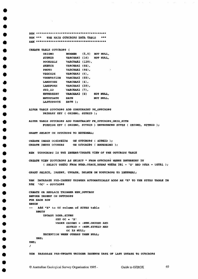
REM ****************************************
REM *** THE MAIN OUTCROPS DATA TABLE ***REM ****************************************
CREATE TABLE OUTCROPS (
ORIGNO NUMBER (5,0) NOT NULL,
SITEID VARCHAR2 (16) NOT NULL,
ROCKRELS VARCHAR2 (128),
SKETCH VARCHAR2 (64),
PHOTO VARCHAR2 (64),
VEGCODE VARCHAR2 (5),
VEGETATION VARCHAR2 (60),
LANDCODE VARCHAR2 (4),
LANDFORM VARCHAR2 (30),
STD_ID VARCHAR2 (7),
ENTEREDBY
ENTRYDATELASTUPDATE
VARCHAR2
DATEDATE );
(8) NOT NULL,
NOT NULL,
ALTER TABLE OUTCROPS ADD CONSTRAINT PE_OUTCROPSPRIMARY KEY ( ORIGNO, SITEID );
ALTER TABLE OUTCROPS ADD CONSTRAINT FK_OUTCROPS_ORIG_SITE
FOREIGN KEY ( ORIGNO, S/TEID ) REFERENCES SITES ( ORIGNO, SITEID );
GRANT SELECT ON OUTCROPS TO EXTERNAL;
CREATE INDEX OCSITEIDS ON OUTCROPS ( SITEID );
CREATE INDEX OCUSERS^ON OUTCROPS ( ENTEREDBY );
REM UOUTCROPS IS THE INSERT/UPDATE VIEW OF THE OUTCROPS TABLE
CREATE VIEW UOUTCROPS AS SELECT * FROM OUTCROPS WHERE ENTEREDBY IN
( SELECT USER2 FROM NGMA.OZROX_USERS WHERE DB1 = IX' AND USER = USER1 );
GRANT SELECT, INSERT, UPDATE, DELETE ON UOUTCROPS TO INTERNAL;
REM DATABASE PRE-INSERT TRIGGER AUTOMATICALLY ADDS AN "X" TO THE SITES TABLE IN
REM IOC' = OUTCROPS
CREATE OR REPLACE TRIGGER NEW_OUTCROP
BEFORE INSERT ON OUTCROPS
FOR EACH ROW
BEGIN
-- Add "X" to OC column of SITES table
BEGIN
UPDATE NGMA.S/TESSET OC =WHERE ORIGNO = :NEW.ORIGNO AND
SITEID = :NEW.SITEID ANDOC IS NULL;
EXCEPTION WHEN OTHERS THEN NULL;
END;
END;
REM DATABASE PRE-UPDATE TRIGGER INSERTS DATE OF LAST UPDATE TO OUTCROPS
0 Australian Geological Survey Organisation 1995 -^Guide to OZROX^69

CREATE TRIGGER UPD_OUTCROPS
BEFORE UPDATE ON OUTCROPS
FOR EACH ROW
BEGIN
-- UPDATE LASTUPDATE FIELD TO TODAYS DATE BUT ONLY IF NECESSARY,
-- TO AVOID "ALTERED BY ANOTHER USER" PROBLEMS IN FORMS
BEGIN
IF NVL(:NEW.LASTUPDATE,TO_DATE( 1 01-JAN-1900',IDD-MON-YYYY'))
!= TRUNC(SYSDATE) THEN
:NEW.LASTUPDATE := TRUNC(SYSDATE);
END IF;
EXCEPTION WHEN OTHERS THEN NULL;
END;
END;
REM *********************************************************************
REM *** THE FOLLOWING LOOKUP TABLES ARE USED BY THE SECTHOLES TABLE ***RED/ *********************************************************************
REM LOOKUP TABLE FOR MEASURED SECTION AND DRILL-HOLE TYPES
CREATE TABLE SECTYPES (
FLAG^VARCHAR2(1)^
NOT NULL,
FLAGNAME^VARCHAR2(24)^
NOT NULL );
ALTER TABLE SECTYPES ADD CONSTRAINT PR_SECTYPES PRIMARY KEY ( FLAG );
GRANT SELECT ON SECTYPES TO EXTERNAL;
REM ************************************************************************
REM *** MAIN DATA TABLE TABLE FOR THE MEASURED SECTION/DRILLHOLE ENTITY **REM ************************************************************************
CREATE TABLE SECTHOLES (
SECTHOLENO NUMBER (5,0) NOT NULL,
ORIGNO^NUMBER (3,0) NOT NULL, .
SITEID^VARCHAR2(16) NOT NULL,
SECTYPE^VARCHAR2(1)^NOT NULL,
TYPESEC^VARCHAR2(1)^NOT NULL,
PEDIN_UNO^VARCHAR2(8),^/* REFERS TO NPD.NPD WELLS.UNO */DH_COMPANY VARCHAR2(48),
DH_ID^VARCHAR2(48),AV_AZIMUTH
AV_INCLIN
TOT_METRES
BEDPERP
REFID
UPORDOWN
ENTEREDBY
ENTRYDATE
LASTUPDATE
NUMBER (3,0),
NUMBER (2,0),
NUMBER (6,2),
VARCHAR2(1) NOT NULL,
VARCHAR2(9),^/* REFERS TO AGSOREFS.REFID */
VARCHAR2(1)^DEFAULT '"?' NOT NULL,
VARCHAR2(8)^NOT NULL,
DATE^NOT NULL,
DATE ):
ALTER TABLE SECTHOLES ADD CONSTRAINT PK _SECTHOLES PRIMARY KEY (SECTHOLEN0);
ALTER TABLE SECTHOLES ADD CONSTRAINT FK_SECTHOLES_ORIGNO_SITEID
0 Australian Geological Survey Organisation 1995 -^Guide to OZROX^70

FOREIGN KEY (ORIGNO,SITE/D) REFERENCES SITES ( ORIGNO,SITEID );
ALTER TABLE SECTHOLES ADD CONSTRAINT FK_SECTHOLES_ORIGNO
FOREIGN KEY (ORIGNO) REFERENCES ORIGINATORS;
ALTER TABLE SECTHOLES ADD CONSTRAINT FX_SECTHOLES_SECTYPE
FOREIGN KEY (SECTYPE) REFERENCES NGMA.SECTYPES;
ALTER TABLE SECTHOLES ADD CONSTRAINT CKLSECTHOLES_TYPESEC
CHECK (TYPESEC IN ('0','R','T'));
ALTER TABLE SECTHOLES ADD CONSTRAINT CK_SECTHOLES_AV_AZIMUTH
CHECK (AV AZIMUTH BETWEEN 0 AND 359);
ALTER TABLE SECTHOLES ADD CONSTRAINT CK_SECTHOLES_AV_/NCL/N
CHECK (AV INCLIN BETWEEN -90 AND 90);
ALTER TABLE SECTHOLES ADD CONSTRAINT CK_SECTHOLES_BEDPERP
CHECK (BEDPERP IN ( I N I . 1 1"));
ALTER TABLE SECTHOLES ADD CONSTRAINT CK_SECTHOLES_UPORDOWN
CHECK (UPORDOWN IN ('U', ID', 'V));
CREATE INDEX SHORIGSITES ON SECTHOLES(ORIGNO,SITE1D);
CREATE INDEX SHENTEREDBY ON SECTHOLES(ENTEREDBY);
CREATE INDEX SHSECTYPES ON SECTHOLES(SECTYPE);
CREATE INDEX SHTYPESEC ON SECTHOLES(TYPESEC);
REM USECTHOLES IS THE INSERT/UPDATE VIEW OF THE SECTHOLES TABLE
CREATE VIEW USECTHOLES AS SELECT * FROM NGMA.SECTHOLES WHERE ENTEREDBY IN
( SELECT USER2 FROM NGMA.OZROX_USERS WHERE DB1 = 'X' AND USER = USER1 );
GRANT SELECT, INSERT, UPDATE, DELETE ON USECTHOLES TO INTERNAL;
REM DATABASE PEE-INSERT TRIGGER AUTOMATICALLY ENTERS NEW PRIMARY KEY VALUE
REM INTO SECTHOLES AND ADDS AN "X" TO THE SITES TABLE IN 'SR' = SECTHOLES.
CREATE OR REPLACE TRIGGER NEW SECTHOLENO
BEFORE INSERT ON SECTHOLES
FOR EACH ROW
BEGIN
IF :NEW.SECTHOLENO IS NULL THEN
SELECT MAXNO + 1, NVL(:NEW.ENTRYDATE,TRUNC(SYSDATE)),
NVL( NEW.ENTEREDBY,USER)
INTO :NEW.SECTHOLENO,:NEW.ENTRYDATE,:NEW.ENTEREDBY
FROM MAXNOS WHERE
IDMAXNO = 'SECTHOLEN0';
UPDATE MAXNOS SET MAO = MO + 1 WHERE IDMAXNO = 'SECTHOLEN0';
END IF;-- ADD "X" TO SR COLUMN OF SITES TABLE
BEGINUPDATE NGMA. SITES
SET SRWHERE ORIGNO = :NEW.ORIGNO AND
SITEID = :NEW.SITEID AND
SR IS NULL;
EXCEPTION WHEN OTHERS THEN NULL;
END;
0 Australian Geological Survey Organisation 1995 -^Guide to OZROX^71

END;
REM DATABASE PRE-UPDATE TRIGGER INSERTS DATE OF LAST UPDATE TO SECTHOLES
CREATE TRIGGER UPD_SECTHOLES
BEFORE UPDATE ON SECTHOLES
FOR EACH ROW
BEGIN-- UPDATE LASTUPDATE FIELD TO TODAYS DATE BUT ONLY IF NECESSARY,
TO AVOID "ALTERED BY ANOTHER USER" PROBLEMS IN FORMS.
BEGINIF NVL(:NEW.LASTUPDATE,TO_DATE( 1 01-JAN-1900',IDD-MON-YYTY'))
!= TRUNC(SYSDATE) THEN:NEW.LASTUPDATE := TRUNC(SYSDATE);
END IF;EXCEPTION WHEN OTHERS THEN NULL;
END;
END;
REM LOOKUP TABLE FOR INTERIZON RECORD TYPES + COLUMN HEADERS FOR SECTHOLES FORM
CREATE TABLE /Z_RECTYPES (
RECTYPE^VARCHAR2(3)^NOT NULL,
RECNAME^VARCHAR2(16)^NOT NULL,
PHEADER^VARCHAR2(10),
LHEADER^VARCHAR2(10),
Q1HEADER^VARCHAR2(10),
Q2HEADER^VARCHAR2(10),
Q3HEADER^VARCHAR2(10),
CHEADER^VARCHAR2(10),
POINT^VARCHAR2(1)^DEFAULT 'N',
PCT_ENABLED VARCHAR2(1)^DEFAULT 'N'
ALTER TABLE IZ_RECTYPES ADD CONSTRAINT PK_IZ_RECTYPESPRIMARY KEY (RECTYPE);
GRANT SELECT ON IZ_RECTYPES TO EXTERNAL;
REM LOOKUP TABLE FOR DIFFERENT TYPES OF CONTACTS BETWEEN LITHOLOGIES
CREATE TABLE CONTACTS (CONTACTID^NUMBER(5,0) NOT NULL
CONTACTNAME^VARCHAR2(32) NOT NULL );
ALTER TABLE CONTACTS ADD CONSTRAINT PK_CONTACTS_CONTACTID
PRIMARY KEY (CONTACTID);
GRANT SELECT ON CONTACTS TO EXTERNAL;
REM *********************************** ******* **************
REM *** THE MAIN DATA TABLE FOR INTERVALS AND HORIZONS ***RED/ ********************************************************
CREATE TABLE INTERIZONS (
IZ_NO^NUMBER (6,0) NOT NULL,
© Australian Geological Survey Organisation 1995 -^Guide to OZROX^72

SECTHOLENO NUMBER (5,0) NOT NULL,
RECTYPE^
VARCHAR2(3)^NOT NULL,
D1^
NUMBER (6,2) NOT NULL,
D2^
NUMBER (6,2),
PERCENT^
NUMBER (7,2),
DETA/L_PTR NUMBER (7,0),
DETAIL_PTR_ CHR VARCHAR2(7),
DETAIL_PTR_ CHR2 VARCHAR2(7),
COMMENTS VARCHAR (128),
ENTEREDBY^
VARCHAR2(8)^NOT NULL,
ENTRYDATE^
DATE^NOT NULL,
LASTUPDATE DATE) ;
ALTER TABLE INTERIZONS ADD CONSTRAINT PK_INTERIZONS PRIMARY KEY ( IZ_NO );
ALTER TABLE INTERIZONS ADD CONTRAINT FK_INTERIZONS_SECTHOLENO
FOREIGN KEY ( SECTHOLENO ) REFERENCES SECTHOLES (SECTHOLEN0);
ALTER TABLE INTERIZONS ADD CONSTRAINT FK_INTERIZONS_RECTYPE
FOREIGN KEY (RECTYPE) REFERENCES IZ_RECTYPES(RECTYPE);
ALTER TABLE INTER/ZONS ADD CONSTRAINT CK_INTERIZONS_D1CHECK (D1 BETWEEN 0.0 AND 99999.9);
ALTER TABLE /NTERIZONS ADD CONSTRAINT CK_INTERIZONS_D2
CHECK (D2 BETWEEN 0.0 AND 99999.9);
CREATE INDEX /ZSECTHOLENOS ON INTERIZONS(SECTROLEN0);
CREATE INDEX IZRECTYPES^ON /NTERIZONS(RECTYPE);
CREATE INDEX IZPOINTER1^ON INTERIZONS(DETAIL_PTR);
CREATE INDEX /ZPOINTER2^ON INTERIZONS(DETAIL_PTR_CHR);
CREATE INDEX IZPOINTER3^ON INTERIZONS(DETAIL_PTR_CHR2);
CREATE INDEX IZENTEREDBY ON INTERIZONS(ENTEREDBY);
GRANT SELECT ON INTERIZONS TO EXTERNAL;
REM U/NTERIZONS IS THE INSERT/UPDATE VIEW OF THE INTERIZONS TABLE
CREATE VIEW UINTERIZONS AS SELECT * FROM NGMA.INTERIZONS WHERE ENTEREDBY IN
( SELECT USER2 FROM NGMA.OZROX_USERS WHERE DB1 = IX' AND USER = USER1 );
GRANT SELECT,INSERT,UPDATE,DELETE ON UINTERIZONS TO INTERNAL;
REM DATABASE PRE-INSERT TRIGGER AUTOMATICALLY ENTERS NEW PRIMARY KEY VALUE
REM INTO INTERIZONS
CREATE OR REPLACE TRIGGER NEW_TZ_NO
BEFORE INSERT ON INTERIZONS
FOR EACH ROW
WHEN (NEW.IZ_NO IS NULL)BEGIN
SELECT MAXNO + 1, NVL(:NEW.ENTRYDATE,trunc(SYSDATE)),NVL( NEW.ENTEREDBY,USER)INTO :NEW.IZ_NO,:NEW.ENTRYDATE,:NEW.ENTEREDBYFROM MAXNOS WHERE
IDMAXNO = IIZ_NOI;
UPDATE MAXNOS SET MAXNO = MAXNO + 1 WHERE IDMAXNO = 'IZ_NOI;
END;
© Australian Geological Survey Organisation 1995 -^Guide to OZROX^73

REM DATABASE PRE-UPDATE TRIGGER INSERTS DATE OF LAST UPDATE TO INTER/ZONS
CREATE TRIGGER UPD_/NTERIZONS
BEFORE UPDATE ON INTERIZONS
FOR EACH ROW
BEGIN
-- UPDATE LASTUPDATE FIELD TO TODAYS DATE BUT ONLY IF NECESSARY,
TO AVOID "ALTERED BY ANOTHER USER" PROBLEMS IN FORMS.
BEGIN
IF NVL(:NEW.LASTUPDATE,TO_DATE( 1 01-JAN-i.900',IDD-MON-YYYY'))
!= TRUNC(SYSDATE) THEN
:NEW.LASTUPDATE := TRUNC(SYSDATE);
END IF;
EXCEPTION WHEN OTHERS THEN NULL;
END;
END;
REM ****************************************************************
REM *** THE FOLLOWING LOOKUP TABLES ARE USED BY THE ROCKS TABLE ***REM *****************************************************************
REM AGSO BASIC ROCK TYPES TABLE - COARSE CLASSIFICATION
CREATE TABLE ROCKTYPES (
ROCKNO^NUMBER (5,0) NOT NULL,
ROCKTYPE^VARCHAR2 (64) NOT NULL );
ALTER TABLE ROCKTYPES ADD CONSTRAINT PX_ROCKTYPES PRIMARY KEY ( ROCKNO );
GRANT SELECT ON ROCKTYPES TO EXTERNAL;
REM AGSO DETAILED LITHOLOGICAL NOMENCLATURE TABLE - INCLUDING QUALIFIERS
CREATE TABLE LITHOLOGIES (
LITHID VARCHAR2 (4) NOT NULL,
QUALIFIER VARCHAR2 (1) NOT NULL,
LITHNAME VARCHAR2 (32) NOT NULL,
PARENT VARCHAR2 (4),
ROCKTYPE NUMBER (5,0) );
ALTER TABLE LITHOLOGIES ADD CONSTRAINT PK_LITHOLOGIES PRIMARY KEY ( LITHID );
ALTER TABLE LITHOLOGIES ADD CONSTRAINT FK_LITHOLOGIES_ROCKTYPEFOREIGN KEY ( ROCKTYPE ) REFERENCES ROCKTYPES( ROCKNO );
CREATE UNIQUE INDEX LITHOLOGYNAMES ON LITHOLOGIES ( LITENAME );
GRANT SELECT ON LITHOLOGIES TO EXTERNAL;
REM AGSO AUTHORITY TABLE OF MINERAL NAMES & THEIR ABBREVIATIONS
CREATE TABLE AGSOMINERALS (
MINABBREV^VARCHAR2 (4)^NOT NULL,
MINNAME^VARCHAR2 (32) NOT NULL,
Australian Geological Survey Organisation 1995 -^Guide to OZROX 74

COMMON^VARCHAR2 (1),
ORE^VARCHAR2 (1) );
ALTER TABLE AGSOMINERALS ADD CONSTRAINT PK_AGSOMINERALS
PRIMARY KEY ( MINABBREV );
ALTER TABLE AGSOMINERALS ADD CONSTRAINT UC_AGSOMINERALS_MINNAME
UNIQUE ( MINNA= );
CREATE INDEX AGSOMINCOMMONS ON AGSOMINERALS ( COMMON );
CREATE INDEX AGSOMINORE^ON AGSOMINERALS ( ORE );
GRANT SELECT ON AGSOMINERALS TO EXTERNAL;
REM THE PETROGRAPHY DATABASE USES AGSOMINERALS IN A UNION VIEW;
GRANT SELECT ON AGSOMINERALS TO PETROG WITH GRANT OPTION;
REM THE VIEW L/THNAMES IS A UNION OF LITHOLOGIES AND COMMON MINERALS.
CREATE VIEW LITHNAMES AS(SELECT LITHID, QUALIFIER, LITHNAME, PARENT, ROCKTYPE
FROM LITHOLOGIESUNION
SELECT MINABBREV, 'Q', MINNAME, NULL, TO_NUMBER(NULL)FROM AGSOMINERALS WHERE COMMON = 'C');
GRANT SELECT ON LITHNAMES TO EXTERNAL;
REM LOOKUP TABLE OF INFORMAL LITHOLOGICAL MAPPING UNITS AND THEIR MAP SYMBOLS
REM SYMBOLS MUST BE UNIQUE WITHIN A PROVINCE
CREATE TABLE LITHUNITS (
MAP SYMBOL^VARCHAR2(8)^NOT NULL,
PROVNO^NUMBER (5,0) NOT NULL, /* REFERS TO STRATA.GEOPROVS
UNITNAME^VARCHAR2(128) );
ALTER TABLE L/THUNITS ADD CONSTRAINT PK_LITHUNITS
PRIMARY KEY ( MAPSYMBOL, PROVNO );
GRANT SELECT ON LITHUNITS TO EXTERNAL;
REM ****************************************************************************
REM *** THE FOLLOWING TABLE AND VIEW BELONGING TO STRATA ARE USED BY ROCKS ***REM ****************************************************************************
REM^AGSO'S GEOLOGICAL PROVINCES TABLE
CREATE TABLE STRATA.GEOPROVS (
PROVNO NUMBER (3,0) NOT NULL,./* PRIMARY KEY */
PROVNAME VARCHAR2 (64) NOT NULL,
PROVLETS VARCHAR2 (4), /* MUST BE UNIQUE */
TYPE VARCHAR2 (16),RANK NUMBER (1,0), /* POINTS TO STRATA.TIMERANK */
STATUS NUMBER (1,0) NOT NULL, /* POINTS TO STRATA.STRATSTATUS*/
PARENT NUMBER (3,0), /* POINTS TO STRATA.GEOPROVS */GEODX_REF VARCHAR2 (9,0), /* POINTS TO GEODX REFERENCE */
COMMENTS VARCHAR2 (64),
© Australian Geological Survey Organisation 1995 -^Guide to OZROX^75

USER/D^VARCHAR2 (8),
LASTCHANGED DATE );
REM AGSO STRATIGRAPHIC LEXICON VIEW OF THE GEODX.STRATNAMES TABLE
CREATE VIEW STRATA.STRATLEX AS SELECT
STRATNO AS UNITNO, /* NUMBER (5,0) NOT NULL^PRIMARY KEY */
STRATNAME AS UNITNAME, /* VARCHAM2 (64) NOT NULL */
RANK, /* NUMBER (1,0) POINTS TO STRATA.STRATRANK */
STATUS, /* NUMBER (1,0) NOT NULL^POINTS TO
STRATA.STRATSTATUS */
CARD, /* VARCHAR2 (1) NOT NULL */
CATEGORY, /* NUMBER (2,0) NOT NULL */
AGEMAX AS AGE1, /* NUMBER (4,0) POINTS TO STRATA.GEOTIME */
AGEM/N AS AGE2, /* NUMBER (4,0) POINTS TO STRATA.GEOTIME */
GEOPROVNO AS GEOLPROV, /* NUMBER (5,0) POINTS TO STRATA.GEOPROVS */
COMMENTS, /* VARCHAR2 (255 */
TYPESTATE, /* VARCHAR2 (3) POINTS TO NGMA.AGSOSTATES */
ORIGNO, /* NUMBER (5,0 ) POINTS TO NGMA.ORIGINATORS */
SITEID, /* VARCHAR2 (16) POINTS TO NGMA.SITES */
SECTHOLENO, /* NUMBER (5,0 ) POINTS TO NGMA.SECTHOLES */
MAXTHICKNESS, /* NUMBER (7,2 */
PARENT, /* NUMBER (5,0 ) POINTS TO STRATA.STRATNAMES */
OVERLYING, /* NUMBER (5,0 ) POINTS TO STRATA.STRATNAMES */
OVERREL AS OVEREL, /* NUMBER (2,0 ) POINTS TO STRATA. STRATRELS */
UNDERLYING, /* NUMBER (5,0 ) POINTS TO STRATA.STRATNAMES */
UNDERREL AS UNDEREL, /* NUMBER (2,0 ) POINTS TO STRATA.STRATRELS */
DEFREF, * VARCHAR2 (8) POINTS TO GEODX.BIBLIOG */
ENTEREDBY AS ENTRYID,
ENTRYDATE,
MODBY AS UPDATEID,
MODDATE AS LASTUPDATE,
ISCURRENT
/ *
*
*
/ *
*
VARCHAR2
DATE
VARCHAR2
DATE
VARCHAR2
(8)
(8)
(1)
NOT NULL
NOT NULL
NOT NULL
*/*/*/*/*/
FROM GEODX.STRATNAMES
WHERE ISCURRENT =
GRANT SELECT ON STRATLEX TO EXTERNAL;
REM ************** ******** ***************
REM *** THE MAIN ROCKS DATA TABLE ***REM *************************************
CREATE TABLE ROCKSROCKNO NUMBER (6,0) NOT NULL,
ORIGNO NUMBER (5,0) NOT NULL,
SITEID VARCHAR2 (16) NOT NULL,
SAMPLEID VARCHAR2 (16),
ROCKTYPE NUMBER (5,0)
QUALIFIER VARCHAR2 (20), /* POINTS TO LITHNAMES(LITHNAME) */
QUALIFIER2 VARCHAR2 (20), /* POINTS TO LITHNAMES(LITHNAME) */
QUALIF/ER3 VARCHAR2 (20), /* POINTS TO LITHNAMES(LITHNAME) */LITHNAME VARCHAR2 (32), /* POINTS TO L/THNAMES(L/THNAME) */
GROUPING VARCHAR2 (50),
STRATNO NUMBER (5,0) /* POINTS TO STRATA.STRATLEX(UNITNO) */
INFORMAL VARCHAR2 (64),
MAPSYMBOL VARCHAR2 (8),
GEOLPROVNO NUMBER (3,0) /* POINTS TO STRATA.GEOPROVS(PROVNO) */
AGE VARCHAR2 (54),
© Australian Geological Survey Organisation 1995 -^Guide to OZROX^76

DESCRIPTION
MODEOCC
OTHERINFO
SECTHOLENO
ENTEREDBY
ENTRYDATE
LASTUPDATE
VARCHAR2 (64),
VARCHAR2 (4),
VARCHAR2 (64),
NUMBER^(6,0),VARCHAR2 (8)
DATE
DATE );
/* POINTS TO SECTHOLES(SECTHOLENO)
NOT NULL,
NOT NULL,
ALTER TABLE ROCKS ADD CONSTRAINT PK_ROCKS PRIMARY KEY ( ROCKNO );
ALTER TABLE ROCKS ADD CONSTRAINT FK_ROCKS_ORIG/NATORS
FOREIGN KEY ( ORIGNO ) REFERENCES ORIGINATORS ( ORIGNO );
ALTER TABLE ROCKS ADD CONSTRAINT FK_ROCKS_ORIGNO_SITEID
FOREIGN KEY ( ORIGNO, S/TEID ) REFERENCES SITES ( ORIGNO, SITE/D );
ALTER TABLE ROCKS ADD CONSTRAINT FK_ROCKS_ROCKTYPE
FOREIGN KEY ( ROCKTYPE ) REFERENCES ROCKTYPES( ROCKNO );
ALTER TABLE ROCKS ADD CONSTRAINT FK_ROCKS_MAPSYMBOL
FOREIGN KEY ( MAPSYMBOL, GEOLPROVNO )
REFERENCES LITHUNITS( MAPSYMBOL, PROVNO
ALTER TABLE ROCKS ADD CONSTRAINT CK_ROCKS_MAPSYMBOLCHECK ( NOT (MAPSYMBOL IS NOT NULL AND GEOLPROVNO IS NULL));
ALTER TABLE ROCKS ADD CONSTRAINT CR_ROCKS_UNITCHECK ( NOT (MAPSYMBOL IS NOT NULL AND STRATNO IS NOT NULL));
CREATE INDEX ROCKORIGSITES ON ROCKS ( ORION°, SITEID );
CREATE INDEX ROCKSITES^ON ROCKS ( SITEID );
CREATE INDEX ROCKORIGSAMPS ON ROCKS ( ORIGNO, SAMPLE/D );
CREATE INDEX ROCKUSERS^ON ROCKS ( ENTEREDBY );
GRANT SELECT ON ROCKS TO EXTERNAL;
REM UROCKS IS THE INSERT/UPDATE VIEW OF THE ROCKS TABLE
CREATE VIEW UROCKS AS SELECT * FROM NGMA.ROCKS WHERE ENTEREDBY IN
( SELECT USER2 FROM NGMA.OZROX_USERS WHERE DB1 = IX' AND USER = USER1 );
GRANT SELECT, INSERT, UPDATE, DELETE ON UROCKS . TO INTERNAL;
REM DATABASE PRE-INSERT TRIGGER AUTOMATICALLY ENTERS NEW PRIMARY KEY VALUE
REM INTO ROCKS AND ADDS AN "X" TO THE SITES TABLE IN IRO' = ROCKS.
CREATE OR REPLACE TRIGGER NEW_ROCKNO
BEFORE INSERT ON ROCKSFOR EACH ROW
BEGINIF :NEW.ROCKNO IS NULL THEN
SELECT MAXNO + 1, NVL(:NEW.ENTRYDATE,TRUNC(SYSDATE)),NVL(:NEW.ENTEREDBY,USER)INTO :NEW.ROCKNO,:NEW.ENTRYDATE,:NEW.ENTEREDBY
FROM MAXNOS WHERE
IDMAXNO = 'ROCKNO';
UPDATE MAXNOS SET NANO = MAXNO + 1 WHERE /DMAXNO = 'ROCKNO';
END IF;ADD "X" TO RO COLUMN OF SITES TABLEBEGIN
0 Australian Geological Survey Organisation 1995 -^Guide to OZROX^77

UPDATE NGMA.SITES
SET RO =
WHERE ORIGNO = :NEW.ORIGNO AND
SITEID = :NEW.SITEID AND
RO IS NULL;
EXCEPTION WHEN OTHERS THEN NULL;
END;
END;
REM DATABASE PRE-UPDATE TRIGGER AUTOMATICALLY ENTERS DATE OF UPDATE
CREATE TRIGGER UPD_ROCKS
BEFORE UPDATE ON ROCKS
FOR EACH ROW
BEGIN
-- UPDATE LASTUPDATE FIELD TO TODAYS DATE BUT ONLY IF NECESSARY,
TO AVOID "ALTERED BY ANOTHER USER" PROBLEMS IN FORMS.
BEGIN
IF NVLONEW.LASTUPDATE,TO_DATE('01-JAN-1900',IDD-MON-Y(YY'))
TRUNC(SYSDATE) THEN
:NEW.LASTUPDATE := TRUNC(SYSDATE);
END /F;
EXCEPT/ON WHEN OTHERS THEN NULL;
END;
END;
REM ********************************************************************
REM *** THE FOLLOWING LOOKUP TABLES ARE USED BY THE LITHDATA TABLE ***REM ********************************************************************
REM LITHDATATYPES HOLDS ATTRIBUTES & VALUES FOR USE BY THE LITHDATA TABLE
CREATE TABLE LITHDATATYPES (
DATATYPE^VARCHAR2
TYPEDESC^VARCHAR2
SUBTYPE^VARCHAR2
SUBDESC^VARCHAR2
(4)^NOT NULL,
(32),
(4),
(32) );
ALTER TABLE LITHDATATYPES ADD CONSTRAINT PK_LITHDATATYPES
PRIMARY KEY ( DATATYPE, SUBTYPE );
ALTER TABLE LITHDATATYPES ADD CONSTRAINT UC_LITHDATATYPES_SUBDESC
UNIQUE ( DATATYPE, SUBDESC );
GRANT SELECT ON LITHDATATYPES TO EXTERNAL;
0 Australian Geological Survey Organisation 1995 -^Guide to OZROX^78

REM UNION VIEW OF LITHDATATYPES AGSOMINERALS TABLES FOR LITHDATA LOOKUP
CREATE VIEW ROCKDATATYPES AS (
SELECT DATATYPE, TYPEDESC, SUBTYPE, SUBDESC
FROM LITHDATATYPES
UN/ON
SELECT 'CM', 'Common Mineral', MINABBREV, MINNAME
FROM AGSOMINERALS
WHERE COMMON = 'C'
UNION
SELECT 'MI', 'Mineral', MINABBREV, M/NNAME
FROM NGMA.AGSOMNERALS );
GRANT SELECT ON ROCKDATATYPES TO EXTERNAL;
REM ****************************************
REM *** THE MAIN LITHDATA DATA TABLE ***REM ****************************************
REM LITHDATA IS THE EXTENDABLE ATTRIBUTES TABLE FOR ROCKS
CREATE TABLE LITHDATA (
ROCKNO NUMBER (5,0) NOT NULL,
DATATYPE VARCHAR2 (4) NOT NULL,
SUBTYPE VARCHAR2 (4),DESCRIPTION VARCHAR2 (64),
ENTEREDBY
ENTRYDATE
LASTUPDATE
VARCHAR2
DATE
DATE );
(8) NOT NULL,
NOT NULL,
ALTER TABLE LITHDATA ADD CONSTRAINT PK_L/THDATA
PRIMARY KEY ( ROCKNO, DATATYPE, SUBTYPE, DESCRIPTION );
ALTER TABLE LITHDATA ADD CONSTRAINT FK_LITHDATA_ROCKNO
FOREIGN KEY ( ROCKNO ) REFERENCES ROCKS ( ROCKNO );
CREATE INDEX LDENTEREDBY ON LITHDATA ( ENTEREDBY );
GRANT SELECT ON LITHDATA TO EXTERNAL;
REM ULITHDATA IS THE INSERT/UPDATE VIEW OF THE LITHDATA TABLE
CREATE VIEW ULITHDATA AS SELECT * FROM NGMA.LITHDATA WHERE ENTEREDBY IN
( SELECT USER2 FROM NGMA.OZROX_USERS WHERE DB1 = 'X' AND USER = USER1 );
GRANT SELECT, INSERT, UPDATE, DELETE ON ULITHDATA TO INTERNAL;
© Australian Geological Survey Organisation 1995 -^Guide to OZROX^79

REM DATABASE PRE-UPDATE TRIGGER INSERTS DATE OF LAST UPDATE TO LITHDATA
CREATE TRIGGER UPDLLITHDATABEFORE UPDATE ON LITHDATA
FOR EACH ROW
BEGIN
-- UPDATE LASTUPDATE FIELD TO TODAYS DATE BUT ONLY IF NECESSARY,
-- TO AVOID "ALTERED BY ANOTHER USER" PROBLEMS IN FORMS.
BEGIN
IF NVL(:NEW.LASTUPDATE,TO_DATE('01-JAN-1900','DD-MON-MY'))
!= TRUNC(SYSDATE) THEN
:NEW.LASTUPDATE := TRUNC(SYSDATE);
END IF;
EXCEPTION WHEN OTHERS THEN NULL;
END;
END;
REM ********************************************************************
REM *** THE FOLLOWING LOOKUP TABLE IS USED BY THE STRUCTURES TABLE ***REM ********************************************************************
REM AUTHORITY TABLE FOR STRUCTURE TYPES - CONTROLLING THE STRUCTURES TABLE
CREATE TABLE STRUCTYPES (
TYPE NUMBER (3,0) NOT NULL,
TYPEDESC VARCHAR2 (16),
SUBTYPE NUMBER (2,0) NOT NULL,
LEGEND VARCHAR2 (32) NOT NULL,
ENDPT
SYMBOL
NUMBER
LONG;
(6,2),
AGSOCODE NUMBER (4,0));
ALTER TABLE STRUCTYPES ADD CONSTRAINT PX_STRUCTYPES
PRIMARY KEY ( TYPE, SUBTYPE );
ALTER TABLE STRUCTYPES ADD CONSTRAINT UC_STRUCTYPES_LEGEND UNIQUE ( LEGEND );
GRANT SELECT ON STRUCTYPES TO EXTERNAL;
© Australian Geological Survey Organisation 1995 -^Guide to OZROX^80
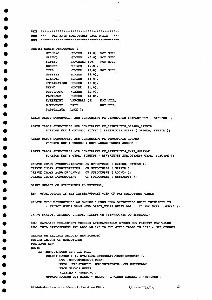
REM ******************************************
REM *** THE MAIN STRUCTURES DATA TABLE ***REM ******************************************
CREATE TABLE STRUCTURES (
STRUCNO NUMBER (7,0) NOT NULL,
ORIGNO NUMBER (5,0) NOT NULL,
SITEID VARCHAR2 (16) NOT NULL,
ROCKNO NUMBER (6,0),
TYPE NUMBER (2,0) NOT NULL,
SUBTYPE NUMBER (2,0),
AZIMUTH NUMBER (3,0),
INCLINATION NUMBER (2,0),
DEFNO NUMBER (1,0),
DEFSURFNO NUMBER (1,0),PLOTRANK NUMBER (3,0),
ENTEREDBYENTRYDATE
LASTUPDATE
VARCHAR2
DATE
DATE );
(8) NOT NULL,
NOT NULL,
ALTER TABLE STRUCTURES ADD CONSTRAINT PK_STRUCTURES PRIMARY KEY ( STRUCNO );
ALTER TABLE STRUCTURES ADD CONSTRAINT FK_STRUCTURES_ORIGNO_SITEID
FOREIGN KEY ( ORIGNO, SITEID ) REFERENCES SITES ( ORIGNO, SITEID );
ALTER TABLE STRUCTURES ADD CONSTRAINT FK_STRUCTURES_ROCKNO
FOREIGN KEY ( ROCKNO ) REFERENCES ROCKS( ROCKNO );
ALTER TABLE STRUCTURES ADD CONSTRAINT FK_STRUCTURES_TYPE_SUBTYPE
FOREIGN KEY ( TYPE, SUBTYPE ) REFERENCES STRUCTYPES( TYPE, SUBTYPE );
CREATE INDEX STRUCTORIGSITES ON STRUCTURES ( ORIGNO, SITEID );
CREATE INDEX STRUCTSITE/DS ON STRUCTURES ( SITEID );
CREATE INDEX STRUCTROCKNOS ON STRUCTURES ( ROCKNO );
CREATE INDEX STRUCTUSERS^ON STRUCTURES ( ENTEREDBY );
GRANT SELECT ON STRUCTURES TO EXTERNAL;
REM USTRUCTURES IS THE INSERT/UPDATE VIEW OF THE STRUCTURES TABLE
CREATE VIEW USTRUCTURES AS SELECT * FROM NGMA. STRUCTURES WHERE ENTEREDBY IN
( SELECT USER2 FROM NGMA.OZROX_USERS WHERE DB1 = 'X' AND USER = USER1 );
GRANT SELECT, INSERT, UPDATE, DELETE ON USTRUCTURES TO INTERNAL;
REM DATABASE PEE-INSERT TRIGGER AUTOMATICALLY ENTERS NEW PRIMARY KEY VALUE
REM INTO STRUCTURESS AND ADDS AN "X" TO THE SITES TABLE IN 1 ST' = STRUCTURES
CREATE OR REPLACE TRIGGER NEW_STRUCNO
BEFORE INSERT ON STRUCTURESFOR EACH ROWBEGIN
IF :NEW.STRUCNO IS NULL THENSELECT MAXNO + 1, NVL(:NEW.ENTRYDATE,TRUNC(SYSDATE)),
NVL( :NEW.ENTEREDBY,USER)
INTO :NEW.STRUCNO,:NEW.ENTRYDATE,:NEW.ENTEREDBY
FROM MAXNOS WHERE
IDMAXNO = 'STRUCNO';
UPDATE MAXNOS SET MAXNO = MAXN0 + 1 WHERE IDMAXNO = 'STRUCNO';
© Australian Geological Survey Organisation 1995 -^Guide to OZROX^81

END IF;Add "X" to ST column of SITES tableBEGIN
UPDATE NGMA.SITES
SET ST = 'X'
WHERE ORIGNO = :NEW. ORIGNO AND
SITEID = :NEW. SITEID AND
ST IS NULL;
EXCEPTION WHEN OTHERS THEN NULL;
END;
END;
REM DATABASE PRE-UPDATE TRIGGER INSERTS DATE OF LAST UPDATE TO STRUCTURES
CREATE TRIGGER UPD_STRUCTURES
BEFORE UPDATE ON STRUCTURES
FOR EACH ROW
BEGIN-- UPDATE LASTUPDATE FIELD TO TODAYS DATE BUT ONLY IF NECESSARY,
-- TO AVOID "ALTERED BY ANOTHER USER" PROBLEMS IN FORMS.
BEGINIF NVLONEW.LASTUPDATE,TO_DATE( 1 01-JAN-1900',IDD-MON-YYYYM
1= TRUNC(SYSDATE) THEN
:NEW.LASTUPDATE := TRUNC(SYSDATE);
END IF; REM
EXCEPTION WHEN OTHERS THEN NULL;
END;
END;
© Australian Geological Survey Organisation 1995 -^Guide to OZROX^82

• APPENDIX B - RULES AND TRIGGERS
•
830 Australian Geological Survey Organisation 1995 - Guide to OZROX•
•TABLE FORM
OR DEDESCRIPTION OF RULE OR TRIGGER
SITES Both Site ID must be unique to OriginatorSITES Form If Country = AUS, valid state must be enteredSITES Form If Country = AUS, valid 100/250K maps must be enteredSITES Form If Country # AUS, 100/250K maps cannot be enteredSITES Form If Country # AUS, AMG reference cannot be enteredSITES Form Either an AMG reference or lat/long must be enteredSITES Form Coordinates must lie within the stated 1:100000 sheet areaSITES Both If AMG ref. entered, lat/long calculated, 'S/E lower caseSITES Both If lat/long entered, AMG ref. calculated, 'S/E' upper caseSITES Both Positional accuracy in metres on ground must be enteredSITES Both Method of location of site must be enteredSITES DB OC field 'X'd whenever new outcrop record is enteredSITES DB SR field 'X'd whenever new secthole record is enteredSITES DB RO field 'X'd whenever new rocks record is enteredSITES DB ST field 'X'd whenever new structures record is enteredOUTCROPS Form Originator Number/Site ID must point to an existing siteOUTCROPS Form Landform code must point to record in RTMAP.LANDFOUTCROPS Form Vegetation code must point to record in QUATDB.VEGETOUTCROPS Form Stratdat codes must link to record in STRATDAT databaseOUTCROPS DB OC flag in matching SllbS record automatically set to 'X'SECTHOLES DB Secthole Numbers automatically inserted in new recordsSECTHOLES Form Originator Number/Site ID must point to an existing siteSECTHOLES Form Secthole azimuth must lie between 0 and 359 degreesSECTHOLES Form Secthole inclination must lie between -90 and +90 degreesSECTHOLES DB SH flag in matching SITES record automatically set to 'X'INTERIZONS Form Secthole No. automatically set to displayed SectholeINTERIZONS Form Column headings match type of record cursor occupiesINTERIZONS Form LTH records automatically call the Rocks FormINTER.TZONS Form STR records automatically call a Structures FormINTERIZONS Form RUB records automatically call a Rocks Units FormINTERIZONS Form STD records automatically call a STRATDAT FormINTERIZONS Form CON records automatically call a Rock Contacts FormROCKS DB Rock Number automatically inserted into new recordsROCKS Both Originator No. & Site ID must point to existing siteROCKS Form The default Sample ID is copied from the Site IDROCKS Both Entered Sample ID must be unique to the originatorROCKS Form Alert if Geological Province differs from STRATLEXROCKS Form Entered Stratigraphic Unit must point to record in STRATLEXROCKS Form However, above straigraphic unit can become superseded in statusROCKS Form Secthole No. inserted if form called from Sectholes FormROCKS Both RO flag in matching SITES record automatically set to 'X'LITHDATA Form Rock No. automatically set to displayed ROCKS recordLITHDATA Form Allow only Attributes in the ROC1CDATATYPES viewLITHDATA Form Allow only Values of Attribute in ROCKDATATYPESLITHDATA Form If Attrib = REF, Description points to AGSOREFS recordSTRUCTURES DB Structure No. automatically inserted into new recordsSTRUCTURES Form Rock No. automatically sei to displayed ROCKS recordSTRUCTURES Both ST flag in matching SITES record automatically set to 'X'All Tables Both Enteredby/Entrydate automatically entered in new records
•••••
•••••••
•••
••••••••