groundwater surveys and development agency, … groundwater resources of maharashtra groundwater...
TRANSCRIPT
DYNAMIC GROUNDWATER RESOURCES OF MAHARASHTRA
Groundwater Surveys And Development Agency,
Water Supply and Sanitation Department,
REPORT ON
DYNAMIC GROUNDWATER RESOURCES OF MAHARASHTRA
AS ON MARCH, 2004
Groundwater Surveys And Development Agency,
Water Supply and Sanitation Department,
Government of Maharas
&
REPORT ON
DYNAMIC GROUNDWATER RESOURCES OF MAHARASHTRA
AS ON MARCH, 2004
Groundwater Surveys And Development Agency,
Water Supply and Sanitation Department,
Government of Maharashtra
DYNAMIC GROUNDWATER RESOURCES OF MAHARASHTRA

3
3
REPORT ON
DYNAMIC GROUNDWATER RESOURCES OF
MAHARASHTRA
AS ON MARCH, 2004
Prepared by -
Groundwater Surveys and Development Agency,
GoM
&
4
4
Central Ground Water Board, Central Region,
Nagpur
Contributions by
Groundwater Surveys and Development Agency
Government of Maharashtra, Pune
V.V. Poreddiwar
Pravin Darade
Radheshyam L. Mopalwar
Suryakant P. Bagade
V. Krishnamurthy
Smt. Sheela Patil
Dr. Shivaji K. Thorat
Raymond A. Duraiswami
FINAL REPORT
5
5
Smt. Sulochana
Pradip Kadam
Rajesh Sharma and team
Ajay K. Gaikwad
Ramesh G. Kulkarni and team
Central Ground Water Board
Central Region, Nagpur
K. Keerthiseelan
D. Venkateswaran
FOREWORD
Maharashtra is one of the most well endowed states in the country in
respect of rainfall, but it may soon become a state where large parts of it face
perennial water shortage, if urgent institutional, policy and technological initiatives
are not taken to address both the quantity and the quality issues of groundwater.
There are 40,785 villages and 45,528 hamlets in the state with the total
population of 96.7 million of which 41.13 million is urban and 55.57 million is rural.
Almost 82% of the total rural population is relying on agriculture. Out of the total
area under irrigation in Maharashtra, 28.75 lakh hectares (71%) are irrigated by
groundwater and 11.83 lakh hectares (29%) are served by flow / canal irrigation.
Out of the total ground water consumed, 85% is for irrigation, 10% is for
industries and only 5% is for domestic consumption. Drinking water needs of 90%
of the total rural population are entirely met from groundwater.
6
6
Groundwater is a natural resource with both ecological and economic
value and is of vital importance for sustaining life, health and integrity of
ecosystems. This resource is however, increasingly threatened by over-
abstraction which has insidious long-term effects. Scarcity and misuse of
groundwater pose a serious and growing threat to sustainable development and
livelihood.
The availability of groundwater is extremely uneven, both spatially and
temporally and so will be the case in future. The uneven distribution of
groundwater can be mainly attributed to highly heterogeneous lithology and due
to uneven distribution of rainfall.
While first major but adhoc attempt of estimating groundwater resource
estimation was made during 1973 but the first scientific groundwater resource
assessment of Maharashtra was made during 1979 on the basis of
Overexploitation Committee Report. Since then various committees constituted
by Government of India and Government of Maharashtra have made attempts
from time to time to estimate the groundwater resources. After due consideration
of the limitations in the earlier methodologies, the Groundwater Estimation
Committee (GoI), during 1997, proposed the revised methodology known as GEC
97.
Based on these GEC 97 guidelines, GSDA has completed the exercise of
Groundwater Resource Estimation of Maharashtra as on March, 2004. As per
this, the total rechargeable groundwater resource in the State is computed as
32,96,109 Hectare Meter (Ham) or (32.96 BCM) and the Net ground water
availability is 31,21,404 Hectare Meter (Ham) or (31.21 BCM). Out of these,
1,50,883 Ham or 1.51 BCM is earmarked for domestic and industrial requirement
and the remaining is available for future irrigation. Between 1988 and 2004, the
groundwater use has increased by 4.03Ham (i.e. from 11.05 to 15.09 BCM).
7
7
A note of caution is required to be put on record, here, regarding the happy
position that may emerge from the statement in the preceding paragraph i.e.
while after subtracting the present groundwater draft of 15.09 BCM it looks that
there is still a balance of 15.13 BCM. The present irrigation draft is to the tune of
14.24 BCM, leaving behind a fairly good groundwater balance. Unfortunately
major part of these balances exists in the areas where development is not
required for either irrigation or for drinking and/or is in areas, which are not
favorable for development. It is observed that even the draft figure is not accurate
(much less than actual) because except for Latur and Osmanabad, the draft from
irrigation borewells/tubewells has not been accounted for. It is a well-known fact
that large number of irrigation borewells/tubewells are the main source of
irrigation in all the parts of the State and large number of them are not even on
record for electricity connections. If draft from those borewells/tubewells had been
accounted for then the balance position would have certainly emerged as
alarming and it is a ground reality.
Groundwater resource estimation is mainly dependent on the quality of the
basic data. Many a times because of the lack of accurate data the resource
assessment misleads the Planners, Administrators and Technocrats in
formulating various development activities. If the agricultural borewell/ tubewell
data was made available to GSDA the groundwater utilization status of
Maharashtra would have changed drastically, some of the semicritical units would
have been converted to critical or even over-exploited. The non-availability of the
data is the main constraint in resource assessment.
On the basis of the present resource assessment, out of the total 1505
watershed, 76 watersheds are categorised as overexploited i.e. the groundwater
development is more than 100% of the recharge and the water table during either
Post or Pre monsoon interval or both shows declining trend. 20 watersheds are
categorised as critical where groundwater development is more than 90% of the
recharge and where water table, either Post or Pre monsoon interval or both,
shows significant declining trend and 163 watersheds are categorised as semi-
critical where groundwater development is between 70 and 90% of the recharge
and where water table, either Pre or Post monsoon interval, shows declining
trend.
8
8
Out of the total tashils 7 tashils are categorized as Over Exploited, one
tashil is categorized as Critical and 23 tashils are categorized as Semi-Critical.
Out of 23 tashils, in 11 tashils the exploitation is more than 95% i.e. they are in
the verge of transformation into the Over Exploited category. It may be mentioned
here that the areas which have emerged as overexploited, critical or semi-critical
are the areas in which we have the lowest rainfall, highest percentage of water
guzzling commercial crops and showing alarming as well as progressive
deterioration of the ground water and soil quality.
Groundwater is one amongst the State’s most important natural resources.
It provides drinking water to urban and rural community, supports irrigation and
industry, sustains the flow of streams and rivers and maintains wetland
ecosystem. There is a significant freshwater deficit in many areas of the State.
Human health, welfare, food security are at risk unless the groundwater
resources are managed more effectively and efficiently. It is necessary to note
that over abstraction of ground water over years without any compensatory
replenishment is affecting large tracts of land adversely. The non-replenishment
of the shallow aquifers and depletion of the deeper aquifers on account of
unregulated sinking of deep borewells/tubewells, almost amounting to “water-
mining” unmindful of the adverse ecological effects is one of the contributory
causes for recurring droughts. Concerted action, therefore, is needed to reverse
the present trend of periodic occurrence of droughts.
Effective management of groundwater depends on a holistic approach, it
also links the land and water use across the catchment area of groundwater
aquifer. The development and management should be based on a participatory
approach, involving users, planners and policy makers at all levels. It is
necessary to formulate and adopt a long-term policy to protect groundwater by
preventing pollution and overuse. This policy should be comprehensive and
implemented at all appropriate levels. It should be consistent with other water
management policies and be duly taken into account in other sectoral policies.

9
9
It will be instructive to understand the international experience especially of
California, Brazil, Texas, South Africa and Israel if we have to ensure availability
of water for sustained development. We may have to forge basin/ sub-basin
water partnerships at least to avoid the unpleasant break out of conflicts between
upstream and the down stream dwellers. Concepts like Village Water Accounting/
Balance, District Water Accounting, Basin/ Sub-basin Water accounting, Region
and State Water Accounting will have to be popularized and made a basis for
equitable distribution of water.
An appropriate policy is required to be adopted for preferential allocation of
groundwater (actually, water in general), giving appropriate weight to competing
users and balancing short-term demands with long-term objectives. Legal
provisions specific to peculiarities of groundwater management will have to be
formulated and promulgated. Legislation may contain provisions for its effective
implementation including the mandate, competence and power of the relevant
authorities in accordance with the principles of State Water Policy. It is high time
that Government’s right to control groundwater abstraction and use as well as all
activities with potential impact, both on the quantity and quality of groundwater
resources may be established by legislation.
(V.V. Poreddiwar)
Director
Groundwater Surveys and Development Agency,
Maharashtra State, Pune 411 005.
PREFACE
Ground Water is a replensihable resource and is readily available resource for the mitigation
of distress caused by the various natural disasters like droughts, floods, earthquakes, tsunami,
cyclone, etc. In the State of Maharashtra, ground water is an important source of irrigation and caters
71% of the total irrigation. Even though, ground water is a replenishable resource, but not
replenishing evenly, because of the heterogeneous composition of the rock formation and its
availability is not uniform throughout the State. Hence, it is very much essential to quantify the
ground water resources precisely for its proper management and judicious use.
10
10
Even though, the assessment of ground water resources was attempted in the year 1949, the
first effort to estimate the ground water resources on scientific basis was made in 1979 through a
committee known as the “Ground Water Over Exploitation Committee” constituted by the
Government of India under Ministry of Agriculture. Based on the recommendations of the above
committee the Central Ground Water Board was assigned the job of estimating the ground water
resources of the country under the precise context of National Water Policy, which recommends
subsequent estimation of ground water resources.
Subsequently, the Ministry of Water Resources, Government of India had constituted another
committee under the Chairmanship of Chairman, Central Ground Water Board which is known as
“GROUND WATER ESTIMATION COMMITTEE -1984 (GEC 84)” and this methodology till recently
formed the basis of ground water assessment in the country. Based on this methodology, the total
replenishable ground water resources in the State of Maharashtra was estimated as 3.33998
m.ham/year, the gross ground water draft estimated on prorates basis during 1988 was 0.94257
m.ham/year and the balance ground water resource was 1.58674 m.ham/year and the Stage of
ground water development was 29.37 %.
While using the machinery of GEC 1984 methodology, several improvements were felt. In
order to improve the GEC-84 methodology, several workshops and seminars were conducted. Apart
from the above, a Steering Committee was formed and the Committee has recommended revision of
Ground Water Estimation Methodology and the “GROUND WATER ESTIMATION COMMITTEE – 1997
(GEC-97)” was constituted and recommended re-estimation of ground water resources using the
Revised GEC-1997 Methodology.
Now the GEC-97 brought out the policy framework, which forms the basis for the
methodology to be followed by all the States and Union Territories in India for ground water resource
estimation. The State Government which was having good network of monitoring and the ground
water development in their States have been assigned to determine the ground water recharge, draft
etc. As per the advise of Government of India, a committee was formed in the State of Maharashtra,
where the Chairman will be the Principal Secretary to Government of Maharashtra and the Member
Secretary will be the Regional Director, Central Ground Water Board, Nagpur. The Committee in its
meeting assigned the quantification work to the State Ground Water Department and the CGWB was
assigned to determine the specific yield etc.
Based on GEC-97, the Groundwater Surveys and Development Agency, Government of
Maharashtra in collaboration with the Central Ground Water Board has completed its first exercise
and prepared a report on “Estimation of Ground Water Estimation in Maharashtra”. This report was
11
11
reviewed by the State High-Level Technical Committee under the Chairmanship of the Principal
Secretary, Water Supply and Sanitation Department, Government of Maharashtra and was accepted
after critical discussion.
On a later stage, the Ministry of Water Resources, Government of India has constituted a
Standing Committee – “Research and Development Advisory Committee on Ground Water
Estimation” to provide required research and development support in the field of ground water
assessment based on GEC-97 methodology. The R&D Advisory Committee was headed by the
Chairman, Central Ground Water Board and members from various State Departments constitutes the
Committee. The resources estimated by each State has to submit their report to the Advisory
Committee for its approval. The report of Maharashtra State was submitted to the Advisory
Committee and the committee has approved the report. The total annual dynamic groundwater
resources of Maharashtra as on March 2004 is 3.296 m.ham and the net ground water availability is
3.121 m.ham. The total annual gross ground water draft is 1.508 m. ham, the net annual ground
water availability for future irrigation development is 1.509 m.ham and the Stage of ground water
development is 48.33 %. In the earlier assessment (GEC-84) the number of dark, grey and white
watersheds were 34, 80 and 1389 respectively. On the basis of present assessment (GEC-97), out of
total 1505 watersheds in Maharashtra, 76 watersheds are categorized as over-exploited, 20 as
Critical, 163 as Semi Critical and remaining 1242 as Safe watersheds.
The present report on “Dynamic Ground Water Resources of Maharashtra as on March 2004”
is the culmination of efforts made by the CGWB and GSDA. The GSDA, which has been doing a
pioneering work in assessing the ground water resources of Maharashtra on watershed basis, has
contributed significantly in the preparation of this report. This report reflects the various suggestions
and modifications made by the expert group of R&D Advisory.
(K. KEERTHISEELAN)
Regional Director
Central Ground Water Board
Ministry of Water Resources, Govt. of India
Central Region, Nagpur
12
12
C o n t e n t s
Chapter 1: Introduction … 1
1.1 Background … 2
1.2 Review of Groundwater Resources Assessment Methodologies … 2
1.3 Recommendations of GEC 1984 … 3
1.4 Merits and Limitations of GEC 1984 Methodology … 4
1.5 Improvements by GEC 1997 Methodology … 6
1.6 Constitution of Committee for Maharashtra for present assessment … 7
1.7 Static Resources … 9
Chapter 2: About Maharashtra … 9
2.1 Salient Features of Maharashtra … 9
2.2 Rainfall … 11
2.3 Geology … 12
2.4 Groundwater Province of Maharashtra … 15
2.5 Water Quality … 17
Chapter 3: Ground Water Resource Estimation Methodology, 1997 … 18
3.1 Ground water recharge … 18
3.2 Ground water draft … 20
3.3 Stage of groundwater development and categorisation of units … 20
13
13
3.4 Allocation of ground water resource for utilisation … 21
3.5 Poor quality ground water … 21
3.6 Apportioning of ground water assessment from
watershed to development unit … 21
3.7 Additional Potential Recharge … 21
Chapter 4: Computation of groundwater resources estimation in the State … 22
4.1 Norms adopted for Groundwater Estimation, March 2004 … 22
4.2. Present evaluation … 23
4.3 Some constraints … 24
4.4 Future Strategies … 24
Justification for reduction in recharge … 26
ANNEXURES
Information at a Glance of 6th Groundwater Assessment as per GEC 1997 … 29
District wise details of area considered in 6th Groundwater
Assessment as per GEC-1997 in Maharashtra … 30
3. District wise details of categorisation of watersheds in Maharashtra … 31
District wise net GW Availability and draft details of
6th Groundwater Assessment as per GEC 1997 …
32
District wise no. of dugwells, borewells and draft data … 33
Comparison of Groundwater Assessment between
GEC 84 and GEC 97 norms … 34
TALUKAWISE ASSESSMENT REPORT AS ON 31/03/2004
General Description Of The Groundwater Assessment Unit … 35
Groundwater Resource Potential … 47

14
14
Stage Of Groundwater Development … 75
Categorization For Groundwater Development
Of The Assessment Unit …
103
Categorization For Groundwater Development
Of The Administrative Unit …
115
Annual Groundwater Recharge In Poor Quality Zone … 116
WATERSHED WISE ASSESSMENT REPORT AS ON 31/03/2004
Part I - Groundwater resources abstract: Thane District … 117
Part II - Component wise groundwater recharge: Thane District … 119
Part I - Groundwater resources abstract: Raigad District … 121
Part II - Component wise groundwater recharge: Raigad District … 123
Part I - Groundwater resources abstract: Ratnagiri District … 125
Part II - Component wise groundwater recharge: Ratnagiri District … 127
Part I - Groundwater resources abstract: Sindhudurg District … 129
Part II - Component wise groundwater recharge: Sindhudurg District ... 130
Part I - Groundwater resources abstract: Nashik District … 131
Part II - Component wise groundwater recharge: Nashik District … 137
Part I - Groundwater resources abstract: Dhule District … 143
Part II - Component wise groundwater recharge: Dhule District … 148
Part I - Groundwater resources abstract: Jalgaon District … 153
Part II - Component wise groundwater recharge: Jalgaon District … 158
Part I - Groundwater resources abstract: A’nagar District … 163
Part II - Component wise groundwater recharge: A’nagar District … 168
Part I - Groundwater resources abstract: Pune District … 173
Part II - Component wise groundwater recharge: Pune District … 178
Part I - Groundwater resources abstract: Solapur District … 183
Part II - Component wise groundwater recharge: Solapur District … 187
Part I - Groundwater resources abstract: Kolhapur District … 191
15
15
Part II - Component wise groundwater recharge: Kolhapur District … 193
Part I - Groundwater resources abstract: Sangli District … 195
Part II - Component wise groundwater recharge: Sangli District … 198
Part I - Groundwater resources abstract: Satara District … 201
Part II - Component wise groundwater recharge: Satara District … 204
Part I - Groundwater resources abstract: Aurangabad District … 207
Part II- Component wise groundwater recharge: A’bad District … 211
Part I - Groundwater resources abstract: Jalna District … 215
Part II - Component wise groundwater recharge: Jalna District … 218
Part I - Groundwater resources abstract: Beed District … 221
Part II - Component wise groundwater recharge: Beed District …
225
Part I - Groundwater resources abstract: Parbhani District … 229
Part II - Component wise groundwater recharge: Parbhani District … 233
Part I - Groundwater resources abstract: Nanded District … 237
Part II - Component wise groundwater recharge: Nanded District … 241
Part I - Groundwater resources abstract: Osmanabad District … 245
Part II - Component wise groundwater recharge: Osmanabad District … 248
Part I - Groundwater resources abstract: Latur District … 251
Part II - Component wise groundwater recharge: Latur District … 254
Part I - Groundwater resources abstract: Amravati District … 257
Part II - Component wise groundwater recharge: Amravati District … 261
Part I - Groundwater resources abstract: Yeotmal District … 265
Part II - Component wise groundwater recharge: Yeotmal District … 270
Part I - Groundwater resources abstract: Buldhana District … 275
Part II - Component wise groundwater recharge: Buldhana District … 280
Part I - Groundwater resources abstract: Akola District … 285
Part II - Component wise groundwater recharge: Akola District … 290
Part I - Groundwater resources abstract: Nagpur District … 295
Part II - Component wise groundwater recharge: Nagpur District … 299
Part I - Groundwater resources abstract: Bhandara District … 303
Part II - Component wise groundwater recharge: Bhnadara District … 307
16
16
Part I - Groundwater resources abstract: Wardha District … 311
Part II - Component wise groundwater recharge: Wardha District … 314
Part I - Groundwater resources abstract: Chandrapur District … 317
Part II - Component wise groundwater recharge: Chandrapur District ... 321
Part I - Groundwater resources abstract: Gadchiroli District … 325
Part II - Component wise groundwater recharge: Gadchiroli District … 329
***

17
17
GROUNDWATER RESOURCE
ESTIMATION IN THE STATE OF MAHARASHTRA
Chapter 1 Introduction
Groundwater resource assessment is the determination of the source, extent, dependability
and quality of groundwater resources, on which the evaluation of the possibilities of the utilisation
and control depends. Estimation of groundwater is also important for the construction and the
maintenance of the States water supply infrastructure, especially those that are dependent on
groundwater. This report provides an overview of the groundwater resources of Maharashtra for a
vast range of activities like agricultural, domestic and industrial water supply. It will form the basis for
understanding the existing and planning the future use of groundwater and to decide the
management options on a holistic basis. This data also provides inputs that would be used to
understand the dynamics of the various sector wise demands and ensure sustainability for different
water sector activities.
The accurate groundwater resource assessment will help the policy makers in determining
the extent, contours and nature of:
• Co-ordinating and integrating mechanisms, now, required in the field of water sector.
• New legislation and regulations, and
• Strategies and policies that deal with the priority of uses and conflict resolution mechanism
(through mutually beneficial bargaining- basin/sub-basin water partnerships).
In short, groundwater resources assessment is a prerequisite for sustainable development of
States natural resources.
The present availability and requirement of water is extremely uneven, both spatially and
temporally and so will be case in the future. Rapid population growth and intensive anthropogenic
activities have put both surface and groundwater under heavy stress, and significantly fresh water is
becoming scarce and dearer in many areas. It is believed that in the coming decades most of the
Earth’s population will face a critical situation with regards to availability of water. The water
deficiency will become a factor affecting the living standards of populations adversely. Surprisingly, it
is observed that the potential water availability for the Earth’s population is decreasing from 12.9
tcm to 7.6 tcm/year/person. To understand more about the water resource deficit that will face us in
the future it is very important to analyse the present situation and understand rate of change in
specific water resource availability in relation to socio-economic, geohydrologic and physiographic
conditions.
18
18
In the State of Maharashtra, groundwater is an essential component for many water
strategies and systems. It is therefore essential that the groundwater resource estimation is accurate
so as to prepare strategies for the long-term management of this precious resource and for ensuring
the long-term safety and well being of all the sections of the society.
Groundwater resource estimation is mainly dependent on the quality of the data. Many a
times because of the lack of good quality data the resource assessment misleads the planners,
administrators and technocrats in formulating various developmental activities. Even today, the
situation is no better. Systematic information on groundwater withdrawal by various sectors through
different groundwater structures is unavailable. Even with sincere efforts made by the GSDA, it was
not possible to obtain the required data, especially the well census data. The State of Maharashtra is
covered mostly by highly heterogeneous and structurally complicated rock formations, wherein it is
very difficult to generalise any methodology or guidelines on hydrogeological aspects. In Deccan Trap
there is no well-defined, uniformly distributed, homogeneous aquifer system. Even during the
process of recharge the surface water in the given area does not uniformly replenish the subsurface.
For assessing the groundwater resources on a regular basis it is necessary to determine certain
hydrogeological factors, which define the groundwater regime. This includes precipitation,
storativity of the bedrock, aquifer characteristics, water quality and the overall environment.
1.1 Background
Groundwater has emerged as an important source to meet the water requirements of
various sectors. Demands for groundwater resources are ever increasing and competition amongst
users has intensified. The sustainable development of groundwater requires precise quantitative
assessment based on reasonably valid scientific principles. The occurrence, movement and storativity
of groundwater are quite complex, being governed by several factors like geology, geomorphology,
hydrogeology, meteorology and above all the human activities. All these factors make the precise
assessment of groundwater very difficult and there is no direct technique available for precise
assessment. Hence the methods applied for groundwater resource estimation are all indirect. There
are several techniques and methodologies in vogue for estimation of groundwater resources.
Quantification of groundwater resources is often critical and no single comprehensive technique is
yet identified which is capable of estimating accurate groundwater assessment. Since groundwater is
a replenihsable resource, its proper and economic development on a sustainable basis requires its
realistic assessment. The estimation must be seen as an interactive procedure. Initial estimation are
revised and refined by comparing these results with the results obtained by adopting alternative
methods and third party studies.
1.2 Review of Groundwater Resources Assessment Methodologies
19
19
There are numerous methodologies for estimation of groundwater resources both by
empirical method and by field studies. They are generally based on hydrological budget technique.
The hydrologic budget equations based on the law of “conservation of matters”, as applies to the
hydrologic cycle, defines the total water balance.
Attempts have been made from time to time by various working groups/ committees
constituted by GoI and GoM to estimate the groundwater resources of the State based on the status
of available data and in response to developmental needs. But due to the paucity of scientific data
and incomplete understanding of the various parameters involved in recharge and discharge process
all the earlier estimations were tentative and best approximations. The basic concept considered for
hydrologic budget is the hydrological cycle.
The first approximate evaluation of groundwater in Maharashtra was done during 1973 on
the basis of guidelines circulated by the Ministry of Agriculture, Government of India (GoI). The said
guidelines recommended the norms for groundwater recharge from rainfall and from other sources.
These norms were ad hoc basis and without any scientific base. During this exercise, for the sake of
accurate estimation of groundwater resources the State was divided into 1505 elementary
watersheds. Subsequently during 1979, the first attempt to estimate the groundwater resource on
the basis of scientific database was made. A high-level groundwater over-exploitation committee was
constituted by the A.R.D.C (Agricultural Refinancing Development Corporation). The committee was
headed by the Chairman, C.G.W.B (Central Ground Water Board) and included member
representatives from the State Groundwater Organizations and financial institutions. This committee
was formed to define norms for groundwater resource computations.
In the year 1982, GoI constituted groundwater estimation committee (GEC) with its members
drawn both from State groundwater organizations and from various other organizations engaged in
hydrogeological studies and groundwater development. This committee after reviewing the data
collected by various organizations recommended the methods for the estimation of groundwater
resources known as GEC 1984.
1.3 Recommendations of GEC 1984
The committee recommended two approaches for groundwater resource assessment namely
• Water level fluctuations and specific yield methods
• Rainfall infiltration methods
20
20
The total replenishable groundwater resources are estimated by computing annual
replenishable groundwater recharge plus potential recharge in shallow water level areas. The annual
groundwater recharge includes the following components:
Annual groundwater recharge = Recharge during monsoon + non monsoon RF recharge + seepage
from canals + return flow from irrigation + inflow from influent
rivers, etc. + recharge from submerged lands
The annual recharge during monsoon is calculated based on water table fluctuation and
specific yield method. Change in groundwater storage volume during pre and post monsoon period,
which is in turn the product of specific yield, water level fluctuation and the geographical area, is the
groundwater draft during monsoon. The other factors considered during the computation of
recharge during the monsoon are:
• Recharge during canal seepage during monsoon
• Recharge from recycled water from groundwater irrigation
• Recharge from recycled water from monsoon
• Surface water irrigation during monsoon
• Rainfall normalization factor.
The total groundwater resources thus computed would be available for utilization for
irrigation, domestic and industrial uses. Out of total groundwater resources 15% was kept for
domestic and industrial use and the remaining 85% was kept for irrigation. On the discharge side only
groundwater draft for irrigation purpose has been considered. Thus the total quantity withdrawn was
termed as gross draft.
For working out the water balance, 70% of the gross extraction was taken as net draft. The
rest 30% was presumed to go as return flow to the groundwater regime. The categories of
watersheds were made on the basis of stage of development at years 5. The various categories were:
White < 65%
Grey > 65% to < 85%
Dark > 85% to < 100%
Overexploited > 100 %
Using this approach, during 1998 the renewable groundwater annual recharge in the state
was 31,54,461 Ham, with the annual draft of 8,83,707 Ham, leaving the balance of 22,70,754 Ham. In

21
21
the State 1392 watersheds were declared as white, 87 watersheds as grey and 26 watersheds were
declared as dark. About 14,53,654 wells existed during this assessment.
1.4 Merits and Limitations of GEC 1984 Methodology
The basic merits of the GEC 1984 methodology are: (a) simplicity (b) suitability of the method
with regard to the data normally available from the ground water level monitoring programs of the
State and Central Government agencies (c) reliability and robustness of the ground water level
fluctuation method as it is based on the well established principle of ground water balance, and (d)
provision of an alternate approach based on the rainfall infiltration factor, in the absence of
adequate data of ground water levels. It may be noted that though the rainfall infiltration factor
method is empirical, the approach provides scope for continuous improvement, as the norms can be
periodically revised and refined for different agro-climatic and hydrogeological regions, based on
case studies of ground water assessment in different regions of the country.
While alternate methodologies for ground water recharge assessment are possible, the
ground water level fluctuation method, based on the concept of ground water balance, is the most
suitable and reliable at this point of time, considering the type and extent of data available. The two
approaches recommended by the GEC-1984 can therefore still form the basis for ground water
assessment.
Several issues have been raised with regard to the methodology recommended in the GEC-1984
Report. The limitations of the methodology are summarised as follows:
1.4.1 Units for ground water recharge assessment
The GEC-1984 does not explicitly specify the unit to be used for ground water assessment,
but it is implied that the assessment is to be made for an administrative unit, namely a block. While
an administrative unit is convenient from development angle, it is not a natural hydrological unit.
Watershed has been proposed as a more desirable option.
1.4.2 Delineation of areas within a unit
The GEC-1984 methodology does not take into account the spatial variability of ground water
availability within a unit. There is a necessity for delineation of different sub-areas within a unit for
ground water assessment viz. command, non-command and poor ground water quality areas.

22
22
1.4.3 Season-wise assessment of ground water resource There is a clear need expressed for season-wise assessment of the ground water resource for
Kharif, Rabbi and summer seasons or for monsoon and non-monsoon seasons. It is felt that this
approach may explain the paradox of water not being available in summer even for drinking
purposes in hard rock areas, while the stage of ground water development as evaluated based on the
GEC-1984 recommendations indicate good availability for development.
1.4.4 Ground water resource estimate in confined
aquifer The GEC-1984 has made a brief mention regarding ground water resource estimation in
confined aquifers, based on Darcy’s law. Questions have been raised on this aspect on three
grounds: (a) practical utility of this estimate, (b) reliability of the estimate, in view of the difficulty of
delineating the confined and unconfined parts, or the recharge and discharge parts, and (c)
possibility of duplication of resource estimation as the flow which enters the confined aquifer is
already estimated under unconfined aquifer part due to their inter-relationship. However, there may
be situations in alluvial areas where ground water estimate in confined aquifer may be an important
aspect.
1.4.5 Estimation of specific yield
The ground water level fluctuation method requires the use of specific yield value as a key
input for assessment of groundwater recharge. The GEC-1984 suggests that for semi-critical and
critical areas, pump tests (APT- Aquifer Performance Test) may be used for the estimation of specific
yield. Regarding regional ground water assessment in hard rock areas, determination of specific yield
through pump tests has several limitations
1.4.6 Ground water draft estimation
Groundwater draft refers to the quantity of ground water that is being withdrawn from the
aquifer. Groundwater draft is a key input in ground water resource estimation. Hence, accurate
estimation of groundwater draft is highly essential to calculate the actual groundwater balance
available.
1.4.7 Groundwater flow
23
23
The groundwater level fluctuation method as per the GEC-1984 does not account for ground
water inflow/outflow from the region and also base flow from the region, as part of the water
balance. This means that the recharge estimate obtained provides an assessment of net
groundwater availability in the unit, subject to the natural loss or gain of water in the monsoon
season due to base flow and inflow/outflow.
1.4.8 Return flow from ground water draft
The GEC-1984 recommends that 30% of gross groundwater draft used for non-paddy areas
may be taken as return flow recharge, and this is raised to 35% for paddy areas. It is, generally, felt
that with respect to ground water irrigation, these estimates of recharge from return flow are high,
particularly for non-paddy areas. It is even felt that when the water table is relatively deep and the
intensity of groundwater application is relatively low, return flow recharge may be practically
negligible. On the other hand, some data available from Punjab, Haryana and Western UP suggests
that the return flow from paddy areas may be higher than 35%.
1.5 Improvements by GEC 1997 Methodology
In 1995, GoI constituted a new committee headed by the Chairman, C.G.W.B to review the
Groundwater Estimation Committee Methodology (1984) and to look into the related issues. GEC
(1997) upheld the basic approach of GEC 1984 i.e. computation of groundwater recharge using the
water level fluctuation method and rainfall infiltration factor. However, several improvements were
suggested over the previous methodology as listed below:
a) It is proposed that watershed may be used as the unit for ground water resource assessment in
hard rock areas, which occupy about 2/3rd
of the state. For alluvial areas, the resources
assessment based on block-wise may be adopted.
b) It is proposed that the total geographical area of the unit for resource assessment be divided into
sub areas such as hilly regions, saline ground water areas, canal command areas and non-
command areas, and separate resource assessment may be made for these sub areas.
c) Groundwater recharge assessment should be made separately for monsoon season and the
non-monsoon season.
d) The focus of ground water recharge assessment may be for unconfined aquifers. In specific
alluvial areas where resource from deep confined aquifer is important, such resource may have
to be estimated by specific detailed investigation, taking care to avoid duplication of resource
estimation from the upper unconfined aquifers.
e) An alternate methodology is provided for the estimation of specific yield based on the
application of ground water balance and water level fluctuation in the dry season. The
methodology may be applied to non-command areas in hard rock regions.
24
24
f) With regard to norms for specific yield and recharge factor for rainfall, though a range is
provided, a single value is recommended for normal application in each type of
hydrogeological unit, unless use of other values can be justified.
g) The problem of accounting for ground water inflow/outflow and base flow from a region is
difficult to solve. If watershed is used as a unit for resource assessment in hard rock areas, the
ground water inflow/outflow may become negligible. The base flow can be estimated if one
stream gauging station is located at the exit of the watershed.
h) Norms for return flow from ground water and surface water irrigation are to be revised taking
into account the source of water (ground water/surface water), type of crop (paddy/non-paddy)
and depth of ground water level.
i) Explicit focus is introduced on: (a) recharge due to water conservation structures and (b)
additiona1 recharge from rainfall due to adoption of watershed development techniques
with associated soil conservation measures.
j) Greater clarity is introduced in the water level fluctuation method for recharge assessment with
regard to net ground water inflow and base flow terms.
k) Norms for return flow from irrigation are based on the source of irrigation (ground water or
surface water), type of crop (paddy or non-paddy), and depth to water table below ground level.
l) Normalisation of rainfall was based on regression analysis.
m) About 5 to 10 percent of the total annual ground water potential may be assigned to
account for natural discharges in the non-monsoon season. Allocation for domestic and
industrial water supply is to be based on population density and relative load on ground
water for these purposes.
n) Categorisation of areas for groundwater development is to be made based on the stage of
ground water development and the long-term trend of pre-monsoon and post-monsoon
groundwater levels. Accordingly, a four-fold categorisation is suggested as a) safe areas,
b) semi-critical areas, c) critical areas and d) over-exploited areas.
o) The needs for drinking water and industrial water use are to be decided based on the population
density of the area.
1.6 Constitution of Committee for Maharashtra for present assessment
The groundwater estimates for the State of Maharashtra have been computed by the Ground
Water Survey and Development Agency in collaboration with the Central Ground Water Board on the
guidelines given by the Groundwater Estimation Committee (GEC-1997) constituted by Ministry of
Water Resources, GoI, New Delhi vide Resolution No. 3/9/93-GW (II) 2332, dated 13.11.1995. The
Groundwater Survey and Development Agency has finalized this groundwater estimation report in
consultation with the officers of Central Ground Water Board. The Report gives groundwater
potential of different districts of the State on watershed basis and also information about the Semi-
critical, Critical and Over-Exploited watersheds. A Technical Committee has been constituted, as
advised by Government of India, vide their letter No. 18-36/83-GW dated 10th
May 1985. The
Committee comprises of the following members:
25
25
• Secretary, Water Supply & Sanitation Department, GoM - Chairman
• Chief Engineer and Jt. Secretary, Irrigation Department GoM. - Member
• Director, Social Forestry, Pune - Member
• Director, Groundwater Surveys Development .Agency, Pune - Member
• Director, Soil Conservation & Watershed Management, Pune - Member
• Regional Director, C.G.W. B, Nagpur - Member and Convenor
• Managing Director, Maharashtra State Co-operative Agricultural
and Rural Development Bank, Mumbai - Member
• Representative of NABARD - Member
• Chief Engineer, Minor Irrigation- Local Sector, Pune - Member
• Deputy Director, G.S.D.A.(R&D) Pune, - Member
• Representative of Mahatma Phule Agricultural University, Rahuri - Member
The Committee was required to consider the report submitted by Groundwater Survey and
Development Agency and submit observations to the Government about various recommendations
made in the report and for giving comments wherever necessary for onward submission to
Government of India.
The 1st
meeting of the State high level Technical Committee as held on 2nd
April 2002 under
the Chairmanship of The Secretary, Water Supply and Sanitation Department, Government of
Maharashtra. The Committee discussed various aspects such as Methodology of GEC 1997, Draft
Report, validity of database, constraints, etc. However, due to some abnormalities in the
assessments, a Technical Sub-Committee to review, update and finalise Draft Report was constituted.
The following was the constitution of the Technical Sub-Committee:-
Deputy Director, (R&D), GSDA - Convener
Mr. S. K. Bansal, CGWB - Member
Mr. D. Venkateshwaran, CGWB - Member
Rep. of Chief Engineer, Minor Irrigation (Local Sector), Pune - Member
Dr. A. R. Tamhankar, NABARD - Member
Mr. A. Chandra, Joint Director, Social Forestry - Member
The Technical Sub-Committee was entrusted with the following responsibilities:
26
26
• Look into availability of data and to update draft report.
• To verify the draft data, especially pertaining to Irrigation Department
• Look into variations of Recharge component of GEC 1984 vis-a-vis GEC 1997
• To prepare the final Draft Report
1.7 Static Resources
The discussion in the preceding paragraphs was with respect to dynamic annually
replenihsable resource. As per the National Water Policy, the extraction of groundwater should be
limited to the amount which is being recharged annually i.e. Dynamic or Replenishable resource.
Below the Dynamic Resource, which is the potential in the zone of water level fluctuation lies 'Static'
or 'In-Storage' Resource. The 'Static' implies reserve stock of ground water, which should be utilised
only in case of extreme eventualities like drought conditions. Presently, there is no fine demarcation
to distinguish the dynamic resources from the static resources. Water table hydrograph could be an
indicator to distinguish the dynamic sources and at times it is difficult to distinguish between
dynamic and static resources when water tables are deep.
The computation of Static Resource is being done as follows:
Static Groundwater = Thickness of the aquifer below x areal extent x specific yield
Chapter 2 About Maharashtra
Maharashtra State has a geographical area of 30.77 million hectares. The State has 35
districts and 353 talukas. The State has 2 urban districts i.e. Mumbai and Mumbai Sub-Urban where
as the remaining 33 districts are rural. There are 336 cities and towns in the State, out of which 40
have population more than 100,000. There are 40,785 villages and 45,528 hamlets (wadi, vasti or
pada). Map of Maharashtra showing District Administrative boundaries considered for Groundwater
Resource Assessment is shown figure. The population of the State is 96.7 million (2001) of which
41.13 million is urban and 55.57 million is rural. Maharashtra is mainly an agriculture State with 82%
of rural population relying on agriculture. Recently though, there is migration of 2% population,
annually, from rural to urban areas. Out of total area of 30.77 million ha, 21.04 million ha (68 %) is
cultivable and 6.20 million ha (20 %) is under forest. Agriculture productivity of the cultivable land is
Rs. 16000/- per hectare. The salient features of Maharashtra are given below:
2.1 Salient Features of Maharashtra
2.1.1 Location:
27
27
Longitude 72º 30’ 00” to 80º 30’ 00”
Latitude 15º 40’ 00” to 22º 00’ 00”
2.1.2. Area : 30.77 million hectares
2.1.3. Coastline: 720 km.
2.1.4. Physiography: The Physiography of Maharashtra is depicted.
HDP area: 6.15 million hectares
MDP area: 15.39 million hectares
UDP area : 9.23 million hectares
2.1.5. Rainfall zones:
High Rainfall: 2000 to 3500 mm
DPAP Area : 400 to 700 mm
Assured Rainfall: 800 to 1250 mm
2.1.6. Soils:
Plains and Central Highlands: Brown to black calcareous loams and clay.
Western Ghats and Peninsular Plateau: Shallow lithbrown to dark brown gravel, loams on high
slopes, red to reddish brown laterites and lateritic soils on high level
Costal Plains: Laterites and lateritic soils red to reddish brown loam of non-lateritic origin.
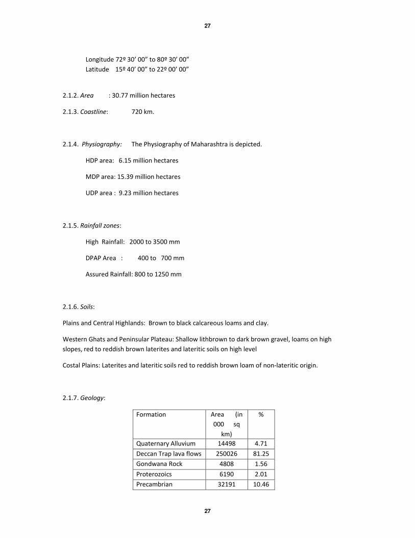
2.1.7. Geology:
Formation Area (in
000 sq
km)
%
Quaternary Alluvium 14498 4.71
Deccan Trap lava flows 250026 81.25
Gondwana Rock
Formation
4808 1.56
Proterozoics 6190 2.01
Precambrian 32191 10.46
28
28
2.1.8. Cultivable Area: 210390 sq. kms.
2.1.9. Forest Area: 61935 sq. kms.
2.1.10. Irrigation potential created (by all sources): 36.93 lakhs hectare.
2.1.11. Cropping Pattern:
Konkan: Paddy, horticulture and vegetables.
Western Maharashtra: Jowar, wheat, sugarcane, groundnut, onion, horticulture, sunflower,
etc.
Central Maharashtra: Jowar, wheat, cotton, sugarcane, grams, vegetables, sunflower,
safola.
Vidarbha: Paddy, Jowar, wheat, cotton, orange, grams, chilli.
Khandesh: Jowar, maize, grams, banana, wheat and chilli
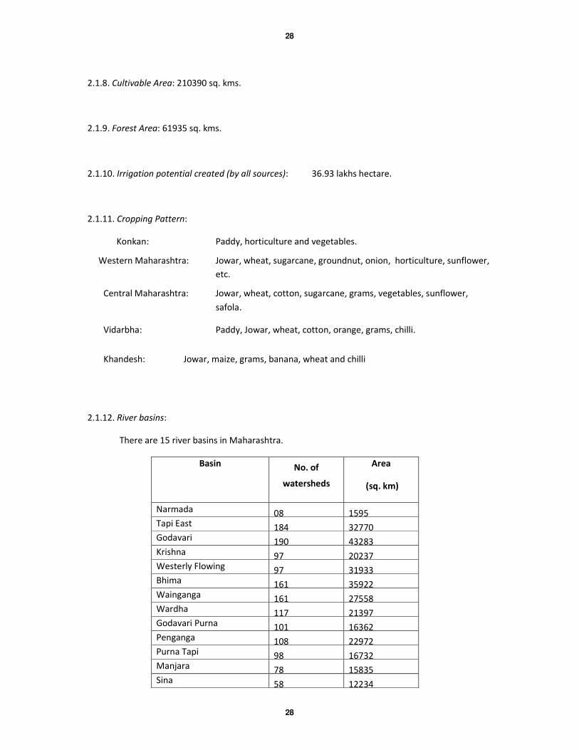
2.1.12. River basins:
There are 15 river basins in Maharashtra.
Basin No. of
watersheds
Area
(sq. km)
Narmada 08 1595 Tapi East 184 32770 Godavari 190 43283 Krishna 97 20237 Westerly Flowing 97 31933 Bhima 161 35922 Wainganga 161 27558 Wardha 117 21397 Godavari Purna 101 16362 Penganga 108 22972 Purna Tapi 98 16732 Manjara 78 15835 Sina 58 12234
29
29
Indravati 31 5488 Pranhita 16 3395
2.2 Rainfall:
The distribution of rainfall across the State is variable and is strongly influenced by
physiography. The Western Ghats, popularly known as the ‘Sahyadri’ rises up from the coastal plains-
‘Konkan’ upto a maximum height of 1654 m. It forms a fairly continuos hill range in the north-south
direction and forms a major water divide along the western parts of the State. The Konkan coast
experiences high rainfall upto 3000 mm. The Sahyadris also act as a barrier to the advancing
southwest monsoon and also receive copious rainfall. However, they form a rain shadow zone on the
eastern side where the rainfall is generally between 400- 700 mm but at times less than 400 mm. This
region constitutes the Drought Prone Area of the State. Thus, the central part of the State almost
always reels under scarcity and droughts. Ninety-nine talukas in the State are chronically drought
affected. The region towards east of Marathwada and Vidarbha receives up to 1250 mm rainfall and
falls within the assured rainfall zone. Variability of rainfall over the State is generally high ranging
from 20 to 35 %, except in coastal areas where it is less than 20%.
2.3 Geology:
The geology of Maharashtra is famous for the Deccan Traps, which occur in all the districts of
the State, except Bhandara, Gondia and Gadchiroli. The other geological formations, older and
younger than Deccan Traps, occur in the northeast and as isolated patches in the Sindhudurg and
Ratnagiri districts. The stratigraphic succession of the geologic formations in the State is given in
Table 1. The variation in hydrological properties is due to inherent physical characteristic.
2.3.1 Precambrian rocks:
The Precambrian rocks of Maharashtra are as varied and diverse as is found in Peninsular
India. They are mostly confined to the northeastern parts and fringe areas of the State. Most of
these rocks are older than 3.5 billion years and are invariably metamorphosed. Major lithotype is that
of rocks belonging to the Peninsular Basement Complex. These are mostly gneisses with enclaves of
schists and amphibolites. Gneisses occur in Nagpur, Bhandara, Chandrapur, Gadchiroli and
Sindhudurg districts. Besides this, the metasediments belonging to Sausar Series are also exposed in
the Nagpur and Bhandara districts and include a variety of rock types such as calcgranulites,
calciphyres, quartzites, geisses, schists and manganese bearing ‘gondites’. Structurally, these rocks
are intensely folded and faulted as these were subjected to a number of tectonic events. Another
group of rocks popularly referred to as the Sakoli Series is exposed in the Gadchiroli, Chandrapur,
Nagpur and Bhandara districts. These consist of pelitic, psamopelitic and metabasic sediments and
30
30
include phyllites, schists, amphibolites, quartzites and associated basic instrusives. The Iron Ore
Series constitutes an important iron ore bearing formation in the Gadchiroli and Sindhudurg districts.
The rocks consist of quartzites and Banded Hematite Quartzites with sizeable quantities of
exploitable iron ore.
2.3.2 Proterozic Rocks:
The Basement Gneissic Complex are overlain by the Proterozoic sediments. The limestone rocks
equivalent to the Cuddapah Super Group exposed in Andhra Pradesh, are exposed in small areas in
the southern part of Gadchiroli district. Another equivalent rock formations referred to as Kaladgi
Group rest directly on the Precambrian rocks in Sindhudurg and Kolhapur districts. The Kaladgi rocks
consist of sandstones and shales and have give rise to important deposits of silica sands. Rocks
belonging to this formation occur below the Deccan Trap flows in Kolhapur district. Vast areas in the
districts of Nanded, Yavatmal, Chandrapur and Gadchiroli, are occupied by the rocks of the Vindhyan
Super Group. They consist of limestones, dolomitic limestones, purple shales and feldspathic
sandstone.
2.3.3 Gondwana System:
The coal bearing Gondwana sediments were deposited in basins formed by the rifting of the
Gondwana protocontinent. The sedimentary rocks belonging to the Gondwana system can be
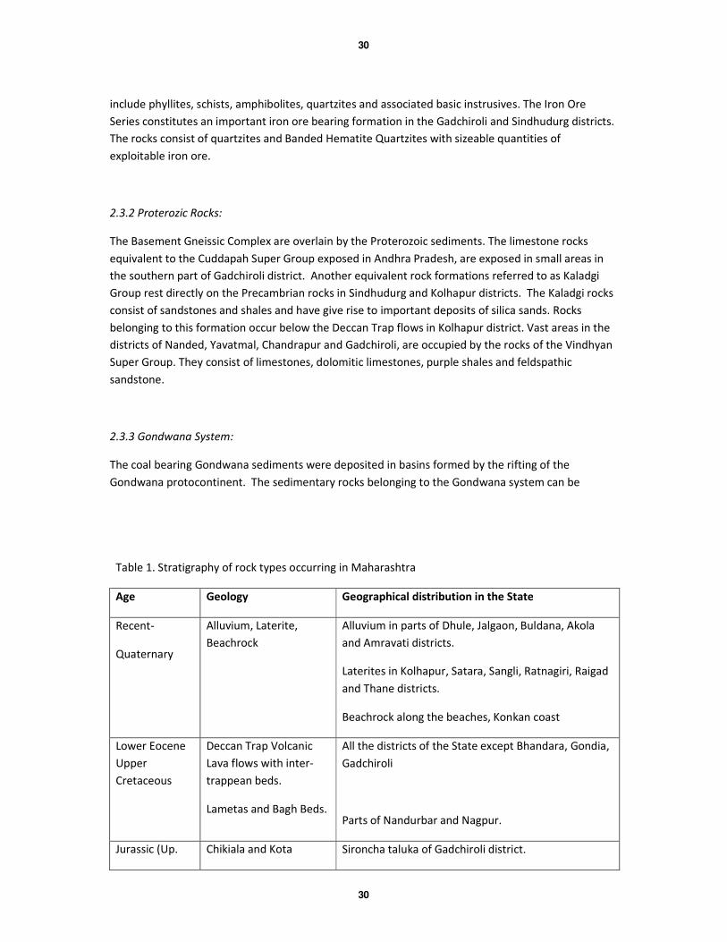
Table 1. Stratigraphy of rock types occurring in Maharashtra
Age Geology Geographical distribution in the State
Recent-
Quaternary
Alluvium, Laterite,
Beachrock
Alluvium in parts of Dhule, Jalgaon, Buldana, Akola
and Amravati districts.
Laterites in Kolhapur, Satara, Sangli, Ratnagiri, Raigad
and Thane districts.
Beachrock along the beaches, Konkan coast
Lower Eocene
Upper
Cretaceous
Deccan Trap Volcanic
Lava flows with inter-
trappean beds.
Lametas and Bagh Beds.
All the districts of the State except Bhandara, Gondia,
Gadchiroli
Parts of Nandurbar and Nagpur.
Jurassic (Up. Chikiala and Kota Sironcha taluka of Gadchiroli district.

31
31
Gondwana) Stages: Limestone.
Triassic Paachmari and Maleri
Stages: Clays,
Sandstones.
Sironcha taluka of Gadchiroli district and Achalpur
taluka of Amravati district.
Permian (Lw.
Gondwana)
Mangli Beds,
Sandstones.
Warora taluka of Chandrapur district.
Kamathi series
Sandstones, Shales, Coal
Nagpur, Chandrapur and Yavatmal districts.
Barakar series
Sandstone, Shales and
Coal
Nagpur, Chandrapur and Yavatmal districts.
Upper
Carboniferous
Talchir series Nagpur, Chandrapur and Yavatmal districts.
Proterozoic Vindhyan Super Group
(Limestones, Shales,
Sandstones).
Yavatmal, Nanded and Chandrapur districts
Cuddapah equivalent
Limestones and Shales.
Sironcha Taluka of Gadchiroli district.
Kaladgi Super Group
Sandstones, Shales
Conglomerates
Ratnagiri, Sindhudurg and Kolhapur districts.
Precambrian. Sakoli Series,
Iron Ore Series
Gadchiroli, Chandrapur, Nagpur and Bhandara
districts.
Sausar Series Nagpur and Bhandara districts.
Peninsular Basement
Complex
Gadchiroli, Chandrapur, Nagpur, Bhandara and
Sindhudurg districts.
divided into two groups namely the Lower and the Upper. The Lower Gondwana sediments include
the Talchir series, the oldest group of rocks followed by Barakar series, Kamthi series and Mangli
beds. The Talchir series include serrated boulders and green shales, sandstone, clays and mudstones
that were deposited during the glacial period.The Barakar series consists of a thick succession of
alternate layers of sandstones and shales with interbedded coal seams. The youngest group of rocks
belonging to the lower Gondwana sequence is known as the Mangli beds and consists of
conglomerates, grits and sandstones and is exposed in Warora taluka of Chandrapur district. The
upper Gondwana sediments include Pachmari, Maleri, Kota and Chikli group and are mainly exposed
in Sironcha taluka of Gadchiroli district. Around Bairamghat in Amravati district, the Pachmari group
32
32
sediments are exposed. They essentially consist of sandstones, shales and clays and include number
of plant fossils.
2.3.4 Lameta and Bagh Beds:
The rocks formations referred to the Bagh Beds are exposed along the southern bank of
Narmada River in Akkalkuwa taluka, Nandurbar district and comprise of siliceous limestones and
sandstones. The Lametas comprise essentially of calcareous sandstone, cherty limestones and clays.
The Lameta and Bagh Beds are referred to as infra-trappean beds i.e. occurring below the Deccan
Traps. The are located at various places and along the fringes of the Deccan Traps near Nagpur and
in Amravati district.
2.3.5 Deccan Volcanic Province (Deccan Traps):
The Cretaceous-Eocene Deccan Volcanic Province occupies more than 500,000 sq. km area in
parts of western and central India and is an important geological formation in the Indian sub-
continent. In Maharashtra, it occupies an area of about 2,46,784 sq. km, which is about 82% of the
State. The Traps are composed of a thick pile of lava flows seldom separated by flow top breccia or
‘red bole’. The individual lava flow varies greatly in thickness from a few metres to as much as 30-35
meters. In the fringe areas i.e. around Mumbai, Nagpur, etc. intertrappean sediments, which
consists of sandstones, shales, marls etc. is exposed between flows. The basaltic flows that
constitute the shallow- and deeper aquifers present inconsistent and complex hydrogeological
pattern. Although climatic, physiographic and rainfall vary widely across the State, the inherent
differences in the lava type, their geometry and the superimposing fabric of post-volcanic tectonics
are more important locally in contributing to anisotropic nature of the aquifer. The Deccan Trap
aquifers can be broadly divided into the following major physical units:
• Dense, compact and massive basalt,
• Vesicular/amygdaloidal basalt,
• Jointed or fractured basalt.
The intrusive dyke swarms occur along two tectonic belts i.e. the West Coast and the
Narmada-Tapi River. Most of the dykes are hypabassal. The dykes cut across number of flows and
form an important physiographic feature- sometimes occurring as ridges (positive feature) and at
other places forming linear depressions (negative features). The dykes control groundwater
movement and as such are known to be ‘carriers’ or ‘barriers’.
2.3.6 Alluvial Deposits:
33
33
The alluvial deposits generally occur along the lower reaches of major river valleys. Two well
known alluvial deposits namely, Tapi Valley (districts of Dhule and Jalgaon) and the Purna Valley
(districts of Buldhana, Akola and Amravati) are recognised. These alluvial deposits belong to slightly
older period (Quaternary) in geological history then most of the alluvial deposits in the coastal areas
of the country. The alluvial deposits in the Tapi and Purna valleys occur in separate, rather, long
narrow basins and occupy a total area of 10,500 sq. km. of which Tapi covers an area of 4100 sq. km
and Purna covers 6400 sq. km. On the basis of exploratory drilling, it is known that, these alluvial
deposits attain considerable thickness, maximum being about 425 m.b.g. l. Minor alluvial deposits
are also known to occur in other parts of the State such as along Bhima, Godavari, Wardha,
Wainganga, Penganga rivers and along some of their tributaries.
2.4 Groundwater Province of Maharashtra
On the basis of geological formations, the State can be divided into the following groundwater
provinces: -
i. Precambrian metamorphic groundwater province
ii. Proterozoic sedimentary groundwater province
iii. Gondwana groundwater province
iv. Deccan Trap volcanic groundwater province
v. Alluvial groundwater province
2.4.1. Precambrian metamorphic groundwater province
The basement complex rock types such as schists, gneisses, granite, amphibolites and basic intrusives constitute this
province. The rocks are very hard and compact and possess practically no primary porosity. However, these are highly
weathered and are fractured, sheared and jointed due to numerous tectonic episodes. The secondary porosity is
therefore
of prime importance in this province. The yield from the wells in this province generally varies from 45 to 80 m3/day and
the water level fluctuation varies from 2 to 8 metres b.g.1. However, the wells located on major lineaments or shear
zones have higher yields (100 to 150 m3/day).
2.4.2 Proterozoic sedimentary groundwater province:
The compact sediments mainly comprise of Vindhyan and Kaladgi formations. The total area occupied by these
sediments is 6,217 sq. km. The Vindhyans comprise of limestones, sandstones and shales. Groundwater occurs in these
rocks under phreatic as well as semi-confined conditions. The dug wells piercing the Vindhyan rock types range in depth
between 5 and 12 m and static water levels range between 2 and 7 m. b.g.l. The diameters of the wells range between 3
and 5 m. The limestones at places are massive but are generally bedded and exhibit vertical joints. In some places,
particularly in Yavatmal and Chandrapur districts they develop ‘karst’ topography. Geomorphological features such as
sink holes, galleries and caverns associated with this topography impart secondary porosity and permeability to this
formation. The wells in this area generally sustain a discharge of 50 to 100 m3/day.
2.4.3 Gondwana sedimentary groundwater province:
The Gondwana sedimentary rock formations are confined chiefly to the districts of Nagpur, Chandrapur, Yavatmal
and Amravati. These sediments occupy a total area of about 4,801 sq. km and comprise of sandstones, shales and clays
of varying thickness and degree of compaction. These rocks posses primary porosity. However, due to block faulting and
intra-formational faulting and fracturing, secondary porosity is generated within these formations. Occasionally, lenses
of pebbles and gravels are also encountered. There are possibilities of encountering confined aquifers in these type of
rocks. Few exploratory tube wells drilled by Groundwater Surveys and Development Agency and Central Ground Water
Board have indicated a discharge of 100 to 300 m3/day. The dug wells in these types of rocks vary in depth from 10 to 20
m. The water levels vary from few metres to 8 m.b.g.l. The yield ranges between 50 and 300 m3/day. Groundwater
Surveys and Development Agency has drilled large number of tube wells in this formation, especially for drinking water
purposes.
2.4.4 Deccan Trap volcanic groundwater province:
The Deccan Traps, which occupy about 82% of the total area of the State, is a major groundwater province for
consideration and evaluation of groundwater potential in the State. The basalt lava flows are formed as wide spread
flows forming extensive plateaus. The entire pile of near horizontal lava flows show variation in their physical character,
thereby influencing the aquifer parameters. While considering the occurrence of groundwater in the basaltic hard rocks,
which possess very poor primary porosity it is interesting to note that the basaltic lava flows develop vesicular character,
especially, in the flow crust. Further, secondary features like weathering, jointing, and shearing develop storage space,
which make the basaltic rocks capable of holding and transmitting groundwater. The vesicles, the joint system and inter-
flow zones contribute considerably to the yield of the basaltic flow. The yield is considerably affected by other two
factors namely, degree of weathering and topographic setting. Weathering increases porosity and permeability and
topographic setting affects the movement and discharge of groundwater. Thus a highly weathered vesicular lava flow
has good porosity and permeability and proves to be a good aquifer. However, the inter flow horizons such as red boles
tend to become clayey and sometimes reduce the aquifer properties. Groundwater in the basaltic aquifers occurs under
phreatic and semi-confined conditions. The massive lava flows and thick red-bole layers tend to inhibit vertical
movement of groundwater and thus act as confining aquicludes. The productive aquifers when favourably situated
2
receive recharge and groundwater moves down the slopes till it is withdrawn by abstraction structures such as dugwells
or natural discharge (spring). The water level and yields of wells are a function of the permeability and thickness of the
aquifer encountered. The entire succession of lava flows act as multi-aquifer system. The average depth of wells varies
from 9 to 15 m and diameter varies from 4 to 8 m. The range of water level varies from 3 to 7 m and the yield ranges
from 75 to 100 m3/day in winter. Wells located in favourable sites have very good yields ranging from 150 to 200
m3/day. In the Deccan traps the low availability of groundwater is attributed to its peculiar geomorphological and
geological set up. The lava flows are individually different in their ability to receive, hold as well as to transmit water.
The availability and productivity of groundwater in Deccan Trap is entirely dependent in its inherent physical property
such as the size and distribution of vesicles, number and spacing of interconnected joints and fractures and degree of
weathering.
2.4.5 Alluvial groundwater province:
The alluvial deposits in Tapi and Purna valleys are unique in that, they have been deposited in faulted basins. The
northern - boundaries of the two basins are faulted and the floors of the basins have sunk to relatively greater depths.
The basements have a slope towards north in both the cases. The weathering and erosion of the Satpuras have
contributed considerable volume of material in filling up of the two basins. The foothills of the Satpuras have a thick
accumulation of pediment deposits commonly referred to as the ‘bazada zone’. The thickness of the zone varies
considerably but holds tremendous potential as far as artificial recharge to the depleting groundwater is concerned. The
alluvial deposits in the basins have attained a maximum thickness of about 400 m at Akot in Akola district of Purna valley
and about 300 m at Yawal in Jalgaon district in the Tapi valley. The alluvial sediments in the two basins generally consist
of clays, silt, sand, pebbles and boulders. The sand, gravel, boulders etc. occur in one or more beds of 2 to 13 m in
thickness, generally within a depth of about 100 m and sometimes even down to the depth of 250 m below surface.
Boulders and gravels sometimes mixed with clays are predominant in the northern part of alluvial area in the Purna
basin.
The alluvial deposits in the two areas consist of different type of water bearing horizons. The most important
amongst them are the beds of sand, gravel and boulders, as these beds receive recharge, and store and transmit large
quantities of groundwater. The alluvial material generally contain one shallow aquifer within a depth of about 20 m and
one deep confined aquifer below 30 m. Central Ground Water Board has carried out extensive exploratory drilling in
Tapi (57 tube wells) and Purna (78 tube wells) alluvial areas. The depth of these tube wells range from 17 to 322 m. b.g.l.
and their yield range is from 5 to 45 lps. The exploratory study has shown that the alluvium is deposited in faulted basin
which have prominent northerly tilting basement of the Deccan Trap. The 300 to 350 m thick alluvial deposits can be
divided into younger alluvium up to 80 m depth and older alluvium below it. The younger alluvium contains 2 to 4
granular aquifer zones, which have excellent hydrologic parameters. The water levels in open wells vary in depth from
15 to 30 m. In areas bordering Satpura in the north water levels are deeper and the wells are 30 m or more in depth.
Most of the existing dug wells yield 100 to 300 m3/day, though in few case higher yields are observed. Groundwater
Surveys and Development Agency has drilled large number of' tube wells in these formations especially for drinking
water purposes. The chemical quality of groundwater in the aquifer of alluvial deposits is generally good in northern
part. However, in Purna alluvial areas the groundwater in shallow aquifers, especially in the southern part of the basin is
saline.
2.5 Water Quality
The chemical quality of groundwaters from the shallow basaltic aquifers is good (electrical conductivity ~501-
1000 µs cm-1
). In most samples the pH values range from 7.5 to 8.5 indicationg the alkaline nature of the groundwaters.
In Maharashtra, the saline groundwaters (electrical conductivity ~2001-3000 µs cm-1
) are present in three geographically
distinct areas viz. the coastal areas of Konkan, the Purna alluvial basin and the upland DPAP areas. The chemical quality
of groundwaters for deeper aquifers however represents a different picture. Saline groundwater patches (electrical
3
conductivity > 2001µs cm-1
) are reported from the Konkan coast (Thane, Raigad, Ratnagiri), Purna (Buldana, Akola,
Amravati) and the DPAP areas (Pune, Sangli,). The Hardness of groundwaters range between 100 to 500 mg/lit which is
suitable for drinking purposes. The fluoride concentration in groundwaters from the Precambrian basement rocks and
Proterozoic sediments are above prescribed limits. Such occurrences have been reported from districts such as
Chandrapur, Nagpur, Gadchiroli, Yavatmal, Bhandara and Sindhudurg where drinking water is not suitable for
consumption. However, it is to mention that these are treated as point sources and not applicable to the entire
watershed.
Chapter 3. Ground Water Resource Estimation Methodology, 1997
The previous ground water resource assessment of the state was done based on the recommendations of
Ground Water Estimation Committee - 1984 (GEC'84). The GEC'84 methodology was subsequently modified in the light
of enhanced database and new findings of experimental studies in the field of hydrogeology. The present methodology
used for resources assessment is known as Ground Water Resources methodology - n1997 (GEC'97). In GEC'97, two
approaches are recommended-water level fluctuation method and norms of rainfall infiltration method. The water level
fluctuation method is based on the concept of storage change due to difference between various input and output
components. Input refers to recharge from rainfall and other sources and subsurface inflow into the unit of assessment.
Output refers to ground water draft, ground water evapotranspiration, base flow to streams and subsurface outflow
from the unit. Since the data on subsurface inflow / outflow are not readily available, it is advantageous to adopt the
unit for ground water assessment as basin / subbasin / watershed, as the inflow / outflow across these boundaries may
be taken a s negligible.
Thus the ground water resources assessment unit is in general watershed particularly in hard rock areas. In case
of alluvium areas, administrative block can also be the assessment unit. In each assessment unit, hilly areas having slope
more than 20% re deleted from the total area to get the area suitable for recharge. Further areas where the quality of
groundwater is beyond the usable limits should be identified and handled separately. The remaining area after deleting
the hilly area and separating the area with poor quality groundwater quality is to be delineated into command and non-
command areas are done separately for monsoon an non-monsoon seasons
3.1 Ground water recharge
Monsoon Season
The resources a ssessemnt during monsoon season I sestimateed as the sum total of the change in storgae and
gross draft. The change in storgae is computed by multiplying water level fluctuation between pre and post monsoon
periods with the area of assessment and specific yield. Monsoon recharge can be expressed as:-
R = h x Sy x A + DG
where,
h = rise in water level in the monsoon season, Sy = specific yield
A = area for computation of recharge, DG = gross ground water draft
The monsoon ground water recharge has two components- rainfall recharge and recharge from other sources.
Mathematically it can be represented as-

4
R(Normal) = Rrf(normal)+Rc + Rsw + Rt + Rgw + Rwc
where,
Rrf is the normal monsoon rainfall recharge. The other sources of groundwater recharge during monsoon season include
Rc , Rsw , Rt , Rgw , Rwc which are recharge from rainfall, seepage from canals, surface water irrigation, tanks and
ponds, ground water irrigation, and water conservation structures respectively.
The rainfall recharge during monsoon season computed by Water Level Fluctuation (WLF) method is compared
with recharge figures from Rainfall Infiltration Factor (RIF) method. In case the difference between the two sets of data
are more than 20%, then RIF figure is considered, other wise monsoon recharge from WLF is adopted. While adopting
the rainfall recharge figures, weightage is to be given to the WLF method over adhoc norms method of RIF. Hence,
wherever the difference between RIF and WLF is more than 20%, data have to be scrutinised and corrected accordingly.
Non- Monsoon season
During the non-monsoon season, rainfall recharge is computed by using Rainfall Infiltration Factor (RIF) method.
Recharge from other sources is then added to get total non-monsoon recharge. In case of areas receiving less than 10%
of the annual rainfall during non-monsoon season, the rainfall recharge is ignored.
Total annual ground water recharge
The total annual groundwater recharge of the area is the sum-total of monsoon and non-monsoon recharge. AN
allowance I kept for natural discharge in the non-monsoon season by deducting 5% of total annual ground water
recharge, if WLF method is employed to compute rainfall recharge during monsoon season and 10% of total annual
ground water recharge if RIF method is employed. The balance ground water available accounts for existing ground
water withdrawal for various uses and potential for future development. This quantity is termed as Net Groundwater
Availability.
Net Groundwater Availability = Annual Ground Water - Natural discharge during non
Recharge monsoon season
Norms for estimation of recharge
GEC97 methodology has recommend norms for various parameters being used in ground water recharge
estimation. These norms vary depending up on water bearing formations and agroclimatic conditions. While norms for
specific yield and recharge from rainfall values are to be adopted within the guidelines of GEC'97, in case of other
parameters like seepage from canals, return flow from irrigation, recharge from tanks and ponds, water conservation
structures, result of specific case studies may replace the ad-hoc norms.
3.2 Ground water draft
The gross yearly ground water draft is to be calculated for irrigation, domestic and industrial uses. The gross
ground water draft would include the ground water extraction from all existing ground water structures during
monsoon as well as during non-monsoon period. While the number of ground water structures should preferably be
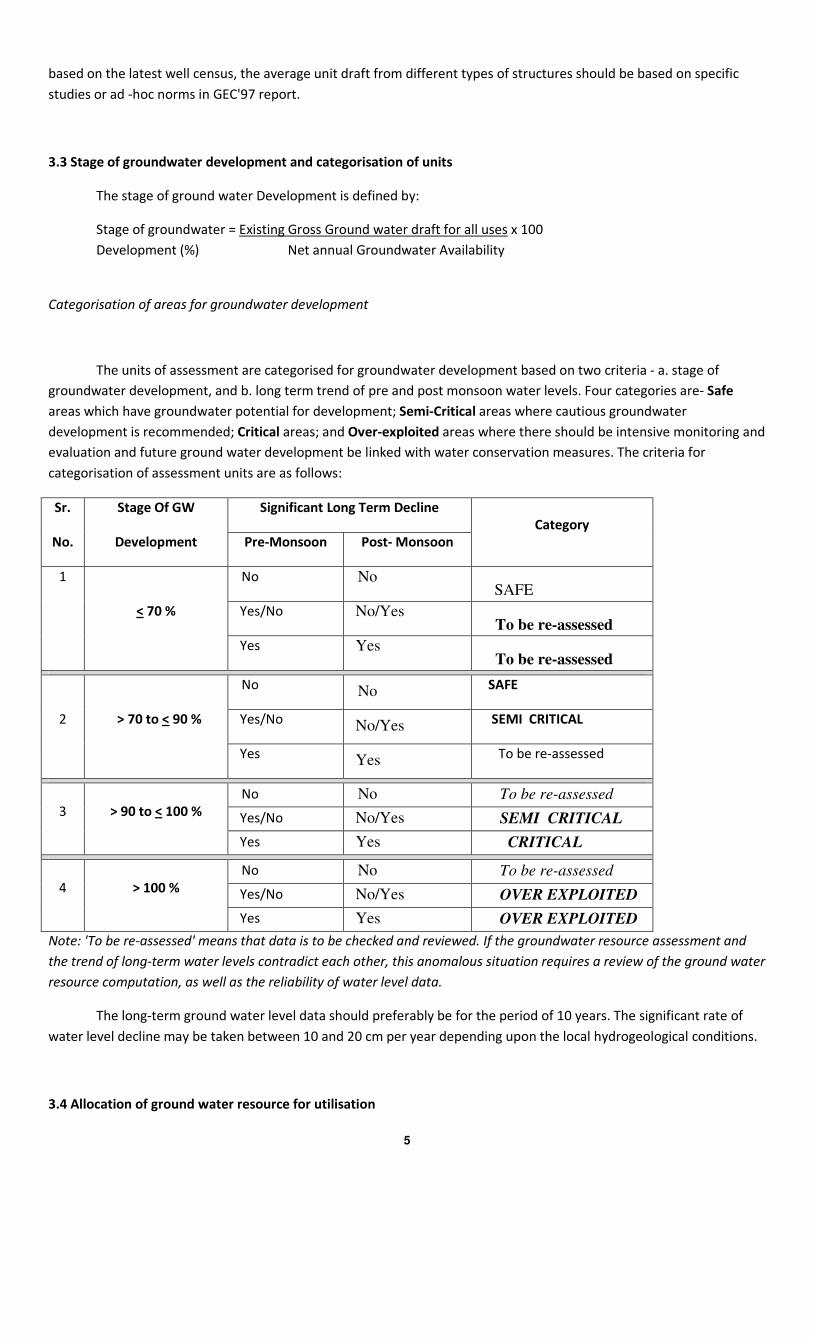
5
based on the latest well census, the average unit draft from different types of structures should be based on specific
studies or ad -hoc norms in GEC'97 report.
3.3 Stage of groundwater development and categorisation of units
The stage of ground water Development is defined by:
Stage of groundwater = Existing Gross Ground water draft for all uses x 100
Development (%) Net annual Groundwater Availability
Categorisation of areas for groundwater development
The units of assessment are categorised for groundwater development based on two criteria - a. stage of
groundwater development, and b. long term trend of pre and post monsoon water levels. Four categories are- Safe
areas which have groundwater potential for development; Semi-Critical areas where cautious groundwater
development is recommended; Critical areas; and Over-exploited areas where there should be intensive monitoring and
evaluation and future ground water development be linked with water conservation measures. The criteria for
categorisation of assessment units are as follows:
Sr. Stage Of GW Significant Long Term Decline
Category
No. Development Pre-Monsoon Post- Monsoon
1
< 70 %
No No SAFE
Yes/No No/Yes To be re-assessed
Yes Yes To be re-assessed
2 > 70 to < 90 %
No No SAFE
Yes/No No/Yes SEMI CRITICAL
Yes Yes To be re-assessed
3 > 90 to < 100 %
No No To be re-assessed
Yes/No No/Yes SEMI CRITICAL
Yes Yes CRITICAL
4 > 100 %
No No To be re-assessed
Yes/No No/Yes OVER EXPLOITED
Yes Yes OVER EXPLOITED
Note: 'To be re-assessed' means that data is to be checked and reviewed. If the groundwater resource assessment and
the trend of long-term water levels contradict each other, this anomalous situation requires a review of the ground water
resource computation, as well as the reliability of water level data.
The long-term ground water level data should preferably be for the period of 10 years. The significant rate of
water level decline may be taken between 10 and 20 cm per year depending upon the local hydrogeological conditions.
3.4 Allocation of ground water resource for utilisation
6
The net annual ground water availability is to be apportioned between domestic, industrial and irrigation uses.
Among these, as per the National Water Policy, 2002, requirement for domestic water supply is to be accorded priority.
The requirement for domestic and industrial water supply is to be kept based on the population as projected to the year
2025. The water available for irrigation use is obtained by deducting the allocation for domestic and industrial use, from
the net annual ground water availability.
3.5 Poor quality ground water
Computation of ground water recharge in poor quality ground water is o be done on the same line as described
above. However, in saline areas, there may be practical difficulty due to non-availability of data, as there will usually be
no observation wells in such areas. Recharge assessment in such cases may be done based on Rainfall Infiltration Factor
method.
3.6 Apportioning of ground water assessment from watershed to development unit
Where the assessment unit is a watershed, the ground water assessment is converted in terms of an
administrative unit such as Block/Taluka/Mandal. This is done by converting the volumetric resource in to depth unit
and then multiplying this depth with the corresponding area of the Block.
3.7 Additional Potential Recharge
In shallow water table areas, particularly in discharge areas rejected recharge would be considerable ad water
level fluctuation area subdued resulting in underestimation of recharge component. In the area where the ground water
level is less than 5 m below ground level or in water logged areas, ground water resources have to be estimated up to
5m bgl only based on the following equations:
Potential ground water recharge = (5-D) x A x Specific yield
where,
D = depth to water table below ground surface in pre monsoon in shallow aquifers
A = area of shallow water table zone
Chapter 4 Computation of groundwater resources estimation in the State
4.1 Norms adopted for Groundwater Estimation, March 2004
4.1.1 Resources assessment unit
7
Basically both recharge and draft was computed considering watershed as unit and within that command, non-
command and poor quality a subunit. The final assessment of the potential is apportioned and presented as taluka wise.
4.1.2 Assessment area
Out of the total geographical area, the hilly area (slope > 20%) was identified and deleted and only groundwater
worthy area is considered.
4.1.3 Method of Resource assessment
Out of the total 2316 sub units, for 2166 subunits (i.e. 93%) the water table fluctuation method is adopted.
Resources worked out respectively for monsoon and non-monsoon.
4.1.4 Specific yield
For non-command area as per GEC-97 guidelines the dry season specific yield is considered. The dry season
specific yield for Deccan Traps varies from 0.95% to 2.5% as against the allotted value of 1 to 3% with an average of 2%.
4.1.5 Rainfall infiltration factor
6-12% is considered in basaltic area because in Konkan strip, most of the area is capped by very hard and
compact massive unit. Hence 6-12 % is considered. (as per GEC-97: 6-14%).
4.1.6 Recharge due to canal seepage
15 Ham per day/million sq. m wetted area for unlined canals and 20% of it for lined canals.
4.1.7 Recharge from Tanks and Ponds
Average water spread area * No. of days * 0.00144 meters per day per Ha.
4.1.8 Recharge from water conservation structure
50% of the total storage.
4.1.9 Return flow from irrigation
SWL < 10 SWL 10-25
GW - P/NP 45/25 35/15
SW - P/NP 50/30 40/20
4.1.10 Categorisation
As per guideline Assessment unit wise (clubbing both command and non-command)

8
4.1.11 Stage of development
As per guidelines.
4.1.12 Unit Draft
The average unit draft of dug wells works out to be 0.964 ham with the range from 0.6 to 1.5 ham. For bore
wells, the unit draft ranges from 1.5 ham to 2.5 ham.
4.2. Present Evaluation
For the purpose of groundwater estimation and evaluation the Maharashtra state is divided 1505 elementary
watersheds. The recharge is estimated for the groundwater worthy area of all the watersheds. The non-worthy area
comprising of steep slops (Slope more than 20 %), Hill Tops and Rock Waste have been deleted. The worthy area of the
watershed is also known as groundwater assessment area. Each watershed is further delineated into groundwater poor
quality area, where the quality of the groundwater is beyond the usable limits, command area and non-command area,
likewise each watershed is divided in to three assessment subunits. But all the subunits may not be present in the single
watershed. Hence, the assessment was carried out on a watershed basis, although initially the assessment was carried
out for the command and non-command areas. The groundwater estimation is carried out for 29 districts of
Maharashtra i.e. combined estimate for Parbhani- Hingoli, Dhule-Nandurbar, Bhandra-Gondia and Akola-Washim.
Groundwater estimation is not carried out for Greater Bombay district also.
The current estimation of groundwater recharge as brought out in the report is based on GEC 1997
methodology. As per this, the total rechargeable fresh groundwater resources in the State are computed as 32.96 BCM
and the net ground water availability is to the tune of 31.21 BCM. The present gross draft for all purpose is 15.09 BCM
out of which 14.24 is the present irrigation draft.
The inflow component of groundwater resources has been divided based on the contribution from natural
recharge due to rainfall and augmentation from canal irrigation system. Though the rainfall has been principal source for
groundwater recharge the canal seepage and return flow of irrigation has also been significant in certain districts of the
State. The groundwater resources assessment for the State as a whole indicates that there is still a large balance of
groundwater potential. Despite this, certain watersheds in the State have already attained the stage of over-
exploitation/critical stage where the further groundwater development should be restricted. The Elementary watershed
map of Maharashtra showing stages of groundwater development is shown on back page of this volume. There are 76
overexploited, 20 critical and 163 semi critical watersheds. The district-wise details of the assessment area (command
and non-command), categorisation of watersheds, details of resource assessment, existing dugwells, borewells and
draft is given in the Annexure 1-5. Annexure no. 6 shows the comparison between the Groundwater resource
assessment carried out in Maharashtra based on GEC 84 (1988) and GEC-97 guidelines (2004).
4.3 Some Constraints
9
• It may be noted that water balance exercises are not carried out under GEC 1997 methodology as inflow -
out flow components. Outflow components are considered as negligible with watershed as a boundary.
• The long term water level trend and stage of development are considered for declaring an area as safe or
critical or semi-critical or overexploited. In cases, where Percentage Departure (PD) is large, monsoon
rainfall recharge is computed using rainfall infiltration factor (ad hoc norms), which implicitly suggest that
water level data is not representative. However, long-term water level data of the same wells are used for
categorisation, which is contradictory.
• The long-term trend computed from linear regression analysis depends on the first data considered for the
analysis. If the data pertains to the drought year, the trend becomes a rising trend and if the first data
pertains to the above normal rainfall year, the trend gets reversed. A simple regression analysis may not
reflect the actual field situation.
• For determination of domestic and industrial requirement an empirical relationship is suggested in the
absence of adequate data. However, the industrial requirement should also be made mandatory.
• In spite of the cumbersome computations, the final categorization is not always realistic confirming the
ground truth.
• A part of the watershed may have well showing declining trend while the rest may have wells showing
rising trend. In such cases, the categorisation becomes subjective and in reality we may have multiple
categorisation for each assessment sub-unit.
4.4 Future Strategies
Since there is no direct method of quantifying the groundwater resource potential the methodology adopted for
estimation of this resource and figures estimated using these methodologies have always been subject to debate and
controversies. For the same reason there is a constant urge for improving on the techniques and refining of database.
However, any such changes should be preceded with the proper evaluation of the existing norms and techniques. In
some cases difficulties have been noticed in computing the resources using GEC 1997 guidelines. The reasons include
paucity of data, usage of certain norms or conditions suggested in GEC 1997 that leads to over or under estimation of
recharge component. In such cases, it may be mentioned here, a flexible approach within the broad guidelines of GEC
1997 was adopted which yielded results more or less confirming the ground realities.
Several refinements to the recommended methodology along with the alternative approaches has been suggested
in the report of GEC 1997 itself. These include:
• Geographic unit for assessment: watershed in hard rock, block in alluvial areas
• Employing remote sensing technique
• Computerisation of GEC methodology of resource estimation
• Refinement of database and norms for estimation of recharge based on R&D studies
• Distributed parameter modelling, and
• Soil moisture balance method as an alternative approach

Out of the above, State of Maharashtra has already been using watershed concept for resource assessment
since 1973 for demarcation of groundwater non
used. In addition to this, computerisation of GEC 1997 methodology and refinement of data has also been attempted. As
per the suggestion made by GEC 1997 the watershed wise exercise has been made to divide
into two components – natural recharge and augmented recharge. The natural recharge includes recharge from rainfall,
seepage from ponds, tanks, and ground inflow. The augmented recharge includes return flow from surface irrigation
groundwater irrigation along with other artificial recharge component.
Large-scale groundwater development significantly changes the recharge
time. Thus, hydrologic budget computed under steady state condition may be co
account of groundwater development in the area.
It is therefore recommended that assessment of hydrologic budget of the area may be carried out periodically
giving the due considerations to the prevailing groundwater deve
recharge-discharge regime.
10
Out of the above, State of Maharashtra has already been using watershed concept for resource assessment
since 1973 for demarcation of groundwater non-worthy and worthy areas and Remote Sensing tools are also being
used. In addition to this, computerisation of GEC 1997 methodology and refinement of data has also been attempted. As
per the suggestion made by GEC 1997 the watershed wise exercise has been made to divide
natural recharge and augmented recharge. The natural recharge includes recharge from rainfall,
seepage from ponds, tanks, and ground inflow. The augmented recharge includes return flow from surface irrigation
groundwater irrigation along with other artificial recharge component.
scale groundwater development significantly changes the recharge
time. Thus, hydrologic budget computed under steady state condition may be co
account of groundwater development in the area.
It is therefore recommended that assessment of hydrologic budget of the area may be carried out periodically
giving the due considerations to the prevailing groundwater development scenario and constituent modification in the
Out of the above, State of Maharashtra has already been using watershed concept for resource assessment
rthy areas and Remote Sensing tools are also being
used. In addition to this, computerisation of GEC 1997 methodology and refinement of data has also been attempted. As
per the suggestion made by GEC 1997 the watershed wise exercise has been made to divide the groundwater recharge
natural recharge and augmented recharge. The natural recharge includes recharge from rainfall,
seepage from ponds, tanks, and ground inflow. The augmented recharge includes return flow from surface irrigation
scale groundwater development significantly changes the recharge-discharge regime as a function of
time. Thus, hydrologic budget computed under steady state condition may be considerably modified with time on
It is therefore recommended that assessment of hydrologic budget of the area may be carried out periodically
lopment scenario and constituent modification in the
Out of the above, State of Maharashtra has already been using watershed concept for resource assessment
rthy areas and Remote Sensing tools are also being
used. In addition to this, computerisation of GEC 1997 methodology and refinement of data has also been attempted. As
the groundwater recharge
natural recharge and augmented recharge. The natural recharge includes recharge from rainfall,
seepage from ponds, tanks, and ground inflow. The augmented recharge includes return flow from surface irrigation,
discharge regime as a function of
nsiderably modified with time on
It is therefore recommended that assessment of hydrologic budget of the area may be carried out periodically
lopment scenario and constituent modification in the
11
Justification for reduction in recharge
It is observed that the recharge during 1998 (as per GEC 84) was 37. 87 BCM and as per GEC 1997 (as on
2004) the total annual fresh replenishable recharge is 32.96 BCM. There is a reduction in recharge by 4.91
BCM to the tune of 14%. The reduction in recharge is mainly attributed to the following reasons.
1. During 1988 as per GEC 1984 methodology the entire area of the watershed in terms of the entire area
of State (30.77 million hectare or 307713 km2) was considered for resource assessment. As per GEC
1997 methodology the assessment area is reduced to 26.03 million-hectare from 30.77 million hectare.
i.e. overall reduction is by 17%. In some districts like Thane, Raigad, Ratnagiri the reduction is even up
to 50%.
2. During 1988, only 370 watersheds (only 24%) the resource assessment was done by WTF method. In
the remaining 74% of the area RIF method was adapted by using total area x 12% infiltration factor.
During 2004 out of 2316 subunits 2166 i.e. 93% is assessed by WTF method.
3. In Konkan district i.e. Thane, Raigad, Ratnagiri and Sindhudurg districts as per GEC-84, the
Groundwater resource assessment was made only by RIF method considering the high rainfall. As per
GEC-97 (2004) in 94% of the watersheds the resource assessment was done by WTF method, hence the
recharge has been reduced considerably compared to GEC-84 methodology.
4. In RIF infiltration method the overall 12% recharge was considered. In high rainfall zone where the
rainfall > 1200 mm the rainfall cut off range limited to 1200 mm was considered i.e. to say that even in
Konkan without considering the groundwater worthy condition total area x RF (1200 mm) x 12% was
considered resulting in exorbitant recharge.
5. In some watersheds from districts Solapur, Jalna, Beed, Nanded, Amravati, Buldhana and Chandrapur
even during 1998 the resource assessment was done by WTF method. However, the average specific
yield of the entire watershed was considered The specific yield value were varying between 2-4.5%
where as during 2004 the dry season specific yield is considered the average value varies between 1 to
2.5%.
6. Under WTF method, during 1988 the cumulative WT fluctuation of all the observation wells from 1973-
88 in the watershed was considered.
7. Explanation for lowering of category – In BM-7 of Pune district, during 1988 Groundwater Assessment
canal irrigation and surface irrigation was not considered, subsequently the canal system was started.
During 2004 Groundwater Resource Assessment an additional input of 609 hm recharge id added.
In GV-15 of Nashik district, the surface irrigation component of 348 hm and recharge due to tanks and
ponds to the tune of 155 hm total in to 503 hm is added dui\ring 2004 Groundwater Assessment.
Hence in both the watersheds groundwater exploitation reduced below 85% of stage of development.
As per the irrigation draft figure is concern it is increased from 11.06 BCM to 14 .27 BCM. All the
districts the irrigation draft is increased compared to 1988. District wise supporting statement A & B is enclosed
at the end.