groundwater monitoring and contingency plan for the
TRANSCRIPT

Groundwater Monitoring and Contingency
Plan for the Sweetwater and Ahipara sub-
aquifers of the Aupōuri Aquifer
Management Unit
May 2021

Table of contents
1. INTRODUCTION 1
1.1 Scope and Objective of the GMCP .............................................................. 1
1.2 Parties Associated with this GMCP .............................................................. 2
1.2.1 Northland Regional Council ........................................................ 2 1.2.2 Consent Holders ......................................................................... 2 1.2.3 Director-General of Conservation ............................................... 3
1.3 Changes to the GMCP ................................................................................. 3
2. FRAMEWORK FOR ADAPTIVE MANAGEMENT 5
2.1 Staged Implementation ................................................................................ 6
2.1.1 Staging: Implementation and Monitoring Programme Review ........................................................................................ 7
2.1.2 Stage 1 (Year 1) Management Regime ...................................... 8 2.1.2.1 Monitoring and Triggers ............................................... 8
2.1.2.2 Trigger Level Responses ............................................. 9
2.1.2.3 Ceasing Interim Stage 1 (Year 1) Management Regime ......................................................................... 9
2.2 Trigger Level System ................................................................................... 9
2.2.1 Timeframe for setting of trigger levels......................................... 9 2.2.2 Method for setting of trigger levels .............................................. 9 2.2.3 Response to exceeding trigger levels ....................................... 10
3. MONITORING PROGRAMME & TRIGGER LEVEL SETTING 11
3.1 Bore Locations and Details ........................................................................ 11
3.2 Groundwater Level Monitoring & Establishment of Trigger Levels ............ 15
3.2.1 Continuous Groundwater Level Monitoring............................... 15 3.2.2 Manual Groundwater Level Monitoring ..................................... 15 3.2.3 Ongoing Monitoring .................... Error! Bookmark not defined. 3.2.4 Setting of Groundwater Level Trigger Levels ............................ 16
3.2.4.1 Shallow Sand Aquifer ... Error! Bookmark not defined.
3.2.4.2 Deep Shellbed Aquifer . Error! Bookmark not defined.
3.3 Saline Intrusion Monitoring & Establishment of Trigger Levels .................. 17
3.3.1.1 Setting of Saline Intrusion TriggersError! Bookmark not defined.
3.3.1.2 Ongoing Monitoring .................................................... 18
3.3.2 Schedule of Monitoring & Trigger Levels .................................. 18 3.4 Production Bore Monitoring ........................................................................ 19
3.4.1 Trigger levels .............................. Error! Bookmark not defined. 3.4.2 Ongoing monitoring .................................................................. 19 3.4.3 Monitoring Schedule & Trigger Levels ...................................... 20
3.5 Unmapped Wetlands .................................................................................. 21
3.5.1 Unmapped Wetland Delineation Procedure.............................. 21 3.5.2 Repeat Survey of Natural Wetlands.......................................... 25
3.6 Environmental Monitoring Report ............................................................... 25
4. CONTINGENCY PLAN 26
4.1 Exceedance of TL1 .................................................................................... 26

4.2 Exceedance of TL2 .................................................................................... 27
5. REFERENCES 29 DOCUMENT FIGURES Figure 1. Groundwater Monitoring and Production Bore Location Map ............................................... 14
DOCUMENT TABLES Table 1. Summary of staged implementation annual volumes. ............................................................. 6 Table 2: Summary trigger level parameters by monitoring suite. ........................................................ 10 Table 3: Schedule of monitoring bore details....................................................................................... 12 Table 4. Schedule of Manual Groundwater Monitoring Bores. ............................................................. 16 Table 5: Monitoring Schedule – Saline Intrusion. ................................................................................ 18 Table 6: Monitoring Schedule – Production Bore Water Levels and Electrical Conductivity ............... 20 Table 7: Unmapped wetland delineation procedure. ........................................................................... 22
GLOSSARY OF TERMS
Saline/saltwater intrusion For the purposes of this Groundwater Monitoring and Contingency Plan, saline/saltwater intrusion refers to changes in salinity at nominated monitoring locations that exceed thresholds established to indicate elevated potential for adverse effects on groundwater quality for potable supply and/or irrigation use and effects on freshwater ecosystems.
Efficient bore takes An efficient bore take is when a bore fully penetrates the water bearing layer and takes water from the base of the aquifer.
Sub-aquifer The Aupōuri Aquifer system is divided into 12 separate sub-aquifer units for the purposes of setting tailored aquifer-specific allocation limits.1
First in-first served Under the Resource Management Act 1991, applications for water takes are processed in the order in which they are lodged.
The rights of parties associated with this Groundwater Monitoring and Contingency Plan are prioritised according to the order in which their permits are granted and added to this Plan.
Stage 1 The period up to the point that trigger levels have been set and irrigation has occurred for one full irrigation season as applicable to each individual take/consent.
1 Policy H.4.4 of the Proposed Regional Plan for Northland (Appeals Version) June 2020.

Full irrigation season Irrigation that occurs within the entire period of a water year, being 1 July to 30 June, when irrigation is required, whether or not the full allocation for a stage is irrigated during a water year.
Sentinel bore A monitoring bore specifically established to monitor groundwater levels and salinity indicators in a specified location. For the purposes of this Groundwater Monitoring and Contingency Plan, sentinel bores are those established and/or proposed monitoring bores (not production bores) in which piezometers are installed to measure groundwater levels and salinity indicators in the deep shellbed aquifer and/or the shallow sand aquifer.


1
1. INTRODUCTION
1.1 Scope and Objective of the GMCP
This document comprises a groundwater monitoring and contingency plan for the Sweetwater and Ahipara sub-aquifers of the Aupōuri aquifer management unit (GMCP). Much of the approach outlined in this GMCP has been informed by the technical assessment presented in the Aupouri Aquifer Groundwater Model, Factual Technical Report – Modelling – Aupouri Aquifer Water User Group. WWLA0184, Rev 3, prepared by Williamson Water & Land Advisory Ltd, and dated 5 February 2020 (hereafter referred to as the AAGWM Report).
The GMCP covers the implementation and monitoring of the groundwater take consents listed in Table 1 (the Consent Holders) and is a programme of adaptive management that is suitable to provide a platform for the implementation of the abstractions listed in Table 1.
An adaptive management regime requires reasonably clear objectives against which the effects and management progress may be evaluated. The objective of this GMCP is that;
Objective 1: The abstractions must, individually and cumulatively, avoid:
(a) adverse effects of saltwater intrusion into the Aupōuri aquifer;
(b) adverse effects on the hydrological functioning, including changes to water levels2, of natural wetlands, springs and dune lakes;
(c) alterations to the extents of rivers, natural wetlands, springs and/or dune lakes;
(d) adverse effects on the significant indigenous vegetation and habitats in (terrestrial and freshwater environments of) dune lakes, springs and natural wetlands;
(e) Adverse effects on the flow levels and flow variability of rivers and streams and springs so that their habitat quality and sustainable mahinga kai, recreational, and other social and cultural values, are maintained (including sufficient flows and flow variability to maintain their habitat quality, including to flush rivers of deposited sediment and nuisance algae and macrophytes and support the natural movement of indigenous fish and valued introduced species such as trout; and
(f) lowering of the groundwater levels of the Aupouri aquifer such that existing efficient bore takes operating as a permitted activity or in accordance with resource consent conditions cannot access the authorised volume of groundwater.
Extensive environmental monitoring is required to confirm avoidance of the effects listed above, and to facilitate an ‘adaptive management’ approach including a staged implementation of groundwater extraction. The purpose of the GMCP is to provide a frameworks that meets the requirements and principles of adaptive management. The GMCP provides a methodology for implementing adaptive management and prescribes specific monitoring requirements, establishes groundwater level and
2 Avoiding “change” means that as a result of the abstraction of water; median water levels, mean annual water level fluctuations and patterns of water level seasonality (relative summer vs winter) remain unchanged.
Commented [SK1]: Council is comfortable with the inclusion of 'adverse effects' and notes that there are discrete locations within the area of interest where groundwater has shown increased salinity. The inclusion of "adverse effects of" provides for these anomalies.

2
groundwater quality monitoring triggers and outlines a process for implementation of appropriate mitigation and remediation measures in the event that nominated trigger values are exceeded.
The GMCP is intended to allow the early detection of any impact to the , Sweetwater and Ahipara sub-aquifers of the Aupōuri aquifer management unit and surface water bodies associated with the exercise of groundwater take consent(s), by:
Requiring regular monitoring of the groundwater system both on and off-site;
Setting monitoring criteria to indicate potential adverse impacts on the groundwater system and surface water bodies;
Implementing mitigation measures including changes to the pumping regime if trigger levels are reached to ensure that Objective 1 continues to be met;
Reviewing monitoring data before and after a step level increase in pumping rate;
Ensuring that the monitoring data is available for regular review by the Council;
Detailing a Contingency Plan to be implemented if an unanticipated impact(s) is identified;
Providing information to quantify the actual effects of the abstraction on the groundwater resource; and
Enabling validation of the numerical model by the Consent Holders for any replacement groundwater take consent applications.
1.2 Parties Associated with this GMCP
The parties who have been deemed to be associated with this GMCP at its inception are the Northland Regional Council (“the Council”), the Consent Holders in Table 1, and the Director-General of Conservation.
The following sections provide a brief description of the roles and responsibilities of each party associated with this GMCP.
Should any of these parties change during the implementation of this GMCP, either through addition or removal, the process as set out in Section 1.3 below shall be applied.
The rights of Consent Holders associated with this GMCP are prioritised according to the order in which their consents are granted and added to this GMCP, in accordance with the first in-first served approach to water allocation under the Resource Management Act 1991.
1.2.1 Northland Regional Council
The Council will undertake the ongoing monitoring requirements of the GMCP on behalf of the Consent Holders. The actual and reasonable cost of undertaking the ongoing monitoring of these consents will be charged to each consent holder in accordance with Council’s Charging Policy.
The installation of sentinel bores and monitoring equipment is the responsibility of the Consent Holders.
1.2.2 Consent Holders
The Consent Holders identified in Table 1 of this GMCP are required to exercise their consents in accordance with this GMCP.

3
The exercise of the consents will be in accordance with Council initiated instructions which will be issued once the actions and process established through this GMCP have been undertaken.
The Consent Holders may seek changes to the GMCP through either of the processes set out in Section 1.3.
1.2.3 Director-General of Conservation
The Director-General of Conservation is responsible for administering land and waterbodies subject to reserve status under the Reserves Act 1977 and conservation or stewardship area status under the Conservation Act 1987, along with native fish and functions relating to protected species under the Wildlife Act 1953. Within the Sweetwater and Ahipara sub-aquifers of the Aupōuri Aquifer these areas3 include:
The Sweetwater Dune Lakes Conservation Area;
Lake Ngatu Recreation Reserve;
Waipapakauri Beach Scenic Reserve;
Scenic Reserve.
The Director-General of Conservation is a party to this GMCP to ensure that the relevant provisions of these Acts, which the Director-General of Conservation administers, in particular that matters identified in Objective 1(b) and 1(c) of the GMCP are met.
It is also relevant to note that the Ngāti Kuri Claims Settlement Act 2015, Te Aupōuri Claims Settlement Act 2015, NgāiTakoto Claims Settlement Act 2015, and the Te Rarawa Claims Settlement Act 2015 all contain provisions relating to a ‘korowai redress’ which set-out co-governance arrangements for conservation land known as the ‘Korowai for Enhanced Conservation’. The Korowai for Enhanced Conservation recognises the historical, spiritual and cultural association NgāiTakoto, Te Aupōuri, Te Rarawa and Ngāti Kuri iwi have with conservation land and the roles that the hapū and marae of each undertake as kaitiaki of the whenua and taonga of the conservation estate.
1.3 Changes to the GMCP
This GMCP may be amended at any time to:
Incorporate new or replacement water permits, or remove water permits, within the Sweetwater and Ahipara sub-aquifers of the Aupōuri aquifer management unit that have overlapping and/or additional monitoring requirements or which are subject to different trigger levels or trigger levels based on monitoring described in this GMCP;
Alter the nature and scope of the required monitoring (i.e. monitoring frequency and intensity (type and number of samples)) and associated trigger levels;
Incorporate or remove parties who are, or may need to be, a part of this GMCP to ensure Objective 1 is met.
3 Parts of the NgāiTakoto Claims Settlement Act 2015 and Te Rarawa Claims Settlement Act 2015 contain provisions which identify areas that will cease to be a conservation area under the Conservation Act 1987.

4
If either the Council or a Consent Holder wishes to amend the GMCP, then it must provide notice in writing of the proposed changes, along with any supporting technical documents, to the other Consent Holders, and the Director-General of Conservation.
A suitably qualified and experienced hydrogeologist (and ecologist if required) shall be nominated by Council to act as an independent technical expert for the purpose of peer reviewing proposed changes to the GMCPs. The nominated technical expert shall, within 20 working days, to provide a response report to the Council, the Consent Holders and the Director-General of Conservation on the proposed changes to the GMCP.
If no response is received from a party within the stated timeframe, then Council will consider that the party has no concerns with the written notice of proposed change(s).
If any party does not agree with the outcome of the report on the proposed change(s), that party shall engage a suitably qualified hydrogeologist and/or an ecologist to prepare a report detailingnotify the Council of the reasons for the disagreement which shall be provided to Council, the other Consent Holders and the Director-General of Conservation within 230 working days from the date that the written notice of the proposed changes was sent to the partyreview report was received.
Any change to the GMCP will only be authorised by Council if the technical or administrative assessmentreview of the proposed change clearly indicates that the change will meet Objective 1 of the GMCP.
The Council will provide a report tonotify the Consent Holders and the Director-General of Conservation of the decision, detailing the reasons for its decision, including the identification and discussion of areas of agreement and disagreement. The report will also be provided to the Director-General of Conservation.
If any changes are made to the GMCP, then a copy of the amended GMCP will be provided to the Consent Holders and the Director-General of Conservation.

5
2. FRAMEWORK FOR ADAPTIVE MANAGEMENT
In summary, the following adaptive management techniques are applied in this GMCP;
(a) Baseline monitoring – existing environmental and resource consent compliance monitoring in the Sweetwater sub-aquifer provides a baseline for evaluating the potential effects of the proposed abstraction. The monitoring programme developed for Stage 1 of the Table 1 abstractions is intended to continue key components of the existing monitoring programme while also providing greater focus on monitoring and management of groundwater levels and quality along the coastal margin. This monitoring programme is contained in this GMCP, however, some monitoring detail is still required and this is indicated by the acronym ‘TBC’.
(b) Early warning systems – trigger levels (TLs) will be established to set up an early warning system that provides a response mechanism when differences between predicted and actual water levels and/or salinity concentrations occur. A trigger level is an environmental criterion that if reached or met, requires a certain response to be actioned.
(c) Staged development – abstraction volumes will progressively be increased in a staged manner, with expansion contingent on compliance with yet to be established trigger levels and on regular reviews of groundwater level, freshwater and wetland ecology, hydrology, and salinity monitoring results. The proposed staging recognises that a significant portion of the abstraction covered by this GCMP is already authorised by existing water permit AUT.020995.01.03.
It is noted that the consent documentation requires that all development starts at Stage 1 volumes whether or not others have progressed to Stage 2 or further, and that takes must be implemented for the minimum period of Stage 1 before progressing to Stage 2. This is an essential mechanism for staging as an adaptive management response.
(d) Management of consents being exercised immediately after commencement – until such time as there is an adequate monitoring record to establish trigger levels in new monitoring bores, the abstractions that will occur immediately after commencement (i.e., in the first year) will be subject to interim groundwater level and saline trigger levels and Trigger Exceedance Report procedures; and
(e) Tiered approach to monitoring –monitoring requirements will increase if site trigger levels are approached or exceeded. Likewise, monitoring intensity may decrease with evidence of sustained compliance and stability or to reflect improved characterisation of the hydrogeological environment by way of the process outlined in Section 1.3 of this GMCP; and
(f) Ongoing adaptive management – the abstractions will be managed adaptively within the term of consent and, in the event of trigger level exceedance, through the implementation of the recommendations of a Groundwater Trigger Exceedance Report (“GTER”) prepared by Council.
(g) Suspension of abstractions – should compliance with Objective 1 of this GMCP not be achieved, then the exercise of some or all of the consents to abstract and use groundwater may be suspended until such time as Council confirms in writing that compliance can be achieved.
(h) Consent review – this GMCP does not override the ability for consents and/or consent conditions to be reviewed in circumstances stipulated in section 128 of the Resource Management Act 1991.

6
The following sections provide detailed information relating to the adaptive management framework to be imposed for the exercise of the consents listed in Table 1.
2.1 Staged Implementation
The uptake by Consent Holders of the consented total allowable water volumes will be permitted in four (4) stages over nine (9) years, in accordance with the following factors:
Level of current orchard development – where existing consents authorising the take and use of water are proposed to be replaced or varied, or where existing authorised abstraction will be subject to the provisions of this GMCP.
Rate of orchard/horticultural development – will occur at differing rates depending on the owner’s cashflow and access to plants; and
Tree/crop maturity – approximately nine years to full maturity and plant water usage, hence irrigation requirements commensurately increase with tree growth.
The progressive increase in irrigation requirements provides an opportunity to apply an adaptive management approach that establishes a baseline and allows the original hypotheses of avoidance of effects to be periodically re-evaluated to ensure Objective 1 of this GMCP continues to be met as development occurs.
The management approach provides a series of responses to be taken based on the monitoring results, including where monitoring shows that Objective 1 of this GMCP is not being met, as discussed in Section 2.2.
The uptake by Consent Holders of the consented total authorised water volumes will be permitted in four stages over nine years as shown in Table 1 below, unless the outcome of the Staged Implementation and Monitoring Programme Review detailed in Section 2.1.1 shows that there should be a delay in moving to the next stage, or that the next stage should not occur.
The development stages reflect:
A combination of existing allocation (2,317,000 m3/year) and proposed future development of pastoral and horticultural irrigation activity for APP.020995.01.04; and
The progressive increase in water requirements for the proposed orchard associated with AUT.040364.01.01.
The Stage 1 process applies to any new or additional take beyond that already authorised prior to the granting of these consents. As such, the existing volume of take (2,317,000 m3/year) at Sweetwater Station authorised by AUT.020995.01.03 is excluded from the requirements of Stage 1.
Table 1. Summary of staged implementation annual volumes.
Application Number Consent Holder
Allowable Annual Volume (m3)
Stage 1
(Year 1)*
Stage 2
(Year 2-3)*
Stage 3
(Year 4-8)*
Stage 4
(Year 9 - full consent term)*
Sweetwater sub-aquifer management unit
AUT.040364.01.01 ELBURY HOLDINGS LTD
(C/- KJ & FG KING) 50,000 100,000 150,000 200,000
AUT.020995.01.04 TE RARAWA FARMING LTD 321,000** 321,000 321,000 321,000

7
AND TE MAKE FARMS LTD (Consent Total
3,093,000)
(Consent Total 3,093,000)
(Consent Total 3,093,000)
(Consent Total
3,093,000)
TOTAL (m3/year)*** 371,000 421,000 471,000 521,000
Total (% allocated per stage) 71% 81 90 100
Ahipara sub-aquifer management unit
AUT.020995.01.04 TE RARAWA FARMING LTD
AND TE MAKE FARMS LTD
455,000**
(Consent Total
3,093,000)
455,000
(Consent Total
3,093,000)
455,000
(Consent Total
3,093,000)
455,000
(Consent
Total
3,093,000)
TOTAL (m3/year)*** 3,093,000 3,093,000 3,093,000 3,093,000
Total (% allocated per stage) 100% 100% 100% 100%
Notes:
*The staged implementation is based on years when irrigation occurs following the commencement of the consents.
** APP.020995.01.04 may be exercised up to the current consented volume of 2,317,000 m3/year without staging meaning that
Stage 1 (Year 1) for this consent occurs when the take exceeds 2,317,000 m3/year.
*** Given that APP.020995.01.04 includes existing un-staged allocation, and that timing of the first exercise of
APP.040364.01.01 is not yet known, totals are indicative only.
2.1.1 Staging: Implementation and Monitoring Programme Review
A Staged Implementation and Monitoring Programme Review (“the SIMPR”) will be required for Council to decide whether Consent Holders proceed to the next allocation stage. At the following times, the volume of abstraction authorised will be reviewed against the staged implementation outlined in Section 2.1 at the minimum intervals of:
End of Stage 1: A period where all or part abstraction of the Stage 1 annual volume is taken after commencement of the consent and after which a full 12 months of baseline monitoring data has been collected;
End of Stage 2: 3 irrigation seasons following date of commencement of the consents; and
End of Stage 3: 6 irrigation seasons following date of commencement of the consents;
The main purpose of the SIMPR is to assess whether abstraction increasing to the subsequent development stage would remain compliant with Objective 1 of the GMCP.
The SIMPR will be commissioned by the Council and shall be prepared by a suitably qualified hydrogeologistthe nominated technical expert with experience and knowledge of the locality.
The SIMPR shall include a detailed assessment of all environmental monitoring data including groundwater levels, salinity indicators, and water quality, and include consideration of spatial and temporal trends including potential effects of groundwater abstraction on water levels in dune lakes and natural wetlands. If the potential for more than minor effects on a surface water body is identified, then the SIMPR will also include assessment of the likely significance of those effects prepared by a suitably qualified ecologist. The SIMPR shall assess whether Objective 1 of this GMCP is being met at the current level of abstraction, and whether Objective 1 will be met at the next stage level of abstraction. The SIMPR may also consider the nature and scope of continued monitoring (i.e. monitoring frequency and intensity (type and number of samples)) and associated trigger levels.
The SIMPR will provide recommendations based on the assessment of the environmental monitoring data to date on:
the setting or alteration of the trigger levels;

8
whether any changes to the monitoring programme are required; and
whether to advance to the next stage of abstraction or to remain at the current level of abstraction, or to reduce the level of abstraction.
A copy of the SIMPR will be provided to the Consent Holders listed in Table 1 and the Director-General of Conservation a minimum of three (3) months prior to the anticipated commencement of the subsequent irrigation season utilising volumes defined for the subsequent development stage as stated in Table 1. The Consent Holders and Director-General of Conservation have 20 working days to provide a response to the Council on the conclusions and recommendations of the SIMPR.
If no response is received from a party within the stated timeframe, then the Council will consider that the party has no concerns with the conclusions of the review.
If any party does not agree with the conclusions and recommendations of the SIMPR, then a report by a suitably qualified hydrogeologist and/or ecologist, both with experience and knowledge of the locality if possible, detailing the reasons for the disagreement shall be provided to Council within 30 working days from the date that the review was sent to the party.
An increase in the volume of abstraction to the next development stage and any change to the monitoring programme will only be authorised by Council if the technical assessment of the monitoring data clearly indicates that the increase in the allocation and any necessary change to GMCP would meet Objective 1 of this GMCP.
Council will provide a report to the Consent Holders and the Director-General of Conservation detailing the reasons for its decision, including the identification and discussion of areas of agreement and disagreement.
If any changes are made to the GMCP, then a copy of the amended GMCP will be provided to the Consent Holders and the Director General of Conservation within five (5) working days of the change being authorised as final.
A summary of the above process is also included in the conditions of each consent that is covered by this GMCP.
2.1.2 Stage 1 (Year 1) Management Regime
Stage 1, from a management perspective, is the initial development stage following commencement of the consents listed in Table 1. This stage is intended to maintain abstraction at similar levels to those currently authorised while trigger levels are established for all sentinel monitoring bores. The Stage 1 process applies to any new or additional take beyond that already authorised prior to the commencement of these consents.
The Council is to notify the Consent Holders and the Director-General of Conservation of the default management parameters for Stage 1 (Year 1) three (3) months prior to the commencement of abstraction. The Consent Holders and the Director-General of Conservation have 10 working days to provide responses to the Council on the default management parameters once notified.
Ongoing monitoring will be required to ensure that Objectives 1(a), (b), and (c) are met by implementing trigger level exceedance measures. These trigger level exceedance measures are identified in Section 4 below.
The interim management regime established for Stage 1 (Year 1) will be superseded by the Monitoring and Trigger Level Setting components set out in Section 2.2 of this GMCP.
2.1.2.1 Saline Intrusion & Groundwater Level: Monitoring and Triggers

9
To ensure that Objective 1 is met during Stage 1 (Year 1) interim trigger levels for minimum groundwater levels and salinity indicators will be established in all new sentinel bores identified in Table 3.
These trigger levels will be established either based on existing baseline data (for existing compliance monitoring bores associated with Water Permit AUT.020995.01.03) or determined from preliminary data once each new sentinel bore is installed, following the methodology established in Section 2.2 below. Interim trigger levels must be set prior to the exercise of any of the consents and apply to Stage 1 (Year 1) only.
The saline intrusion and groundwater level monitoring trigger levels for Stage 1 (Year 1) shall be inserted into the GMCP through the process set out in Section 1.3 of this GMCP prior to the exercise of any consents subject to this GMCP.
For clarity, the unmapped wetlands, delineated through the procedure set out in Section 3.5.1, do not require interim trigger levels, as identification of adverse effects on the hydrological functioning of these wetlands, and therefore their ecological integrity, because of the exercise of these consents, will be provided for through the interim trigger levels for minimum groundwater levels.
2.1.2.2 Trigger Level Responses
In the event of an exceedance of a trigger level applicable in Stage 1 (Year 1), the Trigger Level Exceedance response plan contained in Section 4 of this GMCP shall apply.
2.1.2.3 Ceasing Interim Stage 1 (Year 1) Management Regime
This interim management regime shall remain in place until such time as the setting of trigger levels as per Section 2.2 below through amendment to this GMCP in accordance with the change process established in Section 1.3 of this GMCP.
2.2 Trigger Level System
2.2.1 Timeframe for setting of trigger levels
The setting of trigger level values for each parameter (where TBC is indicated in the monitoring plan tables in Section 3 (Monitoring Programme)) will be undertaken based either on current baseline data (for sites with existing monitoring) or data collected during Stage 1. This approach recognises that:
There is significant historical monitoring data available to characterise the response of groundwater levels and quality (salinity) to current levels of abstraction;
The manifestation of any effects from the exercising of these consents will steadily progress with time in accordance with the staged development process outlined in Table 1. The scale of abstraction during Stage 1 (i.e. generally 12 months following commencement of consent) will not vary significantly from what is currently considered as the existing environment4.
2.2.2 Method for setting of trigger levels
A two-tier trigger level system will be implemented on the consents:
4 The Stage 1 process applies to any new or additional take beyond that already authorised prior to the granting of these consents. As such, the existing volume of take (2,317,000 m3/year) at Sweetwater Station authorised by AUT.020995.01.03 is excluded from the requirements of Stage 1.

10
TL1 – The first-tier trigger level establishes when an individual monitoring parameter is exhibiting a departure from baseline conditions. If this trigger level is breached, then additional monitoring will be undertaken by the Council. This additional monitoring will assist characterisation of the nature and significance in changes to the baseline condition of the groundwater resource;
TL2 – The second-tier trigger level is set at a threshold defining a ‘significant’ departure from baseline conditions and/or conditions where the risks of adverse environmental effects are increased. If this trigger level is breached, then the Consent Holders will be required to reduce their daily water take volume in a staged manner over a set period of time.
The trigger level parameters required under this GMCP for the various suites are summarised in Table 2.
Table 2: Summary trigger level parameters by monitoring suite.
Monitoring Suite Parameters
Groundwater level and salinity monitoring Groundwater level, electrical conductivity
Saline intrusion monitoring Electrical conductivity, chloride, sodium, total dissolved solids.
2.2.3 Response to exceeding trigger levels
The actions required should trigger levels be exceeded are set out in Section 4 (Contingency Plan).

11
3. MONITORING PROGRAMME & TRIGGER LEVEL SETTING
3.1 Bore Locations and Details
A consolidated summary of the schedule of bores that are required to be monitored as part of this GMCP is provided in Table 3. Along with the bores identified for monitoring, the table provides key details relating to the bores’ physical attributes and parameters to be monitored. The locations of the monitoring bores are shown on Figure 15.
The following sections of the GMCP provide the monitoring schedules (frequency and trigger levels) for the bores.
The monitoring schedule comprises four components:
Three sentinel bores located along the coastal margin seaward of areas where abstraction is concentrated. The sentinel bores will provide the primary reference sites for monitoring and management of potential saline intrusion effects. Each sentinel bore will comprise two piezometers accessing the shallow unconfined aquifer and the deep shellbed aquifer respectively. Instrumentation in each piezometer will enable continuous monitoring of groundwater levels and electrical conductivity (EC), and provide for telemetry of monitoring data to the Council. All sentinel monitoring bores listed in Table 6 will be installed prior to the exercise of the consents.
An existing NRC piezometer with a long monitoring record (Lake Heather No. 1 (105 m)) will be the primary reference site for management of cumulative well interference effects. Instrumentation in the piezometer will enable continuous monitoring of groundwater levels and provide for telemetry of monitoring data to NRC.
Manual monitoring of groundwater levels on a monthly basis in existing compliance monitoring bores on Sweetwater Station, along with an existing NRC piezometer at Lake Heather (Lake Heather No. 1 (29 m)) and a private bore at Sweetwater Nursery (LOC.201424). These sites will provide ongoing monitoring of groundwater levels and provide data to characterise both localised and cumulative drawdown in response to abstraction and be used to inform the staged implementation process.
Measurement of salinity indicators on a quarterly basis in each piezometer at the three sentinel bores, augmented by an additional monitoring bore at Waipapakauri Beach (if access to a suitable existing bore can be established). These sites will be monitored on a quarterly basis for the parameters listed in Table 2 and provide a secondary baseline to characterise any changes in aquifer salinity along the coastal margin.
The locations of the production bores in Table 3 are also shown in Figure 1. An error accuracy level of +/- 50 metres is applicable to these bore locations. Any differentiation in their locations by greater than 50 metres will result in a requirement for an application to the Council for a change of consent condition pursuant to Section 127 of the Resource Management Act 1991 (RMA). Assessment of the effects on the environment of the change will be required pursuant to Schedule 4 of the RMA.
5 Note: the locations shown for the two new sentinel bores are indicative. Final locations may depend on physical access available for piezometer installation.

12
Table 3: Schedule of monitoring bore details.
MONITORING BORES
Bore Details Bore Owner
COORDINATES (NZTM 2000) Depth (m) Dia. (mm) Target Aquifer Purpose*
Name (Fig 1) NRC Ref. Easting Northing
MW1a LOC.210522 Sweetwater Station 1617843 6119772 13.3 Unconfined GLm
MW1b LOC.209755 Sweetwater Station 1617597 6119793 94.0 Shellbed GLm
MW2a LOC.210523 Sweetwater Station 1620419 6120014 15.0 Unconfined GLm
MW2b LOC.210524 Sweetwater Station 1620422 6120015 59.0 Shellbed GLm
MW4a LOC.210527 Sweetwater Station 1616386 6119031 25.0 Unconfined GLc, ECc, SI
MW4b LOC.209753 Sweetwater Station 1616404 6119040 92.0 Shellbed GLc, ECc, SI
MW5a Sweetwater Station 1617811 6114690 6.0 Unconfined GLm
MW5b LOC.209759 Sweetwater Station 1617644 6114898 61.0 Shellbed GLm
MW6 LOC.320452 Sweetwater Station 1617451 6118946 14.4 Unconfined GLm
Lake Heather No 1 (29 m)
LOC.200226
NRC
1617605 6121325
29 Unconfined GLm
Lake Heather No 1 (105 m)
NRC 105.5 Shellbed GLc
Waipapapakauri Sentinel (shallow)
TBC NRC 1616020 6121100 TBC Unconfined GLc, ECc, SI
Waipapapakauri Sentinela (deep)
TBC NRC 1616020 6121100 TBC Shellbed GLc, ECc, SI
Waipapakauri Qualitya TBC Private? 1615500 6122500 TBC Shellbed SI
Ahipara Sentinel (shallow)
TBC NRC 1615750 6112150 TBC Unconfined GLc, ECc, SI
Ahipara Sentinel (deep)
TBC NRC 1615750 6112150 TBC Shellbed GLc, ECc, SI
Sweetwater Nurserya LOC.201424 Private 1618734 6122288 82 Shellbed GLm
a Monitoring site equivalent to that specified in Schedule 1 to AUT.25683.01.03

13
* Purpose Key
GLc = Continuous Groundwater Level (Telemetered)
GLm = Manual (monthly) groundwater level
ECc = Continuous Electrical Conductivity (Telemetered)
SI = Salinity Indicatory (Quarterly)
MI = Major Ions (Quarterly)

14
Figure 1. Groundwater Monitoring and Production Bore Location Map

15
3.2 Groundwater Level Monitoring & Establishment of Trigger Levels
3.2.1 Continuous Groundwater Level Monitoring
Sentinel bores as described in Table 5 will collect data continuously for water levels and electrical conductivity in individual piezometers and will be utilised as the primary reference sites for regional monitoring of potential effects associated with saline intrusion. Data will be telemetered to the Council.
Groundwater levels will be monitored in the shallow sand and deep shellbed aquifers to quantify the magnitude of drawdown resulting from the proposed abstraction in the deep shellbed and unconfined shallow sand aquifers to ensure it is within the magnitude anticipated in the AEE and meets Objective 1 of this GMCP.
These bores will provide early detection or warning of:
Groundwater levels around the coastal margin approaching a threshold that could indicate a greater risk of saline intrusion; and
Any reduction in water quality that could indicate the landward migration of the saline interface; and
Groundwater levels in the shallow sand aquifer lowering and having a potential adverse effect on surface water bodies, springs, dune lakes or natural wetlands.
Details of the sentinel bores are summarised in Table 5 below. The existing NRC Lake Heather No.1 (105 m) piezometer will be utilised as the primary reference site to determine the magnitude of cumulative well interference effects. Groundwater levels will be monitored on a continuous basis and telemetered to the Council.
All sentinel monitoring bores listed in Table 5 will be installed prior to the exercise of the consents.
Checking of the sensors required for continuous monitoring will be undertaken on a monthly basis, and any faults will be recorded and remedied immediately. Data will be collected, processed and managed in accordance with the Council’s quality standards.
3.2.2 Manual Groundwater Level Monitoring
Groundwater levels will be monitored manually in the shallow sand and deep shellbed aquifers to:
Ensure groundwater abstraction does not result in a reduction in the reliability of supply for AUT.025683.01.03; and
Quantify the magnitude of drawdown resulting from the proposed abstraction in the deep shellbed and shallow sand aquifers to ensure it is within the magnitude anticipated in the AEE and does not result in adverse effects on the surface water environment, existing groundwater users and long-term aquifer storage volumes.
16
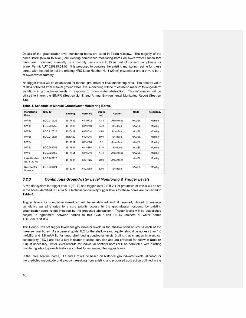
Details of the groundwater level monitoring bores are listed in Table 4 below. The majority of the bores listed (MW1a to MW6) are existing compliance monitoring bores on Sweetwater Station that have been monitored manually on a monthly basis since 2013 as part of consent compliance for Water Permit AUT.020995.01.03. It is proposed to continue the existing monitoring regime for these bores, with the addition of the existing NRC Lake Heather No 1 (29 m) piezometer and a private bore at Sweetwater Nursery.
No trigger levels will be established for manual groundwater level monitoring sites. The primary value of data collected from manual groundwater level monitoring will be to establish medium to longer-term variations in groundwater levels in response to groundwater abstraction. This information will be utilised to inform the SIMPR (Section 2.1.1) and Annual Environmental Monitoring Report (Section 3.6).
Table 4. Schedule of Manual Groundwater Monitoring Bores.
Monitoring Bore
NRC ID Easting Northing
Depth (m)
Aquifer Units Frequency
MW1a LOC.210522 1617843 6119772 13.3 Unconfined mAMSL Monthly
MW1b LOC.209755 1617597 6119793 94.0 Shellbed mAMSL Monthly
MW2a LOC.210523 1620419 6120014 15.0 Unconfined mAMSL Monthly
MW2b LOC.210524 1620422 6120015 59.0 Shellbed mAMSL Monthly
MW5a 1617811 6114690 6.0 Unconfined mAMSL Monthly
MW5b LOC.209759 1617644 6114898 61.0 Shellbed mAMSL Monthly
MW6 LOC.320452 1617451 6118946 14.4 Unconfined mAMSL Monthly
Lake Heather No. 1 (29 m)
LOC.200226 1617605 6121325 29.0 Unconfined
mAMSL Monthly
Sweetwater Nursery
LOC.201424 1618734 6122288 82.0 Shellbed
mAMSL Monthly
3.2.3 Continuous Groundwater Level Monitoring & Trigger Levels
A two-tier system for trigger level 1 (“TL1”) and trigger level 2 (“TL2”) for groundwater levels will be set in the bores identified in Table 5. Electrical conductivity trigger levels for these bores are contained in Table 6.
Trigger levels for cumulative drawdown will be established and, if required, utilised to manage cumulative pumping rates to ensure priority access to the groundwater resource by existing groundwater users is not impeded by the proposed abstraction. Trigger levels will be established subject to agreement between parties to this GCMP and FNDC (holders of water permit AUT.25683.01.03).
The Council will set trigger levels for groundwater levels in the shallow sand aquifer in each of the three sentinel bores. As a general guide TL2 for the shallow sand aquifer should be no less than 1.0 mAMSL and 1.5 mAMSL for deep shell bed groundwater levels (noting that changes in electrical conductivity (“EC”) are also a key indicator of saline intrusion and are provided for below in Section 3.3). If necessary, water level records for individual sentinel bores will be correlated with existing monitoring sites to provide historical context for estimating the trigger levels.
In the three sentinel bores, TL1 and TL2 will be based on historical groundwater levels, allowing for the predicted magnitude of drawdown resulting from existing and proposed abstraction outlined in the

17
AAWUG Model Report. If necessary, water level records for individual sentinel bores will be correlated with existing monitoring sites to provide historical context for estimating the trigger levels.
Table 5: Continuous Monitoring & Trigger Levels – Groundwater Levels
Bore Name Depth (m) Piezo. No. Target aquifer Units Frequency Trigger Levels
TL1 TL2
MW4 25 a Unconfined mAMSL Continuous TBC TBC
92 b Deep shellbed mAMSL Continuous 2.5 2.0
Waipapakauri
Sentinel
TBC 1 Unconfined mAMSL Continuous TBC TBC
>50 (TBC) 2 Deep shellbed mAMSL Continuous TBC TBC
Ahipara Sentinel TBC 1 Unconfined mAMSL Continuous TBC TBC
> 50 TBC 2 Deep Shellbed mAMSL Continuous TBC TBC
TBC = to be confirmed within 15 months of the date of commencement of these consents.
GL TL1s (where provided) have been calculated from long term monitoring data.
GL TL2s (where provided) have been interpolated from Table F1, WWA Groundwater Modelling Report
The setting of TL1 and TL2 trigger levels values for remaining piezometers will be undertaken during Stage 1 after 12 months of monitoring data has been collected and within 15 months of the date of commencement of these consents and will replace the interim trigger levels established through the process described at Section 2.1.2.1 above.
3.3 Saline Intrusion Monitoring & Establishment of Trigger Levels
Sentinel bores will be utilised as the primary reference sites for monitoring of potential effects associated with saline intrusion. These bores will be positioned between existing/proposed abstraction and the coastline to provide early detection or warning of:
Groundwater levels around the coastal margin approaching a threshold that could indicate a greater risk of saline intrusion; and
Any reduction in water quality that could indicate the landward migration of the saline interface.
Details of the sentinel bores are summarised in Table 6 below.
3.3.1 Stage 1 Monitoring
During the initial 12-month monitoring period, sampling for the following salinity indicators in the bores listed in Table 6 below will be undertaken at quarterly intervals6:
Electrical conductivity;
Chloride;
Sodium;
Total Dissolved Solids.
6 This frequency applies to the initial 12-month monitoring period for the establishment of baseline information. The frequencies specified in Table 6 are for ongoing monitoring specifications.

18
The samples will be collected in accordance with A National Protocol for State of the Environment Groundwater Sampling in New Zealand (Ministry for the Environment, 2006).
3.3.2 Ongoing Monitoring
Ongoing monitoring of groundwater and electrical conductivity levels will be undertaken continuously via individual piezometers in sentinel monitoring bores. Monitoring data will be telemetered to the Council on a twice-daily basis. Sampling at the frequencies specified for the following salinity indicators will take place in the bores listed in Table 6 below:
Electrical conductivity;
Chloride;
Sodium;
Total Dissolved Solids.
3.3.3 Schedule of Saline Intrusion Monitoring & Trigger Levels
The monitoring and trigger levels as discussed in this section are provided in Table 6 below. Data will be collected, processed and managed in accordance with the Council’s quality standards and A National Protocol for State of the Environment Groundwater Sampling in New Zealand (Ministry for the Environment, 2006).
A two-tier trigger level system (TL1 and TL2) for groundwater levels and electrical conductivity will be set in these bores.
As an initial guide, trigger levels for individual determinants will be established as follows:
TL1 – Median concentration from the Stage 1 monitoring period +25%.
TL2 – Median concentration from the baseline monitoring period + 50%.
TL1 and TL2 trigger levels for groundwater level and EC in MW4b are specified in Table 6 below. The setting of TL1 and TL2 trigger levels for the remaining piezometers will be undertaken during the first implementation stage after 12 months of monitoring data has been collected and within 15 months of the date of commencement of these consents, and will replace the interim trigger levels outlined in Section 2.1.2.1 above. The current trigger levels that are shown in Table 6 are based on existing data and will be reconfirmed by the Council when the other trigger levels are confirmed.
All sentinel monitoring bores listed in Error! Reference source not found.Table 6 will be installed
prior to the exercise of the consents.
Table 6: Monitoring Schedule – Saline Intrusion.
Bore Name Depth
(m)
Piezo.
No.
Target
aquifer
Parameter* Units Frequency Trigger Levels
TL1 TL2
MW4
25 a Unconfined
EC µS/cm Continuously TBC TBC
Chloride mg/L Quarterly TBC TBC
Sodium mg/L Quarterly TBC TBC
TDS mg/L Quarterly TBC TBC
92 b Deep shellbed EC µS/cm Continuously 500 600
Chloride mg/L Quarterly TBC TBC

19
Bore Name Depth
(m)
Piezo.
No.
Target
aquifer
Parameter* Units Frequency Trigger Levels
TL1 TL2
Sodium mg/L Quarterly TBC TBC
Waipapakauri
Sentinel TBC 1 Unconfined
EC µS/cm Continuous TBC TBC
Chloride mg/L Quarterly TBC TBC
Sodium mg/L Quarterly TBC TBC
TDS mg/L Quarterly TBC TBC
>50
(TBC) 2 Deep shellbed
EC µS/cm Continuous TBC TBC
Chloride mg/L Quarterly TBC TBC
Sodium mg/L Quarterly TBC TBC
TDS mg/L Quarterly TBC TBC
Ahipara Sentinel
TBC 1 Unconfined
EC µS/cm Continuous TBC TBC
Chloride mg/L Quarterly TBC TBC
Sodium mg/L Quarterly TBC TBC
TDS mg/L Quarterly TBC TBC
> 50 TBC
2 Deep Shellbed
EC µS/cm Continuous TBC TBC
Chloride mg/L Quarterly TBC TBC
Sodium mg/L Quarterly TBC TBC
TDS mg/L Quarterly TBC TBC
Waipapakauri
Quality TBC 1 Deep shellbed
EC µS/cm Continuous TBC TBC
Chloride mg/L Quarterly TBC TBC
Sodium mg/L Quarterly TBC TBC
TDS mg/L Quarterly TBC TBC
Notes:
* Parameter key: GL = Groundwater Level; EC = Electrical Conductivity; SI = Salinity Indicators; TDS = Total Dissolved Solids.
TBC = to be confirmed within 15 months of the date of commencement of these consents.
3.4 Production Bore Monitoring
3.4.1 Stage 1 Monitoring
During the initial 12-month monitoring period, sampling for the following salinity indicators in the bores listed in Table 7 below will be undertaken at 6-weekly intervals7.
3.4.2 Ongoing monitoring
Monthly water level monitoring will be undertaken in the production bores listed in Table 7. During the winter months (nominally May to September) this monitoring will provide information to identify any inter-annual variations in aquifer storage which may be anomalous compared to regional trends. During the irrigation season, water level measurements will be undertaken for a minimum of eight hours following the cessation of pumping.
Electrical conductivity (“EC”) values will also be measured at monthly intervals from the production bores during the irrigation season to check on any changes in salinity induced by the pumping. Requirements to continue monitoring of groundwater levels and electrical conductivity in individual production bores after Stage 1 will be addressed in the SIMPR (Section 2.1.1).
7 This frequency applies to the initial 12-month monitoring period for the establishment of baseline information. The frequencies
specified in Table 6 are for ongoing monitoring specifications.

20
3.4.3 Schedule of Production Bore Monitoring & Trigger Levels
The schedule of monitoring and trigger levels as discussed in this section are provided in Table 7 below. Data will be collected, processed and managed in accordance with Council’s quality standards and A National Protocol for State of the Environment Groundwater Sampling in New Zealand (Ministry for the Environment, 2006).
EC trigger levels will be established in the production bores listed in Table 7 below.
During the initial 12-month monitoring period EC trigger levels will be no greater than:
TL1 – Departure exceeding 25% of the EC value from the initial monitoring round
TL2 – Departure exceeding 50% of the EC value from the initial monitoring round
Long-term EC triggers for individual production bores will be established following an initial 12-month monitoring period, based on an assessment of observed spatial and temporal variation in EC in baseline and sentinel bore monitoring data, in a manner consistent with EC trigger levels established in the sentinel monitoring bores.
No trigger levels will be established for groundwater levels in the production bores as water levels in the production bores can be impacted by well efficiency and pumping schedules so are not necessarily representative of groundwater levels in the surrounding aquifer.
Table 7: Monitoring & Trigger Levels – Production Bores
Bore Name (NRC ID) Depth (m) Target aquifer Parameter* Units Frequency Trigger Levels
TL1 TL2
Sweetwater 1 TBC Shellbed GL mASL Monthly NA NA
EC mS/m Monthly NA NA
Sweetwater 2 TBC Shellbed GL mASL Monthly NA NA
EC mS/m Monthly NA NA
Sweetwater 3 TBC Shellbed GL mASL Monthly NA NA
EC mS/m Monthly NA NA
Sweetwater 4 TBC Shellbed GL mASL Monthly NA NA
EC mS/m Monthly NA NA
Sweetwater 5 TBC Shellbed GL mASL Monthly NA NA
EC mS/m Monthly NA NA
Sweetwater 6 TBC Shellbed GL mASL Monthly NA NA
EC mS/m Monthly NA NA
Sweetwater 7 TBC Shellbed GL mASL Monthly NA NA
EC mS/m Monthly NA NA
Sweetwater 8 TBC Shellbed GL mASL Monthly NA NA
EC mS/m Monthly NA NA
Sweetwater 9 TBC Shellbed GL mASL Monthly NA NA
EC mS/m Monthly NA NA
Sweetwater 10 TBC Shellbed GL mASL Monthly NA NA
EC mS/m Monthly NA NA
Sweetwater 11 TBC Shellbed GL mASL Monthly NA NA
EC mS/m Monthly NA NA
Sweetwater 12 TBC Shellbed GL mASL Monthly NA NA
EC mS/m Monthly NA NA
Sweetwater 13 TBC Shellbed GL mASL Monthly NA NA

21
Bore Name (NRC ID) Depth (m) Target aquifer Parameter* Units Frequency Trigger Levels
TL1 TL2
EC mS/m Monthly NA NA
Sweetwater 14 TBC Shellbed GL mASL Monthly NA NA
EC mS/m Monthly NA NA
Elbury Holdings Sweetwater-1 TBC Shellbed GL mASL Monthly NA NA
EC mS/m Monthly NA NA
Elbury Holdings TBC Shellbed GL mASL Monthly NA NA
EC mS/m Monthly NA NA
Notes:
* Purpose key: GL = Groundwater Level; EC = Electrical Conductivity.
All trigger limit values in this Table to be confirmed by Council.
3.5 Unmapped Natural Wetlands
Natural wetland means a wetland (as defined in the RMA) that is not:
(a) a wetland constructed by artificial means (unless it was constructed to offset impacts on, or restore, an existing or former natural wetland); or
(b) a geothermal wetland; or
(c) any area of improved pasture that, at the commencement date, is dominated by (that is more than 50% of) exotic pasture species and is subject to temporary rain derived water pooling.
Some wetlands in this area have been mapped from prior studies and surveys8, however, there are sites that may be classified as natural wetland that are currently unmapped.
In cases of uncertainty or dispute about the existence or extent of a natural inland wetland, the National Policy Statement for Freshwater Management 2020 directs that regard must be had to the Wetland Delineation Protocols9 as a robust method for delineating wetlands based on the United States delineation system. This protocol uses three criteria for identifying and delineating wetlands: vegetation, soils, and hydrology. The vegetation and soils components have been adapted to New Zealand conditions and the hydrological component is currently under development.
3.5.1 Unmapped Wetland Delineation Procedure
The Wetland Delineation Procedure is deemed appropriate for identifying whether three Areas of Interest (AoI) (Appendix A) contain natural inland wetland areas in the Ahipara and Sweetwater sub-aquifers. The Wetland Delineation Procedure is therefore replicated in Table 8 below.
Procedures which were completed prior to the commencement of the consent are referenced as having been completed and no further action is required against those particular procedures.
For all other procedures which were not completed prior to commencement of the consents, Table 8 contains the steps that shall be taken to complete that procedure within this adaptive management regime.
8 Northland Regional Council top wetland study, Protected Natural Areas Programme survey reports. 9 https://www.mfe.govt.nz/sites/default/files/media/Fresh%20water/wetland-delineation-protocols.pdf

22
Table 8: Unmapped wetland delineation procedure.
No. Delineation Procedure Completed Prior
to
Commencement
of Consents
(Yes/No)
Comment
1. Determine the project area (the putative wetland). Yes See Areas of Interest map attached (Appendix A).
2. Decide if ‘normal circumstances’ are present, ie, typical climatic/hydrologic
conditions, and no recent disturbances or modifications to the project area. If yes,
proceed to step 3. If no, proceed to step 7.
Yes Area D is a back-beach area behind a foredune to Te Onerohe a Tohe and is in a
state of ‘normal circumstance’.
Area E is on farmland but has been in this state for some period of time and is
therefore deemed to be in a state of ‘normal circumstance’.

23
No. Delineation Procedure Completed Prior
to
Commencement
of Consents
(Yes/No)
Comment
Area Q
3. Identify and map the major vegetation types using aerial photographs, maps,
contours, inventory reports, other data, and, if necessary, on-site field verification.
No Within one month of commencement of the consents, the Council, in consultation
with the Director-General of Conservation and the Consent Holders, will
commission a suitably qualified and experienced ecologist to undertake the desktop
and field analysis established under Procedures 4, 5 and 6.
A Wetland Delineation Report (WDR) containing details of the assessment
approach and outcomes shall be prepared by the same ecologist commissioned to
undertake the desktop and field analysis. The WDR shall be circulated to the
Consent Holders listed in Table 1 and the Director-General of Conservation a
minimum of 40 working days prior to the anticipated commencement of the
subsequent irrigation season. The Consent Holders and Director-General of
Conservation have 20 working days to provide a response to the Council on the
conclusions and recommendations of the WDR. If no response is received from a
party within the stated timeframe, then Council will consider that the party has no
concerns with the conclusions of the WDR. If any party does not agree with the
4. Off-site methods to identify wetland presence and sketch approximate
boundaries. Wetlands may be confirmed without an on-site inspection depending
on:
i. the amount and quality of data (vegetation, soils, hydrology, topography)
ii. wetland ecological expertise to interpret the data.
No
5. On-site methods to delineate wetland presence and accurate boundaries:
i. for small areas (≤2 ha), establish a representative plot in each major
vegetation type and record the plot vegetation in three strata: tree,
sapling/shrub, herb
ii. for larger areas, establish representative plots along transects (as per
Clarkson 2014) and sample the vegetation in three strata: tree,
sapling/shrub, herb.
No
Commented [ML2]: Add oblique imagery

24
No. Delineation Procedure Completed Prior
to
Commencement
of Consents
(Yes/No)
Comment
6. Hydrophytic vegetation determination. Based on the data gathered, conduct a
hydrophytic vegetation determination using the following flow chart (figure 1).
Wetland indicator status ratings for species are in Clarkson et al. 2013 and
subsequent updates.
No conclusions and recommendations of the WDR, then a report by a suitably qualified
hydrogeologist and/or an ecologist, both with experience and knowledge of the
locality, detailing the reasons for the disagreement shall be provided to Council
within 30 working days from the date that the assessment was sent to the party.
Council has the final authority over the delineation of a natural wetland and will
provide a report to the Consent Holders and the Director-General of Conservation
detailing the reasons for its decision, including the identification and discussion of
areas of agreement and disagreement within 5 working days of receipt of the
disagreeing parties report.

25
3.5.2 Repeat Survey
For sites delineated as natural wetland from the procedure set out at Section 3.5.1, the Council shall commission, in consultation with the Director-General of Conservation and the Consent Holders, a suitably qualified and experienced ecologist to undertake wetland vegetation survey and subsequent reporting within five (5) years from the original date of survey at around the same time of year as the original delineation survey. The repeat surveys must be designed in a way that enables ecologically meaningful and statistically robust scoring of the wetland condition in order to analyse changes to the wetland’s condition resulting from the groundwater abstraction.
This repeat survey must be completed once after the initial delineation Wetland Delineation Procedure (to provide an accurate baseline) but thereafter will only take place every five (5) years where technical assessment carried out according to Section 2.1.1 confirms that there is an adverse decline in wetland levels resulting from groundwater abstraction.
A decline in wetland water level attributable to groundwater abstraction will be determined from the monitoring and analysis of temporal groundwater level variations in the sentinel bores set out in Table 6.
3.6 Environmental Monitoring Report
At the end of each irrigation season, the Council will commission the preparation of an Annual Environmental Monitoring Report (AEMR) by a suitably qualified hydrogeologistthe nominated technical expert. The Council will endeavour to ensure that, if possible, both the hydrogeologist and the ecologist have experience and knowledge of the locality. A copy of the AEMR will be provided to the Consent Holders and the Director General of Conservation by 31 July each year.
The purposes of the AEMR are;
To provide a summary of the monitoring results for the previous year, including trends, against Objective 1 of the GMCP;
To assess the monitoring undertaken over the previous year against the standards set out in Objective 1;
To Identify any changes/amendments to monitoring locations/parameters/frequencies that could be incorporated in future SIMPRs;
To report on any issues apparent with the monitoring; and
To identify any improvement that could be made with respect to the monitoring.
The AEMR will also contain an evaluation of whether the observed effects of the groundwater takes are consistent with the predictions of environmental response contained in the AAGWM Report.

26
4. CONTINGENCY PLAN
Exercise of the consents is subject to compliance with Objective 1 of this GMCP. It is however noted that the exercise of AUT.020995.01.04 is not subject to the measures set out in this Contingency Plan up until the point at which their annual take exceeds 2,317,000 m3/year.
As described in Section 2, a trigger level system is used to define environmental criteria that signal changes may be occurring outside of what is normal (TL1) or at a point where remedial action is required to avoid Objective 1 not being met (TL2).
This section details the actions that will be undertaken where trigger levels are exceeded under any of the monitoring suites discussed in Sections 2.1.2.1, 3.3, and 3.4.
Where a trigger level is exceeded the Council will commission a Groundwater Trigger Exceedance Report (GTER). The objective of the GTER is to establish the cause of a trigger level exceedance and to recommend a programme of action to end the exceedance.
A GTER shall include:
Review of the monitoring results collected established why the exceedance has occurred;
Set out requirements for increased monitoring of the exceedance;
Set out environmental monitoring to detect effects of the exceedance, such as changes in extent of rivers, natural wetlands, springs or dune lakes;
Update the report on a regular basis as more data becomes available; and
Recommend actions to end the trigger exceedance, which could include;
◦ A staged reinstatement of abstraction levels to pre-exceedance levels,
◦ Reduced levels of abstraction for all or some of the consent holders covered by the GMCP, or
◦ Suspension of abstraction by all or some of the consent holders covered by the GMCP.
4.1 Exceedance of TL1
In the event of a TL1 exceedance, which may represent declining groundwater levels or rising salinity indicators, the following actions must be undertaken:
(a) The Council will notify the Consent Holders in writing within two (2) working days24 hours of when the TL1 exceedance became known.
(b) If the exceedance is of a salinity indicator in the bores listed in Table 6, then sampling of the monitoring bore(s) in exceedance shall immediately be upgraded to a weekly frequency for four (4) weeks following the first exceedance of the TL1. Weekly monitoring shall continue until sample results are consistently below TL1 values for a period of four (4) weeks or as directed by Council.
(c) If after four (4) weeks following the first exceedance of the TL1, the initiation of seawater intrusion and/or water level decline cannot be discounted to the satisfaction of the Council, then a GTER by a suitably qualified hydrogeologistthe nominated technical expert (and ecologist if the exceedance concerns a surface water body) shall be commissioned by the Council.
Commented [SK3]: Changed to reflect that information will be telemetered and a swift response should be able to be initiated

27
(d) The GTER shall assess the significance of the exceedance against the requirements of Objective 1 of the GMCP. The GTER shall assess why trigger levels have been breached, identify the pumping bores in the area(s) of effect and will review all of the available data collected in the affected area(s), in particular the data collected pursuant to this GMCP.
4.2 Exceedance of TL2
In the event of a TL2 exceedance, which represents a significant departure from normal groundwater conditions, with either continuously declining groundwater levels or rising salinity indicators:
(a). The Council will immediately inform the Consent Holders in writing within 24 hours of upon a TL2 exceedance becoming known.
(b). All Consent Holders must reduce their abstraction to 50% of the current average daily quantity, as calculated using the previous month’s water use records required to be kept in accordance with the conditions of its groundwater take consent. If the exceedance occurs within one month of a Consent Holder first taking water for irrigation purposes within an irrigation season, then the average shall be calculated using the water use records for this period only. The Council will advise the Consent Holder in writing of any breach and the required reduction in the daily water take volume.
(c). A GTER by a suitably qualified hydrogeologistthe nominated technical expert (and ecologist if the exceedance concerns dune lakes or natural wetlands) shall be commissioned by Council. The GTER shall assess why the TL2 has been breached, identify the pumping bores in the area of effect, and include a review of all available data collected for the affected area(s), in particular, the data collected under this GMCP.
(d). Once (b) above has been complied with, the Consent Holder may apply to the Council’s Compliance Manager for an alternative reduction in its daily water take volume. The Council’s approval of an alternative reduction value will only be given if it is satisfied that relevant TL2 values will not be exceeded. The Council will use the GTER to inform its decision on any alternative reduction value for a Consent Holder.
(e). If the TL2 exceedance is in a bore(s) that is/are not continuously monitored, then weekly groundwater level measurements and/or sampling of saline intrusion (depending on which trigger level is breached) in all bores where TL2 trigger levels are breached will commence within one week of the TL2 trigger level exceedance. Monitoring will continue until such time as:
Three consecutive samples in an individual monitoring bore are below all TL2 thresholds established for that piezometer; or
As directed by the Council.
(f). If salinity indicators continue to increase or groundwater levels continue to decline after 21 days following the implementation of (b), then the Consent Holder’s abstraction must be reduced to 25% of the current average daily quantity, as calculated for (b) above. The Council will advise the Consent Holder in writing of this further reduction and the required reduction in the daily water take volume.
(g). If (f) is implemented, then the Council will commission a review and update of the GTER report by a suitably qualified hydrogeologistthe nominated technical expert (and ecologist if the exceedance concerns a dune lake or natural wetland) with a longer-term programme of recommended responses incorporating observed responses to interim pumping rate reductions. The updated GTER will include a specific programme (including timeframes) of

28
actions which would achieve compliance with Objective 1 of this GMCP. The actions may include, but not be limited to incremental reductions in the daily quantity of groundwater taken as a percentage of the allowable daily pumped volume, as well as testing of domestic/stock water supplies in bores that are efficiently utilising the aquifer and are potentially impacted by saline intrusion, and if necessary, the provision of temporary water supplies to any affected parties (excluding any of the Consent Holders) in the event that Chloride concentrations exceed 250 mg/L (being the guideline value for taste prescribed in New Zealand Drinking Water Standards for New Zealand 2005 (Revised 2008)). The GTER will also identify a methodology which the Council will utilise to increase abstraction back to the volumes applicable to the relevant stage of taking (see Section 2.1), where this can be done such that Objective 1 of this GMCP will be met. If it is not possible to increase abstraction back to the relevant stage of taking, then the GTER will identify a methodology to increase abstraction to a lesser volume such that Objective 1 of the GMCP will be met.
(h). Actions arising from the GTER shall continue as long as the issue continues.
(i). Implement additional remedial measures as directed by Council, including the suspension of taking.

29
5. REFERENCES
Clarkson, B.R., Sorrell, B.K., Reeves, P.N., Champion, P.O., Partridge, T.R., Clarkson, B.D. (2003). Handbook for monitoring wetland condition (Revised October 2004).
Retrieved from
https://www.landcareresearch.co.nz/publications/researchpubslhandbook_wetland_condition.pdf
Ministry for the Environment. (2006). A National Protocol for State of the Environment Groundwater Sampling in New Zealand. Retrieved from http://www.mfe.govt.nz/sites/default/files/national-protocol-groundwater-dec06-updated.pdf