groundwater availability at fairmount, illinois...
TRANSCRIPT

1
Midwest Technology Assistance Center Groundwater Resource Assessment for Small Communities
Groundwater Availability
at Fairmount, Illinois (Vermilion County)
Project Overview This project is an outgrowth of the Public Service Program of the Center for Groundwater Science (CGS) at the Illinois State Water Survey. For over 50 years, the CGS has provided groundwater information to any requesting individual, commercial facility or public water facility. Groundwater resource assessments have been an integral part of this public service and have been undertaken for thousands of individuals and facilities throughout its history. Community groundwater supplies that have been identified as potentially “deficient” are the targets for this project. The criterion used for determining community deficiency were; 1) Water Supply and Demand (operating time), 2) Aquifer Limitation, 3) Well Specific Capacity, and 4) Facility History. The Village of Fairmount has been identified as a target community for groundwater assessment through this project. Project Goal To provide a resource tool of pertinent groundwater information to each target facility. This document describes a summary of historic information, current conditions and the potential for expansion of the water supply within 5 and 10 miles of Fairmount. Fairmount (Vermilion County)

2
The Village of Fairmount (IEPA Facility #1830250) utilizes three community water supply wells. Wells #2, #4, and #5, provide an average of 95,000 gallons per day (gpd) to 305 service connections, or a population of 690. The project criterion ranked Fairmount as “marginal” mainly due to its shallow water table wells, a long history of searching for the minimal groundwater supply currently utilized, and the problems associated with those searches due to the highly variable sand formations found throughout this area.
Historic Information Background Well Information Well No.2 Finished in shale, the well is located at the water treatment plant in Section 9, T.18N., R.13W., Vermilion County. The well was drilled to a depth of 72 feet in 1950 and, upon completion, reportedly produced 35 gallons per minute (gpm) for a short period of time with 23 of drawdown. Calculated specific capacity from this test was 1.5 gpm/ft. Static water level was reported as 8 feet below land surface. Well No.4 Finished in shallow sand and gravel deposits located in Section 9, T.18N., R.13W., Vermilion County. The well was drilled to a depth of 43 feet in 1986 and, upon completion, reportedly produced 80 gpm for 3 hours with 11.2 feet of drawdown. Calculated specific capacity from this test was 6.5 gpm/ft. Static water level was reported as 12.98 feet below land surface. Well No.5 Finished in shallow sand and gravel deposits located in Section 4, T.18N., R.13W., Vermilion County. The well was drilled to a depth of 47 feet in 1996 on an emergency basis to replace Well No.3 which had failed. The pump is rated at 40 gpm and a static was reported at 9 feet below land surface.

3
Background Pumpage Information
Rep o rted F a irm o u n t P u m p ag e
05000000
10000000150000002000000025000000300000003500000040000000
19791981
19831985
19871989
19911993
19951997
19992001
20032005
D ate
Gal
lons
W ell 5
W ell 4
W ell 3
W ell 2
Source: ISWS Illinois Water Inventory Program
Historic Population Information
R e porte d Fairmount Population
0200
400600800
10001200
19 7919 81
19 8319 85
19 8719 89
19 9119 93
19 9519 97
19 9920 01
20 0320 05
Da te
Pop
ulat
ion
Po pu la tio n
Source: ISWS Illinois Water Inventory Program

4
Regional Information Resources within 5 miles of Fairmount (Figure 1). Domestic Groundwater Supplies The available regional data indicate that groundwater for domestic and farm use in this part of Illinois is obtained from a variety of different types of wells from large-diameter dug and bored wells finished in the unconsolidated materials above bedrock, and from small-diameter drilled wells tapping both sand and gravel found within the unconsolidated materials and the shallow underlying bedrock formations. The large-diameter dug and bored wells tap stringers or lenses of silt, sand, or gravel only a few inches thick contained in the unconsolidated materials above bedrock. They range in depth from about 14 to 64 feet. The yield of this type of well is limited to a few hundred gallons per day and may be only barely adequate for normal household uses. Several small-diameter (4- to 6-inch) drilled wells are finished within thin sand and gravel deposits found within the unconsolidated material above bedrock. These wells range in depth from 40 to 64 feet. A few reported wells in the area have been drilled into the underlying Pennsylvanian bedrock formations. These wells are finished in thin sandstone and creviced limestone beds in the shallow bedrock and range in depth from about 70 to 150 feet. Upon completion, these wells were pumped at rates of 4 to 5 gallons per minute for short periods of time. Municipal Groundwater Supplies There are two towns located within five miles of Fairmount; the Village of Muncie to the north, and the Village of Jamaica to the south. Neither town reports a municipal water supply and it is assumed that the residents use domestic wells for their water needs. Resources with 10 miles of Fairmount (Figure 2). Municipal Groundwater Supplies Towns within 5 to 10 miles of Fairmount include: Belgium, Brothers, Bunsenville, Catlin, Fithian, Hegelar, Indianola, Oakwood, Sidell, Tilton, and Westville all located in Vermilion County. Two towns that are located in Champaign County within 10 miles of Fairmount are Homer and Ogden. The towns of Fithian, Indianola (Aqua Illinois), Sidell, Homer, and Ogden all report use of groundwater for their municipal needs. The Village of Oakwood pumps water from an intake located in the Salt Fork of the Vermilion River and Aqua Illinois sells water from Danville to many nearby towns. The Village of Fithian currently uses two wells located in Section 10, T.19N., R.14W., Vermilion County. These wells are finished in sand and gravel at depths

5
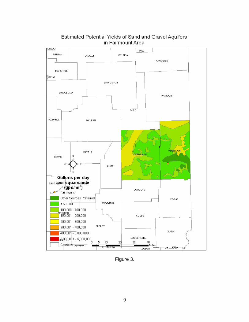
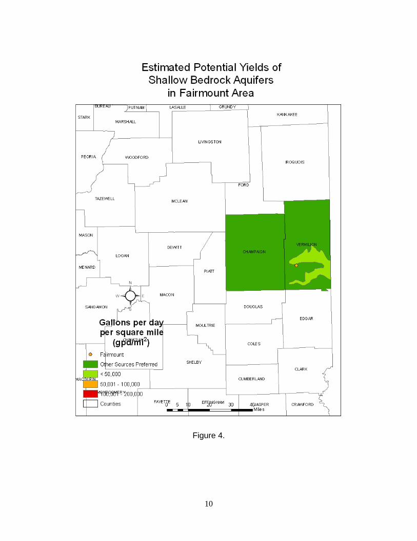
of 84 and 85 feet below land surface. Upon completion, these wells were pumped at rates of 70 to 100 gpm for short periods of time. Aqua Illinois currently owns and manages one well located in Section 17, T.17N., R.12W., Vermilion County. Files indicate that the Village of Indianola sold this well to Aqua Illinois because they could not obtain funding on their own. It is assumed that this well furnished groundwater only for Indianola in this area. The well is finished in sand and gravel at a depth of 49 feet below land surface and was originally pumped at 300 gpm for 3 hours. The Village of Sidell currently uses three wells (Nos. 3, 4 and 6) located in Sections 26 and 27, T.17N., R.13W., Vermilion County. These wells are finished in sand and gravel at depths of 28, 22, and 55, respectively, below land surface. The current production ratings of these wells are 25, 16, and 72 gpm. Well No. 6 is their main source of groundwater for the village. The Village of Homer currently uses 5 wells (Nos. 2-6) located in Sections 8 and 18, T.19N., R.14W., Champaign County. The village has recently developed two high capacity wells in Section 18 after extensive resistivity work, test drilling and production testing in this area. The original well field (Section 8) pumped groundwater from three wells finished in sand and gravel at depths ranging from 59 to 65 feet below land surface. Two wells located in Section 18, are their main source for groundwater. These wells are finished in sand and gravel at a depth of 143 feet and were pumped at rates close to 200 gpm for extensive testing. These wells double the output of the village wells in Section 8. The Village of Ogden currently uses three wells (Nos. 1-3) located in Section 9, T.19N., R.14W., Champaign County. These wells are finished in sand and gravel at depths of 65 to 86 feet below land surface. The current production ratings of these wells are 120, 120, and 210 gpm, respectively. Figures 3 and 4 picture the ISWS Potential Yield maps for sand and gravel and bedrock aquifer in Illinois, respectively. The pertinent counties for Fairmount are highlighted. Figure 3 indicates that sand and gravel deposits are variable throughout the Fairmount area. The bedrock map (Figure 4) indicates poor availability of groundwater from the bedrock throughout the Fairmount area. Figures 5 and 6 present the probability of occurrence of the sand and gravel and the water-yielding character of the shallow bedrock for the Fairmount area as depicted in the Illinois State Geologic Survey Circular 248, Groundwater Geology in East-Central Illinois (Selkregg, et al., 1958). Figure 5 indicates “Fair to Good,” variable and discontinuous sand and gravel deposits and Figure 6 indicates only small supplies are available from the shallow bedrock units. The domestic well construction records verify these map outlooks.

Figure 1. 5-mile radius map- Fairmont

Figure 2. 10-mile radius map- Fairmont

8
Groundwater Availability Summary The available information indicates that the sand and gravel deposits that the Village uses are capable of supplying the current needs of the town; however, should expansion of the well field be proposed, there are several areas that can be explored for water-yielding deposits. Illinois State Water Survey Contract Report 209 (Visocky, et.al., 1978) indicates that the northwest corner of town (NW¼, Section 4, T.18N., R.13W., Vermilion County has a good potential for test drilling but recommends resistivity work prior to testing. This document also indicates a second area for potential development would be the small rise to the northeast of town. The third area that is suggested for exploration is adjacent to the Salt Fork Vermilion River in the NW¼, SE¼, of Section 29, T.19N., R.13W., Vermilion county. Wells 4 and 5 have been developed in Sections 4 and 9 (respectively), T.18N., R.13W., south of town. We have no information to either confirm or deny the potential in the northwest corner of town as well as from the other two suggested locations. These would be likely areas to begin testing for additional sources of groundwater. Although these areas should be explored, it is likely that any additional sands and gravels that might be found would be very similar to the existing wells that are currently being used. Variable and discontinuous sands are found throughout this area as corroborated through many reports filed for all the towns seeking groundwater in this area. If the Village wanted to ensure a high capacity well field, capable of supplying groundwater for many years, the relatively newly discovered sand and gravel deposits south of Ogden would be the most likely source for exploration. These deposits, located in Section 18, T.19N., R.14W., Champaign County, are being used by Homer and have proven to be highly capable of producing large quantities of good quality groundwater. Illinois State Water Survey Contract Report 633 (Sanderson, et.al., 1998), discusses the testing of the Homer wells at this location.
9
Figure 3.
10
Figure 4.

11
Figure 5.
Figure 6.

12
References Selkregg, L.F. and J. Kempton. 1958. Groundwater Geology In East-Central Illinois, A preliminary Geologic Report. Illinois State Geological Survey Circular 248. Sanderson, E.W., A.P. Visocky. 1998. Groundwater Investigation for the Village of Homer, Ogden Township, Champaign County, Illinois. Illinois State Water Survey Contract Report 633. Visocky, A.P., H.A. Wehrmann, K.W. Kim (Illinois State Water Survey), and R.W. Ringler (Illinois State Geological Survey). 1978. Assessment of Public Groundwater Supplies in Illinois. Illinois State Water Survey Contract Report 209.
ISWS publications list for Fairmount and surrounding area (* indicates out of print) CHAMPAIGN *1950 RI-6 Groundwater resources in Champaign County. Smith. 44p. *1965 RI-48 Ground-water recharge and runoff in Illinois. Walton. 55p. *1965 RI-53 Potential yield of aquifers in Embarras River Basin, Illinois.
Walton-Csallany. Open File Report. 1965 RS-48 Relationship between water use and population in the
Embarras River Basin, Illinois. Csallany. *1969 RI-62 Groundwater resources of the buried Mahomet Bedrock Valley.
Visocky-Schicht. 52p. 1972 RI-70 Plans for meeting water requirements in the Kaskaskia River
Basin, 1970-2020. Singh-Visocky-Lonnquist. 24p. *1975 B-60-15 Public groundwater supplies in Champaign County. Woller.
55p. *1976 C-124 Groundwater availability in Champaign County.
Sanderson-Zewde. 139p. *1978 CR-209 Assessment of public groundwater supplies in Illinois.
Visocky-Wehrmann- Kim-Ringler. 193p.

13
*1980 CR-237 Assessment of eighteen public groundwater supplies in Illinois. Wehrmann-Visocky-Burris-Ringler-Brower. 185p.
1998. CR633 Groundwater Investigation for the Village of Homer, Ogden Township, Champaign County, Illinois. Sanderson, E.W., A.P. Visocky. VERMILION *1965 RI-53 Potential yield of aquifers in Embarras River Basin, Illinois.
Walton-Csallany. Open File Report. 1965 RS-48 Relationship between water use and population in the
Embarras River Basin, Illinois. Csallany. *1966 RI-55 Yields of wells in Pennsylvanian and Mississippian rocks in
Illinois. Csallany. 42p. *1969 RI-62 Groundwater resources of the buried Mahomet Bedrock Valley.
Visocky-Schicht. 52p. *1978 CR-196 Water supply alternatives for the city of Danville. Singh. 124p. *1978 CR-199 Reconnaissance study of final cut impoundments. Gibb-Evans.
101p. *1978 CR-209 Assessment of public groundwater supplies in Illinois.
Visocky-Wehrmann-Kim- Ringler. 193p. *1980 CR-237 Assessment of eighteen public groundwater supplies in Illinois.
Wehrmann- Visocky-Burris-Ringler-Brower. 185p. 1982 COOP-8 Hydrogeologic evaluation of sand and gravel aquifers for
municipal groundwater supplies in east-central Illinois. Kempton-Morse-Visocky. 59p.
1985 COOP-10 Geology, hydrology, and water quality of the Cambrian and
Ordovician Systems in northern Illinois. Visocky-Sherrill-Cartwright. 136p.