greening offshore wind with the smart wind chart
TRANSCRIPT

Web Ecol., 16, 73–80, 2016
www.web-ecol.net/16/73/2016/
doi:10.5194/we-16-73-2016
© Author(s) 2016. CC Attribution 3.0 License.
Greening offshore wind with the Smart Wind Chart
evaluation tool
Takvor Soukissian1, Sofia Reizopoulou1, Paraskevi Drakopoulou1, Panagiotis Axaopoulos1,
Flora Karathanasi1,2, Simona Fraschetti3, Laura Bray1, Federica Foglini4, Anastasios Papadopoulos1,
Francesco De Leo3, Chara Kyriakidou1, Evangelos Voukouvalas5, Evangelos Papathanassiou1, and
Ferdinando Boero3,6
1Hellenic Centre for Marine Research, P.O. Box 712, 190 13 Anavyssos, Greece2School of Naval Archit. & Marine Eng., National Technical Univ. of Athens, Heroon Polytechneiou 15573,
Zografos, Athens, Greece3Dipartimento di Scienze e Tecnologie Biologiche ed Ambientali, Università del Salento, CoNISMa,
Via Prov.le Lecce Monteroni, 73100 Lecce, Italy4CNR-National Research Council of Italy, ISMAR-Marine Sciences Institute, via Gobetti 101,
40129, Bologna, Italy5European Commission, Joint Research Centre (JRC), Institute for Environment and Sustainability,
Climate Risk Management Unit, Via Enrico Fermi 2749, 21027 Ispra (VA), Italy6Istituto di Scienze Marine del CNR, 16149, Genoa, Italy
Correspondence to: Takvor Soukissian ([email protected])
Received: 1 November 2015 – Revised: 18 February 2016 – Accepted: 25 February 2016 – Published: 9 March 2016
Abstract. The development of offshore wind farms (OWFs) and the establishment of marine protected areas
(MPAs) comprise two main elements for the production of clean energy, and the simultaneous maintenance and
protection of biodiversity in the Mediterranean and Black seas. Successful, efficient, and sustainable coupling
of these two aspects presumes that the criteria for selecting suitable locations for the deployment of OWFs
should not only include technical-engineering terms (e.g. high wind energy efficiency, bottom suitability, inland
infrastructures) but also ecological–environmental considerations (e.g. the least possible impact on biodiversity,
ecosystem functioning) and socio-economic aspects (e.g. effects on coastal and marine activities, development
of marine spatial planning). In the context of the FP7 CoCoNet project, the integration between OWFs and MPAs
is based on four main steps: (i) the identification of existing (networks of) MPAs focusing on the biodiversity
distribution patterns and current legislation, (ii) the coupling of offshore wind potential within networks of MPAs,
(iii) the evaluation of the knowledge gained up to date and the theoretical approaches at the two pilot sites of
the Mediterranean and Black sea basins, and (iv) the development of the “Smart Wind Chart”, a convenient
and rational tool addressed to scientists and policy makers for the evaluation of maritime policy management
schemes. The latter step comprises the core of this work.
1 Introduction
The exploitation of wind energy has long been recognized
as a key element in the common EU energy policy in order
to reduce the dependence on fossil fuel and emissions from
carbon sources, to decouple energy costs from oil prices, and
to ensure a secure energy supply. Although onshore wind en-
ergy generation is currently cheaper than offshore, finding
new suitable onshore sites is becoming increasingly difficult
in Europe. Offshore wind energy (OWE) is an attractive al-
ternative solution to take advantage of marine winds, which
tend to be higher, more frequent, and less variable than in-
land winds. Despite the tremendous development of offshore
wind farms (OWFs) in the northern European countries, with
more than half of the installed offshore capacity belonging to
Published by Copernicus Publications on behalf of the European Ecological Federation (EEF).

74 T. Soukissian et al.: Greening offshore wind with the Smart Wind Chart evaluation tool
the UK, no full-scale OWFs have been developed yet in the
Mediterranean and Black seas.
The development of OWFs in these two basins seems to
be an appealing and environmentally friendly pathway. Ac-
cording to Gaudiosi and Bori (2010), the total wind energy
production (offshore and onshore) could cover 10 % of elec-
tricity demand of the Mediterranean countries by 2030. On
the other hand, the development of OWFs alongside other
offshore (and coastal) human activities and the imperative
need for the conservation of marine habitats seem to be, at
first sight, heterogeneous (and often conflicting) aspects. In
this regard, it is not straightforward or evident how to har-
monize these aspects into a single holistic framework. The
relevant arguments that have been raised concerning the im-
pacts of OWFs on the local biotic and abiotic elements (EEA,
2009) necessitate the synthesis of these seemingly opposing
aspects into a single holistic framework, where networks of
marine protected areas (MPAs) will form the most important
marine environmental conservation and protection units.
The EU-funded coordinated project “Towards COast to
COast NETworks of Marine Protected Areas (from the shore
to the high and deep sea), coupled with sea-based wind en-
ergy potential” (CoCoNet) is focused inter alia on the ful-
filment of the synthesis of a holistic framework related to
the protection and connection of the ecologically important
areas in the Mediterranean and Black seas along with the ex-
ploitation of the climate-friendly offshore wind power (see
also http://www.coconet-fp7.eu/). The CoCoNet project aims
firstly to identify interconnected MPA networks within the
Mediterranean and Black seas at the local, regional, and
basin scale. According to Article 13 of the Marine Strat-
egy Framework Directive, coherent, representative, and inter-
connected networks of MPAs should represent an integrated
system of multiple protected areas designed to conserve re-
gional biodiversity and ecosystem function. In this respect,
the approaches considered for the evaluation of the degree
of connectivity at the spatial scale are currents, propagules,
beta diversity analysis on communities, and genetic diver-
sity. The second main aim of the CoCoNet project is linked
to the exploitation of OWE and deals with the integration of
geotechnical, socioeconomic, and environmental aspects into
a geospatial tool in order to evaluate the feasibility of the in-
stallation of OWFs in the examined basins. The identification
of the “overall” favourable OWF locations is important in or-
der to secure the financial viability and sustainability of the
offshore project, as well as to minimize the negative impacts
and maximize the positive effects of OWF installations in the
marine environment as a whole. The major outputs from the
CoCoNet project are (i) a set of guidelines for the design,
management, and monitoring of networks of MPAs and the
sustainable development of OWE along with marine conser-
vation goals, and (ii) the Smart Wind Chart (SWC).
Aiming our attention at the second major output, SWC
represents a robust and unbiased favourable site identifica-
tion approach that should be implemented for the integra-
tion of all the available information in order to illustrate
potential sites for deploying offshore wind installations and
to join the networks of MPAs. The visualizing aiding tool
for this approach is based on Geographic Information Sys-
tem (GIS) environment. During recent years, due to its flex-
ibility and available features, this spatial analysis tool has
been extensively used by renewable energy developers in
the context of multi-criteria decision analysis for OWF site
selection procedure (see, for example, Atici et al., 2015).
Moreover, there are recent studies evaluating OWE devel-
opment through GIS tools, but only at a national level; for
instance, there are assessment studies for Denmark (Möller
et al., 2012), Greece (Vagiona and Karanikolas, 2012), Por-
tugal (Costa et al., 2006), and the UK (Cavazzi and Dutton,
2016). Although there are numerous studies proposing multi-
criteria approaches for wind farm siting (mainly onshore),
an integrated approach combining the aforementioned view-
points with evaluation procedures is still missing for offshore
wind applications with reference to an extended spatial scale,
such as a large basin.
In this work, the procedure for the implementation of the
SWC is presented and applied in the Mediterranean Sea
(MS), focused on the corresponding pilot area located in the
northern Ionian Sea, in order to formalize the route leading to
the identification of favourable zones for OWF development.
The comparability of potential locations for developing off-
shore wind projects is based on quantifiable multi-parameter
technical criteria, which are considered of most importance
in the OWE industry, combined with environmental restric-
tions.
The structure of this work is the following: in Sect. 2, the
methodology developed in the context of the SWC analysis
is presented in more detail. In Sect. 3, the input data, includ-
ing technical and environmental factors, and the pilot study
area in the MS are described at length, and the results ob-
tained after the implementation of the SWC are presented in
the subsequent section. In Sect. 5, there is a discussion with
reference to some important aspects related to potential mis-
interpretations of the SWC results and some generic knowl-
edge/information gaps that were encountered at the basin
scale. In the last section, some concluding remarks and sug-
gestions are provided for further research.
2 Methodology for the development of the Smart
Wind Chart
A first step towards the development of a structured method-
ology, from which optimal OWF sites are determined, is the
identification of the main key actors that are involved in the
development of OWE projects and are characterized by dif-
ferent, and often contradictory, priorities and requirements.
Some of the included key actors include government bod-
ies, policy makers, financing mechanisms, scientists, local
communities, NGOs, and wind industry. Seen in this con-
Web Ecol., 16, 73–80, 2016 www.web-ecol.net/16/73/2016/

T. Soukissian et al.: Greening offshore wind with the Smart Wind Chart evaluation tool 75
Table 1. Ranking score and corresponding weightings of potential “go” areas.
Offshore wind Water Distance Proximity to very Electrical grid Bottom
speed (10 m a.s.l.) depth from shore large or large ports infrastructure sediments
Categorization > 6.9 m s−1 (5) 10–40 m (5) 10–20 km (5) 0–100 km (5) > 400 kV (5) Sand (5)
(rank) 6.3–6.9 m s−1 (4) – 5–10 km (4) 100–200 km (4) 225–400 kV (4) –
5.7–6.3 m s−1 (3) 70–200 m (3) 20–100 km (3) 200–300 km (3) 36–225 kV (3) Mud (3)
4.9–5.7 m s−1 (2) – 0–5 km (2) 300–500 km (2) < 36 kV (2) –
4.1–4.9 m s−1 (1) 40–70 m (1) > 100 km (1) > 500 km (1) Distribution grid (1) Rock (1)
Weighting (%) 35 25 15 5 15 5
text, a holistic approach for OWF development requires the
rational interweaving of geotechnical/engineering, socioeco-
nomic, and environmental aspects. The development of the
SWC moves towards this direction.
SWC is a flexible tool for the comparison and evaluation
of the potential OWF locations according to some quantifi-
able multi-parameter eligibility criteria. However, the loca-
tions evaluated through this tool should not be considered as
direct suggestions for future OWF development, but merely
as favourable candidate areas that deserve further in-depth
assessment in the context of detailed feasibility studies. Con-
sequently, the SWC should be regarded as a marine planning
tool rather than a decision-making platform.
There are two major steps for the implementation of the
SWC: (i) preparatory actions and (ii) processing phase (see
also Fig. 1). Preparatory actions include the assessment of the
most important quantifiable factors (technical criteria), the
factor rating table, and the identification of “no-go/restricted”
areas, i.e. areas that are either excluded from further consid-
eration or restricted under specific conditions, mainly due to
environmental considerations. The primary technical factors
consist of mean annual wind speed and bottom depth whilst
the additional factors that were considered include distance
to shore, proximity to ports, electrical grid infrastructure, and
type of bottom sediments. These factors are categorized in
rating tables, and rankings from 1 (least feasible) to 5 (most
feasible) are provided for each category. Then, each factor
is assigned a weight corresponding to its relative importance
on the feasibility of an OWF development. Thus, the overall
score for each location is a combination between the factor
rating table and the relative weights assigned to each factor
(see Table 1). A simple linearly weighted methodology was
adopted in order to keep the methodology as straightforward
as possible and be easily adoptable and flexible according to
the different demands and requirements of the involved key
actors. Moreover, future alteration of costs, diversity of lo-
cal conditions, and any progress in offshore wind technology
can be easily integrated in the developed methodology.
In this approach, the exclusion/restriction of an area is pri-
marily based on environmental restrictions, namely national
protected sites/MPAs and Natura 2000 sites, areas character-
ized by meadows of the seagrass Posidonia oceanica, fields
of the algae Phyllophora crispa, biogenic habitats such as
coralligenous, marl, and deep sea coral formations. Let us
note that national protected areas/MPAs and Natura 2000
sites may belong to either restricted or no-go areas; they
can be definitively characterized as no-go areas after detailed
in situ assessment. On the other hand, areas where the rest
of the environmental features are met are characterized as
no-go areas; the sensitivity and the vital role (at biologi-
cal/ecological level) of such features in maintaining the ma-
rine coastal equilibrium and preserving marine biodiversity
over the long term impose the need to prohibit any (harmful)
human marine activity in the corresponding areas. For exam-
ple, the Mediterranean endemic seagrass species Posidonia
oceanica is considered among the natural habitats requiring
conservation under the EU’s Habitats and Water Framework
Directive, since it is among the few representatives of biolog-
ical quality elements in the MS waters due to its recognized
ecological indicator possibilities (Lopez y Royo et al., 2011),
while Phyllophora beds supply benthic primary production
and water oxygenation in the circalittoral zone, and provide
breeding and feeding grounds, and nursery for diverse inver-
tebrate and fish species (Salomidi et al., 2012). Other restric-
tions may be attributed to marine and maritime uses (e.g. mil-
itary exercise areas, areas of fisheries and aquaculture, ship-
ping lanes, oil and gas extraction areas). However, such con-
siderations are the main object of marine spatial planning and
refer to site-specific studies concerning OWF development
(see Sect. 5 for more details).
In the processing phase, the two most important (tech-
nical) parameters have been firstly taken into consideration
for the primary identification of the site suitability: mean
annual wind speed and bottom depth. The former is evalu-
ated for the grid points that are not under any environmen-
tal restriction, and then the corresponding value for the lat-
ter one is extracted. Regarding mean annual wind speed, the
lowest threshold was set to 4.1 m s−1 at 10 m a.s.l. (meters
above sea level). This rather low limit is justifiable since
Eta-SKIRON underestimates (sometimes significantly) wind
speed with respect to satellite data and buoy measurements
(see Soukissian and Papadopoulos, 2015). Regarding bottom
depth, three different water depth ranges were considered:
(i) 0–40 m (“shallow waters”), (ii) 40–70 m (“intermediate”
www.web-ecol.net/16/73/2016/ Web Ecol., 16, 73–80, 2016

76 T. Soukissian et al.: Greening offshore wind with the Smart Wind Chart evaluation tool
Figure 1. Flow chart for the development of the SWC.
or “transitional waters”), and (iii) 70–200 m (“deep waters”).
Shallow and intermediate water depths refer to monopile,
gravity-based, tripod, jacket, and tripile supporting structure,
while deep waters refer to floating wind turbines technolo-
gies. Although fixed foundations are to date dominant in the
offshore wind market, floating structures seem to be a viable
alternative solution, especially for the Mediterranean waters,
provided that the relevant floating technology reach the de-
sired maturity level in the coming years.
If the combination of wind speed and bottom depth sat-
isfies the adopted thresholds (i.e. mean annual wind speeds
greater than 4.1 m s−1 at 10 m a.s.l. height and water depths
smaller than 200 m), then the point (area) is characterized as
“potentially go” area and is graded according to the exam-
ined factors and the relative weights, so that the final rank-
ings of the locations are derived. At the end of the analy-
sis, the potentially suitable sites worth being further assessed
for OWF development are identified with the highest overall
scores characterizing the most favourable sites. Let us note
that any preliminary national spatial planning for OWFs is
also included in the analysis. Such plans exist for France,
Greece, Italy, and Spain; however, some of these plans are
currently under revision.
3 Data and study area
3.1 Data sources
Wind data can be obtained from various sources that may
use different measuring principles, devices, and configura-
tions; these variations contribute to uncertainties in the long-
term wind speed (and resource) assessment and should be
properly considered (Soukissian and Papadopoulos, 2015).
In this work, the results obtained from the Eta-SKIRON
model (Papadopoulos et al., 2011) were used since they have
the finest available spatial (1/10◦×1/10◦) and temporal (3 h)
resolution. The simulation period is 15 years (1995–2009)
with reference height at 10 m a.s.l., and the initial conditions
were provided by the ERA-40 reanalysis data and the oper-
ational analyses of the European Centre for Medium-Range
Weather Forecasts (ECMWF), through the Hellenic National
Meteorological Service. The Eta-SKIRON model is based on
the Eta-NCEP (National Centre for Environmental Predic-
tion) model and was developed for operational purposes. Its
unique capabilities make it appropriate for mesoscale simu-
lations in regions with varying geographic characteristics.
The bathymetric information was obtained by the EMOD-
net Bathymetry portal (generated in February 2015) with
grid size resolution 1/8× 1/8 arcmin (see also http://
www.emodnet-hydrography.eu/). This bathymetry has been
produced from bathymetric survey data and aggregated
bathymetry data sets collated from public and private organi-
zations.
Distance from the shore is highly connected with socio-
economic aspects; a short distance from the shore minimizes
all the costs related to the technical infrastructure, installa-
tion and maintenance activities (i.e. capital and operating ex-
penditures), but on the other hand it maximizes visual distur-
bance. The coastline from EEA was used for delimiting the
specified distances from the shore (Table 1).
Similarly, regarding proximity to ports, as distances from
ports shorten, the accessibility to the offshore wind project
area is faster and more economical. These distances were de-
rived from the World Port Index Database of the National
Web Ecol., 16, 73–80, 2016 www.web-ecol.net/16/73/2016/

T. Soukissian et al.: Greening offshore wind with the Smart Wind Chart evaluation tool 77
Figure 2. Results from the SWC as regards technical criteria in the Mediterranean pilot area: score for wind resource (a), score for bottom
depth (b), score for distance from the shore (c), score for proximity to ports (d), score for bottom sediment type (e), and score for electrical
grid infrastructure (f).
Geospatial Intelligence Agency (WPI 2015 pub. 150, http:
//msi.nga.mil/NGAPortal/MSI.portal). The ports included in
the analysis are those whose controlling depth of the prin-
cipal or deepest channel or the greatest depth alongside the
wharf/pier is over 10 m.
Regarding bottom sediments, the existence of cobbles,
boulders, dense or soft sand, etc., affects the foundation de-
sign and cable laying. The type of bottom sediments was
derived via digitization of the Unconsolidated Bottom Sur-
face Sediments of the International Bathymetric Chart of the
Mediterranean (IBCM) of the Intergovernmental Oceano-
graphic Commission, and the scale of the corresponding map
is 1 : 1 000 000.
The assessment of the existing electrical grid infrastruc-
ture was based on the 2014 ENTSO-E Interconnected Net-
work Grid Maps (see www.entsoe.eu). ENTSO-E’s Intercon-
nected Grid Map is one of the publications of this associa-
tion. It displays the electricity transmission grid as of 31 De-
cember 2014, and the scale of the map is 1 : 4 000 000.
The data of all the environmental variables were derived
from the “Mediterranean Sensitive Habitat” (MEDISEH)
project (see http://mareaproject.net/). These data were par-
tially based on (i) revision of historical and current data from
the compilation of published and unpublished information,
and (ii) habitat suitability modelling that was applied to fill
spatial information gaps on the distribution of such species
by predicting the locations that habitats are likely to be suit-
able for species to live (Giannoulaki et al., 2013). For the
pilot site, the model results were based on a large number of
personal observations that were collected related to the oc-
currence of Posidonia oceanica, and some point data sources
for coralligenous and marl beds.
3.2 Description of study area
The Diapontia Islands, an island complex opposite to the
north-western coasts of Corfu, Greece, were selected as a
pilot area for OWF development in the context of the Co-
CoNet project and were used to develop the rationale of
SWC. The main reason for this selection is that the Greek
government (by the Ministry of Environment, Energy and
Climate Change in 2011) has already preselected the area
for potential OWF development; from this point of view, it
comprises a realistic case to be studied in depth. The rele-
vant activities are scheduled to take place in various phases.
In the first phase (which is at the concept/early planning sta-
tus), the foreseen capacity is 15 MW (three turbines each of
5 MW nominal power) (see www.4coffshore.com).
On the other hand, the selected area encompasses fea-
tures that are very representative of the coastal areas of the
MS. Specifically, Diapontia Islands do not belong to the few
top-ranked areas according to the wind resource availability
www.web-ecol.net/16/73/2016/ Web Ecol., 16, 73–80, 2016
78 T. Soukissian et al.: Greening offshore wind with the Smart Wind Chart evaluation tool
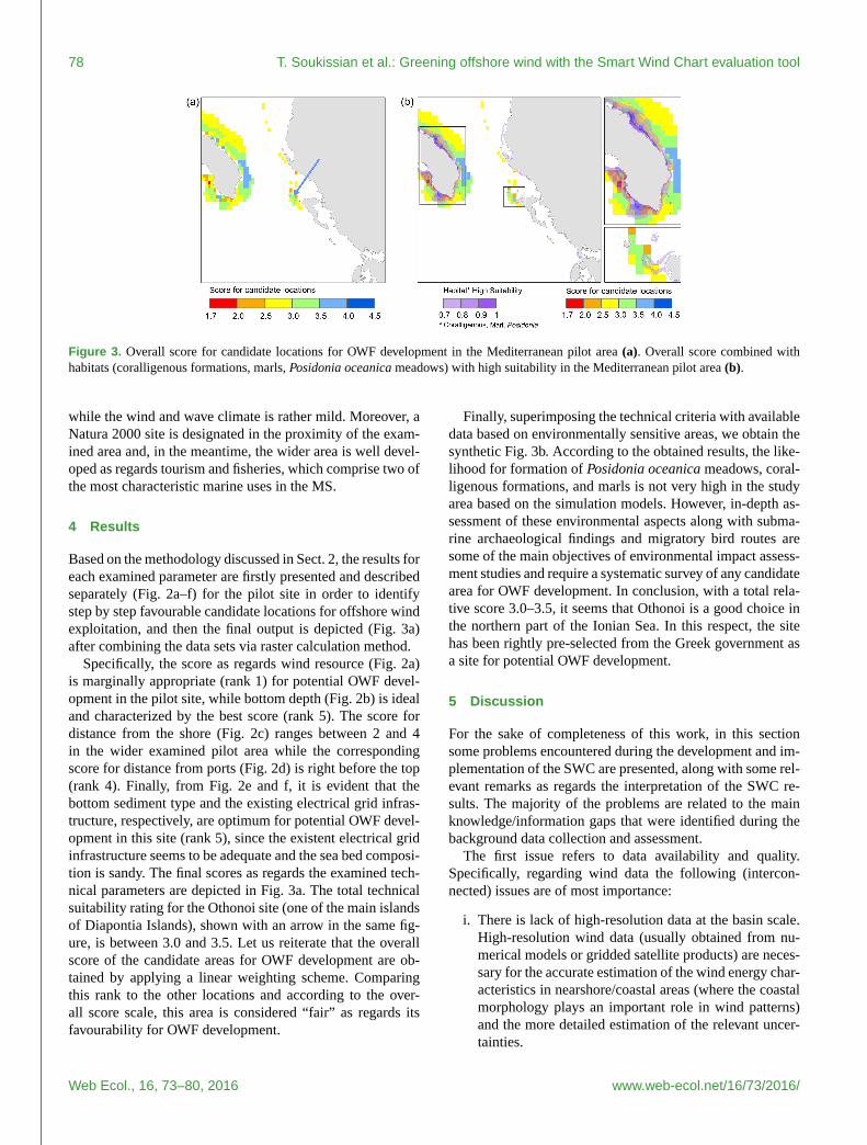
Figure 3. Overall score for candidate locations for OWF development in the Mediterranean pilot area (a). Overall score combined with
habitats (coralligenous formations, marls, Posidonia oceanica meadows) with high suitability in the Mediterranean pilot area (b).
while the wind and wave climate is rather mild. Moreover, a
Natura 2000 site is designated in the proximity of the exam-
ined area and, in the meantime, the wider area is well devel-
oped as regards tourism and fisheries, which comprise two of
the most characteristic marine uses in the MS.
4 Results
Based on the methodology discussed in Sect. 2, the results for
each examined parameter are firstly presented and described
separately (Fig. 2a–f) for the pilot site in order to identify
step by step favourable candidate locations for offshore wind
exploitation, and then the final output is depicted (Fig. 3a)
after combining the data sets via raster calculation method.
Specifically, the score as regards wind resource (Fig. 2a)
is marginally appropriate (rank 1) for potential OWF devel-
opment in the pilot site, while bottom depth (Fig. 2b) is ideal
and characterized by the best score (rank 5). The score for
distance from the shore (Fig. 2c) ranges between 2 and 4
in the wider examined pilot area while the corresponding
score for distance from ports (Fig. 2d) is right before the top
(rank 4). Finally, from Fig. 2e and f, it is evident that the
bottom sediment type and the existing electrical grid infras-
tructure, respectively, are optimum for potential OWF devel-
opment in this site (rank 5), since the existent electrical grid
infrastructure seems to be adequate and the sea bed composi-
tion is sandy. The final scores as regards the examined tech-
nical parameters are depicted in Fig. 3a. The total technical
suitability rating for the Othonoi site (one of the main islands
of Diapontia Islands), shown with an arrow in the same fig-
ure, is between 3.0 and 3.5. Let us reiterate that the overall
score of the candidate areas for OWF development are ob-
tained by applying a linear weighting scheme. Comparing
this rank to the other locations and according to the over-
all score scale, this area is considered “fair” as regards its
favourability for OWF development.
Finally, superimposing the technical criteria with available
data based on environmentally sensitive areas, we obtain the
synthetic Fig. 3b. According to the obtained results, the like-
lihood for formation of Posidonia oceanica meadows, coral-
ligenous formations, and marls is not very high in the study
area based on the simulation models. However, in-depth as-
sessment of these environmental aspects along with subma-
rine archaeological findings and migratory bird routes are
some of the main objectives of environmental impact assess-
ment studies and require a systematic survey of any candidate
area for OWF development. In conclusion, with a total rela-
tive score 3.0–3.5, it seems that Othonoi is a good choice in
the northern part of the Ionian Sea. In this respect, the site
has been rightly pre-selected from the Greek government as
a site for potential OWF development.
5 Discussion
For the sake of completeness of this work, in this section
some problems encountered during the development and im-
plementation of the SWC are presented, along with some rel-
evant remarks as regards the interpretation of the SWC re-
sults. The majority of the problems are related to the main
knowledge/information gaps that were identified during the
background data collection and assessment.
The first issue refers to data availability and quality.
Specifically, regarding wind data the following (intercon-
nected) issues are of most importance:
i. There is lack of high-resolution data at the basin scale.
High-resolution wind data (usually obtained from nu-
merical models or gridded satellite products) are neces-
sary for the accurate estimation of the wind energy char-
acteristics in nearshore/coastal areas (where the coastal
morphology plays an important role in wind patterns)
and the more detailed estimation of the relevant uncer-
tainties.
Web Ecol., 16, 73–80, 2016 www.web-ecol.net/16/73/2016/

T. Soukissian et al.: Greening offshore wind with the Smart Wind Chart evaluation tool 79
ii. There is lack of offshore measurements at the usual op-
erational turbine hub heights (i.e. within the range of
70–110 m a.s.l.). Measured wind data of the wind pro-
file are necessary in order to estimate reliably the actual
wind energy characteristics at hub heights. The wind
profile can be accurately deduced only by utilizing mea-
sured wind data at various heights a.s.l., which, cur-
rently, may be obtained either by meteorological masts
or lidar (light detection and ranging) measurements.
Furthermore, such measurements are also necessary in
order to evaluate less reliable data sources such as nu-
merical models or satellite products. However, there is
lack of lidar measurements in the Mediterranean and
Black seas, and the installation, operation and main-
tenance of meteorological masts are expensive proce-
dures, especially for offshore locations.
The data quality issue is also associated with the inherent un-
certainties of wind speed data and, consequently, wind power
density estimates, i.e. the most determinative parameter for
SWC analysis. Before the implementation of the SWC, four
different wind data sources (measurements from two buoy
networks, satellite products, and results from two numerical
weather prediction models) were assessed for the MS in or-
der to be statistically analysed and evaluated. The analysis re-
vealed that there were statistically significant deviations be-
tween the examined data sources. However, as it was recom-
mended by Soukissian and Papadopoulos (2015), calibration
schemes can be efficient in local spatial scales while it is very
risky to apply them in large spatial scales, such as the exam-
ined basins. Eventually, the most representative data source
with the highest spatiotemporal resolution was adopted. On
the other hand, such uncertainties necessarily should be taken
into consideration when site-specific studies are made for po-
tential OWF development.
More detailed spatial information is vital regarding also
marine environmental data. The more accurate mapping of
important habitats at the critical bottom depths for OWF de-
velopment, such as meadows of Posidonia oceanica, fields
of Phyllophora crispa, coralligenous, and deep-water white
coral formations, provide necessary background information
for efficient OWF planning in wide areas. Moreover, bird
migration routes over the same areas should be defined as
accurately as possible and relevant quantitative information
should be available.
However, the most important information gap seems to be
the lack of a basin-wide marine spatial planning. Some Eu-
ropean Mediterranean countries have coarse preliminary spa-
tial plans and very few detailed plans at regional level tailor-
made for OWE projects (e.g. at the Gulf of Lions in France).
In addition, since OWF installations are expected to affect
coastal zone activities, integrated coastal zone management
(combined with relevant information on the socio-economic
status of the area) is also required as a necessary complemen-
tary tool for marine spatial planning. In this regard, socio-
economic aspects could be included in future SWC applica-
tions, even in extended sea areas.
Another aspect to call attention to, especially when inter-
preting the SWC results, is related to the appropriate con-
sideration of the involved spatial scales. The spatial extent
of the examined basin, the heterogeneity of the considered
data sets, and the data spatial scales do not allow a detailed
(in the spatial domain) and in-depth (as regards the involved
parameters) analysis, let alone the lack of data, especially
with respect to socio-economic aspects. Specifically, the geo-
graphical extent of the MS is of the order of several hundreds
of kilometres, which assigns the magnitude of the spatial
scale, and, in turn, the data involved. The next most impor-
tant spatial scale is connected to the spatial resolution of wind
data. The resolution of the numerical model we have used is
roughly of the order of 10 km× 10 km (see also Sect. 3.1).
Here, the underlying assumption is that the wind information
contained in the area corresponding to the model grid point
(i.e. 100 km2) is homogeneous and representative of the en-
tire “pixel”. Although this assumption can be valid for mor-
phologically homogeneous sea areas (e.g. offshore areas),
there are cases in which it may be incorrect (e.g. for coastal
areas). Moreover, the spatial resolution of bathymetric data
is, in principle, not compatible with the wind data resolution,
since it is roughly of the order of 200 m. Let us also men-
tion that a large part of bathymetric data have been produced
by interpolation methods and thus cannot be considered as
fully accurate. In this respect, outputs of the SWC can only
provide some preliminary suggestions for potential OWF de-
velopment, mainly through indicative zones, in the examined
basin. Since this spatial scale may lead to misjudgements as
regards the development of offshore wind projects, a detailed
local assessment of technical, socio-economic, and environ-
mental features at the finest possible spatial scale is required
for localized cases in order to reach final decisions and form
strategies.
6 Conclusions
The identification of potential zones for offshore wind farm
development is a very delicate procedure and should be based
on sufficient and high-quality data regarding both biotic and
abiotic elements of the marine environment. An integrated
and interdisciplinary approach has been adopted integrating
technical, and environmental criteria and data related to the
offshore wind energy exploitation. The integration is imple-
mented through a robust tool – the so-called Smart Wind
Chart, aiming to maintain and secure the sustainable blue
growth in the Mediterranean and Black seas through the sup-
port of offshore wind energy projects and marine habitat
conservation. The application of the Smart Wind Chart in
the northern Ionian Sea provided one of the most favourable
candidate areas for offshore wind farm development in this
part of the Hellenic seas, which, in this case, coincides with
www.web-ecol.net/16/73/2016/ Web Ecol., 16, 73–80, 2016

80 T. Soukissian et al.: Greening offshore wind with the Smart Wind Chart evaluation tool
the suggestion of the Greek government. On the other hand,
some knowledge and information gaps were evident during
the implementation of the Smart Wind Chart while some ad-
ditional aspects, related to the uncertainties of the wind data
involved and the involved spatial scale of the data, were ex-
plicated in order to prevent misinterpretations of the outputs.
It is, however, important to note that the results obtained
from the Smart Wind Chart cannot replace an in-depth en-
vironmental and socio-economic impact assessment study,
which includes the corresponding mapping and monitoring
of any candidate area and, in general, more detailed analysis
with high-resolution data. Considering the future introduc-
tion of offshore wind farm installations in the Mediterranean
Sea, the potential impacts should be closely linked to the
environmental and ecological processes. Standardized mon-
itoring protocols and a clear guidance on the assumptions
and requirements of monitoring programmes are necessary,
in agreement with the scientific community and regulatory
bodies (Franco et al., 2015).
Acknowledgements. The research leading to these results
has received funding from the European Community’s Seventh
Framework Programme (FP7/2007-2013) under grant agreement
no. 287844 for the project “Towards COast to Coast NETworks of
marine protected areas (from the shore to the high and deep sea),
coupled with sea-based wind energy potential”.
Edited by: D. Montesinos
Reviewed by: two anonymous referees
References
Atici, K. B., Simsek, A. B., Ulucan, A., and Tosun, M. U.: A
GIS-based Multiple Criteria Decision Analysis approach for
wind power plant site selection, Utilities Policy, 37, 86–96,
doi:10.1016/j.jup.2015.06.001, 2015.
Cavazzi, S. and Dutton, A. G.: An Offshore Wind Energy Geo-
graphic Information System (OWE-GIS) for assessment of the
UK’s offshore wind energy potential, Part 1, Renew. Energ., 87,
212–228, doi:10.1016/j.renene.2015.09.021, 2016.
Costa, P., Simoes, T., and Estanquero, A.: Assessment of Sustain-
able Offshore Wind Potential in Portugal, in: Proceedings of
European Wind Energy Conference and Exhibition (EWEC),
Athens, Greece, 27 February–2 March 2006, 3, 2006.
European Environmental Agency: Europe’s onshore and offshore
wind energy potential. An assessment of environmental and eco-
nomic constraints, Technical report No 6, 90 pp., 2009.
Franco, A., Quintino, V., and Elliott M.: Benthic monitoring and
sampling design and effort to detect spatial changes: A case study
using data from offshore wind farm sites, Ecol. Indicators, 57,
298–304, doi:10.1016/j.ecolind.2015.04.040, 2015.
Gaudiosi, G. and Borri, C.: Offshore wind energy in the Mediter-
ranean countries, Revue des Energies Renouvelables SMEE’10
Bou Ismail Tipaza, 173–188, 2010.
Giannoulaki, M., Belluscio, A., Colloca, F., Fraschetti, S., Scardi,
M., Smith, C., Panayotidis, P., Valavanis, V., and Spedicato, M.
T. (Eds.): Mediterranean Sensitive Habitats (MEDISEH), final
project report, DG MARE Specific Contract SI2.600741, Hel-
lenic Centre for Marine Research, 557 pp., 2013.
Lopez y Royo, C., Pergent, G., Alcoverro, T., Buia, M. C., Casazza,
G., Martínez-Crego, B., Pérez, M., Silvestre, F., and Romero, J.:
The seagrass Posidonia oceanica as indicator of coastal water
quality: Experimental intercalibration of classification systems,
Ecol. Indicators, 11, 557–563, doi:1016/j.ecolind.2010.07.012,
2011.
Möller, B., Hong, L., Lonsing, R., and Hvelplund, F.: Evaluation
of offshore wind resources by scale of development, Energy, 48,
314–322, doi:10.1016/j.energy.2012.01.029, 2012.
Papadopoulos, A., Korres, G., Katsafados, P., Ballas, D., Perivolio-
tis, L., and Nittis, K.: Dynamic downscaling of the ERA-40 data
using a mesoscale meteorological model, Medit. Mar. Sci., 12,
183–198, doi:10.12681/mms.59, 2011.
Salomidi, M., Katsanevakis, S., Borja, A., Braeckman, U., Damalas,
D., Galparsoro, I., Mifsud, R., Mirto, S., Pascual, M., Pipitone,
C., Rabaut, M., Todorova, V., Vassilopoulou, V., and Vega Fer-
nandez, T.: Assessment of goods and services, vulnerability,
and conservation status of European seabed biotopes: a step-
ping stone towards ecosystem-based marine spatial management,
Medit. Mar. Sci., 13, 49–88, doi:10.12681/mms.23, 2012.
Soukissian, T. H. and Papadopoulos, A.: Effects of different wind
data sources in offshore wind power assessment, Renew. Energ.,
77, 101–114, doi:10.1016/j.renene.2014.12.009, 2015.
Vagiona, D. G. and Karanikolas, N. M.: A multicriteria approach to
evaluate offshore wind farms sitting in Greece. Glob NEST J, 14,
235–243, 2012.
Web Ecol., 16, 73–80, 2016 www.web-ecol.net/16/73/2016/