greenham and crookham common data collection, mapping and review project 04 cons site... ·...
TRANSCRIPT

Peak Ecology Limited, Lumford Mill, Riverside Business Park, Bakewell, Derbyshire, DE45 1GS.
Greenham and Crookham Common data collection, mapping and review project
March 2009

Peak Ecology Limited, Lumford Mill, Riverside Business Park, Bakewell, Derbyshire, DE45 1GS.
Client West Berkshire Council
Project Title Greenham and Crookham Common Data Collation, Mapping and Review.
P. E. Ref. WBC01
Date Version Report
Name Position Signature Date
Author
Mark Hampton Senior Ecologist
Reviewed by
Jonathan Brickland
Director
Signed off by
Jonathan Brickland
Director

Peak Ecology Limited, Lumford Mill, Riverside Business Park, Bakewell, Derbyshire, DE45 1GS.
Contents
1.0 INTRODUCTION ........................................................................................................ 5
2.0 METHODOLOGY ....................................................................................................... 7
3.0 RESULTS ................................................................................................................... 9
4.0 MONITORING........................................................................................................... 22
5.0 SUMMARY AND RECOMMENDATIONS ................................................................ 27
REFERENCES ..................................................................................................................... 28

Peak Ecology Limited, Lumford Mill, Riverside Business Park, Bakewell, Derbyshire, DE45 1GS.
SUMMARY Peak Ecology Ltd was commissioned by West Berkshire Council to collate and computerise a large
amount of data that had been collected over a period of 15 years for Greenham and Crookham Common.
The data consisted mainly of paper based records, with some data in Excel spreadsheets. This data was
to be input into the species database, Mapmate. Also, digitisation of recently produced, hand drawn maps
was also to be carried out.
A total of 4639 species records for Greenham and Crookham Common were put onto the Mapmate
database. These data are for 1096 species, 54 of which are Biodiversity Action Plan (BAP) priority species.
A further 449 records were input into Mapmate for areas adjacent to the Common. These represent
records for 181 species, 33 of which were not found within the Common boundary.
In total, 5088 records for 1129 species were computerised.
Maps for Compartments ? were digitised.
In addition, all the species data was put into an excel spreadsheet. Additional information was added to the
excel spreadsheet, which could not input into Mapmate. The extra information, such as habitat types found
within the different Compartments and taxonomic groups of the different species found, was added to aid
analysis.
The report uses the computerised data to:
summarise habitat and species information,
highlight Biodiversity Action Plan habitats and species,
give example analyses,
identify knowledge gaps,
discuss future site monitoring, restoration and management.

Peak Ecology Limited, Lumford Mill, Riverside Business Park, Bakewell, Derbyshire, DE45 1GS.
1.0 INTRODUCTION
1.1 Background information
Greenham and Crookham Common represents a large natural resource including lowland heath, species
rich grassland, woodland, open gravel and wetland communities.
The Common was a large-scale military airbase, holding nuclear weapons until it was decommissioned in
the early 1990’s. In 1994 large areas of Greenham and Crookham Common were designated a Site of
Special Scientific Interest (SSSI), ensuring it would remain a large open space and haven for important and
increasingly rare habitats and species of national and local interest.
The dismantling of the airbase involved removal of the concrete runways, which were crushed and sold as
aggregate by Raymond Brown Ltd. Therefore, alongside the management of the existing habitat, West
Berkshire Council and Natural England (then English Nature) initiated a heathland/grassland restoration
project in 1997. The restoration was based on the areas of bare gravel exposed by removal of runways,
buildings and fuel tanks.
In addition, 1 million tonnes of gravel was removed from the site by Tarmac in 2000/2001, which was then
stockpiled, to be sold over the following ten years. The gravel removal then facilitated the creation of a large
wetland area to the east of the site.
Surveys on the site during 1998 and 1999 collated a considerable amount of vegetation, butterfly and bird
data. For example, Ron Porley of Natural England set up monitoring transects on particularly sensitive areas
of the Common in 1994, which were surveyed again in 1996 and 1998.
In addition, three large transects across the SSSI were carried out in 1999, along with other vegetation data
recorded from the western section of the Common. Various MSc theses have been completed using the
Common for species data collection and a PhD was carried out on the Common, which collected vegetation
data from the grasslands, heath, wet woodland and gravel communities in 2001, 2002 and 2003.
Between 1994 and 2000 the Common was un-grazed and closed to the public, and the main management
on site comprised scrub removal, bracken bruising, grass cutting with hay collection and gorse swiping.
It has been a minimum of 8 years since the baseline data was collected. During this time, grazing was
introduced in 2001 and mowing with a hay collection and gorse swiping has since ceased. In addition, the
Commons were opened up to the public for recreational use in 2000. Importantly, a large gravel extraction
project occurred at the north-eastern end of the site, which may have impacted on the nature conservation
interest of the site, but has contributed to creating potentially important habitats on site.
Peak Ecology Limited, Lumford Mill, Riverside Business Park, Bakewell, Derbyshire, DE45 1GS.
Further data collection has occurred on site between 2001 and 2008 and a new management plan is being
developed with new habitat maps (produced in 2007).
Importantly, most of this data, collected for the site, is only in paper form and has not been computerised.
1.2 The Project
In 2008, West Berkshire Council (WBC) applied to the Aggregates Levy Sustainability Fund (ALSF) for
money to collate and computerise the large amount of data collected for Greenham and Crookham
Common. In addition, the funding application aimed to begin the digitisation of the 2007 habitat maps for the
site, into a Geographical Information System (ArcView). Once collated, the electronic database generated
could be assessed in terms of the impact of gravel extraction, management change and recreation on the
nature conservation interest of the Common, and importantly to begin the process of developing a site
specific monitoring protocol.
WBC was successful in their application and in November 2008 employed Peak Ecology Ltd to carry out the
data collation, data inputting, map digitisation and initial data assessment. This report summarises how this
carried out, what was achieved and discusses the findings in terms of habitat change and developing a site-
specific monitoring protocol. This will ultimately feed into the new management plan for the site.
The overall aim is that this is the first part of a larger project to assess change over the last 15 years (since
becoming a nature reserve) in terms of established species and habitats, the restoration process and to
develop a site-specific monitoring protocol that will indicate and highlight the effects of industrial processes
(gravel extraction), management and recreation on a nationally important nature reserve.

Peak Ecology Limited, Lumford Mill, Riverside Business Park, Bakewell, Derbyshire, DE45 1GS.
2.0 METHODOLOGY
2.1 Data collation
Data collation included the gathering of information recorded through various surveys and assessments
undertaken at Greenham and Crookhams by a range of statutory bodies, voluntary naturalist groups,
students, consultants and local enthusiasts. Information was supplied to Peak Ecology Ltd in a variety of
formats from recognised taxon specific recording forms to informal recordings from visitors whilst on site.
The majority of the information was provided in paper format with some in excel spreadsheets. The aim
was to input all the available data onto the species database Mapmate, which WBC use for collating
information on their nature reserves.
When inputting a species into the Mapmate programme a site name must be added against it with a grid
reference and county location. As the Common is such a large site, it has been divided up into
management Compartments, which have been mapped. Using the most recent map, a set of central grid
reference for each Compartment on site was generated. This central grid reference was then used in
creating a site name for each Compartment. Each Compartment would be added as “Greenham &
Crookham Commons. Compartment X” (with the central grid reference for the Compartment used).
When the data did not have a Compartment number or grid reference noted, the taxon was inputted
against a generic site name. This was ‘Greenham & Crookham Commons’ with a central gird reference
taken for the overall site. A third set of data was not within the boundary of the site, but was from areas
adjacent to the site.
Therefore, within the database the records are separated into three different groups, due to the data
available for a given record, as follows:
Compartment record. Record from a known area on the Common
General site record. Record was not from a specific area on the Common
Off-site record. Record not within the Common boundary, but adjacent to the site. The record
is denoted by the site name, such as Long Copse, which is where the record was taken.
Once all the data was inputted into Mapmate it was then imported into an excel spread sheet which
allowed for analysis of the information gathered for each Compartment. Comparisons could also be made
about the level of information gathered for each Compartment.
2.2 Map digitisation
The hand drawn paper copies of the management plans for each Compartment were transferred into a
geographical information system (GIS). This was achieved simply through recreating the hard copies with
the ArcView GIS programme. There was a specific allocation of 5 days for map digitisation within the
funding proposal and the number of maps digitised was restricted by this allocation. The rest of the map

Peak Ecology Limited, Lumford Mill, Riverside Business Park, Bakewell, Derbyshire, DE45 1GS.
digitisation would be carried out by WBC once this project was complete.

Peak Ecology Limited, Lumford Mill, Riverside Business Park, Bakewell, Derbyshire, DE45 1GS.
3.0 RESULTS
3.1 General Data
Habitat Information
Habitat information for the site was taken from the maps drawn in 2007 for the new management plan.
Mapmate appears to be limited as to what habitat information can be recorded being more of a species
based database. Therefore all of this information has been put into excel for use by WBC and for analyses.
The different habitat types found on the site and the Compartments they are found in are shown in Table 1.
These are generalised habitat descriptions and in part done from the memory of the author along with the
most recent maps. Further detail may be added by the site Rangers as required.
Table 1. List of habitats on Greenham and Crookham Common and the Compartments in which they are found.
Habitat Descriptions Compartments
Acid grassland 1c, 7a, 7d, 17b
Alder gully 3a, 3c, 4a, 5b, 5d, 6c
Birch scrub 1a, 3b, 3e, 4b, 5a, 5b, 5c, 6a, 6b, 7a, 7b, 7c, 7d, 8c, 13, 14, 15, 17a, 17b, 17c, 17d
Birch scrub woodland 2a, 3c
Bracken stands 2a, 3b, 4b
Bramble patches 17a, 17b
Coppice hazel and oak woodland 2b
Heath with grassland 6a, 6b
Lowland heath 1b, 1c, 2a, 3b, 3e, 4b, 7a, 7d, 10, 11, 12, 17b
Lowland heath (wet and dry heathland mosaic) 9
Lowland meadow 9, 10, 11, 12
Neutral grassland 8a
Open gravel 1b, 8b, 13, 14, 15, 16 central, 16 east, 16 north, 16 south, 16 west
Patches of heath 8c
Patches of heath with grassland 4c, 5c, 5d, 17a, 17c, 17d
Patches of heather and gorse 8a, 15
Pine with birch and sycamore scrub 3d
Ponds 3b, 3e, 14, 16 central, 16 east, 16 north, 16 south, 16 west, 18
Re-landscaped wetland 18
Rough grassland 3e, 13, 15
Secondary oak & beech woodland, with yew 1d
Secondary oak woodland 1a, 3c, 4a, 4c, 5a, 5c, 5d, 6a, 6b, 6c, 7a, 7b, 7c, 7d, 17a, 17b, 17c, 17d
Short turf grassland 1b, 3b, 3e, 8b, 8c, 10, 11, 12, 13, 14, 15

Peak Ecology Limited, Lumford Mill, Riverside Business Park, Bakewell, Derbyshire, DE45 1GS.
Habitat Descriptions Compartments
Wet meadow 9
Wet woodland 3a, 4a, 5b, 5d, 6c
Woodland plantation (non-natives) 13, 14
The variety of the habitats found across such a large area indicates that this reserve and the overall site
management requirements are of a genuinely landscape scale.
Species Records
A total of 5088 species records for Greenham and Crookham Common were put onto the Mapmate
database. These data are for 1129 species, 54 of which are Biodiversity Action Plan (BAP) priority species.
Figure 1 shows breakdown of all the records given the available information used to input them, in terms of
where the record was taken from on site.
Figure 1. Total number of records input into Mapmate separated into Biodiversity Action Plan (BAP) priority species
and non-BAP species. The records are further broken down into the record detail as to where the record was taken
from the site.
Total: 5088
records
252 records of BAP species (for 54 BAP species)
4836 records of non-BAP species (for 1075 non-BAP species)
Compartment records:
3750 records
216 records of BAP species (for 40 BAP species)
3534 records of non-BAP species (for 790 non-BAP species)
General site records:
889 records
36 records of BAP species (for 34 BAP species)
853 records of non-BAP species (for 764 non-BAP species)
Off-site records:
449 records
0 record of BAP species
449 records of non-BAP species (for 180 non-BAP species)

Peak Ecology Limited, Lumford Mill, Riverside Business Park, Bakewell, Derbyshire, DE45 1GS.
3750 of these records were allocated to a specific Compartment area (e.g. Greenham and Crookham
Common Compartment 2b) for the Common. The records were for 830 different species, 40 of which were
Biodiversity Action Plan (BAP) priority species.
889 records (for 798 species) were input into mapmate under the general site name of Greenham and
Crookham Common when a Compartment number or grid reference was not specified. These records can
only determine presence/absence of the species for the general area rather than for a specific area/habitat
found on the site. Of the 798 species with a general record, 34 were BAP species. 14 BAP species found
on the site only had a general record and it is therefore unknown where these species were actually found.
Overall, there were 281 species recorded as a general site record that were not recorded for a specific
Compartment. The fact that the Common represents a large area (approx. 500ha), will make it difficult to
determine management and monitoring options for the site/species given these records.
A further 449 records (for 181 species) from sites immediately outside the Greenham & Crookham
Commons boundary were also input into Mapmate. 33 of the species recorded in these sites were not
found within the Common boundary. These records were for the Bomb Site, Burys Bank Road, George’s
Wood, Great Wood, Kenton’s Wood, Long Copse and Parks Copse, Powells Copse & Barn Gulley (as one
woodland site). These have not been included within the analysis as any proposed monitoring and
management will not affect these areas.
Figure 2 below presents the total number of species within each Compartment, as well as the total BAP
species for added comparison (see also section 3.3). A considerable number of records were for
Compartments 9, 10, 11 & 12, which are the blocks of vegetation between the runways, generally referred
to as the lozenges. Several botanical, fungi and lichen surveys had been under taken within these areas
over different years giving a large amount of data.
Three Compartments had no species records; these were Compartments 17a, 17c and 18. As some of the
raw data had no indication of the Compartment it was recorded within, it should not be discounted that a
number of records inputted under the general site name could have been recorded from within these
Compartments.
In terms of Compartment 17, all sub-sections have a similar habitat type which suggests that monitoring
and management options decided for 17b and 17d, where there are species records, could be
implemented across the whole Compartment.
Compartment 18 is where a large amount of gravel was extracted. This area is now wetland, with sloping
banks on all sides that are under-going heathland restoration. As yet, there are no site records for this
area.

Peak Ecology Limited, Lumford Mill, Riverside Business Park, Bakewell, Derbyshire, DE45 1GS.
Figure 2. Total number of species found in the different Compartments on Greenham and Crookham Common

Peak Ecology Limited, Lumford Mill, Riverside Business Park, Bakewell, Derbyshire, DE45 1GS.
The species recorded cover various taxonomic groups, such as birds and vascular plants. Table 2 shows
the number of records for the different taxonomic groups, the number of species within each group and the
number of BAP species within the particular group.
Table 2. The number of records for the different taxonomic groups, how many species recorded in each taxonomic
group and the number of BAP species within each taxonomic group.
Taxon Number of records Number of species Number of BAP species
Amphibians 7 3 1
Birds 521 102 19
Fungi 178 105 0
Invertebrates 695 275 23
Lichen 39 17 0
Liverwort 75 22 0
Mammals 21 7 2
Moss 296 98 0
Non-vascular plant 1 1 0
Reptiles 7 2 2
Vascular plant 3248 497 7
This shows that some groups such as vascular plants, invertebrates and birds have the highest records
associated with them, and represent the bulk of the recording effort for the Common. In particular, vascular
plants represent the largest number of records (3248), having considerably more than any other group.
Some groups, such as amphibians, reptiles, mammals and non-vascular plants have only a small number
of records taken from the site.
Given that there are a lot of invertebrate records across different taxa, Table 3 shows the breakdown of
which invertebrate taxa have been recorded on the Common.
Table 3. Number of records for the different invertebrate taxa for Greenham and Crookham Common, along with how
many species in each taxa and how many of these are BAP species.
Invertebrate Taxa Number of records Number of species Number of BAP species
Bee 1 1 0
Bug 2 2 0
Butterfly 288 32 7
Cranefly 6 6 0
Damselfly 25 8 0
Dragonfly 32 13 0
Dung Beetle 1 1 0
Earwig 1 1 0
Flower Beetle 1 1 0
Fly 1 1 0

Peak Ecology Limited, Lumford Mill, Riverside Business Park, Bakewell, Derbyshire, DE45 1GS.
Invertebrate Taxa Number of records Number of species Number of BAP species
Glowworm 4 1 0
Grasshopper 26 13 0
Ground beetle 103 35 1
Groundhopper 2 2 0
Hoverfly 5 4 0
Ladybird 3 3 0
Leaf beetle 1 1 0
Longhorn Beetle 1 1 0
Moth 190 147 15
Robberfly 1 1 0
Window Gnat 1 1 0
As with the overall taxon records, there is a skew between the different invertebrates recorded, with
butterflies and moths having the largest number of records taken, in fact many of the invertebrate taxa
have less than 5 records for the site.
The rest of the results section looks at the BAP habitats and species in more detail. There are scarce and
uncommon species found on the Common, which are not BAP priority species; some of which are
highlighted in the Excel spreadsheet under the Wildlife and Countryside Act Scheduled Species column.
However, there are species of interest such as Moenchia erecta, Archidium alternifolium, Riccia
subbifurca, Scopania compacta and Orchid species (there are more species of interest not noted here)
which are not specifically highlighted and would need expert knowledge of a given group to identify the fact
that they are of conservation interest.
3.2 BAP Habitat Types
Table 4 below shows the Eight BAP priority habitat types present on the site and the Compartment where
they are found on site.
Table 4. Greenham and Crookham Common Compartments, which contain priority habitats.
Priority Habitat Type Compartment No.
Lowland Beech and Yew Woodland 1d
Lowland Heath 1b, 1c, 2a, 3b, 3e, 4b, 9. 10, 11, 12, 17b
Lowland Acid Grassland 1c, 17b
Lowland Meadow 9, 10, 11, 12
Lowland Mixed Deciduous Woodland 2b
Open Mosaic Habitats on Previously Developed Land 14, 16 East, 16 Central, 16 west, 16 South, 16 North
Ponds 3b, 14, 16 East, 16 Central, 16 west, 16 South, 16 North, 18

Peak Ecology Limited, Lumford Mill, Riverside Business Park, Bakewell, Derbyshire, DE45 1GS.
Priority Habitat Type Compartment No.
Wet Woodland 3a, 3c, 4a, 5b, 5d, 6b
In the SSSI citation, the site is designated due to the lowland heath, lowland grasslands and the different
woodlands on site. In particular the short turf, annual communities and lichen covered heath were
mentioned in terms of the species interest.
The area of lowland heath on the Common is the largest in Berkshire and is both regionally and nationally
important in terms of nature conservation. However, the fact that this is a large, landscape scale reserve
with a variety of other important habitat types including species-rich meadows, short-turf annual
communities and woodlands make the whole site an important natural resource.
The lowland meadow within the lozenges has been modified considerably over the last sixty years. In fact,
in the 1950’s these areas were completely stripped of vegetation and had temporary buildings on them.
Generally, considerable modifications to the site have occurred, including building what was the longest
runway in Europe. This means that these grassland areas have had a huge human influence on them and
have become a mosaic of neutral, calcareous and acid grassland communities from what was heathland.
The fact that these areas are extremely species-rich given the many and destructive disturbances that
have occurred, is most likely due to the thin soils and the management regime of regular mowing. The
mosaic of calcareous, acid and neutral communities is due to the disturbance that has occurred and with
regard to the calcareous grassland will be because of the large amount of concrete mixed on site to build
the runways, and the subsequent leaching from the runways into the adjacent grassland.
An important aspect of the site is the open gravel community, which includes a mix of terrestrial and
landscaped wetland areas. This community at present is an early successional habitat, with considerable
plant diversity, due to the rich pool of species in the nearby grasslands and heathland. These areas may
also be rich in invertebrates, with the potential to have rare species present. Also uncommon bird species
such as Lapwing and Little Ringed Plover utilise the open gravels for breeding.
Many of the open gravel areas have been subject to heathland restoration (spreading of heather cuttings
taken from the site), which may (or may not) be developing into a heathland/grassland mosaic. The other
important habitat developing on the newly exposed gravels are the ponds and general wetland areas that
have either been landscaped for the purpose of being a pond/wetland, or have developed naturally due to
clay lenses generating perched water tables. Both temporary and permanent ponds are present on site,
adding to the overall diversity on site and to the importance of the gravel communities found.
Peak Ecology Limited, Lumford Mill, Riverside Business Park, Bakewell, Derbyshire, DE45 1GS.
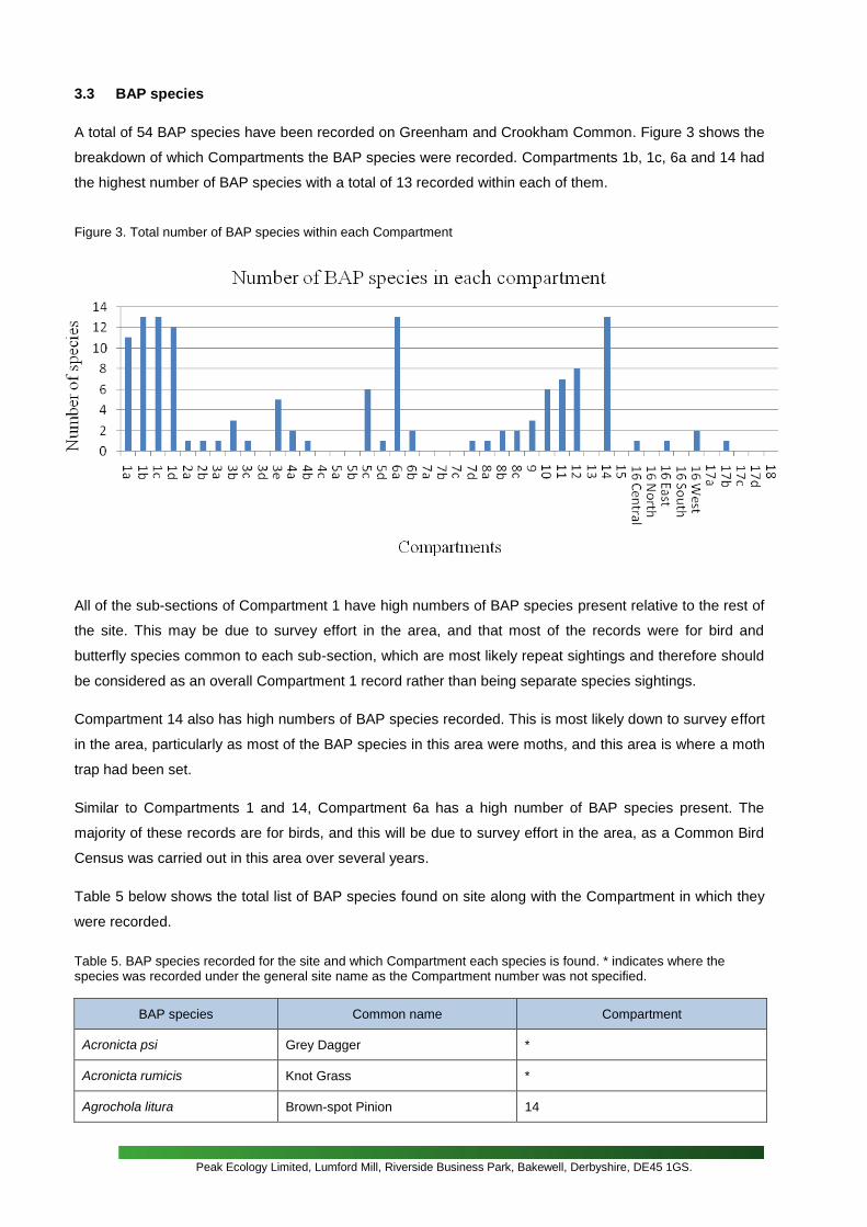
3.3 BAP species
A total of 54 BAP species have been recorded on Greenham and Crookham Common. Figure 3 shows the
breakdown of which Compartments the BAP species were recorded. Compartments 1b, 1c, 6a and 14 had
the highest number of BAP species with a total of 13 recorded within each of them.
Figure 3. Total number of BAP species within each Compartment
All of the sub-sections of Compartment 1 have high numbers of BAP species present relative to the rest of
the site. This may be due to survey effort in the area, and that most of the records were for bird and
butterfly species common to each sub-section, which are most likely repeat sightings and therefore should
be considered as an overall Compartment 1 record rather than being separate species sightings.
Compartment 14 also has high numbers of BAP species recorded. This is most likely down to survey effort
in the area, particularly as most of the BAP species in this area were moths, and this area is where a moth
trap had been set.
Similar to Compartments 1 and 14, Compartment 6a has a high number of BAP species present. The
majority of these records are for birds, and this will be due to survey effort in the area, as a Common Bird
Census was carried out in this area over several years.
Table 5 below shows the total list of BAP species found on site along with the Compartment in which they
were recorded.
Table 5. BAP species recorded for the site and which Compartment each species is found. * indicates where the species was recorded under the general site name as the Compartment number was not specified.
BAP species Common name Compartment
Acronicta psi Grey Dagger *
Acronicta rumicis Knot Grass *
Agrochola litura Brown-spot Pinion 14

Peak Ecology Limited, Lumford Mill, Riverside Business Park, Bakewell, Derbyshire, DE45 1GS.
BAP species Common name Compartment
Alauda arvensis Sky Lark *, 1a, 1b, 1c, 1d, 6a, 9, 10, 11, 12
Amphipoea oculea Ear Moth *, 14
Anthus trivialis Tree Pipit *, 6a
Apamea remissa Dusky Brocade 14
Aporophyla lutulenta Deep-brown Dart 14
Bembidion quadrimaculatum *, 11, 12
Caprimulgus europaeus European Nightjar *, 1a, 1b, 1c, 1d, 2a, 3b, 3c, 3e, 4b , 5c, 5d, 6a, 6b, 8c, 17b
Caradrina morpheus Mottled Rustic *
Carduelis cabaret Lesser Redpoll *
Carduelis cannabina Common Linnet *, 6a, 10, 11, 12
Carex ericetorum Rare Spring-sedge 16 West
Clinopodium acinos Basil Thyme *
Coccothraustes coccothraustes Hawfinch *
Coenonympha pamphilus Small Heath *, 1a, 1b, 1c, 1d, 3b , 5c, 14
Cuculus canorus Common Cuckoo *, 1a, 1b, 1c, 1d, 6a
Cupido minimus Small Blue *, 5c, 10, 12, 14
Damasonium alisma Starfruit 3e
Dendrocopos minor Lesser Spotted Woodpecker *
Ecliptopera silaceata Small Phoenix *
Emberiza citrinella Yellowhammer 6a
Erynnis tages Dingy Skipper *, 5c
Eugnorisma glareosa Autumnal Rustic 14
Euphrasia anglica 9, 11, 12,
Hipparchia semele Grayling *, 1a, 1b, 1c, 1d, 3b , 5c, 14
Lasiommata megera Wall *
Limenitis camilla White Admiral *
Lullula arborea Wood Lark *, 1a, 1b, 1c, 1d, 3e, 6a, 6b, 8b
Melanchra persicariae Dot Moth *
Minuartia hybrida Fine-leaved Sandwort 8b, 10, 11, 16 Central
Muscardinus avellanarius Hazel Dormouse 4a
Muscicapa striata Spotted Flycatcher *, 3e
Mythimna comma Shoulder-striped Wainscot *
Natrix natrix Grass Snake 1c

Peak Ecology Limited, Lumford Mill, Riverside Business Park, Bakewell, Derbyshire, DE45 1GS.
BAP species Common name Compartment
Numenius arquata Eurasian Curlew *
Passer domesticus House Sparrow *
Phylloscopus sibilatrix Wood Warbler 1a, 1b, 1c, 1d
Plecotus auritus Brown Long-eared Bat 2b, 4a, 14
Prunella modularis modularis Continental Dunnock *, 1a, 1b, 1c, 1d, 6a
Pyrgus malvae Grizzled Skipper *, 1a, 1b, 1c, 1d, 5c
Scleranthus annuus Annual Knawel *, 8a, 9, 10, 11, 12, 16 East
Spilosoma lubricipeda White Ermine 14
Spilosoma luteum Buff Ermine 14
Stellaria palustris Marsh Stitchwort 3a
Streptopelia turtur European Turtle Dove *, 6a
Sturnus vulgaris Common Starling 6a, 12
Triturus cristatus Warty Newt / Great Crested Newt 3e
Turdus philomelos Song Thrush *, 1a, 1b, 1c, 1d, 6a
Tyria jacobaeae Cinnabar *, 1b, 14
Vanellus vanellus Northern Lapwing *, 1a, 1b, 1c, 1d, 6a, 10, 11, 12, 16 West
Vipera berus Adder 1b, 1c, 1d, 6a, 7d, 8c, 14
Xanthia icteritia Sallow 14
Some of these species have been monitored over several years, generating a considerable amount of
information for particular species, including Lapwings, Nightjar, Grayling and Skylark. This information
makes it possible to focus on certain species within Compartments to asses any change over time.
For example, Lapwings were recorded in Compartments 1a, 1b, 1c, 1d, 6a, 10, 11, 12 and 16 west
between 1996 and 2000. No records for this species in these areas have been recorded since. Is this
because they are no longer present (potential recreational use effect) or are they still using these areas, or
are they utilising other areas on site?
Using Nightjar as another bird example, many surveys dating from 1996 have recorded the presence of
nightjars within several of the Compartments across the site. Figure 4 shows the changes of the number of
individual Nightjars recorded in different Compartments over a seven year period.

Peak Ecology Limited, Lumford Mill, Riverside Business Park, Bakewell, Derbyshire, DE45 1GS.
Figure 4. Nightjar monitoring details for Compartments 1c, 2a, 3c, 4b, 5c and 6b between 2002 and 2008. = Not
surveyed for given year.

Peak Ecology Limited, Lumford Mill, Riverside Business Park, Bakewell, Derbyshire, DE45 1GS.
The nightjar population varies across the years and within the Compartments. Compartment 2a for
example shows that nightjars were present every year from 2002 to 2007, with no individuals being
recorded in 2008. Also, the number of individuals recorded varied between years, with one seen in 2002,
2003 and 2004, and two seen in 2005, 2006 and 2007.
Nightjars are consistently seen in these Compartments and are obviously coming back to breed on the
Common every year where the habitat remains viable for them to use. Fluctuations are seen such that
some Compartments appear not to have nightjars utilising them in certain years (Compartment 2a in 2008,
Compartment 4b in 2002, Compartment 5c in 2003 and 2005, Compartment 6b in 2002 and 2006).
The changing nature of the heathland and scrub mosaic required by nightjars to breed means that
monitoring of the requirements for nightjar is essential for the long-term use of the Common by these birds.
The regular sightings for example in Compartments 1c, 2a and 4b will be linked to the fact these areas are
lowland heath with a scrub edge, and birch scrub encroachment onto the open heath is always an issue,
and will need to be monitored (and managed) to keep the area as suitable habitat for nightjar. For example
in Compartment 2a, if the nightjar survey of 2009 does not record any individuals as in 2008, then an
assessment of this area in terms of nightjar habitat should be made.
3.4 BAP Species by BAP Habitat
As discussed in the previous section, species records can be assessed with relation to habitat (as
mentioned above). For example Compartments 1b, 1c & 2a are Lowland Heath and Acid Grassland
communities surrounded by a scrub woodland edge. These areas contain BAP species including nightjar
(see above), reptiles (adder and grass snake) and butterflies (including grayling and grizzled skipper). All
such species depend on the varied vegetation structure of a heathland, grassland and scrub mosaic, with
open areas for foraging, nesting and basking. This mosaic nature of heathland and grassland habitats are
perhaps the most susceptible to change, requiring substantial management to maintain open areas and
prevent encroaching trees and scrub, which would impact on the population status of BAP species found.
Clearly different species can utilise mosaics of different habitat types, as noted above; however without
specialist knowledge confusion as to certain species requirements can arise where Compartments have
several habitat types. For example Skylarks are recorded in Compartments 9, 10, 11 and 12. These
Compartments have both lowland heath and lowland meadow communities, and the Skylarks are most
likely using the meadow areas of these Compartments, rather than the heathland in terms of breeding and
foraging.
Another example is Annual Knawel, the annual plant; again this species is found in Compartments 9, 10,
11 and 12, but this species will be associated in the open, short turf communities generally found at the
edges of these Compartments, rather than in the heath or perennial grassland areas.

Peak Ecology Limited, Lumford Mill, Riverside Business Park, Bakewell, Derbyshire, DE45 1GS.
3.5 Map Digitisation
Compartments ? have been created using the ArcView GIS software. The remaining maps will be
completed by West Berkshire Council at a later date.
3.6 Knowledge Gaps
As discussed above, a lot of data has been collected for Greenham and Crookham Common. However, by
assessing and computerising this data, some gaps in information have been highlighted, which could form
the basis of survey and assessment projects for the future, and could feed into management and
monitoring for the site. The key gaps drawn out so far are as follows:
There are no clear objectives for the different habitats on site, for example the area and
structure of lowland heath, both for established areas, and for the restoration process occurring on
the gravels (see Section 4 – Monitoring).
There is no information on the development and restoration of Compartment 18 – where
gravel extraction occurred.
There is very little amphibian data, including only two GCN records, so it is unknown if they
are dispersing across the site, which could be/is happening, as there is suitable habitat developing
on site.
There is little information on the wetland areas, and in particular pond quality in terms of
plants and invertebrates, which also links to the lack of knowledge on amphibian dispersal (see
above).
There is very little data on the bats on site.
There is limited data on Dormice. There is a record for a particular Compartment (4a) but little
else.
There is little information on certain invertebrate groups such as bees and wasps that, in
particular, may be utilising the open vegetation and gravel communities on site.
From the initial assessment of the data, these appear to be the key gaps in knowledge for the site and
addressing these issues in terms of future projects should be considered the priority. This information can
be fed into the management and ultimately the nature conservation value of a nationally important site.
Peak Ecology Limited, Lumford Mill, Riverside Business Park, Bakewell, Derbyshire, DE45 1GS.
4.0 MONITORING
This project is primarily concerned with collating all the data collected over the last 15 years for Greenham
and Crookham Common and inputting this data onto a specialist computer database for the Common. This
has been carried out, along with digitising some of the recent hand-drawn maps for the Common. This
information is now available for analysis, examples of which have been carried out (see previous sections)
for the purposes of this project.
An important outcome of this project will be to use the data assessment to identify changes in the nature
conservation interest of the site, assess the restoration process and develop a monitoring protocol for the
site. These outcomes will not only assess the effects of gravel extraction, but will ensure that management
and recreation are not having a negative impact on the nature conservation interest of the site both in
terms of established habitat and the restoration process.
In particular, by developing a monitoring protocol, the various unknowns can be addressed, therefore
linking monitoring with management and restoration objectives rather than relying on perceived and often
anecdotal change on the site. The fact that much of the data for the Common is now in a usable form as a
database will feed into this process, the beginnings of which are discussed below. The need for clear
conservation objectives will be extremely important in terms of assessing the various impacts on the
Common and in developing a monitoring protocol, and will need to be developed as an initial outcome of
this project.
In recent years questions have been raised as to management and restoration on the Common such as:
Are the areas of grassland being overgrazed?
Are the open vegetation/annual communities being maintained?
Are the areas of heath potentially under-grazed and becoming dominated by Gorse?
What effect is recreation having on the site, and in particular the ground nesting birds?
How is the restoration process developing on the re-landscaped areas?
How are the wetland communities developing across the site, and in particular on the gravel
extraction area?
These are key questions, but cannot be answered without a monitoring programme, which in itself cannot
be put in place without clear aims and objectives for the different communities/species found being set.
These in turn will be affected by what is possible in terms of how the site is managed and the resources
available to carry out that management.
For example, the vegetated areas between where the runways used to be (the lozenges), listed as
Compartments 9, 10, 11 and 12 were highly managed by the Ministry of Defence when the site was an

Peak Ecology Limited, Lumford Mill, Riverside Business Park, Bakewell, Derbyshire, DE45 1GS.
airbase. These areas were mown every two weeks to keep the turf short, which in part maintained low
nutrient status of the soil and held competitive species in check. The dominant habitats are grassland and
heathland, but the height of the vegetation was kept very short and the heathland areas were held in a
building-mature phase of development. The mowing regime essentially maintained the species-rich
grassland (including short turf annual communities) and open, short heath with a diversity of lichen
species.
Data collected from the heathland area in Compartment 10 between 1994 and 1998 shows that with the
cessation of mowing, the vegetation height increased from an average of 68mm to an average of 150mm,
although species richness did not significantly change in that time. Also, shrub and tree species were
noted as scattered across the grassland areas, in short a successional process was beginning.
The outcome was to ensure the grassland and heathland areas were mown, with the arisings removed to
an identified area on site, from 1998 onwards. The mowing regime was a once a year cut and removal; this
not only kept the heathland and grassland open, by arresting succession, it also allowed grassland herbs
to flower in the meadow areas providing a rich show of flowering during the summer months (see database
for the diversity of herbaceous species found). Short-turf annual communities were also maintained during
this time, although this was undoubtedly due to the thin soils found in those particular areas.
Grazing on site was introduced in 2000, and 2003 was the last time these areas were mown, with grazing
being the only form of management used on site (other than bracken control) after 2003. This was in part
because there was very little to cut since grazing had been introduced.
From observational notes from 2007 and 2008, the grassland areas are now maintained as short turf with
flowering of herbs occurring less due to the grazing; the heath community is still being maintained but there
is little information on whether the canopy height or ground cover is changing. Other anecdotal evidence
suggests that shrub species such as Gorse are increasing in cover on the grassland and heathland areas.
Alongside this information, there are 452 vascular plant, bryophyte and lichen records for this area
collected over 15 years, which highlight species of interest and the diversity found in this area alone.
With this information clear conservation objectives can be put in place, against which a monitoring protocol
can be developed. Indicator species for the grassland and heath can be pulled out of the database, and
decisions as to vegetation structure can be made, given the known historical patterns for the vegetation
communities.
In terms of an overall, achievable monitoring protocol for Greenham, a mix of habitat and species
monitoring protocols could be developed. Using habitat indicator species and vegetation structure would
create a protocol to assess habitat degradation. As mentioned previously, the beginning of this process is

Peak Ecology Limited, Lumford Mill, Riverside Business Park, Bakewell, Derbyshire, DE45 1GS.
to set objectives for the communities and species found, given the site as a whole, against which
monitoring can be based.
It would be impractical and expensive to implement an extensive monitoring programme for the whole
Common so key areas need to be identified, against which the condition of the Common is assessed.
Eight key habitat types have been identified in this report, and these should set the basis for setting
objectives and developing the monitoring protocol. Key species found on site can be used as part of the
monitoring process, but should be addressed in terms of the habitats in which they are found and their
habitat requirements.
For the monitoring protocols themselves, it is suggested that the format and procedures to be developed
be based on the methodology laid out in Hurford and Schneider (2006), which discusses in detail the
purpose and practice of monitoring nature conservation. The basic premise of their work states that
monitoring is hypothesis testing; the aims as to what is to be achieved are established in advance, and
then data is collected to determine whether or not the aims have been achieved. There is a predetermined
view as to what is trying to be achieved, as opposed to tracking something through time, such as habitat
composition with no expectation as to what change might occur (this is surveillance). Key factors
highlighted are that conservation objectives are linked with the hypothesis testing and that reliable indicator
assemblages are site-specific.
Other key texts to be used would be the Joint Nature Conservation Committee (JNCC) Common
Standards Monitoring (CSM) protocols for relevant habitat types (lowland dry heath etc). Alongside Natural
England indicator species for key habitat types under Environmental Stewardship (found within the Farm
Environment Plan (FEP) handbook). However, there would be a need for these to be adapted for the
Common and for the particular objectives for the site; this would most likely involve simplification of the
JNCC protocols in line with conservation objectives. Obviously, Natural England officers would be
consulted during this process, and linkages with condition assessment monitoring would need to made
throughout this process.
At this stage and for this report, only examples can be given, a full protocol would need to be set against
objectives, and generated from botanical and animal surveys carried out with objectives in mind. This
project can help identify habitats to be monitored, where they are on site and the indicator species that can
be used in the protocol.
For example, grassland monitoring will most likely need to be split into the different community types that
are deemed important. There are interesting annual plant communities have been recorded within
transitional zones from bare ground to grassland and in open grassland. Whereas other grassland areas
contain the more traditional meadows (MG5 type – NVC) including several orchid species such as Green-
Peak Ecology Limited, Lumford Mill, Riverside Business Park, Bakewell, Derbyshire, DE45 1GS.
winged Orchid, a very large population of Autumn Lady’s Tresses, Pyramidal Orchid, Bee Orchid, Common
and Heath Spotted Orchids. Anecdotal evidence has also suggested that another important species, Fine-
leaved Sandwort, is associated with anthills present within the grassland and on particularly disturbed
areas of the Common.
In terms of selection of indicator species an example would be the use of FEP indicator species for nutrient
poor grassland species such as Devil’s-bit Scabious and Burnet-saxifrage, Fairy Flax and Greater
Knapweed which have been recorded within several of the Compartments.
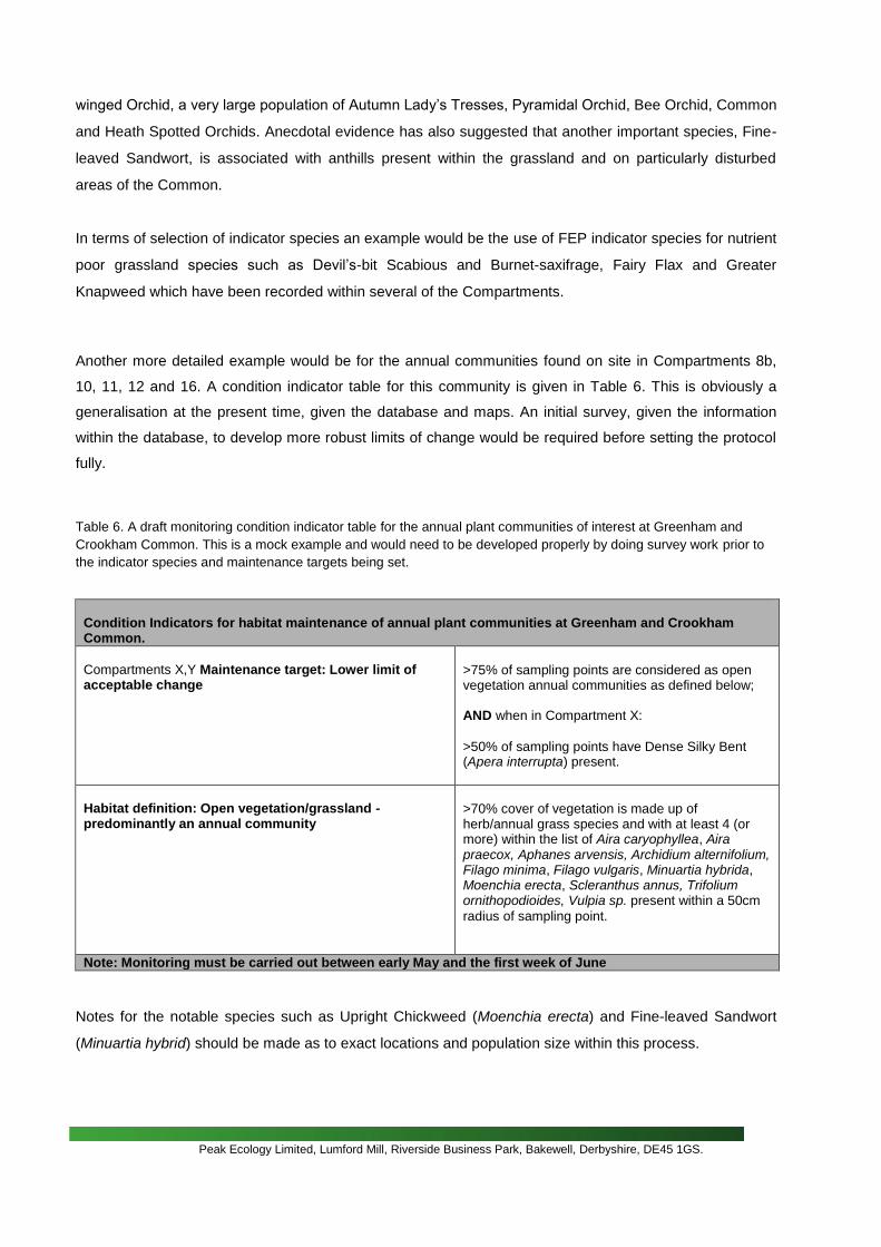
Another more detailed example would be for the annual communities found on site in Compartments 8b,
10, 11, 12 and 16. A condition indicator table for this community is given in Table 6. This is obviously a
generalisation at the present time, given the database and maps. An initial survey, given the information
within the database, to develop more robust limits of change would be required before setting the protocol
fully.
Table 6. A draft monitoring condition indicator table for the annual plant communities of interest at Greenham and
Crookham Common. This is a mock example and would need to be developed properly by doing survey work prior to
the indicator species and maintenance targets being set.
Condition Indicators for habitat maintenance of annual plant communities at Greenham and Crookham Common.
Compartments X,Y Maintenance target: Lower limit of acceptable change
>75% of sampling points are considered as open vegetation annual communities as defined below; AND when in Compartment X:
>50% of sampling points have Dense Silky Bent (Apera interrupta) present.
Habitat definition: Open vegetation/grassland -predominantly an annual community
>70% cover of vegetation is made up of herb/annual grass species and with at least 4 (or more) within the list of Aira caryophyllea, Aira praecox, Aphanes arvensis, Archidium alternifolium, Filago minima, Filago vulgaris, Minuartia hybrida, Moenchia erecta, Scleranthus annus, Trifolium ornithopodioides, Vulpia sp. present within a 50cm
radius of sampling point.
Note: Monitoring must be carried out between early May and the first week of June
Notes for the notable species such as Upright Chickweed (Moenchia erecta) and Fine-leaved Sandwort
(Minuartia hybrid) should be made as to exact locations and population size within this process.

Peak Ecology Limited, Lumford Mill, Riverside Business Park, Bakewell, Derbyshire, DE45 1GS.
The procedure would be to select suitable areas of this community and mark a grid of 30 1x1m squares.
Each square would be assessed as to the indicator table and once the criteria are fulfilled, the surveyor
would move on. This should be relatively quick and given that only a small number of species are
assessed, and with some training, non-experts would be able to carry out the monitoring. Vegetation height
and bare ground may also be a useful indicator to be included within this habitat, but would need to be
assessed in the initial surveys.
Importantly, for the areas of habitat restoration and creation (Compartments 1b, 14, 16 and 18 for
example) a specialist condition protocol would be required in terms of restoration/creation expectations. No
clear goals were given as to what was being restored, other than general expectations of lowland heath
(and species rich grassland) and wetlands. This project will help clarify objectives, and give
recommendations as to whether the restoration/creation process is working.

Peak Ecology Limited, Lumford Mill, Riverside Business Park, Bakewell, Derbyshire, DE45 1GS.
5.0 SUMMARY AND RECOMMENDATIONS
This project has fulfilled its brief to input a large amount of data that was only in reports and field notes into
a computer database for Greenham and Crookham Common.
In summary 5088 individual records have been input into Mapmate and are included on an excel
spreadsheet; these are records covering 1129 species, 54 of which are Biodiversity Action Plan (BAP)
priority species. Importantly 3750 of these records are recorded in specific Compartments for the Common.
The Compartment records were for 830 different species, 40 of which were Biodiversity Action Plan (BAP)
priority species. The computerisation of this data allows for analysis of the data, which can input into the
future management and monitoring of the site to ensure the nature conservation interst of the Common is
maintained.
Also, .... maps have been digitised. This has allowed subsequent examples of analysis of the data to be
carried out as part of this project. Areas of the different habitat types can be accessed from the digitised
maps, which can feed into monitoring of the site.
Knowledge gaps have been identified in terms of the nature conservation interest of the site, which can be
included in future management planning, funding applications and volunteer survey programmes.
The development of a monitoring assessment and protocol which can encompass gravel extraction,
alongside other variables such as management and visitor pressure, that may have/had an impact upon
the habitats and species found on site, has also been discussed and examples of the potential future
development of this process have been given.
Key recommendations are as follows:
Clear nature conservation objectives should be set for the site given the data
that has been collected and now consolidated.
Given the nature conservation objectives, a clear and simple monitoring protocol should be
developed form the gathered information. This would include a specialist survey of the site to
develop the protocol, given the nature conservation objectives.
Compartment 18, where gravel extraction occurred should be surveyed to give a baseline of
knowledge as to how this area is developing with regard to nature conservation, which can feed
into the monitoring process.
Further analysis, particularly of BAP habitats and species should be made with regard to inputting
into the management plan (e.g. nightjar populations and required management), which could be
used as part of the monitoring protocol.
Identified knowledge gaps should be addressed with a realistic timescale as to when this could be
achieved.

Peak Ecology Limited, Lumford Mill, Riverside Business Park, Bakewell, Derbyshire, DE45 1GS.
REFERENCES

Peak Ecology Limited, Lumford Mill, Riverside Business Park, Bakewell, Derbyshire, DE45 1GS.