green infrastructure techniques for resilience of the ... documents/green-infrastructur… · green...
TRANSCRIPT

Green Infrastructure Techniques for Resilience of the Oregon Coast Highway
This report was developed by the Oregon Department of Transportation in accordance with a grant from the Federal Highway Administration (FHWA). The statements, findings, conclusions and recommendations are those of the author(s) and do not necessarily reflect the views of FHWA or the U.S. Department of Transportation.

Cover photo: Ona Beach at the mouth of Beaver Creek. Source: Oregon ShoreZone, CC-BY-SA
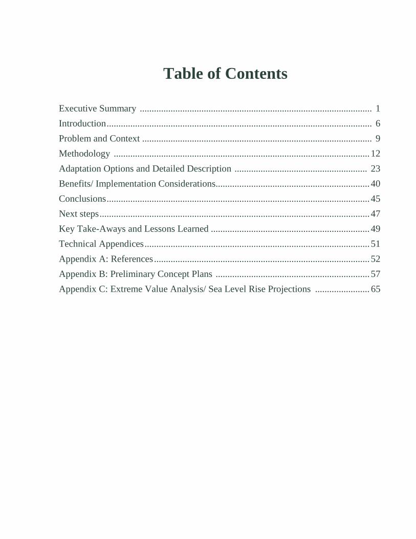
Table of Contents
Executive Summary .................................................................................................. 1 Introduction ................................................................................................................ 6 Problem and Context ................................................................................................. 9 Methodology ............................................................................................................ 12 Adaptation Options and Detailed Description ........................................................ 23 Benefits/ Implementation Considerations................................................................. 40 Conclusions ............................................................................................................... 45 Next steps .................................................................................................................. 47 Key Take-Aways and Lessons Learned ................................................................... 49 Technical Appendices ............................................................................................... 51 Appendix A: References ........................................................................................... 52 Appendix B: Preliminary Concept Plans ................................................................. 57 Appendix C: Extreme Value Analysis/ Sea Level Rise Projections ....................... 65

Table of Figures
Figure 1, Ona Beach Concept Design Typical Section .............................................. 5 Figure 2, US101 Coastal Erosion Areas of Concern, Lincoln County, OR ............. 13 Figure 3, Selected Study Sites Vicinity Map ............................................................ 14 Figure 4, Extreme Total Water Level Elevations ..................................................... 22 Figure 5, Beverly Beach Features Considered ......................................................... 23 Figure 6, Beverly Beach Preliminary Concept Design Options ............................... 24 Figure 7, Beverly Beach Concept Design Typical Section ...................................... 26 Figure 8, Beverly Beach Concept Design Plan View ............................................... 27 Figure 9, Beverly Beach Concept Design Cost Estimate ......................................... 28 Figure 10, Lost Creek Features Considered ............................................................. 30 Figure 11, Lost Creek Preliminary Concept Design Options ................................... 30 Figure 12, Lost Creek Concept Design Typical Section .......................................... 32 Figure 13, Lost Creek Concept Design Plan View ................................................... 33 Figure 14, Lost Creek Concept Design Cost Estimate ............................................. 34 Figure 15, Ona Beach Features Considered ............................................................. 35 Figure 16, Ona Beach Preliminary Concept Design Options ................................... 35 Figure 17, Ona Beach Concept Design Typical Section .......................................... 37 Figure 18, Ona Beach Concept Design Plan View ................................................... 38 Figure 19, Ona Beach Concept Design Cost Estimate ............................................. 39

Green Infrastructure Techniques for Resilience of the Oregon Coast Highway
1
Executive Summary
In July 2016, the Oregon Department of Transportation (ODOT) was awarded a Federal Highway Administration (FHWA) grant to analyze how green infrastructure, or nature-based infrastructure, can help protect the Oregon Coast Highway from the impacts of extreme storms and coastal bluff erosion. This study builds upon prior ODOT research on dynamic revetments, also known as cobble beaches or berms, and incorporates lessons learned from similar projects. Results from the study include a set of conceptual design plans for three high-risk sites. More detailed analysis of the preferred designs was conducted and includes anticipated protection against future coastal impacts, estimated construction and maintenance costs, and implementation benefits and challenges.
A goal of the study was also to collaborate with regulatory and resource agencies and on the design options that could be permitted and constructed under current rules and regulations. The options developed and our outreach with stakeholders will help inform and guide decisions for how we address these and similar sites vulnerable to coastal hazards in the future. The project was co-led by the ODOT Sustainability Program and Region 2 Technical Center in Salem, Oregon.
Problem and Context The Oregon Coast Highway (US 101) is a vital transportation corridor that runs the length of the Oregon Coast for 363 miles, from Washington to California. Much of US 101 runs along high cliffs, beaches, and State Park lands, including pristine natural resource areas. Limited space between the roadway and the shoreline reduces the maintainability of the roadway and restricts repair or protection options. Adding to these challenges are Oregon’s coastal and land use requirements, including Statewide Planning Goal 18 (Beaches and Dunes) which prohibits armoring of the coast without going through a regulatory exceptions process that is time consuming, costly, and unprecedented.
ODOT has identified at least 20 miles along the coast highway as highly vulnerable to coastal bluff erosion and wave attack, coastal hazards that will likely worsen with extreme storms and the effects of climate change. This study focused on three sites susceptible to erosion and storm surge in Lincoln County, Oregon. Through this study ODOT explored the use of nature-based design solutions to protect infrastructure. Nature-based design options have the potential to provide effective protection with the benefits of responding dynamically to coastal processes and being more natural in appearance. These solutions may be more acceptable to permitting agencies and a wider range of stakeholders in some locations.
Methods The study focused on three sites vulnerable to coastal hazards along US 101. Beverly Beach is a critical site with near term protection needs, while Lost Creek and Ona Beach are of concern over a longer timeframe. The different sites chosen allowed ODOT to explore different types of nature based solutions that might be successful under different constraints.

Green Infrastructure Techniques for Resilience of the Oregon Coast Highway
2
Previous ODOT research on dynamic revetments was referenced to help support the designs. Cobble beaches are naturally found on the Oregon coast and provide a natural form of wave protection along the backshore. We also coordinated with regulating agencies and coastal experts to identify benefits and preferred options at each site that would support future implementation. For example, the Department of Land Conservation and Development provided assistance regarding how these solutions might conform to Statewide Planning Goal 18, and the Oregon State Parks Department provided input relative to their permitting requirements for Beachfront Protective Structures.
In a first for ODOT, climate data and modeling tools were applied in conceptual design of coastal infrastructure. Recently acquired sea level rise and flood inundation projections were used to inform the elevation design of protective features. The intent was to consider design solutions that would provide protection for a high-range 2050 sea level rise scenario under a 100-year storm event. For each of the study sites, preliminary concept designs options were developed and distributed to the entire team, including resource and regulatory agencies. Final concept designs were chosen based largely on feedback from these agencies. Cost estimates and assumed maintenance needs were created for each final concept design. A wave runup analysis was also performed by the Oregon Department of Geology and Mineral Industries on the typical section for each final concept design in order to gauge how effective the designs might be.
Adaptation Options and Costs Beverly Beach: This site has areas of active coastal bluff erosion and is a current threat to the highway. This is the most challenging site to protect due to the narrow beach, sand starved littoral cell, and impacts from high energy waves. Based on input from the ODOT team and regulating agencies, it was decided to move forward with a hybrid design that includes a cobble beach covering large rock and riprap keyed in at the toe of the slope with piles. This design also includes a Mechanically Stabilized Earth (MSE) slope with planted terraces. The minimum length of repair at this site is about 2,100 feet. The total cost estimate is $41 million, putting the repair cost for this section of coast at about $19,500 per linear foot.
Lost Creek: This site is a low-lying area of highway above the creek outfall that is vulnerable to flooding, storm surge, and sea level rise. The highway has been impacted during large storms with water overtopping in the past. Design options selected for this site are non-structural, and include a cobble beach fronting an artificial dune. A culvert on the east side of the highway would also be replaced. The length of repair at this site is about 600 feet. The total cost estimate is $2.8 million, putting the repair cost for this section of coast at about $4,700 per linear foot.
Ona Beach: This low section of highway is vulnerable to river flooding, sea level rise, and storm surge. Based on input from the design team and regulating agencies, it was decided to move forward with a hybrid design for further analysis that included a cobble beach, MSE Slopes, and a core of sand tubes for structural stability (see Figure 1). The length of repair at this site is about 1,150 feet. The total cost estimate is almost $5.9 million, putting the repair cost for this section of coast at just over $5,000 per linear foot.

Green Infrastructure Techniques for Resilience of the Oregon Coast Highway
3
Benefits and Implementation Considerations The nature-based conceptual designs analyzed were shown to be effective and potentially feasible to implement at Ona Beach and Lost Creek, although likely not at Beverly Beach. The wave runup analysis at Ona Beach suggests that the design for that site would be sufficient up to a 100-year storm event, but a Goal 18 exception would be needed to implement the design. Although the wave runup analysis for Lost Creek showed that the design as it now stands is not adequate, it suggests that only a slight increase in elevation could improve conditions enough to protect the highway against large storms. Because this design option has only non-structural components on the beach, and there is an existing cobble beach at the site, it could potentially be permitted without going through a Goal 18 exception.
The wave runup analysis at Beverly Beach showed that a significantly greater amount of material would be needed to improve the efficacy of our concept design. A greater amount of material not only means even higher costs and increased construction timelines, but also a much larger project footprint (a concern of resource agencies). All of these factors, but the larger footprint in particular, suggests that the approach of our design for Beverly Beach may not be feasible.
Conclusions and Lessons Learned This study was a valuable exploration of how nature-based design solutions can protect coastal infrastructure. Compared with “hard” engineering, these options have the advantage of being natural in appearance and may allow for certain coastal processes to continue. Recently available sea level rise inundation data and wave run-up modeling were used to test the designed elevations relative to projected storm and wave impacts. The wave runup analysis showed that extreme total water levels varied greatly from site to site. This highlights the need for site specific designs that reflect variation in local geography, wave, and beach conditions. ODOT applied these solutions on a conceptual level, however to design to the level required for permitting and construction plans ODOT would need to either outsource or bring in more expertise in coastal design.
ODOT engaged land use and permitting agencies on what specific protective design options or features were considered preferable, acceptable, or “non-starters.” Clear information was received about what design options would be considered structural, or non-structural, in certain coastal environments and therefore subject to Statewide Planning Goal 18, a coastal regulation which restricts ODOT’s ability to armor the coast to protect infrastructure. ODOT received some agency support for testing these design approaches on a pilot basis, so the study can be seen as a positive step towards designing a collaborative, constructible project in a critical area of need.
ODOT also found that in some locations engineered cobble beaches may present recreation (beach access) and specific environmental concerns. It was found that traditional hard engineering might sometimes be preferred over nature based options for infrastructure protection due to the smaller footprint that can minimize impacts.
In some cases, the costs for constructing cobble beaches can be high due to their large volume and footprint. In addition, rounded cobbles are likely preferred, and since rounded cobbles are not readily available near the coast, long haul distances contribute to their high cost. The option of using less expensive, angular rock from nearby sources needs to be explored further.

Green Infrastructure Techniques for Resilience of the Oregon Coast Highway
4
Next Steps The options analyzed and outreach with stakeholders will help inform and guide decisions for how ODOT addresses these and similar coastal hazard sites in the future. The study team intends to work with ODOT management to advance the issues and opportunities identified in the study. For example, ODOT now has the information needed to pursue design and permitting for a nature-based test pilot, such as a non-structural dune or cobble beach, which could have the added benefit of a streamlined regulatory approval process.

Green Infrastructure Techniques for Resilience of the Oregon Coast Highway
5
Figure 1

Green Infrastructure Techniques for Resilience of the Oregon Coast Highway
6
Introduction
Anticipated climate change and extreme weather events pose significant risks to the safety, reliability, and effectiveness of ODOT’s infrastructure along the Oregon coast. Climate projections point to increasing risks of damage and weather-related roadway hazards, along with increasing maintenance and operations costs. These impacts are already affecting maintenance cycles and decisions for when and where to invest, protect, or reconstruct roadways. These decisions are particularly complex on vulnerable roadways located atop eroding coastal bluffs and in low-lying areas which are subject to chronic flooding, wave scour, and storm surge.
ODOT’s study analyzes green infrastructure or nature-based techniques to protect coastal highways. Nature-based solutions are either naturally occurring features or features that have been engineered to mimic natural conditions. A traditional approach to protection would be to armor the coastline with a sea wall, riprap or other fixed revetment. These approaches are highly regulated and challenged on the Oregon coast. This study was an opportunity for the agency to “think outside the box” and develop new solutions that may be more acceptable to regulators, coastal stakeholders, and the public, while still providing a measure of long-term protection. In part, the agency collaboration and input was possible because the scope and schedule pressure typical in delivery of transportation projects was absent.
Through the study a set of site-specific protection options, concept plans, and detailed specifications were developed with input from state regulators and coastal experts. The project focused on three vulnerable highway locations in Lincoln County, Oregon.
Project Team This study was a collaborative effort between ODOT’s Sustainability Program and Region 2 Technical Center which jointly managed the project and prepared this report, together with the input from other agency stakeholders.
ODOT’s internal project team included: Katie Castelli – Region 2 Geology. Bo Miller – Region 2 Hydraulics.
Philip Wurst – Region 2 Geotechnical.
Adam Roberts – Region 2 Environmental.
Ken Shonkwiler – Region 2 Planning, Area 1.
Kendal Weeks – Region 2 Maintenance, District 4.
Savannah Crawford – Region 2 Project Delivery Coordinator, Area 4.
Geoff Crook – ODOT Sustainability Program.
Jeff Shambaugh – Project Sponsor, Region 2 Maintenance & Operations. Region 2 Roadway, Traffic, Survey, and Right-of-way – (resources, minimal design support).

Green Infrastructure Techniques for Resilience of the Oregon Coast Highway
7
The full team with external agencies included:
Emily Cline – Federal Highway Administration, Oregon Division Office.
Meg Reed – Department of Land Conservation and Development.
Jay Sennewald – Oregon Parks and Recreation Department.
Jonathan Allan – Department of Geology and Mineral Industries.
Onno Husing – Lincoln County Planning and Development Department.
Kevin Maurice – US Fish and Wildlife Service.
Brad Johnson – U.S. Army Corps of Engineers.
Derek Wilson – Oregon Department of Fish and Wildlife.
Tom Loynes – National Marine Fisheries Service.
Each of the external agencies included has a specific role.
The Federal Highway Administration (FHWA) has provided funding support for this study, and has a mission to improve mobility on our Nation's highways through national leadership, innovation, and program delivery.
The Department of Land Conservation and Development (DLCD) oversees the statewide land use planning program, including goals and rules that govern beaches, dunes and coastal projects.
Oregon Parks and Recreation Department (OPRD) is the permitting agency for siting and construction of beachfront protective structures, or erosion control measures placed on beaches and coastal bluffs.
Lincoln County Planning and Development Department is responsible for administering the statewide planning goals and rules through its local Comprehensive Plan.
The Department of Geology and Mineral Industries (DOGAMI) is the lead agency with expertise in geologic and coastal processes, including coastal erosion. DOGAMI has conducted past research regarding landslides, erosion rates, and cobble beaches and berms.
U.S. Army Corps of Engineers (Corps) has jurisdiction for activities in waters of the U.S. and permitting authority for areas within the coastal zone.
Oregon Department of Fish and Wildlife (ODFW) has a mission to protect and enhance fish and wildlife species and their habitats.
The U.S. Fish and Wildlife Service (USFWS) is works with others to conserve, protect, and enhance fish, wildlife, plants, and their habitats for the continuing benefit of the American people.
The National Marine Fisheries Service (NMFS) is responsible for the stewardship of the nation's ocean resources and their habitat.
Scope The project involved selecting three high-risk sites for analysis and preparing conceptual designs for a range of coastal protection options. The sites selected were in areas that are currently experiencing or are vulnerable to impacts from bluff erosion and storm surge. ODOT explored the use of both “hard” and “soft” engineered options, reviewed the level of protection that would be provided, and considered their environmental impacts or benefits. Input and concerns from resource agencies were collected to inform the various options developed. This stakeholder input played into the design options and alternatives selected.

Green Infrastructure Techniques for Resilience of the Oregon Coast Highway
8
The result of the study is a set of conceptual design options and plans for the three sites. More detailed analysis of the preferred design was provided for each selected alternative which includes level of protection against future coastal impacts, anticipated construction and maintenance costs, and implementation benefits and challenges.
Study Goals Apply nature-based solutions. Considering green infrastructure solutions for coastal highway
protection is a new concept for ODOT. A study goal was to explore how cobble beaches and artificial dunes can be effective in Oregon’s high-energy wave environment. This study helped test questions of where and how these approaches can be implemented to protect vulnerable locations. This study had ODOT designers, engineers, and planners explore new approaches to coastal protection, both in design solutions and ways to work with permitting agencies for project approvals.
Build upon prior research and lessons learned. This study relied on ODOT’s prior research on natural cobble beaches and berms conducted in 2005. Monitoring reports and maintenance records from other similar projects were also reviewed, including coordinating with Oregon State Parks Department on a successful cobble revetment and artificial sand dune that was constructed to protect Cape Lookout State Park.
Collect input from regulators and coastal experts. A project goal was to enhance stakeholder involvement. State and local agencies that have an interest in these outcomes were consulted and asked to provide their input for this study. ODOT partnered with permitting agencies on site-specific conceptual designs preferences and regulatory needs and concerns.
Document options and pathways to implement. A goal was for the results of this study to help ODOT become more proactive and collaborative with stakeholders on green infrastructure or “hybrid” solutions. Only through piloting these approaches can we test how effective these approaches are to slowing erosion along the coastal highway. The study documents preferred options and pathways to implementation, and outlines key benefits and challenges ahead.

Green Infrastructure Techniques for Resilience of the Oregon Coast Highway
9
Problem and Context
The Oregon Coast Highway (US 101) runs the length of the Oregon Coast for 363 miles from Washington to California, connecting dozens of coastal communities. Built in the 1920’s and 1930’s, US 101 is an invaluable national highway with scenic, economic, emergency, and national defense attributes. The route is part of the National Highway System, Strategic Highway Network, and a designated National Scenic Byway. US 101 is also a designated Lifeline Route and Oregon Scenic Byway in the Oregon Highway Plan.
Some sections of state US 101 are oceanfront and vulnerable to the hazards of coastal erosion – about 123 miles total. ODOT has identified at least 26 sites, totaling nearly 20 miles along the coastal highway as “highly vulnerable” areas of concern for erosion and wave attack. This study focused on three sites susceptible to erosion and storm surge in Lincoln County, Oregon.
Historically, this section of the coast has seen large increases in sediment loss due to climate variation. Sediment starved littoral cells in combination with an increased wave climate are likely to increase erosion rates. The Central Oregon Coast is comprised of a series of smaller pocket beach littoral cells, many of which contain gravel beach deposits. Most of the central coast gravel beaches are characterized by a series of offshore basaltic reefs. Unlike the northern coast, the central coast gravel beaches are much smaller in size, typically averaging only several hundred meters in length.
Most of US 101 travels along high cliffs, beaches, and State Park lands, including natural resource areas (forests, wetlands, and estuaries). Limited space between the roadway and the shoreline further reduces the maintainability of the roadway and restricts repair or protection (armoring) options. Adding to these challenges are Oregon’s coastal land use requirements, including Statewide Planning Goal 18 (Beaches and Dunes) that prohibits armoring of the coast without going through a regulatory exceptions process that is time consuming, costly, and unprecedented.
Impacts from Climate Change Oregon is known to have one of the most active and dynamic coastal landscapes in North America. Oregon State University researchers have documented over 40-years of increasing wave height and storm intensity on the Oregon coast. Significant winter storms in combination with King Tides and periodic El Nino events are major drivers for active coastal erosion processes.
US 101 is particularly vulnerable to rising sea-levels, increasing storm frequency and intensity, storm surge, and wave scour that cause coastal bluff erosion and trigger slides. Wave intensity has increased on the Oregon coast and impacts from storm surge, bluff and dune erosion, and coastal flooding has become more frequent and severe. Sea levels are rising globally and are projected to rise through this century. Sea levels on the Oregon coast are projected to rise as high as 19-inches (48 cm) by the year 2050, under a “high-range” emissions scenario. (National Research Council, 2012).
ODOT’s climate change vulnerability assessment on the North Coast piloted the use of sea level rise mapping to inform future risks to coastal highways. We are currently refining sea level rise data and highway exposure inventories in geographic information system (GIS), for use along the entire coast in partnership with the Department of Land Conservation and Development. This data was used to inform projected inundation and water elevations for the three sites analyzed as part of this study. For details on projected flood and sea level rise on the Oregon coast, refer to Appendix C

Green Infrastructure Techniques for Resilience of the Oregon Coast Highway
10
This report uses a high range sea level rise scenario for year 2050. This dataset includes a locally developed methodology specific to Oregon coastal counties that combines maximum tidal and flood values, or Extreme Value Analysis (EVA), including projected sea level rise. The EVA was conducted by DOGAMI and Oregon State University as part of its local FEMA flood mapping work. The methods used to perform EVA are described in many publications (e.g. Coles, 2001). The application of EVA on the Oregon coast is described in Allan et al. (2012) and Ruggiero et al. (2011).
The Extreme Value Analysis (EVA) is a statistically robust methodology because it calculates the extreme values (10%, 2%, 1% events) based on a complete 40-year time series of hourly tides, as opposed to doing this deterministically by adding the various contributions and making assumptions about their magnitudes (Allan, 2012). These data reflect the combined effect of the astronomical tides in addition to seasonal change, El Nino effect (when present) and storm surge. Use of the EVA is a defensible methodology since it relies on actual tidal values over a long time period.
However, this analysis does not reflect any storm wave runup that occurs out on the open coast during extreme events. This wave runup is occurring on top of the tides and can contribute an additional 3 to 4 meters of water level on top of the measured tides. ODOT has not mapped these “Total Water Levels” however it is critically important to consider the impacts from wave runup when designing coastal infrastructure on the open coast. Wave runup commonly refers to the height above the still water elevation (tide and surge) reached by the swash. Determining wave runup heights is complex and depends on a range of local variables and conditions in the water levels, waves, and beaches.
Regulatory context Regulatory and permitting requirements limit the options ODOT has available to protect the coastal highway even within the existing alignment. Conditions exist in many areas where the highway is constrained by development, parks, natural resources, high steep slopes, and/or is underlain by weak materials affecting slope stability. These constraints limit opportunities to avoid or mitigate erosion hazards outside of the existing alignment. When the highway becomes impassable, it causes major regional transportation, economic, and public safety challenges. While there may be options to realign the highway further from the seafront in some areas, these options are costly, can impact pristine or sensitive habitats, or may be infeasible due to existing landslide prone terrain.
Statewide Planning Goal 18 (Beaches and Dunes) allows local cities and counties to approve beachfront protective structures only in areas where “development” existed on January 1, 1977. State highways and other public facilities are not included in the definition of “development” under the current Goal language. This significantly limits the options ODOT has available when seeking to protect coastal infrastructure.
Oregon land use law gives priority to project alternatives that do not require a Goal exception. For ODOT to build structural or hard protective elements along the coast it would require an exception to Goal 18 – a lengthy, complex, and unprecedented process that requires approval of plan from the applicable local government. The Goal exception process involves a formal amendment to the comprehensive land use plan from the local jurisdiction where the project is being proposed. For more on Oregon’s Statewide Planning Goals see - http://www.oregon.gov/LCD/Pages/goals.aspx
Currently, nature-based, non-structural alternatives such as cobble revetments may fall within the definition of riprap and so would need to meet Goal 18 eligibility and OPRD permitting requirements. Some coastal experts do not think a cobble revetment should be considered riprap or “structure” because it is meant to mimic natural beach characteristics and move dynamically with coastal processes. However there remain concerns about cobble revetments and their potential to impact the natural beach environment. These issues will require further collaborative discussion and are a topic of this study.

Green Infrastructure Techniques for Resilience of the Oregon Coast Highway
11
In addition to a potential exception to Goal 18, a Beachfront Protective Structure permit from OPRD is required before protective structures can be put in place on the coast. Removal/fill permits would be needed from the Department of State Lands and an approval from the Army Corps for any work on the beach or in waters of the U.S. Natural resource permits would be required for both terrestrial and aquatic species, involving ODFW, USFWS, and NMFS.
A focus of this study was to explore issues around permitting and find ways to navigate the process and make it easier to approve nature-based projects. A better understanding of what structural or non-structural solutions could be approved without going through Goal exception was desired.
ODOT also gained additional clarity around DLCD’s Goal exception process and the coordination necessary with the state and local agencies in the case that was pursued in the future.

Green Infrastructure Techniques for Resilience of the Oregon Coast Highway
12
Methodology
This section outlines the approach and methods taken to select sites, collect and analyze data, and consider adaptation options. The study approach involved:
Site selection.
Initial agency coordination and outreach.
Protection alternatives development.
Final agency coordination and outreach.
Final conceptual design.
A series of benefits and implementation concerns were captured and documented relating to: project construction and maintenance costs, materials sourcing, construction access, public access, recreation usage, permitting, and beach and offshore environmental impacts.
Site Selection ODOT has previously identified several high-risk areas vulnerable to coastal erosion and storm surge totaling 7.25 miles of highway in Lincoln County (see Figure 2). In selecting sites for this study, we wanted to balance near-term risk levels with other factors that relate to the feasibility and constructability of solutions. Our goal was to select up to three sites for analysis.

Green Infrastructure Techniques for Resilience of the Oregon Coast Highway
13
Figure 2

Green Infrastructure Techniques for Resilience of the Oregon Coast Highway
14
ODOT established an internal project team. Our first step was to coordinate a kick-off meeting to relay information about our goals, site selection process, roles and responsibilities, and to map out project timelines, milestones, and desired outcomes. Core team members later conducted a visit to the coast to review and screen sites for selection.
Criteria considered for site selection included: Risk from storm surge or sea level rise - is the site a current or future area of concern for
Maintenance?
Site selection would not conflict with current or pending ODOT projects or permits.
Construction and maintenance access – does the site have a known or potential beach access points for construction work and long-term maintenance?
Environmental and cultural constraints – the project should avoid or minimize potential impacts to known cultural and natural resources.
Range of options – consider sites with potentially different solutions for protecting the highway (e.g., hard vs. soft vs. hybrid).
Permitting feasibility – some sites may present a clearer pathway for permit approvals due to land use and/or geographic constraints.
Team input was collected and meeting notes were generated to document the discussion and decisions. After several sites were reviewed as part of the selection process, three sites were selected for further study (see Figure 3).
Figure 3
➤

Green Infrastructure Techniques for Resilience of the Oregon Coast Highway
15
Beverly Beach was selected as a highly critical site with near-term risk that may provide ODOT with a potential path forward in an area of high need, where a combination of structural and green infrastructure solutions would be necessary. Lost Creek and Ona Beach were selected as less critical sites that may allow ODOT more flexibility in developing and implementing potential solutions.
At these two sites green infrastructure solutions alone could be effective to provide long-term protection, and allow for a more proactive approach.
Beverly Beach Beverly Beach is located six miles north of Newport on US 101 and includes nearly two miles in length of active coastal bluff erosion. Several sections of this highway are severely eroded and are considered in a critical state in need of repair. The eroding bluff edge has destroyed the shoulder pavement at this site and is currently threatening the highway guardrail. The section of coast in front of Beverly Beach State Park is arguably the longest and most critical coastal stretch of concern in the state and has been the subject of past study.
The primary factors leading to coastal erosion at this site include: Narrow beach and sand starved littoral cell.
The bluff is undercut at the toe due to wave erosion.
Continual weathering of non-durable rock that makes up the majority of the bluff.
Groundwater seepage from areas above and across the roadway.
Runoff over the roadway crest.
In this geologically active area, coastal erosion and related slides in the weak mudstone forming the beach cliff west of the highway are active hazards threatening the base of the highway. The area along US 101 in the vicinity of Beverly Beach is extremely dynamic and complex, both in its geology and offshore environment. The primary issues include the wave attack at the sea cliff toe and unstable sea cliff slope.
In many areas along US 101 for the highway to be maintained in its current alignment, some sort of engineered solution for coastal erosion and chronic landslide problems would be necessary.
At Beverly Beach, the Army Corps found that on 5 to 10-year intervals of occurrence the slide conditions were triggered or exacerbated by high precipitation events initiating landslides or slumping along the sea cliff and episodic and severe storm events involving elevated water levels and large wave heights, often associated with El Nino events.
The ODOT team met with FHWA representatives to discuss erosion issues at Beverly Beach. Credit: ODOT.

Green Infrastructure Techniques for Resilience of the Oregon Coast Highway
16
Wave action from storms has eroded away areas of roadway asphalt and is close to compromising the guardrail along US 101, southbound lane. Credit: ODOT.
Active erosion along the coastal bluff at Beverly Beach. Credit: ODOT.

Green Infrastructure Techniques for Resilience of the Oregon Coast Highway
17
Lost Creek Lost Creek State Recreation Area is located approximately seven miles south of Newport, Oregon. The wayside and beach overlook is developed for picnicking and beach access. Oregon State Parks has a parking lot atop an eroding coastal bluff that provides access to the site. The geology of the bluff area is similar to that at Beverly Beach, but there is a wider beach that affords the site a bit more protection.
Directly adjacent south, the Lost Creek drainage crosses at a low point along US 101 (approximately 23- feet above sea level) and outfalls on the beach. The beach is primarily sand with a small cobble berm and dune along the backshore located in front of the creek. There is an existing culvert that carries Lost Creek under US 101 and a second culvert under SE 130th Drive that connects with the highway nearby. This smaller culvert under SE 130th Drive is known to back up during high flow events and cause overtopping of the highway during larger winter storms.
Factors leading to impacts at this site include:
Areas of active coastal bluff erosion.
Low area of highway vulnerable to overtopping during flooding, storm surge, and future sea level rise.
The culvert under US 101 at Lost Creek is located at mile post (MP) 147.3 and is an 8 x 8-foot box culvert built in 1998. The culvert under 130th Drive does not meet fish passage requirements and is undersized to handle hydraulic flows from larger storm events. There are two stream miles above these culverts with fish habitat quality listed as “Fair”.
Active erosion of the coastal bluffs can be seen along the backshore at Lost Creek. Credit: ODOT.
The ODOT team inspects where Lost Creek flows under highway US 101. Note the small cobble beach along the backshore. Credit: ODOT.

Green Infrastructure Techniques for Resilience of the Oregon Coast Highway
18
ODOT reviewed two locations at this site and opted to focus on the low-lying area of US 101 vulnerable to storm surge at the creek outfall.
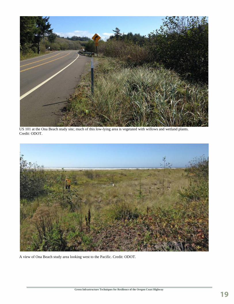
Ona Beach Ona Beach is located approximately eight miles south of Newport and is near the Beaver Creek estuary and the Brian Booth State Park facility. Sections of US 101 north of the creek are fronted by vegetated sand dunes which provide for a certain measure of protection from coastal impacts. The section of beach reviewed is currently vulnerable to migration and scour from Beaver Creek, which has occurred in the recent past.
The primary factors leading to erosion include:
Erosion due to creek meandering against the highway embankment.
Overtopping during flooding, storm surge, and future sea level rise.
The highway in this area is vulnerable to inundation from flood events and future sea level rise scenarios. Although the highway is not currently experiencing erosion or overtopping, it has as recently as 15 years ago when the creek had meandered closer to the highway. This site was considered because nature based solutions might be adequate for protection here and could be addressed proactively. Through the study the project team looked at the potential for sand dunes or Mechanically Stabilized Earth (MSE) walls and a cobble beach/berm to protect low areas of the highway from coastal hazards.
A view of Ona Beach study area looking west to the Pacific. Credit: ODOT.
Green Infrastructure Techniques for Resilience of the Oregon Coast Highway
19
US 101 at the Ona Beach study site; much of this low-lying area is vegetated with willows and wetland plants. Credit: ODOT.
A view of Ona Beach study area looking west to the Pacific. Credit: ODOT.
Green Infrastructure Techniques for Resilience of the Oregon Coast Highway
20
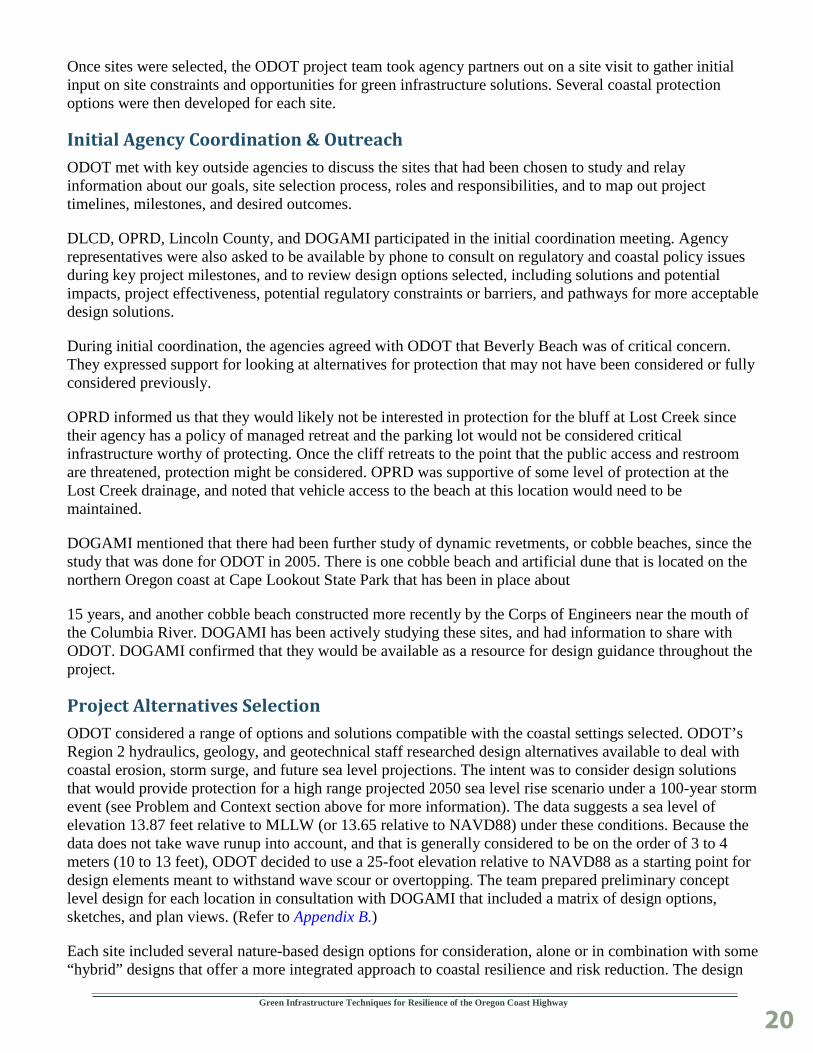
Once sites were selected, the ODOT project team took agency partners out on a site visit to gather initial input on site constraints and opportunities for green infrastructure solutions. Several coastal protection options were then developed for each site.
Initial Agency Coordination & Outreach ODOT met with key outside agencies to discuss the sites that had been chosen to study and relay information about our goals, site selection process, roles and responsibilities, and to map out project timelines, milestones, and desired outcomes.
DLCD, OPRD, Lincoln County, and DOGAMI participated in the initial coordination meeting. Agency representatives were also asked to be available by phone to consult on regulatory and coastal policy issues during key project milestones, and to review design options selected, including solutions and potential impacts, project effectiveness, potential regulatory constraints or barriers, and pathways for more acceptable design solutions.
During initial coordination, the agencies agreed with ODOT that Beverly Beach was of critical concern. They expressed support for looking at alternatives for protection that may not have been considered or fully considered previously.
OPRD informed us that they would likely not be interested in protection for the bluff at Lost Creek since their agency has a policy of managed retreat and the parking lot would not be considered critical infrastructure worthy of protecting. Once the cliff retreats to the point that the public access and restroom are threatened, protection might be considered. OPRD was supportive of some level of protection at the Lost Creek drainage, and noted that vehicle access to the beach at this location would need to be maintained.
DOGAMI mentioned that there had been further study of dynamic revetments, or cobble beaches, since the study that was done for ODOT in 2005. There is one cobble beach and artificial dune that is located on the northern Oregon coast at Cape Lookout State Park that has been in place about
15 years, and another cobble beach constructed more recently by the Corps of Engineers near the mouth of the Columbia River. DOGAMI has been actively studying these sites, and had information to share with ODOT. DOGAMI confirmed that they would be available as a resource for design guidance throughout the project.
Project Alternatives Selection ODOT considered a range of options and solutions compatible with the coastal settings selected. ODOT’s Region 2 hydraulics, geology, and geotechnical staff researched design alternatives available to deal with coastal erosion, storm surge, and future sea level projections. The intent was to consider design solutions that would provide protection for a high range projected 2050 sea level rise scenario under a 100-year storm event (see Problem and Context section above for more information). The data suggests a sea level of elevation 13.87 feet relative to MLLW (or 13.65 relative to NAVD88) under these conditions. Because the data does not take wave runup into account, and that is generally considered to be on the order of 3 to 4 meters (10 to 13 feet), ODOT decided to use a 25-foot elevation relative to NAVD88 as a starting point for design elements meant to withstand wave scour or overtopping. The team prepared preliminary concept level design for each location in consultation with DOGAMI that included a matrix of design options, sketches, and plan views. (Refer to Appendix B.)
Each site included several nature-based design options for consideration, alone or in combination with some “hybrid” designs that offer a more integrated approach to coastal resilience and risk reduction. The design

Green Infrastructure Techniques for Resilience of the Oregon Coast Highway
21
approach was to build off prior research on cobble beaches, and their potential application on the Oregon coast as a means to protect coastal highways. Prior findings from research ODOT conducted on cobble beaches in 2005 was referred to. ODOT also has access to research and studies on slide movement and coastal protection options at Beverly Beach as part of its 2003 Spencer Creek Bridge reconstruction project.
An intermediate meeting was held with the internal project team to present and explain the design options developed for each site. The internal team discussed what questions were important to ask of outside regulating agencies in order to inform preferred alternatives selection. ODOT’s planning and environmental team members were asked to start coordinating with outside agencies at this point.
Meeting notes were generated to document discussion and decisions.
Final Agency Coordination & Outreach ODOT worked with state and local partners throughout the study. One of the study goals was to explore new coastal protection options in collaboration with the regulatory liaisons directly responsible for approving plans and permits for construction. ODOT used the project to help facilitate discussions about a full range of coastal protection options. The stakeholder group was used to help highlight challenges and opportunities presented with each of the options considering current science and applicable coastal regulations.
ODOT’s planning and environmental team members relayed our preliminary concept design alternatives to the external agency team members. A site visit was then held with core ODOT team members and representatives from each of the external agencies in order to gain input into design preferences of each agency, likelihood of permitting each of the options, and impacts that would need to be considered.
The project team documented the primary benefits of the preferred options, permitting needs, implementation challenges, and potential solutions. The team also helped to identify the pros and cons of each concept level option and outlined what permitting or other related work would likely be needed for each. A written summary was generated that documents discussions with each agency, and the pertinent points are discussed in the Adaptation Options and Detailed Descriptions section of the report below.
Final Conceptual Design Based largely upon input from the external agencies ODOT consulted with, a preferred alternative was chosen at each of the three sites. A more detailed analysis of each preferred option was performed. Basic specifications, anticipated project materials, dimensions, and concept level drawings were generated. Project costs, expected performance, and needed maintenance of preferred options were researched and estimated. Details of the design options considered and the preferred options can be found in the Adaptation Options and Detailed Descriptions section, below.
After final conceptual designs were drafted, Jonathan Allan at DOGAMI performed a wave runup analysis for each of the three sites to gauge effectiveness of the designs. Data for the 10-, 25-, 50-, and 100-year extreme total water levels (combined wave runup and tides) was extracted from the model. The methodology used can be found in Coastal Flood Hazard Study, Lincoln County, Oregon (Allan et al., 2015). Projected sea level rise of 0.48 meter (19 in.) for the year 2050 high range scenario was then added to the extreme total water level elevations. The output data is shown below in Figure 4.

Green Infrastructure Techniques for Resilience of the Oregon Coast Highway
22
Figure 4 Extreme Total Water Level Elevations (in feet)
Return Period Event (years) Beverly Beach Lost Creek Ona Beach 10 34.71 27.75 18.07 25 36.64 29.52 19.16 50 37.99 30.74 20.17 100 39.3 31.92 21.39
* Analysis by Jonathan Allan of DOGAMI. ** Analysis includes wave runup and tides, relative to NAVD88. *** 2050 high-range sea level rise projections factored into results.

Green Infrastructure Techniques for Resilience of the Oregon Coast Highway
23
Adaptation Options and Detailed Descriptions
For each of the three study sites, preliminary concept designs options were developed and distributed to the entire team, including resource and regulatory agencies. Because the resource and regulatory agencies would have a large influence over what kind of designs would be allowed if ODOT was to proceed with implementing any coastal erosion mitigation, final concept designs options were chosen based largely on feedback from resource and regulatory agencies. Cost estimates and assumed maintenance needs were created for each final concept design. In addition, a site specific wave runup analysis was performed on the typical section for each final concept design in order to gauge how effective the designs might be.
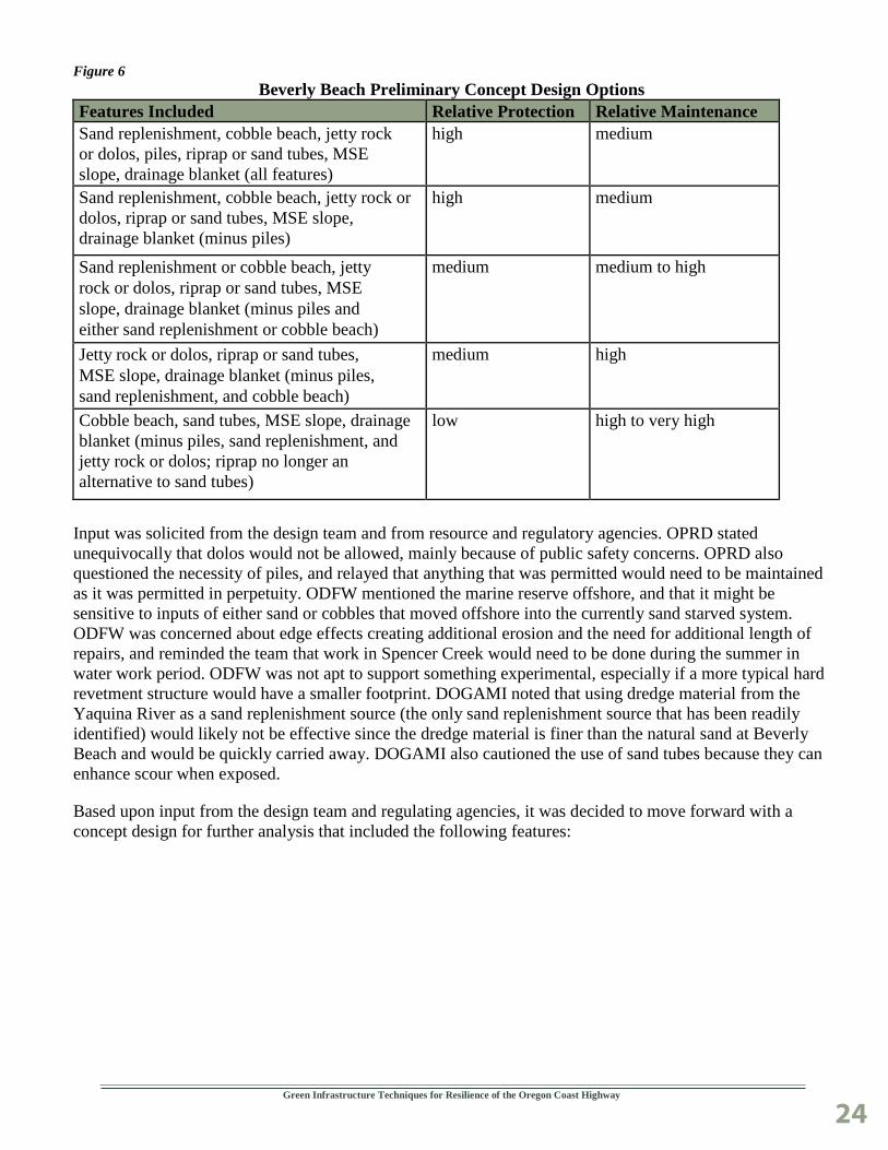
Beverly Beach This is the most challenging site due to the narrow beach and active erosion from a high impact wave environment. This is also a highly public site, with the beach being accessed year round as a popular State Park and recreation destination. Initially, potential features that could be used to make Beverly Beach more resilient were investigated, and then these features were drawn upon to develop preliminary concept design options. The preliminary concept design options were assembled into a matrix that described the benefits of various features and what combinations of those features would produce designs of varying protection levels and maintenance needs (see Figures 5 and 6).
The preliminary concept design options also included sketches and plan view maps, which can be found in Appendix B.
Figure 5 Beverly Beach Features Considered
Feature Purpose Priorities & Advantages Sand Replenishment wave energy dissipation beneficial, not essential; utilizes material
that would otherwise be wasted Cobble Beach wave energy dissipation beneficial, not essential; supplements toe
protection and hides jetty rock Jetty Rock erosion protection at toe of the slope essential; provides primary toe
protection, alternative to dolos Dolos erosion protection at toe of the slope essential; provides primary toe protection,
alternative to jetty rock Piles aids retention of jetty rock beneficial, maybe essential; allows for use
of smaller jetty rock or dolos Sand Tubes foundation for MSE slope and backing
for jetty rock essential; alternative to riprap
Riprap foundation for MSE slope and backing for jetty rock
essential; alternative to sand tubes
MSE Slope mid and upper slope protection essential; provides support for vegetation or architectural face
Drainage Blanket controls seepage and runoff essential; provides for MSE slope stability
Green Infrastructure Techniques for Resilience of the Oregon Coast Highway
24
Figure 6 Beverly Beach Preliminary Concept Design Options
Features Included Relative Protection Relative Maintenance Sand replenishment, cobble beach, jetty rock or dolos, piles, riprap or sand tubes, MSE slope, drainage blanket (all features)
high medium
Sand replenishment, cobble beach, jetty rock or dolos, riprap or sand tubes, MSE slope, drainage blanket (minus piles)
high medium
Sand replenishment or cobble beach, jetty rock or dolos, riprap or sand tubes, MSE slope, drainage blanket (minus piles and either sand replenishment or cobble beach)
medium medium to high
Jetty rock or dolos, riprap or sand tubes, MSE slope, drainage blanket (minus piles, sand replenishment, and cobble beach)
medium high
Cobble beach, sand tubes, MSE slope, drainage blanket (minus piles, sand replenishment, and jetty rock or dolos; riprap no longer an alternative to sand tubes)
low high to very high
Input was solicited from the design team and from resource and regulatory agencies. OPRD stated unequivocally that dolos would not be allowed, mainly because of public safety concerns. OPRD also questioned the necessity of piles, and relayed that anything that was permitted would need to be maintained as it was permitted in perpetuity. ODFW mentioned the marine reserve offshore, and that it might be sensitive to inputs of either sand or cobbles that moved offshore into the currently sand starved system. ODFW was concerned about edge effects creating additional erosion and the need for additional length of repairs, and reminded the team that work in Spencer Creek would need to be done during the summer in water work period. ODFW was not apt to support something experimental, especially if a more typical hard revetment structure would have a smaller footprint. DOGAMI noted that using dredge material from the Yaquina River as a sand replenishment source (the only sand replenishment source that has been readily identified) would likely not be effective since the dredge material is finer than the natural sand at Beverly Beach and would be quickly carried away. DOGAMI also cautioned the use of sand tubes because they can enhance scour when exposed.
Based upon input from the design team and regulating agencies, it was decided to move forward with a concept design for further analysis that included the following features:

Green Infrastructure Techniques for Resilience of the Oregon Coast Highway
25
Cobble beach.
Jetty Rock.
Riprap.
Drainage blanket.
Mechanically Stabilized Earth (MSE) Slope with planted terraces or architectural face.
Piles.
Dolos. Credit: Public Domain, https://commons.wikimedia.org/w/index.php?curid=2651809
A typical section and plan view were created to depict this concept design, as shown in Figures 7 and 8

Green Infrastructure Techniques for Resilience of the Oregon Coast Highway
26
Figure 7

Green Infrastructure Techniques for Resilience of the Oregon Coast Highway
27
Figure 8
Photo credit: Google Earth.

Green Infrastructure Techniques for Resilience of the Oregon Coast Highway
28
Because of the high energy environment at this site, it was necessary to blend traditional hard components with nature based components in order to attain an acceptable level of protection. The piles, jetty rock, riprap, drainage blanket, and MSE slope would all be considered traditional hard components. The piles were needed to maintain the toe of the jetty rock and help hold it in place, especially since sources of very large jetty rock are not readily available. The jetty rock and riprap were needed to stabilize the toe of the slope from wave cut erosion. The MSE slope was needed to stabilize the upper portion of the bluff since the bluff is already perilously close to the traveled roadway. The drainage blanket controls seepage and runoff which aids in bluff stabilization and MSE slope integrity.
Nature based components include the cobble beach and the face of the MSE slope. The cobble beach is composed of rounded cobbles that are meant to move and shift with wave impact and reduce the wave energy transferred to the rest of the system. The cobble beach mimics natural cobble beaches that exist along the Oregon coast in some areas. There are multiple options for the face of the MSE slope, but planting it would mimic vegetation along other areas of the bluff. An alternate to plantings would be an architectural face that would mimic the existing exposed bluffs, although plantings seemed to be preferred by most if not all of the regulatory agencies that were involved in this project.
The minimum length of repair at this site was assumed to be approximately 2,100 feet. Construction of this repair would take six months, assuming a large company with considerable resources was awarded the job. The total cost estimate is approximately $41 million, putting the repair cost for this section of coast at about $19,500 per linear foot. See Figure 9 for a more detailed cost estimate.
It should be noted that a large component of the cost was for the cobble beach materials. A very high cost estimate was used because it was assumed that rounded rock would be required, and that would need to be trucked in from the valley. If angular rock was acceptable, the unit cost for the cobble beach would likely be reduced by about 75% for a total project cost of approximately $30 million, or about $14,000 per linear foot. Another possibility is that a combination of angular and rounded rock would be acceptable, with a core of angular rock buried by rounded rock.
Figure 9 Beverly Beach Concept Design Cost Estimate
Feature Quantity Unit Price Total Price Cobble Beach 105,000 cuyd $110 cuyd $11,550,000 MSE Slope 160,000 sqft $66 sqft $10,560,000 Riprap 17,000 cuyd $66 cuyd $1,122,000 Piles 14,000 ft $275 ft $3,850,000 Jetty Rock 36,000 cuyd $75 cuyd $2,700,000 Toe Trench 12,000 cuyd $17 cuyd $204,000 Traffic Control LS $500,000 $500,000 Mobilization LS 10% $3,048,600 CE LS 15% $4,862,517 PE LS 7% $2,687,798
Total $41,084,915

Green Infrastructure Techniques for Resilience of the Oregon Coast Highway
29
Features that were not included in the final concept plans were dolos, sand tubes, and sand replenishment. Oregon State Parks Department would not allow dolos on the beach. Although the sand tubes would ideally stay buried if used, there was concern over increased erosion and scour if exposed as well as visual aesthetics.
The option of sand replenishment at Beverly Beach is one that was considered during ODOT’s 2003 Spencer Creek Bridge project. Sand nourishment is a logical option to study since the beach is narrow and sand starved, and there is a relatively close source of sand nearby. The Army Corps of Engineers in coordination with the Port of Newport dredges material out of the Yaquina River estuary to keep the river channel operational for navigation. The Yaquina River is about 7.5 miles south of Beverly Beach.
The Army Corps reviewed the 2003 Spencer Creek report and adjusted the costs for utilizing a hopper dredge to place material in a nearshore disposal site off of Beverly Beach. In 2003, the estimate was $564,000 for offshore placement of up to 300,000 cubic yards (CY) of material.
Sand Tubes. Credit: Geo_Synthetics, LLC.
The Army Corps now estimates it would take about 42 days and $1,094,600 to barge 260,000 CY of dredge materials to Beverly Beach. This includes a new FY2018 daily haul rate estimated to increase to $95,000 per day. We were also informed that additional costs would apply to this work due to the limited availability of equipment.
There were other potential downsides to use of sand replenishment as an option. During our inter- agency site visit, DOGAMI noted that dredge materials from the Yaquina would likely be too fine to stay in place long enough to provide a buffer against the high wave energy experienced at Beverly Beach. The Army Corps questioned whether the active landslides and extreme geologic slope angles in the area might deter sand from being impounded onto the beach and so sand would naturally be forced to move laterally, north along the shore. There were also concerns from Fish and Wildlife that dredge spoils could make their way offshore and impact shellfish and other marine resources.
Additionally, the volume of sand available from dredging may not be significant enough to create a meaningful buffer from wave energy at this site.
Green Infrastructure Techniques for Resilience of the Oregon Coast Highway
30
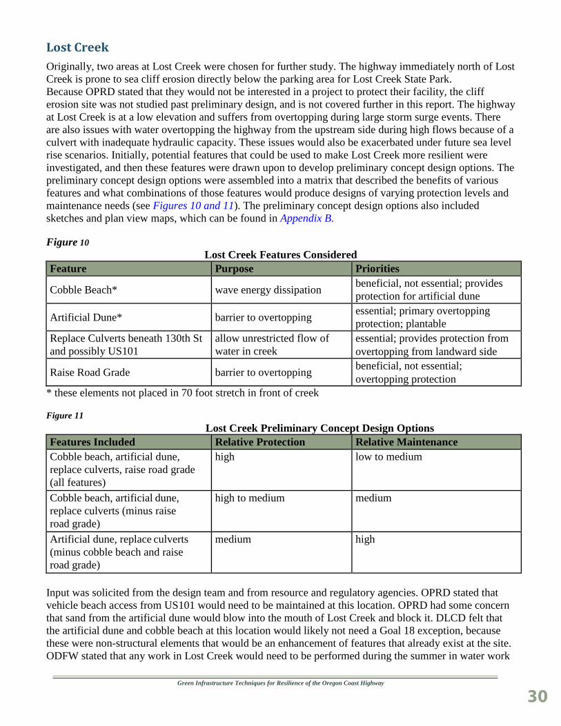
Lost Creek Originally, two areas at Lost Creek were chosen for further study. The highway immediately north of Lost Creek is prone to sea cliff erosion directly below the parking area for Lost Creek State Park. Because OPRD stated that they would not be interested in a project to protect their facility, the cliff erosion site was not studied past preliminary design, and is not covered further in this report. The highway at Lost Creek is at a low elevation and suffers from overtopping during large storm surge events. There are also issues with water overtopping the highway from the upstream side during high flows because of a culvert with inadequate hydraulic capacity. These issues would also be exacerbated under future sea level rise scenarios. Initially, potential features that could be used to make Lost Creek more resilient were investigated, and then these features were drawn upon to develop preliminary concept design options. The preliminary concept design options were assembled into a matrix that described the benefits of various features and what combinations of those features would produce designs of varying protection levels and maintenance needs (see Figures 10 and 11). The preliminary concept design options also included sketches and plan view maps, which can be found in Appendix B.
Figure 10 Lost Creek Features Considered
Feature Purpose Priorities
Cobble Beach* wave energy dissipation beneficial, not essential; provides protection for artificial dune
Artificial Dune* barrier to overtopping essential; primary overtopping protection; plantable
Replace Culverts beneath 130th St and possibly US101
allow unrestricted flow of water in creek
essential; provides protection from overtopping from landward side
Raise Road Grade barrier to overtopping beneficial, not essential; overtopping protection
* these elements not placed in 70 foot stretch in front of creek
Figure 11 Lost Creek Preliminary Concept Design Options
Features Included Relative Protection Relative Maintenance Cobble beach, artificial dune, replace culverts, raise road grade (all features)
high low to medium
Cobble beach, artificial dune, replace culverts (minus raise road grade)
high to medium medium
Artificial dune, replace culverts (minus cobble beach and raise road grade)
medium high
Input was solicited from the design team and from resource and regulatory agencies. OPRD stated that vehicle beach access from US101 would need to be maintained at this location. OPRD had some concern that sand from the artificial dune would blow into the mouth of Lost Creek and block it. DLCD felt that the artificial dune and cobble beach at this location would likely not need a Goal 18 exception, because these were non-structural elements that would be an enhancement of features that already exist at the site. ODFW stated that any work in Lost Creek would need to be performed during the summer in water work

Green Infrastructure Techniques for Resilience of the Oregon Coast Highway
31
window. ODFW was also concerned that cobbles from the cobble beach might fill in the creek outfall and impact fish passage. DOGAMI had the same concerns with the potential for cobbles to block the creek, but provided some ideas for mitigation, including placing larger rocks to act as buffers along the creek channel.
Based upon input from the design team and regulating agencies, it was decided to move forward with a concept design for further analysis that included the following features:
Cobble Beach.
Artificial Dune.
Replace Culvert under SE 130th Drive.
A typical section and plan view were created to depict this concept design, as shown in Figures 12 and 13.

Green Infrastructure Techniques for Resilience of the Oregon Coast Highway
32
Figure 12

Green Infrastructure Techniques for Resilience of the Oregon Coast Highway
33
Figure 13
Photo credit: Google Earth.

Green Infrastructure Techniques for Resilience of the Oregon Coast Highway
34
All the conceptual design components on the beach at this site would be considered nature based. The cobble beach is composed of rounded cobbles that are meant to move and shift with wave impact and reduce the wave energy transferred landward. The cobble beach mimics natural cobble beaches that exist along the Oregon coast in some areas, including at this site to some extent.
Because Lost Creek outlets to the ocean at this location, the cobble beach would need to be left open for some distance in front of the creek so as not to impede flow or fish passage. The artificial dune is meant to raise the existing dune structure at Lost Creek between the beach and the highway to an elevation that would exclude or limit overtopping. Replacing the culvert under SE 130th Drive would allow adequate flow through the culvert and stop or reduce the amount of overtopping during high flows.
The length of repair at this site was assumed to be approximately 600 feet. Construction of this repair would take six weeks. The total cost estimate is approximately $2.8 million, putting the repair cost for this section of coast at about $4,700 per linear foot. See Figure 14 for a more detailed cost estimate.
It should be noted that a large component of the cost was for the cobble beach materials. A very high cost estimate was used because it was assumed that rounded rock would be required, and that would need to be trucked in from the valley. If angular rock was acceptable, the unit cost for the cobble beach would likely be reduced by about 75% for a total project cost of just over $1.2 million, or about $2,000 per linear foot. Another possibility is that a combination of angular and rounded rock would be acceptable, with a core of angular rock buried by rounded rock.
Figure 14 Lost Creek Conceptual Design Cost Estimate
Feature Quantity Unit Price Total Price Cobble Beach 15,000 cuyd $110 cuyd $1,650,000 Artificial Dune 4,000 cuyd $17 cuyd $68,000 Culvert under SE 130th LS $360,000 $360,000 Traffic Control LS $30,000 $30,000 Mobilization LS 10% $210,800 CE LS 14.50% $336,226 PE LS 7% $185,851.82
Total $2,840,878
Features that were not included in the final concept plans were raising the road grade and replacing the culvert under US101. The team decided not to include raising the road grade since that was a traditional structural option, and it was decided that an acceptable level of protection could be afforded without that. It was discovered during our design that the culvert under US101 had been replaced with an 8-foot by 8-foot fish passage box culvert in the late 1990’s and that was considered adequate for handling large flows, so only the culvert under SE 130th Drive would need to be replaced.

Green Infrastructure Techniques for Resilience of the Oregon Coast Highway
35
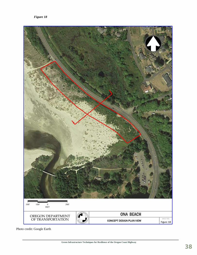
Ona Beach The outlet of Beaver Creek meandered closer to US101 in the recent past, and at that time experienced overtopping during storm surge events as well as direct erosion from the creek. The highway is a significant distance from the ocean, but is at a very low elevation and is vulnerable to future sea level rise. Initially, potential features that could be used to make Ona Beach more resilient were investigated, and then these features were drawn upon to develop preliminary concept design options. The preliminary concept design options were assembled into a matrix that described the benefits of various features and what combinations of those features would produce designs of varying protection levels and maintenance needs (see Figures 15 and 16). The preliminary concept design options also included sketches and plan view maps, which can be found in Appendix C.
Figure 15 Ona Beach Features Considered
Feature Purpose Priorities & Advantages Cobble Beach erosion protection beneficial, not essential;
provides protection for artificial dune or MSE slope
Artificial Dune overtopping protection essential; plantable, alternative to MSE slope
MSE Slope overtopping protection essential; saves beach width, plantable, alternative to artificial dune
Sand Tubes erosion protection essential; primary erosion protection, alternative to riprap
Riprap erosion protection essential; primary erosion protection, alternative to sand tubes
Figure 16 Ona Beach Preliminary Concept Design Options
Features Included Relative Protection Relative Maintenance Cobble beach, artificial dune and/or MSE slope, sand tubes or riprap (all features)
high low
Artificial dune and/or MSE slope, sand tubes or riprap (minus cobble beach)
medium medium
Input was solicited from the design team and from resource and regulatory agencies. OPRD was interested in the use of MSE slopes over artificial dunes because the smaller footprint would allow more of the beach to be kept open for public recreation. Various agencies were also interested in the smaller footprint of the MSE slopes because of reduced impact to the extensive wetlands at this site.

Green Infrastructure Techniques for Resilience of the Oregon Coast Highway
36
Vegetated MSE slope. Credit: ODOT
Based upon input from the design team and regulating agencies, it was decided to move forward with a concept design for further analysis that included the following features:
Cobble Beach.
MSE Slopes.
Sand Tubes.
A typical section and plan view were created to depict this concept design, as shown in Figures 17 and 18.

Green Infrastructure Techniques for Resilience of the Oregon Coast Highway
37
Figure 17
Green Infrastructure Techniques for Resilience of the Oregon Coast Highway
38
Figure 18
Photo credit: Google Earth.

Green Infrastructure Techniques for Resilience of the Oregon Coast Highway
39
This design blends traditional hard components with nature-based components due to feedback from regulatory agencies, and not because nature-based components would not have provided enough protection at this site. The MSE slopes would be considered traditional hard components, and act as a barrier to overtopping. The MSE slopes were chosen over artificial dunes because they could be constructed with a smaller footprint and would impact less of the wetlands found at the south end of this site. The sand tubes act as a second line of defense and would provide erosion protection if the MSE slopes were breached. The sand tubes are designed to be buried and would only be visible if the MSE slopes were compromised.
Nature-based components include the cobble beach and the face of the MSE slope. The cobble beach is composed of rounded cobbles that are meant to move and shift with wave impact and reduce the wave energy transferred to the rest of the system. The cobbles would also provide some direct erosion protection from the creek when it meanders back to its previous alignment closer to the highway. The cobble beach mimics natural cobble beaches that exist along the Oregon coast in some areas. There are multiple options for the face of the MSE slope, but planting it would mimic vegetation along the vegetated dunes adjacent to the north.
The length of repair at this site was assumed to be approximately 1,150 feet. Construction of this repair would take four to six months depending on the resources available to the contractor. The total cost estimate is almost $5.9 million, putting the repair cost for this section of coast at just over $5,000 per linear foot. See Figure 19 for a more detailed cost estimate.
It should be noted that a very high unit cost for the cobble beach was used because it was assumed that rounded rock would be required, and that would need to be trucked in from the valley. If angular rock was acceptable, the unit cost for the cobble beach would likely be reduced by about 75% for a total project cost of approximately $3.4 million, or about $3,000 per linear foot. Another possibility is that a combination of angular and rounded rock would be acceptable, with a core of angular rock buried by rounded rock.
Figure 19 Ona Beach Conceptual Design Cost
Feature Quantity Unit Price Total Price Cobble Beach 23,000 cuyd $110 cuyd $2,530,000 MSE Slope 69,000 sqft $17 cuyd $1,173,000 Sand Tubes 19,000 cuyd $28 cuyd $532,000 Riprap 1,150 cuyd $66 cuyd $75,900 Traffic Control LS $55,000 $55,000 Mobilization LS 10% $436,590 CE LS 14.50% $696,361 PE LS 7% $384,920
Total $5,883,771
Features that were not included in the final concept plans were artificial dunes and riprap. The team decided to include MSE slopes instead of artificial dunes in order to decrease the project footprint. Sand tubes were included instead of riprap because they use material more readily available, and sand tubes are a new concept for ODOT that would be beneficial for us to experiment with.
Green Infrastructure Techniques for Resilience of the Oregon Coast Highway
40
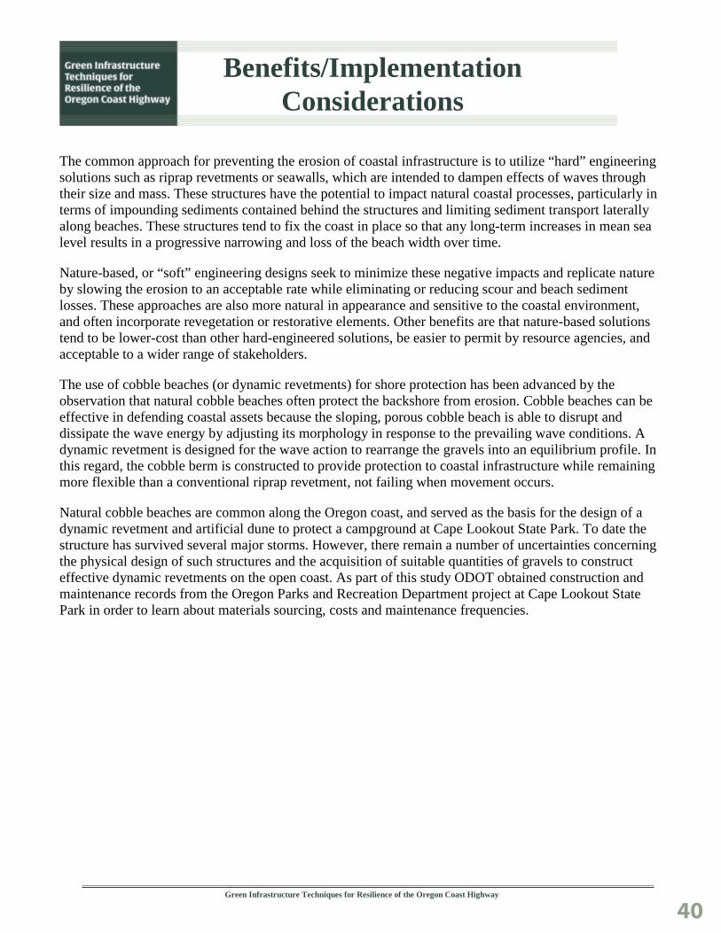
Benefits/Implementation Considerations
The common approach for preventing the erosion of coastal infrastructure is to utilize “hard” engineering solutions such as riprap revetments or seawalls, which are intended to dampen effects of waves through their size and mass. These structures have the potential to impact natural coastal processes, particularly in terms of impounding sediments contained behind the structures and limiting sediment transport laterally along beaches. These structures tend to fix the coast in place so that any long-term increases in mean sea level results in a progressive narrowing and loss of the beach width over time.
Nature-based, or “soft” engineering designs seek to minimize these negative impacts and replicate nature by slowing the erosion to an acceptable rate while eliminating or reducing scour and beach sediment losses. These approaches are also more natural in appearance and sensitive to the coastal environment, and often incorporate revegetation or restorative elements. Other benefits are that nature-based solutions tend to be lower-cost than other hard-engineered solutions, be easier to permit by resource agencies, and acceptable to a wider range of stakeholders.
The use of cobble beaches (or dynamic revetments) for shore protection has been advanced by the observation that natural cobble beaches often protect the backshore from erosion. Cobble beaches can be effective in defending coastal assets because the sloping, porous cobble beach is able to disrupt and dissipate the wave energy by adjusting its morphology in response to the prevailing wave conditions. A dynamic revetment is designed for the wave action to rearrange the gravels into an equilibrium profile. In this regard, the cobble berm is constructed to provide protection to coastal infrastructure while remaining more flexible than a conventional riprap revetment, not failing when movement occurs.
Natural cobble beaches are common along the Oregon coast, and served as the basis for the design of a dynamic revetment and artificial dune to protect a campground at Cape Lookout State Park. To date the structure has survived several major storms. However, there remain a number of uncertainties concerning the physical design of such structures and the acquisition of suitable quantities of gravels to construct effective dynamic revetments on the open coast. As part of this study ODOT obtained construction and maintenance records from the Oregon Parks and Recreation Department project at Cape Lookout State Park in order to learn about materials sourcing, costs and maintenance frequencies.

Green Infrastructure Techniques for Resilience of the Oregon Coast Highway
41
The engineered cobble beach and artificial sand dune at Cape Lookout State Park, Oregon. These features blend well into the natural environment and have effectively protected state campground facilities from wave attack and storm surge on the open coast. Credit: ODOT.
Implementation Considerations Beverly Beach Beverly Beach is in an extreme environment that leads to harsh erosional conditions at what is already one of the most critical coastal erosion sites along US101 in Oregon. This means that in order to be effective, any approach that incorporates nature based design alternatives in particular would impact a significant width of the beach. Design alternatives are also very expensive in order to create a design with a more significant level of protection. Because Beverly Beach is the most popular State Park on the Oregon coast, such a drastic impact on the beach may be particularly unfavorable to both regulating agencies and the public. This may be an instance where typical hard engineered options are preferred in order to have less of an impact. Some of the agency input we received falls along these lines.
It is estimated that maintenance on the preferred alternative would be high. The cobble beach would likely need to be regraded each year, as well as replacing up to 15% of the cobbles on a yearly basis. Every 5 years or so, during extreme winters, the entire cobble beach portion of the design may need to be replaced. Other portions of the design might also need maintenance during these extreme winters. Plantings in the MSE slope would likely need some ongoing maintenance and replanting.

Green Infrastructure Techniques for Resilience of the Oregon Coast Highway
42
This very high level of maintenance would be costly. Summary of permits/approvals needed:
Goal 18 exception (Lincoln County).
OPRD permit for beachfront protective structure (BPS).
No Department of State Lands (DSL) permit needed.
US Army Corps permit needed for any work on the beach.
Endangered Species Act (ESA) clearance for Coho Salmon (especially if interacting in nearby Spencer Creek).
Essential Fish Habitat (EFH) clearance for groundfish species - (the further out the beach, the more complicated this could become).
There are no known USFWS species of concern.
The Oregon Department of Fish and Wildlife (ODFW) does not issue permits but comments on DSL/Corps permits. ODFW comments are almost always incorporated.
The conceptual designs were based on an assumption that building protection features to an elevation of 25 feet would provide adequate protection from wave erosion and overtopping.
Subsequent analysis shows that wave runup would overtop the cobble berm at Beverly Beach quite easily even during the 10 year storm event. This indicates that a much larger volume of cobbles, and potentially jetty rock and riprap as well, would be needed to adequately address wave erosion at this site. This translates to significant cost increases over the already high cost estimates for this design.
Lost Creek Lost Creek is a low area of US 101 that experiences overtopping during high flows and storm surge events, and is susceptible to sea level rise. The preferred alternative uses nature based designs.
The outside agencies that ODOT consulted with were supportive of this approach. In addition, this protection method would likely not need a Goal 18 exception since a small cobble beach already exists at the site. Not needing to go through a Goal 18 exception would be a major advantage to utilizing a nature based approach at this site.
Site specific implementation considerations here include maintaining vehicle access over the artificial dune and cobble beach for OPRD, and maintaining an open channel across the outlet of Lost Creek. It is assumed that fairly minimal maintenance on an ongoing basis would take care of these considerations.
Site maintenance is estimated to include significant regrading the cobble beach every two to three years, and replacing up to 15% of the cobble beach at that same interval. Every five to 10 years, during extreme winters, it is estimated that 50 to 100% of the cobble beach may need to be replaced, as well as a portion of the artificial dune. This represents a significant maintenance commitment and cost that should be considered carefully if this concept is moved forward in the future.
Summary of permits/approvals needed:
DLCD/ OPRD determination and permit for non-structural improvements.
No DSL permit if not placing fill (big rocks) within the ordinary high water line (OHW) of the creek US Army Corps permit needed for work on the beach.
ESA clearance for Coho Salmon (especially if interacting in Lost Creek).

Green Infrastructure Techniques for Resilience of the Oregon Coast Highway
43
EFH clearance for groundfish species - (the further out the beach, the more complicated it could become).
No known USFWS species of concern.
ODFW may comment on DSL/Corps permits. ODFW comments are almost always incorporated as conditions.
The conceptual designs were based on an assumption that building our protection features to an elevation of 25 feet would provide adequate protection from wave erosion and overtopping.
Subsequent analysis shows that wave runup would overtop the cobble berm and artificial dune at Lost Creek even during the 10 year event. Adding an additional 4.5 feet of elevation would protect to the 25 year event. This indicates that a slight increase in volume of materials would potentially create an adequate level of protection at this site. If the additional elevation could be included only in the artificial dune portion of the design, additional costs beyond those already estimated would be low.
Ona Beach Ona Beach is a site that would perform well with nature based design options, but a hybrid solution seemed to be preferred here because of the smaller footprint it would afford. Even if a fully nature based design was implemented at this site, a Goal 18 exception would still be needed because a cobble beach does not already exist at this site. There are also wetland impacts that would need to be mitigated to carry out this design.
Because conditions do not exist currently that threaten the site, maintenance would be minimal until conditions and the site starts being impacted by creek erosion and/or storm surge.
Summary of permits/approvals needed:
Goal 18 exception (Lincoln County).
OPRD beach protective structure permit.
DSL permit necessary - extensive wetlands beyond riprap next to the roadway prism.
US Army Corps permit for wetland fill.
No known USFWS species of concern.
ODFW may comment on DSL/Corps permits. ODFW comments are almost always incorporated as conditions.
The conceptual designs were based on an assumption that building our protection features to an elevation of 25 feet would provide adequate protection from wave erosion and overtopping. Subsequent analysis shows that the design at Ona Beach would not come close being overtopped by wave runup even during the 100- year return interval. This indicates that the design is valid for this site, and may potentially remain effective if volumes of materials were reduced to in order to decrease costs.
Additional Agency Input
DLCD clarified that most of the project alternatives that were proposed would require a Goal 18 exception. Artificial dunes, raising the road grade at its current location, and culvert replacements would not trigger Goal 18. Cobble beaches, in areas where cobble beaches already existed to some extent, could be considered non-structural and may likely not trigger Goal 18.
OPRD confirmed that they would not be interested in a project at the bluff area of the Lost Creek site to protect the parking lot. They relayed that continued public use of and access to all Oregon beaches was a

Green Infrastructure Techniques for Resilience of the Oregon Coast Highway
44
key consideration for them across all sites and options. They clarified that dolos would absolutely not be allowed, and they were unfamiliar with and wary of the use of sand tubes. They also made clear that if ODOT were to be issued a permit for a project on the beach, we would be responsible to maintain it as permitted in perpetuity.
ODFW mentioned in water work restrictions, and relayed what kind of flexibility there might be at the different sites. They were particularly concerned about the extent of protection measures at Beverly Beach, and of the potential impacts of sand replenishment on Dungeness crab and other nearshore ecosystems. They mentioned that they would likely support a more traditional hard engineered solution at Beverly Beach since it would impact much less of the beach environment. Other agencies echoed that sentiment to some extent.

Green Infrastructure Techniques for Resilience of the Oregon Coast Highway
45
Conclusions
This study was a valuable exploration of nature-based design solutions to protect infrastructure from coastal hazards that will likely worsen with extreme storms and the effects of climate change. ODOT’s experience implementing coastal hazard mitigation projects is limited, so it is increasingly important to understand the range of design options available and the scope of the regulatory issues that will influence project decisions. The options developed and outreach with stakeholders initiated during this study will help inform and guide decisions for how these and similar sites vulnerable to coastal hazards are addressed in the future.
Opportunities This study brought new focus to questions surrounding how and when to address resilience of the coastal highway. Some coastal erosion sites are in a critical state of repair. Other sites have experienced impacts in the past and are projected to be at higher risk in the future. Locating opportunities under different timeframes with a wider range of protection options was important since implementing proactive solutions is a goal of adaptation.
In a first for ODOT, climate data and modeling tools were applied in conceptual design of coastal infrastructure. ODOT applied recently acquired sea level rise and flood inundation projections to inform the elevation design and protective features along the backshore. ODOT also received technical assistance from DOGAMI. A wave runup analysis was also performed by the DOGAMI on the typical section for each final concept design in order to gauge how effective the designs might be.
The wave runup analysis showed that extreme total water levels varied greatly from site to site. This highlighted the need for site specific design, and for design assistance that was outside the current abilities of ODOT. The wave runup analysis at Ona Beach suggests that the concept design at that site is sufficient – protecting the highway up to and beyond a 100-year storm event. Although the wave runup analysis for Lost Creek showed that the concept design as it now stands is not adequate, it suggests that only a slight increase in elevation could improve conditions enough to protect the highway against large storm events.
ODOT was able to engage the land use and permitting agencies on what specific protective design options or features were considered preferable, acceptable, or “non-starters.” Clear information was received about what design options would be considered structural - or non-structural - in certain coastal environments and therefore subject to Goal 18 requirements. For example, a cobble revetment may be eligible under Goal 18 if proposed on a coastal beach already comprised of cobbles. ODOT also learned more about agency preferences for specific design features among the alternatives reviewed.
Coordination between state and local agencies was enhanced on issues related to coastal protection and options moving forward that may help implement future projects. The connections made through the study will be beneficial as ODOT seeks technical assistance, and further develops and implements solutions. There was a general consensus from resource agencies on the value of ODOT having nature-based infrastructure as a coastal protection option. ODOT received some agency support for testing these nature-based design approaches on a pilot basis, so the study can be seen as a positive step towards designing a collaborative, constructible project in a critical area of need.

Green Infrastructure Techniques for Resilience of the Oregon Coast Highway
46
Challenges Many of the nature based options explored took up a larger footprint than traditional hard engineering options. It was found that traditional hard engineering might sometimes be preferred over nature based options for infrastructure protection for this reason. There were concerns that cobble beaches could potentially impact access to recreation and limit the amount of beach available for use by the public since cobbles are harder to walk on than sand. There were also concerns that cobble beaches could potentially impact natural habitats through the migration of material into the offshore environment. Options relating to sand replenishment also had environmental concerns, was found to be likely ineffective, and was cost prohibitive.
Although cobble beaches have many strong aspects in terms of engineering effectiveness and being more acceptable to regulating agencies because they mimic cobble beaches found along much of the Oregon coast, cost can be high due to their large size and footprint. A large volume of cobbles are needed to make a cobble beach work as a protective structure, however the more preferable rounded cobbles are not available near the coast. Hauling costs over long distances make use of this rock very expensive. The option of using less expensive, angular rock from nearby sources needs to be explored further.
Many nature-based options will also require more frequent and regular maintenance, which means increased costs after construction relative to more traditional hard engineering solutions.
ODOT learned how to apply nature-based solutions on a conceptual level, however to design to the level required for permitting and construction plans ODOT would need to either outsource or bring in more expertise in coastal design.
The wave runup analysis at Beverly Beach indicated that a significantly greater amount of materials would be needed to adequately address concerns with the type of mitigation that was chosen for concept design. A greater amount of materials not only means higher costs and increased construction timelines, but also a much larger project footprint. All of these factors, but potentially the larger footprint in particular, suggest that the approach of the concept design for Beverly Beach is not feasible.

Green Infrastructure Techniques for Resilience of the Oregon Coast Highway
47
Next Steps
ODOT will consider taking the following additional actions regarding the options analyzed. We also have several climate change adaptation research projects and planning activities that are underway that will contribute to coastal highway resilience.
Coordinate with DLCD to document policies and pursue project development options that only include non-structural improvements (without the need for a Goal 18 exception- e.g., Lost Creek). This could include a request for determination by State Parks that the proposed design would not be considered a Beachfront Protective Structure under current requirements.
Continue coordination with DLCD, State Parks and other stakeholders on specific solutions at Beverly Beach – including the process for a Goal 18 exception. ODOT needs to determine the feasibility of other options to protect the coastal highway and the costs/ benefits of those options relative to the work completed through this study. Additional work will be necessary at this location to select a preferred solution considering the critical nature of the coastline and that the most recent environmental studies that addressed protection of US 101 are nearly 15 years old.
Work with Regions 2 and 3 regarding other high risk locations on the coast where proactive mitigation using nature-based engineering solutions would be appropriate, cost- effective, and feasible to implement.
Identify and explore potential test sites and options for using less expensive, angular rock from nearby coastal sources. Coordination with the resource agencies would be needed on applicable sites where these materials could be acceptable. Use of an angular rock base capped with rounded cobbles may also be a way to lower costs. This could make the application of cobble revetments a more cost-effective alternative, similar to the original construction of the cobble beach at Cape Lookout State Park.
ODOT has the following projects underway related to coastal resilience:
Coastal Landslide and Bluff Retreat Monitoring (SPR 807): ODOT is actively monitoring coastal landslides and will produce risk assessments for five landslide/eroding bluff sites over a seven year period (2016-2023). One of these monitoring sites is at Beverly Beach. The goal of this research is to develop a more comprehensive data-driven framework for prioritizing coastal asset management. The research will focus on the relationships between coastal bluff retreat, precipitation, groundwater and slide movement. The rate and magnitude of bluff retreat are essential measures to be used in prioritizing mitigation strategies in these areas. Results will be used to inform project-level risks and decision making, and will inform planning and policy decisions for shoreline protection where infrastructure is threatened.
Automated Landslide Hot Spot Identification Tool (SPR 808): This recently funded ODOT research will help to prioritize and optimize landslide mitigations at the landscape scale with a focus on climate change and seismic resiliency. This project will result in a GIS-based mapping tool, guidance and training for ODOT staff, and risk maps for priority corridors.

Green Infrastructure Techniques for Resilience of the Oregon Coast Highway
48
Sea Level Rise Mapping Tool and Guidance: ODOT is developing sea level rise mapping and guidance for use in project planning and design. Sea level rise data and assessment tools can enhance project decision-making and increase resilience to rising seas and extreme weather events. ODOT is working with DLCD’s Oregon Coastal Management Program on a detailed sea level rise exposure inventory for state highways in coastal estuaries. The results of this effort will be GIS map layers depicting inundation areas under three climate change and flooding scenarios (2030, 2050, 2100). This information on potential future impacts will inform needed protection or alignment changes in vulnerable project locations or corridors.

Green Infrastructure Techniques for Resilience of the Oregon Coast Highway
49
Key Take-Aways and Lessons Learned
This section summarizes useful information for other transportation agencies, including the key challenges and solutions encountered during the pilot project that could be instructive. Some of these items could be included in FHWA’s forthcoming implementation guide on green infrastructure for coastal highway resilience.
Another “tool in the toolbox”: Several of the resource agencies consulted during the study expressed interest and support for ODOT to explore nature-based solutions for shoreline protection. Regardless of their complexity for siting, approval, etc., the potential to apply these relatively new solutions provides for a more integrated approach to coastal resilience and risk reduction, one that can employ a full range of engineering measures (hard, soft, hybrid) that supports coastal systems and infrastructure. This may lend more flexibility in the type of solutions that can be implemented and the ability to be more proactive.
Limitations of nature-based solutions: Due to Oregon’s high energy wave environment, the nature-based features analyzed were limited to those with the most potential to slow coastal bluff erosion and the impacts from extreme storms. These included cobble beaches and berms, artificial sand dunes, and sand replenishment options. Although these natural features are dynamic and therefore allow coastal processes to continue to some extent, they also do not provide for specific ecological benefits, per se relative to other types of solutions.
One size does not fit all: The benefits of applying nature-based design options for coastal protection are highly site specific. Cobble beaches/ berms may not necessarily be preferred by resource and regulating agencies due to their large footprint. A larger footprint can result in potential impacts to beach and offshore habitats, but can also raise recreational and access concerns from land managers. It was found that regulating agencies may prefer traditional hard engineering approaches over nature-based options for infrastructure protection for this reason.
Costs can be high: A working assumption at the onset of this study was that cobble beaches would come at a much lower cost than more traditional options. Because a large volume of cobbles are needed to make a cobble beach work as a protective structure, and the more preferable rounded cobbles are not available near the coast and need to be hauled over long distances, the cost estimates were high. The option of using angular rock from nearby sources needs to be explored further, which has the potential to lower rock costs by much as 75-percent.
Use of climate and wave modeling data: The wave runup analysis showed that extreme total water levels varied greatly from site to site. This analysis was very useful and highlights the need for site specific designs that reflect variation in local geography, wave, and beach conditions. To design to the level required for permitting and construction plans ODOT would need to either outsource or bring in more expertise in coastal infrastructure design.

Green Infrastructure Techniques for Resilience of the Oregon Coast Highway
50
A need for test pilots: Examples of engineered cobble beaches and dunes on the Oregon coast are few and far between. Therefore, there is limited data to support the effectiveness of these approaches in various conditions on the open coast. The analysis conducted showed that Beverly Beach may not be the right place to apply nature-based options, however at other sites this may be more feasible and effective. There is a need to test these solutions on the ground –even at a small scale –to better understand how effective they are in certain conditions and as a near-term solution to coastal highway resilience.

Green Infrastructure Techniques for Resilience of the Oregon Coast Highway
51
Technical Appendices
Additional documentation can be found in the following appendices.
• Appendix A - References
• Appendix B - Preliminary Concept Plans
• Appendix C - Extreme Value Analysis and Sea Level Rise Projections
Green Infrastructure Techniques for Resilience of the Oregon Coast Highway
52
Appendix A
GREEN INFRASTRUCTURE COASTAL HIGHWAY RESILIENCE STUDY
References and Background Resources
Allan, J.C. et al., 2015. Coastal Flood Hazard Study, Lincoln County, Oregon. Open file report O-15- 06, Oregon Department of Geology and Mineral Industries, Portland, Oregon.
Allan, J., et al., Dynamic Revetments for Coastal Erosion in Oregon, Final Report SPR 620, DOGAMI, August 2005 https://www.oregon.gov/ODOT/TD/TP_RES/docs/reports/ dynamicrevetments.pdf
Allan, J. C., P. Ruggiero, and J. T. Roberts (2012), Coastal Flood Insurance Study, Coos County, Oregon Department of Geology and Mineral Industries, Special Paper 44, Portland, Oregon, 132 pp.
Analysis of Shoreline Armoring and Erosion Policies along the Oregon Coast, Department of Land Conservation and Development, April 2015.
Beverly Beach Shoreline Protection (CAP Section 103), US Army Corps of Engineers, Portland District, June 2003.
Climate Change Vulnerability Assessment and Adaptation Options Study, ODOT and FHWA- December 2014.
Climate Change Adaptation Strategy, ODOT, April 2012.
Coles, S., 2001. An introduction to statistical modeling of extreme values. Springer-Verlag, London, 208 pp.
Gilleland, E. and Katz, R.W., 2016. in2extRemes: Into the R Package extRemes - Extreme Value Analysis for Weather and Climate Applications. NCAR/TN-523+STR, National Center for Atmospheric Research. 102 pp.
Komar, P.D. and Allan, J.C. 2010 “Design with Nature” strategies for shore protection- the construction of a cobble berm and artificial dune in an Oregon State Park, in Dethier, Megan N., et al. Puget Sound Shorelines and the Impacts of Armoring-Proceedings of a State of the Science Workshop, May 2009. No. 2010-5254, pp. 117-126. USGS, 2010.
Ruggiero, P., P. D. Komar, and J. C. Allan (2010), Increasing wave heights and extreme value projections: The wave climate of the U.S. Pacific Northwest, Coastal Engineering, 57(5), 539-552.
Sea Level Rise for the Coasts of California, Oregon, and Washington, National Research Council, 2012.
Spencer Creek Bridge Conceptual Alternatives Report and Appendices to Reconnaissance Report – U.S. Army Corps of Engineers, ODOT, FHWA, 2003.

Green Infrastructure Techniques for Resilience of the Oregon Coast Highway
53
ODOT Region 2 analysis re: Coastal Areas of Concern subject to Goal 18, May 2003. Oregon Department of Fish and Wildlife Culvert Inventory, 2011.
ODOT research on Dynamic Revetments In 2005, ODOT worked with DOGAMI on research aimed at eventually testing the use dynamic revetments to protect coastal highways. The research had two main objectives: 1) observe the geometry of natural cobble beaches (such as average width, slope, elevation, rock size), and how this relates to beach stability, and 2) identify sources of materials and rock haul costs for eventual construction.
Select findings and report link Cobble beaches are common on the Oregon coast. Engineered cobble beaches can provide
acceptable levels of protection with aesthetic, environmental, and functional benefits over traditional riprap or other armoring— and at lower costs.
Less bluff erosion was evident (and well vegetated backshores) where cobbles/berms were present-- the key difference being the width of the gravel beach and its associated sediment volume. There was no clear discernable pattern in the crest elevation of the gravel beaches and their respective slopes and grain sizes.
Based on the relative stability of beaches reviewed, the study recommends building a minimum berm crest height of 23 feet, a minimum slope of 11-degrees, with a mean cobble size of 2.5 inches. Source materials are available at sites in the Coast Range.
The preferred rock type is basalt since is commonly found and highly durable.
The issue of longshore transport needs to be addressed through the design process.
As of 2005, only five quarries were identified in the coast range that could produce small rounded gravels.
Cobble berms provide greater stability than sand beaches, but less than engineered riprap.
The study identifies the need for further analyses based on small scale pilot projects designed to test their relative effectiveness under different wave conditions/ impacts.
ODOT’s full report can be found here: https://digital.osl.state.or.us/islandora/object/osl%3A10470/datastream/OBJ/view
Example Projects/ Studies on the Oregon Coast Cape Lookout State Park - Cobble Berm and Artificial Dune Damage to the State Park campground from numerous storm occurred during El Nino years (1997-
1999).
Nature-based protective structures were constructed in the year 2000 - at a cost of $125,000.
Project is aesthetically compatible with the park setting; the cobble berm is naturally covered in sand during most summer months.
The revetment has withstood numerous storms and requires regular maintenance.

Green Infrastructure Techniques for Resilience of the Oregon Coast Highway
54
The background and performance of the Cape Lookout project has been a source of research/ study by DOGAMI coastal experts- (see Design with Nature- Strategies for Shore Protection). Also see “References Cited” in this report. http://pubs.usgs.gov/sir/2010/5254/pdf/sir20105254_chap12.pdf
A slide show presenting this same research includes photos of other dynamic revetments: http://wa.water.usgs.gov/SAW/presentations/komar.pdf
This OPRD conditional use permit is for rock placement (maintenance) at the CLSP project. https://www.oregon.gov/oprd/RULES/docs/ba-652-08_oprd_capelookout_permit.pdf
Army Corps Dynamic Revetment (South Jetty of Columbia River) – This monitoring report addresses the Army Corps’ construction of a dynamic revetment near the mouth of the Columbia River. Besides the Cape Lookout project, this is the only other publicly constructed dynamic revetment along the Oregon coast. This project is currently being monitored by DOGAMI– http://www.oregongeology.org/pubs/ofr/O-16-07.pdf
Hatfield Marine Science Center Dynamic Revetment Project – Monitoring Report (2012) This monitoring report addresses a revetment project within the Yaquina River estuary. http://oregonstate.edu/marineteam/DRP%20Monitoring%20Report%20Feb%202012%20final.pdf
Beverly Beach – ODOT Spencer Creek Conceptual Alternatives Report This is an area of chronic erosion along a 2.5 mile stretch of beach affecting US 101
Alternatives to protecting and stabilizing the bluff face was analyzed during ODOT’s 2003 Spencer Creek Bridge reconstruction project (at Beverly Beach State Park)
The Army Corps conducted a reconnaissance study for the coastal erosion and landslide issues, which includes these observations:
o Sediment starved littoral cell; low sand volume in beach profile above MHHW line (so material is not available during storms to buffer the shore).
o Geologically vulnerable bluff slope.
o Increasing coastal wave climate/ storm events, and potential wave focusing by off shore reefs.

Green Infrastructure Techniques for Resilience of the Oregon Coast Highway
55
ODOT/ Army Corps design options for protecting eroding coastal bluffs included: o Rock seawall and rock revetment at bluff toe.
o Cobble beach fill (revetment) and beach nourishment.
o Offshore submerged and subaerial reefs.
o Nearshore sediment disposal and sediment berms.
Spencer Creek Bridge Conceptual Alternatives Report - and Appendices to Reconnaissance Report (Army Corps of Engineers, ODOT, FHWA- (2003).
Note – page 24 of Appendix E – Corps Report on Shoreline Protection, addresses cobble beach fill design for Beverly Beach.
National Assessment of Shoreline Change This USGS sponsored report provides an assessment of historical change/ rates of erosion along the PNW coast (USGS)-2012. Local authors include J. Allan (DOGAMI) and P. Ruggerio (OSU).
See pages 37-40 for Lincoln County coast line. http://pubs.usgs.gov/of/2012/1007/
ODOT Climate Change Adaptation planning ODOT prepared a coastal Vulnerability Assessment and Adaptation Options study in 2014. This was a FHWA-funded pilot project that engaged maintenance and technical staff to assess the vulnerability of coast highways to extreme weather events and higher sea levels. The project involved conceptual level designs, cost estimates, maintenance and benefit/costs at five coast sites in Clatsop and Tillamook counties. It also includes a regulatory review and case study of the Beverly Beach/ Spencer Creek project.
FHWA’s website hosts ODOT’s report. Scroll down to “Oregon” to view report contents… https://www.fhwa.dot.gov/environment/sustainability/resilience/pilots/2013-2015_pilots/index.cfm
Coastal Policies, Regulations and Permitting Oregon’s coastal regulations prohibit most development on beaches and dune forms. The legislative history for Statewide Planning Goal 18 is that highway facilities are not considered “development” and therefore are not eligible for beachfront protective structures without an Exception to Goal18.
Statewide Planning Goal 18 - BEACHES AND DUNES - OAR 660-015-0010(3) - https://www.oregon.gov/LCD/docs/goals/goal18.pdf
Statewide Planning Goal 2 – LAND USE PLANNING – Goal Exception process - https://www.oregon.gov/LCD/docs/goals/goal2.pdf
Oregon State Parks is the agency responsible for permitting the construction of beachfront protective structures and coastal bluff protection measures.
Oregon State Parks- DIVISION 20 - BEACH CONSTRUCTION/ ALTERATION STANDARDS – OAR 736-020-0001-0120 - http://arcweb.sos.state.or.us/pages/rules/oars_700/oar_736/736_020.html
Oregon State Parks – Ocean Shore Permit Application (Addendum A- Shoreline Protection) - http:// www.oregon.gov/oprd/RULES/docs/os_add_a.pdf

Green Infrastructure Techniques for Resilience of the Oregon Coast Highway
56
Lincoln County Planning and Development Department is responsible for administering the statewide rules through its local comprehensive plan– http://www.co.lincoln.or.us/planning
Department of Geology and Mineral Industries (DOGAMI) is the state agency with expertise in coastal geomorphology, including coastal erosion. DOGAMI has conducted past research regarding landslides, erosion rates, and cobble beaches and berms. Jon Allan, Coastal Geomorphologist, is a member of the project team. http://www.oregongeology.org/sub/default.htm
Oregon Department of Fish and Wildlife (ODFW) has a mission to protect and enhance fish and wildlife species and their habitats – and should be consulted as part of the project. http://www.dfw.state.or.us/
Design Guidance Coastal Risk Reduction and Resilience: Using the Full Array of Measures – US Army Corps of Engineers (2013) http://www.aldenst.com/wordpress/wp-content/uploads/2016/12/Coastal-Risk-Reduction-and-Resilience-_-Using-the-Full-Array-of-Measures.pdf
US Army Corps of Engineers – Coastal Engineering Manual. http://www.publications.usace.army.mil/USACE-Publications/Engineer-Manuals/u43544q/436F617374616C20456E67696E656572696E67204D616E75616C/
Highways in the Coastal Environment - U.S. Department of Transportation, FHWA Hydraulic Engineering Circular - No. 25 - Publication No. FHWA-NHI-07-096 - (June 2008) http://www.fhwa.dot.gov/engineering/hydraulics/pubs/07096/07096.pdf
Revetment design considerations - http://www.pilebuck.com/highways-coastal-environment-second-edition/chapter-6-coastal-revetments-wave-attack/
NCHRP REPORT 568 - Riprap Design Criteria, Recommended Specifications, and Quality Control http://onlinepubs.trb.org/onlinepubs/nchrp/nchrp_rpt_568.pdf In this report, riprap failure mechanisms are identified as a basis for developing inspection guidance, and selected case studies of failures are used to emphasize the need for post-flood/post-construction inspection. In addition, concepts (but not design guidance) for a bioengineering or hybrid design approach for bank stabilization using a combination of rock and vegetative treatments are discussed. Design guidelines were developed and are included as appendixes to this report. Marine Shoreline Design Guidelines- Washington State Aquatic Habitat Guidelines Program http://wdfw.wa.gov/publications/01583/

Green Infrastructure Techniques for Resilience of the Oregon Coast Highway
57
Appendix B
Preliminary Concept Plan

Green Infrastructure Techniques for Resilience of the Oregon Coast Highway 58

Green Infrastructure Techniques for Resilience of the Oregon Coast Highway
59
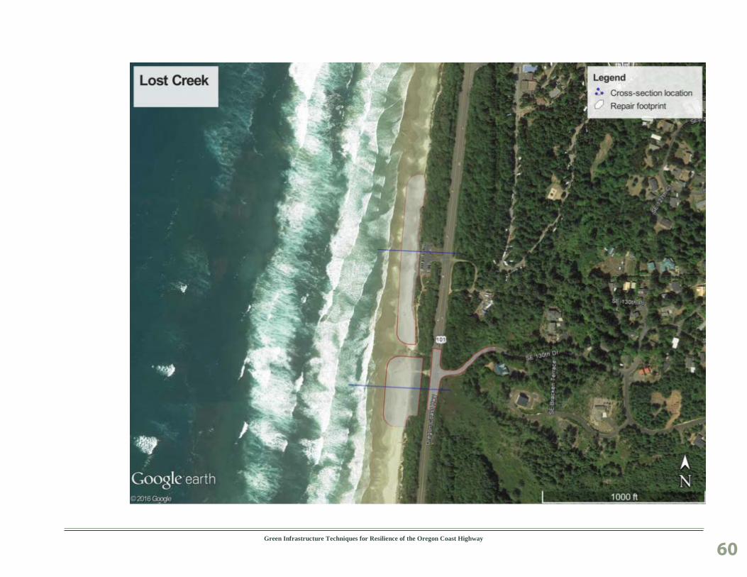
Green Infrastructure Techniques for Resilience of the Oregon Coast Highway
60

Green Infrastructure Techniques for Resilience of the Oregon Coast Highway
61

Green Infrastructure Techniques for Resilience of the Oregon Coast Highway
62
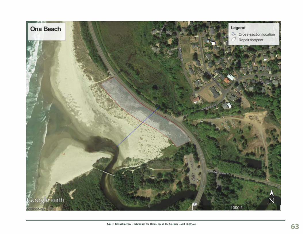
Green Infrastructure Techniques for Resilience of the Oregon Coast Highway
63

Green Infrastructure Techniques for Resilience of the Oregon Coast Highway
64
Green Infrastructure Techniques for Resilience of the Oregon Coast Highway 65
Appendix C
Oregon Projected Sea Level Rise and Extreme Value Analysis (EVA) by County Table on the next two pages.
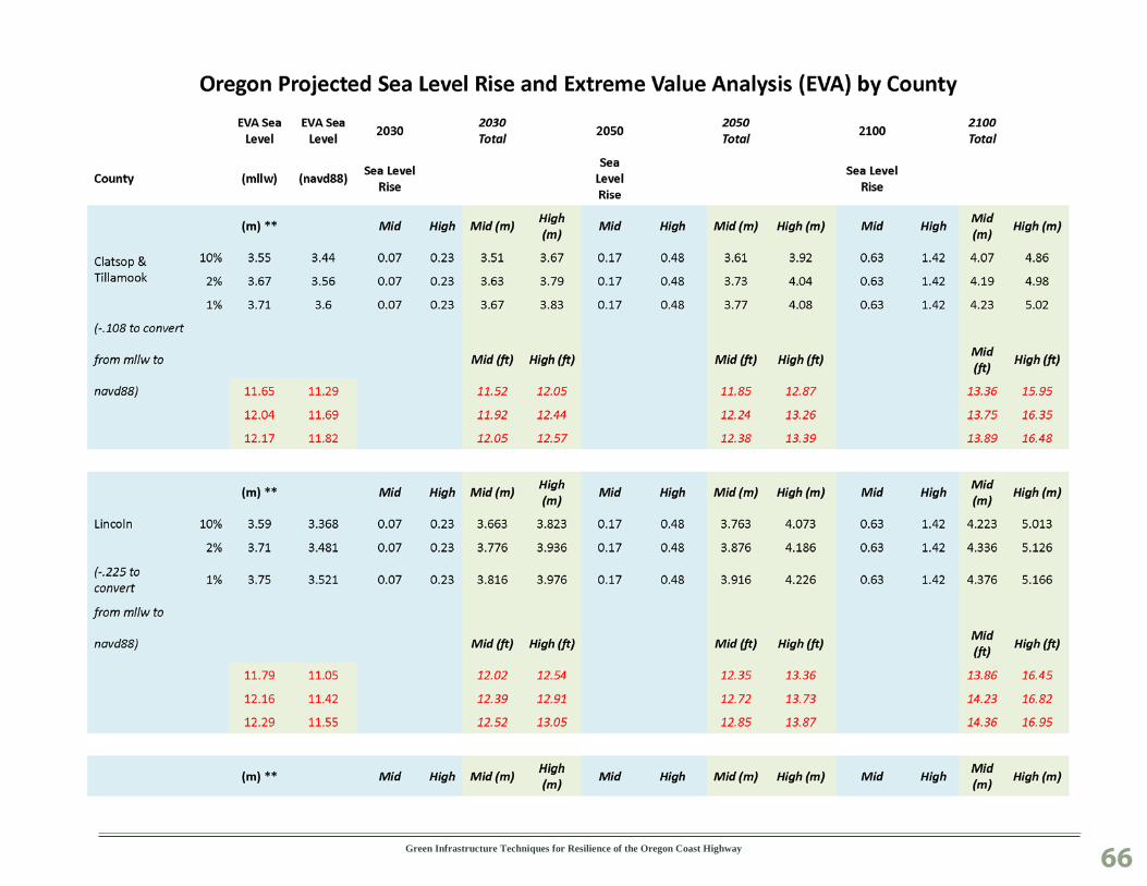
Green Infrastructure Techniques for Resilience of the Oregon Coast Highway
66
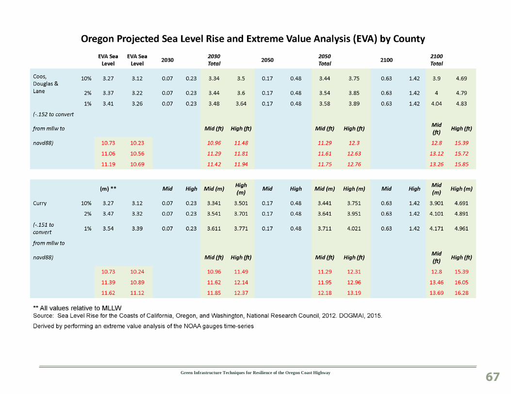
Green Infrastructure Techniques for Resilience of the Oregon Coast Highway
67