greater sage grouse: colorado synthesis report · greater sage grouse: colorado synthesis report i....
TRANSCRIPT

Greater Sage Grouse: Colorado Synthesis Report
I. Introduction
The U.S. Fish and Wildlife Service (FWS) is poised to propose a listing decision for the Greater Sage
Grouse (GrSG) under the Endangered Species Act by 2015. Eleven states are host to habitat for the
species, and the FWS has indicated its intent to make a single range-wide listing decision, rather than a
state-specific determination. Federal, state, local, and private entities have become actively involved in
activities to conserve GrSG habitat in an effort to avert a listing.
II. Background: The Colorado Package
In 2008, the (then) Colorado Division of Wildlife (now Colorado Parks and Wildlife (CPW)) developed
a comprehensive Colorado Greater Sage-Grouse Conservation Plan. Among the components of that
plan is a section entitled “Conservation Strategy,” which identifies key issues facing GrSG
conservation. For each issue, objectives are listed that would contribute to mitigation of the issue; for
each of these objectives, a number of specific strategies are described. Each strategy, in turn, includes a
list of responsible parties with a lead agency identified where possible, an estimated timeline, and an
approximate cost associated with implementation. This Colorado Conservation Plan is available at:
http://wildlife.state.co.us/WildlifeSpecies/SpeciesOfConcern/Birds/Pages/GreaterSageGrouseConsPlan
2.aspx
In 2012, Colorado sought to undertake a comprehensive update to the Conservation Plan. For each
strategy enumerated in the Conservation Plan, described above, the Department of Natural Resources
(DNR) compiled information from stakeholders identified in the matrix to summarize implementation of
the strategies to meet objectives. The result was the Colorado Package1.
The completed Colorado Package was sent to the Bureau of Land Management (BLM) for inclusion in
its Northwest Colorado RMP revision, as an Appendix common to all alternatives being considered.
The Package was also submitted to the FWS for its review, and in August, 2013 that agency provided
feedback to the state. Areas that were considered strong include communication among stakeholders,
identification of the biology and related issues, acquisition of conservation easements, and habitat
1 http://wildlife.state.co.us/WildlifeSpecies/SpeciesOfConcern/Birds/Pages/GreaterSageGrouseConsPlan2.aspx
Report Page Number: 1

improvement work. Areas where the FWS has requested more information come from threats
identified in the Conservation Objectives Team (COT) Report:
Implementation of oil and gas rules in GrSG habitat, pursuant to HB 07-1298. While the
Colorado Oil and Gas Association (COGCC) rules are well documented in the Package, the FWS
is interested in detailed data that show whether implementation of those rules has resulted in
effective conservation of GrSG habitat on the ground to date, and whether there are opportunities
for improved implementation going forward.
Exurban development at the county level. Some counties have zoning regulations and related
approaches on the books that seek to manage development in GrSG habitat within their borders.
The FWS is interested in the implementation of those regulations, again with a focus on the
extent to which they have been effective in protecting habitat. Additionally, the agency would
like us to project future development pressure and consider how habitat protection can be assured
going forward.
Livestock management. The FWS is also interested in a broad-scale evaluation of livestock
management and range condition on state and private land. The agency recommended the use of
State Land Board data on grazing practices across the northwest part of the state as a tool for
approximating a more comprehensive evaluation.
The State of Colorado now submits this synthesis report at the request of the FWS. This report draws
from data collected in the Package, information contained in the COT report, and information obtained
from county, state, federal, and private stakeholders. State and local entities were integral to the
production of this synthesis, and while DNR took the lead on writing the report, it is a statewide
document. In addition to the three specific items listed above, this report also includes updated
information on a number of other conservation actions that should be considered by the USFWS in its
listing decision.
III. Implementation of oil and gas rules in GrSG habitat, pursuant to HB 07-1298.
Colorado's General Assembly passed House Bill 07-1298 in 2007, and the COGCC developed regulations
to implement its provisions that are contained in the agency's 1200-Series Rules (see Appendix A). The
statute and these rules provide, among other things, an opportunity for CPW officials to consult with oil
and gas companies when drilling is proposed in certain habitat areas. These Sensitive Wildlife Habitat
(SWH) or Restricted Surface Occupancy (RSO) areas are depicted in maps maintained and periodically
Report Page Number: 2

updated by the COGCC and encompass habitat for a number of species that may be impacted by oil and
gas development, including GrSG.
While regulations make consultation between oil and gas operators and CPW mandatory when drilling is
proposed in SWH or RSO areas, CPW lacks regulatory authority to require measures arising from this
consultation. Instead, such measures are provided to COGCC and to operators as recommendations to
minimize adverse impacts to wildlife. We sought to explore the extent to which implementation of
recommendations was happening on the ground. To accomplish this, we hired a contractor (Tetra Tech) to
conduct the analysis, by reaching out to individual operators and to field managers with CPW.
Results show very high correlation between Best Management Practices (BMPs) recommended by SPW
for protection of GrSG habitat and voluntary adoption. In other words, CPW met with operators every
time a permit for drilling in GrSG habitat was sought. During those consultations, CPW recommended a
series of actions designed to minimize or eliminate impacts on habitat. Adoption of those
recommendations by an operator is entirely voluntary under the 1200-series regulations, but our analysis
suggests that they are adopted 97% of the time. Please see Appendix B for the full report.
One problem our contractor had in developing that analysis was pervasive difficulty in obtaining data.
Ultimately, he relied on conversations and paperwork from CPW and Form 2As filed with the COGCC
by operators. Data on voluntary avoidance, minimization, and mitigation was much harder to collect.
Colorado will move forward with a more comprehensive tracking system that can happen in real time;
that is, as consultations take place and companies begin operations, they will be required to enter their
protective practices in a centralized database. In this way, we hope to have our fingers on the
implementation results without having to launch a separate study. Stakeholders in the development of a
tracking system include state agencies, industry, and local governments. We will begin to develop this
process in 2014.
IV. Exurban development at the county level
There are two dimensions to the issue of exurban development: the threat of expanding residential
development and the county level response to that threat. With only a few exceptions, the northwest part
of the state has not seen extensive housing development in recent years; indeed, many rural areas have
little or no exurban development. In order to understand the nature of the threat of exurban development
to the 8 counties that overlap with GrSG habitat, we contracted with Conservation Science Partners
(CSP). Using parcel data, census data, and groundwater well data, CSP estimated past growth and
Report Page Number: 3

generated projections for future development. These data proved to be occasionally misleading; well data,
in particular, may suggest residential development when in fact it indicates stock ponds or other
agricultural use. Additionally, it is important to note that growth rates are highly uneven across the region.
Some counties have little to no growth while others, especially resort areas, experience consistently
higher levels of growth.
Results show that for the years 1980-2010, residential units across the eight-county area grew by more
than 50% in GrSG habitat; perhaps more importantly, however, priority habitat saw an annual increase of
development of only 1.8%. Currently, 11% of total priority habitat has residential development at a
density higher than one unit per 160 acres. Projections suggest that future growth will add 55,683 acres to
that number, an increase of 1.43%. The full report is attached in Appendix C.
The second component of this issue is the county level response to exurban development. Colorado
statute authorizes counties to establish planning and zoning commissions (CRS 30-28-103), and describes
a range of duties those commissions are authorized to accomplish (CRS 30-28-111). Pursuant to these
authorities, many counties have placed stipulations on plats based on issues of concern including
important wildlife habitat. Enforcement of those stipulations is then left to the counties. Similarly,
counties are authorized to conduct master planning (CRS 30-28-106(3)(a)(XI)) to guide land use and
development; that provision identifies threatened and endangered species as a topic counties may include
in their planning documents.
Colorado counties have approached the planning and zoning challenge differently, in part due to variation
in the perceived threat. Please refer to the Colorado Package for details about related efforts by counties;
the information below is specific to GrSG habitat.
Jackson:
Nearly all of the priority habitat for GrSG is located within the county’s designated Ranching
District Zone. Under county regulations, the R zone is managed as follows:
o Uses that are permitted in the R zone include ranching, general agriculture, ponds and
reservoirs, limited sand and gravel operations, low impact recreation facilities, and oil
and gas exploration and development.
o All other uses require a Special Use permit or Conditional Use Permit. All such uses
generally require a public hearing on the application with written notice published in a
newspaper of general circulation. Among the attendees at these hearings is Colorado
Report Page Number: 4

Parks and Wildlife, which is invited to provide recommendations for protecting wildlife
habitat.
Since 2008, the county has approved 21 building permits for new residential dwelling units. Of
those, five were approved for new structures on existing ranches, 10 were approved for residential
structures and cabins outside of the PPH, and only two were approved within the boundaries of
the PPH. One of those approvals was for a very small cabin in the historic ghost town of
Coalmont, and the other was for a new residence within the Eagles Watch Planned Unit
Development near Walden.
Garfield:
Recently completed Comprehensive Plan 20302, a document that details current and future
growth projections.
o Relevant sections include the stated goal to “ensure that natural, scenic, ecological, and
critical wildlife habitat resources are protected and/or impacts mitigated,” (p. 61). To
achieve this goal, “the county will encourage and cooperate with the protection of critical
habitat including state and federally protected, threatened, or endangered species.” (p. 62)
30% of GrSG mapped habitat in the county falls into Open Space / Public Lands designation. The
remaining 70% is private, and falls into the county designation of Resource Production / Natural.
These areas are prioritized for resource extraction within significant environmental constraints.
The only permitted residential use in that designation is one dwelling per 35 acres.
Grand:
Grand County Master Plan (2011) prioritizes wildlife habitat and provides county-wide direction
for planning. Planning and Zoning Regulations3 consistent with Master Plan.
Growth boundaries are detailed in the Master Plan and favor clustered development.
All proposed new developments and all applications for higher impact Special Use Permits must
be reviewed by CPW.
Mesa:
Approximately 14,200 acres of GrSG habitat exists in the “Sunny Side” area of Mesa County
between Collbran and DeBeque. Of those, 12,000 acres are privately owned. Of those, 22% are
protected through conservation easements.
2 http://www.garfield-county.com/community-development/comprehensive_plan2030.aspx
3 http://co.grand.co.us/208/Planning-Zoning-Regulations
Report Page Number: 5

Ranching and oil and gas development are the primary activities anticipated in this habitat area.
There is little residential development.
Mesa County Land Development Code, Sec. 7.6.4 is entitled Wildlife Habitat Protection and
includes the requirement that “Any project on any parcel that falls within the current Wildlife
Composite Map for Mesa County … shall require consultation with the Colorado Division of
Wildlife [now CPW] to substantiate the basis for the potential impact and to address various,
specific measures to avoid, minimize, or mitigate negative impacts to wildlife and its habitat.”
Moffat:
Has authority through the County Planning and Zoning Commission to establish sage grouse
development stipulations; to date, no such stipulations have been deemed necessary, and therefore
none have been placed on subdivisions.
Planning and zoning subdivision regulations allow CPW review of subdivisions, new
developments, and Conditional Use permits (Article IV P.19).
The Moffat County / City of Craig Master Plan prioritizes responsible wildlife habitat
management as follows: “Moffat County shall support recovery planning efforts for sensitive,
threatened, and endangered species, which evaluate, mitigate, and support Moffat County’s
custom and culture and economic viability.” (p14)
Rio Blanco:
County Master Plan policy NR-1D states that the County will work with federal and state
agencies to protect wildlife habitat, including restricting development in the most sensitive habitat
and mitigating impacts in other critical areas.
Standards for wildlife management apply to all land use approvals, and provide design features
and other prescription for buffers, non-native plants and animals, refuse disposal, fencing,
domestic animals, and exterior lighting. Land Use Resolution Section 259 also describes
development review criteria for consideration of wildlife impacts, and addresses previously
undisturbed areas, disruption of life cycle functions, species reliance on habitat features, habitat
removal / alteration / fragmentation, and proposed mitigation efforts to address potential impacts.
Report Page Number: 6

Routt:
Over 90% of the County is zoned Agriculture and Forestry.4 Lot size was established in 1995 as a
minimum of 35 acres (Sec. 5.2.1). Since then, only one subdivision has been proposed and it was
subsequently withdrawn.
Commercial activity in the Agriculture and Forestry Zone requires a Special Use Permit. By
county policy, those permit applications are sent to CPW for review and comment. Based on
those comments, conditions such as timing constraints, disturbance extent and reclamation
requirements are frequently written into new permits.
V. State Land Board & Grazing
The Colorado State Board of Land Commissioners (SLB) is a constitutionally created state agency to
which the State of Colorado delegated its fiduciary and management responsibility for the state trust
lands of eight public trusts in Colorado. The state trust lands were lands transferred as an endowment to
Colorado by the federal government around the time of statehood to be managed for the benefit of public
education and public institutions. Today these assets include approximately three million surface acres of
land that are leased for agricultural, grazing, recreational, commercial real estate, rights-of-way,
renewable energy and other uses; and approximately four million acres of mineral estate that are leased
for oil, natural gas, coal and other solid mineral extraction uses. Revenues generated by the state trust
lands through surface leases, rights-of-way and mineral production royalties go to the trust beneficiaries,
capital investment, and board operations.
In 1996, the voters of Colorado passed Amendment 16 to the state constitution, which requires that state
trust lands be managed both for reasonable and consistent revenue and the preservation of long-term asset
values – both economic and natural.
The SLB currently has 164 grazing and multiple use leases that contain, in whole or in part, state trust
lands within GrSG priority and general habitat areas. These leases total 264,116 acres of GrSG habitat
and occur in five of the seven GrSG populations in the northwest part of the state. Of those state trust
lands leased for grazing and/or recreational uses, 49% fall within Priority Habitat and 18% fall within
General Habitat (see Appendix D).
4 Routt County Master Plan available at: www.co.routt.co.us/DocumentCenter/View/275
Report Page Number: 7

Cattle grazing is the predominant type of grazing on state trust lands in GrSG habitat areas. Fencing in
these leases amounts to 166 miles of woven-wire fence and 439 miles of barbed wire fence; there is
roughly one mile of fence per section. Per SLB grazing lease, lessees are responsible for maintaining the
fences on their property.
Recreational use is another important use on state trust lands containing GrSG habitat. Approximately
67% of the SLB grazing leases in GrSG habitat have all or part of their lands enrolled in the CPW Public
Access Program. Another 17% have private recreation leases, predominantly hunting.
State trust lands are typically inspected by District Managers once every five years; grazing leases are
inspected at least 18-30 months prior to a lease expiration date, and whenever a new use is proposed.
Since 1999, nearly 16,000 acres (16%) of SLB’s grazing leases in GrSG habitat have been inventoried by
a private range specialist. In many cases, those inspections resulted in improved grazing management
practices and treatment for noxious weeds. The SLB is now developing a Greater Sage Grouse
Stewardship Action Plan that will include range inventories using a rapid assessment tool for at least
200,000 acres of GrSG habitat. This inventory has been integrated into the agency’s 2013 Strategic Plan
as follows.
Strategic Objective #2.2: Enhance stewardship of all trust lands through an increased use of sustainable
practices in land management.
Complete systematic inventory of natural resources on state trust lands.
Increase management and monitoring of state trust lands.
Develop a comprehensive set of BMPs to guide all uses on state trust lands.
Develop SLB Stewardship Action Plans (SAPs) for special ecosystems on state trust lands.
Develop and strengthen stewardship partnerships with land management agencies,
appropriate Non-Governmental Organizations and citizen volunteers.
Develop Integrated Resource Management Plans for our most significant properties.
Pursuant to this objective, the SLB has begun to develop Stewardship Action Plans (SAP) for its
properties. An SAP is a landscape-scale management plan for a targeted species (e.g. GrSG) or type of
natural resource (e.g. wetland fens). SAPs are outcome-based and pragmatic. They incorporate an
adaptive management framework that sets goals and priorities, develops strategies and action steps,
measures results and regularly re-evaluates those elements to make sure they are still relevant.
Report Page Number: 8

The SAP will assess the quality of state trust lands for the identified natural resource or species – in this
case, GrSG -- propose strategies to enhance and/or restore those lands, and determine the best
management practices for generating revenue through existing and new uses, including emerging
ecosystem services marketplaces.
In 2013, SLB initiated the field work associated with the preparation of a GrSG SAP for state trust lands
located in NW Colorado. The effort will provide the SLB with additional information about its properties
and identify strategies that may allow the SLB to avoid or minimize the impacts associated with a listing
decision. Most importantly, the inventory will provide vegetation monitoring data to support adaptive
management techniques to improve habitat, including the potential to revise grazing plans as needed.
In 2014, staff plans to continue the field assessments associated with the GrSG and Gunnison Sage
Grouse SAPs. In March 2014, the Board endorsed the project, authorized staff time and directed staff to
include the project’s cost in the agency’s base budget. SLB anticipates the GrSG SAP will be completed
by 2016.
VI. Additional Activities in Colorado
a. Colorado Habitat Exchange
The Colorado Habitat Exchange (Exchange) is a new tool for conserving and creating GrSG habitat,
currently under development. It creates new incentives for private landowners, public land managers, and
development companies to reduce impact, as well as conserve, enhance, and restore critical habitat for the
species. The Exchange is a market-based mechanism that quantifies conservation outcomes (credits) and
impacts from human activities (debits), defines standards for market transactions, and reports the overall
progress from implementation of conservation actions throughout the GrSG range in Colorado. The
Exchange establishes the market infrastructure and tools necessary to facilitate effective and efficient
conservation for the species, which include the habitat quantification tool (HQT) and protocols (i.e.
processes and rules) to ensure conservation benefits are measurable and repeatable. The Exchange is
intended to provide regulatory certainty for industries by addressing compensatory mitigation needs
whether or not the species is listed under the Endangered Species Act.
The Exchange abides by the following guiding principles:
Produce high-quality conservation where it makes the greatest ecological difference.
Enable sound decision-making based on the best available science.
Report Page Number: 9

Create an efficient marketplace, where every transaction will result in a net benefit for the GrSG.
Foster transparency, accountability, and credibility.
Improve the effectiveness and efficiency through programmatic management of the Exchange.
The Exchange will cover the entire occupied range for GrSG in Colorado, as mapped by the BLM as part
of the National Planning Strategy for the species. Credits are generated by projects that create benefits for
GrSG habitat, and debits are accrued from impacts to habitat. The Exchange scope can be expanded to
support additional conservation needs and to correspond with revisions to habitat and management maps
in the future. For example, the Exchange will also include Mule Deer habitat in the future.
The development of the Exchange is currently led by a diverse Working Group that includes
representatives from Environmental Defense Fund, DNR, Colorado Cattlemen’s Association, CPW,
Partners for Western Conservation, and the Colorado Oil & Gas Association.
The steps for generating and transacting credits are depicted as follows, and described in further detail in
the Colorado Habitat Exchange Manual, which is anticipated to be released in May 2014.
The orange Track and Transfer connector represents the role of the Exchange Administrator who provides
the platform for transactions to occur. In addition to the operational steps outlined above, the Exchange
Administrator will manage the Exchange under a transparent and inclusive process that is designed to
improve the efficiency and effectiveness of the Exchange over time. This process includes an annual
cycle of reporting on Exchange performance, executing strategic monitoring and evaluation, and
systematically improving Exchange tools and operations.
A series of operational design rules will ensure net benefit for the species. Key operational features
include the following:
Mitigation Ratios make the total functional acres of credit greater than the functional acres of
debit.
Outcome-Based Quantification & Performance-Based Credit Release links the release of credits
to on-the-ground functional habitat that is known to support populations.
Overview of the process steps to generate and purchase credits
Report Page Number: 10

Verification with Performance & Financial Assurances creates strong incentives for Credit
Developers to generate functional habitat that is durable.
Reserve Account creates an insurance pool of credits that can be used in cases where projects
unexpectedly cease to produce functional habitat, so that the program overall ensures sufficient
credits are available to offset debits.
The Exchange’s Habitat Quantification Tool (HQT) is the method for quantifying habitat function in
functional acres and determining debits and credits. The HQT uses a set of metrics, applied at multiple
spatial scales, to evaluate vegetation and environmental conditions related to GrSG habitat quality and
quantity. The HQT enables the Exchange to create incentives to generate credits on the most beneficial
locations for the GrSG, and to minimize impacts to existing high quality habitat. The HQT is used to
calculate scores for each type of seasonal habitat, including summer, winter, and breeding habitat. The
metrics are applied at four spatial scales derived from the Habitat Assessment Framework. To calculate
credits or debits, pre- and post-project conditions are measured at the site to determine functional acre
scores. The debit/credit score is adjusted to account for indirect effects of the local area surrounding the
site. Mitigation ratios are applied to ensure that the functional acres of credit acquired are greater than the
functional acres of debit. Actual conditions at the site are verified using the HQT, and credits are released
according to the habitat quality achieved.
The Working Group is in the process of finalizing the Exchange Manual and HQT for release in May
2014. Additionally, the Working Group is drafting an Exchange Agreement that will authorize the use of
the Exchange for GrSG mitigation upon USFWS approval. The Exchange intends to execute pilot
transactions in summer 2014 to further test and improve the draft HQT and protocols.
b. Habitat Protection through Conservation Easements: Updated Information
In addition to the habitat protection program through CPW, Colorado is host to a number of private land
trusts. Many of these organizations have been focused on protecting GrSG habitat in recent years.
Summary data from these public / private partnerships indicates strong protection both of core habitat and
linkage areas. Total acres protected in each GrSG population is as follows:
Meeker/White River: 6,248.9 acres
Middle Park: 26,183.5 acres
North Eagle/South Routt: 11,520.15 acres
North Park: 26,786.9 acres
Northwest Colorado: 48,939.4 acres
Report Page Number: 11

Parachute/Piceance/Roan: 4,852 acres
In addition, the following linkage habitat has been protected:
Between Meeker and Northwest populations: 3,954 acres
Between North Park and Middle Park: 173 acres
Between North Eagle/South Routt and Northwest: 1,293 acres
Please see Appendix E for complete conservation easement summary data.
Report Page Number: 12

APPENDICES
A Colorado Oil and Gas Conservation Commission 1200-series Regulations
B Tetra Tech Report: Analysis of Oil and Gas Permitting in GrSG Habitat
C Conservation Science Partners Report: Summary of Status and Trends of Residential Growth in
Northwestern Colorado
D Map: State Land Board Sections in GrSG Habitat
E Conservation Easement Matrices and Maps
F Grazing White Paper
Report Page Number: 13

1200-1 As of April 1, 2009
APPENDIX A: COGCC 1200 Series Regulations
PROTECTION OF WILDLIFE RESOURCES
1201. IDENTIFICATION OF WILDLIFE SPECIES AND HABITATS
Prior to the preparation of a Comprehensive Drilling Plan or the submittal of a Form 2A for a proposed new oil and gas location, an operator shall review the Sensitive Wildlife Habitat map and the Restricted Surface Occupancy map maintained by the Commission on its website and attached as Appendices VII and VIII to determine whether the proposed oil and gas location falls within Sensitive Wildlife Habitat or a Restricted Surface Occupancy area. The operator shall include this determination in the Form 2A or Comprehensive Drilling Plan.
1202. CONSULTATION
a. The purpose of consultation under Rule 306.c is to allow the Director to determine whether conditions
of approval are necessary to minimize adverse impacts from the proposed oil and gas operations in the identified sensitive wildlife habitat or restricted surface occupancy area, in an order increasing well density, or in a basin-wide order involving wildlife resource issues and to evaluate requests for variances from the provisions of the 1200-Series Rules. For purposes of this rule, minimize adverse impacts shall mean wherever reasonably practicable, to (i) avoid adverse impacts from oil and gas operations on wildlife resources, (ii) minimize the extent and severity of those impacts that cannot be avoided, (iii) mitigate the effects of unavoidable remaining impacts, and (iv) take into consideration cost-effectiveness and technical feasibility with regard to actions taken and decisions made to minimize adverse impacts to wildlife resources, consistent with the other provisions of the Act.
b. Unless excepted as set forth in Rule 1202.d, when a proposed new oil and gas location is located in
sensitive wildlife habitat or a restricted surface occupancy area, the Colorado Division of Wildlife shall consult with the operator, the surface owner, and the Director in accordance with Rule 306.c prior to approval of a Form 2A to identify possible conditions of approval.
c. Any conditions of approval resulting from such consultation shall be guided by the list of Best
Management Practices for Wildlife Resources maintained on the Commission website. In selecting conditions of approval from such Best Management Practices or other sources, the Director shall consider the following factors, among other considerations:
(1) The Best Management Practices for the producing geologic basin in which the oil and gas
location is situated;
(2) Site-specific and species-specific factors of the proposed new oil and gas location;
(3) Anticipated direct and indirect effects of the proposed oil and gas location on wildlife resources;
(4) The extent to which conditions of approval will promote the use of existing facilities and
reduction of new surface disturbance;
(5) The extent to which legally accessible, technologically feasible, and economically practicable alternative sites exist for the proposed new oil and gas location;
(6) The extent to which the proposed oil and gas operations will use technology and practices
which are protective of the environment and wildlife resources;
(7) The extent to which the proposed oil and gas location minimizes surface disturbance and habitat fragmentation;
Report Page Number: 14

1200-2 As of April 1, 2009
(8) The extent to which the proposed oil and gas location is within land used for residential, industrial, commercial, agricultural, or other purposes, and the existing disturbance associated with such use; and
(9) Permit conditions, lease terms, and surface use agreements that predate December 11,
2008.
d. Consultation under Rule 306.c shall not be required if:
(1) The Director or Commission has previously approved a Form 2A or Comprehensive Drilling Plan which includes the proposed new oil and gas location;
(2) The Colorado Division of Wildlife has previously approved, in writing, a wildlife mitigation plan
or other wildlife protection or conservation plan that remains in effect for the area that includes the proposed new oil and gas location and the oil and gas location is in compliance with such plan;
(3) The operator demonstrates that the identified habitat and/or species, where applicable, is not
in fact present to support the identified species and use, such as where the proposed oil and gas location is located in a high density area, designated pursuant to Rule 603.b, or within an incorporated homeowners association or city or town limits;
(4) The proposed new well would involve a one-time increase in surface disturbance of one (1)
acre or less per well site at or immediately adjacent to an existing well site;
(5) The operator applies for and obtains a Commission order pursuant to Rule 503 providing that there will not be more than three (3) well sites per section, with ground disturbing activity during the period from January 1 to March 31 (or other biologically appropriate alternative period up to ninety (90) consecutive days as determined by the Director for bighorn sheep winter range, elk production areas, bald or golden eagle nest or roost sites, columbian or plains sharp-tailed grouse production areas, greater or Gunnison sage grouse production areas, black-footed ferret release areas, or lesser prairie chicken production areas) limited to one (1) such well site, as determined by the Director. This exemption from consultation shall not apply to operations in occupied greater sage grouse sensitive wildlife habitat in Moffat, Routt, or Jackson Counties or in occupied Gunnison sage grouse sensitive wildlife habitat in Delta, Mesa, Gunnison, San Miguel, Dolores, or Montezuma Counties;
(6) The Director grants a variance pursuant to Rule 502.b; or
(7) The Colorado Division of Wildlife waives the consultation requirement.
e. No permit-specific condition of approval for wildlife habitat protection under this rule shall be imposed
without surface owner consent, including any permit-specific conditions for wildlife habitat protection that modify, add to, or differ materially from the general operating requirements in Rules 1203 and 1204. If the surface owner fails to consent to any such permit-specific condition of approval, then the parties shall consult with the surface owner regarding alternative conditions of approval acceptable to the surface owner.
1203. GENERAL OPERATING REQUIREMENTS IN SENSITIVE WILDLIFE HABITAT AND
RESTRICTED SURFACE OCCUPANCY AREAS
a. General Operating Requirements. Within sensitive wildlife habitat and restricted surface occupancy areas, operators shall comply with the operating requirements listed below.
Report Page Number: 15

1200-3 As of April 1, 2009
(1) During pipeline construction for trenches that are left open for more than five (5) days and are greater than five (5) feet in width, install wildlife crossovers and escape ramps where the trench crosses well-defined game trails and at a minimum of one quarter (1/4) mile intervals where the trench parallels well-defined game trails.
(2) Inform and educate employees and contractors on wildlife conservation practices, including
no harassment or feeding of wildlife.
(3) Consolidate new facilities to minimize impact to wildlife.
(4) Minimize rig mobilization and demobilization where practicable by completing or recompleting all wells from a given well pad before moving rigs to a new location.
(5) To the extent practicable, share and consolidate new corridors for pipeline rights-of-way and
roads to minimize surface disturbance.
(6) Engineer new pipelines to reduce field fitting and reduce excessive right-of-way widths and reclamation.
(7) Use boring instead of trenching across perennial streams considered critical fish habitat.
(8) Treat waste water pits and any associated pit containing water that provides a medium for
breeding mosquitoes with Bti (Bacillus thuringiensis v. israelensis) or take other effective action to control mosquito larvae that may spread West Nile Virus to wildlife, especially grouse.
(9) Use wildlife appropriate seed mixes wherever allowed by surface owners and regulatory
agencies.
(10) Mow or brushhog vegetation where appropriate, leaving root structure intact, instead of scraping the surface, where allowed by the surface owner.
(11) Limit access to oil and gas access roads where approved by surface owners, surface
managing agencies, or local government, as appropriate.
(12) Post speed limits and caution signs to the extent allowed by surface owners, Federal and state regulations, local government, and land use policies, as appropriate.
(13) Use wildlife-appropriate fencing where acceptable to the surface owner.
(14) Use topographic features and vegetative screening to create seclusion areas, where
acceptable to the surface owner.
(15) Use remote monitoring of well production to the extent practicable.
(16) Reduce traffic associated with transporting drilling water and produced liquids through the use of pipelines, large tanks, or other measures where technically feasible and economically practicable.
b. Exceptions. If the operator believes that any of the foregoing operating requirements should be
waived for any proposed oil and gas location, it shall so specify in a Form 2A for Director consideration.
Report Page Number: 16

1200-4 As of April 1, 2009
1204. OTHER GENERAL OPERATING REQUIREMENTS
a. The operating requirements identified below shall apply in all areas.
(1) In black bear habitat west of Interstate 25 and on Raton Mesa east of Interstate 25, operators shall install and utilize bear-proof dumpsters and trash receptacles for food-related trash at all facilities that generate such trash.
(2) In designated Cutthroat Trout habitat, as identified on the Colorado Division of Wildlife
Species Activity Mapping (SAM) system, operators shall disinfect water suction hoses and water transportation tanks withdrawing from or discharging into surface waters (other than contained pits) used previously in another river, lake, pond, or wetland and discard rinse water in an approved disposal facility. Disinfection practices shall be repeated after completing work or before moving to the next water body. Disinfection may be performed by removing mud and debris and then implementing one of the following practices:
A. Spray/soak equipment with a disinfectant solution capable of killing whirling disease
spores; or
B. Spray/soak equipment with water greater than 140 degrees Fahrenheit for at least 10 minutes.
(3) To minimize adverse impacts to wildlife resources, plan new transportation networks and new
oil and gas facilities to minimize surface disturbance and the number and length of oil and gas roads and utilize common roads, rights of way, and access points to the extent practicable, consistent with these rules, an operator’s operational requirements, and any requirements imposed by federal and state land management agencies, local government regulations, and surface use agreements and other surface owner requirements, and taking into account cost effectiveness and technical feasibility.
(4) Establish new staging, refueling, and chemical storage areas outside of riparian zones and
floodplains.
(5) Use minimum practical construction widths for new rights-of-way where pipelines cross riparian areas, streams, and critical habitats.
b. Exceptions. If the operator believes that any of the foregoing operating requirements should be
waived for any proposed oil and gas location, it shall so specify in a Form 2A for Director consideration.
1205. REQUIREMENTS IN RESTRICTED SURFACE OCCUPANCY AREAS
a. Operators shall avoid Restricted Surface Occupancy areas to the maximum extent technically and
economically feasible when planning and conducting new oil and gas development operations, except:
(1) When authorized following consultation under Rule 306.c.(3);
(2) When authorized by a Comprehensive Drilling Plan;
(3) Upon demonstration that the identified habitat is not in fact present;
(4) When specifically exempted by the Colorado Division of Wildlife; or
(5) In the event of situations posing a risk to public health, safety, welfare, or the environment.
Report Page Number: 17
1200-5 As of April 1, 2009
b. As set forth in Rule 1205.a, new ground disturbing activities are to be avoided in Restricted Surface Occupancy areas, including construction, drilling and completion, non-emergency workovers, and pipeline installation activity, to minimize adverse impacts to wildlife resources. Production, routine maintenance, repairs and replacements, emergency operations, reclamation activities, or habitat improvements are not prohibited in Restricted Surface Occupancy areas. Notwithstanding the foregoing, non-emergency workovers, including uphole recompletions, may be performed with prior approval of the Director on a schedule that minimizes adverse impacts to the species for which the restricted surface occupancy area exists.
c. Applicability. The requirements of Rule 1205 are not applicable to Applications for Permit-to-Drill,
Form 2, or Oil and Gas Location Assessments, Form 2A, which are approved prior to May 1, 2009 on federal land or April 1, 2009 on all other land. The requirements of Rule 1205 are also not applicable until January 1, 2010, for any proposed oil and gas location in a Restricted Surface Occupancy area where the operator has in good faith initiated and is diligently pursuing consultation on the proposed oil and gas location begun prior to May 1, 2009 on federal land or April 1, 2009 on all other land, pursuant to Rule 306.c or Rule 216.
Report Page Number: 18

Analysis of Oil and Gas Permitting inGreater Sage Grouse Habitat
Prepared for:
Colorado Department of Natural Resources
1313 Sherman StreetDenver, CO 80203(303) 866-3311
Prepared by:
Tetra Tech
4900 Pearl East Circle, Suite 300WBoulder, CO 80301(303) 447-1823Fax (303) 447-1836
Tetra Tech Project No. 114-910016
March, 2014
Report Page Number: 19

Analysis of Oil and Gas Permitting in Greater Sage Grouse Habitat Colorado Department of Natural Resources
Tetra Tech March 4, 2014 i
TABLE OF CONTENTS
1.0 INTRODUCTION.............................................................................................................1
2.0 METHODOLOGY............................................................................................................2
2.1 Data collection from the COGCC Website............................................................22.2 Operator Input......................................................................................................32.3 CPW and COGCC Consultations.........................................................................32.4 BMPs Outside of Permit Approvals or Wildlife Mitigation Plans............................3
3.0 RESULTS .......................................................................................................................5
3.1 Data Collection from the COGCC Website...........................................................53.1.1 Wells by County ................................................................................................. 53.1.2 Wells by Operator .............................................................................................. 53.1.3 Wells by Land and Mineral Ownership................................................................ 53.1.4 Wells in GrSG SWH versus RSO areas.............................................................. 6
3.2 Operator Input......................................................................................................63.3 CPW and COGCC Consultations.........................................................................7
3.3.1 CPW Consultation.............................................................................................. 73.3.2 COGCC Consultation......................................................................................... 93.3.3 BMPs Outside of Permit Approvals or Wildlife Mitigation Plans ........................... 9
4.0 DATA ANALYSIS .........................................................................................................10
4.1 Avoidance Data .................................................................................................104.2 Minimization Data ..............................................................................................124.3 Mitigation Data...................................................................................................124.4 Acreage Data.....................................................................................................13
5.0 CONCLUSION AND RECOMMENDATIONS................................................................15
LIST OF TABLES
Table 1. Operator Size and Participation .................................................................................6Table 2. CPW Consultation Analysis .......................................................................................8Table 3. Acres of Avoidance by Operator ..............................................................................11Table 4. Acres of Mitigation by Operator................................................................................14Table 5. Disturbance Acres by Operator................................................................................14
LIST OF APPENDICES
Appendix A FigureAppendix B Operator data
Report Page Number: 20

Analysis of Oil and Gas Permitting in Greater Sage Grouse Habitat Colorado Department of Natural Resources
Tetra Tech March 4, 2014 1
1.0 INTRODUCTION
The passage of Colorado State House Bill (HB) 07-1298 requires consultation with the ColoradoDepartment of Parks and Wildlife (CPW) for activities conducted within sensitive wildlife habitat(SWH) and restricted surface occupancy (RSO) areas. Greater sage grouse (GrSG) is onespecies CPW designated as having SWH and RSO areas. The GrSG is currently beingproposed for listing under the Endangered Species Act by the U.S. Fish and Wildlife Service(USFWS).
In response to the proposed listing, Colorado Department of Natural Resources (DNR) providedthe USFWS a report detailing the actions Colorado has implemented to minimize disturbancesin GrSG habitat. The USFWS responded to DNR’s report requesting additional datademonstrating, among other items, whether the implementation of HB 07-1298 has resulted ineffective conservation of GrSG habitat and whether there are opportunities for improvedimplementation.
Tetra Tech, Inc. (Tetra Tech) was contracted by DNR to conduct an analysis of oil and gaspermitting in GrSG habitat in an effort to provide the USFWS data documenting theimplementation of HB 07-1298 by oil and gas operators. This document provides the results ofTetra Tech’s analysis of oil and gas operations in GrSG habitat.
Report Page Number: 21

Analysis of Oil and Gas Permitting in Greater Sage Grouse Habitat Colorado Department of Natural Resources
Tetra Tech March 4, 2014 2
2.0 METHODOLOGY
The following discussion details the steps taken and assumptions made to obtain thequantifiable data requested by DNR (the Project). The Project is broken down into the followingfour phases:
1. Data collection from the Colorado Oil and Gas Conservation Commission (COGCC)website
2. Operator input3. CPW and COGCC consultations4. Identification of best management practice (BMPs) outside of permit approvals or wildlife
mitigation plans
Each phase is described below.
2.1 Data collection from the COGCC Website
Oil and gas permit- related data was obtained from the COGCC website (www.cogcc.com). Thedata was obtained following the steps below.
1. Retrieval of geographic information system (GIS) well permit data, as well as the GrSGdata layer from the website
2. Use of a GIS Intersect tool, reduce the number of permits to those located in GrSGhabitat
3. Reduction of the number of permits to those implemented since passage of HB 07-1298
The initial evaluation of permitted wells in GrSG habitat totaled 3,183 wells, some of which pre-dated passage of HB 07-1298. To reduce the number of wells for detailed analysis, a samplewas selected of up to 100 individual drill site locations, differentiating between sites managed bylarge operators and sites managed by small operators. A large operator is defined as a well-established oil and gas company. The small operator is defined as a lesser known oil and gascompany. Considering both large and small operators helps to determine the extent to whichsmall operators are engaged in GrSG habitat protection and may indicate a need for additionaloutreach or other action on the part of, for example, the COGCC or the Colorado Oil and GasAssociation (COGA). This analysis relied on documents available through hyperlinks on theCOGCC website associated with individual permits. Available documents are Form 2, Form 2A,and associated documents that provide general discussion of BMPs.
The final dataset was entered into a spreadsheet (Appendix A) that identifies the followinginformation:
Permitted well locations by county
Surface and mineral rights ownership (listed as fee, state, federal, or Native American)
Whether permitted wells are located within GrSG SWH versus RSO areas
BMPs listed in Form 2, Form 2A, or associated documents
Acreages assigned to wells, when provided on Form 2 or Form 2A
Report Page Number: 22

Analysis of Oil and Gas Permitting in Greater Sage Grouse Habitat Colorado Department of Natural Resources
Tetra Tech March 4, 2014 3
2.2 Operator Input
The publicly- available data from the COGCC website was limited to voluntary BMPs andsubsequent concurrence letters from CPW. Tetra Tech, therefore, contacted targeted operatorsin GrSG habitat, based on the sample described above, to verify BMPs and to obtain additionalinformation regarding minimization and/or avoidance actions that were implemented but whichdo not appear in the publicly-available documents.
Tetra Tech targeted a subset of operators using the list and specific contact informationresulting from the data collection. Tetra Tech also contacted several COGA member operatorswho are aware of this project, have agreed to assist with data gathering, and have operations inGrSG habitat. To preserve anonymity among the operators, Tetra Tech identifies the operatorsnumerically in this report and spreadsheet.
Tetra Tech conducted outreach with individual operators by phone and email. To increase theresponse rate, Tetra Tech provided text for an email to be issued by COGA to individualoperator contacts announcing the outreach effort and indicating that Tetra Tech would follow upby phone Tetra Tech assumed a single email and up to two phone contacts with individualoperators.
Tetra Tech requested the following information from operators:
Specific avoidance actions in response to GrSG habitat, including locations andacreages
Specific minimization actions in response to GrSG habitat, including locations, acreages,and actions
Specific mitigation actions in response to GrSG habitat, including locations, acreages,and actions
Tetra Tech predicted that responses would describe actions, such as well pad development(with approximate dimensions) that were relocated to avoid GrSG habitat, use of specializedequipment, or minimization of road development (with approximate dimensions).
2.3 CPW and COGCC Consultations
Tetra Tech conducted outreach to CPW and COGCC to supplement the information providedfrom the COGCC website and to identify additional measures that were not included in theavailable information. The Energy Liaison with CPW was consulted to identify operator specificagreements that would affect the operator’s avoidance, minimization, or mitigation in GrSGhabitat. Tech Tech consulted with the Permitting Supervisor and the Oil and Gas LocationAssessment Supervisor with COGCC was consulted to identify the consultation process and todetermine if COGCC had conducted field evaluations of agreed wildlife BMPs.
2.4 BMPs Outside of Permit Approvals or Wildlife Mitigation Plans
In some instances, BMPs or other commitments resulted directly from negotiations withlandowners. That information was indicated on Form 2, Form 2A, surface agreementdocuments, or correspondence documents available on the COGCC website. The specificBMPs and commitments, however, either were not specified or required follow-up with individual
Report Page Number: 23

Analysis of Oil and Gas Permitting in Greater Sage Grouse Habitat Colorado Department of Natural Resources
Tetra Tech March 4, 2014 4
operators. Tetra Tech contacted individual operators, as well as CPW to obtain this information;to the extent it was available.
Report Page Number: 24

Analysis of Oil and Gas Permitting in Greater Sage Grouse Habitat Colorado Department of Natural Resources
Tetra Tech March 4, 2014 5
3.0 RESULTS
3.1 Data Collection from the COGCC Website
A review of publically- available data from COGCC’s website was conducted from October 21through October 26, 2013. The data, finalized on October 26, 2013, is the basis for theevaluation and review of the well permits. It was necessary to create a data collection end pointfor this analysis since the COGCC website is updated daily. The dataset for this exercise waslimited to wells permitted since implementation of HB 07-1298 within GrSG habitat (Projectarea). GrSG habitat is defined by the CPW as a combination of SWH and RSO datasets. Thewells were identified by county, operator, land ownership, mineral ownership, and location ofwell within an RSO or SWH.
3.1.1 Wells by County
The mapped GrSG areas cover a total of eight counties (Eagle, Garfield, Grand, Jackson,Moffat, Rio Blanco, Routt, and Summit) (Figure 1, Appendix B). The following five counties arerepresented in the spreadsheet: Garfield, Jackson, Moffat, Rio Blanco, and Routt (AppendixA). Eagle and Summit counties did not have permitted wells within the GrSG habitatboundaries. In Grand County, permitted wells were identified, but were permitted prior topassage of HB 07-1298. The Grand County wells, therefore, were eliminated from furtherevaluation. Operators provided supplemental data for analysis in four of the five counties. Theoperators with permitted wells in Jackson County did not participate in this analysis. The wellswere identified by land ownership, mineral ownership, and location of the well within an RSO orSWH.
3.1.2 Wells by Operator
Review of the COGCC website database identified 30 operators that have at least one wellpermitted in the Project area. Five of these operators were eliminated from the analysis becausethey did not specifically address GrSG or GrSG habitat in the COGCC website database. The25 remaining operators were divided into large operators versus small operators. Nine largeoperators were identified as having at least one permitted well in GrSG habitat in the Projectarea. All nine of these operators are represented in the spreadsheet. A total of 16 smalloperators were identified as having at least one permitted well in GrSG habitat in the Projectarea. Of these, two small operators applied for permits on behalf of one of the large operatorsand, therefore, were removed from additional analysis to avoid duplication. Of the remaining 14operators, 11 were selected at random for additional analysis. The total sample size of largeand small operators represented in the spreadsheet is 20 operators (9 large and 11 small).
The 20 operators represent a total of 293 permitted wells in GrSG habitat. The permitted wellsevaluated for this analysis exceeded the anticipated number of wells (100) by 293 percent. The293 permitted wells are 28 percent of the potential 1,039 permitted wells in GrSG habitat sincethe passage of HB 07-1298. Figure 1 in Appendix B shows the permitted well locations bycounty and GrSG habitat type. Of the 293 permitted wells evaluated, 227 permitted wells (77percent) had quantifiable data provided to the COGCC by the operators. Figure 2 in Appendix Bshows the permitted wells together with operator- provided data. The lack of quantifiable datafor the other wells likely is due to the grouping of large numbers of permits under one WildlifeMitigation Agreement (WMA), or by the grouping of several wells under one set of BMPs.
3.1.3 Wells by Land and Mineral Ownership
Report Page Number: 25

Analysis of Oil and Gas Permitting in Greater Sage Grouse Habitat Colorado Department of Natural Resources
Tetra Tech March 4, 2014 6
The surface and mineral rights for the permitted wells are either private (fee) or federal. None ofthe permitted wells identified had state or tribal surface or mineral rights. Private surface rightsconstituted 89 percent of the total evaluated. The remaining 11 percent were federal surfacerights. Private mineral rights constituted 84 percent of the total evaluated. The remaining 16percent were federal mineral rights.
3.1.4 Wells in GrSG SWH versus RSO areas
The analysis includes 279 permitted wells (95 percent) in SWH areas. A total of 14 permittedwells (less than 5 percent) are located in RSO areas.
3.2 Operator Input
To meet Project timelines, initial contact with operators was conducted by phone on November21-22, 2013.. Additional contact by phone was conducted on December 2-3, 2013, with follow-up emails sent December 3-4, 2013. Tetra Tech continued to contact operators at least once aweek for those operators who did not respond to the initial email or phone requests. In addition,COGA issued an email to its members on December 14, 2013 requesting their participation inthe Project. Tetra Tech participated in two COGA Wildlife Subcommittee conference calls withCOGA members during which members were introduced to the Project and were requested toparticipate with data.
Nine operators did not respond to outreach conducted for the Project. Three operators declinedto participate in the Project (Table 1). The operators are listed in Table 1. Explanations fornonresponses included the following:
Company restructuring prevented the allocation of time required to respond Company chose, instead, to focus efforts on national GrSG actions Company agreed to participate, but did not provide data
The remaining eight operators, of the 20-operators sample, provided data. Of these, however,one operator sold all but one company asset located in GrSG habitat. The company’s remainingasset is active but no quantifiable actions have been implemented. A second operator haspermitted wells but no quantifiable data for the wells. A total of five operators (four large and onesmall operator), therefore, provided quantifiable data for this analysis. Details for the operatordata are provided in Section 4.0, Data Analysis.
Table 1. Operator Size and Participation
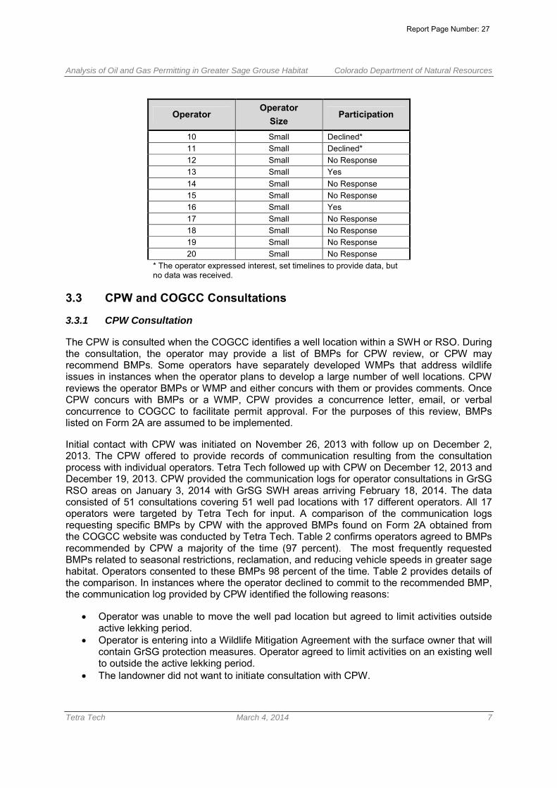
OperatorOperator
SizeParticipation
1 Large Yes2 Large Yes3 Large No Response4 Large Declined5 Large No Response6 Large Yes7 Large Yes8 Large Yes9 Large Yes
Report Page Number: 26
Analysis of Oil and Gas Permitting in Greater Sage Grouse Habitat Colorado Department of Natural Resources
Tetra Tech March 4, 2014 7
OperatorOperator
SizeParticipation
10 Small Declined*11 Small Declined*12 Small No Response13 Small Yes14 Small No Response15 Small No Response16 Small Yes17 Small No Response18 Small No Response19 Small No Response20 Small No Response
* The operator expressed interest, set timelines to provide data, butno data was received.
3.3 CPW and COGCC Consultations
3.3.1 CPW Consultation
The CPW is consulted when the COGCC identifies a well location within a SWH or RSO. Duringthe consultation, the operator may provide a list of BMPs for CPW review, or CPW mayrecommend BMPs. Some operators have separately developed WMPs that address wildlifeissues in instances when the operator plans to develop a large number of well locations. CPWreviews the operator BMPs or WMP and either concurs with them or provides comments. OnceCPW concurs with BMPs or a WMP, CPW provides a concurrence letter, email, or verbalconcurrence to COGCC to facilitate permit approval. For the purposes of this review, BMPslisted on Form 2A are assumed to be implemented.
Initial contact with CPW was initiated on November 26, 2013 with follow up on December 2,2013. The CPW offered to provide records of communication resulting from the consultationprocess with individual operators. Tetra Tech followed up with CPW on December 12, 2013 andDecember 19, 2013. CPW provided the communication logs for operator consultations in GrSGRSO areas on January 3, 2014 with GrSG SWH areas arriving February 18, 2014. The dataconsisted of 51 consultations covering 51 well pad locations with 17 different operators. All 17operators were targeted by Tetra Tech for input. A comparison of the communication logsrequesting specific BMPs by CPW with the approved BMPs found on Form 2A obtained fromthe COGCC website was conducted by Tetra Tech. Table 2 confirms operators agreed to BMPsrecommended by CPW a majority of the time (97 percent). The most frequently requestedBMPs related to seasonal restrictions, reclamation, and reducing vehicle speeds in greater sagehabitat. Operators consented to these BMPs 98 percent of the time. Table 2 provides details ofthe comparison. In instances where the operator declined to commit to the recommended BMP,the communication log provided by CPW identified the following reasons:
Operator was unable to move the well pad location but agreed to limit activities outsideactive lekking period.
Operator is entering into a Wildlife Mitigation Agreement with the surface owner that willcontain GrSG protection measures. Operator agreed to limit activities on an existing wellto outside the active lekking period.
The landowner did not want to initiate consultation with CPW.
Report Page Number: 27

Analysis of Oil and Gas Permitting in Greater Sage Grouse Habitat Colorado Department of Natural Resources
Tetra Tech March 4, 2014 8
Table 2. CPW Consultation Analysis
CPW Recommended Best Management PracticeTotal
RequestedTotal
AcceptedPercentageAccepted
Conduct well site visitations to portions of the day between 9:00a.m. and 4:00 p.m. during the lekking season (March 1 to May 15). 50 49 98%
Reclaim/restore greater sage-grouse habitats with native grasses,forbs, and shrubs conducive to optimal greater sage-grouse habitatand other wildlife appropriate to the ecological site.
48 47 98%
Use certified, weed free grass hay, straw, hay or other mulchmaterial used for the reseeding and reclamation of disturbed areas. 11 9 82%
Use only certified weed-free native seed mixes, unless use of non-native plant materials is recommended by CPW 28 27 96%
Use local seed when available 15 15 100%Avoid aggressive non-native grasses in greater sage grousereclamation 5 5 100%
Lek avoidance is from March 1 through May 15 for major activities 31 29 94%4-mile buffer for GrSG March 1-June 30 (4-months) 15 13 87%reducing visits to pads through the SCADA system 17 17 100%25 mph limit for all roads/ reduce speeds to minimize wildlifemortality 50 49 98%
No surface occupancy within 0.6 mile of any known lek 34 32 94%Phase and concentrate all development activities so that largeareas of undisturbed habitat for wildlife remain and thoroughreclamation occurs immediately after development and beforemoving to new sites.
14 14 100%
Use centralized hydraulic fracturing operations 14 14 100%Transport water through centralized pipelines in lieu of water trucks 16 16 100%Maximize use of state-of-the-art drilling operations technology 14 14 100%Minimize surface disturbance and fragmentation of greater sagegrouse habitat 16 16 100%
Design tanks and other facilities with structures such that they donot provide perches or nest substrates for raptors, crows, andravens.
36 35 97%
Provide access to CPW research personnel for ongoing sagegrouse population research 18 18 100%
Site new disturbance so as to use topographic features to shieldleks from new disturbance when feasible. 19 19 100%
Schedule pipeline construction and installation (not including linesalong roads) outside of the Critical Habitat Season. 18 18 100%
Restrict new disturbance within nesting and brood-rearing habitatas much as possible from April 15 to July 1. 18 18 100%
Use solar panels for on-location production, where feasible. 18 18 100%Operator agrees to use hospital grade mufflers for compressors,pump jacks, or other motors necessary to run operations. 14 14 100%
Operator will implement a weed management plan as part ofmitigation 4 4 100%
Close and immediately reclaim all roads that are redundant, notused regularly, or have been abandoned to the maximum extentpossible to minimize disturbance and habitat fragmentation.
3 2 67%
Car pool to minimize commuting 6 6 100%Implement fugitive dust control measures 6 6 100%Combine utility infrastructure alongside access roads to avoid theuse of separate utility corridors. 1 1 100%
Total 539 525 97%
Report Page Number: 28
Analysis of Oil and Gas Permitting in Greater Sage Grouse Habitat Colorado Department of Natural Resources
Tetra Tech March 4, 2014 9
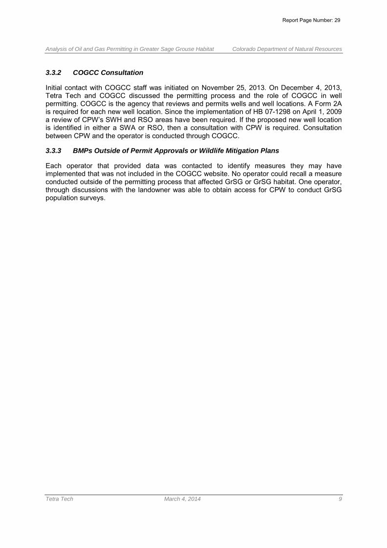
3.3.2 COGCC Consultation
Initial contact with COGCC staff was initiated on November 25, 2013. On December 4, 2013,Tetra Tech and COGCC discussed the permitting process and the role of COGCC in wellpermitting. COGCC is the agency that reviews and permits wells and well locations. A Form 2Ais required for each new well location. Since the implementation of HB 07-1298 on April 1, 2009a review of CPW’s SWH and RSO areas have been required. If the proposed new well locationis identified in either a SWA or RSO, then a consultation with CPW is required. Consultationbetween CPW and the operator is conducted through COGCC.
3.3.3 BMPs Outside of Permit Approvals or Wildlife Mitigation Plans
Each operator that provided data was contacted to identify measures they may haveimplemented that was not included in the COGCC website. No operator could recall a measureconducted outside of the permitting process that affected GrSG or GrSG habitat. One operator,through discussions with the landowner was able to obtain access for CPW to conduct GrSGpopulation surveys.
Report Page Number: 29

Analysis of Oil and Gas Permitting in Greater Sage Grouse Habitat Colorado Department of Natural Resources
Tetra Tech March 4, 2014 10
4.0 DATA ANALYSIS
Section 3.0, above, described the results of research conducted through the COGCC databaseand directly with operators and agencies. This section provides an analysis of the data obtainedfrom the COGCC database, operators, and agencies. The analysis is based on quantifiableavoidance, minimization, and mitigation measures. A table with data collected by operator isprovided in Appendix A.
4.1 Avoidance Data
The BMPs identified in Appendix B list actions that constitute avoidance of GrSG habitat.Actions that operators have implemented but are not quantifiable include:
Verbal agreements between CPW and the operator to move well pad locations outsideof GrSG SWH and/or RSO areas
Re-aligning roads outside of GrSG habitat Increasing the spacing between well pads
Several operators are developing multiple wells from a single well pad using directional drilling.This practice benefits both the operator and GrSG habitat. There are economic benefits to theoperator to reduce the number of well pads which also benefits wildlife habitat by disturbing lessacreage. Table 3 provides an analysis of the benefits of directional drilling on GrSG habitat. Theacreage calculations are based on a worst case scenario in which each permitted well requiresa well pad. The average well pad size is operator and terrain specific. Access roads (whenprovided by the operator) also are included in this table to demonstrate another avoidancemeasure resulting from the use of directional drilling.
Report Page Number: 30

Analysis of Oil and Gas Permitting in Greater Sage Grouse Habitat Colorado Department of Natural Resources
Tetra Tech January 10, 2014 11
Table 3. Acres of Avoidance by Operator
OperatorOperator
SizeWells
PotentialWellPads
Avg. WellPadSize
PotentialAcreage
ofDisturbance
ActualWellPads
ActualWellsper
Pad
Well PadAcreage
Total
Roadsize
1
perWellPad
PotentialRoad
Disturbanceper Well
ActualRoad
Disturbance
TotalAcres
ofAvoidance
1 Large 77 77 4.98 383.50 22 3.50 109.60 1.56 120.12 34.32 359.70
2 Large 294 294 4.00 1176.00 14 21 56.00 1.44 423.36 20.16 1523.20
6 Large 40 40 9.00 360.00 4 10.00 36.00 - - - 324.00
7 Large 78 77 4.00 308.00 7 11.14 44.00 0.06 4.68 0.66 268.02
9 Large 6 5 3.80 19.00 42 1.20 15.20 - - - 3.802
13 Small 26 26 5.19 134.94 10 2.60 51.90 0.22 5.72 2.18 86.58
Totals - 521 519 30.97 2,381.44 57 49.44 366.70 3.28 553.88 57.32 2,565.301 Road size is calculated by multiplying the road width (30ft.) by the average length of the access road to the well pad.2 One well pad was moved out of GrSG habitat after CPW consultation.
Report Page Number: 31

Analysis of Oil and Gas Permitting in Greater Sage Grouse Habitat Colorado Department of Natural Resources
Tetra Tech January 10, 2014 12
4.2 Minimization Data
Several actions described in operator BMPs minimize activities in GrSG habitat. One operator,for example, after coordination with CPW, moved a well pad from a GrSG RSO area to an SWHarea. This relocation effort avoided approximately 4 acres of disturbance to a known GrSG lek(a.k.a., an RSO) but is considered minimization, rather than avoidance, because the well padcontinues to be located in GrSG habitat. Other actions identified in operator BMPs to minimizeactivities in GrSG habitat include the following:
Routing pipelines and roads in previously disturbed areas – Operators confirmed that whenfeasible, construction of roads and pipelines would be placed in already disturbed areas. Theseareas consisted of existing roads or pipelines. Data to calculate the use of existing pipeline androad ROW was not available for this analysis.
Reducing the widths of roads and pipeline ROWs – Operators on average use between a 25and 30 foot ROW for road construction. CPW confirmed that road and pipeline ROWs on federallands are restricted to the agencies regulations. On private lands, road and/or pipelineconstruction can vary depending topography as well as landowner agreements. A potentialmethod for calculating road and pipeline widths would take the ROW widths required on federallands versus the constructed ROW widths on private lands. Data to calculate the widthreduction of pipeline and road ROW’s was not available for this analysis.
Implementing fugitive dust control measures – Operators typically use water trucks tosuppress fugitive dust during construction activities.
Using a remote monitoring system to reduce the frequency for operator visits to eachwell pad – Operators use the supervisory control and data acquisition (SCADA) system to limitthe number of visits to each well pad. This reduced frequency limits the potential for wildlifemortality, dust emissions, and noise disturbances in GrSG habitat.
Early reclamation of disturbance areas – Operators agreed to implement interim reclamationupon completion of well pads. This action reduces the GrSG habitat recovery time.
Requiring reduced speeds to reduce wildlife mortality – Operators agreed to implement aspeed reduction in GrSG habitat. Operators include, during safety training, a section on wildlifeand require drivers to reduce their vehicle speed to limit the potential for wildlife mortality.
Conducting site visits outside of GrSG brood rearing periods – Operators agreed toconduct site visits outside of GrSG brood rearing periods, when applicable and unavoidable.
Installing noise reduction equipment for compressors, pump jacks, and other motors –When applicable, operators have agreed to install hospital grade mufflers to aid noise andvibration reduction. Hospital grade mufflers can be expected to reduce noise level from 35 to 42dBAs.
4.3 Mitigation Data
Each operator in this analysis agreed to provide mitigation through approved BMPs for areasdisturbed during well pad development. Types of mitigation that were identified include thefollowing:
Report Page Number: 32

Analysis of Oil and Gas Permitting in Greater Sage Grouse Habitat Colorado Department of Natural Resources
Tetra Tech January 10, 2014 13
Reclaiming or restoring GrSG habitat with grasses, forbs, and shrubs optimal for GrSGhabitat
Enacting weed control measures Installing wildlife netting over reserve/completion pits
Quantifiable data used for calculating acreages of mitigation included the implementation ofinterim reclamation during well pad construction and reclamation of roads. Construction of wellpads requires the disturbance of an area greater than the area needed for well pad operations.Operators reclaim the temporary construction area after the well pad is operational. In addition,one operator reclaimed one access road. The operator reclaimed an alternate access road thatwas no longer needed for the well pad. Table 4 identifies the acreage of mitigation by operatorfor the well pad reclamation and road reclamation that has been implemented.
4.4 Acreage Data
A review of the data provided on the COGCC website identified approximately 2.5 million acresof GrSG habitat in Colorado. The habitat is located on private, state, and federal lands. The oiland gas industry owns or leases approximately 109,000 acres of land considered GrSG habitator four percent of the total GrSG habitat. The land ownership for oil and gas industry occupiesapproximately 51,200 acres of federal land and 58,000 acres of private or other lands. Table 5lists operator provided data including disturbance acreages.
The table represents 588 of the 1,039 (57 percent) of the wells permitted since theimplementation of HB 07-1298. The 588 wells were located on 57 well pads with a totaldisturbance of 339 acres (well pad plus access road). Further analysis of the disturbancecalculations could not be determined for this, but, based on the currently available data, thedisturbance acreages of greater sage grouse habitat by oil and gas operators would likely beless than one percent of the total GrSG habitat in Colorado. This estimate is based oncalculating the available data provided by the operators representing 57 percent of the totaldata. With 57 percent of the oil and gas leased or owned land (62,130 acres) being the totalpotential land disturbed by oil and gas development and 339 acres of land disturbed by well padconstruction and associated road development. The total percent disturbed land within the oiland gas leased or owned would be less than 0.5 percent. The calculation is only an estimate asother land disturbing activities that may occur (ex. Pipeline development) are not taken intoaccount.
Report Page Number: 33

Analysis of Oil and Gas Permitting in Greater Sage Grouse Habitat Colorado Department of Natural Resources
Tetra Tech January 10, 2014 14
Table 4. Acres of Mitigation by Operator
OperatorOperator
Size
TotalWellPads
Number ofWells Padswith InterimReclamation
Total Well PadDisturbance
(acres)
TotalReclamation
(acres)
Total RoadDisturbance
(acres)
ReclaimedRoad
Disturbance(acres)
TotalMitigation
(acres)
1 Large 23 23 114.54 59.57 - - 54.97
2 Large 14 14 56 18.2 - - 37.8
6 Large 4 4 40.40 15.00 - - 25.40
7 Large 7 4 28.001 8.002 - - 8.002
9 Large 4 4 24.37 5.00 - - 19.37
13 Small 10 10 55.30 43.20 3.28 1.94 14.04
Totals - 48 45 234.61 122.77 3.28 1.94 151.581 Calculation based on 7 well pads. 3 well pads did not have reclamation at the time of analysis.2 Calculation based on approximate interim reclamation of 2 acres per well pad.
Table 5. Disturbance Acres by Operator
Operator
AverageWell Pad
Size(acres)
ActualWellPads
WellPad
AcreageTotal
Actual roadDisturbance
(acreage)
Well PadAcreage Post
InterimReclamation
TotalDisturbance
Total DisturbancePost InterimReclamation
1 4.98 22 109.56 34.32 54.97 143.88 88.91
2 4 14 56 5.53 37.8 61.53 23.73
6 9 4 36 - 25.4 36 10.6
7 4 7 28 0.66 8 28.66 20.66
9 3.8 4 15.2 - 5 15.2 10.2
13 5.19 10 51.9 2.18 14.04 54.08 40.04
Totals 5.16 57 296.66 42.69 145.21 339.35 194.14
Report Page Number: 34

Analysis of Oil and Gas Permitting in Greater Sage Grouse Habitat Colorado Department of Natural Resources
Tetra Tech January 10, 2014 15
5.0 CONCLUSION AND RECOMMENDATIONS
Data Availability
The analysis conducted for this Project was based on available data from the COGCC websitedatabase, and communication with individual operators, CPW, and COGCC. The COGCCwebsite database provided the foundation for the analysis. The data reviewed from the websiteincluded BMPs and surface ownership agreements. The BMP information was found in severallocations, including attachments to forms2 and 2A, links to correspondence, and links to BMPs.At times, agreements from consultation with CPW were noted on Form 2A, but the contents ofthe agreements were not attached to Form 2A. The information, therefore, was gathered, whenavailable, through contact with the operator and CPW.
Operator Responsiveness
Of the 20 operators contacted, nine provided responses. Eight of these operators provideddata. The level of participation varied depending on the staff resources within the company andthe data each operator either tracked or to which they had access. Each operator interviewedstated that the BMPs listed on Form 2A were treated as a regulatory requirement, rather than avoluntary action. Providing quantifiable data regarding implementation of the BMPs proved to bechallenging. The operators that provided data did not have a tracking system in place to ensurethat BMPs were implemented. The data, instead, was obtained through internal coordinationwithin each operator’s company.
Patterns of Development
Development of oil and gas operations in GrSG habitat since implementation of HB 07-1298 hasshown evidence of operator involvement to reduce impacts in GrSG habitat. Throughconsultation with CPW, operators have implemented BMPs that are beneficial to GrSG habitat.For quantifiable BMPs, however, operators communicated that they did not track measurabledata.
Two of the large operators discussed future well pad placement and the number of wells perwell pad as mechanisms for reducing disturbances in, not only GrSG habitat, but all wildlifeSWHs and RSOs in Colorado. These operators have been working with CPW to produce a wellpad development plan to limit future disturbances in wildlife SWHs and RSOs. The well paddevelopment plan would call for greater spacing between well pads (from 10- acre spacing to20- acre spacing), as well as increasing the number of wells per pad (up to 20 wells per pad).Implementing these measures would reduce the acreage impacts of oil and gas development,as well as reduce habitat fragmentation.
Recommendations for Future Data Collection
The data collected for this analysis was limited to those operators willing to participate. In orderto get a more complete understanding of oil and gas operations in GrSG, greater participation isnecessary. To increase participation, CPW could consider follow-up consultation with individualoperators regarding implementation of BMPs with advance guidance on metrics to track in thefield. Additional metrics could be implemented to aid in tracking disturbance in GrSG as follows:
Report Page Number: 35

Analysis of Oil and Gas Permitting in Greater Sage Grouse Habitat Colorado Department of Natural Resources
Tetra Tech January 10, 2014 16
• There is no mechanism for tracking minimization or avoidance efforts undertaken by theoperator. Tracking well pad location adjustments, road alignments, road widthadjustments, pipeline right-of-way alignments and widths could demonstrate reduceddisturbances agreed to by operators. This data was not available through CPW or theoperators.
• The disturbance acreages rely solely on input from each operator. To increaseparticipation, CPW could consider follow-up consultation with individual operatorsregarding implementation of BMPs with advance guidance on metrics to track in thefield.
Report Page Number: 36

Analysis of Oil and Gas Permitting in Greater Sage Grouse Habitat Colorado Department of Natural Resources
Tetra Tech January 10, 2014 18
APPENDIX AFIGURE
Report Page Number: 37

XYXYXYXYXYXYXYXYXYXYXYXYXYXYXYXYXYXYXY XYXYXYXYXYXYXYXYXYXYXYXYXYXYXYXYXYXYXYXYXYXYXYXYXYXYXYXYXYXYXYXYXYXYXYXYXYXYXYXYXYXYXYXYXYXYXYXYXYXYXYXYXYXYXYXYXYXYXYXYXYXYXYXYXYXYXYXYXYXYXYXYXYXYXYXYXYXYXYXYXYXYXYXYXYXYXYXYXYXYXYXYXYXYXYXYXYXYXYXYXYXYXYXYXYXYXYXYXYXYXYXYXYXYXYXYXYXYXYXYXYXYXYXYXYXYXYXYXYXYXYXYXYXYXYXYXYXYXYXYXYXYXYXYXYXYXYXYXYXYXYXYXYXYXYXYXYXYXYXYXYXYXYXYXYXYXYXYXYXYXYXY XYXYXYXYXYXYXYXYXYXYXYXYXYXYXYXYXYXYXYXYXYXYXYXYXYXYXYXYXYXYXYXYXYXYXYXYXYXYXYXYXYXYXYXYXYXYXYXYXYXYXYXYXYXYXYXYXYXYXYXYXYXYXYXYXYXYXYXYXYXYXY XYXYXYXYXYXYXYXYXYXYXYXYXYXYXYXYXYXYXYXYXYXYXYXYXYXYXYXYXYXYXYXYXYXYXYXYXYXY XYXYXYXYXYXYXYXYXYXYXYXYXYXYXYXYXYXYXYXYXYXYXYXYXYXYXYXY XYXYXYXYXYXYXYXY XYXYXYXYXYXYXYXYXYXYXYXYXYXYXYXY XYXYXY XYXYXY XYXY XYXY XYXY XYXYXYXYXY XYXYXY XYXYXYXYXYXYXY XYXYXYXYXYXY XYXY XYXYXYXY XYXYXYXYXY XYXYXYXYXYXYXYXYXYXYXYXYXY XYXYXYXYXYXYXYXYXYXYXYXYXYXYXYXYXYXYXYXYXYXYXYXYXY XYXYXYXYXYXYXYXYXYXYXYXYXYXYXYXYXYXYXYXYXYXYXYXYXYXYXYXYXYXYXYXYXYXYXYXYXYXYXYXYXYXYXYXYXYXYXYXYXYXYXYXYXYXYXYXYXYXYXYXYXYXYXYXYXYXYXYXYXYXYXYXYXYXYXYXY XYXYXYXYXYXYXYXYXYXYXYXY XYXYXYXYXYXYXYXYXYXY XYXYXYXYXYXYXYXYXYXYXYXYXYXYXYXYXYXYXYXYXYXYXYXYXYXYXYXYXYXYXYXYXYXYXYXYXYXYXYXYXYXYXYXYXYXYXYXYXYXYXYXYXYXYXYXYXYXYXYXYXYXYXYXYXYXYXYXYXYXYXYXYXYXYXYXYXYXY XYXY XYXYXYXY XYXYXYXY XYXYXYXYXYXYXYXYXYXYXYXYXYXYXYXYXYXYXYXYXYXYXYXYXYXYXYXYXYXYXYXYXYXYXYXYXYXY XYXYXYXYXYXYXYXYXYXYXYXYXYXYXYXYXYXYXYXYXYXYXYXYXYXYXYXYXYXYXYXYXYXYXYXYXYXYXYXYXY XYXYXYXYXYXYXYXYXYXYXYXYXY XYXYXYXYXYXYXYXYXYXYXYXYXYXYXYXYXYXYXYXYXYXYXYXYXYXY XYXYXYXYXYXYXYXYXYXYXY XYXYXYXYXYXYXYXYXYXYXYXYXYXYXYXYXYXYXYXYXYXYXYXYXYXYXYXYXYXY XYXYXYXYXYXYXYXYXY XYXYXYXYXYXYXYXYXYXYXYXYXYXYXYXYXYXYXYXY XYXYXYXYXYXYXYXYXYXYXYXYXYXYXYXYXYXYXYXYXYXYXYXYXYXYXY XYXYXYXYXYXYXYXYXYXYXYXYXYXYXYXYXYXYXYXYXYXYXYXY XYXYXYXYXYXYXYXYXYXYXYXYXYXYXYXYXYXYXYXYXY XYXYXYXYXYXYXYXYXYXY XYXYXYXY XYXYXYXYXYXYXYXYXYXYXYXYXYXYXYXYXYXYXYXYXYXYXYXYXYXYXYXYXYXYXYXYXYXYXYXYXYXYXYXYXYXYXYXYXYXYXYXYXYXYXYXYXYXYXYXYXYXYXYXYXYXYXYXYXYXYXYXYXYXYXYXYXYXYXYXYXYXYXYXYXYXYXYXYXYXYXYXYXYXYXYXYXYXYXYXYXYXYXYXYXYXYXYXY XY XYXYXYXYXYXY XYXYXYXYXYXYXYXYXYXYXYXYXYXYXYXYXYXYXYXYXYXYXY XYXYXYXYXYXYXYXYXYXYXYXYXYXYXYXYXYXYXYXYXYXYXYXYXYXYXYXYXYXYXYXYXYXYXYXYXYXYXYXYXYXYXYXYXYXYXYXY XYXYXYXYXYXYXYXYXYXYXYXYXYXYXYXYXYXYXYXYXYXYXYXYXYXYXYXYXYXYXYXYXYXYXYXYXYXYXYXYXYXYXYXYXYXYXYXYXYXYXYXYXYXYXYXYXYXYXYXYXYXYXYXYXYXYXYXYXYXYXYXYXYXYXYXYXYXYXYXYXYXYXYXYXYXYXYXYXYXYXYXYXYXYXYXYXYXYXYXYXYXYXYXYXYXYXYXYXYXYXYXYXYXYXYXYXYXYXYXYXYXYXYXY XYXYXYXYXYXYXYXYXYXYXYXYXYXYXYXYXYXYXYXYXYXYXYXYXYXYXYXYXYXYXYXYXYXYXYXYXYXYXYXYXYXYXYXYXYXYXYXYXYXYXYXYXYXYXYXYXYXYXYXYXYXYXYXYXYXYXYXYXYXYXYXYXYXYXYXYXYXYXYXYXYXYXYXYXYXYXYXYXYXYXYXYXYXYXYXYXYXYXYXYXYXYXYXYXYXYXYXYXYXYXYXYXYXYXYXYXYXYXYXYXYXYXYXYXYXYXYXYXYXYXYXYXYXYXYXYXYXYXYXYXYXYXYXYXYXYXYXYXYXYXYXYXYXYXYXYXYXYXYXYXYXY XYXYXYXYXYXYXY XYXYXYXYXYXYXYXYXYXYXY XYXYXYXY XY
XYXYXYXYXYXYXYXYXYXYXYXYXYXYXYXYXYXYXYXYXYXYXYXYXYXYXYXYXYXYXYXYXYXYXYXYXYXYXYXY
XY
XY
XY XYXY XYXY XYXY XYXYXY XYXYXYXYXY XYXYXYXYXY XYXYXYXYXYXYXY
XYXYXYXY XYXYXYXY XYXYXYXYXYXYXY XYXYXYXYXY XYXYXYXYXY XYXY XYXYXY XYXYXY XYXY XYXY XYXYXYXYXYXYXYXYXYXY XYXYXYXY XYXY XYXY XYXY XYXY XYXY XYXYXY
XYXYXYXYXYXY
XYXYXYXYXY XY
XYXY XY
XYXY XYXY XY XYXYXYXYXYXY XYXY XYXYXYXYXYXYXYXY XYXYXYXYXYXYXYXYXY XYXY XYXYXYXY XY XYXY XY XYXYXYXYXYXYXY XYXYXYXY XYXYXYXY
Mo ffa t
Rou tt
Gar f i e ld
Gran d
Ea gle
Rio B lan co
Jackso nLar imer
Carb on
Su mmi t
Mes aPa rk
Alb anySw eetw ater
³ JANUARY, 2014
Figure 1Oil and Gas Wells Permitted Since HB 07-1298
in Greater Sage Grouse HabitatLegendXY Wells Permitted since HB 07-1298 Restricted Surface Occupancy
Sensitive Wildlife Habitat
Sources: County Data from ArcGIS Online. All other data from http://cogcc.state.co.us/
0 5 10 15 202.5Miles
Colorado
Copyright:© 2013 NationalGeographic Society, i-cubed
Project Location
Report Page Number: 38
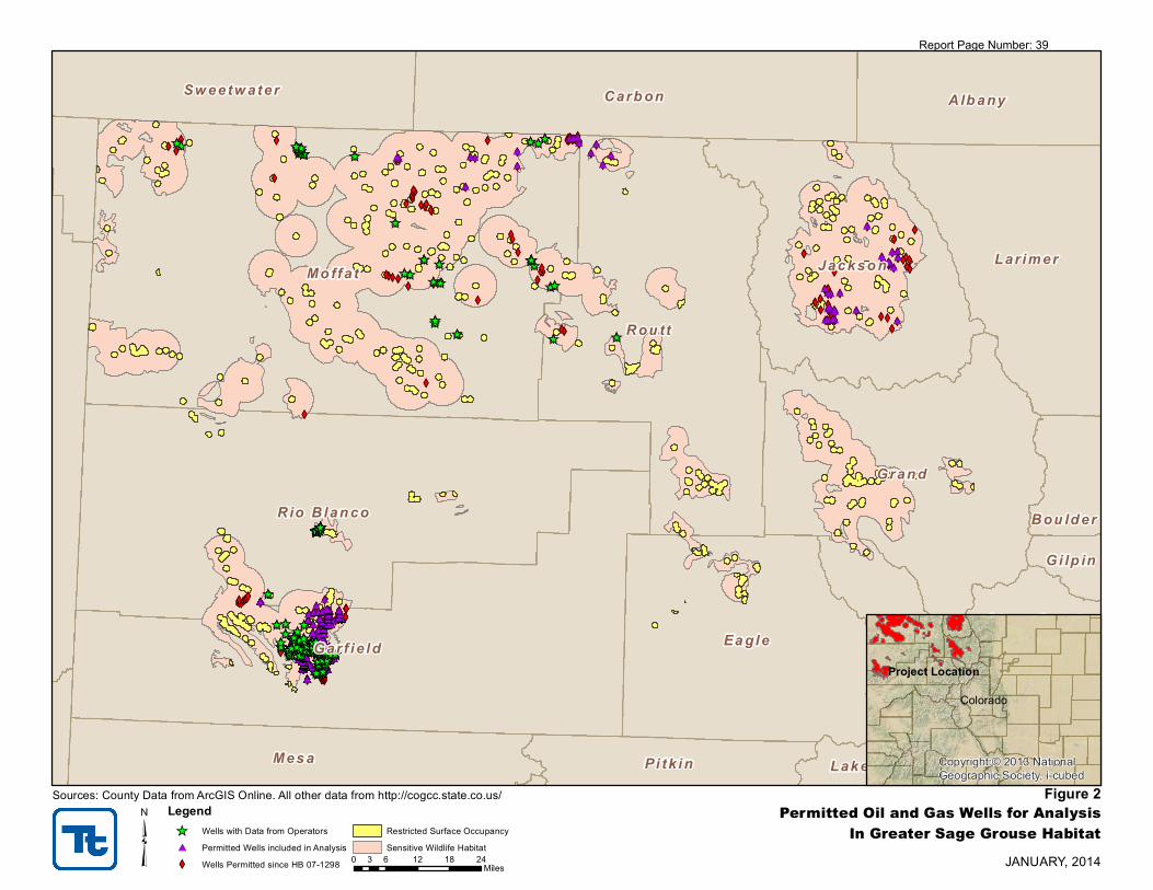
XYXYXYXYXYXYXYXYXYXYXYXYXYXYXYXYXYXYXY XYXYXYXYXYXYXYXYXYXYXYXYXYXYXYXYXYXYXYXYXYXYXYXYXYXYXYXYXYXYXYXYXYXYXYXYXYXYXYXYXYXYXYXYXYXYXYXYXYXYXYXYXYXYXYXYXYXYXYXYXYXYXYXYXYXYXYXYXYXYXYXYXYXYXYXYXYXYXYXYXYXYXYXYXYXYXYXYXYXYXYXYXYXYXYXYXYXYXYXYXYXYXYXYXYXYXYXYXYXYXYXYXYXYXYXYXYXYXYXYXYXYXYXYXYXYXYXYXYXYXYXYXYXYXYXYXYXYXYXYXYXYXYXYXYXYXYXYXYXYXYXYXYXYXYXYXYXYXYXYXYXYXYXYXYXYXYXYXYXYXYXY XYXYXYXYXYXYXYXYXYXYXYXYXYXYXYXYXYXYXYXYXYXYXYXYXYXYXYXYXYXYXYXYXYXYXYXYXYXYXYXYXYXYXYXYXYXYXYXYXYXYXYXYXYXYXYXYXYXYXYXYXYXYXYXYXYXYXYXYXYXYXY XYXYXYXYXYXYXYXYXYXYXYXYXYXYXYXYXYXYXYXYXYXYXYXYXYXYXYXYXYXYXYXYXYXYXYXYXYXY XYXYXYXYXYXYXYXYXYXYXYXYXYXYXYXYXYXYXYXYXYXYXYXYXYXYXYXY XYXYXYXYXYXYXYXYXYXYXYXYXYXYXYXYXYXYXYXYXYXYXYXY XYXYXY XYXYXY XYXY XYXY XYXY XYXYXYXYXY XYXYXY XYXYXYXYXYXYXY XYXYXYXYXYXY XYXY XYXYXYXY XYXYXYXYXY XYXYXYXYXYXYXYXYXYXYXYXYXY XYXYXYXYXYXYXYXYXYXYXYXYXYXYXYXYXYXYXYXYXYXYXYXYXY XYXYXYXYXYXYXYXYXYXYXYXYXYXYXYXYXYXYXYXYXYXYXYXYXYXYXYXYXYXYXYXYXYXYXYXYXYXYXYXYXYXYXYXYXYXYXYXYXYXYXYXYXYXYXYXYXYXYXYXYXYXYXYXYXYXYXYXYXYXYXYXYXYXYXYXY XYXYXYXYXYXYXYXYXYXYXYXY XYXYXYXYXYXYXYXYXYXY XYXYXYXYXYXYXYXYXYXYXYXYXYXYXYXYXYXYXYXYXYXYXYXYXYXYXYXYXYXYXYXYXYXYXYXYXYXYXYXYXYXYXYXYXYXYXYXYXYXYXYXYXYXYXYXYXYXYXYXYXYXYXYXYXYXYXYXYXYXYXYXYXYXYXYXYXYXY XYXY XYXYXYXY XYXYXYXY XYXYXYXYXYXYXYXYXYXYXYXYXYXYXYXYXYXYXYXYXYXYXYXYXYXYXYXYXYXYXYXYXYXYXYXYXYXYXYXYXYXYXYXYXYXYXYXYXYXYXYXYXYXYXYXYXYXYXYXYXYXYXYXYXYXYXYXYXYXYXYXYXYXYXYXYXYXYXY XYXYXYXYXYXYXYXYXYXYXYXYXY XYXYXYXYXYXYXYXYXYXYXYXYXYXYXYXYXYXYXYXYXYXYXYXYXYXY XYXYXYXYXYXYXYXYXYXYXY XYXYXYXYXYXYXYXYXYXYXYXYXYXYXYXYXYXYXYXYXYXYXYXYXYXYXYXYXYXY XYXYXYXYXYXYXYXYXYXYXYXYXYXYXYXYXYXYXYXYXYXYXYXYXYXYXYXYXY XYXYXYXYXYXYXYXYXYXYXYXYXYXYXYXYXYXYXYXYXYXYXYXYXYXYXY XYXYXYXYXYXYXYXYXYXYXYXYXYXYXYXYXYXYXYXYXYXYXYXY XYXYXYXYXYXYXYXYXYXYXYXYXYXYXYXYXYXYXYXYXY XYXYXYXYXYXYXYXYXYXY XYXYXYXY XYXYXYXYXYXYXYXYXYXYXYXYXYXYXYXYXYXYXYXYXYXYXYXYXYXYXYXYXYXYXYXYXYXYXYXYXYXYXYXYXYXYXYXYXYXYXYXYXYXYXYXYXYXYXYXYXYXYXYXYXYXYXYXYXYXYXYXYXYXYXYXYXYXYXYXYXYXYXYXYXYXYXYXYXYXYXYXYXYXYXYXYXYXYXYXYXYXYXY
XYXYXYXYXY XY XYXYXYXYXYXY XYXYXYXYXYXYXYXYXYXYXYXYXYXYXYXYXYXYXYXYXYXYXY XYXYXYXYXYXYXYXYXYXYXYXYXYXYXYXYXYXYXYXYXYXYXYXYXYXYXYXYXYXYXYXYXYXYXYXYXYXYXYXYXYXYXYXYXYXYXYXY XYXYXYXYXYXYXYXYXYXYXYXYXYXYXYXYXYXYXYXYXYXYXYXYXYXYXYXYXYXYXYXYXYXYXYXYXYXYXYXYXYXYXYXYXYXYXYXYXYXYXYXYXYXYXYXYXYXYXYXYXYXYXYXYXYXYXYXYXYXYXYXYXYXYXYXYXYXYXYXYXYXYXYXYXYXYXYXYXYXYXYXYXYXYXYXYXYXYXYXYXYXYXYXYXYXYXYXYXYXYXYXYXYXYXYXYXYXYXYXYXYXYXYXY XYXYXYXYXYXYXYXYXYXYXYXYXYXYXYXYXYXYXYXYXYXYXYXYXYXYXYXYXYXYXYXYXYXYXYXYXYXYXYXYXYXYXYXYXYXYXYXYXYXYXYXYXYXYXYXYXYXYXYXYXYXYXYXYXYXYXYXYXYXYXYXYXYXYXYXYXYXYXYXYXYXYXYXYXYXYXYXYXYXYXYXYXYXYXYXYXYXYXYXYXYXYXYXYXYXYXYXYXYXYXYXYXYXYXYXYXYXYXYXYXYXYXYXYXYXYXYXYXYXYXYXYXYXYXYXYXYXYXYXYXYXYXYXYXYXYXYXYXYXYXYXYXYXYXYXYXYXYXYXYXYXY XYXYXYXYXYXYXY XYXYXYXYXYXYXYXYXYXYXY XYXYXYXY XY
XYXYXYXYXYXYXYXYXYXYXYXYXYXYXYXYXYXYXYXYXYXYXYXYXYXYXYXYXYXYXYXYXYXYXYXYXYXYXYXY
XY
XY
XY XYXY XYXY XYXY XYXYXY XYXYXYXYXY XYXYXYXYXY XYXYXYXYXYXYXYXY
XYXYXY XYXYXYXYXYXYXYXYXYXYXY XYXYXYXYXY XYXYXYXYXY XYXY XYXYXY XYXYXY XYXY XYXY XYXYXYXYXYXYXYXYXYXY XYXYXYXY XYXY XYXY XYXY XYXY XYXY XYXYXY
XYXYXYXYXYXYXY
XYXYXYXYXY
XYXY XYXYXY XYXY XY XYXYXYXYXYXY XYXY XYXYXYXYXYXYXYXY XYXYXYXYXYXYXYXYXY XYXY XYXYXYXY XY XYXY XY XYXYXYXYXYXYXY XYXYXYXY XYXYXYXY
#*#*#*#*#*#*#*#*#*#*#*#*#*#*#*#*#*#*#*#*#*#*#*#*#*#*#*#*#*#*#*#*#*#*#*#*#*#*#*#*#*#*#*#*#*#*#*#*#*#*#*#*#*#*#*#*#*#*#*#*#*#*#*#*#*#*#*#*#*#*#*#*#*#*#*#*#*#*#*#*#*#*#*#*#*#*#*#*#*#*#*#*#*#*#*#*#*#*#*#*#*#*#*#*#*#*#*#*#*#*#*#*#*#*#*#*#*#*#*#*#*#*#*#*#*#*#*#*#*#*#*#*#*#*#*#*#*#*#*#*#*#*#*#*#*#*#*#* #*#*#*#*#*#*#*#*#*#*#*#*#*#*#*#*#*#*#*#*#*#*#*#*#*#*#*#*#*#*#*#*#*#*#*#*#*#*#*#*#*#*#*#*#*#*#*#*#*#*#*#*#*#*#*#*#*#*#*#*#*#*#*#*#*#*#*#*#*#*#* #*#*#*#*#*#*#*#*#*#*#*#*#*#*#*#*#*#*#*#*#*#*#*#*#*#*#*#*#*#*#*#*#*#*#*#*#*#*#*#*#*#*#*#*#*#*#*#*#*#*#*#*#*#*#*#*#*#*#*#*#*#*#*#*#* #*#*#*#*#*#*#*#* #*#*#*#*#*#*#*#*#*#*#*#*#*#*#*#* #*#*#* #*#*#* #*#* #*#* #*#* #*#*#*#*#* #*#*#* #*#*#*#*#*#*#* #*#*#*#*#*#* #*#* #*#*#*#* #*#*#*#*#* #*#*#*#*#*#*#*#*#*#*#*#*#* #*#*#*#*#*#*#*#*#*#*#*#*#*#*#*#*#*#*#*#*#*#*#* #*#*#*#*#*#*#*#*#*#*#*#*#*#*#*#*#*#*#*#*#*#*#*#*#*#*#*#*#*#*#*#*#*#*#*#*#*#*#*#*#*#*#*#*#*#*#*#*#*#*#*#*#*#*#*#*#*#*#*#*#*#*#*#*#*#*#*#*#*#*#*#*#*#*#*#* #*#*#*#*#*#*#*#*#*#*#*#* #*#*#*#*#*#*#*#*#*#* #*#*#*#*#*#*#*#*#*#*#*#*#*#*#*#*#*#*#*#*#*#*#*#*#*#*#*#*#*#* #*#*#*#*#*#*#*#*#*#*#*#*#*#*#*#*#*#*#*#*#*#*#*#*#*#*#*#*#*#*#*#*#*#*#*#*#*#*#*#*#*#*#*#*#*#*#* #*#* #*#*#*#* #*#*#* #*#*#*#*#*#*#*#*#*#*#*#*#*#*#*#*#*#*#*#*#*#*#*#*#*#*#*#*#*#*#*#*#*#*#*#*#* #*#*#*#*#*#*#*#*#*#*#*#*#*#*#*#*#*#*#*#*#*#*#*#*#*#*#*#*#*#*#*#*#*#*#*#*#*#*#*#*#* #*#*#*#*#*#*#*#*#*#*#*#* #*#*#*#*#*#*#*#*#*#*#*#*#*#*#*#*#*#*#*#*#*#*#*#*#* #*#*#*#*#*#*#*#*#*#*#* #*#*#*#*#*#*#*#*#*#*#*#*#*#*#*#*#* #*#*#* #*#* #*#*#*#*#*#*#* #*#*#*#*#*#*#*#* #*#*#*#*#*#*#*#*#*#*#*#*#*#*#*#*#*#*#* #*#*#*#*#*#*#*#*#*#*#*#*#*#*#*#*#*#*#*#*#*#*#*#*#*#*#* #*#*#*#*#*#*#*#*#*#*#*#*#*#*#*#*#*#*#*#*#*#*#*#* #*#*#*#*#*#*#*#*#*#*#*#*#*#*#*#*#*#*#*#*#* #*#*#*#*#*#*#*#*#*#* #*#*#*#* #*#*#*#*#*#*#*#*#*#*#*#*#*#*#*#*#*#*#*#*#*#*#*#*#*#*#*#*#*#*#*#*#*#*#*#*#*#*#*#*#*#*#*#*#*#*#*#*#*#*#*#*#*#*#*#*#*#*#*#*#*#*#*#*#*#*#*#*#*#*#*#*#*#*#*#*#*#*#*#*#*#*#*#*#*#*#*#*#*#*#*#*#*#*#*#*#*#*#*#*#*#*#*#* #* #*#*#*#*#*#* #*#*#*#*#*#*#*#*#*#*#*#*#*#*#*#*#*#*#*#*#*#*#* #*#*#*#*#*#*#*#*#*#*#*#*#*#*#*#*#*#*#*#*#*#*#*#*#*#*#*#*#*#*#*#*#*#*#*#*#*#*#*#*#*#*#*#*#*#*#*#* #*#*#*#*#*#*#*#*#*#*#*#*#*#*#*#*#*#*#*#*#*#*#*#*#*#*#*#*#*#*#*#*#*#*#*#*#*#*#*#*#*#*#*#*#*#*#*#*#*#*#*#*#*#*#*#*#*#*#*#*#*#*#*#*#*#*#*#*#*#*#*#*#*#*#*#*#*#*#*#*#*#*#*#*#*#*#*#*#*#*#*#*#*#*#*#*#*#*#*#*#*#*#*#*#*#*#*#*#*#*#*#*#*#*#*#*#*#*#*#*#*#*#*#*#*#*#*#*#*#*#*#*#*#*#*#*#*#*#*#*#*#*#*#*#*#*#*#*#*#*#*#*#*#*#*#*#*#*#*#* #*#*#*#*#*#*#*#*#*#*#*#*#*#*#*#*#*#*#*#*#*#*#*#*#*#*#*#*#*#*#*#*#*#*#*#*#*#*#*#*#*#*#*#*#*#*#*#*#*#*#*#*#*#*#*#*#*#*#*#*#*#*#*#*#*#*#*#*#*#*#*#*#*#*#*#*#*#*#*#*#*#*#*#*#*#*#*#*#*#*#*#*#*#*#*#*#*#*#*#*#*#*#*#*#*#*#*#*#*#*#*#*#*#*#*#*#*#*#*#*#*#*#*#*#*#*#* #*
#*
#*#*#*#*#*#*#*#*#*#*#*#*#*#*#*#*#*#*#*#*#*#*#*#*#*#*#*#*#*#*#*#*#*#*#*#*#*#*#*#*
#* #*#*#* #*#*#* #*#*#*#*
#*#* #*#*#*#*#*
#*#*#* #*#*#*#*#*#*#*#*
#*#* #*#* #*#*#*#*#*#*#*#*#*#*#*#* #*#*#*#*
#*#*
#*
#* #*#*#* #*#* #* #*#*#*#*#*#* #*#* #*#*#*#*#*#*#*#*#*#*#*#*#*#*#*
#*#* #*#*#*#* #* #*#*#*#*#*#*#*#* #*
_̂̂_̂_̂_̂_̂_̂_̂_̂_̂_̂_̂_̂_̂_̂_̂_̂_̂_̂_̂_̂_̂_̂_̂_̂_̂_̂_̂_̂_̂_̂_̂_̂_̂_̂_̂_̂_̂_̂_̂_̂_̂_̂_̂_̂_̂_̂_̂_̂_̂_̂_̂_̂_̂_̂_̂_̂_̂_̂_̂_̂_
_̂̂_̂_̂_̂_̂_ _̂̂_̂_̂_̂_̂_̂_̂_̂_̂_̂_̂_̂_̂_̂_̂_̂_̂_̂_̂_̂_̂_̂_̂_̂_̂_̂_̂_̂_̂__̂̂_̂_̂_̂_̂_̂_̂_̂_̂_̂_̂_̂__̂_̂ _̂̂__̂̂__̂_̂_̂ _̂̂_̂_̂_̂_̂_̂__̂̂_̂_̂_̂_̂_̂_̂_̂_̂_̂_̂_̂_̂_̂_̂_̂_̂_̂_̂_̂_̂_̂_̂_̂_̂_̂_̂_̂__̂̂_̂_̂_̂_̂_̂_̂_̂_̂_̂_̂_̂_̂_̂_̂_̂__̂̂_̂_̂_̂_̂_̂_̂_̂_̂_̂_̂_̂_̂_̂_̂_̂_̂_̂_̂_̂_̂_̂_̂_̂_ _̂̂_̂_̂_̂_̂_̂_̂_̂_̂__̂ _̂̂_̂_̂_̂_̂_̂_̂__̂̂_ _̂̂_̂_̂_̂_̂_̂_̂__̂̂_̂_̂_̂_̂_̂__̂ _̂̂_̂_̂_̂_̂_̂_̂_̂_̂_̂_̂_̂_̂_̂_̂_̂_̂__̂̂_̂_̂_̂_̂_̂_̂_̂_̂_̂_̂_̂_̂_̂_̂_̂_̂_̂_̂_̂_̂_̂_̂_̂__̂̂_̂_̂_̂_̂_̂_̂_̂_̂_̂_̂_̂__̂_̂ _̂_̂
_̂
_̂̂_̂_̂_̂_̂_̂_̂_̂_̂_̂_̂_̂_̂_̂_̂_̂_̂_̂_̂_̂_̂_̂_̂_̂_̂_̂_̂_̂_̂_̂_̂_̂_̂_̂_̂_̂_̂_̂_̂_
_̂ _̂_̂_̂̂_
_̂̂__̂̂__̂̂_
_̂_̂ _̂̂_̂_̂_̂__̂̂_
_̂
_̂_̂̂_̂_̂_̂_̂_̂_̂_̂_̂_̂_̂_̂_̂_̂_̂_̂_̂_̂_̂__̂ _̂_̂ _̂ _̂
Mo ffa t
Rou tt
Gar f i e ld
Gran d
Ea gle
Rio B lan co
Jackso n
Mes a
Carb on
Lar imer
Pa rk
Alb any
Su mmi t
Sw eetw ater
Pi tk in
Bou ld er
C lea r C reek
Lake
Gi lp in
³ JANUARY, 2014
Figure 2Permitted Oil and Gas Wells for AnalysisIn Greater Sage Grouse Habitat
Legend_̂ Wells with Data from Operators#* Permitted Wells included in AnalysisXY Wells Permitted since HB 07-1298
Restricted Surface OccupancySensitive Wildlife Habitat
Sources: County Data from ArcGIS Online. All other data from http://cogcc.state.co.us/
0 6 12 18 243Miles
Colorado
Copyright:© 2013 NationalGeographic Society, i-cubed
Project Location
Report Page Number: 39

Analysis of Oil and Gas Permitting in Greater Sage Grouse Habitat Colorado Department of Natural Resources
Tetra Tech January 10, 2014 18
APPENDIX BOPERATOR DATA
Report Page Number: 40

Analysis of Oil and Gas Permitting in Greater Sage Grouse Habitat
Appendix B
Operator Data
Operator
ID
Operator
Size County
Permitted
Wells Acres Permit Date
Surface
Ownership
Mineral
Ownership GRSG Habitat COGCC Forms 1st Contact 2nd Contact GIS Data
1 Large Garfield 77 Not Listed 7/2/13 Fee Fee Sensitive 2 21-Nov-13 2-Dec-13 COGCC
Best Management Practices (BMPs)
Comments
Avoidance
Minimization
Mitigation
Landowner terms
Operator
ID
Operator
Size County
Permitted
Wells Acres Permit Date
Surface
Ownership
Mineral
Ownership GRSG Habitat COGCC Forms 1st Contact 2nd Contact GIS Data
2 Large Garfield 8 Not Listed 7/17/09 Fee Fee Sensitive 2 21-Nov-13 2-Dec-13 COGCC
BMPs
No BMPs are available in the COGCC website database.
Comments
Avoidance
Minimization
Mitigation
Landowner terms
CPW Input
COGCC-CPW Consultation
COGCC-CPW Consultation
Operator Input (Actions, Locations, Acreages)
CPW Input
Conditions of Approval (COA)
A Wildlife Mitigation Plan was developed in consultation with CPW.
BMPs are for all operations within the Piceance Basin.
An annual Plan of Development is required which includes the following:
• Avoid GrSG Sensitive Wildlife Habitat (SWH).
• Avoid or minimize activities near and within lek sites.
• Avoid at a minimum 66% of GrSG SWH.
• Avoid lek sites from March 1 through May 15 for major activities.
• 4-mile buffer for GrSG March 1 through June 30.
• Use approved seed mixes for sagebrush restoration. High priority habitats (lek areas and adjacent lands) may require additional restoration discussion and BMPs.
Agency Representative: Michael Warren, Energy Liaison, CPW
Reclaim and/or restore GrSG habitat with native grasses, forbs, and shrubs conducive to optimal GrSG habitat and other wildlife appropriate to the ecological site. Establish
guidelines to minimize wildlife mortality from vehicle collisions on roads.
Operator has 77 wells operating on 23 well pads. Operator averages 4.98 acres per pad. If all wells were placed on individual pads, 383.5 acres would be developed. Currenty
there are 109.6 developed acres. Operator has future plans to develop 8 additional pads at 20 acre spacing and 16 well pads at 10 acre spacing.
Conditions of Approval
Operator Input (Actions, Locations, Acreages)
Agency Representative: Michael Warren, Energy Liaison, CPW
Operator declined to participate
Operator has 23 well pads all of which have entered into interim reclamation: Total reclamation = 54.97
Report Page Number: 41

Analysis of Oil and Gas Permitting in Greater Sage Grouse Habitat
Appendix B
Operator Data
Operator
ID
Operator
Size County
Permitted
Wells Acres Permit Date
Surface
Ownership
Mineral
Ownership GRSG Habitat COGCC Forms 1st Contact 2nd Contact GIS Data
3 Large Garfield 15 3.7 9/17/09 Fee Federal Sensitive 2 22-Nov-13 2-Dec-13 COGCC
BMPs
Comments
Avoidance
Minimization
Mitigation
Landowner terms
Operator
ID
Operator
Size County
Permitted
Wells Acres Permit Date
Surface
Ownership
Mineral
Ownership GRSG Habitat COGCC Forms 1st Contact 2nd Contact GIS Data
4 Large Rio Blanco 39 Not Listed 6/14/12 Fee Fee Sensitive 2, 2A 21-Nov-13 25-Nov-13 COGCC
BMPs
Comments
Avoidance
Minimization
Mitigation
Landowner terms
Agency Representative: Michael Warren, Energy Liaison, CPW
Agency Representative: Michael Warren, Energy Liaison, CPW
Operator Input (Actions, Locations, Acreages)
Operator did not respond to solicitations.
Operator is currently in a restructing process and is not available to participate.
Form 2 states that the BMPs are located within the approved WMP for this operator.
CPW confirms that the wells fall within the operators WMP. The WMP sufficiently addresses wildlife and wildlife habitat concerns.
Specific BMPs would be found in the WMP and are not listed in individual well permits.
CPW Input
No BMPs are available in the COGCC website database.
COGCC-CPW Consultation
Conditions of Approval
COGCC-CPW Consultation
Conditions of Approval
CPW Input
CPW recommends that activities within 4 miles of GrSG lek sites are limited to the period outside of March 1 through June 30. CPW noted this was not a COA but a
recommendation.
Operator Input (Actions, Locations, Acreages)
Report Page Number: 42

Analysis of Oil and Gas Permitting in Greater Sage Grouse Habitat
Appendix B
Operator Data
Operator
ID
Operator
Size County
Permitted
Wells Acres Permit Date
Surface
Ownership
Mineral
Ownership GRSG Habitat COGCC Forms 1st Contact 2nd Contact GIS Data
5 Large Jackson 1 Not Listed 4/13/10 Federal Federal Sensitive 2, 2A 22-Nov-13 3-Dec-13 COGCC
BMPs
Comments
Avoidance
Minimization
Mitigation
Landowner terms
Operator
ID
Operator
Size County
Permitted
Wells Acres Permit Date
Surface
Ownership
Mineral
Ownership GRSG Habitat COGCC Forms 1st Contact 2nd Contact GIS Data
6 Large Rio Blanco 5 5.1 4/29/10 Fee Fee Sensitive 2, 2A
Correspondence11/22/2013 12/3/2013 COGCC
BMPs
Comments
Avoidance
Minimization
Mitigation
Landowner terms
Agency Representative: Michael Warren, Energy Liaison, CPW
Operator did not respond to solicitations.
CPW Input
Operator Input (Actions, Locations, Acreages)
COGCC-CPW Consultation
Conditions of Approval
Operator entered into a WMA with the surface owner.
The WMA will identify requirements related to the operator's activities, the installation of surface equipment, reclamation and revegetation of disturbed areas, and offsite
GrSG habitat improvement.
• A total of five wells will be directionally drilled from the existing well pad. Directional drilling has enabled the operator to reduce the number of well pads required for gas
recovery and will minimize surface damage.
• The well pad will be constructed adjacent to an existing access road. This eliminates the need to construct an additional road for access and avoids additional surface
disturbance.
• The reserve/completion pit will be fenced/flagged and/or netted to prevent entry of wildlife (including birds) and livestock.
• Noxious weeds will be controlled.
• During the reclamation phase, all areas of soil disturbance will be smooth graded, cultivated to provide a loose seed bed of a minimum of 6 inches in depth, fertilized with 250
pounds of 46-0-0 per acre, seeded with the seed mixture specified by the surface owner, and mulched with 1-1/2 tons of grass hay crimped into the soil.
CPW Input
Agency Representative: Michael Warren, Energy Liaison, CPW
COGCC-CPW Consultation
Conditions of Approval
CPW consultation not available in the COGCC website database.
Where drilling and/or completion activities occur within 4 miles of GrSG leks or within GrSG breeding or summer habitat, the operator will limit activities outside the period
between March 1 and June 30.
Operator Input (Actions, Locations, Acreages)
Operator has 40 wells operating on 4 pads with each pad averaging 9 acres. The total disturbance is 36 acres. If a well pad was developed for each well the total acreage of
disturbance for the 40 wells would be 360.
Operator had no quantifiable minimization activities.
Total well pad disturbance from well pad construction 40.4 acres (for all 4 well pads). Well pad size after interim reclamation totaled 15 acres (for all 4 well pads). Total
mitigation for the operator in GrSG habitat is 25.4 acres.
No landowner terms accociated with GrSG were recorded.
Report Page Number: 43

Analysis of Oil and Gas Permitting in Greater Sage Grouse Habitat
Appendix B
Operator Data
Operator
ID
Operator
Size County
Permitted
Wells Acres Permit Date
Surface
Ownership
Mineral
Ownership GRSG Habitat COGCC Forms 1st Contact 2nd Contact GIS Data
BMPs
Comments
Avoidance
Minimization
Mitigation
Landowner terms
COGCC-CPW Consultation
CPW Input
Agency Representative: Michael Warren, Energy Liaison, CPW
CPW divided the consultation by type of GrSG area (SWH and restricted surface occupancy (RSO)).
For activities in GrSG SWHs, the operator will follow the CPW approved BMPs listed below.
For activities in GrSG RSOs, the operator and land owner will enter into a separate WMA which will include additional measures beyond those established by the SDA for the
protection of GrSG.
• Maximize directional drilling to minimize habitat fragmentation/loss.
• Phase and concentrate development activities so large areas of undisturbed habitat remain.
• Minimize rig mobilization and demobilization where practicable by completing or recompleting all wells from a given well pad before moving rigs to a new location.
• To the extent practicable, share and consolidate new corridors for pipeline rights-of-way and roads to minimize surface disturbance.
• Engineer new pipelines to reduce field fitting and reduce excessive right-of-way widths and, therefore, subsequent reclamation requirements.
• Plan new transportation networks and new oil and gas facilities to minimize surface disturbance and the number and length of oil and gas roads through the utilization of
common roads, rights-of-way, and access points to the extent practicable.
• Post speed limits and caution signs to the extent practicable.
• Use remote monitoring of well production to the extent practicable.
• Construct habitat improvement projects as practical.
• Use wildlife appropriate seed mixes wherever allowed by surface owners and regulatory agencies.
• Control weeds.
• Educate employees.
• Treat waste water pits and other mosquito breeding grounds with Bti (Bacillus thuringiensis v. israelensis) to limit the spread of West Nile Virus to wildlife.
Conditions of Approval
Sensitive
Restricted
7 2A 21-Nov-13 25-Nov-13 COGCC
The area of minimization would be related to pipleline width reduction or road width reduction. This data was not available from the operator.
5 of the 7 well pads have had partial or "interim" reclaimation post construction disturbance. The average initial size of each well pad is 4 acres. The aveage size of the pad
after the interim reclamation is 2 acres. Operator averages 2 acres of reclamation during the well operations. Currently they have reclaimed approximately 10 acres of GrSG
habitat. Note: the habitat has not been fully reclamained to original structure as this will take years of natural regeneration to occur. Reclamation refers to the re-seeding and
contouring of the disturbed land to pre-construction topography.
No Landowner terms applied to GrSG habitat conservation.
Large Garfield 77 Fee4.0 per pad 5/19/10 Fee
Operator Input (Actions, Locations, Acreages)
Operator has a total of 77 permitted wells. The 77 wells are located on 7 well pads. As part of their BMPs, the operator has used directional drilling to limit impacts (both for
economic and wildlife benefits). Average size well pad is 4 acres. The operator has disturbed approx. 30 acres of land not already impacted. Operator would have disturbed
280 acres of additonal GrSG habitat using standard drilling techniques. The operator also limited its ROW disturbance by the use of directional drilling. The average road width
is 24ft of disturbance. An additional 9,400 feet of road would have been required without the use of directional drilling. This is approximately 5.18 acres of disturbance avoided
(9,400 feet X 24 feet). The total area of avoidance is 285.18 acres.
Report Page Number: 44

Analysis of Oil and Gas Permitting in Greater Sage Grouse Habitat
Appendix B
Operator Data
Operator
ID
Operator
Size County
Permitted
Wells Acres Permit Date
Surface
Ownership
Mineral
Ownership GRSG Habitat COGCC Forms 1st Contact 2nd Contact GIS Data
8 Large Moffat 2 3.0 11/23/11 Fee Fee Sensitive 2A, BMPs 21-Nov-13 22-Nov-13 COGCC
BMPs
Comments
Avoidance
Minimization
Mitigation
Landowner terms
Operator
ID
Operator
Size County
Permitted
Wells Acres Permit Date
Surface
Ownership
Mineral
Ownership GRSG Habitat COGCC Forms 1st Contact 2nd Contact GIS Data
9 Large Routt 5 3.8 9/26/13 Fee Fee Sensitive 2A, Correspondence 21-Nov-13 2-Dec-13 COGCC
BMPs
Comments
Avoidance
Minimization
Mitigation
Landowner terms
Agency Representative: Michael Warren, Energy Liaison, CPW
Operator Input (Actions, Locations, Acreages)
Operator moved one well outside of GrSG habitat at CPW request (approximatley 4 acres of avoidance).
Operator moved one well pad outside of an RSO at CPW request (approximately 4 acres of minimization).
Landowner requested CPW not participate. Operator worked with landowner to develop GrSG plan and, through consultations between the operator, the landowner, and CPW;
CPW is now been granted access to their property to gather GrSG data.
Operator Input (Actions, Locations, Acreages)
COGCC-CPW Consultation
Operator reviewed their records and found that they have no permitted wells operating within GrSG habitat. The wells on record were part of a joint venture with Shell and
Shell is now the owner of those wells. While these wells were permitted, they were never constructed.
CPW approved the BMPs listed by the operator.
Agency Representative: Michael Warren, Energy Liaison, CPW
• The operator will conduct post‐development well site visitations between the hours of 9:00 a.m. and 4:00 p.m. and reduce well site visitations between March 1 and July 30 ‐
(GrSG brood rearing period). Emergencies exempted.
• The operator will use hospital grade mufflers for compressors, pump jacks or other motors necessary to run operations at the site. Mufflers will be pointed upward to
dissipate potential vibration.
• Interim and final reclamation will match existing vegetation.
• The operator will include a weed management plan and implement the plan as part of reclamation.
BMPs were provided to CPW by the operator during an onsite visit. CPW affirms the BMPs are sufficient to address wildlife concerns at this location and has no further
recommendations. The BMPs were not available in the COGCC website database.
CPW Input
CPW Input
Conditions of Approval
COGCC-CPW Consultation
Conditions of Approval
Email correspondence states that CPW consultation took place during an onsite visit. No additional information was available on the COGCC website database.
Report Page Number: 45

Analysis of Oil and Gas Permitting in Greater Sage Grouse Habitat
Appendix B
Operator Data
Operator
ID
Operator
Size County
Permitted
Wells Acres Permit Date
Surface
Ownership
Mineral
Ownership GRSG Habitat COGCC Forms 1st Contact 2nd Contact GIS Data
10 Small Garfield 17 320.0 4/14/10 Fee Fee Sensitive 2, 2A, BMPs 11/21/2013 12/3/2013 COGCC
BMPs
Comments
Avoidance
Minimization
Mitigation
Landowner terms
The operator agreed to participate, but did not provide data.
COGCC-CPW Consultation
CPW Input
Operator Input (Actions, Locations, Acreages)
Agency Representative: Michael Warren, Energy Liaison, CPW
• Use early and effective reclamation techniques, including an aggressive interim reclamation program, to return habitat to use by GrSG as quickly as possible.
• Reclaim/restore GrSG habitats with native grasses, forbs, and shrubs conducive to optimal GrSG habitat and other wildlife appropriate to the ecological site.
• Use approved CP-4D (GrSG) seed mixes, based on soil type, precipitation, and elevation, available from Farm Service Agency or Natural Resources Conservation Service, or
other seed mixes approved by CPW.
• Avoid aggressive non-native grasses in GrSG habitat reclamation.
• Restore disturbed sagebrush sites with the appropriate sagebrush species or subspecies on disturbed sagebrush sites. Use locally collected seed for reseeding where possible.
• Reclaim mapped summer habitat with a substantially higher percentage of forbs (> 15 percent cover post establishment) than used in other areas.
• Utilize native and select non-native forbs and legumes in seed mixes as they are a vital component of brood-rearing habitat.
• Identify seasonal habitats and migratory patterns of GrSG. Map all seasonal habitats using CPW habitat selection models as they become available.
• No surface occupancy within 0.6 mile of any known GrSG lek.
• After drilling and completions activities reduce visits to well-sites through remote monitoring (i.e. SCADA) and the use of multi-function contractors.
• Schedule, as best as possible, well site visitations to portions of the day between 9:00 a.m. and 4:00 p.m. during the active lek season (March 1 to May 15).
• Phase and concentrate all development activities, so that large areas of undisturbed habitat for wildlife remain and thorough reclamation occurs immediately after
development and before moving to new sites. Development should progress at a pace commensurate with reclamation success.
• Implement the species appropriate Drilling and Production Operations Wildlife Protection Measures found in Section II D. of the CPW Wildlife BMP document (listed below).
Section II D. DRILLING AND PRODUCTION OPERATIONS WILDLIFE PROTECTION MEASURES:
The purpose of these measures is to reduce disturbance on the actual drill site and the surrounding area, to reduce direct conflict with wildlife and hunters, and to prevent
wildlife access to equipment.
• Use centralized hydraulic fracturing operations.
• Transport water through centralized pipeline systems rather than by trucking.
• Where possible, locate pipeline systems under existing roadways, or roadways that are planned for development.
• Maximize use of state-of-the-art drilling technology (e.g., high efficiency rigs, coiled-tubing unit rigs, closed-loop or pitless drilling, etc.) to minimize disturbance.
• Conduct well completions with drilling operations to limit the number of rig moves and traffic.
• Install exclusionary devices to prevent bird and other wildlife access to equipment stacks, vents and openings.
• During pipeline installations install trench plugs, earthen ramps, or other means as necessary to ensure that open pipeline trenches do not trap wildlife, and that pipe strings
to not impair wildlife movements.
• Minimize surface disturbance and fragmentation of GrSG habitat through use of the smallest facility footprints possible, use of multiple well pads, clustering of roads and
pipelines, and the widest possible spacing of surface facilities.
• Where applicable design tanks and other facilities with structures such that they do not provide perches or nest substrates for raptors, crows and ravens.
• Where needed, install raptor perch deterrents on equipment, fences, cross arms and pole tops in GrSG habitat.
• Remove all unnecessary infrastructure.
Conditions of Approval
CPW notes that they concur with the operator provided BMPs.
Report Page Number: 46

Analysis of Oil and Gas Permitting in Greater Sage Grouse Habitat
Appendix B
Operator Data
Operator
ID
Operator
Size County
Permitted
Wells Acres Permit Date
Surface
Ownership
Mineral
Ownership GRSG Habitat COGCC Forms 1st Contact 2nd Contact GIS Data
11 Small Routt 3 2.2 1/24/13 Federal Federal Sensitive 2
Surface Use Plan21-Nov-13 2-Dec-13 COGCC
BMPs
Comments
Avoidance
Minimization
Mitigation
Landowner terms
Operator
ID
Operator
Size County
Permitted
Wells Acres Permit Date
Surface
Ownership
Mineral
Ownership GRSG Habitat COGCC Forms 1st Contact 2nd Contact GIS Data
12 Small Moffat 1 Not Listed 6/3/09 Federal Federal Sensitive
Restricted2, 2A 22-Nov-13 3-Dec-13 COGCC
BMPs
Comments
Avoidance
Minimization
Mitigation
Landowner terms
Agency Representative: Michael Warren, Energy Liaison, CPW
Agency Representative: Michael Warren, Energy Liaison, CPW
Operator agreed to participate but did not provide data.
Operator Input (Actions, Locations, Acreages)
CPW Input
CPW Input
Operator did not respond to solicitations.
The BLM stipulations are listed below.
• No activity between March 1 through June 30.
• Timing restrictions from March 1 through May 15 to limit activity between 9:00 a.m. and 4:00 p.m.
• Implement noise reduction measures.
• Avoid nearby GrSG lek site.
CPW provided COGCC with COAs but affirms that the lease stipulations and COAs assigned to the permits by the Federal government suffice to address wildlife habitat and
mitigation concerns. The COAs and lease stipulations are not available in the COGCC website database.
No BMPs were available in the COGCC website database.
COGCC-CPW Consultation
Conditions of Approval
Operator Input (Actions, Locations, Acreages)
COGCC-CPW Consultation
Conditions of Approval
CPW affirms the stipulations, COAs, and/or other status assigned to this permit by the BLM to address wildlife.
Report Page Number: 47

Analysis of Oil and Gas Permitting in Greater Sage Grouse Habitat
Appendix B
Operator Data
Operator
ID
Operator
Size County
Permitted
Wells Acres Permit Date
Surface
Ownership
Mineral
Ownership GRSG Habitat COGCC Forms 1st Contact 2nd Contact GIS Data
13 Small Moffat 26 5.19 6/22/09 Federal Federal Sensitive 2
Surface Use Plan21-Nov-13 2-Dec-13 COGCC
BMPs
Comments
Avoidance
Minimization
Mitigation
Landowner terms
Operator
ID
Operator
Size County
Permitted
Wells Acres Permit Date
Surface
Ownership
Mineral
Ownership GRSG Habitat COGCC Forms 1st Contact 2nd Contact GIS Data
14 Small Moffat 1 Not Listed 7/6/09 Fee Federal Sensitive 2 22-Nov-13 3-Dec-13 COGCC
BMPs
Comments
Avoidance
Minimization
Mitigation
Landowner terms
Operator has 26 wells operating on 10 well pads. Each well pads averages 5.19 acres. The total disturbance is 51.6 acres. Total potential disturbance is 134.94 if each well was
constructed on its own well pad. Each access road is approximately 0.22 acres or a potential disturbance of 5.72 acres. The actual disturbance for the 10 well pads is 2.18 acres.
The total acres of avoidance is 86.58.
Agency Representative: Michael Warren, Energy Liaison, CPW
Operator did not respond to solicitations.
Operator Input (Actions, Locations, Acreages)
CPW Input
COGCC-CPW Consultation
COGCC-CPW Consultation
Conditions of Approval
CPW provided COGCC with COAs but affirms that the lease stipulations and COAs assigned to the permits by the federal government suffice to address wildlife habitat and
mitigation concerns. The COAs and lease stipulations are not available in the COGCC website database.
Reclaim and/or restore GrSG habitats with native grasses, forbs, and shrubs conducive to optimal GrSG habitat and other wildlife appropriate to the ecological site.
Conditions of Approval
CPW provided COGCC with COAs but affirms that the lease stipulations and COAs assigned to the permits by the federal government suffice to address wildlife habitat and
mitigation concerns. The COAs and lease stipulations are not available in the COGCC website database.
No BMPs were available in the COGCC website database.
Operator Input (Actions, Locations, Acreages)
No landowner stipulations were associated with the operator permits.
No minimization acreages were provided.
Operator has a total disturbance for the 10 well pads of 55.3 acres. The total acreage of the well pads after reclamation is 43.2. Total road disturbance for all well pads is 3.25
acres. After road reclamation the total road disturbance is 1.94 acres. The total mitigation for the operator is 14.04 acres.
CPW Input
Agency Representative: Michael Warren, Energy Liaison, CPW
Report Page Number: 48

Analysis of Oil and Gas Permitting in Greater Sage Grouse Habitat
Appendix B
Operator Data
Operator
ID
Operator
Size County
Permitted
Wells Acres Permit Date
Surface
Ownership
Mineral
Ownership GRSG Habitat COGCC Forms 1st Contact 2nd Contact GIS Data
15 Small Jackson 9 3.0 7/16/09 Fee Fee Sensitive 2 21-Nov-13 3-Dec-13 COGCC
BMPs
Comments
Avoidance
Minimization
Mitigation
Landowner terms
Agency Representative: Michael Warren, Energy Liaison, CPW
Operator did not respond to solicitations.
COGCC-CPW Consultation
Conditions of Approval
Since these pads are located on an existing, already disturbed locations, CPW concurred with the existing stipulations within the Surface Use Agreement (SUA).
The SUA for these permitted wells requires topsoil reclamation and the restoration of the site as reasonably practical.
Operator Input (Actions, Locations, Acreages)
CPW Input
Report Page Number: 49

Analysis of Oil and Gas Permitting in Greater Sage Grouse Habitat
Appendix B
Operator Data
Operator
ID
Operator
Size County
Permitted
Wells Acres Permit Date
Surface
Ownership
Mineral
Ownership GRSG Habitat COGCC Forms 1st Contact 2nd Contact GIS Data
16 Small Moffat 2 4.7 6/14/13 Fee Fee Sensitive
Restricted
2A 22-Nov-13 3-Dec-13 COGCC
BMPs
Comments
Avoidance
Minimization
Mitigation
Landowner terms
CPW Input
Agency Representative: Michael Warren, Energy Liaison, CPW
Operator Input (Actions, Locations, Acreages)
Operator did not have quantifiable data.
There were no BMPs available in the COGCC website database.
COGCC-CPW Consultation
Conditions of Approval
Landowner requested CPW not participate in onsite consultation. CPW reviewed the pad location using remote sensing data with the following analysis:
• The well pad is 1.9 miles from an GrSG SWH. The proposed access road is 0.5 mile from a GrSG SWH.
• The SWH "Lay Creek #1" is the largest lek in Colorado.
CPW makes the following comments:
• Avoid oil and gas operations within 4 miles of any known GrSG lek, and within mapped GrSG breeding, summer, and winter habitat outside the 4 mile buffer. Select sites for
development that will not disturb suitable nest cover or brood-rearing habitats within 4 miles of an active lek, or within identified nesting and brood-rearing habitats outside
the 4-mile perimeter. Where oil and gas activities must occur within 4 miles of GrSG leks or within other mapped GrSG breeding or summer habitat, conduct these activities
outside the period March 1 through June 30.
• Where oil and gas activities must occur in elk winter concentration areas, conduct these activities outside the time period from December 1 through April 15.
• Restrict post-development well site visitations to between the hours of 9:00 a.m. and 4:00 p.m. December 1 through May 15, to accommodate elk winter concentration area,
and the GrSG brood rearing period.
• No human encroachment or construction activity within 0.5 mile of any active golden eagle nest December 15 through July 15.
• Locate facilities in vegetation types other than sagebrush to avoid impacts to sage-grouse breeding and wintering habitat.
• Establish company guidelines to minimize wildlife mortality from vehicle collisions on roads.
• Gate single purpose roads and restrict general public access to reduce traffic disruptions to wildlife.
• In consultation with landowner, close and immediately reclaim all roads that are redundant, not used regularly, or have been abandoned to the maximum extent possible to
minimize disturbance and habitat fragmentation.
• Treat waste water pits and any associated pit containing water that provides a medium for breeding mosquitos with Bti or take other effective action to control mosquito
larvae that may spread West Nile Virus to wildlife, especially grouse.
• In consultation with CPW and landowner, replace any permanently impacted, disturbed, or altered GrSG seasonal habitats by enhancing marginal sagebrush steppe
communities (big sagebrush and related communities) and grasslands within or immediately adjacent to mapped seasonal GrSG habitat.
• Include a weed management plan and implement the plan as part of reclamation.
• Restore appropriate sagebrush species or subspecies on disturbed sagebrush sites. Use locally collected seed for reseeding where possible. Avoid aggressive non-native
grasses and shrubs in GrSG, and elk habitat restoration.
Report Page Number: 50

Analysis of Oil and Gas Permitting in Greater Sage Grouse Habitat
Appendix B
Operator Data
Operator
ID
Operator
Size County
Permitted
Wells Acres Permit Date
Surface
Ownership
Mineral
Ownership GRSG Habitat COGCC Forms 1st Contact 2nd Contact GIS Data
17 Small Jackson 1 5.8 9/21/13 Fee Fee Sensitive 2, 2A 22-Nov 3-Dec COGCC
BMPs
Comments
Avoidance
Minimization
Mitigation
Landowner terms
CPW Input
Operator did not respond to solicitations.
• Establish company guidelines (e.g., speed limits, report bird strikes, restrict firearms in vehicles, no pets) to minimize wildlife mortality during operational activities.
• Use noise reduction equipment on compressors or other development and production equipment.
• Muffle or otherwise control exhaust noise from pump jacks and compressors so that operational noise will not exceed 49 dB measured at 30 feet from the source.
• Use early and effective reclamation techniques, including an aggressive interim reclamation program, to return habitat to use by GrSG as quickly as possible.
• Reclaim/restore GrSG habitats with native grasses, forbs, and shrubs conducive to optimal GrSG habitat and other wildlife appropriate to the ecological site (work with BLM
where appropriate to meet this BMP and work with private surface owner where appropriate).
• Avoid aggressive non-native grasses in GrSG habitat reclamation.
COGCC-CPW Consultation
Conditions of Approval
No COAs were available in the COGCC website database.
Operator Input (Actions, Locations, Acreages)
Agency Representative: Michael Warren, Energy Liaison, CPW
Report Page Number: 51

Analysis of Oil and Gas Permitting in Greater Sage Grouse Habitat
Appendix B
Operator Data
Operator
ID
Operator
Size County
Permitted
Wells Acres Permit Date
Surface
Ownership
Mineral
Ownership GRSG Habitat COGCC Forms 1st Contact 2nd Contact GIS Data
18 Small Routt 1 2.5 11/5/11 Fee Fee Sensitive 2, 2A, BMPs see notes see notes COGCC
BMPs
Comments
Avoidance
Minimization
Mitigation
Landowner terms
Operator did not respond to solicitations.
CPW Input
Operator Input (Actions, Locations, Acreages)
Conditions of Approval
No COAs were available in the COGCC website database.
Agency Representative: Michael Warren, Energy Liaison, CPW
• Pad construction and drilling will occur outside of the GrSG and sharp‐tailed breeding and nesting period (March 1 through July 30).
• Operator agrees to conduct drilling activities for additional and/or subsequent wells outside the period March 1 through July 30.
• Operator will make a good‐faith effort to schedule and conduct post‐development well site visitation between the hours of 10:00 a.m. and 3:00 p.m. and reduce well site
visitations March 1 through July 30.
• Operator will use hospital grade mufflers for compressors, pump jacks or other motors necessary to run operations at the site as applicable. Mufflers will be pointed upward
to dissipate potential vibration. Control exhaust noise from pump jacks and compressors so that operational noise will not exceed 49 dB measured at 30 feet from the source.
• Design tanks and other facilities with structures such that they do not provide perches or nest substrates for raptors, crows and ravens.
• CPW is open to the idea of flexibility/amending the elk winter concentration timing stipulations in order to protect sage and sharp‐tailed grouse habitat and lek activities.
On‐going and future discussions between CPW and Operator will be necessary to determine if/how the elk timing stipulation can be amended for this site.
• Interim and final reclamation will match existing vegetation.
• Operator will include a weed management plan and implement the plan as part of reclamation.
COGCC-CPW Consultation
Report Page Number: 52

Analysis of Oil and Gas Permitting in Greater Sage Grouse Habitat
Appendix B
Operator Data
Operator
ID
Operator
Size County
Permitted
Wells Acres Permit Date
Surface
Ownership
Mineral
Ownership GRSG Habitat COGCC Forms 1st Contact 2nd Contact GIS Data
19 Small Moffat 3 5.0 7/11/10 Fee Fee Sensitive 2, 2A, BMPs 11/22/2013 12/3/2013 COGCC
BMPs
Comments
Avoidance
Minimization
Mitigation
Landowner terms
Operator did not respond to solicitations.
Conditions of Approval
No COAs were available in the COGCC website database.
CPW Input
• Routine well site visitations to the Mud Gulch 23 -32 pad would be restricted to the period of 9:00 p.m. to 4:00 p.m. during the lekking season (March 1 through May 15).
Exceptions would be made in the event of emergency repairs.
• Operator guidelines would be established to minimize wildlife mortality from vehicle collisions
• (posted speed limits, plus notifications of all employees and contractors to drive cautiously and within those speed limits).
• Operator is researching and will make a good faith effort to design tanks, fences, and other facilities to prevent raptor/raven/crow perching and nesting, where feasible.
• Operator will use early and effective reclamation techniques, to return habitat used by GrSG as quickly as possible,
• Operator will reclaim/restore GrSG habitat with native grasses, forbs, and shrubs, conducive to optimal GrSG habitat.
• Operator will use a high diversity reclamation seed mix/approved CP-4D seed mix.
• Avoid aggressive non-native grasses in GrSG habitat reclamation.
• Combine utility infrastructure (gas and water pipelines) alongside the access road to avoid the use of a separate utility corridor.
• Implement fugitive dust control measures. (watering)
• To reduce vehicle-animal collisions, Operator will either house the drilling crew on the location to minimize commuting, or strongly recommend carpooling to the pad site to
reduce traffic.
• Vehicle parking will be restricted to disturbed areas.
• As stated above, activity would be scheduled to avoid the sensitive time period for GrSG.
Agency Representative: Michael Warren, Energy Liaison, CPW
Operator Input (Actions, Locations, Acreages)
COGCC-CPW Consultation
Report Page Number: 53

Analysis of Oil and Gas Permitting in Greater Sage Grouse Habitat
Appendix B
Operator Data
Operator
ID
Operator
Size County
Permitted
Wells Acres Permit Date
Surface
Ownership
Mineral
Ownership GRSG Habitat COGCC Forms 1st Contact 2nd Contact GIS Data
20 Small Moffat 2 Not Listed 7/8/09 Fee Federal Sensitive 2 22-Nov-13 3-Dec-13 COGCC
BMPs
Comments
Avoidance
Minimization
Mitigation
Landowner terms
CPW provided COGCC with COAs but affirms that the lease stipulations and COAs assigned to the permits by the federal government suffice to address wildlife habitat and
mitigation concerns. The COAs and lease stipulations are not available in the COGCC website database.
Reclaim and/or restore GrSG habitats with native grasses, forbs, and shrubs conducive to optimal GrSG habitat and other wildlife appropriate to the ecological site.
CPW Input
Agency Representative: Michael Warren, Energy Liaison, CPW
Operator Input (Actions, Locations, Acreages)
Operator did not respond to solicitations.
COGCC-CPW Consultation
Conditions of Approval
Report Page Number: 54

4.10.14 11050 PIONEER TRAIL • SUITE 202 TRUCKEE • CALIFORNIA • 96161 (p) 530.214.8905 • (f) 530.214.8907
[email protected] | www.csp-inc.org
1
A Summary of Status and Trends of Residential Growth in Northwestern Colorado David M. Theobald, PhD.
Senior Scientist Conservation Science Partners, Inc. 11 Old Town Square, Suite #270
Fort Collins, CO 80524
The purpose of this report is to summarize the status and trends of development in Northwestern Colorado, including the extent and pattern of residential and commercial growth patterns in northwest Colorado, particularly Eagle, Garfield, Grand, Jackson, Moffat, Rio Blanco, and Routt counties – especially the area that intersects with greater sage grouse habitat. More specifically, this report:
– compares patterns through the past 30 years (1980-‐2010) in terms of number of housing units, estimating growth rates of houses as well as potential growth (through platted lots); and
– estimates future threats by examining patterns of growth that would likely occur given current planning and zoning policies.
Generally, there is strong and consistent evidence that residential growth in the greater sage grouse habitat of northwestern Colorado has occurred at annual rates of 1.8 to 3.2%. If future growth occurs at rates consistent with a 30-‐year average, then an additional nearly 55,600 acres of priority habitat and 31,200 acres of general habitat may be affected by likely future residential development in 2040. Basic results are summarized, followed by a brief description of data sources and methods. Note that the primary source of data for this analysis were from parcels, but parcel level data were not available for Jackson County, and attributes on parcels in Garfield County were limited. Therefore, conclusions about trends for these counties are less certain because they are based on groundwater well data.
Report Page Number: 55

4.10.14 11050 PIONEER TRAIL • SUITE 202 TRUCKEE • CALIFORNIA • 96161 (p) 530.214.8905 • (f) 530.214.8907
[email protected] | www.csp-inc.org
2
Data overview I used two main data sources in this analysis to examine status and trends in residential growth. The first is land owner parcel data, typically produced and managed by county assessors and/or planning departments. When these data are available, they provide the most detailed insight – but are of varying level of completeness. A second source of data is from groundwater well data – which indicates growth in rural portions of counties that do not use a central water supply that is often found in more densely settled towns or cities. It is consistent across counties, and is available for all 7 counties in the study area, although because domestic and ag wells are not carefully distinguished, some caution is needed in interpreting these data. County-‐level status and trends The 7 counties that contain the significant portions of sage grouse habitat in Colorado are: Eagle, Garfield, Grand, Jackson, Moffat, Rio Blanco, and Routt. Based on parcel data, there were 58,776 total housing units in 2010 in these counties (except for Jackson County, which contains roughly 1% of housing units in the 7-‐county region). The estimate developed from the parcel data is likely conservative (lower than actual) because a fair number of records did not have a reasonable value for the year-‐built attribute (which should range from 1950-‐2010, but often had values of 0). Therefore, I removed these records (parcels) from the count. Another reason would be missing housing units that occur as multi-‐units per parcel, though there may be other legitimate reasons why there is a discrepancy due to definitional issues.
An additional 37,000 parcels existed in 2010 that were created through a subdivision process by their owners -‐-‐ but these parcels do not presently contain a housing unit or building. That is, these lots provide a rough measure of the availability or potential for future housing development. Based on parcel-‐level data, housing units have grown by 5.1% annually in the counties over the past 30 years. Although parcel level-‐data likely underestimate the total number of housing units, the calculation of the rates of growth is not likely to be biased, especially because the data quality for more recent development (i.e. since 1970) is typically higher. Trends within sage grouse habitat Based on examining data on groundwater wells (for residential/commercial uses only, excluding agricultural uses), the number of residential units has grown by over 50% from 1980 to 2010 in sage grouse habitat (Figures 1 & 2). In 2010 there were 1,438 units in priority habitat, 3,311 in priority and general habitat, and 3,610 units in priority, general, and linkage habitat (Figure 1). A simple estimate of the long-‐term (40-‐year) trend is that growth of residential units increased between 15 and 44 units annually. Growth occurred at roughly half the rate (15 per year) for priority habitat as compared to priority and general habitat (39 per year). Note that the operating assumption here is that each residence uses its own well, though there may be cases where multiple residences are tied to a single well. Thus, this estimate of the number of housing units based on groundwater well numbers is conservative. Also note that although wells that were specifically
Report Page Number: 56

4.10.14 11050 PIONEER TRAIL • SUITE 202 TRUCKEE • CALIFORNIA • 96161 (p) 530.214.8905 • (f) 530.214.8907
[email protected] | www.csp-inc.org
3
attributed as Stock Tank or Agricultural were NOT included in this analysis, that it is possible that some of the Domestic use wells are stock tanks/agricultural use. To determine the precise number of location of these would require a well-‐by-‐well analysis, which was beyond the scope of this work. Moreover, the intent of providing the analysis of the groundwater well data is to: (1) provide an indication of the general trends, and (2) to provide specific information for counties that did not provide parcel-‐level data (i.e. Jackson). Therefore, for counties that do have parcel-‐level data available, the intention is to make recommendations using parcel data (see section below). Figure 1. Number of domestic/municipal groundwater well permits located in Greater Sage Grouse habitats of Colorado.
Report Page Number: 57

4.10.14 11050 PIONEER TRAIL • SUITE 202 TRUCKEE • CALIFORNIA • 96161 (p) 530.214.8905 • (f) 530.214.8907
[email protected] | www.csp-inc.org
4
Figure 2. Trends in the number of residential use groundwater wells in sage grouse habitat of Colorado. Note that the slope factor on the linear equation is for 10 year periods.
Based on parcel data (excluding Garfield and Jackson due to data limitations), the number of housing units in priority habitat grew from 491 to 763 (1980-‐2010), an annual increase of 1.8% (Figure 3). The number of housing units in priority and general habitat grew from 1,154 to 2,274 (1980-‐2010), an annual increase of 3.2%. There are 2,084 additional parcels in the priority habitat, and 4,522 in the priority and general habitat that were undeveloped in 2010, but presumably are developable without further subdivision. These privately-‐owned parcels vary in size, from small-‐lot (<1 acre) to ranchlands (>1,000 acres).
y = 148.5x + 653.5 R² = 0.96791
y = 385x + 1296.2 R² = 0.98197
y = 434.7x + 1339.3 R² = 0.98331
0
500
1000
1500
2000
2500
3000
3500
4000
1970 1980 1990 2000 2010
Priority Habitat
Priority & General Habitat
Priority & General Habitat and Linkages
Linear (Priority Habitat)
Linear (Priority & General Habitat)
Linear (Priority & General Habitat and Linkages)
Report Page Number: 58

4.10.14 11050 PIONEER TRAIL • SUITE 202 TRUCKEE • CALIFORNIA • 96161 (p) 530.214.8905 • (f) 530.214.8907
[email protected] | www.csp-inc.org
5
Figure 3. Developed parcels in greater sage grouse priority & general habitat. Note that parcel data were not available for Jackson County, and year-‐built attributes were not available for Garfield county.
Forecasted growth
I forecasted residential development based on recent growth trends and assumptions tied to county and state planning and zoning regulations – what is called a “base case”. That is, it assumes all development will occur according to existing zoning and minimum lot standards and recent (30 years) growth trends. Population projections by county for 2040 were obtained from the Colorado State Demography Office, and projected
0
250
500
750
1000
Eagle Grand Moffat Rio Blanco RouM
Developed parcels in priority habitat
1980
1990
2000
2010
PlaMed but not developed
0
500
1000
1500
2000
2500
Eagle Grand Moffat Rio Blanco RouM
Developed parcels in priority and general habitat
1980
1990
2000
2010
PlaMed but not developed
Report Page Number: 59

4.10.14 11050 PIONEER TRAIL • SUITE 202 TRUCKEE • CALIFORNIA • 96161 (p) 530.214.8905 • (f) 530.214.8907
[email protected] | www.csp-inc.org
6
populations were converted to housing units using a representative value of 2.5 people per unit estimated based on the average number of occupants per unit.
About 11% (130,249 acres) of the roughly 1.2 million acres of priority habitat in 2010 had residential development at a density higher than 1 unit per 160 acres (Table 1). An additional 130,593 acres of general habitat also had development in 2010. The area of priority habitat that would likely be affected under forecasted growth would increase by 1.43 – that is, an additional 55,683 acres. The area of general habitat that would likely be affected under forecasted growth would increase by 1.24 – that is, an additional 31,276 acres.
Table 1. Total number of acres of greater sage grouse habitat and area disturbed by development (i.e. residential density higher than 1 unit per 160 acres) for current and base-‐case future development in northwestern Colorado, by county.
Total area (acres) In 2010 Forecasted Acres increase
County Priority habitat
General habitat
Priority habitat
General habitat
Priority habitat
General habitat
Priority habitat
General habitat
Eagle 36,610 34,291 4,838 2,606 14,521 15,186 9,684 12,580 Garfield 148,971 72,328 1,171 336 5,540 3,503 4,369 3,166 Grand 203,630 55,667 28,230 13,775 37,217 16,076 8,987 2,302 Jackson 384,212 36,730 29,731 4,235 32,223 4,259 2,492 24 Moffat 129,776 971,767 34,771 78,113 50,353 84,706 15,582 6,593 Rio Blanco 94,179 194,363 4,866 10,848 5,428 13,310 562 2,462 Routt 195,660 91,687 26,643 20,680 40,649 24,829 14,007 4,149 Data and methods Sage grouse habitat Data on high priority greater sage grouse habitat (dated 20120309) was obtained from: http://wildlife.state.co.us/WildlifeSpecies/SpeciesOfConcern/Birds/Pages/GreaterSage-‐grousePriorityHabitat.aspx Parcel data Parcel data from counties ~2010 for all but Jackson counties. Processed parcel data to remove parcels that were public owned or with known conservation easements, using COMAP v8. Groundwater data Data were obtained from the Colorado Division of Water Resources: http://water.state.co.us/datamaps/gisandmaps/pages/gisdownloads.aspx Data were filtered to retain only domestic, household, municipal, or industrial uses.
Report Page Number: 60

4.10.14 11050 PIONEER TRAIL • SUITE 202 TRUCKEE • CALIFORNIA • 96161 (p) 530.214.8905 • (f) 530.214.8907
[email protected] | www.csp-inc.org
7
Build-‐out scenario* To estimate current housing density, I combined data from three sources: county-‐level parcels, state-‐engineer groundwater wells, and US Census of Housing for 2010. Parcel-‐level data are likely to be the most accurate form of information on residential development. I obtained electronic parcel data where available and combined them with county assessor information to provide relevant attributes for the housing density and build-‐out analyses, including number of residential units, year built, property type, structure type, number of structures, subdivision, and ownership. In addition, I attributed parcels with lot requirements, maximum densities and other restrictions based on county zoning documents.
Digital parcel information was available for 6 of the 7 counties in the study area (except for Jackson). To fill in for Jackson County, I used state engineer groundwater well data, and block-‐level census records for more urban areas (i.e. Walden). I converted the parcel, groundwater well, and census block datasets to points that represent individual housing units. For parcel data with only one housing unit in it (most of the parcels for current housing density), the point was placed in the centroid of the parcel polygon. For parcels with multiple units per parcel (which happened occasionally for multi-‐family tracts, or frequently when forecasting housing units in 2040), a corresponding number of points were randomly placed within the parcel boundary. This same procedure was followed to generate points within census block groups. Kernel density surfaces were then generated independent of the other residential datasets using 400 m radii, where the effect. The kernel density values represents the potential impact of each housing unit on the surrounding landscape and declines from 1.0 at the point location to 0.0 at the radius distance. A distance of 400 m distance to be consistent with greater sage grouse models.
To generate the final map of housing density, I combined the kernel density surfaces by finding the maximum density value from among the three data sources. I classified the housing density (dwelling units per acre; dua) into the eight density classes (Table 2).
Table 2. Residential density classes used in the analysis.
Density Class (Dwelling Units per Acre)
Residential -‐ high (>10 dua)
Residential -‐ med (1.6-‐10 dua)
*This work builds significantly on a previous report: Reed, S, DM Theobald, and D Harrison-‐Atlas. 2012. Developing key datasets to support prioritization of wildlife habitat in Colorado and New Mexico. Unpublished report to Colorado Division of Wildlife. August, 24th 2012.
Report Page Number: 61

4.10.14 11050 PIONEER TRAIL • SUITE 202 TRUCKEE • CALIFORNIA • 96161 (p) 530.214.8905 • (f) 530.214.8907
[email protected] | www.csp-inc.org
8
Residential -‐ low (0.4-‐1.6 dua)
Residential -‐ exurban (0.1-‐0.4 dua)
Residential -‐ exurban low (0.025-‐0.1 dua)
Residential -‐ rural (0.006-‐0.025 dua)
Residential -‐ rural low (0.001-‐.0.006 dua)
Undeveloped (<0.001 dua)
The base-‐case built-‐out scenario represents a plausible future development pathway that is linked directly with county and state planning and zoning regulations: a baseline that assumes all development will occur according to existing zoning and minimum lot standards. Building lots or parcels that have not been created through a formal subdivision process typically are eligible to be subdivided in accordance with minimum lot sizes as specified in county zoning regulations. Parcels that have been previously subdivided but not yet developed and are at least 0.1 acres are assumed to be “buildable” and receive one unit in this scenario. Previously subdivided parcels that are currently developed are not considered buildable in this analysis. A minimum lot size of 2.29 acres was assigned to parcels lacking explicit zoning regulations – this is a common threshold of the minimum lot size for lots with septic systems.
The year 2040 was selected as the time frame for the forecasting analysis. Population projections by county for 2040 were obtained from the Colorado State Demography Office, and I converted population projections to housing units using a representative value of 2.5 people per unit estimated based on the average number of occupants per unit. In addition, the number of new secondary homes were estimated using the proportion of secondary homes to primary residences per county based on U.S. census data.
Parcels considered exempt are precluded from receiving additional residential units in each of the build-‐out scenarios. Exempt parcels include those that are publicly owned, right-‐of-‐ways, residential open space, belong to a homeowner’s association, pertain to religious/educational interests, or are otherwise designated exempt in the assessor records. In addition, each of the build-‐out scenarios assumes development is prohibited on public lands and properties protected through a conservation easement. I identified protected areas within Colorado using the Colorado Ownership Management and Protection (COMaP) spatial database version 8.
Where available, parcel data were attributed with number of residential units, year built, property type, structure type, number of structures, subdivision, ownership lot requirements, maximum densities and other restrictions based on county zoning
Report Page Number: 62

4.10.14 11050 PIONEER TRAIL • SUITE 202 TRUCKEE • CALIFORNIA • 96161 (p) 530.214.8905 • (f) 530.214.8907
[email protected] | www.csp-inc.org
9
documents. PUD and City zoning districts were given a minimum lot size of 0.125 acres in scenario 1 to represent higher densities typical of these lands. Districts excluding residential development as a principal land use were marked as exempt from additional development under all four scenarios.
Parcels containing residential units, or commercial/industrial development were marked as “developed”. Parcels created as part of previously approved subdivisions were identified using the subdivision fields contained in the assessor database. In this analysis, parcels classified as previously subdivided and currently “developed” as described above were considered ineligible for further subdivision.
I identified parcels most likely to be developed by weighting them with a value representing travel time to the nearest urban area. To account for uncertainty in future growth patterns, I then estimated the probability of development as a function of inverse travel time and a random value ranging between 0 and 1. I then selected the probability of development threshold value such that it would produce the desired number of new housing units developed in each county by 2040 (as specified by the population projections). Points representing the location of new units developed were randomly placed within each parcel.
For those counties lacking sufficient parcel data (Jackson County), I employed an alternative build-‐out methodology wherein I created a grid of points within each county. For consistency with the parcel-‐based methodology, I excluded areas of future development within urban areas (> 0.5 dwelling units per acre), protected areas, and water bodies. I estimated the probability of development based on the randomized travel time surface, “developing” those points whose development probability fell within the threshold associated with the number of new housing units projected for each county.
Report Page Number: 63

Report Page Number: 64

Appendix E
Acreage Protected by Conservation
Easements in Greater Sage Grouse
Habitat March 2014
Colorado Cattlemen's
Agricultural Land Trust Colorado Open Lands
Aspen Valley Land
Trust Mesa Land Trust
American Farmland
Trust and Summit
Co. Legacy Land Trust
Colorado
Headwaters Land
Trust
The Nature
Conservancy
Rocky Mountain Elk
Foundation
Yampa Valley
Land Trust
Colorado Parks and
Wildlife TOTALS
Linkage Habitat 0
Rio Blanco County 1004 452 0 0 0 0 0 0 0 2332 166 3954
North Park 173 0 0 0 0 0 0 0 0 0 0 173
Routt County 178 0 0 0 0 0 0 0 105 491 519 1293
Total 1355 452 0 0 0 0 0 0 105 2823 685 5420
PPH Habitat
Meeker/White River 0 0 0 0 0 0 0 0 0 132 1520 1652
Middle Park 643 0 0 0 160 0 2238 0 2471.5 0 11775 17287.5
North Eage/South Routt 1495.8 1039.25 0 0 0 0 0 483 77.5 2827.4 2129 8051.95
Northwest Colorado 5077.6 0 0 0 0 0 0 5698 156 3478 20593 35002.6
North Park 9452 0 0 0 0 3284 0 8689 0 1636.6 38 23099.6
Parachute/Piceance/Roan 0 0 583 0 0 0 0 0 1382 0 0 1965
Total 16668.4 1039.25 583 0 160 3284 2238 14870 4087 8074 36055 87058.65
PGH Habitat
Meeker/White River 495.5 0 0 0 0 0 0 0 0 2040.4 2061 4596.9
Middle Park 7001 165 0 0 120 0 161 0 628 0 821 8896
North Park 2508 0 0 0 0 778 0 90.3 0 311 0 3687.3
North Eagle/South Routt 191 569.5 0 0 0 0 0 132.7 697.5 1876 1.5 3468.2
Northwest Colorado 2152 0 0 0 0 0 0 2346.7 922 2285.6 6230.5 13936.8
Parachute/Piceance/Roan 0 0 542 2197 0 0 0 0 0 0 148 2887
Total 12347.5 734.5 542 2197 120 778 161 2569.7 2247.5 6513 9262 37472.2
GRAND TOTAL 30370.9 2225.75 1125 2197 280 4062 2399 17439.7 6439.5 17410 46002 129950.9 129950.9
Report Page Number: 65

Colorado Department January 2014
of Natural Resources
Appendix F Grazing and the Greater Sage-Grouse
Overview
Grazing is not necessarily a threat to conservation of Greater Sage-Grouse (GrSG) habitat. Indeed,
grazing by domestic and wild ungulates plays an important role in shaping and maintaining vegetative
communities in sage-grouse range. The BLM’s Conservation Objectives Team report notes that
“livestock grazing is the most widespread type of land use across the sagebrush biome and almost all
sagebrush areas are managed for livestock grazing,” (COT 2013, p. 44). In a recent letter to Wyoming
Governor Mead, the USFWS reiterated the point: “We do not consider grazing as an activity to be a
significant threat to the GrSG as a species,” (USFWS 2013).
However, certain livestock management practices may contribute to degradation of habitat at a local level,
and the challenge facing ranchers in NW Colorado is to identify which practices have been clearly linked
to negative habitat impacts. The USFWS uses the term “improper grazing” to label practices known to be
harmful to GrSG.
The intent of this white paper is to summarize Colorado’s understanding of the role played by grazing in
the state’s ongoing effort to conserve habitat for the GrSG. Since this is an overview piece intended for a
non-scientific audience, only limited scientific data and citations are provided. Extensive research exists
on the topic, and readers are encouraged to explore the literature for more detail.
Brief Summary of the Science
In all cases, grazing practices are evaluated based on local ecological conditions. This means that a
single, one-size-fits-all definition for “improper grazing” doesn’t exist. Instead, the literature echoes state
and local plans that indicate that properly monitored, evaluated and managed resources are
complimentary both to the grouse and grazing. Any grazing management system that does not take into
account sage-grouse habitat requirements and other needs could be considered 'improper grazing for sage-
grouse'.
Maintaining or restoring healthy sagebrush and native grass and forb communities is the most important
objective for conservation of GrSG habitat. Scientists agree that “grazing management is important
because it affects the height and density of herbaceous material available for hiding cover and food,”
(Cagney, p. 3). These variables depend on season of use and habitat type; achieving conservation
objectives therefore means attention to local ecological conditions, including soil types, precipitation
zones, vegetation composition and drought conditions. Ranchers must consider stocking levels, season of
use, and utilization levels. Treatments (such as removing sagebrush or shrub cover to increase forage for
livestock) have also been a wide ranging concern; however, some vegetation treatments, if carefully
designed and executed, can be beneficial to some seasonal sage grouse habitats.
Indirect impacts are also relevant. For example, livestock management infrastructure such as properly
designed fencing and water improvements can serve to move grazing pressure away from sensitive
landscape features, including critical sage-grouse habitat features. Again, site-specific conditions would
need to be evaluated to determine whether particular developments will contribute to a decline in habitat
suitability.
Report Page Number: 66

Conservation Strategies
The 2008 Conservation Plan and the 2013 progress update to that plan (Colorado Package) shed
additional light on the need for site-specific management. The Plan emphasized research and monitoring,
with a focus on local participation. Additionally, the Plan describes strategies that address domestic and
wild herbivore management, stressing the importance of properly managing both sources of grazing and
their impacts on vegetative structure. Developing grazing systems and management plans that would
achieve desired vegetation composition and structure, including shrubs, forbs, and grasses, should benefit
both GrSG and domestic and wild ungulates.
Of note, the State Land Board (SLB) holds a total of 661 sections in NW Colorado. Many of those
sections are leased for grazing, giving the SLB an opportunity to survey for consistent management
practices and provide habitat assessments. Grazing and multiple use (grazing with recreation) leases that
overlap at least partially with GrSG habitat total over 393,000 acres. Between 2001 and 2012, the SLB
conducted inventory on nearly 80,000 acres of state trust lands, and is in the process of developing a long-
term assessment of GrSG habitat on over 200,000 additional acres.
Monitoring
Perhaps most importantly, the Conservation Plan, along with the COT Report, reiterates the importance of
education, continuous monitoring, and adaptive management.
The Colorado Rangeland Monitoring Guide, developed and endorsed by academic institutions, federal
and state agencies (BLM, NRCS, USFS), and the Colorado Association of Conservation Districts and
Colorado Cattlemen’s Association, provides detailed guidance for both short and long term rangeland
monitoring. As noted in that document, monitoring is only valuable when it is conducted within the
context of defined goals. Conserving greater sage grouse habitat is one such goal, and the tools provided
in the Guide ensure consistency across agencies and land ownership types.
Resources
Cagney, Jim, et.al. 2010. Grazing Influence, Objective Development, and Management in Wyoming’s
Greater Sage-Grouse Habitat. University of Wyoming: Laramie, WY.
Colorado Department of Natural Resources. 2013. Colorado Package. Available at:
http://wildlife.state.co.us/WildlifeSpecies/SpeciesOfConcern/Birds/Pages/GreaterSageGrouseConsPlan2.
aspx
Colorado Division of Wildlife. 2008. Colorado Greater Sage-Grouse Conservation Plan. DOW: Denver,
CO.
U.S. Department of the Interior. 2013. Greater Sage-grouse Conservation Objectives: Final Report. Fish
and Wildlife Service: Washington, DC.
U.S. Fish and Wildlife Service. 2013. Letter to Wyoming Governor Matthew Mead, dated July 23, 2013.
Report Page Number: 67