greater manchester’s future transport what the transport
TRANSCRIPT

Greater Manchester’sFuture Transport
What the Transport
Innovation Fund
Package includes
A description of the proposedimprovements to public transportand the congestion chargingscheme in Greater Manchester
July 2008
Information Pack Document no. 2
2
Contents
Glossary 3
Your Views Are Important 4
Introduction 5
The investment package 6
Delivering better bus services 7
Improvements to the local rail network 23
Improvements to the Metrolink network 32
Fares, ticketing and improved information systems 47
Safety and security 49
Interchanges 51
Park & ride 57
Behavioural change 60
Congestion charging 65
Appendices 80

3
Glossary
AGMA Association of Greater Manchester Authorities
ANPR Automatic Number Plate Recognition
CROPT Crime Reduction on Public Transport Partnership
CT Community Transport
DCSF Department for Children, Schools and Families
DfT Department for Transport
DRT Demand Responsive Transport
DVLA Driver and Vehicle Licensing Authority
FT Flexible Transport
GMBOA Greater Manchester Bus Operators’ Association
GMP Greater Manchester Police
GMPTA Greater Manchester Passenger Transport Authority
GMPTE Greater Manchester Passenger Transport Executive
HLOS High Level Output Specification
P and R Park and Ride
RCTS Regional Centre Transport Strategy
RFA Regional Funding Allocation
TIF Transport Innovation Fund
YSB Yellow School Bus

Your views are important
We are particularly interested to hear the views of local residents andbusinesses – that’s why a Consultation Brochure has been sent to allhomes and businesses in Greater Manchester.
Within the brochure is a response form that can be filled in with yourviews and returned to the following address in the freepost envelopeenclosed in the brochure by 10 October 2008.
GM Future Transport ConsultationIpsos MORIAdmail Freepost 4115Manchester M4 5ZZ
Responses can also be provided by a number of other means
• Online at www.gmfuturetransport.com• Via email to: [email protected]• In writing to the GM Future Transport Consultation freepost address• By texting us free @ 60013. Simply text TIF plus your message.
If you represent an organisation or group you are encouraged to send usan email or a letter – the views of such groups may be made public.
Information in different languages and formats
To receive this document in other languages, or in Braille, largeprint or audio format, please ring 0800 234 6100. If you use atext phone please dial 18001 before the phonenumber – you willthen be connected to the BT Typetalk service.
4

On 9 June 2008 the Secretary of Statefor Transport announced that GreaterManchester’s bid for an investment ofup to £3 billion to boost the CityRegion’s public transport system hadbeen approved for Programme Entry bythe Department for Transport. Thisdocument is one of three which takentogether, explain in detail the rationaleand detail of the proposals as part of acomprehensive public consultationexercise. This document (Document 2),is divided into sections which focus ontwo key components of the overallpackage.
Section A contains details of the publictransport investment proposals. Theseinclude radical plans to transform thelocal bus network. A new, ground-breaking partnership with bus operatorswill be created to improve services,modernise vehicles and ensure that thegreat majority of local people are withineasy reach of guaranteed level ofservice. Investment in new Metrolinkextensions and extra trams is proposedalong with improvements to rail and busstations and interchanges, and provisionof longer trains. The package will alsoinclude more and better facilities forcyclists and pedestrians, and acomprehensive package of proposals toencourage changes in travel behaviour,and create a safe environment forpeople to use public transport at alltimes of the day.
Section B details the complementaryproposals for a weekday peak-time onlycongestion charge which is due to beimplemented in 2013 when at least 80%of the public transport improvementswill have been delivered. This shows theoptions considered and how presentproposals target only those journeys bycar which contribute most to local
congestion. Drivers will be charged ifthey cross one or two of the rings ofcharging points located inside the M60and between the M60 and the CityCentre, inbound in the morning peakand outbound in the evening peak. Nocharge will be payable outside thesetimes, at weekends or on BankHolidays. There will be no charge if thejourney concerned does not cross one ofthe charging rings. There are no othercharging proposals being considered forGreater Manchester.
Document 1 addresses the key questionof why a strategy of significantinvestment to transform GreaterManchester’s public transport systemalongside action to tackle congestionand incentivise a switch from car travelto public transport is consideredessential. Document 1 also explains theimpact of this package on the futureeconomic and social health of GreaterManchester, what alternatives havebeen considered, and why the packageof investment, reform to exercise morecontrol over buses and rail services anda weekday peak-time only congestioncharge is considered to be in theinterests of the area.
Document 3 explains how all thetransport improvements will bedelivered, including an outline of howtransport will fit into the newgovernance arrangements for GreaterManchester and how GMPTE ischanging its skills and organisationalarrangements to deliver the scale ofinvestment which is associated with thepackage. Document 3 also addressesfunding and financing of the overallpackage and how a more intensiveapproach to funding and managingfinancial risk will characterise thedelivery process.
Introduction
5

Overview
The Transport Innovation Fund (TIF)investment package has been carefullydesigned to ensure that its differentelements work together to providemaximum benefit and value for money.The planned investments, based on theidentified transport needs of keycorridors of movement, have beenselected to deliver effective integrationbetween the bus, train and tramnetworks, and to provide attractivepublic transport alternatives for carusers. These investments will becomplemented by integrating ticketingarrangements, making it easier andsimpler to pay for travel on differenttypes of public transport. Theinvestments will also include proposalsfor new and upgraded transportinterchanges, and plans for capacity andservice improvements on existing keyroutes. Improvements to facilitiesavailable for cyclists and pedestrianswill also be introduced. All of theseinvestment proposals will beaccompanied by a programme ofmeasures to support changes inindividual travel behaviour andmaximise the benefit gained from theinvestments.
Key improvements that TIF will deliveracross Greater Manchester include:
• an expanded, reliable and accessiblebus network which consistentlydelivers high quality, easy to useservices for Greater Manchester;
• more bus feeder services to rail andMetrolink stations with direct andmore frequent services to theRegional Centre and other towncentres across the region;
• enhanced orbital services operatingthroughout the day, making busjourneys a real alternative to the carfor more people;
• extensions to the Metrolink tramnetwork including Oldham andRochdale town centres, ManchesterAirport, East Didsbury, Ashton-under-Lyne and a new secondcrossing of the City Centre. Fundshave also been earmarked for aMetrolink extension to Trafford Parkand the Trafford Centre;
• major expansion of capacity on localtrains through additional carriages;
• improvements to over 40 railwaystations, building on theimprovements already being fundedfrom other sources;
• real-time information displays at allmajor bus and rail stations;
• 120 additional Yellow School Buses;
• 8 new state-of-the-art publictransport interchanges;
• integrated ticketing arrangements,including smart card;
• doubling of park and ride provisionon rail/Metrolink networks;
• fully-funded behavioural change /change support programme;
• 200km of new and improved cycleroutes;
• a cycle hire scheme modelled onthose operating in Paris and Lyon;
6
The investment package

and
• a weekday peak-time only chargingscheme operational from Summer2013.
This document describes the strategicrole played by the different parts of theTIF investment package, and describesits key elements. Appendices provide afuller description of some of theindividual schemes.
Introduction – the currentsituation
In contrast to the recent growth in localrail travel in Greater Manchester,overall passenger use of buses hasremained at around 223 million tripsper annum over the past 7 years,despite the introduction of free bustravel for older people. Barriers exist tomaking bus services an attractive andacceptable alternative to the car formany journeys. Our research amongstboth bus users and non-users inGreater Manchester has identifiedfundamental problems such as:
• a lack of buses in the early morningand late evening;
• reliability problems, often as a resultof traffic congestion;
• services are often too infrequent;
• some parts of Greater Manchesterare difficult to reach by bus;
• the inability to change between buseswithout paying a second fare;
• a lack of services which link to localrail or Metrolink stations, from where
a fast connection to the City Centrecan be made;
• variable quality of the buses inservice; and
• personal safety concerns whenwaiting for or travelling on buses,particularly when it is dark.
Passengers can also be frustrated bythe complexity of services, fares andtickets, and by the time wasted at busstops whilst passengers pay the driver.
Transforming the quality and reliabilityof the bus network is a fundamentalpart of the overall transportimprovements. Within the overallpackage of public transportimprovements, those relating to busservices are the most critical. Even withan improved and extended tramnetwork plus enhanced local railservices, we anticipate that around 80%of public transport trips in GreaterManchester will be made by bus. Whenbus is combined with a simplifiedticketing system, it becomes the modewhich can most effectively integrate andunite other forms of transport into oneseamless system.
The bus network will be radicallyoverhauled throughout the conurbationif the TIF package is implemented. Thenetwork will respond to recent changesin the patterns of working, shopping andleisure, providing more frequent andreliable services running as part of acoordinated and simplified network.This will include a significantenhancement to the range of servicesprovided in all parts of GreaterManchester and more consistent andstable levels of service and standards of
7
Delivering better bus
services

8
provision. The revised network willinclude more early morning and lateevening services, fill key gaps in theexisting networ will ensure muchimproved links to major employmentareas such as Salford Quays andTrafford Park, provide enhanced feederservices to rail and tram routes and willboost the frequency of services onexisting main routes. The proposals alsoinvolve the development of bus transitschemes from Leigh, Bolton and SouthManchester, a new network of cross cityservices and better local neighbourhoodlinks.
Future strategy for the busnetwork
Under the TIF proposals busfrequencies and hours of operation willbe enhanced to cater for work journeysand other journey purposes. The aim isto provide high quality, reliable servicesat peak times which are a genuinelyattractive alternative to the car, as wellas enhanced services throughout theday. Our aim is to achieve the followingstandards and enhancements toservices:
Network Standards
Minimum frequencies
On main corridors between the CityCentre and major town centres (Bolton,Bury, Rochdale, Oldham, Ashton-under-Lyne, Stockport, Altrincham, Wigan,Middleton, Hyde and Leigh), existingfrequencies will be maintained orimproved to give a service at least everyseven to eight minutes during the dayand twenty minutes during earlymornings / evenings / Sundays.
On main radial routes into the majortown centres from places other than theCity Centre, the service frequency willbe at least every twenty minutes duringthe day, and thirty minutes in the earlymornings / evenings / Sundays.
There will be enhanced Sundayfrequencies on services to significantshopping centres.
First / last bus times
From Monday to Saturday, first buses onmain radial corridors to the City Centreand major towns will arrive no laterthan 0600 and 0630 respectively. Thelast buses departing from the CityCentre and major towns will leave noearlier than 2330 and 2300 respectively.Where an existing service runs earlierin the morning or later into the eveningthan these times, this will bemaintained.
Access to the bus network
Our aim is to maximise the number ofpeople within a five-minute walk of aregular or frequent all-day service tothe most appropriate local centre. Thiswill apply across Greater Manchester.
More specifically, service levels will beplanned so that at least 90% of thepopulation will live within 5 minutes of aservice operating at least every 20minutes during the day and at leastevery 30 minutes at other times. 95%will live within a five minute walk to aservice operating at least every 30minutes during the day and at leastevery 60 minutes at other times. Wherewalk routes are particularly hilly, orthere is a much larger than average

9
elderly population, we will seek tofurther reduce walking distances.
During the day, major hospitals will beserved by services that operate at leastevery fifteen minutes from theappropriate local major town, or the CityCentre.
Design principles
The guiding principle is that the busnetwork should promote and supportgrowth in overall public transport use,by making door-to-door journeysquicker and more convenient by publictransport than they are at present. Thiswill be done through:
• Simplifying the network. We intendto make it easier to understandwhere routes go to and from. Whereservices come together on a maincorridor, their timetables will be co-ordinated to ensure an even spread ofservice times across each hour.Evening and Sunday services willfollow the same routes as daytimeservices.
• Minimising the need to change
buses. Virtually all passengerstravelling from within the M60 to theCity Centre will have direct services,as will those beyond who live nearmain roads to the city. The sameservice principles will also apply forlocal passengers to all the TownCentres in Greater Manchester.
• Providing cross-city services. Thesewill make it easier for travellers tomake cross-city journeys or get todestinations within or on the otherside of the City Centre.
• Improvements to orbital routes.These will provide links to keycentres of activity across the CityRegion, for example town centres,Trafford Park or Salford Quays/MediaCity.
• Bus feeder services to rail and
Metrolink stations. We will ensuresufficient feeder services areprovided to rail and Metrolinkstations, particularly outside the M60.
• Reliability. Helping make busesmore reliable by designing-inadditional bus priority measures thatwill help make journey times fasterand more consistent.
• Express buses. These will operate tothe City Centre from places morethan 30 minutes away (provided thereis sufficient demand) that are notserved by a rail or Metrolink service.These will be ‘limited stop’ servicesaimed at providing a fast journey intothe City Centre.
• Night services will also be provided,with the core route following thesame routes as daytime services.

10
Examples of Local BusService Enhancements
Some specific examples of the types ofimprovements that the proposalsprovide in each part of GreaterManchester are summarised below.Three types of service enhancement aredescribed. Improvements to radialservices; improvements to feederservices connecting to rail or Metrolink;and improvements to local connectionsproviding improved accessibility to jobs,shopping or leisure facilities.
Bolton examples
Radial Service Improvement: Bolton –
Manchester corridor
Significant upgrading of this route andplanned infrastructure investments willfacilitate quicker and more reliablejourney times between Bolton andManchester. The frequency of the busservice will be increased from one busevery ten minutes to one bus every 7minutes across the bulk of the day. Theservice is to be operated with highquality articulated vehicles.
Feeder service and Improved Access to
Local Centre: Daisy Hill / Westhoughton
This will provide an improved servicefrequency for Hart Common andreintroduce local bus links to parts ofWesthoughton not currently served. Inaddition this rerouted service will offerlinks into the rail network at Daisy Hillfor commuters and shoppers as well asimproving overall local levels of serviceprovision.
Improved Access to Employment and
Shops: Middlebrook Retail Park
This service will address a long standingdesire to improve accessibility to theMiddlebrook area. Both the currentservices are planned to be enhancedfrom hourly to half hourly with the Leigh– Horwich – Wigan service rerouted toadditionally serve the Horwich Parkwayarea.
Bury examples
Radial service improvement: Bury –
Unsworth – Prestwich – Carr Clough –
Manchester
The frequency of the existing servicebetween Bury and Manchester viaUnsworth, Besses o' th' Barn, Prestwichand Kersal will be increased from every20 minutes to every 10 minutes, offeringa higher frequency link to the CityCentre from areas some distance fromthe Metrolink corridor.
Feeder Service: Simister – Prestwich
The period of operation of the Simister –Prestwich service, which serves HeatonPark and Prestwich Metrolink stations,will be significantly extended to startearlier and finish later and also operateon Sunday.
Improved Access to Employment,
Shopping and Leisure: Pilsworth Retail
and Industrial Parks
The existing service betweenManchester and Simister will bererouted via Unsworth, Pilsworth, theM66 and Heap Bridge to Bury and thefrequency will be increased from every

11
60 minutes to every 30 minutes. Thiswill provide direct links to the PilsworthIndustrial Estate and Retail Park andother local facilities in that area fromadditional areas to the south as well asan improved frequency to / from Bury.
Manchester examples
Radial Service Improvement: A34
Kingsway: East Didsbury – Burnage –
Manchester
The current weekday frequency for thisservice varies between 5 and 10minutes. The proposals will enhance theservice to give a regular 5 minutefrequency service throughout the day.
Feeder Service and Improved Access to
Employment and Healthcare: Stockport
– Peel Hall – Wythenshawe Hospital /
Manchester Airport
Peel Hall is an area beyond reasonablewalking distance to the proposedMetrolink Airport line and currently hasa limited bus service to the City Centre.Existing services will be strengthenedfrom 4 to 6 buses per hour. This willprovide a feeder service every 10minutes from Peel Hall to the Metrolinkat Wythenshawe for onward connectionsto Manchester, enabling significantlyshorter journey times than are currentlyavailable.
Improved Access to Employment:
Chorlton – Gorton – Newton Heath –
Central Business Park
Central Business Park is a developingemployment area to the north east ofthe City Centre. Links to the Park fromsouth and east Manchester are
currently poor. The east Manchestercross-radial routes will be reconfiguredand an existing service extended toCentral Business Park. Commencingfrom Chorlton to the south of the city,the communities of Fallowfield,Longsight, Levenshulme, Gorton andClayton will all benefit from a directservice to the Business Park every 30minutes during the daytime with hourlyjourneys at other times suitable for shiftworkers
Oldham examples
Radial Service Improvement:
Manchester - Oldham – Greenfield /
Saddleworth
The frequency of Manchester - Oldham– Greenfield / Saddleworth service willbe increased from 6 to 8 buses perhour, splitting at Oldham into tworegular 15 minute services to Greenfieldand Saddleworth, thus improving theservice to both communities, who willalso be able to interchange ontoMetrolink at Oldham Mumps.
Feeder Service: Shaw – Rushcroft –
Buckstones circular.
The existing service frequency will beincreased from 30 minutes to 20minutes and the period of operation willbe significantly extended to start earlier,finish later and also operate on Sunday.The service will also be re-routed tofacilitate better interchange with Shawand Crompton Metrolink stop and toavoid any potential delays at the levelcrossing.

12
Improved Access to Healthcare and
Employment: Chadderton – Oldham /
Royal Oldham Hospital
The current hourly Middleton – Oldhamservice will start earlier and operateevery 30 minutes. It will be diverted toserve the Royal Oldham Hospital, thusimproving accessibility for the BurnleyRoad Area.
Rochdale examples
Local Radial Service Improvement:
Rochdale – Littleborough corridor
Services on this corridor will berationalised to enable 4 services to beco-ordinated to offer a regular 7-8minute frequency (8 buses per hour)direct between Rochdale andLittleborough.
Feeder Service: Middleton – Hollins /
Boarshaw
The corridor from Middleton toManchester has been designated forsignificant bus priority measures and 24buses per hour will connect Middletonto Manchester City Centre. Localservices will be rationalised into onecircular route providing more directaccess into Middleton Interchangewhilst maintaining connections ontoRochdale Road for journeys northwards.
Improved connections to Heywood
A comprehensive package of serviceimprovements is proposed for Heywood,including enhanced daytime, eveningand Sunday frequencies on manyroutes, transforming connections to thetown centre from other parts of the
town and improving connections toother places. For example the 163service to Bury and Manchester willhave an increase in daytime frequencyfrom every ten minutes to every 7/8minutes with a half hourly rather thanan hourly evening service and a twentyminute frequency on Sundays. A halfhourly rather than an hourly service willbe provided for Hopwood and theservice between Bury, Heywood andRochdale will have a 7/8 minute service(increased from every 10 minutes).Sunday services on this route will beincreased to every twenty minutes.
Salford examples
Radial Service Improvement and
Improved Access to Employment,
Education and Healthcare: Bolton –
Manchester Service and Leigh- Salford-
Manchester Service
The proposals for both the Leigh -Salford – Manchester services and theWigan – Atherton – Manchester servicewill see the introduction of a new 7/8minute frequency, high quality serviceinto the Regional Centre via the EastLancashire Road and Salford University.This service will operate cross-city tothe Higher Education Precinct andManchester Royal Infirmary to improveaccess to these facilities from the westof the conurbation.
The Bolton – Manchester service willalso be improved to operate every 7/8minutes between Bolton andManchester. This will also be extendedto operate cross-city to the HigherEducation Precinct and ManchesterRoyal Infirmary to offer a combined 16buses per hour between Irlams o’ th’Height and Manchester Royal Infirmary

13
via Salford University and the RegionalCentre.
Feeder Service and Improved Access to
Healthcare and Shops: Clifton Estate –
Salford Royal Hospital
Clifton estate services will berationalised into one twenty minutefrequency service to Eccles via Swintongiving passengers same stopinterchange on Bolton Road for theBolton – Manchester service, at SwintonStation and in Swinton centre for tripsto Pendleton on Routes 36 and 37.
Improved Access to Employment:Locks and Quays and ImprovedServices in Salford Outside theM60.
Locks and Quays
Although served by the Eccles line ofMetrolink, Salford Quays is not wellserved by bus, with only an hourlyservice between Eccles and Stretfordcurrently operating through the Quays.The Media City development will see amajor new facility being created withthe need to link it to areas not providedfor by the proposed Metrolink spur.
Similarly, the emerging Irwell Riversideresidential developments in Ordsall andthe mixed use Middlewood Locksdevelopments are not currently wellserved and some distance from regularand frequent bus services.
The Locks and Quays service will offer adedicated and branded bus serviceoperating every 20 minutes from SalfordCrescent station via Salford ShoppingCity (Pendleton Precinct) to Media City.From here the service will continue via
Ordsall and Middlewood into theRegional Centre to terminate at OxfordRoad station.
Impoving services beyond the M60
The Boothstown area and other areas ofSalford beyond the M60 will see anumber of service improvements. A newpeak and off peak limited stop servicewill operate between Leigh,Boothstown, East Lancashire Road,Salford Crescent and Manchester givingfaster, more regular and reliablejourneys to Salford Crescent and theRegional Centre.The existing 30 minute frequencydaytime, hourly evening and Sundayservice between Leigh, Swinton andManchester will be diverted viaBoothstown and Worsley offering directconnections to services on the Leigh –Salford – Manchester busway.
The existing Boothstown – Walkden –Bolton service will be increased tooperate every 30 minutes, daytime andhourly in the evenings and on Sundaysand a coordinated 30 minute frequencyservice will operate between TyldesleyInterchange and the Trafford Centre .

14
Stockport examples
Radial Service Improvement: Stockport
– Heaton Chapel – Reddish –
Manchester
A revised network will extend theStockport – Heaton Chapel – Reddishlocal service through to Manchesterevery 15 minutes to provide improvedlinks to the City Centre for HeatonChapel and the Mount Road area ofLevenshulme.
Feeder Service: Mellor – Marple – Hawk
Green – Rose Hill
The frequency of the Mellor – Marple –Hawk Green – Rose Hill service will beincreased from hourly to half hourly andthis level of service will enable buses tobe better timed to connect with trains,facilitating onward journeys to the CityCentre.
Improved Access to Employment and
Healthcare: Stockport – Bramhall –
Stepping Hill Hospital – Newby Rd
Industrial Estate
In order to improve access to SteppingHill Hospital and to provide new links toemployment opportunities, thefrequency of the Stockport – Cheadle –Bramhall – Hazel Grove circular will beincreased from hourly to half hourlywith the route extended beyond thehospital to additionally serve NewbyRoad Industrial Estate.
Tameside examples
Improved Radial Service: Gee Cross –
Hyde – Denton – Manchester City Centre
A new limited stop ‘express’ service willoperate from Gee Cross and Hyde takingadvantage of the M67 motorway toachieve a fast journey as far as Denton,from where only a limited number ofstops will be observed to achieve a fastoverall journey to the City Centre. Thenew 'limited stop' service will operateevery 15 minutes with the stoppingservice from Hyde running every 15minutes and maintaining the currentfrequency from Denton to the CityCentre.
Feeder Service: Hazelhurst – Hurst –
Ashton-under-Lyne
Hazelhurst does not currently have adirect service to Manchester but hastwo routes, each running every halfhour, to Ashton-under-Lyne. Overallimprovements will be achieved byproviding a service which feeds into theproposed Metrolink line at Ashton-under-Lyne, with a combined servicefrequency of every 10 minutes duringthe day.
Improved connections to Mossley
Services to Stalybridge will beregularised to provide an even 30minute frequency and the service toOldham via Grotton will be increased toevery 30 minutes. The developing areaof Manchester Road to the north ofMossley will also benefit from morefrequent services with buses increasedto every 30 minutes offering links toOldham, Stalybridge and a direct hourlyservice to Ashton.

15
The Wakefield Road service from Ashtonwill also be improved to operate atregular hourly intervals with alljourneys continuing via Stockport Roadto Delph and Denshaw.
LocalLink will be extended toadditionally serve Staley Road andMicklehurst Road in the daytime, aswell as evenings and Sundays.
Trafford examples
Radial Service Improvement and
Improved Access to Employment:
Flixton – Manchester
Currently, there are 2 journeys in eachpeak period as a “fast” Flixton – Lostock– Manchester service, which operatesnon-stop through Trafford Park. A newall day service will be introduced,operating every 15 minutes, betweenFlixton and Manchester City Centreobserving all stops through TraffordPark. This gives the Flixton andUrmston areas a new regular and moredirect service to the City Centre (savingin the region of 20 minutes end to end inthe peak), plus direct links toemployment opportunities throughTrafford Park.Feeder Service: Broomwood –
Timperley – Navigation Road –
Altrincham
A regular, single route service will beprovided from Timperley three timesper hour during the daytime (with halfhourly evening and Sunday journeys)feeding into the Metrolink at NavigationRoad, as well as serving the districtcentre at Altrincham (and local facilitiesin Timperley Village).
Improved Access to Employment, Shops
and Leisure: Trafford Bar – Trafford
Park – Trafford Centre
A frequent all-day shuttle service,penetrating the whole of the Park isproposed. This service will enableconnections from many parts of GreaterManchester to be made by Metrolink (atTrafford Bar) or by bus (at Trafford Baror the Trafford Centre Bus Station,where general bus services have alsobeen enhanced). This arrangement willfacilitate travel to and from TraffordPark to suit various combinations ofstart and finish times at work places,offering greater flexibility over theexisting arrangements where servicesoperate only at set times from mostorigins. This is seen as important goingforward with increasing numbers ofemployees working part time or flexiblehours rather than traditional fixedfactory times.
Trafford Park
About 30,000 people work withinTrafford Park making it the biggestemployment centre of its kind in GreaterManchester. Many of those who work inthe park live outside the M60. While arange of bus services serve the park,general accessibility by public transportis poor and the 2001 census showssome 80 % of workers having to use thecar to get to work. As part of the TIFstrategy, a series of improvements tothe current public transport connectionsare proposed. These will be shapedfollowing a separate local publicconsultation exercise within TraffordPark. The package will, amongst otherthings, provide better orbital busconnections to neighbouring parts of

16
Trafford and Salford and improvedshuttle links to the rail and Metrolinknetworks.
Wigan examples
Radial Service Improvement and
Improved Access to Health, Education
and Employment: Leigh – Salford –
Manchester – Manchester Royal
Infirmary
The proposals for the Leigh - Salford –Manchester busway will see theintroduction of a new 15 minutefrequency, high quality service to theCity Centre and onwards to ManchesterRoyal Infirmary.
In addition the existing route 32 will beimproved to operate every 15 minutesbetween Wigan and Manchester. Thiswill be rerouted from Tyldesley to jointhe busway and offer 8 buses per hourbetween Tyldesley and ManchesterRoyal Infirmary via the East LancashireRoad, Salford University and theRegional Centre.
Feeder Service: Hag Fold
A simplified pattern of bus serviceswithin the Hag Fold Estate to provide acore through service to Bolton,Atherton, Tyldesley (for interchange withLeigh Salford Manchester services) andLeigh, every 15 minutes. An additional15 minute frequency service willoperate within the estate to provide ahigher frequency link to the local LIFTcentre, railway stations, supermarketsand Atherton Town Centre, where easyinterchange will be available with busservices to a range of otherdestinations.
Improved Access to Hospitals and
Employment Opportunities: Royal
Albert Edward Infirmary
The frequency of this service will beincreased to every 30 minutes with newevening and Sunday journeys. Inaddition, the service will be routedthrough the new Westwood Parkdevelopment to take advantage of aproposed new bus-only route and tocoordinate with other services to offer acombined 15 minute frequency betweenWigan Town Centre and Westwood Park.
TIF investment to improve busoperations
The bus network improvements will becomplemented by a package ofinvestments to improve the operation ofthe bus services themselves. Thesemeasures are designed to provide theinfrastructure for high quality busservices on the key corridors that arecomplementary to rail or Metrolinklines, as well as catering for the highlevels of demand within the M60 ringwhere bus services are most heavilyused. In a number of areas there is anopportunity to introduce measures thatwill speed up bus journeys byintroducing a package of measures thatwill give buses priority over othertraffic. This package comprises thefollowing schemes:
• Leigh-Salford-Manchester bus transit- (partly funded from the RegionalFunding Allocation);
• Oxford Road bus transit;
• Bolton to Manchester bus transit;

17
• Cross city corridors; and
• District centre corridors.
These proposals will allow bus servicesto operate more reliably and competemore effectively with the car on keyroutes. They will also include improvedpassenger information displays andmore attractive waiting facilities. Moredetails of these individual schemes arecontained at Appendix 1.
Delivering improvement inpartnership with operators
Recognising the key role that improvedbus services play as part of the TIFstrategy a major focus has been on thearrangements which are needed tocreate a step change in the quality andcapacity of bus service provision,together with a new integratedapproach to fares and ticketing, andsupporting financial arrangements toensure that this step change isdelivered equitably and cost effectively.A detailed Bus Partnership Prospectushas been agreed by GMPTA/E and theGreater Manchester Bus OperatorsAssociation (GMBOA) which:
• explicitly recognises a new leadingrole for GMPTE in facilitating thedevelopment of an integratednetwork and the need for a newperformance-driven framework;
• incorporates a commitment toensuring that any competitionenhances the overall service topassengers, avoids underminingpublic sector investment, andminimises over-capacity andinefficient congestion;
• incorporates a commitment tosimplified fares and ticketingarrangements including a smartcardwhich can be used for travel on allmodes, new tickets that makejourneys involving changes easier andcheaper and a fare change processwhich will govern future faresincreases; and
• includes financial arrangements thatenable the delivery of the improvednetwork of services, providing fairreturns to operators whilst ensuringthat the costs to the public sector arekept to a minimum.
The partnership arrangements willconsist of an umbrella partnershipagreement between GMPTE and everyoperator who wishes to participate inthe voluntary partnershiparrangements, and separateagreements between GMPTE and eachindividual operator which is operating alocal service that is covered by theUmbrella Agreement.
The intention is that these will becompleted by the end of 2008 and coverthe following areas:
• a network plan describing servicefrequencies and operating hours,drawn up in accordance with thedesign principles set out above;
• financial arrangements necessary todeliver the services;
• the measures to be implemented orprocured by GMPTA/E and theGreater Manchester local highwayauthorities and the intendedoutcomes relating to journeysspeeds;

18
• fares and ticketing arrangements(see later section of this document);
• standards of service including issuessuch as vehicle specification,punctuality and reliability along witha performance management regime;and
• transitional arrangements along withmeasures for dealing with andagreeing changes.
AGMA and GMPTA have also clearlystated that a contingency arrangementwill be applied, if the partnership fails toprovide the quality network and stabilitythat the TIF strategy requires. In such acase, the authorities have reserved theright to exercise the powers to developquality bus contracts, as set out in the2000 Transport Act to be amended bythe Local Transport Bill.
Flexible transport
Flexible transport (FT) is a door-to-doortransport service targeted at specificgeographic areas, or at specific journeytypes. The service is planned as apositive addition to the conventionalnetwork, enabling people who arelocated away from main routes toaccess the trunk bus network. GMPTE’scurrent FT system accounts for over300,000 passenger journeys a year,across Greater Manchester.
A number of types of FT schemeoperate in Greater Manchester:
• demand responsive transport (DRT) –for those who live in areas withlimited or no public transport;
• Ring and Ride – for individuals andgroups for whom public transportuse is difficult or impossibleincluding, for example, people whosemobility is impaired; and
• community transport (CT) – CTprovides a similar service to Ring andRide and operates a range of servicesfor individuals and groups acrossGreater Manchester.
Under the TIF proposals the current FTnetwork will be expanded tocomplement the revised bus network inareas of relatively low demand. The newservices will be designed to providepublic transport alternatives for tripsthat are more difficult to make by ‘fixed’public transport.
The details of the enhanced DRT systemwill be designed to dovetail with theoutcome of the review of the main bus

19
network. The services will be similar tothose which currently operate providingvital additional local connections. Aperiod of consultation and engagementwill refine the pattern of services thatwill be provided.
Yellow School Buses (YSBs)
By 2018, it is intended that over 300YSBs will be deployed across GreaterManchester, building on the success ofthe current 36 vehicles. At the currentrate of usage this will result in anestimated patronage of over 5 millionhome-to-school trips per annum.
TIF will deliver 120 new YSB vehicles onroutes that have been provisionallyidentified across Greater Manchester.This includes 70 completely newservices and 50 services which replaceexisting home-to-school routes. Thesehave been designed based on currentconditions. It is intended that theseservices will be further enhanced byanother 170 vehicles, funded by acombination of the Government’sRegional Funding Allocation (RFA) and‘Local’ funds, bringing the total to 326.
What the YSB scheme offers
The YSB scheme means more than justyellow-coloured buses. It includes awhole package of features whichcombine to create an attractive,affordable and safe way of gettingchildren to school, such as:
• new, safe, high quality, purpose-builtbuses which are fully accessible andenvironmentally friendly;
• greater convenience, with pupilspicked up close to home and droppedoff near school;
• availability too for teachers, subjectto discussions with individualheadteachers;

20
• affordable; at today’s prices, weeklyYSB tickets cost £6;
• greater comfort, with a guaranteedseat for each child and no standing,through the use of a photo-card passsystem linked to a seating planadministered by drivers;
• a more enjoyable journey, travellingwith other children from the schooland with music on the bus;
• greater safety and security, withregular fully-trained drivers, CCTV,seatbelts and pupils signed up to acode of behaviour; and
• buses available outside school startand finish times to run school trips,to baths and to and from sportsfixtures and after school activities.
During 2006/7 the existing Yellow SchoolBus services delivered the followingbenefits:
• estimated total patronage 561,000home-to-school trips per annum,equating to an average of 41passengers per bus service;
• total patronage on other educationrelated trips was 690,000 per annumfrom 580 return trips per bus;
• reduction in car miles of 265,000 or7,800 per bus ( 30% of new userssurveyed stated they would otherwiseuse a car to get to school);and
• reduction in total reported anti-socialbehaviour incidents compared to theyear prior to introduction of each YSBand 2006/7: from 185 to 45 (75%).
Application packs are distributed viaeach school and direct to pupils’ homesbefore the services are introduced.These packs include all the necessaryinformation to help parents decidewhether to apply for a pass on the YSB.Pupils must show this pass to the drivereach time they get on the bus, beforeeither paying the concessionary fare,using the Yellow School Bus weeklyticket or the System 1 Junior Bus Saverticket.
All timetables are available online, aswell as an individual copy which will besent to pupils’ homes when passes areissued before new services start. Forfurther information, please visit thewebsite at: www.yellowschoolbus.info.
Expanding the scheme under TIF
In total 120 TIF funded YSBs will providehome-to-school transport for anestimated 62 schools across GreaterManchester, with all buses beingavailable outside the school run timesfor educational work including schooltrips as well as trips to swimming bathsand to and from sports fixtures andafter school activities.
GMPTE has used anonymous pupilpostcode data from all the secondaryschools in Greater Manchester toidentify areas where YSB deploymentwill achieve greatest impact as part ofthe TIF strategy.
The scheme will convert existingconventional services, as well asintroducing new services where nodirect links to school are currentlyavailable. In order to get the best value

21
for money from the services, a new YSBservice has only been proposed wherethere are enough pupils to fill most of abus and where most of these pupilswould be unlikely to have a direct trip bya frequent service bus.
All these services are subject to changeas pupil catchments alter and the busnetwork develops, with all vehicles dueto be phased in by 2013. Services will bereviewed in detail before they areintroduced and consultation withschools, pupils and parents will beundertaken in the twelve months beforeany service is due to begin.
Expanding the scheme underRFA and local funding
The distribution of the servicesproposed under TIF is linked to howmuch the pupils and their families ineach district are likely to be affected bythe location of the rings of chargingpoints.
However, local resources are alsoavailable in the shorter term via LocalTransport Plan funding for an estimatedadditional 50 vehicles.
Following a 2004 bid to the Government,there is also provisional fundingapproval for £25.4 million, via theRegional Funding Allocation (RFA) forfurther YSBs. This scheme isprogrammed to be introduced overthree years from 2015/6. It is estimatedthat this will fund a further 120 vehiclesat 2015 -2018 prices. The location of these services will becompletely unrelated to the rings ofcharging points, and will help improvehome-to-school transport for pupils
from every district in GreaterManchester.
Significant future changes in schoolsites and pupil catchments are likely, asthe full effect of the 2006 Education andSchool Inspections Act and any futurelegislation is felt. This means thatspecific routes and the consequentallocation of RFA funded YSBs todistricts cannot be finalised at thisstage. The earlier allocation of vehiclesby district, through local funding andunder TIF, will however be taken intoaccount, in order to even up theallocation across districts as far aspossible without detriment to theoverall RFA business case and itsBenefit Cost Ratio.
At present, the indicative breakdown ofproposed vehicles to be delivered bydistrict across Greater Manchesterfollowing TIF, RFA and Local fundingcontributions is as follows:

22
Number of Vehicles funded Vehicles Funded Total byDistrict current services by LTP and TIF by RFA 2018
Bolton 0 19 21 40Bury 1 12 10 23Manchester 4 50 2 56Oldham 1 9 10 20Rochdale 2 6 15 23Salford 1 19 9 29Stockport 7 8 19 34Tameside 5 18 11 34Trafford 1 20 12 33Wigan 14 9 11 34TOTAL 36 170 120 326
Indicative district breakdown of additional Yellow School Bus vehicles by 2018

23
Improvements to the
local rail network
The Position Today
Greater Manchester‘s heavy railnetwork’s main role is to servepassengers travelling for relativelylonger distances from outside the M60into Manchester. At present manyservices are overcrowded, use old trainsand many stations fail to provide anattractive and safe environment inwhich to wait for the train. Therefore amajor programme of improvements isproposed.
The proposals that are being deliveredas part of the TIF strategy complementimprovements that are being funded byother sources such as Network Rail’sStrategic Business Plan and LocalTransport Plan resources. TIF willenable the pace of improvement to besignificantly accelerated, bringingbenefits to much more of GreaterManchester.
Summary of railimprovements
Our proposals for the rail networkconsist of an integrated package ofimprovements. Rail passengers will seethe crowding they currently experienceat busy times of the day eased. The DFThas confirmed that it will fund extrarailway rolling stock and otherenhancements for a range of local railservices serving Greater Manchesterand supporting in excess of 7,000 extrapassengers at peak times with extracarriages and other improvements onpeak-time commuter trains. This will besupported by improvements at over 40stations ranging in scale from theconstruction of a new station at WhiteCity; major improvements at some of
the busiest stations in Bolton, Rochdale,Stockport and in the Regional Centreand upgrades of passenger informationand improved CCTV coverage at manylocal commuter stations. A majorinterchange scheme at Wigan willimprove connections between WiganNorth Western and Wallgate Stations.Resources have also been identified tosupport the delivery of a new station atGolborne and feasibility studies for theoptions are currently being undertaken.
The individual elements are:
• delivering enough new carriages toreduce the overcrowding that affectsmany of today’s rail passengers whotravel to and from the City Centre inthe rush hours;
• adding to this, enough new carriagesto cater for the extra demand thatwill result from the congestioncharge;
• investment in a total of 41 stationswhich, when combined withimprovements being funded throughthe Local Transport Plan and othersources will deliver improvements toover 60 of the 94 railway stations inGreater Manchester. Theimprovements will include; betterprotection from the weather, up-to-the-minute information on expectedservice arrival times; easier access toplatforms; and greater securitythrough closed circuit television;
• major station upgrades both withinthe Regional Centre at Piccadilly,Oxford Road, Victoria and SalfordCentral and elsewhere at BoltonHattersley, Lostock, Salford Crescent,Rochdale, and Stockport stations;

24
• investment in a total of 41 stationswhich, when combined withimprovements being funded throughthe Local Transport Plan and othersources will deliver improvements toover 60 of the 94 railway stations inGreater Manchester. Theimprovements will include; betterprotection from the weather, up-to-the-minute information on expectedservice arrival times; easier access toplatforms; and greater securitythrough closed circuit television;
• major station upgrades both withinthe Regional Centre at Piccadilly,Oxford Road, Victoria and SalfordCentral and elsewhere at BoltonHattersley, Lostock, Salford Crescent,Rochdale, and Stockport stations;
• a new station will be provided atWhite City improving access to theeastern end of Trafford Park andManchester United’s football groundas well as improving connectionsbetween train and Metrolink services;
• new transport interchanges are beingdeveloped at Bolton and Wigan whichwill involve improvements to thesemajor stations;
• lengthening platforms, wherenecessary, to allow longer trains withmore carriages to use the stations;and
• subject to more detailed siteinvestigations 1,800 additional parkand ride spaces will be provided atrail stations at locations such asBirchwood, Cheadle Hulme, HealdGreen, Horwich Parkway, Mills Hill,Rochdale, Romiley and Stalybridge.
This investment programme will becomplemented by other improvementsthat will be delivered elsewhere in ourTIF investment programme. This willinclude more integrated ticketing withthe objective of having just one ticketcovering the whole of passengers’journeys including bus and tramservices. Information on the full rangeof public transport options will be madewidely available in a range of formats.
In this way we intend to improve everyaspect of passengers’ experience oftrain travel. This will benefit both today’spassengers and those who will chooseto use rail more in the future.
The benefits of providing increasedcapacity will not be confined to GreaterManchester. Through investment fromthe Department for Transport’s HighLevel Output Specification (HLOS) andTIF there are proposals to add capacityto trains operating from Lancashire,West and South Yorkshire, Derbyshire,Cheshire and Merseyside. GMPTE isalso working with neighbouringauthorities to jointly identify theoptimum package of investment on anumber of lines such as withDerbyshire on the Hadfield and Glossopline and with West Yorkshire andLancashire on the Rochdale and CalderValley line.
Description by Rail lineHadfield / Glossop to Manchester line
Forecast passenger growth will requireadditional capacity to be provided andthis will also require some platformlengthening.
25
Planned improvements
Improvements on this line will include:
• improvements to Ashburys, FloweryField, Newton for Hyde andBroadbottom stations;
• a major rebuild of Hattersley station;and
• extra capacity to reduce overcrowdingand enable more people to use theservice.
Stalybridge and Huddersfield toManchester line
The local Manchester to Stalybridge andHuddersfield service has some of themost heavily loaded journeys in theconurbation; on some trains almost onepassenger in three has to stand.
Planned Improvements
• a new platform at Stalybridge toallow more trains to run betweenStalybridge and Manchester toprovide more seats on the mostcrowded section of the line;
• improvements to Greenfield station;
• longer platforms at other stations, where needed, to allow longer trainsto stop there; and.
• extra capacity to reduce overcrowdingand enable more people to use theservice.
Rochdale and Caldervale toManchester corridor
On seven of the morning rush hourtrains to Manchester one in five
passengers has to stand. There is apressing need for more capacity.Rochdale is one of the busiest stationsin the area.
Planned improvements
• extra carriages to reduceovercrowding and enable morepeople to use the service;
• improvements to Castleton andSmithy Bridge stations;
• improving the interchange betweenrail, bus and trams at Rochdalestation; and
• moving the booking office atRochdale to the front of the station,to enable platform facilities andwaiting areas to be improved. Thenew booking hall will provide train,bus and tram tickets from the east ofthe station entrance, so that a waitingarea for bus passengers could beprovided west of the entrance.
Wigan/ Bolton/Blackburn toManchester corridor
This corridor is one of the two busiest inGreater Manchester. Local servicescontinue beyond Bolton to Blackburn /Clitheroe, Wigan / Southport andPreston / Blackpool.
Passenger volumes between Prestonand Manchester rose by almost 75%between 1999 and 2004. Blackburn,Blackpool North, Bolton, Preston andWigan stations are all amongst thebusiest stations in the north-west.Nearly 2 million passengers a yeartravel between Bolton and Manchester.

26
Planned improvements
• longer platforms where necessary;
• improved stations at Hall i’ th’ Wood,Bromley Cross, Lostock, Blackrod,Westhoughton, Gathurst and AppleyBridge;
• extensive improvements at Boltonand Salford Crescent stations;
• new platforms will be built on theWigan line at Lostock Station;
• an earlier train will be operated fromClitheroe to Manchester to easeovercrowding on this service in themornings; and
• extra capacity to reduce overcrowdingand enable more people to use theservice after charging is introduced.
Salford Crescent
A major upgrade of Salford Crescentstation is proposed to improvepassenger facilities and allow moretrains to stop there. This station iscurrently used by 38,000 passengersper week. Passenger numbers areforecast to rise to 57,000 per week by2014 and major changes to the currentdesign are needed if this growth is to beaccommodated and if longer trains areto be able to serve the station. Detailedproposals for the station’s redesign arecurrently being developed and will besubject to full consultation with allinterested parties, including Salford CityCouncil and the Central Salford UrbanRegeneration Company.
Wigan and Atherton toManchester line
The two Wigan stations are some of themost heavily used in the north west.10% of passengers travelling on thisline do not have a seat during the threehour peak period.
Planned improvements
• improvements to Walkden, Atherton,Daisy Hill, Hindley, Ince, WiganWallgate, Pemberton and Brynstations;
• service patterns will be changed solonger Southport trains operate viathe Bolton Line; and
• extra capacity to reduce overcrowdingand enable more people to use theservice.
Eccles and Chat Moss toManchester line
This is a particularly heavily used line inthe rush hours – 10% of passengers aredenied a seat on the eleven trains whichoperate in the three hour morning peak.
Planned Improvements
• longer trains and improvements toEccles station, including enhancedsignage to improve interchange withMetrolink services;
• enhanced interchange / park and ridefacilities at Newton-le-Willowsfunded by Merseytravel will supportthe overall TIF package;

27
• extra capacity to reduce overcrowdingand enable more people to use theservice; and
• resources have also been identifiedto support the delivery of a newstation at Golborne and feasibilitystudies for the options are currentlybeing undertaken.
Irlam and Urmston to
Manchester line
Nearly 50% of passengers on thebusiest trains on this line have to stand.
There are two significant park & ridefacilities at Birchwood and LiverpoolSouth Parkway. For these facilities to beused to the full, all express servicesbetween Liverpool and Manchester willneed to stop at both stations.
Planned Improvements
• improvements to Flixton and Irlamstations;
• a new station at White City where thisline passes close to where sixMetrolink lines will come together.An interchange in this area willreduce some passenger journeytimes by ten minutes, as passengerswill no longer need to travel into theheart of the City Centre and back outagain. Access will be improved to theOld Trafford and Salford Quaysemployment areas – including theBBC / Media City development andManchester United’s ground;
• lengthening platforms wherenecessary; and
• extra capacity to reduce overcrowdingand enable more people to use theservice after charging is introduced.
Manchester to Altrincham /Northwich / Mid Cheshire line
The Northwich to Altrincham andStockport line is currently one of themore lightly used lines but forecastincreases in patronage mean thatimprovements are necessary.
Planned Improvements
• station improvements at Hale; and
• extra capacity to reduce overcrowdingand enable more people to use theservice.
Airport to Manchester line
This line caters for the large number ofpassengers travelling between theAirport and the City Centre and forthose travelling beyond Manchester. Athird platform at Manchester Airport isalready being built to help cope withgrowing numbers of passengers.
Planned Improvements
• a regular half hourly service servinglocal stations from December 2008with all longer distance servicesoperating non stop from the Airportto Piccadilly; and
• extra capacity to reduce overcrowdingand enable more people to use theservice.

28
Stockport to Manchester line
The Stockport corridor is one of the twobusiest in the conurbation, andManchester – Stockport is in the top tenpassenger flows within the North West.Services to Stockport continue to HazelGrove / Buxton, Macclesfield / Stoke-on-Trent, Alderley Edge / Crewe and on tothe Altrincham Corridor.
Planned Improvements
• extending some Manchester to HazelGrove trains to New Mills Newtown toserve a park and ride facility;
• improving the train services for parkand ride passengers at Hazel Groveby stopping all Manchester toSheffield services there;
• platforms will be lengthened asappropriate;
• Bramhall and Woodsmoor stationswill be improved;
• improvements to the transportinterchange facilities between thebus and rail stations in Stockport;and
• extra capacity to reduce overcrowdingand enable more people to use theservice.
Marple to Manchester line (viaBredbury and via Hyde)
This line suffers from some crowding inpeak periods, particularly on the line viaBredbury.
Planned Improvements:
• increased frequencies to New MillsCentral;
• improving Reddish North,Brinnington, Bredbury and Rose Hillstations and the lengthening ofplatforms where required;
• extra carriages to reduceovercrowding and enable morepeople to use the service;and
• a quarter hour frequency servicebetween Manchester Piccadilly andMarple via Bredbury.

29
Regional Centre stations
All the stations in the Regional Centrehave seen growth in passenger use inrecent years. Victoria, Piccadilly andDeansgate provide interchange withtram services, which over one millionpassengers a year use to complete theirjourneys. All the central stations areserved by the free Metroshuttle citydistributor bus services, which providelocal connections throughout theRegional Centre.
Recent forecasts show that passengernumbers will grow by over half between2004/05 and 2013/14 without TIF, andTIF will be expected to contributealmost one in ten more passengers. Inresponse to these increasing demands,access to the Regional Centre - eitherdirectly from a railway station or viaMetrolink and Metroshuttle - will beimproved as part of a comprehensivetransport strategy for the area.
The key issues for each station and themain proposed changes are set outbelow.
Manchester Oxford Road
Issues
Oxford Road is a busy station on thesouth side of the City Centre. It has fiveplatforms, only two of which are fullyaccessible, and the facilities at thestation are currently inadequate forpeople with disabilities. The station isan important rail / bus interchange,especially for people accessing theManchester Universities and hospitals.Walking routes between the station andbus stops are of poor quality, andpedestrians must negotiate steps and
steep roads. The footbridge linkingplatforms 1 to 3, to the entrance isproving inadequate to cope with currentpassenger numbers, with passengersqueuing along platforms at peak times.
Proposals
Funding has already been allocatedthrough the DfT’s Access for Allprogramme to provide better access tothe platforms for people withdisabilities.
TIF resources will enable work to takeplace which will enable the station tocope with more passengers, improvethe passenger flows and furtherimprove accessibility within the station.The links will also be improved betweenthe station, the local bus stops and CityCentre generally including better linkswith the proposed Oxford Road BusTransit scheme.
Manchester Piccadilly
Issues
Manchester Piccadilly is the busieststation in North West England. Itreceived significant investment inimprovements to passenger facilities in2001-02. However, future passengernumbers are forecast to increasefurther leading to the need forimprovements to passenger flows.There will also be a need for betterprotection from the weather for peoplewaiting for Metroshuttle services.
Proposals
Interchange and passenger flow will beimproved as part of the TIF package.The current mezzanine layout between

30
escalators to / from Metrolink and thetaxi rank will be redesigned to cater forthe increase in passenger numbers, andensure that the station continues to besafe and accessible. Improvements towaiting facilities for Metroshuttleservices will also be made.
Manchester Victoria
Issues
Victoria Station is the principal stationfor services to and from the north andwest of Greater Manchester. Victoria islinked directly to Piccadilly station byMetrolink and to the nearby Shudehillinterchange.
Passenger facilities at Victoria are longoverdue for investment. The stationsuffers from the following problems:
• the waiting and passengerinformation facilities need to beimproved significantly;
• lighting levels and passenger toiletfacilities are in need of improvement;
• the range of retail opportunities doesnot match current expectations,especially in comparison withPiccadilly train station; and
• the platform areas under the arenaneed to be improved; they currentlysuffer from draughts and lightingneeds to be improved.
The number of passengers usingVictoria station is forecast to grow from11,500 in 2006 to almost 19,000 a day by2014 if congestion charging isintroduced.
Proposals
Network Rail has appointed a preferreddeveloper/partner to take forward amajor programme of improvements atVictoria, within the context of a widermixed-use commercial developmentscheme on land adjacent to the station.
It is anticipated that the widerdevelopment works will, as a minimum,comprise a mix of retail, office, hoteland residential opportunities, togetherwith associated high quality car parkingand public spaces.
The overall development scheme willprovide the opportunity for substantialimprovement works to the rail stationitself. This will focus on addressing thekey issues identified above, and alsohelp facilitate the planned expansion ofMetrolink services at Victoria.
Salford Central
Issues
Salford Central station is well locatedfor access to a number of the recentoffice developments in the City Centre,most notably the Spinningfieldsdevelopment. Consequently, the use ofCentral station has already increasedsignificantly and this growth is expectedto continue. The station is also servedby Metroshuttle allowing passengers toeasily access all parts of the RegionalCentre.
GMPTE, with the support of £1millionfrom the European RegionalDevelopment Fund, has recentlycompleted a £5million improvementprogramme to the station. The intentionis to make further improvements to

31
upgrade operational capacity, passengerfacilities (particularly at platform level)and linkages to adjacent developments.There are very significant regenerationproposals for the area immediatelysurrounding the station and westwardsalong Chapel Street. The intention is toensure that further improvements to thestation complement and add value to thearea’s regeneration, and that the stationbecomes a key gateway for the west ofthe Regional Centre.
Proposals
Raising the heights of the existingplatforms will provide easier access totrains. Building two new platforms willallow trains to and from Eccles andLiverpool to stop at the station, with theadded benefit of more operationalflexibility, in the event of disruption toservices.
Further improvements to the concourseand ticket office area are proposed,along with a potential new entrance tothe west of the station. Walking routesto the surrounding area and to newdevelopment sites will also be enhancedand there are separate proposals toimprove interchange with buses whichare described in a later section of thisdocument.

32
The position today
Since its launch in 1992, Metrolink hasbecome a very well used and essentialpart of Greater Manchester’s publictransport network.
Metrolink’s strength is in servingcorridors with high levels of demand,and catering for trips of medium length.Its combination of high frequencyservice, penetration of the mainbusiness and shopping areas in the CityCentre and high levels of accessibilityfor all, have proved extremely popular.The entire network now carries 20million passengers per year, andpassenger numbers on the Altrinchamand Bury lines are more than doublethose on the conventional rail servicesthat Metrolink replaced. Metrolink hasbeen particularly successful inattracting previous car users to theservice. The TIF strategy aims to extendthe benefits that Metrolink hasdelivered on the existing lines to moreparts of Greater Manchester, and toprovide Greater Manchester with thequality mass transit system it needs tosupport its future growth.
The current Metrolink networkcomprises 32 vehicles and three lines,totalling 37 km of track fromManchester to Altrincham, Bury andEccles. Funding has already beensecured, and orders placed, to increasethe capacity of the existing system. Anadditional 8 vehicles will be provided toincrease capacity on the Bury andAltrincham lines during 2009. 4 morevehicles will be provided to operate theMedia City extension which is scheduledto commence operation in 2010. Also aspart of this programme to expand thecapacity and improve facilities on theexisting system, improvements arebeing made to existing stops with betterpassenger information, new ticket
vending machines and generalrefurbishment of operating systems. Amajor track renewal programme wasundertaken on the Altrincham and Burylines in 2007 and further track work istaking place in the City Centre. ThePiccadilly Gardens stop will beexpanded during Spring 2009. All theabove improvements are paving the wayfor the major expansion of the currentsystem.
Phase 3a
GMPTE has recently obtained fundingapproval and appointed a “Design,Construct and Maintain Consortium” tobuild three more lines to provide afurther 31.5km of track and 28additional vehicles. These additionallines, known as Phase 3a, will almostdouble the length of the currentnetwork and will be completed in stagesduring 2011 and 2012. The schemesinvolve:
• converting the rail line fromManchester to Oldham and Rochdaleto Metrolink using the existing routebut not going into the town centres;
• a new line from Old Trafford toChorlton (St Werburgh’s Road);
• a line from Manchester Piccadilly toDroylsden; and
• a short spur off the existing SalfordQuays and Eccles line to serve thenew Media City development.
Improvements to the
Metrolink network

33
The TIF investment strategy
The TIF investment strategy will furtherincrease the capacity of the existingsystem and deliver additionalextensions. 18 additional vehicles willbe provided specifically to increase thecapacity of the existing system to caterfor the forecast additional demand.
The TIF funded extensions are known asPhase 3b and are described in detailbelow. In summary they include:
• extending the new Manchester toRochdale line into the town centres ofOldham and Rochdale;
• extending the Old Trafford toChorlton line to Manchester Airportvia Wythenshawe and via a separateline to East Didsbury;
• extending the Manchester toDroylsden line to Ashton under Lyne;
• a second City Centre crossing,providing additional capacity anddirectly serving a wider area of theCity Centre;
• additional trams on the existingnetwork to cater for additionaldemand;
• secure park and ride sites at AshtonMoss, Sale Water Park, TraffordCentre and Shaw and Crompton - anda new interchange at Altrincham -will make it easier to connect fromMetrolink to buses and trains; and
• funds have also been earmarked fora new line through Trafford Park tothe Trafford Centre.
The investment in Phase 3b will add afurther 34.6 km of track helping createa 103.1 km network on which highquality passenger facilities will be a keyfeature. Up to 40 additional vehicles willbe provided to serve these newextensions. The new extensions willcreate new linkages, with services every6 – 12 minutes on weekdays andSaturdays and every 15 minutes onSunday. Services will run from 6am toaround midnight on weekdays andSaturdays and from 7am to around11pm on Sundays. New Metrolink stopswill provide a safe and convenient placeto wait, with CCTV coverage, real timepassenger information displays, publicaddress systems and passengeremergency call points. All the stops onthe new lines will be fully accessible forpeople with mobility difficulties,maintaining and enhancing Metrolink’sreputation as a fully inclusive transportsystem. Tickets will be sold from ticketvending machines on the stops, andalso from a range of other outlets, suchas the Paypoint network in many localshops, Travelshops and directly viaphone ordering for season tickets.

ShadowmossPeel Hall
Cros
Benc
N
Sale W
Hardy
Barlow Moor Ro
Hough End
W
RobinswoodRoad
WythenshaweTown Centre
Woodhouse Park
ManchesterAirport
Wi
TraffordCentre
SC
mediacity:uk
Firswood
St.Werburgh’sRoad
Chorlto
Bury
EcclesWeaste
LadywellLangworthy
Cornbrook
Pomona
Exchange Quay
Salford Quays
Anchorage
Harbour City
Broadway
Stretford
Old Trafford
Trafford Bar
Brooklands
NavigationRoad
Sale
Dane Road
Timperley
Radcliffe
Whitef
Bes
Manc
G-Me
AltrinchamExisting Metrolink
Confirmed Metrolink Extensions
TIF funded Metrolink Extensions
Proposed Metrolink Extensions post TIF
Possible Metrolink Stop
METROLINK NETWORK
Mosley Street Metrolink Stop - southbound only
Stop names subject to confirmation
Metrolink Network
34

StockportTown Centre
Ashton West
Ashton-under-Lyne
Audenshaw
Ashton Moss
Westwood
Oldham King StreetOldhamCentral
ssacres
chill Haveley
Martinscroft
Roundthorn
Baguley
Moor Road
Northern Moor
Water Park
y Farm
ad
Wythenshawe Park
thington
Second CityCrossing
BurtonRoad
DidsburyVillage
WestDidsbury
EastDidsbury
Rochdale Town Centre
Drake Street
Oldham Mumps
Werneth
Hollinwood
South Chadderton
Failsworth
CemeteryRoad
DroylsdenEdgeLane
NewEast
HoltTown
ClaytonSportcityPollardStreet
Dean Lane
Milnrow
Newhey
Shaw and Crompton
Derker
Freehold
on-cum-Hardy
Central Park
Monsall
KingswayBusinessPark
Newbold
RochdaleRailwayStation
field
Heaton Park
Woodlands Road
Crumpsall
Bowker Vale
Prestwich
sses o'th Barn
hester Victoria
ManchesterPiccadilly
Shudehill
MosleySt
Market Street
St Peter’sSquare
PiccadillyGdns
ex
Abraham Moss
Queens Road
© G
MP
TE
2008 08-0350-81434
35
Service betweenWerneth & Oldham Mumpswould be replaced by route
through Oldham town centreunder TIF

36
Details of each of the Metrolinkschemes are provided below:
Chorlton to South Manchesterand Manchester Airport
Route
This scheme will provide a new servicebetween Manchester and ManchesterAirport via Wythenshawe. The proposedroute is 14.5 km long, extending fromChorlton through residential areas ofSouth Manchester, including Sale Moorand Wythenshawe Town Centre on itsway to the Airport. In peak periods, thenew line will have the capacity to carry2,000 passengers an hour.
This line will create a new publictransport corridor between the A56Chester Road from Altrincham andPrincess Parkway. It will give radicallyimproved access to areas south of theRiver Mersey that are currently difficultto reach by public transport from theCity Centre. Another of its objectiveswill be to form a quality link fromvarious residential areas toWythenshawe Town Centre,Wythenshawe Hospital, the Airport andassociated development sites. This willalso clearly improve these areas’ linkswith the City Centre.
Services
The proposed weekday service willprovide a tram every six minutes in eachdirection between Manchester CityCentre and the Airport. During earlymornings and in the evenings, this willreduce to a tram every twelve minuteseach way. At weekends, the six minuteservice will run for a shorter periodeach day; on Sundays the off peak
service will offer one tram every fifteenminutes. Any destination on theexpanded Metrolink network should becapable of being reached with onechange of tram at one of the stops inthe central area. Examples of journeyswhich will be possible from stops on thenew line include Shadowmoss to SalfordQuays by changing at Cornbrook, andBenchill to Bury by changing at G-Mexor Victoria.
Key benefits
The Airport extension will:
• support the sustainable expansionof Manchester Airport by extendingits catchment area for labour;
• significantly reduce journey timesbetween the areas south of theMersey and the City Centre;
• improve access to jobs andservices in Wythenshawe and fromWythenshawe to the Airport,Regional Centre, Salford Quaysand Trafford Park;
• improve access to WythenshaweHospital and local health centres;
• promote sustainable developmentof large employment sites; and
• ensure the vitality of WythenshaweTown Centre and Local Centres.
Chorlton to East Didsbury
Route
This scheme will provide a newMetrolink service between Chorlton and

37
East Didsbury. The 4.5 km extension willhave capacity for up to 2,200passengers an hour and will have fivenew stops. It will start at St Werburgh’sRoad, continuing along the formerrailway line to East Didsbury.
GMPTE has all the principalpermissions it needs to build the routeunder an Act of Parliament and aTransport and Works Act Order.
The route was previously a railway andmost of the land required has been setaside by Manchester City Council forthis purpose. Various works such asbridge strengthening and improvementshave already been completed in theexpectation of government funding.

38
Services
Services running from Rochdale railwaystation or Shaw to Chorlton will beextended to East Didsbury. Theproposed weekday service will deliver atram every six minutes betweenManchester City Centre and EastDidsbury. During early mornings and inthe evenings there will be a tram everytwelve minutes each way. At weekendsthe six minutes service will run for ashorter period during the day, and onSundays the off peak service will runevery fifteen minutes. Several journeysavailable will only require one change,including East Didsbury to Eccleschanging at Cornbrook, or Burton Roadto Bury changing at G-Mex or Victoria.
Key benefits
The Didsbury extension will:
• give people access to employment
and services in the RegionalCentre as well as in Didsburyvillage;
• serve shopping and leisurefacilities at Parrs Wood;
• provide an attractive publictransport alternative to car usersin the corridor, thereby helping toreduce congestion on roads intothe City Centre;
• help relieve overcrowding onDidsbury/Manchester heavy railservices;
• improve bus interchangeopportunities for residents in thecorridor; and
• help cater for the additional publictransport capacity required in thecorridor.
EastDidsbury
Barlow Moor Road
Hardy Farm
Sale WaterPark
Chorlton-cum-Hardy
Burton Road
WestDidsbury
Withington
DidsburyVillage
NorthernMoor
St.Werburgh’sRoad
DIDSBURY
WITHINGTON
BURNAGE
BARLOWMOOR
NORTHERN MOOR
HoughEnd
Burnage
Levenshulme
East Didsbury
WILBRAHAM ROAD
MAULDETHROAD WEST
PRIN
CES
SPA
RKW
AY
BARLOW
MOOR
ROAD
BARLOW
MO
OR
ROAD
NELL
LANE
PALA
TIN
E
ROAD
WIL
MSLO
WR
OA
D
WILM
SLO
WROAD
DIDSBURY ROAD
KIN
GSW
AY
KIN
GSW
AY
FOG LANE
BURN
AG
E
LANE
BURTON
ROAD
LAPWING
LANE
CAVENDISHRD
PRIN
CES
SR
OA
D
PRIN
CESS
ROA
D
DARLEY
AVENUE
ST.WERBU
RGH
’SR
OA
D
5
6
M60
© 100022610 GMPTE 200808-0608-81631
Confirmed Metrolink Extension
TIF funded Metrolink Extensions
Proposed Metrolink Extension post TIF
Possible Metrolink stop
Heavy rail & station
ST.WERBURGH’S ROAD - EAST DIDSBURYMETROLINK EXTENSION
Stop names subject to confirmation
on- -HC HC nLeevveennL nsshhuullmme
A
W MAILBRAHHAM
BARRLA
LOR
OLW
N
M
oug
y
g
oad ough
D
M
y
ur
oad ough
SWW
NE
O
ou
GH
M
RL
R
u
M
HHndnd
OAADD
AUAUA LDDL ETTE H
LOR
OLW
MO
R
OM
OR
ROAOAR
ADDO
DA
EELN
LE L
T.WERBU
RGHH
’’SR
OA
DDA
do
R
ur
on
O
B
thin
A
do
PR
ur
R
H
on
O
B
thinCA
NC
RRBBR
oRO
ngt
TT
ngt
WITITTHIN TOONTTTGG
D
OAD WEST
AOAR
ADDO
DAAVV
CVE
ANEN
VNDD
EDIS
NHIS
DSH
DII HR
S
RIN
PINRN
CCE
IC
ENN
ESCC
SES
RO
AD .WERSTT.
olinketrmed MonfirC
olinetrTIF funded M
olink etrosed MoprP
olink stetrossible MP
tionail & stay rveaH
o c
AD - EAST DRBURGH’S ROMETROLINK EXTENSION
t top names subjecSt
ensiontk Ex
ensionstk Ex
TIFost ension ptEx
opt
onfirmation
DIDSBURYN
6
N
A
D
N
PR
E
BA
DA
A
ENUEARRB RLA
LR OWWO
RIPINRN
C
A
ICE
NESC
SSESS
ROOA
RA
DO
D
AARD
RRLA
LLER
EEYL
YYE
AAVVVEA
EENNNUV
NEUEE
NEUU
ur
stD
AA
M
ur
stD
W
LA
W A
yyurur
PPA
RBU
agag
WWI
F
MO
A
OOM
ORO
RO
ROOAR
ADO
D
ANNL
NEA
EN
U
AALP
ALAAATTL
TIN
ANINTN
ETI
A
IE
N
ROOA
RADD
ODA
MIL
WLIM
SLSLM
LOW
SO
WL
WO
RO
AD
OG
LA
URB
RTTU
TORN
ON
TN
O
LAPAP
L
PWA
WWIN
PNIN
WNG
WI
GI
GN
LLAAANL
NNEA
EEN
RRDDDR
Bur
ast
A
Bur
st
G
A
agege
BURRNANAGA
BuBururnrnanagagege
WKI
L
B
INKNI
GSS
GW
AAAW
Y
LANE
URN
AAN
GEE
G
LAAANL
NNEA
EEN
GE
therortheor
oror
P
5
RIN
CES
SPAAP
RKW
AAW
Y
agag
W
W
EaEasasst DiDididsdsbsbbururyry
ILMSLLOS
O
W
L
W
O
RO
NW
ast
A
KI
y
W
stidsids
yDD
DIIDD DI SBBS
INKN
WI
GSS
GW
AYAW
Y
UBUURYB RYU YR
ROAD

39
Droylsden to Ashton town centre
Route
This scheme will provide a newMetrolink line between Droylsden andAshton town centres. The planned routeis 3.9 km long with four new stops andthe capacity to carry 2,200 passengersin the peak hour.
GMPTE has all the principalpermissions it needs to build the routeunder two Transport and Works ActOrders. The route was subject to apublic inquiry and much of the landrequired has been set aside bydevelopers, or is already in theownership of GMPTE. Various workshave already been completed on thisroute.
Services
Services running to Droylsden fromPiccadilly will be extended to Ashtontown centre. The proposed weekdayservice will provide a tram every sixminutes between Piccadilly and Ashton.During early mornings and in theevenings, there will be a tram everytwelve minutes. At weekends the sixminute frequency service will run for ashorter period each day and on Sundaysthe off peak service will offer one tramevery fifteen minutes. It will be possibleto travel from Audenshaw to Anchorageby changing at Piccadilly or Cornbrook,and Ashton to the Airport by changing atPiccadilly or Trafford Bar.
There will be park and ride stops atAshton West and Ashton Moss withparking for around 600 cars. These areeasily accessible both from the M60 andthe A635.
Ashton-under-Lyne
EdgeLane
Cemetery Road
Droylsden
Audenshaw
AshtonWest
AshtonMoss
ASHTON-UNDER-LYNE
HYDE
DUKINFIELD
DENTON
DROYLSDENSTALYBRIDGE
Fairfield
GuideBridge
HydeNorth Flowery Field
Godley
Stalybridge
Newton forHyde
Denton
Gorton
ASHTON OLD ROADMANCHESTER
ROAD
LUMB
LANE
MARKET
ST
FAIRFIELDROAD
MANOR ROADEDG
ELA
NE
AUDENSHAWROAD
RICHMO
ND
STREET
STOCKPORT
ROAD
PARKPARADE
LORD
SHEL
DONWAY
KING
STREET
WELLINGTON ROAD
STAMFORD STREET
MOSSLEYROAD
24
23
23
1 2
3
M60
M67
© 100022610 GMPTE 200808-0607-81461
Confirmed Metrolink Extension
TIF funded Metrolink Extensions
Heavy rail & station
ASHTON-UNDER-LYNEMETROLINK EXTENSION
Stop names subject to confirmation
© 100022000 G02261000 610 G08-0060708-00 0607
dgRDR
E
ADdEE
DRDA T
DELSRO
ET
DSDRO
ULU
ROYYYLLSDEN
TETD
ROO
UMM
L
MB
U
L
BM
LAAL
TT
T
ESTTS
u
A
YA
onA
A
sA
A
N
nA
T
AU
ASH
n u
P
Y
6EEL
A
AAN
W
TO
HRI
AAW
W
AASH OONUNDER-R- YY
TTTN R-L-LLLLYLYLYLY
ST
NNE
A
EEN
ICR CHI HMMC MO
H
R
ON
MN
DO
DN
STTRTRSS
RRET
TT
O
EER
ETE
TE
ARRKA KRPA
DLEDONON
D
NW
O
WAAYYYA
ELLLE LL INNI GTON ROA
oner
YNE
ony
syne
n
-
M
Y
M
T
onyn
syne
n-h
MO
Y
MO
ST
onr-L
D
YNE
tttL
thshhhnder-
D
AAD
A
-
nder-L
A
-L-LLAAR
N-YNEYN
STAA YYALLLLLYLYLYLYSTTTATAARA ADDEA ED
DA
TAAS AMT
MMFA
FOM
ORF
ROD STREET
EOSOS
MMSSSOOSL
SLE
SEYY
LYE
RROORADDA
YBRIDG
D
YBRIDGYBYYBRRIDGE
g
e
M
A O
e
MLanan
etet
A
F
GoGororrtotonon
SHTON O
F
LD ROAD
ED
AIIRA RFI FR IELLDE DLR
AANA
NA ORROROOR ADADE
GEE
G
LAAN
LN
EA
EN
ude
M
udeR
MA
KE
d
A
D
www
L
UNC
aaAA
W
MM
aiairirrfifieieleldldFFFaF
AANNNNCCHA
TCHNN HEHECC EESHH
ASTE TES ERT RE
AARM
RRKA
KKEETR
ETKKTEE
OADDA
UDEDEU
ENND
NSE
HSHN
HAAS
AHWW
ROAD
ORD
T
R
ST
RO
HL
23
23
GuGuiuididedeBrBrirididgdgege
AOR ADDA
TOK
SOC
TCK
OKP
R
CPO
KOR
PRTT
OTR
RROA
OA
RAD
ODAO
RDSHH
ES
EH
KIKI
StStatalalylybybbrr
IIKK NG
STREET
eerirididgdgege
olinketrmed MonfirC
olink etrTIF funded M
tionail & stay rveaH
onfi
ON-UNDERASHTMETROLINK EXT
o ct top names subjecSt
t
24
DeDeenntotonon
ensiontEx
ensionstEx
irmation
YNER-LLYENSION
TD ONN
1 2
DEN OONTTT
HYY
eow
H
3
HYHYDE
FFl FHyHydydedeHNoor hNorthth FlFlolooweweerry FieieleldldFFiFi
NNNNHyHyHHH
d
NeNeewwtotonon fofororHHydydeded

40
Key benefits
The Ashton extension will:
• provide enhanced access to the CityCentre, Ashton town centre andDroylsden town centre. Givingimproved access for residents willhelp to open up new employmentopportunities and increase mobilityfor all;
• improve access to new developmentswithin the corridor, including AshtonMoss, St Petersfield and DroylsdenCanalside Quarter and assistsustainable regeneration;
• overcome peak hour congestion onthe M60 by providing direct publictransport journeys across the CityCentre to employment sites to thewest; and
• provide new opportunities for parkand ride for motorists approachingfrom the east or from the M60.
Oldham town centre
The proposed scheme consists of 2.4km of new track and four new stops thatwill bring Metrolink into the heart ofOldham town centre. A loop off theMetrolink line from Manchester toRochdale will create the route. Servicesrunning from Rochdale station andShaw will be diverted via Oldham towncentre.
Services
Weekday services will provide a tramevery six minutes between Rochdale orShaw and Manchester City Centre. Inthe early morning and evenings this willreduce to a tram every twelve minutes
Werneth
OldhamCentral
Derker
OldhamKing
Street
Westwood
Freehold
SouthChadderton
Hollinwood
OldhamMumps
OLDHAM
HOLLINSROAD
H OLLINWOOD AVENUE
MAN
CHES
TER
ROA
D
FIEL
DS
NEW
RD
MIDDLETON
ROAD
CHADDERTON
WAY
BRO
AD
WAY
BRO
AD
WAY
LEES
ROAD
YORKSHIREST
HUDDERSFIELDROAD
ST. MARY’S WAY
ROC
HD
ALE
ROA
D
ASH
TON
ROA
D
KIN
G’S
ROAD
PARK ROAD
WATERLOO ST
SWA
NRO
AD
GLO
DW
ICK
RD
GREENACRESROAD
RIPP
ON
DEN
ROA
D
EGERTONST
LEESTREE T
FREDERICKSTREET
LAN
SDO
WN
ERO
AD
OLDHAMWAY
COA
LSH
AW
GN
ROAD
BLOCK
LAN
E
OLD
HA
MW
AY
FOXDENTO
N
LANE
M60
627(M)
22
21
© 100022610 GMPTE 200808-0609-82182
Confirmed Metrolink Extension
TIF funded Metrolink Extension
OLDHAM TOWN CENTREMETROLINK EXTENSION
Stop names subject to confirmation
Service betweenWerneth & Oldham Mumpswould be replaced by route
through Oldham town centreunder TIF
MMIE
IDM DDI DLD LD ET NTOE ONT NO
C
R
A
N
NRTRT
BR
N
DO
O
CH
RROAAAO D
HHAC
AADH DDD
A
DDED
EERD
RTOTOTOERR
ON
ON
TTN
O
WWAAAY
WYYA
RBO
AAW
OD
WAAA
WYY
LDH
AM OLD
hh
DHAME
mh
AC
H
h
S
DHAM N
Y Ym
R
O
OLDEG
M
ddST
R
OLDHAMA
A
TS . MAARRRYY’SE
’SSS’’ WAAW YEG
OC
HHDDD
ALE
ROA
DDD
WA
NROO
ADD
A
EGEGEEE
EERRGG
RTE
TTOR
OONT
NNOSSTTTS
LDH
AM
WAYYA ldh
k
O
R
dG
k
O
RRS
RI
eer
GG
HHUUUDH
DDDU
A
DED ERD RSSSFE SFRR FFSS
RI
IEELI LDE DLROADDA
RRR
EEENACRESROAOR ADDDA
NIPIPRRPPPII
POPO
NP
NDD
OD
EN
EEND
NNERRO
AO
AR
AD
OD
R
X
BR
FO
ROA
BO
AR
ADD
OD
AWW
AAAW
YY
OXF XDDO DE
X
EEN
D
NNT
ETTO
NN
ON
TN
L
O
LAAANL
NNE
A
EENeeh hnether
d
ho
N
R
hneter
d
K
ho
N
FRF
eeho W
L
ww
N
oooowwesestsstWW
ORO
NFI
OAA
RA
ODD
IFELLE
DSS
DN
WEWRD
N
REEF
EDR
DDEE
EERD
RRICE
CICR
CKRI
KI
KC
S
ANS
WS
ND
OW
NNE
WE
N
BBLLLOB
OOCL
CCKO
KK
L
C
AN
E
m
d
L
N
h
e
W
m
mh
ON
E
e
WA
PA
m
Ym
S
m
d E
AS
K
O laa
lh
aarrttnnCeCA
O
ggdd
ggnnt
niit
KKddeeeerr
AAS
tt
Y
ORKSSK HIRE
SHHSHAA
HHT
ST
S
LE
TOH
NO
NT
NO
INGGG’
N
S’
G
SS
R
G
ROOOAR
AADO
DDA
PARAPP RK ROAAO D
AATW
TTEA
EERT RRE
W
EEEL
EEESSTTTRS
RRET
EEER
E T
E
TE
LDHAMWAAYY
W
YA
Wwhtth
L
ldO
A
RL
ld
I
umps
OAD
E
mumpsMM
GL
MLE
L
LEEELESES
E
SSE
ROROAOR
ADADO
DDAA
LOR
OO ST
LOG
OOD
LDD
WO
WWD
ICCKK
RD
neeeewwetwebecceiicvrrveerSSesppsmmpumMmahddhlldO&htthenrrneerWWeetteuorroybbydecceallapeeprreebdllduowwoerrettrneenccenwwnottomaamhddhlldOhgghuugorroh
FITTIreddenuun
N
ollH
oll
O
21
HHNNW
OLLLIL INL NWA
WI WNN OODD A NVEENV NUE UEEEU
derouthH
S
deouth
C
H
ER
S
CH
C
22
Sdddd
MMA
OLLLIL INL NI S
AANM
NNC
ACCHH
NHH
ECC
C
EESH
SSTETTES
R
ERRTREE
R
OOA
LSHH
AAS
AWH
WWA
GGNNNG
D
RR
R
R
T
RO
ST
RO
O
AAOORRADADDA
OAA
DD
TRS
REET
EER
EETE
TTE
oetrmed MonfirC
oetrTIF funded M
o
WOOLDHAM TMETROLINK E
t top names subjecSt
ensiontolink Ex
ensiontolink Ex
onfirmation
WN CENTREEXTENSION
c

41
each way. At weekends the six minutesservice will run for a shorter peakperiod and on Sundays the off peakservice will provide one tram everyfifteen minutes. There will be peakperiod capacity for 2,200 passengersper hour. A range of destinations will beaccessible by making only one change inthe City Centre. For example, journeysfrom Westwood to Wythenshawe couldbe made by changing at Victoria.
Key benefits
The Oldham town centre extension will:
• provide a high quality publictransport system to the heart ofOldham town centre avoiding theneed for a long walk from one of theexisting stations located on the edgeof the centre;
• provide an attractive public transportalternative for car users wishing toaccess services and jobs in Oldhamtown centre;
• help to alleviate congestion onapproaches to the town centre andimprove environmental quality onthese routes; and
• increase access from Oldham towncentre to new jobs and other facilitiesassociated with regenerationinitiatives such as Central Park,Hollinwood Enterprise Area, SalmonFields Industrial Estate and KingswayBusiness Park.
Rochdale town centre
Route
The proposed scheme consists of 1.1km of new track and two new stops, andwill extend the existing scheme fromRochdale railway station, bringingMetrolink to the heart of the towncentre.
Services
The weekday service will consist of atram every twelve minutes betweenRochdale Town Centre and Manchestervia Oldham. Peak time capacity couldaccommodate 1,200 passengers anhour. On Sundays the off peak servicewill offer one tram every fifteenminutes. Many destinations will beaccessible by only making one change inthe City Centre. Examples includejourneys from Drake Street to DaneRoad changing at G-Mex, and Rochdaleto Roundthorn by changing at PiccadillyGardens or Victoria.
Key benefits
The Rochdale town centre extensionwill:
• provide an attractive public transportalternative for car users wishing toaccess services, retail facilities andjobs in the town centre;
• assist in the regeneration and revitalisation of Rochdale towncentre; and

42
Rochdale Town Centre
Drake Street
Rochdale Railway StationNewbold
ROCHDALE
Castleton
RochdaleT WEEDALE ST
MANCHESTER
ROAD
ST. M
ARY
’S GATE
YORKSHIRE STREET
MILNROW
ROAD
ALBERTROYDS
STREET
KIN
GSW
AY
JOHN
ST
WHITW
ORTH
ROA
D
MO
LESW
ORT
HST
REET
DRAKE STREET
OLD
HA
MR
OA
D
ENTWISLERD
ESPLANADETHE
BAILLIE ST
M627(M
)
© 100022610 GMPTE 200808-0610-81501
Confirmed Metrolink Extension
TIF funded Metrolink Extension
ROCHDALE TOWN CENTREMETROLINK EXTENSION
Stop names subject to confirmation
100-06061
0 GMP0 GM0-80-
OCHE
OCHET
Y’
ROROCH AALEDD MAA
MRYY
’’
R
SYY SY
EHHchda
HER
A
t
Y
chdchdE
RE
AL
tr
G
T
T
TW
RE
R
enenn Cn Co
H
ooRR
JO
NA
EN
E
ATTA E
YRORRKK
OKSR
HSHK HIRS
IRH RET
I ERSTTRRS REEET
TEET
REET
EE
D
TEEE
LLBA
EBEL
ERRB
RTE
TTRRROOR
OH
JHNN
ONH
TSTT
ch
W
S
WHHHIT
WTIT
HTWW
HIW
IWTT
TO
RRTO
TR HRO
ADD
A
NTWE TN W
LISSLI LE
S
ELRD
EHE
B
E
AI TIA LLIE STSTTSS
Y
e
OY
e
YDDO
DSY
TSD
STTRRS
RET
EEETR
EETE
TTEEE
a
HE
A
a
T WW
E
H
ak
HE
akr
ilw
r
lw
DD
AES
D
ECH
WT EEEEDE DE ALLEA EL
HEEC
ESTH
TH
STE
TEES
ES
ERRT
R
RE
ROAOAR
ADDO
DA
ST..T
ES
RAKEEK
SPSEE PLS
LAP
ANNL
NA
H
A
HE
hd
T
ion
K
MO
W
AND
hd
E
on
K
M
M
E oochchdhdadalalele
O
RRRoRoSTTS
ILNNL ROOWR WO
R
D
STRE
ET
STTS REEER ETE TE
LDDLH
AM
RO
AD
ENNA
AAAD
NDDEE
AH EDHEEE
N
A
KIN
RO
d
OR ADDA
INKN
GGKII
GS
NWSW
GW
AAS
AW
YY
t
MMMA
C
M627(M627(
CaCasasstltleleetotonon
AANM
NNCA
CHHN
HC
ensiotolink Exetrmed MonfirC
ensiotolink ExetrTIF funded M
onfirmation
WN CENOALE TROCHDMETROLINK EXTENSI
o ct top names subjecSt
on
on
NTREION
• alleviate congestion on approachesto the town centre, and improvethe environmental quality on theseroutes.

43
Manchester second city centrecrossing
Route
This 2.0 km new Metrolink route willform a second crossing of the centralarea linking G-Mex and Victoria. Thetrack will run broadly parallel to theexisting line. It will offer a quickerjourney time between G-Mex and Victoria,and provide extra capacity for theadditional services. Two potential routeoptions exist that are shown on the planbelow. Option one would leave theexisting track before Cornbrook and runon street via Deansgate to Victoria.Option two would run on the existingalignment to the G-Mex stop and wouldrun via Albert Square, Cross Street andCorporation Street to Victoria. Bothpotential routes would pass closer toSpinningfields, Deansgate and the mainshopping areas of the City Centre thanthe existing line.
In contrast to the other proposedextensions described above, the secondcity crossing is subject to a Transport andWorks Act application to the Governmentfor powers to construct the route and fulllocal consultation will take place with allthose who will be affected.
Services
This line will provide a new Metrolinkroute across Manchester City Centre forservices starting and finishing on otherlines. The second city crossing couldcreate essential links with new areas ofthe city, and increase the reliability ofMetrolink. Fifteen trams per hour areenvisaged as a weekday service. Tramswill run every three to six minutes
between Cornbrook and Victoria duringthe day. During early mornings and inthe evenings trams will run every sixminutes. On Sundays the six minutefrequency service will run for a shorterperiod, with the off peak serviceproviding eight trams per hour. The newstops on this route will be reached bychanging trams at Cornbrook or Victoriaif a change of service is necessary.
Key benefits
The Second City Centre Crossing will;
• provide extra trams giving improvedaccess to areas in the western half ofthe City Centre;
• help boost the economic growth ofthe Spinningfields, Salford Centraland Deansgate areas which arecurrently remote from Metrolink;
• provide extra capacity across thewhole Metrolink network, which willotherwise be restricted by lack ofspace on existing trams;
• help to make the whole Metrolinknetwork operate more smoothly andefficiently by providing an alternativeto the congested Mosley Street route;and
• make it possible to extend otherservices, to serve the City Centrewithout having to change trams en-route.

44
SalfordCentral
OxfordRoad
Deansgate
SalfordCrescent
Cornbrook
Pomona
ExchangeQuay
SalfordQuays
Piccadilly
MosleyStreet
Market St
Piccadilly Gdns
G-Mex
St. Peter’s Sq
Victoria
Anchorage
Trafford Bar
Shudehill
Firswood
MANCHESTER
SALFORD
HULME
© 100022610 GMPTE 2008 08-0611-81631
Existing Metrolink
Confirmed Metrolink Extension
TIF funded Metrolink Extension - Option 1
TIF funded Metrolink Extension - Option 2
Heavy rail & station
CITY CENTREPossible Metrolink route alignments
Mosley Street Metrolink stop - southbound onlyStop names subject to confirmation
M602
PRINCESS
RO
AD
KING’S
ROAD
SEYMO
UR
GRO
VE
CH
ORLTO
NRD
CHESTER
ROA
D
CHESTER
ROAD
DEA
NSG
ATE
TALBOT
ROAD
STRETFORD
ROAD
ORDSALL
LANE
REGENTROAD
DAWSON
ST
PRINCESS
STREET
WATERST QUAY ST
PETER ST
L’POOL RDPORTLAND
ST
BLACKFRIARS
ROAD
CHAPEL
STREET
A6042
OXFO
RD
ROA
D
CRO
SSST
CITY Colinkossible MetrP
MAN
CENTREoute alignmentsk r
ESESNCHESESTSTTER
ORD
S
O D
SaSaalflfofoordrdCrCrereescsceceenntCC
AALFOFORDSSlf
T
K
2
L
lf
Q
BL
R
CH
RO
T60
SaSalalflfofooCeCenenntrtr
t
UAAU Y
LAAB
ACL
CKA
KFRRC
FRK
RIAKF
AF
IAR ARRI
RI
RSA
A
SR
ROOOOARR
AO
HC APPA E
064224
ic
lhude
OS
ed M y
t
s
e
D
ia
ehil
ic
ic
lhude
S
err
eeetnsG
AD
ia
ehill
rdrdraralalral
G
ll EEAG
A sleeetetrtrtS
ST
S
k
a
kk
ad
kMaaarMM
adadiccccc
R
PP Gd Gddndn
ororttccVV
T
EL
NAE
NAA
GTT
TS
DA
LE
STTRT
S RET
EER
ETE TE
CRS
dil
t
dillydil
t
illy
SS
ss
o
D
S C
DS
ho
R
C
chanchanExEx
ROR
ho
RDDO
DSSAR
SADD
AASS
EGENT
k
A
A
W
Q
W
AL
Q
W
C
RWA
W
DeDe
HO
RLLTR
TL ON
LLLA
L
L
L
LAAANL
NNEA
EEN
OADDAAWWD WS
A
S
A
SO
W
A6
OSN
ST
TAATW L
TEEA
ERT
RRESTTS UAAU Y
’PP’ OOL RD
60A
06
PiG
t P
dsga Ox
xicc
N
t e
c
dsg
S
x
ES
icc
O
P
icP
OxOxxfofoordrdoaoaadRRRoR
eaeaansnsgsgagaatete
T
PP
s Ss S
eeG-MG-M
eeer’erS
tetPPP
RPO
SS
RPR
RIINR
NI
RINNP
INR
NC
RI
T
ICE
NESSS
CSS
EESSSS
STTRRS
RET
EEER
EETE
TTE
AA
TPETEET R ST
ORP
RTTO
TLR
LLAT
AANNL
DNDA
DN
S
illyadiadiillyadadilcccc
mona
a
H
T
Q
T
CH
TA
A T aBB
SEYYE MO
UR
HEEC
ESH
SE
AALT
TLB
ABO
LOT
BT
R
O
ROAOAR
ADDDO
DA
STTS REETR TE FO
r
TA
HST
OR
r
R
D H
D
TEES
ERT
RRE
ROA
D
RDO DR
ROOR ADDA
X
UL
OX
NC
ULULLME
olinketrExisting M
ensiontolink Exetrmed MonfirC
CEN
ESC
SSE
SSR
OA
D
XFO
FX ORRD
ODR
RROA
ORA
DDA
dirs d
KI
irs
RO
INK NI G’’G S
ROADR AD
G
A
ROOV
RV
OE
dd 002 008 002 008
ension -tolink ExetrTIF funded M
ension -tolink ExetrTIF funded M
tionail & stay rveaH
oundop - southbolink steet Metry StrMosleeyonfirmationo ct top names subjecSt
- Option 1
- Option 2
yd onl

45
Trafford Park and Trafford Centre
Funding has been earmarked for anextension through Trafford Park to theTrafford Centre. Work will beundertaken to establish the optimumroute. If variations to the previouslyestablished route are made a Transportand Works Order will be applied for. Fullconsultation with all those who will beaffected will take place prior tofinalising the plans.
Route
The scheme will consist of a new routeto provide a link between the CityCentre and the employment andregeneration areas of Trafford Park andthe Trafford Centre retail and leisurecomplex. As a result, Trafford Park willbe much better linked to the RegionalCentre and all parts of GreaterManchester served by Metrolink and toother public transport services.
The route could accommodate 1,000 passengers during the peak hour.
Services
On weekdays and Saturdays theservices would provide one tram everytwelve minutes between ManchesterCity Centre and the Trafford Centrethroughout the day. On Sundays thetwelve minute service would run for aperiod during the middle of the day, andthe off peak service would be one tramevery fifteen minutes. More destinationswould be reached with only one changenecessary, for example a journey fromParkway to Prestwich could be made bychanging at G-Mex, or from the TraffordCentre to Timperley by changing atCornbrook.
The plan below shows the previouscentral alignment and two possiblevariations.
ManchesterShip Canal
Bridgewater Canal
9
10
M60
M602
TraffordPark
HumphreyParkUrmston
PatricroftEccles
SalfordCentral
Deansgate
SalfordCrescent
BARTONDOCK
ROADPARK
WAY
LOSTOCK ROAD
TRA
FFORD
BOULEVARD
ASHBURTON
ROAD
WEST
BARTON
ROA
D
BARTONLANE
LIVERPOOLROAD
GUINNESS
ROAD
TEN
AX
ROAD
VILLAGEWAY
WESTIN
GHOUSE
ROAD
BARTON
ROAD
PARK
ROA
D
MO
SLEY
ROA
D
BROADWAY
DAVYHULME ROAD
CHES
TER
ROAD
TALBOT
ROAD
TRAFFORDPARK
ROAD
Cornbrook
TraffordCentre
mediacity:uk
G-MexHarbourCity
Eccles LadywellWeaste
Langworthy
BroadwayAnchorage
ExchangeQuay
Salford Quays
Pomona
Trafford Bar
Stretford
OldTrafford
Firswood
ECCLES
SALFORDQUAYS
TRAFFORDPARK
SALFORD
PotentialPark & Ride site
MANCHESTER - TRAFFORD CENTREPossible Metrolink route alignments
© 100022610 GMPTE 200808-0612-81551
Existing Metrolink
Confirmed Metrolink Extensions
TIF funded Metrolink Extension
Potential variant to authorisedroute
Potential southern alternativeroute
Possible Metrolink stop
Heavy rail & station
Stop names subject to confirmation
MANCHESTER - TRAolink rossible MetrP
AFFORD CENTREoute alignmentsr
dSSaSalalflfofoordrdCrCreresescscecee
ddenennt
CL
A
CL
BA
AS
BA
LIV
aatrtriricicrcrorooftftPPPaP
SA HBURRTU
TOR
OT
ARB
RT
A
TO
R
ON
TN
OROOR
AD
ARB
RTA
TOR ONT
NOLAANL
NEA
EN
IVL VELII ERV RPE PR OOLLO
ROAD
ECCCLEES
M
A
L
ON
L
R
GU
M
EcEcccclcleleses
NOOADDA
UING
INUNN
UIINE
NES
NSSE
SS
ROORAD
TR
OAA
OD
RAT
AFR
FFA
FOF
ORF
RDO
DR
B
M60
W
ee
6
BR
D
60
ROB
OAR
ADO
DWA
WA
W
DAY
WYA
W
P
stt
awwoadoadrrBBagee
D
our
S
nch agege
RD
our
S
nchHarbHarb
yititCC A
AALFOFORDSS
D
d
e
eansg
r
D
dl
x
rd
DD
SaSalalflfofoordrdCeCenenntrtraralalCentral
DeDeaeaansnsgsgagaatete
eG-MG-M
dT af BA
TRR
AR
M6
10
ARB
RRAARATAR
FFFO
FOR
FRDD
OD
BR
af
BOD
OU
B
UL
O
LEU
EVL VAE ARV
RDA
DR
orffe
rrTTtr
A
W
M
RT
N
T
PA
RT
V
TOTRR ONT
NODOOCD
CKO
KC
ROOAR
ADO
DA
WAP
RKKRW
AAW
Y
VI
ROOR
A WEESW
STE TS
WE
ENA
XR
ILV LI LAGEEG
ESW
STE
TINS
INT
N
G
TII
GH
N
HOG
OUH
USO
SEU
ES
OSL
EYRO
AD
:ukA
D
R
WA
PA
WAW Y
OAAO D
AR
A
PRK
AK
RR
ROK
OAR
ADO
DA
ALYSOR
ge
do
o
BB
chang
aff
a
o
D
ar
chang
a
RO
aff d B
OA
R
AD
O
DA
aff ar
yxuauaQQ
ssyyaaS
P
BBaffrrTT
SYSAAY
o
onamona
C
mo
ok
g
oCC
m
olinketrExisting M
ensionstolink Exetrmed MonfirC
L
UrUrmrmsmsstotonon
OSSO TOOT CKKC ROAD
h
P
BA
Humphrey
9
HuHumumpmphphhrereeyaarkkkkrkPPPPPa
AB RTOOT N
ROOAR
AD
O
DA
A
tr
TA
PD
R
t
CH
DA
raraaffffofoordrdararkrk
TTTrTPPPaP
ARRK
AKR
RO
R
ORA
DDA
AD VYYHV HUY ULH LU MEEMOAAO D
HE
CES
HSTETESERTRE
ALT
LBA
BOL
OTB
TO
SS
iri
RO
iir
ORADDA
FFF
T
op naSt
2261 E 200261 20008-0 1061
ensiontolink ExetrTIF funded M
isedo authort tianartial venotPeoutr
etivnaern alttial southerenotPeoutr
opolink stetrossible MP
tionail & stay rveaH
onfirmationo ct tames subjec

46
Key benefits
The Trafford Park extension would;
• allow those without access to a carimproved opportunities to useretail and leisure facilities andreach jobs, in an area currentlydominated by car transport;
• provide high quality, direct publictransport services for employmentareas in Trafford Park, theemployment/retail hub of theTrafford Centre and theManchester United footballground. The extension would givethese areas the high quality publictransport connection toManchester City Centre theycurrently lack;
• encourage sustainable transport toreduce congestion in an areapresently with relatively limitedpublic transport choices; and
• allow the development of anadditional park & ride car park.

47
Current Position
The present public transport faressystem in Greater Manchester iscomplex. Fare structures arecomplicated, and passengers cannotalways be sure that they are buying thebest value ticket for their journey. Thecost for one off journeys and forjourneys that involve a change is alsooften high.
Ensuring that the public transportalternatives to car use are affordableand accessible and remain so, will be animportant part of the overall TIFstrategy. Under the planned partnershipagreement with bus operators,'maximum fares' will be set for specificjourneys.
GMPTE will also address the complexityof the current fares system inconsultation with bus operators. Thedifficulties for passengers and busoperators caused by this complexityinclude:
• delays to buses while passengersfind change and pay their fares onthe bus; and
• the need to sometimes buy multipletickets when changing buses andchanging between transport modes.
Whilst multi-journey and multi-operatortickets valid for a day or longer on morethan one type of transport do exist, theydon’t cover every combination of modesand all times of day. For example, thereis no season ticket for buses, trains andtrams. Day tickets valid on buses, trainsand trams can only be used after 0930on weekdays.
With the exception of train fares andseason tickets, most tickets have to bebought with cash. This is not alwaysconvenient for passengers, given thatsome tickets can cost up to £4 single.Equally, bus drivers and train conductorshave to carry substantial volumes ofcash.
Simplifying the situation
GMPTE will work with the operators,who set the fares on buses and trains,to develop and introduce a simple andeasy to use fares and ticketing system.This will include:
• improving integration within the busnetwork, and between the bus, trainand tram systems so that passengerscan buy one ticket for the whole oftheir journey, even if they arechanging on route, protectingpassengers from being undulypenalised for changing vehicles;
• the use of a smartcard or aprepayment card which can be usedfor daily or weekly passes or on a “payas you go” basis, providingconvenience by eliminating cash anddelivering consequential journey timebenefits. The card could automaticallycap the amount the passenger pays atthe price of the appropriate day (orlonger period) ticket, so people won’thave to decide in advance whether ornot to buy a day or period ticket; and
• fares structure simplification toimprove customer understanding.
Fares, ticketing and improved
information systems

48
Benefits
The following benefits will result fromthe proposed system:
• people who choose to switch from carto public transport as a result of theTIF strategy will find the fares systemeasy to understand and use;
• all passengers will find it much easierto work out how much their journeywill cost, and to find the best valueticket for their journeys;
• journey times on buses will bespeeded up, as drivers will need tospend less time at stops whilst theywork out the fares, issue the ticketsand give change. This will help busesto run more predictably and reliably;
• safer for passengers who would nolonger need to carry cash;
• the system will be predominantlypaperless, and result in less litter onand around public transport; and
• bus drivers and train conductors willnot need to carry as much cash withthem, and the costs of sorting andcounting cash will be reduced.
Passenger and Driver Information
The objective of the TIF strategy is thatcurrent, accurate and accessibleinformation should be readily availableacross all transport modes andlocations through a range of media. Thiswill reduce the barriers to use of allmodes of public transport within theGreater Manchester area. Theobjectives of the passenger informationstrategy are that systems are in place
that enable passengers to makeinformed choices about their travelarrangements, to make it easy forpassengers to use public transport andto encourage the transfer from cars topublic transport.
Both scheduled and real-timeinformation will be provided at allstages of journey planning. Variedmethods will be used to ensure that allusers can efficiently access accurateinformation whenever they need it, inthe format they require it and whereverthey are. Examples of the forms ofinformation that will be availableinclude:
• improved and new passengerinformation displays at interchanges,bus stops and rail stations;
• real time passenger information atbus stops, rail and metrolink stationsand at main interchanges;
• internet, mobile and SMS systems;
• improved and new displays on theMetrolink; and
• on board bus display on key busesand routes.
We will also introduce a state-of-the-arttraffic control system, speeding uptraffic and helping drivers to avoidtraffic jams. This will involve:
• automatic detection of incidents onthe 15 main routes into the citycentre; and
• dynamic signs, regularly updatedwith advice on alternative routes thatdrivers can use to avoid delayscaused by accidents.

49
Safety and Security
Current position
Consultation has revealed that crime,and in particular fear of crime, is one ofthe factors that deters people fromusing buses, trains and trams. Animportant component of the TIF strategyis therefore to build on the work thatAGMA, GMPTA/E and GreaterManchester Police (GMP) have beendoing to improve passenger safety and,equally importanty, to improve publicconfidence in the safety and securityarrangements that are in place on thelocal public transport network.
Much has already been achieved byGMPTA/E working with GMP and thelocal Crime Reduction Partnerships.Through understanding the pattern ofincidents which occur on the networkand by targeting resources at particulartimes and locations, it has beenpossible to reduce the number ofreported incidents. For example, in theyear to May 2008 there was a 21%reduction in the number of reportedincidents of crime and anti socialbehaviour on the Metrolink network, a36% reduction in the number at busstations, a 16% reduction on the railnetwork and a more than 5% reductionon bus services.
The TIF Strategy
The aim of the TIF strategy is to buildon, and accelerate the progress that hasbeen made to date.
The key schemes such as newinterchanges, Metrolink extensions andstation improvements will all bedesigned with safety and securitymeasures built in as standard. Forexample all the new stops on theMetrolink network have been designedin consultation with GMP’s architecturalliaison officer. All new interchanges andstation improvement schemes will alsobe designed in consultation with GMP.They will all be attractive, well litfacilities where attention to design willcreate environments that feel safe andare a pleasure to use. The greater useof the public transport system that willbe supported and encouraged by the TIFpackage, will itself lead to improvedperceptions of safety as bus stops,stations and interchanges will be busierthroughout the day and into the evening.
In addition to the specific schemerelated investment proposals the TIFstrategy also includes resources tointroduce new monitoring acrossGreater Manchester. This will include:
• the upgrade of existing systemsand implementation of additionalsystems to provide evidentialquality CCTV images and publicaddress systems, at bus and railstations/interchanges. CCTV willalso be provided at bus shelterswith a high incidence ofdamage/crime on the general busnetwork and further coverage forshelters on bus priority routes;and

50
• all new buses to be fitted withCCTV camera monitoring systems.
Coupled with the investment measures,the existing Crime Reduction on PublicTransport (CROPT) partnershipoversees joint working initiativesbetween GMPTE, GMP and transportoperators and this continues to bestrengthened. Through the effectivepartnership working that already takesplace, GMP already allocates localconsiderable resources to improvingsafety and security on the local publictransport network. For example, thenight bus network benefits from adedicated policing presence at keyboarding points and community safetyunits and Police Community SupportOfficers are able to respond quickly toincidents on the bus network when theyoccur.
The objective will be to further increasethe police and security presence on thepublic transport network as part of theTIF strategy and to make most effectiveuse of available resources by usingevidence based targeting of resources tothose areas where they have thegreatest benefit. Linked to thisenhanced presence there will be stricterenforcement activity to further reducethe incidence of anti social behaviour.

51
Introduction
To make many journeys by publictransport it is often necessary to changebuses, trams or trains. Only if theserious shortcomings of some theexisting interchange facilities areaddressed will people regard the publictransport system as an attractivealternative to the car. A key element ofthe TIF strategy is therefore to providenew, modern and attractive facilities atthe main hubs of the public transportsystem. Our aim is to provide well lit,airline terminal style environmentswhich are comfortable and pleasantplaces to be with the range of ancillaryservices that passengers will expect inthe best public transport facilities.
There will be major improvements tointerchanges right across GreaterManchester, both at important transporthubs in major town centres and withinthe Regional Centre. The objective is toprovide the necessary capacity to caterfor public transport services andpassenger demands, and to provide thepassengers using the upgradedinterchanges with a good impression ofthe public transport system.
Interchanges in majortown centres
The TIF strategy proposes the deliveryof high quality interchange facilitiesacross Greater Manchester. GMPTA/Ehas already provided high qualityinterchanges in many of the main towncentres. Examples include theMetrolink/ bus interchanges in Bury andEccles and the new bus stations inHyde, Middleton and Oldham. A majornew interchange is planned for
Rochdale town centre, funded from theRegional Funding Allocation which willprovide a direct connection betweenlocal bus services and the proposedMetrolink extension. The new Metrolinkstop proposed for Ashton-under-Lynetown centre is located adjacent to thebus and rail stations and will provide ahigh quality facility for the town. Thereare though a number of places wherethe TIF strategy requires furthersignificant enhancement of existing, orthe creation of new facilities.
Major investment in upgraded or newinterchanges is therefore proposed atAltrincham, Bolton, Stockport andWigan. Facilities in all four places areeither outdated and in need of majorrefurbishment or do not provide thedirect connections between bus, rail andtram that our strategy requires.
The proposals will make it easier tochange between all types of publictransport but the improvements toconnections, at existing and newinterchanges, between local buses andtrams and trains – using one ticket forthe entire journey- are a particularlyimportant feature of the TIF strategy.
Altrincham
The current Altrincham interchange iswell sited in relation to the Metrolinkand rail lines and the town centre, butwas designed over 30 years ago,retaining many of the physicalcharacteristics of the original railwaystation. It does not meet modernstandards for safety, security andaccessibility, nor does it providepassengers with an acceptable qualityof environment. In particular, access for
Interchanges
52
people with mobility problems from thebus stands and the Metrolink platformto the rail platforms is very poor.
To address the shortcomings of theexisting facility it is proposed to developa new bus interchange constructedparallel to Stamford New Road whichwill improve access and bring the buswaiting facilities closer to that of therest of the interchange for improvedintegration with tram and train. It is alsoproposed to improve the main stationbuilding adjacent to Metrolink platform1 to provide enhanced passengerfacilities and to construct a new facilityto house a travel shop, passengerlounge and staff facilities, providingshelter for passengers waiting at thebus interchange.
Further elements of the schemeinclude:
• building a new walkway across theend of the Metrolink platforms toprovide level access;
• improving the canopies on platforms1-4 to improve shelter for waitingpassengers;
• removing the old footbridge andbuilding a new one to link theplatforms. This will significantlyimprove access for disabled people;
• providing real time and electronicinformation systems for all bus, tramand train services, to make changingbetween transport modes as easyand seamless as possible;
• introducing more comprehensiveCCTV to improve safety and securityfor passengers and staff; and
• constructing a shelter at the taxi rankfor better protection against theweather and improved safety.
Key benefits
Passenger benefits will include:
• a new high quality interchange thatwill encourage greater use of publictransport, bringing together bus,Metrolink, heavy rail, taxi, drop-off,cycle and pedestrian movements;
• improved accessibility, integrationbetween transport modes, bettersafety and security, and full accessfor passengers with impairedmobility;
• a new bus indoor concourse and abarrier-free open concourse at thecentre of the site, linking all transportmodes, entry and exit points, andproviding a wide range of passengerfacilities and activities;
• vastly improved access to railplatforms for people with impairedmobility.
• safer, more convenient andwelcoming access from all directionsto the interchange; and
• a significant contribution to theregeneration of Altrincham towncentre.

53
Bolton
Bolton town centre is at the centre of anextensive local bus network as well asbeing served by frequent and very wellused train services. Connectionsbetween the bus services and trains arehowever poor as most buses use MoorLane bus station which is an 8 – 10minute walk from the railway station onthe other side of the town centre.
To make major improvements to theinterchange it is proposed to move thebus station from Moor Lane to a siteclose to the railway station. There willbe a walkway directly linking the twofacilities. The scheme will be partiallyfunded by the Regional FundingAllocation.
Key benefits
• the interchange will allow commutersto travel into Bolton town centre bybus with a much easier transfer torail services for onward journeys intothe City Centre;
• the direct walkway will improveconnectivity between the bus and railstations, by reducing walking time;
• better, more modern facilities,including toilets, retail, real timeinformation and better availability ofticketing prior to boarding the bus;
• access to the commercial and retailareas of Bolton town centremaintained by retaining on-street busstops; and
• strategically, the relocation of the busstation will help the economicregeneration of the town centre, and
help reduce traffic in line with BoltonCouncil’s plans for the future.
Stockport
Stockport town centre is a majorshopping and employment centre andan important hub for rail and busservices. While the rail station hasrecently seen some modernisation,further improvements are needed andthe current bus station, designed some30 years ago, fails to provide themodern passenger facilities that need tobe an essential feature of the futurenetwork. Problems with the current busstation include:
• poor waiting environment;
• poor connections to the rest of thetown centre;
• lack of passenger facilities;
• poor internal layout; and
• lack of real time information.
To address these shortcomings a newbus station will be built within a singlebuilding.
Key benefits
The bus station will have help points,real time passenger information, CCTV,public toilets accessible to all, a caféand retail accommodation. Otherbenefits of the new facility will include :
• a safer and more secure waitingenvironment which will be well litand be covered by CCTV;

54
• better links to the town centreproviding a prominent terminationlocation for scheduled services;
• better links to the rail station; and
• provision for a new Metrolink stop tobe included if the tram system isextended to Stockport in future.
Wigan
Wigan town centre is a major shoppingand employment centre in the west ofthe conurbation. It is served by tworailway stations; Wigan North Westernand Wigan Wallgate which are some 100m apart. There are also four busy busstops close to North Western station.Currently the two stations and the busstops are independent facilities with nodefined identity or linkage. The currentfacilities are used by 11,000 people perday with 17% changing between trainsor between buses and trains.
The Wigan transport hub scheme willcombine these facilities to create a highquality interchange. This will integrateboth railway stations and the bus stopsand make them easier to use.
Key benefits
Passenger benefits will include:
• attractive, contemporary waitingfacilities for bus passengersincluding improved information aboutall modes of travel;
• greater opportunity for interchangebetween buses and trains due toimproved and safer linkage betweenthe two railway stations and busfacilities;
• improved pedestrian environment inthe vicinity of both of the railwaystations and on Wallgate, as a resultof a reduction in car movements anda change in streetscape; and
• improved access between local busservices and the wider transportnetwork. The scheme will alsocomplement the improvements to railrolling stock capacity on theSouthport – Wigan – Manchester railcorridor and wider bus priorityinitiatives.
Fuller descriptions of all theinterchange proposals are contained atAppendix 2.

55
Regional Centre interchanges
Improving the quality of interchange forpassengers within the Regional Centreis a further essential element of the TIFstrategy. The Regional Centre acts as ahub for the rail and Metrolink networksand for many bus services. The TIFstrategy will provide passengers withhigh quality facilities where they canchange between buses, trains andtrams and wait in comfort.
There have been some significantinvestments in facilities in the RegionalCentre in recent years with thetransformation of Piccadilly rail stationand the new state of the art ShudehillInterchange providing directconnections between Metrolink, localbus and Metroshuttle services. Ourstrategy seeks to build on theseinvestments and to address the specificshortcomings of other Regional Centrefacilities. There is a particular need todevelop new interchanges that supportthe proposed strategy for the centre.Current bus routing in the City Centrehas developed on an individual servicebasis, but the predicted increase in busnumbers dictates the need for astrategic change. The TIF bus strategyproposes:
• a network of high frequency busservices that run across the CityCentre, providing direct links into thecentre and between areas onopposite sides. These will reduce theneed to change, and make journeysacross the Regional Centre quickerand easier;
• new “Bus Transit” services using veryhigh quality (tram like) buses running
from Leigh, Wigan, Bolton, and theManchester Universities/ManchesterRoyal Infirmary area;
• more frequent buses on many of theother routes into the centre; and
• an enhanced Metroshuttle busnetwork, linking stations withbusiness and shopping areas andproviding local connections within theCity Centre.
The strategy also seeks to addresssome specific and long standingchallenges:
• congestion on Mosley Street andPortland Street due to large numbersof buses entering and leaving ParkerStreet (Piccadilly Gardens);
• excessive number of buses usingParker Street which results in delaysto services as buses cannot get tobus stands;
• generally poor level of facilities(small shelters, few seats – greaterexposure to the weather) and poorquality waiting environment at on-street locations across the CityCentre. Stops for different servicesare currently disparately positioned,which can make it difficult to findwhere to catch the relevant bus;
• safety and security issues at ParkerStreet (Piccadilly Gardens); and
• under-utilisation of Chorlton StreetCoach Station.

56
The proposed solutions
The City Centre interchange proposalsintend to ease the current situation, by:
• the re-routing of bus services toidentified interchange facilities withinthe Regional Centre, which will resultin a reduction in overall busmovements on key central streets, soimproving the pedestrianenvironment;
• the relocation of National Expresscoach services from Chorlton Streetto a site at the former Mayfield goodsdepot, with improved access to theInner Relief Route for coaches andbetter integration with rail facilitiesfor passengers. This will enable theuse of the current Chorlton Streetfacility as a larger bus interchange;
• the development of new businterchange in the vicinity of thecurrent Chorlton Street CoachStation. This will accommodate thepredicted growth in bus numbers andoffer the passenger high qualityfacilities and waiting environment;and
• the reduction of the number ofservices that use Parker Street sothat only bus transit services will usethis facility. This will allow theclosure of Mosley Street to buses andimprove management of busoperations. As a result, pedestriansafety and the waiting environmentwill be significantly improved at theParker Street facility.
New and upgraded interchanges
Four interchange facilities will bedeveloped, consisting of two newinterchanges and two upgradedfacilities. The new high quality ShudehillInterchange will also play a key role inthe future interchange strategy as willthe major rail stations.
The proposed facilities will provideenhanced amenities for passengers,complement proposals to simplify CityCentre bus routing and encouragegreater use of public transport.
The two locations which are identifiedas suitable for new interchanges are:
• in the vicinity of Salford CentralStation; and
• Mayfield goods depot site – areplacement for the current ChorltonStreet coach facility.
The existing sites recommended forredevelopment are:
• In the vicinity of Chorlton Streetcoach station; and
• Parker Street (Piccadilly Gardens).Fuller descriptions of the proposalsare contained at Appendix 2.

57
Our strategy
Our park and ride strategy aims toprovide car users, who would otherwisefind it difficult or inconvenient to travelfor all of their journey by publictransport, with easy access to park andride (P&R) sites served by fast, highquality services – whether rail,Metrolink or bus transit. By providinghigh quality, safe and secure car parkslinked to fast and frequent publictransport services we aim to reduceoverall car mileage and congestion, andimprove air quality.
Reducing car mileage, increasingpublic transport use
There are currently 3,800 park and ridespaces at rail and Metrolink stations. Aspart of Metrolink Phase 3a, new parkand ride facilities will be provided atHollinwood and Derker on the Oldhamand Rochdale extension. The TIFstrategy aims to deliver approximately3,500 additional spaces.
The sites in the package have beencarefully selected to reduce car mileageand increase public transport usage.The sites are all outside or at the edgeof the M60 to dovetail with the overallpackage of TIF measures designed tomaximise the reduction in trafficvolumes within the M60.
All new spaces will be well-lit, withCCTV connected to existing monitoringfacilities. Where stations are manned,the CCTV will benefit from beingmonitored by staff on site. As is the casefor most existing rail station car parks,barriers are not proposed, unless thefacilities are to be shared with non-rail
users. It is expected that all sites will beopen 24 hours a day.
Passengers using the new car parksand most existing car parks and makingonward journeys by train, tram or buswill not be charged for parking at thefacilities.
Individual sites
Discussions are still taking place on thedetails of these proposals and formalplanning applications will need to besubmitted in due course at which timethe final number of spaces to beprovided will be determined. Thecurrent proposals include the followingsites:
Birchwood: It is expected thatagreement will be reached to use adesignated area of an existing shopper’scar park at Birchwood for use by railpassengers. This will provide a total of300 spaces at Birchwood. Improvementswill also be made to pedestrian routesbetween the car park and the station,and CCTV coverage will be extended toinclude the new spaces.
Cheadle Hulme: The current carparking provision at Cheadle Hulmeconsists of surface level facilitiesprovided for free use by Network Rail,and a pay and display facility operatedby the local authority, but leased from aprivate freeholder. The proposal is tobuild a new multi-storey car park onone of the existing surface facilities. Thefinal location and number of spaces willdepend on the outcome of landownernegotiations.
Park and ride

58
Hazel Grove: There are currently 300car parking spaces at Hazel Grovestation. The existing facility is very wellused and helps to reduce traffic on theheavily congested A6 through Stockportand South Manchester. Subject tofurther negotiations the proposal is toexpand the current facility with anadditional 164 spaces.
Heald Green: The preferred option is toextend the existing limited P&Rprovision at the station, by expansion onto privately owned land. The size of thefacility will be influenced by landnegotiations.
Horwich Parkway: The objective is toextend the existing area further to thewest, creating a further 94 spaces onland owned by the local authority.
Mills Hill: The existing park and ridefacility will be extended to provide atotal of 318 spaces. The land required isunder private ownership.
Rochdale: The proposal involves asignificant amount of work in convertingan elevated area of old, unused stationplatforms and track bed into a P&Rarea. The scheme will result in over 300new car parking spaces at the NetworkRail-owned railway station.
Romiley: The proposal is subject tofurther site investigations. The aim is toprovide approximately 100 additionalspaces on an area adjacent to thecurrent car park and railway station.
Shaw and Crompton: Park and rideprovision at the station could beincreased from 48 to 212 spaces , byexpansion on to land next to the existing
railway. Once the line is converted toMetrolink operation the facility wouldserve the tram stop. The land iscurrently under private ownership.
Stalybridge: By working with the localauthority, it is envisaged that a newlevel or multi-storey facility can beprovided south of the rail station toprovide 340 parking spaces. The land isin private ownership.
Trafford Centre: It is hoped that P&Rusage in the vicinity of the TraffordCentre can be negotiated for the use of200 spaces.
Ashton Moss: Up to 460 spaces will beprovided alongside the Metrolink stop. Afurther 200 spaces will be sited withinthe already constructed leisure complexcar park, connected by stairs and rampsto the adjacent Ashton West Metrolinkstop. Both stops are situated on theAshton Moss Bypass (Robert SheldonWay), and will be easily accessed fromthe A635 Manchester Road and the M60via junction 23.
Sale Water Park: Up to 300 P&R spacescan be provided adjacent to theproposed Metrolink line at Sale WaterPark. The car park will be based on anexisting overflow parking area off RifleRoad, giving easy access to the SaleMoor and Northern Moor areas, andalso from the M60 via junction 6. Theproposal is subject to satisfactoryproposals for the treatment ofcontaminated ground at Sale WaterPark. The ecology of the Mersey Valleyis also being addressed through anexisting environmental managementplan.

59
M61/A580 Junction: Up to 265 spacescan be provided at a site adjacent to theroute of the Leigh – Salford –Manchester busway. The car park willbe readily accessible from theneighbouring trunk road and motorwaynetworks, and will provide for easyinterchange on to the busway systemfor journeys into the Regional Centre.
Leigh-Salford-Manchester busway: Upto 160 further park and ride spaces canbe provided on three smaller scale sitesadjacent to the busway route in Leighand Tyldesley. These are designed aslocal facilities for people who liverelatively close to the busway, but toofar away from it for walking to be anattractive option.
Powers
All projects are in the early stages ofdevelopment. In January 2008, eachscheme was subject to an initialconsultation process. Land owners havebeen approached and the first phase ofpublic consultation is expected to takeplace in the Autumn of 2008.

60
Introduction
There is strong evidence that acombination of travel advice plusimprovements to public transport andconditions for walking and cycling canencourage people now travelling by carto switch to another form of transport.This can improve health and encourageuse of new and existing transportinfrastructure. This package ofmeasures is known as “travel behaviourchange” or sometimes “smarterchoices”.
Clearly, infrastructure investments arecrucial to reducing congestion, butassisting and encouraging people tomake behavioural change is alsoessential. We have developed a specificprogramme to help foster this aimincluding:
• individual personal travel planning;
• travel plans for hospitals, schools,employers and large newdevelopments; and
• measures to enable and encouragemore cycling and walking.
Details of the proposed cyclingmeasures are contained at Appendix 3.
Programme of help andadvice for sustainable travel
Individualised travel marketing
In the largest exercise of its kind everundertaken in the UK, we will offerhome visits to almost 1 in 3 (400,000)Greater Manchester households, to helppeople make informed decisions abouthow to best to travel to the area subjectto charging, particularly during themorning and evening rush-hours. Weintend to make sure people have theinformation they need about all thetransport options available, includinghow much public transport servicescost, and when and where to catchthem.
The proposed programme of advice willtarget those households likely to bemost affected by the congestion chargewithin and around the M60 ring andalong Metrolink, bus rapid transit andrail routes outside the M60. It will beimplemented in phases timed tocoincide with the completion of newpublic transport infrastructure.
Advisors will contact people in theirhomes to offer appointments at aconvenient time, and discuss thejourneys they make including those thatmay be affected by the proposed charge.The details of the public transport andother alternatives will then be explainedto the householder. Advisors will alsosupply a pack of relevant travelinformation, including timetables forservices likely to be of interest anddetails of tickets available.
Behavioural change

61
Help and information forworkplaces, schools, colleges andhospitals
Travel plans – these will start with anorigin & destination survey ofemployees. College students andhospital patients and visitors could alsobe included. Surveys will ask about thecurrent form of transport used, andidentify and discuss what other modesare available. The company orinstitution will then publish writteninformation, based on the survey, butnot individualised.
Workplace travel plans - large andsmall companies will be helped tosurvey their staff to understand moreabout their journeys to work, and helpthem to provide information about traveloptions. The priority focus will be onindividual workplaces with 500 or moreemployees. This includes 76 distinctsites; a total of 23 major employmentareas e.g. business parks/industrialestates; nine hospital sites; and around12 small business travel networks, butworking with the Greater ManchesterChamber of Commerce and theFederation of Small Business we hopeto penetrate all business districts.
Sustainable travel to educationprogrammes - Similar help will beprovided to secondary schools andcolleges. School travel plans haveDepartment for Children Schools andFamilies (DCSF) funding up to 2010. TIFwill extend that funding to a further 300schools within the M60. Wherenecessary, we will consider subsidisingmodest improvements, such as securecycle parking, and encourage busoperators to modify routes wheresurveys indicate this will provide a more
attractive service. Support will also beoffered to around 120 primary schoolsto encourage increases in levels ofcycling among young people. Travelplans will be extended to up to 25 majorfurther education and higher educationsites.
Residential Travel Plans - Developerswill be encouraged to considertransport requirements for allsignificant new housing developments.Through working with developers andestate agents new residents will receiveinformation on local public transportoptions when they move.
Car sharing
We will help companies to encouragecar sharing by providing them with aresource pack. This will enableemployers to set up databases to matchemployees making similar journeys atthe same time. It may also be possibleto include further and higher educationcolleges in this scheme. The promotionof car share schemes will focus on sitescovered by workplace travel plans orsustainable travel to educationprogrammes, as described above.
Car clubs
Car clubs can offer an alternative to carownership for those who only needoccasional access to a car, particularlyin new housing developments. We willalso encourage - although we could notfund - the setting up of commercial carclubs. Subject to commercial businesscases, car clubs will be provided at upto 75-100 locations across GreaterManchester.

62
Improving facilities for cyclists
The proposed improvements for cyclistsare designed to give people a highquality, attractive, healthy, safe andcheaper alternative to travelling into thecharging area by car. The aim is to:
• enable people to cross into and travelwithin the M60 and inner rings bybike;
• enable people to use their bike inconjunction with rail and Metrolinkservices, especially for longerdistance journeys into the RegionalCentre; and
• improve cycle journey options withinthe Regional Centre.
A number of different types of facilityare proposed:
• high quality cycle routes crossing thecharging rings especially for trips towork and educationalestablishments;
• connections for some high-qualitycycle routes to public transportoptions outside the charging area;
• secure, long term cycle storagefacilities at rail and Metrolinkstations on routes into Manchester;
• secure cycle parking at local centreswithin the M60 ring; and
• a bike hire system initially piloted intown centres and business areas andeventually in place throughout theCity Centre.
We will carry out detailed reviews oflocal cycling provision in all district andtown centres within a buffer zonearound the M60, to identify further
works required to underpin theimprovements package. Anyinfrastructure requirements identifiedby this process will be delivered throughlocal transport plan funding.
The detail of these proposals will besubject to further refinement andappraisal, as they are consulted onlocally and further developed.
New and improved cycle routes
An effective package of measures forcyclists will help overcome some of themain disincentives to cycling. The aim isto make cycling a viable alternative foras many people as possible; anenvironmentally positive, healthy andcharge-free method of travel in peakperiods.
The types of car trip targeted by cyclingmeasures are those which generatemost peak time movements, yet arepotentially easily cycled, and in areascomplemented by other behaviouralchange elements of the TIF strategy.These include trips to:
• schools and colleges on the inside ofthe charging rings and up to 2kmoutside it;
• workplaces on the inside of the rings,especially those areas whereemployment is concentrated;
• the City Centre, and to a lesser extentlocal or district centres within 2km ofeither side of the rings; and
• rail and Metrolink stops outside thering with direct services into theRegional Centre, particularly thosewith an increased service capacity.

63
It is proposed to adopt design standardsequivalent to those of the London CycleNetwork+. These are acknowledged to:
• be of a high standard;
• be well documented;
• be realistically achievable; and
• be costed.
Additional cycle parking requirementsat rail and Metrolink stops wereestimated by assessing current levels ofuse, and adding an expected 40%increase in demand between now and2017. A further 10% was added to takeaccount of the TIF package influence.Stations at which most TIF growth wasexpected were identified. Local centreswere determined by reference to eachdistrict’s development plan.
Route suggestions were initially judgedon the following criteria:
• the types of destination served by thefacilities;
• the extent to which the route willprovide a viable alternative way ofcrossing the charging ring;
• their contribution to corridorpartnership objectives, anddistribution between corridors;
• a measure of the expected level ofdemand for the facilities;
• the extent to which the routes serveareas of deprivation, and willtherefore help overcome anypotential adverse social impacts ofcharging;
• the effect on the network as a whole.For instance, its role in removing abottleneck filling in a missingstrategic section or assisting incrossing a potential barrier such as ariver, canal or motorway;
• the route’s fit with other schemes orobjectives; and
• the cost of implementing eachfacility.
Following this appraisal, packages ofproposals were put together, in line withthe overall behavioural change TIFpackage costs.
Bike hire scheme
It is planned to introduce a bike hirescheme which will feature:
• a rental ‘fleet’ of up to 4,000 bikes;
• an additional 150 cycle racks;
• users registering as members andpaying a weekly or annualsubscription, plus a small charge ifthey want to hire the bike for morethan half an hour; and
• security codes and special designfeatures helping to keep bikes safe.
Prior to the introduction of the fullscheme we intend to initially pilot it in avariety of locations across GreaterManchester including an employmentarea such as Trafford Park and towncentres such as Altrincham, Bolton orStockport.
64
A similar scheme operates in Lyon,France – details of which are givenbelow:
The objective of the scheme is "toencourage short period usage for singletrips or parts of trips". Users mustregister in advance so that theirpersonal details are on record; they arethen issued with a security code and aprepaid card, which they can top up ateach rack's computer terminal. Asubscription fee of 5 Euros per annumis charged (or 1 Euro per week). Cyclistsare then charged separately for usage:the first 30 minutes are free; after thatthey pay 50 cents for the next hour (or 1Euro depending on whether the user isa long term or short term member). Thetariff for subsequent hours is double;however, as most journeys are for lessthan 30 minutes, the scheme iseffectively free. Users are issued with asecurity code. The 'bike stations'incorporate a card reader and validator,and the bikes are secured electronicallyto posts.
15,000 Lyonnais are registered users.Average usage is 6.5 times per day perbike.
Walking
The package includes a rollingprogramme of reviews of walkingfacilities, focusing on the areas aroundneighbourhood centres and publictransport interchanges. A smallernumber of community street audits willbe performed, for certain town/districtcentres inside the areas defined for theindividualised travel marketingprogramme.
Any infrastructure requirementsidentified by this process will bedelivered through local transportfunding. This could include, forexample:
• widening or improving pavements;
• signing key destinations;
• improving street lights; and
• introducing dropped kerbs.

65
Introduction
The congestion charging scheme hasbeen designed to ensure that it targetscongestion where and when it actuallyoccurs i.e. the specific locations inGreater Manchester where congestionis a problem, at those times of day whenit is at its worst. The proposed schemehas been designed with the needs ofGreater Manchester in mind, drawing onthe experience of cities internationally.For example, Greater Manchester’sscheme is very different to the Londoncongestion charge, in that it will chargeonly those vehicles travelling in thedirection and at the times of peak trafficflow.
Options considered
There are many potential ways in whichto charge directly for road use. Indesigning the proposed GreaterManchester scheme almost 30 optionswere considered. They ranged from asingle all day charge for all vehiclesdriving within a defined zone (similar tothe London scheme) to a more complexsystem in which the charges would bedirectly related to the time and distancetravelled on individual congested roads.
AGMA agreed seven principles againstwhich the many potential options wereassessed. These were:
• the charging scheme must send theright price signals, when compared tothe overall costs of road use to thecommunity;
• the charging scheme must deal withas much of the congestion problemas possible, without compromising itsefficiency;
• the charging technology must becost-effective;
• the charging scheme must be easy touse;
• the charging scheme must benefitthe environment;
• the charging scheme must promotesocial inclusion; and
• the charging scheme must promoteGreater Manchester’s economiccompetitiveness from the outset.
An assessment was made of how thevarious options performed against allthese principles. The conclusions drawnfrom this work were as follows:
• area charges (London style charging)target congestion ineffectively bycharging all trips within an area atthe same price irrespective ofdifferences in peak and non-peaktravel patterns, and the impact onvulnerable communities. As a result,area charge options failed to satisfythe AGMA principles by failing totackle congestion where it occurs,and an inability to determine chargesbased upon the length of journey.AGMA considered the London style ofcharging a blunt instrument intackling congestion and as a conceptwholly inappropriate for GreaterManchester.
• cordon charges where vehicles arecharged for passing charging pointshave greater flexibility in being ableto charge differently by time andlocation and can better target thecongestion problem. Our analysisshowed :
Congestion charging

66
• charging based solely on theRegional Centre would target lessthan 10% of the peak congestionproblem;
• charging based solely on anM60 cordon would only target justover 20% of the peak congestionproblem; and
• charging based on two cordons,one inside the M60 and the otherat an intermediate ring, wouldtarget almost 30% of the peakperiod congestion problem.
• distance based charging hasconsiderable merit as a principlebecause it allows for variablecharges to be applied for time ofday and location, but the maindrawback of such a system is thatit is very expensive to introduceand operate for GreaterManchester alone. It would havedisadvantages for occasionalusers. There are also practicalproblems associated with theavailability of proven technology.
• charging on the motorwaynetwork raises issues of ‘ratrunning’ (traffic diverted on tounsuitable local roads) anddifficulties for charging motorwayusers who do not either start orend their trips in GreaterManchester. Government has alsoruled out charging on themotorway network in theforeseeable future.
The various potential options wereevaluated specifically against thefollowing criteria:
• impact on the environment;
• impact on social inclusion;• ability to send the right price signals;
• extent to which they target journeysthat impose costs on the localeconomy;
• cost effectiveness;
• immediate impact oncompetitiveness; and
• ease of use.
A two ring charge, based on chargingrings in the vicinity of the M60 and anInner Ring performed best againstAGMA’s evaluation criteria, targetingalmost 30% of the peak periodcongestion problem and optimised thecase for investment in public transport.It also has the advantage over anysingle ring option, of incentivisingchanges in travel behaviour for longerdistance movements that cross bothcordons. A time and distance basedsystem performed marginally better onthe first four criteria but significantlyless well on the latter three. A singlering at the M60 would not perform aswell on environment, price signals andreducing the impact of congestion onthe economy as it would not impact oncongestion caused by journeys whichoriginate from within the M60.

67
Overview of proposedscheme
Vehicles will be charged during thestipulated weekday peak periods if theycross the Outer Ring (just inside theM60) and/or the Inner Ring (around theRegional Centre). Charging will onlyoperate in one direction at a time,matching the flow of congestion –inbound in the morning and outbound inthe evening. For those few vehicles(such as delivery vehicles) which maypass the charging points at peak timesseveral times on any given weekday,there is the opportunity to cap themaximum daily charge. There will be nocharge for driving within the rings oroutside the M60 at any time, forremaining on the M60, or at any timeoutside the stipulated weekday chargingperiods. Congestion charging will notoperate on weekends or bank holidays.
Charging locations
The map illustrates the location of thetwo charging rings, the Outer Ring andthe Inner Ring. The Outer Ring will bejust inside the M60 meaning thatvehicles exiting/crossing the M60 in thedirection of peak traffic flow duringcharging periods will be liable for acharge. Vehicles remaining on the M60will not incur a charge at any time. Theprecise boundary of the Outer Ring willbe determined in consultation with thelocal authorities affected and will takeaccount of specific local issues andcommunity ties. The final location of theOuter Ring will be determined over thesummer.

68
The final position of the inner ring willalso be confirmed in conjunction withthe authorities concerned in the light oflocal issues and community tiesfollowing public consultation throughthe summer. The basic location of theproposed Inner Ring runs along QueensRoad to the north and Alan Turing Wayto the east. The westward boundary is
Trafford Road/Frederick Road. Otherboundaries will be confirmed after thepublic have given their views during theconsultation process.

69
Inner Ring Options
Southern Boundary
Two options are given for the southernboundary:
• South Option A Wilbraham Rd; or
• South Option B Hathersage Rd andMoss Lane.
Northern Boundary
North Option A has the area ofBroughton/Cheetham, inside GreatCheetham Street East and St James‘Road, outside the inner ring.
North Option B has the area ofBroughton/Cheetham, inside GreatCheetham Street East and St James‘Road, inside the inner ring.

Crossing Inner Ring Crossing Outer Ring
Inbound Outbound Inbound Outbound
Mon-Fri 0700-0930 £1 • £2 •Mon-Fri 0931-1559 • • • •Mon-Fri 1600-1830 • £1 • £1Mon-Fri 1831-0659 • • • •Weekends • • • •Bank Holidays • • • •
70
Southwest Options
To the southwest there are a range ofoptions for consideration:
• Whether Withington Road/ChorltonRoad should form the south westernboundary (South West Option A); or
• Whether Manchester Road/SeymourGrove should form the south westernboundary (South West Option B).
The other option for consideration iswhether the north side of BridgewaterWay or the western end of StretfordRoad should form part of the inner ring(South West Option C).
The diagrams indicate the approximatelocations of each ring. Decisions as tothe exact locations of charging pointswill be made in conjunction with localplanning authorities at a later stage ofthe implementation process.
Times of Operation and ChargingAmounts
The charging policy is designedspecifically to target congestion at peaktimes and in the direction thatcontributes to congestion. The proposedcharging period in the morning peak is
0700-0930 Mondays to Fridays(excluding public holidays). Theproposed evening charging period is1600-1830. There are no chargingperiods at weekends or public holidays,or between the morning and afternooncharging periods.
Note that all figures are at 2007 prices,as this is the date of the TIF bid toGovernment. Charging will only beintroduced in 2013, when at least 80% ofthe public transport improvements arein place. By that time, the averageweekday daily charge of £3 at 2007prices, is expected to be no more than£3.60. Once the scheme is in operation,an Independent Transport Regulatorwill be appointed to ensure fairness andoversee any potential changes to thepricing regime. (See document 3)
Drivers will have the opportunity topurchase a day-pass which will allowfor multiple crossings in one day, paidfor by a single capped charge. It isproposed that such a day-pass will cost£10 (at 2007 prices).
The following table summarises thecharging policy.
Summary of proposed charging policy at 2007 prices

71
Vehicles charged
All motor vehicles will be subject to acharge under the scheme, unlessspecifically exempted or subject to a100% discount.
In line with the primary focus of the TIFstrategy and the economic focussedoutcomes determined by the AGMAtests, a thorough analysis of the TIFpackage’s impact on business costs hasconcluded that a positive impact forhauliers is demonstrated at the standardcharge rate. This positive impact iscalculated using DfT’s standard cost-benefit analysis and assumptions toassess the impacts on all businesstravel to, from, or within GreaterManchester, looking at changes injourney times, reliability, vehicleoperating costs and the charges. Theconclusion is that the financial gains tobusinesses in terms of reducedemployee time spent travelling, thelower haulage costs and improvedreliability outweigh the limited additionalcost of a peak time weekday onlycongestion charge. In addition, case-study research amongst haulage-dependent businesses has alsoconcluded that this charge rate wouldnot materially impact on the ability ofindividual businesses to operateefficiently. The research also points tothese particular industries valuing thejourney time savings higher than theassumed DfT rate.
We propose :
All HGVs should be charged at thestandard charge rate that would applyfor cars and light goods vehicles.
The potential for the charging schemeto be used to encourage the take-up ofcleaner freight vehicles has also beeninvestigated. Having analysed, with DfTsupport, the fleet profile of haulagecompanies, it has been shown that thiswould have a significant impact onindependent local haulage companiesthat would be unable to update fleets infull by 2013 without undermining theircompetitiveness. Therefore, we propose:
No additional pollution-based surchargefor HGVs be introduced at the start ofthe charging scheme in 2013.
In addition, the later completion of thefull Trafford Park public transportpackage may incur some marginalimpact on haulage operations in thatarea. Views are therefore beingrequested during the consultationperiod on whether an interim reducedHGV rate should apply for charged tripsinto and out of Trafford Park until theoptimal Trafford Park public transportpackage is operational.

72
Discount Proposals
A variety of discounts have beenproposed to ensure the chargingscheme meets its objectives andcomplies with the AGMA tests.
Low income workers
In developing and presenting the initialbid proposition in July 2007, AGMAagreed in principle the establishment ofa suitable charging discount tosafeguard against the potential forsocial exclusion amongst employees onthe lowest wages.
It is proposed that:The lowest paid workers who would
incur a charge because their workplace
is located within the M60 motorway
should be eligible for a charging
discount of up to 20%.
The detailed design of such a discountscheme will be developed inconsultation with employers andemployee representatives (such as thelow pay unit) over the period running upto the start of the charging schemeoperation in 2013. These discussionswill help us to define the appropriatelevel of income below which thediscount will be available.
Views are also being sought as part ofthis consultation exercise as to whethera similar low income worker discountshould be developed for publictransport fares for the same group ofworkers.
Medical appointments
There are a number of hospitals andspecialist health units located within theM60. For most out-patient appointmentsthe combination of improved publictransport connections and thedevelopment of the NHS “choose andbook” national electronic referralservice will provide the opportunity forappointments to be attended withoutthe need to pay a congestion charge.However, it is recognised that there area range of specific treatments, whichcannot be easily accessed elsewhereand which require regular attendance.
The implications for patients attendinglocal health centres or GP clinics havealso been investigated. This work hasdemonstrated that the vast majority ofpeople should not be affected due tothere being options to access healthcareat a range of locations and times of theday; and local PCTs are committed tomaximising the number of patients forwhom this would be the case. However,there may be exceptional cases wherethis may not be possible.
On the basis of the above analysis it isproposed that:
Patients regularly attending hospitals
and specialist health facilities within
the M60 for treatment should be
entitled to a 100% discount for any
cordon crossings that they incur on
these days. The detailed processes thatwould support the effective delivery ofthis discount will be developed inpartnership with the relevant NHSbodies over the period running up to thecharging scheme operation in 2013.

73
In exceptional cases where, to accesslocal health facilities, people have tocross a ring they will receive a discountfor charges whilst attending anappointment at a local health centre orGP clinic. The detailed processes thatwould support the effective delivery ofthis discount would be developed inpartnership with the relevant NHSbodies over the period running up to thecharging scheme operation in 2013.
Blue badge holders
The Blue Badge Scheme is currentlydesigned to provide on-street parkingconcessions for people who are unableto walk, have severe difficulty in walkingor are registered blind. There areapproximately 134,000 blue badgeholders resident in Greater Manchester.Many of these users experiencesignificant difficulties in using publictransport.
Therefore it is proposed that:100% discount should be provided for
blue badge holders. DfT are currentlycarrying out a review of policy guidancerelating to the issuing of Blue Badges.We need to wait for the conclusions ofthis review before finalising the detailsof the proposed Greater Manchesterdiscount, including a carers’ access tothe discount and how many eligiblevehicles will be allowed per blue badge.We will follow the DfT guidance once thereview has been completed and theconclusions announced.
Motorcycles
Consideration has been given to the lowroad space footprint associated withmotorcycles and the approaches taken
to motorcycles in charging schemeselsewhere.
Therefore it is proposed that:100% discount should be provided for
motorcycles.
Licensed hackney carriages andprivate hire vehicles
Licensed hackney carriages provide adistinct element of the overall non-carpublic transport system in GreaterManchester, as a mode of transport thatcan be hailed on the street by thetravelling public. This is reflected byGreater Manchester policies that offeraccess for these vehicles to bus lanes.
While there are legal differencesbetween hackney carriages and privatehire vehicles, the consensus is that thelatter also perform a valuable publicservice.
It is therefore proposed that:100% discount should be provided for
licensed hackney carriages and private
hire vehicles that are registered with a
Greater Manchester authority.
Buses
The modal shift objectives of the TIFpackage seek to ensure that bus,registered community transportservices and Ring and Ride services canbe provided in the most cost-effectivemanner, so as to minimise the impacton future fare levels.
Therefore, it is proposed that:100% discount should be provided for
all service buses and registered
community transport services,
including Ring and Ride services.

74
Emergency vehicles
It is recognised that a range ofemergency service vehicles andsupporting operational vehicles inoperation in Greater Manchester requirefull road access to all parts of the CityRegion.
It is proposed that: 100% discount should be granted for
all emergency service vehicles,including those operational vehicles asdetermined by the Chief Constable,Chief Fire Officer and Chief Executive ofthe Ambulance Service.
Trafford Park
Trafford Park lies between the proposedouter and inner rings and thereforevehicles entering or leaving TraffordPark at peak times could incur acharge. The TIF delivery programmeshows that the full package of publictransport measures for Trafford Park,including the proposed Metrolinkexpansion, cannot be completed by2013. Indeed, the optimal publictransport package will not beoperational until late 2016, subject toTransport & Works Act processes. Asignificant package of public transportimprovement schemes, utilising buspriority and shuttle bus measures, willbe introduced into Trafford Park (andwill be the subject of consultation withTrafford Park businesses during the TIFconsultation period) as quickly aspossible following the approval of theTIF package. However, this will notdeliver the optimum level of connectivitythat Trafford Park requires to promotemaximum choice and full access to thescale of employment opportunities,which is required in Trafford Park.
It is therefore proposed that:50% discount should apply for all
charged car trips into/out of Trafford
Park until the completion of the full
Trafford Park public transport
package.
A solution has been identified throughthe proposed tag-and-beacontechnology to accommodate thisproposition; the detailed deliverymechanisms will be fully developed indue course.
Note that for the purposes of thisproposed discount scheme, TraffordPark is considered to be bounded in thewest by the M60, so includes the retailand leisure developments in and aroundthe Trafford Centre.
Charging technology andpayment options
The development of the scheme for theTIF Package has drawn upon ontechnologies from similar, workingschemes around the world to form adesign for the scheme in GreaterManchester. This design utilises the ‘tagand beacon’ and automatic numberplate recognition (ANPR) approachwhich has proved successful in a varietyof schemes including Singapore,Stockholm and the M6 toll road. Thisexperience demonstrates how acongestion charging system could bemade to work effectively in the GreaterManchester context.
Detecting vehicles
The charging system will be free-flow,which means that a vehicle does nothave to stop to pay. Rather, vehicles

75
crossing a charging ring at a specifiedtime will automatically trigger acharging process.
The technical design for the schemeneeds to be able to detect accurately allvehicles crossing a ring on the day /time of day / direction when congestioncharging is in force, so that charges canbe correctly applied.
This can be accomplished effectivelyusing a combination of two detectiontechnologies, known as;
• tag and beacon; and
• automatic number platerecognition,(ANPR) – which will bethe back up system for vehicleswithout tags.
Tag and beacon technology can detectthose vehicles that have been equippedwith a tag. A tag is a small electronicdevice, approximately the size of a creditcard. Each tag is coded specifically to avehicle, and can be held in a smallholder on the vehicle windscreen.
As a vehicle with a tag crosses a ring,the tag is detected by a beacon situatedat the charging point. The beacon cansend and receive wireless signals inorder to detect the presence of the tag,and “read” the tag to identify thevehicle. The time and date ofidentification is also recorded, and thisinformation is passed on for furtherprocessing.
Tag and beacon technology is a costeffective and highly accurate means ofautomated vehicle detection. Howeverfor vehicles that have not been fittedwith a tag, ANPR provides an alternative
means of detection. It is also a means ofproviding additional verification forvehicles equipped with a tag, ifnecessary.
ANPR employs a system of camerasand computer based image readingtechnology to identify vehicle numberplates automatically. It is possible toidentify any vehicle via its number plateusing ANPR technology. Again thelocation, time and date of identificationis also recorded, and this information ispassed on for further processing.
The charging process
The charging system undertakes thelarge computational task of interpretingmillions of vehicle identificationreadings to ensure motorists arecharged the correct amount for theirjourney, and ensuring that errors,discrepancies and non-payers arehandled appropriately.
Tag based transactions are comparedagainst:
• the account record held for the tag;
• the date / time stamp for the vehicleidentification reading; and
• the ANPR image corresponding tothe tagged vehicle.
Charges are applied to the accountaccording to charging rules.
ANPR based transactions are comparedagainst records of self declarations andpurchases of passes for the scheme. Amatch corresponds to a charge that hasalready been paid, and so no furtheraction is required at that stage.

76
If there is not a match then the ANPRbased transaction is compared againsttag accounts to ensure that there hasnot been a malfunction or misread ofthe tag. If there has been a malfunctionor misread then charges are applied,but the tag is put into a list forsubsequent monitoring.
If there is no match after thesecomparisons then the transactionrecord is held for a grace period toallow the user to self-declare. Afterthis, any records without payment aretransferred to the Enforcement Centrewhich collects late payments and fines.
Making payments
Payment will be possible via a range ofmethods including pre-registeredaccounts paid by direct debit, or toppedup by credit/debit card, internet bankingor cash.
Vehicles that are not pre-registeredcould still travel through the chargingrings. Drivers will pay by purchasing asingle crossing, multiple crossing orday-pass by phone, online or SMS (text),with the payment being identified by thevehicle’s registration number.
Approved shops will also sell day-passes for cash, or credit or debit cardpayment. Certain payment methods,and drivers that are not pre-registered,may incur additional charges to coverhigher administration costs.
User registration and use of tags
Users requiring a tag will be providedwith one free of charge. Users will beable to apply by post, online, bytelephone or via an authorised agency.
Details such as vehicle and paymentinformation will be needed in order tocreate the account. The tag account willhave a "float" credit amount from whichcharges will be deducted, with usersable to top-up periodically andautomatically. Users will be able toaccess account information tounderstand their current balance andrecent transactions.
The initial setup of the tag account willrequire some identity checks to beconducted before tags are issued,therefore the majority of tags will beposted to users after verification hasbeen completed, although there will bean option to collect approved tags atauthorised agencies.
Once a user has a tag they do not needto declare that they have (or will cross)a charging point, they just need toensure that a sufficient credit balance ismaintained on their account.
Any users who are eligible for acharging discount will need a tagaccount as this will be used toadminister the discount. For example,when a vehicle registered as eligible fora 100% discount crosses a chargingpoint, the system will detect the tag andautomatically identify that no chargewill be payable.
Enforcement
For people who do not pay the chargethere will be an enforcement processwith fines ultimately being levied torecover the charge and the relatedadministration costs.
Amongst drivers not registered for thescheme, any non-payers will be

77
identified from the number plate detailsheld by the Driver Vehicle LicensingAgency. Full details of the enforcementarrangements will be announced in duecourse.
Privacy
The congestion charging scheme hasbeen designed with considerations ofprivacy in mind. This means that datawill not be collected or stored unless itis necessary to meet the operationalneeds of the scheme. Furthermore, theaccess to that data will be strictlylimited and subject to a process basedon necessary access for operational anduser requirements. The time period fordata storage will be limited to the extentnecessary to meet scheme operatingrules.
The final technical design
Having already established an effectivetechnical design for use in GreaterManchester, the work now moves on toimproving upon it, and implementingthe chosen technology.
Given that congestion charging isaround five years away, the technicaldesign of the congestion chargingsystem does not need to be finalised atthis point. It is anticipated thattechnologies will evolve and, potentially,new and better technology will emerge.
Technological options will be discussedwith suppliers, and the option selectedthat best satisfies a range of criteriathat will include cost, robustness /accuracy of technology and ease ofimplementation.
An efficient charging scheme
Charging schemes have been workingsuccessfully across the world for over20 years. In many cases, schemes havehad to be designed and implementedrelatively quickly, for exampleStockholm’s scheme went live 2.5 yearsafter the initial decision to introduce ascheme was made. In such cases,scheme operators have to focus ondriving down operating costs andimproving performance in subsequentyears once the scheme is live. Forexample, Transport for London has justretendered its operating contract for theLondon scheme and is now in theprocess of changing suppliers.
The scheme being considered by AGMAhas been designed with operatingefficiency in mind. As the scheme doesnot need to go live for another fiveyears, the design will continue to berefined over a long period with a focuson efficiency.
Examples of how the scheme hasalready been designed for efficiencyinclude:
• reduced numbers of administrationstaff. Identifying vehicles using tagsis more reliable than solely usingnumber plates (as in London) andtherefore requires less manualintervention to support theidentification process. In GreaterManchester, ANPR will be a back upsystem and the majority of vehicleswill be identified via tags. This is amajor source of efficiency with muchof the vehicle recognition processbeing automated;

78
• virtually all discounted vehicles willbe identified using tags, significantlyreducing the cost of identifying andprocessing zero value transactions. InLondon, all bus, taxi, minicab andother discounted number plates needreading, including a proportion ofmanual processing, every time theypass a charging point, to prove adiscount status; and
• account users do not need to makean individual payment for everyrelevant charged crossing. Insteadpayments will be ‘batched up’ intoless frequent (but larger) amounts.This generally reduces bank chargesand financial transaction costs.
Details of the implementation andoperating costs and anticipatedrevenues of the charging scheme arecontained within document 3.
Congestion chargingfrequently asked questions
Will drivers pay for travelling on the
M60?
There will be no charge at any time fortravelling on the M60.
A driver on the M60 will cross the outerring if they left the motorway andheaded in the direction of ManchesterCity Centre. This ring crossing will onlyincur a charge if it was in the morningpeak (0700-0930). Similarly a vehiclecould cross the outer ring by leaving thecharging rings (i.e. heading away fromManchester City Centre) and drivingonto the M60. This ring crossing willonly incur a charge if it took placeduring the evening peak (1600-1830).
How will someone travelling from
another part of the country be
identified and charged?
Firstly it will be possible for frequenttravellers to apply for a tag account. Inaddition ANPR cameras will support theoperation of the scheme and be able toidentify all vehicles crossing a chargingring. For those vehicles that are notpre-registered the system will identifythe vehicle owners through matchingthe registration number plates withDVLA records. Where a charge ispayable, this information will be used topresent the vehicle owner with ademand for payment.
If drivers stop using their cars then
how will the charge raise enough
money to pay back the loans invested
in improving public transport?
In designing the scheme we havecarried out extensive modelling tounderstand how setting the charges atdifferent levels will impact on drivingchoices. With the charges set at theproposed levels there will be areduction in car journeys which willimprove the congestion problem.However, at these charging levels manydrivers will still continue to drive andincur charges hence generating revenuefor the public transport improvements.
There's a lot of talk about "rings" -
how will I know I've crossed a charging
ring?
The charging rings will be visible andwell signed so that motorists haveplenty of warning that they are about tocross the ring and, depending on thetime of day, incur a charge.

79
What happens if I have to cross a ring
lots of times in the same day?
A charge will become payable each timea ring is crossed during a chargingperiod in the direction of peak trafficflow. As a result it is possible for avehicle to incur multiple charges, aseach individual trip will be contributingto congestion. However you will havethe option of paying a capped daily feethat allows a vehicle to cross the ringsas many times as you want for £10 (at2007 prices).
Can a member of my family and I share
the same tag and swap it between
vehicles to cut costs?
Under a "tag & beacon" design, the tagwill be registered to a specific vehicle sotwo vehicles will require two differenttags.
I live just inside the inner charging
ring: will I be charged every time I
drive my car? Can I get a resident
permit like they have in London?
There will be no need for residentpermits. The Greater Manchesterscheme is a different type of scheme tothat in London. The Greater Manchesterscheme is focused on vehicles using thebusiest roads at the busiest times.Residents will only be charged if theycross a charging ring in a chargingperiod in the direction of peak trafficflow; in London there is a charge for anymovement within a zone. For example, aresident of Manchester City Centredriving from home to the airport in themorning will not incur a charge.Similarly a resident in Failsworthdriving to work at North ManchesterGeneral (in Crumpsall) at any time ofday will not be charged.
Why will I be charged for driving out of
Manchester, in the afternoon? I am
leaving the congestion area, not
entering it?
The congestion charge applies tovehicles contributing to the heaviestlevels of congestion, at weekday peaktimes; congestion does not simplyequate to "Manchester City Centre". Ifyou drive out of the City Centre on aweekday at the same time as the vastmajority of other car commuters, youare contributing to the afternoon peakof congestion, and will be liable to paythe charge. The demand managementobjective of the congestion charge is fordrivers to change their travel patterns,for example by modifying their times oftravel or by using public transport.
Why does the charge apply to journeys
where I have no choice (work), and not
for the ones I choose to make (eg
weekend leisure)?
By 2013 when the proposed congestioncharging scheme will be introducedpublic transport will have improvedsubstantially and so more people willhave a choice of how to travel.
Congestion charging is designed toaddress peaks of congestion. This is atits worst on weekdays, in the morningand late afternoon peak periods. That iswhy the charge applies to trafficcrossing the charging rings onweekdays at those times, in thedirection of peak traffic flow. Congestionis not such a problem at weekends; socharging is not required to reduce it atthose times.

Appendices
R. Irwell
SalfordSalfordCentralCentral
Victoria
SalfordCentral
Salford Crescent
Swinton
Moorside
Walkden Clifton
Cornbrook
Market St
Shudehill
MosleySt
G-Mex
St. Peter’s Sq
Piccadilly Gardens
ManchesterPiccadilly
Deansgate OxfordRd.
TWIST LA CHAPEL ST
MANCHESTER
ROAD
WORSL
EY ROADMCR RD
BOLTON
ROAD
CLAREMONT
RD
EC CLES
OLDROAD FREDERICK
ROAD
HOLDEN RD
ASTLEYST
MANCHESTER ROAD EASTMANCHESTER
ROAD
CHORLEY
ROADAGECROFT ROAD
OLDF
IELD
RD
WALKDEN
ROAD
BROAD
ST
CRESCENT CHAPEL ST
EASTLANCASHIRE
ROAD
EASTLANCS
ROAD
EAST
LANCA
SHIRE
ROAD
TYLDESLEY RD
MANCHESTER RD SALE LAM
OSLEY
COMMONRD LEIGH ROAD
LEIG
HRO
AD
CROM
WELL
ROAD
W’WORTH ST
TRIN
ITYWAY
MOSS LANE EAST
PRINCESS
RD
UPPERBROOK
STREET
OXFORDROAD
PRINCESS
To Wigan
ST
LEIGHMANCHESTER
SWINTONPENDLEBURY
TYLDESLEY
SALFORD
ECCLES
ATHERTON
WALKDEN
Mosley Common
ELLENBROOK
Boothstown
SwintonPark
Irlams o ’th’Height
Worsley
PENDLETON
HigherFolds
Seedley
Charlestown
EllesmerePark
BroadoakPark
M60
M61
M602
Leigh BusStation
ManchesterRoyal Infirmary
Leigh-Salford-ManchesterBus Transit
RoadMotorway
Leigh-Salford-Manchester Bus Transit & stopWigan link
© 100022610 GMPTE 2008 08-0616-81711
Leigh BusStation
Leigh,East Bond Street
Leigh,Holden Rd
TyldesleyWest
TyldesleyInterchange
Tyldesley,HoughLane Tyldesley,
Sale Lane
Ellenbrook,Newearth Rd
Boothstown,Newearth Rd
Worsley,Walkden Rd
Worsley,Old Clough La
Swinton,Moorside Rd
Swinton,Worsley Rd Swinton,
Barton Rd Irlams o’th’HeightIrlams o’th’Height
PendletonChurch
SalfordCrescentStation Salford
UniversitySalford
University
University ofManchester
All Saints
SalfordCathedral
Princess StPrincess St
OxfordRd StnOxfordRd Stn
Deansgate
SalfordSalfordCentralCentralSalfordCentral
Appendix 1– Proposals toImprove Bus Services
This appendix describes the investmentproposals contained in the package thatare designed to support the overallvision for bus services in our futurestrategy.
Leigh-Salford-Manchester bustransit
Route
The scheme, which is partially fundedby the Regional Funding allocation,comprises dedicated services from bothWigan and Leigh to Manchester andincorporates the following measures:
• the operation of 4 buses per hourfrom Wigan and 4 buses an hourfrom Leigh through to centralManchester and the ManchesterRoyal Infirmary;
• services operated with premium stylearticulated buses;
• construction of a segregated guidedbusway along the disused railwaycorridor between Leigh andEllenbrook;
• bus priority and highwayimprovements on the sections ofroute where the system runs onhighway;
• fully accessible bus stops with highquality shelters, CCTV, PassengerHelp Points and Real Time PassengerInformation; and
• provision of a recreational routealongside the guided busway,designed for use by walkers andcyclists and with equestrian provisionalongside a section of the route.
The length of the route from Wigan toManchester is 32km and the length ofthe route from Leigh to Manchester is22km.
Proposed route for the scheme
80

81
The potential to extend these servicessouth of the MRI, using the Oxford Roadcorridor is under review.
The key journey time savings which willbe achieved by the scheme (based onthe inbound AM peak) are as follows:
• Leigh –Manchester: Reduction ofjourney time from 70 minutes to 52minutes;
• Wigan – Atherton: Reduction ofjourney time from 44 minutes to 42minutes;and
• Wigan – Manchester: Reduction ofjourney time from 107 minutes to 88minutes.
These proposed services will maketravel by bus to the city a far quickerand easier option than at present forpeople in the areas served.
Key benefits
• each bus stop will have a high qualitybus shelter with seating, real timepassenger information, CCTVcoverage and lighting;
• high specification articulated buses.These high quality vehicles meetcurrent and proposed UK andEuropean emissions standards whererelevant, and will provide;
• capacity for approximately 100passengers;
• on-board audio and visual real timepassenger information;
• on-board CCTV cameras; and
• air conditioning throughout.
• quick passenger boarding due tolevel/gap free boarding, and bustickets being purchased in advancerather than on the bus;
• a recreational route will be providedalongside the guided busway. Thiswill be used by walkers and cyclists,with horse-riding provision betweenHolden Road and Newearth Road;and
• four park and ride sites at Leigh EastBond Street (70 spaces), Tyldesleyinterchange (50 spaces), TyldesleyHough Lane (42 spaces) and SalfordM61/A580 junction (265 spaces) arealso proposed.
It is proposed that construction willcommence in late 2009, with the newservices running in early 2012.

82
Oxford Road bus transit
Route
The Oxford Road bus transit scheme isplanned as a high quality, limited stoppublic transport scheme linkingDidsbury, Withington, Fallowfield andRusholme with the City Centre. It willfeature high levels of bus priority andtraffic management measures in theHigher Education Precinct (HEP) areaon Oxford Road, and this will be crucialin helping make major improvements tothe public realm in the University areas.
The scheme will comprise nineteenstops serving several areas of theRegional Centre, including AlbertSquare and Piccadilly Gardens. Stopswill also enable access to a number ofmajor rail stations, such as Piccadilly,Oxford Road, Salford Central, SalfordCrescent, and East Didsbury in thesouth of the city. Universities, hospitalsand the district centres of Rusholme,Fallowfield, Withington and Didsburywill all be served by the scheme.
The map to the left illustrates the routeof the Oxford Road bus transit services.
The potential to extend the Oxford Roadbus transit services beyond theRegional Centre, using the Leigh –Salford – Manchester or Boltoncorridors is being reviewed.
The section of Oxford Road fromHathersage Road to Grosvenor Streetwill be for bus transit services only.General traffic and conventional busservices will be diverted on to HigherCambridge Street and Upper BrookStreet. To the south of Rusholme, thebus transit scheme will be mixed with
conventional bus and in short sectionswith general traffic.
Services
The service will be provided by highspecification, high quality vehiclessimilar to those operating on the Leigh- Salford - Manchester service. Buseswill run at least every five minutesbetween Parrs Wood and PiccadillyGardens, and every five minutesbetween Christie Hospital and SalfordCrescent. In addition, a further 6 busesan hour service will operate in the peakbetween Christie Hospital and the MRI.This means that the core section of theroute can offer a bus every one–to-twominutes (peak) and every two-to-threeminutes (off peak).
Key benefits
• each bus stop will have a high qualitybus shelter with seating, real timepassenger information, CCTVcoverage and lighting;
• the scheme will provide a new highfrequency quality product withimproved reliability andapproximately 20% faster journeytimes along the corridor, coupledwith additional journey time benefitsfor conventional buses;
• reducing levels of car use, andincreasing bus use along the OxfordRoad corridor;
• reducing levels of car use on OxfordRoad;
• reducing demand for on-street carparking on Oxford Road corridor;

83
• improving environmental qualitythrough the introduction of cleaner,accessible vehicles;
• facilitating regeneration anddevelopment on the Oxford Roadcorridor; and
• supporting the objective of improvingthe environment through theUniversities’ area.
Construction of the scheme is expectedto start in early 2011, with the newservice running in Spring 2013.
R Mersey
RIrw
ell
Shudehill
G-Mex
St. Peters Sq
Market StMosley
StPiccadilly Gdns
SalfordUniversity
Ardwick
Manchester Piccadilly
ManchesterVictoria
SalfordCrescent
MauldethRoad
Burnage
East Didsbury
SalfordCentralSalfordCentral
Deansgate OxfordRd
RUSHOLME
SALFORD
Fallowfield
OwensPark
WITHINGTON
DIDSBURY
EASTDIDSBURY
Burnage
MANCHESTERCRESCENT CHAPEL
STREETTR
INITYWAY
LIVERPOOL STREET
REGENT ROAD
WATER
ST
BRIDGE STPRINCESS
ST
GTANCOATS
ST
LONDONRD
BIRCHFIELDSROAD
UPPERBROOK
STREET
HYDE ROADSTOCKPORTROAD
GROSVENOR ST
PARSONAGE ROAD
FOG LANE
LAPWINGLANE
HEYSCROFT RD
BARLOW MOOR ROAD
WILM
SLOW
ROAD
SCHOOL LANE
KING
SWAY
KING
SWAY
BURN
AGE
LANE
DIDSBURY RD
PARR
SW
OOD
ROAD
BURT
ON
ROAD
PALA
TINE
ROAD
DICKENSON ROAD
WILBRAHAM ROAD
YEW
TR
EERO
AD
MOSELEY RD
WIL
MSL
OWRO
AD
WILM
SLOW
ROAD
OXFORD
ROAD
CLAREMONT ROAD
PLATT LANE
MOSS LANE EAST
HATHERSAGE RD
PLYMOUTH GROVE
HIGHERC’BDG
ST
Oxford Road Bus TransitRoad
Motorway
East Didsbury - Piccadilly Gardens
Christie Hospital - Salford Crescent
© 100022610 GMPTE 2008 08-0618-81762
ChristieHospital
DEAN
SGAT
E
University ofManchester
All SaintsGrosvenorStreet
ManchesterPiccadilly
Oxford RoadStation
PrincessStreet
Manchester RoyalInfirmary
Rusholme
Owens Park
Fallowfield
Withington
Christie’sChristie’s
Didsbury
FletcherMoss
Parrs Wood
SalfordUniversity
SalfordUniversity
SalfordCentral
SalfordCrescentStation
SalfordCathedral
Deansgate
PiccadillyGdns
Proposed route for the scheme

Bolton to Manchester bus transit
Route
This scheme will link Bolton to ParkerStreet in the City Centre, following theroute of the current Route 8 service.Significant lengths of bus lane will beprovided for a high degree ofsegregation from general traffic.
Services
The service will be provided at afrequency of 8 buses an hour. Theproposed bus lanes, together withpriority at junctions and limited stops,will mean shorter journey times thanthose on the current Route 8 service.
The potential to extend the operation ofthe Bolton Bus Transit services beyondthe City Centre using the Oxford RoadCorridor is under review.
Key benefits
• high specification vehicles will beused;
• each bus stop will have an attractivebus shelter with seating, real timepassenger information, CCTVcoverage and lighting; and
• the Bolton to Manchester BT isexpected to save ten to fifteenminutes off the current journey timeof about an hour;
M61
M602
M60
M60
Weaste
Cornbrook
G-MexSt Peter’s Sq
SalfordQuays Exchange
Quay
Anchorage
Pomona
HarbourCity
Broadway
Langworthy
Market StreetMosley
StPiccadilly Gdns
Shudehill
Clifton Marina
RiverIrwell
River Irwell
R. Irwell
BlackleachReservoir
Manchester Ship Canal
MANCHESTER
BOLTON
SALFORD
WALKDENLinneyshaw
Wardley
Irlamso’th’
Height
BrindleHeath
Clifton
SWINTON
PENDLEBURY
KEARSLEY
Stoneclough
Prestolee
GREATLEVER
Burnden
DarcyLever
FARNWORTH
Moses Gate
Farnworth
ManchesterPiccadilly
ManchesterVictoria
SalfordCrescent
SalfordCentralSalfordCentral
Deansgate Oxford Rd
Kearsley
Clifton
Bolton
SwintonMoorside
SAINT
PETER’SW
AY
STONECLOUGH
RD
FARNWORTH & KEARSLEYBYPASS
CHORLEY
ROADMANCHESTER
ROAD
MANCHESTER ROAD
ECCLES
OLD ROAD
AGECROFTROAD
REGENT ROAD
TRINITY ST
HALL
LANE
ALBERTRD
WORSLEY
RDN
ORTH
BU
CKLEYLA
EASTLANCASHIRE ROAD
EAST LANCASHIRE ROAD
BROAD
STREET
MANCHESTER
ROAD
CRESCENT CHAPEL ST
FR
ED
ERICK
ROAD
ALBI
ONW
AY
STAT
ION
RD
BURYNEW
ROAD
DEAN
SGAT
E
BOLTON
ROAD
MANCHSTER
ROAD
BOLTON RD
SalfordCentral
Deansgate
PrincessSt
Piccadilly Gdns
SalfordUniversity
SalfordCathedralSalford
Cathedral
Irlamso’th’Height
Pendlebury,Hospital Road
Pendlebury,Windmill Hotel
Clifton Parkway
Cedar Drive
StonecloughRoad
Farnworth
Gladstone Road
Moses Gate
Green Lane
Raikes Lane
BoltonTown Centre
KearsleySouth
Salford CrescentStation
PendletonChurchBolton-Manchester
Bus TransitRoadMotorway
Bolton - Manchester Bus Transit & stop
© 100022610 GMPTE 2008 08-0617-81711
Proposed route for the scheme
84
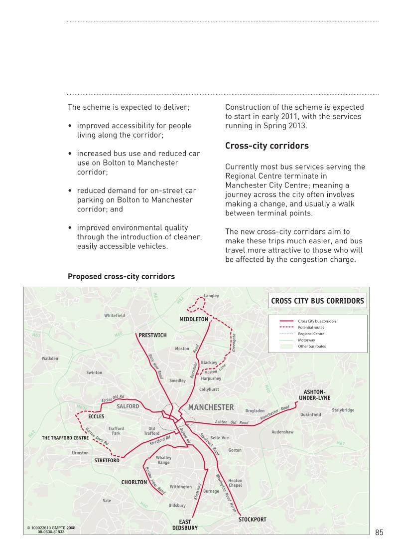
85
The scheme is expected to deliver;
• improved accessibility for peopleliving along the corridor;
• increased bus use and reduced caruse on Bolton to Manchestercorridor;
• reduced demand for on-street carparking on Bolton to Manchestercorridor; and
• improved environmental qualitythrough the introduction of cleaner,easily accessible vehicles.
Construction of the scheme is expectedto start in early 2011, with the servicesrunning in Spring 2013.
Cross-city corridors
Currently most bus services serving theRegional Centre terminate inManchester City Centre; meaning ajourney across the city often involvesmaking a change, and usually a walkbetween terminal points.
The new cross-city corridors aim tomake these trips much easier, and bustravel more attractive to those who willbe affected by the congestion charge.
Roch
dale
King
sway
Stretford Rd
Eccles
Barton Dock Rd
Bury
Moston Lane
erGgneat
eNew
Road
Old Rd
Stockport
BarlowMoor Road
Oxford Rd
Road
Road
Ashton Old RoadMancheste
r Road
Wellington
RoadNorth
© 100022610 GMPTE 200808-0630-81833
OLDHAM
ASHTON-UNDER-LYNE
STOCKPORT
CHORLTON
EASTDIDSBURY
Didsbury
STRETFORD
ECCLES
THE TRAFFORD CENTRE
Sale
TraffordPark
Urmston
Swinton
Walkden
StalybridgeMANCHESTERSALFORD
MIDDLETON
Collyhurst
Droylsden
Gorton
Burnage
HeatonChapel
WhalleyRange
Withington
AudenshawBelle Vue
OldTrafford
Dukinfield
Harpurhey
Blackley
Langley
Moston
Smedley
PRESTWICHM60
M62
M66
M61
M62
M602
M60
M67
M60
WhitefieldCross City bus corridors
Potential routes
Regional Centre
Motorway
Other bus routes
CROSS CITY BUS CORRIDORS
Proposed cross-city corridors

86
Significant infrastructure improvementswill be required to support the proposedcross-city services along key radialcorridors leading to the RegionalCentre, as well as within the RegionalCentre itself. These will include:
• segregated bus lanes;
• pre-signalisation and signal priorityfor buses;
• bus stop upgrades;
• formalised parking arrangements;
• a review of loading and waitingrestrictions; and
• camera enforcement of bus lanes.
Key benefits
The cross-city proposals aim to:
• provide more attractive bus servicesfor people wanting to travel acrossthe City Centre;
• improve bus journey time reliabilityinto the City Centre;
• protect road space for bus vehiclesthrough segregation, regulation andenforcement;
• improve passenger waitingenvironments;
• improve public transport priority overprivate vehicles; and
• increase accessibility to essentialservices and integration betweenpublic transport modes.
Delivery of the cross-city corridors isexpected to commence during 2010,with all corridors completed by Spring2013.
District centre corridors
Improvements aimed at improving theperformance and reliability of busservices are proposed to approximately30 corridors across GreaterManchester, covering approximately 182km in total. Some of these areextensions to the cross-city corridors,with others serving as feeder networksinto the key regional district centres. Alist of these corridors is providedopposite.

87
Origin Destination Length (km)
Oldham Failsworth 5.2 Hyde Denton 4.4 Urmston Chorlton 5.2Eccles Interchange Salford 2.6 Walkden Swinton 3.8 Bury Prestwich 6.2Rochdale Middleton 9.1 Rochdale Oldham 10.0 Oldham Middleton 5.3 Middleton M60 (Middleton) 2.7 Ashton Under Lyne Stalybridge 3.3 Ashton Under Lyne Stockport 7.8 Hyde Stockport 8.4 Marple Stockport 8.3 Hazel Grove Stockport 4.7 Reddish North Stockport 5.2 Chorlton Stockport 7,0 Northern Moor Withington 4,2 Altrincham Stretford 7.5Trafford Centre Urmston 3.2 Farnworth Worsley 5.1 Leigh Bolton 12.5 Hindley Leigh 4.2 Orrel Wigan 6.0 Horwich Bolton 9.7 Egerton Bolton 6.9 Whitefield Broughton Park 3.9Manchester Moston (M60)7.5(Rochdale Rd)Manchester Heaton Park (M60)6.2(Cheetham Hill)Manchester Denton (M60)6.1(Stockport Rd)
Key Benefits
• improved and more reliable busservices connecting to a wide rangeof local employment centres;
• improved connections betweentransport modes at a range ofdifferent interchanges;
• improved orbital connections tomajor employment centres nototherwise provided for by Metrolink,rail or the cross-city bus package;
• reduced travel times;
• improved service reliability;
• better interchange opportunities; and
• improvements at bus stops.
District centre corridors

88
Appendix 2 - Interchanges
This appendix provides more details ofthe proposals for the individualinterchanges where investment isproposed as part of the TIF package.
Major Town CentreInterchanges
Altrincham interchange
The current Altrincham interchange iswell sited in relation to the Metrolink,rail lines and the town centre, but itdoes not meet modern standards forsafety, security and accessibility, nordoes it provide passengers with anacceptable quality of environment. Inparticular, access for people withmobility problems from the bus standsand the Metrolink platform to the railplatforms is very poor. Buses alreadyplay an important role in feedingpassengers to the trams and the needfor this will increase if charging wasintroduced. Altrincham is outside theproposed charging area and Metrolinkshould attract journeys from the car –provided that people can get to theinterchange and change easily betweenbuses, trams and trains.
The challenge
To maximise the potential of publictransport, it is essential that Altrinchaminterchange is brought up to a standardin line with modern travel needs. Theprincipal areas for improvementinclude:
• a better site layout to make changingbetween transport modes easy forall;
• layout improvements to maximise theefficiency of the bus station, therebyreducing delays; and
• creating facilities that matchcontemporary travellers’ expectations– including accessibility for all,greater safety and security, improvedpassenger information and adequateprotection from the weather.
The proposed solution
The scheme includes
• development of new bus waitingfacilities running broadly parallel toStamford New Road, to improveaccess from the town centre to thebus stands, as less roads will need tobe crossed;
• bringing the bus waiting facilitiescloser to that of the rest of theinterchange for improved integrationwith tram and train;
• improvements to the main stationbuilding adjacent to Metrolinkplatform 1 to provide enhancedpassenger facilities;
• construction of a new facility to housea travel shop, passenger lounge andstaff facilities, and to provide shelterfor passengers waiting at the businterchange;
• construction of a shelter at the taxirank for better protection against theweather and improved safety;
• improvements to canopies onplatforms 1-4 to improve shelter forwaiting passengers;

89
• removing the old footbridge andbuilding a new one to link theplatforms. This will significantlyimprove access for disabled people;
• real time and electronic informationsystems for all bus, tram and trainservices, to make changing betweentransport modes as easy andseamless as possible;
• more comprehensive CCTV toimprove safety and security forpassengers and staff; and
• building a new walkway across theend of the Metrolink platforms toprovide level access.
Key benefits
Passenger benefits will include:
• a new high quality interchange thatwill encourage greater use of publictransport, bringing together bus,Metrolink, heavy rail, taxi, drop-off,cycle and pedestrian movements;
• improved accessibility, integrationbetween transport modes, bettersafety and security, and full accessfor passengers with impairedmobility;
• a new bus indoor concourse and abarrier-free open concourse at thecentre of the site, linking alltransport modes, entry and exitpoints, and providing a wide range ofpassenger facilities and activities;
• safer, more convenient andwelcoming access from all directionsto the interchange;
• vastly improved access to railplatforms for the mobility impaired;and
• a significant contribution to theregeneration of Altrincham towncentre.
Powers and consultation
GMPTE has worked very closely withTrafford MBC in developing the schemeconcept, aims and objectives. Thiscollaboration continues with TraffordMBC and other key stakeholders, toexplore the design of the scheme andthe interface with a range of widerinitiatives in the vicinity of theinterchange.
Consultation has been conducted withkey organisations, including NetworkRail, train operators, StagecoachMetrolink, local bus operators andaffected land owners. Consultation willcontinue at all key stages prior to andduring the statutory planning processand in the run up to implementation.
Completion
It is planned to open the interchange inlate 2012.

90
Bolton interchange
The challenge
Bolton is served by an extensive networkof local bus services connecting itsresidential areas and the surroundingtowns with the town centre. It also has afrequent and busy train service toManchester – taking about 20 minutes –far less than is possible by car or by bus.
However, the potential to use buses toget to the station is limited as mostbuses only go to the bus station at MoorLane. This is an eight to ten minutewalk away from the train station on theother side of the town centre.
Whilst Bolton is outside the proposedcharging area, many people from Boltoncommute to central Manchester, andwill cross both charging points on theirjourneys. If the interchange can beimproved then an integrated bus andtrain journey using one through ticketwill be an attractive alternative to thecar, if charging is introduced.
The proposed solution
This scheme, which is partially fundedby the Regional Funding Allocation, willmake a major contribution to improvingpublic transport connections in Boltonby moving the bus station from MoorLane to a new site close to the railwaystation. The two will then be linked by adirect walkway that removes the need tocross the roads
.Other improvements will include:
• a new indoor bus station concourseon the new site, with high quality
passenger facilities, includingaccessible public toilets and retailfacilities;
• a fully accessible walkway above therailway line from the bus station tothe rail station, improvingconnectivity for people changingbetween bus and rail. A taxi rank willbe retained in the area; and
• highway improvements to allowbuses to enter and exit the new busstation from both Newport Street andJohnson Street.
Key benefits
• better, more modern facilities,including toilets, retail, real timeinformation and better availability ofticketing prior to boarding the bus;
• greater opportunity for interchangebetween transport types, becausebus and rail stations will be closetogether;
• an attractive, efficient and logicalalternative for car commuters,particularly if the congestion chargeis introduced;
• access to the commercial and retailareas of Bolton town centremaintained by retaining on-street busstops where necessary;
• the direct walkway will improveconnectivity between the bus and railstations, by reducing walking time;and
• strategically, the relocation of the busstation will help the economicregeneration of the town centre, and

91
help reduce traffic in line with BoltonCouncil’s plans for the future.
The interchange will allow commutersto travel into Bolton town centre by buswith a much easier transfer to rail orBus Transit services for onwardjourneys into the City Centre. Givingsimpler access to a rail service which isfar faster than car into the City Centre isimportant in itself; if congestioncharging is introduced, the new facilitieswill prove absolutely invaluable.
In the wider context, the development ofthis modern interchange offers scopefor the expansion of bus services infuture. It also complements Bolton’sproposed town centre gyratory systemand rationalisation of traffic flows.
In environmental terms, the new busstation will provide a highly visible andhigh quality landmark between thetransport interchange and Bolton towncentre.
Powers and consultation
GMPTE has worked very closely withBolton Council since 2004 on both theoriginal study considering theinterchange location, and more recentlyto develop the proposals for the TIFsubmission. Work continues with BoltonCouncil to explore the scheme’sinterface with the wider economicregeneration of Bolton town centre.
Completion
The interchange is planned to open inlate 2012.
Stockport interchange
Stockport town centre is already amajor transport hub for all modes oftravel, and an important strategicinterchange for local, regional andnational movements. If congestioncharging were introduced, publictransport demand will increasesignificantly.
At a strategic level, for Stockport towncentre to achieve its full potential as aplace to live, work, visit and enjoy,Stockport MBC is striving to create awell designed centre with high qualitypublic spaces and an accessibletransport system. Central to the TIFStrategy, as well as the StockportMasterplan, is the new interchange,which integrates bus, heavy rail and afuture Metrolink service.
The challenge
There are some specific problemspresent at the existing Stockportinterchange, which need to beaddressed. These include:
• an unattractive waiting environment;
• a need to cross a number ofcarriageways between the bus standsand the rest of the town centre;
• delays to bus services getting in andout of the bus station; and
• lack of real time information aboutservices.

92
The current problems in the vicinity ofthe existing bus station at Stockport aresummarised below:
• the dispersed layout of the busstation leads to long walk times toand between bus stops;
• passengers may feel apprehensiveand isolated when waiting for busesas the shelters provided areseparated. The passenger facilitiesprovided are basic and not to amodern standard;
• passengers waiting under the partialshelters provided at the bus standsare exposed to variable weatherconditions and exhaust fumes; and
• passengers walking between the busand rail stations have to walk up anddown a hill, negotiating a significantnumber of steep steps.
The proposed solution
Building the new interchange atStockport will involve the followingactions:
• demolition of the existing bus station;
• building a new bus station with amore efficient layout and acentralised waiting concourse on thesite of the existing facility. The newbus station will include help points,real time passenger information,CCTV, public toilets accessible to all,café and retail accommodation;
• a new bridge will be built over theRiver Mersey, linking the bus stationon the southern side and Heaton
Lane on the north side, as well asassociated highway improvements toprovide efficient bus access to the A6;
• an attractive walkway will beprovided linking the bus station to theA6; and
• a new lift will provide moreconvenient access to the A6, MerseySquare and the main shoppingdistrict.
Key benefits
The new interchange facility willsignificantly enhance Stockport’s publictransport network. It will allowpassengers to travel more convenientlyinto the City Centre and change busesmore easily. It will be seen as anattractive alternative to those that maybe considering a mode switch. Thescheme will deliver the following keybenefits:
• better, more modern waiting facilitiesfor bus passengers includingimproved multi-modal informationabout all routes;
• safer and more secure passengerwaiting environments including theintroduction of more brightly litfacilities covered by CCTV;
• better access to bus station staff;
• improved accessibility into, andacross, the town centre, providing amore prominent termination locationfor scheduled bus services;
• improved integration within the busstation and to the rail station,through improvements to pedestrian

93
movements, facilitating a moreefficient public transport system; and
• strategically, the scheme will supportthe overall TIF package of deliveringattractive and viable alternatives totravel by car. The new interchangewould also be able to accommodate afuture Metrolink stop.
Powers and consultation
A significant amount of public andstakeholder consultation has alreadytaken place and the scheme has beenamended to reflect comments received.Further consultation will take place atkey stages as the project proceeds bothprior to and as part of the statutoryplanning and traffic regulation ordermaking processes and during theimplementation of the scheme.
Completion
The new interchange is due to becompleted in late 2012.
Wigan transport hub
Wigan town centre is currently servedby two railway stations; Wigan NorthWestern and Wigan Wallgate, both ofwhich are situated on Wallgate within100m of each other.
In addition to the railway stations,Wallgate also has four bus stops inclose proximity to Wigan North Westernstation. Currently the two stations andbus stops are effectively independentfacilities with no defined identity orlinkage, despite being so close to eachother. They are used by approximately11,000 passengers per day, with 17% ofpassengers recorded interchangingeither between trains or between busesand trains.
The Wigan transport hub scheme willcombine these separate facilities tocreate a high quality public transportinterchange. This will integrate both therailway stations and the bus stops andmake them easier and more attractiveto use.
The scheme will also act as a catalystfor further development in the area,specifically at Wigan North Westernstation. It has been developed followingprevious work co-ordinated by GMPTEand Wigan MBC, and is considered to bethe most cost effective solution to anumber of highlighted transport relatedissues.
The challenge
A number of problems currently exist atthe location:
• lack of a safe and convenient route

94
between the two railway stations,particularly across Wallgate;
• poor linkage between stations both interms of environment and passengerawareness. The area currently hasnarrow pavements exposed to theelements, poor lighting and hightraffic volumes making it hard tocross the road;
• poor interchange and integrationbetween bus and rail modes;
• poor overall public transportenvironment and lack of sense ofarrival in Wigan;
• lack of an integrated passengerinformation system showing trainsfrom both Wallgate and NorthWestern stations; and
• inadequate car parking to serveWigan North Western station.
The proposed solution
• construction of a new glazedpedestrian canopies to provide acovered link between the two stationsand the adjacent bus stops, providingcomplete protection from theelements;
• a widened footway to further improvethe pedestrian environment;
• bus stops adjacent to Wigan NorthWestern station replaced with amodern, high quality sheltercomplementary to the design of thecanopy;
• the two railway stations linked by
new crossing points situated atlocations where there is a need tocross Wallgate. Improved lighting andCCTV to enhance pedestrian safetyand security in the area;
• a real time passenger informationsystem (for all buses and trains) willbe provided in all areas of theinterchange;
• forecourt areas changed to reducethe dominance of the car and givepedestrians greater priority;
• car movements relocated to dropoff/pick up and taxi facilities atalternative locations; and
• a sensitive restoration of the existingWigan Wallgate station canopy andfaçade is also proposed.
Key benefits
Passenger benefits will include:
• attractive, contemporary waitingfacilities for bus passengersincluding improved information aboutall modes of travel;
• greater opportunity for interchangebetween transport modes due toimproved and safer linkage betweenthe two railway stations and the busfacilities;
• improved pedestrian environment inthe vicinity of both of the railwaystations and on Wallgate, as a resultof a reduction in car movements anda change in streetscape; and
• improved access between local bus

95
services and the wider transportnetwork.The scheme will alsocomplement the improvements to railrolling stock capacity on theSouthport – Wigan – Manchester railcorridor and wider bus priorityinitiatives.
The Wigan transport hub scheme isseen as the first phase of a wider planto enhance the quality of publictransport in the area surrounding WiganNorth Western and Wigan Wallgaterailway stations. The scheme is alsointegral to the delivery of the WiganSouth Central Regeneration Initiative,which is a wider regeneration projectbeing co-ordinated by Wigan MBC.
Powers and consultation
GMPTE has worked very closely withWigan MBC in developing the schemeconcept, aims and objectives. Workcontinues with Wigan MBC along withother key stakeholders to explore thedesign of the scheme, and how it canharmonise with a range of widerinitiatives in the vicinity of both WiganWallgate and Wigan North Westernstations.
Further consultation will take place withall relevant stakeholders at key stagesas the scheme develops, including priorto and during the statutory planningprocess and while the scheme is beingimplemented.
Completion
The interchange is planned to open in2011.
Regional Centre interchanges
Mayfield – former goods depotsite
As part of a wider regeneration proposalfor the area, the Mayfield site will beused to construct a new coach station toreplace the existing facility at ChorltonStreet.
All coach services will be routed fromthe Manchester and Salford Inner ReliefRoute, along Fairfield Street.
The main passenger interchangefacilities will be of a similar highstandard to those at the existingChorlton Street coach station.
Good direct pedestrian links will beprovided to Manchester Piccadillystation and the wider City Centre. Anumber of potential options forproviding this linkage are currentlybeing explored.
Vicinity of Chorlton Street
The proposals for this location include:
• the construction of a new businterchange in the vicinity of thecurrent coach station at ChorltonStreet. The new facility willincorporate high quality pedestrianlinks to the surrounding area, inparticular Portland Street. This willallow integration with bus transit andcross-city services; and
• the proposal will be carefullydesigned so as to protect residentialamenity and respect the character of

96
the Village. Bus access will bearranged so as to minimise impacton the environment of neighbouringareas.
The scheme includes, as part of thewider development proposals for thelocation, for the replacement of all carparking spaces lost as a result ofconstructing the new bus interchange.
In terms of amenities, the new facilitywill incorporate:
• a high quality sheltered and glazedindoor waiting environment whichwill be well lit and patrolled;
• real time passenger information forall routes;
• CCTV cameras providing 24hourrecording;
• staff available from 07:00-23:00;
• help points and roaming staff; and
• toilets and refreshment facilities.
The proposals for this location includefor the provision of high quality publicspace, which will improve the overallaesthetic experience in this area andimprove public perceptions of safety andsecurity.
Parker Street (PiccadillyGardens)
The Parker Street scheme proposesredevelopment of the existing busfacilities adjacent to Piccadilly Gardens:
• existing bus stands will be removed,traffic management arrangementsand pedestrian routing will berevised;
• facilities will undergo a significantupgrade to accommodate two bustransit (BT) services (Bolton-Manchester route 8 and Oxford RoadBT);
• four new stands will be constructed,two for each service. The stops willbe located centrally on an ‘island’and the buses will circulate one-way;
• the current entrance/exit on PortlandStreet will be enhanced;
• Mosley Street will be closed to allvehicles and priority wholly given toMetrolink;
• a substantial section of the existingbus station will be developed toprovide an enhanced pedestrianenvironment that ties in with thesurrounding area; and
• a large canopy is envisaged over allthe new stands and the existingMetrolink stop at Piccadilly Gardens.Additional new facilities at ParkerStreet will include;
• new high quality glazed waitingareas;

97
• help points for information and otherpassenger assistance;
• real time passenger information onall services; and
• associated improvements to thepublic realm and streetscape.
Vicinity of Salford Central Station
A new facility to provide betterinterchange between bus services andbetween buses and trains is proposedon the western side of the RegionalCentre in the vicinity of Salford Central.There are very significant regenerationproposals in this area and discussionsare still taking place with Salford CityCouncil and Central Salford UrbanRegeneration Company on the details ofthis proposal.
Powers and consultation
The overall development of the RegionalCentre Interchanges scheme should beseen in the context of the widerRegional Centre Transport Strategy(RCTS), currently being developed byGMPTA/E and Salford and ManchesterCity Councils.
As part of the development of thestrategy and the scheme-specificproposals, initial consultation has beenundertaken. This has included individualdiscussions with key stakeholders, andmore extensive consultation on theoverall transport strategy with bothstakeholders and the general public.
Consultation will continue throughoutthe design, planning andimplementation process as the schemesdevelop.
Completion
Mayfield – former goods depot 2013Chorlton Street early 2015Parker Street late 2015Vicinity of Salford Central Station 2013
Appendix 3 Cycling Proposals
A package of improvements for cyclistsis proposed across Greater Manchester.
The details of the cycling package arestill being refined. The proposals willneed to be evaluated further and localconsultation will take place before theplans are finalised. The tables belowshow the routes on which it is plannedto introduce improved cycling facilities.These are broken down into thefollowing categories:
• routes on priority public transportcorridors;
• other main routes to the RegionalCentre;
• other routes across the proposedcharging rings;
• routes to rail stations; and
• new secure cycle parking facilities.
The nature of facilities on these routeswill be worked up in conjunction withdeveloping bus priority and RegionalCentre proposals, with the aim ofensuring that cyclists will be catered foron the following corridors:

98
Routes on priority public transport corridors
Corridor Districts Description
A664 Rochdale Road Manchester, Rochdale Between Middleton and Regional CentrecorridorA56 Bury New Road Bury, Salford Between Whitefield and City CentrecorridorA665 Bury, Manchester Between Whitefield and City Centre viaCheetham HillRoad / Bury Old RoadA635 Ashton Old Road Manchester, Tameside Between Ashton and City Centre via CorridorA662 Ashton New Road Manchester, Tameside Between Ashton and City Centre via Corridor DroylsdenA6 Stockport Road Manchester, Stockport Between Stockport town centre and City
CentreA34 Upper Brook Street/ Manchester, Stockport Between Gatley / Cheadle and City Centre, Kingsway including motorway crossingsOxford Road corridor Manchester Between Centre and Royal Infirmary and -
Withington Between Northenden and Manchester Universities and City Centre
A6 Salford/Swinton Salford Between Walkden, Salford University and corridor Regional CentreA5103 Princess Road Manchester Between Didsbury and the City CentrecorridorWalkden/Eccles routes Salford Between Walkden and Boothstown to Worsleyand EcclesOther Salford routes Salford Various routes between Irlam, Salford Quays
and the Regional CentreManchester City Centre Manchester Mainly on-road routes and cycle-friendlyRoutes areas within and through the City CentreA57 Hyde Road Corridor Manchester, Tameside Between Denton and the City Centre

99
Other priority radial routes to the Regional Centre
Corridor Districts Description
A576 Middleton Road/ Manchester, Salford, New on-road facilities between Middleton and Leicester Road corridor Rochdale Regional Centre via Cheetham HillB6393 Greengates Manchester, Oldham New on-road section between existing Lightbowne Road network at Newton Heath and Moston, new
off-road section between Moston and Chadderton/Middleton
A62 Oldham Road Manchester, Oldham Upgraded off-road route alongside RochdaleCanal between City Centre and White Gate.corridor New on-road facilities on Oldham Road
between Miles Platting and Newton HeathA663 Broadway Manchester, Oldham New off and on-road sections on Broadwaybetween
Failsworth and White GatePrincess Road/ Manchester New off-road route between Jackson’s Bridge Alexandra Road and Whalley Range. New on-road link
between Chorlton and City Centre.Sale/Manchester Manchester, Trafford New off-road route alongside Bridgewater corridor (Bridgewater Canal between Sale and City CentreCanal)
Other routes across the proposed charging rings
Corridor Districts Description
Denton to Reddish Vale Stockport / Tameside Upgraded off-road link in Reddish Vale between Denton and Reddish
Ring crossings in Bury Bury Upgraded off road route between Outwood and Rainsoughthrough Clifton Country Park, to create a continuous off-road link between Radcliffe and Charlestown.New off-road link crossing the M60 between Besses o’th’Barnand Heaton Park
Oldham & Tameside ringOldham, Tameside New mainly off-road links crossings • Bardsley, Daisy Nook, Failsworth and
Woodhouses• Taunton (Ashton) and Littlemoss (Droylsden)
Routes accessing Leigh Wigan New off-road routes accessing the route Guided Busway alongside Leigh-
Salford-Manchester busway around Tyldesley

100
Routes to rail stations
Station Justification
Stockport Stockport station is forecast to see the largest increase in patronage withTIF. This scheme tackles a number of obstacles in the vicinity of the stationin order to increase accessibility by cycle.
Bolton Bolton station is forecast to see the second largest increase in patronagewith TIF. This scheme is a high quality route along former Bolton-Bury railline offering significant journey time savings, safety and ambiencecompared to alternative on-carriageway route. Links deprived areas ofLittle Lever, southern Breightmet and Darcy Lever to station. Also somelocal improvements to connect wider cycle network from south and west torail station. Bolton station anticipated to experience high levels ofpatronage increase following charging.
Marple Marple station is forecast to see the fourth largest increase in patronagewith TIF. This scheme fills in a missing link to the station from the existinglocal cycle network.
Hazel Grove Hazel Grove station is forecast to see the sixth largest increase inpatronage with TIF. These improvements link the station to the local cyclenetwork.
Castleton This scheme links Heywood, one of the largest settlements in GreaterManchester without a rail station, to the nearest rail station at Castleton,thereby giving a much needed option for car-free travel to within thecharging area. The route also links from deprived areas. Route alsoextends east across the barrier of the A627 (M) to give significant journeytime savings for people from Kirkholt and Lower Place wanting to accessthe rail service into Manchester.
Rochdale This route links the rail and Metrolink stations at Rochdale with theMarland / Sudden area, offering a way around the significant obstacle ofthe A58/A664 roundabout.
Cycle routes in practice
Cycle routes can take many forms.Some make use of canal tow paths,some share bus lanes, others arecreated by signing cyclists down quietroutes. Cars are allowed to park in non-mandatory cycle lanes, which aresignified by doted lines. We areproposing design standards similar tothose of the London Cycle Network+and Cycling England.
Whilst these designs haverecommended widths for certainfacilities, engineering judgement often
has to be made when retrofittingfacilities into the existing highwaynetwork. We will therefore ensure thatthese standards will apply whereverpossible, but there might of course be alimited number of locations where theymay have to be compromised.
Secure cycle parking
Secure cycle parking will be provided atrail and Metrolink stops, especiallywhere their use will be expected toincrease if charging is introduced.Priority will also be given wherefacilities are limited at present.

101
Examples of stations which will benefitinclude:
• Bolton
• Brooklands
• Altrincham
• Stalybridge
• Bury
• Radcliffe
• Sale
• Rochdale
• Stockport
• Airport
These facilities will be designed andlocated in line with the GreaterManchester cycle parking guidelines,with the emphasis on long stay security.
Parking will be enhanced in theRegional Centre, both with short andlong stay facilities, and throughencouraging employers to providesecure parking and changing facilitiesfor employees. A further possibility is acycle centre, with parking, changing andother services for cyclists on offer.
In addition, 30 additional racks (60spaces) will be provided in the followingtown & district centres inside theproposed charging ring:
• Cheetham Hill
• Chorlton
• Didsbury
• Sportcity
• Fallowfield
• Gorton
• Harpurhey
• Levenshulme
• Longsight
• Newton Heath
• Openshaw
• Rusholme
• Withington
• Salford Precinct
• Eccles
• Swinton
• Prestwich
• Sedgley Park
• Failsworth
• Droylsden
• Houldsworth Square
• Stretford