great valley cottonwood riparian forest description
TRANSCRIPT
Sacramento to Bakersfield California High-Speed Train Program EIR/EIS Biological Resources Technical Evaluation
Page 11 January 2004
U.S. Departmentof TransportationFederal RailroadAdministration
2.3 SENSITIVE VEGETATION COMMUNITIES
Great Valley Cottonwood Riparian Forest
Description: A dense, broadleafed, winter deciduous riparian forest dominated by Fremont cottonwood (Populus fremontii ssp. fremontii) and Goodding’s black willow (Salix gooddingii). The understory is usually dense, with abundant vegetative reproduction of canopy dominants and California wild grape is the most conspicuous vine. Scattered seedlings and saplings of shade-tolerant species such as box elder (Acer negundo var. californica) or Oregon ash (Fraxinus latifolia) may be found, but frequent flooding prevents their reaching into the canopy (Holland 1986).
Site Factors: These sites are inundated yearly during spring, resulting in annual input of nutrients, soil, and new germination sites. They are typically found on fine-grained alluvial soils near perennial or nearly-perennial streams that provide subsurface irrigation even when the channel is dry. At sites higher and farther from the river this community mixes with Great Valley Mixed Riparian Forest. Towards the water it intergrades with Great Valley Willow Scrub on sites that are subject to more severe flooding disturbance.
Characteristic Species: Box elder, California button willow (Cephalanthus occidentalis var. californicus), alkali rye, Oregon ash, Fremont cottonwood, Goodding’s black willow, narrow-leaved willow (Salix exigua), red willow (Salix laevigata), shining willow (Salix lucida ssp. lasiandra), arroyo willow (Salix lasiolepis), California wild grape (Hickman 1993; Holland 1986).
Distribution: Formerly extensive along the major low-gradient streams throughout the Great Valley, but now reduced to scattered, isolated remnants or young stands because of flood control, water diversion, agricultural development, and urban expansion. This community is typically found below 1000 ft in the northern valley and 300 feet in the south (Holland 1986).
Status Within the Project Area: The CNDDB has identified 56 occurrences of Great Valley cottonwood riparian forest, six of which occur in counties of the Sacramento to Bakersfield region. There are three occurrences from Kern County, two from San Joaquin County, and one from Merced County (CDFG 2002).
Great Valley Valley Oak Riparian Forest
Description: This is a medium to tall (rarely to 100 feet) broadleaved, winter deciduous, closed-canopy riparian forest dominated by valley oak (Quercus lobata). Understories include scattered Oregon oak, Northern California black walnut, and western sycamore as well as young valley oaks. Vines are relatively scattered throughout the shady understory but quickly become conspicuous occupying gaps where light is available (Holland 1986).
Site Factors: Restricted to the highest parts of floodplains, most distant from or higher above active river channels and therefore less subject to physical disturbance from flooding, but still receiving annual inputs of silty alluvium and subsurface irrigation. Intergrades closer to the river with Great Valley Mixed Riparian Forest (Holland 1986).
Characteristic Species: Dutchman’s pipe (Aristolochia californical), virgin’s bower (Clematis ligusticifolia), alkali rye, Oregon ash, Northern California black walnut, western sycamore, valley oak, California rose (Rosa californica), blackberries (Rubus spp.), California greenbriar (Smilax californica), western poison oak (Hickman 1993; Holland 1986).
Distribution: Formerly extensive on low-gradient, depositional reaches of the major streams of the Sacramento and northern San Joaquin valleys. More scattered in the San Joaquin watershed and on the floodplains of the Kings and Kaweah rivers. Now virtually eliminated by agriculture and fire wood harvesting (Holland 1986).
Sacramento to Bakersfield California High-Speed Train Program EIR/EIS Biological Resources Technical Evaluation
Page 12 January 2004
U.S. Departmentof TransportationFederal RailroadAdministration
Status Within the Project Area: Within the counties of the Sacramento to Bakersfield region, Great Valley valley oak riparian forest in known from Sacramento County (three occurrences), San Joaquin County (three occurrences), Stanislaus County (one occurrence), and Tulare County (one occurrence) (CDFG 2002).
Northern Hardpan Vernal Pool
Description: This community is dominated by annual grasses and herbs that grow in and out of the water. Germination and growth begin with winter rains, often continuing even when inundated. These pools gradually evaporate during spring, leaving concentric bands of vegetation that colorfully encircle the drying pools (Holland 1986).
Site Factors: Typically found through mounded terrain where soils are very acidic, iron and silica-cemented hardpan soils such as the Redding, San Joaquin series. Winter rainfall perches on the hardpan, forming pools in the depressions. Evaporation (not runoff) empties the pools in spring (Holland 1986).
Characteristic Species: Common vernal pool allocarya (Plagiobothrys stipitatus var. micranthus), coast allocarya (Plagiobothrys undulatus), boisduvalia (Epilobium torreyi), annual hairgrass (Deschampsia danthonoides), bristled downingia (Downingia bicornuta), toothed downingia (Downingia cuspidata), flatface downingia (Downingia pulchella), Vasey’s coyote-thistle, dwarf rush (Juncus leiospermus), inch-high dwarf rush (Juncus uncialis), Fremont’s goldfields, white meadowfoam (Limnanthes alba), northern mudwort (Limosella aquatica), white-headed navarretia (Navarretia leucocephala), vernal pool Indian paintbrush (Castilleja campestris), Sacramento mesamint (Pogogyne zizyphoroides), short woollyheads (Psilocarphus brevissimus), and speedwell (Veronica arvensis) (Hickman 1993; Holland 1986).
Distribution: Found primarily on old alluvial terraces on the east side of the Great Valley from Tulare or Fresno County north to Shasta County (Holland 1986).
Status Within the Project Area: The CNDDB lists 126 occurrences for Northern Hardpan Vernal Pool. This includes 96 occurrences from within the counties of the Sacramento to Bakersfield region, with 65 of those from Sacramento County. In addition, there are ten occurrences from Madera County, eight from Merced County, four from Fresno County, four from San Joaquin County, three from Tulare County, and two from Stanislaus County (CDFG 2002)
Northern Claypan Vernal Pool
Description: This habitat is similar to Northern Hardpan Vernal Pools, but with less topographical relief, and usually lower overall cover. Pools range in size from the small (a few square meters) to quite large (covering several hectares) (Holland 1986).
Site Factors: Typically found over silica-cemented hardpan soils that vary in salinity and alkalinity. Often intergrades through Cismontane Swale with Cismontane Alkali Marsh which have water present throughout the year (Holland 1986).
Characteristic Species: Alkali plagiobothrys (Plagiobothrys leptoclada), stalked popcornflower (Plagiobothrys stipitatus var. stipitatus), smooth boisduvalia (Epilobium pygmaeum), alkali weed (Cressa truxillensis), Hoover’s downingia (Downingia bella), harlequin downingia (Downingia insignis), California eryngo (Eryngium aristulatum), Ferris’ goldfields (Lasthenia ferrisiae), smooth goldfields (Lasthenia glaberrima), woolly goldfields (Lasthenia minor), common mouse tail (Myosurus minimus), Douglas’ mesamint (Pogogyne douglasii), salt marsh sand spurry (Spergularia marina), purslane speedwell (Veronica peregrina ssp. xalaphesis) (Hickman 1993; Holland 1986).
Distribution: Often found on lower terraces and basin rims of Central San Joaquin Valley north to Glenn and Colusa counties. Typically more frequently found toward the valley floor when compared to Northern Hardpan Vernal Pools (Holland 1986).
Sacramento to Bakersfield California High-Speed Train Program EIR/EIS Biological Resources Technical Evaluation
Page 13 January 2004
U.S. Departmentof TransportationFederal RailroadAdministration
Status Within the Project Area: The CNDDB maintains records for 21 occurrences of Northern Claypan Vernal Pool, 14 of which occur in counties of the Sacramento to Bakersfield region. These include seven in Tulare County, three in Merced County, two in Fresno County, one in Sacramento County, and one in San Joaquin County (CDFG 2002).
Valley Sink Scrub
Description: Valley Sink Scrub is a low succulent scrubland dominated by alkali-tolerant species, especially iodine bush (Allenrolfea occidentalis). There is usually no understory, though sparse herbaceous cover of foxtail chess (Bromus madritensis ssp. rubens) sometimes develops.
Site Factors: This community is found on saline and/or alkaline clays of lakebeds or playas. High ground water supports these plants. Soil surfaces often have a brilliant white salty crust that covers a dark, sticky clay. On some sites, this community intergrades with Valley Saltbush Scrub (Holland 1986).
Characteristic Species: Iodine bush, recurved larkspur, saltgrass, Mojave red sage (Kochia californica), alkali goldfields (Lasthenia chrysantha), Ferris’ goldfields (Lasthenia ferrisae), boraxweed (Nitrophila occidentalis), Parish’s pickleweed (Salicornia subterminalis), alkali sacaton (Sporobolus airoides), bush seepweed (Sueda moquinii) (Hickman 1993; Holland 1986).
Distribution: This community formerly surrounded the large San Joaquin Valley lakes (Kern, Buena Vista, Tulare, Goose) and along the San Joaquin Valley through Merced County to Solano and Glenn counties west of the Sacramento River. Valley Sink scrub has now been essentially extirpated by to flood control, agricultural development, and ground water pumping (Holland 1986).
Status Within the Project Area: The CNDDB reports 29 occurrences for Valley Sink Scrub. Twenty of these are from within counties of the Sacramento to Bakersfield region, with nine from Kern County, six from Merced County, three from Tulare County, one from Fresno County, and one from Madera County (CDFG 2002).
2.4 SENSITIVE PLANT SPECIES (INCLUDING FEDERALLY AND STATE-LISTED AND PROPOSED THREATENED AND ENDANGERED AND CNPS LIST 1 SPECIES)
Ferris's Milkvetch (Astragalus tener var. ferrisiae)
Listing Status: Ferris's milkvetch is a federal Species of Concern, has no state status, and is a California Native Plant Society (CNPS) List 1B species. CNPS List 1B plants are rare, threatened, or endangered in California and elsewhere.
Pertinent Life History Information: Ferris's milkvetch is an inconspicuous annual herbaceous member of the legume family (Fabaceae) that blooms from April through May (Tibor 2001). The upright plants reach 10 inches high and are smooth to covered with stiff, straight hairs that hug the stem. Each pinnately compound leaf has 7 to 15 separated, oval leaflets with notched tips. The pea-like flowers are pink to purple with a white "eye" on the top petal, and occur in dense clusters of 3 to 12. Fruits of Ferris's milkvetch are crescent shaped pods with stalk-like bases that produce smooth seeds. It is distinguished from alkali milkvetch, another rare plant, primarily by its fruits, which are 2.7 to 5 cm long on a short, stalk-like base whereas those of alkali milkvetch are up to 2.5 cm long on a round base (Hickman 1993).
Ferris’s milkvetch occurs on sub-alkaline flats, seasonally wet-meadows, and mildly alkaline on overflow land in the Sacramento to Bakersfield region. It is usually seen on dry, heavy clay, or adobe soils between elevations of 5-75 meters (CDFG 2002).
Sacramento to Bakersfield California High-Speed Train Program EIR/EIS Biological Resources Technical Evaluation
Page 14 January 2004
U.S. Departmentof TransportationFederal RailroadAdministration
Distribution: Ferris’s milkvetch historically occurred in the north Central Valley, from Solano County north to Glenn and Butte counties. It was rediscovered in 1989 and is known only from four extant occurrences (Tibor 2001). One is in Glenn County at the Sacramento National Wildlife Refuge near Logandale and the other three are in southwestern Butte County, west of Biggs.
Status Within the Project Area: Within the Sacramento to Bakersfield region, Ferris’s milkvetch is known only from the Mountain House area near the boundary between Alameda and San Joaquin counties. This occurrence is an 1884 herbarium collection that lists “Mountain House” as the collection location. This collection site has never been relocated (CDFG 2002).
Alkali Milkvetch (Astragalus tener var. tener )
Listing Status: Alkali milkvetch is a federal Species of Concern; has no state status and is a CNPS List 1B species.
Pertinent Life History Information: Alkali milkvetch is an inconspicuous annual herbaceous member of the legume family that blooms from March through June (Tibor 2001). The upright plants reach 12 inches high and are smooth to covered with stiff, straight hairs that hug the stem. Each pinnately compound leaf has 7 to 17 well-separated, oval leaflets with notched tips. The pea-like flowers are pink to purple (sometimes fading to white) and occur in dense clusters of 3 to 12. Fruits of alkali milkvetch are straight to slightly curved pods with round bases that produce smooth seeds. The pods fade to a straw-color or sometimes black as the plant matures. It is distinguished from Ferris’s milkvetch primarily by its fruits (see preceeding discussion) Alkali milkvetch occurs on adobe clay playas, vernal flats, and moist grasslands with alkali or heavy clay soils in the Sacramento to Bakersfield region elevations less than 60 meters (Tibor 2001).
Distribution: Alkali milkvetch was historically known from the 13 counties in California that make-up the northern San Joaquin Valley, the southern Sacramento Valley, and the eastern San Francisco Bay area. However it has been extirpated from much of its former range and is now known only from Alameda, Merced, Napa, Solano, and Yolo counties (CDFG 2002).
Status Within the Project Area: The CNDDB lists six records for Alkali milkvetch within the counties of the Sacramento to Bakersfield region. Four extant occurrences of alkali milkvetch are documented in Merced County. The first of these is within the Los Banos Wildife Area north of Little Buttonwillow Lake, off of Henry Miller Road. The second occurrence is located at San Luis Island, 0.7 miles north of Salt Slough on Highway 165. The third location is about 0.25 miles southeast of Highway 140 within Kesterson National Wildlife Refuge. The fourth occurrence is within the North Grasslands Wildlife Area, about 0.5 miles west of Highway 140. In addition, alkali milkvetch is historically known from Stanislaus and San Joaquin counties; however, these occurrences are believed to be extirpated (CDFG 2002).
Heartscale (Atriplex cordulata)
Listing Status: Heartscale is a federal Species of Concern, has no state status, and is a CNPS List 1B species.
Pertinent Life History Information: Heartscale is a member of the goosefoot family (Chenopodiaceae) and blooms from April to October (Tibor 2001). This annual herb has one to few 10-50 cm erect stems. Branches are ascending to erect branches and gray-scaly with tips covered with densely interwoven, generally matted hairs. The oval leaves are also gray-scaly, with blades 6-15 mm long. The inconspicuous flowers of heartscale are covered by oval to round, mostly smooth, deeply toothed bracts. Fruits contain one reddish-brown seed. Because the flowers are inconspicuous, the plant is most easily identified after flowering when in fruit (Hickman 1993). Heartscale is associated with alkaline or saline soils in chenopod scrub, meadows, and seeps and in valley grassland at elevations less than 375 meters (Tibor 2001).

Sacramento to Bakersfield California High-Speed Train Program EIR/EIS Biological Resources Technical Evaluation
Page 15 January 2004
U.S. Departmentof TransportationFederal RailroadAdministration
Distribution: Heartscale is known from throughout the Sacramento to Bakersfield region, from Glenn and Butte counties in the north to Kern and San Luis Obispo counties in the south. The CNDDB has identified 53 occurrences of heartscale, of which 50 are extant (CDFG 2002). It is believed to be extirpated from San Joaquin, Stanislaus, and Yolo counties and has not been reported from Sacramento County (Tibor 2001).
Status Within the Project Area: The CNDDB lists 30 records for heartscale within the counties of the Sacramento to Bakersfield region. Ten extant occurrences of heartscale are documented in Merced County, six in Kern County, five in Madera County, four in Fresno County, and four in Tulare County. In addition, heartscale is historically known from Stanislaus County; however, this occurrence is believed to be extirpated (CDFG 2002).
Brittlescale (Atriplex depressa)
Listing Status: Brittlescale is a federal Species of Concern, has no state status, and is a CNPS List 1B species.
Pertinent Life History Information: Brittlescale is a member of the goosefoot family and blooms from May to October (Tibor 2001). This annual herb has prostrate, scaly stems that are white and brittle and that grow to less than 20 cm. The oval leaves are also white and scaly, with blades 4-8 mm long. The tiny flowers of brittlescale have no sepals or petals and are covered by white, scaly diamond-shaped bracts. Because the flowers are inconspicuous, the plant is most easily identified after flowering when in fruit (Hickman 1993).
Brittlescale is associated with alkaline or clay soils in semi-barren areas of chenopod scrub. It is most frequently found on playas, meadows, vernal pools, or seeps and in valley grassland at elevations less than 320 meters. It can occasionally be found in riparian marshes (CDFG 2002; Tibor 2001).
Distribution: Brittlescale is currently known throughout the Sacramento to Bakersfield region from Glenn and Butte counties in the northern Sacramento Valley to Kern County in the southern San Joaquin Valley (CDFG 2002).
Status Within the Project Area: Of the 18 extant occurrences of brittlescale in the counties of the Sacramento to Bakersfield region, eight occurrences of brittlescale are from Fresno County, three in Merced County, three in Madera County, two in Stanislaus County, one in Kern County, and one in Tulare County (CDFG 2002).
San Joaquin Saltbush (Atriplex joaquiniana)
Listing Status: San Joaquin saltbush is a federal Species of Concern, has no state status, and is a CNPS List 1B species.
Pertinent Life History Information: San Joaquin saltbush is an annual, herbaceous member of the goosefoot family that blooms from April to October (Tibor 2001). This 10 to 100 cm tall plant is upright with finely ridged, sparsely scaled stems. Leaves of the species are gray or green and sparsely scaly with irregularly toothed edges. The tiny flowers of San Joaquin saltbush have no sepals or petals and are covered by ribbed, green bracts. The flowers are arranged in a dense cluster at the ends of the flowering stalks. Fruits contain one dark brown seed (Hickman 1993). San Joaquin saltbush grows in seasonal, alkali wetlands and alkali sinks in chenopod scrub, meadows, playas, and valley and foothill grassland at elevations generally below 320 m (Tibor 2001).
Distribution: San Joaquin saltbush occurs in the southern Sacramento Valley, San Joaquin Valley, and the eastern interior slopes of the South Coast Ranges (Hickman 1993). In addition to Yolo County, San Joaquin saltbush is found in Alameda, Contra Costa, Colusa, Glenn, Merced, Monterey, Napa, Sacramento, San Benito, Solano, and Yolo counties. It is extirpated from Santa Clara, San Joaquin, and Tulare counties (Tibor 2001).
Sacramento to Bakersfield California High-Speed Train Program EIR/EIS Biological Resources Technical Evaluation
Page 16 January 2004
U.S. Departmentof TransportationFederal RailroadAdministration
Status Within the Project Area: The CNDDB lists three records for San Joaquin saltbush within the counties of the Sacramento to Bakersfield region, two from Merced County and one from Sacramento County. In addition, San Joaquin saltbush is historically known from San Joaquin and Tulare counties.
Bakersfield Smallscale (Atriplex tularensis)
Listing Status: Bakersfield smallscale is listed as endangered by the State of California, has no federal status, and is a CNPS List 1B species.
Pertinent Life History Information: Bakersfield smallscale is a member of the goosefoot family that blooms from June to October (Tibor 2001). This annual herb has an upright stem and a few stiff branches that are covered with white scales and have red tips. The leaves, which are lance- or egg-shaped, are opposite on at least the lower part of the stem. Both male and female flowers occur in leaf axils2 throughout the plant. The reddish-brown seeds are enclosed in diamond-shaped bracts that are smooth on the surface but toothed on the margin (Hickman 1993). Bakersfield smallscale is found on the sub-alkaline margins of alkali sinks and on alkaline plains at elevations of 90 to 200 m (Tibor 2001).
Distribution: Bakersfield smallscale was historically restricted to a small area of south-central Kern County between Greenfield and Mettler. This species is now possibly extinct. The only site that still may support Bakersfield smallscale is a remnant of Kern Lake known as Gator Pond, formerly the Kern Lake Preserve (CDFG 2002). However, Bakersfield smallscale specimens historically collected from this location differ in appearance from those now present at Gator Pond, and are probably an undescribed form of bractscale (Atriplex serenana) (Tibor 2001).
Status Within the Project Area: There are three occurrences of Bakersfield smallscale in the counties of the Sacramento to Bakersfield region, all in south-central Kern County, and all three believed to be extirpated (CDFG 2002).
Subtle Orache (Atriplex subtilis)
Listing Status: Subtle orache is a federal Species of Local Concern, has no state status, and is a CNPS List 1B species.
Pertinent Life History Information: Subtle orache is a member of the goosefoot family that blooms from August to October (Tibor 2001). Subtle orache inhabits valley and foothill grassland from elevations between 40 to 100 meters (Tibor 2001). Subtle orache is a recently described species and details of this species are not well known (Stutz and Chu 1997).
Distribution: Subtle orache is currently known from the southern San Joaquin Valley, from Merced County in the north to Kern County in the south. The CNDDB maintains records for 17 occurrences of subtle orache, in Butte, Fresno, Kings, Kern, Madera, Merced, and Tulare counties (CDFG 2002).
Status Within the Project Area: The CNDDB lists 16 records for subtle orache within the counties of the Sacramento to Bakersfield region. Ten occurrences of are documented in Tulare County, two in Kern County, two in Merced County, one in Madera County, and one in Fresno County (CDFG 2002).
Lost Hills Crownscale (Atriplex vallicola)
Listing Status: Lost Hills crownscale is a federal Species of Concern, has no state status, and is a CNPS List 1B species.
Pertinent Life History Information: Lost Hills crownscale is a member of the goosefoot family that blooms from April to August (Tibor 2001). This annual herb has short stems with few branches and alternate, egg-shaped leaves. The individual flowers are inconspicuous because they are tiny and have no petals. Male and female flowers are mixed in small clusters in the upper leaf axils. The fruiting bracts are broadly
2 The axials are the junction of the leaf and the stem.

Sacramento to Bakersfield California High-Speed Train Program EIR/EIS Biological Resources Technical Evaluation
Page 17 January 2004
U.S. Departmentof TransportationFederal RailroadAdministration
triangular, irregularly toothed, and may or may not have tubercles (warty projections). Each pair of bracts encloses a flattened, dark brown seed (Hickman 1993). Lost Hills crownscale typically grows in the dried beds of alkaline pools within scrub or annual grassland communities at elevations of 50 to 635 meters (Tibor 2001).
Distribution: Lost Hills crownscale is known from the southern San Joaquin Valley, from Merced County in the north to Kern County in the south. The CNDDB maintains records for 41 occurrences of Lost Hills crownscale, in Fresno, Kings, Kern, Merced, and San Luis Obispo counties (CDFG 2002).
Status Within the Project Area: The CNDDB lists 25 records for Lost Hills crownscale within the counties of the Sacramento to Bakersfield region, all believed to be extant. Twenty-two of these are from in Kern County, two in Fresno County, and one in Merced County (CDFG 2002).
Big Tarplant (Blepharizonia plumose ssp. plumosa)
Listing Status: Big tarplant is a federal Species of Concern, has no state status, and is a CNPS List 1B species.
Pertinent Life History Information: Big tarplant is a member of the sunflower family (Asteraceaea) that blooms from July to October (Tibor 2001). This annual herb is 30 to 180 cm tall, with many slender branches supporting approximately 1 cm wide flower heads. The outer flowers have red veins and the central flowers have brown anthers. The entire plant is covered with large, tack-shaped glands that give the plant it’s unique odor (Hickman 1993). Big tarplant grows in valley and foothill grassland on dry hills and plains, typically in clay or clay-loam soils. It frequently is found on slopes and burned areas at elevations between 30 and 505 meters (Tibor 2001).
Distribution: Big tarplant is currently known from the northwestern San Joaquin Valley, in Alameda, Contra Costa, San Joaquin, and Stanislaus counties. It is likely extirpated from Solano County (CDFG 2002).
Status Within the Project Area: Within the counties of the Sacramento to Bakersfield region, big tarplant has been recorded from San Joaquin County (15 occurrences) and Stanislaus County (one occurrence) (CDFG 2002).
California Jewelflower (Caulanthus californicus)
Listing Status: California jewelflower is listed as Endangered under both the Federal and State Endangered Species acts. It is also a CNPS List 1B species.
Pertinent Life History Information: California jewelflower is an annual herb belonging to the mustard family (Brassicaceae) that blooms from February to May (Tibor 2001). The upper leaves are egg-shaped and clasp the stem, unlike the leaves at the base of the plant, which are oblong. The maroon buds are clustered at the tip of the stem and contrast with the translucent, white flowers below. California jewelflower has elongated fruits that are flattened in cross-section (Hickman 1993).
California jewelflower is found in several plant communities including chenopod scrub, pinyon and juniper woodland, and annual grasslands usually in areas of dense herbaceous cover. It is found most commonly over sub-alkaline sandy loams at elevations ranging from 70 to 1000 meters (Tibor 2001).
Distribution: The historical range of this California endemic extended across the southern San Joaquin Valley and the surrounding foothills to the east and west. It is currently known from the western edge of its former range in Fresno, Santa Barbara, and San Luis Obispo counties. There is one transplanted population in Kern County, which is believed to be extirpated. It is also likely extirpated from Kings, Tulare, and Ventura counties (CDFG 2002).
Status Within the Project Area: All natural occurrences of California jewelflower on the San Joaquin Valley floor have been extirpated. Today, known populations of California jewelflower are confined to Fresno County in three areas of hilly terrain west of the San Joaquin Valley (CDFG 2002).
Sacramento to Bakersfield California High-Speed Train Program EIR/EIS Biological Resources Technical Evaluation
Page 18 January 2004
U.S. Departmentof TransportationFederal RailroadAdministration
Slough Thistle (Cirsium crassicaule)
Listing Status: Slough thistle is a federal Species of Concern, has no state status, and is a CNPS List 1B species.
Pertinent Life History Information: Slough thistle is an herbaceous annual or biennial in the sunflower family that blooms from May to August (Tibor 2001). The single stem is generally only branched in the upper parts and is cobwebby, and hollow reaching 1 to 3 meters in height. The leaves are densely cobwebby, with spiny margins and slight lobes. The pale rose-purple flower heads are similar in appearance to other thistle species (Hickman 1993). Slough thistle typically occurs in sloughs, riverbanks, and marshy areas, at elevations ranging from 3 to 100 meters (Tibor 2001)
Distribution: Slough thistle is found in the San Joaquin Valley in Kern, Kings, and San Joaquin counties. The populations in the northern San Joaquin Valley are believed to be extirpated (CDFG 2002).
Status Within the Project Area: The CNDDB lists 16 records for slough thistle within the counties of the Sacramento to Bakersfield region, the majority in Kern County (14 records). San Joaquin County has one extant and one extirpated occurrence (CDFG 2002).
Mt. Hamilton Thistle (Cirsium fontinale var. campylon)
Listing Status: Mt. Hamilton thistle is a federal Species of Concern, has no state status and is a CNPS List 1B species.
Pertinent Life History Information: Mt. Hamilton thistle is an herbaceous perennial in the sunflower family that blooms from February to October (Tibor 2001). One to several hairy, green stems reach up to 2 meters in height and bear terminal flowers. The densely-hairy leaves are strongly lobed with wavy/spiny margins and spiny leaf stalks. The leaves are 10 to 70 cm long, and get gradually smaller towards the upper stem. Upper leaves clasp the stem and are without a leaf stalk. Flower heads are white to pink or lavender (Hickman 1993). Mt. Hamilton thistle occurs in serpentine seeps and streams, at elevations ranging from 100 to 890 meters (Tibor 2001)
Distribution: Mt. Hamilton thistle is restricted to the southeastern San Francisco Bay, in the inner coast range surrounding the Santa Clara Valley. It is found in Valley in Santa Clara, Stanislaus, and Alameda counties. The CNDDB has records for 42 occurrences of this species, all presumed to be extant (CDFG 2002).
Status Within the Project Area: The CNDDB lists five records for Mt. Hamilton thistle within the counties of the Sacramento to Bakersfield region, all within Stanislaus County. There are no known occurrences within 0.5 miles of the alignment (CDFG 2002).
Hispid Bird’s-Beak (Cordylanthus mollis ssp. hispidus)
Listing Status: Hispid bird’s-beak is a federal Species of Concern, has no state statusand is a CNPS List 1B species.
Pertinent Life History Information: Hispid bird’s-beak is an annual herb in the figwort family (Scrophulariaceae) that blooms from June to September (Tibor 2001). It is 10 to 40 cm tall and bristly with upright branches from the base. The plant is generally gray-green and often tinged purple. Leaves are 10 to 25 mm long and more or less oblong in shape, sometimes with minor lobes. Dense flower-spikes with white flowers that are nearly hidden by leafy bracts cover the last 2 to 15 cm of each branch (Hickman 1993). Hispid bird’s-beak, grows in saline or alkaline soils in meadows, marshes, flats, sinks, playas, and valley and foothill grassland at elevations ranging from 1 to 155 meters (Tibor, 2002).
Distribution: Hispid bird’s-beak is currently known from the central and southern Central Valley, in Alameda, Kern, Merced, Placer, and Solano counties (CDFG 2002). It is apparently extirpated from much of the lower San Joaquin Valley (Tibor 2001).
Sacramento to Bakersfield California High-Speed Train Program EIR/EIS Biological Resources Technical Evaluation
Page 19 January 2004
U.S. Departmentof TransportationFederal RailroadAdministration
Status Within the Project Area: Within the Project Area, Hispid bird’s-beak is known from Merced (19 occurrences) and Kern counties (one occurrence) (CDFG 2002).
Recurved Larkspur (Delphinium recurvatum)
Listing Status: Recurved larkspur is a federal Species of Concern, has no state status and is a CNPS List 1B species
Pertinent Life History Information: Recurved larkspur is a 20 to 85 cm tall, perennial herb in the buttercup family (Ranunculaceae) that blooms from March to May (Tibor 2001). The leaves at the base of the plant are much larger than those on the stem. Usually one flower-bearing stem is produced each year. Recurved larkspur is associated with fine, alkaline soils and alkaline areas, in chenopod scrub, cismontane woodland, and valley and foothill grassland, at elevations ranging from 3 to 750 meters (Tibor 2001)
Distribution: Recurved larkspur is known from throughout the Central Valley, from Butte and Glenn counties in the north to Kern and San Luis Obispo counties in the south. It is also known from the Salinas Valley in eastern Monterey County. Many of the occurrences in the CNDDB are historical and are unlikely to still be viable populations, including the populations in the northern Central Valley (CDFG 2002).
Status Within the Project Area: The CNDDB lists 42 records for recurved larkspur within the counties of the Sacramento to Bakersfield region. The majority of these are in Kern County (26 occurrences), eight in Tulare County, six in Fresno County, and two in Merced County (CDFG 2002).
Bogg’s Lake Hedge-Hyssop (Gratiola heterosepala)
Listing Status: Bogg’s Lake hedge-hyssop is listed as Endangered under the California Endangered Species Act and is a CNPS List 1B species, but has no federal status.
Pertinent Life History Information: Bogg’s Lake hedge-hyssop is a very small, semi-aquatic, herbaceous annual in the figwort family (Scrophulariaceae) that blooms between April and August (Tibor 2001). The stems are mostly smooth, and grow erect from 1-10 cm tall. Leaves are opposite, narrowly elongate and blunt or slightly notched at the tip, and range from 2-20 mm in length. Flowers are borne on stout stocks and have small tubular petals. The upper two flower lobes are yellow while the lower three are white (Hickman 1993).
Bogg’s Lake hedge-hyssop generally occurs in the shallow waters or saturated clay soils of vernal pools, lake margins, and seasonal stock ponds. The species is typically found in very sparsely vegetated sites, often in close association with Orcutt’s quillwort (Isoetes orcuttii) at elevations ranging from 10 to 2375 meters (Tibor 2001).
Distribution: Bogg’s Lake hedge-hyssop is found in scattered sites from Modoc County, through the Sacramento Valley and surrounding foothills, south to Fresno County in the San Joaquin Valley. The CNDDB maintains records for 86 occurrences of Bogg’s Lake hedge-hyssop, one of which is extirpated (CDFG 2002).
Status Within the Project Area: Within the counties of the Sacramento to Bakersfield region, Bogg’s Lake hedge-hyssop has been recorded from Fresno County (nine occurrences), Sacramento County (five extant occurrences, one extirpated occurrence), San Joaquin County (five occurrences), Madera County (one occurrence), and Merced County (one occurrence) (CDFG 2002).
Coulter’s Goldfields (Lasthenia glabrata ssp. coulter)
Listing Status: Coulter’s goldfields is a CNPS List 1B species and has no federal or State status.
Pertinent Life History Information: Coulter’s goldfields are herbaceous annuals in the sunflower family that blooms from February to June (Tibor 2001). The erect stems can reach 60 cm, and have linear to
Sacramento to Bakersfield California High-Speed Train Program EIR/EIS Biological Resources Technical Evaluation
Page 20 January 2004
U.S. Departmentof TransportationFederal RailroadAdministration
awl-shaped leaves arranged opposite along its length. Stems terminate with 1 to 2 cm wide flower heads. This species occurs in tidal marsh areas near the coast at the extreme upper end of tidal inundation. It has also been noted on the periphery of vernal pools in conjunction with alkaline soils. It is found at elevations from sea level up to 1220 meters (Tibor 2001)
Distribution:- Coulter’s goldfields is known from throughout southwestern California, from Kern and San Luis Obispo counties in the north to Orange and Riverside counties in the south (CDFG 2002).
Status Within the Project Area: The CNDDB lists two records for Coulter’s goldfields within the counties of the Sacramento to Bakersfield region. The single occurrence in Kern County is believed to be extirpated, while the single occurrence in Tulare County has not been verified since 1965. The Tulare County occurrence is mapped along SR 99, about 2.3 miles north of Earlimart (CDFG 2002).
Comanche Point Layia (Layia leucopappa)
Listing Status: Comanche Point layia is a federal Species of Concern, has no state status, but is a CNPS List 1B species.
Pertinent Life History Information: Comanche Point layia is an annual herbaceous member of the sunflower family that typically blooms in March and April (Tibor 2001). Comanche Point layia has pale yellow stems with oblong fleshy leaves. Each daisy-like flower head is composed of flattened, white ray and yellow disk florets. Comanche Point layia has been reported from light-colored, sub-alkaline clay soils on dry hills within chenopod scrub and annual grasslands at elevations of 100 to 350 m (CDFG 2002; Tibor 2001).
Status Within the Project Area: Comanche Point layia is endemic to Kern County and has not been recorded outside the county (CDFG 2002). The CNDDB lists eight records for Comanche Point layia within Kern County. Comanche Point layia remains in the Comanche and Tejon Hills. However, it has not been observed in the Edison-Bena area or on the valley floor since 1935, where large-scale conversion to agriculture has eliminated most suitable habitat (CDFG 2002).
Munz’s Tidy Tips (Layia munzii)
Listing Status: Munz’a tidy tips is a federal Species of Concern, has no state status, and is a CNPS List 1B species.
Pertinent Life History Information: Munz's tidy-tips is an annual herb in the sunflower family that flowers during March and April. The stems of Munz's tidy-tips may trail along the ground or grow upright. Munz's tidy-tips grows on white-gray alkaline clay soils in low-lying scrublands and on hillsides in grasslands at elevations ranging from 150 to 700 m (CDFG 2002; Tibor 2001).
Distribution: Historically, Munz's tidy-tips was widespread in the western San Joaquin Valley and inner Coast Ranges. Occurrences were recorded from Fresno, Kern, and San Luis Obispo counties. Few of the historical populations of this species have been confirmed in the past 50 years, but most low-lying areas in the historic range have been converted to agriculture during that time. Munz's tidy-tips is believed to remain extant near Soda Lake in San Luis Obispo County and in the vicinity of Lost Hills in Kern County (Tibor 2001).
Status Within the Project Area: The CNDDB lists nine extant records for Munz's tidy-tips within the counties of the Sacramento to Bakersfield region, six from Fresno County and three from Kern County (CDFG 2002).
Legenere (Legenere limosa)
Listing Status: Legenere is a federal Species of Concern, has no state status, and is a CNPS List 1B species.

Sacramento to Bakersfield California High-Speed Train Program EIR/EIS Biological Resources Technical Evaluation
Page 21 January 2004
U.S. Departmentof TransportationFederal RailroadAdministration
Pertinent Life History Information: Legenere is an emergent aquatic annual herb in the bellflower family (Campanulaceae) that blooms from April to June (Tibor 2001). Its stems trail along the ground when the waterbody has dried out. It has small narrow leaves, the uppermost with flowers in the axils. The entire flower is less than 1 cm long (Hickman 1993). Legenere grows in the bottoms of vernal pools and wet depressions in grasslands at elevations less than 880 meters (Tibor 2001).
Distribution: Legenere has been found in the northern Central Valley and foothills from Stanislaus County to Shasta County and in San Mateo and Sonoma counties. The CNDDB has identified 53 occurrences of legenere (CDFG 2002).
Status Within the Project Area: The CNDDB lists 22 records for legenere within the counties of the Sacramento to Bakersfield region. Sacramento Coutny accounts for 19 of these, with one extirpated occurrence. San Joaquin County has one extant and one extirpated occurrence. In addition, legenere is historically known from Stanislaus County (CDFG 2002).
Madera Linanthus (Linanthus serrulatus)
Listing Status: Madera linanthus is a Species of Local Concern (USFWS 2002). It has no state status but is a CNPS List 1B species.
Pertinent Life History Information: Madera linanthus is a 5 to 18 cm tall annual herb in the phlox family (Polemoniaceae) that blooms in April and May (Tibor 2001). The leaves are arranged opposite on the stem and are palmately lobed. The inflorescences consist of flowers with a slender tube and abruptly spreading petals. Madera linanthus grows in open areas and dry slopes, often on decomposed granite, in coniferous forests, woodlands, and chaparral at elevations ranging from 300 to 1000 meters (Tibor, 2002).
Status Within the Project Area: Madera linanthus is currently known from the Sierra Nevada foothills east of the Central Valley in Fresno, Kern, Madera, and Tulare counties (CDFG 2002). Within the Project Area, the only record is an 1899 collection near the town of Madera. This occurrence is near the alignment, but has not been rediscovered (CDFG 2002).
Merced Monardella (Monardella leucocephala)
Listing Status: Merced monardella is a federal Species of Concern, has no state status, and is a CNPS List 1A species. CNPS List 1A plants are presumed to be extinct because they have not been seen or collected in the wild for many years (Tibor 2001).
Pertinent Life History Information: Merced monardella is an annual herb in the mint family (Lamiaceae) that blooms from May to August (Tibor 2001). It has square stems and opposite, lance-shaped leaves, which have a characteristic mint scent. Although the white flowers are small, the flower heads are showy because each one is surrounded by a circle of white bracts. Merced monardella is restricted to extremely sandy, sub-alkaline soils in low-lying areas bordering rivers. The native vegetation in these areas is grassland, but several collections were made in dry-farmed fields. Elevations at the historical sites range from approximately 35 to 100 m (Tibor 2001).
Distribution: Historically, Merced monardella was collected from five individual sites that were clustered in two areas: near the Merced River south of Delhi in Merced County, and along the Tuolumne River near La Grange and Waterford in Stanislaus County. The most recent record of the species was from 1941. Merced monardella was not found at historical sites during recent surveys but may persist on private lands where access was denied.
Status Within the Project Area: The CNDDB maintains records for three historic occurrences of Merced monardella in Merced and Stanislaus counties. All three are believed to be extirpated (CDFG 2002).
Sacramento to Bakersfield California High-Speed Train Program EIR/EIS Biological Resources Technical Evaluation
Page 22 January 2004
U.S. Departmentof TransportationFederal RailroadAdministration
San Joaquin Woollythreads (Monolopia congdonii)
Listing Status: San Joaquin woollythreads is listed as Endangered under the Federal Endangered Species Act. It has no state status but is a CNPS List 1B species.
Pertinent Life History Information: San Joaquin woollythreads is an annual herb in the sunflower family that blooms from February to May (Tibor 2001). The common name "woollythreads" is derived from the many long (up to 45 cm) trailing stems covered with tangled hairs. Tiny, yellow flowers are clustered at the tips of the stems and branches. San Joaquin woollythreads occurs in sandy soils in grasslands and alkali flats in chenopod scrub at elevations ranging from 60 to 800 m. This species typically occupies areas with less than 10 percent shrub cover (Tibor 2001).
Distribution: Historically, San Joaquin woollythreads occurred primarily in the San Joaquin Valley, with a few occurrences in the hills to the west and in the Cuyama Valley of San Luis Obispo and Santa Barbara counties. The majority of the occurrences in the San Joaquin and Cuyama valleys were extirpated by intensive agriculture. However, many new occurrences of San Joaquin woollythreads have been discovered since 1986, primarily in the hills and plateaus west of the San Joaquin Valley. San Joaquin woollythreads is now found in Fresno, Kings, Kern, Santa Barbara, San Benito, and San Luis Obispo counties. In addition, it is believed to be extirpated from Tulare County (CDFG 2002).
Status Within the Project Area: Out of 87 total occurrences documented in the CNDDB, there are 45 from within the counties of the Sacramento to Bakersfield region. All of these are from Fresno and Kern counties, with 19 extant and six extirpated occurrences from Fresno County, and six extant and 14 extirpated occurrences from Kern County (CDFG 2002).
Bakersfield Cactus (Optunia basilaris var. treleasei)
Listing Status: Bakersfield cactus is listed as Endangered under both the Federal and State Endangered Species acts. In addition, it is a CNPS List 1B species.
Pertinent Life History Information: Bakersfield cactus is a succulent, spiny member of the cactus family (Cactaceae) with large, magenta flowers from March through June. It is a spreading perennial plant with gray-green stems that form flat joints. The dry fruits are the size and shape of small eggs and may contain grayish-white seeds (Hickman 1993). Bakersfield cactus typically occurs on soils that are sandy, although a component of gravel, cobbles, or boulders also may be present. Bakersfield cactus is found in several plant communities, including chenopod scrub, cismontane woodlands, and annual grasslands at elevations ranging from 120 to 550 meters (Tibor 2001).
Distribution: The Bakersfield cactus is endemic to a limited area of central Kern County in the vicinity of Bakersfield. The northern, southern, eastern, and western limits of the known range, respectively, are Granite Station, Comanche Point, Caliente, and Oildale (CDFG 2002). The CNDDB reports 44 occurrences within this area, 10 of which are believed to be extirpated (CDFG 2002).
San Joaquin Valley Orcutt Grass (Orcuttia inaequalis)
Listing Status: San Joaquin Valley orcutt grass is listed as Threatened under the Federal Endangered Species Act and Endangered under the California Endangered Species Act. It is also a CNPS List 1B species.
Pertinent Life History Information: San Joaquin Valley orcutt grass is a small, tufted annual in the unique Orcuttieae tribe of the grass family that blooms from April to September (Tibor 2001). The plant has several 5 to 15 cm stems that end in a spike-like inflorescence. The foliage is grayish, with soft, straight hairs. As with other orcutt grasses, habitat for San Joaquin Valley orcutt grass consists of large, relatively barren vernal pools that hold water for long duration (Crampton 1959). Orcutt grasses typically occur in the absence of other vegetation, and they are often found in barren, dried, cracked adobe mud of large pools at elevations ranging from 30 to 755 meters (Tibor 2001).

Sacramento to Bakersfield California High-Speed Train Program EIR/EIS Biological Resources Technical Evaluation
Page 23 January 2004
U.S. Departmentof TransportationFederal RailroadAdministration
Distribution: San Joaquin Valley orcutt grass is the only orcutt grass restricted to the San Joaquin Valley. Historically, its range included the eastern margin of the valley from Stanislaus County to Tulare County. At least half these populations have been extirpated, including all of those in Stanislaus and Tulare Counties. San Joaquin Valley orcutt grass currently occurs in Fresno, Madera, and Merced counties. Most of the extant populations occur in a 36-mile-long strip in Fresno, Merced, and Madera counties (CDFG 2002; Tibor 2001).
Status Within the Project Area: The CNDDB has identified 48 occurrences of San Joaquin Valley orcutt grass, 19 of which are extirpated. Most of the extant occurrences are located in Merced County (18 occurrences). Madera County (seven occurrences), Fresno County (two occurrences), and Tulare County (one occurrence) also support populations of this species (CDFG 2002).
Hairy Orcutt Grass (Orcuttia pilosa)
Listing Status: Hairy orcutt grass is listed as Endangered under both the Federal and State Endangered Species acts and is a CNPS List 1B species.
Pertinent Life History Information: Hairy orcutt grass is a yellow-green, densely hairy, aromatic, tufted annual in the unique Orcuttieae tribe of the grass family that blooms from May to September. Each stem reaches 5 to 20 cm in length and ends in a long, spike-like inflorescence with flowers crowded near the tip. As with other Orcutt grasses, habitat for hairy Orcutt grass consists of large, relatively barren pools that hold water for long periods of time (Crampton 1959).
Distribution: Hairy Orcutt grass is endemic to vernal pools in the Sacramento to Bakersfield. The historical range of hairy Orcutt grass includes the eastern margins of Sacramento and San Joaquin Valleys from Tehama County south to Stanislaus County and through Merced and Madera counties. The CNDDB has 40 documented occurrences of this species, 12 of which are presumed extirpated and at least eight of which are declining. The remaining populations occur in Tehama, Butte, Glenn, Madera, Merced and Stanislaus counties (CDFG 2002).
Status Within the Project Area: Hairy Orcutt grass is documented from 12 locations in Madera County, three of which are extirpated. In addition, there are eight occurrences from Stanislaus County, six of which are extirpated. It is also known from three locations in Merced County, two of which are extirpated (CDFG 2002).
Merced Phacelia (Phacelia ciliata var. opaca)
Listing Status: Merced phacelia is a federal Species of Concern, has no state status, and is a CNPS List 1B species.
Pertinent Life History Information: Merced phacelia is an annual member of the waterleaf family (Hydrophyllaceae) that blooms February through May (Tibor 2001). This species varies in form from simple to branching, with mostly erect stems reaching 10-55 cm in length. The leaves of Merced phacelia also vary in both size and shape, ranging from 3 to 15 cm long and from deeply lobed to divided. Each branch tip is coiled like a scorpion's tail and holds many flowers. The individual flowers measure 8 to 10 mm and are five-petaled, bell-shaped, and blue with pale centers. Merced phacelia is restricted to heavy clay soils on the San Joaquin Valley floor and adjacent low hills at elevations below 100 m (Tibor 2001).
Distribution: Merced phacelia is only known from Merced County. Merced phacelia was collected in east-central Merced County near the towns of Le Grand, Merced, Planada, and Tuttle between 1929 and 1939. A very small population, consisting of fewer than 10 individuals, was observed in 1977 approximately 10 km northeast of Merced. The other historical locations have not been visited for over 50 years due to a lack of access. However, Merced phacelia is assumed to remain extant at the historical sites because these areas have not been developed or converted to agriculture (CDFG 2002). The CNDDB lists seven records for Merced phacelia within the Merced County, and all are presumed to be extant (CDFG 2002).
Sacramento to Bakersfield California High-Speed Train Program EIR/EIS Biological Resources Technical Evaluation
Page 24 January 2004
U.S. Departmentof TransportationFederal RailroadAdministration
San Joaquin Adobe Sunburst (Pseudobahia peirsonii)
Listing Status: San Joaquin adobe sunburst is listed as Threatened under the Federal and State Endangered Species acts. In addition, it is a CNPS List 1B species.
Pertinent Life History Information: San Joaquin adobe sunburst is a 10 to 45 cm slender, woolly annual in the sunflower family that blooms from March to April. Solitary flower heads are at the ends of the branches contain bright yellow ray flowers and many disk flowers San Joaquin adobe sunburst grows on grassy valley floors and rolling foothills in heavy adobe clay soils at elevations ranging from 90 to 800 meters (CDFG 2002; Tibor 2001).
Distribution: San Joaquin adobe sunburst is restricted to the eastern San Joaquin Valley and foothills. Historical occurrences were scattered from northern Kern County to Tulare and Fresno counties. Populations are currently concentrated in three areas: the Round Mountain-Wahtoke area in Fresno County, the Porterville-Visalia region in Tulare County, and the Pine Mountain-Woody region in Kern County (CDFG 2002).
Status Within the Project Area: San Joaquin adobe sunburst is documented from 26 locations in Tulare County, seven of which are extirpated. In addition, there are seven occurrences from Kern County, and six from Fresno County (CDFG 2002).
Sanford’s Arrowhead (Sagittaria sanfordii)
Listing Status: Sanford’s arrowhead is a federal Species of Concern, has no state status, and is a CNPS List 1B species.
Pertinent Life History Information: Sanford’s arrowhead is an emergent aquatic perennial in the water plantain family (Alismataceae) that blooms from May to October. Emergent leaf blades are 14 to 25 cm long. Sanford’s arrowhead does not have arrow shaped leaves like other members of this genus. It flowers in several whorls, located well below leaf ends.
Sanford’s arrowhead occurs in shallow, standing, fresh water and sluggish waterways utilizing a broad array of habitats (Tibor 2001).
Distribution: Sanford’s arrowhead occurs in Butte, Del Norte, Fresno, Kern, Merced, Sacramento, Shasta, San Joaquin, and Tehama counties. It is extirpated from Orange and Ventura counties. CNDDB currently maintains records for 50 occurrences distributed in the Central Valley, ranging from Kern to Shasta counties. More than half of the total known occurrences are from Sacramento County (CDFG 2002).
Status Within the Project Area: The CNDDB lists 40 records for Sanford’s arrowhead within the counties of the Sacramento to Bakersfield region. Most of these, 26 extant occurrences are documented in Sacramento County, eight in Fresno County, three in Merced County, and one in San Joaquin County (CDFG 2002).
Greene’s Tuctoria (Tuctoria greenei)
Listing Status: Greene’s tuctoria is listed as Endangered under the Federal Endangered Species Act and as Rare under the State Endangered Species Act, and is included on the CNPS List 1B.
Pertinent Life History Information: Greene’s tuctoria is a small, tufted annual in unique Orcuttieae tribe of the grass family that blooms from May to July. The plant can have many erect to decumbent3 stems each ending in a spike-like inflorescence that may be partly enfolded in the upper leaf. Greene’s tuctoria is found in small or shallow vernal pools and on the early drying sections of deeper vernal pools. This species is unable to grow in soils that are inundated or saturated during the late spring and early summer. It is has been found at elevations ranging from 30 to 1070 meters (Tibor 2001).
3 Decumbent stems are those that are flat on the ground for the most part, then rise up at the tip.

Sacramento to Bakersfield California High-Speed Train Program EIR/EIS Biological Resources Technical Evaluation
Page 25 January 2004
U.S. Departmentof TransportationFederal RailroadAdministration
Distribution: Greene’s tuctoria is endemic to vernal pools in the Central Valley. Its historical range included parts of Shasta, Tehama and Butte counties in the northern Sacramento Valley, and extended from San Joaquin County to Tulare County in the San Joaquin Valley. The species has apparently been extirpated from Fresno, Madera, and Tulare counties. The remaining populations are in Shasta, southern Tehama, Butte, Glenn, and eastern Merced counties. The CNDDB has identified 40 occurrences of Greene’s tuctoria, of which only 21 are presumed extant (CDFG 2002).
Status Within the Project Area: Within the Project Area, Greene’s tuctoria is only known from Merced County. There are seven extant records and 4 extirpated records from Merced County (CDFG 2002).
2.5 SENSITIVE WILDLIFE (INCL. FEDERALLY AND STATE-LISTED AND PROPOSED THREATENED AND ENDANGERED SPECIES)
2.5.1 Invertebrates
Vernal Pool Fairy Shrimp (Branchinecta lynchi)
Listing Status: The vernal pool fairy shrimp is federally listed as Threatened. This species currently has no status under the California Endangered Species Act.
Life History: The vernal pool fairy shrimp occurs in vernal pools and other seasonal wetlands in grasslands and open oak woodlands through much of the Central Valley. This species occurs in a wide variety of pool types including shallow, short-lived pools to deeper, longer lasting pools where it is known to occasionally go through more than one generation cycle in a given season. This species breeds and lays eggs that become embedded in the mud at the bottom of the pools as they dry out. These eggs will survive one or more dry seasons before rains fill the pools and the eggs hatch out and grow into adults. This species feeds on algae, bacteria and other planktonic organisms in the pools.
Distribution: The vernal pool fairy shrimp occurs in a patchy distribution through much of the Central Valley, including Shasta, Tehama, Butte, Sutter, Yuba, Placer, Sacramento, Solano, Stanislaus, Merced, Tulare and Kern counties. However, this species has also been recorded out side of the Central Valley in Alameda, Contra Costa, San Benito, Monterey, San Luis Obispo, Ventura and Riverside counties. Although it has a wide distribution, populations are typically in fairly restricted areas where it occurs.
Status within Project Area: The CNDDB contains records for vernal pool fairy shrimp in the following counties along the proposed project alignment: Sacramento, San Joaquin, Stanislaus, Merced, Madera, Tulare and Kern counties (CDFG 2002). Many of these records are from within one half mile of the proposed project alignment.
Valley Elderberry Longhorn Beetle (Desmocerus californicus dimorphus)
Listing Status: The Valley elderberry longhorn beetle is federally listed as Threatened. This species currently has no status under the California Endangered Species Act.
Life History: The valley elderberry longhorn beetle occurs in riparian woodlands and other habitats where blue elderberry shrubs are present. Valley elderberry longhorn beetle are completely dependant on elderberry shrubs for all stages of their life cycle. The adults feed on the plants and lay their eggs on the branches. The larvae burrow into the pith of larger branches and live there until they emerge as adults. All elderberry shrubs that occur within the known range for valley elderberry longhorn beetle and have one or more stems with diameters of one inch or greater at ground level are considered potential habitat for this species.
Distribution: The valley elderberry longhorn beetle occurs in riparian woodlands and elderberry savannas throughout much of the Central Valley. Although broadly distributed in the State, much of its habitat has been lost to development and agriculture. The remaining occupied habitat is generally restricted in range and is isolated from other longhorn beetle populations.
Sacramento to Bakersfield California High-Speed Train Program EIR/EIS Biological Resources Technical Evaluation
Page 26 January 2004
U.S. Departmentof TransportationFederal RailroadAdministration
Status within Project Area: The CNDDB contains records for valley elderberry longhorn beetle in the following counties along the proposed project alignment: Sacramento, San Joaquin, Stanislaus, Merced, Fresno, and Tulare counties (CDFG 2002). There are many records from within one half mile of the proposed project alignment. However, these records are concentrated in Sacramento, San Joaquin and Stanislaus Counties.
Vernal Pool Tadpole Shrimp (Lepidurus packardi)
Listing Status: The vernal pool tadpole shrimp is federally listed as Endangered. Currently, this species has no status under the State Endangered Species Act.
Life History: The vernal pool tadpole shrimp is a predatory species that occurs in vernal pools and other seasonal wetlands in grasslands and open oak woodlands through much of the Central Valley. This species typically occurs in deeper, longer lasting pools where it will frequently be found well into the spring. This species breeds and lays eggs that become embedded in the mud at the bottom of the pools as they dry out. These eggs will survive one or more dry seasons before rains fill the pools and the eggs hatch out and grow into adults. This species feeds on a variety of aquatic invertebrates (including fairy shrimp) and insect larvae.
Distribution: The vernal pool tadpole shrimp has a spotty distribution through much of the Central Valley, including Shasta, Tehama, Butte, Colusa, Sutter, Yuba, Placer, Sacramento, Solano, Stanislaus, Merced and Tulare counties. However, this species has also been recorded outside of the Central Valley in Alameda County. Although it appears to have a wide distribution, populations are typically fairly restricted in areas where it occurs.
Status within Project Area: The CNDDB contains records for vernal pool tadpole shrimp in Sacramento, Stanislaus and Merced Counties. Several of these records are from within one half mile of the proposed project alignment, particularly in Sacramento County.
2.5.2 Fish
Sacramento Splittail (Pogonichthys macrolepidotus)
Listing Status: Sacramento splittail are endemic to Central Valley lakes, sloughs, and estuary environments (Moyle 2002). Within the San Joaquin River system they have been reported as far upstream as the confluence with the Merced River (USFWS 1995). More typically they are restricted to the north and western portions of the Sacramento-San Joaquin Delta, although their distribution can change depending on streamflows (Moyle 2002). They are very tolerant of low levels of dissolved oxygen, relatively high water temperatures, and changing salinities (Moyle 2002). Adults spawn over flooded vegetation between February and June. Sacramento splittail was listed as a federally threatened species in 1999 (64 FR 5963) and is a California species of special concern. The listing was prompted by long-term population declines and a corresponding reduction in range.
Status within the Project Area: Suitable habitat exists within the project area for Sacramento splittail. Areas of aquatic vegetation within the rivers of the project area could be classified as suitable spawning habitat.
Chinook Salmon (Oncorhynchus tshawytscha)
Four runs of chinook, divided into three different Evolutionary Significant Units (ESUs), exist within the Sacramento and San Joaquin River systems. In descending order of relative abundance these are the Fall/Late-fall, Spring, and Winter run fish. Names of the runs are based on the season that the adults enter freshwater on upstream spawning migrations.
General Life History Information: Adult salmon migrate from the ocean to spawning grounds distributed through the Sacramento-San Joaquin River system. Female chinook deposit eggs in gravels where suitable flows will ensure exchange of gasses and removal of waste products. Once juvenile salmon
Sacramento to Bakersfield California High-Speed Train Program EIR/EIS Biological Resources Technical Evaluation
Page 27 January 2004
U.S. Departmentof TransportationFederal RailroadAdministration
emerge from the gravel, they initially seek areas of shallow water and low velocities. Many, however, disperse downstream, especially if high-flow events correspond with emergence (Healey 1991). A major limiting factor for juvenile chinook salmon is temperature, which strongly affects growth and survival. Salmon fry will move downstream, and smolts emigrate to the ocean when freshets increase river flow, increase turbidity, and decrease temperatures (Moyle 2002).
Fall/Late-Fall Chinook: The Central Valley fall-run and late fall-run chinook salmon are designated as candidates for listing under the Federal Endangered Species Act. On September 16, 1999, NMFS determined that listing of these runs was not warranted (64 FR 50394). However, they remain a federal candidate subject to periodic review.
Pertinent Life History Information: Migration of fall-run chinook salmon occurs from June through December, peaking in September and October. Juveniles emerge from the gravel in spring and move downstream within a few months, to rear in mainstem rivers or estuaries before heading out to sea (Kjelson et al. 1982). The strategy allows salmon to take advantage of extensive high-quality spawning and rearing areas in Central Valley reaches of rivers, which are often too warm to support salmon in summer. The success of this strategy is reflected in the fact that fall-run chinook have historically been the most abundant run in California (Moyle 2002).
Late-fall-run chinook salmon migrate from October through April, with peak migration occurring in December (Yoshiyama et al. 1998). Adults typically hold in the river for 1-3 months before spawning. They spawn and rear in reaches of mainstem rivers that remain cold and deep enough in summer for rearing of juveniles. After 7-13 months in fresh water, juveniles migrate to the ocean, where they remain for 4-5 years before returning to spawn (Moyle 2002).
Distribution: Central Valley fall-run chinook salmon have always been the most abundant run in the Central Valley, and may have numbered over a million spawners in some years (Yoshiyama et al. 1998). In the period of 1967-1997 the average numbers in the Sacramento River, including hatchery fish, ranged from 107,300 to 381,00 fish with an average of around 200,000 fish (Moyle 2002). In the San Joaquin system annual numbers have been smaller and more variable, ranging from 1,100 to 77,500. Both runs are supplemented by fish from large hatcheries on Battle Creek and the Feather, American, Mokelumne, and Merced rivers.
The historical abundance of Central Valley late-fall-run chinook salmon is not known because it was officially recognized as distinct from the fall-run Chinook only after Red Bluff Diversion Dam was constructed in 1966. In the first 10 years of counting at the dam (1967-1976) the run averaged about 22,000 fish. Their numbers declined to about 10,000 fish through 1990 and then to about 6,700 fish in 1991-1994 (Martin and Saiki 2001). After 1991, full counts were no longer made because the gates at Red Bluff Diversion Dam had been opened to allow free passage of winter-run chinook. Some late-fall-run chinook are now reared at Battle Creek Hatchery to supplement wild stocks. It is likely that the San Joaquin River also once supported a late fall run, but it is now extinct (Moyle 2002). A recovery plan for the Sacramento late-fall-run chinook salmon and the San Joaquin fall-run chinook salmon has been published by the USFWS within the Sacramento/San Joaquin Delta Native Fishes Recovery Plan (USFWS 1995).
Spring-run Chinook: Spring Run chinook were listed as federally threatened on September 16, 1999 (64 FR 50394). They were listed as threatened under the California ESA on February 5, 1999. The federal listing applies to all natural spawning populations in the Sacramento River. Other streams within the Sacramento-San Joaquin River System contain spring-run chinook, but the bulk of the remaining populations are primarily found in Butte, Big Chico, Deer, and Mill creeks (CDFG 2000).
Pertinent Life History Information: Spring-run chinook enter the Sacramento River system anytime from March to May, moving upstream to spawning areas on spring snowmelt run-off (Moyle et. al. 1995). They are sexually immature when they enter freshwater. Accumulated fat stores allow them to survive until it is time to spawn. Spawning occurs in late summer to early fall and eggs remain in the gravels for

Sacramento to Bakersfield California High-Speed Train Program EIR/EIS Biological Resources Technical Evaluation
Page 28 January 2004
U.S. Departmentof TransportationFederal RailroadAdministration
5-6 months before hatching (Moyle et. al. 1995). Juveniles spend varying amounts of time in freshwater before migrating to the ocean.
Winter-run Chinook: Winter-run chinook were re-classified from threatened to endangered in 1994 (59 FR 440). They were listed as endangered under the California ESA on September 22, 1989. Historically this population spawned in the upper Sacramento River, but today is restricted to areas below Keswick Dam on the mainstem Sacramento River (Moyle 2002).
Pertinent Life History Information: Winter-run chinook typically return to the upper Sacramento River between December and July with runs peaking in March (Moyle 2002). Spawning peaks in May through June with juveniles emerging from the gravels by October. Juveniles spend five to ten months in the river before entering the ocean (Moyle 2002).
Steelhead (Oncorhynchus mykiss)
Listing Status: Central Valley steelhead were federally listed as a threatened species on March 19, 1998 (63 FR 13347). This ESU includes all naturally spawning steelhead in the Sacramento and San Joaquin Rivers and their tributaries, excluding steelhead from San Francisco and San Pablo Bays and their tributaries. In February 2000, critical habitat was designated for this ESU (65 FR 7764), however, on April 30, 2002, the U.S. District Court for the District of Columbia approved a NMFS consent decree withdrawing this critical habitat designation. A recovery plan has not yet been published by NMFS for this ESU; however, a recovery and management plan for steelhead was published in 1996 by CDFG (McEwan and Jackson 1996).
Pertinent Life History Information: Steelhead begin their migration from the ocean when winter rains provide large amounts of cold water for migration and spawning. They typically spawn in tributaries to mainstem rivers, often ascending long distances from the ocean. Some of the adults survive spawning and return to the ocean. During their first 1-3 years of life, juvenile steelhead are found in cool, clear, permanent streams and rivers where riffles predominate over pools. They prefer areas with ample riparian cover with undercut banks, and areas where invertebrate life is abundant.
Distribution: Winter steelhead were once widely distributed in the Sacramento and San Joaquin drainages, but construction of dams on most of its tributaries separated them from historical spawning and rearing areas. The principal remaining wild populations are a few hundred fish that spawn annually in Deer and Mill creeks, tributaries to the Sacramento River in Tehama County, and a population of unknown size in the lower Yuba River. Apparent wild steelhead are found elsewhere in the Sacramento system, mainly in the cold tailwaters of dams. With the possible exception of a small population in the lower Stanislaus River, steelhead appear to have been extirpated from the San Joaquin basin (Moyle 2002).
Status within the Project Area: The streams within the Sacramento to Bakersfield region could be considered potential migration corridors for steelhead. Presence of spawning habitat is unlikely based on the relatively low gradient of most streams on the valley floor. Additionally, the populations of steelhead once known to exist in the San Joaquin River are now believed extinct (Moyle 2002).
Delta Smelt (Hypomesus transpacificus)
Listing Status: The delta smelt was listed as a threatened species on March 5, 1993 (58 FR 12854). Critical habitat for the species was designated in December 1994 and includes all the waters and all submerged lands bounded by, and contained in, Suisun Bay (including the continuous Grizzly and Honkers Bays), the length of Goodyear, Suisun Cutoff, First Mallard (Spring Branch), and Montezuma sloughs, and the existing contiguous waters contained within the Delta, as defined in section 12220 of the California Water Code (59 FR 65256). A recovery plan for the Delta smelt has been published by the USFWS as part of the Sacramento/San Joaquin Delta Native Fishes Recovery Plan (USFWS 1995).
Pertinent Life History Information: Delta smelt are the only smelt endemic to California and the only true native estuarine species found in the Delta (Moyle et al. 1989, Stevens et al. 1990, and Wang 1986).

Sacramento to Bakersfield California High-Speed Train Program EIR/EIS Biological Resources Technical Evaluation
Page 29 January 2004
U.S. Departmentof TransportationFederal RailroadAdministration
They are tolerant of a wide salinity range and typically rear in shallow, fresh or slightly brackish waters of estuarine habitats. Spawning season varies from year to year and may occur from late winter (December) to early summer (July and August), but mainly from March - April. Although delta smelt spawning behavior has not been observed in the wild (Moyle et. al. 1992), the adhesive eggs are thought to attach to substrates such as cattails, tree roots, and submerged branches (Moyle 1976, Wang 1991).
Distribution: Delta smelt have historically congregated in the upper Suisun Bay and Montezuma Slough when the Sacramento and San Joaquin river flows were high. However, substantial human-caused changes in the relative amount of seasonal freshwater outflows has changed the abundance of delta smelt abundance and shifted it to the Sacramento River channel in the Delta (Moyle et al.1992). Delta smelt are now rare in Suisun Bay, and virtually absent from Suisun Marsh where they once were seasonally common. During high-outflow periods they may be washed into San Pablo Bay, but they do not establish permanent populations there (Moyle 2002).
Status within Project Area: It is unlikely that any of the proposed alignments for the HST will cross portions of the Delta within the known range of this fish.
2.5.3 Reptiles and Amphibians
California Tiger Salamander (Ambystoma californiense)
Listing Status: The California tiger salamander is a federal Candidate for listing as Threatened or Endangered through the Central Valley and along the coast, north of Santa Barbara County to the San Francisco Bay. The populations in Santa Barbara and Sonoma counties are disjunct from the rest of the population of this species, and have been determined to be genetically unique. The Santa Barbara and Sonoma County populations are listed as Endangered under the federal Endangered Species Act (USFWS 2002b). This species is also designated as a Species of Special Concern by the California Department of Fish and Game.
Life History: The California tiger salamander inhabits annual grasslands and open oak woodlands and savannas in areas where there are seasonally inundated, or permanent fishless water bodies for reproduction (USFWS 2002b). This species spends much of its time in rodent burrows, such as those of the California ground squirrel (Spermophilus beecheyi), damp cellars or other moist, protected underground retreats. The California tiger salamander remain in these sheltered areas throughout the dry season. During night time fall and winter rains, California tiger salamander travel from their underground retreats and migrate to their breeding pools to spawn. While in the pools, the California tiger salamander will feed on a variety of aquatic insects and other invertebrates, and occasionally other amphibian larvae. Pools that the California tiger salamander breed in must stay inundated for a minimum of eight weeks for the larvae to have sufficient time to reach metamorphosis. Once metamorphosis occurs, the young California tiger salamander disperse into the surrounding habitat in search of underground retreats.
Distribution: The California tiger salamander is endemic to California (USFWS 2002b). Historically, this species ranged throughout much of the Central Valley and adjacent foothills south of Butte County, and along the coast ranges from southern Sonoma County, south to Santa Barbara County. This species has largely been eliminated from the Central Valley, and is now restricted to rangelands in the foothills along either side of the Central Valley from southern Colusa County south to northern Kern County, and in the coast ranges from Suisun Bay south to the Temblor Range (Jennings and Hayes 1994). The California tiger salamander is known to occur at elevations that range from 3 m to 1,054 m (Jennings and Hayes 1994; Stebbins 1985).
Status within Project Area: Records exist for California tiger salamander within one half mile of the proposed alignment in the following counties: Sacramento, San Joaquin, Stanislaus, Merced, Madera, Fresno, and northern Tulare and Kings counties. Records for this species occur within one half mile of the proposed project alignment.
Sacramento to Bakersfield California High-Speed Train Program EIR/EIS Biological Resources Technical Evaluation
Page 30 January 2004
U.S. Departmentof TransportationFederal RailroadAdministration
California Red-Legged Frog (Rana aurora draytonii)
Listing Status: The California red-legged frog is federally listed as Threatened under the Federal Endangered Species Act. In addition, it is considered to be a Species of Special Concern by CDFG.
Life History: The California red-legged frog occurs in marshes, streams, ponds and other water bodies that are relatively free from introduced fish and bullfrogs (Rana catesbeiana). California red-legged frog requires permanent water, but can survive in ephemeral streams if there are deep pools that persist through the dry season. This is particularly true if these pools are well shaded or vegetated. Habitat where California red-legged frog typically occurs is generally well vegetated with marsh or riparian vegetation. This species breeds in the late winter or early spring, and the larvae usually metamorphose later in the same year.
Distribution: The historic range of the California red-legged frog extended from approximately Shasta County, south through parts of Sonoma County to the coast near Point Reyes, and then south along the coast into Baja California, Mexico. In the interior of the State, California red-legged frog ranged across the Central Valley, and along the Sierra Nevada foothills below 5,000 feet from Plumas County, south through Kern County, and across the transverse ranges into Los Angeles County. Due to a combination of habitat loss, over harvest for the restaurant trade at the beginning of the 20th Century, and the introduction of non-native predators, this species has been extirpated from approximately 70 percent of its former range. Although still relatively abundant along the coast ranges from Sonoma and Marin counties, south to Santa Barbara County, they have been completely eliminated from the Central Valley, and are present only in small fragmented populations in the Sierra foothills and northern Transverse ranges. California red-legged frog is believed to also be extirpated from the southern Transverse and Peninsular ranges, but it is known to still be present in Baja California, Mexico.
Status within Project Area: There are no current records for this species along the proposed Modal or HST alternatives.
Blunt-Nosed Leopard Lizard (Gambelia sila)
Listing Status: The blunt-nosed leopard lizard is listed as Endangered under both the State and Federal Endangered Species acts.
Life History: The blunt-nosed leopard lizard occurs in open, sparsely vegetated, relatively flat areas on the valley floor and the surrounding foothills. Habitat types where this species is known to occur include alkali playas, alkali saltbush scrub, and also in chenopod scrub communities which are associated with non-alkaline, sandy soils.
The blunt-nosed leopard lizard feeds primarily on insects including grasshoppers, crickets, and moths, however, this species is also known to feed on small vertebrates such as other lizards and small rodents on an opportunistic basis (USFWS 2002c; Stebbins 1985). This species is preyed upon by snakes, predatory birds and many carnivorous mammals. Blunt-nosed leopard lizards utilize small mammal burrows for permanent shelter and during winter dormancy (USFWS 2002c; Stebbins 1985). These burrows typically include abandoned ground squirrel tunnels and occupied or abandoned kangaroo rat tunnels (USFWS 2002c; Sandoval et. al. 1996; Stebbins 1985). Blunt-nosed leopard lizards are also known to construct shallow tunnels under exposed rocks or earthen berms for temporary shelter and for permanent shelter in areas where small mammal burrows are scarce (USFWS 2002c).
Distribution: The blunt-nosed leopard lizard historically ranged across the floor of the San Joaquin Valley and Sierra foothills from Stanislaus County southward to the Tehachapi Mountains in Kern County (USFWS 2002c). This species also occurred west of the San Joaquin Valley at the Kettleman and Carrizo plains, and in the southeastern Cuyama Valley in San Luis Obispo, Santa Barbara, and Ventura counties (USFWS 2002c). Blunt-nosed leopard lizard has been recorded at elevations ranging from 98 feet to 2,600 feet (USFWS 2002c). Blunt-nosed leopard lizard has been eliminated from almost 70 percent of its range in the San Joaquin Valley, and now occurs only in scattered locations in the valley and in the
Sacramento to Bakersfield California High-Speed Train Program EIR/EIS Biological Resources Technical Evaluation
Page 31 January 2004
U.S. Departmentof TransportationFederal RailroadAdministration
eastern portions of the Coast Ranges, including the Antelope and Carrizo plains and Cuyama Valley (USFWS 2002c).
Status within Project Area: Records for blunt-nosed leopard lizard are all from Kern County. Although none of these records are from within one half mile of the proposed project alignment, there is potential for this species to occur within that distance.
Giant Garter Snake (Thamnophis gigas)
Listing Status: The giant garter snake is listed as Threatened under both the State and Federal Endangered Species acts.
Life History: The giant garter snake is one of the most aquatic garter snakes that occurs in California (CDFG 2000a; USFWS 2002d). This species feeds primarily on small fishes, tadpoles, and frogs, but may take crayfish or other invertebrates on an opportunistic basis (CDFG 2000a; USFWS 2002d; Stebbins, 1985). The giant garter snake retreats into small mammal burrows and other soil crevices that are located above prevailing flood elevations during its winter dormancy period. Burrows inhabited by giant garter snakes are typically located on sunny, south and west facing slopes that afford them opportunities to manage their body temperatures before leaving the safety of their burrows (CDFG 2000a; USFWS 2002d).
Habitat requirements for the giant garter snake consist of adequate water during the snake's active season (early-spring through mid-fall) to provide food and cover; presence of emergent, herbaceous wetland vegetation, such as cattails and bulrushes, for escape cover and foraging habitat during the active season; grassy banks and openings in waterside vegetation for basking; and higher elevation uplands adjacent to their aquatic habitat for cover and refuge from flood waters during the snake's dormant season in the winter (CDFG 2000a; USFWS 2002d).
Giant garter snakes can inhabit water bodies that contain predatory fish if substantial cover is available, even when numerous predators share the same habitats. Historically, the primary habitat that giant garter snakes occurred in was cattail and tule marshes, and open riparian woodlands on the valley floor (CDFG 2000a; USFWS 2002d). Although much of their historic habitat has been lost due to a variety of causes ranging from channelization of waterways, flood control measures, and the conversion of marshlands to agriculture, this species has managed to adapt to occupy certain man-made waterways (CDFG 2000a; USFWS 2002d). Giant garter snakes are typically do not occur in larger rivers because of lack of suitable emergent vegetative cover, or in wetlands with sand, gravel, or rock substrates (CDFG 2000a; USFWS 2002d).
Distribution: The giant garter snake historically ranged from Butte County, South through the central valley to Buena Vista and Tulare Lake in Tulare and Kern counties. The current distribution extends from near Chico, Butte County, to the vicinity of Burrel in Fresno County. This species is believed to have been extirpated south of Fresno County. The current stronghold for this species is in the American River Basin of Sacramento and Sutter counties which provides some of the most important remaining habitat for the giant garter snake (CDFG 2000a; USFWS 2002d).
Status within Project Area: There are records for giant garter snake in the following counties through which the proposed alignment passes: Sacramento, San Joaquin, Merced, Fresno and Kern Counties. However, the population in Kern County is believed to be extirpated. Records for Sacramento, San Joaquin and Merced Counties are potentially within one half mile of the proposed project alignment.
2.5.4 Birds
Swainson’s Hawk (Buteo swainsoni)
Listing Status: The Swainson's hawk is listed as a threatened species under the California Endangered Species Act and is also fully protected against take pursuant to Section 3503.5 of the Fish and Game Code of California and the Federal Migratory Bird Treaty Act.

Sacramento to Bakersfield California High-Speed Train Program EIR/EIS Biological Resources Technical Evaluation
Page 32 January 2004
U.S. Departmentof TransportationFederal RailroadAdministration
Pertinent Life History Information: The Swainson's hawk is a relatively large bird-of-prey that typically nests in large trees in riparian corridors as well as in isolated trees remaining in or adjacent to agricultural fields in the Central Valley. Swainson's hawks require suitable nest trees adjacent to or in close proximity to large open agricultural fields, grasslands, and pastures that have an abundant prey base. Breeding occurs in late March to late August.
This species forages in open grassland habitats and has adjusted to foraging in certain types of agricultural lands. Published information indicates these raptors typically forage within a 10-mile radius of nest sites but may range up to 18 miles from a nest site in search of suitable foraging habitat and available prey. Formal studies have shown that Swainson's hawks will spend the majority of foraging time in close proximity to the nest site when high quality foraging habitat (measured by the abundance and availability of prey) is present. Swainson's hawks primarily eat insects, birds, and small mammals, occasionally taking reptiles, amphibians, and other invertebrates.
Distribution: Historically, Swainson's hawks were found throughout the lowland valleys of California and were absent only from the Sierra Nevada, north Coast Ranges and Klamath Mountains, and portions of the desert regions of the State. Today, Swainson's hawks are restricted to portions of the Central Valley and Great Basin regions where suitable nesting and foraging habitat is still available. Central Valley populations are centered in Sacramento, San Joaquin, and Yolo counties (CDFG 2000b). Migrating individuals move south through the southern and central interior of California in September and October, and north in March through May (Grinnell and Miller 1944).
Status within the Project Area: There are 354 occurrences of Swainson’s hawk in the counties located along the proposed railway. Suitable foraging habitat for the bird exists along portions of the proposed rail alignment that pass through open grasslands and agricultural fields. Riparian corridors located along the alignment may serve as potential nesting habitat for the Swainson’s hawk.
Bank Swallow (Riparia riparia)
Listing Status: The bank swallow is listed as a threatened species under the California Endangered Species Act and is a Federal Species of Concern.
Pertinent Life History Information: Bank swallows are small, migrant birds that breed in California from April to August and spend the winter months in South America. While in California, they can be found in riparian habitats, lakes, and coastal areas with vertical banks, bluffs, and cliffs with fine-textured or sandy soils. They often form large nesting colonies. They feed by catching insects while in flight predominantly over open riparian areas, but will also over scrubland, grassland, wetlands, water, and cropland during migration.
Channelization of rivers, especially in Southern California, and erosion-control and bank stabilization programs have destroyed former nesting sites and pose the greatest long-term threat to this species. Almost all of the colonies in the Sacramento Valley will be destroyed by planned bank "protection" projects by the Corps (Remsen 1978). Breeding in compact colonies makes this species vulnerable to harassment by humans, and the low number of colonies in California augments this vulnerability (Remsen 1978).
Distribution: Historically, bank swallows occurred principally in the tributaries along the coast. Currently, they are locally common only in restricted portions of California where sandy, vertical bluffs or riverbanks are available for the birds to dig their burrows and nest in colonies. Bank swallows were eliminated from Southern California because virtually every river and natural waterway where it was known to occur was converted to flood control channels. Most of California's remaining populations nest along the upper Sacramento River. It is estimated that the range of bank swallows in California has been reduced by 50 percent since 1900 (CDFG 1990).
Status Within Project Area: There are eight recorded occurrences of bank swallows in the counties along the proposed rail alignment. Seven of the records are from Sacramento County, and one is from Fresno
Sacramento to Bakersfield California High-Speed Train Program EIR/EIS Biological Resources Technical Evaluation
Page 33 January 2004
U.S. Departmentof TransportationFederal RailroadAdministration
County. Several of the records from Sacramento County are located along the American River Parkway. Two of the records are from locations on the Cosumnes River. One occurrence is located in the Brannon Island State Recreational Area. The occurrence in Fresno is located near Mendota Pool, along the San Joaquin River. All of the occurrences are a considerable distance away from the rail alignment.
2.5.5 Mammals
Fresno Kangaroo Rat (Dipodomys nitratoides exilis)
Listing Status: The Fresno kangaroo rat was listed by the State of California as endangered on October 2, 1980 (Title 14, California Admin. Code, Sec 670.5) and Federally listed as endangered on January 30, 1985 (Federal Register 50:4222-4226).
Life History: The Fresno kangaroo rat can be distinguished from other kangaroo rats within its geographic range by the presence of four toes on its hind foot. All other species in the San Joaquin Valley have five toes. The Fresno kangaroo rat is the smallest of the three subspecies of kangaroo rat (Williams and Brown 1997).
Like all kangaroo rats, the Fresno kangaroo rat is adapted for survival in an arid environment. They typically shelter in ground burrows that either they or their predecessors have dug. Burrows are usually found in relatively light, sandy soils in raised areas. There are usually two to five burrow entrances that slant gently underground, and one or more holes that open from a vertical shaft (Williams and Brown 1997).
The diet of Fresno kangaroo rats consists primarily of seeds, but they may also eat some types of green herbaceous vegetation and insects. Most kangaroo rats gather seeds when they are available and store them for consumption later (Williams and Brown 1997).
Within the alkali sink plant associations, Fresno kangaroo rats were historically the most numerous small mammal under natural conditions. As such, they provided a major source of food for a variety of predators including the San Joaquin kit fox (Vulpes macrotis mutica). Their burrows were used extensively by the blunt-nosed leopard lizard and other reptiles. Their seed-caching behavior may have been important in the dispersal and germination of some plants, and their burrowing and digging probably beneficially affected soil structure and fertility (Williams and Brown 1997).
Distribution: The known historical range of the Fresno kangaroo rat encompassed grassland and alkali sink communities on the San Joaquin Valley floor in Merced, Kings, Fresno, and Madera counties.
Status Within Project Area: Most recently, the subspecies has been found only in alkali sink communities from 200 to 300 feet in elevation. Currently there are no known populations within its historical geographic range in Merced, Madera, and Fresno counties. The last record of a Fresno kangaroo rat in Fresno County was in 1992 at the Alkali Sink Ecological Reserve. Existing threats to this species survival include flooding of existing habitat in Fresno County, which is located near the San Joaquin River. The most recent extensive floods were in 1986 and 1997. Loss of habitat to cultivation, year-round grazing and conversion of land to other uses continue to diminish the size and quality of existing, historical habitat. Other potential threats are the indiscriminate use of rodenticides, competition with Heermann's kangaroo rats, and disease and depredation, any of which could decimate small, isolated populations (Williams and Brown 1997).
Tipton Kangaroo Rat (Dipodomys nitratoides nitratoides)
Listing Status: The Tipton kangaroo rat was listed by the State of California as endangered in 1989 and federally listed as endangered in 1988 (USFWS 1998).
Life History: Tipton kangaroo rats are visually similar to other kangaroo rats; they have a large tawny yellow head and back with a white belly and a white stripe on the hind legs that continues down the sides of the otherwise black tail. Other characteristics include large dorsally placed eyes; small rounded

Sacramento to Bakersfield California High-Speed Train Program EIR/EIS Biological Resources Technical Evaluation
Page 34 January 2004
U.S. Departmentof TransportationFederal RailroadAdministration
ears; small forelegs with strong claws; and a long, tufted tail (Williams et al., 1997). Like most kangaroo rats, Tipton kangaroo rats eat mostly seeds, but will supplement their diet with green, herbaceous vegetation and insects when available (Williams et al., 1997).
Tipton kangaroo rats inhabit arid-land with level or nearly level terrain located within the floor of the Tulare Basin in the southern San Joaquin Valley. Many of the presently inhabited areas have one or more species of woody shrubs, such as saltbush, iodine bush, goldenbush, and honey mesquite, and a ground cover dominated by introduced and native grasses and forbs. Burrows are commonly located in slightly elevated mounds, road berms, canal embankments, railroad beds, and bases of shrubs and fences. Soft soils, such as fine sands and sandy loams, and powdery soils of finer texture and of higher salinity generally support higher densities of Tipton kangaroo rats than other soil types. Terrain not subject to flooding is essential to sustain a population of Tipton kangaroo rats (Williams et al., 1997).
Distribution: Historically, Tipton kangaroo rats were distributed from the southern margins of Tulare Lake in the north, along the edge of the San Joaquin Valley floor in Tulare and Kern counties to the foothills of the Tehachapi Mountains in the east and south, and within the marshes and open water of Kern and Buena Vista lakes and the sloughs and channels of the Kern River alluvial fan in the west (Williams et al., 1997).
Status Within Project Area: The current distribution of this species is not completely known. Occurrences of the Tipton kangaroo rat are limited to scattered, isolated clusters west of Tipton, Pixley, and Earlimart and in areas in southern Kern County. Cultivation and urbanization has reduced much of the area historically inhabited. However, in recent years, Tipton kangaroo rats have reinhabited several hundred acres that were formerly in crop production but were retired and allowed to go fallow, or were acquired by state or federal government as wildlife habitat (Williams et al., 1997).
San Joaquin Kit Fox (Vulpes macrotis mutica)
Listing Status: On March 11, 1967, the San Joaquin kit fox was listed as a federally endangered species (Federal Register 32:4001), and on June 27, 1971, the California Fish and Game Commission declared it a State threatened species.
Life History: The San Joaquin kit fox is a subspecies of the kit fox, the smallest member of the dog family in North America. The kit fox is a small fox with large ears that are set close together, slim body with long slender legs, narrow nose, and long, bushy tail tapering slightly toward the tip. The color and texture of the fur of kit foxes varies seasonally and geographically with buff, tan, and yellowish-gray being the most common colors. The ears are dark on their inner sides and the tail is black-tipped (Williams et al., 1997).
Kit foxes are active year-round and are primarily nocturnal. San Joaquin kit foxes inhabit grasslands and scrublands, many of which have been extensively modified by oil exploration and extraction, wind turbines, and agricultural mosaics of row crops, irrigated pastures, orchards, vineyards, and grazed annual grasslands. Oak woodland, alkali-sink scrub, and vernal pool and alkali meadow communities also provide habitat for the San Joaquin kit fox. Kit foxes construct their own dens, but they can also enlarge or modify burrows constructed by other animals, such as ground squirrels, badgers, and coyotes. They also den in human-made structures, such as culverts, abandoned pipes, and banks in roadbeds (Williams et al., 1997). Dens are usually scarce in areas with shallow soils due to the proximity to bedrock, high water tables, or impenetrable hardpan layers (Williams et al., 1997).
The diet of San Joaquin kit foxes consists of kangaroo rats, pocket mice, white-footed mice, and other nocturnal rodents. Ground squirrels, black-tailed hares, cottontails, ground-nesting birds, insects, and vegetation (grasses) also are eaten (Williams et al., 1997).
Distribution: Prior to 1930, San Joaquin kit foxes inhabited most of the San Joaquin Valley from southern Kern County north to eastern Contra Costa County and eastern Stanislaus County. Although no reason was given for the decline, it was believed that by 1930 the subspecies’ range had been reduced by more

Sacramento to Bakersfield California High-Speed Train Program EIR/EIS Biological Resources Technical Evaluation
Page 35 January 2004
U.S. Departmentof TransportationFederal RailroadAdministration
than half, with the largest remaining portion being in the western and southern portions of the Central Valley (Williams et al., 1997). Many factors have contributed to the decline of the San Joaquin kit fox. By the 1950s, loss, degradation, and fragmentation of habitats in the San Joaquin Valley due to agricultural, industrial, and urban developments were the primary factors in the decline of the San Joaquin kit fox. Since the 1970s, researchers have identified predation, starvation, flooding, and drought as natural mortality factors. Human-induced mortality factors include shooting, trapping, poisoning, electrocution, road kills, and suffocation (Williams et al., 1997).
Status Within Project Area: San Joaquin kit foxes are thought to inhabit suitable habitat on the San Joaquin Valley floor and in the surrounding foothills of the Coastal Ranges, Sierra Nevada, and Tehachapi Mountains. San Joaquin kit foxes have been found on all the larger, scattered islands of natural land on the valley floor in Kern, Tulare, Kings, Fresno, Madera, San Benito, Merced, Stanislaus, and San Joaquin, Alameda, and Contra Costa counties. They also occur in the interior basins and ranges in Monterey, San Benito, San Luis Obispo, and, possibly, Santa Clara counties; the upper Cuyama River watershed in northern Ventura and Santa Barbara counties; and southeastern San Luis Obispo County.
2.5.6 Wildlife Movement/Migration Corridors
Roads and rail lines can create physical barriers to animal movement or dispersal. Some terrestrial wildlife species would not cross roads even though they are physically capable of doing so (Noss 2001). Intensive agricultural activities have reduced the available native habitats, existing infrastructures (roads, rail lines, aqueducts) have already fragmented habitat and reduced migration corridors. Large populations of migratory wildlife like deer and elk have essentially been eliminated from the Central Valley. The remaining primary mammal of concern within this portion of the Central Valley is the San Joaquin kit fox. The proposed rail lines and improved roads could pose potential barriers to San Joaquin kit fox movement, particularly if fences are used along the roads to prevent road kill or vehicle volumes are substantial enough during the normal activity period of San Joaquin kit fox (e.g., generally during evenings) to preclude individuals from crossing the road. Thus, creation of a new rail line between Sacramento and Bakersfield could disrupt terrestrial wildlife migratory routes or dispersal corridors, unless periodic wildlife crossing corridors are incorporated into the rail designs. These passive crossing corridors can be located on the basis of observed migration patterns. New infrastructure could also reduce or preclude dispersal of aquatic plant and wildlife species (e.g., federally-listed vernal pool crustaceans and succulent owl’s clover) when the roads create barriers to the flow of surface water between wetlands in the same or hydrologically connected watershed subbasins. When roads fragment wildlife and plant populations, the smaller, isolated populations that remain are more vulnerable to genetic deterioration from inbreeding and random drift in gene frequencies, environmental catastrophes, fluctuations in habitat conditions, and chance variation in age and sex ratios (Soule 1987).
2.6 JURISDICTIONAL WATERS AND WETLANDS
The Sacramento to Bakersfield region contains wetlands and other water bodies that fall under the jurisdiction of the U.S. Army Corps of Engineers (Corps). Under Section 404 of the Clean Water Act (CWA) of 1972, the Corps has the authority to regulate activity that could discharge fill or dredge material or otherwise adversely modify “waters of the United States.”
The term "waters of the United States" as defined in Code of Federal Regulations (33 CFR 328.3[a]; 40 CFR 230.3[s]) includes:
All waters which are currently used, were used in the past, or may be susceptible to use in interstate or foreign commerce, including all waters which are subject to the ebb and flow of the tide;
All interstate waters including interstate wetlands. (Wetlands are defined by the Federal government [CFR, Section 328.3(b), 1991] as those areas that are inundated or saturated by surface or ground water at a frequency and duration sufficient to support, and that under normal
Sacramento to Bakersfield California High-Speed Train Program EIR/EIS Biological Resources Technical Evaluation
Page 36 January 2004
U.S. Departmentof TransportationFederal RailroadAdministration
circumstances do support, a prevalence of vegetation typically adapted for life in saturated soil conditions.);
All other waters such as intrastate lakes, rivers, streams (including intermittent streams), mud flats, sand flats, wetlands, sloughs, prairie potholes, wet meadows, playa lakes, or natural ponds, the use, degradation, or destruction of which could affect interstate or foreign commerce including any such waters:
• which are or could be used by interstate or foreign travelers for recreational or other purposes; or
• from which fish or shellfish are or could be taken and sold in interstate or foreign commerce; or
• which are used or could be used for industrial purposes by industries in interstate commerce;
All impoundments of waters otherwise defined as waters of the United States under the definition;
Tributaries of waters identified in items 1 through 4;
Territorial seas;
Wetlands adjacent to waters (other than waters that are themselves wetlands) identified in items one through six; and
Waters of the United States do not include prior converted cropland. Notwithstanding the determination of an area’s status as prior converted cropland by any other federal agency, for the purposes of the CWA, the final authority regarding CWA jurisdiction remains with the U.S. Environmental Protection Agency (EPA [328.3(a)(8) added 58 FR 45035, Aug. 25, 1993].
In 1987, the Corps published a manual that standardized the manner in which waters, including wetlands, were to be delineated nationwide. To determine whether areas appearing to be wetlands are subject to Corps jurisdiction (i.e., are "jurisdictional" wetlands), a wetland delineation must be performed. Under normal circumstances, three positive indicators: (1) wetland hydrology (2) hydrophytic vegetation, and (3) hydric soils must be present for an area to be classified as a jurisdictional wetland. For the purposes of this document, wetlands and other waters that could fall within the Corps’ jurisdiction are referred to as jurisdictional waters.
2.6.1 Linear Features
Linear features are water courses which exhibit a well-defined bed and bank and usually, but not always contain flowing water. All wetlands and deepwater habitats within a channel below the ordinary high water mark are included in this category. This category could include larger components of irrigation systems (canals) that show a direct connectivity to Waters of the U.S. Linear features are bounded on the landward side by the channel bank, by upland, or by other vegetation such as riparian habitat. Rivers, streams, drainages, and irrigation canals are categorized as linear features.
2.6.2 Freshwater Marsh
Freshwater marsh is characterized by erect, rooted herbaceous water loving plants. Dominant vegetation is generally perennial monocots such as cattails and bulrush. Other species associated with this feature include various sedges, spikerush (Eleocharis macrostachya), and buttercup (Ranunculus bonariensis var. trisepalus). All freshwater marshes are flooded frequently enough so that the roots of the vegetation prosper in an anaerobic environment.

Sacramento to Bakersfield California High-Speed Train Program EIR/EIS Biological Resources Technical Evaluation
Page 37 January 2004
U.S. Departmentof TransportationFederal RailroadAdministration
2.6.3 Vernal Pool
Vernal pools are ephemeral wetlands that form in shallow depressions underlain by a substrate near the surface that restricts the percolation of water. A barrier to overland flow that causes water to collect and pond characterizes these water features. These depressions fill with rainwater and runoff from adjacent areas during the winter and may remain inundated until spring or early summer, sometimes filling and emptying several times during the wet season. The vegetation shift between upland grasses and forbs and vernal pool species define the wetland boundary for the vernal pools. Topography is characterized by hogwallows and mima mounds, with some pools having a cobbled bottom. Dominant vegetation consists of herbs less than 0.25 m in height, although some pools may have an intermittent or open canopy. Associated species include popcorn flower (Plagiobothrys ssp.), Downingia (Downingia ssp.), coyote thistle (Eryngium spp.), Navarretia (Navarretia ssp.), goldfields (Lasthenia ssp.), annual hairgrass (Deschampsia danthonioides), dwarf woolly-heads (Psilocarphus brevissimus var. brevissimus), white meadowfoam (Limnanthes alba), and Sacramento mesa mint (Pogogyne zizyphoroides).
Vernal pools are distinguished from other water features by the shallow, depressional nature of their topography, the ephemeral nature of their wetland status, and by the distinctive plant communities adapted to this habitat.
2.6.4 Vernal Swale
Vernal swales are typically narrow, linear features that do not have distinct pooling, but rather function to convey water (often to or from vernal pools). Swale segments typically lack the volume and flow velocity to create a scoured bed or defined bank, and therefore are not considered “other waters of the United States.” Frequently, swales are sparsely vegetated, or are vegetated with species similar to those found in vernal pools such as coyote thistle or species found in the surrounding grassland.
In most instances, swales do not normally pond water, but the underlying soil may remain saturated for extended periods during the rainy season. There may be segments of swales that do not meet the technical criteria for jurisdictional wetlands, but do provide a hydrologic link between wetland features. These segments lack a sufficient duration of saturation to develop hydric soils and to support hydrophytic vegetation.
2.6.5 Vernal Pool / Swale Complex
A vernal pool/swale complex is defined as those features where the hydrology and vegetation do not allow for a discernible boundary between vernal pool basins and adjoining swales, while vernal pools are differentiated based on a clear boundary for the vernal pool basin. Both vernal pool/swale complex and vernal pools typically support similar types of vegetation.
2.6.6 Riparian Habitat
The riparian habitat supports a wide assemblage of trees that are deciduous, with an understory of shrub and forb species. Native trees dominate the riparian canopy, and the structural diversity of the mixed forest provides important habitat for a variety of wildlife species. The riparian habitat also provides a movement corridor along the rivers and streams for various wildlife species. The common plant species in the riparian forest are cottonwood, valley oak, box elder, Oregon ash, wild grape, boxelder, Himalayan blackberry (Rubus discolor), blue elderberry, poison oak, and stinging nettles (Urtica diocia).
Sacramento to Bakersfield California High-Speed Train Program EIR/EIS Biological Resources Technical Evaluation
Page 38 January 2004
U.S. Departmentof TransportationFederal RailroadAdministration
3.0 EVALUATION METHOD
The analysis relied extensively on available Geographic Information Systems (GIS) datasets from state and federal sources. These datasets were obtained for the Sacramento to Bakersfield region and covered vegetation communities, listed plant and wildlife species, and wetlands. This information was supplemented by local information available to EIP Associates from prior work and by consultations with the state and federal resource agencies. The most recent biological datasets of state and federal regulatory agencies were obtained in GIS format. Specifically, these are the California Department of Fish and Game and the U.S. Fish and Wildlife Service. Further datasets from this federal source were the published Habitat Conservation Plans for the region. This information was also supplemented by the library of technical studies enumerated in the References described in Section 6.0 of this report.
Technical analysis, as applied to the three programmatic alternatives, the No-Project Alternative, the Modal Alternative and the High Speed Train (HST) Alternative, in the Sacramento to Bakersfield region has been reported in six corridors within the region and by HST alignments within the corridors.
For purposes of comparative analysis, the HST corridors are described from station-to-station within each region, except where a by-pass option is considered when the point of departure from the corridor defines the end of the corridor segment. The Sacramento to Bakersfield region has been divided into six corridors: Corridor A runs generally from Sacramento to Stockton; Corridor B, from Stockton to Modesto; Corridor C, from Modesto to Merced; Corridor D, from Merced to Fresno; Corridor E, from Fresno to Tulare; and Corridor F, from Tulare to Bakersfield. Within any given corridor, various alignment options have been developed. Each alignment option is named with an alpha-numeric designation: The letter corresponds to the corridor, and the number refers to a specific route within that corridor. The corridors and alignment routes for HST for this region are defined and presented in Appendix A. The technical analysis of the Modal Alternative uses the same geographical corridor designations to provide the most appropriate context for comparison of environmental data. The No-Project Alternative consists of existing conditions and a list of improvements of local significance but limited region-wide implications. At the programmatic level it is not feasible or useful to quantify these impacts.
GIS files of the highway, rail, and airport improvements were digitally "overlain" on top of the datasets of biological resources and wetlands to identify areas where the transportation facilities might encroach on sensitive biological areas. A study area of approximately 1,000 feet around the components of the Modal and HST alternatives was defined in order to encompass both construction-related and operational impacts.
The areas of "overlap" - that is wherever the study area encroached into a sensitive vegetation community or habitat - were considered potential effects of the project alternatives. The data were compiled in terms of the number of occurrences that a particular biological resource appeared within the study area; linear contact of the study area with the biological resource; and acreage of the resource within the study area. These data were processed into a series of frequency distributions that in turn allowed an estimate of whether the potential for an impact were high, medium, or low. The definitions for these ratings are presented as footnotes in Table 1.
As noted previously, there are inherent inaccuracies within these statewide and federal datasets and vegetation data layers. For the scale of analysis for this Program EIR/EIS, the use of these available data sources is acceptable and appropriate to help identify preferred corridors and technologies. Given the level of nature of the datasets, the lack of impact to a resource does not mean that this portion of the project would not result in impacts to these resources; just that site-specific data are required to make an accurate determination.
Sacramento to Bakersfield California High-Speed Train Program EIR/EIS Biological Resources Technical Evaluation
Page 39 January 2004
U.S. Departmentof TransportationFederal RailroadAdministration
4.0 IMPACTS TO BIOLOGICAL RESOURCES AND JURISDICTIONAL WATERS
4.1 NO-PROJECT ALTERNATIVE
The No-Project Alternative involves only those transportation improvements that have been programmed and funded. They include localized changes to the transportation system – a new or improved interchange, installation of carpool or high occupancy lanes, selective highway widenings, expansions of airport passenger terminals and parking, and track and station upgrades on the conventional passenger rail system. Given the nature of these improvements, the impacts to biological resources and jurisdictional waters, if any, would be geographically and areally limited. Compared to the more extensive Modal and HST Alternatives, the No-Project Alternative would trigger less environmental impact. Nonetheless, this statement is not intended to suggest that the No-Project would not have adverse effects. In fact, it is anticipated that collectively the various improvements programmed and funded in the State Transportation Improvement Program, Regional Transportation Plans, Airport Master Plans, and intercity passenger rail plans would have impacts, many of which will require mitigation measures to reduce the effects in their local areas. Within the 270-mile length of the Sacramento to Bakersfield Region, however, a precise quantification of these local impacts is not feasible at this level of analysis and would not be meaningful as a point of comparison to the overall evaluation of the Modal and HST Alternatives; therefore No-Project values have not been calculated in the tables of this report. Impacts of the No-Project Alternative would be expected both during the construction period and during the long-term operational period. The effects would occur throughout the Sacramento to Bakersfield region, primarily along the highways where the majority of the funded and programmed improvements are proposed, and at two of the region’s airports, Sacramento Metropolitan and Fresno Yosemite International. With respect to the roadway improvements, biological resource impacts would be greatest in those segments proposed for widening:
• SR 99 from I-5 to Elkhorn Boulevard in Sacramento (Sacramento County)
• I-5 from I-80 to North Market Boulevard (for auxiliary lanes in Sacramento County)
• I-5 from Del Paso Road to SR 99 (for auxiliary lanes in Sacramento County)
• I-5 from Monte Diablo to Country Club (for auxiliary lane in Stockton, San Joaquin County)
• I-5 from Monte Diablo undercrossing to Hammer Lane (Stockton, San Joaquin County)
• I-5 from I-205 to SR 120 northbound (San Joaquin County)
• I-5 from Hammer Lane to Eight Mile Road (Stockton, San Joaquin County)
• SR 99 from Hammer Lane to north of Crosstown Freeway (Stockton, San Joaquin County)
• I-580 from Patterson Pass to Alameda/San Joaquin county line (San Joaquin County)
• SR 99 from south of Jensen Avenue to Ventura Street (for auxiliary lane in Fresno County)
• SR 99 from south of South Pacific and Biola Junction Bridge to Fresno/Madera county line (Fresno County)
• SR 99 from Goshen to SR 201 (Fresno/Tulare County)
• SR 99 from SR 201 to Floral (Fresno County).
Impacts that would be expected include:
Sacramento to Bakersfield California High-Speed Train Program EIR/EIS Biological Resources Technical Evaluation
Page 40 January 2004
U.S. Departmentof TransportationFederal RailroadAdministration
• loss of vegetation;
• loss of wildlife habitat;
• disturbance to, or loss of, sensitive biological habitats, such as riparian corridors and jurisdictional wetlands;
• disturbance to, or “take,” of listed threatened and endangered species and/or their habitat; and
• increased interference with, or obstruction of, wildlife migration corridors.
4.2 MODAL ALTERNATIVE
The Modal Alternative combines improvements to the state roadways, intercity passenger rail service, and expansion at two of the Sacramento to Bakersfield region’s airports, Sacramento Metropolitan and Fresno. The vast majority of the biological resource and jurisdictional wetland impacts associated with the Modal Alternative are attributable to the roadway widenings. Of the entire acreage that lies within the study area established for biological resources, nearly 80 percent is committed in agricultural or urban uses. The balance is spread among a variety of vegetation communities including annual grasslands (36,000 acres, or 14 percent); alkali desert scrub (7,400 acres, or 3 percent); blue oak woodland or foothill pine (4,500 acres, or 2 percent); wetlands, lakes, or riverine habitats (1,250 acres, or 0.5 percent); and others. The Modal Alternative study area also includes about 10,200 acres of wetlands, of which about 32 percent are vernal pools and 20 percent are forested wetlands. Following is a corridor-by-corridor description of potential biological resource and jurisdictional wetland impacts.
4.2.1 Sacramento to Stockton Corridor
The potential impacts in this corridor are high for sensitive vegetation communities, which include about 315 acres of valley foothill riparian and 875 acres of valley oak woodland (see Table 2). This corridor is also rated as having a high potential for impacts to Threatened & Endangered (T&E) species with 51 records of Swainson’s hawk occurrence and other species, for a total of 93 recorded occurrences (see Table 3). Over 5,500 acres of wetlands occur in the Sacramento to Stockton Corridor (see Table 4), more than twice the amount found in any other corridor. Notably, a majority of these wetlands are vernal pools, and two-thirds of all vernal pools in the Sacramento to Bakersfield region occur in this corridor. Roadway improvements and expansion of the Sacramento Metropolitan Airport could affect tidal waters (about 320 acres), the only tidal waters that are encountered by the Modal Alternative in the Sacramento to Bakersfield region. As such, there is a potential for the proposed transportation improvements to affect fish. The length of interface with wetlands of all types is significant at over 13,500 meters (see Table 5). Given this description of sensitive biological resources, this corridor ranks the highest in risk to natural resources compared to the other corridors of the Modal Alternative.
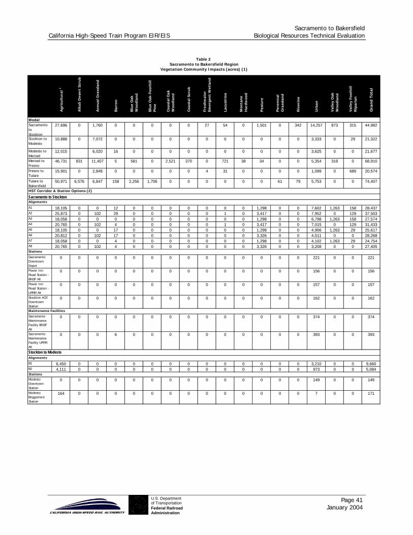
Sacramento to Bakersfield California High-Speed Train Program EIR/EIS Biological Resources Technical Evaluation
Page 41 January 2004
U.S. Departmentof TransportationFederal RailroadAdministration
Agr
icu
ltu
ral 1
Alk
ali D
eser
t Sc
rub
An
nu
al G
rass
lan
d
Bar
ren
Blu
e O
ak
Woo
dlan
d
Blu
e O
ak-F
ooth
ill
Pin
e
Coa
stal
Oak
W
oodl
and
Coa
stal
Scr
ub
Fres
hw
ater
Em
erge
nt
Wet
lan
d
Lacu
stri
ne
Mon
tan
e H
ardw
ood
Pas
ture
Per
enn
ial
Gra
ssla
nd
Riv
erin
e
Urb
an
Val
ley
Oak
W
oodl
and
Val
ley
Foot
hill
R
ipar
ian
Gra
nd
Tota
l
ModalSacramento toStockton
27,696 0 1,760 0 0 0 0 0 27 54 0 1,501 0 342 14,257 873 315 44,982
Stockton to Modesto
10,888 0 7,072 0 0 0 0 0 0 0 0 0 0 0 3,333 0 29 21,322
Modesto to Merced
12,015 6,020 16 0 0 0 0 0 0 0 0 0 0 3,625 0 0 21,677
Merced to Fresno
46,731 831 11,407 5 581 0 2,521 370 0 721 38 34 0 0 5,354 318 0 68,910
Fresno to Tulare
15,901 0 2,849 0 0 0 0 0 4 31 0 0 0 0 1,099 0 689 20,574
Tulare to Bakersfield
50,971 6,576 6,847 158 2,256 1,706 0 0 0 0 0 0 61 79 5,753 0 0 74,407
HST Corridor & Station Options (2)
Sacramento to StocktonAlignments
A1 18,105 0 0 12 0 0 0 0 0 0 0 1,298 0 0 7,602 1,263 158 28,437A2 25,873 0 102 29 0 0 0 0 0 1 0 3,417 0 0 7,952 0 129 37,503A3 18,058 0 0 0 0 0 0 0 0 0 0 1,298 0 0 6,798 1,263 158 27,574A4 20,765 0 102 4 0 0 0 0 0 1 0 3,417 0 0 7,015 0 129 31,433A5 18,105 0 0 17 0 0 0 0 0 0 0 1,298 0 0 4,906 1,263 29 25,617A6 20,812 0 102 17 0 0 0 0 0 0 0 3,326 0 0 4,011 0 0 28,268A7 18,058 0 0 4 0 0 0 0 0 0 0 1,298 0 0 4,102 1,263 29 24,754A8 20,765 0 102 4 0 0 0 0 0 0 0 3,326 0 0 3,208 0 0 27,405Stations
Sacramento Downtown Depot
0 0 0 0 0 0 0 0 0 0 0 0 0 0 221 0 0 221
Power Inn Road Station - BNSF Alt
0 0 0 0 0 0 0 0 0 0 0 0 0 0 156 0 0 156
Power Inn Road Station - UPRR Alt
0 0 0 0 0 0 0 0 0 0 0 0 0 0 157 0 0 157
Stockton ACE Downtown Station
0 0 0 0 0 0 0 0 0 0 0 0 0 0 162 0 0 162
Maintenance Facilities
Sacramento Maintenance Facility BNSF Alt
0 0 0 0 0 0 0 0 0 0 0 0 0 0 374 0 0 374
Sacramento Maintenance Facility UPRR Alt
0 0 0 6 0 0 0 0 0 0 0 0 0 0 393 0 0 393
Stockton to ModestoAlignments
B1 6,450 0 0 0 0 0 0 0 0 0 0 0 0 0 3,210 0 0 9,660B2 4,111 0 0 0 0 0 0 0 0 0 0 0 0 0 973 0 0 5,084StationsModesto Downtown Station
0 0 0 0 0 0 0 0 0 0 0 0 0 0 149 0 0 149
Modesto Briggsmore Station
164 0 0 0 0 0 0 0 0 0 0 0 0 0 7 0 0 171
Table 2
Vegetation Community Impacts (acres) (1)Sacramento to Bakersfield Region

Sacramento to Bakersfield California High-Speed Train Program EIR/EIS Biological Resources Technical Evaluation
Page 42 January 2004
U.S. Departmentof TransportationFederal RailroadAdministration
Agr
icu
ltu
ral 1
Alk
ali D
eser
t Sc
rub
An
nu
al G
rass
lan
d
Bar
ren
Blu
e O
ak
Woo
dlan
d
Blu
e O
ak-F
ooth
ill
Pin
e
Coa
stal
Oak
W
oodl
and
Coa
stal
Scr
ub
Fres
hw
ater
Em
erge
nt
Wet
lan
d
Lacu
stri
ne
Mon
tan
e H
ardw
ood
Pas
ture
Per
enn
ial
Gra
ssla
nd
Riv
erin
e
Urb
an
Val
ley
Oak
W
oodl
and
Val
ley
Foot
hill
R
ipar
ian
Gra
nd
Tota
l
Modesto to MercedAlignments
C1 18,150 0 0 0 0 0 0 0 0 0 0 0 0 0 2,172 0 0 20,322C2 21,860 0 0 0 0 0 0 0 0 0 0 0 0 0 2,517 0 0 24,377C3 14,694 0 0 0 0 0 0 0 0 0 0 0 0 0 2,164 0 0 16,858C4 18,503 0 0 0 0 0 0 0 0 0 0 0 0 0 2,509 0 0 21,012C5 10,011 0 29 0 0 0 0 0 0 0 0 0 0 0 1,887 0 0 11,928C6 13,575 0 29 0 0 0 0 0 0 0 0 0 0 0 2,090 0 0 15,695C7 10,006 0 29 0 0 0 0 0 0 0 0 0 0 0 1,887 0 0 11,923C8 13,669 0 29 0 0 0 0 0 0 0 0 0 0 0 2,090 0 0 15,788C9 8,168 0 0 0 0 0 0 0 0 0 0 0 0 0 2,260 0 0 10,428C10 8,266 0 0 0 0 0 0 0 0 0 0 0 0 0 2,260 0 0 10,526C11 11,183 0 29 0 0 0 0 0 0 0 0 0 0 0 1,274 0 0 12,487C12 11,282 0 29 0 0 0 0 0 0 0 0 0 0 0 1,274 0 0 12,585C13 13,373 0 86 0 0 0 0 0 0 0 0 0 0 0 1,689 0 0 15,148C14 12,201 0 86 0 0 0 0 0 0 0 0 0 0 0 2,302 0 0 14,589C15 13,471 0 86 0 0 0 0 0 0 0 0 0 0 0 1,689 0 0 15,247C16 12,196 0 86 0 0 0 0 0 0 0 0 0 0 0 2,302 0 0 14,584Stations
Merced Downtown Station
0 0 0 0 0 0 0 0 0 0 0 0 0 0 155 0 0 155
Merced Municipal Airport Station
94 0 0 0 0 0 0 0 0 0 0 0 0 0 125 0 0 219
Castle Air Force Base Station
163 0 0 0 0 0 0 0 0 0 0 0 0 0 55 0 0 218
Merced to Fresno Alignments
D1 13,660 0 1,760 308 10 0 0 0 0 0 0 0 0 0 3,530 0 0 19,268D2 21,816 0 1,760 308 10 0 0 0 0 0 0 0 0 0 3,570 0 0 27,464D3 11,604 0 1,760 308 10 0 0 0 0 0 0 0 0 0 3,784 0 0 17,466D4 18,705 0 1,760 308 10 0 0 0 0 0 0 0 0 0 4,017 0 0 24,800D5 11,079 0 408 0 0 0 0 0 0 0 0 28 0 0 4,283 0 0 15,798D6 17,673 0 408 0 0 0 0 0 0 0 0 121 0 0 4,516 0 0 22,718D7 13,134 0 408 0 0 0 0 0 0 0 0 28 0 0 4,029 0 0 17,600D8 20,784 0 408 0 0 0 0 0 0 0 0 121 0 0 4,069 0 0 25,382Stations
Fresno Downtown Station
0 0 0 0 0 0 0 0 0 0 0 0 0 0 144 0 0 0
Fresno to TulareAlignments
E1 7,626 0 0 0 0 0 0 0 0 3 0 0 0 0 1,553 0 404 9,585E2 8,380 0 0 0 0 0 0 0 0 0 0 0 0 0 773 0 0 9,153StationsVisalia Airport Station
146 0 0 0 0 0 0 0 0 0 0 0 0 0 70 0 0 216
Hanford Station 0 0 0 0 0 0 0 0 0 0 0 0 0 0 128 0 0 128
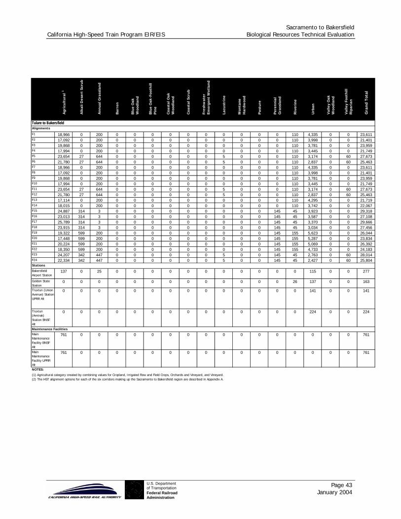
Sacramento to Bakersfield California High-Speed Train Program EIR/EIS Biological Resources Technical Evaluation
Page 43 January 2004
U.S. Departmentof TransportationFederal RailroadAdministration
Agr
icu
ltu
ral 1
Alk
ali D
eser
t Sc
rub
An
nu
al G
rass
lan
d
Bar
ren
Blu
e O
ak
Woo
dlan
d
Blu
e O
ak-F
ooth
ill
Pin
e
Coa
stal
Oak
W
oodl
and
Coa
stal
Scr
ub
Fres
hw
ater
Em
erge
nt
Wet
lan
d
Lacu
stri
ne
Mon
tan
e H
ardw
ood
Pas
ture
Per
enn
ial
Gra
ssla
nd
Riv
erin
e
Urb
an
Val
ley
Oak
W
oodl
and
Val
ley
Foot
hill
R
ipar
ian
Gra
nd
Tota
l
Tulare to BakersfieldAlignments
F1 18,966 0 200 0 0 0 0 0 0 0 0 0 0 110 4,335 0 0 23,611F2 17,092 0 200 0 0 0 0 0 0 0 0 0 0 110 3,998 0 0 21,401F3 19,868 0 200 0 0 0 0 0 0 0 0 0 0 110 3,781 0 0 23,959F4 17,994 0 200 0 0 0 0 0 0 0 0 0 0 110 3,445 0 0 21,749F5 23,654 27 644 0 0 0 0 0 0 5 0 0 0 110 3,174 0 60 27,673F6 21,780 27 644 0 0 0 0 0 0 5 0 0 0 110 2,837 0 60 25,463F7 18,966 0 200 0 0 0 0 0 0 0 0 0 0 110 4,335 0 0 23,611F8 17,092 0 200 0 0 0 0 0 0 0 0 0 0 110 3,998 0 0 21,401F9 19,868 0 200 0 0 0 0 0 0 0 0 0 0 110 3,781 0 0 23,959F10 17,994 0 200 0 0 0 0 0 0 0 0 0 0 110 3,445 0 0 21,749F11 23,654 27 644 0 0 0 0 0 0 5 0 0 0 110 3,174 0 60 27,673F12 21,780 27 644 0 0 0 0 0 0 5 0 0 0 110 2,837 0 60 25,463F13 17,114 0 200 0 0 0 0 0 0 0 0 0 0 110 4,295 0 0 21,719F14 18,015 0 200 0 0 0 0 0 0 0 0 0 0 110 3,742 0 0 22,067F15 24,887 314 3 0 0 0 0 0 0 0 0 0 145 45 3,923 0 0 29,318F16 23,013 314 3 0 0 0 0 0 0 0 0 0 145 45 3,587 0 0 27,108F17 25,789 314 3 0 0 0 0 0 0 0 0 0 145 45 3,370 0 0 29,666F18 23,915 314 3 0 0 0 0 0 0 0 0 0 145 45 3,034 0 0 27,456F19 19,322 599 200 0 0 0 0 0 0 0 0 0 145 155 5,623 0 0 26,044F20 17,448 599 200 0 0 0 0 0 0 0 0 0 145 155 5,287 0 0 23,834F21 20,224 599 200 0 0 0 0 0 0 0 0 0 145 155 5,069 0 0 26,392F22 18,350 599 200 0 0 0 0 0 0 0 0 0 145 155 4,733 0 0 24,183F23 24,207 342 447 0 0 0 0 0 0 5 0 0 145 45 2,763 0 60 28,014F24 22,334 342 447 0 0 0 0 0 0 5 0 0 145 45 2,427 0 60 25,804Stations
Bakersfield Airport Station
137 0 25 0 0 0 0 0 0 0 0 0 0 0 115 0 0 277
Golden State Station
0 0 0 0 0 0 0 0 0 0 0 0 0 26 137 0 0 163
Truxtun (Union Avenue) Station UPRR Alt
0 0 0 0 0 0 0 0 0 0 0 0 0 0 141 0 0 141
Truxtun (Amtrak) Station BNSF Alt
0 0 0 0 0 0 0 0 0 0 0 0 0 0 224 0 0 224
Maintenance FacilitiesMain Maintenance Facility BNSF Alt
761 0 0 0 0 0 0 0 0 0 0 0 0 0 0 0 0 761
Main Maintenance Facility UPRR Alt
761 0 0 0 0 0 0 0 0 0 0 0 0 0 0 0 0 761
NOTES:
(1) Agricultural category created by combining values for Cropland, Irrigated Row and Field Crops, Orchards and Vineyard, and Vineyard.(2) The HST alignment options for each of the six corridors making up the Sacramento to Bakersfield region are described in Appendix A.
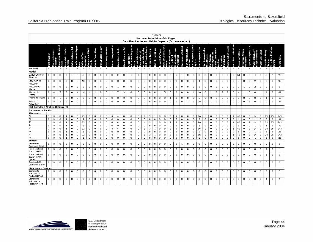
Sacramento to Bakersfield California High-Speed Train Program EIR/EIS Biological Resources Technical Evaluation
Page 44 January 2004
U.S. Departmentof TransportationFederal RailroadAdministration
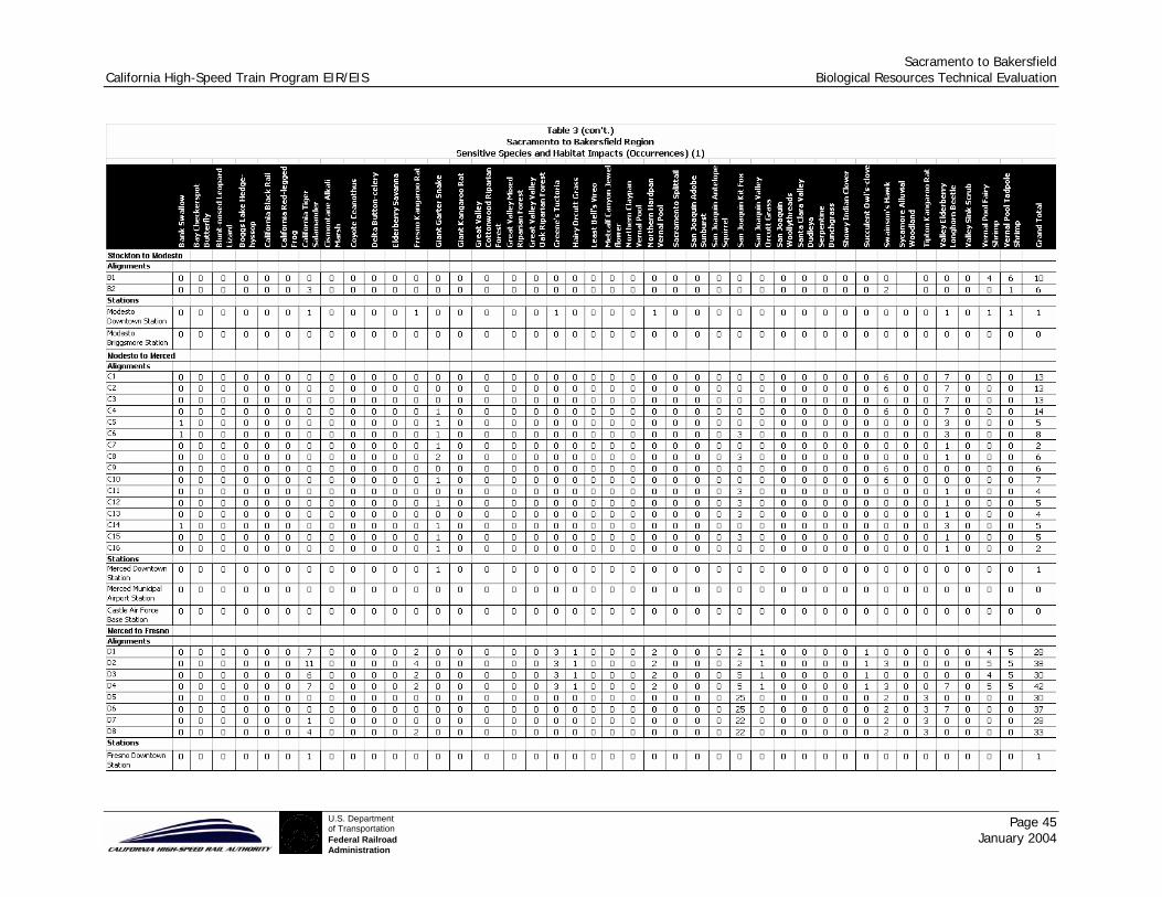
Sacramento to Bakersfield California High-Speed Train Program EIR/EIS Biological Resources Technical Evaluation
Page 45 January 2004
U.S. Departmentof TransportationFederal RailroadAdministration
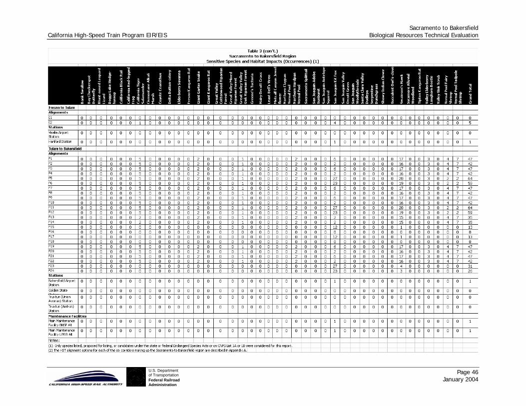
Sacramento to Bakersfield California High-Speed Train Program EIR/EIS Biological Resources Technical Evaluation
Page 46 January 2004
U.S. Departmentof TransportationFederal RailroadAdministration
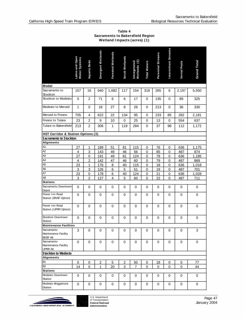
Sacramento to Bakersfield California High-Speed Train Program EIR/EIS Biological Resources Technical Evaluation
Page 47 January 2004
U.S. Departmentof TransportationFederal RailroadAdministration
Lake
s an
d O
pen
W
ater
Sys
tem
s
Aqu
atic
Bed
s
Emer
gen
t W
etla
nds
Fore
sted
Wet
lan
ds
Scru
b W
etla
nds
Un
vege
tate
d W
etla
nds
(2)
Tida
l Wat
ers
Per
enn
ial S
trea
ms
Inte
rmit
ten
t St
ream
s
Ver
nal
Poo
ls
Gra
nd
Tota
l
ModalSacramento toStockton
157 16 640 1,682 117 154 318 265 6 2,197 5,550
Stockton to Modesto 0 2 71 6 6 17 0 135 0 89 325
Modesto to Merced 1 0 18 27 8 26 0 213 0 36 330
Merced to Fresno 705 4 622 22 134 95 0 233 85 282 2,181Fresno to Tulare 23 2 9 10 0 25 0 13 0 554 637Tulare to Bakersfield 213 2 306 1 119 284 0 37 98 112 1,172
HST Corridor & Station Options (3)Sacramento to StocktonAlignmentsA1 27 1 189 51 81 115 0 76 0 636 1,175A2 4 3 143 49 46 56 0 85 0 487 874A3 27 0 191 49 81 124 0 78 0 636 1,185A4 4 2 142 47 46 60 0 79 0 487 869A5 23 1 176 8 40 115 0 18 0 636 1,018A6 3 3 126 6 5 51 0 19 0 487 701A7 23 0 178 6 40 124 0 21 0 636 1,028A8 3 2 127 4 5 60 0 22 0 487 711StationsSacramento Downtown Depot
0 0 0 0 0 0 0 0 0 0 0
Power Inn Road Station (BNSF Option)
0 0 0 0 0 0 0 0 0 0 0
Power Inn Road Station (UPRR Option)
0 0 0 0 0 0 0 0 0 0 0
Stockton Downtown Station
0 0 0 0 0 0 0 0 0 0 0
Maintenance FacilitiesSacramento Maintenance Facility BNSF Alt
3 0 0 0 0 0 0 0 0 0 3
Sacramento Maintenance Facility UPRR Alt
0 0 0 0 0 0 0 0 0 0 0
Stockton to ModestoAlignmentsB1 0 0 2 5 2 50 0 18 0 0 77B2 14 0 1 20 3 7 0 0 0 0 44StationsModesto Downtown Station
0 0 0 0 0 0 0 0 0 0 0
Modesto Briggsmore Station
0 0 0 0 0 0 0 0 0 0 0
Table 4Sacramento to Bakersfield Region
Wetland Impacts (acres) (1)

Sacramento to Bakersfield California High-Speed Train Program EIR/EIS Biological Resources Technical Evaluation
Page 48 January 2004
U.S. Departmentof TransportationFederal RailroadAdministration
Lake
s an
d O
pen
W
ater
Sys
tem
s
Aqu
atic
Bed
s
Emer
gen
t W
etla
nds
Fore
sted
Wet
lan
ds
Scru
b W
etla
nds
Un
vege
tate
d W
etla
nds
(2
)
Tida
l Wat
ers
Per
enn
ial S
trea
ms
Inte
rmit
ten
t St
ream
s
Ver
nal
Poo
ls
Gra
nd
Tota
l
Modesto to MercedAlignmentsC1 10 1 5 0 0 70 0 0 22 0 107C2 10 2 10 0 7 75 0 0 22 0 126C3 10 0 3 12 0 30 0 0 0 0 54C4 10 1 5 19 0 35 0 0 0 0 69C5 0 2 23 7 8 21 0 52 0 0 113C6 0 4 32 7 16 31 0 52 0 0 141C7 0 2 19 15 1 16 0 52 0 0 107C8 0 4 26 22 1 26 0 52 0 0 131C9 10 1 8 0 7 14 0 0 0 0 40C10 10 1 5 6 0 14 0 0 0 0 36C11 0 4 26 3 8 21 0 37 0 0 99C12 0 4 132 3 7 55 0 54 0 487 742C13 0 4 26 3 8 22 0 37 0 0 100C14 0 2 23 7 8 21 0 52 0 0 114C15 0 4 23 10 1 22 0 37 0 0 96C16 10 0 3 9 1 13 0 16 0 55 107StationsMerced Downtown Station
0 0 0 0 0 0 0 0 0 0 0
Merced Municipal Airport Station
0 0 0 0 0 0 0 0 0 0 0
Castle Air Force Base Station
0 0 0 0 0 0 0 0 0 0 0
Merced to Fresno AlignmentsD1 13 0 12 10 2 37 0 19 41 1,295 1,429D2 13 0 15 14 2 40 0 49 41 1,295 1,470D3 13 0 10 10 2 29 0 19 41 1,295 1,419D4 13 0 10 14 2 36 0 49 41 1,295 1,460D5 0 0 12 6 1 26 0 11 27 155 237D6 0 0 12 6 1 43 0 23 27 155 267D7 0 0 14 6 1 33 0 11 27 155 247D8 1 0 17 6 1 48 0 23 27 155 276StationsFresno Downtown Station
0 0 0 0 0 0 0 0 0 0 0
Fresno to TulareAlignmentsE1 7 6 4 13 0 22 0 17 0 322 390E2 10 0 15 11 3 40 0 14 0 0 94StationsVisalia Airport Station 0 0 0 0 0 0 0 0 0 0 0
Hanford Station 0 0 0 0 0 0 0 0 0 0 0

Sacramento to Bakersfield California High-Speed Train Program EIR/EIS Biological Resources Technical Evaluation
Page 49 January 2004
U.S. Departmentof TransportationFederal RailroadAdministration
Lake
s an
d O
pen
W
ater
Sys
tem
s
Aqu
atic
Bed
s
Emer
gen
t W
etla
nds
Fore
sted
Wet
lan
ds
Scru
b W
etla
nds
Un
vege
tate
d W
etla
nds
(2
)
Tida
l Wat
ers
Per
enn
ial S
trea
ms
Inte
rmit
ten
t St
ream
s
Ver
nal
Poo
ls
Gra
nd
Tota
l
Tulare to BakersfieldAlignmentsF1 0 2 4 0 0 46 0 1 37 66 156F2 0 2 4 0 0 46 0 1 37 66 156F3 0 2 4 0 0 48 0 1 37 66 159F4 0 2 4 0 0 48 0 1 37 66 159F5 64 5 18 0 0 56 0 10 7 1,815 1,974F6 64 5 18 0 0 56 0 10 7 1,815 1,974F7 0 2 4 0 0 46 0 1 37 66 156F8 0 2 4 0 0 46 0 1 37 66 156F9 0 2 4 0 0 48 0 1 37 66 159F10 0 2 4 0 0 48 0 1 37 66 159F11 64 5 18 0 0 56 0 10 7 1,815 1,974F12 64 5 18 0 0 56 0 10 7 1,815 1,974F13 0 2 4 0 0 46 0 1 37 66 156F14 0 2 4 0 0 48 0 1 37 66 159F15 0 2 6 1 0 96 0 1 78 66 251F16 0 2 6 1 0 96 0 1 78 66 251F17 0 2 6 1 0 99 0 1 78 66 254F18 0 2 6 1 0 99 0 1 78 66 254F19 0 2 4 1 0 46 0 1 70 66 191F20 0 2 4 1 0 46 0 1 70 66 191F21 0 2 4 1 0 49 0 1 70 66 193F22 0 2 4 1 0 49 0 1 70 66 193F23 64 3 16 1 0 63 0 3 40 1,815 2,005F24 64 3 16 1 0 63 0 3 40 1,815 2,005StationsBakersfield Airport Station
0 0 0 0 0 0 0 0 0 0 0
Golden State Station 0 0 0 0 0 0 0 0 0 0 0Truxtun (Union Avenue) Station
0 0 0 0 0 0 0 0 0 0 0
Truxtun (Amtrak) Station
0 0 0 0 0 0 0 0 0 0 0
Maintenance FacilitiesMain Maintenance Facility BNSF Alt
0 0 0 0 0 13 0 0 0 0 13
Main Maintenance Facility UPRR Alt
0 0 0 0 0 4 0 0 1 0 5
NOTES:
(1) Wetland data from NWI, with similar types combined for ease of presentation.(2) Unvegetated Wetlands a combination of Palustrine Unconsolidated Bottom and Palustrine Unconsolidated Shore NWI types where the common feature is less than 30 percent vegetative cover.(3) The HST alignment options for each of the six corridors making up the Sacramento to Bakersfield region are described in Appe

Sacramento to Bakersfield California High-Speed Train Program EIR/EIS Biological Resources Technical Evaluation
Page 50 January 2004
U.S. Departmentof TransportationFederal RailroadAdministration
Lake
s an
d O
pen
W
ater
Sys
tem
s
Aqu
atic
Bed
s
Emer
gen
t W
etla
nds
Fore
sted
Wet
lan
ds
Scru
b W
etla
nds
Un
vege
tate
d W
etla
nds
(3
)
Tida
l Wat
ers
Per
enn
ial S
trea
ms
Inte
rmit
ten
t St
ream
s
Ver
nal
Poo
ls
Gra
nd
Tota
l
ModalSacramento toStockton
504 123 1,168 3,005 128 218 612 368 37 7,409 13,573
Stockton to Modesto
0 0 400 0 0 0 0 224 0 0 624
Modesto to Merced 0 0 0 0 0 0 0 175 0 438 612
Merced to Fresno 758 0 96 233 251 155 0 405 200 0 2,098
Fresno to Tulare 0 0 0 0 0 0 0 153 0 537 690Tulare to Bakersfield
0 0 0 0 0 41 0 92 137 221 491
HST Corridor & Station Options (4)Sacramento to StocktonAlignmentsA1 0 0 1,055 61 263 226 0 100 0 2,496 4,201A2 0 0 862 0 102 81 0 127 0 1,307 2,479A3 0 0 913 61 263 487 0 114 0 2,496 4,332A4 0 0 719 0 102 342 0 111 0 1,307 2,581A5 0 0 859 61 161 226 0 100 0 2,496 3,902A6 0 0 665 0 0 81 0 98 0 1,307 2,151A7 0 0 716 61 161 487 0 114 0 2,496 4,034A8 0 0 523 0 0 342 0 111 0 1,307 2,283StationsSacramento Downtown Depot
0 0 0 0 0 0 0 0 0 0 0
Power Inn Road Station (BNSF Option)
0 0 0 0 0 0 0 0 0 0 0
Power Inn Road Station (UPRR Option)
0 0 0 0 0 0 0 0 0 0 0
Stockton Downtown Station
0 0 0 0 0 0 0 0 0 0 0
Maintenance FacilitiesSacramento Maintenance Facility BNSF Alt
0 0 0 0 0 0 0 0 0 0 0
Sacramento Maintenance Facility UPRR Alt
0 0 0 0 0 0 0 0 0 0 0
Table 5Sacramento to Bakersfield RegionWetland Impacts (meters) (1)(2)
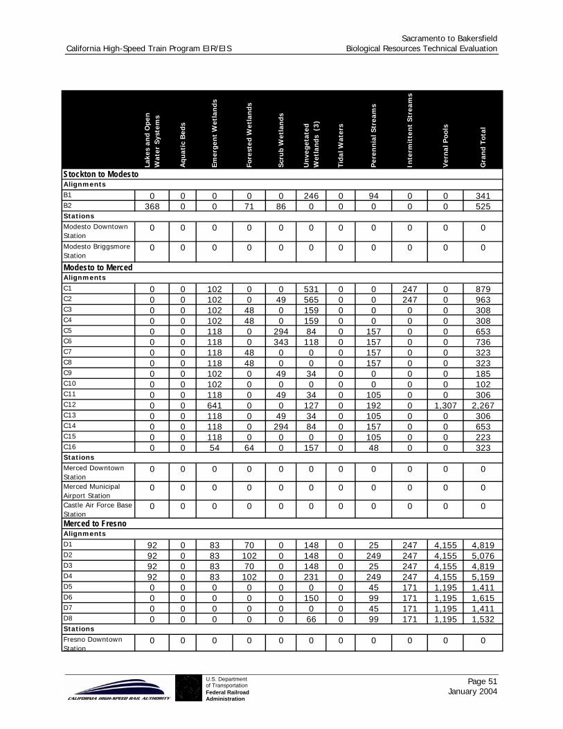
Sacramento to Bakersfield California High-Speed Train Program EIR/EIS Biological Resources Technical Evaluation
Page 51 January 2004
U.S. Departmentof TransportationFederal RailroadAdministration
Lake
s an
d O
pen
W
ater
Sys
tem
s
Aqu
atic
Bed
s
Emer
gen
t W
etla
nds
Fore
sted
Wet
lan
ds
Scru
b W
etla
nds
Un
vege
tate
d W
etla
nds
(3)
Tida
l Wat
ers
Per
enn
ial S
trea
ms
Inte
rmit
ten
t St
ream
s
Ver
nal
Poo
ls
Gra
nd
Tota
l
Stockton to ModestoAlignmentsB1 0 0 0 0 0 246 0 94 0 0 341B2 368 0 0 71 86 0 0 0 0 0 525StationsModesto Downtown Station
0 0 0 0 0 0 0 0 0 0 0
Modesto Briggsmore Station
0 0 0 0 0 0 0 0 0 0 0
Modesto to MercedAlignmentsC1 0 0 102 0 0 531 0 0 247 0 879C2 0 0 102 0 49 565 0 0 247 0 963C3 0 0 102 48 0 159 0 0 0 0 308C4 0 0 102 48 0 159 0 0 0 0 308C5 0 0 118 0 294 84 0 157 0 0 653C6 0 0 118 0 343 118 0 157 0 0 736C7 0 0 118 48 0 0 0 157 0 0 323C8 0 0 118 48 0 0 0 157 0 0 323C9 0 0 102 0 49 34 0 0 0 0 185C10 0 0 102 0 0 0 0 0 0 0 102C11 0 0 118 0 49 34 0 105 0 0 306C12 0 0 641 0 0 127 0 192 0 1,307 2,267C13 0 0 118 0 49 34 0 105 0 0 306C14 0 0 118 0 294 84 0 157 0 0 653C15 0 0 118 0 0 0 0 105 0 0 223C16 0 0 54 64 0 157 0 48 0 0 323StationsMerced Downtown Station
0 0 0 0 0 0 0 0 0 0 0
Merced Municipal Airport Station
0 0 0 0 0 0 0 0 0 0 0
Castle Air Force Base Station
0 0 0 0 0 0 0 0 0 0 0
Merced to Fresno AlignmentsD1 92 0 83 70 0 148 0 25 247 4,155 4,819D2 92 0 83 102 0 148 0 249 247 4,155 5,076D3 92 0 83 70 0 148 0 25 247 4,155 4,819D4 92 0 83 102 0 231 0 249 247 4,155 5,159D5 0 0 0 0 0 0 0 45 171 1,195 1,411D6 0 0 0 0 0 150 0 99 171 1,195 1,615D7 0 0 0 0 0 0 0 45 171 1,195 1,411D8 0 0 0 0 0 66 0 99 171 1,195 1,532StationsFresno Downtown Station
0 0 0 0 0 0 0 0 0 0 0

Sacramento to Bakersfield California High-Speed Train Program EIR/EIS Biological Resources Technical Evaluation
Page 52 January 2004
U.S. Departmentof TransportationFederal RailroadAdministration
Lake
s an
d O
pen
W
ater
Sys
tem
s
Aqu
atic
Bed
s
Emer
gen
t W
etla
nds
Fore
sted
Wet
lan
ds
Scru
b W
etla
nds
Un
vege
tate
d W
etla
nds
(3
)
Tida
l Wat
ers
Per
enn
ial S
trea
ms
Inte
rmit
ten
t St
ream
s
Ver
nal
Poo
ls
Gra
nd
Tota
l
Fresno to TulareAlignmentsE1 0 0 70 126 0 48 0 109 0 1,878 2,230E2 0 0 42 0 46 188 0 46 0 0 323StationsVisalia Airport Station 0 0 0 0 0 0 0 0 0 0 0
Hanford Station 0 0 0 0 0 0 0 0 0 0 0Tulare to BakersfieldAlignmentsF1 0 0 20 0 0 492 0 0 175 0 687F2 0 0 20 0 0 492 0 0 175 0 687F3 0 0 20 0 0 545 0 0 175 0 740F4 0 0 20 0 0 545 0 0 175 0 740F5 0 69 0 0 0 766 0 30 20 7,785 8,671F6 0 69 0 0 0 766 0 30 20 7,785 8,671F7 0 0 20 0 0 492 0 0 175 0 687F8 0 0 20 0 0 492 0 0 175 0 687F9 0 0 20 0 0 545 0 0 175 0 740F10 0 0 20 0 0 545 0 0 175 0 740F11 0 69 0 0 0 766 0 30 20 7,785 8,671F12 0 69 0 0 0 766 0 30 20 7,785 8,671F13 0 0 20 0 0 492 0 0 175 0 687F14 0 0 20 0 0 545 0 0 175 0 740F15 0 0 170 0 0 867 0 0 659 0 1,695F16 0 0 170 0 0 867 0 0 659 0 1,695F17 0 0 170 0 0 920 0 0 659 0 1,748F18 0 0 170 0 0 920 0 0 659 0 1,748F19 0 0 20 0 0 492 0 0 476 0 988F20 0 0 20 0 0 492 0 0 476 0 988F21 0 0 20 0 0 545 0 0 476 0 1,041F22 0 0 20 0 0 545 0 0 476 0 1,041F23 0 69 149 0 0 713 0 0 321 7,785 9,038F24 0 69 149 0 0 713 0 0 321 7,785 9,038StationsBakersfield Airport Station
0 0 0 0 0 0 0 0 0 0 0
Golden State Station 0 0 0 0 0 0 0 0 0 0 0Truxtun (Union Avenue) Station
0 0 0 0 0 0 0 0 0 0 0
Truxtun (Amtrak) Station
0 0 0 0 0 0 0 0 0 0 0
Maintenance FacilitiesMain Maintenance Facility BNSF Alt
0 0 0 0 0 0 0 0 0 0 0
Main Maintenance Facility UPRR Alt
0 0 0 0 0 0 0 0 0 0 0
NOTES:
(1) Wetland data from NWI, with similar types combined for ease of presentation.(2) No length data is avaialble for station related wetland impacts.(3) Unvegetated Wetalnds a combination of Palustrine Unconsolidated Bottom and Palustrine Unconsolidated Shore NWI types where the common feature is less than 30 percent vegetative cover.(4) The HST alignment options for each of the six corridors making up the Sacramento to Bakersfield region are described in Appendix A.

Sacramento to Bakersfield California High-Speed Train Program EIR/EIS Biological Resources Technical Evaluation
Page 53 January 2004
U.S. Departmentof TransportationFederal RailroadAdministration
4.2.2 Stockton to Modesto Corridor
The Modal Alternative in the Stockton to Modesto Corridor would have a low potential impact to vegetation communities, as almost all the land in this stretch is agricultural, urban, or annual grasses (see Table 2). California tiger salamander and California red-legged frog have each been recorded at ten locations in this corridor (see Table 3), and there would be a high potential to affect these T&E species with construction and operation of the roadway widenings, compared to other corridors for the Modal Alternative in the Sacramento to Bakersfield region. Of the wetlands in this corridor, the greatest amount is of the perennial stream ecosystems (see Table 4). The Modal Alternative would have a medium potential to affect perennial streams in the Stockton to Modesto Corridor. However, the highway improvements in this corridor cross or potentially come in contact with 400 meters of emergent wetlands and are therefore rated as having a high potential for wildlife habitat risk (see Table 5). The amount of perennial streams and the high contact with emergent wetlands also means that the Modal Alternative has a potential to affect fish resources in this corridor.
4.2.3 Modesto to Merced Corridor
The Modesto to Merced Corridor would also have a low potential to affect native vegetation communities (see Table 3) and a high potential for wildlife habitat based on the relatively great amount of wetlands (see Table 4). Approximately 330 acres of wetlands could be affected by the Modal Alternative, with about 438 meters contacting vernal pools (see Table 5). This latter condition also suggests that the Modal Alternative has a potential to affect fish resources. The Modesto to Merced Corridor would encounter relatively few T&E species. Compared to the other corridors, this corridor is characterized by the least amount of natural resources that could be disturbed by the Modal Alternative.
4.2.4 Modesto to Fresno Corridor
This corridor is the most varied among in the Sacramento to Bakersfield region in terms of vegetation communities (see Table 3). Over 700 acres of open water systems, 280 acres of vernal pools, various other wetland acreages totaling more than 2,180 acres, over 2,500 acres of coastal oak woodlands, and over 830 acres of alkali desert scrub make this area subject to potentially high impacts from the Modal Alternative. In addition, a high occurrence of California tiger salamander, giant garter snake, and San Joaquin kit fox are in this corridor and subject to disturbance by construction and operation of the Modal Alternative. After the Sacramento to Stockton Corridor, this corridor has the greatest number of occurrences of T&E species (see Table 3).
4.2.5 Fresno to Tulare Corridor
This corridor would be rated as having a low potential to affect sensitive vegetation communities, even though it contains more Valley foothill riparian vegetation any other corridor in the Sacramento to Bakersfield region. The Modal Alternative would have a low potential to affect T&E species based on occurrence information (see Table 3). One blunt-nosed leopard lizard record, three giant kangaroo occurrences, and six San Joaquin kit fox sightings are notable. While the amount of wetlands that could be affected in this corridor is medium, virtually all of the wetland acreage occurs as vernal pools. Compared to the other corridors, this corridor ranks as second lowest in potential impacts.
4.2.6 Tulare to Bakersfield Corridor
The Tulare to Bakersfield Corridor contains substantial acreage in alkali desert scrub, blue oak woodland, and blue oak foothill pine that could be disturbed by the improvements proposed under the Modal Alternative (see Table 2). In addition, this corridor has the greatest number of occurrences of San Joaquin kit fox in the entire Sacramento to Bakersfield region. Overall, potential impacts to T&E species and to wetlands would be rated as medium, compared to other corridors.
Sacramento to Bakersfield California High-Speed Train Program EIR/EIS Biological Resources Technical Evaluation
Page 54 January 2004
U.S. Departmentof TransportationFederal RailroadAdministration
4.3 HIGH-SPEED TRAIN ALTERNATIVE
The HST Alternative traverses a varied biological landscape, encountering many of the same vegetation communities, wildlife and sensitive habitats, and T&E species as the Modal Alternative. However, a noticeable difference is the smaller amounts of sensitive biological resources, habitats, and T&E species that are located within the HST Alternative study area compared to the Modal Alternative. As a result, the potential impact ratings for the HST Alternative tend to be comparable to or lower than those for the Modal Alternative.
The HST station and maintenance facility options in the Sacramento to Bakersfield region are almost entirely urbanized, so that there are relatively few natural vegetation communities that might be adversely affected. Several of the stations and maintenance facilities occur in predominantly agricultural areas where, again, the natural vegetation communities have been disturbed and consequently no impacts to biologically sensitive vegetation communities would be expected. The only station or maintenance facility that might affect a riverine community is the Bakersfield Golden State Station near the Kern River. The study area defined around the station site includes 26 acres of this community and would result in a medium potential effect, compared to the other stations and maintenance facilities in the Sacramento to Bakersfield region. Because the station and maintenance facility options, except the Golden State Station, would not affect biological resources, the following evaluation of the HST Alternative focuses on the alignment options.
4.3.1 Sacramento to Stockton Corridor
This corridor has eight alignment options. Depending on final construction details, all routes in this corridor have a significant potential to disturb natural resources, including anadromous fish. None of the alignment options in this corridor would disturb a substantial acreage of vegetation communities (see Table 2). The alignments following the UP (i.e., A1, A3, A5, and A7) could potentially affect valley oak woodlands and valley foothill riparian habitats. In contrast, the other alignment options that follow the CCT right-of-way would affect annual grasslands. Alignment options in this corridor would have a high potential to encounter T&E species and wetlands (see Tables 3 and 4). The UP alignment options are noteworthy in that over 240 occurrences of T&E species have been recorded in their vicinity. A high potential exists to affect San Joaquin kit fox, Swainson’s hawk, the California Tiger Salamander. The lengths of alignments, potentially affecting wetlands, range from 2,151 meters up to 4,332 meters. In these alignment options, the CCT routes are considered as medium in potential impact. Comparatively, the lowest potential encroachment is A6, which, including the study area, totals a significant 701 wetland acres (including 487 acres of vernal pools). The other routes that follow the CCT (i.e., A2, A4 and A8) have similar but slightly higher totals. All of the UP routes are rated as having a high potential to disturb wetlands. A1 at 1,175 acres and A3 at 1185 acres, both along the UP route, encroach on the most wetland acreage and have the highest linear contact totaling 4200+ meters.
4.3.2 Stockton to Modesto Corridor
This corridor has two alignments and there is no notable difference between the two options for impact to biological resources. There are no vegetation communities along these alignments, as the land is either in urban or agricultural uses. Between 6 and 10 T&E species could be affected by the HST right-of-way (see Table 3). All of the T&E species along B1, which follows the UP, are vernal pool species. By contrast, B2 along the BNSF encounters relatively few occurrences of California tiger salamander, Swainson’s hawk, and vernal pool tadpole shrimp.
The potential for impact to wildlife habitat is considered low. However, B1 crosses 246 meters of un-vegetated wetland potentially containing fairy and tadpole shrimp, and B2 crosses near or along 368 meters of lakes or open water systems. Both routes could impact wildlife movement corridors and anadromous fish resources depending on construction design.

Sacramento to Bakersfield California High-Speed Train Program EIR/EIS Biological Resources Technical Evaluation
Page 55 January 2004
U.S. Departmentof TransportationFederal RailroadAdministration
4.3.3 Modesto to Merced Corridor
This corridor has sixteen alignment options, with all rated low in potential interaction with sensitive vegetation communities, T&E listed species, and wildlife habitat. As with all alignment options, they have the potential to affect wildlife movement corridors. Because they cross anadromous streams, these alignment options also could place fish resources at risk, depending on construction design. While all the options in the Modesto to Merced Corridor have low potential effects to biological resources, in general, the UP alignments going to the Merced Downtown Station (i.e., C1 through C4) cross territories with more sightings of T&E species. In contrast, the BNSF alignments tend to have a greater potential to affect wetlands, compared to the UP alignments. In particular, the BNSF/Merced Municipal Airport Station option with connection to UP south of Merced (C12) traverses about 740 acres of wetlands, of which about 490 acres are vernal pools. The Merced Municipal Airport loop, while following new alignment rather than paralleling an existing transportation corridor, does not cause heightened impact to biological resources.
4.3.4 Merced to Fresno Corridor
This corridor has eight alignment options. As with the other corridors, except the Sacramento to Stockton Corridor, there are relatively few potential impacts to sensitive vegetation communities. The four BNSF alignments (i.e., D1 through D4) traverse annual grasslands and have a relatively extensive wetland interface (each is over 1400 acres). Each route crosses 4,155 meters of vernal pool habitat and over 100 meters of other wetlands. As a result, these alignment options are rated as having a high potential to affect wetlands. D4 is also notable for a high rating with regard to T&E species interaction, such as California tiger salamander, Fresno kangaroo rat, and two vernal pool shrimp. Each of the four UP options cross 155 meters of vernal pools and slightly more than 80 meters of other wetlands, resulting in potential disturbances to these sensitive habitats. While the BNSF alignment options generally do not rate as well as the UP alignment options, the exception relates to the potential to affect the San Joaquin kit fox: two to five occurrence records for this species was found on the four BNSF alignments but 25 records were identified for each of the four UP routes.
Impacts to sensitive vegetation communities and T&E species are heightened (about 50 percent higher) for those alignment options that include a high-speed loop around Fresno (D2, D4, D6, and D8). These alignments, however, do not have any greater impact on wetlands.
4.3.5 Fresno to Tulare Corridor
The two corridor-alignment options for this route are rated low for potential impact to natural resources, compared to routes elsewhere in the Sacramento to Bakersfield region. E1 along the UP is considered to have a slightly higher potential impact compared to E2 along the BNSF with respect to wetlands. E1 could cross nearly 1,900 meters (totaling about 320 acres) of vernal pools compared to none for E2. In terms of T&E species, E2 has four recorded occurrences of San Joaquin kit fox to none for E1.
4.3.6 Tulare to Bakersfield Corridor
The Fresno to Tulare Corridor has 24 alignment options, each with potentially significant natural resource impacts. Comparing other alignments, UP routes F15 through F18 have the least potential to affect wetland acres, riverine habitats, and sensitive vegetation communities. Accordingly, these alignment options are rated as having a low potential to disturb biological resources. On the other hand, these same routes are rated as having a medium impact potential for wildlife habitat impacts, such as for San Joaquin kit fox. No anadromous fish species are at risk, but as many as 250 acres of wetland could be affected on each route.

Sacramento to Bakersfield California High-Speed Train Program EIR/EIS Biological Resources Technical Evaluation
Page 56 January 2004
U.S. Departmentof TransportationFederal RailroadAdministration
The remaining alignments have medium to high impacts depending on the resource under consideration. The Swainson’s hawk and San Joaquin kit fox are indicated as occurring the most along these routes. The highest risk to T&E species are with UP’s F1, F3, F7, F9, F19, and F21, and BNSF’s F5, F6, F11 and F12. The rest have medium impact potential. The greatest extent of encroachment on vernal pool formation is along nearly 7,800 meters of alignment along F5, 6, 11, 12, 23, and 24. California tiger salamander could occur in these and other alignments crossing wetland habitats. Other alignments avoid vernal pool formations. As with all Sacramento to Bakersfield alignments, any of the options in this corridor could interfere with wildlife movement. The new alignment around Tulare is not expected to have more adverse biological impacts than an alignment through Tulare. The connector from the BNSF alignment to UP alignment north of Bakersfield, on the other hand, causes those options (F5, F6, F11, and F12) to have higher impacts to T&E species (see Figure 6) as well as to wetlands. Alignments with a UP connector to BNSF (present in F15 through F18), on the other hand, reduce impacts to T&E species within this corridor.
Sacramento to Bakersfield California High-Speed Train Program EIR/EIS Biological Resources Technical Evaluation
Page 57 January 2004
U.S. Departmentof TransportationFederal RailroadAdministration
5.0 REFERENCES
Baltz, D.M., and P.B. Moyle. 1984. Segregation by species and size classes of rainbow trout, Salmo gairdneri, and Sacramento sucker, Catostomus occidentalis, in three California streams. Env. Biol. Fish. 10:101-110.
Baltz, D.M., B. Vondracek, L.R. Brown, and P.B. Moyle. 1991. Seasonal changes in microhabitat selection by rainbow trout in small stream. Trans. Am. Fish. Soc. 120:166-176.
Brown, N.L. 1996. Endangered Species Profiles, Swainson's Hawk. San Joaquin Valley Endangered Species Recovery Program, Calif. State Univ., Stanislaus. Available online at: http://www.dfg.ca.gov/hcpb/species/jsp/more_info.jsp?specy=birds&idNum=33
Brown, N.L., and D.F Williams. 1997. San Joaquin Valley Endangered Species Recovery Program Endangered Species Profiles. URL: http://arnica.csustan.edu/esrpp/eslist.htm
CDFG (California Department of Fish and Game) 1990. California’s wildlife, black rail. California Statewide Wildlife Habitat Relationships System. Vol II, Birds.
CDFG (California Department of Fish and Game) 2000a. The Status of Rare, Threatened, and Endangered Animals and Plants of California, Giant Garter Snake. California Department of Fish and Game, Habitat Conservation Planning Branch. Available online at: http://www.dfg.ca.gov/hcpb/ species/jsp/ssc_result.jsp?specy=reptiles&query=Thamnophis%20gigas
CDFG (California Department of Fish and Game) 2000b. The Status of Rare, Threatened, and Endangered Animals and Plants in California, Swainson’s hawk. Available online at: http://www.dfg.ca.gov/hcpb/species/jsp/more_info.jsp?specy=birds&idNum=33
CDFG (California Department of Fish and Game) 2002. California Natural Diversity Data Base. Commercial version 1.2.1, Data dated July 1, 2002.
CDFG (California Department of Fish and Game). 1990. Central Valley Salmon and Steelhead Restoration and Enhancement Plan. 115 pp.
CDFG (California Department of Fish and Game). 2000. The Status of Rare, Threatened, and Endangered Animals and Plants of California, Spring-run Chinook Salmon. Available online at: http://www.dfg.ca.gov/hcpb/species/jsp/more_info.jsp?specy=fish&idNum=52
CDFG (California Department of Fish and Game). 2000. The Status of Rare, Threatened, and Endangered Animals and Plants in California, Least Bell's Vireo. Available online at: http://www.dfg.ca.gov/hcpb/species/jsp/more_info.jsp?specy=birds&idNum=92
CDFG (California Department of Fish and Game). 2000. The Status of Rare, Threatened and endangered animals and plants in California, California black rail. Available online at: http://www.dfg.ca.gov/hcpb/species/jsp/more_info.jsp?specy=birds&idNum=44
Crampton, B. 1959. The grass genera Orcuttia and Neostapfia: A study in habitat and morphological specialization. Madrono No. 15 p. 97-110.
Gregory, R.S. 1994. The influence of ontogeny, perceived risk of predation, and visual ability on the foraging behavior of juvenile Chinook salmon. Pages 271-284 in D.J. Stouder, K.L. Fresh and R.J. Feller, eds. Theory and application in fish feeding ecology. Columbia: University of South Carolina Press.
Grinnell, J., and A. H. Miller. 1944. The distribution of the birds of California. Pac. Coast Avifauna No. 27.608 pp. Healey, M.C. 1991. Life history of Chinook salmon (Oncorhynchus tshawyscha). Pages 311-394 in C. Groot and
L.Margolis, eds. Pacific salmon life histories. Vancouver: University of British Columbia Press. Hickman, J. C. (ed.). 1993. The Jepson manual: Higher plants of California. University of California Press, Berkeley,
California. Holland, R. F. 1986. Preliminary Descriptions of the Terrestrial Natural Communities of California. California
Department of Fish & Game. Jennings and Hayes, 1994. Jennings, Mark R. and Marc P. Hayes. Amphibian and Reptile Species of Special Concern
in California. California Department of Fish and Game, Natural Heritage Division, 1994. Kjelson, M.A., P.F. Raquel, and F.W. Fisher. 1982. Life history of fall-run juvenile Chinook salmon, Oncorhynchus
tshawytscha, in the Sacramento-San Joaquin estuary, California. Pages 393-410 in V.S. Kennedy, ed. Estuarine comparisons. New York: Academic Press
Sacramento to Bakersfield California High-Speed Train Program EIR/EIS Biological Resources Technical Evaluation
Page 58 January 2004
U.S. Departmentof TransportationFederal RailroadAdministration
Lee, G.D., and A. Jones-Lee, 2000. Synopsis of issues in developing the San Joaquin River Deep Water Ship Channel DO TMDL. Report to the San Joaquin River DO TMDL Steering Committee and the Central Valley Regional Water Quality Control Board.
Manolis, T. 1978. Status of the black rail in central California. West. Birds 9:151-158. Marine, K.R. 1997. Effects of elevated water temperature on some aspects of the physiological and ecological
performance of juvenile Chinook salmon (Oncorhynchus tshawytscha). M.S. thesis, Univ. Calif., Davis. 63pp.
Martin, B.A., and M.K. Saiki. 2001. Gut contents of juvenile Chinook salmon from the upper Sacramento River, California, during spring 1998. Calif. Fish Game 87: 38-43.
McEwan, D. and T.A. Jackson 1996. Steelhead Restoration and Management Plan for California. California Department of Fish and Game.
Moyle, P.B. and D.M. Baltz. 1985. Microhabitat use by an assemblage of California stream fishes: Developing criteris for Instream flow determinations. Trans. Am. Fish. Soc. 114:695-704.
Moyle, P.B., J.E. Williams, and E.D. Wikramanayake. 1989. fish species of special concern of California. Final report prepared for State of California, Department of Fish and Game, Inland Fisheries Division, Rancho Cordova, California. 222pp.
Moyle, P.B.,B. Herbold, D.E. Stevens, and L.W. Miller. 1992. Life history and status of delta smelt in the Sacramento-San Joaquin Estuary, California. Trans. Am. Fish. Soc. 77.67-77
Moyle, P.B.. 1976. Some effects of channelization on the fishes and invertebrates of Rush Creek, Modoc County, California. Calif. Fish Game 62:179-186.
Moyle, P.B.. 2002. Inland Fishes of California. University of California Press, Ltd. London, England. Noss, R. 2001. “The Ecological Effects of Roads.” http://www.eco-action.org/dt/roads.html (December 2001). Remsen, J.V. Jr. 1978 Bird species of special concern in California, bank swallow California Department of Fish and
Game. Available online at: http://www.dfg.ca.gov/hcpb/species/ssc/sscbird/ basw_ssc.html
Resources Agency, 1998 Preserving California’s Natural Heritage, a Bioregional Guide to land and water conservation. Available online at http://ceres.ca.gov/planning/conservation_guidebook/Joaquin_HCP.pdf
Reynolds, F.L., Mills, T.J., Benthin, R., and A. Low. 1993. Restoring Central Valley streams: a plan for action. Ripley, S. D. 1977. Rails of the world: Monograph of the family Rallidae. D. R. Godine, Boston, MA. 406pp. Sandoval, T.M., C.D. Johnson, and D.F. Williams 1996. Species Account: Blunt-nosed Leopard Lizard (Gambelia
silus) San Joaquin Valley Endangered Species Recovery Plan Available online at: http://arnica.csustan.edu/esrpp/bnll.htm
Smith, G.E., and M.E. Aceituno. 1987. Habitat preference criteria for brown, brook, and rainbow trout in eastern Sierra Nevada streams. CDFG Stream Eval. Rpt. 87-2.104pp.
Soule, M. E. (editor). 1987. Viable Populations for Conservation. Cambridge University Press; Great Britain.
Stebbins, R.C. 1985. A Field Guide to Western Reptiles and Amphibians, Second Edition, Revised. Houghton Mifflin Company
Stevens, D.E., L.W. Miller, and B.C. Bolster. 1990. Report to the Fish and Game Commission: A status review of the delta smelt (hypomesus transpacificus) in California. California Department of Fish and Game Candidate Species Status Report 90-2. 149pp.
Stutz, H. C., and G. L. Chu. 1997. Atriplex subtilis (Chenopodiaceae): A new species from south-central California. Madrono 44:184-188.
Tibor, D. P. (ed). 2001. Inventory of rare and endangered vascular plants of California. California Native Plant Society, Sacramento, California, Special Publication No. 1 (6th edition)
U.S. Fish and Wildlife Service. 1998. Recovery Plan for Upland Species of the San Joaquin Valley, California. Region 1, Portland, OR.
USFWS (U.S. Fish and Wildlife Service) 1995. Sacramento-San Joaquin Delta native fishes recovery plan. U.S. Fish and Wildlife Service, Portland, Oregon.
USFWS (U.S. Fish and Wildlife Service) 1998. Central Valley Project Improvement Act, Tributary production enhancement report.

Sacramento to Bakersfield California High-Speed Train Program EIR/EIS Biological Resources Technical Evaluation
Page 59 January 2004
U.S. Departmentof TransportationFederal RailroadAdministration
USFWS (U.S. Fish and Wildlife Service) 2002a. Plant Species of Concern. Produced by Sacramento Fish and Wildlife Office. Available online at: http://sacramento.fws.gov/es/spp_lists/plant_sp_concern.cfm
USFWS (U. S. Fish and Wildlife Service) 2002b. Species Account: California Tiger Salamander (Ambystoma californiense) Prepared by Endangered Species Division, Sacramento Fish and Wildlife Office. Available online at: http://sacramento.fws.gov/es/animal_spp_acct/california_tiger_salamander.htm
USFWS (U. S. Fish and Wildlife Service) 2002c. Species Account: Blunt-nosed Leopard Lizard (Gambelia silus) Prepared by Endangered Species Division, Sacramento Fish and Wildlife Office. Available online at: http://sacramento.fws.gov/es/animal_spp_acct/blunt_nosed_lizard.htm
USFWS (U. S. Fish and Wildlife Service ) 2002d. Species Account: Giant Garter Snake (Thamnophis gigas). Prepared by Endangered Species Division, Sacramento Fish and Wildlife Office. Available online at: http://sacramento.fws.gov/es/animal_spp_acct/giant_garter_snake.htm
USRFRHAC (Upper Sacramento River Fisheries and Riparian Habitat Advisory Council) 1989. Upper Sacramento River Fisheries and Riparian Habitat Management Plan. Rpt. Prepared for the Resources Agency, State of California. 158 pp.
Vondracek, B., and D.R. Longanecker. 1993. Habitat selection by rainbow trout Oncorhynchus mykiss in a California stream: implications for the Instream flow incremental methodology. Ecol. Freshw. Fish 2:173-186.
Wang, J.C.S. 1991. Early life stages and early life history of the delta smelt, Hypomesus transpacificus, in the Sacramento-San Joaquin estuary, with comparison with the early life history of longfin smelt, Spirinchusthaleichthys. IEP Tech. Rpt. 28. 52pp.
Wang, J.C.S. 1986. Fishes of the Sacramento-San Joaquin estuary and adjacent waters, California: A guide to the early life histories. Interagency Ecological Study Program for the Sacramento- San Joaquin Estuary, Tech. Rept. 9.
Wilbur, S. R. 1974. The literature of the California black rail. U.S. Dep. Inter., Fish and Wild. Serv., Portland, OR. Spec. Sci. Rep. Wildl. No. 179. 17pp.
Williams, D.F. 1997. San Joaquin Valley Endangered Species Recovery Program Endangered Species Profiles. URL: http://arnica.csustan.edu/esrpp/eslist.htm
Williams, D.F., and N.L. Brown. 1997. San Joaquin Valley Endangered Species Recovery Program Endangered Species Profiles. URL: http://arnica.csustan.edu/esrpp/eslist.htm
Williams, D.F., N.L. Brown, P.A. Kelly, and C.D. Johnson. 1997. San Joaquin Valley Endangered Species Recovery Program Endangered Species Profiles. URL: http://arnica.csustan.edu/esrpp/eslist.htm
Yoshiyama, R.M., E. R. Gerstung, F.W. Fisher, and P.B. Moyle. 2001. Historical and present distribution of Chinook salmon in the Central Valley drainage of California. Pages 71-76 in R.L. Brown, ed. Contributions to the biology of Central Valley salmonids. CDFG Fish Bull. 179.
Yoshiyama, R.M., F.W. Fisher, and P.B. Moyle. 1998. Historical abundance and decline of Chinook salmon in the Central Valley region of California. N.Am. J. Fish. Mgmt. 18:487-521.
USFWS 2002. Endangered Species Habitat Conservation Planning, available online at http://endangered.fws.gov/hcp/
USFWS 2003. Habitat Conservation Plans as of March 12, 2003. Available online at http://ecos.fws.gov/servlet/PlanReportSelect?region=1&type=HCP
Sacramento to Bakersfield California High-Speed Train Program EIR/EIS Biological Resources Technical Evaluation
Page 60 January 2004
U.S. Departmentof TransportationFederal RailroadAdministration
6.0 PREPARERS
Demian Ebert Wildlife and Fisheries Biologist
BA, Biology. 11 years experience. • Responsible for fisheries setting, data processing, summary tables,
preliminary development of mitigation strategies, and editorial review of technical report.
Jim Steele Fisheries and Wildlife Biologist
MA, Biological Sciences. 30 years experience. • Prepared impact analysis text.
Ellen Piazza Botanist
BS, Biological Sciences. 10 years experience. • Prepared setting discussion of jurisdictional waters.
Joshua Boldt Botanist
BS, Biology. 2 years experience. • Prepared setting discussion of sensitive plants and vegetation
communities.
Mark Genaris Wildlife Biologist
MA, Environmental Science. 12 years experience. • Prepared setting discussion of mammals.
Sam Bachinni Wildlife Biologist
BA, Biology. 10 years experience. • Prepared setting discussion of sensitive amphibians, reptiles and
invertebrates.
Russell Kobyashi Forester
BS, Biological Sciences. 6 years experience. • Prepared setting discussion of sensitive birds.
Nils Johnson GIS Specialist
MS, Environmental Management and Forestry. 5 years of experience. • GIS acquisition, analysis, and mapping.
Sacramento to Bakersfield California High-Speed Train Program EIR/EIS Biological Resources Technical Evaluation
AppendixU.S. Departmentof TransportationFederal RailroadAdministration
APPENDICES
Sacramento to Bakersfield California High-Speed Train Program EIR/EIS Biological Resources Technical Evaluation
AppendixU.S. Departmentof TransportationFederal RailroadAdministration
APPENDIX – A Corridor and Design Options for
High-Speed Train Alternative
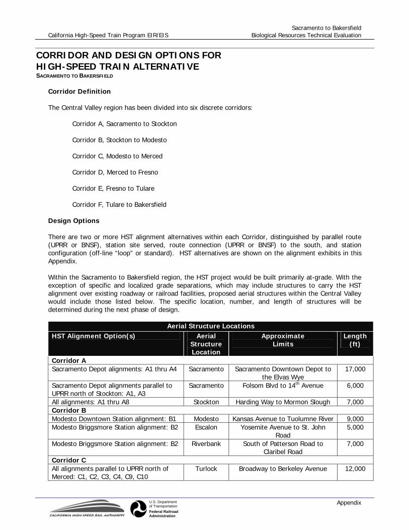
Sacramento to Bakersfield California High-Speed Train Program EIR/EIS Biological Resources Technical Evaluation
AppendixU.S. Departmentof TransportationFederal RailroadAdministration
CORRIDOR AND DESIGN OPTIONS FOR HIGH-SPEED TRAIN ALTERNATIVE SACRAMENTO TO BAKERSFIELD
Corridor Definition The Central Valley region has been divided into six discrete corridors:
Corridor A, Sacramento to Stockton Corridor B, Stockton to Modesto Corridor C, Modesto to Merced Corridor D, Merced to Fresno Corridor E, Fresno to Tulare Corridor F, Tulare to Bakersfield
Design Options There are two or more HST alignment alternatives within each Corridor, distinguished by parallel route (UPRR or BNSF), station site served, route connection (UPRR or BNSF) to the south, and station configuration (off-line “loop” or standard). HST alternatives are shown on the alignment exhibits in this Appendix. Within the Sacramento to Bakersfield region, the HST project would be built primarily at-grade. With the exception of specific and localized grade separations, which may include structures to carry the HST alignment over existing roadway or railroad facilities, proposed aerial structures within the Central Valley would include those listed below. The specific location, number, and length of structures will be determined during the next phase of design.
Aerial Structure Locations HST Alignment Option(s) Aerial
Structure Location
Approximate Limits
Length (ft)
Corridor A Sacramento Depot alignments: A1 thru A4 Sacramento Sacramento Downtown Depot to
the Elvas Wye 17,000
Sacramento Depot alignments parallel to UPRR north of Stockton: A1, A3
Sacramento Folsom Blvd to 14th Avenue 6,000
All alignments: A1 thru A8 Stockton Harding Way to Mormon Slough 7,000 Corridor B Modesto Downtown Station alignment: B1 Modesto Kansas Avenue to Tuolumne River 9,000 Modesto Briggsmore Station alignment: B2 Escalon Yosemite Avenue to St. John
Road 5,000
Modesto Briggsmore Station alignment: B2 Riverbank South of Patterson Road to Claribel Road
7,000
Corridor C All alignments parallel to UPRR north of Merced: C1, C2, C3, C4, C9, C10
Turlock Broadway to Berkeley Avenue 12,000

Sacramento to Bakersfield California High-Speed Train Program EIR/EIS Biological Resources Technical Evaluation
AppendixU.S. Departmentof TransportationFederal RailroadAdministration
Aerial Structure Locations HST Alignment Option(s) Aerial
Structure Location
Approximate Limits
Length (ft)
All alignments parallel to UPRR north of Merced: C1, C2, C3, C4, C9, C10
South of Delhi
High Fine Canal to Merced River 8,000
All alignments parallel to UPRR north of Merced: C1, C2, C3, C4, C9, C10
Atwater Atwater Canal/Jordan Canal to SR99 Overpass
13,000
Corridor D All alignments parallel to UPRR north of Fresno: D5, D6, D7, D8
Madera Fresno River to Olive Avenue 8,000
All alignments: D1 thru D8 Fresno Ashlan Avenue to Clinton Avenue 12,000 All alignments: D1 thru D8 Fresno Belmont Avenue to SR180
Overpass 4,000
Corridor E Visalia Airport Station alignment: E1 Selma Floral Avenue to Nebraska
Avenue 8,000
Hanford Station alignment: E2 Hanford 11th Avenue to south of 3rd Street 6,000 Corridor F All alignments thru Tulare: F1, F2, F7, F8, F13, F15, F16, F19, F20
Tulare Prosperity Avenue/Avenue 240 to Bardsley Avenue
11,000
All alignments parallel to UPRR north of Bakersfield: F1 thru F4, F7 thru F10, F13 thru F22
Delano Cecil Avenue to High Street 8,000
All alignments parallel to BNSF north of Bakersfield: F5, F6, F11, F12, F23, F24
Corcoran Orange Avenue to Pickerell Avenue
6,000
All alignments parallel to BNSF north of Bakersfield: F5, F6, F11, F12, F23, F24
Shafter Tulare Avenue to Lerdo Highway 4,000
Truxtun (Amtrak) Station (without loop) alignments parallel to UPRR north of Bakersfield: F15 thru F18
Famoso North of Poso Creek to south of SR99
16,000
Bakersfield Airport Station, Golden State Station, Truxtun (Union Avenue) Station, and Truxtun (Amtrak) Station (with high-speed loop) alignments: F1 thru F6, F7 thru F12 F13, F14, F19 thru F22
Bakersfield North of Norris Road to Olive Drive
6,000
Bakersfield Airport Station, Golden State Station, Truxtun (Union Avenue) Station, and Truxtun (Amtrak) Station (with high-speed loop) alignments: F1 thru F6, F7 thru F12 F13, F14, F19 thru F22
Bakersfield Beale Avenue to Mount Vernon Avenue
7,000
Truxtun (Amtrak) Station alignments: F15 thru F24
Bakersfield North of Mohawk Street to Carrier Canal
8,000
Truxtun (Amtrak) Station alignments: F15 thru F24
Bakersfield F Street to Truxtun Avenue 14,000