gravity field and steady-state ocean circulation explorer...
TRANSCRIPT

GGravity field and steady-state OOcean
CCirculation EExplorer
Mark Drinkwater,Mark Drinkwater,
Roger Haagmans &Roger Haagmans &
Michael KernMichael Kern
Mission Science DivisionMission Science Division
www.esa.int/livingplanet/goce
Mission Objectives
and Requirements
Mark Drinkwater, R. Haagmans & M. Kern – November
2006
GOCE
2GOCE Origin
n GOCE owes its origin to:
– Solid-Earth Science and Applications Mission for Europe (SESAME) inthe Early 1980’s (ESA, SP-1080)
– 1987 ESA-NASA Workshop on Joint Solid Earth Programme (SP-1094)
– Former ESA Aristoteles mission (ESA, 1991)
n The first Core missions originated via Consultations with the Usercommunity in 1991 and 1994 (ref: SP-1143; SP-1186)
– Gravity mission recommended as a priority for study
n Early studies by Consortium Involving Gravity Advanced Research:
– CIGAR I and II
• Study of precise gravity field determination and mission requirements.Phase 1 ended Jan. ’89 and Phase 2 in Mar. ‘90.
– CIGAR III and IV
• Study on gravity field determination using gradiometry and GPS.Phase III ended May ‘93 and Phase IV ended in Jan. 1995.
– CIGAR V
• Study of advanced reduction methods for spaceborne gravimetry data andcombination with geophysical quantities. Ended Aug. ‘96.
Mark Drinkwater, R. Haagmans & M. Kern – November
2006
GOCE
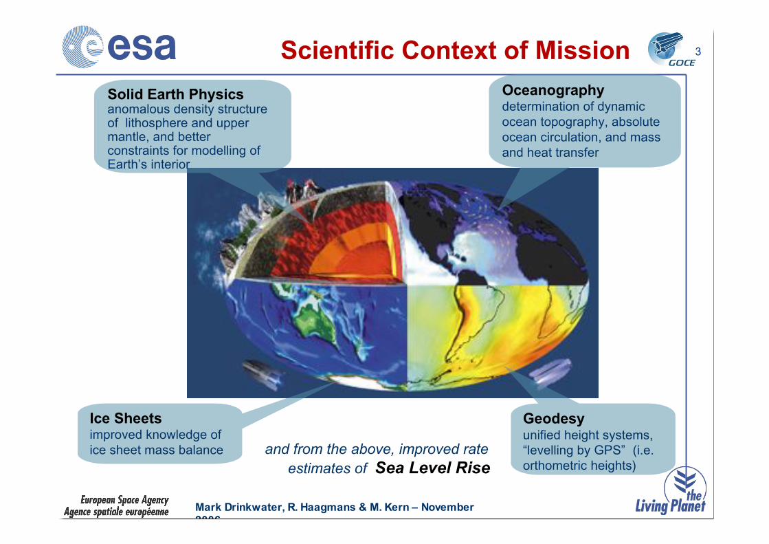
3Scientific Context of Mission
and from the above, improved rate
estimates of Sea Level Rise
Solid Earth Physicsanomalous density structureof lithosphere and uppermantle, and betterconstraints for modelling ofEarth’s interior
Oceanographydetermination of dynamic
ocean topography, absolute
ocean circulation, and mass
and heat transfer
Geodesyunified height systems,
“levelling by GPS” (i.e.
orthometric heights)
Ice Sheetsimproved knowledge of
ice sheet mass balance
Mark Drinkwater, R. Haagmans & M. Kern – November
2006
GOCE
4Scientific Objectives – Part 1
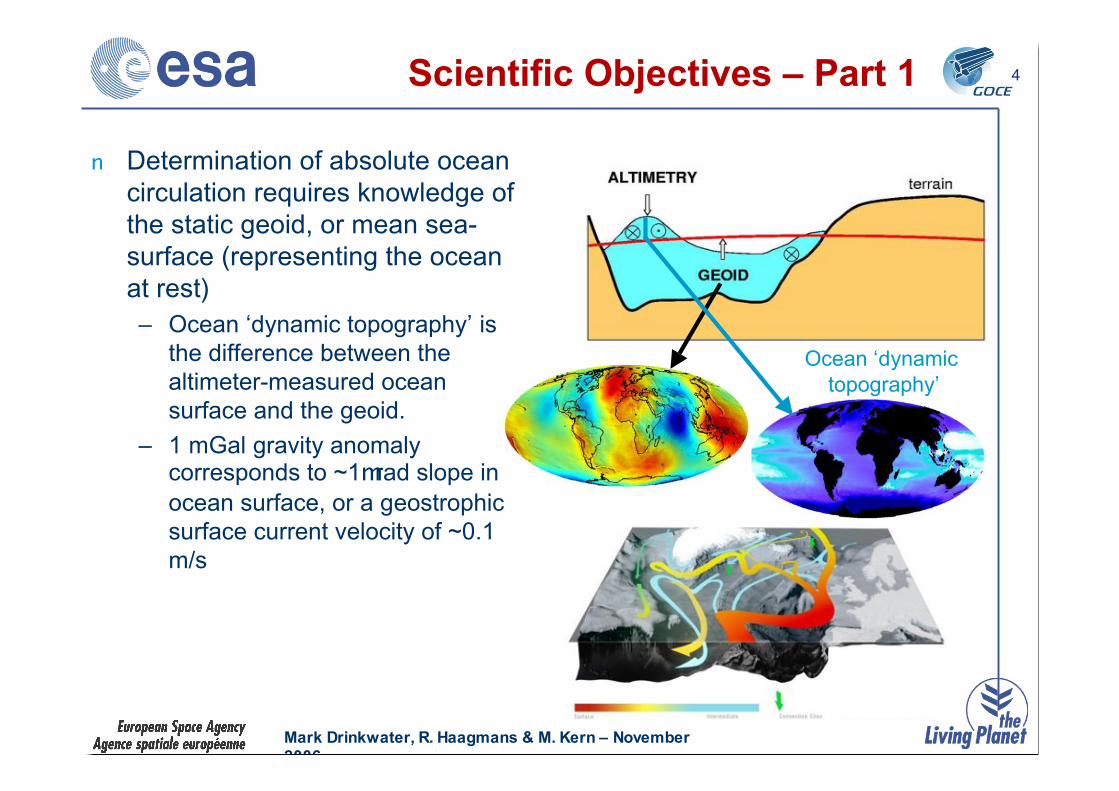
n Determination of absolute ocean
circulation requires knowledge of
the static geoid, or mean sea-
surface (representing the ocean
at rest)
– Ocean ‘dynamic topography’ is
the difference between the
altimeter-measured ocean
surface and the geoid.
– 1 mGal gravity anomalycorresponds to ~1mrad slope in
ocean surface, or a geostrophic
surface current velocity of ~0.1
m/s
Ocean ‘dynamic
topography’

Mark Drinkwater, R. Haagmans & M. Kern – November
2006
GOCE
5Scientific Objectives – Part 2
n To provide high spatialresolution information ongravity anomalies in relationto density structure of thelithosphere and uppermantle
n To deliver information ofrelevance to the study ofEarthquakes, Volcanoesand other natural hazards
n To provide information onhigh spatial harmonics inpost-glacial rebound andimprovements in ice sheetmass balance estimates

Mark Drinkwater, R. Haagmans & M. Kern – November
2006
GOCE
6
+
GOCE geoid
Local
measurements
=
Detailed
regional geoid
n To provide a unified global heightreference surface from which ‘pseudo-levelled or ‘orthometric’ heights canbe derived.
Scientific Objectives – Part 3
Mark Drinkwater, R. Haagmans & M. Kern – November
2006
GOCE
7Scientific Objectives – Part 4
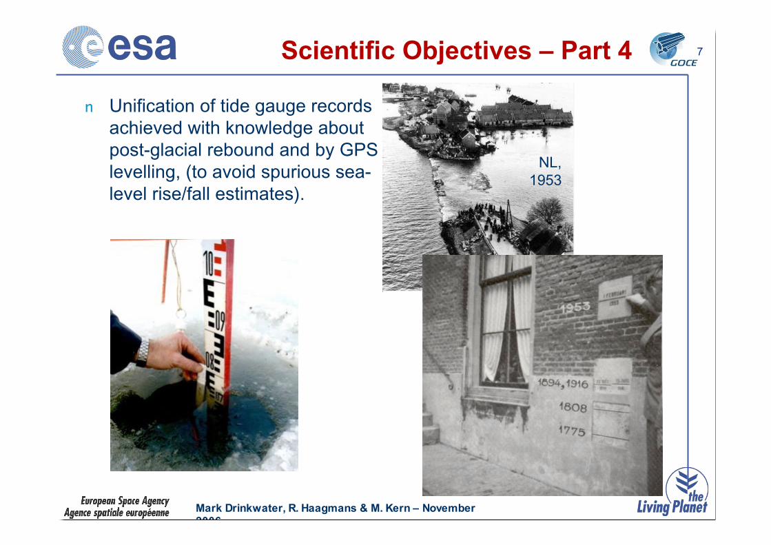
n Unification of tide gauge records
achieved with knowledge about
post-glacial rebound and by GPS
levelling, (to avoid spurious sea-
level rise/fall estimates).
NL,
1953
Mark Drinkwater, R. Haagmans & M. Kern – November
2006
GOCE
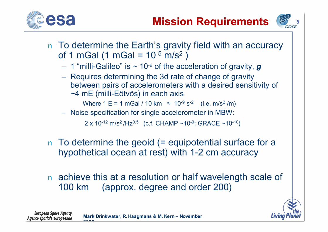
8Mission Requirements
n To determine the Earth’s gravity field with an accuracyof 1 mGal (1 mGal = 10-5 m/s2 )– 1 “milli-Galileo” is ~ 10-6 of the acceleration of gravity, g
– Requires determining the 3d rate of change of gravitybetween pairs of accelerometers with a desired sensitivity of~4 mE (milli-Eötvös) in each axis
Where 1 E = 1 mGal / 10 km ! 10-9 s-2 (i.e. m/s2 /m)
– Noise specification for single accelerometer in MBW:
2 x 10-12 m/s2 /Hz0.5 (c.f. CHAMP ~10-9; GRACE ~10-10)
n To determine the geoid (= equipotential surface for ahypothetical ocean at rest) with 1-2 cm accuracy
n achieve this at a resolution or half wavelength scale of100 km (approx. degree and order 200)
Mark Drinkwater, R. Haagmans & M. Kern – November
2006
GOCE
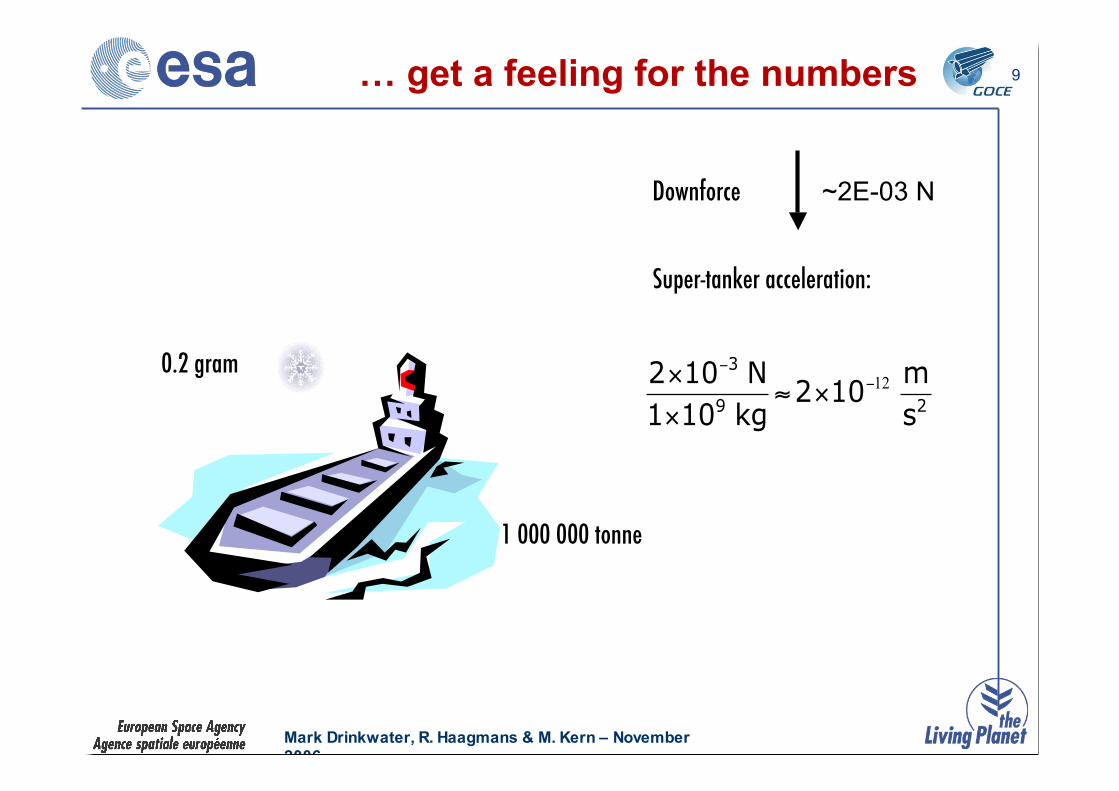
9
0.2 gram
~2E-03 N
1 000 000 tonne
Downforce
Super-tanker acceleration:
29
3
s
m 102
kg 101
N 102 12!!
"#"
"
… get a feeling for the numbers

Mark Drinkwater, R. Haagmans & M. Kern – November
2006
GOCE
10Comparison of Gravity Missions
CHAMP
• Satellite-satellite
tracking in high-low
(SST-hl) mode
• cm orbit determination
• no drag-free control
• STAR accelerometer
* mission has developed
low resolution geoid
GRACE
• Satellite-satellite tracking
in high-low and low-low
modes
• cm orbit determination
• two platforms with 3d
accelerometers
• intersatellite link
measures precise platform
separation
• no drag-free control
•SuperSTAR
accelerometers
GOCE
• Satellite-satellite tracking
in high-low mode
• cm orbit determination
• Electrostatic gravity gradiometer
comprising 6 accelerometers
• drag-free control to maintain
“free-fall” around proof masses.
• new accelerometers
* GOCE mission designed to resolve high
spatial resolution gravity field
* GRACE mission
designed to resolve time-
varying gravity field at
long wavelengths > 300
km

Mark Drinkwater, R. Haagmans & M. Kern – November
2006
GOCE
11Measurement Approach
• Electrostatic Gravity Gradiometer(EGG):
Measures the components of thegravity gradient tensor in thegradiometer reference frame within abandwidth of 5-100 mHz
• Satellite-to-Satellite TrackingInstrument (SSTI):
Geodetic-quality GPS receiver allowsorbit reconstitution with an accuracy of~1 cm in all directions and recovery oflower order harmonics
GOCE combines satellite gradiometry
and high-low satellite-to-satellite tracking
in a low Earth orbit of ± 250km altitude,
with unique continuous operation of Drag-
Free Attitude Control to combat the
effects of air drag
EGM96 gradients; Mean value removed

Mark Drinkwater, R. Haagmans & M. Kern – November
2006
GOCE
12Gradiometer Principle

Mark Drinkwater, R. Haagmans & M. Kern – November
2006
GOCE
13Gradiometer L1b Data Product
n Gravity gradients: 2nd spatial derivatives of gravitational
potential V
– Gravity gradient tensor (GGT) consists of 9 elements, of which
5 (shown below) are independent due to symmetry and
traceless condition
MBW = Hz1010513 !!
!"
s2005!
km160040!

Mark Drinkwater, R. Haagmans & M. Kern – November
2006
GOCE
14
Gravity Field Requirements for Science (see SP-1233(1), July 1999)
Gravity Field Requirements Table

Mark Drinkwater, R. Haagmans & M. Kern – November
2006
GOCE
15Requirements: Solid-Earth Physics
GRACE
gravity field
Mark Drinkwater, R. Haagmans & M. Kern – November
2006
GOCE
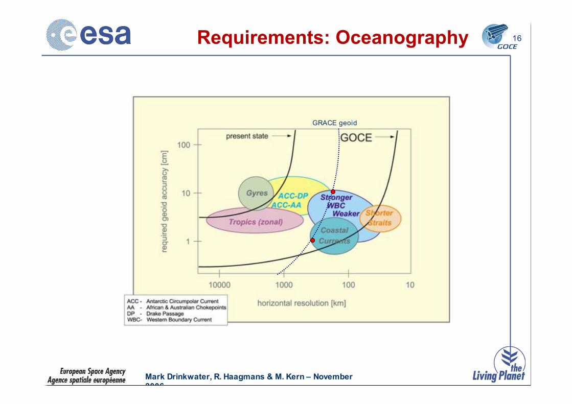
16Requirements: Oceanography
GRACE geoid

Mark Drinkwater, R. Haagmans & M. Kern – November
2006
GOCE
17Requirements: Geodesy
GRACE geoid

Mark Drinkwater, R. Haagmans & M. Kern – November
2006
GOCE
18Science and Applications
solid earth sea levelgeodesyiceocean
gravityanomalies
geoidgravityanomalies
geoid
tide gaugesaltimetry
positioning (GPS)
icetopography
oceanaltimetry
post glacialRebound
mean oceancirculation
ice massbalance
orbits
unified heightsystems
levelled heights
unifiedheight system
bedrocktopography
mean oceancirculation
seismictomograpy
topography
deformations
laboratory
massbalance ofice sheets
constraintson
mass&
heat transport
anomalousdensity
structure
gravityanomalies
INS + orbits
+ + ++
Mark Drinkwater, R. Haagmans & M. Kern – November
2006
GOCE
19
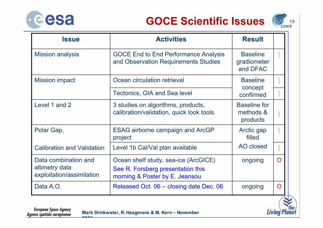
OongoingReleased Oct. 06 – closing date Dec. 06Data A.O.
!Arctic gap
filled
AO closed
ESAG airborne campaign and ArcGP
project
Polar Gap,
Calibration and Validation !Level 1b Cal/Val plan available
OongoingOcean shelf study, sea-ice (ArcGICE)
See R. Forsberg presentation this
morning & Poster by E. Jeansou
Data combination and
altimetry data
exploitation/assimilation
Baseline for
methods &
products
Baseline
concept
confirmed
Baseline
gradiometer
and DFAC
Result
!
!
!
!
3 studies on algorithms, products,
calibration/validation, quick look tools
Level 1 and 2
Tectonics, GIA and Sea level
Ocean circulation retrievalMission impact
GOCE End to End Performance Analysis
and Observation Requirements Studies
Mission analysis
ActivitiesIssue
GOCE Scientific Issues
Mark Drinkwater, R. Haagmans & M. Kern – November
2006
GOCE
20Level 2 Data Products
n Externally calibrated and corrected gravity gradients
n Global Earth gravity potential modelled as sphericalharmonic series up to deg/order 200 –corresponding to 100km spatial res. (incl.coefficients and error estimates)
n Global ground-referenced gridded values of:– geoid heights (Earth geoid map)
– gravity anomalies (Earth gravity map)
– geoid slopes
n Variance-covariance matrix of final GOCE Earthgravity field model

Mark Drinkwater, R. Haagmans & M. Kern – November
2006
GOCE
21GOCE Level 2 Products
! Final GOCE Earth gravity field model as spherical harmonic series including error estimates.
Target: 1-2 cm / 1 mGal up to degree and order 200 corresponding to 100 km spatial
resolution.
! Grids of geoid heights, gravity anomalies and geoid slopes computed from final GOCE Earth
gravity field model including propagated error estimates
! Quality report for final GOCE gravity field model
EGM_GOC_2
! Variance-covariance matrix of final GOCE Earth gravity field modelEGM_GVC_2
! GOCE precise science orbits final product
! Quality report for precise orbits
SST_PSO_2
! Externally calibrated gravity gradients in Earth fixed reference frame including error estimates
for transformed gradients
! Transformation parameters to Earth fixed reference frame
EGG_TRF_2
! Externally calibrated and corrected gravity gradients in GRF (2 weeks latency)
! Corrections to gravity gradients for temporal gravity variations
! Flags for outliers, fill-in gravity gradients for data gaps with flags
! Statistical information
EGG_NOM_2
DescriptionIdentifier
Mark Drinkwater, R. Haagmans & M. Kern – November
2006
GOCE
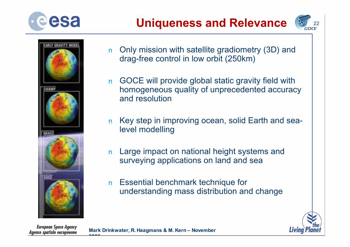
22Uniqueness and Relevance
n Only mission with satellite gradiometry (3D) anddrag-free control in low orbit (250km)
n GOCE will provide global static gravity field withhomogeneous quality of unprecedented accuracyand resolution
n Key step in improving ocean, solid Earth and sea-level modelling
n Large impact on national height systems andsurveying applications on land and sea
n Essential benchmark technique forunderstanding mass distribution and change
Mark Drinkwater, R. Haagmans & M. Kern – November
2006
GOCE
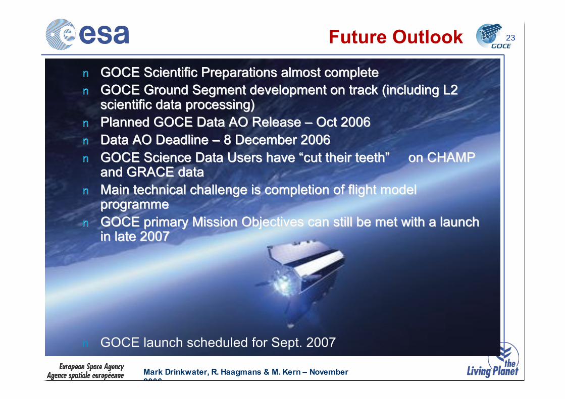
23Future Outlook
nn GOCE Scientific Preparations almost completeGOCE Scientific Preparations almost complete
nn GOCE Ground Segment development on track (including L2GOCE Ground Segment development on track (including L2scientific data processing)scientific data processing)
nn Planned GOCE Data AO Release Planned GOCE Data AO Release –– Oct 2006 Oct 2006
nn Data AO Deadline Data AO Deadline –– 8 December 2006 8 December 2006
nn GOCE Science Data Users have GOCE Science Data Users have ““cut their teethcut their teeth”” on CHAMP on CHAMPand GRACE dataand GRACE data
nn Main technical challenge is completion of flight modelMain technical challenge is completion of flight modelprogrammeprogramme
nn GOCE primary Mission Objectives can still be met with a launchGOCE primary Mission Objectives can still be met with a launchin late 2007in late 2007
n GOCE launch scheduled for Sept. 2007