granit e fal · 2019. 1. 28. · granite falls’ central location on the state‐designated...
TRANSCRIPT

John Ande
Dec
erson Archite
ember 18,
ect and the Sh
GR
2015
himoda Group
RANIT
REC
p
TE FAL
CONNAISSA
LLS W
ANCE REPO
WHITE
ORT
WATE
1
ER
GraniteFallsRiverRecreation
2 John Anderson Architect and the Shimoda Group
ContentsContents ........................................................................................................................................................ 2
Executive Summary ....................................................................................................................................... 3
Background ................................................................................................................................................... 4
Project Need and Purpose ............................................................................................................................ 5
Prior Studies/Information Gathering .......................................................................................................... 10
Recreation Options ..................................................................................................................................... 11
Hydrology .................................................................................................................................................... 16
Operations .................................................................................................................................................. 18
Budget Estimate .......................................................................................................................................... 25
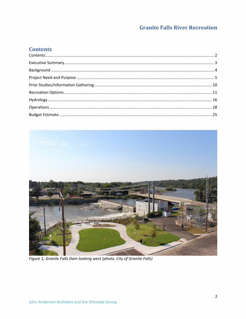
Figure 1, Granite Falls Dam looking west (photo, City of Granite Falls)

GraniteFallsRiverRecreation
3 John Anderson Architect and the Shimoda Group
ExecutiveSummaryThe City of Granite Falls commissioned this pre‐design reconnaissance to assess the potential for a whitewater bypass at Granite Falls Dam. In addition we evaluated the recreation potential of the Minnesota River downstream to Minnesota Falls and the overflow channel. We conclude that the dam site has excellent prospects for a whitewater bypass for both recreation and fish passage. The riverfront park fronting on the bypass could also support a canoe livery and outfitter. Its diverse recreation offerings would include quiet water paddling on the dam impoundment; inflatable kayaks, tubes and rafts on the whitewater bypass; and Minnesota River trips of varying lengths both upstream and downstream of Granite Falls. A constructed whitewater wave at the Highway 212 bridge crossing and a high quality adjustable wave within the whitewater bypass would attract boating enthusiasts from a several hour driving radius. Granite Falls’ central location on the State‐designated Minnesota River Water Trail between Lac Qui Parle and Redwood Falls combined with the unique whitewater course is an opportunity for branding and marketing the City as an outdoor destination. Overnight stays at area hotels and camping at Memorial park should be promoted and complemented with a revitalized retail and dining district surrounding the whitewater park, as well as additional lodging choices. Minnesota DNR indicates that the site is a high priority for fish passage, and provided that a properly designed fishway is included in the project, there would be financial and technical support for the project. Due to the regulatory complexity of the project and its relatively high cost, such assistance should be welcomed. We identified two approaches for a whitewater river at the dam. Option 1A is a whitewater bypass that provides a continuous water route around the spillway. This option has the advantage of serving also as a nature‐like fish passage but is expensive. Much of the expense is related to safety modifications to the spillway that would be required with recreational boating in the upstream impoundment. A less expensive option 1B provides only an indirect hydraulic connection to the river and therefore does not pass fish. In addition we developed a medium‐cost, hybrid approach that provides both recreation and fish passage but is optimal for neither. Water required for the fish passage and recreation will reduce hydropower generation at the City utility and must be made up by power purchase agreements. An independent economic impact study of the whitewater project should be commissioned by the City to assure that the revenue loss would be offset by direct and indirect economic benefits to the City. Next Steps
1. Construct a whitewater wave in conjunction with DNR’s reconfiguring the Highway 212 weir (currently planned for spring, 2016).
2. Economic impact assessment of the project 3. Engineering feasibility with hydraulic analysis of two (or more) alternatives for a whitewater
bypass 4. Continue pursuing land donation at the former Minnesota Falls dam site 5. Land purchase/donation on the east river bank adjacent to the Highway 212 wave.

GraniteFallsRiverRecreation
4 John Anderson Architect and the Shimoda Group
Background
HydroelectricOperationThe City of Granite Falls owns and operates the Granite Falls hydroelectric project, under Federal Energy Regulatory Commission (FERC) license P‐8423. The City Electric Department operates the plant for local consumption. The City is in the process of installing new turbines on the two 250 kW units and controls at a cost of $1.9 million. For this reason dam removal will not be an option for some time into the future. Particulars on the project: Authorized capacity: 1175 KW Installed capacity: 1200 KW No of units three: (1) 750Kw, (2) 250Kw) Weir length 280 feet Weir crest el. 901.5 with flashboards. Top of flashboards el. 903.5 Normal pool el. 903.5 to 904 feet Normal working head 16.5 to 18.5 feet Gates: two 20‐foot wide tainter gates Min flow capacity 200 cfs1 Max flow capacity 1100 cfs Tainter gates Able to maintain constant pool up to 8000 cfs+/‐ Dam hazard classification Significant The FERC license was granted on January 27, 1985 and because of its relatively small output and location at an existing dam, it is exempt from relicensing. The exemptee (City of Granite Falls) may operate the facility indefinitely subject to complying with regulatory conditions at the time the exemption was issued:
1. Run of river operation with some drawdown permitted: a. Minor draw‐downs permitted provided that 100 cfs minimum in‐stream flow is provided
downstream during reservoir recharge b. Maximum reservoir drawdown no lower than fixed crest of dam (el. 901.5)
2. No minimum flow requirement over flashboards The tainter gates are employed to control headwater and to preserve the flashboards. They are also used to lower the pool for maintenance as well as removing and installation of flashboards. Power production normally provides about 35 percent of customer’s demand—the balance is purchased from the grid. The use of water for non‐power benefits is subject to FERC review and approval. The potential impact of the water diversion is discussed later in the report.
CityWaterThe City Water Department reports that they have no withdrawals from the river. All raw water comes from wells. The dam impoundment is not relied upon for aquifer recharge2.
1 Generation with 100 cfs flow may be possible but has not been tried. Mike Enstead, City Water, personal communication, 10-2015 2 Mike Enstead, City Water, personal communication 10-2015

GraniteFallsRiverRecreation
5 John Anderson Architect and the Shimoda Group
CityUtilitiesDrawings of public utilities were not available for this study. A phone interview with City Public Works revealed the following utility conflicts with the whitewater bypass concept:
1. A ten to twelve inch sanitary sewer runs parallel to, and under the river walk from the American Legion property downstream to Washington Street. Several laterals enter from the west. The portion in the region of Sorlien Park will have to be realigned to the west.
2. Several storm outfalls enter the river in the project area. Depending on their elevation, they will either be reconfigured to outlet into the whitewater bypass or, if there is sufficient cover, they will remain in place.
3. Several storm water pump stations were installed along Prentice Street as part of the 1997 flood recovery project. Potential conflicts should be reviewed during preliminary design.
4. Two 10‐inch water lines on the Oak Street Bridge. No known water mains in Sorlien Park. 5. Power Transmission3
a. Primary distribution lines crossing the Sorlien Park and river (3 plus one spare) 2400 V three phase.
b. Secondary lines for street lighting and lighting on the flood wall at Sorlien Park.
ParkingandSorlienParkMasterPlanThe whitewater bypass project is located in within Sorlien Park which contains approximately 60 parking spaces. Informal parking occurs at various points along the river walk, as it is largely concrete. The floodwall encloses a loading / parking area at the rear of five properties on Prentice Street. The Sorlien Park master plan (Damon Farber Associates, 2004) includes two permanent structures for the Farmer’s Market, an outdoor amphitheater, a historic Depot Trailhead Facility, and limited parking, in addition to the whitewater bypass in the river. Because the whitewater bypass must be located on the west side of the flood/retaining wall and not in the river for economy, the 2004 master plan elements must also shift west. This will leave little room for parking. The large City‐owned parcels to the north of Oak Street are an opportunity to replace the lost parking. See attached drawings.
Figure 2, Aerial view of Granite Falls Dam, Sorlien Park and river walk.
3 Don Reznechek, Electric Distribution, personal communication 11-2015

GraniteFallsRiverRecreation
6 John Anderson Architect and the Shimoda Group
Figure 3, Sorlien Park Master Plan (2004)

GraniteFallsRiverRecreation
7 John Anderson Architect and the Shimoda Group
ProjectNeedandPurpose
AquaticHabitatRestoration/NuisanceSpeciesThe following narrative is derived from informal comments from MN DNR personnel during our October 29, 2015 presentation. DNR attendance included Dr. Luther Aadland, Chris Domeier, Lucas Youngsman; Stream Habitat Program; and Erik Wrede, State Parks and Trails. Comments included background on conservation issues summarized below. This is preliminary information and additional background and passage criteria would be needed in order to develop a design.
AquaticInvasiveSpeciesMinnesota waterways are under pressure from several aquatic invasive species, zebra mussels and Asian carp being the most well‐known and worrisome. Zebra mussels are difficult to control and likely to spread to project area over time. There is no practical way to halt their spread. Asian carp thrive in impounded rivers that concentrate nutrients and promote the growth of blue‐green algae, their favorite food source. Free flowing rivers, such as the Minnesota, lack blue green algae and have more bio diversity that help suppress carp population: Native species compete with carp for space, feed on their eggs and predate on their young. Asian carp are strong jumpers—they easily surmount barriers such as dams that otherwise block native fish. Dams do little to control Asian carp and actually provide nutrient and algae‐rich waters where they thrive. A healthy connected river such as the Minnesota resist spread of Asian carp better than artificial control. This background information indicates that at high river stages, Asian would likely be able to jump the Granite Falls Dam should they appear at the site. Fortunately, the connected and reasonably healthy river system below is not conducive to their spread. A connected river above Granite Falls would be nearly as inhospitable to Asian carp as the lower Minnesota; therefore their ability to utilize a fish passage at the dam is not a great concern.
FishPassageNature‐like fishways throughout Minnesota pass over 50 native species and the State is taking an active role in construction of such passages. DNR opines that similar success may be possible at Granite Falls Dam with proper attention to design and construction. With the recent removal of nearby Minnesota Falls Dam, the river is entirely free flowing to its confluence with the Mississippi River 240 miles downstream. A passage at Granite Falls Dam would open an additional 33 miles of river to the Lac Qui Parle dam at Highway 13, and reconnect the Lower Minnesota River with more than 55 miles of the Chippewa River.

John Ande
RecreatWhitewatopinion oof the damrecreation
WhitewaPossible r
• Whywd
• Thth
• W• Tu• A
p• In
Figure 4, Amaintenagrowing s
Figure 5, Cinflatable
erson Archite
tionOutputer recreationn whether rem and hydroenal use of the
aterBypassrecreational oWhitewater kaydraulics (wa
with their ownrive to the sithrough passahe whitewateWaves for riveubing in multmenities on saths and bridncreased foot
Adjustable heance gate at thsegment of th
Confluence Pas.
ect and the Sh
utsn is the main fcreation is poelectric genere Minnesota R
satGraniteFoutputs that aayaking and cves and “holen gear. A “whte and perforage for open cer rapids. er surfing, a spti‐chamberedshore for watdges. tage of shorel
ead gate at Bohe entrance the whitewater
ark, Denver C
himoda Group
focus of the possible given ration. At theRiver and the
FallsDamare possible inanoeing: an es”) for use bhitewater parm tricks in thcanoes: a po
port popular inflatable cratching and spe
line access fo
oise River Parto the whitewr park use.
CO, an in‐river
p
project and ththe other cone City’s requeoverflow cha
nclude: open channeby properly eqk” as a destine hydraulics. rtage path fo
in Europe andaft, with partectating: attr
or fishing.
rk, Boise, Idahwater bypass c
r bypass. The
GraniteF
he purpose ofnstraints of thest, we includeannel.
el with abruptquipped and knation for par r carrying or
d experiencinicipants wearractive lightin
ho. A similar channel. Rive
e dominant su
FallsRive
f this report ihe site, partice a discussion
t drops and pknowledgeabrk and play bo
lining an ope
ng rapid growring life jackeng, furnishing
gate could seer board surfi
ummertime u
erRecrea
is to provide acularly the hen of the poten
pools with ble private booating—users
en canoe arou
wth in the US. ets. gs, landscapin
erve as a ing is a fast
use is tubing a
tion
8
an eight ntial
oaters s
und
ng,
and

GraniteFallsRiverRecreation
9 John Anderson Architect and the Shimoda Group
CanoeLiveryandOutfitterA canoe livery and outfitter would promote use of the site to the general population, stimulate economic growth, and create jobs. A similarly situated livery in Ann Arbor, Michigan on the Huron River receives nearly 90,000 visits a year and employs 70 seasonal workers. The site has programs on a dam‐impounded lake, a whitewater bypass, and a three‐mile segment of free flowing river. The City‐run outfitter rents kayaks, rafts, inflatable kayaks, sit on top paddleboards (SUPs) and canoes.
Figure 6, Argo Canoe Livery, Ann Arbor, Michigan http://www.a2gov.org/departments/Parks‐Recreation/play/pages/canoeing.aspx

GraniteFallsRiverRecreation
10 John Anderson Architect and the Shimoda Group
PriorStudies/InformationGathering
LiteratureReview• PowerPoint Presentation for Minnesota Dam Removal, Public Meeting, Barr Engineering, 9‐15‐
2010 • PowerPoint Presentation For Minnesota Dam Removal, Pre‐Permit Application Meeting 12‐2‐
2011 • Rendering of whitewater park concept as part of a Flood Recovery Project Damon Farber
Associates with Stanley Consultants, 2004. • Photographic Data
o Bird’s eye view of Granite Falls Dam o View of Granite Falls Dam looking west from elevated vantage point on east shore
• Graph of hydroelectric output of Granite Falls Dam (and other sources) 1933 to 2000. • 2011 Economic Impact Study of Kelly’s Whitewater Park in Cascade, Idaho. Willem Braak, 2012 • Granite Falls Memorial Park Master Plan Upper Minnesota Valley Regional Development
Commission, 2015 • Minnesota River Valley Area Survey Summary Report, Minnesota Department of Natural
Resources Office of Management and Budget Services, 2002 • Upper Minnesota Valley Regional Trails Plan, Upper Minnesota Valley Regional Development
Commission, 2013
MappingDataCounty‐provided mapping, raster .jpg format and vector AutoCAD dwg format. Utility mapping was requested but was not made available in time for this draft.
Hydrology/HydraulicDataDaily flow data (most recent 30 years) from USGS Montevideo gauge, public domain download. Fema FIRM Community Panel no. 720069‐0001 C (Granite Falls and vicinity) 1980 Section 22 Study, Minnesota River Main Stem Hydrologic Analyses, USACE, 2001
GraniteFallsRiverRecreation
11 John Anderson Architect and the Shimoda Group
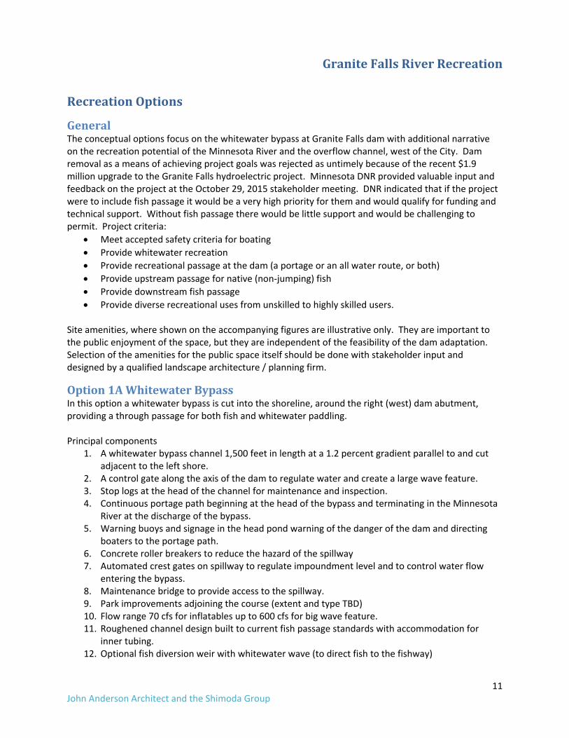
RecreationOptions
GeneralThe conceptual options focus on the whitewater bypass at Granite Falls dam with additional narrative on the recreation potential of the Minnesota River and the overflow channel, west of the City. Dam removal as a means of achieving project goals was rejected as untimely because of the recent $1.9 million upgrade to the Granite Falls hydroelectric project. Minnesota DNR provided valuable input and feedback on the project at the October 29, 2015 stakeholder meeting. DNR indicated that if the project were to include fish passage it would be a very high priority for them and would qualify for funding and technical support. Without fish passage there would be little support and would be challenging to permit. Project criteria:
• Meet accepted safety criteria for boating • Provide whitewater recreation • Provide recreational passage at the dam (a portage or an all water route, or both) • Provide upstream passage for native (non‐jumping) fish • Provide downstream fish passage • Provide diverse recreational uses from unskilled to highly skilled users.
Site amenities, where shown on the accompanying figures are illustrative only. They are important to the public enjoyment of the space, but they are independent of the feasibility of the dam adaptation. Selection of the amenities for the public space itself should be done with stakeholder input and designed by a qualified landscape architecture / planning firm.
Option1AWhitewaterBypassIn this option a whitewater bypass is cut into the shoreline, around the right (west) dam abutment, providing a through passage for both fish and whitewater paddling. Principal components
1. A whitewater bypass channel 1,500 feet in length at a 1.2 percent gradient parallel to and cut adjacent to the left shore.
2. A control gate along the axis of the dam to regulate water and create a large wave feature. 3. Stop logs at the head of the channel for maintenance and inspection. 4. Continuous portage path beginning at the head of the bypass and terminating in the Minnesota
River at the discharge of the bypass. 5. Warning buoys and signage in the head pond warning of the danger of the dam and directing
boaters to the portage path. 6. Concrete roller breakers to reduce the hazard of the spillway 7. Automated crest gates on spillway to regulate impoundment level and to control water flow
entering the bypass. 8. Maintenance bridge to provide access to the spillway. 9. Park improvements adjoining the course (extent and type TBD) 10. Flow range 70 cfs for inflatables up to 600 cfs for big wave feature. 11. Roughened channel design built to current fish passage standards with accommodation for
inner tubing. 12. Optional fish diversion weir with whitewater wave (to direct fish to the fishway)

GraniteFallsRiverRecreation
12 John Anderson Architect and the Shimoda Group
Merits and Demerits of Alternative 1A Positive Negative Thru passage for boaters Expensive‐built to spillway standards May also function as a nature‐like fish passage* Requires significant and expensive modifications
to dam spillway Excellent location and visibility to non‐boaters Perceived danger of dam spillway Uses existing retaining wall for economy Diverts water from hydro generation. Fish passage
requires 365/24‐7 Water control at dam simplifies entrance hydraulics
Requires automated flashboards in lieu of tainter gate operation (for boater safety)
Big wave feature Displaces valuable parking (parking may be at a premium during peak summer use)
Linear arrangement not ideal for fish passage. Creates a bypass reach in river.
Linear arrangement not ideal for rafting and inflatable rentals due to necessity of a vehicle shuttle for equipment
*With proper design and attention to rockwork and construction.
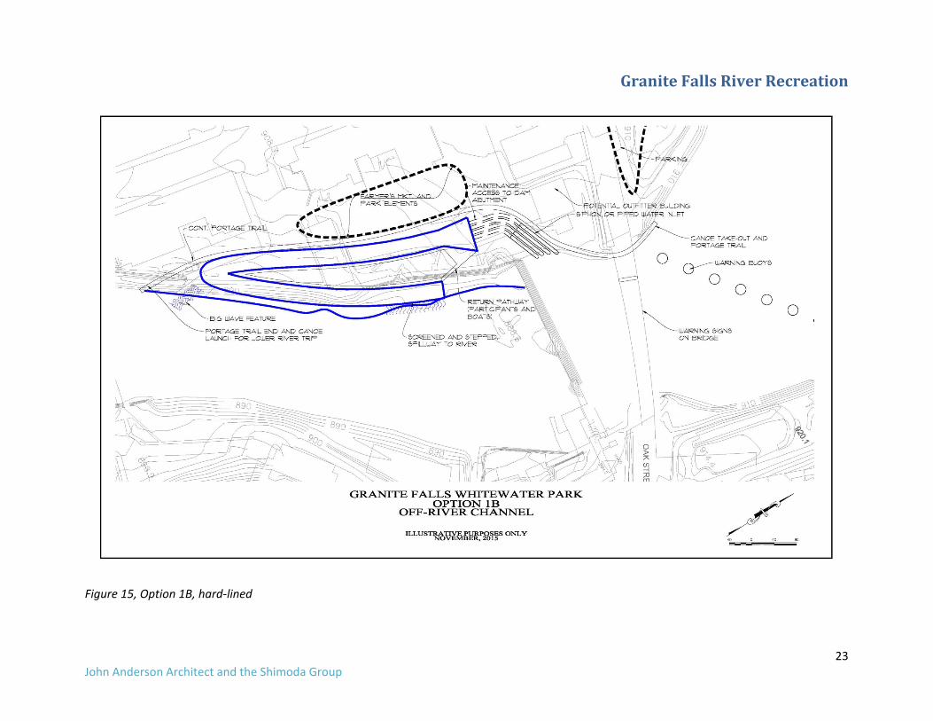
Option1BOff‐RiverChannelwithoutThruPassageIn this option a stand‐alone whitewater channel is cut into the shoreline, downstream of the right (west) dam abutment, providing a highly recreational channel but without a direct connection to the river on either end. For the purpose of comparison, this option does not include fish passage. Principal components
1. A stand‐alone off‐river whitewater channel 900 feet in length at a 1.3 percent gradient parallel to and cut into the left shore, with a switchback (see plan).
2. Flow range 75 cfs for tubing up to 600 cfs for big wave feature. 3. A siphon or piped inlet to admit water to the course. 4. A take‐out pool at the downstream‐most end of the course that is perched above the level of
the river. This allows the river to rise and fall without affecting the performance of the course. 5. A broad‐crested and screened spillway return to the river. 6. Smooth concrete channel design optimized or recreation. 7. Big wave feature at the outlet to the river. 8. Park improvements adjoining the course (extent and type TBD)
Merits and Demerits of Alternative 1B Positive Negative Perceived safety due to separation from dam and river. Less need for dam spillway modifications
Diverts water from hydro generation.
Excellent location and visibility to non‐boaters No thru passage for boaters Uses existing retaining wall for economy Mandatory portage Less expensive construction due to separation from dam. Siphon option does not breach dam
Displaces valuable parking (parking may be at a premium during peak summer use)
Big wave feature No fish passage

GraniteFallsRiverRecreation
13 John Anderson Architect and the Shimoda Group
Option1COff‐RiverChannelwithFishPassageWe developed this option following the reconnaissance visit as a hybrid scheme between the two options which balances, fish passage, recreation and cost. It consists of a stand‐alone whitewater channel is cut into the shoreline, downstream of the right (west) dam abutment, providing a recreational experience and a fish passage, but without a direct connection to the river on the upstream end. The majority of the cost savings comes from eliminating the direct hydraulic connection at the upstream end and the spillway modifications (required with a “wet” recreation passage at the dam). As a consequence, the upstream portion fish passage is accomplished through a technical fish ladder. Principal components
1. A stand‐alone off‐river whitewater channel 1,000 feet in length at a 1.3 percent gradient parallel to and cut into the left shore, with a switchback (see plan).
2. Flow range 75 cfs up to 600 cfs for big wave feature. 3. A siphon or piped inlet to admit water to the course. 4. A discharge to the river in the region of the historic pedestrian bridge 5. Technical fishways at the upstream end to pass fish. Location and configuration to be
coordinated with MDNR. 6. Roughened channel design built to current fish passage standards with accommodation for
inner tubing. 7. Big wave feature mid‐way down the channel. 8. Park improvements adjoining the course (extent and type TBD)
Merits and Demerits of Alternative 1C Positive Negative Perceived safety due to separation from dam and river. Less need for dam spillway modifications
Diverts water from hydro generation. Fish passage requires 365/24‐7
Excellent location and visibility to non‐boaters No thru passage for boaters Uses existing retaining wall for economy Mandatory portage Less expensive construction due to separation from dam. Siphon option does not breach dam
Displaces valuable parking (parking may be at a premium during peak summer use)
Potential (but not ideal) use as nature‐like fish passage*
Linear arrangement not ideal for fish passage. Creates a bypass reach in river. Technical fishways generally do not work for Mid‐west species.4
Big wave feature Linear arrangement not ideal for rafting and inflatable rentals due to necessity of a vehicle shuttle for equipment
*With proper design and attention to rockwork and construction.
Option2OverflowChannelThis option adds recreation component to a conjectural DNR fish passage project. That project creates a meandering, seasonal river along what is now an overflow channel of the Minnesota River west and south of town. Presently the channel runs only during high water, leaving behind perched pools and a small run that receive local drainage. This DNR project would widen and deepen the existing channel to receive more regular flows from the Minnesota River for the purpose of fish passage. It would flow by gravity from Dyke Road to its natural confluence with the Minnesota River near the US Highway 212 bridge. The recreational opportunity at this site would be a family / beginner canoe trip through
4 Luther Aadland, MDNR email correspondence, 11-18-2015

GraniteFallsRiverRecreation
14 John Anderson Architect and the Shimoda Group
agricultural land along a small intimate creek with intermittent pools and small ponds. The watercourse crosses three roads, two highways, a rail line, and a private drive; only three of which have proper bridge crossings. The minor roads and the drive have culverts. The DNR project does not address human passage at the culverts, so that cost would fall to the recreation component. Principal Components
1. An improved, four‐mile long channel along an existing drainage with intermittent pools and small ponds.
2. An engineered, fixed crest water inlet to the Minnesota River near Dyke Road. 3. Several road bridges with adequate head clearance would be required. 4. Widened and deepened channel to receive year‐round flow as well as flood flows. 5. Requires land acquisition or easement along the selected channel alignment. Should be
wide enough to allow for the channel and a forested buffer to the surrounding agricultural fields.
6. May offer opportunities for wetland creation, wetland bank, or wetland mitigation site. 7. Would benefit from an extensive riparian planting and reforesting plan.
Merits and Demerits of Option 2 Positive Negative Potential for easy novice padding Far from town—diverts activity away from
downtown riverfront More natural appearance is possible Requires private land acquisition Fish passage and habitat creation Requires breaching of levee Very expensive Requires construction of road bridges Road bridges would collect debris during floods,
adding to maintenance cost of the projects
Option3GraniteFallstoMinnesotaFallsReachThe river run from Granite Falls to the former dam at Minnesota Falls is approximately 3 miles in length—ideal for a livery trip. The mild Class II rapids are challenging but not overpowering at normal flows. We toured the river on October 27‐28 with flow in the range of 475 to 800 CFS at the USGS gauge at Highway 212. The river is subject to peaking flows [in the summer] with minimum in‐stream flows of 100 cfs during reservoir recharge. Project Components
1. An improved hand‐carry canoe put in the region downstream of Granite Falls Dam. (This is included in Options 1A, 1B and 1C. If a stand‐alone project, one would have to be benched into the armored shoreline downstream of the dam).
2. Improved boater access and parking lot at the Excel property at the former Minnesota Dam site, three miles downstream of Granite Falls.
3. Granite Falls Memorial Park: An extension of the existing trailered boat launch to the water’s edge. (The existing launch terminates at the former impounded water level.)
Merits and Demerits of Option 3 Positive Negative Easy short trips of varying lengths (1, 3 and 9 The shorter three‐mile trip depends on land

GraniteFallsRiverRecreation
15 John Anderson Architect and the Shimoda Group
miles) donation from Excel Energy. Trip beginning in town brings people into City center. Convenience of city with beauty of nature
Rapids are not usual in the region and may require special messaging / education
Beautiful scenery, class II+ rapids, interesting rock outcrops
Proximity to Granite Falls Memorial Park with an additional launch area
Interpretive opportunity with narrative on dam removal, river restoration, connectivity etc.
Option4In‐RiverFeatureA man‐made boulder riffle was discovered at the Highway 212 bridge when the Minnesota Falls Dam was removed. The approximate three‐foot drop at the site is ideal for a whitewater feature and it does not conflict with hydro generation. Minnesota DNR plans to reconfigure the riffle as a rock ramp for fish passage and erosion control in the near future. DNR is open to the concept of creating whitewater features, provided that it does not conflict with the other project purposes and that it is funded separately5. If funds were available, we propose a series of whitewater features on river right (west) side of the river. The features would be designed to come in at a range of flows from 300 cfs to approximately 6,000 cfs. The left half of the channel would be an easy Class I ‐ II riffle with nature‐like fish passage containing a low flow notch for canoes. At summertime flows, the channels would be separated by a low island or bar. The site enjoys visibility from several nearby roads and has paddle‐in access from Granite Falls Memorial Park. Merits and Demerits of Option 4 Positive Negative Project is imminent. Would get GF “on the map” of whitewater destinations in the region
Location slightly away from City Center
Proximity to, and paddle in from, Granite Falls Memorial Park
Would benefit from land acquisition on the south bank of river
Visibility from numerous roads in the immediate area
Would need to be funded and designed separately from
No conflict with hydro generation Ample drop Natural appearance
�
5 Conference call with City and DNR, Dec. 4 2015

GraniteFallsRiverRecreation
16 John Anderson Architect and the Shimoda Group
Hydrology
HydrologyDischarge of the Minnesota River is measured at the USGS gage stations # 5311000 (Montevideo) and # 05311150 (Granite Falls). The Granite Falls gage is the closest to the site but has only been in operation since 2013, so the Montevideo gage which has nearly 100 years of record was used for our analysis. USGS Gage Data # 5311000 near Montevideo Drainage area: 6180 square miles Period of record 8/1/1909 to present Maximum recorded flow 47,500 cfs (4/6/1997) Minimum recorded flow 1.2 cfs (7/16/1933) Period of record for our analysis 1985 to 2015 (most recent 30 years)
Jan Feb Mar April May Jun Jul Aug Sept Oct Nov Dec90% Exceedanc 90 77 296 599 541 516 266 114 44 43 97 119Median 366 345 963 3240 2570 2070 1510 624 326 576 663 51610% Exceedanc 840 885 5012 11190 6262 4832 5833 3118 2109 2380 2284 1260
Figure 7, Table of discharge (1985 to 2015) at Montevideo without proportioning for added drainage at subject site.
1
10
100
1000
10000
100000
Jan Feb Mar April May Jun Jul Aug Sept Oct Nov Dec
90% Exceedance
Median
10% Exceedance
Figure 8, Graph of flow exceedance at the site (logarithmic scale) Discussion The river’s hydrology is notable for the unusually low flows given its large drainage of over 6,000 square miles. Each of the options discussed later utilizes different flows and each has its advantages and disadvantages.
High Recreation Season
Recreation Season

GraniteFallsRiverRecreation
17 John Anderson Architect and the Shimoda Group
RecreationHydrologyThe primary reason for this study is the whitewater bypass at the dam. Flow in man‐made whitewater courses typically ranges from 70 cfs to over 1,000 cfs, depending on the availability of water. The Minnesota River is in the higher range of flow for whitewater parks but is subject to extended periods of exceptionally low water i.e. less than 100 cfs6. Should the facility be built it should be done with the understanding that during a drought year, use and or attractiveness of the course could be limited. Potential uses for the park include:
• Whitewater canoe passage • Introductory kayaking and “play‐boating” (i.e. surfing on standing waves) • Advanced whitewater boating and play boating • Competitive events—canoe/kayak slalom and freestyle • Stand‐up paddleboards • River surfing • Tubing7, inflatable rafts and duckies
Hosting advanced whitewater boating or high level competitive events put a premium on reliable water. In this regard the site would benefit from special water releases from the impoundment‐similar to peaking flow by the power plant.
River Discharge Mar April May Jun Jul Aug Sept OctWhitewater Reduces Hydro Operation 200 to 1300 CFS 20 13 9 9 14 18 16 20
Sufficient Water for Both Hydro and Whitewater Over 1300 CFS 11 17 22 21 17 13 14 11Insufficient Water for Hydro but Sufficient for Low
Flow Whitewater 50 to 200 CFS 1 0 0 1 2 4 9 4
Figure 9, Estimated Impact on Hydroelectric Generation for whitewater bypass. See also following discussion on Operations
FloodHydrologyThe following tables are compiled from the USACE Section 22 Study, Minnesota River Main Stem Hydrologic Analyses and undated flow schematic. Event Discharge (cfs) 500 year 55,000 100 year 39,000 50 year 30,500 10 year 12,500 Figure 10, Flood hydraulics Minnesota River downstream of Overflow (Granite Falls Dam site) Event Discharge (cfs) 500 year 74,000 100 year 47,000 50 year 35,000 10 year 12,500 April 1997 Flood 47,500 (Montevideo gage) Figure 11, Flood hydraulics Minnesota River upstream of Overflow
6 During the dust bowl years of the 1930’s discharge was frequently in the single digits, approaching zero. 7 Provided that participants are required to have multi-chambered floatation device and Coast Guard approved personal floatation devices.

GraniteFallsRiverRecreation
18 John Anderson Architect and the Shimoda Group
Operations
ImpactonHydroProductionOptions 1A, 1B and 1C use water that would otherwise go to hydro power production and therefore increase reliance on power purchases. FERC classifies the bypass flow as a non‐power benefit and is subject to formal FERC review and approval. The following narrative quantifies the amount of water that would be diverted from power production. A separate study of the economic impact of the whitewater project should be commissioned in order to quantify the benefits.
ProposedFlowRates• Fish passage: 75 cfs, potentially higher in the spring8 • Low Recreation (inner tubing and inflatable craft): 50 to 100 cfs with an average of 75 cfs • High Recreation (kayaking and river surfing) 200 to 600 cfs with an average of 400
cfs. Dependent on flow and includes regulatory minimum in‐stream flow (if required). The following water release schedule balances environmental flows, tubing and inflatable craft and higher flows for experienced boaters and river surfers on weekends.
WinterLowSeason~mid‐OctoberthruMarchFish passage 24/7 High Recreation: releases as water available and user demand exists, provided that it does not impact hydro operations
SpringShoulderSeason‐~Apriltomid‐JuneFish passage 24/7 except as below High Recreation: Saturday 10:00‐17:00 Sunday 10:00‐15:00 (longer hours possible provided sufficient flow in river so as to not impact hydro operation)
SummerHighSeason~mid‐JunethruAugustFish passage 24/7 except as below Weekends:
Friday 18:00 to 21:00, High Recreation Saturday 09:00 to 11:00 High Recreation Saturday 11:00 to 17:00 Low Recreation Saturday 17:00 to 21:00 High Recreation Sunday 09:00 to 11:00 High Recreation Sunday 11:00 to 17:00 Low Recreation
Weekdays 12:00 to 17:00 Low Recreation (more or less as demand dictates)
FallShoulderSeason~Septemberthrumid‐OctoberFish passage 24/7 except as below Weekends:
Saturday 09:00 to 11:00 High Recreation Saturday 11:00 to 16:00 Low Recreation Saturday 16:00 to 19:00 High Recreation Sunday 10:00 to 12:00 High Recreation
8 Luther Aadland, MDNR email correspondence, 11-16-2015

GraniteFallsRiverRecreation
19 John Anderson Architect and the Shimoda Group
Sunday 12:00 to 15:00 Low Recreation
Web/SocialMediaPresenceRequiredBoating enthusiasts regularly drive long distances to enjoy their sport, provided that they know of conditions in advance. An accurate, and up‐to date web presence is a must in order to keep users informed of scheduled and unscheduled releases, water levels and special events. This is especially important during dry periods when the normal water releases need to be curtailed, and wet periods/early season when additional water may be available. A link to the USGS site at the Highway 212 bridge. It provides real‐time information on flow at the proposed Option 4, in‐river feature.

GraniteFallsRiverRecreation
20 John Anderson Architect and the Shimoda Group
IllustrativePlans
Figure 12, Option 1A, as presented 10‐29‐15

GraniteFallsRiverRecreation
21 John Anderson Architect and the Shimoda Group
Figure 13, Option 1B, as presented 10‐29‐15

GraniteFallsRiverRecreation
22 John Anderson Architect and the Shimoda Group
Figure 14, Option 1A, hard‐lined
GraniteFallsRiverRecreation
23 John Anderson Architect and the Shimoda Group
Figure 15, Option 1B, hard‐lined

GraniteFallsRiverRecreation
24 John Anderson Architect and the Shimoda Group
Figure 16, Additional Option 1C, hard‐lined

GraniteFallsRiverRecreation
25 John Anderson Architect and the Shimoda Group
BudgetEstimateThe cost ranges presented below represent known or estimated costs of similar projects and professional judgment. An engineering design would be required to refine costs to an actionable level. The purpose is to inform the City of the range of possible costs and to define possible options for further study. Exclusions:
• Escalation • Lands acquisition, easements, and damage to private property • Buildings • Landscape architecture • Parking
Base Estimate GC's, Bonds, Mobil. AE design/permitting Contingency Project Budget10% 20% 25% (Rounded)
High Range Alt 1A Bypass and Dam Modifications 6,510,000$ 651,000$ 1,432,200$ 2,148,300$ 10,700,000$ Low Range Alt 1B Off‐River Channel wo fish passage 2,730,000$ 273,000$ 600,600$ 900,900$ 5,000,000$ Mid Range Alt 1C Off‐River Channel w fish passage 4,030,000$ 403,000$ 886,600$ 1,329,900$ 6,600,000$
Figure 17 Summary of Cost Analysis

GraniteFallsRiverRecreation
26 John Anderson Architect and the Shimoda Group
Appendices
1. International Scale of Whitewater Difficulty 2. PowerPoint presentation afternoon of October 29, 2015 3. PowerPoint presentation evening of October 29, 2015