government camp community wildfire protection … camp community wildfire protection plan ... name...
TRANSCRIPT

An Action Plan for Wildfire Mitigation
October, 2012
Government Camp Community Wildfire Protection Plan
This document is intended to educate the public on the ramifications of living in
the wildland urban interface, including their responsibilities as landowners to
reduce fire risk on their property and to provide safe access for emergency
personnel and equipment. Homeowners building in high fire risk areas must
understand how to make their properties more fire resistant by using proven
firesafe construction and landscaping techniques, and they must have a realistic
understanding of the capability of local fire service organizations to defend their
property.

Government Camp CWPP Page i
Community Representatives
The following report is a collaborative effort among structural and wildland fire agencies and local community members. The representatives listed below comprise the core decision-making team responsible for this report and mutually agree on the plan’s contents.
Name Nick Rinard - President, Government Camp Community Planning Organization
Address P.O. Box 112 Government Camp, OR 97028
Phone Number 541-757-3888
Other Contact Information [email protected]
Name Brett Fisher – Vice President, Government Camp CPO
Address 88900 Government Camp Loop Government Camp, OR 97028
Phone Number 503-997-3591
Other Contact Information [email protected]
Local Fire Department Representative(s):
Name Chief Mic Eby
Address 69634 E. Hwy 26 Welches, OR 97067
Phone Number 503-622-3256
Other Contact Information [email protected]
Name Deputy Chief John Ingrao
Address 69634 E. Hwy 26 Welches, OR 97067
Phone Number 503-622-3256
Other Contact Information [email protected]
ODF Representative(s):
Name Cindy Kolomechuk – Community Wildfire Planner
Address 14995 S Hwy 211 Molalla, OR 97038
Phone Number 971-275-4937 cell 503-829-2216 office
Other Contact Information [email protected]
Name Chris Paul – Wildland Fire Supervisor
Address 14995 S Hwy 211 Molalla, OR 97038
Phone Number 503-781-7830 cell 503-829-2216 office
Other Contact Information [email protected]
USFS Representative(s):
Name Jeremy Goers – Assistant Fire Management Officer, Mount Hood National Forest
Address 70220 East Hwy 26 Zigzag, OR 97049
Phone Number 503-622-2011
Other Contact Information [email protected]
Name Michael Moore- Fire Management Officer, Mount Hood National Forest
Address 595 NW Industrial Way Estacada, OR 97023
Phone Number 503-312-8097 cell 503-630-8783 office
Other Contact Information [email protected]

Government Camp CWPP Page ii
TABLE OF CONTENTS
1.) COMMUNITY INFORMATION & WILDFIRE EVALUATION ..................................................................................................... 1
2.) WILDFIRE HISTORY & FOREST CONDITIONS ......................................................................................................................... 4
3) COMMUNITY BASE MAP ....................................................................................................................................................... 5
4.) GOALS/OBJECTIVES .............................................................................................................................................................. 6
5.) PRIORTIZED MITIGATION RECOMMENDATIONS .................................................................................................................. 6
6.) GOVERNMENT CAMP FIREWISE ACTION PLAN 2012/2013 ................................................................................................ 7
7.) ATTACHMENTS ..................................................................................................................................................................... 8
Important Concepts:
Wildland Urban Interface (WUI): is defined as the area where homes and communities meet or intermingle with
undeveloped wildland vegetation. Wildfires that occur in the WUI can be extremely dangerous or destructive to lives and
property.
Home Ignition Zone: includes the home and an area surrounding the home within 100 to 200 feet. The potential for
ignition depends on the home’s exterior materials and design and the amount of heat to the home from the flames within the home ignition zone. Firebrand ignitions also depend on the home ignition zone either by igniting the home directly or igniting adjacent materials that heat the home to ignition.
Government Camp CWPP Page 1
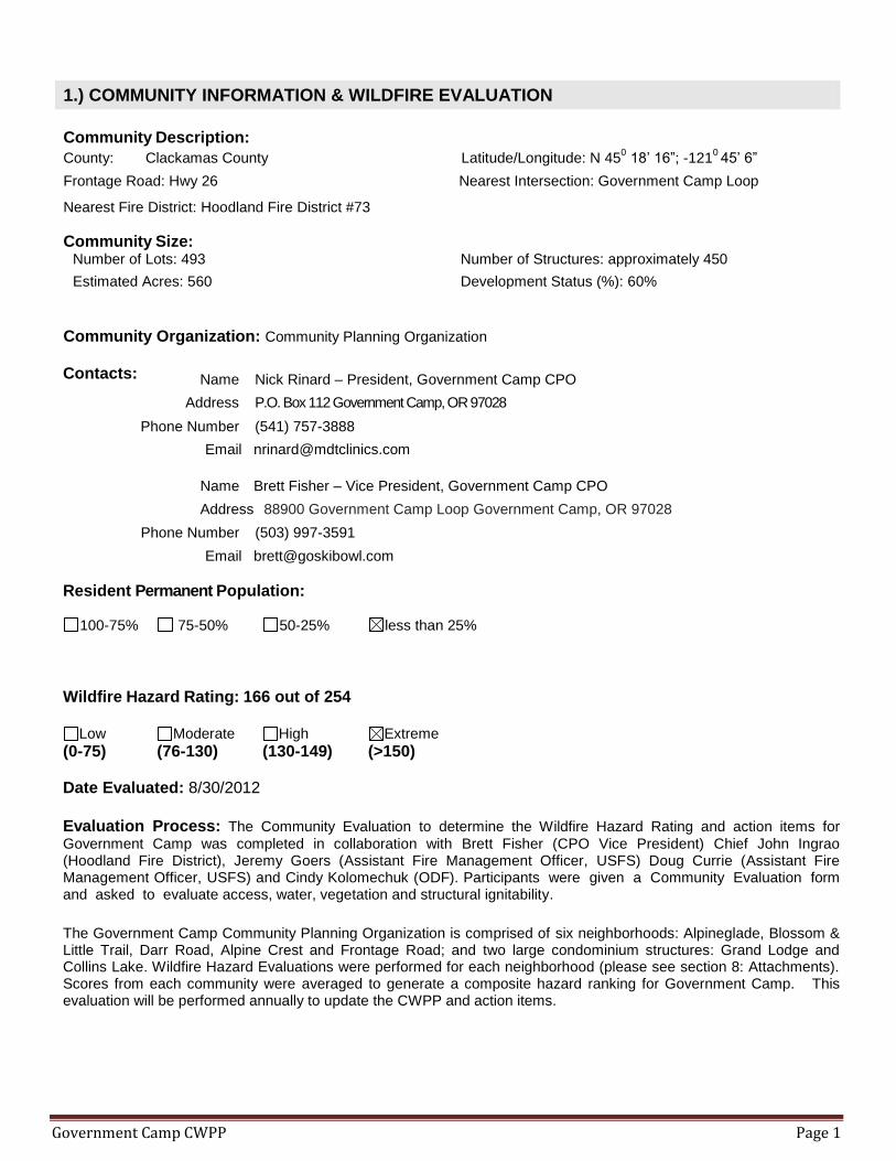
1.) COMMUNITY INFORMATION & WILDFIRE EVALUATION
Community Description:
County: Clackamas County Latitude/Longitude: N 450 18’ 16”; -121
0 45’ 6”
Frontage Road: Hwy 26 Nearest Intersection: Government Camp Loop
Nearest Fire District: Hoodland Fire District #73
Community Size: Number of Lots: 493 Number of Structures: approximately 450
Estimated Acres: 560 Development Status (%): 60%
Community Organization: Community Planning Organization
Contacts:
Name Nick Rinard – President, Government Camp CPO
Address P.O. Box 112 Government Camp, OR 97028
Phone Number (541) 757-3888
Email [email protected]
Name Brett Fisher – Vice President, Government Camp CPO
Address 88900 Government Camp Loop Government Camp, OR 97028
Phone Number (503) 997-3591
Email [email protected]
Resident Permanent Population:
100-75% 75-50% 50-25% less than 25%
Wildfire Hazard Rating: 166 out of 254
Low Moderate High Extreme
(0-75) (76-130) (130-149) (>150) Date Evaluated: 8/30/2012
Evaluation Process: The Community Evaluation to determine the Wildfire Hazard Rating and action items for
Government Camp was completed in collaboration with Brett Fisher (CPO Vice President) Chief John Ingrao (Hoodland Fire District), Jeremy Goers (Assistant Fire Management Officer, USFS) Doug Currie (Assistant Fire Management Officer, USFS) and Cindy Kolomechuk (ODF). Participants were given a Community Evaluation form and asked to evaluate access, water, vegetation and structural ignitability.
The Government Camp Community Planning Organization is comprised of six neighborhoods: Alpineglade, Blossom & Little Trail, Darr Road, Alpine Crest and Frontage Road; and two large condominium structures: Grand Lodge and Collins Lake. Wildfire Hazard Evaluations were performed for each neighborhood (please see section 8: Attachments). Scores from each community were averaged to generate a composite hazard ranking for Government Camp. This evaluation will be performed annually to update the CWPP and action items.

Government Camp CWPP Page 2
Community Evaluation Highlights (Important Considerations):
1. Access – Narrow roads, dead ends, limited turnouts, vegetation overhanging roads.
There are many dead-end roads with little or no turnaround options, creating a scenario where backing out is the only option. Turnouts are limited throughout the community. It is recommended to enhance and create new turnouts on Blossom Road, Little Trail Road, Frontage Road and Darr Road.
Roads throughout the community are narrow making it difficult for a large structural fire engine or tender to maneuver. Turnaround options should be enhanced at dead end streets, and surface roads should be widened by brushing and removing trees in the right-of-way.
2. Heavy fuels adjacent of homes and infrastructure – Closed canopy of Douglas Fir and Lodge Pole Pine with a dense brush understory.
A dense overstory throughout the community creates a continuous fuel scenario that would allow fire to continue to spread. Above-ground propane tanks are prevalent in this community. Overstory thinning is recommended to reduce the horizontal continuous fuels. Fuel breaks in the form of trails or cleared roads will also break up the fuel.
3. Public Awareness/ Structural Ignitability – The majority of homes in this community are vacation homes, making it difficult to engage homeowners in wildfire education and risk reduction activities. The structures in this community are primarily wood, and about 30% of homes have cedar shake roofs. It is recommended that homeowners Replace wood siding and roof materials with less flammable synthetic options such as HardiPlank siding and metal roofing.
4. Ingress/Egress – There is only one way in and out of the community.
There is only one way in and out of the community, and there is little opportunity to create secondary access here. This could present an issue during a wildfire event, as people are trying to evacuate while response vehicles attempt to access the community. It is critical that the community is aware that evacuation is imminent and which routes to take. It is recommended that the community register telephone numbers with the Clackamas County Emergency Notification System (CCENS) and evacuation signs are posted.

Government Camp CWPP Page 3
/Thinning/Brushing Example Pruning/Thinning/Brushing Example
Successful Firewise Modifications:
The Government Camp Community Planning Organization partnered with Hoodland Fire and the Oregon Department of
Forestry to host a Firewise Community Clean-Up Event September 15th, 2012. The event was advertised through the
CPO member email list (please see Attachment 7.2). The Firewise Community Clean-Up Event included the creation of defensible space around homes and infrastructure. Fire Agency (ODF, Hoodland Fire District, USFS) personnel were available to help guide the work, and provide home assessments for landowners. Over 55 residents participated in the Clean Up event, but the chipping was postponed due to extreme fire danger. The ODF covered the cost of debris disposal (chipping) through a Title III grant. Participants pruned trees to reduce the vertical continuous fuel, thinned trees to reduce the horizontal continuous fuels, and removed brush. Future grant dollars will increase awareness of these techniques, and financially assist landowners to complete more of these treatments throughout the community.
Debris Piles Thinning and Limbing
Opportunity: Firewise Demonstration Areas: Mount Hood Ski Patrol and Hoodland Fire Station # 253
There is an opportunity to create a Defensible Space Demonstration Area around two critical structures: the Mount Hood
Ski Patrol and Hoodland Fire Station #253. The Oregon Department of Forestry uses seasonal fuel reduction crews to
implement demonstration areas to protect critical infrastructure and provide an example for local area residents. These
two locations were chosen as potential fuels reduction project areas, but the land belongs to the United States Forest
Service, and is currently under consideration for a real estate transaction. For this reason, no fuels modifications were
completed at the time of this report. The community and ODF are committed to creating demonstration areas in these
sites in the future.
Mount Hood Ski Patrol Hoodland Fire Station #253

Government Camp CWPP Page 4
2.) WILDFIRE HISTORY & FOREST CONDITIONS
Relative Frequency: Moderate amount of annual initial attack situations, occasional extended
attack situations.
Common Causes: Lightning, Human (debris burning & escaped campfires)
Areas of Future Concern: Highway 26 corridor, Mount Hood National Forest Lands
The most recent wildfire to threaten the Government Camp Community was the Dollar Lake Fire, which ignited during a lightning storm in the Mount Hood Wilderness on Friday, August 26, 2011. This 6,304-acre fire had the potential to spread into the Bull Run Watershed, public and private forest lands, and wildland urban interface communities, including Government Camp.
Although the Dollar Lake Fire did not reach Government Camp, it was an excellent opportunity to build community awareness of the high fire risk in this area. In preparation for a potential WUI response, Hoodland Fire conducted structural triage assessments for each home in their service area, including Government Camp. The assessments serve as an education and a response tool, informing homeowners of how defendable their homes are, while allowing firefighters to gauge level of risk associated with protecting residential structures. It is important to continue to capitalize on these opportunities to educate homeowners about their exposure to wildfire and the measures they can take to protect their homes.
There are two fire regimes in Government Camp. The northeastern portion of the community is characteristic of a moderate fire regime, as it is dominated by lodge pole pine and ground fuels that have a lower severity rating and a shorter return interval (35 years), with the potential for isolated torching. The remainder of the community is dominated by a more severe fire regime, with mature Douglas fir and cedar being the predominant species. Although fires in this type of stand occur less frequently, with a return interval of 200+ years, there is a much higher mortality rate and a high probability of stand-replacing crown fires that leave little to no residual vegetation. Because wildland fires are being effectively suppressed, the patterns and characteristics of fires are changing. Vegetation that historically would have been minimized by frequent fires has become more dominant. Over time, some species have also become more susceptible to disease and insect damage, which leads to an increase in mortality. The resulting accumulation of dead wood and debris creates the types of fuels that promote intense, rapidly spreading fires. Areas subject to wildland-urban interface fires have very different fire hazard characteristics. The defining characteristic of the wildland-urban interface area is that structures are built in areas with essentially continuous (and often high) vegetative fuel loads. In other words, structures are built in areas subject to wildland fires. When wildland fires occur in such areas, they tend to spread quickly and structures in these areas may, unfortunately, become little more than additional fuel sources for wildland fires. The siting of homes has also changed over time. Historically pioneering families built their homes in low lands, close to water and the fields they intended to work. In the last 30 years, rural homes have increasingly been built in locations chosen because of the view or other amenities. Thus, many newer homes are in locations more difficult to defend against wildland fires. Fire risk to structures and occupants in the rural Government Camp community is high due to significant vegetative fuel loads and limited fire suppression resources, as compared to urban or suburban areas. Government Camp is at the eastern margin of the Hood Fire District. In addition, narrow winding roads and driveways, dead ends, and lack of turnaround space impede access by firefighting apparatus. The reduced availability of firefighting personnel and apparatus and longer response times increase the probability that a small wildland fire or a single structure fire will spread. Heavy fuels on adjacent Forest Service land are also an issue for Government Camp. The Mount National Forest secured funding to reduce hazardous fuels on the northern end of Government Camp in 2006. This project resulted in an effective fuel break, and should be extended to the west of Government Camp to Hwy 26 to protect the community and forest resources. Because this area is under consideration for a real estate transaction, fuels reduction planning efforts for this area are on hold. Firewise partners will continue to work current and future landowners to reduce hazards associated with forest land adjacent to the Government Camp community.

Government Camp CWPP Page 5
3) COMMUNITY BASE MAP
The Government Camp Community Planning Organization is comprised of six neighborhoods:
Alpineglade: Hazard score: 172
Access here is good, with paved roads and sufficient turnaround space. The primary concerns for this area are the large
Douglas fir and lodge pole pine stands adjacent to homes, and the increased structural ignitability of primarily wooden
structures, decks and roofing materials. Blossom & Little Trail: Hazard Score: 181
The roads in this area are generally well-maintained. There is a mix of paved and gravel roads, and all are less than 20
ft. wide. Access is limited in some areas. Heavy fuels adjacent to homes are also a major concern. Many homes in this
neighborhood have cedar shake roofs, which is the most vulnerable part of the home. Darr Road: Hazard Score 181
Darr Road has poor access with very limited turn around space. The lodge pole pine stands adjacent to and between
homes are extremely dense. Address signage is also poor. Homes are primarily wood with cedar shake roofs. Alpine Crest: Hazard Score 160
Access here is only one way in and out, but the roads are wide and well-maintained with ample turn around space. The
praimry concern here are the heavy fuels adjacent o homes. Frontage Road: Hazard Score: 194
Fronatge Road and Multipore Meadows is a particularly vulnerable area due to limited access, heavy fuels and
flammable building materials. There is a locked gate to Multipore Meadows. Grand Lodge and Collins Lake: Hazard Score: 110These recently built condominium structures are made of fire-resistant building materials, have ample turnaround space and metal roofs. The primary hazard is the heavy fuel load in the forest adjacent to condos.
Dar Road
Collins Lake and Grand Lodge
Frontage Road
Blossom & Little Trail
Alpineglade
Alpine Crest

Government Camp CWPP Page 6
4.) GOALS/OBJECTIVES
Goal: Increase community awareness and build organizational capacity to reduce the likelihood of a catastrophic
wildfire in Government Camp.
Objective: Set clear priorities for the implementation of wildfire mitigation in the Government Camp community. This
includes prioritized recommendations that the community, individual landowners and governmental agencies can take to protect lives, property, infrastructure and forestland from wildfires.
5.) PRIORTIZED MITIGATION RECOMMENDATIONS
The following recommendations were developed by the Government Camp CPO, ODF, USFS and Hoodland Fire. A priority order was determined based on the effectiveness of mitigation activities for significantly reducing wildfire hazards and resources available for implementing projects.
Proposed Community Fuels Reduction Priorities: Partners for Implementation: Govt. Camp CPO, Homeowners, Hoodland Fire, USFS, ODF
1. Conduct an annual Firewise Community Clean-up Day.
2. Create Firewise Defensible Space around structures and infrastructure: cut, prune, and thin vegetation at least 30
feet around homes and around above ground propane tanks.
3. Remove trees in the ROW and trim all trees overhanging access roads 14’ high.
4. Create shaded fuel breaks in forested areas, especially around the condominium structures.
5. Create a Firewise Demonstration Area around the Mount Hood Ski Patrol and Hoodland Fire Station #253.
6. Extend the USFS fuel break to the western edge of the community.
Proposed Structural Ignitability Reduction Priorities: Actions to be taken by homeowners.
1. Clean roofs and gutters.
2. Replace wood siding and roof materials with less flammable synthetic options such as HardiPlank siding and
metal roofing.
Proposed Education and Outreach Priorities: Partners for Implementation: Govt. Camp CPO, Hoodland Fire, USFS, ODF
1. Hold an annual Firewise education day. This will include concepts, techniques, and training to complete fuel
reduction and structure improvements on individual properties.
2. Encourage homeowners to register their telephone numbers on the County’s Emergency Notification System.
3. Create a neighborhood “Fire Prevention” newsletter. Electronic or hard copy versions.
4. Annually review the Government Camp CWPP and renew Firewise Certification
Proposed Emergency Operations Priorities: Partners: Govt. Camp CPO, Hoodland Fire, Clackamas County, USFS, ODF, CCEM? 1. Create a Multiagency Emergency Response Map.
2. Post evacuation route signs throughout the community.
3. Install additional turnouts and/or widen access roads in the Darr, Blossom and Little Trail and Frontage Road
neighborhoods.
4. Enhance turnaround options on dead end roads.

Government Camp CWPP Page 7
6.) GOVERNMENT CAMP FIREWISE ACTION PLAN 2012/2013
Action Partners Timeline Funding Needs Potential Resources
Conduct a Firewise Community Clean-up Day.
CPO, ODF, Hoodland Fire, USFS
Spring/Fall, 2013
$3,000 (chipping) Title III, Hoodland Fire
Create Firewise Defensible Space around structures and infrastructure.
Homeowners
Ongoing $1,000/acre (thinning trees around homes)
Title III, ODF
Clean roofs and gutters. Homeowners
Ongoing NA NA
Hold an annual Firewise education day.
CPO, ODF, Hoodland Fire USFS
Spring, 2013 NA NA
Register telephone numbers
on the County’s Emergency
Notification System.
CPO
Ongoing NA NA
Create a neighborhood “Fire
Prevention” newsletter.
CPO, Hoodland Fire
Ongoing NA NA
Create a Multiagency
Emergency Response Map.
Hoodland Fire, ODF, USFS
Winter, 2013 NA NA
Annually review the
Government Camp CWPP and
renew Firewise Certification.
CPO, ODF, Hoodland Fire, USFS
Fall, 2013 NA NA
The following agencies/ organizations are committed to implementing this plan:
___________________________________ ___________
Nick Rinard, Government Camp CPO Chair Date
__________________________________ ___________
Mic Eby, Hoodland Fire Chief Date
___________________________________ __________
Michael Moore, Mount Hood National Forest Date
Fire Management Officer
___________________________________ ___________
Chris Paul, Oregon Department of Forestry Date
Wildfire Protection Supervisor

Government Camp CWPP Page 8
7.) ATTACHMENTS
7.1 WILDFIRE PRE-SUPRESSION PLAN A. Wildfire Protection Responsibility
Structural Protection: Hoodland Fire & Rescue
Wildland Protection: Oregon Department of Forestry – Private, County, State and BLM Lands
, Mount Hood National Forest – USFS Lands
B. Incident Command Post Location: Ski Bowl West
C. Incident Staging Area Location: Ski Bowl West
D. Medical Unit Staging Area Location:
Ski Bowl West and/or Hwy 26 Govt. Camp Rest Stop
E. Alarm Response – How do we fit in what ODF and USFS has for automatic response?
First Alarm
Fire Department/Rescue Squad Travel Distance Response Time
Hoodland Fire (Govt. Camp Station-Volunteer) E-251, SQ253
.1 mile 5-7 minutes (if staffed)
Hoodland Fire (Welches Station)
E-254, E-253, WT 251, WT252
17.6 miles 11-15 minutes
Second Alarm (report to designated staging area)
Fire Department/Rescue Squad Travel Distance Response Time
Hoodland Fire (Brightwood Station)
E-252
28.1 miles 38 minutes
Sandy Fire
E-74, E-71, WT-71
29.2 miles 40 minutes
F. Air Support
Fixed Wing
North Cascade District orders retardant through the ODF Salem Coordination Center (SCC). Refer to the Aviation Procedures Manual. Call Molalla Oregon Department of Forestry for more details: (503) 829-2216.
Helicopter
North Cascade District orders helicopters. Refer to the Aviation Procedures Manual. Call Molalla Oregon Department of Forestry for more details: (503) 829-2216.
G. Water Availability (accessible to fire engines)
Location: Hydrants
Description: Full pressure hydrant system, pump backup with emergency power

Government Camp CWPP Page 9
H. Communications
Name Phone Number Radio Frequencies
Dispatch/Emergency Services
CCOM 503-655-8412 VHF F1 (Dispatch) F4 (Operations)
Clackamas County Sheriff 503-655-8211
North Cascade Dispatch 503-829-4051
Columbia Cascade Dispatch 360-891-5140 Columbia Cascade Dispatch
Local Department of Forestry Office
Molalla Unit
503-829-2216
High Heaven (Command)
RX151.20500Tone: 179.9
TX159.43500Tone: 179.9
Skamania (Command)
RX151.20500 Tone:179.9
TX159.43500 Tone:167.9
Red Net (Operations)
RX151.34000 Tone:156.7
TX151.34000 Tone: 156.7
Other
US Forest Service 503-622-3191 Timberline Repeater (Command) RX 170.5250 tone 114.8 TX 168.6750 tone 127.3 Work 1 (Operations) RX170.5000 tone 123.0
TX 170.5000 tone 123.0
Bureau of Land Management 503-375-5692 BLM Saddle Mountain (Command) RX 171.67500 Tone: None TX 164.75000 Tone: 123.0 BLM Fire (Operations) RX 173.6750 Tone: None TX 173. 6750 Tone: None
ODOT 503- 283-5859
I. Evacuation
This is a one way in/out community and evacuation would be onto Hwy 26.
J. Resource List: The North Cascade District of the Oregon Department of Forestry has prepared a Mobilization Plan,
including contact information for resources (lodging, food, equipment operators, and local, state and
federal contact agencies) that may be used during an emergency. These resources have been gathered
and listed for Wildland Fire use and would need to be contacted to see if they are available for other use. The Mobilization Plan is updated annually.

Government Camp CWPP Page 10
7.2 FIREWISE COMMUNITY CLEAN UP DAY FLYER

Government Camp CWPP Page 11
7.3 WILDFIRE HAZARD EVALUATION

Government Camp CWPP Page 12

Government Camp CWPP Page 13

Government Camp CWPP Page 14