gold investigations in precambrian clastic and pelitic
TRANSCRIPT

Gold Investigations in Precambrian Clastic and Pelitic Rocks, Southwestern Colorado and Northern New Mexico
GEOLOGICAL SURVEY BULLETIN 1272-F


Gold Investigations in Precambrian Clastic and Pelitic Rocks, Southwestern Colorado and Northern New MexicoBy FRED BARKER
CONTRIBUTIONS TO ECONOMIC GEOLOGY
GEOLOGICAL SURVEY BULLETIN 1272-F
UNITED STATES GOVERNMENT PRINTING OFFICE, WASHINGTON : 1969

UNITED STATES DEPARTMENT OF THE INTERIOR
WALTER J. HICKEL, Secretary
GEOLOGICAL SURVEY
William T. Pecora, Director
For sale by the Superintendent of Documents, U.S. Government Printing Office Washington, D.C. 20402 - Price 25 cents (paper cover)
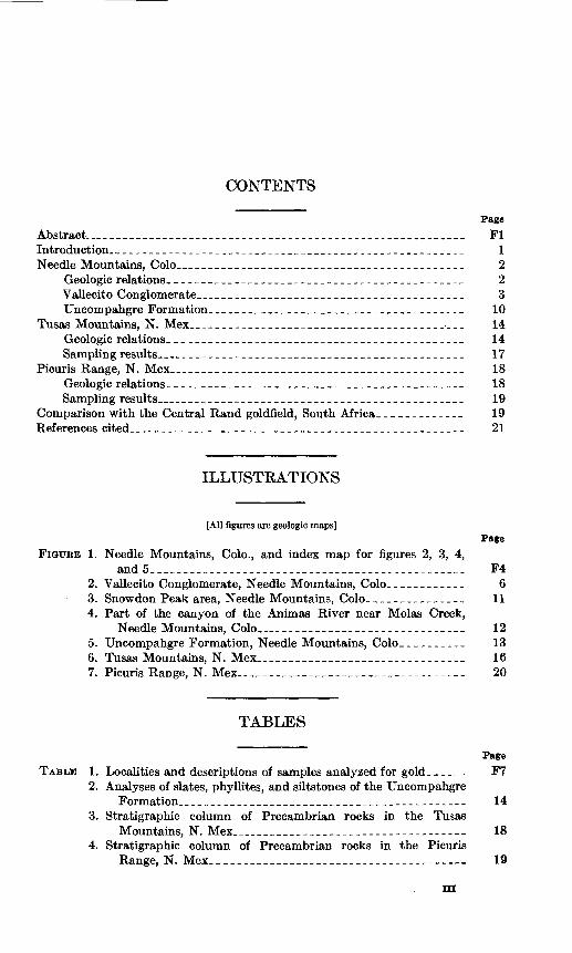
CONTENTS
Page
Abstract._______________________________________________________ FlIntroduction- _____________________________________________________ 1Needle Mountains, Colo__________________________________________ 2
Geologic relations.____________________________________________ 2Vallecito Conglomerate_______________________________________ 3Uncompahgre Formation_______________________________________ 10
Tusas Mountains, N. Mex_______________________________________-___ 14Geologic relations.____________________________________________ 14Sampling results_____________________________________________ 17
Picuris Range, N. Mex___________________________________________ 18Geologic relations.____________________________________________ 18Sampling results_____________________________________________ 19
Comparison with the Central Rand goldfield, South Africa.____________ 19References cited.__________________________________________________ 21
ILLUSTKATIONS
[All figures are geologic maps]Page
FIGURE 1. Needle Mountains, Colo., and index map for figures 2, 3, 4,and 5__-__-__--___--___-_____------__--_-_-___-_---_- F4
2. Vallecito Conglomerate, Needle Mountains, Colo____________ 63. Snowdon Peak area, Needle Mountains, Colo_______________ 114. Part of the canyon of the Animas River near Molas Creek,
Needle Mountains, Colo______________________________ 125. Uncompahgre Formation, Needle Mountains, Colo__________ 136. Tusas Mountains, N. Mex________________________________ 167. Picuris Range, N. Mex_________________________________ 20
TABLES
Page TABLE 1. Localities and descriptions of samples analyzed for gold.-____ F7
2. Analyses of slates, phyllites, and siltstones of the UncompahgreFormation.._ _________________________________________ 14
3. Stratigraphic column of Precambrian rocks in the TusasMountains, N. Mex__________________________________ 18
4. Stratigraphic column of Precambrian rocks in the PicurisRange, N. Mex___________.____.___._______. _...__ 19
in


CONTRIBUTIONS TO ECONOMIC GEOLOGY
GOLD INVESTIGATIONS IN PRECAMBRIAN CLASTIC AND PELITIC ROCKS, SOUTHWESTERN COLORADO AND NORTHERN NEW MEXICO
By FEED BARKER
ABSTEACT
A search was made to find fossil placer deposits of gold in the Precambrian clastic rocks of southwestern Colorado and northern New Mexico. In Colorado, the Vallecito Conglomerate and conglomerates of the Uncompahgre Formation of the Needle Mountains were sampled. In New Mexico, the Ortega Quartzite, the Big Rock Conglomerate Member, the Jawbone Conglomerate Member, and the upper quartzite member of the Kiawa Mountain Formation in the Tusas Mountains, and the lower quartzite member of the Ortega Quartaite and the conglomerate member of the Vadito Formation of Montgomery (1953) in the Picuris Range were sampled. These rocks contain less than 0.1 part per million gold, and they apparently were derived from a terrane of quartzite, jasper, argillite, and iron-formation that contained virtually no gold.
In addition, carbonaceous slate and schist of the Uncompahgre Formation were sampled and analyzed for gold and for 29 other metals. These rocks are predominantly low in metals.
INTRODUCTION
This report describes a reconnaissance search for gold in Pre cambrian clastic and politic rocks of the Needle Mountains of south western Colorado and of the Tusas and Picuris Mountains of northern New Mexico. The possibility of finding fossil placers in pebbly quartz- ites and conglomerates, and deposits of very fine grained precipitated vanadium and gold in carbonaceous slates and schists, provided induce ment for this work as part of the U.S. Geological Survey's search for heavy metals. Analyses show low amounts of gold less than 0.1 part per million in these rocks, and consequently no geochemically anom alous amounts of gold or commercially important deposits are in dicated. The three areas involved are discussed separately.
Fl

F2 CONTRIBUTIONS TO ECONOMIC GEOLOGY
NEEDLE MOUNTAINS, COLO.
GEOLOGIC RELATIONS
The Needle Mountains, which lie in La Plata, San Juan, and Hins- dale Counties, Colo., form the southwestern part of the San Juan Mountains and include the Grenadier Kange, the Needle Mountains group, the West Needle Mountains, and adjacent peaks. They are underlain largely by Precambrian rocks.
The geology of the Needle Mountains was studied intensively in the period 1895-1910 by Cross, Howe, and Kansome (1905), Cross and Howe (1905), and Cross and Hole (1910). Keports of these studies included geologic maps at 1:62,500 scale. Later the geology was summarized by Cross and Larsen (1935) and Larsen and Cross (1956), whose reports included geologic maps at 1:250,000 scale. The Precambrian Uncompahgre Formation in illncompahgre Gorge, about 14 miles north of the Needle Mountains area, was described by Kelley (1946),Luedke and Burbank (1962), and Burbank and Luedke (1964). Kecent studies by the author (Barker, 1968a, b; 1969) have revealed a geologic history of the Precambrian rocks of the Needle Mountains that is somewhat different from that described by Cross and his asso ciates and that consists of:
1. Deposition of the Vallecito Conglomerate.2. Deposition of the largely metavolcanic Irving Formation,
which comprises Cross and Howe's Irving Greenstone and Archean schist and gneiss.
3. Folding along north to northeast trends, metamorphism to high rank, and formation of the Twilight Gneiss and the Tenmile and Bakers Bridge Granites.
4. Deep erosion.5. Unconformable deposition of sediments of the Uncompahgre
Formation now quartzite, slate, schist, and conglomerate.6. Isoclinal folding along east to southeast trends, and metamor
phism of low to medium rank.7. Intrusion of the Eolus and Trimble Granites and the Electra
Lake Gabbro.8. Deep erosion, followed by deposition of sediments in Cam
brian time.These various geologic units are shown on the geologic map (fig. 1), but the older and younger intrusive rocks are shown undivided.
Kadiometric studies by Silver and Barker (1968), using the ura nium-lead method, and by Bickford, Barker, Wetherill, and Lee-Hu (1969), using the rubidium-strontium method, indicate that the Twi-

GOLD INVESTIGATIONS, PRECAMBRIAN ROCKS F3
light Gneiss is about 1,780 m.y. (million years) old, the Tenmile and Bakers Bridge Granites are about 1,720 m.y. old, and the Eolus Granite and the Electra Lake Gabbro are about 1,460 m.y. old.
The Vallecito Conglomerate, the basal conglomerate of the Un- compahgre Formation, and the pebbly quartzite and pyritic pelitic rocks stratigraphically higher in that formation were sampled and analyzed for gold, with negative results. Descriptions of these units follow.
VALLECITO CONGLOMERATE
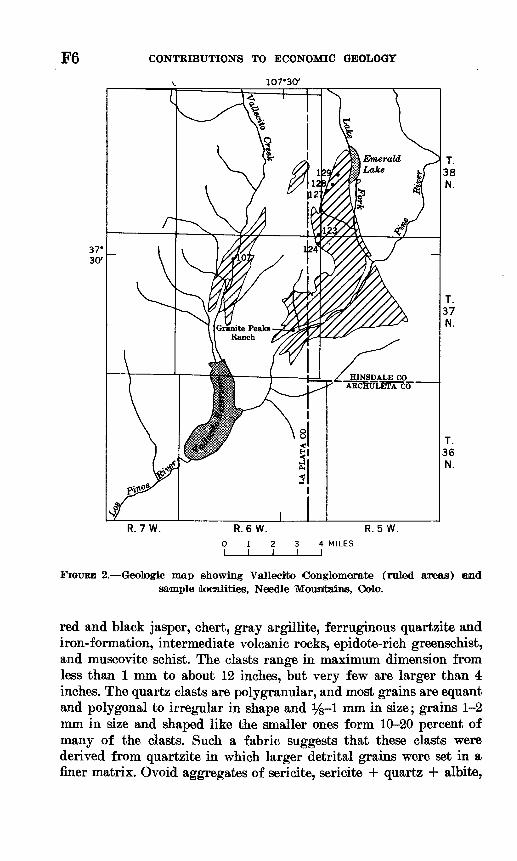
The Vallecito Conglomerate is found only in the southeastern Needle Mountains, along the lower valleys of Vallecito Creek and Pine River and underlying much of the complex ridge between these streams (fig. 2). This conglomerate forms many cliffs and is well exposed.
In outcrop the Vallecito Conglomerate is mostly gray, but locally it is pink or purple. It is thin to very thick bedded, and it shows conspicuous cross-stratification of the trough type described by McKee and Weir (1953, p. 387) or the pi type described by Alien (1963, p. 109), except that the cross-strata are lithologically heterogeneous; hematite laminae are interlayered with pebble conglomerate. The Val lecito contains randomly distributed beds of coarse-grained quartzite 1-18 inches thick and a few scattered, much thicker, beds of quartzite. Joints cut both clasts and matrix.
A few folds that have amplitudes of one hundred to several hundred feet were found, but folds that have amplitudes of a few inches to several feet are extremely sparse.
The Vallecito Conglomerate is overlain by amphibolite, metavol- canic rocks of intermediate composition, mica schists, quartzite, gneis ses, and chlorite schists of the Irving Greenstone of Cross and Howe (1905), here termed the Irving Formation. The contact between the Vallecito and the overlying rocks has little or no angular discordance, and the sequence of deposition was determined from cross-stratifica tion. The lower contact of the Vallecito is not exposed, and therefore neither the thickness of the formation nor the nature of rocks underly ing it is known. However, at Granite Peaks Ranch in Pine River valley (fig. 2), good top and bottom control by cross-stratified beds enables measurement of a 2,400-foot thickness of the stratigraphically lowest part of the Vellecito Conglomerate. Larsen and Cross (1956, p. 24) gave "an estimated exposed thickness of more than 3,000 feet west of Pine River." This formation may well be more than 5,000 feet thick.
The Vallecito Conglomerate is metaconglomerate and pebbly quartz ite that contains subangnlar to rounded fragments of milky quartz,

F4 CONTRIBUTIONS TO ECONOMIC GEOLOGY
107M5' 107°30'
Area shownArea shown in figure 3- in figure 5
12 MILES
FIGURE 1. Generalized geologic map of the Needle Mountains, Hinsdale, La Plata, and San Juan Counties, Oolo., and index to location of areas shown in figures 2-5.

GOLD INVESTIGATIONS, PRECAMBRIAN ROCKS
EXPLANATION
F5
Post-Precambrian rocks
Younger intrusive rocksInclude Trimble Granite, Electra Lake Gabbro, and Eolus
Uncompahgre FormationStipple, quartzite
Solid black, slate and schist
Older intrusive rocksInclude Tenmile and Bakers Bridge Granites and
Irving FormationDashes show trend of foliation
oa a ~ n o
Vallecito Conglomerate
Contact
Fault
381-385 O 69 2
F6 CONTRIBUTIONS TO ECONOMIC GEOLOGY
v 107*30'
R. 7W. R.6 W. R. 5W.4 MILES I
FIGURE 2. Geologic map showing Vallecito Conglomerate (ruled areas) and sample (localities, Needle Mountains, Oolo.
red and black jasper, chert, gray argillite, ferruginous quartzite and iron-formation, intermediate volcanic rocks, epidote-rich greenschist, and muscovite schist. The clasts range in maximum dimension from less than 1 mm to about 12 inches, but very few are larger than 4 inches. The quartz clasts are polygranular, and most grains are equant and polygonal to irregular in shape and %-l mm in size; grains 1-2 mm in size and shaped like the smaller ones form 10-20 percent of many of the clasts. Such a fabric suggests that these clasts were derived from quartzite in which larger detrital grains were set in a finer matrix. Ovoid aggregates of sericite, sericite + quartz + albite,

GOLD INVESTIGATIONS, PRECAMBRIAN ROCKS F7
and sericite + epidote + biotite + quartz are interpreted as meta morphosed grains of feldspar or of relatively fine grained quartzose f eldspathic rocks, probably volcanic rocks of intermediate to rhyolitic compositions, in which original potassic feldspar has been hydrolyzed to sericite and original plagioclase has been converted to albite and epidote. The matrix is a poorly sorted aggregate of quartz and sericite with minor hematite, leucoxene, garnet, albite, biotite, and epidote. It is mostly gray, but locally it is pink to purple; most grains are y$-l mm in size. The rock was completely recrystallized during meta- morphism: quartz, both in the matrix and in the various types of clasts in which it occurs, has grown into polygranular mosaic fabrics; the sericite is mostly well alined and gives a schistose aspect to the matrix; the sparse garnets all lie enclosed in sericite and may be metamorphic rather than detrital; and epidote grains only rarely show rounded outlines, suggesting detrital origin and later recrystal- lization. Dark laminae 1-3 mm thick are abundant in much of the formation. These are largely hematite, commonly with accessory ilmenite and rutile. The hematite commonly shows octahedral forms, indicating derivation from magnetite by oxidation (Barker, 1968b). No gold was found in the Vallecito Conglomerate within the limits of detectability.
Sampling of the Vallecito Conglomerate involved collecting a 170- Ib sample (No. 107 in table 1 and fig. 2) in the canyon of Vallecito
TABLE 1. Localities and descriptions of samples analyzed for gold
Analyses showed that all samples, except first sample listed, contained less than 0.1 part per million of gold. All samples, except first sample listed, are chip samples. Analysts: W. L. Campbell, R. L. Miller, M. 8. Rickard, and T. A. Roomer]
Sample localityFormation Remarks
Tig. Loc.__________________No. No.________________________________
Needle Mountains, Colo.
Vallecito Conglomerate. _..-.- 2 107 170-lb sample collected in canyon of Vallecito CreekDescription and analysis given in text.
123,124, 5-lb composite chip samples taken west of the Lake 127-129 Fork of Pine River.
ITncompahgre Formation:Basal conglomerate...-.-. 3 192 3-4 ft above base (base not exposed here).
193 Basal 6 in.194 6 in. to 4 ft above base.195 4-8 ft (top) above base.196 Laterally 8 ft along base and in lowermost 2 in.199 Basal 12 in.200 1-8 ft (top) above base.201 Basal 12 in.202 1-8 ft (top) above base.203 2J4-3 ft above base (base not exposed here).
(North side of formation, 4 197 0-18 in. above base of pebbly layer, about 20 ft ver- where basal conglom- tically above railroad tracks.erate is 1J4-3 ft thick). 204 18-in.-thick conglomerate overlain by pebbly quartzite.
206 4-in.-thick layer of conglomerate in a 2}£-ft-thick layer of pebbly quartzite (equivalent to the basal con glomerate).

F8 CONTRIBUTIONS TO ECONOMIC GEOLOGY
TABLE 1. Localities and descriptions of samples analyzed for gold Continued
FormationSample locality
Fig. No.
Loc.No.
Remarks
Uncompahgre Formation Con. Pebbly quartzite and
conglomerate (body of formation).
143 4-in.-thick pebble conglomerate.144 Pebble quartzite lens 3-6 in. thick.168 12-ft-thick pebbly conglomerate and quartzite.169 3-ft-thick layer of conglomerate.174 5- to 6-in.-thick lens of conglomerate.175 2- to 4-in.-thick lens of conglomerate'.185 Across a 15-ft-thick conglomerate layer with 1 in.
pebbles of quartz and jasper; layer lies hi 300-ft thick unit of coarse-grained to pebbly quartzite.
187 lO-in.-thick conglomerate.188 4- to 5-in-.thick conglomerate in sparsely pebbly
quartzite; 9 ft north of sample 187.189 6-in.-thick conglomerate lens; 100 ft north of sample 188.191 2- to lO-in.-thick conglomerate lenses hi 2-ft-thick
pebbly quartzite. ____ ___
Tusas Mountains, N. Meat.
Kiawa Mountain Formation: Big Rock Conglomerate
Member.
Jawbone Conglomerate Member.
Upper quartzite member .
12 SWJiSEW sec. 22, T. 27 N., R. 8 E.; Las Tablas quad rangle. Massive conglomerate with 1- to 4-in. clasts; muscovitic schistose matrix. Sampled across a 10-ft breadth normal to schistosity, bedding not visible. Lowermost conglomerate exposed on northeast flank of Big Rock syncline, sample within about 20 ft of base of this member.
13 200 ft N. 70° W. of sample 12 locality, SEJiSWJi sec. 22, T. 27 N., R. 8 E. Lithology like that of sample 12. Chipped across a 40-ft breadth normal to schistosity; bedding not visible.
14 SWJiNWJi sec. 27, T. 27 N., R. 8 E., Las Tablas quadrangle. Lithology similar to that of samples 12 and 13. Chipped across a 50-ft breadth normal to schistosity. Lowermost exposed conglomerate on southwest flank of Big Rock syncline. Bedding not visible hi sampled section but is apparent hi folded pebbly quartzite immediately to the northeast, which suggests that the conglomerate, also, contains minor folds.
15 1,650 ft southeast of sample 14 locality, also on southwest flank of Big Rock syncline; SEJ£NWJ£ sec. 21, T. 27 N., R. 8 E., Las Tablas quadrangle Chinrwd across a 4-ft thickness of a small outcrop
6 NEJiNEM sec. 24, T. 29 N., R. 6 E., Cebolla quad rangle, south ridge of Jawbone Mountain at 10,340-ft elevation. Chipped across a 10-ft thickness of mixed conglomerate and pebbly quartzite, each with hema tite-rich laminae. Pebbles mostly H-l in. in maxi mum dimension and consist of about 80 percent quartz and 20 percent red and dark-gray jasper. The heavy minerals of 354 grains of this sample were separated with bromoform and yielded 56 grams of hematite, kyanite, rutile, and ilmenite.
7 NEJiNWJi sec. 19, T. 29 N., R. 7 E., Burned Mountain quadrangle, 10,400-ft elevation on southwest slope of east summit (10,601-ft elev.) of Jawbone Mountain. Chipped across a 3-ft thickness of conglomerate with Ji- to 1-in. pebbles of milky and pink quartz and red and dark-gray jasper. Underlying rocks not exposed; overlying rocks are cross-stratified fine-grained con glomerate and quartzite.
8 SEJtfNEJi sec. 7, T. 28 N., R. 7 E., Burned Mountain quadrangle, 9,650-ft elevation. Chipped across a 30-ft thickness of poorly sorted conglomerate with >£- to 2- in. pebbles of quartz and jasper.
20 SWMNEJi sec. 24, T. 29 N., R. 6 E., Cebolla quad rangle, small knob at 10,200-ft elevatidn. Chipped across 8-ft thickness of about 80 percent of conglomer ate with Ji-in. pebbles and 20 percent of fine-grained quartzose conglomerate and quartzite.
9 West end of hill near 9,727-ft elevation, Burned Moun tain quadrangle. Sample, largely of float, chipped across 30 ft of folded quartz pebble conglomerate that probably is 5-10 ft thick.
10 200 ft east of sample 9 locality. Chipped across 12 ft of intricately folded quartzite that contains 25-30 per cent conglomerate in layers 4-8 in. thick.
11 About 525 ft east and 75 ft north of sample 9 locality. Chipped across 15 ft of mixed bedrock and float of a layer of conglomerate that is probably 10-15 ft thick.

GOLD INVESTIGATIONS, PRECAMBRIAN ROCKS F9
TABLE l.< Localities and descriptions of samples analyzed for gold- Continued
Sample localityFormation Remarks
Fig. Loc. No. No.
Picnris Ranee, N. MM.
Ortega Quartzite, lower 7 6 NWJ£NWJ£ sec. 21, T. 23 N., E. 11E., Trampas quad- quartzlte member, rangle. southeast side of Cooper Hill at 7,470-ft
elevation. Chipped across a 2-ft thickness of gray hematitic quartzite with kyanite and staurolite.
8 NWJiNEJi sec. 15, T. 23 N., E. 12 E., Peflasco quad rangle, north end of summit of Picuris Peak. Chipped across 5-ft thickness of slightly rusty, massive quartz ite that contains 10-15 percent of garnet and staurolite but no hematite or other opaque minerals.
9 NWJtfSWJi sec. 24, T. 24 N., E. 11 E., Taos SW quad rangle, north side of Hondo Canyon at 7,090-ft eleva tion. Chipped across 5-ft thickness of sillimanite- muscovite quartzite with laminae of hematite and ilmenite spaced 8 mm to 8 cm apart; rock is not cross- stratified.
(10-13) NEJiNEJi sec. 12, T. 23 N., E. 10 E., Trampas quad rangle, Glen Woody prospect (Jones, 1904, p. 158-161; Lindgren and others, 1010. p. 82, 01), east of Glen Woody bridge, about 6,070-ft elevation.
10 Kyanite-bearing quartzite that contains disseminated hematite and ilmenite; from walls of shallow old adit.
11 15 ft northeast of sample 10 locality. Eed altered quartz ite containing sericite, limonite, and leucoxene. Chipped across a 7-ft-thick altered zone that is sub- parallel to bedding.
12 Interlayered quartz pebble conglomerate and quartzite with hematitic laminae. From talus blocks that fell from cliffs above old adit; from 5-in.-thick layer of conglomerate in a 2-ft-thick block.
13 Same as sample 12, except from conglomerate andquartzite from 6 talus blocks.
Vadito Formation of Mont- 7 1 SWJiSWJi sec. 24, T. 23 N., B. 10 E., Trampas quad- gomery (10S3) conglomerate rangle, south side of Canada de Piedra Lumbre, at member. 6,620-ft elevation. Chip of matrix across startigraphic-
ally lowest 3 ft of unit, here consisting of 70-80 percent pebbles and cobbles of milky quartz and felsite in matrix of quartz and muscovite with minor hematite, ilmenite, kyanite, and chlorite.
2 From next 25 ft of strata above sample 1, and of similar conglomerate.
3 NWKNEJi sec. 30, T. 23 N., E. 10 E., readout on north side of State Highway 75 in Arroyo del Ploma. Sample largely of matrix across a 10-ft-thick layer of conglom erate with about 00 percent by volume clasts of milky quartz as large as 12 in., and 10 percent clasts of pink felsite as large as 8 hi. set hi schistose gray matrix of quartz, muscovite, hematite, and minor chlorite and tourmaline.
4 NEJiSWJi sec. 22, T. 23 N., E. 11 E., Trampas quad rangle. Chipped across 7-ft thickness of peblby and cobbly quartzite, with 10-15 percent by volume of clasts of milky quartz.
6 NWJiSEJi sec. 15, T. 23 N., E. 12 E., Peflasco quad rangle, about 1,100 ft east of 9,315-ft elevation summit on south ridge of Picuris Peak (area contains only small scattered outcrops). Chip sample of 6 small outcrops in 20-ft thickness of pebble conglomerate and pebbly quartzite.
Locality of sample 6; chip sample of conglomerate from a 2- by 5-ft outcrop, the largest found hi this area.
Creek and collecting five 5-lb composite chip samples (Nos. 123, 124, 127, 128, and 129 in table 1 and fig. 2) west of the Lake Fork of Pine Kiver. The five smaller samples were analyzed for gold, and no gold was detected. The large sample was crushed and processed through bromoform. The heavy fraction contained no visible gold and, more over, showed an unusually sparse heavy mineral population that con-

F10 CONTRIBUTIONS TO ECONOMIC GEOLOGY
sists chiefly of hematite with minor amounts of subangular to sub- rounded zircon. A split of this heavy fraction was sieved, and the resulting four size fractions were analyzed for gold as shown in the folio wing table:
Size fraction (mesh)
+ 20 -20, +100
-100, +200 -200
Weight (grams)
0.89 15.0 10.0 2.2
Fire assay .Cyanide at< Fire assay.
-____do__._
Method of analysis l Gold (ppm)
__... <0. 3_____ <. 02_____ <. 02..... <. 1
1 Fire assays by L. B. Riley, O. M. Parker, and Claude Huffman, Jr.; cyanide-atomic absorption analy sis by J. A. Thomas.
UNCOMPAHGRE FORMATION
BASAL CONGLOMERATE
The Uncompahgre Formation unconf ormably overlies the older Twi light Gneiss and Irving Formation (fig. 1). Lying in gradational to abrupt contact with these older formations at and west of the Animas River (figs. 1,3,4) is an unusual rock, 4 to about 40 feet thick, that con sists of about 10-50 percent 14- to 4-mm single grains and polygranular aggregates of quartz set hi a schistose matrix of sericite and minor hematite, limonite, and leucoxene. This rock, which could be classified as quartz sericite schist, apparently is a phyllonite formed from the older rocks, in which the original quartz grains were not comminuted but were first severely strained and then recrystallized, and in which the original iron was oxidized. A granite dike in the Irving Forma tion, 75 feet north of the unconformity, shows similarly strained and recrystallized quartz and therefore is a possible source of such quartz in the basal Uncompahgre. The phyllonite is mostly in gradational contact with the underlying granitic and metamorphic rocks; its sohistosity is parallel to bedding of the overlying metasedimentary rocks; and it is free of chert and jasper granules that are present in the overlying conglomerate.
The basal unit of the Uncompahgre Formation is a V/2- to 8-foot thick bed of interlayered quartzose conglomerate and pebbly quartzite. This rock is gray, and it is poorly stratified and sorted; it is cross- stratified in only a few places. Its matrix is largely recrystallized quartz, mostly of %0- to 14-mm grain size, with variable amounts of sericite and hematite; and its clasts are predominantly quartz, with red and black jasper, gray chert, and dark-gray argillite. The clasts range in size from 2-mm granules to 6-inch'cobbles, but most are in the 1- to 8-cm range. Some of the quartzose clasts are quartzite and

GOLD INVESTIGATIONS, PRECAMBRIAN ROCKS Fll
have a fabric in which y2- to 2-mm original detrital quartz grains are set in a recrystallized matrix of %0- to % 0-mm quartz grains, but others show irregular fabrics and perhaps were derived from quartz veins. The clasts, like those in the Vallecito Conglomerate, indicate that the source data contained much quartzite, jasper, chert, and iron- formation. This basal conglomerate grades upward for several feet through pebbly quartzite into about 1,000 feet of pale-violet to white sparsely laminated and cross-laminated rarely pebbly quartzite at Snowdon Peak (fig. 3) and into 300-600 feet of similar quartzite in the canyon of the Animas River (fig. 4).
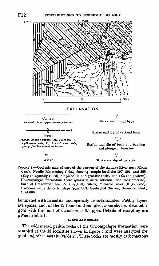
The basal conglomerate was sampled hi its three areas of exposure: west of Snowdon Peak, on the east bank of the Animas River, and below the west rim of the canyon of the Animas River. None of the samples contained detectable gold, with the limit of detection at 0.1 ppm. Descriptions and localities of samples are given in table 1 and in figures 3 and 4.
PEBBLY QTTARTZITE AND CONGLOMERATE
The quartzite layers in the Uncompahgre Formation, for the most part, are well sorted, pale violet to light gray, thick bedded, sparsely
1 MILE J
Contact
EXPLANATION40 87
Strike and dip of beds Strike and dip of foliationWWater
FIGURE 3. Geologic map of the Snowdon Peak area, Needle Mountains, Colo., showing sample localities 192-196 and 199-203. p-Ct (diagonally ruled), Twilight Gneiss; p-Cu (no pattern), Uncompahgre Formation, here quartzite with an 8-foot-thick basal conglomerate, both of Precambrian age; Qtr (stippled), Holocene talus and rock glaciers. Base from U.S. Geological Survey, Snowdon Peak, 1:24,000.
CONTRIBUTIONS TO ECONOMIC GEOLOGY
107MO' f SILVERTON 3,5 M'
1 MILEI
EXPLANATION
Contact Dashed where approximately located
K »Fault
Dashed where approximately located. U, upthrown side; D, downthrown side; query, further extent unknown
W Water
Strike and dip of beds
Strike and dip of vertical beds
83^7
Strike and dip of beds and bearing and plunge of lineation
73
Strike and dip of foliation
FIGURE' 4. Geologic map of part of the canyon of the Animas River near Molas Creek, Needle Mountains, Colo., showing sample localities 197, 204, and 205. p ag (diagonally ruled), amphibolite and granitic rocks, and p-Cu (no pattern), Uncompahgre Formation (here quartzite, slate, siltstone, and conglomerate), both of Preambrian age; Pzr (vertically ruled), Paleozoic rocks; Qt (stippled), Holocene talus deposits. Base from U.S. Geological Survey, Snowdon Peak, 1:24,000.
laminated with hematite, and sparsely cross-laminated. Pebbly layers are sparse, and, of the 13 found and sampled, none showed detectable gold with the limit of detection at 0.1 ppm. Details of sampling are given in table 1.
SLATE AND SCHIST
The widespread pelitic rocks of the Uncompahgre Formation were sampled at the 13 localities shown in figure 5 and were analyzed for gold and other metals (table 2). These rocks are mostly carbonaceous

GOLD INVESTIGATIONS, PRECAMBRIAN ROCKS F13
351-385 O 69 3

F14 CONTRIBUTIONS TO ECONOMIC GEOLOGY
TABLE 2. Analyses of slates, phyllites,[All values are in parts per million except those for Ca, Fe, Mg, and Ti, which are in percent. Numbers in
parentheses below element symbols are limits of detection. N, looked for but not detected; n.a. not looked for. Analytical errors, of values given, are +100 percent, 50 percent for spectrographic analyses and ±30
Sampleloc. No.1 Semiquantitative spectrographic analyses 2 (fig- 5)
Ag As B Ba Be Bi Ca Cd Co Cr Cu Fe La Mg Mo Mn (0.5) (200) (10) (20) (1) (10) (0.05) (20) (5) (5) (2) (0.05) (20) (0.02) (2) (20)
125B125D125F125G125H125J125K125L125M125N125Q142145146148153154155156157186190198
NNNN1.5.7.5.7.5
NNNNNNNNNNNNN
NNNNNNNNNNNNNNNNNNNNNNN
301501502002003015010050
1001505030150150100100505020707050
700500
1,500700500700700
1,000700700700500200200300150300200500500200200200
321N1NN1.5NNN112111111111
NNNNNNNNNNNNNNNNNNNNNNN
0.05.05.15.07.7.5.3
1.5.5.7.7.2.2.05.05.05
NN
.5NN
.1N
NNNNNNNNNNNNNNNNNNNNNNN
503020NN105NNN30NN5N5N5N550NN
1501501503030503030303050100100705070
15015030505020100
2030501550705
301020150705050202010302050150305
151515275.7
21.53753217351571.55
5030N3020N3020202020N2050N30100303020202030
1.51.53.7
21.51.51.7
1.511.5.5
1.7
1.5
11.7
1
NNN5070303070505010NNNNNNN15NN20N
1,5001,00050020070050070
300300150500500300203015010050050500200100200
1 Samples 125B-125Q were collected, by T. A. Steven, in a layer of black slate and siltstone about 145 ft thick; individual samples were collected above the base (north margin of this layer) as follows: 125B, 8 ft; 125D, 21 ft; 125F, 39 ft; 125G, 49 ft; 125H, 55 ft; 125J, 90 ft; 125K, 105 ft; 125L, 120 ft; 125M, 126ft; 125N, 131 ft; and 125Q, 139 ft. Sample 155 was collected 10 ft east of sample 154 locality.
and pyritic compositionally layered dark-gray to black slate, phyllite, and siltstone. None of the samples showed detectable gold by atomic absorption analysis, with 0.02 ppm as the limit of detection. These analytical results indicate that the pelites of the Uncompahgre For mation generally are not metalliferous.
TUSA8 MOUNTAINS, N. MEX.
GEOLOGIC RELATIONS
The Tusas Mountains of Eio Arriba County, N. Mex., lie immediately west of the Rio Grande valley, and are a southeastern continuation of the San Juan Mountains of Colorado. Slightly more than 200 square miles of Precambrian rocks are exposed in this area.
The hydrothermal ore deposits of the Tusas Mountains, including the gold placers of Hopewell, were described by Lindgren, Graton, and Gordon (1910), and the geology of the Precambrian rocks was

GOLD INVESTIGATIONS, PRECAMBRIAN ROCKS F15
and siltstones of the Uncompahgre Formationpercent for atomic absorption analyses. Gold was not detected in any of the samples, by atomic absorption analysis, with 0.02 ppm as the limit of detection]
Atomic absorptionSemiquantitative spectrographic analyses 3 Continued analyses, by colori-
metric methods,3 (parts per million)
Nb Ni Pb Sb Sc Sn Sr Ti V W Y Zn Zr Cu Mo Pb Zn (10) (2) (10) (100) (5) (10) (60) (0.002) (5) (50) (5) (200) (10,200) (10) (4) (25) (20)
2015151010151515151515
n.a.n.a.n.a.n.a.n.a.n.a.n.a.n.a.n.a.n.a.n.a.n.a.
1001503010303015
15D155030151530N151015N1550105
10050703050NNNN30701510N10N2010101070N10
NNNNNNNNNNNNNNNNNNNNNNN
30203015151577
1077
302020151550303020201030
NNNNNNNNNNNNNNNNNNNNNNN
NNNNNNNNNNN505050NNNNNNNN50
111.3.5.3.2.3
1.5.3.7.7
1.7.7.5.5.7.3.2.3.5
20020050070070030030050070050030010010010020050
1501002005050200150
NNNNNNNNNNNNNNNNNNNNNNN
5070152030101520301515202020203030505015503030
200NNN
1,000NNNNNNNNNNNNNNNNNN
200> 1,000
30015015015010015070
100150700300300200500150200200150200200200
245992186722N12N12
100
4NN446016406060568
40707040110NNNN35N
16089100675103402009210020180
2 Analysts: samples 125B-125Q, Arnold Parley, Jr.; samples 142-198, K. C. Watts. a Analysts: for Cu, Pb, and Zn, S. L. Noble and Elizabeth Mart Inez; for Mo, W. L. Campbell and Z. C.
Stephenson.
described by Just (1937), Barker (1958), and Bingler (1965). The study by Just was reconnaissance in nature; the stratigraphic sequence (table 3) and structural features were first determined by Barker (1958, p.10-36).
The rock units pertinent to this investigation are the Ortega Quartzite and the Big Rock Conglomerate and Jawbone Conglomerate Members, and the upper quartzite member of the Kiawa Mountain Formation. The lithology and thickness of each of these is given in table 3, and areal distributions are shown in figure 6. The clasts in the pebbly quartzite and conglomerates of this area are identical with those in the rocks of the Needle Mountains, which suggests a common provenance. Also, there may be a general correlation of these rocks of the Tusas Mountains with the Vallecito Conglomerate and Irving Formation of the Needle Mountains.
The Precambrian rocks of the Tusas Mountains are intensely folded (see Barker, 1958), and the fold axes plunge to the northwest and west-northwest. The major folds are a syncline whose axial surface

F16 CONTRIBUTIONS TO ECONOMIC GEOLOGY
106° 15' 106°00'
10 MILES _I
FIGUBE 6. Geologic sketch map of the Tusas Mountains, N. Mex. Geology adapted from Barker (1958) for area north of lat 36°30' N., and from Bingler (1965) for area south of lat 36°30' N.
is approximately vertical, called the Kiawa syncline, which passes through Kiawa Mountain and is delineated by the upper quartzite member of the Kiawa Mountain Formation (fig. 6); and an inferred anticline, the Hopewell anticline, whose axial surface lies close to

GOLD INVESTIGATIONS, PRECAMBRIAN ROCKS
EXPLANATION
F17
Post-Precambrian rocks
Other Precambrian rocks
Upper quartzite member
Jawbone Conglomerate Member
Big Rock Conglomerate Member
Predominantly Ortega Quartzite
Contact
Fault
.6
Sample locality and number
Hopewell. The Big Rock Conglomerate Member is folded into a minor syncline and anticline, as indicated by the pattern in figure 6.
SAMPLING RESULTS
The Ortega Quartzite in the Tusas Mountains is sparsely pebbly, and only one sample was taken from it. That sample was collected in the SE%SWi/4 sec. 10, T. 26 N., R. 8 E. (La Madera quadrangle),

F18 CONTRIBUTIONS TO ECONOMIC GEOLOGY
TABLE 3. Stratigraphic column of Precambrian rocks in the Tusas Mountains,N. Mex.
[In part from Barker (1958, p. 10)]
Formations (from Character Thickness, in feet youngest to oldest)
Kiawa Mountain Forma tion:
Upper quartzite Quartzite, light-gray to blue, vitreous, massive, with 5,000-10,000; member. sparse pebbly layers; contains laminae of kyanite sCnd of uppermost part
hematite (commonly both) along bedding planes; cross- not exposed, laminated.
Amphibolite member Amphibolite and quartzite, interlayered. Amphibolite 35 to about 2,000. consists largely of hornblende, oligoclase-andesine, chlo- rite, quartz, and ilmenite; it is basaltic in composition.
Lower quartzite Quartzite, light-gray to blue, vitreous, massive; contains Several hundred.member. muscovite in the Petaca pegmatite district.
Jawbone Conglomer- Quartzose conglomerate and quartzite, gray, fine-grained, 500-2,000(7). ate Member. interlayered, vitreous, massive. A few pebbly layers with
clasts of quartzite and jasper 6-25 mm in size.Big Rock Conglom- Quartzose conglomerate and pebbly quartzite, interlay- 50-200.
erate Member. ered, gray; clasts are of quartzite and jasper, J£-5 in. hisize; secondary muscovite is present; cross-laminated.
Moppin Metavolcanic Qreenschist and amphibolite, ranging hi composition from Several thousand. Series. olivine basaltic to andesitic; minor phyllite, conglom
erate, schist, and gneiss.Ortega Quartzite-......... Quartzite, light-gray, pink, or blue, vitreous, massive; with 14,000-20,000; low-
laminae of kyanite and of hematite (commonly both) ermost part not along bedding planes; cross-lamination is common. exposed.
across a 15-foot thickness of gray schistose muscovitic quartzite con taining 3-10 percent by volume of i/£- to 3-inch pebbles of quartz and dark-gray jasper. The Big Rock Conglomerate and Jawbone Conglom erate Members, and the upper quarzite member of the Kiawa Moun tain Formation were sampled. ('See table 1 for localities and descrip tions of samples.) None of the rocks collected was found to contain gold, with 0.1 ppm as 'the limit of detection.
PICURIS RANGE, N. MEX.
GEOLOGIC RELATIONS
The Picuris Range, which is east of the Rio Grande River and southwest of Taos, is underlain largely by Precambrian metasedimen- tary rocks. Its geology was studied by Just (1937, p. 9-40) and, in much greater detail, by Montgomery (1953). The economic geology of the Copper Hill or Picuris district and of the Glen Woody area, both in the Picuris Range, was discussed by Lindgren, Graton, and Gordon (1910, p. 82,89-91).
The Stratigraphic units of the Precambrian rocks of the Picuris Range are described in table 4. These units are intensely folded and are generally eastward trending.

GOLD INVESTIGATIONS, PRECAMBRIAN ROCKS F19
TABLE 4. Stratigraphic column of Precambrian rocks in the Picuris Range, N. Mex.
[From Montgomery (1953, p. 8)]
Formations Character Thickness, in feet (from youngest to oldest)
Vadito Formation:Schist member........ Quartz-muscovite schist and phyllite, quartz-btotite 2,500.
granolite; lower part quartz-muscovite schist inter- layered with plagioclase amphibolite.
Conglomerate Quartzose conglomerate and quartzite, both muscovitic; 2,000. member. interlayered felsite, meta-dacite, meta-andesite, and
amphibolite. Unconformity. Ortega Formation:
Filar Phyllite Gray to black carbonaceous quartz-muscovite phyllite.... 2,300.Member.
Rinconada Schist Phyllite, quartzite, staurolite schist and gneiss and andalu- 800-1,850.Member. site-biotite hornfels.
Lower quartzite Coarse-grained quartzite with minor hematite and ilme- 2,500; lowermost member. nite, including thin beds of sillimanite and (or) fcyanite, part not exposed,
and sparse lenses of quartz-pebble conglomerate.
SAMPLING RESULTS
In this study the lower quartzite member of the Ortega Quartzite and the conglomerate member of the Vadito Formation of Mont gomery (1953) were sampled, as shown in figure 7, and no gold was found. Sample localities and descriptions are given in table 1.
COMPARISON WITH THE CENTRAL, RAND GOL.DFIBLD,SOUTH AFRICA
The quartzites and conglomerates examined in this study may be compared with the auriferous conglomerates of the Central Rand goldfield of South Africa. The gold-bearing conglomerates of the Central Rand are found in the Precambrian Witwatersrand System, which is about 24,000 feet thick and lies on a basement complex of granite, gneiss, and schist. These conglomerates were deposited 2,100- 3,000 m.y. ago, and they contain about 8 percent conglomerate beds (Pretorius, 1964, p. 69-86). The economically important deposits are in many thin layers of pebble conglomerate that lie in the upper 9,400 feet of the Witwatersrand System. The pebbles are mostly vein quartz, quartzite, and chert, with lesser amounts of quartz porphyry, shale and schist, jasper, and tourmaline-bearing rock. The matrices are pre dominantly quartz, pyrite, muscovite, sericite, and pyrophyllite, with minor chlorite, chloritoid, rutile, tourmaline, carbon, zircon, calcite, dolomite, pyrrhotite, galena, sphalerite, chalcopyrite, chromite, gold, uraninite, ilmenite, leucoxene, platinum metals, and other minerals

F20
36°20'
CONTRIBUTIONS TO ECONOMIC GEOLOGY
105"45' TAPS 5.5 Ml.
36° 10'
10 MILES
EXPLANATION
Tertiary and Precambrian rocks
Conglomerate member of Vadito Formation
Lower quartzite member of Ortega Quartzite.
Contact
Fault
.8 Sample locality and number
FIGURE 7. Geologic sketch map of the Picuris Range, N. Mex., showing areas underlain by the lower quartzite member of the Ortega Quartzite and the conglomerate member of the Vadito Formation. (From Mont gomery, 1953.)

GOLD INVESTIGATIONS, PRECAMBRIAN ROCKS F21
(Pretorius, 1964, p. 94r-95). Average values of ore of the 17 largest mines in the Central Rand have ranged from about 1/3 to 1 ounce of gold per ton (Pretorius, 1964, p. 105). The varied and unusual suite of minerals in these conglomerates partly results from a postdepositional hydrothermal event in which the detrital quartz, feldspars, magnetite, gold, uraninite, platinum, and other minerals were partly recrystal- lized and were moved short distances or otherwise altered, and in which the mica, pyrophyllite, and sulfides were formed.
In contrast to these rich beds of the upper Witwatersrand System, the quartzites, shales, and minor conglomerates of the lower parts of that system are largely barren. These quartzites are orthoquartzites, whereas the quartzose sedimentary rocks of the upper part of the Witwatersrand System are largely graywackes (Fuller, 1958, p. 27- 30). Thus the quartzites of the Ortega, Kiawa Mountain, and Un- compahgre Formations in Colorado and New Mexico, all orthoquartz ites, are lithologically similar to the lower, barren quartzites of the Central Rand goldfield.
In summary, the clastic rocks of Colorado and New Mexico dis cussed in this report differ from the auriferous conglomerates of the Central Rand in their lack of detrital gold, platinum group minerals, and uraninite; in being free of carbon; in having escaped hydrother mal alteration in which pyrite, sphalerite, galena, and other sulfides were formed; and probably in containing much less detrital vein quartz. Also, the American rocks are at least 300 m.y. younger than the African sediments and apparently were derived from a terrane much poorer in granitic and gneissic rocks.
REFERENCES CITED
Alien, J. R. L., 1963, The classification of cross-stratified units, with notes ontheir origin: Sedimentology, v. 2, no. 2, p. 93-114.
Barker, Fred, 1958, Precambrian and Tertiary geology of Las Tablas quadrangle,New Mexico: New Mexico Bur. Mines and Mineral Resources Bull. 45,104 p.
1968a, Precamibrian geologic history in the Needle Mountains, Colorado, in Abstracts for 1966: Geol. Soc. America Spec. Paper 101, p. 385.
1968b, Occurrence and genesis of hematite in Precambrian clastic rocks in southwestern Colorado and northern New Mexico [abs.] : Geol. Soc. Amer ica, Cordilleran sec., Program 64th Ann. Mtg., p. 33-34.
1969, Precambrian geology of the Needle Mountains, southwestern Colorado : U.S. Geol. Survey Prof. Paper 644-A (in press).
Bickford, M. E., Barker, Fred, Wetherill, G. W., and Lee-Hu, Chin-nan, 1969, Pre cambrian Rb-Sr chronology in the Needle Mountains, southwestern Colo rado : Jour. Geophys. Research, v. 74, p. 1660-1676.
Bingler, E. C., 1965, Precambrian geology of La Madera quadrangle, Rio Arriba County, New Mexico: New Mexico Bur. Mines and Mineral Resources Bull. 80,132 p.

F22 CONTRIBUTIONS TO ECONOMIC GEOLOGY
Burbank, W. S., and Luedke, R. G., 1964, Geology of the Ironton quadrangle,Colorado: U.S. Geol. Survey Geol. Quad. Map GQ-291.
Cross, Whitman, and Hole, A. D., 1910, Description of the Engineer Mountainquadrangle, Colorado: U.S. Geol. Survey Geol. Atlas, Folio 171, 14 p.
Cross, Whitman, and Howe, Ernest, 1905, Description of the Needle Mountainsquadrangle [Colorado] : U.S. Geol. Survey Geol'. Atlas, Folio 131, 13 p.
Cross, Whitman, Howe, Ernest, and Ransome, F. L., 1905, Description of theSllverton quadrangle [Colorado]: U.S. Geol. Survey Geol. Atlas, Folio 120,34 p.
Cross, Whitman, and Larsen, E. S., Jr., 1935, A brief review of the geology ofthe San Juan region of southwestern Colorado: U.S. Geol. Survey Bull. 843,138 p.
Fuller, A. O., 1958, A contribution to the petrology of the Witwatersrand sys tem [with discussion] i South Africa Geol. Soc. Trans. and Proc., v. 61,p. 19-45.
Jones, F. O., 1904, New Mexico mines and minerals: Santa Fe, New MexicanPrinting Co., 349 p.
Just, Evan, 1937, Geology and economic features of the pegmatites of Taos andRio Arriba Counties, New Mexico: New Mexico School Mines Bull. 13, 73 p.
Kelley, V. C., 1946, Geology, ore deposits, and mines of the Mineral Point,Poughkeepsie, and Upper Uncompahgre districts, Ouray, San Juan, Hins-dale Counties, Colorado: Colorado Sci. Soc. Proc., v. 14, no. 7, p. 287-466.
Larsen, E. S., Jr., and Cross, Whitman, 1956, Geology and petrology of theSan Juan region, southwestern Colorado: U.S. Geol. Survey Prof. Paper258,303 p.
Lindgren, Waldemar, Graton, L. C., and Gordon, C. H., 1910, The ore depositsof New Mexico: U.S. Geol. Survey Prof. Paper 68, 361 p.
Luedke, R. G., and Burbank, W. S., 1962, Geology of the Ouray quadrangle,Colorado: U.S. Geol. Survey Geol. Quad. Map GQ-152.
McKee, E. D., and Weir, G. W., 1953, Terminology for stratification and cross- stratification in sedimentary rocks: Geol. Soc. America Bull., v. 64, no. 4,p. 381-389.
Montgomery, Arthur, 1953, Pre-Cambrian geology of the Picuris Range, north- central New Mexico: New Mexico Bur. Mines and Mineral Resources Bull.30,89 p.
Pretorius, D. A., 1964, The geology of the Central Rand goldfield, p. 63-108 inHaughton, S. H., ed., The geology of some ore deposits in Southern Africa:South Africa Geol. Soc., v. 1, 625 p.
Silver, L. T., and Barker, Fred, 1968, Geochronology of Precambrian rocks ofthe Needle Mountains1, southwestern Colorado Pt 1, U-Pb zircon results,in Abstracts for 1967: Geol. Soc. America Spec. Paper 115, p. 204.
Contributions to Economic Geology 1968_________GEOLOGICAL SURVEY BULLETIN 1272
This volume was published as separate chapters A-F

UNITED STATES DEPARTMENT OF THE INTERIOR
WALTER J. HICKEL, Secretary
GEOLOGICAL SURVEY
William T. Pecora, Director

CONTENTS
[Letters designate the separately published chapters]
(A) Phosphate rock in Colombia A preliminary report, by James B. Cathcart and Francisco Zambrano O., with a section on The phosphate occurrence at Turmeque1 , by Pedro E. Mojica G.
(B) Geology of magnesite deposits in northern Okanogan County, Washington A preliminary report, by Kenneth F. Fox, Jr., and C. Dean Rinehart.
(C) Fluorite deposits of the Quinn Canyon Range, Nevada, by C. L. Sainsbury and F. J. Kleinhampl.
(D) New talc deposit in St. Lawrence County, New York, by C. Ervin Brown. (E) Stratigraphy of the Morrison Formation and structure of the Ambrosia
Lake district, New Mexico, by Elmer S. Santos. (F) Gold investigations in Precambrian clastic and pelitic rocks, southwestern
Colorado and northern New Mexico, by Fred Barker.
US. GOVERNMENT PRINTING OFFICE: 1969 O 351-385


" £
'
"' ~
' - 5"
»
''*
"^i:
' *
& >
"",-
.'" . -
"
«»
i:
' - -
' ,
'«*
»
'
.,^
^^^^^i^
'.vf'
vi'.
^*S%
- U/{
-':>
- "
- - *
--v^,«
*"..,
;.v«-
,jj.^
^*'
.'-v
l",:
<, ^
- -.i-
^ ,,,
;y.^
»;v'
.;f %
; ..
* ' ;
. :-. '>
.*;*%
'!:-
w^'
^sjS
-V
%:*
,:,^
:^^
' -:
*^;.
-.' ^^^'*
1 ^ ' ^
^^,*
f:"-
''|^/
:^7-
' J4
'^-^
V-
;:5^u
^ -
^»' -