goes-r proving ground nasa/sp o rt update 2009 planning meeting, boulder, co
Post on 19-Dec-2015
213 views
TRANSCRIPT

GOES-R PROVING GROUNDNASA/SPORT UPDATE
2009 Planning Meeting, Boulder, CO

SPoRT Plan Outline – 2009/10 Overview of planned contributions
Transition and Evaluate GOES-R ABI proxy data/products produced by other members of Proving Ground Team to SR WFOs
Improve the display of LMA data in AWIPS Risk Reduction via GLM proxy data Development of multi-channel and composite
products and displays to meet forecast needs Apply lightning algorithm to WRF-ABI
simulation Assimilation of real and proxy data in modeling

Transition Efforts
Match products to problems
Make PG products available to forecasters in their DSS
Developing and implementing product training
Conduct assessment on utility of product in operations
Document usefulness of product to address specific forecast need
This is the SPoRT paradigm. Recent examples of transitioned products include MODIS SST and Fog products, GOES aviation products, and CIRA TPW.

Forecast Problem Proxy Data / Source Product(s)
Diagnosing changing weather ABI / TBD High resolution imagery and derived products
Diagnosing low clouds and fog ABI / SPoRT Enhanced channel difference imagery
Local temperature forecasts ABI / SPoRT Land surface temperature
Visibility reductions due to smoke and fire weather support ABI / CIMSS-SPoRT Color composites, active fires and
burn areas
Lead time for severe weather GLM, WRF / AWG Total lightning products, WRF lightning threat
Sea breeze impact ABI / SPoRT Local model forecasts initialized with surface parameters and SSTs
Diagnosing severe weather and heavy precipitation ABI / CIRA-SPoRT Blended total precipitable water
Convective weather forecasts ABI / CIMSS-SPoRTLocal modeling initialized with vegetation parameters and SSTs, and assimilated cloud-tracked wind fields
Regional precipitation forecasts and off shore weather ABI / CIMSS-SPoRT
T(p), q(p), 3D fields of met. variables from model forecasts improved with radiances or profile information
SPoRT South/Southeast Focus for GOES-R Products

Contributed Expertise
From proxy data sets by PG and AWG teams that mimic GOES-R instruments……. Multi-channel
True Color, False Color, Fog Composites
SST from simulated ABI – Impact difference from MODIS? Lightning Threat
Facilitate GLM proxy data usage in severe weather Apply McCaul algorithm to ABI-WRF 2km domain
Assimilation of Real and Proxy Data in Models ABI simulated T and q profile assimilation (compare to AIRS/CrIS) ABI proxy data (MODIS LST, veg.) in coupled WRF-LIS
Partnerships HUN, ESSC, GLM AWG members NASA Goddard GMAO, JCSDA

GLM Proxy Product from LMA data
Can applications from LMA still be used with reduced resolution of GLM?

Updraft Intensifie
s
Vortex Spin-
up
Notice intra-cloud and CG trends before the tornado touchdown
Intra-cloud shows clear trend
Cloud-to-ground is steady
Correlates with:
Storm updraft strength
Incipient severity
Source density “jump” noted in advance of many severe weather occurrences
GLM?
What is the Practical Benefit?
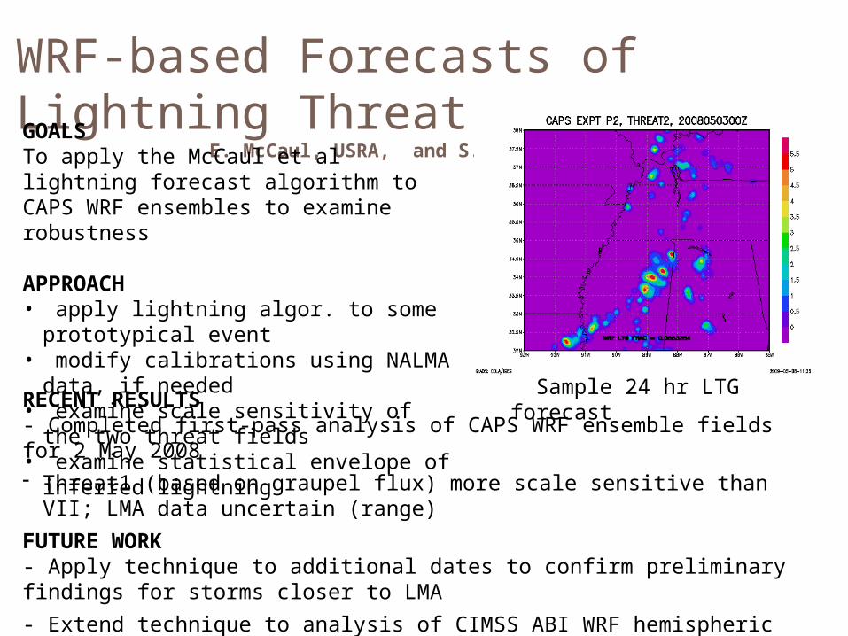
WRF-based Forecasts of Lightning Threat
E. McCaul, USRA, and S. Goodman, NOAAGOALSTo apply the McCaul et al lightning forecast algorithm to CAPS WRF ensembles to examine robustness
APPROACH• apply lightning algor. to some
prototypical event• modify calibrations using NALMA
data, if needed• examine scale sensitivity of the two
threat fields• examine statistical envelope of
inferred lightning
RECENT RESULTS- Completed first-pass analysis of CAPS WRF ensemble fields for 2 May 2008- Threat1 (based on graupel flux) more scale sensitive than VII; LMA data
uncertain (range)
FUTURE WORK- Apply technique to additional dates to confirm preliminary findings for storms closer to LMA
- Extend technique to analysis of CIMSS ABI WRF hemispheric simulation of 4 June 2005 event
Sample 24 hr LTG forecast

Evaluation of Products
Key to success Sustained interaction between developers and end users
facilitated by PG teams for the purpose of training, product assessment, and obtaining feedback
Type of methods to engage users Site visits and presentations
(8 last year outside of HUN) Distance-learning modules with GOES-R proxy product
impacts to specific forecast problems WES Cases Regular coord. telecons (Q&A and feedback opportunity) Online surveys (comparable, metric oriented) Blog posts (peer influence, visual, relevant)

Data in AWIPS IILightning Mapping Array Observations
18 February 2009 – 2306 UTC
AWIPS
AWIPS II
Displaying source densities
Using GRIB format
Combined with radar
Have physical side-by-side comparison of AWIPS versus AWIPS II
Lessons learned to be applied to other SPoRT products
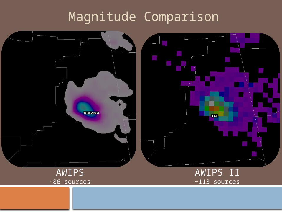
Magnitude Comparison
AWIPS~86 sources
AWIPS II~113 sources

Benefits to the Proving Ground
Radar
NALMA
SPoRT’s efforts to ingest products into AWIPS II are preparing for the future of visualization by NWS
Lessons learned can be applied directly to GOES-R Lightning Mapper
SPoRT is developing expertise with AWIPS II (future McIDAS plug-in)

Updrafts
SPC Spring Program Activities with GOES-R PGTraining for
source density product
SPoRT and the Lightning Group are providing expertise in total lightning
• Provide training to personnel
• Visits by SPoRT staff to SPC and Experimental Warning Program
Real-time total lightning data from three networks will be provided
• North Alabama Lightning Mapping Array
• Washington DC Lightning Mapping Array
• Kennedy Space Center Lightning Detection and Ranging II Network
Data Flow to SPC
Summary
Transition and evaluation of proxy products from PG members to forecast issues of S/SE WFOs
Contribute expertise on total lightning in operations based on partnerships with AWG and RR and past work over several years with WFOs within the NALMA
Use of proxy data for multi-channel or composite product development, as needed for S/SE fcst issues
Lightning threat forecast product from WRF-ABI run
Use both real and proxy data to understand impacts of data assimilation / model initialization