glacial lake pickering: stratigraphy and chronology of a ...eprints.whiterose.ac.uk/102850/1/glacial...
TRANSCRIPT

Glacial Lake Pickering: stratigraphy and chronology ofa proglacial lake dammed by the North Sea Lobe ofthe British–Irish Ice Sheet
DAVID J. A. EVANS,1* MARK D. BATEMAN,2 DAVID H. ROBERTS,1 ALICIA MEDIALDEA,2 LAURA HAYES,2
GEOFF A. T. DULLER,3 DEREK FABEL4 and CHRIS D. CLARK2
1Department of Geography, Durham University, South Road, Durham DH1 3LE, UK2Department of Geography, University of Sheffield, Sheffield, UK3Institute of Geography and Earth Sciences, Aberystwyth University, Penglais Campus, Aberystwyth, UK4School of Geographical and Earth Sciences, University of Glasgow, Glasgow, UK
Received 16 July 2015; Revised 8 December 2015; Accepted 10 December 2015
ABSTRACT: We report the first chronology, using four new optically stimulated luminescence dates, on thesedimentary record of Glacial Lake Pickering, dammed by the North Sea Lobe of the British–Irish Ice Sheet duringthe Dimlington Stadial (24–11 ka cal BP). Dates range from 17.6� 1.0 to 15.8�0.9 ka for the sedimentation of theSherburn Sands at East Heslerton, which were formed by multiple coalescing alluvial fans prograding into thefalling water levels of the lake and fed by progressively larger volumes of debris from the Wolds. Fan formationceased �15.8 ka, at a time when permafrost was degrading and nival-fed streams were no longer capable ofsupplying sediment to the fans. A further age of 10.1� 0.7 ka dates the reworking of coversand into the early partof the Holocene, immediately post-dating Younger Dryas periglacial structures. A 45-m lake level dates to�17.6 ka, when the North Sea Lobe was already in retreat, having moved eastward of the Wykeham Moraine; itstood further east at the Flamborough Moraine by �17.3 ka. The highest (70m) lake level and the occupation ofthe Wykeham Moraine date to an earlier phase of the North Sea Lobe occupation of the Vale of Pickering.Copyright # 2016 John Wiley & Sons, Ltd.
KEYWORDS: British–Irish Ice Sheet; Glacial Lake Pickering; North Sea Lobe; OSL dating; Sherburn Sands.
Introduction to Glacial Lake Pickering
The sedimentary and stratigraphic record of the recession ofthe North Sea Lobe of the British–Irish Ice Sheet (BIIS) isbest documented along the coast of eastern England, specifi-cally in the tills and associated glacilacustrine deposits ofHolderness (Catt, 1991, 2007; Evans et al., 1995; Bostonet al., 2010; Evans and Thomson, 2010) and the HumberEstuary and North Lincolnshire (Straw, 1961, 1979; Gaunt,1981; Bateman et al., 2008, 2015). The style of North SeaLobe recession, based largely upon these onshore landform–sediment assemblages, has been hypothesized by Clark et al.(2012) based upon a restricted number of chronostratigraphiccontrol points. From this, a palaeoglaciology has beenproposed that acknowledges the damming of regional drain-age to produce glacial lakes along the Yorkshire and Durhamcoastlines. Significant advances have recently been made insecuring a chronology for ice recession from the sites onHolderness and the inner Humber Estuary, the former relatingto the Dimlington Stadial type site (cf. Penny et al., 1969;Rose, 1985; Bateman et al., 2015) and the latter relating morespecifically to Glacial Lake Humber (Bateman et al., 2008;Fairburn and Bateman, 2015). Glacial lakes further north,such as lakes Pickering, Eskdale, Tees and Wear (Kendall,1902; Agar, 1954; Smith, 1981; Plater et al., 2000) arerelatively poorly constrained chronologically. We report hereon attempts to refine the chronology of glacial lake develop-ment in the region in relation to the North Sea Lobe,concentrating specifically on Glacial Lake Pickering.The Vale of Pickering today is an east–west-orientated low-
lying plain bounded on three sides by the Howardian Hills(west), the chalky North Yorkshire Wolds (south-east) and thelimestone of the North Yorkshire Moors (north; Fig. 1). Thedamming of pre-glacial easterly river drainage from the North
Yorkshire Moors and Yorkshire Wolds by the onshoreadvance of the North Sea Lobe of the BIIS has long beenacknowledged and depicted on palaeoglaciological maps inthe form of Glacial Lake Pickering (70–30-m OD shorelinealtitude range) and its eastern moraine dam, referred to as theFlamborough Moraine (Fig. 1; Farrington and Mitchell, 1951;Kendall, 1902). This event has had a lasting impact on theregional drainage network, in that the River Derwent, afterrising <5 km from the North Sea on the dip slope of the NorthYorkshire Moors, no longer flows directly east to its nearestcoastline, as it likely did, and is presumed to have done (cf.King, 1965), before the last glaciation, but instead flows160 km westward up the Vale of Pickering and down theKirkham Priory gorge (presently at 20m OD) towards theHumber Estuary. This drainage pattern was dictated by acombination of ice and then moraine damming of the eastend of the Vale of Pickering and Vale of Scalby as well as thedeepening of the Forge Valley and Kirkham Priory gorge asglacial lake spillways (Fig. 1).Kendall (1902) was the first to identify shorelines at 68–70
and 45m OD. For the lake to reach this level, the western endof the vale had to have been blocked by the margin of theVale of York ice lobe at the Coxwold–Gilling Gap, cutting offthat potential drainage route at 68m OD. Because the pre-spillway incision altitude of the Kirkham Priory gap was ataround 60m (Fig. 1e; Edwards, 1978), the presence of Vale ofYork ice would also have been required in the Kirkham Priorygap to block or restrict outflow and thereby produce the 70-mOD level of Glacial Lake Pickering. Kendall (1902) associatedthe 70-m shoreline with a kame terrace/ice-contact delta andhummocky moraine belt between West Ayton and Wykeham(King, 1965; Edwards, 1978). This landform assemblage wastermed the Wykeham moraine and used to define the BIISNorth Sea Lobe ‘Wykeham Stage’ of Penny and Rawson(1969), when ice sheet marginal meltwater was forced to flowinto the lake along the Forge Valley. With its highest altitude
�Correspondence to: D. J. A. Evans, as above.E-mail: [email protected]
Copyright # 2016 John Wiley & Sons, Ltd.
JOURNAL OF QUATERNARY SCIENCE (2016) ISSN 0267-8179. DOI: 10.1002/jqs.2833

at 70m OD, Hunmanby Dale is a likely candidate for a lakespillway for the Wykeham Stage; it was interpreted by King(1965) as a spillway for a small lake located north ofHunmanby but its large size is inconsistent with drainage ofsuch a small volume of water. It could have served as aspillway for the 70-m Lake Pickering stand by one of twomechanisms: (i) the southern lateral margin of the North Sealobe receded a short distance to expose the lower scarp slopeof the Yorkshire Wolds above Flotmanby; or (ii) the ice lobeallowed lake water to escape via a sub-marginal tunnel due topartial snout flotation, akin to the cyclical emptying of ice-dammed lakes along modern ice cap margins (e.g. Bj€ornsson,1976; Clarke, 1982, 2003; Tweed and Russell, 1999; Robertset al., 2005). The lower 45-m shoreline, purportedly controlledby down-cutting of the Kirkham Priory gorge (Edwards, 1978),was associated with an outwash fan fed by the Mere Valley atSeamer and used to define the BIIS North Sea lobe at the
‘Cayton-Speeton’ Stage of Penny and Rawson (1969). At thistime the Flamborough Moraine (Farrington and Mitchell,1951) was thought to have been constructed, as it forms thetopography against which the Seamer Gravels (Mere Valleyfan delta) were deposited (Fig. 1c). A gravel delta progradedfrom the Newtondale channel (spillway?) at Pickering docu-ments a former lake level as low as 30m OD (Kendall, 1902).Later lowstands such as this are presumed to have beencontrolled by further downcutting of the Kirkham Priory gorge(spillway), which presently is as low as 20m OD at its intake,but there is no morphochronological control on such down-cutting. The only other exit from the Vale of Pickering thatcould have controlled a 30-m lake stand is a 29–35-m ODchannel through the Flamborough Moraine between Flot-manby and Filey (Fig. 1c).Borehole records (Fig. 2) reveal that parts of the former lake
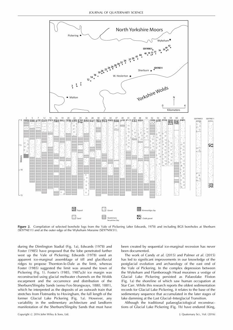
floor contain up to 12m of fine-grained laminations lying
Figure 1. Maps of the study area and the glacial geomorphology pertinent to Glacial Lake Pickering. (a) Location map for the Vale of Pickering;(b) digital elevation model of the Vale of Pickering and surrounding terrain; (c) detailed map of the surficial geology (after BGS Digimap sources)and key landforms and sediments from previous research and this study; (d) traditional palaeoglaciological map of the ice sheet margins andassociated ice-dammed lakes around the North Yorkshire Moors (after Kendall, 1902); (e) map of the Kirkham Priory gorge, showing present-daycontours and reconstructed pre-incision contours used by Edwards (1978) to propose a ‘passive’ overflow route at 60–61m OD. This demonstratesthat the Vale of York ice is required as a dam for the 70-m level of Glacial Lake Pickering.
Copyright # 2016 John Wiley & Sons, Ltd. J. Quaternary Sci., Vol. (2016)
JOURNAL OF QUATERNARY SCIENCE

over bedrock and capped by up to 12m of interbeddedsequences of sands and gravels, with gravels becoming moredominant towards the Wykeham and Flamborough moraines(Edwards, 1978). The westward change along the centre ofthe vale from sand- and gravel-dominated sequences ataround borehole 52 to sand and clay sequences (Fig. 2)reflects the increasingly ice-distal depositional environment.
Borehole SE97NW31 at the Wykeham Moraine is representa-tive of subaqueous ice-contact sedimentation and boreholeSE97NE11 at Sherburn is representative of the Sherburn Sandsof Fox-Strangways (1880, 1881) and the deposits central tothe findings of this paper.Although the Wykeham Moraine has been widely regarded
as the limit of the North Sea Lobe in the Vale of Pickering
Figure 1. Continued
Copyright # 2016 John Wiley & Sons, Ltd. J. Quaternary Sci., Vol. (2016)
GLACIAL LAKE PICKERING
during the Dimlington Stadial (Fig. 1a), Edwards (1978) andFoster (1985) have proposed that the lobe penetrated furtherwest up the Vale of Pickering; Edwards (1978) used anapparent ice-marginal assemblage of till and glacifluvialridges to propose Thornton-le-Dale as the limit, whereasFoster (1985) suggested the limit was around the town ofPickering (Fig. 1). Foster’s (1985, 1987a,b) ice margin wasreconstructed using glacial meltwater channels on the Woldsescarpment and the occurrence and distribution of theSherburn/Slingsby Sands (sensu Fox-Strangways, 1880, 1881),which he interpreted as the deposits of an outwash train thatstretches from Flotmanby to Hovingham, the full length of theformer Glacial Lake Pickering (Fig. 1a). However, anyvariability in the sedimentary architecture and landformmanifestation of the Sherburn/Slingsby Sands that must have
been created by sequential ice-marginal recession has neverbeen documented.The work of Candy et al. (2015) and Palmer et al. (2015)
has led to significant improvements in our knowledge of thepostglacial evolution and archaeology of the east end ofthe Vale of Pickering. In the complex depression betweenthe Wykeham and Flamborough Head moraines a vestige ofGlacial Lake Pickering persisted as Palaeolake Flixton(Fig. 1a) the shoreline of which saw human occupation atStar Carr. While this research reports the oldest sedimentationrecords for Glacial Lake Pickering, it relates to the base of thesedimentary sequence that accumulated in the later stages oflake damming at the Last Glacial–Interglacial Transition.Although the traditional palaeoglaciological reconstruc-
tions of Glacial Lake Pickering (Fig. 1b) have endured (King,
Malton
Pickering
Sherburn
W. Heslerton
Wykeham
Yorkshire Wolds
North Yorkshire Moors
3 5 712
1416
19 2022 24
26 2830 32
34 37 3941 44
48 50 52 53 56 5960
62
0 4
Kilometers
N
SE97NE11
SE97NW31
12753 14 16 19 20 22 24 26 28 30 32 34 37 39 41 44 48 50 52 53 56 59 60 620
5
10
15
Met
ers
SE97NW31 SE97NE11
Sand
Gravel
Quaternary lacustrine clay
Kimmeridge clayTopsoil
Chalk gravel
Figure 2. Compilation of selected borehole logs from the Vale of Pickering (after Edwards, 1978) and including BGS boreholes at Sherburn(SE97NE11) and at the outer edge of the Wykeham Moraine (SE97NW31).
Copyright # 2016 John Wiley & Sons, Ltd. J. Quaternary Sci., Vol. (2016)
JOURNAL OF QUATERNARY SCIENCE
1965; Catt, 1991; Clark et al., 2004; Evans et al., 2005), thelandform and sedimentary evidence proposed to support bothminimum and maximum western full glacial limits for NorthSea Lobe advances (Fig. 1a) has not been fully scrutinizedand never dated, especially in the centre and at the westernend of the vale. This paper reports on the first attempt toprovide a chronology on the sedimentary record pertaining tothe operation of Glacial Lake Pickering during the DimlingtonStadial (24–11 ka cal BP), specifically on the sedimentationrecorded on the south side of the vale in the Sherburn Sandsat East Heslerton (Fig. 1). The chronology presented for theEast Heslerton deposits forms part of a wider dating pro-gramme (BRITICE-CHRONO) aiming to constrain the rateand timing of recession of the last BIIS.
Study site and methods
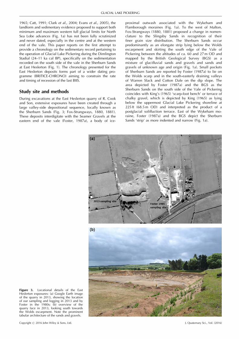
During excavations at the East Heslerton quarry of R. Cookand Son, extensive exposures have been created through alarge valley-side depositional sequence, locally known asthe Sherburn Sands (Fig. 3; Fox-Strangways, 1880, 1881).These deposits interdigitate with the Seamer Gravels at theeastern end of the vale (Foster, 1987a), a body of ice-
proximal outwash associated with the Wykeham andFlamborough moraines (Fig. 1a). To the west of Malton,Fox-Strangways (1880, 1881) proposed a change in nomen-clature to the Slingsby Sands in recognition of theirfiner grain size distribution. The Sherburn Sands occurpredominantly as an elongate strip lying below the Woldsescarpment and skirting the south edge of the Vale ofPickering between the altitudes of ca. 60 and 27m OD andmapped by the British Geological Survey (BGS) as amixture of glacifluvial sands and gravels and sands andgravels of unknown age and origin (Fig. 1a). Small pocketsof Sherburn Sands are reported by Foster (1987a) to lie onthe Wolds scarp and in the south-easterly draining valleysof Warren Slack and Cotton Dale on the dip slope. Thearea depicted by Foster (1987a) and the BGS as theSherburn Sands on the south side of the Vale of Pickeringcoincides with King’s (1965) ‘scarp-foot bench’ or terrace ofchalky gravel, which is depicted by King (1965) as lyingbelow the uppermost Glacial Lake Pickering shoreline at225 ft (68.5m OD) and interpreted as the product of apostglacial solifluction terrace. East of the Wykeham mo-raine, Foster (1987a) and the BGS depict the SherburnSands ‘strip’ as more indented and narrow (Fig. 1a).
Figure 3. Locational details of the EastHeslerton exposures: (a) Google Earth imageof the quarry in 2013, showing the locationof our sampling and logging in 2013 and byFoster in the 1980s; (b) overview of thequarry face in 2013, looking south towardsthe Wolds escarpment. Note the prominenttabular architecture of the sands and gravels.
Copyright # 2016 John Wiley & Sons, Ltd. J. Quaternary Sci., Vol. (2016)
GLACIAL LAKE PICKERING

At East Heslerton the bench or terrace of Sherburn Sandsappears to dip northwards towards the centre of the Vale ofPickering from 50 to 30m OD, although the northern edgeis not particularly pronounced; hence it more resembles adipping shelf than a bench. The Sherburn Sands that havebeen exposed occur in the middle to outer edge of the shelf(Fig. 3a). Exposures through the stratigraphic sequence atEast Heslerton have been logged previously by Foster(1985, 1987a), who proposed a glacial outwash origin, withthe deposits grading distally into the Slingsby Sands at thewest end of the Vale of Pickering and interdigitating inthe east with the glacier-proximal Seamer Gravels at theWykeham and Flamborough moraines. Earlier notions thatthe deposits were lacustrine in origin and associatedwith Glacial Lake Pickering sedimentation (Kendall, 1902;Clark, 1954; Sheppard, 1956) were dismissed by Foster(1987a), who explained the shelf-like, valley-side distribu-tion of the deposits as indicative of sedimentation alongthe left lateral margin of the glacier lobe that penetrated theeast end of the vale, presumably as a feature similar to akame terrace but grading to the falling base level of theproglacial lake to the west. Pockets of the Sherburn Sandson the Wolds scarp and dip slope valleys document theearliest stages of such sedimentation, when the icemargin overtopped the eastern escarpment summit and fedmeltwater down valleys such as Cotton Dale. Foster(1987b) also identifies glacier sub-marginal chutes alongthe escarpment which contain pockets of Sherburn Sands.Because the Sherburn Sands shelf-like deposit continueswestwards and backfills small escarpment valleys such asthe Wintringham Beck valley, it has been used by Foster(1987a) to justify the more westerly or maximum glaciermargin reconstruction.Two outstanding problems arise from this reconstruction of
the Sherburn Sands depositional environment: first, as ac-knowledged by Foster (1987a), the source of the SherburnSands is difficult to reconcile with direct glacial meltwaterdrainage, as the materials are predominantly fine grained andcontain few far-travelled erratics typical of those containedwithin the east coast tills (Madgett and Catt, 1978); second,there are no indicators of ice-contact sedimentation, whichwould be abundant if the positioning of the Sherburn Sandsbench was conditioned by the margin of a glacier lobeextending as far west as Thornton-le-Dale, as proposed byEdwards (1978). However, the upper shelf altitude of 40–60m is compatible with Kendall’s (1902) lower shoreline of45m OD and the altitude of the outwash fan delta at Seamerused to define the Cayton–Speeton Stage (Penny and Rawson,1969). At this stage the North Sea ice lobe constructed theFlamborough Moraine (Farrington and Mitchell, 1951) andformed the topographic barrier against which the SeamerGravels were deposited.
Consequently, some outstanding but not unrelated ques-tions need to be addressed using the sedimentology andgeomorphology of the Vale of Pickering. First, why do theSherburn Sands and equivalent deposits coincide with andoutcrop below the Glacial Lake Pickering shorelines (45–70m OD) if they are not lacustrine? Second, if they recordglacier-marginal recession, why are they devoid of ice-contact characteristics and why is their depositional shelf at aconsistent altitudinal range inside and outside the WykehamMoraine? Third, if they represent glacial outwash, why arethey concentrated in a valley-side shelf which has no kameterrace characteristics and why do palaeocurrents recordformer water flow in all directions except south? Fourth, asthe East Heslerton deposits in particular lie below 45m andbeyond the Wykeham Moraine (i.e. in an area formerlysubmerged by the 70- and 45-m lake stands) why are theynot deltaic?Further to the work of Foster (1987a) we now present new
logging, together with sampling for optically stimulatedluminescence (OSL) dating, which was undertaken in 2013 inthe exposures through the thickest part of the deposit, belowthe bench surface at 40m OD, at the south end of the quarry(Fig. 3b). Vertical profile logs were compiled following theprocedures set out by Evans and Benn (2004) and employingthe lithofacies description and coding approach of Eyles et al.(1983).
Luminescence dating
Samples for OSL dating were taken using opaque plastictubes. In the laboratory, sediment preparation followedstandard procedures to isolate and clean the quartzfraction including wet sieving to separate out the dominant180–250-mm fraction (Bateman and Catt, 1996; Porat et al.,2015). Beta dose rates are based on the concentration of U,Th and K measured using inductively couple plasma massspectroscopy (ICP-MS). Gamma dose rates are based on sitemeasurement of radionuclide activities carried out with anEG & G MicroNomad gamma spectrometer. Cosmic radiationcontributions were calculated based on average burial depthsthrough time (Prescott and Hutton, 1994). Appropriate con-version factors (Gu�erin et al., 2011) including attenuation bymoisture and grain size were used to calculate the final totaldose rate (Table 1). Moisture values were assumed at20�5% for samples well below the current water table(Shfd13054) and 10�5% for those currently close to butabove the current water table.Burial doses (De) were measured at both the single
grain (SG) and ultra-small multigrain aliquot (SA, containing�20 grains each) levels. All luminescence measurementswere carried out on automated Risø readers with blue(470� 30 nm) LED and green (532 nm) Nd:YVO4 laser
Table 1. OSL dates and associated information from East Heslerton.
Field code Lab code Depth(m)
w(%)
b dose rate(Gy/ka)
g dose rate(Gy/ka)
Cosmicdose rate(Gy/ka)
Totaldose rate(Gy/ka)
Aliquotsaccepted(measured)
Aliquotsize
OD(%)
Equivalentdose(Gy)
Age(ka)
HES13/1/4 Shfd13057 1 10� 5 0.58� 0.04 0.43� 0.03 0.18� 0.01 1.22� 0.05 72 (150) SA 38 12.3� 0.6 10.1� 0.737 (4500) SG 32 13.8� 0.9
HES13/1/3 Shfd13056 2 10� 5 0.61� 0.05 0.32� 0.02 0.17� 0.01 1.11� 0.05 83 (140) SA 26 17.5� 0.6 15.8� 0.940 (4500) SG 39 19.4� 1.3
HES13/1/2 Shfd13055 5.5 10� 5 0.53� 0.04 0.18� 0.01 0.12� 0.01 0.85� 0.04 86 (140) SA 22 14.7� 0.4 17.3� 1.037 (4500) SG 40 16.4� 1.3
HES13/1/1 Shfd13054 8.6 20� 5 0.65� 0.05 0.34� 0.02 0.08� 0.01 1.09� 0.05 81 (140) SA 22 19.2� 0.6 17.6� 1.051 (5000) SG 44 21.3� 1.5
Copyright # 2016 John Wiley & Sons, Ltd. J. Quaternary Sci., Vol. (2016)
JOURNAL OF QUATERNARY SCIENCE
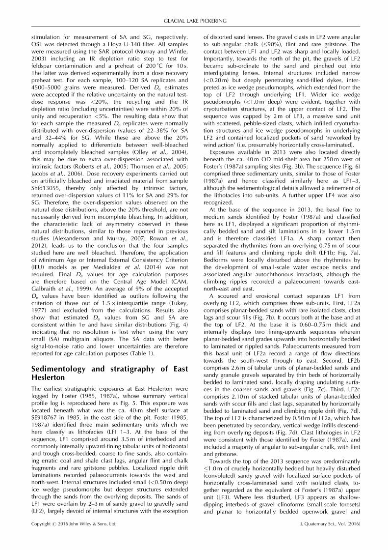
stimulation for measurement of SA and SG, respectively.OSL was detected through a Hoya U-340 filter. All sampleswere measured using the SAR protocol (Murray and Wintle,2003) including an IR depletion ratio step to test forfeldspar contamination and a preheat of 200 ˚C for 10 s.The latter was derived experimentally from a dose recoverypreheat test. For each sample, 100–120 SA replicates and4500–5000 grains were measured. Derived De estimateswere accepted if the relative uncertainty on the natural test-dose response was <20%, the recycling and the IRdepletion ratio (including uncertainties) were within 20% ofunity and recuperation <5%. The resulting data show thatfor each sample the measured De replicates were normallydistributed with over-dispersion (values of 22–38% for SAand 32–44% for SG. While these are above the 20%normally applied to differentiate between well-bleachedand incompletely bleached samples (Olley et al., 2004),this may be due to extra over-dispersion associated withintrinsic factors (Roberts et al., 2005; Thomsen et al., 2005;Jacobs et al., 2006). Dose recovery experiments carried outon artificially bleached and irradiated material from sampleShfd13055, thereby only affected by intrinsic factors,returned over-dispersion values of 11% for SA and 29% forSG. Therefore, the over-dispersion values observed on thenatural dose distributions, above the 20% threshold, are notnecessarily derived from incomplete bleaching. In addition,the characteristic lack of asymmetry observed in thesenatural distributions, similar to those reported in previousstudies (Alexanderson and Murray, 2007; Rowan et al.,2012), leads us to the conclusion that the four samplesstudied here are well bleached. Therefore, the applicationof Minimum Age or Internal External Consistency Criterion(IEU) models as per Medialdea et al. (2014) was notrequired. Final De values for age calculation purposesare therefore based on the Central Age Model (CAM,Galbraith et al., 1999). An average of 9% of the acceptedDe values have been identified as outliers following thecriterion of those out of 1.5� interquartile range (Tukey,1977) and excluded from the calculations. Results alsoshow that estimated De values from SG and SA areconsistent within 1s and have similar distributions (Fig. 4)indicating that no resolution is lost when using the verysmall (SA) multigrain aliquots. The SA data with bettersignal-to-noise ratio and lower uncertainties are thereforereported for age calculation purposes (Table 1).
Sedimentology and stratigraphy of EastHeslerton
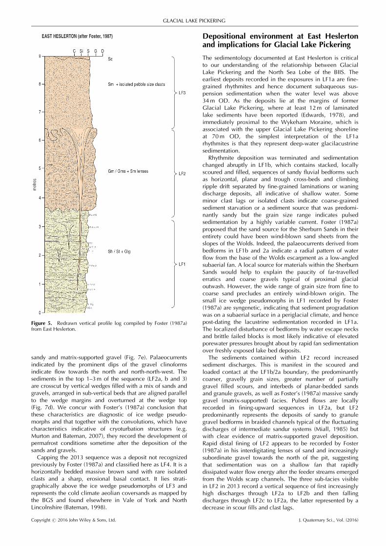
The earliest stratigraphic exposures at East Heslerton werelogged by Foster (1985, 1987a), whose summary verticalprofile log is reproduced here as Fig. 5. This exposure waslocated beneath what was the ca. 40-m shelf surface atSE918767 in 1985, in the east side of the pit. Foster (1985,1987a) identified three main sedimentary units which wehere classify as lithofacies (LF) 1–3. At the base of thesequence, LF1 comprised around 3.5m of interbedded andcommonly internally upward-fining tabular units of horizontaland trough cross-bedded, coarse to fine sands, also contain-ing erratic coal and shale clast lags, angular flint and chalkfragments and rare gritstone pebbles. Localized ripple driftlaminations recorded palaeocurrents towards the west andnorth-west. Internal structures included small (<0.50m deep)ice wedge pseudomorphs but deeper structures extendedthrough the sands from the overlying deposits. The sands ofLF1 were overlain by 2–3m of sandy gravel to gravelly sand(LF2), largely devoid of internal structures with the exception
of distorted sand lenses. The gravel clasts in LF2 were angularto sub-angular chalk (�90%), flint and rare gritstone. Thecontact between LF1 and LF2 was sharp and locally loaded.Importantly, towards the north of the pit, the gravels of LF2became sub-ordinate to the sand and pinched out intointerdigitating lenses. Internal structures included narrow(<0.20m) but deeply penetrating sand-filled dykes, inter-preted as ice wedge pseudomorphs, which extended from thetop of LF2 through underlying LF1. Wider ice wedgepseudomorphs (<1.0m deep) were evident, together withcryoturbation structures, at the upper contact of LF2. Thesequence was capped by 2m of LF3, a massive sand unitwith scattered, pebble-sized clasts, which infilled cryoturba-tion structures and ice wedge pseudomorphs in underlyingLF2 and contained localized pockets of sand ‘reworked bywind action’ (i.e. presumably horizontally cross-laminated).Exposures available in 2013 were also located directly
beneath the ca. 40m OD mid-shelf area but 250m west ofFoster’s (1987a) sampling sites (Fig. 3b). The sequence (Fig. 6)comprised three sedimentary units, similar to those of Foster(1987a) and hence classified similarly here as LF1–3,although the sedimentological details allowed a refinement ofthe lithofacies into sub-units. A further upper LF4 was alsorecognized.At the base of the sequence in 2013, the basal fine to
medium sands identified by Foster (1987a) and classifiedhere as LF1, displayed a significant proportion of rhythmi-cally bedded sand and silt laminations in its lower 1.5mand is therefore classified LF1a. A sharp contact thenseparated the rhythmites from an overlying 0.75m of scourand fill features and climbing ripple drift (LF1b; Fig. 7a).Bedforms were locally disturbed above the rhythmites bythe development of small-scale water escape necks andassociated angular autochthonous intraclasts, although theclimbing ripples recorded a palaeocurrent towards east-north-east and east.A scoured and erosional contact separates LF1 from
overlying LF2, which comprises three sub-units. First, LF2acomprises planar-bedded sands with rare isolated clasts, clastlags and scour fills (Fig. 7b). It occurs both at the base and atthe top of LF2. At the base it is 0.60–0.75m thick andinternally displays two fining-upwards sequences whereinplanar-bedded sand grades upwards into horizontally beddedto laminated or rippled sands. Palaeocurrents measured fromthis basal unit of LF2a record a range of flow directionstowards the south-west through to east. Second, LF2bcomprises 2.6m of tabular units of planar-bedded sands andsandy granule gravels separated by thin beds of horizontallybedded to laminated sand, locally draping undulating surfa-ces in the coarser sands and gravels (Fig. 7c). Third, LF2ccomprises 2.10m of stacked tabular units of planar-beddedsands with scour fills and clast lags, separated by horizontallybedded to laminated sand and climbing ripple drift (Fig. 7d).The top of LF2 is characterized by 0.50m of LF2a, which hasbeen penetrated by secondary, vertical wedge infills descend-ing from overlying deposits (Fig. 7d). Clast lithologies in LF2were consistent with those identified by Foster (1987a), andincluded a majority of angular to sub-angular chalk, with flintand gritstone.Towards the top of the 2013 sequence was predominantly
�1.0m of crudely horizontally bedded but heavily disturbed(convoluted) sandy gravel with localized surface pockets ofhorizontally cross-laminated sand with isolated clasts, to-gether regarded as the equivalent of Foster’s (1987a) upperunit (LF3). Where less disturbed, LF3 appears as shallow-dipping interbeds of gravel clinoforms (small-scale foresets)and planar to horizontally bedded openwork gravel and
Copyright # 2016 John Wiley & Sons, Ltd. J. Quaternary Sci., Vol. (2016)
GLACIAL LAKE PICKERING
Figure 4. Dose distributions from four samples measured using the SAR protocol on small multi-grain aliquots (left column) and single grains(right column). We show the signal of the natural test dose as a function of measured dose (De). The estimated doses derived from CAMcalculation are indicated by the vertical red bar. Over-dispersion values (OD), number of accepted aliquots (n) and the number of identifiedoutliers are included in the plots. Outliers have been excluded from the plotted distributions and from the corresponding CAM and over-dispersionvalues reported.
Copyright # 2016 John Wiley & Sons, Ltd. J. Quaternary Sci., Vol. (2016)
JOURNAL OF QUATERNARY SCIENCE
sandy and matrix-supported gravel (Fig. 7e). Palaeocurrentsindicated by the prominent dips of the gravel clinoformsindicate flow towards the north and north-north-west. Thesediments in the top 1–3m of the sequence (LF2a, b and 3)are crosscut by vertical wedges filled with a mix of sands andgravels, arranged in sub-vertical beds that are aligned parallelto the wedge margins and overturned at the wedge top(Fig. 7d). We concur with Foster’s (1987a) conclusion thatthese characteristics are diagnostic of ice wedge pseudo-morphs and that together with the convolutions, which havecharacteristics indicative of cryoturbation structures (e.g.Murton and Bateman, 2007), they record the development ofpermafrost conditions sometime after the deposition of thesands and gravels.Capping the 2013 sequence was a deposit not recognized
previously by Foster (1987a) and classified here as LF4. It is ahorizontally bedded massive brown sand with rare isolatedclasts and a sharp, erosional basal contact. It lies strati-graphically above the ice wedge pseudomorphs of LF3 andrepresents the cold climate aeolian coversands as mapped bythe BGS and found elsewhere in Vale of York and NorthLincolnshire (Bateman, 1998).
Depositional environment at East Heslertonand implications for Glacial Lake Pickering
The sedimentology documented at East Heslerton is criticalto our understanding of the relationship between GlacialLake Pickering and the North Sea Lobe of the BIIS. Theearliest deposits recorded in the exposures in LF1a are fine-grained rhythmites and hence document subaqueous sus-pension sedimentation when the water level was above34m OD. As the deposits lie at the margins of formerGlacial Lake Pickering, where at least 12m of laminatedlake sediments have been reported (Edwards, 1978), andimmediately proximal to the Wykeham Moraine, which isassociated with the upper Glacial Lake Pickering shorelineat 70m OD, the simplest interpretation of the LF1arhythmites is that they represent deep-water glacilacustrinesedimentation.Rhythmite deposition was terminated and sedimentation
changed abruptly in LF1b, which contains stacked, locallyscoured and filled, sequences of sandy fluvial bedforms suchas horizontal, planar and trough cross-beds and climbingripple drift separated by fine-grained laminations or waningdischarge deposits, all indicative of shallow water. Someminor clast lags or isolated clasts indicate coarse-grainedsediment starvation or a sediment source that was predomi-nantly sandy but the grain size range indicates pulsedsedimentation by a highly variable current. Foster (1987a)proposed that the sand source for the Sherburn Sands in theirentirety could have been wind-blown sand sheets from theslopes of the Wolds. Indeed, the palaeocurrents derived frombedforms in LF1b and 2a indicate a radial pattern of waterflow from the base of the Wolds escarpment as a low-angledsubaerial fan. A local source for materials within the SherburnSands would help to explain the paucity of far-travellederratics and coarse gravels typical of proximal glacialoutwash. However, the wide range of grain size from fine tocoarse sand precludes an entirely wind-blown origin. Thesmall ice wedge pseudomorphs in LF1 recorded by Foster(1987a) are syngenetic, indicating that sediment progradationwas on a subaerial surface in a periglacial climate, and hencepost-dating the lacustrine sedimentation recorded in LF1a.The localized disturbance of bedforms by water escape necksand brittle failed blocks is most likely indicative of elevatedporewater pressures brought about by rapid fan sedimentationover freshly exposed lake bed deposits.The sediments contained within LF2 record increased
sediment discharges. This is manifest in the scoured andloaded contact at the LF1b/2a boundary, the predominantlycoarser, gravelly grain sizes, greater number of partiallygravel filled scours, and interbeds of planar-bedded sandsand granule gravels, as well as Foster’s (1987a) massive sandygravel (matrix-supported) facies. Pulsed flows are locallyrecorded in fining-upward sequences in LF2a, but LF2predominantly represents the deposits of sandy to granulegravel bedforms in braided channels typical of the fluctuatingdischarges of intermediate sandur systems (Miall, 1985) butwith clear evidence of matrix-supported gravel deposition.Rapid distal fining of LF2 appears to be recorded by Foster(1987a) in his interdigitating lenses of sand and increasinglysubordinate gravel towards the north of the pit, suggestingthat sedimentation was on a shallow fan that rapidlydissipated water flow energy after the feeder streams emergedfrom the Wolds scarp channels. The three sub-facies visiblein LF2 in 2013 record a vertical sequence of first increasinglyhigh discharges through LF2a to LF2b and then fallingdischarges through LF2c to LF2a, the latter represented by adecrease in scour fills and clast lags.
Figure 5. Redrawn vertical profile log compiled by Foster (1987a)from East Heslerton.
Copyright # 2016 John Wiley & Sons, Ltd. J. Quaternary Sci., Vol. (2016)
GLACIAL LAKE PICKERING

Figure 6. Details of section sampled at East Heslerton in 2013: (a) vertical profile log with OSL dates presented to the left and palaeocurrentmeasurements in rose plots on the right; (b) photograph of section represented in the vertical profile log, showing horizontal and tabularsedimentary architecture.
Copyright # 2016 John Wiley & Sons, Ltd. J. Quaternary Sci., Vol. (2016)
JOURNAL OF QUATERNARY SCIENCE
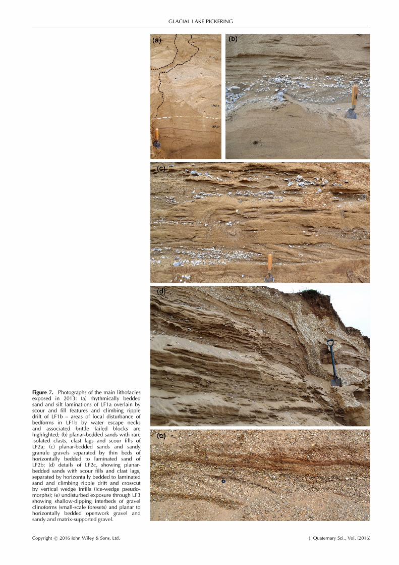
Figure 7. Photographs of the main lithofaciesexposed in 2013: (a) rhythmically beddedsand and silt laminations of LF1a overlain byscour and fill features and climbing rippledrift of LF1b – areas of local disturbance ofbedforms in LF1b by water escape necksand associated brittle failed blocks arehighlighted; (b) planar-bedded sands with rareisolated clasts, clast lags and scour fills ofLF2a; (c) planar-bedded sands and sandygranule gravels separated by thin beds ofhorizontally bedded to laminated sand ofLF2b; (d) details of LF2c, showing planar-bedded sands with scour fills and clast lags,separated by horizontally bedded to laminatedsand and climbing ripple drift and crosscutby vertical wedge infills (ice-wedge pseudo-morphs); (e) undisturbed exposure through LF3showing shallow-dipping interbeds of gravelclinoforms (small-scale foresets) and planar tohorizontally bedded openwork gravel andsandy and matrix-supported gravel.
Copyright # 2016 John Wiley & Sons, Ltd. J. Quaternary Sci., Vol. (2016)
GLACIAL LAKE PICKERING
The sands and gravels that comprise LF3 at the top ofthe sequence have been largely post-depositionally modifiedby cryoturbation and ice wedge development (Foster, 1987a).Localized reworking by wind was also proposed by Foster(1987a). Some exposures in 2013 revealed that thedeposits were originally interbeds of gravel clinoforms andplanar to horizontally bedded openwork gravel and sandy,matrix-supported gravel and hence record a return to highdischarges in a braided stream network similar to thatreflected in LF2 but with gravel bedforms accumulating in thestyle of transverse bars (Miall, 1992).The largest ice wedge pseudomorphs at East Heslerton
penetrate up to 3m vertically, through LF3 and 2a at the topof the sequence. Together with the cryoturbation structures,the ice wedge pseudomorphs record a phase of permafrostconditions that post-dates the deposition of the SherburnSands. These features are typical of many surface sands andgravels in eastern England, with excellent examples in thesame stratigraphic position at Sewerby and Barmston (Evanset al., 1995; Evans and Thomson, 2010) and well-developedpolygons being visible on upland surfaces in the region(Dimbleby, 1952).The dominance of angular to sub-angular clast forms within
the gravels at East Heslerton indicates the mechanicalbreakdown (frost shattering) of cold climate conditions butalso of short travel distances, the former being compatiblewith the development of intraformational ice wedges in LF2.They also reflect low-energy fluvial conditions and/or shorttravel distances and hence are not likely to have beendelivered to the site after significant transport through andthen along the margin of a glacier snout. This further supportsthe notion that the depocentre represented at East Heslertonis a scarp base fan fed by runoff from the Wolds. A faninterpretation, however, does not explain the Sherburn Sands‘shelf’ located just below the altitude of the lower GlacialLake Pickering shoreline (45m OD), unless a series ofchannels through the escarpment were used by runoff toprograde sediments into the vale in a series of fans thatcoalesced over time and, at the last stages of sedimentproduction, aggraded to a base level below the 45-mshoreline. If deposited at the margin of Glacial Lake Picker-ing, the Sherburn Sands were probably deposited in a scarpfoot fan delta. The occurrence of a small outcrop ofrhythmites in LF1a is probably the stratigraphic equivalent ofthe lake sediments previously reported from the former lakefloor and hence the lake deposits appear to continue underthe Sherburn Sands. Additionally, the more gravel-rich sedi-ments of LF2 interdigitate with sands in a distal-finingarchitecture at East Heslerton (Foster, 1987a). The paucity oflake deposits in areas covered by the Sherburn Sands can beexplained by their location within the limits of the formerVale of Pickering ice lobe, so that fan progradation onlystarted once the ice margin began its recession eastwards.Moreover, the subaerial nature of LF2, as indicated by thefluvial bedforms and intraformational ice wedge developmentat East Heslerton, indicates that lake water levels had fallento below 34m OD by the time it was deposited. This musthave taken place sometime after the 45-m shoreline phase ofthe Cayton–Speeton Stage (Penny and Rawson, 1969) and alower lake stand is recorded by the Pickering delta at 30mOD (Kendall, 1902), potentially recording a later incisionlevel at the intake of the Kirkham Priory spillway. However,the 45-m lake stand must have impacted upon the SherburnSands because they extend up the Wolds to at least 60m OD.Lake waters probably trimmed fans west of the FlamboroughMoraine, East Heslerton being an example, rejuvenating themwith new base levels. This enabled these fans to continue
carrying sediments from the Wolds. It therefore appears thatthe distribution of the Sherburn Sands over an altitude rangeof 60–27m OD to produce King’s (1965) and Foster’s (1987a)‘shelf’ is the result of various lakes stands (i.e. 70, 45 and30m), with the East Heslerton deposits relating to sedimenta-tion patterns in the later, lower lake stands.
OSL dating of the East Heslerton stratigraphy
Four OSL ages have been obtained from the East Heslertonstratigraphy (Table 1) and are located on Fig. 6(a). The oldestage of 17.6�1.0 ka (Shfd15054) comes from the LF1aglacilacustrine deposits and therefore dates the sedimentationin Glacial Lake Pickering at the time the ice margin lay at orimmediately east of the Wykeham Moraine. If the Last GlacialMaximum limit lies at the maximum western margin pro-posed by Edwards (1978) and Foster (1985), this date relatesto initial deglaciation of the Vale of Pickering. Alternatively,if the Last Glacial Maximum limit lies at the WykehamMoraine as proposed by Kendall (1902) the age of 17.6�1.0ka relates to the development of a full glacial lake, althoughwe do not know the depth of water above the sample andhence it dates lake sedimentation any time after the glaciermargin stood at the Wykeham Moraine.An age of 17.3�1.0 ka (Shfd15055) from LF2b records fan
aggradation and permafrost conditions following the loweringof Glacial Lake Pickering, to somewhere below 34m OD.Together with the 17.6� 1.0 ka age on LF1b, this dateindicates a drop in lake level sometime around 17.5� 1.0 kaand below the 45-m stand. This drop from the 45-m lakestand indicates that a lower altitude spillway outlet than thatat the Kirkham Priory gorge was exploited by the lake waters.This could simply relate to incision of the gorge down to anew altitude, controlled by the next level of relativelyresistant strata, but the gorge could not have incised down toa base level lower than the altitude of Glacial Lake Humberat that time, which stood at >30m OD (Fairburn andBateman, 2015). Alternatively, it was controlled by theunblocking of the lower topography in the area betweenFlotmanby and Filey where a corridor of low terrain at 29–35m OD dissects the Flamborough Moraine. If the drainageof lake waters did take place through this spillway to createthe 30-m lake level, the age of 17.6�1.0 ka dates thethinning of the North Sea Lobe and its recession eastwardfrom the Flamborough Moraine.The reduced discharges and sediment grades recorded by
LF2c are dated to 15.8� 0.9 ka (Shfd15056). As this depositcontains no evidence of obvious lacustrine sedimentation orshoreline reworking despite lying below 45m OD, it mustrelate to fan progradation to a lower lake stand and hencepost-date the Cayton–Speeton Stage and the production ofthe Flamborough Moraine, at which time the 45-m lakedeveloped. The general fining-upwards evident in LF2c toLF2a sometime after 15.8� 0.9 ka probably records theexhaustion of sediment and meltwater energy in the Woldsdrainage channels feeding the lake marginal fans. Thiscessation might be coincident with the ameliorating climateassociated with the Windermere Interstadial (Allerod/Bolling;GI-1 14.7–12.9 ka, Lowe et al, 2008). Permafrost degradationas reported elsewhere in lowland UK (e.g. Murton et al.,2003) would have reduced overland flow on the Chalk Woldsand the peak discharge associated with spring nival meltingwould have been reduced.An age of 10.1� 0.7 ka (Shfd15057) was obtained from the
LF4 sand unit above the cryoturbated sandy gravels of LF3.The final phase of significant epigenetic ice wedge develop-ment occurred between 15.8�0.9 and 10.1� 0.7 ka,
Copyright # 2016 John Wiley & Sons, Ltd. J. Quaternary Sci., Vol. (2016)
JOURNAL OF QUATERNARY SCIENCE

indicating probably a Younger Dryas age for the periglacialfeatures. This further supports previous reports of significantlowland permafrost during the stade (e.g. Bateman et al.,2014). Sediment from LFA4, dated to 10.1� 0.7 ka, mostlikely reflects coversand reworking into the early part of theHolocene, before the Sherburn sands were stabilized by thedevelopment of vegetation in the ameliorating climate ofthat time. However, the youngest possible derived age of9.4 ka, if it is the more accurate, would coincide with theestablishment of birch and corylus vegetation, as documentedby pollen analysis by Day (1996), indicative of vegetationstabilization. Hence further age determinations on the upper-most facies of the Sherburn Sands are warranted.
Discussion
The extensive outcrop through the Sherburn Sands at EastHeslerton clearly records the aggradation of a fan from thebase of the Wolds escarpment after a drop in the level ofGlacial Lake Pickering sometime around 17.5 ka (Fig. 8).Although Foster (1987a) previously rejected earlier notionsthat the deposits were lacustrine, their occurrence ataltitudes <40m OD and therefore well below the 70- and45-m lake stands associated, respectively, with when theBIIS was at the Wykeham and Flamborough Morainesrequires explanation. Although the sedimentology presentedhere based upon new exposures does include evidence oflake sedimentation at ca. 17.6 ka in LF1b, we have noevidence of water depth at that time. Above LF1b, the EastHeslerton deposits predominantly record subaerial fanaggradation. Because they lie below 45m OD, they musthave aggraded to a lake level no higher than that altitudeand probably to the lowest Glacial Lake Pickering shorelineindicated by the Pickering delta at 30m OD.We now attempt to answer the questions we posed above
regarding the Sherburn Sands and equivalent deposits. First,they coincide with and outcrop below the Glacial LakePickering shorelines (45–70m OD) because they relate toalluvial fans receiving progressively larger volumes of debrisand adjusting to falling shallow lake levels. Hence,although they are not lacustrine in nature, they are relatedto lake surface base level. Second, they probably do notdirectly record glacier-marginal recession and hence aredevoid of ice-contact characteristics; their depositional shelfat a consistent altitudinal range inside and outside theWykeham Moraine is dictated by the accommodation spaceafforded by the shallow lake margins and the dominant45- and 70-m lake level altitudes at the time of sedimentdelivery from the Wolds. Third, they only partially representglacial outwash, with most sediment-laden streams emerg-ing from the Wolds probably being fed by nival meltand hence explaining their grain size, clast forms andlithologies; palaeocurrents are typical of alluvial fansthat coalesced and aggraded to falling lake levels be-tween 70 and 30m OD. Fourth, they are not deltaicbecause of the lack of vertical accommodation spacenecessary for the development of foreset beds in a shallowlake margin subject to falling water levels; this wouldbe compounded by localized incision and regrading ofalluvial fans adjusting to falling lake levels. Interesting inthis respect is the source of the abundant sand andgravel, which must reflect the activity of nival melt on theWolds escarpment.The range of OSL dates on the East Heslerton stratigraphy
provides chronological control on lake-marginal infilling byaggrading glacial and nival-fed fans on the distal side of theWykeham Moraine. The basal date of 17.6 ka could
conceivably relate to lacustrine sedimentation (LF1a) asearly as the 70-m lake stand in front of the WykehamMoraine. However, work elsewhere has shown that theNorth Sea Lobe of the BIIS had extended sufficiently southto have blocked the Vale of Pickering to form Glacial LakePickering from �20.5 ka onwards (Bateman et al., 2015). Itis more likely therefore that the East Heslerton basal age of17.6� 1.0 ka reflects sedimentation within the later 45-mlake, a period not to too dissimilar to that of the highstandof Lake Humber (16.6�1.2 ka; Bateman et al., 2008) intowhich Glacial Lake Pickering flowed (Fig. 8). The fluvialrather than deltaic signature of overlying LF1b and LF2indicates that fan construction at ca. 17.3 ka was grading tolower lake levels and hence must post-date the 45-m levelof Glacial Lake Pickering. Therefore, the construction of theFlamborough Moraine, which is associated with the 45-mlake level, must have taken place before 17.3 ka (Fig. 8).Indeed, although the basal age of Shfd13054 is thought todirectly date this 45-m lake, as only the upper sedimentswere observed, this age more likely represents the finalphase of the 45-m lake. The duration of the 45-m lake, andtherefore the Flamborough Moraine which impounded it,remains undated but with 17.6� 1.0 ka being the bestminimum age at present. Further adjustment to the 30-mlake level at �17.3 ka is coincident with the time whena regional-scale BIIS North Sea Lobe is thought tohave retreated a short distance eastward (Batemanet al., 2015) and would have held Lakes Pickering andHumber at similar levels while the Vale of York Loberetreated northward (Fairburn and Bateman, 2015). Withthe shrinkage and demise of Lake Humber, flow throughthe Kirkham Gap resumed lowering Glacial Lake Pickeringfurther (down to the 20-m OD level of the gap; Fig. 8). Thisin combination with silting up led to fragmentation anddemise of Glacial Lake Pickering, leaving only Lake Flixtonto survive into the Holocene (Palmer et al., 2015).The first direct chronology that Glacial Lake Pickering
existed at least by �17.6 ka (probably with an earlier higherlake level) until sometime before 15.6 ka provides furtherinformation for the dynamics of the BIIS North Sea Lobe.Given ice impoundment for the existence of the lake isrequired, the North Sea Lobe must have been established andfurther south of the Vale of Pickering by this time range. Itmust have also endured close to the present-day coastline forthis period. Livingstone et al. (2012) showed extension of theNorth Sea ice lobe to the Vale of Pickering by 25 ka,establishment of Glacial Lake Pickering by 22 ka and with itpersisting and blocking the Vale of Pickering until 16 ka.Clark et al. (2012) showed ice approaching the Vale ofPickering at 23 ka but not reaching it until 19 ka and gone by16 ka. Given the ice had to retreat before the lake could existat East Heslerton, the new data broadly agree with the onsettimes of both studies but that the North Sea lobe retreatednorthward later than either suggest. The latter point is borneout by new work by Bateman et al (2015) who propose thatice arrived in the Vale of Pickering �20.5 ka but did notretreat northward until just before 15.1 ka. They also showtwo ice-marginal advances (within 20.9–17.1 and 17.1–15.1ka) on the Holderness coastline to the south. The occurrenceof a low col at around 29–35m OD on the FlamboroughMoraine between Flotmanby and Filey indicates that thechange of level of Glacial Lake Pickering to 30m at around17.3 ka was probably initiated by the retreat of ice that wasblocking the Vale of Pickering at that time (Fig. 8). Hence thelake level was maintained at ca. 30m by the moraine damrather than ice. Although Glacial Lake Humber stood at 33mOD from 18 to 17 ka (Bateman et al., 2015; Fairburn and
Copyright # 2016 John Wiley & Sons, Ltd. J. Quaternary Sci., Vol. (2016)
GLACIAL LAKE PICKERING

Bateman, 2015), it is unknown whether there was a linkbetween it and Glacial Lake Pickering. This is because thealtitude of the Kirkham Gap (presently <20m OD) at thattime is unknown even though a newly incised altitude of45m OD is assumed as the control on the 45-m LakePickering level.
Conclusions
� The 45-m level of Glacial Lake Pickering dates to �17.6ka. The lake’s initial impoundment to the 70-m level wasprobably much earlier and was related to Vale of York icedamming both the Coxwold–Gilling gap (68m OD) and
Figure 8. Palaeogeographical reconstruc-tions of glacial events and the developmentof Glacial Lake Pickering during the lastglaciation, incorporating the regional re-constructions of Fairburn and Bateman(2015) and Bateman et al. (2015): (a) thealternative potential scenarios for the Dim-lington Stadial maximum, bracketed at>17.6 ka to <20.5 ka – drainage of the 70-m lake level is assumed to be sub-ice-marginal through Hunmanby Dale, whichwould require the North Sea lobe to belocated as far east at least as the WykehamStage limit; (b) the 45-m OD lake level at�17.6 ka at the Cayton–Speeton Stage; (c)the 30-m OD lake level at �17.3 ka,assumed to be controlled by the 29–35-mOD spillway between Flotmanby and Fileyand hence dating the recession of the NorthSea lobe from the Flamborough Moraine.Note that at this stage it is unknownwhether the 33-m level of Lake Humberand 30-m level of Lake Pickering wereexactly coeval but Lake Pickering waterscould not have decanted through the Kirk-ham Priory gorge.
Copyright # 2016 John Wiley & Sons, Ltd. J. Quaternary Sci., Vol. (2016)
JOURNAL OF QUATERNARY SCIENCE
the Kirkham Priory gorge (ca. 60m OD). The maximumextent of the North Sea lobe is unknown but the Pickering/Thornton-le-Dale limit could be related to the early stagesof the 70-m lake level. At the Wykeham Stage, the lakewaters probably spilled out along the Hunmanby Gap(70m OD) but this route could not have operated if thelobe stood further west at the Pickering/Thornton-le-Dalelimit. Indeed, initial North Sea lobe thinning and recessionprobably triggered the sub-marginal drainage.
� The Sherburn Sands and equivalent deposits were formedby multiple coalescing alluvial fans receiving progressivelylarger volumes of debris from the Wolds and beingrejuvenated by the falling water levels of Glacial LakePickering.
� Fan formation ceased �15.8 ka as climate ameliorated andpermafrost waned. This enhanced the percolation into theChalk of the Wolds and reduced the power of the nival-fedstreams which had been supplying sediment to the fans.
� During the Loch Lomond Stadial, periglacial conditionsresumed with extensive epigenetic ice wedge formationand coversand deposition.
� At the time when the 45-m lake level formed (�17.6 ka)the North Sea lobe of the BIIS was already in retreat,having moved eastward of the Wykham Moraine in theVale of Pickering to the Flamborough Moraine (Cayton–Speeton Stage).
� The operation of the 29–35m OD easterly drainingspillway through the Flamborough Moraine at Filey, whichmost likely controlled the 17.3 ka lake level, indicates thatthe North Sea lobe lay east of the Flamborough Moraine by17.3 ka.
This paper provides the first chronology for Glacial LakePickering during the Dimlington Stadial. In doing so its givesan initial indication of the lake’s sensitivity not only to thedynamics and position of North Sea Lobe of the BIIS but alsoto its relationship with Glacial Lake Humber and climaticcontrols within its catchment. Future work is required toestablish on the exact timing and position of the North SeaLobe within the Vale of Pickering as well as the initiation andduration of the different lake levels.
Acknowledgments. This work was supported by the UK NaturalEnvironment Research Council consortium grant BRITICE-CHRONONE/J009768/1. Thanks to Cook & Son sand quarry at East Heslerton forexcellent access to the site. Rob Ashurst is acknowledged for hisassistance in the preparation of the luminescence samples. Chris Orton(Durham Geography) drafted most of the figures. Thanks forconstructive comments by an anonymous reviewer and Jim Rose.
Abbreviations. BIIS, British–Irish Ice Sheet; BGS, British GeologicalSurvey; CAM, Central Age Model; OSL, optically stimulated lumines-cence; SA, ultra-small multigrain aliquot; SG, single grain.
References
Agar R. 1954. Glacial and post-glacial geology of Middlesboroughand the Tees estuary. Proceedings of the Yorkshire GeologicalSociety 29: 237–253 [DOI: 10.1144/pygs.29.3.237].
Alexanderson H, Murray AS. 2007. Was southern Sweden ice free at19–25ka, or were the post LGM glacifluvial sediments incom-pletely bleached? Quaternary Geochronology 2: 229–236.
Bateman MD. 1998. The origin and age of coversand innorth Lincolnshire, UK. Permafrost and Periglacial Processes 9:313–325 [DOI: 10.1002/(SICI)1099-1530(199810/12)9:4<313::AID-PPP297>3.0.CO;2-P].
Bateman MD, Buckland PC, Chase B et al. 2008. The Late-Devensian proglacial Lake Humber: new evidence from littoraldeposits at Ferrybridge, Yorkshire, England. Boreas 37: 195–210[DOI: 10.1111/j.1502-3885.2007.00013.x].
Bateman MD, Catt JA. 1996. An absolute chronology for the raisedbeach and associated deposits at Sewerby, East Yorkshire, England.Journal of Quaternary Science 11: 389–395 [DOI: 10.1002/(SICI)1099-1417(199609/10)11:5<389::AID-JQS260>3.0.CO;2-K].
Bateman MD, Evans DJA, Buckland PC et al. 2015. Last glacialdynamics of the Vale of York and North Sea lobes of the Britishand Irish Ice Sheet. Proceedings of the Geologists Association 126:712–730.
Bateman MD, Hitchens S, Murton JB et al. 2014. The evolution ofperiglacial patterned ground in East Anglia, UK. Journal ofQuaternary Science 29: 301–317 [DOI: 10.1002/jqs.2704].
Bj€ornsson H. 1976. Marginal and supraglacial lakes in Iceland. J€okull26: 40–50.
Boston CM, Evans DJA, O’Cofaigh C. 2010. Styles of till depositionat the margin of the Last Glacial Maximum North Sea lobeof the British–Irish Ice Sheet: an assessment based ongeochemical properties of glacigenic deposits in eastern England.Quaternary Science Reviews 29: 3184–3211 [DOI: 10.1016/j.quascirev.2010.05.028].
Candy I, Farry A, Darvill CM et al. 2015. The evolution of PalaeolakeFlixton and the environmental context of Star Carr: an oxygen andcarbon isotopic record of environmental change for the EarlyHolocene. Proceedings of the Geologists’ Association 126: 60–71[DOI: 10.1016/j.pgeola.2014.10.001].
Catt JA. 1991. Late Devensian glacial deposits and glaciations ineastern England and the adjoining offshore region. In GlacialDeposits in Great Britain and Ireland, Ehlers J, Gibbard PL, Rose J(eds). Balkema: Rotterdam; 61–68.
Catt JA. 2007. The Pleistocene glaciations of eastern Yorkshire: areview. Proceedings of the Yorkshire Geological Society 56:177–207 [DOI: 10.1144/pygs.56.3.177].
Clark C, Evans D, Khatwa A et al. 2004. Map and GIS database ofglacial landforms and features related to the last British Ice Sheet.Boreas 33: 359–375 [DOI: 10.1080/03009480410001983].
Clark CD, Hughes ALC, Greenwood SL et al. 2012. Pattern and timingof retreat of the last British-Irish Ice Sheet. Quaternary ScienceReviews 44: 112–146 [DOI: 10.1016/j.quascirev.2010.07.019].
Clark JGD. 1954. Excavations at Star Carr. Cambridge UniversityPress: Cambridge.
Clarke GKC. 1982. Glacier outburst floods from “Hazard Lake”,Yukon Territory, and the problem of flood magnitude prediction.Journal of Glaciology 28: 3–21.
Clarke GKC. 2003. Hydraulics of subglacial outburst floods: newinsights from the Spring-Hutter formulation. Journal of Glaciology49: 299–313 [DOI: 10.3189/172756503781830728].
Day P. 1996. Devensian Late-glacial and early Flandrian environ-mental history of the Vale of Pickering, Yorkshire, England. Journalof Quaternary Science 11: 9–24 [DOI: 10.1002/(SICI)1099-1417(199601/02)11:1<9::AID-JQS210>3.0.CO;2-5].
Dimbleby GW. 1952. Pleistocene ice wedges in north-east Yorkshire.Journal of Soil Science 3: 1–19 [DOI: 10.1111/j.1365-2389.1952.tb00627.x].
Edwards CA. 1978. The Quaternary history and stratigraphy of North-East Yorkshire. PhD thesis, University of Hull.
Evans DJA, Clark CD, Mitchell WA. 2005. The last British Ice Sheet:a review of the evidence utilised in the compilation of the glacialmap of Britain. Earth Science Reviews 70: 253–312 [DOI:10.1016/j.earscirev.2005.01.001].
Evans DJA, Benn. 2004. A Practical Guide to the Study of GlacialSediments. Arnold: London.
Evans DJA, Owen LA, Roberts DH. 1995. Stratigraphy and sedimen-tology of Devensian (Dimlington Stadial) glacial deposits, EastYorkshire, England. Journal of Quaternary Science 10: 241–265[DOI: 10.1002/jqs.3390100305].
Evans DJA, Thomson SA. 2010. Glacial sediments and landforms ofHolderness, eastern England: A glacial depositional model for theNorth Sea lobe of the British–Irish Ice Sheet. Earth – ScienceReviews 101: 147–189 [DOI: 10.1016/j.earscirev.2010.04.003].
Eyles N, Eyles CH, Miall AD. 1983. Lithofacies types and verticalprofile models; an alternative approach to the description andenvironmental interpretation of glacial diamict and diamictitesequences. Sedimentology 30: 393–410 [DOI: 10.1111/j.1365-3091.1983.tb00679.x].
Copyright # 2016 John Wiley & Sons, Ltd. J. Quaternary Sci., Vol. (2016)
GLACIAL LAKE PICKERING
Fairburn WA, Bateman MD. 2015. A new multi-stage recessionmodel for Proglacial Lake Humber during the retreat of the LastBritish and Irish Icesheet. Boreas (in press).
Farrington A, Mitchell GF. 1951. The end moraine north ofFlamborough Head. Proceedings of the Geologists’ Association 62:100–106 [DOI: 10.1016/S0016-7878(51)80002-6].
Foster SW. 1985. The Late Glacial and Early Post Glacial history ofthe Vale of Pickering and the North Yorkshire Wolds. PhD thesis,University of Hull.
Foster SW. 1987a. The Sherburn sands of the southern Vale ofPickering. In East Yorkshire - Field Guide, Ellis S. (ed.) QuaternaryResearch Association: Cambridge; 31–35.
Foster 1987b. Features of glacial drainage on the northernWolds escarpment. In East Yorkshire - Field Guide, Ellis S. (ed.)Quaternary Research Association: Cambridge; 39–41.
Fox-Strangways C. 1880. The geology of the oolitic and Cretaceousrocks south of Scarborough. Memoirs of the Geological Survey ofGreat Britain. No. 53. HMSO: London.
Fox-Strangways C. 1881. The geology of the oolitic and Kiassic rocksto the north and west of Malton. Memoirs of the Geological Surveyof Great Britain. No. 53. HMSO: London.
Galbraith RF, Roberts RG, Laslett GM et al. 1999. Optical datingof single and multiple grains of quartz from Jinmium rockshelter, Northern Australia: Part 1, Experimental design andstatistical models. Archaeometry 41: 339–364 [DOI: 10.1111/j.1475-4754.1999.tb00987.x].
Gaunt GD. 1981. Quaternary history of the southern part of the Valeof York. In The Quaternary in Britain, Neale J, Flenley J (eds).Pergamon: Oxford; 82–97.
Gu�erin G, Mercier N, Adamiec G. 2011. Dose-rate conversionfactors: update. Ancient TL 29: 5–8.
Jacobs Z, Duller GAT, Wintle AG, Henshilwood CS. 2006. Extendingthe chronology of deposits at Blombos Cave, South Africa, back to140 ka using optical dating of single and multiple grains of quartz.Journal of Human Evolution 51: 255–273.
Kendall PF. 1902. A system of glacier-lakes in the Cleveland Hills.Quarterly Journal of the Geological Society 58: 471–571 [DOI:10.1144/GSL.JGS.1902.058.01-04.32].
King CAM. 1965. British Landscapes Through Maps: the ScarboroughDistrict. Geographical Association: Sheffield.
Livingstone SJ, Evans DJA, �O Cofaigh C et al. 2012. Glaciodynamicsof the central sector of the last British–Irish Ice Sheet in NorthernEngland. Earth Science Reviews 111: 25–55 [DOI: 10.1016/j.earscirev.2011.12.006].
Lowe JJ, Rasmussen SO, Bj€orck S et al. 2008. Synchronisation ofpalaeoenvironmental events in the North Atlantic region during theLast Termination: a revised protocol recommended by the INTI-MATE group. Quaternary Science Reviews 27: 6–17 [DOI:10.1016/j.quascirev.2007.09.016].
Madgett PA, Catt JA. 1978. Petrography, stratigraphy and weatheringof Late Pleistocene tills in East Yorkshire, Lincolnshire and northNorfolk. Proceedings of the Yorkshire Geological Society 42:55–108 [DOI: 10.1144/pygs.42.1.55].
Medialdea A, Thomsen KJ, Murray AS et al. 2014. Reliability ofequivalent-dose determination and age-models in the OSL datingof historical and modern palaeoflood sediments. QuaternaryGeochronology 22, 11–24.
Miall AD. 1985. Architectural-element analysis: a new method offacies analysis applied to fluvial deposits. Earth Science Reviews22: 261–308.
Miall AD. 1992. Alluvial deposits. In Facies Models: Response toSea-Level Change, Walker RG, James NP (eds). GeologicalAssociation of Canada: Toronto; 119–142.
Murray AS, Wintle AG. 2003. The single aliquot regenerativedose protocol: potential for improvements in reliability.
Radiation Measurements 37: 377–381 [DOI: 10.1016/S1350-4487(03)00053-2].
Murton JB, Bateman MD. 2007. Syngenetic sand veins and anti-syngenetic sand wedges, Tuktoyaktuk Coastlands, western ArcticCanada. Permafrost and Periglacial Processes 18: 33–47 [DOI:10.1002/ppp.577].
Murton JB, Bateman MD, Baker CA et al. 2003. The Devensianperiglacial record on Thanet, Kent, UK. Permafrost and PeriglacialProcesses 14: 217–246 [DOI: 10.1002/ppp.442].
Olley JM, Pietsch T, Roberts RG. 2004. Optical dating of Holocenesediments from a variety of geomorphic settings using single grainsof quartz. Geomorphology 60: 337–358.
Palmer AP, Matthews IP, Candy et al. 2015. The evolution ofPalaeolake Flixton and the environmental context of Star Carr, NE.Yorkshire: stratigraphy and sedimentology of the Last Glacial–Interglacial Transition (LGIT) lacustrine sequences. Proceedings ofthe Geologists’ Association 126: 50–59.
Penny LF, Coope GR, Catt JA. 1969. Age and insect fauna of theDimlington silts, East Yorkshire. Nature 224: 65–67 [DOI: 10.1038/224065b0].
Penny LF, Rawson PF. 1969. Field meeting in East Yorkshire andNorth Lincolnshire. Proceedings of the Geologists’ Association 80:193–216 [DOI: 10.1016/S0016-7878(69)80041-6].
Plater AJ, Ridgway J, Rayner B et al. 2000. Sediment provenance andflux in the Tees Estuary: the record from the Late Devensian to thepresent. Geological Society, London, Special Publications 166:171–195 [DOI: 10.1144/GSL.SP.2000.166.01.10].
Porat N, Faerstein G, Medialdea A, et al. 2015. Re-examination ofcommon extraction and purification methods of quartz and feldsparfor luminescence dating. Ancient TL 33: 22–30.
Prescott JR, Hutton JT. 1994. Cosmic ray contributions to dose ratesfor luminescence and ESR dating: Large depths and long-term timevariations. Radiation Measurements 23: 497–500 [DOI: 10.1016/1350-4487(94)90086-8].
Roberts MJ, P�alsson F, Gudmundsson MT et al. 2005. Ice–waterinteractions during floods from Grænal�on glacier-dammed lake,Iceland. Annals of Glaciology 40: 133–138 [DOI: 10.3189/172756405781813771].
Rose J. 1985. The Dimlington stadial/Dimlington Chronozone: aproposal for naming the main glacial episode of the Late Devensianin Britain. Boreas 14: 225–230 [DOI: 10.1111/j.1502-3885.1985.tb00724.x].
Rowan AV, Roberts HM, Jones MA, Duller GAT, Covey-Crump SJ,Brocklehurst SH. 2012. Optically stimulated luminescence datingof glaciofluvial sediments on the Canterbury Plains, South Island,New Zealand. Quaternary Geochronology 8: 10–22.
Sheppard JA. 1956. The draining of the marshlands of East Yorkshire.PhD Thesis, University of Hull.
Smith DB. 1981. The Quaternary geology of the Sunderland district,north-east England. In The Quaternary in Britain, Neale J, Flenley J(eds). Pergamon: Oxford; 146–167.
Straw A. 1961. Drifts, meltwater channels and ice margins in theLincolnshire Wolds. Transactions and Papers (Institute of BritishGeographers) 29: 115–128 [DOI: 10.2307/621247].
Straw A. 1979. The Devensian glaciation. In The Geomorphology ofthe British Isles: Eastern and Central England, Straw A, Clayton KM(eds). Methuen: London; 21–45.
Thomsen KJ, Murray AS, Botter-Jensen L. 2005. Sources of variabilityin OSL dose measurements using single grains of quartz. RadiationMeasurements 39: 47–61.
Tukey JW. 1977. Exploratory Data Analysis. Addison-Wesley, Read-ing, MA.
Tweed FS, Russell AJ. 1999. Controls on the formation and suddendrainage of glacier-impounded lakes: implications for j€okulhlaupcharacteristics. Progress in Physical Geography 23: 79–110.
Copyright # 2016 John Wiley & Sons, Ltd. J. Quaternary Sci., Vol. (2016)
JOURNAL OF QUATERNARY SCIENCE