gji 4591 lr - california institute of...
TRANSCRIPT
Geophys. J. Int. (2010) 181, 1214–1246 doi: 10.1111/j.1365-246X.2010.04591.x
GJI
Geo
dyna
mic
san
dte
cton
ics
Oroclinal bending, distributed thrust and strike-slip faulting, and theaccommodation of Arabia–Eurasia convergence in NE Iran since theOligocene
James Hollingsworth,1 Morteza Fattahi,2,3 Richard Walker,4 Morteza Talebian,5
Abbas Bahroudi,6 Mohammad Javad Bolourchi,5 James Jackson7 and Alex Copley1
1Division of GPS, California Institute of Technology, MC 100–23, Pasadena, CA 91125, USA. E-mail: [email protected] of Geophysics, University of Tehran, Kargar Shomali, Tehran, PO Box 14155–6466, Iran3School of Geography, University of Oxford, South Parks Road, Oxford OX1 3QY, UK4COMET-NCEO & Department of Earth Sciences, University of Oxford, Parks Road, Oxford OX1 3PR, UK5Geological Survey of Iran, Azadi Sq., Meraj Avenue, PO Box 13185–1494, Tehran, Iran6Exploration Department, University of Tehran, Tehran, PO Box 11365–4563, Iran7COMET-NCEO & Bullard Laboratories, University of Cambridge, Madingley Road, Cambridge CB3 0EZ, UK
Accepted 2010 March 7. Received 2010 February 2; in original form 2009 January 24
S U M M A R YRegional shortening is accommodated across NE Iran in response to the collision of Arabia withEurasia. We examine how N–S shortening is achieved on major thrust systems bounding theeastern branch of the Alborz (east of 57◦E), Sabzevar and Kuh-e-Sorkh mountain ranges, whichlie south of the Kopeh Dagh mountains in NE Iran. Although these ranges have experiencedrelatively few large earthquakes over the last 50 yr, they have been subject to a number ofdevastating historical events at Neyshabur, Esfarayen and Sabzevar. A significant change inthe tectonics of the eastern Alborz occurs directly south of the Central Kopeh Dagh, near 57◦E.To the east, shortening occurs on major thrust faults which bound the southern margin of therange, resulting in significant crustal thickening, and forming peaks up to 3000 m high. Activeshortening dies out eastward into Afghanistan, which is thought to belong to stable Eurasia.The rate of shortening across thrust faults bounding the south side of the eastern Alborz northof Neyshabur is determined using optically stimulated luminescence dating of displaced riverdeposits, and is likely to be 0.4–1.7 mm yr−1. Shortening across the Sabzevar range 150 kmwest of Neyshabur has previously been determined at 0.4–0.6 mm yr−1, although reassessmentof the rate here suggests it may be as high as 1 mm yr−1. Migration of thrust faulting intoforeland basins is common across NE Iran, especially in the Esfarayen region near 57◦E,where the northward deflection of the East Alborz range reaches a maximum of 200 ± 20 km(from its presumed linear E–W strike at the beginning of the Oligocene). West of 57◦E, thetectonics of the Alborz are affected by the westward motion of the South Caspian region, whichresults in the partitioning of shortening onto separate thrust and left-lateral strike-slip faultsnorth and south of the range. At the longitude of 59◦E, published GPS velocities indicate that50 per cent of the overall shortening across NE Iran is accommodated in the Kopeh Dagh.The remaining 50 per cent regional shortening must therefore be accommodated south of theKopeh Dagh, in the eastern Alborz and Kuh-e-Sorkh ranges. Assuming present day rates ofslip and the fault kinematics are representative of the Late Cenozoic deformation in NE Iran,the total 200 ± 20 km N–S shortening across the eastern Alborz and Kopeh Dagh mountainssince the beginning of uplift of the Kopeh Dagh basin would be accommodated in 30 ±8 Ma. Although this extrapolation may be inappropriate over such a long timescale, theage is nevertheless consistent with geological estimates of post Early-to-Middle Oligocene(<30 Ma) for the onset of Kopeh Dagh uplift.
Key words: Geomorphology; Seismicity and tectonics; Continental neotectonics; Tectonicsand landscape evolution; Asia.
1214 C© 2010 The Authors
Journal compilation C© 2010 RAS
Geophysical Journal International
Thrust and strike-slip faulting in NE Iran 1215
1 I N T RO D U C T I O N
Iran occupies a place of special importance in the study of activecontinental collisions. It is situated between the Eurasian and Ara-bian plates, which converge at about 25 mm yr−1, and virtually theentire active collision zone is contained within the geographical andpolitical borders of the country (Fig. 1a). The orogen is thereforeuniquely compact and accessible, and active geomorphological fea-tures are generally well exposed and preserved in the desert or aridclimate. Within Iran, many features of continental tectonics thatare of generic importance are well known, such as partitioning ofoblique motions onto parallel strike-slip and thrust faults (Talebian& Jackson 2004; Vernant et al. 2004a), block rotations about ver-tical axes (Walker & Jackson 2004; Copley & Jackson 2006), andthe concentration of deformation around the edges of rigid blockswithin the collision zone (Jackson et al. 2002; Masson et al. 2005;Reilinger et al. 2006). Recent syntheses of the active tectonic mo-tions in various parts of Iran (e.g. Walker & Jackson 2004; Regardet al. 2005; Hessami et al. 2006; Meyer et al. 2006; Ritz et al. 2006;Walpersdorf et al. 2006) all emphasize the three-dimensionalityof continental tectonics, first highlighted by McKenzie (1972) andMolnar & Tapponnier (1975).
Within Iran, the NE part of the country, which is the subject ofthis paper, is also special. Seismicity, GPS and active geomorphol-ogy all reveal an abrupt edge to the collision zone, trending N–Salong the eastern border between Iran and Afghanistan, and trend-ing NW–SE along the northern border with Turkmenistan (Fig. 1).The N to NNE convergence between Arabia and Eurasia requiresIran to be compressed into this NE corner, and this simple geometrydominates the pattern of strains within the country (Jackson et al.1995; Masson et al. 2005). Along its eastern border, the north-southright-lateral shear between Iran and Afghanistan is accommodatedby N–S right-lateral strike-slip faults in the southern part, but thefaulting then changes to E–W left-lateral faults on the north side ofthe aseismic Lut block, which can only accommodate the shear byrotating clockwise (Walker & Jackson 2004), see Fig. 1(b). Furthernorth still, that shear must end by shortening against the edge of theTurkmen shield in the high mountains of the Kopeh Dagh and itsadjacent ranges. Yet some of this shortening is also achieved by awestward movement of the aseismic South Caspian Basin relativeto both Iran and Eurasia, which is, in turn, related to an along-strikeextension of the Kopeh Dagh mountains (Hollingsworth et al. 2006,2008).
The subject of this paper is the region immediately south of theKopeh Dagh mountains which run along the Turkmenistan border(Fig. 1c). This is a crucial region that must somehow accommodate(1) the north–south transition from right-lateral shear and clock-wise rotation along the Afghan border to shortening against Turk-menistan and (2) the transition from shortening in the east, to lateral‘expulsion’ of the South Caspian Basin on obliquely convergent andpartitioned strike-slip systems to the west (transpression). Spatialtransitions of this sort are probably common in continental colli-sions, but rarely as active or as well exposed as in this case: theregion is therefore of much more than local significance. There is awealth of data from earthquake focal mechanisms, observations offaulting in the field and some GPS measurements (which are likelyto become much more abundant in the future). Individually thesedata sets provide only limited information on the active tectonicsof an area. However, when used together, they allow the first orderfeatures of the deformation to be identified, thereby providing a farmore robust and coherent picture of the regional kinematics. Theaim of this paper is to summarize in one place, so that the kinematics
of this whole important transitional region is visible together, whatis known of the active faulting and how it accommodates motionswithin and across the zone. Once a regional kinematic model hasbeen established for this region, it will provide a framework forfuture more detailed studies, thereby further refining the model.
Before this study the location of active faults in this regionwas virtually unknown and not reported in the literature. There-fore, in Sections 3–7 we describe in detail various fault systemsthroughout the region, before discussing their role in accommo-dating Arabia–Eurasia shortening in Section 8. We make use offield and remote-sensing observations, geomorphological informa-tion about fault slip rates, and accounts of historical earthquakes,which highlight both the activity on structures and also the signifi-cant risk to several densely populated modern cities that have beendestroyed, some of them several times, in the past.
2 T E C T O N I C A N D G E O L O G I C A LB A C KG RO U N D
2.1 Regional tectonics and geographic setting
The collision of the Arabian plate with Eurasia is accommodatedby shortening across the Iran region. Recent GPS measurements(Sella et al. 2002; McClusky et al. 2003; Vernant et al. 2004b;Masson et al. 2007) indicate that Arabia moves northward, withrespect to Eurasia, at ∼23 mm yr−1 at the longitude of the NEIran (Fig. 1a). Both the northward decrease in GPS velocities, andthe large number of earthquakes across Iran indicates that much ofthe deformation is concentrated in the Zagros, Alborz, Talysh andKopeh Dagh mountain ranges, by subduction beneath the centralCaspian sea (Apsheron-Balkan sill), and the Makran, and on N–Sright-lateral fault systems in East Iran—see Fig. 1(b). These areassurround the relatively aseismic Central Iran (CI), South Caspian(SC) and Lut desert (L) regions, which contribute little to the re-gional shortening and probably behave as relatively rigid blocks(Jackson & McKenzie 1984). West of 57◦E, the Zagros accommo-dates about half of the northward motion of Arabia (e.g. Tatar et al.2002), with the Alborz and central Caspian sea taking up the restfurther north. East of 57◦E, about half of the northward motion ofArabia is accommodated by subduction beneath the Makran, withthe remainder accommodated on various intracontinental moun-tain belts in East and NE Iran. The low velocity of station ZABO,which lies east of the Lut block, indicates Afghanistan is part ofstable Eurasia, and no extrusion of continental material occurs tothe east. Shortening north of the Zagros requires N–S right-lateralstrike-slip faulting between Central Iran and stable Afghanistan.This is observed in the N–S right-lateral fault systems either sideof the Lut desert, in east Iran (e.g. Walker & Jackson 2002, 2004).Therefore, shortening in Iran is accommodated primarily by parti-tioning onto separate thrust and strike-slip systems. The relativelycomplicated pattern of faulting is probably due to the influence ofpre-existing structural weaknesses, which have been reactivated inthe Late Cenozoic (Allen et al. 2006).
Detailed GPS studies have been undertaken in the Zagros andcentral Alborz (Tatar et al. 2002; Vernant et al. 2004a), which allow abetter understanding of their role in accommodating Arabia–Eurasiaconvergence. Although similar studies have not been undertaken inNE Iran, where shortening is both slower and more distributed, GPSvelocities from coarsely-spaced stations at KASH, SHIR, MSHNand YAZT allow a general assessment of deformation in NE Iran(Fig. 1c). These show 6 mm yr−1 N–S shortening between Kashmar
C© 2010 The Authors, GJI, 181, 1214–1246
Journal compilation C© 2010 RAS
1216 J. Hollingsworth et al.
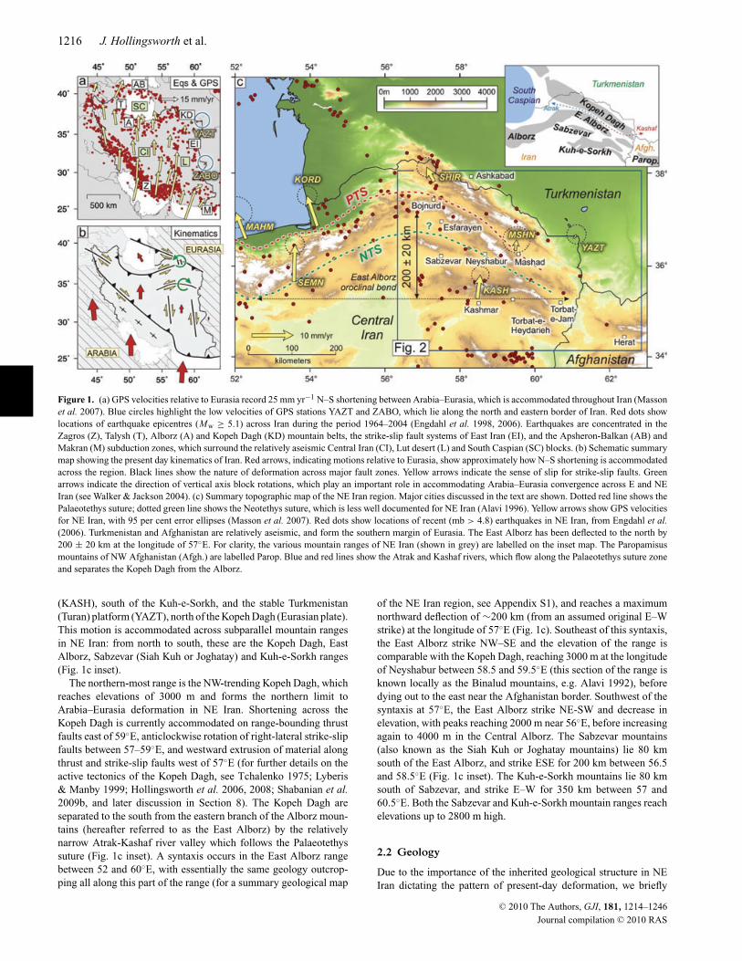
Figure 1. (a) GPS velocities relative to Eurasia record 25 mm yr−1 N–S shortening between Arabia–Eurasia, which is accommodated throughout Iran (Massonet al. 2007). Blue circles highlight the low velocities of GPS stations YAZT and ZABO, which lie along the north and eastern border of Iran. Red dots showlocations of earthquake epicentres (Mw ≥ 5.1) across Iran during the period 1964–2004 (Engdahl et al. 1998, 2006). Earthquakes are concentrated in theZagros (Z), Talysh (T), Alborz (A) and Kopeh Dagh (KD) mountain belts, the strike-slip fault systems of East Iran (EI), and the Apsheron-Balkan (AB) andMakran (M) subduction zones, which surround the relatively aseismic Central Iran (CI), Lut desert (L) and South Caspian (SC) blocks. (b) Schematic summarymap showing the present day kinematics of Iran. Red arrows, indicating motions relative to Eurasia, show approximately how N–S shortening is accommodatedacross the region. Black lines show the nature of deformation across major fault zones. Yellow arrows indicate the sense of slip for strike-slip faults. Greenarrows indicate the direction of vertical axis block rotations, which play an important role in accommodating Arabia–Eurasia convergence across E and NEIran (see Walker & Jackson 2004). (c) Summary topographic map of the NE Iran region. Major cities discussed in the text are shown. Dotted red line shows thePalaeotethys suture; dotted green line shows the Neotethys suture, which is less well documented for NE Iran (Alavi 1996). Yellow arrows show GPS velocitiesfor NE Iran, with 95 per cent error ellipses (Masson et al. 2007). Red dots show locations of recent (mb > 4.8) earthquakes in NE Iran, from Engdahl et al.(2006). Turkmenistan and Afghanistan are relatively aseismic, and form the southern margin of Eurasia. The East Alborz has been deflected to the north by200 ± 20 km at the longitude of 57◦E. For clarity, the various mountain ranges of NE Iran (shown in grey) are labelled on the inset map. The Paropamisusmountains of NW Afghanistan (Afgh.) are labelled Parop. Blue and red lines show the Atrak and Kashaf rivers, which flow along the Palaeotethys suture zoneand separates the Kopeh Dagh from the Alborz.
(KASH), south of the Kuh-e-Sorkh, and the stable Turkmenistan(Turan) platform (YAZT), north of the Kopeh Dagh (Eurasian plate).This motion is accommodated across subparallel mountain rangesin NE Iran: from north to south, these are the Kopeh Dagh, EastAlborz, Sabzevar (Siah Kuh or Joghatay) and Kuh-e-Sorkh ranges(Fig. 1c inset).
The northern-most range is the NW-trending Kopeh Dagh, whichreaches elevations of 3000 m and forms the northern limit toArabia–Eurasia deformation in NE Iran. Shortening across theKopeh Dagh is currently accommodated on range-bounding thrustfaults east of 59◦E, anticlockwise rotation of right-lateral strike-slipfaults between 57–59◦E, and westward extrusion of material alongthrust and strike-slip faults west of 57◦E (for further details on theactive tectonics of the Kopeh Dagh, see Tchalenko 1975; Lyberis& Manby 1999; Hollingsworth et al. 2006, 2008; Shabanian et al.2009b, and later discussion in Section 8). The Kopeh Dagh areseparated to the south from the eastern branch of the Alborz moun-tains (hereafter referred to as the East Alborz) by the relativelynarrow Atrak-Kashaf river valley which follows the Palaeotethyssuture (Fig. 1c inset). A syntaxis occurs in the East Alborz rangebetween 52 and 60◦E, with essentially the same geology outcrop-ping all along this part of the range (for a summary geological map
of the NE Iran region, see Appendix S1), and reaches a maximumnorthward deflection of ∼200 km (from an assumed original E–Wstrike) at the longitude of 57◦E (Fig. 1c). Southeast of this syntaxis,the East Alborz strike NW–SE and the elevation of the range iscomparable with the Kopeh Dagh, reaching 3000 m at the longitudeof Neyshabur between 58.5 and 59.5◦E (this section of the range isknown locally as the Binalud mountains, e.g. Alavi 1992), beforedying out to the east near the Afghanistan border. Southwest of thesyntaxis at 57◦E, the East Alborz strike NE-SW and decrease inelevation, with peaks reaching 2000 m near 56◦E, before increasingagain to 4000 m in the Central Alborz. The Sabzevar mountains(also known as the Siah Kuh or Joghatay mountains) lie 80 kmsouth of the East Alborz, and strike ESE for 200 km between 56.5and 58.5◦E (Fig. 1c inset). The Kuh-e-Sorkh mountains lie 80 kmsouth of Sabzevar, and strike E–W for 350 km between 57 and60.5◦E. Both the Sabzevar and Kuh-e-Sorkh mountain ranges reachelevations up to 2800 m high.
2.2 Geology
Due to the importance of the inherited geological structure in NEIran dictating the pattern of present-day deformation, we briefly
C© 2010 The Authors, GJI, 181, 1214–1246
Journal compilation C© 2010 RAS
Thrust and strike-slip faulting in NE Iran 1217
summarize the geological evolution of this region from publishedstudies and our own deductions based on the geological maps ofHuber (1977a,b). The geological history of NE Iran involved aperiod of relative quiescence and stable shelf sedimentation duringthe Palaeozoic, followed by continental collision during the Meso-zoic and Cenozoic, which continues today. Collision started in theLate Triassic and Late Jurassic (Cimmerian Orogeny), when theCentral-and-East Iran microplate collided with Eurasia (northernPangea). The collision resulted in the closure of the Palaeotethysocean along a suture zone (Palaeotethys Suture Zone; PTS in Fig. 1c)which runs along the north side of the Alborz and follows theAtrak-Kashaf valley in NE Iran (Berberian & King 1981; Sengor1984; Alavi 1996). During the Cretaceous the Central-and-East Iranblock became separated from Eurasia by a newly formed branch ofthe Neotethys ocean (Stocklin 1974). During the end of the Creta-ceous and early Palaeocene, shortening along the northern margin ofNeotethys resulted in the collision of the Central-and-East Iran mi-croplate with Eurasia, marking the onset of the Alpine-HimalayanOrogeny, and the formation of an early Alborz mountain chain(Berberian 1981; Alavi 1996; Guest et al. 2006a). During collisionthe narrow band of Neotethys between Central-and-East Iran andEurasia was subducted, and ophiolitic material was emplaced acrossNE Iran south of the Alborz mountains (e.g. the Sabzevar and Kuh-e-Sorkh ophiolites, see Appendix S1). Once Central-and-East Iranwas resutured to Eurasia (along the Neotethyan Suture Zone; NTSin Fig. 1c) subduction of Neotethys shifted to the southern marginof Central-and-East Iran.
In NE Iran, the East Alborz consist of unmetamorphosed Palaeo-zoic and Mesozoic deposits; predominantly Jurassic limestone. Anexception occurs in the the Binalud section of the East Alborz(north of Neyshabur) where Jurassic limestones are absent, andPalaeozoic to Jurassic exposures have been metamorphosed. TheBinalud provide a window into the older Cimmerian structure ofNE Iran, which has been overprinted by later Alpine movements(Alavi 1992). During the Palaeocene, Alborz-derived molasse wasdeposited in the South Caspian and Kopeh Dagh sedimentary basins,north of the range, which may have resembled the present-day Per-sian Gulf foreland basin south of the Zagros mountains. During theEocene (56–34 Ma), widespread volcanism occurred throughoutNE Iran and the Alborz (absent in the South Caspian and KopehDagh basins), which is thought to record a period of backarc ex-tension related to the northward subduction along the Zagros su-ture (Alavi 1996; Vincent et al. 2005; Guest et al. 2006a; Zanchiet al. 2006). Meanwhile, increased uplift and erosion of the Alborzoccurred during the Oligocene (34–23 Ma— Afshar-Harb 1979;Berberian & King 1981; Alavi 1996), which is reflected by a pulsein exhumation at 32 Ma recorded by apatite-fission track data fromthe west and central Alborz (Rezaeian 2009). The early Oligoceneprobably corresponds to the initial stages of Arabia–Eurasia colli-sion, based on the regional change from extension to convergence,unconformable deposition of terrestrial sediments across the Al-borz, and decelerated volcanism across the region (Vincent et al.2005), although a recent compilation of geological data by Allen &Armstrong (2008) suggests a slightly later onset at ∼35 Ma (LateEocene). The onset of collision may have been in response to theinitial opening of the Red Sea between 20 and 30 Ma (Hempton1987).
Uplift of the Kopeh Dagh basin, north of the East Alborz, oc-curred sometime after the early-to-middle Oligocene (post 30 Ma,Berberian & King 1981; Golonka 2004), with an unconformablechange from marine (Eocene Khangiran Formation) to terrestrial(Miocene? continental red beds; similar to the post-20 Ma Upper
Red Formation of the central Alborz) sedimentation occurring dur-ing the Oligocene–Early Miocene (34–20 Ma). As the Kopeh Daghbecame uplifted in NE Iran, the South Caspian, north of the westand central Alborz, remained a sedimentary basin. Therefore, short-ening was focused in the west and central Alborz (where the range isboth wider and higher than the East Alborz) south of the rigid SouthCaspian backstop, while shortening in NE Iran migrated north (dis-tributed across both the Alborz and Kopeh Dagh) as the Kopeh Daghbasin was uplifted. Rezanov (1959) recognized a gradual northwardmigration of the Kopeh Dagh trough axis towards the Turanian fore-land during the Mesozoic and Tertiary, based on changes in sedi-mentary thickness across the region. Therefore, the deflection of theEast Alborz (Fig. 1c) probably began when the Kopeh Dagh basinbegan to be uplifted. The Kopeh Dagh range consists of upliftedCretaceous limestone and overlying early-Alborz-derived molasse(e.g. continental red beds of the Palaeocene Pestehleigh Formation).The rocks are structurally distinct from those of Central Iran, lyingnorth of the Palaeotethys suture, and are considered part of Eurasiabased on the exposure of Eurasian Palaeozoic rocks in the Agdhar-band erosional window in the eastern Kopeh Dagh (Stocklin 1968;Berberian & King 1981; Ruttner 1993; Alavi 1996). Gravity anoma-lies show that the adjacent flat Turkmenistan plain NE of the KopehDagh is a filled-in flexural foreland basin (Maggi et al. 2000).
During the Middle to Late Miocene, further pulses in exhuma-tion occurred in the west and central Alborz. Thermochronologystudies record various ages for these pulses: 16 Ma and 7–8 Mafor samples spanning the west, central and central-east Alborz(Rezaeian 2008); 12 Ma for samples from the west Alborz (Guestet al. 2006b); and 6–4 Ma for samples from the central Alborz(Axen et al. 2001). It is thought the region underwent major tec-tonic reorganization between 15 and 5 Ma, during which full-scaleArabia–Eurasia continental collision and crustal thickening began(e.g. 10–14 Ma McQuarrie et al. 2003). The younger event at 5Ma may correspond to the onset of seafloor spreading in the RedSea (Hempton 1987). During the Late Miocene, shortening acrossthe Kopeh Dagh in NE Iran is thought to have changed from pre-dominantly folding and thrusting, to westward extrusion and theonset of subduction of the South Caspian-West Kopeh Dagh block(Hollingsworth et al. 2008). However, although the Kopeh Daghform a seismically active and abrupt northeastern limit to activedeformation in Iran, displaced Quaternary fans along the East Al-borz, Sabzevar and Kuh-e-Sorkh mountain ranges indicates thatpresent-day shortening is actually distributed across the entire NEIran region. The aim of this paper is to investigate the active tecton-ics of NE Iran south of the Kopeh Dagh, and also to better quantifyrates of shortening across each of the mountain ranges.
2.3 Seismicity
Unlike the Kopeh Dagh, the East Alborz have experienced no majordestructive earthquakes over the last 150 yr, although three eventsfor which fault plane solutions could be determined occurred on1969 January 3 (Mw 5.5), 1987 April 10 (Mw 5.1) and 2003 July3 (Mw 5.1)—see Fig. 2, and Table 1—for a summary of seismicityin the Kopeh Dagh, see Hollingsworth et al. (2006). Despite thisrelative seismic quiescence in recent times, destructive historicalearthquakes near Neyshabur (1209, 1270, 1389 and 1405) and Es-farayen (1695) indicate that the East Alborz play an important rolein accommodating regional shortening (Table 1 and Fig. 2). Near61◦E, the East Alborz range dies out along the Iran–Afghanistanborder, before rising again as the E–W Paropamisus mountains of
C© 2010 The Authors, GJI, 181, 1214–1246
Journal compilation C© 2010 RAS

1218 J. Hollingsworth et al.
Figure 2. (a) Simplified seismotectonic map for the area of NE Iran east of 57◦E and south of the Kopeh Dagh (see also Hollingsworth et al. 2006, 2008).Thrust faulting occurs along the south side of the East Alborz and Sabzevar ranges, and the north side of the Kuh-e-Sorkh range between 57 and 61◦E (shownby black lines). Minor strike-slip also occurs along the the north side of the East Alborz range. Dotted black lines show older thrust faults (that may or may notbe active) which lie within the East Alborz and Sabzevar mountains, as well as potentially active younger thrust faults in the intervening basin. Red dotted linehighlights an active Neogene fold south of the Kuh-e-Sorkh range. Fault plane solutions for recent large earthquakes (Mw > 5.1) are shown in red (from theHarvard CMT catalogue), and black (Baker 1993). Dates are given for major historical earthquakes which have affected the Esfarayen, Neyshabur, Sabzevar,Kuh-e-Sorkh and Herat regions.
Northern Afghanistan (Fig. 1c). Despite the dramatic cut off inrecent (post-1964) seismicity along the Iran–Afghanistan border,three historical earthquakes occurred in the western Paropamisus,near the city of Herat, in 849, 1102 and 1364 (Ambraseys & Bilham2003) suggesting some active deformation is accommodated in NWAfghanistan. The seismicity of the Sabzevar range resembles that ofthe East Alborz; no large earthquakes have been recorded during theinstrumental period, although a large earthquake destroyed the cityand surrounding area in 1052 (Ambraseys & Melville 1982; Fattahiet al. 2006, see Fig. 2). The Kuh-e-Sorkh mountains have experi-enced many large, but generally less destructive earthquakes overboth historical and recent times (Fig. 2 and Table 1). The majority ofthese events occur along the southern margin of the range, and areprobably related to slip on the left-lateral Doruneh fault (e.g. Fattahi& Walker 2007) and shortening across a prominent E–W fold southof the range (dashed red line in Fig. 2). In this paper, we use satelliteand field data, and Quaternary dating methods, to identify whichfaults in the East Alborz, Sabzevar and Kuh-e-Sorkh ranges ei-ther slipped in recent earthquakes, or contribute significantly to thelate Cenozoic deformation across this region. We also investigatehow East Alborz deformation continues eastward into Afghanistan,which is thought to be aseismic, yet displays clear faulting in thegeomorphology and has a record of historical seismicity.
In the following sections, we identify active structures along theEast Alborz range which may have caused large historical earth-quakes near Neyshabur (Section 3) and both historical and recentearthquakes near Esfarayen (Section 3). In Section 4, we identifyother active structures along the East Alborz range near Torbat-e-
Jam, SE of Neyshabur (Fig. 2), which have not experienced largehistorical earthquakes, but appear active based on their geomorphol-ogy and minor seismicity. We also examine how the deformationextends eastward into the Paropamisus mountains of Afghanistan.Finally, in Sections 6 and 7, we briefly discuss the active tectonicsof the Sabzevar and Kuh-e-Sorkh mountain ranges.
3 N E Y S H A B U R E A RT H Q UA K E S( 1 2 0 9 , 1 2 7 0 , 1 3 8 9 , 1 4 0 5 A N D 1 6 7 3 )
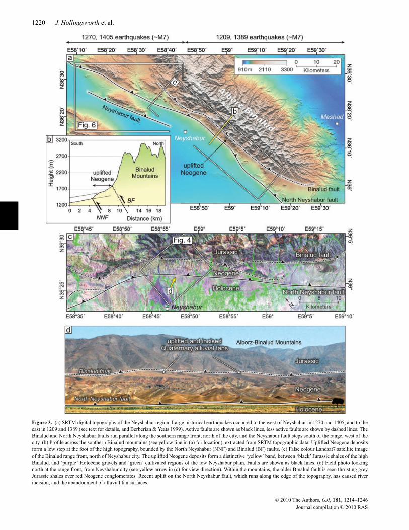
The city of Neyshabur (200 000 pop.) lies on the southern margin ofthe Binalud section of the East Alborz mountains (Figs 2 and 3a). Ithas been destroyed at least five times by major historical earthquakesin 1209, 1270, 1389 and 1405 and 1673 (Table 1, see also Berberian& Yeats 1999). Three large faults occur in the region (Fig. 3a), whichextend 100 km along the south side of the Binalud mountains: theBinalud and North Neyshabur faults lie at the foot of the range northof Neyshabur (Section 3.1), and the Neyshabur fault lies within thevalley west of Neyshabur (Section 3.2). Although the historicalreports are not detailed enough to resolve which faults rupturedduring each earthquake, the damage distribution broadly indicatesthat the 1209 and 1389 events may have ruptured the southernBinalud range front east of Neyshabur, and the 1270 and 1405events west of Neyshabur. Initial results from Quaternary dating ofdisplaced geomorphic markers are used to better constrain the LateQuaternary rate of shortening across the North Neyshabur fault(Section 3.1.2) and Neyshabur fault (Section 3.2.2).
C© 2010 The Authors, GJI, 181, 1214–1246
Journal compilation C© 2010 RAS
Thrust and strike-slip faulting in NE Iran 1219
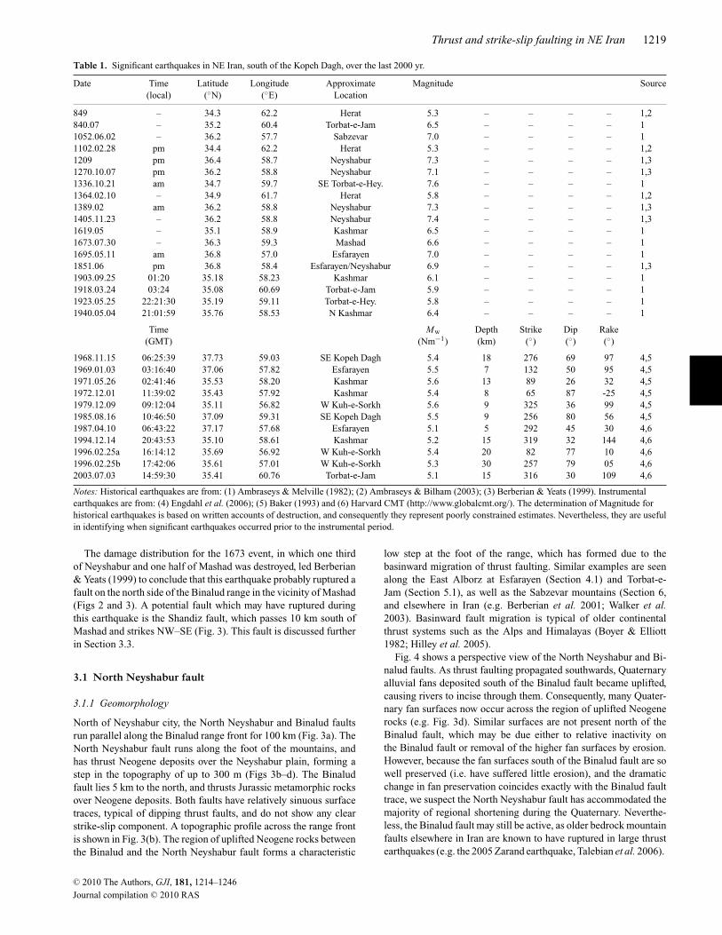
Table 1. Significant earthquakes in NE Iran, south of the Kopeh Dagh, over the last 2000 yr.
Date Time Latitude Longitude Approximate Magnitude Source(local) (◦N) (◦E) Location
849 – 34.3 62.2 Herat 5.3 – – – – 1,2840.07 – 35.2 60.4 Torbat-e-Jam 6.5 – – – – 11052.06.02 – 36.2 57.7 Sabzevar 7.0 – – – – 11102.02.28 pm 34.4 62.2 Herat 5.3 – – – – 1,21209 pm 36.4 58.7 Neyshabur 7.3 – – – – 1,31270.10.07 pm 36.2 58.8 Neyshabur 7.1 – – – – 1,31336.10.21 am 34.7 59.7 SE Torbat-e-Hey. 7.6 – – – – 11364.02.10 – 34.9 61.7 Herat 5.8 – – – – 1,21389.02 am 36.2 58.8 Neyshabur 7.3 – – – – 1,31405.11.23 – 36.2 58.8 Neyshabur 7.4 – – – – 1,31619.05 – 35.1 58.9 Kashmar 6.5 – – – – 11673.07.30 – 36.3 59.3 Mashad 6.6 – – – – 11695.05.11 am 36.8 57.0 Esfarayen 7.0 – – – – 11851.06 pm 36.8 58.4 Esfarayen/Neyshabur 6.9 – – – – 1,31903.09.25 01:20 35.18 58.23 Kashmar 6.1 – – – – 11918.03.24 03:24 35.08 60.69 Torbat-e-Jam 5.9 – – – – 11923.05.25 22:21:30 35.19 59.11 Torbat-e-Hey. 5.8 – – – – 11940.05.04 21:01:59 35.76 58.53 N Kashmar 6.4 – – – – 1
Time Mw Depth Strike Dip Rake(GMT) (Nm−1) (km) (◦) (◦) (◦)
1968.11.15 06:25:39 37.73 59.03 SE Kopeh Dagh 5.4 18 276 69 97 4,51969.01.03 03:16:40 37.06 57.82 Esfarayen 5.5 7 132 50 95 4,51971.05.26 02:41:46 35.53 58.20 Kashmar 5.6 13 89 26 32 4,51972.12.01 11:39:02 35.43 57.92 Kashmar 5.4 8 65 87 -25 4,51979.12.09 09:12:04 35.11 56.82 W Kuh-e-Sorkh 5.6 9 325 36 99 4,51985.08.16 10:46:50 37.09 59.31 SE Kopeh Dagh 5.5 9 256 80 56 4,51987.04.10 06:43:22 37.17 57.68 Esfarayen 5.1 5 292 45 30 4,61994.12.14 20:43:53 35.10 58.61 Kashmar 5.2 15 319 32 144 4,61996.02.25a 16:14:12 35.69 56.92 W Kuh-e-Sorkh 5.4 20 82 77 10 4,61996.02.25b 17:42:06 35.61 57.01 W Kuh-e-Sorkh 5.3 30 257 79 05 4,62003.07.03 14:59:30 35.41 60.76 Torbat-e-Jam 5.1 15 316 30 109 4,6
Notes: Historical earthquakes are from: (1) Ambraseys & Melville (1982); (2) Ambraseys & Bilham (2003); (3) Berberian & Yeats (1999). Instrumentalearthquakes are from: (4) Engdahl et al. (2006); (5) Baker (1993) and (6) Harvard CMT (http://www.globalcmt.org/). The determination of Magnitude forhistorical earthquakes is based on written accounts of destruction, and consequently they represent poorly constrained estimates. Nevertheless, they are usefulin identifying when significant earthquakes occurred prior to the instrumental period.
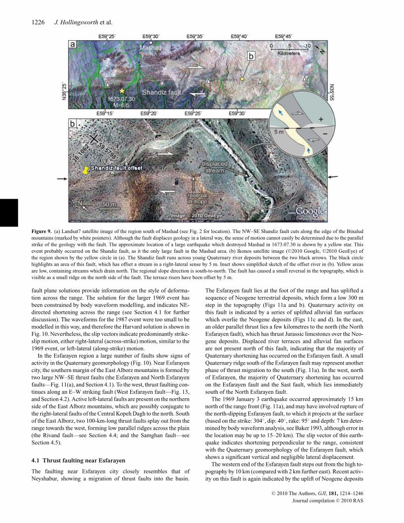
The damage distribution for the 1673 event, in which one thirdof Neyshabur and one half of Mashad was destroyed, led Berberian& Yeats (1999) to conclude that this earthquake probably ruptured afault on the north side of the Binalud range in the vicinity of Mashad(Figs 2 and 3). A potential fault which may have ruptured duringthis earthquake is the Shandiz fault, which passes 10 km south ofMashad and strikes NW–SE (Fig. 3). This fault is discussed furtherin Section 3.3.
3.1 North Neyshabur fault
3.1.1 Geomorphology
North of Neyshabur city, the North Neyshabur and Binalud faultsrun parallel along the Binalud range front for 100 km (Fig. 3a). TheNorth Neyshabur fault runs along the foot of the mountains, andhas thrust Neogene deposits over the Neyshabur plain, forming astep in the topography of up to 300 m (Figs 3b–d). The Binaludfault lies 5 km to the north, and thrusts Jurassic metamorphic rocksover Neogene deposits. Both faults have relatively sinuous surfacetraces, typical of dipping thrust faults, and do not show any clearstrike-slip component. A topographic profile across the range frontis shown in Fig. 3(b). The region of uplifted Neogene rocks betweenthe Binalud and the North Neyshabur fault forms a characteristic
low step at the foot of the range, which has formed due to thebasinward migration of thrust faulting. Similar examples are seenalong the East Alborz at Esfarayen (Section 4.1) and Torbat-e-Jam (Section 5.1), as well as the Sabzevar mountains (Section 6,and elsewhere in Iran (e.g. Berberian et al. 2001; Walker et al.2003). Basinward fault migration is typical of older continentalthrust systems such as the Alps and Himalayas (Boyer & Elliott1982; Hilley et al. 2005).
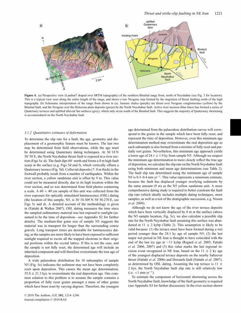
Fig. 4 shows a perspective view of the North Neyshabur and Bi-nalud faults. As thrust faulting propagated southwards, Quaternaryalluvial fans deposited south of the Binalud fault became uplifted,causing rivers to incise through them. Consequently, many Quater-nary fan surfaces now occur across the region of uplifted Neogenerocks (e.g. Fig. 3d). Similar surfaces are not present north of theBinalud fault, which may be due either to relative inactivity onthe Binalud fault or removal of the higher fan surfaces by erosion.However, because the fan surfaces south of the Binalud fault are sowell preserved (i.e. have suffered little erosion), and the dramaticchange in fan preservation coincides exactly with the Binalud faulttrace, we suspect the North Neyshabur fault has accommodated themajority of regional shortening during the Quaternary. Neverthe-less, the Binalud fault may still be active, as older bedrock mountainfaults elsewhere in Iran are known to have ruptured in large thrustearthquakes (e.g. the 2005 Zarand earthquake, Talebian et al. 2006).
C© 2010 The Authors, GJI, 181, 1214–1246
Journal compilation C© 2010 RAS
1220 J. Hollingsworth et al.
Figure 3. (a) SRTM digital topography of the Neyshabur region. Large historical earthquakes occurred to the west of Neyshabur in 1270 and 1405, and to theeast in 1209 and 1389 (see text for details, and Berberian & Yeats 1999). Active faults are shown as black lines, less active faults are shown by dashed lines. TheBinalud and North Neyshabur faults run parallel along the southern range front, north of the city, and the Neyshabur fault steps south of the range, west of thecity. (b) Profile across the southern Binalud mountains (see yellow line in (a) for location), extracted from SRTM topographic data. Uplifted Neogene depositsform a low step at the foot of the high topography, bounded by the North Neyshabur (NNF) and Binalud (BF) faults. (c) False colour Landsat7 satellite imageof the Binalud range front, north of Neyshabur city. The uplifted Neogene deposits form a distinctive ‘yellow’ band, between ‘black’ Jurassic shales of the highBinalud, and ‘purple’ Holocene gravels and ‘green’ cultivated regions of the low Neyshabur plain. Faults are shown as black lines. (d) Field photo lookingnorth at the range front, from Neyshabur city (see yellow arrow in (c) for view direction). Within the mountains, the older Binalud fault is seen thrusting greyJurassic shales over red Neogene conglomerates. Recent uplift on the North Neyshabur fault, which runs along the edge of the topography, has caused riverincision, and the abandonment of alluvial fan surfaces.
C© 2010 The Authors, GJI, 181, 1214–1246
Journal compilation C© 2010 RAS
Thrust and strike-slip faulting in NE Iran 1221
Figure 4. (a) Perspective view (Landsat7 draped over SRTM topography) of the southern Binalud range front, north of Neyshabur (see Fig. 3 for location).This is a typical view seen along the entire length of the range, and shows a low Neogene step formed by the migration of thrust faulting south of the hightopography. (b) Schematic interpretation of the range front shown in (a). Jurassic shales (purple) are thrust over Neogene conglomerates (yellow) by theBinalud fault, and the Neogene over the Holocene plain deposits (green) by the North Neyshabur fault. Active river incision (blue lines) has formed a series ofQuaternary terraces and uplifted alluvial fan surfaces (grey), which only occur south of the Binalud fault. This suggests the majority of Quaternary shorteningis accommodated on the North Neyshabur fault.
3.1.2 Quantitative estimates of deformation
To determine the slip rate for a fault, the age, geometry and dis-placement of a geomorphic feature must be known. The last twomay be determined from field observations, while the age mustbe determined using Quaternary dating techniques. At 36◦18
′N
58◦50′E, the North Neyshabur thrust fault is exposed in a river sec-
tion (Figs 5a–d). The fault dips 60◦ north and forms a 8 m high faultscarp at the surface (e.g. Figs 5d and f), which vertically offsets aQuaternary terrace (Fig. 5d). Colluvial deposits (7–8 m thick) in thefootwall probably result from a number of earthquakes. Within theriver section, a yellow sandstone unit is offset by 9 m. This valuecould not be measured directly, due to its high location within theriver section, and so was determined from field photos containinga scale. A 60 × 40 cm sample of this unit was collected from theriver exposure for optically stimulated luminescence (OSL) dating(the location of this sample, N5, is 36◦18.309
′N 58◦50.270
′E, see
Figs 5c and d). A detailed account of the methodology is givenin (Fattahi & Walker 2007). OSL dating measures the time sincethe sampled sedimentary material was last exposed to sunlight (as-sumed to be the time of deposition—see Appendix S2 for furtherdetails). The medium-fine grain size of sample N5 suggests thematerial was in transport for longer than the surrounding coarsegravels. Long transport times are desirable for luminescence dat-ing, as the samples are more likely to have been exposed to sufficientsunlight required to excite all the trapped electrons to their origi-nal positions within the crystal lattice. If this is not the case, andthe sample is not fully reset, the determined age will include aninherited component and will therefore overestimate the true age ofdeposition.
A wide palaeodose distribution for 18 subsamples of sampleN5 (Fig. 5e) indicates the sediment may not have been completelyreset upon deposition. This causes the mean age determination,55.0 ± 21.3 kyr, to overestimate the real deposition age. One com-mon solution to this problem is to assume the sample contains aproportion of fully reset grains amongst a mass of other grainswhich have been reset by varying degrees. Therefore, the youngest
age determined from the palaeodose distribution curves will corre-spond to the grains in the sample which have been fully reset, andrepresent the time of deposition. However, even this minimum agedetermination method may overestimate the real deposition age aseach subsample is also formed from a mixture of fully reset and par-tially rest grains. Nevertheless, this minimum age approach yieldsa lower age of 24.1 ± 1.9 ky from sample N5. Although we suspectthe minimum age determination to more closely reflect the true ageof deposition, we calculate the slip rate on the North Neyshabur faultusing both minimum and mean age determinations (see Table 2).The fault slip rate determined using the minimum age of sampleN5 is 0.3–0.4 mm yr−1. This value represents a minimum estimate,because the fault has displaced younger overlying sediments bythe same amount (9 m) as the N5 yellow sandstone unit. A morecomprehensive dating study is required to better constrain the faultslip rate (which ideally includes multiple dating techniques, moresamples, as well as a test of the stratigraphic succession, e.g. Nissenet al. 2009).
Although we do not know the age of the river terrace depositswhich have been vertically displaced by 8 m at the surface (abovethe N5 sample location, Fig. 5c), we also calculate a possible sliprate for the North Neyshabur fault assuming this surface was aban-doned at 11 ± 2 kybp (Table 2). This assumption is likely to bevalid because: (1) the terrace must have been formed during a wetperiod younger than the 24.1 ky age of sample N5; (2) the lastmajor wet period in NE Iran is thought to have coincided with theend of the last ice age at ∼11 kybp (Regard et al. 2005; Fattahiet al. 2006, 2007) and (3) this value marks the last regional in-cision event recognized in NE Iran, based on the 11 ± 2 ky ageof the youngest displaced terrace deposits on the nearby Sabzevarthrust (Fattahi et al. 2006) and Doruneh fault (Fattahi et al. 2007),as determined by OSL dating. Assuming the top terrace is 11 ±2 kyr, the North Neyshabur fault slip rate is still relatively low(i.e. <1 mm yr−1).
To estimate the component of horizontal shortening across theNorth Neyshabur fault, knowledge of the fault geometry is required(see Appendix S3 for further discussion). In the river section shown
C© 2010 The Authors, GJI, 181, 1214–1246
Journal compilation C© 2010 RAS

1222 J. Hollingsworth et al.
Figure 5. (a) Topographic map of the Binalud range front, north of Neyshabur (same location as Fig. 4). Blue line shows a large river, which drains south acrossthe North Neyshabur fault and exposes it in section. Dashed white line shows the Binalud fault, and the yellow pointers mark the topographic step formed bythe North Neyshabur fault. Orange arrow shows the location of the field photo shown in (c), and the white line shows the topographic profile shown in (f).(b) Landsat7 satellite image of the region in (a), for comparison. Lithologies are marked, and the North Neyshabur fault is shown in red. Uplifted Quaternaryalluvial fan surfaces are outlined in black. (c) Field photo looking west from 36◦15.967
′N 58◦50.247
′E showing the North Neyshabur fault exposed in a river
section. The orange circle shows the location of sample N5 (see text for details). (d) Schematic interpretation of field photo (c). The yellow sandstone depositshave been displaced 9 m by the North Neyshabur thrust. A similar displacement is seen in the Quaternary terrace at the surface. Thick colluvial depositsoccur in the footwall, south of the fault. The minimum age determination of sample N5 is shown. (e) Palaeodose distribution curve for sample N5. The broadspread of data suggests the sample was not fully reset on deposition. (f) Topographic profile across the fault scarp shown in (d), obtained using kinematic GPSreceivers—see (a) for location. The youngest terrace has been displaced vertically 8 m across the fault.
in Fig. 5(c), the fault dips north at 60◦. If this dip is representative ofthe fault at depth, the shortening-rate is 0.3–0.5 mm yr−1. However,if the fault shallows out at depth onto a horizontal decollement,then the shortening rate on the decollement will equal the fault sliprate where the fault ramps to the surface, that is, 0.7–1.0 mm yr−1
(see Appendix S3). To determine which shortening rate estimateis correct for the North Neyshabur fault knowledge is required ofthe subsurface structure across the fault, which may be revealedby seismic reflection experiments. As we lack this information, ourestimate for the shortening rate across this fault incorporates both
rates estimated above as upper and lower bounds, yielding 0.3–1.0 mm yr−1 (Table 2).
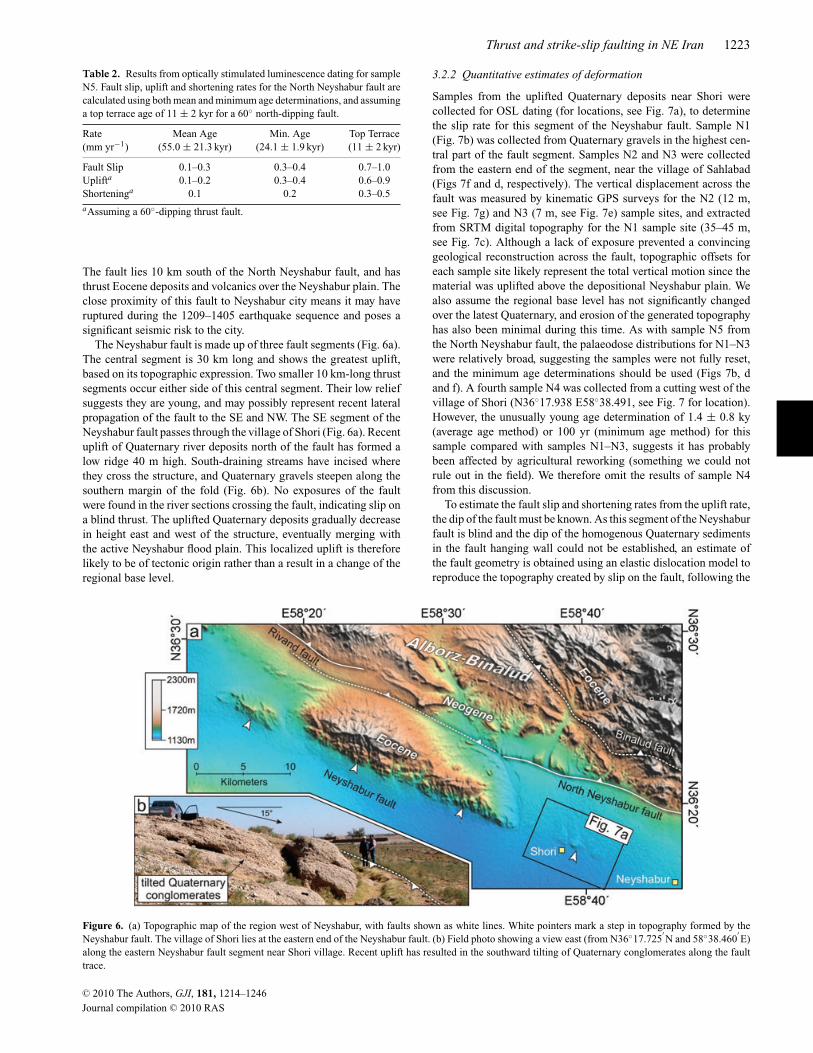
3.2 Neyshabur fault
3.2.1 Geomorphology
The Neyshabur fault strikes NW–SE for 50 km along the southernEast Alborz range front, west of Neyshabur city (Figs 6a and b).
C© 2010 The Authors, GJI, 181, 1214–1246
Journal compilation C© 2010 RAS
Thrust and strike-slip faulting in NE Iran 1223
Table 2. Results from optically stimulated luminescence dating for sampleN5. Fault slip, uplift and shortening rates for the North Neyshabur fault arecalculated using both mean and minimum age determinations, and assuminga top terrace age of 11 ± 2 kyr for a 60◦ north-dipping fault.
Rate Mean Age Min. Age Top Terrace(mm yr−1) (55.0 ± 21.3 kyr) (24.1 ± 1.9 kyr) (11 ± 2 kyr)
Fault Slip 0.1–0.3 0.3–0.4 0.7–1.0Uplifta 0.1–0.2 0.3–0.4 0.6–0.9Shorteninga 0.1 0.2 0.3–0.5aAssuming a 60◦-dipping thrust fault.
The fault lies 10 km south of the North Neyshabur fault, and hasthrust Eocene deposits and volcanics over the Neyshabur plain. Theclose proximity of this fault to Neyshabur city means it may haveruptured during the 1209–1405 earthquake sequence and poses asignificant seismic risk to the city.
The Neyshabur fault is made up of three fault segments (Fig. 6a).The central segment is 30 km long and shows the greatest uplift,based on its topographic expression. Two smaller 10 km-long thrustsegments occur either side of this central segment. Their low reliefsuggests they are young, and may possibly represent recent lateralpropagation of the fault to the SE and NW. The SE segment of theNeyshabur fault passes through the village of Shori (Fig. 6a). Recentuplift of Quaternary river deposits north of the fault has formed alow ridge 40 m high. South-draining streams have incised wherethey cross the structure, and Quaternary gravels steepen along thesouthern margin of the fold (Fig. 6b). No exposures of the faultwere found in the river sections crossing the fault, indicating slip ona blind thrust. The uplifted Quaternary deposits gradually decreasein height east and west of the structure, eventually merging withthe active Neyshabur flood plain. This localized uplift is thereforelikely to be of tectonic origin rather than a result in a change of theregional base level.
3.2.2 Quantitative estimates of deformation
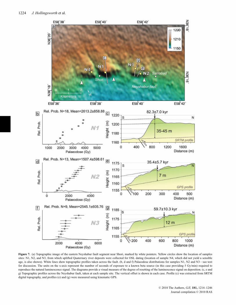
Samples from the uplifted Quaternary deposits near Shori werecollected for OSL dating (for locations, see Fig. 7a), to determinethe slip rate for this segment of the Neyshabur fault. Sample N1(Fig. 7b) was collected from Quaternary gravels in the highest cen-tral part of the fault segment. Samples N2 and N3 were collectedfrom the eastern end of the segment, near the village of Sahlabad(Figs 7f and d, respectively). The vertical displacement across thefault was measured by kinematic GPS surveys for the N2 (12 m,see Fig. 7g) and N3 (7 m, see Fig. 7e) sample sites, and extractedfrom SRTM digital topography for the N1 sample site (35–45 m,see Fig. 7c). Although a lack of exposure prevented a convincinggeological reconstruction across the fault, topographic offsets foreach sample site likely represent the total vertical motion since thematerial was uplifted above the depositional Neyshabur plain. Wealso assume the regional base level has not significantly changedover the latest Quaternary, and erosion of the generated topographyhas also been minimal during this time. As with sample N5 fromthe North Neyshabur fault, the palaeodose distributions for N1–N3were relatively broad, suggesting the samples were not fully reset,and the minimum age determinations should be used (Figs 7b, dand f). A fourth sample N4 was collected from a cutting west of thevillage of Shori (N36◦17.938 E58◦38.491, see Fig. 7 for location).However, the unusually young age determination of 1.4 ± 0.8 ky(average age method) or 100 yr (minimum age method) for thissample compared with samples N1–N3, suggests it has probablybeen affected by agricultural reworking (something we could notrule out in the field). We therefore omit the results of sample N4from this discussion.
To estimate the fault slip and shortening rates from the uplift rate,the dip of the fault must be known. As this segment of the Neyshaburfault is blind and the dip of the homogenous Quaternary sedimentsin the fault hanging wall could not be established, an estimate ofthe fault geometry is obtained using an elastic dislocation model toreproduce the topography created by slip on the fault, following the
Figure 6. (a) Topographic map of the region west of Neyshabur, with faults shown as white lines. White pointers mark a step in topography formed by theNeyshabur fault. The village of Shori lies at the eastern end of the Neyshabur fault. (b) Field photo showing a view east (from N36◦17.725
′N and 58◦38.460
′E)
along the eastern Neyshabur fault segment near Shori village. Recent uplift has resulted in the southward tilting of Quaternary conglomerates along the faulttrace.
C© 2010 The Authors, GJI, 181, 1214–1246
Journal compilation C© 2010 RAS
1224 J. Hollingsworth et al.
Figure 7. (a) Topographic image of the eastern Neyshabur fault segment near Shori, marked by white pointers. Yellow circles show the location of samplessites: N1, N2, and N3, from which uplifted Quaternary river deposits were collected for OSL dating (location of sample N4, which did not yield a sensibleage, is also shown). White lines show topographic profiles taken across the fault. (b, d and f) Palaeodose distributions for samples N1, N2 and N3—see textfor discussion. The units on the x-axis represent the number of seconds of exposure to a known beta source (in this case providing 5 Gy/min) required toreproduce the natural luminescence signal. The diagrams provide a visual measure of the degree of resetting of the luminescence signal on deposition. (c, e andg) Topographic profiles across the Neyshabur fault, taken at each sample site. The vertical offset is shown in each case. Profile (c) was extracted from SRTMdigital topography, and profiles (e) and (g) were measured using kinematic GPS.
C© 2010 The Authors, GJI, 181, 1214–1246
Journal compilation C© 2010 RAS
Thrust and strike-slip faulting in NE Iran 1225
Table 3. Results from optically stimulated luminescence dating for samplesN1, N2 and N3. Fault slip, uplift and shortening rates for the Neyshabur faultare calculated using both mean and minimum age determinations, and a faultdip of 60◦.
Rate Mean age Minimum age(mm yr−1) (129.0 ± 43.5 ky) (82.3 ± 7.0 ky)
Fault Slipa 0.2–0.6 0.5–0.7N1 Uplift 0.2–0.5 0.4–0.6
Shorteninga 0.1–0.3 0.2–0.3
(56.9 ± 22.9 ky) (35.4 ± 5.7 ky)
Fault Slipa 0.1–0.2 0.2–0.3N2 Uplift 0.1–0.2 0.2
Shorteninga 0.1 0.1
(76.6 ± 18.8 ky) (59.7 ± 10.3 ky)
Fault Slipa 0.1–0.2 0.2–0.3N3 Uplift 0.1–0.2 0.2
Shorteninga 0.1 0.1aAssuming a 60◦-dipping thrust fault.
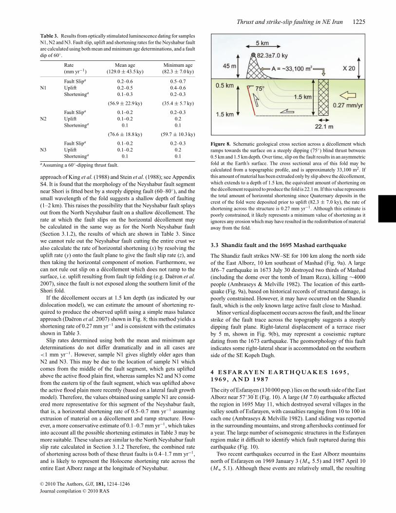
approach of King et al. (1988) and Stein et al. (1988); see AppendixS4. It is found that the morphology of the Neyshabur fault segmentnear Shori is fitted best by a steeply dipping fault (60–80◦), and thesmall wavelength of the fold suggests a shallow depth of faulting(1–2 km). This raises the possibility that the Neyshabur fault splaysout from the North Neyshabur fault on a shallow decollement. Therate at which the fault slips on the horizontal decollement maybe calculated in the same way as for the North Neyshabur fault(Section 3.1.2), the results of which are shown in Table 3. Sincewe cannot rule out the Neyshabur fault cutting the entire crust wealso calculate the rate of horizontal shortening (x) by resolving theuplift rate (y) onto the fault plane to give the fault slip rate (z), andthen taking the horizontal component of motion. Furthermore, wecan not rule out slip on a decollement which does not ramp to thesurface, i.e. uplift resulting from fault tip folding (e.g. Daeron et al.2007), since the fault is not exposed along the southern limit of theShori fold.
If the decollement occurs at 1.5 km depth (as indicated by ourdislocation model), we can estimate the amount of shortening re-quired to produce the observed uplift using a simple mass balanceapproach (Daeron et al. 2007) shown in Fig. 8; this method yields ashortening rate of 0.27 mm yr−1 and is consistent with the estimatesshown in Table 3.
Slip rates determined using both the mean and minimum agedeterminations do not differ dramatically and in all cases are<1 mm yr−1. However, sample N1 gives slightly older ages thanN2 and N3. This may be due to the location of sample N1 whichcomes from the middle of the fault segment, which gets upliftedabove the active flood plain first, whereas samples N2 and N3 comefrom the eastern tip of the fault segment, which was uplifted abovethe active flood plain more recently (based on a lateral fault growthmodel). Therefore, the values obtained using sample N1 are consid-ered more representative for this segment of the Neyshabur fault,that is, a horizontal shortening rate of 0.5–0.7 mm yr−1 assumingextrusion of material on a decollement and ramp structure. How-ever, a more conservative estimate of 0.1–0.7 mm yr−1, which takesinto account all the possible shortening estimates in Table 3 may bemore suitable. These values are similar to the North Neyshabur faultslip rate calculated in Section 3.1.2 Therefore, the combined rateof shortening across both of these thrust faults is 0.4–1.7 mm yr−1,and is likely to represent the Holocene shortening rate across theentire East Alborz range at the longitude of Neyshabur.
Figure 8. Schematic geological cross section across a decollement whichramps towards the surface on a steeply dipping (75◦) blind thrust between0.5 km and 1.5 km depth. Over time, slip on the fault results in an asymmetricfold at the Earth’s surface. The cross sectional area of this fold may becalculated from a topographic profile, and is approximately 33,100 m2. Ifthis amount of material has been extruded only by slip above the decollement,which extends to a depth of 1.5 km, the equivalent amount of shortening onthe decollement required to produce the fold is 22.1 m. If this value representsthe total amount of horizontal shortening since Quaternary deposits in thecrest of the fold were deposited prior to uplift (82.3 ± 7.0 ky), the rate ofshortening across the structure is 0.27 mm yr−1. Although this estimate ispoorly constrained, it likely represents a minimum value of shortening as itignores any erosion which may have resulted in the redistribution of materialaway from the fold.
3.3 Shandiz fault and the 1695 Mashad earthquake
The Shandiz fault strikes NW–SE for 100 km along the north sideof the East Alborz, 10 km southeast of Mashad (Fig. 9a). A largeM6–7 earthquake in 1673 July 30 destroyed two thirds of Mashad(including the dome over the tomb of Imam Reza), killing ∼4000people (Ambraseys & Melville 1982). The location of this earth-quake (Fig. 9a), based on historical records of structural damage, ispoorly constrained. However, it may have occurred on the Shandizfault, which is the only known large active fault close to Mashad.
Minor vertical displacement occurs across the fault, and the linearstrike of the fault trace across the topography suggests a steeplydipping fault plane. Right-lateral displacement of a terrace riserby 5 m, shown in Fig. 9(b), may represent a coseismic rupturedating from the 1673 earthquake. The geomorphology of this faultindicates some right-lateral shear is accommodated on the southernside of the SE Kopeh Dagh.
4 E S FA R AY E N E A RT H Q UA K E S 1 6 9 5 ,1 9 6 9 , A N D 1 9 8 7
The city of Esfarayen (130 000 pop.) lies on the south side of the EastAlborz near 57◦30
′E (Fig. 10). A large (M 7.0) earthquake affected
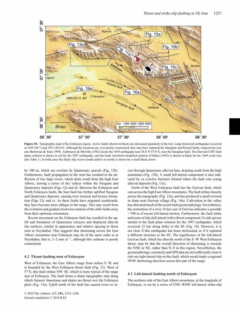
the region in 1695 May 11, which destroyed several villages in thevalley south of Esfarayen, with casualties ranging from 10 to 100 ineach one (Ambraseys & Melville 1982). Land sliding was reportedin the surrounding mountains, and strong aftershocks continued fora year. The large number of seismogenic structures in the Esfarayenregion make it difficult to identify which fault ruptured during thisearthquake (Fig. 10).
Two recent earthquakes occurred in the East Alborz mountainsnorth of Esfarayen on 1969 January 3 (Mw 5.5) and 1987 April 10(Mw 5.1). Although these events are relatively small, the resulting
C© 2010 The Authors, GJI, 181, 1214–1246
Journal compilation C© 2010 RAS
1226 J. Hollingsworth et al.
Figure 9. (a) Landsat7 satellite image of the region south of Mashad (see Fig. 2 for location). The NW–SE Shandiz fault cuts along the edge of the Binaludmountains (marked by white pointers). Although the fault displaces geology in a lateral way, the sense of motion cannot easily be determined due to the parallelstrike of the geology with the fault. The approximate location of a large earthquake which destroyed Mashad in 1673.07.30 is shown by a yellow star. Thisevent probably occurred on the Shandiz fault, as it the only large fault in the Mashad area. (b) Ikonos satellite image ( C©2010 Google, C©2010 GeoEye) ofthe region shown by the yellow circle in (a). The Shandiz fault runs across young Quaternary river deposits between the two black arrows. The black circlehighlights an area of this fault, which has offset a stream in a right-lateral sense by 5 m. Inset shows simplified sketch of the offset river in (b). Yellow areasare low, containing streams which drain north. The regional slope direction is south-to-north. The fault has caused a small reversal in the topography, which isvisible as a small ridge on the north side of the fault. The terrace risers have been offset by 5 m.
fault plane solutions provide information on the style of deforma-tion across the range. The solution for the larger 1969 event hasbeen constrained by body waveform modelling, and indicates NE-directed shortening across the range (see Section 4.1 for furtherdiscussion). The waveforms for the 1987 event were too small to bemodelled in this way, and therefore the Harvard solution is shown inFig. 10. Nevertheless, the slip vectors indicate predominantly strike-slip motion, either right-lateral (across-strike) motion, similar to the1969 event, or left-lateral (along-strike) motion.
In the Esfarayen region a large number of faults show signs ofactivity in the Quaternary geomorphology (Fig. 10). Near Esfarayencity, the southern margin of the East Alborz mountains is formed bytwo large NW–SE thrust faults (the Esfarayen and North Esfarayenfaults—Fig. 11(a), and Section 4.1). To the west, thrust faulting con-tinues along an E–W striking fault (West Esfarayen fault—Fig. 13,and Section 4.2). Active left-lateral faults are present on the northernside of the East Alborz mountains, which are possibly conjugate tothe right-lateral faults of the Central Kopeh Dagh to the north. Southof the East Alborz, two 100-km-long thrust faults splay out from therange towards the west, forming low parallel ridges across the plain(the Rivand fault—see Section 4.4; and the Samghan fault—seeSection 4.5).
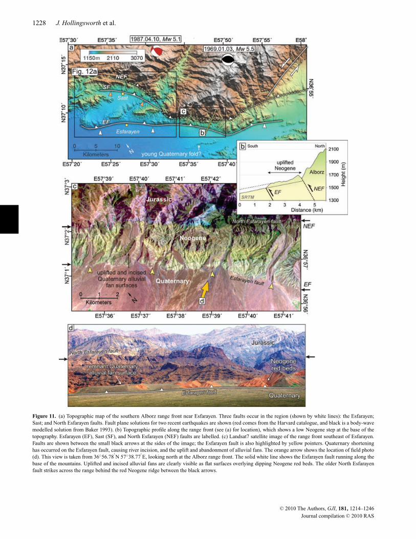
4.1 Thrust faulting near Esfarayen
The faulting near Esfarayen city closely resembles that ofNeyshabur, showing a migration of thrust faults into the basin.
The Esfarayen fault lies at the foot of the range and has uplifted asequence of Neogene terrestrial deposits, which form a low 300 mstep in the topography (Figs 11a and b). Quaternary activity onthis fault is indicated by a series of uplifted alluvial fan surfaceswhich overlie the Neogene deposits (Figs 11c and d). In the east,an older parallel thrust lies a few kilometres to the north (the NorthEsfarayen fault), which has thrust Jurassic limestones over the Neo-gene deposits. Displaced river terraces and alluvial fan surfacesare not present north of this fault, indicating that the majority ofQuaternary shortening has occurred on the Esfarayen fault. A smallQuaternary ridge south of the Esfarayen fault may represent anotherphase of thrust migration to the south (Fig. 11a). In the west, northof Esfarayen, the majority of Quaternary shortening has occurredon the Esfarayen fault and the Sast fault, which lies immediatelysouth of the North Esfarayen fault.
The 1969 January 3 earthquake occurred approximately 15 kmnorth of the range front (Fig. 11a), and may have involved rupture ofthe north-dipping Esfarayen fault, to which it projects at the surface(based on the strike: 304◦, dip: 40◦, rake: 95◦ and depth: 7 km deter-mined by body waveform analysis, see Baker 1993, although error inthe location may be up to 15–20 km). The slip vector of this earth-quake indicates shortening perpendicular to the range, consistentwith the Quaternary geomorphology of the Esfarayen fault, whichshows a significant vertical and negligible lateral displacement.
The western end of the Esfarayen fault steps out from the high to-pography by 10 km (compared with 2 km further east). Recent activ-ity on this fault is again indicated by the uplift of Neogene deposits
C© 2010 The Authors, GJI, 181, 1214–1246
Journal compilation C© 2010 RAS
Thrust and strike-slip faulting in NE Iran 1227
Figure 10. Topographic map of the Esfarayen region. Active faults (shown in black) are discussed separately in the text. Large historical earthquakes occurredin 1695 (M 7) and 1851 (M 6.9). Although the locations are very poorly constrained, they may have ruptured the Samghan and Rivand faults, respectively (seealso Berberian & Yeats 1999). Ambraseys & Melville (1982) locate the 1695 earthquake near 36.8◦N 57.0◦E, near the Samghan fault. The Harvard CMT faultplane solution is shown in red for the 1987 earthquake, and the body waveform modelled solution of Baker (1993) is shown in black for the 1969 event (seealso Table 1). In both cases the likely slip vector (south relative to north) is shown by a small black arrow.
by 100 m, which are overlain by Quaternary gravels (Fig. 12b).Furthermore, fault propagation to the west has resulted in the de-flection of two large rivers, which drain south from the high EastAlborz, leaving a series of dry valleys within the Neogene andQuaternary deposits (Figs 12a and d). Between the Esfarayen andNorth Esfarayen faults, the Sast fault has further uplifted Neogeneand Quaternary deposits, causing river incision and terrace forma-tion (Figs 12c and e). As these faults have migrated southwards,they have become more oblique to the range. This may result fromthe evolution and gradual clockwise rotation of the older faults awayfrom their optimum orientation.
Recent movement on the Esfarayen fault has resulted in the up-lift and formation of Quaternary terraces and displaced alluvialfan surfaces, similar in appearance and relative spacing to thoseseen at Neyshabur. This suggests that shortening across the EastAlborz mountains near Esfarayen may be of the same order as atNeyshabur, that is, 1–2 mm yr−1, although this estimate is poorlyconstrained.
4.2 Thrust faulting west of Esfarayen
West of Esfarayen, the East Alborz range front strikes E–W, andis bounded by the West Esfarayen thrust fault (Fig. 13). West of57◦E, this fault strikes NW–SE, which is more typical of the rangeeast of Esfarayen. The fault forms a sharp topographic step alongwhich Jurassic limestones and shales are thrust over the Esfarayenplain (Fig. 13a). Uplift north of the fault has caused rivers to in-
cise through Quaternary alluvial fans, draining south from the highmountains (Fig. 13b). A small left-lateral component is also indi-cated by en echelon fractures formed where the fault cuts youngalluvial deposits (Fig. 13c).
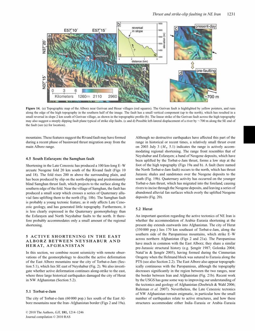
North of the West Esfarayen fault lies the Gerivan fault, whichcuts across the high East Alborz mountains. The fault strikes linearlyacross the topography (Fig. 13a), and has produced a small reversalin slope near Gerivan village (Fig. 14a). Cultivation in the valleyhas obscured much of the recent fault geomorphology. Nevertheless,the restoration of a river 10 km east of Gerivan indicates a possible∼700 m of recent left-lateral motion. Furthermore, the fault strikeand sense of slip (left-lateral with a thrust component, N-side up) aresimilar to the fault plane solution for the 1987 earthquake, whichoccurred 25 km along strike to the SE (Fig. 10). However, it isnot clear if this earthquake has been mislocated, or if it ruptureda different structure to the SE. The significance of the left-lateralGerivan fault, which lies directly north of the E–W West Esfarayenthrust, may be that the overall direction of shortening is towardsthe NNE or NE, rather than N–S in this region. Nevertheless, thegeomorphology, seismicity and GPS data are not sufficiently clear torule out right-lateral slip on this fault, which would imply a regionalNNW shortening direction across this part of the range.
4.3 Left-lateral faulting north of Esfarayen
The northern side of the East Alborz mountains, at the longitude ofEsfarayen, is cut by a series of ENE–WSW left-lateral strike-slip
C© 2010 The Authors, GJI, 181, 1214–1246
Journal compilation C© 2010 RAS
1228 J. Hollingsworth et al.
Figure 11. (a) Topographic map of the southern Alborz range front near Esfarayen. Three faults occur in the region (shown by white lines): the Esfarayen;Sast; and North Esfarayen faults. Fault plane solutions for two recent earthquakes are shown (red comes from the Harvard catalogue, and black is a body-wavemodelled solution from Baker 1993). (b) Topographic profile along the range front (see (a) for location), which shows a low Neogene step at the base of thetopography. Esfarayen (EF), Sast (SF), and North Esfarayen (NEF) faults are labelled. (c) Landsat7 satellite image of the range front southeast of Esfarayen.Faults are shown between the small black arrows at the sides of the image; the Esfarayen fault is also highlighted by yellow pointers. Quaternary shorteninghas occurred on the Esfarayen fault, causing river incision, and the uplift and abandonment of alluvial fans. The orange arrow shows the location of field photo(d). This view is taken from 36◦56.78
′N 57◦38.77
′E, looking north at the Alborz range front. The solid white line shows the Esfarayen fault running along the
base of the mountains. Uplifted and incised alluvial fans are clearly visible as flat surfaces overlying dipping Neogene red beds. The older North Esfarayenfault strikes across the range behind the red Neogene ridge between the black arrows.
C© 2010 The Authors, GJI, 181, 1214–1246
Journal compilation C© 2010 RAS
Thrust and strike-slip faulting in NE Iran 1229
Figure 12. (a) Landsat7 satellite image of the western end of the Esfarayen fault (active faults are shown in black). Blue lines show major rivers draining south ofthe Alborz, which have been deflected by the northwest propagation of the Esfarayen fault, leaving a series of dry valleys (heavy white lines). The orange arrowshows the location of field photo (e). The location of topographic profiles, (b) and (c) are shown in yellow. These profiles are taken across Quaternary fan surfacesdisplaced across the Esfarayen fault (EF—100 m) and the Sast fault (SF—50 m), respectively. (d) Quickbird satellite image ( C©2010 Google, C©2010 DigitalGlobe)of the western end of the Esfarayen fault (see (a) for location), where uplift has caused the deflection of a river (blue line) to the west, and the abandonmentof its original course which is now a dry valley. (e) Field photo looking north from 37◦07.25
′N 57◦33.75
′E at the Sast fault (black line), which has uplifted
Quaternary alluvial fan surfaces to the north. Incision south of the fault is the result of uplift caused by the Esfarayen fault, which lies 5 km to the south.
faults, which strike linearly across the topography from the Atrakvalley (Fig. 10). At least three faults occur, each extending for atleast 20 km from the valley into the high topography. Examples ofdisplaced geology and geomorphology from each fault are shown inFig. 15. The two northern faults (Figs 15a and c) displace Cretaceouslimestone on both sides of the fault, and therefore the total offset ishard to determine. Nevertheless, the truncation of a small anticlinein Fig. 15(a), and deflected and abandoned drainage in Fig. 15(c),indicate offset of a few kilometres. The southern fault, known as theFarhadan fault (Shabanian et al. 2009a) displaces Eocene volcanicsby 4 km, and Quaternary movement has deflected drainage againstthe general topographic slope by 1.5 km. Shabanian et al. (2009a)estimate a slip rate of 1.8 ± 0.4 mm yr−1 for this fault based onthe offset of drainage and Pliocene deposits along the fault. Similarleft-lateral faults are present further west along the Atrak valleynear Bojnurd (Hollingsworth et al. 2008).
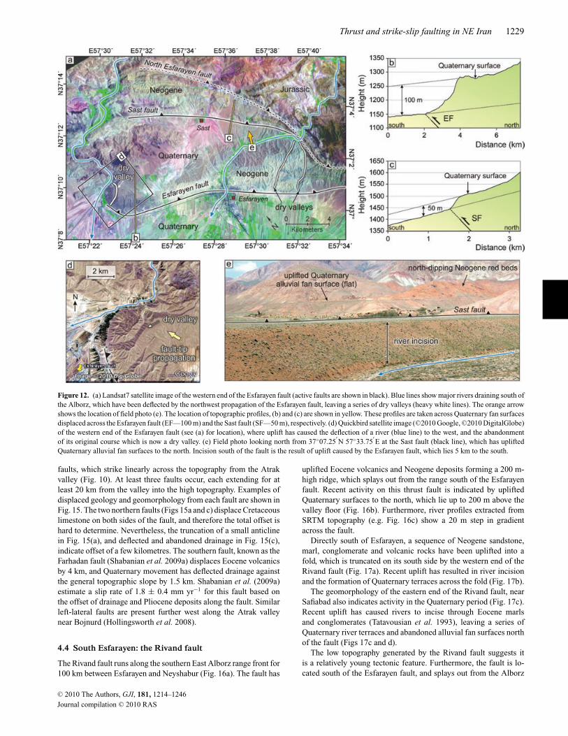
4.4 South Esfarayen: the Rivand fault
The Rivand fault runs along the southern East Alborz range front for100 km between Esfarayen and Neyshabur (Fig. 16a). The fault has
uplifted Eocene volcanics and Neogene deposits forming a 200 m-high ridge, which splays out from the range south of the Esfarayenfault. Recent activity on this thrust fault is indicated by upliftedQuaternary surfaces to the north, which lie up to 200 m above thevalley floor (Fig. 16b). Furthermore, river profiles extracted fromSRTM topography (e.g. Fig. 16c) show a 20 m step in gradientacross the fault.
Directly south of Esfarayen, a sequence of Neogene sandstone,marl, conglomerate and volcanic rocks have been uplifted into afold, which is truncated on its south side by the western end of theRivand fault (Fig. 17a). Recent uplift has resulted in river incisionand the formation of Quaternary terraces across the fold (Fig. 17b).
The geomorphology of the eastern end of the Rivand fault, nearSafiabad also indicates activity in the Quaternary period (Fig. 17c).Recent uplift has caused rivers to incise through Eocene marlsand conglomerates (Tatavousian et al. 1993), leaving a series ofQuaternary river terraces and abandoned alluvial fan surfaces northof the fault (Figs 17c and d).
The low topography generated by the Rivand fault suggests itis a relatively young tectonic feature. Furthermore, the fault is lo-cated south of the Esfarayen fault, and splays out from the Alborz
C© 2010 The Authors, GJI, 181, 1214–1246
Journal compilation C© 2010 RAS

1230 J. Hollingsworth et al.
Figure 13. (a) Topographic map of the Alborz range front west of Esfarayen. A sharp step in the topography, marked by yellow pointers, corresponds tothe West Esfarayen thrust fault. The left-lateral Gerivan fault strikes across the mountainous topography to the north. (b) Quickbird satellite image ( C©2010Google, C©2010 DigitalGlobe) of the West Esfarayen fault. A significant shortening component exists on this fault, which has resulted in the uplift and incisionof a series of alluvial fans. (c) Where the fault crosses the youngest fan deposits (i.e. between the two black arrows), en echelon cracks, indicating left-lateralmotion, have formed. Qanat systems run along and across the fractures, tapping the ponded water (see also Jackson 2006).
C© 2010 The Authors, GJI, 181, 1214–1246
Journal compilation C© 2010 RAS
Thrust and strike-slip faulting in NE Iran 1231
Figure 14. (a) Topographic map of the Alborz near Gerivan and Hesar villages (red squares). The Gerivan fault is highlighted by yellow pointers, and runsalong the edge of the high topography in the southern half of the image. The fault has a small vertical component (up to the north), which has resulted in asmall reversal in slope 2 km south of Gerivan village, as shown in the topographic profile (b). The linear strike of the Gerivan fault across the high topographymay also suggest a steeply dipping fault plane typical of strike slip faults. (c and d) Possible left-lateral displacement of a river by ∼700 m along the SE end ofthe fault (see (a) for location).
mountains. These features suggest the Rivand fault may have formedduring a recent phase of basinward thrust migration away from themain Alborz range.
4.5 South Esfarayen: the Samghan fault
Shortening in the Late Cenozoic has produced a 100 km-long E–Warcuate Neogene fold 20 km south of the Rivand fault (Figs 10and 18). The fold rises 200 m above the surrounding plain, andhas been produced by slip on the north-dipping and predominantlyblind Samghan thrust fault, which projects to the surface along thesouthern edge of the fold. Near the village of Samghan, the fault hasproduced a small scarp which crosses a series of Quaternary allu-vial fans uplifting them to the north (Fig. 18b). The Samghan faultis probably a young tectonic feature, as it only affects Late Ceno-zoic geology, and has generated little topography. Furthermore, itis less clearly expressed in the Quaternary geomorphology thanthe Esfarayen and North Neyshabur faults to the north. It there-fore probably accommodates only a small amount of the regionalshortening.
5 A C T I V E S H O RT E N I N G I N T H E E A S TA L B O R Z B E T W E E N N E Y S H A B U R A N DH E R AT, A F G H A N I S TA N
In this section, we combine recent seismicity with remote obser-vations of the geomorphology to describe the active deformationof the East Alborz mountains near the city of Torbat-e-Jam (Sec-tion 5.1), which lies SE east of Neyshabur (Fig. 2). We also investi-gate whether active deformation continues along-strike to the east,where three large historical earthquakes damaged the city of Heratin NW Afghanistan (Section 5.2).
5.1 Torbat-e-Jam
The city of Torbat-e-Jam (60 000 pop.) lies south of the East Al-borz mountains near the Iran–Afghanistan border (Figs 2 and 19a).
Although no destructive earthquakes have affected this part of therange in historical or recent times, a relatively small thrust eventon 2003 July 3 (Mw 5.1) indicates the range is actively accom-modating regional shortening. The range front resembles that ofNeyshabur and Esfarayen; a band of Neogene deposits, which havebeen uplifted by the Torbat-e-Jam thrust, forms a low step at thefoot of the high topography (Figs 19a and b). A fault (here namedthe North Torbat-e-Jam fault) occurs to the north, which has thrustJurassic shales and sandstones over the Neogene deposits to thesouth (Fig. 19b). Quaternary activity has occurred on the youngerTorbat-e-Jam thrust, which has migrated into the foreland, causingrivers to incise through the Neogene deposits, and leaving a series ofabandoned alluvial fan surfaces which overly the uplifted Neogenedeposits (Fig. 20).
5.2 Herat
An important question regarding the active tectonics of NE Iran iswhether the accommodation of Arabia–Eurasia shortening at thepresent day extends eastwards into Afghanistan. The city of Herat(350 000 pop.) lies 170 km southeast of Torbat-e-Jam, along thesouthern side of the Paropamisus mountains, which strike E–Wacross northern Afghanistan (Figs 2 and 21a). The Paropamisushave much in common with the East Alborz; they share a similarpre-Jurassic structural history (e.g. Sengor 1987; Golonka 2004;Natal’in & Sengor 2005), having formed during the CimmerianOrogeny when the Helmand block was sutured to Eurasia along thePTS (see also Section 2.2). The East Alborz also appear topograph-ically continuous with the Paropamisus, although the topographydecreases significantly in the region between the two ranges, nearthe border between Iran and Afghanistan (Fig. 21b). Recent workby the USGS has gone some way to improving our understanding ofthe tectonics and geology of Afghanistan (Doebrich & Wahl 2006;Ruleman et al. 2007). Nevertheless, the Late Cenozoic tectonicsof NW Afghanistan remain enigmatic, in particular how the smallnumber of earthquakes relate to active structures, and how thesestructures accommodate either India–Eurasia or Arabia–Eurasia
C© 2010 The Authors, GJI, 181, 1214–1246
Journal compilation C© 2010 RAS
1232 J. Hollingsworth et al.
Figure 15. (a) Interpreted and (b) uninterpreted aster satellite images of the north side of the Alborz showing the northern-most left-lateral strike slip fault inFig. 10. A Cretaceous limestone anticline (shown by a yellow dotted line along its southern margin) has been rotated into, and truncated across the fault zonewhich runs between the two heavy black arrows. (c) Interpreted and (d) uninterpreted images showing digital topography of the northern Alborz range front,SE of the region shown in (a)—see Fig. 10 for location. A strike-slip fault runs between the two black arrows and is visible in SRTM digital topography asa linear feature in the geomorphology. Two rivers (blue lines) have been deflected against the topographic slope (SW to NE), indicating 1 km of left-lateralslip during the Quaternary. This offset has also resulted in the beheading of a river, shown in red, across the fault. (e) Interpreted and (f) uninterpreted Astersatellite images of the southern-most left-lateral strike slip fault, referred to by Shabanian et al. (2009a) as the Farhadan fault (see Fig. 10), which cuts across aseries of Cenozoic volcanics (between the black arrows; black lines show the fault trace). The dotted yellow line shows the boundary between Eocene(?) andPlio-Quaternary volcanics, which has been offset by up to 4 km. Blue lines show rivers that have been deflected against the overall westward drainage direction,indicating 1.5 km left-lateral motion.
regional shortening. A number of relatively small historical earth-quakes have affected Herat city (849, 1102, and 1364—see Table 1,Fig. 21a, and Ambraseys & Bilham 2003, for further details).Wellman (1966) first documented the Herat (Harirud) fault,which is a major active right-lateral fault striking E–W alongthe Paropamisus mountains for more than 600 km (see alsoTapponnier et al. 1981; Ruleman et al. 2007).
GPS velocities located in Iran either side of the western end ofthe Herat fault (ZABO and YAZT, see Fig. 1, and Masson et al.2007), show little present-day shear across the fault zone, althoughthey cannot accurately resolve slip rates <2 mm yr−1. The ge-omorphology (Figs 22a and b) and historical seismicity indicatethe Herat fault is an important active right-lateral strike-slip faulteast of Herat city, which could therefore be slipping at a rate of0–2 mm yr−1 without being resolved by existing and limited GPS
data. West of Herat, the geomorphological expression of right-lateral strike-slip faulting becomes far less pronounced, althoughremnants of uplifted and abandoned fan surfaces along the southernedge of the mountain range suggests some shortening is accommo-dated across the range (Fig. 22c). Nevertheless, the morphology ofthe range front contrasts with that of Torbat-e-Jam only 40 km to theNW (Fig. 20 appearing less active based on its geomorphologicalexpression; there is no clear topographic step along the range front(presumably the thrust fault is blind), there are significantly fewerand less extensive uplifted and incised alluvial fan surfaces over-lying Neogene red beds, and the elevations of the range are muchlower (by 800 m, Fig. 21b) than Torbat-e-Jam. Despite a relativelack of data with which to better constrain the active tectonics ofWestern Afghanistan, we suspect N–S shortening along the EastAlborz, which accommodates the collision of Arabia and Eurasia,
C© 2010 The Authors, GJI, 181, 1214–1246
Journal compilation C© 2010 RAS

Thrust and strike-slip faulting in NE Iran 1233
Figure 16. (a) SRTM digital topography of the region south of Esfarayen. The Esfarayen fault is shown by white line. The Rivand fault, which lies 15 km to thesouth, forms a low step in the topography, and is shown by white pointers. This step is highlighted by topographic profiles taken across the fault, the locationsof which are shown by yellow lines. Black boxes show the locations of Figs. 17(a) and (c). (b) A Plio-Quaternary surface has been uplifted by the Rivand faultabove the valley floor. (c) A river profile shows a change in gradient where it crosses the fault, indicating at least 20 m vertical offset during the Quaternary.
gradually dies out eastwards in the westernmost Paropamisus ofNW Afghanistan. It is not clear what role the Herat fault plays inthe regional kinematics, although it may be related to the west-ward motion (extrusion) of Central Afghanistan resulting from theIndia–Eurasia collision (Molnar & Tapponnier 1975; Tapponnier& Molnar 1976; Tapponnier et al. 1981, see Section 8 for morediscussion).
6 A C T I V E T E C T O N I C S O F T H ES A B Z E VA R M O U N TA I N S
Before discussing how regional shortening is distributed across NEIran south of the Kopeh Dagh mountains, it is necessary to drawattention to the Sabzevar range, which lies 50–80 km south of theEast Alborz mountains (Fig. 2). The Sabzevar (or Siah Kuh = ‘blackmountains’) range consists of Cretaceous ophiolitic rocks obducted
during the early stages of the Alpine Orogeny. The 200 km-longrange reaches elevations of up to 2800 m and strikes WNW–ESEacross NE Iran, subparallel to the East Alborz (Figs 2 and 23). Anumber of subparallel thrust faults occur on the southern side of therange, which may have been responsible for a destructive earthquakein 1052 (Ambraseys & Melville 1982; Fattahi et al. 2006, see alsoTable 1).
The active faulting of the Sabzevar range closely resembles thatof the East Alborz near Esfarayen and Neyshabur, again showinga basinward migration of faulting (Figs 23a and b). The Sabzevarfault lies at the foot of the range, and has uplifted a band of redNeogene conglomerates, which form a low step in the topography(Figs 23c and d). Recent uplift across the Sabzevar fault has causedrivers to incise through the Neogene deposits, leaving a series ofuplifted Quaternary fan surfaces (Fig. 23d). Using the OSL datingmethod, Fattahi et al. (2006) determined a 11 ± 2 kyr age for the
C© 2010 The Authors, GJI, 181, 1214–1246
Journal compilation C© 2010 RAS
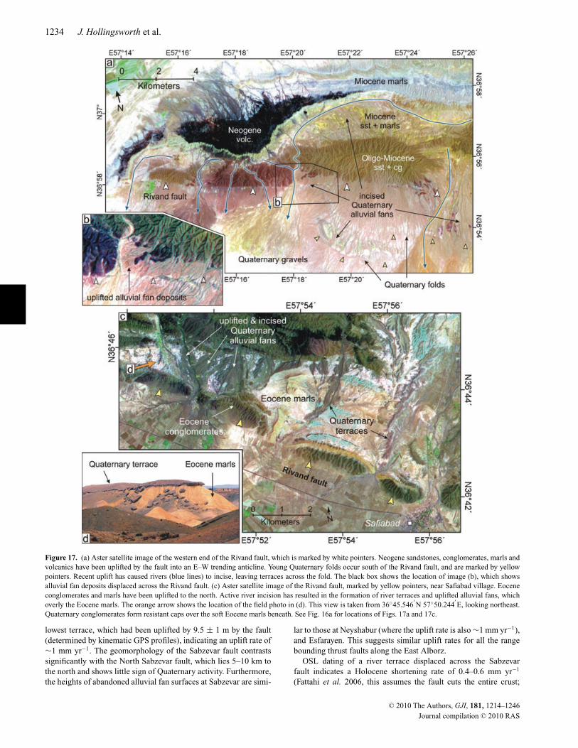
1234 J. Hollingsworth et al.
Figure 17. (a) Aster satellite image of the western end of the Rivand fault, which is marked by white pointers. Neogene sandstones, conglomerates, marls andvolcanics have been uplifted by the fault into an E–W trending anticline. Young Quaternary folds occur south of the Rivand fault, and are marked by yellowpointers. Recent uplift has caused rivers (blue lines) to incise, leaving terraces across the fold. The black box shows the location of image (b), which showsalluvial fan deposits displaced across the Rivand fault. (c) Aster satellite image of the Rivand fault, marked by yellow pointers, near Safiabad village. Eoceneconglomerates and marls have been uplifted to the north. Active river incision has resulted in the formation of river terraces and uplifted alluvial fans, whichoverly the Eocene marls. The orange arrow shows the location of the field photo in (d). This view is taken from 36◦45.546
′N 57◦50.244
′E, looking northeast.
Quaternary conglomerates form resistant caps over the soft Eocene marls beneath. See Fig. 16a for locations of Figs. 17a and 17c.
lowest terrace, which had been uplifted by 9.5 ± 1 m by the fault(determined by kinematic GPS profiles), indicating an uplift rate of∼1 mm yr−1. The geomorphology of the Sabzevar fault contrastssignificantly with the North Sabzevar fault, which lies 5–10 km tothe north and shows little sign of Quaternary activity. Furthermore,the heights of abandoned alluvial fan surfaces at Sabzevar are simi-
lar to those at Neyshabur (where the uplift rate is also ∼1 mm yr−1),and Esfarayen. This suggests similar uplift rates for all the rangebounding thrust faults along the East Alborz.
OSL dating of a river terrace displaced across the Sabzevarfault indicates a Holocene shortening rate of 0.4–0.6 mm yr−1
(Fattahi et al. 2006, this assumes the fault cuts the entire crust;
C© 2010 The Authors, GJI, 181, 1214–1246
Journal compilation C© 2010 RAS
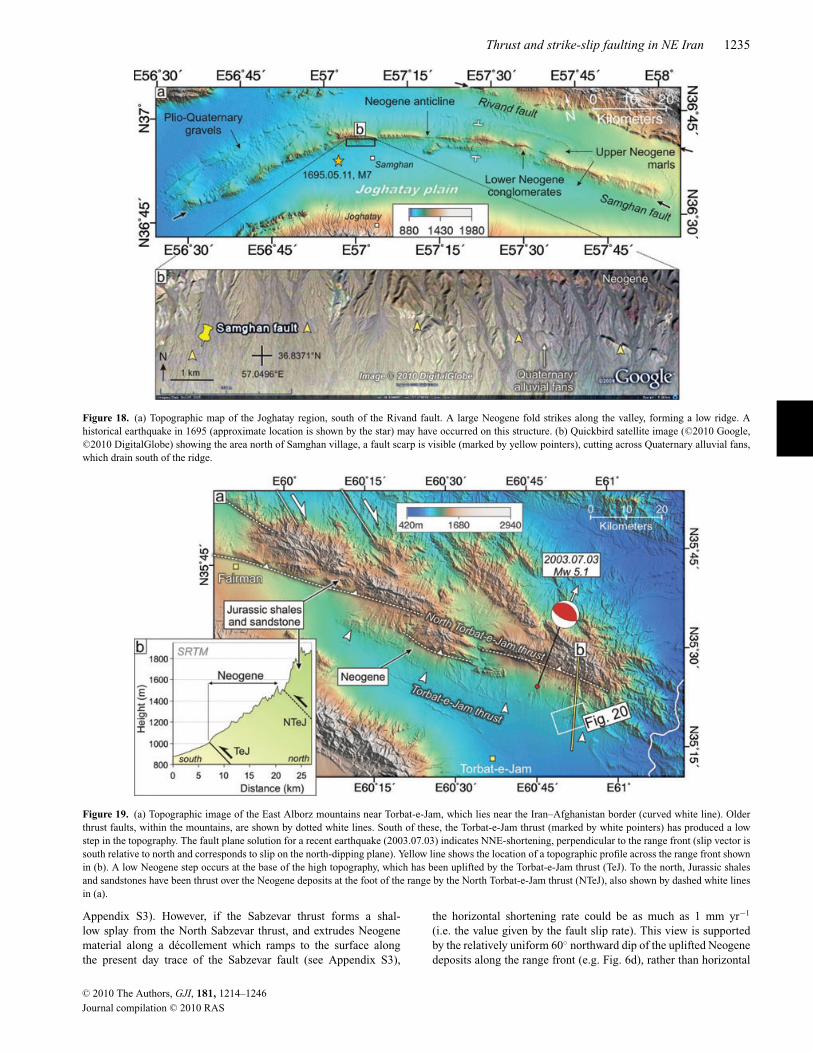
Thrust and strike-slip faulting in NE Iran 1235
Figure 18. (a) Topographic map of the Joghatay region, south of the Rivand fault. A large Neogene fold strikes along the valley, forming a low ridge. Ahistorical earthquake in 1695 (approximate location is shown by the star) may have occurred on this structure. (b) Quickbird satellite image ( C©2010 Google,C©2010 DigitalGlobe) showing the area north of Samghan village, a fault scarp is visible (marked by yellow pointers), cutting across Quaternary alluvial fans,which drain south of the ridge.
Figure 19. (a) Topographic image of the East Alborz mountains near Torbat-e-Jam, which lies near the Iran–Afghanistan border (curved white line). Olderthrust faults, within the mountains, are shown by dotted white lines. South of these, the Torbat-e-Jam thrust (marked by white pointers) has produced a lowstep in the topography. The fault plane solution for a recent earthquake (2003.07.03) indicates NNE-shortening, perpendicular to the range front (slip vector issouth relative to north and corresponds to slip on the north-dipping plane). Yellow line shows the location of a topographic profile across the range front shownin (b). A low Neogene step occurs at the base of the high topography, which has been uplifted by the Torbat-e-Jam thrust (TeJ). To the north, Jurassic shalesand sandstones have been thrust over the Neogene deposits at the foot of the range by the North Torbat-e-Jam thrust (NTeJ), also shown by dashed white linesin (a).
Appendix S3). However, if the Sabzevar thrust forms a shal-low splay from the North Sabzevar thrust, and extrudes Neogenematerial along a decollement which ramps to the surface alongthe present day trace of the Sabzevar fault (see Appendix S3),
the horizontal shortening rate could be as much as 1 mm yr−1
(i.e. the value given by the fault slip rate). This view is supportedby the relatively uniform 60◦ northward dip of the uplifted Neogenedeposits along the range front (e.g. Fig. 6d), rather than horizontal
C© 2010 The Authors, GJI, 181, 1214–1246
Journal compilation C© 2010 RAS

1236 J. Hollingsworth et al.
Figure 20. (a) Digital topography of the eastern Torbat-e-Jam thrust (see Fig. 19a for location), which forms a low step in the topography, marked by whitearrows. (b) Topographic profile across an uplifted Quaternary fan, shown by the yellow line in (a), which has been displaced vertically by 40 m. (c) Astersatellite image of the region in (a) for comparison. ‘Yellow’ Neogene deposits have been thrust over ‘purple’ Quaternary gravels by the Torbat-e-Jam thrust(black line). Recent uplift has caused rivers (blue lines) to incise, leaving a series of river terraces and abandoned alluvial fans across the uplifted Neogenedeposits.
bedding which would be expected if the fault did not sole into adecollement at depth.
7 A C T I V E T E C T O N I C S O F T H EK U H - E - S O R K H M O U N TA I N S
The Kuh-e-Sorkh mountains lie SE of the Sabzevar range, andconsist of uplifted Eocene volcanics and Cretaceous ophiolitic ma-terial obducted at the start of the Alpine Orogeny. The range strikesbroadly E–W for over 300 km, reaching elevations of 2800 m alongits central portion, north of Kashmar city (Fig. 24a). Many earth-quakes have occurred in the Kuh-e-Sorkh region (Fig. 2), which
are mostly associated with deformation occurring along the southside of the range. The dominant active tectonic structure of theKuh-e-Sorkh is the left-lateral Doruneh fault, which strikes for over300 km along the southern range front and is one of the most distinc-tive tectonic features of NE Iran (Walker & Jackson 2004; Fattahiet al. 2007). It has been suggested the Doruneh fault accommodatesleft-lateral shear as a result of the clockwise rotation of rigid blocksbounding the range to the north and south (Walker & Jackson 2004).Thrust earthquakes which occur south of the Kuh-e-Sorkh (Fig. 2c)are related to shortening across a large Neogene fold (Fig. 24a). Al-though the majority of deformation appears to be concentrated alongthe southern part of the range, historical earthquakes are known to
C© 2010 The Authors, GJI, 181, 1214–1246
Journal compilation C© 2010 RAS
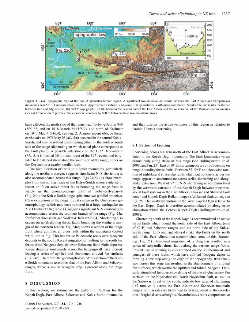
Thrust and strike-slip faulting in NE Iran 1237
Figure 21. (a) Topographic map of the Iran–Afghanistan border region. A significant low in elevation occurs between the East Alborz and Paropamisusmountains near 61◦E. Faults are shown in black. Approximate locations, and years, of large historical earthquakes are shown. Solid white line marks the borderbetween Iran and Afghanistan. (b) SRTM topographic profile between the eastern end of the East Alborz and the western end of the Paropamisus mountains(see (a) for location of profile). The elevation decreases by 800 m between these two mountain ranges.
have affected the north side of the range near Torbat-e-Jam in 849(M5–6?) and on 1918 March 24 (M5.9), and north of Kashmaron 1940 May 4 (M6.4), see Fig. 2. A more recent oblique thrustearthquake on 1971 May 26 (Mw 5.6) occurred in the central Kuh-e-Sorkh, and may be related to shortening either on the north or southside of the range (depending on which nodal plane corresponds tothe fault plane). A possible aftershock on the 1972 December 1(Mw 5.4) is located 30 km southwest of the 1971 event, and is re-lated to left-lateral shear along the south side of the range, either onthe Doruneh or a nearby parallel fault.
The high elevation of the Kuh-e-Sorkh mountains, particularlyalong the northern margin, suggests significant N–S shortening isalso accommodated across this range. Figs 24(b)–(d) show exam-ples from the northern side of the Kuh-e-Sorkh where evidence ofrecent uplift on active thrust faults bounding the range front isvisible in the geomorphology. East of Torbat-e-Heydarieh(Fig. 24a), the Kuh-e-Sorkh range splits into two parallel branches.Clear expression of the Jangal thrust system in the Quaternary ge-omorphology, which may have ruptured in a large earthquake on21st October 1336 (Table 1), suggests significant N–S shortening isaccommodated across the southern branch of the range (Fig. 24a,for further discussion, see Walker & Jackson 2004). Shortening alsooccurs on north-dipping thrust faults bounding the southern mar-gin of the northern branch. Fig. 24(e) shows a section of the rangefront where uplift on an older fault within the mountains (dottedwhite line in Fig. 24e) has thrust Palaeozoic rocks over Neogenedeposits to the south. Recent migration of faulting to the south hasthrust these Neogene deposits over Holocene flood plain deposits.Rivers draining southwards across the hangingwall have incised,leaving a series of uplifted and abandoned alluvial fan surfaces(Fig. 24e). Therefore, the geomorphology of this section of the Kuh-e-Sorkh mountains resembles that of the East Alborz and Sabzevarranges, where a similar Neogene step is present along the rangefront.
8 D I S C U S S I O N
In this section, we summarize the pattern of faulting for theKopeh Dagh, East Alborz, Sabzevar and Kuh-e-Sorkh mountains,
and then discuss the active tectonics of this region in relation toArabia–Eurasia shortening.
8.1 Pattern of faulting
Shortening across NE Iran north of the East Alborz is accommo-dated in the Kopeh Dagh mountains. The fault kinematics variesdramatically along strike of this range (see Hollingsworth et al.2008, and Fig. 25). East of 59◦E shortening occurs by oblique slip onrange-bounding thrust faults. Between 57–59◦E anticlockwise rota-tion of right-lateral strike-slip faults which cut obliquely across therange appear to accommodate across-strike shortening and along-strike extension. West of 57◦E, N–S shortening is accommodatedby the westward extrusion of the Kopeh Dagh between transpres-sional fault systems in the East Alborz (Khazaar and Shahrud faultzone) and Kopeh Dagh-Balkan ranges (Ashkabad fault zone), seeFig. 25. The westward motion of the West Kopeh Dagh relative tothe East Kopeh Dagh is therefore accommodated by along-strikeelongation within the Central Kopeh Dagh (Hollingsworth et al.2008).
Shortening south of the Kopeh Dagh is accommodated on activethrust faults which bound the south side of the East Alborz (eastof 57◦E) and Sabzevar ranges, and the north side of the Kuh-e-Sorkh range. Left- and right-lateral strike slip faults on the northside of the East Alborz also accommodate some of this shorten-ing (Fig. 25). Basinward migration of faulting has resulted in aseries of subparallel thrust faults along the various range fronts.Present day shortening is concentrated on the southernmost andyoungest of these faults, which have uplifted Neogene deposits,forming a low step along the edge of the topography. River inci-sion across this zone has resulted in the abandonment of alluvialfan surfaces, which overlie the uplifted and folded Neogene. Opti-cally stimulated luminescence dating of displaced Quaternary fansurfaces on the Neyshabur and North Neyshabur fault, as well asthe Sabzevar thrust to the south, indicate low rates of shortening(<2 mm yr−1) across the East Alborz and Sabzevar mountainranges. Similar rates are likely near Esfarayen, based on the correla-tion of regional terrace heights. Nevertheless, a more comprehensive
C© 2010 The Authors, GJI, 181, 1214–1246
Journal compilation C© 2010 RAS
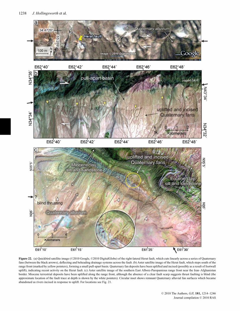
1238 J. Hollingsworth et al.
Figure 22. (a) Quickbird satellite image ( C©2010 Google, C©2010 DigitalGlobe) of the right-lateral Herat fault, which cuts linearly across a series of Quaternaryfans (between the black arrows), deflecting and beheading drainage systems across the fault. (b) Aster satellite image of the Herat fault, which steps south of therange front (marked by yellow pointers), forming a small pull-apart basin. Quaternary fan deposits have been uplifted and incised (possibly as a result of footwalluplift), indicating recent activity on the Herat fault. (c) Aster satellite image of the southern East Alborz-Paropamisus range front near the Iran–Afghanistanborder. Miocene terrestrial deposits have been uplifted along the range front, although the absence of a clear fault scarp suggests thrust faulting is blind (theapproximate location of the fault trace at depth is shown by the white pointers). Circular inset shows remnant Quaternary alluvial fan surfaces which becameabandoned as rivers incised in response to uplift. For locations see Fig. 21.
C© 2010 The Authors, GJI, 181, 1214–1246
Journal compilation C© 2010 RAS
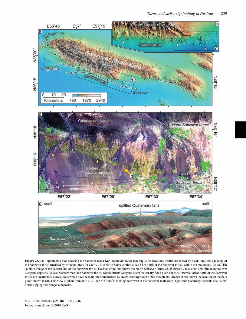
Thrust and strike-slip faulting in NE Iran 1239
Figure 23. (a) Topographic map showing the Sabzevar (Siah Kuh) mountain range (see Fig. 2 for location). Faults are shown by black lines. (b) Close-up ofthe Sabzevar thrust (marked by white pointers for clarity). The North Sabzevar thrust lies 5 km north of the Sabzevar thrust, within the mountains. (c) ASTERsatellite image of the eastern end of the Sabzevar thrust. Dashed white line shows the North Sabzevar thrust which thrusts Cretaceous ophiolite material overNeogene deposits. Yellow pointers mark the Sabzevar thrust, which thrusts Neogene over Quaternary flood plain deposits. ‘Purple’ areas north of the Sabzevarthrust are Quaternary alluvial fans which have been uplifted and incised by rivers draining south of the mountains. Orange arrow shows the location of the fieldphoto shown in (d). This view is taken from 36◦14.321
′N 57◦27.902
′E looking northwest at the Sabzevar fault scarp. Uplifted Quaternary deposits overlie 60◦
north-dipping red Neogene deposits.
C© 2010 The Authors, GJI, 181, 1214–1246
Journal compilation C© 2010 RAS
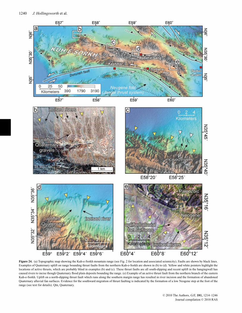
1240 J. Hollingsworth et al.
Figure 24. (a) Topographic map showing the Kuh-e-Sorkh mountain range (see Fig. 2 for location and associated seismicity). Faults are shown by black lines.Examples of Quaternary uplift on range bounding thrust faults from the northern Kuh-e-Sorkh are shown in (b) to (d). Yellow and white pointers highlight thelocations of active thrusts, which are probably blind in examples (b) and (c). These thrust faults are all south-dipping and recent uplift in the hangingwall hascaused rivers to incise though Quaternary flood plain deposits bounding the range. (e) Example of an active thrust fault from the northern branch of the easternKuh-e-Sorkh. Uplift on a north-dipping thrust fault which runs along the southern margin range has resulted in river incision and the formation of abandonedQuaternary alluvial fan surfaces. Evidence for the southward migration of thrust faulting is indicated by the formation of a low Neogene step at the foot of therange (see text for details). Qtn, Quaternary.
C© 2010 The Authors, GJI, 181, 1214–1246
Journal compilation C© 2010 RAS
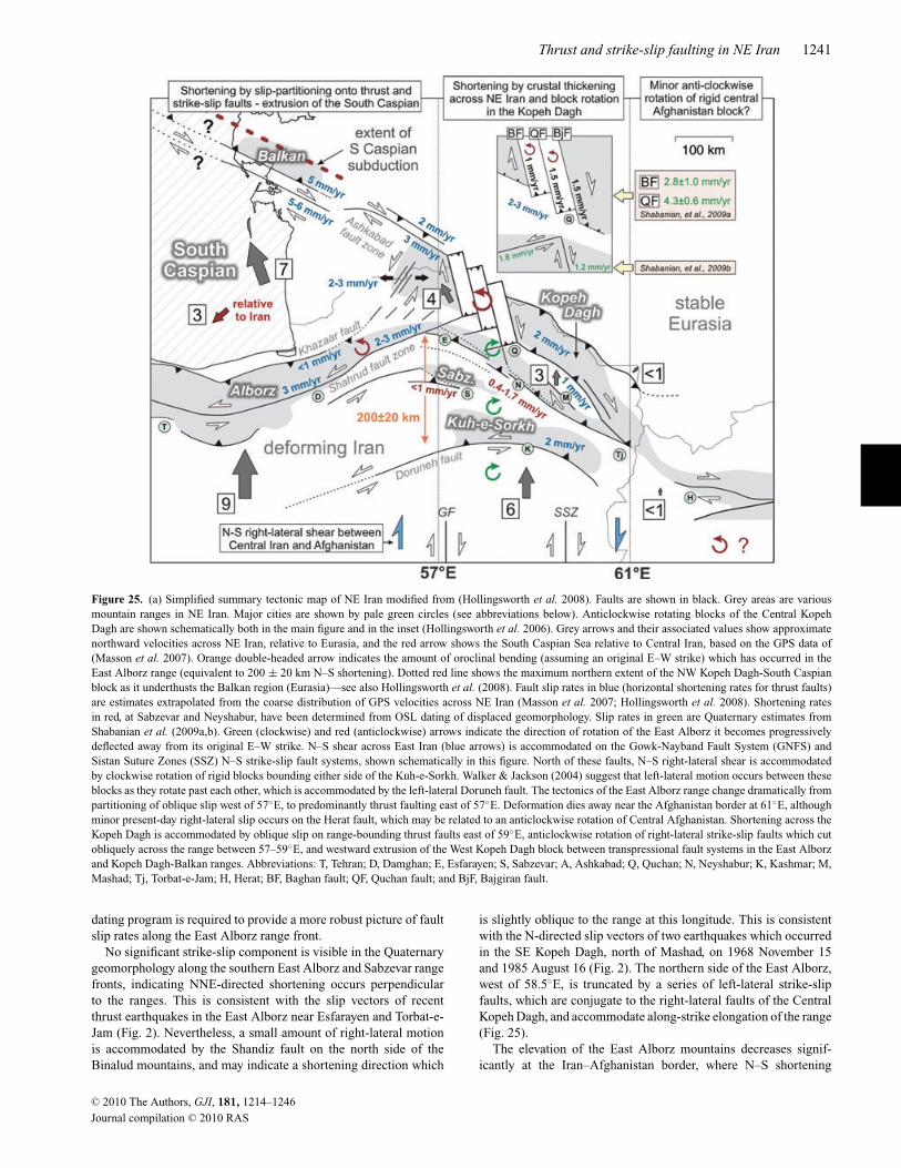
Thrust and strike-slip faulting in NE Iran 1241
Figure 25. (a) Simplified summary tectonic map of NE Iran modified from (Hollingsworth et al. 2008). Faults are shown in black. Grey areas are variousmountain ranges in NE Iran. Major cities are shown by pale green circles (see abbreviations below). Anticlockwise rotating blocks of the Central KopehDagh are shown schematically both in the main figure and in the inset (Hollingsworth et al. 2006). Grey arrows and their associated values show approximatenorthward velocities across NE Iran, relative to Eurasia, and the red arrow shows the South Caspian Sea relative to Central Iran, based on the GPS data of(Masson et al. 2007). Orange double-headed arrow indicates the amount of oroclinal bending (assuming an original E–W strike) which has occurred in theEast Alborz range (equivalent to 200 ± 20 km N–S shortening). Dotted red line shows the maximum northern extent of the NW Kopeh Dagh-South Caspianblock as it underthusts the Balkan region (Eurasia)—see also Hollingsworth et al. (2008). Fault slip rates in blue (horizontal shortening rates for thrust faults)are estimates extrapolated from the coarse distribution of GPS velocities across NE Iran (Masson et al. 2007; Hollingsworth et al. 2008). Shortening ratesin red, at Sabzevar and Neyshabur, have been determined from OSL dating of displaced geomorphology. Slip rates in green are Quaternary estimates fromShabanian et al. (2009a,b). Green (clockwise) and red (anticlockwise) arrows indicate the direction of rotation of the East Alborz it becomes progressivelydeflected away from its original E–W strike. N–S shear across East Iran (blue arrows) is accommodated on the Gowk-Nayband Fault System (GNFS) andSistan Suture Zones (SSZ) N–S strike-slip fault systems, shown schematically in this figure. North of these faults, N–S right-lateral shear is accommodatedby clockwise rotation of rigid blocks bounding either side of the Kuh-e-Sorkh. Walker & Jackson (2004) suggest that left-lateral motion occurs between theseblocks as they rotate past each other, which is accommodated by the left-lateral Doruneh fault. The tectonics of the East Alborz range change dramatically frompartitioning of oblique slip west of 57◦E, to predominantly thrust faulting east of 57◦E. Deformation dies away near the Afghanistan border at 61◦E, althoughminor present-day right-lateral slip occurs on the Herat fault, which may be related to an anticlockwise rotation of Central Afghanistan. Shortening across theKopeh Dagh is accommodated by oblique slip on range-bounding thrust faults east of 59◦E, anticlockwise rotation of right-lateral strike-slip faults which cutobliquely across the range between 57–59◦E, and westward extrusion of the West Kopeh Dagh block between transpressional fault systems in the East Alborzand Kopeh Dagh-Balkan ranges. Abbreviations: T, Tehran; D, Damghan; E, Esfarayen; S, Sabzevar; A, Ashkabad; Q, Quchan; N, Neyshabur; K, Kashmar; M,Mashad; Tj, Torbat-e-Jam; H, Herat; BF, Baghan fault; QF, Quchan fault; and BjF, Bajgiran fault.
dating program is required to provide a more robust picture of faultslip rates along the East Alborz range front.
No significant strike-slip component is visible in the Quaternarygeomorphology along the southern East Alborz and Sabzevar rangefronts, indicating NNE-directed shortening occurs perpendicularto the ranges. This is consistent with the slip vectors of recentthrust earthquakes in the East Alborz near Esfarayen and Torbat-e-Jam (Fig. 2). Nevertheless, a small amount of right-lateral motionis accommodated by the Shandiz fault on the north side of theBinalud mountains, and may indicate a shortening direction which
is slightly oblique to the range at this longitude. This is consistentwith the N-directed slip vectors of two earthquakes which occurredin the SE Kopeh Dagh, north of Mashad, on 1968 November 15and 1985 August 16 (Fig. 2). The northern side of the East Alborz,west of 58.5◦E, is truncated by a series of left-lateral strike-slipfaults, which are conjugate to the right-lateral faults of the CentralKopeh Dagh, and accommodate along-strike elongation of the range(Fig. 25).
The elevation of the East Alborz mountains decreases signif-icantly at the Iran–Afghanistan border, where N–S shortening
C© 2010 The Authors, GJI, 181, 1214–1246
Journal compilation C© 2010 RAS
1242 J. Hollingsworth et al.
associated with the Arabia–Eurasia collision dies out. TheParopamisus mountains lie eastward of the East Alborz, and strikeE–W across northern Afghanistan (Fig. 25). A small amount ofactive deformation occurs in the Paropamisus on the E–W right-lateral Herat fault, which runs for >600 km between Herat andKabul.
8.2 Kinematics of East Alborz deformation
Velocities of GPS stations across NE Iran indicate an eastwarddecrease in N–S shortening across the region from 9 mm yr−1 atSEMN, to 6 mm yr−1 at KASH (Fig. 2), and 2 mm yr−1 at ZABOnear the Iran–Afghanistan border in East Iran (east of the Lut block,Fig. 1a).
The Kopeh Dagh mountains accommodate a significant amountof this motion, by a combination of slip-partitioning in the NW,thrust faulting in the SE, and anticlockwise block rotation in theCentral Kopeh Dagh (Hollingsworth et al. 2006, 2008)—see Fig. 25.However, active thrust faulting in the East Alborz, Sabzevar andKuh-e-Sorkh mountain ranges indicates that shortening also occurssouth of the Kopeh Dagh. At the longitude of Neyshabur, the EastAlborz range contribute 0.4–1.7 mm yr−1 to the regional shortening,based on a relatively small set of OSL ages for two displaced Qua-ternary alluvial fans (Fig. 25). This is broadly consistent with a 3 ±2 mm yr−1 difference in northward velocity between GPS stations atMashad (MSHN) and Kashmar (KASH), which lie north and southof the range, respectively (Figs 1 and 25, see also Masson et al.2007). However, this higher GPS shortening estimate also includesa component of shortening which is accommodated across the Kuh-e-Sorkh mountains south of the East Alborz, and is likely to be in therange of 2.3 ± 2.3 mm yr−1 (this value accounts for the range of GPSshortening estimates between Kashmar and Mashad minus the OSLshortening estimates across the East Alborz; see also Fig. 25). Sucha shortening rate is also consistent with the similar 3 km elevationsof the East Alborz and Kuh-e-Sorkh ranges at the longitude of Kash-mar and Neyshabur (59◦E). Further west, the Sabzevar range alsocontributes ∼1 mm yr−1 to the regional shortening. Therefore, ofthe 6 mm yr−1 N–S shortening which occurs between Kashmar andTurkmenistan (i.e. stable Eurasia), roughly half is accommodatedin the Kopeh Dagh, and the other half in the various subparallelmountain ranges to the south (see also Masson et al. 2007). Thecurrent lack of well-resolved dense continuous GPS measurements,detailed Quaternary dating fault slip rate studies and knowledge ofthe geometry of active faults at depth throughout NE Iran preventsa more accurate and precise strain field from being determined.Furthermore, although Jackson & McKenzie (1988) and Massonet al. (2005) found that 50–100 per cent of the deformation in NEIran is accommodated seismically, presumably on structures such asthose detailed in this study, a certain amount of shortening must alsobe accommodated by distributed aseismic deformation to producethe folded geology that we see across the region. Although beyondthe scope of this study, future detailed geological cross sectionsacross all the structures in NE Iran will provide valuable constraintson the amount of aseismic deformation accommodated across thisregion over geological timescales. Present-day slip rates estimatedfor the major fault systems across NE Iran, based on the GPS veloc-ity field (e.g. Hollingsworth et al. 2008) may therefore overestimatethe real rates by as much as 50 per cent. However, due to the rela-tively low rates of shortening (typically <1 mm yr−1) across thesefaults, such an overestimate will not be resolvable within the errorof the determined rates. Despite the broad range of error in the
rates of deformation presented in this study, they represent the firstattempt at constraining fault slip rates in this region, and under-standing how these fault systems accommodate regional shorteningresulting from the Arabia–Eurasia collision.
The change in tectonics across the Kopeh Dagh (i.e. extrusionin the NW, anticlockwise block rotation in the Central, and N–Sshortening in the SE) is also reflected in East Alborz mountainsto the south. West of 57◦E, N–S shortening is accommodated byslip-partitioning onto thrust faults north of the range (Khazaar fault)and left-lateral faults on the south side of the range (Shahrud faultsystem)—see Fig. 25 and Hollingsworth et al. (2008). East of 57◦E,NNE-shortening occurs on thrust faults bounding the south side ofthe range, with only minor partitioning onto strike-slip faults on thenorth side. It is in this region that the highest elevations of the EastAlborz occur (3 km).
The topography of the East Alborz mountains, seismicity and thegeneral northward velocity of GPS stations across NE Iran all sig-nificantly decrease east of Torbat-e-Jam, near the Iran–Afghanistanborder, suggesting that virtually all of the shortening between Ara-bia and Eurasia has been accommodated in NE Iran, and doesnot continue eastwards into Afghanistan. Therefore, an importantstructural change must occur in the Iran–Afghanistan border re-gion (61◦E): to the west, deformation in NE Iran accommodatesArabia–Eurasia collision by shortening predominantly on thrustfaults in the Kopeh Dagh, Alborz, Sabzevar and Kuh-e-Sorkhranges; to the east, minor E–W right-lateral shear occurs acrossmuch of northern Afghanistan. It is not clear what the role of theHerat fault is within the present day kinematics of the region, asE–W right-lateral slip cannot easily accommodate N–S regionalshortening. Nevertheless, slip on the Herat fault may be associ-ated with the India–Eurasia collision, with perhaps minor westwardmovement of Afghanistan, relative to Eurasia (see also Molnar &Tapponnier 1975; Tapponnier & Molnar 1976; Tapponnier et al.1981). However, the presence of the Herat fault might also be ex-plained by minor anticlockwise rotation of the relatively rigid (andaseismic) Central Afghanistan block about a vertical axis, relativeto stable Eurasia to the north (Treloar & Izatt 1993). Not onlydoes the latter explanation avoid the space problems encounteredif Afghanistan extrudes westward into Iran, but it is also consistentwith sparse palaeomagnetic data from East Central Afghanistan(33.25◦N E62.12◦E) which indicates ∼5◦ anticlockwise rotationsince the Oligo-Eocene (23–56 Ma) and South Central Afghanistan(31.55◦N E65.49◦E) which indicates ∼40◦ anticlockwise rotationsince the Lower Cretaceous (Barremian period; 125-130 Ma—forfurther details, see Krumsiek 1976).
The kinematic model for NE Iran presented here builds on theearlier studies of Jackson et al. (2002) and Hollingsworth et al.(2008), and incorporates kinematic information on the Kopeh Daghfrom Hollingsworth et al. (2006) and Shabanian et al. (2009a). Aslightly different kinematic model for the this region is presented byShabanian et al. (2009b) which does not involve anticlockwise rota-tion of blocks in the Central Kopeh Dagh, but instead features a sim-ple translation of material across both the Kopeh Dagh and Alborz-Binalud ranges. Key observations can be used to argue for eachmodel, but ultimately we suspect along-strike elongation by blockrotation plays some kind of role in accommodating E–W extensionin the Central Kopeh Dagh, due to the linear range front across thenorthern Central Kopeh Dagh (as opposed to an offset range frontpredicted by a translation model), as well as anticlockwise rotationof anticlines visible in satellite images across the Central KopehDagh, and which is not seen in the Alborz-Binalud (Hollingsworthet al. 2006). Furthermore, the translation model of Shabanian et al.
C© 2010 The Authors, GJI, 181, 1214–1246
Journal compilation C© 2010 RAS
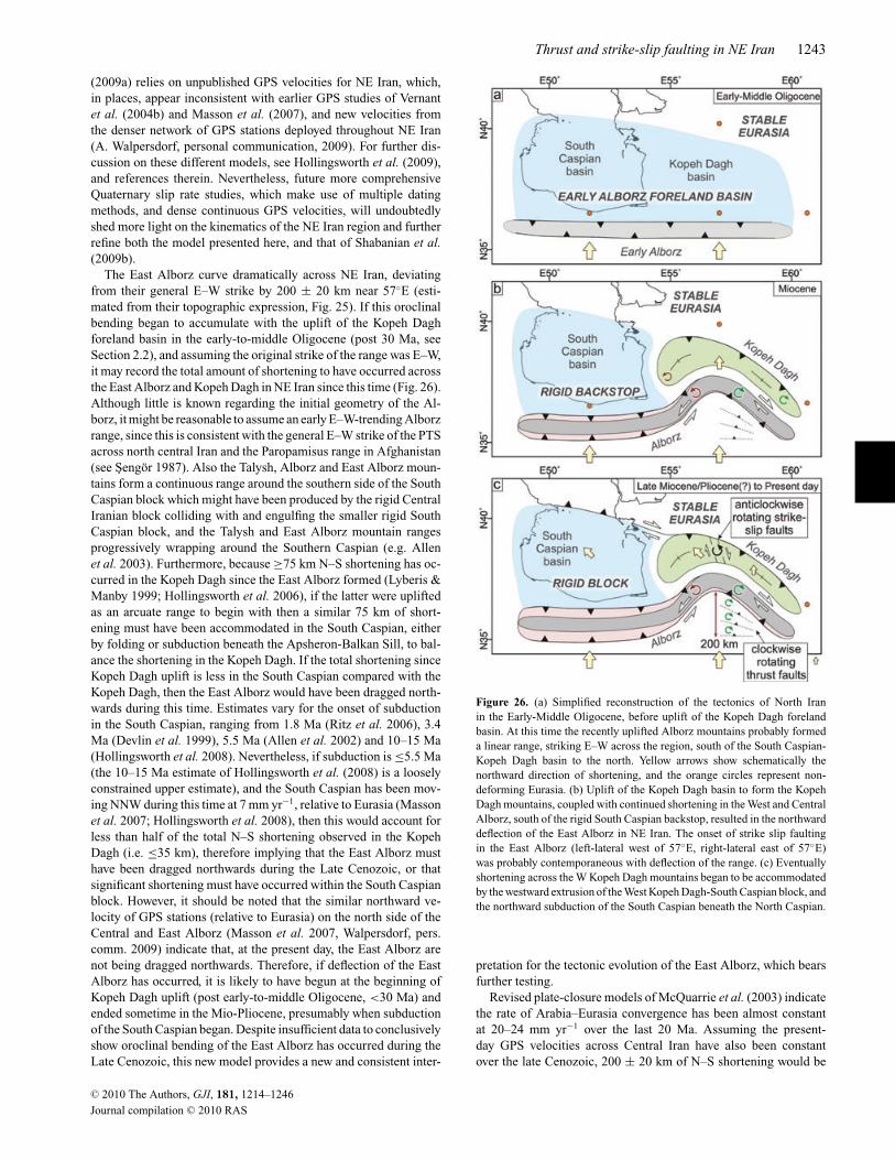
Thrust and strike-slip faulting in NE Iran 1243
(2009a) relies on unpublished GPS velocities for NE Iran, which,in places, appear inconsistent with earlier GPS studies of Vernantet al. (2004b) and Masson et al. (2007), and new velocities fromthe denser network of GPS stations deployed throughout NE Iran(A. Walpersdorf, personal communication, 2009). For further dis-cussion on these different models, see Hollingsworth et al. (2009),and references therein. Nevertheless, future more comprehensiveQuaternary slip rate studies, which make use of multiple datingmethods, and dense continuous GPS velocities, will undoubtedlyshed more light on the kinematics of the NE Iran region and furtherrefine both the model presented here, and that of Shabanian et al.(2009b).
The East Alborz curve dramatically across NE Iran, deviatingfrom their general E–W strike by 200 ± 20 km near 57◦E (esti-mated from their topographic expression, Fig. 25). If this oroclinalbending began to accumulate with the uplift of the Kopeh Daghforeland basin in the early-to-middle Oligocene (post 30 Ma, seeSection 2.2), and assuming the original strike of the range was E–W,it may record the total amount of shortening to have occurred acrossthe East Alborz and Kopeh Dagh in NE Iran since this time (Fig. 26).Although little is known regarding the initial geometry of the Al-borz, it might be reasonable to assume an early E–W-trending Alborzrange, since this is consistent with the general E–W strike of the PTSacross north central Iran and the Paropamisus range in Afghanistan(see Sengor 1987). Also the Talysh, Alborz and East Alborz moun-tains form a continuous range around the southern side of the SouthCaspian block which might have been produced by the rigid CentralIranian block colliding with and engulfing the smaller rigid SouthCaspian block, and the Talysh and East Alborz mountain rangesprogressively wrapping around the Southern Caspian (e.g. Allenet al. 2003). Furthermore, because ≥75 km N–S shortening has oc-curred in the Kopeh Dagh since the East Alborz formed (Lyberis &Manby 1999; Hollingsworth et al. 2006), if the latter were upliftedas an arcuate range to begin with then a similar 75 km of short-ening must have been accommodated in the South Caspian, eitherby folding or subduction beneath the Apsheron-Balkan Sill, to bal-ance the shortening in the Kopeh Dagh. If the total shortening sinceKopeh Dagh uplift is less in the South Caspian compared with theKopeh Dagh, then the East Alborz would have been dragged north-wards during this time. Estimates vary for the onset of subductionin the South Caspian, ranging from 1.8 Ma (Ritz et al. 2006), 3.4Ma (Devlin et al. 1999), 5.5 Ma (Allen et al. 2002) and 10–15 Ma(Hollingsworth et al. 2008). Nevertheless, if subduction is ≤5.5 Ma(the 10–15 Ma estimate of Hollingsworth et al. (2008) is a looselyconstrained upper estimate), and the South Caspian has been mov-ing NNW during this time at 7 mm yr−1, relative to Eurasia (Massonet al. 2007; Hollingsworth et al. 2008), then this would account forless than half of the total N–S shortening observed in the KopehDagh (i.e. ≤35 km), therefore implying that the East Alborz musthave been dragged northwards during the Late Cenozoic, or thatsignificant shortening must have occurred within the South Caspianblock. However, it should be noted that the similar northward ve-locity of GPS stations (relative to Eurasia) on the north side of theCentral and East Alborz (Masson et al. 2007, Walpersdorf, pers.comm. 2009) indicate that, at the present day, the East Alborz arenot being dragged northwards. Therefore, if deflection of the EastAlborz has occurred, it is likely to have begun at the beginning ofKopeh Dagh uplift (post early-to-middle Oligocene, <30 Ma) andended sometime in the Mio-Pliocene, presumably when subductionof the South Caspian began. Despite insufficient data to conclusivelyshow oroclinal bending of the East Alborz has occurred during theLate Cenozoic, this new model provides a new and consistent inter-
Figure 26. (a) Simplified reconstruction of the tectonics of North Iranin the Early-Middle Oligocene, before uplift of the Kopeh Dagh forelandbasin. At this time the recently uplifted Alborz mountains probably formeda linear range, striking E–W across the region, south of the South Caspian-Kopeh Dagh basin to the north. Yellow arrows show schematically thenorthward direction of shortening, and the orange circles represent non-deforming Eurasia. (b) Uplift of the Kopeh Dagh basin to form the KopehDagh mountains, coupled with continued shortening in the West and CentralAlborz, south of the rigid South Caspian backstop, resulted in the northwarddeflection of the East Alborz in NE Iran. The onset of strike slip faultingin the East Alborz (left-lateral west of 57◦E, right-lateral east of 57◦E)was probably contemporaneous with deflection of the range. (c) Eventuallyshortening across the W Kopeh Dagh mountains began to be accommodatedby the westward extrusion of the West Kopeh Dagh-South Caspian block, andthe northward subduction of the South Caspian beneath the North Caspian.
pretation for the tectonic evolution of the East Alborz, which bearsfurther testing.
Revised plate-closure models of McQuarrie et al. (2003) indicatethe rate of Arabia–Eurasia convergence has been almost constantat 20–24 mm yr−1 over the last 20 Ma. Assuming the present-day GPS velocities across Central Iran have also been constantover the late Cenozoic, 200 ± 20 km of N–S shortening would be
C© 2010 The Authors, GJI, 181, 1214–1246
Journal compilation C© 2010 RAS
1244 J. Hollingsworth et al.
accumulated in 30 ± 8 Ma, based on a northward shortening rate of6–8 mm yr−1 at 57◦E. This age is consistent with the the geologicalestimate for the onset of uplift in the Kopeh Dagh (post 30 Ma)(e.g. Allen & Armstrong 2008, see also Section 2.2). Nevertheless, anumber of major tectonic events have affected north Iran during thisperiod, such as rapid exhumation of the West Alborz at 12 Ma (Guestet al. 2006a), increased subsidence in the NW South Caspian basinat 5.5 Ma (Allen et al. 2002), and a possible kinematic change in theCentral Alborz at 1.8 Ma (Ritz et al. 2006). Therefore, it cannot beassumed that the accommodation of 6–8 mm yr−1 N–S shorteningacross NE Iran has been constant over this period. Nevertheless, theEast Alborz mountains probably played a more important role inaccommodating Arabia–Eurasia shortening prior to the formationof the Kopeh Dagh, and the onset of South Caspian subductionbeneath Eurasia (both 12 Ma or younger). The Sabzevar and Kuh-e-Sorkh mountain ranges both lie south of the deflected East Alborzrange, and yet also accommodate N–S shortening. Therefore, thetotal N–S shortening across NE Iran, north of the Doruneh fault,since the start of Arabia–Eurasia collision at ∼30 Ma must exceed200 ± 20 km.
9 C O N C LU S I O N S
The most important result of this work has been the identification ofmajor active thrust faults bounding the south side of the East Alborz(east of 57◦E) and Sabzevar mountains, and the north side of theKuh-e-Sorkh mountains in NE Iran, which are responsible for majorhistorical earthquakes in the region. The contribution of these faultsto regional shortening is small (each range accommodates 1–2 mmyr−1), with the remainder being accommodated across the KopehDagh mountains, which form the northern limit of deformation inNE Iran. Future, more comprehensive Quaternary dating and GPSinvestigations coupled with focused studies looking at both thesurface and subsurface structure and palaeomagnetic evolution ofthe region are essential for testing and further refining our kinematicmodel.
Total shortening across the East Alborz and Kopeh Dagh moun-tains since uplift of the Kopeh Dagh basin may be 200 ± 20 km,based on the topographic deflection of the East Alborz range,which at present-day rates of shortening would be accommodated in∼30 Ma, and is in agreement with geological estimates for the onsetof uplift in the Kopeh Dagh in the early-to-middle Oligocene.
A C K N OW L E D G M E N T S
We thank the Geological Survey of Iran for organizing all aspectsof the fieldwork, and for their continued support of our work inIran. Reza Tajik and Asghar Dolati provided valuable support bothin the field and measuring GPS profiles at Neyshabur and Sabzevar.We are particularly grateful to Mr Taheri, Nasser Naimi and NassirNadheri, who helped organize various aspects of the fieldwork, andfor making JH, RW and JJ so welcome at GSI Mashad. This workbenefited from useful discussion with Dr M. Ghorashi, Jeff Ritz,Nicky White, Mahnaz Rezaeian, Dan McKenzie, Keith Priestley,Barry Parsons, Bob Engdahl, Eric Bergman, Jean-Philippe Avouac,Daniel Rham, Brian Emmerson and Beth Shaw. JH would like tothank the Centre for the Observation and Modelling of Earthquakesand Tectonics (COMET) for financial assistance, and for providinga stimulating environment for the discussion of active tectonics.Various images in this paper were created using the public domainGeneric Mapping Tools (GMT) software (Wessel & Smith 1998).
Ikonos and Quickbird satellite images were obtained from GoogleEarth ( C©2010 Google, C©2010 GeoEye, C©2010 DigitalGlobe), Land-sat7 images from the USGS and NASA, via the Global Land CoverFacility at the University of Maryland, and ASTER and SRTMwere obtained from the USGS and NASA. This work benefitedgreatly from careful reviews by Mike Taylor and three anonymousreviewers.
R E F E R E N C E S
Afshar-Harb, A., 1979. The stratigraphy, tectonics and petroleum geologyof the Kopet Dagh region, northern Iran, PhD thesis, Imperial College ofScience and Technology, London.
Alavi, M., 1992. Thrust tectonics of the Binalood region, NE Iran, Tectonics,11(2), 360–370.
Alavi, M., 1996. Tectonostratigraphic synthesis and structural style of theAlborz mountain system in northern Iran, J. Geodyn., 21(1), 1–33.
Allen, M. & Armstrong, H., 2008. Arabia-Eurasia collision and the forc-ing of mid-Cenozoic global cooling, Palaeogeogr., Palaeoclimatol.,Palaeoecol., 265, 52–58.
Allen, M., Jones, S., Ismail-Zadeh, A., Simmons, M. & Anderson, L., 2002.Onset of subduction as the cause of rapid Pliocene-Quaternary subsidencein the South Caspian Basin, Geology, 30, 775–778.
Allen, M., Vincent, S., Alsop, G., Ismail-zadeh, A. & Flecker, R., 2003.Late Cenozoic deformation in the South Caspian region: effects of a rigidbasement block within a collision zone, Tectonophysics, 366, 223–239.
Allen, M., Walker, R., Jackson, J., Blanc, E.-P., Talebian, M. & Ghassemi,M., 2006. Contrasting styles of convergence in the Arabia-Eurasia col-lision: Why escape tectonics does not occur in Iran, in PostcollisionalTectonics and Magmatism in the Mediterranean Region and Asia, GSASpecial Paper Vol. 409, pp. 579–589, eds Dilek, Y. & Pavlides, S.,Geological Society of America, Boulder, CO.
Ambraseys, N. & Bilham, R., 2003. Earthquakes in Afghanistan, Seismol.Res. Lett., 74, 107–123.
Ambraseys, N. & Melville, C., 1982. A History of Persian Earthquakes,Cambridge University Press, Cambridge.
Axen, G.J., Lam, P.S., Grove, M., Stockli, D.F. & Hassanzadeh, J.,2001. Exhumation of the west-central Alborz Mountains, Iran, Caspiansubsidence, and collision-related tectonics, Geology, 29(6), 559–562.
Baker, C., 1993. Active seismicity and tectonics of Iran, PhD thesis, Uni-versity of Cambridge.
Berberian, M., 1981. Active faulting and tectonics of Iran, in Zagros-HinduKush-Himalaya Geodynamic Evolution, Geodynamic Series, chapter 3,pp. 33–69, eds Gupta, H., Delany, F., American Geophysical Union.
Berberian, M. & King, G., 1981. Towards a paleogeography and tectonicevolution of Iran, Can. J. Earth Sci., 18(2), 210–265, Exhaustive geolog-ical history of Iran.
Berberian, M. & Yeats, R., 1999. Patterns of Historical Earthquake Rupturein the Iranian Plateau, Bull. seism. Soc. Am., 89, 120–139.
Berberian, M. et al., 2001. The 14 March 1998 Fandoqa earthquake (Mw 6.6)in Kerman province, S.E. iran: re-rupture of the 1981 Sirch earthquakefault, triggering of slip on adjacent thrusts, and the active tectonics of theGowk fault zone., Geophys. J. Int., 146, 371–398.
Boyer, S. & Elliott, D., 1982. Thrust systems, Am. Assoc. Petrol. Geol. Bull.,66(9), 1196–1230.
Copley, A. & Jackson, J., 2006. Active tectonics of the Turkish-IranianPlateau, Tectonics, 25(TC6006), 1–19.
Daeron, M., Avouac, J.-P. & Charreau, J., 2007. Modeling the shorteninghistory of a fault-tip fold using structural and geomorphic records ofdeformation, J. geophys. Res., 112, B03S13.
Devlin, W., Cogswell, J., Gaskins, G., Isaksen, G., Pitcher, D., Puls, D.,Stanley, K. & Wall, G., 1999. South Caspian Basin: young, cool, and fullof promise, GSA Today, 9(7), 1–9.
Doebrich, J. & Wahl, R., 2006. Geologic and Mineral ResourceMap of Afghanistan, USGS Open-File Report 2006–1038, p.http://pubs.usgs.gov/of/2006/1038/.
C© 2010 The Authors, GJI, 181, 1214–1246
Journal compilation C© 2010 RAS
Thrust and strike-slip faulting in NE Iran 1245
Engdahl, E., van der Hilst, R. & Buland, R., 1998. Global teleseismic earth-quake relocation with improved travel times and procedures for depthdetermination, Bull. seism. Soc. Am., 88(3), 722–743.
Engdahl, E., Jackson, J., Myers, S., Bergman, E. & Priestley, K., 2006.Relocation and assessment of seismicity in the Iran region, Geophys. J.Int., 167, 761–788.
Fattahi, M. & Walker, R., 2007. Luminescence dating of the last earthquakeof the Sabzevar thrust fault, NE Iran, Quarter. Geochronol., 2, 284–289.
Fattahi, M., Walker, R., Hollingsworth, J., Bahroudi, A., Nazari, H., Talebian,M., Armitage, S. & Stokes, S., 2006. Holocene slip-rate on the Sabzevarthrust fault, NE Iran, determined using optically stimulated luminescence(OSL), Earth planet. Sci. Lett., 245(3–4), 673–684.
Fattahi, M., Walker, R., Khatib, M., Dolati, A. & Bahroudi, A., 2007. Slip-rate estimate and past earthquakes on the Doruneh fault, eastern Iran,Geophys. J. Int., 168, 691–709.
Golonka, J., 2004. Plate tectonic evolution of the southern margin of Eurasiain the Mesozoic and Cenozoic, Tectonophysics, 381, 235–273.
Guest, B., Axen, G., Lam, P. & Hassanzadeh, J., 2006a. Late Cenozoicshortening in the west-central Alborz Mountains, northern Iran, by com-bined conjugate strike-slip and thin-skinned deformation, Geosphere,2(1), 35–52.
Guest, B., Stockli, D., Grove, M., Axen, G., Lam, P. & Hassanzadeh, J.,2006b. Thermal histories from the central Alborz Mountains, northernIran: implications for the spatial and temporal distribution of deformationin northern Iran, Geol. Soc. Am. Bull., 118, 1507–1521.
Hempton, M., 1987. Constraints on Arabian plate motion and extensionhistory of the Red Sea, Tectonics, 6, 687–705.
Hessami, K., Nilforoushan, F. & Talbot, C., 2006. Active deformation withinthe Zagros Mountains deduced from GPS measurements, J. Geol. Soc.,163(1), 143–148.
Hilley, G., Blisniuk, P. & Strecker, M., 2005. Mechanics and erosionof basement-cored uplift provinces, J. geophys. Res., 110, B12409,doi:10.1029/2005JB003704.
Hollingsworth, J., Jackson, J., Walker, R., Gheitanchi, M. & Bolourchi, M.,2006. Strike-slip faulting, rotation, and along-strike elongation in theKopeh Dagh mountains, NE Iran, Geophys. J. Int., 166, 1161–1177.
Hollingsworth, J., Jackson, J., Walker, R. & Nazari, H., 2008. Extrusiontectonics and subduction in the eastern South Caspian region since 10Ma, Geology, 36(10), 763–766.
Hollingsworth, J., Jackson, J., Walker, R. & Nazari, H., 2009. Extrusiontectonics and subduction in the eastern South Caspian region since 10Ma: reply, Geology, doi:10.1130/G30529Y.1, e199–e200.
Huber, H., 1977a. Geological map of Iran – Sheet No. 2 – NE Iran, NIOC.Huber, H., 1977b. Geological map of Iran – Sheet No. 3 – NE Iran, NIOC.Jackson, J., 2006. Fatal attraction: living with earthquakes, the growth of
villages into megacities, and earthquake vulnerability in the developingworld, Phil. Trans. R. Soc. A, 364, 1911–1925.
Jackson, J. & McKenzie, D., 1984. Active tectonics of the Alpine-HimalayanBelt between western Turkey and Pakistan, Geophys. J. R. astr. Soc., 77(1),185–264.
Jackson, J. & McKenzie, D., 1988. The relationship between plate motionsand seismic moment tensors, and the rates of active deformation in theMediterranean and Middle East, Geophys. J., 93, 45–73.
Jackson, J., Haines, J. & Holt, W., 1995. The accommodation ofArabia–Eurasia plate convergence in Iran, J. geophys. Res., 100(B8),15 205–15 219.
Jackson, J., Priestley, K., Allen, M. & Berberian, M., 2002. Active tectonicsof the South Caspian Basin, Geophys. J. Int., 148, 214–245.
King, G., Stein, R. & Rundle, J., 1988. The growth of geological structuresby repeated earthquakes, 1: conceptual framework, J. geophys. Res., 93,13 307–13 318.
Krumsiek, K., 1976. Zur Bewegung der Iranisch-Afghanischen Platte, Ge-ologische Rundschau, 65, 909–929.
Lyberis, N. & Manby, G., 1999. Oblique to orthogonal convergence acrossthe Turan block in the post-Miocene, Am. Assoc. Petrol. Geol. Bull., 83(7),1135–1160.
Maggi, M., Jackson, J., McKenzie, D. & Priestley, K., 2000. Earthquake
focal depths, effective elastic thickness, and the strength of the continentallithosphere, Geology, 28(6), 495–498.
Masson, F., Chery, J., Hatzfeld, D., Martinod, J., Vernant, P., Tavakoli, F.& Ghafory-Ashtiani, M., 2005. Seismic versus aseismic deformation inIran inferred from earthquakes and geodetic data, Geophys. J. Int., 160(1),217–226.
Masson, F., Anvari, M., Djamour, Y., Walpersdorf, A., Tavakoli, F.,Daignieres, M., Nankali, H. & van Gorp, S., 2007. Large-scale veloc-ity field and strain tensor in Iran inferred from GPS measurements: newinsight for the present-day deformation pattern within NE Iran, Geophys.J. Int., 170, 436–440.
McClusky, S., Reilinger, R., Mahmoud, S., Ben Sari, D. & Tealeb, A., 2003.GPS constraints on Africa (Nubia) and Arabia plate motions, Geophys. J.Int., 155(1), 126–138.
McKenzie, D., 1972. Active tectonics of the Mediterranean region, Geophys.J. R. astr. Soc., 30, 109–185.
McQuarrie, N., Stock, J., Verdel, C. & Wernicke, B., 2003. Cenozoic evo-lution of Neotethys and implications for the causes of plate motions,Geophys. Res. Lett., 30(20).
Meyer, B., Mouthereau, F., Lacombe, O. & Agard, P., 2006. Evidence ofquaternary activity along the deshir fault: implication for the tertiarytectonics of central iran, Geophys. J. Int., 164, 192–201.
Molnar, P. & Tapponnier, P., 1975. Cenozoic tectonics of Asia: effects of acontinental collision, Science, 189, 419–426.
Natal’in, B.A. & Sengor, A., 2005. Late Palaeozoic to Triassic evolution ofthe Turan and Scythian platforms: the pre-history of the Palaeo-Tethyanclosure, Tectonophysics, 404(3-4), 175–202.
Nissen, E. et al., 2009. The late Quaternary slip-rate of the Har-Us-Nuurfault (Mongolian Altai) from cosmogenic ı0Be and luminescence dating,Earth planet. Sci. Lett., (286(3–4), 467–478.
Regard, V. et al., 2005. Cumulative right-lateral fault slip rate across theZagros-Makran transfer zone: role of the Minab-Zendan fault system inaccommodating Arabia-Eurasia convergence in southeast Iran, Geophys.J. Int., 162(1), 177–203.
Reilinger, R. et al., 2006. GPS constraints on continental deformation in theAfrica-Arabia-Eurasia continental collision zone and implications for thedynamics of plate interactions, J. geophys. Res., 111, B05411.
Rezaeian, M., 2008. Active seismicity and tectonics of Iran, PhD thesis,Univ. Cambridge.
Rezanov, I., 1959. Tectonics and Seismicity in the Turkmeno-Horasan Moun-tains, Academy of Sciences, USSR, Moscow.
Ritz, J.-F., Nazari, H., Ghassemi, A., Salamati, R., Shafei, A., Solaymani, S.& Vernant, P., 2006. Active transtension inside central Alborz: a new in-sight into northern Iran–Southern Caspian geodynamics, Geology, 34(6),477–480.
Ruleman, C., Crone, A., Machette, M., Haller, K. & Rukstales, K.,2007. Map and database of probable and possible Quaternary faults inAfghanistan, U.S. Geological Survey Open-File Report 2007-1103.
Ruttner, A.W., 1993. Southern borderland of Triassic Laurasia in NE Iran,Geologische Rundschau, 82, 110–120.
Sella, G.F., Dixon, T.H. & Mao, A., 2002. Revel: a model for Re-cent plate velocities from space geodesy, J. geophys. Res., 107(B4),doi:10.1029/2000JB000033.
Sengor, A., 1984. The Cimmeride Orogenic System and the Tectonics ofEurasia, Geol. Soc. Am. Special Paper, 195, 1–82.
Sengor, A., 1987. Tectonics of the tethysides: Orogenic collage developmentin a collisional setting, Ann. Rev. Earth planet. Sci., 15, 213–244.
Shabanian, E., Bellier, O., Siame, L., Arnaud, N., Abbassi, M. & Cocheme,J., 2009a. New tectonic configuration in NE Iran: active strike-slip fault-ing between the Kopeh Dagh and Binalud mountains, Tectonics, 28,TC5002.
Shabanian, E., Siame, L., Bellier, O., Benedetti, L. & Abbassi, M., 2009b.Quaternary slip rates along the northeast boundary of the Arabia-Eurasiacollision zone (Kopeh Dagh Mountains, north-east Iran), Geophys. J. Int.,178, 1055–1077.
Stein, R., King, G. & Rundle, J., 1988. The growth of geological structuresby repeated earthquakes, 2: field examples of continental dip-slip faults,J. geohys. Res., 93, 13 319–13 331.
C© 2010 The Authors, GJI, 181, 1214–1246
Journal compilation C© 2010 RAS

1246 J. Hollingsworth et al.
Stocklin, J., 1968. Structural history and tectonics of Iran: a review, Am.Assoc. Petrol. Geol. Bull., 52(7), 1229–1258.
Stocklin, J., 1974. Possible ancient continental margins in Iran, in Geology ofContinental Margins, pp. 873–877, eds Burke, C. & Drake, C., Springer-Verlag, New York.
Talebian, M. & Jackson, J., 2004. A reappraisal of earthquake focal mech-anisms and active shortening in the Zagros mountains of Iran, Geophys.J. Int., 156(3), 506–526.
Talebian, M. et al., 2006. The Dahuiyeh (Zarand) earthquake of 2005 Febru-ary 22 in central Iran: reactivation of an intramountain reverse fault,Geophys. J. Int., 164(1), 137–148.
Tapponnier, P. & Molnar, P., 1976. Slip-line field theory and large-scalecontinental tectonics, Nature, 264, 319–324.
Tapponnier, P., Mattauer, M., Proust, F. & Cassaigneau, C., 1981. Mesozoicophiolites, sutures and large scale tectonic movements in Afghanistan,Earth planet. Sci. Lett., 52, 355–371.
Tatar, M., Hatzfeld, D., Martinod, J., Walpersdorf, A., Ghafori-Ashtiany,M. & Chery, J., 2002. The present-day deformation of the cen-tral Zagros from GPS measurements, Geophys. Res. Lett., 29(19),doi:10.1029/2002GL015427.
Tatavousian, S., Zohreh-Bakhsh, A., Sahandi, M., Hoseyni, M., Pour, H.,Tehrani, A., S., S. & Tabar, F., 1993. Geological quadrangle map of IranNo. J4 (Sabzevar sheet), scale 1:250 000, Geological Survey Of Iran.
Tchalenko, J.S., 1975. Seismicity and structure of the Kopet Dagh (Iran,USSR), Phil. Trans. R. Soc. Lond., A., 278(1275), 1–28.
Treloar, P. & Izatt, C., 1993. Tectonics of the Himalayan collision betweenthe Indian Plate and the Afghan Block: a synthesis, Geol. Soc., Lond.,Special Publications, 74, 69–87.
Vernant, P. et al., 2004a. Deciphering oblique shortening of central Alborzin Iran using geodetic data, Earth planet. Sci. Lett., 223, 177–185.
Vernant, P. et al., 2004b. Present-day crustal deformation and plate kine-matics in the Middle East constrained by GPS measurements in Iran andnorthern Oman, Geophys. J. Int., 157(1), 381–398.
Vincent, S., Allen, M., Ismail-Zadeh, A., Flecker, R., Foland, K. & Simmons,M., 2005. Insights from the Talysh of Azerbaijan into the Paleogene evo-lution of the South Caspian region, Geol. Soc. Am. Bull., 117, 1513–1533.
Walker, R. & Jackson, J., 2002. Offset and evolution of the Gowk fault,SE Iran: a major intra-continental strike-slip system, J. Struct. Geol., 24,1677–1698.
Walker, R. & Jackson, J., 2004. Active tectonics and late Cenozoicstrain distribution in central and eastern Iran, Tectonics, 23, TC5010,doi:10.1029/2003TC001529.
Walker, R., Jackson, J. & Baker, C., 2003. Surface expression of thrustfaulting in eastern Iran: source parameters and surface deformation of the1978 Tabas and 1968 Ferdows earthquake sequences, Geophys. J. Int.,152, 749–765.
Walpersdorf, A. et al., 2006. Difference in the GPS deformation pat-tern of north and central zagros (Iran), Geophys. J. Int., 167(3), 1077–1088.
Wellman, H.W., 1966. Active wrench faults of Iran, Afghanistan, and Pak-istan, Geologische Rundschau, 55, 716–735.
Wessel, P. & Smith, W.H.F., 1998. New, improved version of Generic Map-ping Tools released, EOS, Trans. Am. Geophys. Un., 79(47), 579.
Zanchi, A., Berra, F., Mattei, M., Ghassemi, M. & Sabouri, J., 2006. Inversiontectonics in central Alborz, Iran, J. Struct. Geol., 28, 2023–2037.
S U P P O RT I N G I N F O R M AT I O N
Additional Supporting Information may be found in the online ver-sion of this article:
Appendix S1. This appendix contains a summary geological mapshowing the major units in the NE Iran region (PDF format).Appendix S2. This appendix describes the methodology behindoptically stimulated luminescence dating (PDF format).Appendix S3. This appendix outlines the different ways of calcu-lating horizontal shortening rate across a thrust fault according todifferences in the subsurface geometry of the fault (PDF format).Appendix S4. This appendix gives the results of an elastic disloca-tion model, which is used to reproduce the topography created byslip on the Neyshabur fault. The model is used to better constrainthe subsurface geometry of the fault, which dips to the north by50–80◦, and extends from 1 km to 0.5 km depth beneath the sur-face. These results suggest slip occurs on a blind thrust ramp whichsplays out from the North Neyshabur fault (PDF format).
Please note: Wiley-Blackwell are not responsible for the content orfunctionality of any supporting materials supplied by the authors.Any queries (other than missing material) should be directed to thecorresponding author for the article.
C© 2010 The Authors, GJI, 181, 1214–1246
Journal compilation C© 2010 RAS