gis and related tools and programs for modernizing
TRANSCRIPT

GIS and Related Tools and GIS and Related Tools and Programs for Modernizing Programs for Modernizing
Irrigation Districts Irrigation Districts
Guy FippsProfessor and Extension Agricultural EngineerBiological and Agricultural Engineering Dept.
Director, Irrigation Technology CenterTexas A&M University System
GISGIS
Geographical Information Systems Geographical Information Systems
An ideal means of organizing, An ideal means of organizing, displaying and analyzing displaying and analyzing
information….information….

Replacing static maps with an interactive, easy to modify and customize media that is linked to the database

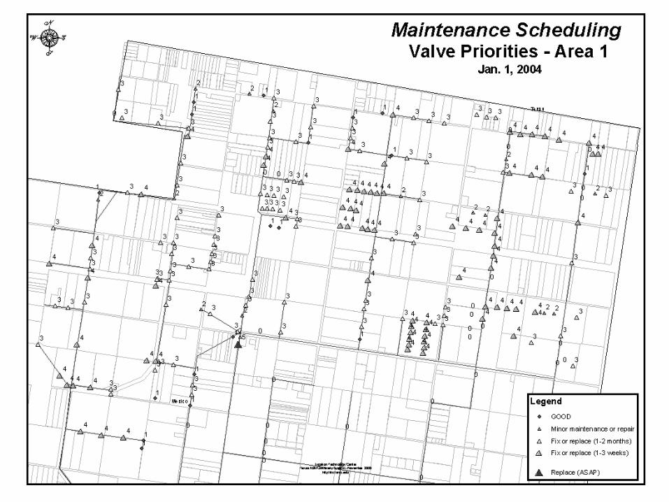
Simplest UseSimplest Use
nn Producing customized maps for district Producing customized maps for district personnel to be used in daypersonnel to be used in day--toto--day day activitiesactivities
nn Example shown here is the prioritized Example shown here is the prioritized maintenance schedule for valves maintenance schedule for valves

Getting Started in GISGetting Started in GIS
nn First step is to develop basic GIS maps of First step is to develop basic GIS maps of the districtthe district
nn Use of Use of AutoCADAutoCAD maps and electronic data maps and electronic data is not recommended and is usually more is not recommended and is usually more time consuming than retime consuming than re--drawing the drawing the district from scratchdistrict from scratch
nn A fast and accurate method is to use A fast and accurate method is to use areialareialphotographs that have been geophotographs that have been geo--referenced as a guidereferenced as a guide

Areial photographs which have been rectified such as DOQQ (Digital Ortho-photo Quarter Quadrangles) from the USGS can serve as a quick means to map out a district.

Drawing in land parcels by using the DOQQ as reference. EachOn the map has exact ordinances (latitude, longitude). Aerial Photographs can have resolutions within a few feet.

The water distribution network can also be drawn into ArcViewusing DOQQ as a reference.

Outlet, well, pump, and check stations are also included. IDs for each structure can be linked to existing databases.

Field or account IDs are linked to the data base to show, in this example, grown by each land owner or tenant.
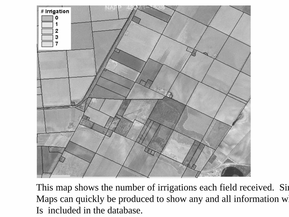
This map shows the number of irrigations each field received. SimilarMaps can quickly be produced to show any and all information whiIs included in the database.

This shows all the information on the field highlighted. Thiscan be done by simply clicking on a tract of land using the informationtool. The database was linked to the field ID number 65.
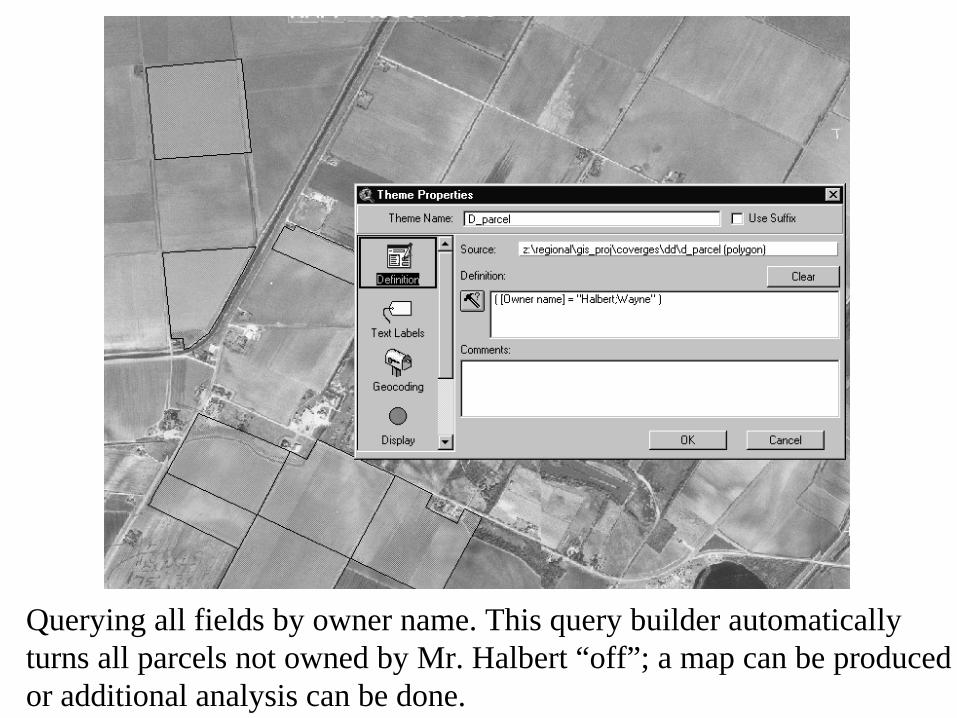
Querying all fields by owner name. This query builder automatically turns all parcels not owned by Mr. Halbert “off”; a map can be produced or additional analysis can be done.

Several options exist for querying owner name and displaying fields.

This query shows all fields irrigated after a specific dateUsing [Date watered 1])>19970605. All information in the database can be queried and displayed.

By using the info tool and clicking on a drainage ditch, a pop-up window displays specific data on that sditch which has been linked to the GIS or included in a property table.

Visual representation of data is very helpful for management and planning. Shown is the Mission Irrigation District which is undergoing massive urbanization


The Mercedes Irrigation District.

Interactive maps provide more information that static paper maps.

Width and lengths of canal segments can be easily extracted and used to determine costs of lining or pipeline replacement.

Database ConsiderationsDatabase Considerations
§§ Most Texas districts have old and outdated Most Texas districts have old and outdated databases, many running on obsolete databases, many running on obsolete computers and operating systemscomputers and operating systems
-- changes have to be done by consultants changes have to be done by consultants -- limited inlimited in--house capabilityhouse capability-- complicates GIS linkagecomplicates GIS linkage

Database ConsiderationsDatabase Considerations§§First recommendation, covert over to a modern, First recommendation, covert over to a modern, widely used database, such as widely used database, such as
Microsoft Server/SQL 2000 database system
§ Other options exisit, but SQL is an inexpensive, easy to use database, widely used in the U.S.§ Training and support services are also widely available

Database ConsiderationsDatabase Considerations
§§Example, Cameron County Irrigation District Example, Cameron County Irrigation District No. 2No. 2§§Problem, they have completed mapping of all Problem, they have completed mapping of all fields and want to link the GIS to their database fields and want to link the GIS to their database and display account informationand display account information§§ But they do not have a field ID number, only But they do not have a field ID number, only account numbers, and each account may cover account numbers, and each account may cover several different tracks of land (fields)several different tracks of land (fields)

Chart 1:Water Ticket Software
Each water ticket includes name, account, subdivision, and block, but no field ID.
Chart 1:Water Ticket Software
Each water ticket includes name, account, subdivision, and block, but no field ID.

Chart 2:Water Ticket Database Table
Using the ticket number we can find the account number and block to which the water
was delivered. We cannot determine which field was irrigated from the database due to the lack of a field ID.
Chart 2:Water Ticket Database Table
Using the ticket number we can find the account number and block to which the water
was delivered. We cannot determine which field was irrigated from the database due to the lack of a field ID.

Chart 3:Property Database Table
Here we see the property table of the database. A field
ID (PID) has been implemented here; however
it is not fully useful. There is no way to cross reference the field ID to the water ticket,
because one account can own several fields in the same
block.
Chart 3:Property Database Table
Here we see the property table of the database. A field
ID (PID) has been implemented here; however
it is not fully useful. There is no way to cross reference the field ID to the water ticket,
because one account can own several fields in the same
block.

Chart 4:Block ordering
(current system)
Water is delivered to the correct block, but which field
receives the water? In this case there are four fields
located in this single forty acre block.
Chart 4:Block ordering
(current system)
Water is delivered to the correct block, but which field
receives the water? In this case there are four fields
located in this single forty acre block.

Chart 5:Field ID ordering
(proposed solution)
Water is delivered to the correct field ID. There is no
question as to where the water went.
Chart 5:Field ID ordering
(proposed solution)
Water is delivered to the correct field ID. There is no
question as to where the water went.

Chart 6:Block ordering
(current system)
This diagram shows several highly watered areas on this
map. With the current database structure,
there is no way to determine why these blocks are using
so much water without physically going to the
location.
Chart 6:Block ordering
(current system)
This diagram shows several highly watered areas on this
map. With the current database structure,
there is no way to determine why these blocks are using
so much water without physically going to the
location.

Chart 7:Field ID ordering
(recommended solution)
Using field ID’s, we can quickly identify the highly watered areas by field, and can then check that field to
see if there is an over-watering issue.
Chart 7:Field ID ordering
(recommended solution)
Using field ID’s, we can quickly identify the highly watered areas by field, and can then check that field to
see if there is an over-watering issue.

Chart 8:
A field map can be made available to simplify water
ordering. (note individual field IDs)
Chart 8:
A field map can be made available to simplify water
ordering. (note individual field IDs)

Example of other uses for Example of other uses for GISGIS
Applications to Regional Applications to Regional Water Planning in TexasWater Planning in Texas

Map of the irrigation districts in the Lower Map of the irrigation districts in the Lower Rio Grande Valley of TexasRio Grande Valley of Texas

Irrigation water distribution network showing lining status

“Turning off” district boundaries

Extent of existing urban areas.
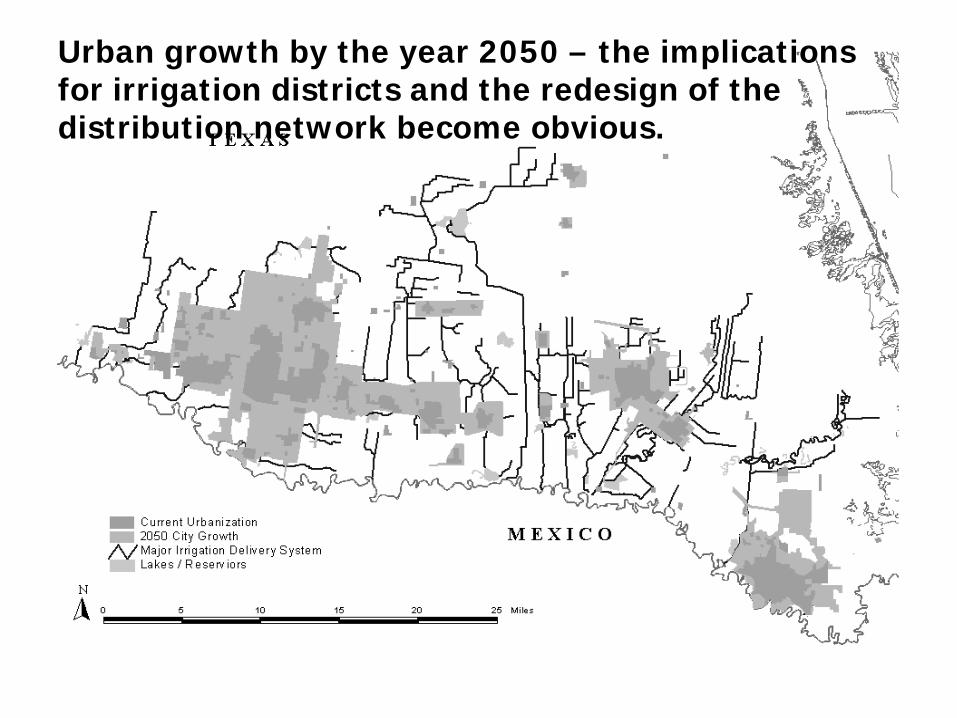
Urban growth by the year 2050 – the implications for irrigation districts and the redesign of the distribution network become obvious.

County growth also will affect irrigation water delivery.

Regional Water Planning Regional Water Planning Example 2 Example 2 –– analyzing the municipal analyzing the municipal supply network of irrigation districtssupply network of irrigation districts
nnWhat is the volume of water needed in the What is the volume of water needed in the irrigation district distribution network irrigation district distribution network needed for municipal water needed for municipal water delieveriesdelieveries??
nnWhat are the losses in the municipal water What are the losses in the municipal water supply network?supply network?
nnWhat are the considerations for future What are the considerations for future rehabilitation projects and network rerehabilitation projects and network re--design?design?


How we used GIS in conducting How we used GIS in conducting this analysisthis analysis
nn Means of organization for all data Means of organization for all data collected and needed for calculationscollected and needed for calculations
nn Canal and pipeline Canal and pipeline lenghtslenghts and and reserviorreserviorcapacities were calculated directly in capacities were calculated directly in ArcGISArcGIS
nn Enabled the extrapolation of seepage loss Enabled the extrapolation of seepage loss tests to untested canal segmentstests to untested canal segments
[interactive example showing how canal [interactive example showing how canal measurements were used within GIS to measurements were used within GIS to
calculate water capacities]calculate water capacities]
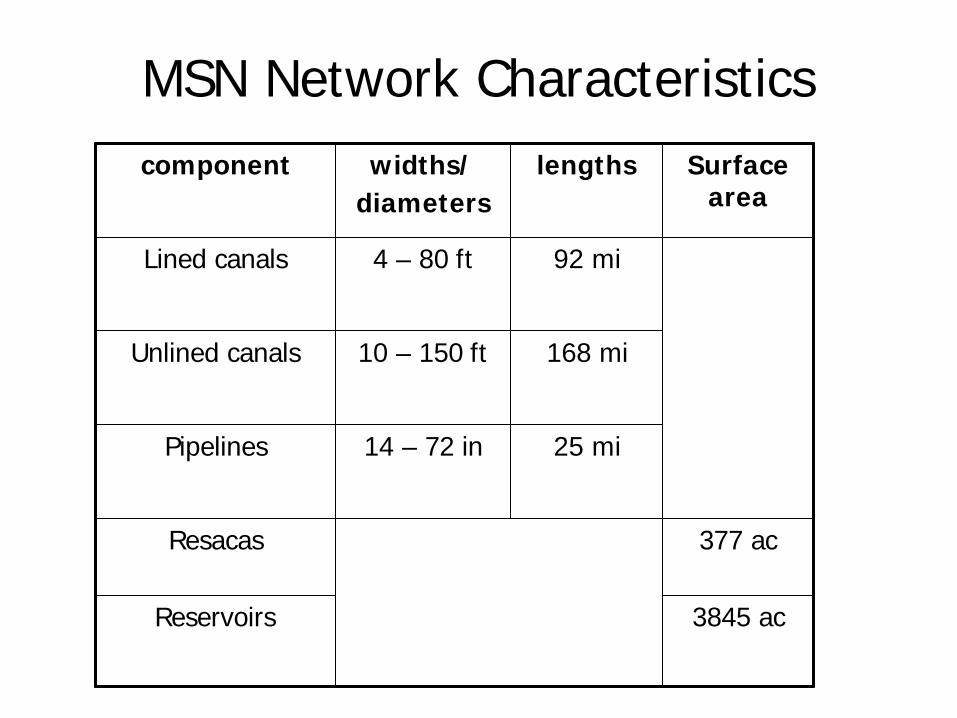
MSN Network CharacteristicsMSN Network Characteristics
3845 ac3845 acReservoirsReservoirs
377 ac377 acResacasResacas
25 mi25 mi14 14 –– 72 in72 inPipelinesPipelines
168 mi168 mi10 10 –– 150 ft150 ftUnlined canalsUnlined canals
92 mi92 mi4 4 –– 80 ft80 ftLined canalsLined canals
Surface Surface areaarea
lengthslengthswidths/widths/diametersdiameters
componentcomponent

MSN Network CharacteristicsMSN Network Characteristics
82168216ReservoirsReservoirs
15,001 15,001 –– 17,29117,291TOTALTOTAL
24842484ResacasResacas
26.626.6PipelinesPipelines
4,382 4,382 –– 6,5276,527Unlined canalsUnlined canals
722 722 -- 866866Lined canalsLined canals
Static volumeStatic volume(ac(ac--ft)ft)
componentcomponentThese are the These are the preliminary preliminary estimates of static estimates of static volume of water (acvolume of water (ac--ft) needed to charge ft) needed to charge the MSN for normal the MSN for normal agricultural water agricultural water deliveries (excludes deliveries (excludes siphons, culverts)siphons, culverts)

Seepage Losses Tests Seepage Losses Tests Canal segments tested, overlaid onto the Canal segments tested, overlaid onto the
Municipal Supply Network. Next step is to Municipal Supply Network. Next step is to extrapolate data to untested segments.extrapolate data to untested segments.


Seepage Losses Seepage Losses Preliminary Analysis (acrePreliminary Analysis (acre--feet/day)feet/day)
8181Reservoirs/Reservoirs/resacasresacas
25725717117199Lined canalsLined canals
11711171808808117117TOTALSTOTALS
8348345565562727Unlined canalsUnlined canals
High with High with leaksleaks
HighHighLow Low componentcomponent

Other Components of Our ProgramOther Components of Our ProgramTechnical Assistance
nn Analyzing the water supply situation in districts Analyzing the water supply situation in districts and their ability to deliver sufficient water and and their ability to deliver sufficient water and head at the farm turnouthead at the farm turnout
nn Analyzing water losses in districts including Analyzing water losses in districts including seepage loss tests and spill measurement, and seepage loss tests and spill measurement, and potential water savings from proposed potential water savings from proposed rehabilitation projectsrehabilitation projects
nn Rating the condition of district infrastructure to Rating the condition of district infrastructure to identify distribution system segments and identify distribution system segments and structures needing renovationstructures needing renovation

Other Components of Our ProgramOther Components of Our ProgramTechnical Assistance
nn GIS mapping and integration with district GIS mapping and integration with district accounting and database systems accounting and database systems
nn Selection, programming and use of automatic Selection, programming and use of automatic gate and other water control systemsgate and other water control systems
nn GPS surveying of district facilitiesGPS surveying of district facilities
nn Database programming and modernizationDatabase programming and modernization
nn Design of GIS systems and setDesign of GIS systems and set--up in districtsup in districts
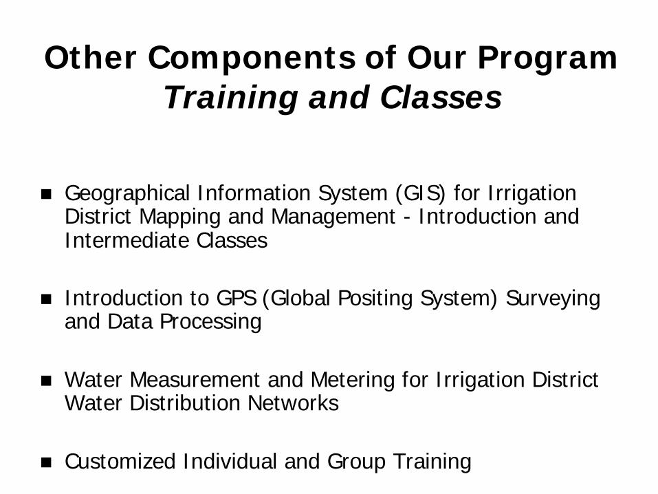
Other Components of Our ProgramOther Components of Our ProgramTraining and Classes
nn Geographical Information System (GIS) for Irrigation Geographical Information System (GIS) for Irrigation District Mapping and Management District Mapping and Management -- Introduction and Introduction and Intermediate ClassesIntermediate Classes
nn Introduction to GPS (Global Positing System) Surveying Introduction to GPS (Global Positing System) Surveying and Data Processingand Data Processing
nn Water Measurement and Metering for Irrigation District Water Measurement and Metering for Irrigation District Water Distribution NetworksWater Distribution Networks
nn Customized Individual and Group TrainingCustomized Individual and Group Training

Other Components of Our ProgramOther Components of Our ProgramApplied Research
nn Development of a GISDevelopment of a GIS--based irrigation district water distribution based irrigation district water distribution network simulation model for rehabilitation planning and networknetwork simulation model for rehabilitation planning and networkmanagement/optimizationmanagement/optimization
nn MultiMulti--spectral remote sensing for detecting leaks in canals and spectral remote sensing for detecting leaks in canals and underground pipelines underground pipelines -- in cooperation with USDAin cooperation with USDA--ARS labs in ARS labs in Lubbock and WeslacoLubbock and Weslaco
nn Development of a prototype database/accounting system for Development of a prototype database/accounting system for irrigation districts with GIS integrationirrigation districts with GIS integration
nn Development of the Rapid Assessment Tool (RAT), composed of Development of the Rapid Assessment Tool (RAT), composed of visual facility rating procedures combined with limited direct visual facility rating procedures combined with limited direct measurements to define the need for renovation and to quantify tmeasurements to define the need for renovation and to quantify the he potential water saving of proposed rehabilitation projects potential water saving of proposed rehabilitation projects -- in in cooperation with the Bureau of Reclamationcooperation with the Bureau of Reclamation

Other Components of Our ProgramOther Components of Our ProgramRelated Projects
nn Rehabilitation and improving the operation Rehabilitation and improving the operation and management of irrigation schemes and management of irrigation schemes --with the National Irrigation Commission of with the National Irrigation Commission of JamaicaJamaica
nn GIS implementation program for GIS implementation program for managing data and optimizing field managing data and optimizing field operation, harvesting and transportation operation, harvesting and transportation to the mill to the mill -- with the Lower Rio Grande with the Lower Rio Grande Valley Sugar Growers, Inc.Valley Sugar Growers, Inc.

For more information…For more information…
Irrigation District Engineering and Education Program Irrigation District Engineering and Education Program http://http://idea.tamu.eduidea.tamu.edu
A program of theA program of theIrrigation Technology CenterIrrigation Technology Center
http://itc.tamu.eduhttp://itc.tamu.edu