gippsland basin study kicks off - srk pdfs/srk_basin_study... · banjo 1 barracouta 1 barracouta 2...
TRANSCRIPT
Specific aims of the study include the interpretation of a new basin model by addressing key geological questions; such as:
The relationship of basin structure, evolution, and architecture •and its influence on basin stress patterns, petroleum systems, geosequestration, coal, CBM, and geothermal energy potential;
The nature of the relationship between the onshore and •offshore parts of the Gippsland Basin and the intervening transition zone; and
The spatial relationship between petroleum systems.•
One of the key outcomes of the study is to enable clients to develop new exploration models of previously under-explored parts of the basin. The approach adopted for the study is both ‘bottom-up’ and ‘top-down’, utilising traditional seismic and well data together integrated with extensive potential field data.
The development of sedimentary basins is largely controlled by the strength, composition and fabric of the earth’s crust at the time of the tectonic event(s) that helped form the basin. This crust forms the basement to the sedimentary basin.
A better understanding of the basement structure, composition and topography provides an improved basis for assessing (and predicting) a range of geological factors that can affect energy exploration and sequestration plans, such as the most likely locations of significant sedimentary depocentres, basement controlled structures, structures in the sediments, fluid migration pathways, hydrocarbon/coal source distribution, etc.
With the study outcomes contributing to more efficient and effective exploration and risk assessment, sponsors can expect incremental and significant project cost improvements.
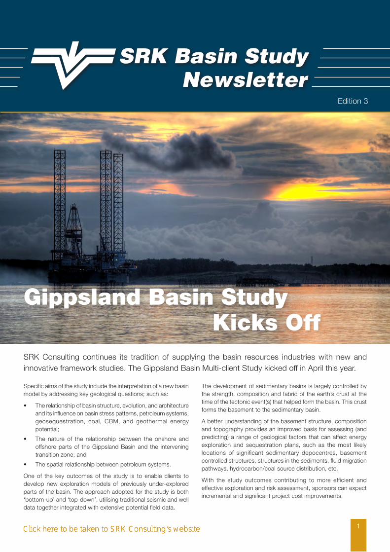
Gippsland Basin Study Kicks OffSRK Consulting continues its tradition of supplying the basin resources industries with new and innovative framework studies. The Gippsland Basin Multi-client Study kicked off in April this year.
SRK Basin StudyNewsletter
1
Edition 3
Gippsland Basin Study Kicks Off (continued)
2
The compilation, interpretation and integration of a range of geological, geophysical, petrophysical and geochemical data into 2D and 3D GIS work platforms is an integral part of the basin study.
The resulting Information Base will provide a powerful data interrogation and viewing tool that can be readily updated or broadened with new information. Once compiled, the data can be rapidly and effectively analysed.
Compilation and interpretation will be at a nominal scale of ~1:100,000 or higher resolution depending on data resolution. Information will include both extensive public domain and other sponsor-provided non confidential data sets.
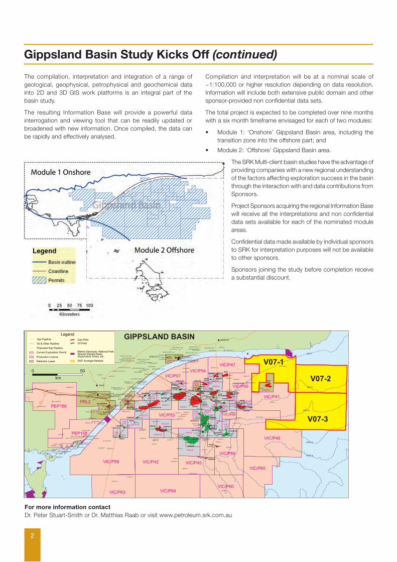
The total project is expected to be completed over nine months with a six month timeframe envisaged for each of two modules:
Module 1: ‘Onshore’ Gippsland Basin area, including the •transition zone into the offshore part; and
Module 2: ‘Offshore’ Gippsland Basin area.•
The SRK Multi-client basin studies have the advantage of providing companies with a new regional understanding of the factors affecting exploration success in the basin through the interaction with and data contributions from Sponsors.
Project Sponsors acquiring the regional Information Base will receive all the interpretations and non confidential data sets available for each of the nominated module areas.
Confidential data made available by individual sponsors to SRK for interpretation purposes will not be available to other sponsors.
Sponsors joining the study before completion receive a substantial discount.
For more information contact Dr. Peter Stuart-Smith or Dr. Matthias Raab or visit www.petroleum.srk.com.au
VIC/L11
VIC/L9
VIC/RL3
VIC/L20
VIC/L25
VIC/L26
VIC/L1
VIC/RL1
VIC/RL4
VIC/L19
VIC/L6
VIC/L5
VIC/L21
VIC/L17
VIC/L15 VIC/L16
VIC/L13
VIC/L14
VIC/L2
VIC/L18
VIC/R
L1(V
)
VIC/L3
VIC/L7
VIC/L8
VIC/L4
VIC/L10
VIC/P57
PEP158
PRL2
PRL3
VIC/P41
VIC/P42 VIC/P45
VIC/P47
VIC/P53
VIC/P49
PEP166
VIC/P54
VIC/P55
VIC/P56
VIC/P59
VIC/P58
VIC/P60
V07-1
V07-2
V07-3
VIC/P63 VIC/P64
VIC/P65
VIC/L29
VIC/L27
VIC/L28
BALEEN
PATRICIA
SOLE
KIPPER
FLOUNDER
BLACKBACK
TUNA
BATFISH
TURRUM
NORTHTURRUM
WESTTUNA
SUNFISH
MARLIN
FORTESCUE
HALIBUT
COBIA
MACKEREL
GUDGEON
YELLOWTAIL
KINGFISH
PERCH
DOLPHIN
TARWHINE
MULLOWAY
WHIPTAIL
BARRACOUTA
SEAHORSE WIRRAH
SWEETLIPS
MOONFISH
SNAPPER
WHITING
BREAM 'B'
BASKER
MANTA
BREAM
ARCHER
ANEMONE
LEATHERJACKET
GUMMY
GRUNTERANGELFISH
REMORA
SPERMWHALELONGTOM
ANGLER
EMPEROR
GOLDENBEACH
TORSK
Nth SEASPRAY
MOBY
SCALLOP
EASTPILCHARD
GRAYLING
200 m
1000 m
2000 m
3000 m
3000 m
4000 m
100 m
Admiral 1
Albacore 1
Albatross 1
Amberjack 1
Anemone 1Anemone 1a
Angelfish 1
Angler 1
Archer 1
Athene 1
Avon 1
Ayu 1
Baleen 1
Baleen 2
Baleen 3
Banjo 1
Barracouta 1
Barracouta 2
Barracouta 3
Barracouta 4Barracouta 5
Basker 1Basker 2
Basker South 1
Batfish 1
Baudin 1
Beardie 1
Bellbird 1
Bignose 1
Billfish 1
Blackback 1
Blackback 2
Blackback 3
Blenny 1
Bonita 1,1a
Boundary Creek 1a,2
Bream 1Bream 2
Bream 3Bream 4a
Bream 5
Broadbill 1 Bullseye 1
Bunga Creek 2
Burong 1
Carr's Creek 1
Chimaera 1
Cobdens Bore 1
Cobia 1Cobia 2
Cod 1
Colliers Hill 1
Colquhoun East 6
Colquhoun North 1
Comley 1
Conger 1
Cross Roads 1
Culverin 1
Cuttlefish 1
Darriman 1
Darriman 3
Darriman 4
Dart 1
Deadman Hill 1
Devilfish 1
Dolphin 1Dolphin 2
Dome Frome L.t. 1
Dome Frome L.t. 2 Dome Frome L.t. 3
Dome Frome L.t. 4
Drummer 1
Duck Bay 1
Dulungalong 1
Dutson 1
Dutson Downs 1
East End 1
East Halibut 1
East K1
East Lake Tyers 1
East Nowa 1
East Pilchard 1
East Reeve 1
East Seacombe 1
Echidna High 1
Edina 1
Emperor 1
Fairhope 1
Flathead 1
Flounder 1Flounder 2
Flounder 3Flounder 4Flounder 5
Flounder 6
Flying Fish 1
Fortescue 1
Fortescue 2
Fortescue 3
Fortescue 4
Fur Seal 1
Gangell 1
Gannet 1
Gilbert 1,1a
Gipps 1Gipps 2
Gipps 3
Gipps. Frome Lake 1Gipps. Frome Lake 1a
Gipps. Frome Lake 2
Gipps. Frome Lake 3
Gipps. Frome Lake 4
Gipps. Frome Lake 5
Golden Beach 1,1aGolden Beach West 1
Goon Nure 1
Grayling 1,1a
Great White 1
Groper 1
Groper 2
Grunter 1
Gudgeon 1
Gummy 1
Gurnard 1
Halibut 1Halibut 2
Hammerhead 1
Hapuku 1
Harlequin 1
Hedley 1
Helios 1
Hermes 1
Hollands Landing 1
Investigator 1
Judith 1
Kahawai 1
Kalimna 1
Keystone 1
K1K2
K3
K4
K'fish 5
K6K7
K'fish 8
Kingfish 9
Kipper 1
Kipper 2
Kyarra 1a
Lake Bunga 1
Lake Reeve 1
Lake Wellington 1
Leatherjacket 1Longtom 1Longtom 2
Loy Yang 1a,2
Luderick 1
Macalister 1
Mackerel 1
Mackerel 2
Mackerel 3
Mackerel 4
Maclean 1
Manta 1Manta 2,2a
Marlin 1
Marlin 2
Marlin 3 Marlin 4
Mccreesh 1
Megamouth 1
Melville 1
Merriman 1
Midfield Glen Sth 1
Moby 1
Moonfish 1 Moonfish 2
Moray 1
Morwong 1
Mudskipper 1
Mullet 1
Mulloway 1
Nannygai 1
Northright 1
North Seaspray 1,3North Seaspray 2
North Wirrah 1
Nuntin 1Nuntin 2
Oil Search Bengw 1Oil Search Bengw 2
Oil Search Coong 1
Oil Search Coong 2
Oil Search Steam Drill
Oil Search Toms Cr
Omeo 1Omeo 2a
Opah 1
Orange Roughy 1
Palmer 1
Patricia 1
Patricia 2
Patrobus 1
Patties Pies 1Patties Pies South 1/1a
Paynesville 1
Pelican Point 1
Perch 1Perch 2Perch 3,4
Pike 1
Pilotfish 1a
Pisces 1
Point Addis 1
Point Addis 2
Protea 1
Remora 1
Rockling 1
Romawi 1
Rosedale 1
Roundhead 1
Sa Oil Colq 1
Salmon 1
Salt Lake 1
Sawbelly 1
Scallop 1
Seacombe 1
Seacombe South 1
Seahorse 1
Seahorse 2
Seaspray 1
Selene 1
Shark 1
Signal Hill 1
Smiler 1
Snapper 1Snapper 2
Snapper 3 Snapper 4Snapper 5
Snapper 6
Snook 1
Sole 1Sole 2
South Longford 1
Speke 1
Sperm Whale 1
Sperm Whale Head 1
Spoon Bay 1
St Margaret Island 1
Sth West Bairnsdale1
Stonefish 1
Stringy Bark 1
Sunday Island 1
Sunfish 1 Sunfish 2
Sweep 1
Sweetlips 1
Swordfish 1
Tailor 1
Tanjil-Pt.A
ddis 1
Tanjil-pt.addis 2
Tarra 1
Tarwhine 1
Teraglin 1
Terakihi 1
Texland 1
Threadfin 1
Tildesley East 3
Tommyruff 1
Torsk 1
Trevally 1
Trifon 1Trifon 2,2r
Trumpeter 1
Tukari 1
Tuna 1Tuna 2
Tuna 3
Tuna 4Turrum 1
T2
Turrum 3
Turrum 4
Turrum 5
Turrum 6
Turrum 7
Veilfin 1Volador 1
Wahoo 1
Wellington Park 1Wellington Park 2
West Fortescue 1
West Halibut 1
West Moonfish 1
West Seacombe 1
W Seahorse 1
W Seahorse 3
West Whiptail 1
Whale 1
Whaleshark 1
Whiptail 1a
Whiting 1
Whiting 2
Wirrah 1
Wirrah 2
Wirrah 3
Wombat 1Wombat 2 Wombat 3
Wonga Binda 1
Woodside 1
Woodside 2 Woodside 3
Woodside 4
Woodside South 1
Wrasse 1
Wrixondale 1
Wyrallah 1
Yarram 1
Yellowtail 1Yellowtail 2
York 1
Zane Grey 1,st1,2
Galloway 1 Longtom 3
W Seahorse 2
Hazelwood 1
Alberton 1
Speke Sth1
Boola Boola 1,2
War
die
1
GIPPSLAND BASIN
0 50
km
LAKES ENTRANCE
ORBOST
SALE
LONGFORD
LegendGas Pipeline
Proposed Gas Pipeline
Oil & Other Pipeline
Current Exploration Permit
Production Licence
Retention Lease
Gas Field
Oil Field
Marine Sanctuary, National Park, Special Interest Areas, Aquaculture Zones, etc.
2007 Acreage Release
147°E 148°E 149°E
147°E 148°E 149°E
39°S
38°S
39°S
38°S
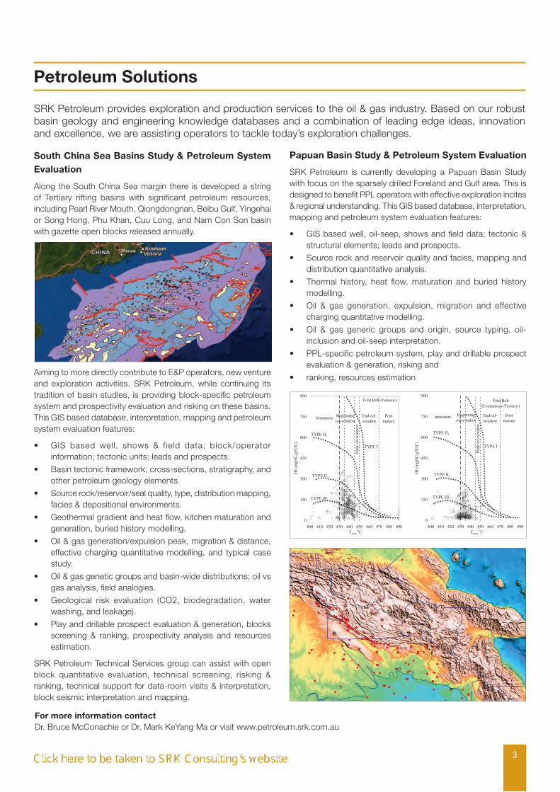
South China Sea Basins Study & Petroleum System Evaluation
Along the South China Sea margin there is developed a string of Tertiary rifting basins with significant petroleum resources, including Pearl River Mouth, Qiongdongnan, Beibu Gulf, Yingehai or Song Hong, Phu Khan, Cuu Long, and Nam Con Son basin with gazette open blocks released annually.
Aiming to more directly contribute to E&P operators, new venture and exploration activities, SRK Petroleum, while continuing its tradition of basin studies, is providing block-specific petroleum system and prospectivity evaluation and risking on these basins. This GIS based database, interpretation, mapping and petroleum system evaluation features:
GIS based well, shows & field data; block/operator •information; tectonic units; leads and prospects.
Basin tectonic framework, cross-sections, stratigraphy, and •other petroleum geology elements.
Source rock/reservoir/seal quality, type, distribution mapping, •facies & depositional environments.
Geothermal gradient and heat flow, kitchen maturation and •generation, buried history modelling.
Oil & gas generation/expulsion peak, migration & distance, •effective charging quantitative modelling, and typical case study.
Oil & gas genetic groups and basin-wide distributions; oil vs •gas analysis, field analogies.
Geological risk evaluation (CO2, biodegradation, water •washing, and leakage).
Play and drillable prospect evaluation & generation, blocks •screening & ranking, prospectivity analysis and resources estimation.
SRK Petroleum Technical Services group can assist with open block quantitative evaluation, technical screening, risking & ranking, technical support for data-room visits & interpretation, block seismic interpretation and mapping.
Papuan Basin Study & Petroleum System Evaluation
SRK Petroleum is currently developing a Papuan Basin Study with focus on the sparsely drilled Foreland and Gulf area. This is designed to benefit PPL operators with effective exploration incites & regional understanding. This GIS based database, interpretation, mapping and petroleum system evaluation features:
GIS based well, oil-seep, shows and field data; tectonic & •structural elements; leads and prospects.
Source rock and reservoir quality and facies, mapping and •distribution quantitative analysis.
Thermal history, heat flow, maturation and buried history •modelling.
Oil & gas generation, expulsion, migration and effective •charging quantitative modelling.
Oil & gas generic groups and origin, source typing, oil-•inclusion and oil-seep interpretation.
PPL-specific petroleum system, play and drillable prospect •evaluation & generation, risking and
ranking, resources estimation•
Petroleum Solutions
3
SRK Petroleum provides exploration and production services to the oil & gas industry. Based on our robust basin geology and engineering knowledge databases and a combination of leading edge ideas, innovation and excellence, we are assisting operators to tackle today’s exploration challenges.
For more information contact Dr. Bruce McConachie or Dr. Mark KeYang Ma or visit www.petroleum.srk.com.au
For more information, visit us at: www.srk.com
4
Focus On
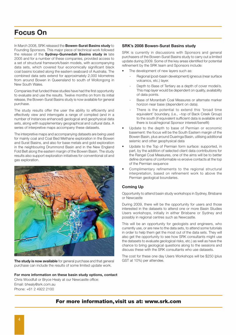
In March 2008, SRK released the Bowen-Surat Basins study to Founding Sponsors. This major piece of technical work followed the release of the Sydney-Gunnedah Basins study in late 2005 and for a number of these companies, provided access to a set of structural framework/basin models, with accompanying data sets, which covered four economically significant black coal basins located along the eastern seaboard of Australia. The combined data sets extend for approximately 2,000 kilometres from around Bowen in Queensland to south of Wollongong in New South Wales.
Companies that funded these studies have had the first opportunity to evaluate and use the results. Twelve months on from its initial release, the Bowen-Surat Basins study is now available for general purchase.
The study results offer the user the ability to efficiently and effectively view and interrogate a range of compiled (and in a number of instances enhanced) geological and geophysical data sets, along with supplementary geographical and cultural data. A series of interpretive maps accompany these datasets.
The interpretive maps and accompanying datasets are being used for mainly coal and Coal Bed Methane exploration in the Bowen and Surat Basins, and also for base metals and gold exploration in the neighbouring Drummond Basin and in the New England Fold Belt along the eastern margin of the Bowen Basin. The study results also support exploration initiatives for conventional oil and gas exploration.
The study is now available for general purchase and that general purchase can include the results of some limited update work.
SRK’s 2008 Bowen-Surat Basins study
SRK is currently in discussions with Sponsors and general purchasers of the Bowen-Surat Basins study to carry out a limited update during 2009. Some of the key areas identified for potential refinement by the SRK team and Sponsors include:
The development of new layers such as: •
Regional (post-basin development) igneous (near surface -volcanics, etc.) layer.
Depth to Base of Tertiary as a depth of cover model/s. -This map layer would be dependent on quality, availability of data points.
Base of Moranbah Coal Measures or alternate marker -horizon near base (dependent on data).
There is the potential to extend this ‘broad time -equivalent’ boundary, (i.e., ~top of Back Creek Group) to the south (if equivalent sufficient data is available and there is local/regional Sponsor interest/benefit)
Update to the depth to base of Permian or economic •basement: the focus will be the South Eastern margin of the Bowen Basin, plus around Duaringa Basin, utilising additional seismic and other geophysical data
Update to the Top of Permian form surface: supported, in •part, by the addition of selected client data contributions for the Rangal Coal Measures, one of the aims will be to better define domains of conformable vs erosive contacts at the top of the Permian sequence
Complimentary refinements to the regional structural •interpretation, based on refinement work to above the Permian geological boundaries.
Coming Up
Opportunity to attend basin study workshops in Sydney, Brisbane or Newcastle
During 2009, there will be the opportunity for users and those interested in the datasets to attend one or more Basin Studies Users workshops, initially in either Brisbane or Sydney and possibly in regional centres such as Newcastle.
This will be an opportunity for geologists and engineers, who currently use, or are new to the data sets, to attend some tutorials in order to help them get the most out of the data sets. They will also get the opportunity to see how SRK consultants might use the datasets to evaluate geological risks, etc.) as well as have the chance to bring geological questions along to the sessions and discuss these with the SRK consultants who use datasets.
The cost for these one day Users Workshops will be $250 (plus GST at 10%) per attendee.
For more information on these basin study options, contact Chris Woodfull or Bryce Healy at our Newcastle office:Email: [email protected]: +61 2 4922 2100