gippsland basin 2d infill 2015 marine seismic survey ... · gippsland basin 2d infill 2015 marine...
TRANSCRIPT

Gippsland Basin 2D Infill 2015 Marine Seismic Survey – GA0352 Acquisition and Processing Reports
GEOSCIENCE AUSTRALIA RECORD 2016/25
C.H. Mitchell, M. Gunning, and R.P. Langford

Department of Industry, Innovation and Science Minister for Resources and Northern Australia: Senator the Hon Matthew Canavan Assistant Minister for Industry, Innovation and Science: The Hon Craig Laundy MP Secretary: Ms Glenys Beauchamp PSM
Geoscience Australia Chief Executive Officer: Dr Chris Pigram This paper is published with the permission of the CEO, Geoscience Australia
© Commonwealth of Australia (Geoscience Australia) 2016
With the exception of the Commonwealth Coat of Arms and where otherwise noted, this product is provided under a Creative Commons Attribution 4.0 International Licence. (http://creativecommons.org/licenses/by/4.0/legalcode)
Geoscience Australia has tried to make the information in this product as accurate as possible. However, it does not guarantee that the information is totally accurate or complete. Therefore, you should not solely rely on this information when making a commercial decision.
Geoscience Australia is committed to providing web accessible content wherever possible. If you are having difficulties with accessing this document please email [email protected].
ISSN 2201-702X (PDF) ISBN 978-1-925297-24-9 (PDF) eCat ID 100253
Bibliographic reference: Mitchell, C.H., Gunning, M. and Langford, R.P. 2016. Gippsland Basin 2D Infill 2015 Marine Seismic Survey – GA0352: Acquisition and Processing Reports. Record 2016/25. Geoscience Australia, Canberra. http://dx.doi.org/10.11636/Record.2016.025

Contents 1 Introduction ............................................................................................................................................ 4
1.1 Background ...................................................................................................................................... 4 1.2 Regional geology and seismic survey objective .............................................................................. 4 1.3 Survey planning ............................................................................................................................... 6
2 Additional acquisition datasets .............................................................................................................. 9
3 Acquisition licences and permits ........................................................................................................... 9 3.1 Greenhouse Gas Research Consent permit .................................................................................... 9 3.2 Environment Plan ...........................................................................................................................10 3.3 Seismic Data Acquisition Parameters ............................................................................................11
4 Seismic Data Processing.....................................................................................................................12 4.1 Data Processing .............................................................................................................................12 4.2 Data Processing Flow ....................................................................................................................15
NAL PROCESSING SEQUENCE .....................................................................................................15
5 Acknowledgements .............................................................................................................................16
6 References ..........................................................................................................................................16
Appendices .............................................................................................................................................17
Gippsland Basin 2D Infill 2015 Marine Seismic Survey - GA352: Acquisition and Processing Reports 3

1 Introduction
1.1 Background The Australian Government, through the Department of Industry, Innovation and Science, routinely funds Geoscience Australia to acquire pre-competitive data to support prospectivity assessments of various offshore basins. As part of the Australian Government’s National CO2 Infrastructure Plan (Carbon Storage Taskforce 2009), a marine seismic reflection survey, Gippsland Basin Infill 2D Marine Seismic Survey – GA0352, was undertaken in the offshore southern margin of the Gippsland Basin to investigate potential sites suitable for CO2 geological storage (Langford, 2016).
The offshore Gippsland Basin is a mature hydrocarbon province, where exploration began in the 1960s, and has been producing hydrocarbons for over fifty years. Consequently, the basin has extensive seismic data coverage with approximately 90,000 line km of 2D reflection seismic data and over forty 3D seismic surveys. However, the data in the central and western areas of the southern margin of the basin is of poor coverage and quality. In 2010 the Victorian and Commonwealth governments acquired a regional ~8,000 line kilometre marine seismic survey GDPI10 (Figure 1.1) to address these data and quality gaps. This data provided new geological insights to the region (Blevin et al., 2013), but also prompted further studies and the acquisition of Geoscience Australia’s Gippsland Basin Infill 2D Marine Seismic Survey – GA0352.
Survey GA0352 was awarded to Gardline CGG Pty Ltd, and approximately 900 line km of 2D reflection seismic data was acquired by the MV Duke between the 5–24 April 2015 (Appendix A). On completion of the survey the processing contract was awarded to DownUnder GeoSolutions Pty Ltd on 25 October 2015 to process the seismic data in both time and depth and the provision of a processing report (Appendix B).
1.2 Regional geology and seismic survey objective The southern margin of the offshore Gippsland Basin comprises the east-west trending Southern Platform and Southern Terrace, which are bounded to the north by the Foster and Darriman fault systems, respectively (Figure 1.1). Further north of the Southern Terrace is the Central Deep, which is the main depocentre of the basin that has near complete 3D seismic coverage. The basement on the Southern Platform is relatively shallow (Figure 1.2) and generally less than one kilometre deep (~one second two-way-time). Potential upper Latrobe Group reservoirs, and the overlying regional seal, increase in thickness over the Southern Terrace and Central Deep and are the main target interval for the GA0352 survey.
Although the southern margin of the basin is largely underexplored, it has recently been proposed as a potential area for CO2 geological storage. In 2010, the GDPI10 2D reflection seismic survey provided additional insight into the structure and stratigraphy of the basin’s southern margin. However, correlating the significant geological changes between the Central Deep with extensive 3D seismic coverage and the recent 2D seismic data across the Darriman and Foster fault systems onto the Southern Terrace and Southern Platform remained a challenge. This is particularly the case in the northern part of the GDPI10 survey where seismic lines cross the main structural trend obliquely, thus making structural features and sequence relationships more difficult to interpret (Figure 1.3).
The GA0352 survey was planned to tie the existing 2D and 3D surveys from the Central Deep with the broader structural interpretation on the GDPI10 seismic data.
Gippsland Basin 2D Infill 2015 Marine Seismic Survey - GA352: Acquisition and Processing Reports 4

Figure 1.1 Location of Gippsland Southern Margin Infill 2D Seismic Acquisition Survey – GA0352. Structural elements of the southern margin showing hydrocarbon accumulations, 3D seismic coverage and good to moderate quality 2D seismic data. Thicker 2D seismic lines show the location of the GDPI10 survey data and their oblique orientation to the main fault systems.
The survey was designed to shoot perpendicular to the main structural trend of the Foster Fault System to provide better seismic data density in an area with widely-spaced seismic lines. It also provided an opportunity to use the latest processing de-ghosting technology to better image the various coal horizons and to clarify the palaeo-depositional environments along the southern margin of the basin.
Gippsland Basin 2D Infill 2015 Marine Seismic Survey - GA352: Acquisition and Processing Reports 5

1.3 Survey planning Fifty-five open-file 2D, and five 3D seismic surveys, in the area (Table 1.1) were assessed for quality as part of the survey planning. As the upper Latrobe Group succession was the primary focus for the assessment each existing survey was assessed for the ability to identify and resolve stratigraphy. The planning process then utilised interpreted seismic data for line placement and the Foster Fault System trend for its orientation.
Figure 1.2 Seismic section across the southern margin of the Gippsland Basin showing the major structural elements and stratigraphic units. Location of the cross-section shown in Figure 1.1 (after Blevin et al., 2013).
The southern flank has a relative lack of wells when compared to the rest of the basin, however, five wells (Table 1.2), of varying vintages, were used to tie the survey. The wells are located on the Southern Terrace and along the Southern Platform, with the exception of Bullseye 1, which is located in the Central Deep (Figure 1.1).
Figure 1.3 Comparison of seismic line GDPI10-011 (a) and obliquely orientated PreSDM line GA0352 line p1036 (b). The location of these lines is shown in Figure 1.1.
Gippsland Basin 2D Infill 2015 Marine Seismic Survey - GA352: Acquisition and Processing Reports 6

Table 1.1 Quality assessment of Gippsland Basin southern margin open-file 2D seismic surveys. The assessment was mainly based on the ability to resolve the upper Latrobe Group stratigraphy. Seismic quality was defined: Good—a strong likelihood to resolve stratigraphy in the upper Latrobe and deeper stratigraphy; Moderate—a moderate likelihood to resolve stratigraphy in the upper Latrobe, but deeper stratigraphy unlikely; Poor—ability to resolve stratigraphy in the upper Latrobe Group is largely diminished.
Survey Type Organisation Year Acquired
Record Length (s TWT)
Upper Latrobe Quality
Ninety Mile Beach 2D MSS 2D Arco Australia 1963 4 Poor EC67 2D MSS 2D ESSO 1967 4 Poor East Gippsland Basin 2D MSS 2D Magellan Petroleum 1969 4 Poor G69A 2D MSS 2D Esso 1969 4 Poor G69B and Extensions 2D MSS 2D Esso 1969 4 Poor Seaspray 2D MSS 2D Endeavour Oil 1970 2 Moderate G72A 2D MSS 2D Esso 1972 4 Poor NE Fureaux 2D MSS 2D Magellan Petroleum 1973 5 Poor G74A 2D MSS 2D Esso 1975 5 Moderate G77A 2D MSS 2D Esso 1978 4 Moderate GB79 2D MSS 2D Beach Petroleum 1980 4 Poor G80A and Extension Marine Seismic 2D Esso 1980 4 Poor GBS80 2D MSS 2D Bass Strait Oil and Gas 1980 4 Poor GC80A 2D MSS 2D Cultus 1980 4 Poor GBS81 2D MSS 2D Bass Strait Oil and Gas 1981 3 Poor G81A 2D MSS 2D Esso 1981 4 Moderate GP81A 2D MSS 2D Phillips Australian Oil 1981 5 Moderate GC82 2D MSS 2D Cultus 1981 4 Moderate GH82A 2D MSS 2D Hudbay Oil 1982 4 Poor GS81B 2D MSS 2D Shell 1982 6 Moderate GA82B 2D MSS 2D AAP 1982 5 Poor GS82 2D MSS 2D Shell 1982 5 Poor GUT83A 2D MSS 2D Union Texas Australia 1983 5 Moderate GUT-83P 2D MSS 2D Union Texas Australia 1983 5 Moderate GA83A 2D MSS 2D AAP 1983 5 Poor Seacombe 2D MSS 2D Lasmo 1985 5 Poor GSI85B 2D MSS 2D GSI 1985 5 Poor G84A 2D MSS 2D Esso 1985 4 Poor GSI85A 2D MSS 2D GSI 1985 6 Moderate G85A 2D MSS 2D Esso 1985 4 Poor Gippsland Basin 1 2D BMR 1987 12 Moderate Marlo 2D_3D MSS 2D Lasmo 1988 4 Poor GH88A 2D MSS 2D BHPP 1988 6 Poor
Gippsland Basin 2D Infill 2015 Marine Seismic Survey - GA352: Acquisition and Processing Reports 7

Survey Type Organisation Year Acquired
Record Length (s TWT)
Upper Latrobe Quality
GF88 Regional 2D MSS 2D Petrofina 1988 5 Moderate Archer 3D MSS 2D Petrofina 1988 5 Moderate G88A 2D MSS 2D Esso 1988 4 Poor GS88C 2D MSS 2D Shell 1988 5 Moderate GS88B 2D MSS 2D Shell 1988 5 Good Snowy River 2D_3D MSS 2D Lasmo 1988 2 Moderate Gippsland Basin 2 2D BMR 1988 8 Moderate GSE89A 2D MSS 2D Southeastern Oil and Gas 1989 4 Moderate GC89A 2D MSS 2D Cultus 1989 5 Poor G89A and G89A Experimental Marine Seismic 2D Esso 1989 4 Poor
G89A Experimental 2D MSS 2D Esso 1990 5 Moderate G91A_B Kingfish 2D_3D Marine Seismic 2D Esso 1991 4 Moderate
GF91A 2D MSS 2D Petrofina 1991 6 Moderate East Bream 3D MSS 2D Esso 1992 6 Moderate G92C 2D MSS 2D Esso 1992 6 Poor Volador Perch 2D MSS 2D Esso 1994 6 Moderate Protea 2D MSS 2D Mount Isa Mines 1994 6 Moderate Billfish 2D MSS 2D Esso 1995 6 Good GDW99 2D MSS 2D Seismic Australia 1999 10 Moderate AUSTREA-1 2D National Oceans Office 2000 8 Poor GBA02B 3D MSS 3D Bass Strait Oil and Gas 2002 6 Good HGP2002A 3D MSS 3D BHPBP 2002 5 Good Sue 3D MSS 3D Apache 2005 5 Good 2006 Greater Bream 3D MSS 3D Esso 2006 6 Good Marie 3D MSS 3D Apache 2007 6 Good Deep Water and Bronze Whaler GNXS07 2D MSS 2D Nexus Energy 2007 6 Moderate
GNX05 2D MSS 2D Nexus Energy 2010 6 Good Southern Flank 2D MSS 2D VIC DPI 2010 6 Good
Gippsland Basin 2D Infill 2015 Marine Seismic Survey - GA352: Acquisition and Processing Reports 8

Table 1.2 List of tie wells to survey GA0352.
Well Name Latitude Longitude Datum Operator Total Depth
Spud Date Tie Line
Bullseye 1 -38.589953 147.567802 AGD66 Assumed Esso Australia Ltd 2368 24/11/1973 GA0352P1036
Devilfish 1 -38.797966 147.920876 AGD66 The Shell Company Of Australia Ltd 2058 10/04/1990 GA0352P1034
Kyarra 1A -38.679730 147.188039 AGD66 Australian Aquitaine
Petroleum Pty Ltd 1280 16/02/1983 GA0352P1036
Pike 1 -38.773200 147.951482 AGD66 Assumed Esso Australia Ltd 2134 16/07/1973 GA0352P1035
Tarra 1 -38.642118 147.703562 AGD66 Australian Aquitaine
Petroleum Pty Ltd 2905 4/03/1983 GA0352P1025,
GA0352P1033
2 Additional acquisition datasets In addition to acquiring seismic reflection data, Geoscience Australia also acquired Multibeam Echo Sounder (MBES) bathymetry, single-beam echo sounder and sub-bottom profiler (chirp) data along all seismic survey lines. These data can be requested through the Geoscience Australia repository (email: [email protected]) or by download of the Geoscience Australia released MBES bathymetry data product (http://www.ga.gov.au/metadata-gateway/metadata/record/gcat_83957).
3 Acquisition licences and permits
3.1 Greenhouse Gas Research Consent permit In order to undertake marine seismic acquisition in the offshore a Greenhouse Gas Research Consent RC2-2014 (Figure 3.1) was granted to Geoscience Australia, under Part 3.7 of the Offshore Petroleum and Greenhouse Gas Storage Act 2006, in November 2014.
Gippsland Basin 2D Infill 2015 Marine Seismic Survey - GA352: Acquisition and Processing Reports 9

Figure 3.1 Gippsland Basin Infill 2D Marine Seismic Survey GA0352 and the area covered by the Greenhouse Gas Research Consent RC2-2014. Also shown are major structural elements, wells with key tie wells labelled and hydrocarbon fields.
3.2 Environment Plan An Environment Plan (Document No. N1413301, Revision 1) for the Gippsland Basin 2D Infill 2015 Marine Seismic Survey was submitted by Geoscience Australia to the National Offshore Petroleum Safety and Environmental Management Authority (NOPSEMA) in January 2015. A letter of acceptance was received 16 March 2015, in accordance with the Environment Protection and Biodiversity Conservation Act 1999 and Offshore Petroleum and Greenhouse Gas Storage (Environment) Regulations 2009. The Environment Plan Summary is available on the NOPSEMA web page: (http://www.nopsema.gov.au/assets/epsummaries/Resubmission-EP-Summary-Geoscience-Australia-Gippsland-2D-Infill-2015-Marine-Seismic-Survey.pdf)
Gippsland Basin 2D Infill 2015 Marine Seismic Survey - GA352: Acquisition and Processing Reports 10

3.3 Seismic Data Acquisition Parameters
Table 3.1 Survey GA0352 2D seismic acquisition parameters.
Item Parameter
Country of survey: Offshore Australia
Area of survey: Gippsland Basin
Survey vessel: M.V. Duke
Data type: 2D Marine
Volume: 908.175 line kilometres
Acquisition record length: 5.5 seconds
Acquisition sample interval: 2 ms
Acquisition filter applied: Low cut: 3Hz
Low cut slope: 12 dB/ oct
Acquisition filter applied: High cut: 412 Hz
High cut slope: 276 dB/ oct
Number of sources: 1
Source depth: 6 +/- 1 m
Shot interval: 18.75 m
Streamer length: 5100 m
No. of streamers: 1
Streamer depth: 8 +/- 1 m
Channel interval: 12.5 m
No. channels: 408
Nominal inline near offset: 20 m
Recording system: Sercel SEAL 408
Tape format: SEG-D 3592
Gippsland Basin 2D Infill 2015 Marine Seismic Survey - GA352: Acquisition and Processing Reports 11

4 Seismic Data Processing
4.1 Data Processing The processing challenges for this survey arose from both geological and acquisition related issues. The acquisition operational issues include significant feathering and swell noise, geologically the challenges were those typically encountered in the Gippsland Basin.
The geological challenges are: the high velocity Southern Platform; lateral velocity variation from channels and slump features; a rugose and laterally highly variable seafloor generating significant multiples; and the Foster Fault System, delineating the Southern Platform from the Central Deep, causing a significant lateral velocity change at depth.
The processing contract was awarded to DownUnder GeoSolutions Pty Ltd through Geoscience Australia’s panel procurement process. Processing was performed in their Brisbane office from September 2015 to May 2016. Test lines included the dip lines P1001, P1011 and P1028, and the strike line P1035. Early deliverable Post-stack Time Migration (PostSTM) was requested, but due to the small size of the survey a Pre-stack time migration (PreSTM) was provided instead. All sail lines (37) were processed with no merging of lines due to minimal overshooting having occurred. The processing report (Appendix B) was provided to Geoscience Australia on June 16th 2016.
Significant multiple removal tools were used to improve the image from the effects of surface related multiples and also from those peg-leg multiples off the main unconformity. As a result the imaging of the unconformity is much improved and was aided by application of the de-ghosting technology (Figure 4.1 and Figure 4.2).
Pre-stack Depth Migration (PreSDM) of the data (Figure 4.3), including the application of deghosting, to increase the bandwidth and provide better characterisation of the shallower sedimentary sequences, was applied. The data was processed at 2 ms sample rate to aim for better resolution of the thin coal seams. Five wells tie the data and all were used in development of the anisotropic velocity model (Figure 4.4) and anisotropic delta and epsilon models. Five tomographic updates were performed for Prestack Depth Migration.
Gippsland Basin 2D Infill 2015 Marine Seismic Survey - GA352: Acquisition and Processing Reports 12

Figure 4.1 GDPI10 Line 011 PreSTM image of main unconformity across the Foster Fault System. The location of this line is shown in Figure 1.1.
Figure 4.2 GA0352 Line P1036 PreSDM image of main unconformity (sub-parallel to Figure 4.1). The location of this line is shown in Figure 1.1.
Characterisation of the Southern Platform remains poor as the attenuated basin sequences and extremely high basement velocities make it inherently difficult to resolve geological features using the reflection seismic method. However, the top of the basement on the platform is much clearer, and the definition of the Foster Fault System is improved on the PreSDM when compared with the PreSTM data.
Gippsland Basin 2D Infill 2015 Marine Seismic Survey - GA352: Acquisition and Processing Reports 13
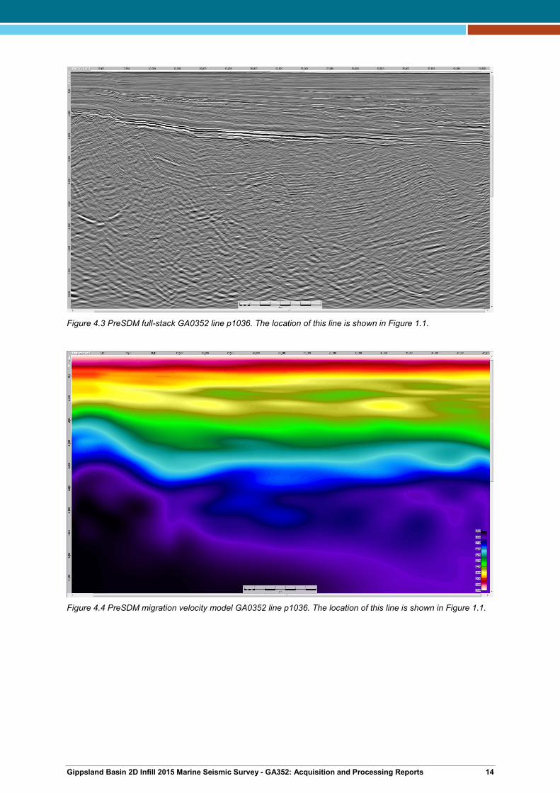
Figure 4.3 PreSDM full-stack GA0352 line p1036. The location of this line is shown in Figure 1.1.
Figure 4.4 PreSDM migration velocity model GA0352 line p1036. The location of this line is shown in Figure 1.1.
Gippsland Basin 2D Infill 2015 Marine Seismic Survey - GA352: Acquisition and Processing Reports 14
4.2 Data Processing Flow The processing flow applied to the seismic data is outlined below. More detail about the parameters of each step is available in the processing report (Appendix B). The processed data, consisting of angle stacks, velocities, navigation and reports, are available through [email protected].
NAL PROCESSING SEQUENCE
• Data reformat and navigation merge
• Spherical divergence
• Low cut filter
• Seismic interference and swell noise attenuation
• Linear noise attenuation
• Surface Related Multiple Elimination (SRME)
• Shallow Water Multiple Prediction (SWaMP)
• Pre-migration Radon demultiple
• DUG Broad deghosting
• Debubble
• Zero phasing
• Pre-migration noise attenuation
• Inverse Q filtering (phase only)
• Remove spherical divergence
• Five iterations of tomographic velocity analysis
• Kirchhoff pre-stack depth migration
• Time tomography
• Post migration Radon demultiple
• Post migration residual noise attenuation
• Inverse Q filtering (amplitude only)
• NMO, mute and stack
• Angle stack
• Spectral enhancement
• Time varying bandpass filter
• Scaling
• Polarity and phase
• Shot point to CDP relationship
• Output to SEGY
Gippsland Basin 2D Infill 2015 Marine Seismic Survey - GA352: Acquisition and Processing Reports 15

5 Acknowledgements Tristian Kemp, who voluntarily took on the challenge, on top of his other duties, of Operations Manager for the survey. Louise Goldie-Divko and Nick Hoffman from the Energy and Energy Resources - Geological Survey of Victoria provided valuable planning feedback and advice. Murray Woods and Theo Chiotis for preparation of figures, and John Pugh for his contractual management input. Kevin Turner for the ongoing role as Collections Manager for assistance in the timely delivery of Geoscience Australia’s data.
6 References Blevin, J., Cathro, D., Nelson, G., Vizy, J. and Lee, J.D., 2013. Survey GDPI10 Interpretation Project,
Southern Flank, Gippsland Basin. VicGCS Report 8, Department of Primary Industries. Carbon Storage Taskforce 2009. National Carbon Mapping and Infrastructure Plan – Australia:
Concise Report, Department of Resources, Energy and Tourism, Canberra. Langford, R.P. (Editor) 2016. Carbon dioxide storage potential of the Gippsland Basin: Results of a
study undertaken as part of the National CO2 Infrastructure Plan. Geoscience Australia Record (in press).
Gippsland Basin 2D Infill 2015 Marine Seismic Survey - GA352: Acquisition and Processing Reports 16

Appendices The following appendices are available on the Geoscience Australia website at: http://www.ga.gov.au/metadata-gateway/metadata/record/100253
• Appendix A: Gardline CGG Survey Report – Gippsland 2D Seismic Infill Survey
• Appendix B: DownUnder GeoSolutions Pty Ltd – Processing Report
Gippsland Basin 2D Infill 2015 Marine Seismic Survey - GA352: Acquisition and Processing Reports 17