geotechnische aspekte von verwitterten und alterierten · an increased disintegration and...
TRANSCRIPT

Deutsche Gesellschaft für Geotechnik e.v. (DGGT), ed. (2000): Proceedings of the Eurock 2000 Symposium, Aachen, 27 – 31 March 2000, Essen (Glückauf), 177-182.
177
ABSTRACT: Intensivly weathered and altered granites have been excavated during tunnelling works on two 3.3 km long motorway tubes in eastern Germany. The oportunity was given to study these zones through the implementation of a detailed field and laboratory program. As a result, each alteration and weathering stage could be characterized with rock or soil properties. Special emphasis was attached to the changes of rock porosity and the connection with rock properties. One of the primary observations was the increase in porosity with the degree of weathering and subsequently a decrease in most of the mechanical rock properties. It is of considerable importance that hydrothermal alteration contributed to an increased disintegration and decomposition by weathering processes. This also explains the pattern and unusual distribution of the weatered granite zones along the tunnel axis. ZUSAMMENFASSUNG: Während der Bauarbeiten zu zwei 3,3 km langen Tunnelröhren für die A4 in Sachsen wurden verwitterte und alterierte Granite durchörtert. Dadurch ergab sich die Gelegenheit, diese Zonen mit einem detailieten Feld- und Laborprogramm zu untersuchen. Als Ergebnis konnten die Alterations- und Verwitterungsgrade mit fels- oder bodenmechnischen Kennwerten charakterisiert werden. Besonderes Augenmerk wurde auf die Änderung der Gesteinsporosität und des Zusammen-hangs mit den Gesteinskennwerten gerichtet. Eine der wichtigsten Beobachtungen war die Zunahme der Porosität mit dem Verwitterungsgrad und die gleichzeitige Abnahme der meisten felsmechanischen Kennwerte. Es ist von besonderer Wichtigkeit, dass die hydrothermale Alteration der Wegbereiter für eine verstärkte Zerlegung und Zersetzung durch die Verwitterung war. Dies erklärt vor allem das ungewöhnliche Muster und die Verteilung der verwitterten Zonen entlang der Tunnelachse.
1 Project outline
In the area of the Königshainer Berge (100 km
east of Dresden, Saxonia, Germany), two 3.3 km roadway tunnels of have been built in connection with the extension of the German Federal Freeway A4 to the Polish border (Table 1). The two tubes provided an unique cross section through zones of intensive weathering and hydrothermal alteration within different biotite granites. Although no major problems were encountered during excavation, the pattern and the distribution of the weathered zones was somehow unusual. At the same time, obser-vations have been made concerning zones of unusual altered, “greenish” granites of up to several meters thickness following steep-dipping faults.
Table 1: Project overview after (1). Königshainer Berge tunnel project Purpose Extension of the German Federal
Freeway A4 to the Polish border Length 2 tubes, 3´300 m each, d=30 m Excavation method NATM, drill & blast excavation Excavated cross section
Standard cross-section 80.5 m² Emergency bay 120 m²
Construction time February 1996 – May 27, 1997 Opening: April 1999
Client Federal Republic of Germany and Free State of Saxony
Overall design and project management
DEGES Deutsche Einheit Fern-strassenplanungs- und -bau GmbH
Design construction project management, geology
Müller-Hereth Tunnel- und Fels-bau, Consulting Engineers, Freilassing, Germany
Construction / Joint Venture
Tunnel Königshainer Berge: Hochtief AG, Universale Bau GmbH, Schachtbau Nordhausen
Geotechnische Aspekte von verwitterten und alterierten Graniten beim Tunnelprojekt Königshainer Berge
Geotechnical aspects of weathered and altered granite in the Königshainer Berge tunnel project
Dr. Thuro, Kurosch 1; Dr. Hecht, Lutz 2, 3; Dipl.-Geol. Plinninger, Ralf J. 3; Dipl.-Geol. Scholz, Marcus 3; Dipl.-Geol. Bierer, Sandro 3 –
1 Engineering Geology, Institute of Geology, Swiss Federal Institute of Technology, Zürich, Schweiz
2 CREGU – Geologie et Gestion des Ressources Minerales et Énergetiques, Departement des Sciences de la Terre, Vandoeuvre/Nancy, France
3 Department of General, Applied and Engineering Geology, Technical University of Munich, Germany
178
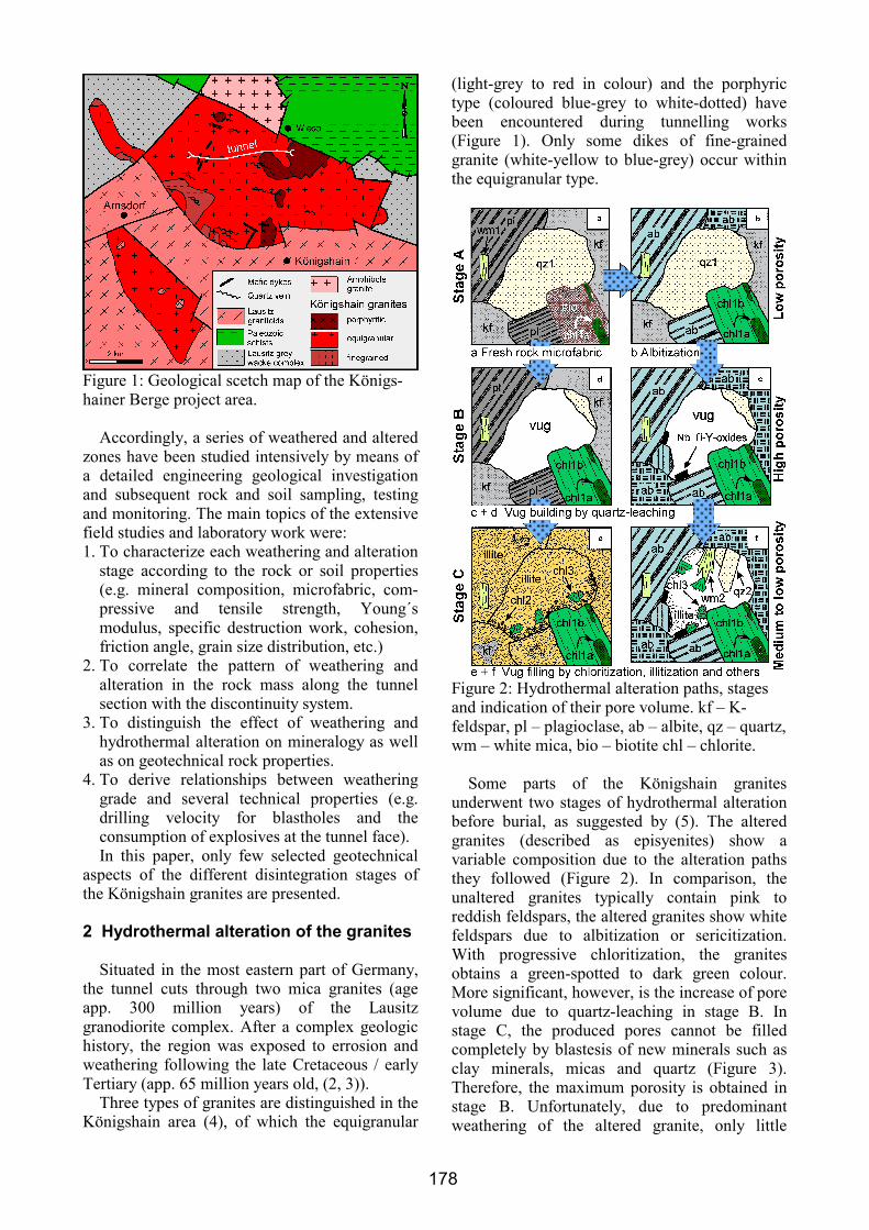
Figure 1: Geological scetch map of the Königs-hainer Berge project area.
Accordingly, a series of weathered and altered
zones have been studied intensively by means of a detailed engineering geological investigation and subsequent rock and soil sampling, testing and monitoring. The main topics of the extensive field studies and laboratory work were: 1. To characterize each weathering and alteration
stage according to the rock or soil properties (e.g. mineral composition, microfabric, com-pressive and tensile strength, Young´s modulus, specific destruction work, cohesion, friction angle, grain size distribution, etc.)
2. To correlate the pattern of weathering and alteration in the rock mass along the tunnel section with the discontinuity system.
3. To distinguish the effect of weathering and hydrothermal alteration on mineralogy as well as on geotechnical rock properties.
4. To derive relationships between weathering grade and several technical properties (e.g. drilling velocity for blastholes and the consumption of explosives at the tunnel face). In this paper, only few selected geotechnical
aspects of the different disintegration stages of the Königshain granites are presented.
2 Hydrothermal alteration of the granites
Situated in the most eastern part of Germany,
the tunnel cuts through two mica granites (age app. 300 million years) of the Lausitz granodiorite complex. After a complex geologic history, the region was exposed to errosion and weathering following the late Cretaceous / early Tertiary (app. 65 million years old, (2, 3)).
Three types of granites are distinguished in the Königshain area (4), of which the equigranular
(light-grey to red in colour) and the porphyric type (coloured blue-grey to white-dotted) have been encountered during tunnelling works (Figure 1). Only some dikes of fine-grained granite (white-yellow to blue-grey) occur within the equigranular type.
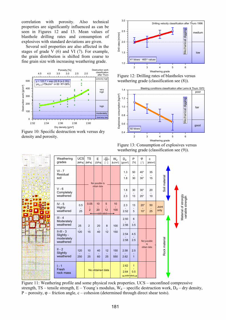
Figure 2: Hydrothermal alteration paths, stages and indication of their pore volume. kf – K-feldspar, pl – plagioclase, ab – albite, qz – quartz, wm – white mica, bio – biotite chl – chlorite.
Some parts of the Königshain granites
underwent two stages of hydrothermal alteration before burial, as suggested by (5). The altered granites (described as episyenites) show a variable composition due to the alteration paths they followed (Figure 2). In comparison, the unaltered granites typically contain pink to reddish feldspars, the altered granites show white feldspars due to albitization or sericitization. With progressive chloritization, the granites obtains a green-spotted to dark green colour. More significant, however, is the increase of pore volume due to quartz-leaching in stage B. In stage C, the produced pores cannot be filled completely by blastesis of new minerals such as clay minerals, micas and quartz (Figure 3). Therefore, the maximum porosity is obtained in stage B. Unfortunately, due to predominant weathering of the altered granite, only little

179
material could be gained for rock testing in the laboratory.
0
2
4
6
8
10
12
14
Poro
sity
[%]
1 2 3 4 5Grade of hydrothermal alteration
B
CA
Figure 3: Development of porosity with the grade of hydrothermal alteration. Stages A – B – C refer to Figure 2.
The unconfined compressive strength –
determined by point load tests – changes significantly with porosity and the grade of alteration (Figure 4). Although porosity is increasing again in Stage C, compressive strength decreases due to the weak sericite and clay minerals.
veryhigh
high
moderately
lowvery low
AB
C
UCS Classification after ISRM 1978
0
25
50
75
100
125
150
175
200
UC
S[M
Pa]
14 12 10 8 6 4 2 0Porosity [%]
Figure 4: Development of unconfined com-pressive strength with porosity and alteration.
3 Weathering grades of the granite
It is remarkable, that only after the endogene
alteration processes had finished, the rock has been exposed to the exogene processes of weathering. The change of mineral content and the increase of pore volume promotes the action of mechanical disintegration and chemical decomposition.
Figure 5 shows the stages of weathering in the microfabric of the granite by disintegration and decomposition into a clayey-silty soil material. Grades (I – VI) refer to the ISRM weathering grades (6). An additional grade called “II-III
slightly to moderately weathered” could be distinguished. In the following diagrams, the grades therefore are counted in arabic numerals from 1 to 7 (with VI = 7 residual soil, V = 6 completely weathered and so on).
Figure 5: Weathering grades in the microfabric (leaving out grade VI = Residual soil).
Apart from mineralogical changes, porosity is
increasing considerably and dry density of the rock material is decreasing simultaneously (Figure 6).
1.8
2.0
2.2
2.4
2.6
Dry
dens
ity[g
/m³]
0
10
20
30
Por
osity
[%]
2 3 4 5 6Weathering grade
Dry density
Porosity
Figure 6: Connection of the weathering grade with dry density and porosity (pore volume). High/mean/low values are plotted for each grade.

180
At the same time, the rock mass undergoes changes (Figure 7) due to weathering. The process begins with the fresh granite (grade I = 1, which has not been encountered during tunnelling works). Subsequently, a typically reddish-brown rust front and a zone of microscopic weathered granite moves from the wall rock into the rock mass (grade II = 2). A bleached light-brown to yellow-white zone then marks the end of the solid rock (grade II–III = 3). The disintegrated zone in grade III (= 4) consists mainly of clay and silt as the material of the wall rock decomposes. This proved to be the most dangerous material encountered, because of the low friction angle of the material and its tendency to shear along existing discontinuities. In grade IV (= 5) the granite disintegrates into a mixture of sandy and/or clayey and silty material. In the completely weathered material (grade V = 6) the rust colours have disappeared and the residual soil (grade VI = 7) only holds remnants of the disintegrated granite.
Accordingly, the physical properties of the rock change in a similar manor. Figure 8 shows the unconfined compressive strength correlated to the different weathering grades. Since the weathering classification is always determined in the rock mass, the correlation is poor with a large standard deviation between values. Nevertheless, a trend can be seen. Only when the UCS is plotted against dry density or porosity (Figure 9) is a good correlation found with a fitted curve.
0
25
50
75
100
125
150
175
200
225
UC
S[M
Pa]
2 3 4 5 6Weathering grade
veryhigh
high
moderately
lowvery low
UCS classification after ISRM 1978
Mec
hani
cald
iggi
ng
Figure 8: Unconfined compressive strength versus weathering grade (max/mean/min values).
0
25
50
75
100
125
150
175
200
225
UC
S[M
Pa]
2.3 2.4 2.5 2.6
Dry density [g/m³]
veryhigh
high
moderately
lowvery low
y = 13.9 + exp (17.9·(x-2.31))y =26MPa n=81 R =81%σ(n-1)
2
UCS classificationafter ISRM 197814 12 10 8 6 4 2
Porosity [%]
Figure 9: Unconfined compressive strength versus dry density and prosity (single values).
In addition to the compressive strength, tensile
strength, and Young´s modulus, the specific destruction work (integral of the complete stress-strain curve, after (7), Figure 10) shows a close
Figure 7: Grades of weathering in a Königshain granite block according to the ISRM grades (6).
181
correlation with porosity. Also technical properties are significantly influenced as can be seen in Figures 12 and 13. Mean values of blasthole drilling rates and consumption of explosives with standard deviations are given.
Several soil properties are also affected in the stages of grade V (6) and VI (7). For example, the grain distribution is shifted from coarse to fine grain size with increasing weathering grade.
0
100
200
300
400
500
Des
truct
ion
wor
k[g
/cm
³]
2.52 2.54 2.56 2.58 2.60Dry density [g/m³]
veryhigh
high
moderately
low/very low
extremly high
Destruction workclassification
after Thuro
Porosity [%]4.5 4.0 3.5 3.0 2.5 2.0
y = 123.7 + exp (22.8·(x-2.35))y =75kJ/m³ n=30 R =38%σ(n-1)
2
Figure 10: Specific destruction work versus dry density and porosity.
1.0
1.5
2.0
2.5
3.0
Dril
lrat
es[m
/min
]
2 3 4 5 6Weathering grade
Mec
hani
cald
iggi
ng
Drilling velocity classification after Thuro 1996
low
medium
41 blows - 4651 values
Figure 12: Drilling rates of blastholes versus weathering grade (classification see (8)).
0.4
0.6
0.8
1.0
1.2
1.4
Expl
osiv
esco
nsum
ptio
n[k
g/m
³]
2 3 4 5 6Weathering grade
Blasting conditions classification after Leins & Thum 1970
good
fair
poor
92 blows
Mec
hani
cald
iggi
ng
Figure 13: Consumption of explosives versus weathering grade (classification see (9)).
II-III - 3Slightly -moderatelyweathered
I - 1Freshrock mass
II - 2Slightlyweathered
III - 4Moderatelyweathered
IV - 5Highlyweathered
V - 6Completelyweathered
VI - 7Residualsoil
Roc
km
ater
ial
Soil
mat
eria
l
Mat
eria
lofs
trong
lyva
riabl
est
reng
th
120-
250
UCS TS E UCSSPZ Wd Dd P ϕ c
[MPa] [MPa] [GPa] [ - ] [kJ/m³] [g/cm³] [ °] [kN/m²][%]
25-
120
0.5-
25
10-
25
2-
15
0.05-2
40-
60
20-
40
10-
20
12-
25
8-
12
5-
12
150-
550
100-
150
10-
100
2.58-
2.62
2.54-
2.58
2.3-
2.52
1.8-
2.3
1.3-
1.8
2.62-
2.64
50-
30
30-
13
13-5
4.5-
2.5
2.5-1
1-
0.5
2.50-
2.56
6-
3.5
40°-
30°
30°-
20°
35-
15
20-
10
20°-
10°
Not possibleto
obtain data
50-
25
Weatheringgrades
Jointonly
estimated
Not possible toobtain data
No dataobtained
estimated
Figure 11: Weathering profile and some physical rock properties. UCS – unconfined compressive strength, TS – tensile strength, E – Young´s modulus, Wd – specific destruction work, Dd – dry density, P – porosity, ϕ – friction angle, c – cohesion (determined through direct shear tests).
182
4 Conclusion Figure 11 gives an overview of the rock and
soil properties determined for each weathering grade. Compared to (10) some differences have been encountered concerning description and characterization of the weathered rock mass. In the Königshainer Berge tunnel project, hydrothermal alteration has induced increased porosity in the rock mass. The hydrothermal solutions ascended in dikes following faults and the joint system and produced a finger-like pattern of altered material which easily could be exposed to weathering from the surface. Figure 14 shows the derived model of the weathered rock mass with respect to the scale of the tunnel.
References
1. Kagerer, W., Reintjes, K.-H. & Voyé, R., 1997. Planning and Construction of the Königshainer Berge tunnel. Tunnel 1997 (7), pp 20-31. 2. Eidam, J., Götze. J., 1991. The granitic massif of Königshain-Arnsdorf (Lusatian Anticlinal Zone) - An example of a reversely zoned pluton. Chem. der Erde 51, pp 55-71. 3. Krauss, M., Eidam, J., Hammer, J., Korich, D., 1992. Die cadomisch-variszische Entwicklung des Lausitzer Granodiorit-Komplexes. Zbl. Geol. Paläont. Teil I II (1/2), pp 71-85. 4. Möbus, G., Lindert, W., 1967. Das Granitmassiv von Königshain bei Görlitz (Oberlausitz). Abh. Dt. Akad.
Wissensch. Kl. Bergbau, Hüttenwesen und Montangeo-logie 1, pp 81-160. 5. Hecht, L., Thuro, K., Plinninger, R.J., Cuney, M., 1999. Mineralogical and geochemical characteristics of hydrothermal alteration and episyenitization in the Königshain granites, northern Bohemian Massif, Germany. Int. Journ. Earth Sciences 88, pp 236-252. 6. ISRM, 1978. Suggested methods for the quantitative description of discontinuities in rock masses. Inter-national Society for Rock Mechanics, Commission on Standardization of Laboratory and Field Tests, Document No. 4, Int. J. Rock Mech. Min. Sci. & Geomech. Abstr. 15, pp 319-368. 7. Thuro, K., Spaun, G., 1996. Introducing `destruction work´ as a new rock property of toughness refering to drillability in conventional drill- and blast tunnelling. in: Barla, G., ed. Eurock ´96. Turin, Italy. Prediction and performance in rock mechanics and rock engineering. Vol. 2., 1440 p, Rotterdam, Brookfield: Balkema, pp 707-713. 8. Thuro, K., 1997. Drillability prediction - geological influences in hard rock drill and blast tunnelling. Geol. Rundsch. 86, pp 426 - 437. 9. Leins, W., Thum, W., 1970. Ermittlung und Beur-teilung der Sprengbarkeit von Gestein auf der Grund-lage des spezifischen Sprengenergieaufwandes. Forsch.-ber. d. Landes Nordrhein-Westfalen, 2118. 10. Heitfeld, K.-H. 1985. Ingenieurgeologische Proble-me im Grenzbereich zwischen Locker- und Festge-steinen. Berlin, Heidelberg, New York etc.: Springer, 695 p.
Figure 14: Model of weathering in the Königshainer Berge tunnel project with the dimenson of top heading (excavated cross section area). Stages in arabic numerals refer to Figure 11.