geotechnical investigation for the proposed new ...rhdhv.co.za/media/swwtw deiar_/appendix c9...
TRANSCRIPT

GEOTECHNICAL INVESTIGATION FOR THE PROPOSED NEW DEVELOPMENTS AT THE SOUTHERN WASTE WATER TREATMENT
WORKS IN MEREWENT, DURBAN
December 2014
PREPARED BY:
AECOM SA (Pty)Ltd
PO Box 56
Westville
3630
CONTACT PERSON
Mrs. R S Naidoo
Tel No: 031 204 3800


DISCLAIMER
This report (‘Report’) and deliverables (‘Deliverables’) and the information within it is confidential. If you
have received the Report in error please notify AECOM SA (Pty) Ltd immediately. You should not copy it
for any purpose, or disclose its contents to any other person. The Report is qualified in its entirety by and
should be considered in the light of AECOM’s Terms of Engagement and the following:
1. The Report is provided solely for the use for this contract and its advisers benefit unless
expressly permitted otherwise and for the specific purpose of providing a geotechnical
assessment of the site for the proposed development. Unless required by law, the Client shall not
provide the Report to any other party without AECOM’s prior written consent, which AECOM may
at its discretion grant, withhold or grant subject to conditions. Possession of the Report does not
carry with it the right to commercially reproduce, publish, sale, hire, lend, redistribute, abstract,
excerpt or summarise the Report or to use the name of AECOM in any manner without first
obtaining the prior written consent of AECOM.
2. The Report is based on estimates, assumptions and other information made by AECOM from its
independent research effort, general knowledge of the industry and consultations with the Client,
its employees and its representatives. No guarantee or warranty is made by AECOM in relation to
the projected values or results contained in the Report. In addition, the Report is based upon
information that was obtained on or before the date in which the Report was prepared.
Circumstances and events may occur following the date on which such information was obtained
that are beyond AECOM’s control and which may affect the findings or projections contained in
the Report. AECOM is not responsible for such circumstances or events and specifically
disclaims any responsibility therefore.
3. In preparing the Report, AECOM has relied on information provided by the Client and by other
parties (‘Information Providers’) to produce the Report and arrive at its conclusions. AECOM has
not verified information provided by Information Providers (unless specifically noted otherwise)
and AECOM assumes no responsibility and makes no representations with respect to the
adequacy, accuracy or completeness of such information. AECOM is not responsible for
inaccuracies in the information provided or reported by Information Providers including, without
limitation, by the Client’s employees or representatives or for inaccuracies in any other data
source whether provided in writing or orally used in preparing or presenting the Report.
4. The forecasts (‘Forecasts’) and projections prepared by AECOM and described herein are based
in substantial part on AECOM’s consideration of the possible interactions of a number of complex
factor and the information available to it at the time of preparation of this Report, and are subject
to substantial uncertainties regarding future events. They are not intended, and should not be
regarded, as any guarantee or future traffic or revenues of the project. Neither the above
executive summary nor this Report is intended or should be regarded as a recommendation to
any person to make any investment in any securities offered to finance the project or to take or
refrain in taking such securities or to take or refrain from taking any other action.
5. In preparing this Report and the Forecasts and projections included herein, AECOM devoted
reasonable professional efforts compatible with the time and budget available in the bid process.
AECOM’s findings represent its judgement within the time and budget content of its commission
and utilizing the information available to it at the time.
6. The Report may include ‘forward-looking statements’. These statements relate to AECOM’s
expectations, beliefs, intentions or strategies regarding the future. These statements may be
identified by the use of words like ‘anticipate’, ‘believe’, ‘estimate’, ‘expect’, ‘intend’, ‘may’, ‘plan’,
‘project’, ‘will’, ‘should’, ‘seek’, and similar expressions. The forward-looking statements reflect
AECOM’s views and assumptions with respect to future events as of the date of this document
and are subject to future conditions, and other risks and uncertainties, including but not limited to
economic and political conditions and sovereign risk. Circumstances and events will occur
following the date on which such information was obtained that are beyond AECOM’s control of
knowledge which may affect the findings or projections contained in this document.
6. The conclusions in the Report must be viewed in the context of the entire Report including,
without limitation, any assumptions made and disclaimers provided. The conclusions in this
Report must not be excised from the body of the Report under any circumstances.
7. Without the prior written consent of AECOM, which approval may be withheld at AECOM’s
absolute discretion, the Report is not to be used in conjunction with any public or private offering
of securities or other similar purpose where it might be relied upon to any degree by any person
other than you.
8. All intellectual property rights (including, but not limited to copyright, database rights and
trademarks rights) in the Report including any Forecasts, drawings, spreadsheets, plans or other
materials provided are the property of AECOM. The Client may use and copy such materials for
its own internal use.
9. In no event, regardless of whether AECOM’s consent has been provided, shall AECOM assume
any liability or responsibility to any other party to whom the Report is disclosed or otherwise made
available or who may rely upon such Report and no such reliance is authorized by AECOM,
unless AECOM expressly agrees in writing to the other party receiving the Report.

TABLE OF CONTENTS
1. INTRODUCTION ................................................................................................................................... 1
2. SITE DESCRIPTION ............................................................................................................................. 1
3. GEOLOGICAL SUMMARY .................................................................................................................. 2
4. METHOD OF INVESTIGATION............................................................................................................ 2
5. RESULTS OF THE INVESTIGATION .................................................................................................. 3
5.1 REVIEW OF PREVIOUS BOREHOLES DRILLING WITHIN AND IN PROXIMITY TO THE SWWTW ................... 3
5.2 BOREHOLE LOG AND SOIL PROFILES .......................................................................................................... 3
5.3 DCP, DPSH AND SPT TEST RESULTS ...................................................................................................... 8
5.4 LABORATORY TEST RESULTS .................................................................................................................... 15
6 GEOTECHNICAL EVALUATION ....................................................................................................... 20
6.1 EXPANSIVE SOILS ...................................................................................................................................... 20
6.2 CONSOLIDATION SETTLEMENT .................................................................................................................. 20
6.3 EXCAVATABILITY ........................................................................................................................................ 21
6.4 DRAINAGE .................................................................................................................................................. 21
6.5 STABILITY OF EXCAVATIONS ...................................................................................................................... 22
7 RECOMMENDATIONS ....................................................................................................................... 22
7.1 FOUNDING CONDITIONS ............................................................................................................................. 22
8 CONCLUSION .................................................................................................................................... 26
ANNEXURES
Annexure A Figure
Annexure B Test Pit Profiles and Borehole Logs
Annexure C DCP and DPSH Results
Annexure D Laboratory Results
1
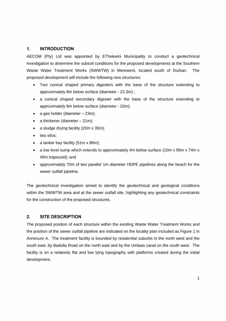
1. INTRODUCTION
AECOM (Pty) Ltd was appointed by EThekwini Municipality to conduct a geotechnical
investigation to determine the subsoil conditions for the proposed developments at the Southern
Waste Water Treatment Works (SWWTW) in Merewent, located south of Durban. The
proposed development will include the following new structures:
Two conical shaped primary digesters with the base of the structure extending to
approximately 8m below surface (diameter - 22.3m) ;
a conical shaped secondary digester with the base of the structure extending to
approximately 8m below surface (diameter - 20m);
a gas holder (diameter – 23m);
a thickener (diameter – 21m);
a sludge drying facility (20m x 35m);
two silos;
a tanker bay facility (51m x 86m);
a low level sump which extends to approximately 4m below surface (10m x 95m x 74m x
40m trapezoid); and
approximately 70m of two parallel 1m diameter HDPE pipelines along the beach for the
sewer outfall pipeline.
The geotechnical investigation aimed to identify the geotechnical and geological conditions
within the SWWTW area and at the sewer outfall site, highlighting any geotechnical constraints
for the construction of the proposed structures.
2. SITE DESCRIPTION
The proposed position of each structure within the existing Waste Water Treatment Works and
the position of the sewer outfall pipeline are indicated on the locality plan included as Figure 1 in
Annexure A. The treatment facility is bounded by residential suburbs in the north west and the
south east, by Badulla Road on the north east and by the Umlaas canal on the south west. The
facility is on a relatively flat and low lying topography with platforms created during the initial
development.
2
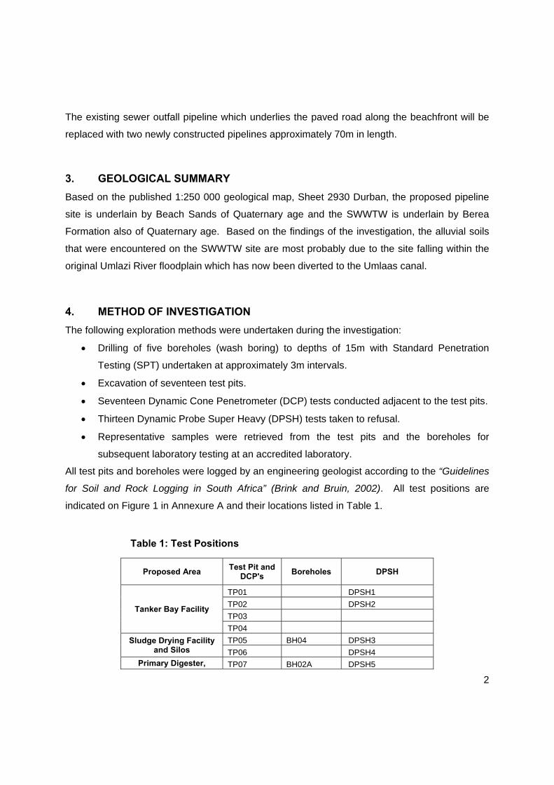
The existing sewer outfall pipeline which underlies the paved road along the beachfront will be
replaced with two newly constructed pipelines approximately 70m in length.
3. GEOLOGICAL SUMMARY
Based on the published 1:250 000 geological map, Sheet 2930 Durban, the proposed pipeline
site is underlain by Beach Sands of Quaternary age and the SWWTW is underlain by Berea
Formation also of Quaternary age. Based on the findings of the investigation, the alluvial soils
that were encountered on the SWWTW site are most probably due to the site falling within the
original Umlazi River floodplain which has now been diverted to the Umlaas canal.
4. METHOD OF INVESTIGATION
The following exploration methods were undertaken during the investigation:
Drilling of five boreholes (wash boring) to depths of 15m with Standard Penetration
Testing (SPT) undertaken at approximately 3m intervals.
Excavation of seventeen test pits.
Seventeen Dynamic Cone Penetrometer (DCP) tests conducted adjacent to the test pits.
Thirteen Dynamic Probe Super Heavy (DPSH) tests taken to refusal.
Representative samples were retrieved from the test pits and the boreholes for
subsequent laboratory testing at an accredited laboratory.
All test pits and boreholes were logged by an engineering geologist according to the “Guidelines
for Soil and Rock Logging in South Africa” (Brink and Bruin, 2002). All test positions are
indicated on Figure 1 in Annexure A and their locations listed in Table 1.
Table 1: Test Positions
Proposed Area Test Pit and
DCP's Boreholes DPSH
Tanker Bay Facility
TP01 DPSH1
TP02 DPSH2
TP03
TP04
Sludge Drying Facility and Silos
TP05 BH04 DPSH3
TP06 DPSH4 Primary Digester, TP07 BH02A DPSH5

3
Proposed Area Test Pit and
DCP's Boreholes DPSH
Secondary Digester, Thickener, Gas Holder,
Mixing Building and Boiler House
TP08 BH03 DPSH6
TP09 DPSH7
TP10 DPSH8
TP11 DPSH9
TP12
TP17
Low Level Sump
TP13 BH01 DPSH10
TP14 DPSH11
TP15 DPSH12
TP16 Sewer Outfall Pipeline BH05 DPSH13
5. RESULTS OF THE INVESTIGATION
5.1 Review of Previous Boreholes Drilling Within and in Proximity to the SWWTW
Twenty six borehole logs from previous investigations undertaken within the treatment facility,
along the Umlaas Canal near the beach (in proximity to the sewer outfall pipeline) and at the
neighboring Beverley Gardens Residential Development were reviewed as part of the desktop
study. The results of the logs indicate that the subsoil profile within and in proximity to the
treatment facility comprises interlayered sand and silt of alluvial origin, extending to depths
ranging between 26.15m and 37.19m. Sandstone rock was encountered in one borehole at a
depth of 26.15m.
From the boreholes drilled within the treatment facility, a clayey organic layer underlies the
upper sandy layer at a depth between 2.0m to 4.6m.
5.2 Borehole Log and Soil Profiles
The test pit profiles and borehole logs are included in Annexure B and summarized in Table 2
for ease of reference. The overall site is generally underlain by the following subsoils.
Fill material comprising loose to dense silty sand which occurs from surface to depths
ranging from 0.2m to 3.0m. Scattered occurrences of sandy silty clay, fill material were
encountered in TP07 and TP10.

4
The fill material is generally underlain by alluvial deposits comprising predominantly silty
clayey sand extending to depths in excess of 15.5m. The sand layers are interlayered
with lenses of silty (sometimes sandy) clay.
The silty sand of alluvial origin in BH01 (at the position of the Low Level Sump) is
underlain by alluvial sandy silty clay which occurs between 7.81 and 15.55m.
Lenses of slightly organic rich soils can be expected below the fill and within the alluvial
deposits, which were encountered randomly at various depths on site.
The lithology referred to as Beach Sand comprising silty clayey sand underlies 2.6m of
fill comprising sandy soils at the position of the Sewer Outfall Pipeline on the beach.
The beach sand extends to depths in excess of 15m.
Tanker Bay Facility
The subsoil at the Tanker Bay facility generally comprise loose to medium dense, silty sand, fill,
from surface to depths ranging between 0.6m and 2.0m. The fill is underlain by alluvial material
comprising, loose to medium dense (occasionally dense to very dense), silty clayey sand, to
depths in excess of 3.05m. Groundwater was encountered at depths between 1.7m and 2.6m in
all four boreholes drilled in the area.
Sludge Drying Facility and Silos
Fill material comprising loose to very dense silty sand occurs from surface to an average depth
of 1.5m (ranging from 1.2m-2.18m). The fill material is underlain by medium dense to dense
silty clayey sand, alluvium which extends to depths in excess of 15.45m. Groundwater was
encountered at depths between 1.0m (rest level in BH04) and 2.2m.
Primary Digesters (PD), Secondary Digester (SD), Thickener (TH), Gas Holder (GH),
Mixing Building and Boiler House (M&B)
The area identified for the above mentioned structures is generally underlain by fill material
comprising generally medium dense to dense (occasionally loose and very dense) silty
clayey/gravelly sand which extends to depths between 0.6m and 3.0m. In TP07 (0.9-1.5m) and
TP10 (1.6-1.9m and 2.4-2.8m) horizons of approximately 0.5m of stiff to very stiff clay (fill
material) was encountered. The fill material is predominantly underlain by loose to medium
dense silty clayey sand, alluvium which extends to depths greater than 15.03m.
5
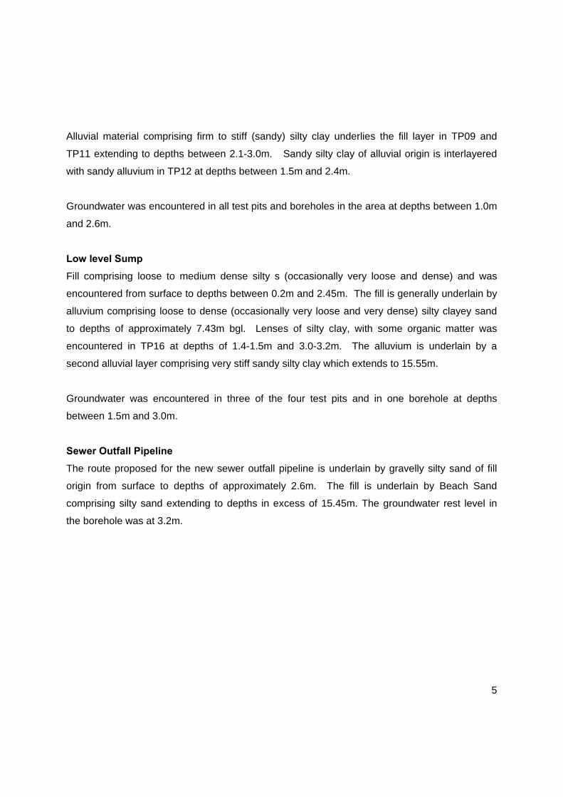
Alluvial material comprising firm to stiff (sandy) silty clay underlies the fill layer in TP09 and
TP11 extending to depths between 2.1-3.0m. Sandy silty clay of alluvial origin is interlayered
with sandy alluvium in TP12 at depths between 1.5m and 2.4m.
Groundwater was encountered in all test pits and boreholes in the area at depths between 1.0m
and 2.6m.
Low level Sump
Fill comprising loose to medium dense silty s (occasionally very loose and dense) and was
encountered from surface to depths between 0.2m and 2.45m. The fill is generally underlain by
alluvium comprising loose to dense (occasionally very loose and very dense) silty clayey sand
to depths of approximately 7.43m bgl. Lenses of silty clay, with some organic matter was
encountered in TP16 at depths of 1.4-1.5m and 3.0-3.2m. The alluvium is underlain by a
second alluvial layer comprising very stiff sandy silty clay which extends to 15.55m.
Groundwater was encountered in three of the four test pits and in one borehole at depths
between 1.5m and 3.0m.
Sewer Outfall Pipeline
The route proposed for the new sewer outfall pipeline is underlain by gravelly silty sand of fill
origin from surface to depths of approximately 2.6m. The fill is underlain by Beach Sand
comprising silty sand extending to depths in excess of 15.45m. The groundwater rest level in
the borehole was at 3.2m.

6
Table 2: Soil Profile Summary
SITE ID
FILL BEACH SAND
ALLUVIUM
SEEPAGE COMMENTS Silty (clayey / gravelly) SAND / SAND
Sandy silty CLAY
Silty (clayey) SAND
Silty SAND* / Silty CLAY with some
organic matter
Silty (clayey) SAND / SAND
Silty (sandy) CLAY
Tanker Bay Facility
TP01 0.0-1.3 1.3-1.9 Moderate to strong seepage at 1.7m
Collapse of pit hence stopped at 1.9m
TP02 0.0-0.6 0.6-3.05 Slight seepage at 2.6m
TP03 0.0-0.9 0.9-3.0 Slight seepage at 1.8m
TP04 0.0-2.0 >2.0 Slight seepage at 1.9m
Collapse of pit hence stopped at 2.0m
Sludge Drying Facility and Silos
TP05 0.0-1.2 1.2-2.7 Collapse of pit hence stopped at 2.7m
TP06 0.0-1.5 1.5-2.4 Slight seepage at 2.2m
Collapse of pit hence stopped at 2.4m
BH04 0.0-2.18 2.18-15.45 Water rest level is at 1.0m
SD, M&B, TH, GH and PD
TP07 0.0-0.9 0.9-1.5 1.5-2.8 Slight seepage at 2.2m
Collapse of pit hence stopped at 2.8m
TP08 0.0-1.3 1.3-2.8 Strong seepage at 1.0m
Collapse of pit hence stopped at 2.8m
TP09 0.0-1.8 1.8-3.0 Strong seepage at 1.5m
Collapse of pit
TP10
0.0-1.6 1.6-1.9 Slight seepage at 2.2m
Collapse of pit 1.9-2.4 2.4-2.8
2.8-3.0

7
SITE ID
FILL BEACH SAND
ALLUVIUM
SEEPAGE COMMENTS Silty (clayey / gravelly) SAND / SAND
Sandy silty CLAY
Silty (clayey) SAND
Silty SAND* / Silty CLAY with some
organic matter
Silty (clayey) SAND / SAND
Silty (sandy) CLAY
TP11 0.0-2.1 >2.1 Strong seepage at 1.5m
Collapse of pit hence stopped at 2.1m
TP12 0.0-0.6 0.6-1.5* 1.5-2.4 Slight seepage at
1.5m
Collapse of pit hence stopped at 2.5m 2.4-2.5
TP17 0.0-2.6 2.6-3.0 Strong seepage at 2.6m
BH02A 0.0-1.7 1.7-15.51 Water rest level is at 1.2m
BH03
0.0-2.42 3.64-4.05 2.42-3.64 Water rest level is at 1.5m
11.1-11.64* 4.05-11.10
11.64-15.03
Low Level Sump
TP13 0.0-1.7 1.7-3.0
TP14 0.0-0.8 0.8-2.4 Strong seepage at 1.7m
Collapse of pit hence stopped at 2.4m
TP15 0.0-0.2 0.2-2.5 Slight seepage at 2.0m
Collapse of pit hence stopped at 2.5m
TP16 0.0-0.4 3.0-3.2 0.4-1.4 1.4-1.5 Strong seepage at
3.0m
Collapse of pit
1.5-3.0
BH01 0.0-2.47 2.47-7.43 7.43-7.81 Water rest level is
at 1.5m
7.81-15.55
Beach - Pipeline BH05 0.0-2.6 2.6-15.45 Water rest level is at 3.2m

8
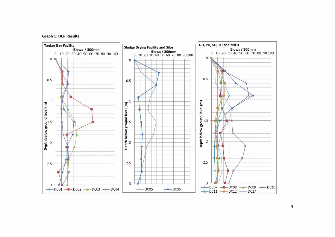
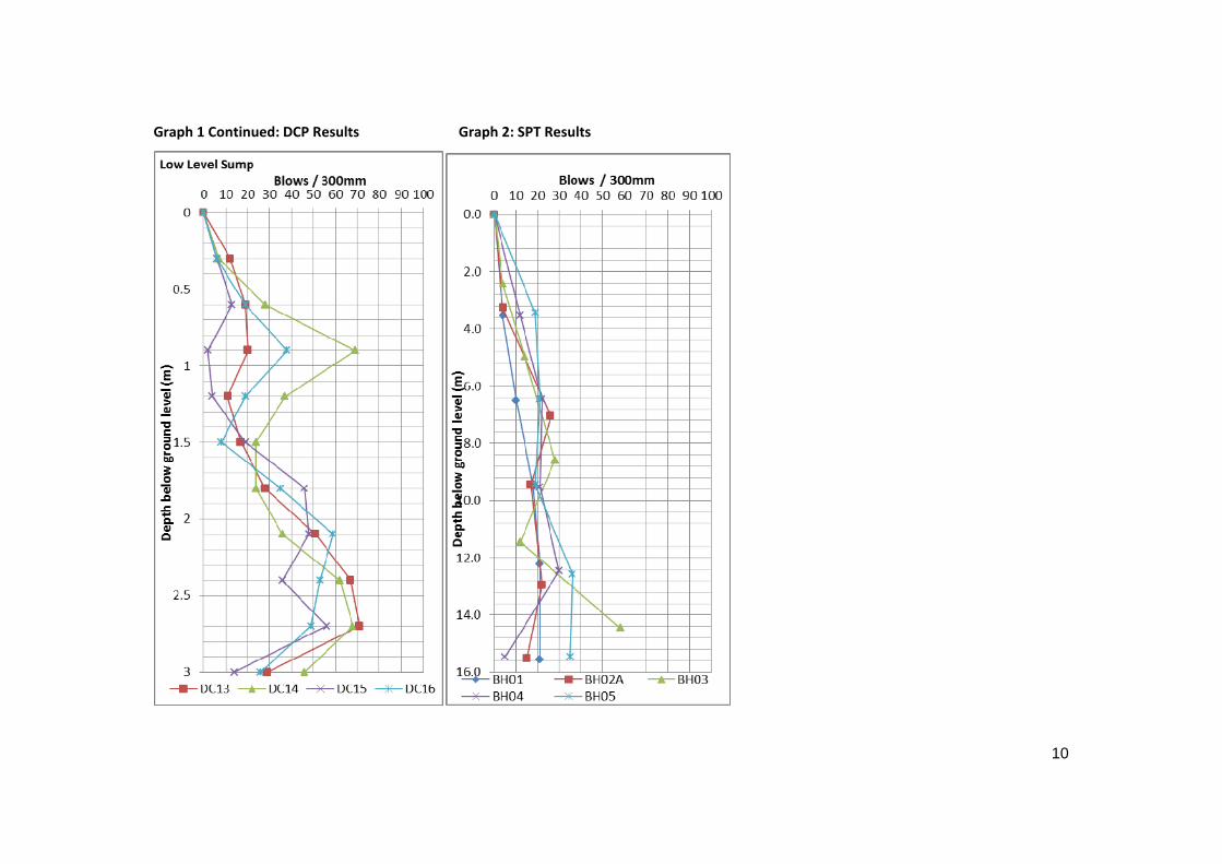
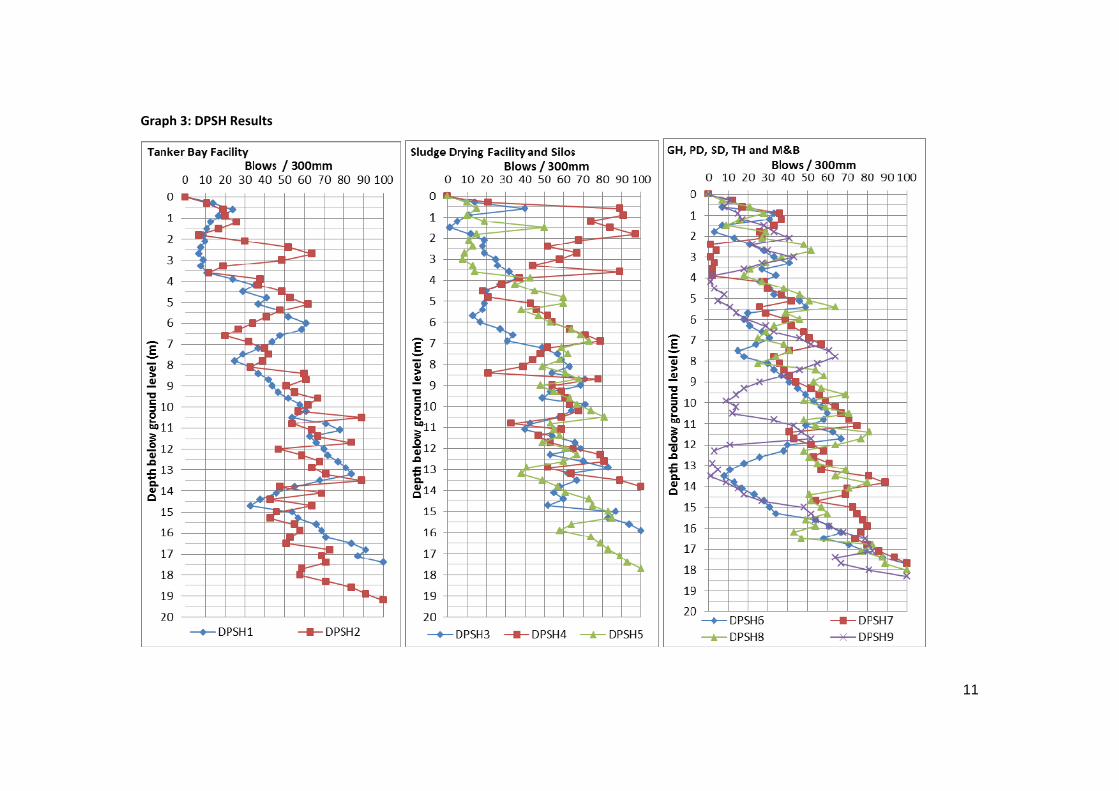
5.3 DCP, DPSH and SPT Test Results
The results from the DCP, DPSH and SPT tests are presented graphically in Graph 1 to 3 with
the raw data appended to this report in Annexure C. These tests were carried out to assess the
consistency of the subsoils.
The results confirm that the fill generally comprise loose to medium dense sand with the lenses
of clay having a firm to very stiff consistency to depths of approximately 3.0m. The alluvial
sands encountered also have a loose to dense consistency with the clay alluvial soils having a
firm to very stiff consistency. These consistencies are generally erratic to approximately 3.0m.
From 3.0m to 15.5m there is a general densification of the subsoils with depth, with scattered
loose to medium dense layers identified within the subsoils at the position of the PD,SD, TH, GH
and M&B structures and at the Low Level Sump. The subsoils along the sewer outfall pipeline
is described as medium dense to very dense based on the SPT and DPSH results.
The allowable bearing pressures of the subsoil based on the DCP, SPT and DPSH results are
given in Table 3.
9
Graph 1: DCP Results
0
0.5
1
1.5
2
2.5
3
0 10 20 30 40 50 60 70 80 90 100
Dep
th below
groun
d level (m)
Blows / 300mmSludge Drying Facility and Silos
DC05 DC06
10
Graph 1 Continued: DCP Results Graph 2: SPT Results
11
Graph 3: DPSH Results

12
Graph 3 Continued: DPSH Results

13
Table 3: Allowable Bearing Pressures
Structure Depth Allowable Bearing
Pressure (kPa)
Tanker Bay Facility 0.0-3.9 150
3.9-19.2 > 300
Sludge Drying facility and Silos
0.0-0.6 100 0.6-1.5 200 1.5-2.4 150 2.4-3.0 200 3.0-6.0 300
6.0-10.0 400 10.0-14.0 500 14.0-15.45 600 15.45-17.7 700
Gas Holder, Primary Digesters, Secondary Digesters, Thickeners, Mixing Building and Boiler House
0.0-0.6 100 0.6-1.2 200 1.2-4.5 150 4.5-5.1 200
5.1-7.8 300 7.8-9.6 400
9.6-12.0 500
12.0-13.5 300 13.5-14.1 250 14.1-15.5 400 15.5-18.3 600
Low Level Sump
0.0-0.6 100 0.6-1.2 300 1.2-2.4 200 2.4-6.0 400 6.0-7.8 300 7.8-9.0 400
9.0-12.9 500 12.9-13.8 300 13.8-18.6 600
Sewer Outfall 0.0-2.0 200 2.0-5.0 400 5.0-7.5 700
The allowable bearing pressure estimations assume 25mm of total settlement with 12-18mm of
differential settlement.
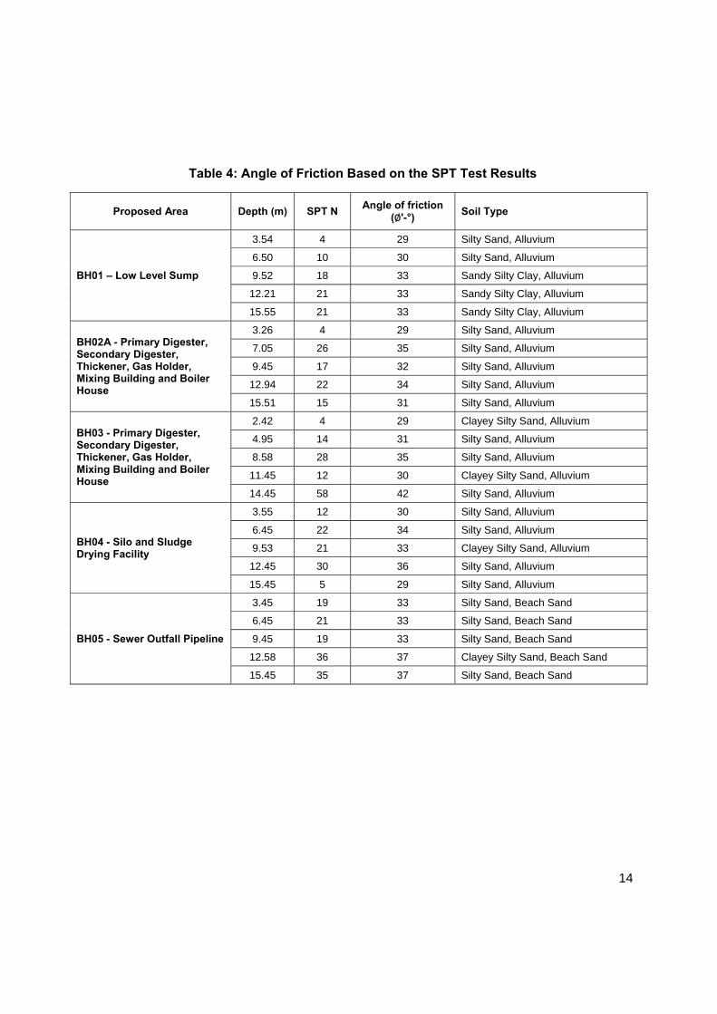
In addition to the allowable bearing pressures, the SPT results may be used to determine the
anticipated angle of friction of the soils (Peck et al, 1974). The expected angles of friction of the
subsoil’s with depth are tabulated on Table 4.
14
Table 4: Angle of Friction Based on the SPT Test Results
Proposed Area Depth (m) SPT N Angle of friction
(∅'-°) Soil Type
BH01 – Low Level Sump
3.54 4 29 Silty Sand, Alluvium
6.50 10 30 Silty Sand, Alluvium
9.52 18 33 Sandy Silty Clay, Alluvium
12.21 21 33 Sandy Silty Clay, Alluvium
15.55 21 33 Sandy Silty Clay, Alluvium
BH02A - Primary Digester, Secondary Digester, Thickener, Gas Holder, Mixing Building and Boiler House
3.26 4 29 Silty Sand, Alluvium
7.05 26 35 Silty Sand, Alluvium
9.45 17 32 Silty Sand, Alluvium
12.94 22 34 Silty Sand, Alluvium
15.51 15 31 Silty Sand, Alluvium
BH03 - Primary Digester, Secondary Digester, Thickener, Gas Holder, Mixing Building and Boiler House
2.42 4 29 Clayey Silty Sand, Alluvium
4.95 14 31 Silty Sand, Alluvium
8.58 28 35 Silty Sand, Alluvium
11.45 12 30 Clayey Silty Sand, Alluvium
14.45 58 42 Silty Sand, Alluvium
BH04 - Silo and Sludge Drying Facility
3.55 12 30 Silty Sand, Alluvium
6.45 22 34 Silty Sand, Alluvium
9.53 21 33 Clayey Silty Sand, Alluvium
12.45 30 36 Silty Sand, Alluvium
15.45 5 29 Silty Sand, Alluvium
BH05 - Sewer Outfall Pipeline
3.45 19 33 Silty Sand, Beach Sand
6.45 21 33 Silty Sand, Beach Sand
9.45 19 33 Silty Sand, Beach Sand
12.58 36 37 Clayey Silty Sand, Beach Sand
15.45 35 37 Silty Sand, Beach Sand

15
5.4 Laboratory Test Results
The following sections discuss the results of the laboratory tests conducted on samples from
site.
5.4.1 Foundation Indicator Tests
The laboratory test results on the fill material, alluvial soils and beach sand samples retrieved
from the test pits and the boreholes are summarised in Table 5 with the detailed test results
presented in Annexure D.
From surface to depths varying between 0.2m and 3.0m the fill layer classifies as either a poorly
graded sand (SP) or as an inorganic low to medium plastic clay (CL) according to the Unified
Soil Classification System. According to the laboratory results, the sands have a low
expansiveness potential, while the clay has a medium potential expansiveness based on the
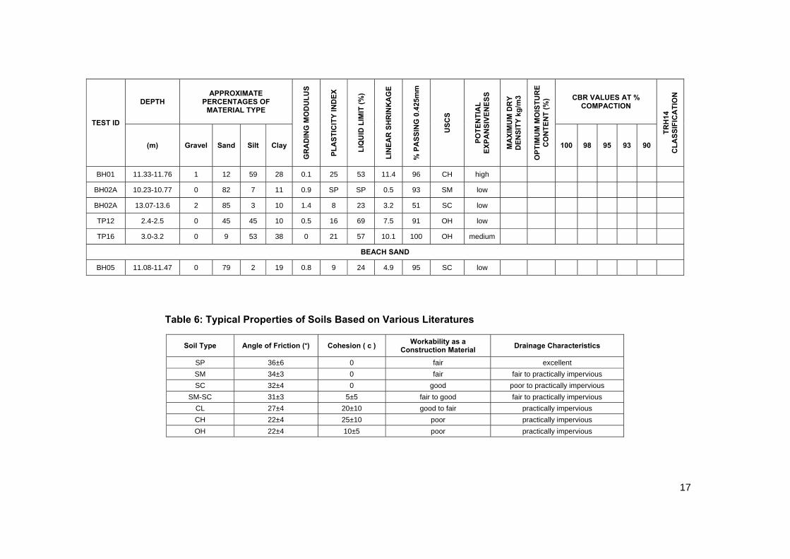
results plotted on the Van der Merwe Chart. Typical properties of these soils in accordance with
published literature are tabulated in Table 6.
The alluvial sandy soil encountered across the site generally classifies as either a poorly graded
sand (SP), a silty sand (SM), a clayey sand (SC) or as a silty to clayey SAND (SM-SC). The
clay lenses within the alluvial sands classify as a low to medium plasticity silty CLAY (CL). The
clay layer underlying the alluvial sand encountered in BH01 (at the Low Level Sump) between
7.81m and 15.55m classified as an inorganic high plasticity CLAY (CH). According to the Van
der Merwe Chart, the SC soils have a low to medium expansiveness potential, the CL clay has
a low to high potential expansiveness and the CH clays have a high potential expansiveness.
Typical properties of SP, SM, SC, SM-SC, CL and CH soils are indicated in Table 6.
The clayey soil encountered on site within the vicinity of the primary and secondary digesters
and at the low level sump area classified as an organic clay (OH) with a low expansiveness
potential based on the Van der Merwe Chart.
The beach sands encountered in BH05 along the new sewer outfall pipeline is a clayey SAND
(SC) according to the Unified Soil Classification System and has a low expansiveness potential.
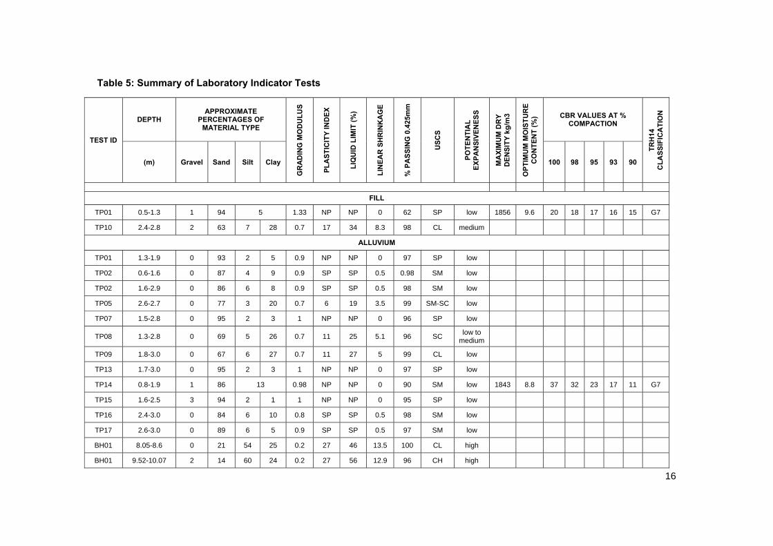
16
Table 5: Summary of Laboratory Indicator Tests
TEST ID
DEPTH APPROXIMATE
PERCENTAGES OF MATERIAL TYPE
GR
AD
ING
MO
DU
LU
S
PL
AS
TIC
ITY
IND
EX
LIQ
UID
LIM
IT (
%)
LIN
EA
R S
HR
INK
AG
E
% P
AS
SIN
G 0
.425
mm
US
CS
PO
TE
NT
IAL
E
XP
AN
SIV
EN
ES
S
MA
XIM
UM
DR
Y
DE
NS
ITY
kg
/m3
OP
TIM
UM
MO
IST
UR
E
CO
NT
EN
T (
%) CBR VALUES AT %
COMPACTION
TR
H14
C
LA
SS
IFIC
AT
ION
(m) Gravel Sand Silt Clay 100 98 95 93 90
FILL
TP01 0.5-1.3 1 94 5 1.33 NP NP 0 62 SP low 1856 9.6 20 18 17 16 15 G7
TP10 2.4-2.8 2 63 7 28 0.7 17 34 8.3 98 CL medium
ALLUVIUM
TP01 1.3-1.9 0 93 2 5 0.9 NP NP 0 97 SP low
TP02 0.6-1.6 0 87 4 9 0.9 SP SP 0.5 0.98 SM low
TP02 1.6-2.9 0 86 6 8 0.9 SP SP 0.5 98 SM low
TP05 2.6-2.7 0 77 3 20 0.7 6 19 3.5 99 SM-SC low
TP07 1.5-2.8 0 95 2 3 1 NP NP 0 96 SP low
TP08 1.3-2.8 0 69 5 26 0.7 11 25 5.1 96 SC low to
medium
TP09 1.8-3.0 0 67 6 27 0.7 11 27 5 99 CL low
TP13 1.7-3.0 0 95 2 3 1 NP NP 0 97 SP low
TP14 0.8-1.9 1 86 13 0.98 NP NP 0 90 SM low 1843 8.8 37 32 23 17 11 G7
TP15 1.6-2.5 3 94 2 1 1 NP NP 0 95 SP low
TP16 2.4-3.0 0 84 6 10 0.8 SP SP 0.5 98 SM low
TP17 2.6-3.0 0 89 6 5 0.9 SP SP 0.5 97 SM low
BH01 8.05-8.6 0 21 54 25 0.2 27 46 13.5 100 CL high
BH01 9.52-10.07 2 14 60 24 0.2 27 56 12.9 96 CH high
17
TEST ID
DEPTH APPROXIMATE
PERCENTAGES OF MATERIAL TYPE
GR
AD
ING
MO
DU
LU
S
PL
AS
TIC
ITY
IN
DE
X
LIQ
UID
LIM
IT (
%)
LIN
EA
R S
HR
INK
AG
E
% P
AS
SIN
G 0
.425
mm
US
CS
PO
TE
NT
IAL
E
XP
AN
SIV
EN
ES
S
MA
XIM
UM
DR
Y
DE
NS
ITY
kg
/m3
OP
TIM
UM
MO
IST
UR
E
CO
NT
EN
T (
%) CBR VALUES AT %
COMPACTION
TR
H14
C
LA
SS
IFIC
AT
ION
(m) Gravel Sand Silt Clay 100 98 95 93 90
BH01 11.33-11.76 1 12 59 28 0.1 25 53 11.4 96 CH high
BH02A 10.23-10.77 0 82 7 11 0.9 SP SP 0.5 93 SM low
BH02A 13.07-13.6 2 85 3 10 1.4 8 23 3.2 51 SC low
TP12 2.4-2.5 0 45 45 10 0.5 16 69 7.5 91 OH low
TP16 3.0-3.2 0 9 53 38 0 21 57 10.1 100 OH medium
BEACH SAND
BH05 11.08-11.47 0 79 2 19 0.8 9 24 4.9 95 SC low
Table 6: Typical Properties of Soils Based on Various Literatures
Soil Type Angle of Friction (°) Cohesion ( c ) Workability as a
Construction Material Drainage Characteristics
SP 36±6 0 fair excellent
SM 34±3 0 fair fair to practically impervious
SC 32±4 0 good poor to practically impervious
SM-SC 31±3 5±5 fair to good fair to practically impervious
CL 27±4 20±10 good to fair practically impervious
CH 22±4 25±10 poor practically impervious
OH 22±4 10±5 poor practically impervious

18
The poorly graded sand (SP) of fill origin encountered at the Tanker Bay Facility classified as a
G7 soil according to the TRH 14 Guideline for Road Construction Material. The alluvial silty
sand (SM) encountered at the Low Level Sump also classified as a G7 soil. G7 soils are
generally considered suitable for use as bulk fill and as the subgrade and selected layer in
pavement layers.
5.4.2 Tri-axial Test
A number of shelby tube samples were taken from the boreholes for tri-axial testing however
during the extraction of the samples from the tubes, it was found that the samples were not
intact given the presence of shell fragments, the loose nature of the material or significant
quantities of water within the sample. As a result of these poor quality samples only one
sample of the clayey sand (Beach sand from BH05) was tested to determine its shear strength
properties. This material was encountered at depths between 10.05m and 13.63m at the sewer
outfall pipeline. A consolidated undrained (CU) triaxial test was carried out whereby the cell
pressure is applied by allowing drainage in the CU test sample (which represents long term
properties). Drainage is prohibited during the loading application. The result of the test is
summarized in Table 7.
The internal angle of friction from the SPT results are slightly higher than the values obtained
from the triaxial tests conducted in the laboratory. The lower angle of friction determined by the
laboratory results are possible due to the clay content of the soil (19%).
Table 7: Tri-axial Test Result
Test Position
Sample Depth (m)
Test Type Soil
Description
Angle of Internal Friction (Φ) - (°)
Apparent Cohesion (c) -
(kPa)
Angle of Friction Interpreted from SPT
Results Depth
Range (m) Angle of Internal Friction (Φ) - (°)
BH05 11.08-11.47 Consolidated
Undrained Clayey SAND, BEACH SAND
30 41 9.45-12.58 33-37
19
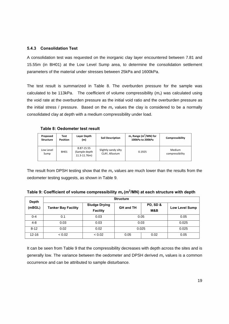
5.4.3 Consolidation Test
A consolidation test was requested on the inorganic clay layer encountered between 7.81 and
15.55m (in BH01) at the Low Level Sump area, to determine the consolidation settlement
parameters of the material under stresses between 25kPa and 1600kPa.
The test result is summarized in Table 8. The overburden pressure for the sample was
calculated to be 113kPa. The coefficient of volume compressibility (mv) was calculated using
the void rate at the overburden pressure as the initial void ratio and the overburden pressure as
the initial stress / pressure. Based on the mv values the clay is considered to be a normally
consolidated clay at depth with a medium compressibility under load.
Table 8: Oedometer test result
Proposed Structure
Test Position
Layer Depth (m) Soil Description mv Range (m
2/MN) for 100kPa to 200kPa Compressibility
Low Level Sump
BH01 8.87‐15.55
(Sample depth 11.3‐11.76m)
Slightly sandy silty CLAY, Alluvium
0.1925 Medium
compressibility
The result from DPSH testing show that the mv values are much lower than the results from the
oedometer testing suggests, as shown in Table 9.
Table 9: Coefficient of volume compressibility mv (m2/MN) at each structure with depth
Depth
(mBGL)
Structure
Tanker Bay Facility Sludge Drying
Facility GH and TH
PD, SD &
M&B Low Level Sump
0-4 0.1 0.03 0.05 0.05
4-8 0.03 0.03 0.03 0.025
8-12 0.02 0.02 0.025 0.025
12-16 < 0.02 < 0.02 0.05 0.02 0.05
It can be seen from Table 9 that the compressibility decreases with depth across the sites and is
generally low. The variance between the oedometer and DPSH derived mv values is a common
occurrence and can be attributed to sample disturbance.

20
6 Geotechnical Evaluation
6.1 Expansive Soils
Expansive soils are materials where variations in moisture content result in volumetric changes.
Unless cognisance is taken of the potential for volumetric change when designing structures
founded in or on this type of soil, distress of the structure may occur.
Based on laboratory results generally the clayey soils encountered classify as “potentially
expansive” according to the Van der Merwe chart and are recorded in Table 5. The clay (fill
material) in TP10, the clay (alluvium) in TP16 and the clay (alluvium) in BH01 have an
expansiveness potential, however given the depth of these expansive layers, which is below the
water table and considering the overburden pressure at these depths, the potential to heave is
negligible within these clays.
For shallow foundations within expansive soils it is generally recommended that appropriate
foundations and construction methods be implemented. This may include reinforced footings,
beam-stiffened or cellular raft foundations, constructing a soil raft or split construction,
depending on the settlement tolerances of the structure. In addition, care should be taken to
ensure good site drainage and that all surface water is channeled away from the structure
foundations avoiding ingress of water within the bedding.
6.2 Consolidation Settlement
Consolidation settlement is the vertical settlement or decrease in soil volume that occurs in a
soil under an applied load owing to the time related reduction in volume as a result of dissipation
of pore water.
As indicated previously a consolidation test was carried out on an undisturbed sample of clay,
alluvium which was encountered at the position of the low level sump. This test determines the
settlement parameters and the anticipated settlement behavior of the material under the
influence of loading. The coefficient of volume compressibility calculated based on the test
results confirm that the alluvial clay at the low level sump has a medium compressibility. DPSH
21
results do however indicate a low compressibility across the sites. Differential settlement may
still be problematic as there is still a difference between compressibilities of the clay layers.
Techniques for mitigating potential settlement and differential settlement problems include
reinforced strip / pad footings, deep strip/pad footings, founding within a soil raft, or pile
foundations. The choice of foundation is generally dependent on the foundation loads and the
sensitivity of the structure to settlement.
Given the depth of the clay layer (8.87m bgl) within the footprint of the proposed low level sump,
consolidation settlement below shallow foundations is not anticipated to be a problem. However
for deep piled foundations it is recommended that the piles be founded / extended to depths
beyond the potentially compressible layer to minimize the settlement of the piles.
6.3 Excavatability
In accordance with the SANS 1200DA soft excavations can be expected to depths of
approximately 19m based on the results of this investigation. All soft excavations may be
carried out with conventional earthmoving equipment.
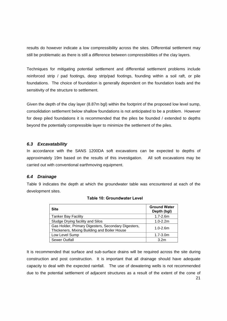
6.4 Drainage
Table 9 indicates the depth at which the groundwater table was encountered at each of the
development sites.
Table 10: Groundwater Level
Site Ground Water
Depth (bgl) Tanker Bay Facility 1.7-2.6m Sludge Drying facility and Silos 1.0-2.2m Gas Holder, Primary Digesters, Secondary Digesters, Thickeners, Mixing Building and Boiler House
1.0-2.6m
Low Level Sump 1.7-3.0m Sewer Outfall 3.2m
It is recommended that surface and sub-surface drains will be required across the site during
construction and post construction. It is important that all drainage should have adequate
capacity to deal with the expected rainfall. The use of dewatering wells is not recommended
due to the potential settlement of adjacent structures as a result of the extent of the cone of

22
depression that develops due to the dewatering process. Therefore it is recommended that a
sump is excavated at the lowest position within deep excavations (greater than the water table)
from which the water is pumped out.
6.5 Stability of Excavations
The sidewalls of the test pits were unstable with the test pits collapsing on several occasions.
Unstable excavation conditions can be expected during construction as a result of the
unconsolidated material and shallow groundwater table. As a result of the shallow water table,
the unconsolidated materials are expected to flow into excavations.
Given the unstable excavation conditions, the shallow groundwater level and the depth of
various proposed structures, battering of the sidewalls to 1V:1H is recommended in excavations
to 1.0m depth, under dry conditions. Lateral support measures will be necessary for
excavations greater than 1.0m.
Due to the shallow water table and given that dewatering of excavation sidewalls are not
expected to be undertaken, due to the drop in the cone of depression (and its influence on
surrounding structures), battering of the side walls is not considered an adequate solution for
the various deep excavations anticipated.
All traffic, personnel, equipment etc. should be kept at a minimum of 2m from the crest of any
excavation. All excavations should, also, be inspected by a competent person at least once a
day and following any periods of rain or any long periods where no work has taken place.
7 RECOMMENDATIONS
7.1 Founding Conditions
Although allowable bearing pressures of between 100 kPa and >250kPa is achievable in the fill
and alluvial soils for shallow foundations, these soils in its in-situ state are considered unsuitable
as a founding medium for the proposed structures due to the variable consistency of the soils.
Due to heavy anticipated loading of some of the structures, settlement problems are anticipated
if founding within these soils.

23
The choice of the most suitable founding solution is dictated by various factors. For the
SWWTW site, the main geotechnical factors to be considered are:-
The variable subsoil conditions in terms of bearing and settlement in both the fill and the
alluvial deposits.
The structural loads, required tolerances and sensitivity of the structure to settlement (at
the time of preparation of this report, the particular load cases and required tolerances of
the structure were not available).
Based on these conditions, the following foundation recommendations are provided:
7.1.1 Shallow Foundations - Lightly to Moderately Loaded Structures
The lightly to moderately loaded structures on site are expected to be the following:-
Sludge Drying Facility;
Tanker Bay Facility;
Mixing Building and Boiler House.
In order to reduce settlement and improve the allowable bearing capacity it is recommended
that the sludge drying facility and the tanker bay facility should be founded on an engineered
soil raft using conventional footings (strip or pad footings). This will involve the removal of the
fill/alluvial soils below the footings to a depth and width of at least 1.5 times the foundation
width. The in-situ soil at the base of the excavation should then be compacted to at least 95%
Mod AASHTO. The removed material should be placed in compacted layers not exceeding
150mm to 95% Mod AASHTO density at the optimum moisture content up to the desired
founding levels. A bearing capacity of at least 100kPa is achievable within the soil raft.
It is recommended that the proposed mixing building and boiler house should be founded, using
conventional footings, on an engineered soil raft constructed of inert G6 material. This will
involve the removal of the fill/alluvial soils below the footings to a depth and width of at least 1.5
times the foundation width. The in-situ soil at the base of the excavation should be compacted
to at least 95% Mod AASHTO. The removed material should be replaced with G6 material to be
placed in compacted layers not exceeding 150mm to 95% Mod AASHTO density at the

24
optimum moisture content up to the desired founding levels. A bearing capacity of 250kPa
would be achievable within the soil raft if a G6 material is used and 150kPa if a G7 material is
used.
As a general rule, settlement of the fill is taken as 0.1% of the fill height for the well compacted
fill.
In cases where low settlement tolerances are anticipated, or where excessive load magnitudes
result in stressing of the ground to depths which practically preclude the excavation and
replacement of the in-situ soil, an alternative foundation approach should be considered, such
as piled foundations or founding on a rock mattress.
Rock mattress
Depending on the settlement sensitivity of the structures founded on shallow footings, a rock
mattress compacted by a 5-10t vibratory compactor will eliminate differential settlement. The
rock fill is to be compacted in 300-500mm thick layers.
7.1.2 Piled Foundations - Heavily Loaded Structures
The following are considered to be heavily loaded structures:-
Primary Digesters
Secondary Digester
Thickener
Gas Holder
Silos
Low Level Sump
Given the variability of the consistency of the alluvial soils and the sensitivity of the above
mentioned water bearing structures it is recommended that these heavy structures will have to
be placed on piled foundations designed as friction piles. The pile types which may be
considered are:

25
Driven Precast Piles
These piles can be driven to unlimited depths however driven pre cast piles often meet with
problems when penetrating materials with an SPT ‘N’ Value greater than 30. Such values
were measured in Borehole BH05 (drilled along the sewer outfall) and in all the DPSH tests.
This could be solved by using a rock shoe on each of the driven piles. Typical working
loads are 750kN to 2000kN depending on the pile dimensions.
Augered cast in situ piles
These piles are one of the most commonly used piling solutions in South Africa. However
due to the presence of a shallow water table, it may be necessary to case the piles which
would increase installation time and increase cost. Working loads on augered cast in situ
piles vary from 200kN to 25 000kN depending on the diameter of pile used.
Underslurry Piles
These piles are suitable for heavily loaded structures and are excavated under a head of
bentonite slurry which prevents collapse of the pile excavation. This collapse of the
sidewalls is likely on this site due to the shallow water level and sands over much of the pile
length. Typical working loads are 1700kN to 14 000kN depending on the pile diameter.
Although CFA piles are a fast and economical solution which is widely used in South Africa, it is
not considered a viable option given that when CFA piles are founded below the water table in
sandy soils, this results in a reduction of soil strength immediately around the pile due to the
drilling operation, hence the load/deflection performance of the pile is inferior to other systems
such as a driven pile (P114, Guide to Practical Geotechnical Engineering, 2008).
The type of pile used will need to be selected according to the programme of work, economics
of piling system and performance of the piled system.
All piles would need to be designed taking into account the presence of very loose and loose
material in the upper subsoil layers (up to approximately 5m depth) and isolated weaker zones
(poor consistencies) within the alluvial soils which may cause some downdrag.

26
Sewer Outfall Pipeline
Although the subsoil’s have a medium dense to very dense consistency, the presence of a
shallow water table and the possibility of tidal influences (due to the pipeline being located on
the beach) may result in settlement / movement of the pipeline due to scouring removing
material. It is therefore recommended that the pipeline be constructed on a concrete cradle
founded on piles to mitigate any differential settlement and movement due to the effect of the
cyclic increase and decrease of the water table on the pipe. The piling solutions considered
appropriate is the driven precast piles, augered cast in-situ piles and micropiles.
The piling for the pipeline will be a cost consideration – buried pipeline with difficult maintenance
vs elevated pipeline with possible security issues.
8 Conclusion The site is developable providing cognisance is taken of the findings included herein. It is
imperative that the recommendations within this report be re-visited once foundation types,
dimensions and stresses are available.
All light to medium loaded structures may be founded at shallow depths on a soil raft while the
heavily loaded structures are to be founded on friction piles.
In addition, during construction an engineering geologist or geotechnical engineer should
inspect all foundation excavations and provide input on the piling to ensure that conditions at
variance to those found during the investigation are not present and to validate the findings of
this report.

ANNEXURE A
FIGURES

BH05
DPSH13
STMH
Pillar
Pillar
Marker
M
anholes
V
V
STMH
Pillar
Pillar
Marker
M
anholes
V
V
TP/DC13
TP/DC14
TP/DC15
TP/DC16
BH01
DPSH10
DPSH11
DPSH12
Pillar
Pillar
Pillar
Pillar
Pillar
Pillar
P
i
l
l
a
r
s
P
i
l
l
a
r
s
P
i
l
l
a
r
s
P
i
l
l
a
r
s
Pillar
Pillar
MH
MH
Open MH
MH
Cable MH
MH
MH
MH
MH
MH
MH
MH
MH
MH
MH
MH
MH
MH
MH
MH
MH
MH
MH
MH
MH
MH
MH
MH
MH
MH
MH
MH
MH
MH
MH
MH
MH
Sewer discharge MH
MH
MH
MH
MH
MH
MH
MH
MH
MH
MH
MH
MH
FH
PipeMarker
PipeMarker
PipeMarker
PipeMarker
PipeMarker
V
V
V
W
a
l
l
W
a
l
l
W
a
l
l
W
a
l
l
W
a
l
l
W
a
l
l
Pillar
Pillar
Pillar
Pillar
Pillar
Pillar
Pillar
Pillar
Pillar
Pillar
Pillar
Pillar
O
v
e
r
h
a
n
g
O
v
e
r
h
a
n
g
O
v
e
r
h
a
n
g
Pillar
Pipe
Pipe
Pipe
Pipe
Pipe
SWMH
SWMH
SWMH
S
u
m
p
MH
MH
Open MH
Open MH
MH
MH
W
a
l
l
W
a
l
l
Pipe Marker
Pipe Marker
MH to SUMP
Surface Pipe
Surface Pipe
Cable MH
Sewer discharge MH
Sewer discharge MH
Sewer discharge MH
Sewer discharge MH
C
A
R
P
O
R
T
MH
Concrete
Concrete
M
H
S
t
e
p
C
o
n
c
r
.
V
V
V
V
V
V
V
V
V
V
V
V
V
V
V
V
V
V
V
V
TAP
TAP
TAP
TAP
TAP
FH
FH
MH
MH
Pillar
Pillar
Pillar
Pillar
Pillar
Pillar
P
i
l
l
a
r
s
P
i
l
l
a
r
s
P
i
l
l
a
r
s
P
i
l
l
a
r
s
Pillar
Pillar
MH
MH
Open MH
MH
Cable MH
MH
MH
MH
MH
MH
MH
MH
MH
MH
MH
MH
MH
MH
MH
MH
MH
MH
MH
MH
MH
MH
MH
MH
MH
MH
MH
MH
MH
MH
MH
MH
MH
Sewer discharge MH
MH
MH
MH
MH
MH
MH
MH
MH
MH
MH
MH
MH
FH
PipeMarker
PipeMarker
PipeMarker
PipeMarker
PipeMarker
V
V
V
W
a
l
l
W
a
l
l
W
a
l
l
W
a
l
l
W
a
l
l
W
a
l
l
Pillar
Pillar
Pillar
Pillar
Pillar
Pillar
Pillar
Pillar
Pillar
Pillar
Pillar
Pillar
O
v
e
r
h
a
n
g
O
v
e
r
h
a
n
g
O
v
e
r
h
a
n
g
Pillar
Pipe
Pipe
Pipe
Pipe
Pipe
SWMH
SWMH
SWMH
S
u
m
p
MH
MH
Open MH
Open MH
MH
MH
W
a
l
l
W
a
l
l
Pipe Marker
Pipe Marker
MH to SUMP
Surface Pipe
Surface Pipe
Cable MH
Sewer discharge MH
Sewer discharge MH
Sewer discharge MH
Sewer discharge MH
C
A
R
P
O
R
T
MH
Concrete
Concrete
M
H
S
t
e
p
C
o
n
c
r
.
V
V
V
V
V
V
V
V
V
V
V
V
V
V
V
V
V
V
V
V
TAP
TAP
TAP
TAP
TAP
FH
FH
MH
MH
TP/DC01
TBF
SDF
GH
SD
PD
TH
S
S
M&B
TP/DC02
TP/DC03
TP/DC04
TP/DC05
TP/DC06
TP/DC07
TP/DC08
TP/DC09
TP/DC10
TP/DC11
TP/DC12
TP/DC17
BH02A
BH03
BH04
DPSH1
DPSH2
DPSH3DPSH4
DPSH5
DPSH6
DPSH7
DPSH8
DPSH9
TP/DC01
TBF
SDF
GH
SD
PD
TH
S
S
M&B
TP/DC02
TP/DC03
TP/DC04
TP/DC05
TP/DC06
TP/DC07
TP/DC08
TP/DC09
TP/DC10
TP/DC11
TP/DC12
TP/DC13
TP/DC14
TP/DC15
TP/DC16
TP/DC17
BH01
BH02A
BH03
BH04
BH05
DPSH1
DPSH2
DPSH3DPSH4
DPSH5
DPSH6
DPSH7
DPSH8
DPSH9
DPSH10
DPSH11
DPSH12
DPSH13
AECOM DETAIL/FIGURE No.
01UPGRADE TO SOUTHERN WASTEWATER TREATMENT WORKS
GEOTECHNICAL INVESTIGATIONPOSITION OF TESTS
KEY:
TBF- TANKER BAY FACILIITY S- SILO
TH- THICKNER M&B- MIXING BUILDING AND BOILER HOUSE
PD- PRIMARY DIGESTER SDF- SLUDGE DRYING FACILITY
SD- SECONDARY DIGESTER
GH- GAS HOLDER
DW- DEWATERING FACILITY
SHEET 1
SHEET 2: Low Level Sump
SHEET 3: Sewer Outfall Pipeline
LOCALITY PLAN
SHEET 1
SHEET 2
SHEET 3
ANNEXURE B
TEST PIT PROFILES & BOREHOLE LOGS

TEST PIT PROFILES

0.5--1.3m
1.3--1.9m
EThekwini MunicipalitySWWTW
TP01Sheet 1 of 1
TP01Sheet 1 of 1
TP01Sheet 1 of 1
TP01Sheet 1 of 1
JOB NUMBER: J01945JOB NUMBER: J01945
0.10
0.00
0.50
1.30
1.90
Dry, dark grey, loose, silty SAND, FILL.
Dry, light grey, loose to medium dense, silty fine SAND, FILL.
Slightly moist to moist, orangey brown, medium dense, SAND, FILL.
Moist to wet, greyish orangey brown, medium dense, SAND, ALLUVIUM.
Scale1:20
NOTES
1) Moderately to strong seepage at 1.7m.
2) Completely unstable sidewalls resulting in collapse of the pit hencestopped at 1.9m.
3) Disturbed samples at 0.5--1.3m and 1.3--1.9m.
CONTRACTOR :MACHINE :
EXCAVATED BY :PROFILED BY :
CHECKED BY :SETUP FILE :
R NAIDOO
TESTPI~1.SET
INCLINATION :DIAM :
DATE :
DATE :TEXT :
23/09/201403/11/2014 07:26..lot\RevisedSWWTWTP’s.txt
ELEVATION :X-COORD :Y-COORD :
33150832408
dotPLOT 7016 PBp7D04D AECOM SA (Pty) Ltd
TP01TP01TP01TP01

0.6--1.6m
1.6--2.9m
EThekwini MunicipalitySWWTW
TP02Sheet 1 of 1
TP02Sheet 1 of 1
TP02Sheet 1 of 1
TP02Sheet 1 of 1
JOB NUMBER: J01945JOB NUMBER: J01945
0.05
0.00
0.30
0.60
1.60
2.90
3.05
Dry, dark grey, loose, silty SAND, FILL.
Dry, light grey, loose to medium dense, silty fine SAND, FILL.
Slightly moist to moist, orangey brown, medium dense, SAND, FILL.
Slightly moist, orangey brown, medium dense to very dense, silty SAND, ALLUVIUM.
Moist to wet, dark grey, loose to medium dense, silty clayey SAND,ALLUVIUM.
Moist, light grey, medium dense, silty SAND, ALLUVIUM.
Scale1:20
NOTES
1) Slight seepage at 2.6m.
2) Unstable sidewalls.
3) Disturbed samples at 0.6--1.6m and 1.6--2.9m.
CONTRACTOR :MACHINE :
EXCAVATED BY :PROFILED BY :
CHECKED BY :SETUP FILE :
R NAIDOO
TESTPI~1.SET
INCLINATION :DIAM :
DATE :
DATE :TEXT :
23/09/201403/11/2014 07:26..lot\RevisedSWWTWTP’s.txt
ELEVATION :X-COORD :Y-COORD :
33151222357
dotPLOT 7016 PBp7D04D AECOM SA (Pty) Ltd
TP02TP02TP02TP02
EThekwini MunicipalitySWWTW
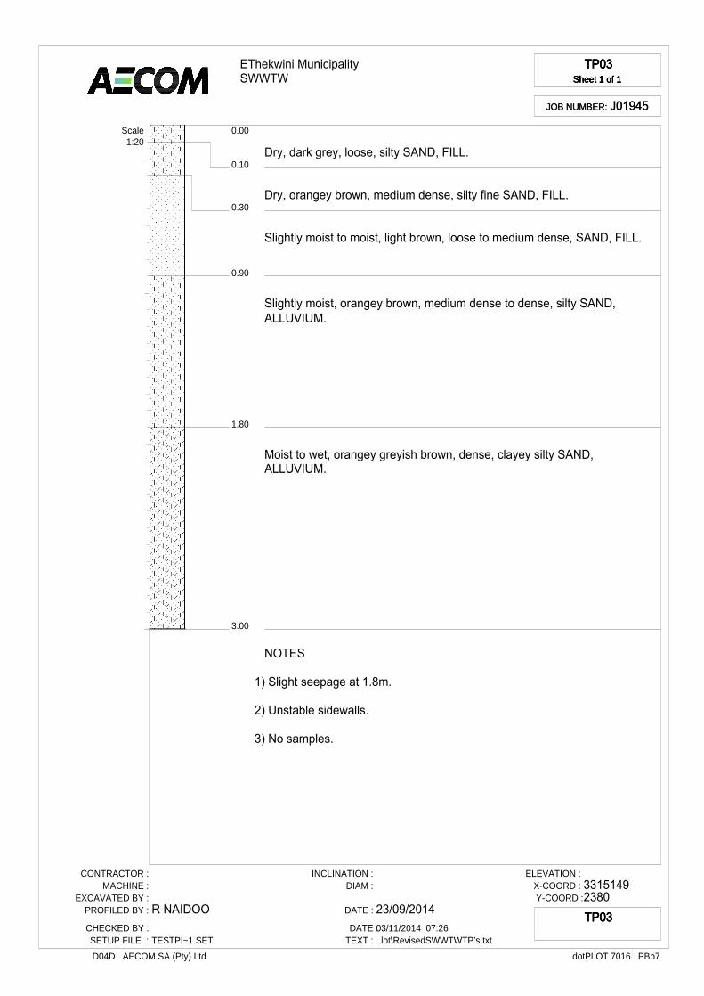
TP03Sheet 1 of 1
TP03Sheet 1 of 1
TP03Sheet 1 of 1
TP03Sheet 1 of 1
JOB NUMBER: J01945JOB NUMBER: J01945
0.10
0.00
0.30
0.90
1.80
3.00
Dry, dark grey, loose, silty SAND, FILL.
Dry, orangey brown, medium dense, silty fine SAND, FILL.
Slightly moist to moist, light brown, loose to medium dense, SAND, FILL.
Slightly moist, orangey brown, medium dense to dense, silty SAND, ALLUVIUM.
Moist to wet, orangey greyish brown, dense, clayey silty SAND, ALLUVIUM.
Scale1:20
NOTES
1) Slight seepage at 1.8m.
2) Unstable sidewalls.
3) No samples.
CONTRACTOR :MACHINE :
EXCAVATED BY :PROFILED BY :
CHECKED BY :SETUP FILE :
R NAIDOO
TESTPI~1.SET
INCLINATION :DIAM :
DATE :
DATE :TEXT :
23/09/201403/11/2014 07:26..lot\RevisedSWWTWTP’s.txt
ELEVATION :X-COORD :Y-COORD :
33151492380
dotPLOT 7016 PBp7D04D AECOM SA (Pty) Ltd
TP03TP03TP03TP03

EThekwini MunicipalitySWWTW
TP04Sheet 1 of 1
TP04Sheet 1 of 1
TP04Sheet 1 of 1
TP04Sheet 1 of 1
JOB NUMBER: J01945JOB NUMBER: J01945
0.10
0.00
0.30
2.00
Dry, dark grey, loose, silty SAND, FILL.
Dry, light grey, loose to medium dense, silty fine SAND, FILL.
Slightly moist to moist, light brown, loose to medium dense, SAND, FILL.
Wet, grey, medium dense, slightly silty SAND, ALLUVIUM.
Scale1:20
NOTES
1) Slight seepage at 1.9m.
2) Completely unstable sidewalls resulting in collapse of the pit hencestopped at 2.0m.
3) No samples.
CONTRACTOR :MACHINE :
EXCAVATED BY :PROFILED BY :
CHECKED BY :SETUP FILE :
R NAIDOO
TESTPI~1.SET
INCLINATION :DIAM :
DATE :
DATE :TEXT :
23/09/201403/11/2014 07:26..lot\RevisedSWWTWTP’s.txt
ELEVATION :X-COORD :Y-COORD :
33151192420
dotPLOT 7016 PBp7D04D AECOM SA (Pty) Ltd
TP04TP04TP04TP04
2.6--2.7m
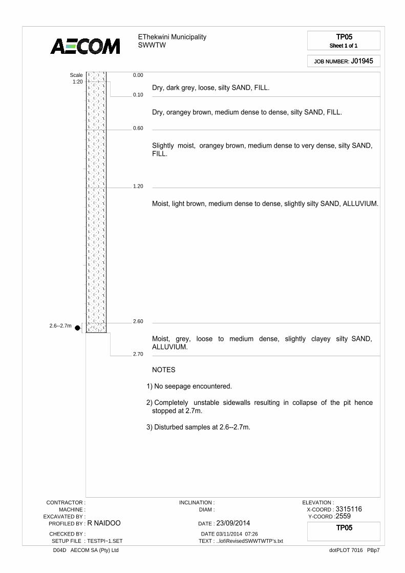
EThekwini MunicipalitySWWTW
TP05Sheet 1 of 1
TP05Sheet 1 of 1
TP05Sheet 1 of 1
TP05Sheet 1 of 1
JOB NUMBER: J01945JOB NUMBER: J01945
0.10
0.00
0.60
1.20
2.60
2.70
Dry, dark grey, loose, silty SAND, FILL.
Dry, orangey brown, medium dense to dense, silty SAND, FILL.
Slightly moist, orangey brown, medium dense to very dense, silty SAND,FILL.
Moist, light brown, medium dense to dense, slightly silty SAND, ALLUVIUM.
Moist, grey, loose to medium dense, slightly clayey silty SAND,ALLUVIUM.
Scale1:20
NOTES
1) No seepage encountered.
2) Completely unstable sidewalls resulting in collapse of the pit hencestopped at 2.7m.
3) Disturbed samples at 2.6--2.7m.
CONTRACTOR :MACHINE :
EXCAVATED BY :PROFILED BY :
CHECKED BY :SETUP FILE :
R NAIDOO
TESTPI~1.SET
INCLINATION :DIAM :
DATE :
DATE :TEXT :
23/09/201403/11/2014 07:26..lot\RevisedSWWTWTP’s.txt
ELEVATION :X-COORD :Y-COORD :
33151162559
dotPLOT 7016 PBp7D04D AECOM SA (Pty) Ltd
TP05TP05TP05TP05
EThekwini MunicipalitySWWTW
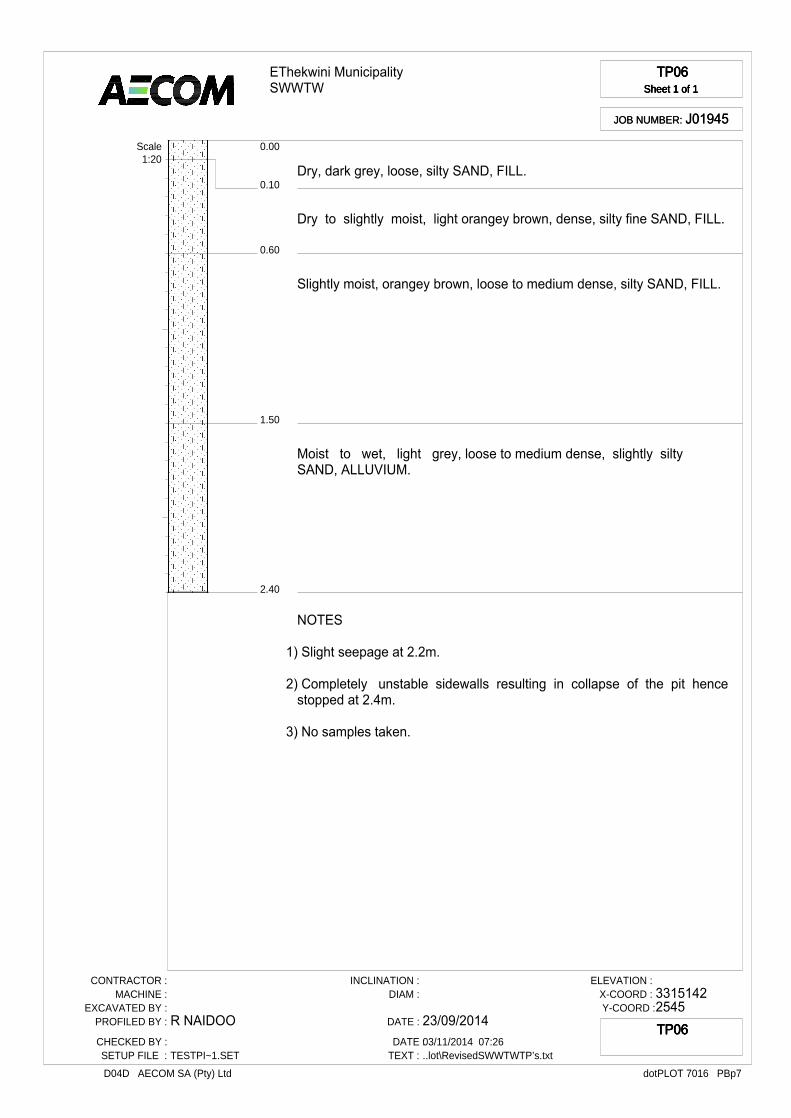
TP06Sheet 1 of 1
TP06Sheet 1 of 1
TP06Sheet 1 of 1
TP06Sheet 1 of 1
JOB NUMBER: J01945JOB NUMBER: J01945
0.10
0.00
0.60
1.50
2.40
Dry, dark grey, loose, silty SAND, FILL.
Dry to slightly moist, light orangey brown, dense, silty fine SAND, FILL.
Slightly moist, orangey brown, loose to medium dense, silty SAND, FILL.
Moist to wet, light grey, loose to medium dense, slightly silty SAND, ALLUVIUM.
Scale1:20
NOTES
1) Slight seepage at 2.2m.
2) Completely unstable sidewalls resulting in collapse of the pit hencestopped at 2.4m.
3) No samples taken.
CONTRACTOR :MACHINE :
EXCAVATED BY :PROFILED BY :
CHECKED BY :SETUP FILE :
R NAIDOO
TESTPI~1.SET
INCLINATION :DIAM :
DATE :
DATE :TEXT :
23/09/201403/11/2014 07:26..lot\RevisedSWWTWTP’s.txt
ELEVATION :X-COORD :Y-COORD :
33151422545
dotPLOT 7016 PBp7D04D AECOM SA (Pty) Ltd
TP06TP06TP06TP06

1.5--2.8m
EThekwini MunicipalitySWWTW
TP07Sheet 1 of 1
TP07Sheet 1 of 1
TP07Sheet 1 of 1
TP07Sheet 1 of 1
JOB NUMBER: J01945JOB NUMBER: J01945
0.90
0.00
1.50
2.80
Dry, orangey brown, medium dense to very dense, slightly clayey silty SAND, FILL.
Moist, grey blotched orangey brown, stiff to very stiff, sandy silty CLAY,FILL.
Moist to wet, dark grey, loose to medium dense, SAND, ALLUVIUM.
Scale1:20
NOTES
1) Slight seepage at 2.2m.
2) Completely unstable sidewalls resulting in collapse of the pit hencestopped at 2.8m.
3) Disturbed sample at 1.5--2.8m.
CONTRACTOR :MACHINE :
EXCAVATED BY :PROFILED BY :
CHECKED BY :SETUP FILE :
R NAIDOO
TESTPI~1.SET
INCLINATION :DIAM :
DATE :
DATE :TEXT :
25/09/201403/11/2014 07:26..lot\RevisedSWWTWTP’s.txt
ELEVATION :X-COORD :Y-COORD :
33153092567
dotPLOT 7016 PBp7D04D AECOM SA (Pty) Ltd
TP07TP07TP07TP07

1.3--2.8m
EThekwini MunicipalitySWWTW
TP08Sheet 1 of 1
TP08Sheet 1 of 1
TP08Sheet 1 of 1
TP08Sheet 1 of 1
JOB NUMBER: J01945JOB NUMBER: J01945
0.10
0.00
0.40
1.30
2.80
Slightly moist, dark greyish brown, loose, silty SAND, FILL.
Slightly moist, light brown, medium dense, silty SAND, FILL.
Moist to wet, dark grey, medium dense, SAND, FILL.
Moist to wet, reddish brown, medium dense, clayey silty SAND,ALLUVIUM.
Scale1:20
NOTES
1) Strong seepage at 1.0m.
2) Completely unstable sidewalls resulting in collapse of the pit hencestopped at 2.8m.
3) Disturbed sample at 1.3--2.8m.
CONTRACTOR :MACHINE :
EXCAVATED BY :PROFILED BY :
CHECKED BY :SETUP FILE :
R NAIDOO
TESTPI~1.SET
INCLINATION :DIAM :
DATE :
DATE :TEXT :
25/09/201403/11/2014 07:26..lot\RevisedSWWTWTP’s.txt
ELEVATION :X-COORD :Y-COORD :
33153412530
dotPLOT 7016 PBp7D04D AECOM SA (Pty) Ltd
TP08TP08TP08TP08
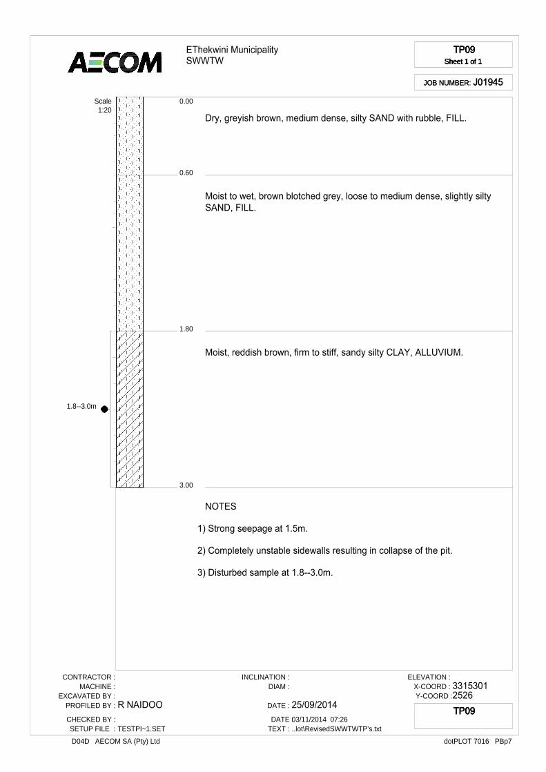
1.8--3.0m
EThekwini MunicipalitySWWTW
TP09Sheet 1 of 1
TP09Sheet 1 of 1
TP09Sheet 1 of 1
TP09Sheet 1 of 1
JOB NUMBER: J01945JOB NUMBER: J01945
0.60
0.00
1.80
3.00
Dry, greyish brown, medium dense, silty SAND with rubble, FILL.
Moist to wet, brown blotched grey, loose to medium dense, slightly silty SAND, FILL.
Moist, reddish brown, firm to stiff, sandy silty CLAY, ALLUVIUM.
Scale1:20
NOTES
1) Strong seepage at 1.5m.
2) Completely unstable sidewalls resulting in collapse of the pit.
3) Disturbed sample at 1.8--3.0m.
CONTRACTOR :MACHINE :
EXCAVATED BY :PROFILED BY :
CHECKED BY :SETUP FILE :
R NAIDOO
TESTPI~1.SET
INCLINATION :DIAM :
DATE :
DATE :TEXT :
25/09/201403/11/2014 07:26..lot\RevisedSWWTWTP’s.txt
ELEVATION :X-COORD :Y-COORD :
33153012526
dotPLOT 7016 PBp7D04D AECOM SA (Pty) Ltd
TP09TP09TP09TP09
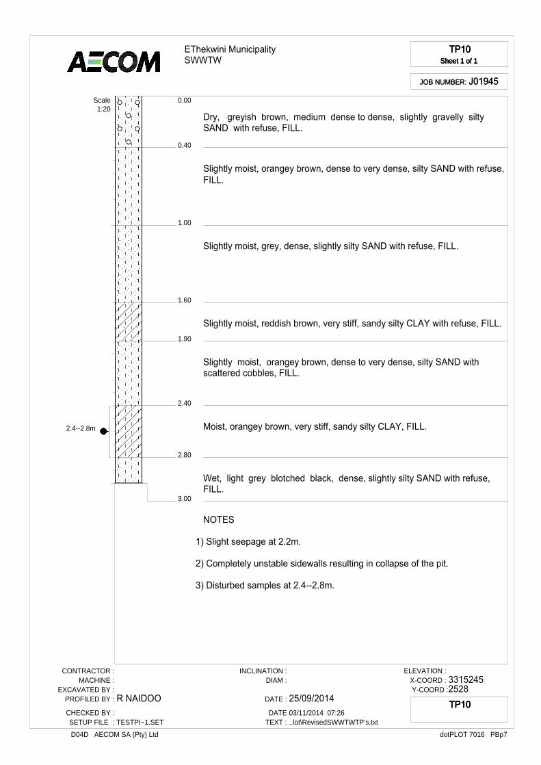
2.4--2.8m
EThekwini MunicipalitySWWTW
TP10Sheet 1 of 1
TP10Sheet 1 of 1
TP10Sheet 1 of 1
TP10Sheet 1 of 1
JOB NUMBER: J01945JOB NUMBER: J01945
0.40
0.00
1.00
1.60
1.90
2.40
2.80
3.00
Dry, greyish brown, medium dense to dense, slightly gravelly silty SAND with refuse, FILL.
Slightly moist, orangey brown, dense to very dense, silty SAND with refuse, FILL.
Slightly moist, grey, dense, slightly silty SAND with refuse, FILL.
Slightly moist, reddish brown, very stiff, sandy silty CLAY with refuse, FILL.
Slightly moist, orangey brown, dense to very dense, silty SAND with scattered cobbles, FILL.
Moist, orangey brown, very stiff, sandy silty CLAY, FILL.
Wet, light grey blotched black, dense, slightly silty SAND with refuse, FILL.
Scale1:20
NOTES
1) Slight seepage at 2.2m.
2) Completely unstable sidewalls resulting in collapse of the pit.
3) Disturbed samples at 2.4--2.8m.
CONTRACTOR :MACHINE :
EXCAVATED BY :PROFILED BY :
CHECKED BY :SETUP FILE :
R NAIDOO
TESTPI~1.SET
INCLINATION :DIAM :
DATE :
DATE :TEXT :
25/09/201403/11/2014 07:26..lot\RevisedSWWTWTP’s.txt
ELEVATION :X-COORD :Y-COORD :
33152452528
dotPLOT 7016 PBp7D04D AECOM SA (Pty) Ltd
TP10TP10TP10TP10
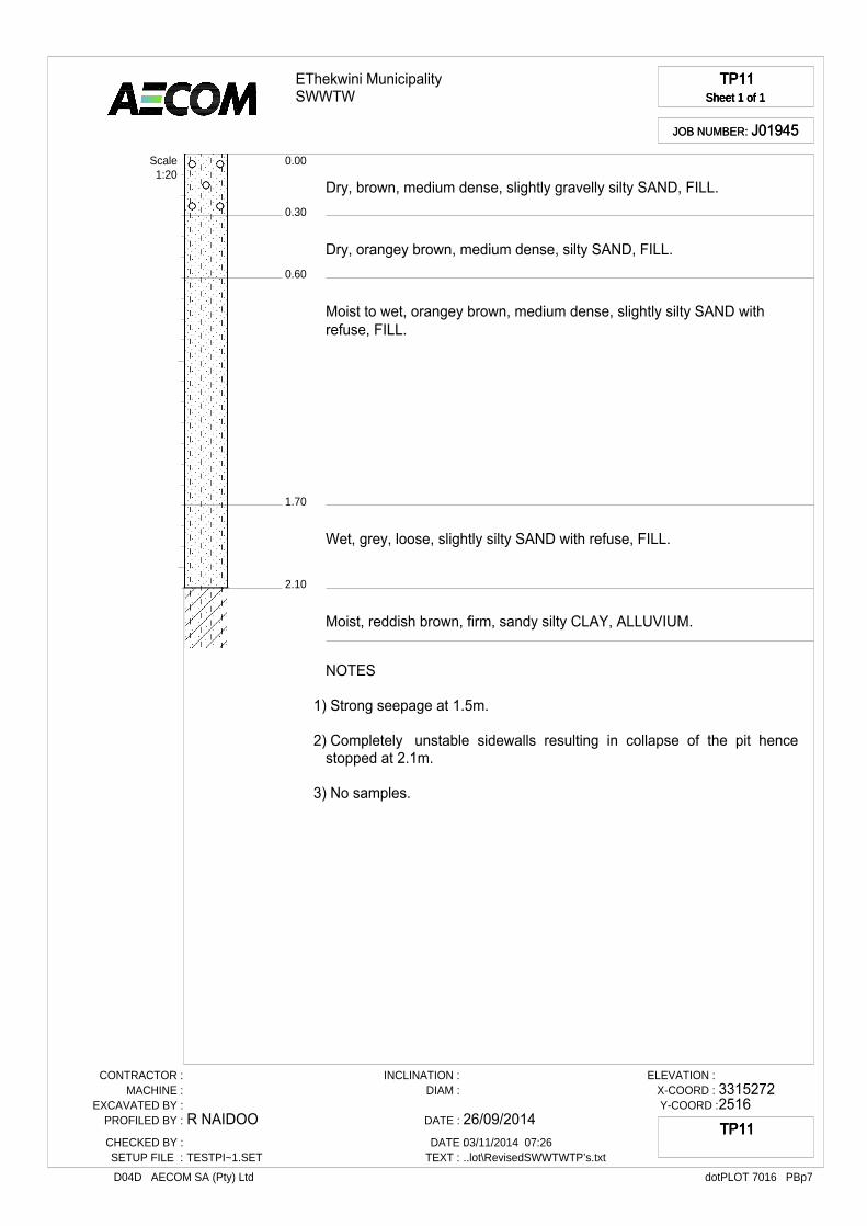
EThekwini MunicipalitySWWTW
TP11Sheet 1 of 1
TP11Sheet 1 of 1
TP11Sheet 1 of 1
TP11Sheet 1 of 1
JOB NUMBER: J01945JOB NUMBER: J01945
0.30
0.00
0.60
1.70
2.10
Dry, brown, medium dense, slightly gravelly silty SAND, FILL.
Dry, orangey brown, medium dense, silty SAND, FILL.
Moist to wet, orangey brown, medium dense, slightly silty SAND with refuse, FILL.
Wet, grey, loose, slightly silty SAND with refuse, FILL.
Moist, reddish brown, firm, sandy silty CLAY, ALLUVIUM.
Scale1:20
NOTES
1) Strong seepage at 1.5m.
2) Completely unstable sidewalls resulting in collapse of the pit hencestopped at 2.1m.
3) No samples.
CONTRACTOR :MACHINE :
EXCAVATED BY :PROFILED BY :
CHECKED BY :SETUP FILE :
R NAIDOO
TESTPI~1.SET
INCLINATION :DIAM :
DATE :
DATE :TEXT :
26/09/201403/11/2014 07:26..lot\RevisedSWWTWTP’s.txt
ELEVATION :X-COORD :Y-COORD :
33152722516
dotPLOT 7016 PBp7D04D AECOM SA (Pty) Ltd
TP11TP11TP11TP11

2.4--2.5m
EThekwini MunicipalitySWWTW
TP12Sheet 1 of 1
TP12Sheet 1 of 1
TP12Sheet 1 of 1
TP12Sheet 1 of 1
JOB NUMBER: J01945JOB NUMBER: J01945
0.10
0.00
0.60
1.50
2.40
2.50
Dry to slightly moist, greyish brown, medium dense, slightly gravelly siltySAND, FILL.
Slightly moist, light brown, medium dense, silty SAND, FILL.
Moist to wet, dark brown blotched grey, loose to medium dense, slightly silty SAND with saturated decomposing organic matter, ALLUVIUM.
Moist, reddish brown, firm to stiff, sandy silty CLAY, ALLUVIUM.
Moist to wet, black, stiff, silty CLAY with decomposing organic matter, ALLUVIUM.
Scale1:20
NOTES
1) Slight seepage at 1.5m.
2) Completely unstable sidewalls resulting in collapse of the pit hencestopped at 2.5m.
3) Disturbed sample at 2.4--2.5m.
CONTRACTOR :MACHINE :
EXCAVATED BY :PROFILED BY :
CHECKED BY :SETUP FILE :
R NAIDOO
TESTPI~1.SET
INCLINATION :DIAM :
DATE :
DATE :TEXT :
30/09/201403/11/2014 07:26..lot\RevisedSWWTWTP’s.txt
ELEVATION :X-COORD :Y-COORD :
33153302514
dotPLOT 7016 PBp7D04D AECOM SA (Pty) Ltd
TP12TP12TP12TP12

1.7--3.0m
EThekwini MunicipalitySWWTW
TP13Sheet 1 of 1
TP13Sheet 1 of 1
TP13Sheet 1 of 1
TP13Sheet 1 of 1
JOB NUMBER: J01945JOB NUMBER: J01945
0.20
0.00
0.50
1.00
1.20
1.70
3.00
Dry, brown, medium dense, silty SAND, FILL.
Slightly moist, orangey brown, medium dense, silty SAND with scatteredgravels, FILL.
Slightly moist, orangey brown, medium dense, silty SAND with scatteredgravels and shell fragments, FILL.
Moist, bluish grey, loose to medium dense, slightly silty SAND with shellfragments, FILL.
Moist, slightly greyish brown, loose to medium dense, silty SAND, FILL.
Moist, greenish brown, medium dense to very dense, SAND, ALLUVIUM.
Scale1:20
NOTES
1) No seepage encountered.
2) Slightly unstable.
3) Disturbed sample at 1.7--3.0m.
CONTRACTOR :MACHINE :
EXCAVATED BY :PROFILED BY :
CHECKED BY :SETUP FILE :
R NAIDOO
TESTPI~1.SET
INCLINATION :DIAM :
DATE :
DATE :TEXT :
30/09/201403/11/2014 07:26..lot\RevisedSWWTWTP’s.txt
ELEVATION :X-COORD :Y-COORD :
33160562541
dotPLOT 7016 PBp7D04D AECOM SA (Pty) Ltd
TP13TP13TP13TP13
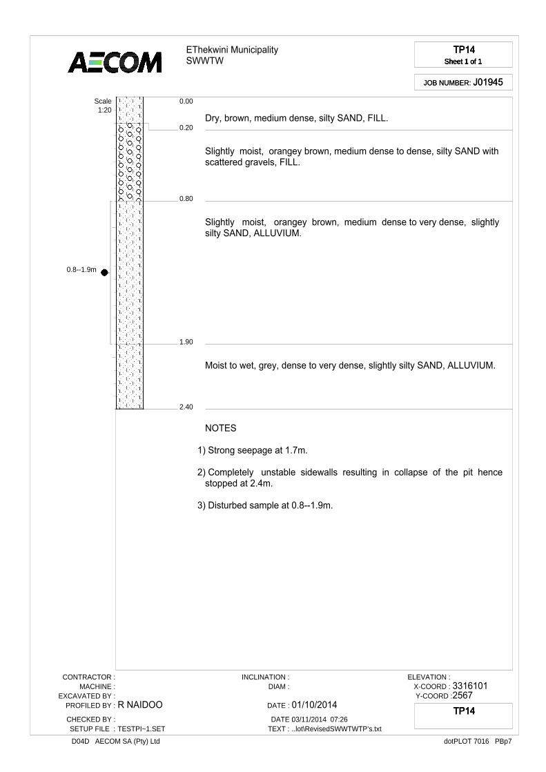
0.8--1.9m
EThekwini MunicipalitySWWTW
TP14Sheet 1 of 1
TP14Sheet 1 of 1
TP14Sheet 1 of 1
TP14Sheet 1 of 1
JOB NUMBER: J01945JOB NUMBER: J01945
0.20
0.00
0.80
1.90
2.40
Dry, brown, medium dense, silty SAND, FILL.
Slightly moist, orangey brown, medium dense to dense, silty SAND with scattered gravels, FILL.
Slightly moist, orangey brown, medium dense to very dense, slightly silty SAND, ALLUVIUM.
Moist to wet, grey, dense to very dense, slightly silty SAND, ALLUVIUM.
Scale1:20
NOTES
1) Strong seepage at 1.7m.
2) Completely unstable sidewalls resulting in collapse of the pit hencestopped at 2.4m.
3) Disturbed sample at 0.8--1.9m.
CONTRACTOR :MACHINE :
EXCAVATED BY :PROFILED BY :
CHECKED BY :SETUP FILE :
R NAIDOO
TESTPI~1.SET
INCLINATION :DIAM :
DATE :
DATE :TEXT :
01/10/201403/11/2014 07:26..lot\RevisedSWWTWTP’s.txt
ELEVATION :X-COORD :Y-COORD :
33161012567
dotPLOT 7016 PBp7D04D AECOM SA (Pty) Ltd
TP14TP14TP14TP14
1.6--2.5m
EThekwini MunicipalitySWWTW
TP15Sheet 1 of 1
TP15Sheet 1 of 1
TP15Sheet 1 of 1
TP15Sheet 1 of 1
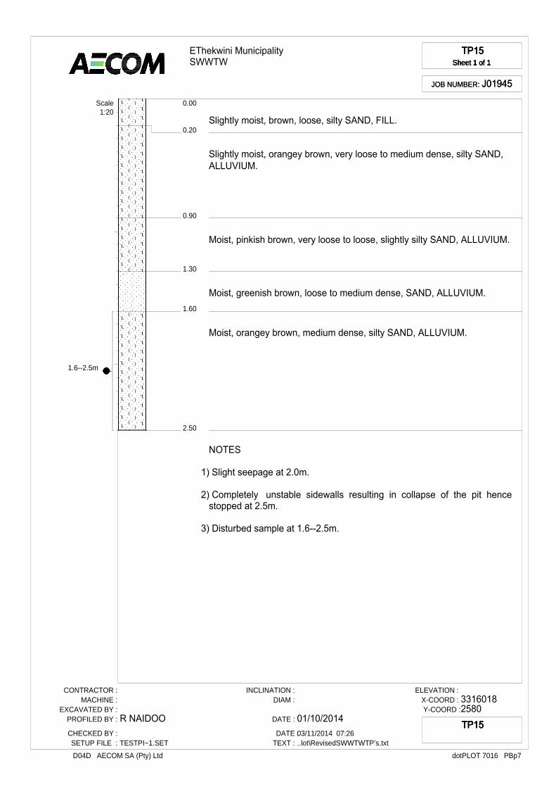
JOB NUMBER: J01945JOB NUMBER: J01945
0.20
0.00
0.90
1.30
1.60
2.50
Slightly moist, brown, loose, silty SAND, FILL.
Slightly moist, orangey brown, very loose to medium dense, silty SAND, ALLUVIUM.
Moist, pinkish brown, very loose to loose, slightly silty SAND, ALLUVIUM.
Moist, greenish brown, loose to medium dense, SAND, ALLUVIUM.
Moist, orangey brown, medium dense, silty SAND, ALLUVIUM.
Scale1:20
NOTES
1) Slight seepage at 2.0m.
2) Completely unstable sidewalls resulting in collapse of the pit hencestopped at 2.5m.
3) Disturbed sample at 1.6--2.5m.
CONTRACTOR :MACHINE :
EXCAVATED BY :PROFILED BY :
CHECKED BY :SETUP FILE :
R NAIDOO
TESTPI~1.SET
INCLINATION :DIAM :
DATE :
DATE :TEXT :
01/10/201403/11/2014 07:26..lot\RevisedSWWTWTP’s.txt
ELEVATION :X-COORD :Y-COORD :
33160182580
dotPLOT 7016 PBp7D04D AECOM SA (Pty) Ltd
TP15TP15TP15TP15

2.4--3.0m
3.0--3.2m
EThekwini MunicipalitySWWTW
TP16Sheet 1 of 1
TP16Sheet 1 of 1
TP16Sheet 1 of 1
TP16Sheet 1 of 1
JOB NUMBER: J01945JOB NUMBER: J01945
0.40
0.00
0.75
1.20
1.40
1.50
1.90
2.40
3.00
3.20
Slightly moist, brown, loose, silty SAND, FILL.
Slightly moist, orangey brown, medium dense, silty SAND, ALLUVIUM.
Moist, light yellowish brown, medium dense to dense, slightly clayey silty SAND, ALLUVIUM.
Moist, greyish orangey brown, medium dense, silty SAND, ALLUVIUM.
Moist, dark greyish black, firm, silty CLAY, ALLUVIUM.
Moist, greenish greyish brown, medium dense to dense, SAND, ALLUVIUM.
Moist, orangey brown, dense to very dense, silty SAND, ALLUVIUM.
Moist, greenish greyish brown, medium dense to very dense, clayey silty SAND, ALLUVIUM.
Moist, black, firm, silty CLAY with organic matter, ALLUVIUM.
Scale1:20
NOTES
1) Strong seepage at 3.0m.
2) Unstable sidewalls resulting in collapse of the pit.
3) Disturbed samples at 2.4--3.0m and 3.0--3.2m.
CONTRACTOR :MACHINE :
EXCAVATED BY :PROFILED BY :
CHECKED BY :SETUP FILE :
R NAIDOO
TESTPI~1.SET
INCLINATION :DIAM :
DATE :
DATE :TEXT :
01/10/201403/11/2014 07:26..lot\RevisedSWWTWTP’s.txt
ELEVATION :X-COORD :Y-COORD :
33160522577
dotPLOT 7016 PBp7D04D AECOM SA (Pty) Ltd
TP16TP16TP16TP16

2.6--3.0m
EThekwini MunicipalitySWWTW
TP17Sheet 1 of 1
TP17Sheet 1 of 1
TP17Sheet 1 of 1
TP17Sheet 1 of 1
JOB NUMBER: J01945JOB NUMBER: J01945
0.60
0.00
1.10
1.60
2.40
2.60
3.00
Slightly moist, brown, loose, silty SAND, FILL.
Slightly moist, orangey brown, loose to medium dense, clayey silty SAND, FILL.
Slightly moist, light grey, medium dense to dense, slightly silty SAND, FILL.
Moist, dark grey, medium dense, slightly clayey silty SAND, FILL.
Moist, reddish brown, medium dense, clayey silty SAND, FILL.
Slightly moist to wet, light grey, medium dense, silty SAND, ALLUVIUM.
Scale1:20
NOTES
1) Strong seepage at 2.6m.
2) Unstable sidewalls.
3) Disturbed samples at 2.6--3.0m.
CONTRACTOR :MACHINE :
EXCAVATED BY :PROFILED BY :
CHECKED BY :SETUP FILE :
R NAIDOO
TESTPI~1.SET
INCLINATION :DIAM :
DATE :
DATE :TEXT :
01/10/201403/11/2014 07:26..lot\RevisedSWWTWTP’s.txt
ELEVATION :X-COORD :Y-COORD :
33153122543
dotPLOT 7016 PBp7D04D AECOM SA (Pty) Ltd
TP17TP17TP17TP17

BOREHOLE LOGS
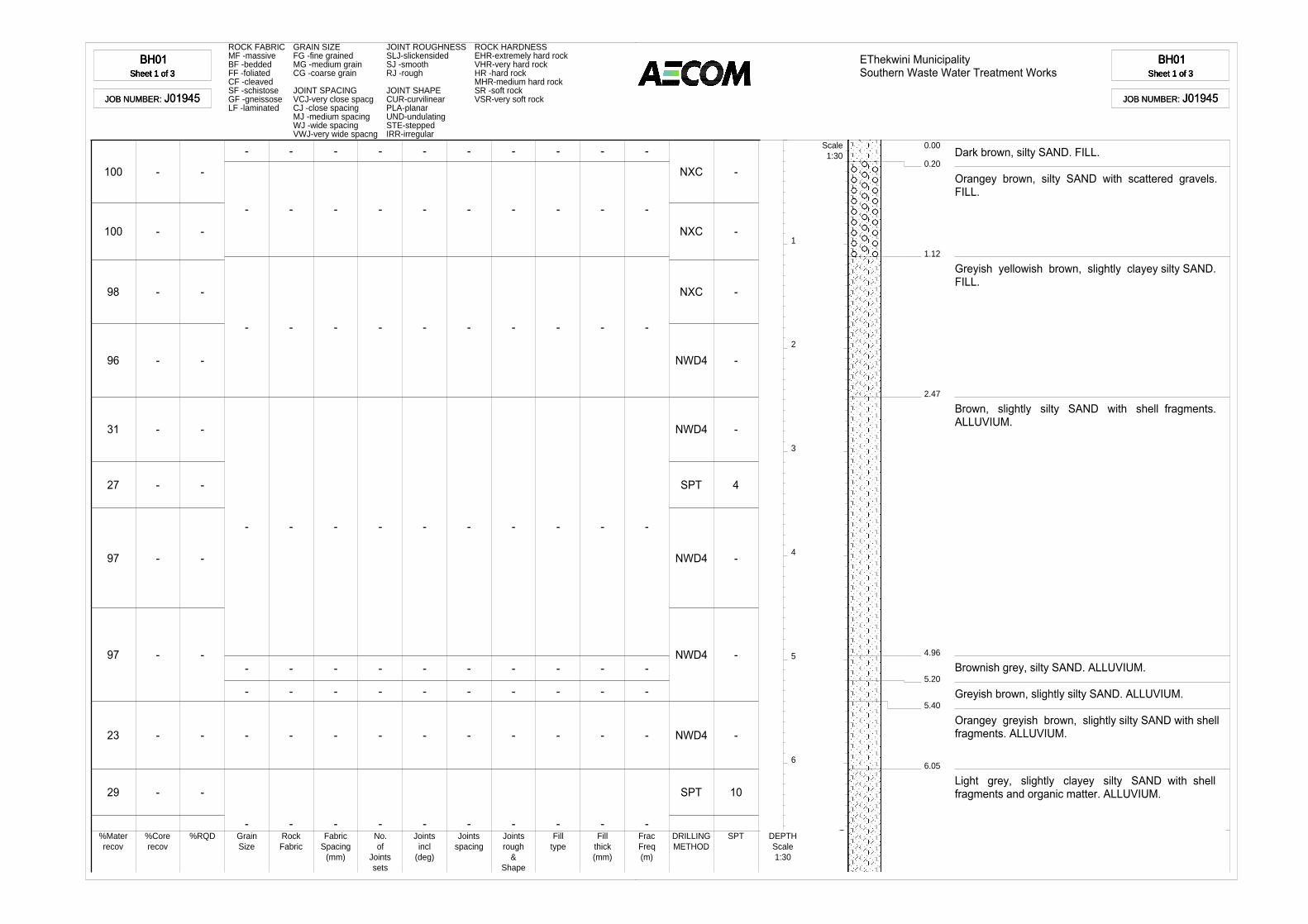
BH01Sheet 1 of 3
BH01Sheet 1 of 3
BH01Sheet 1 of 3
BH01Sheet 1 of 3
JOB NUMBER: J01945JOB NUMBER: J01945
ROCK FABRIC GRAIN SIZE JOINT ROUGHNESS ROCK HARDNESSMF -massive FG -fine grained SLJ-slickensided EHR-extremely hard rockBF -bedded MG -medium grain SJ -smooth VHR-very hard rockFF -foliated CG -coarse grain RJ -rough HR -hard rockCF -cleaved MHR-medium hard rockSF -schistose JOINT SPACING JOINT SHAPE SR -soft rockGF -gneissose VCJ-very close spacg CUR-curvilinear VSR-very soft rockLF -laminated CJ -close spacing PLA-planar
MJ -medium spacing UND-undulatingWJ -wide spacing STE-steppedVWJ-very wide spacng IRR-irregular
1
2
3
4
5
6
100
100
98
96
31
27
97
97
23
29
-
-
-
-
-
-
-
-
-
-
-
-
-
-
-
-
-
-
-
-
-
-
-
-
-
-
-
-
-
-
-
-
-
-
-
-
-
-
-
-
-
-
-
-
-
-
-
-
-
-
-
-
-
-
-
-
-
-
-
-
-
-
-
-
-
-
-
-
-
-
-
-
-
-
-
-
-
-
-
-
-
-
-
-
-
-
-
-
-
-
-
-
-
-
-
-
-
-
-
-
NXC
NXC
NXC
NWD4
NWD4
SPT
NWD4
NWD4
NWD4
SPT
-
-
-
-
-
4
-
-
-
10
%Materrecov
%Corerecov
%RQD GrainSize
RockFabric
FabricSpacing
(mm)
No.of
Jointssets
Jointsincl
(deg)
Jointsspacing
Jointsrough
&Shape
Filltype
Fillthick(mm)
FracFreq(m)
DRILLINGMETHOD
SPT DEPTHScale1:30
EThekwini MunicipalitySouthern Waste Water Treatment Works
BH01Sheet 1 of 3
BH01Sheet 1 of 3
BH01Sheet 1 of 3
BH01Sheet 1 of 3
JOB NUMBER: J01945JOB NUMBER: J01945
0.20
0.00
1.12
2.47
4.96
5.20
5.40
6.05
Dark brown, silty SAND. FILL.
Orangey brown, silty SAND with scattered gravels.FILL.
Greyish yellowish brown, slightly clayey silty SAND.FILL.
Brown, slightly silty SAND with shell fragments.ALLUVIUM.
Brownish grey, silty SAND. ALLUVIUM.
Greyish brown, slightly silty SAND. ALLUVIUM.
Orangey greyish brown, slightly silty SAND with shellfragments. ALLUVIUM.
Light grey, slightly clayey silty SAND with shellfragments and organic matter. ALLUVIUM.
Scale1:30
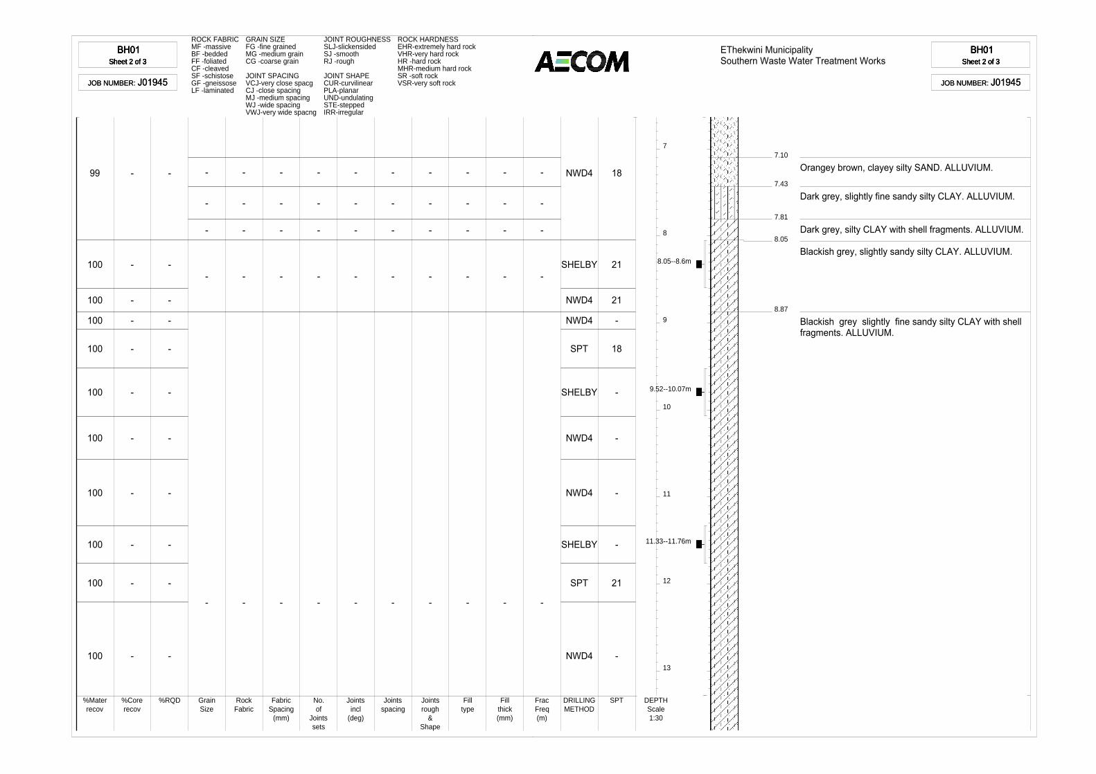
BH01Sheet 2 of 3
BH01Sheet 2 of 3
BH01Sheet 2 of 3
BH01Sheet 2 of 3
JOB NUMBER: J01945JOB NUMBER: J01945
ROCK FABRIC GRAIN SIZE JOINT ROUGHNESS ROCK HARDNESSMF -massive FG -fine grained SLJ-slickensided EHR-extremely hard rockBF -bedded MG -medium grain SJ -smooth VHR-very hard rockFF -foliated CG -coarse grain RJ -rough HR -hard rockCF -cleaved MHR-medium hard rockSF -schistose JOINT SPACING JOINT SHAPE SR -soft rockGF -gneissose VCJ-very close spacg CUR-curvilinear VSR-very soft rockLF -laminated CJ -close spacing PLA-planar
MJ -medium spacing UND-undulatingWJ -wide spacing STE-steppedVWJ-very wide spacng IRR-irregular
7
8
9
10
11
12
13
99
100
100
100
100
100
100
100
100
100
100
-
-
-
-
-
-
-
-
-
-
-
-
-
-
-
-
-
-
-
-
-
-
-
-
-
-
-
-
-
-
-
-
-
-
-
-
-
-
-
-
-
-
-
-
-
-
-
-
-
-
-
-
-
-
-
-
-
-
-
-
-
-
-
-
-
-
-
-
-
-
-
-
NWD4
SHELBY
NWD4
NWD4
SPT
SHELBY
NWD4
NWD4
SHELBY
SPT
NWD4
18
21
21
-
18
-
-
-
-
21
-
%Materrecov
%Corerecov
%RQD GrainSize
RockFabric
FabricSpacing
(mm)
No.of
Jointssets
Jointsincl
(deg)
Jointsspacing
Jointsrough
&Shape
Filltype
Fillthick(mm)
FracFreq(m)
DRILLINGMETHOD
SPT DEPTHScale1:30
8.05--8.6m
9.52--10.07m
11.33--11.76m
EThekwini MunicipalitySouthern Waste Water Treatment Works
BH01Sheet 2 of 3
BH01Sheet 2 of 3
BH01Sheet 2 of 3
BH01Sheet 2 of 3
JOB NUMBER: J01945JOB NUMBER: J01945
7.10
7.43
7.81
8.05
8.87
Orangey brown, clayey silty SAND. ALLUVIUM.
Dark grey, slightly fine sandy silty CLAY. ALLUVIUM.
Dark grey, silty CLAY with shell fragments. ALLUVIUM.
Blackish grey, slightly sandy silty CLAY. ALLUVIUM.
Blackish grey slightly fine sandy silty CLAY with shellfragments. ALLUVIUM.

BH01Sheet 3 of 3
BH01Sheet 3 of 3
BH01Sheet 3 of 3
BH01Sheet 3 of 3
JOB NUMBER: J01945JOB NUMBER: J01945
ROCK FABRIC GRAIN SIZE JOINT ROUGHNESS ROCK HARDNESSMF -massive FG -fine grained SLJ-slickensided EHR-extremely hard rockBF -bedded MG -medium grain SJ -smooth VHR-very hard rockFF -foliated CG -coarse grain RJ -rough HR -hard rockCF -cleaved MHR-medium hard rockSF -schistose JOINT SPACING JOINT SHAPE SR -soft rockGF -gneissose VCJ-very close spacg CUR-curvilinear VSR-very soft rockLF -laminated CJ -close spacing PLA-planar
MJ -medium spacing UND-undulatingWJ -wide spacing STE-steppedVWJ-very wide spacng IRR-irregular
14
15
100
100
98
-
-
-
-
-
-
SHELBY
NWD4
SPT
-
-
21
%Materrecov
%Corerecov
%RQD GrainSize
RockFabric
FabricSpacing
(mm)
No.of
Jointssets
Jointsincl
(deg)
Jointsspacing
Jointsrough
&Shape
Filltype
Fillthick(mm)
FracFreq(m)
DRILLINGMETHOD
SPT DEPTHScale1:30
13.44--13.7m
EThekwini MunicipalitySouthern Waste Water Treatment Works
BH01Sheet 3 of 3
BH01Sheet 3 of 3
BH01Sheet 3 of 3
BH01Sheet 3 of 3
JOB NUMBER: J01945JOB NUMBER: J01945
15.55
NOTES
1) Water level at 1.5m.
2) Undisturbed samples at 8.05--8.6m, 9.52--10.07m,11.33--11.76m and 13.44--13.7m.
CONTRACTOR :MACHINE :
EXCAVATED BY :PROFILED BY :
CHECKED BY :SETUP FILE :
RWBE Geotechnical DrillingYWE - D8Willy MotauRSNKDBorehole.SET
INCLINATION :DIAM :
DATE :
DATE :TEXT :
vertical
02/10/201403/11/2014 07:31..\Dotplot\RevisedBH01.txt
ELEVATION :X-COORD :Y-COORD :
3316055.082609
dotPLOT 7016 PBp7D04D AECOM SA (Pty) Ltd
BH01BH01BH01BH01

BH02ASheet 1 of 3
BH02ASheet 1 of 3
BH02ASheet 1 of 3
BH02ASheet 1 of 3
JOB NUMBER: J01945JOB NUMBER: J01945
ROCK FABRIC GRAIN SIZE JOINT ROUGHNESS ROCK HARDNESSMF -massive FG -fine grained SLJ-slickensided EHR-extremely hard rockBF -bedded MG -medium grain SJ -smooth VHR-very hard rockFF -foliated CG -coarse grain RJ -rough HR -hard rockCF -cleaved MHR-medium hard rockSF -schistose JOINT SPACING JOINT SHAPE SR -soft rockGF -gneissose VCJ-very close spacg CUR-curvilinear VSR-very soft rockLF -laminated CJ -close spacing PLA-planar
MJ -medium spacing UND-undulatingWJ -wide spacing STE-steppedVWJ-very wide spacng IRR-irregular
1
2
3
4
5
6
67
93
71
97
100
38
100
100
95
92
100
-
100
24
100
-
-
-
-
-
-
-
-
-
-
-
-
-
-
-
-
-
-
-
-
-
-
-
-
-
-
-
-
-
-
-
-
-
--
-
-
-
-
--
-
-
-
-
--
-
-
-
-
--
-
-
-
-
--
-
-
-
-
--
-
-
-
-
--
-
-
-
-
--
-
-
-
-
--
-
-
-
-
--
-
NXC
NXC
NXC
NWD4
NWD4
SPT
NWD4
NWD4
NWD4
NWD4
NWD4
SHELBY
NWD4
SPT
NWD4
-
-
-
-
-
4
-
-
-
-
-
-
-
-
-%Materrecov
%Corerecov
%RQD GrainSize
RockFabric
FabricSpacing
(mm)
No.of
Jointssets
Jointsincl
(deg)
Jointsspacing
Jointsrough
&Shape
Filltype
Fillthick(mm)
FracFreq(m)
DRILLINGMETHOD
SPTSPT
DEPTHScale1:30
EThekwini MunicipalitySouthern Waste Water Treatment Works
BH02ASheet 1 of 3
BH02ASheet 1 of 3
BH02ASheet 1 of 3
BH02ASheet 1 of 3
JOB NUMBER: J01945JOB NUMBER: J01945
1.54
0.00
1.70
5.11
5.20
5.47
Slightly orangey brown, slightly gravelly silty SANDwith scattered gravels. FILL
Orangey grey, clayey silty SAND. FILL.
Grey, slightly silty SAND with scattered gravels.ALLUVIUM.
Dark grey, slightly clayey silty SAND. ALLUVIUM.
Dark grey, silty SAND. ALLUVIUM.
Grey, slightly silty SAND. ALLUVIUM.
Scale1:30

BH02ASheet 2 of 3
BH02ASheet 2 of 3
BH02ASheet 2 of 3
BH02ASheet 2 of 3
JOB NUMBER: J01945JOB NUMBER: J01945
ROCK FABRIC GRAIN SIZE JOINT ROUGHNESS ROCK HARDNESSMF -massive FG -fine grained SLJ-slickensided EHR-extremely hard rockBF -bedded MG -medium grain SJ -smooth VHR-very hard rockFF -foliated CG -coarse grain RJ -rough HR -hard rockCF -cleaved MHR-medium hard rockSF -schistose JOINT SPACING JOINT SHAPE SR -soft rockGF -gneissose VCJ-very close spacg CUR-curvilinear VSR-very soft rockLF -laminated CJ -close spacing PLA-planar
MJ -medium spacing UND-undulatingWJ -wide spacing STE-steppedVWJ-very wide spacng IRR-irregular
7
8
9
10
11
12
13
58
43
22
-
100
100
100
93
99
60
38
-
-
-
-
-
-
-
-
-
-
-
-
-
-
-
-
-
-
-
-
-
-
-
-
-
-
-
-
-
-
-
-
-
-
-
-
-
-
-
-
-
-
-
-
-
-
-
-
-
-
-
-
-
-
-
-
-
-
-
-
-
-
-
-
-
-
-
-
-
-
-
-
-
-
-
-
-
-
-
-
-
-
-
-
-
-
-
-
-
-
-
-
SPT
NWD4
NWD4
SPT
NWD4
SHELBY
NWD4
NWD4
NWD4
SPT
NWD4
26
-
-
17
-
-
-
-
-
22
-
%Materrecov
%Corerecov
%RQD GrainSize
RockFabric
FabricSpacing
(mm)
No.of
Jointssets
Jointsincl
(deg)
Jointsspacing
Jointsrough
&Shape
Filltype
Fillthick(mm)
FracFreq(m)
DRILLINGMETHOD
SPTSPT
DEPTHScale1:30
10.23--10.77m
EThekwini MunicipalitySouthern Waste Water Treatment Works
BH02ASheet 2 of 3
BH02ASheet 2 of 3
BH02ASheet 2 of 3
BH02ASheet 2 of 3
JOB NUMBER: J01945JOB NUMBER: J01945
7.05
8.01
9.00
9.45
10.23
10.77
12.94
13.07
Grey, slightly silty SAND. ALLUVIUM.
Light grey, slightly silty SAND. ALLUVIUM.
Interpreted as slightly silty SAND. ALLUVIUM.
Orangey yellowish grey, slightly silty SAND.ALLUVIUM.
Orangey grey, slightly silty SAND. ALLUVIUM.
Orangey pinkish grey, slightly silty SAND. ALLUVIUM.
Interpreted as slightly silty SAND. ALLUVIUM.
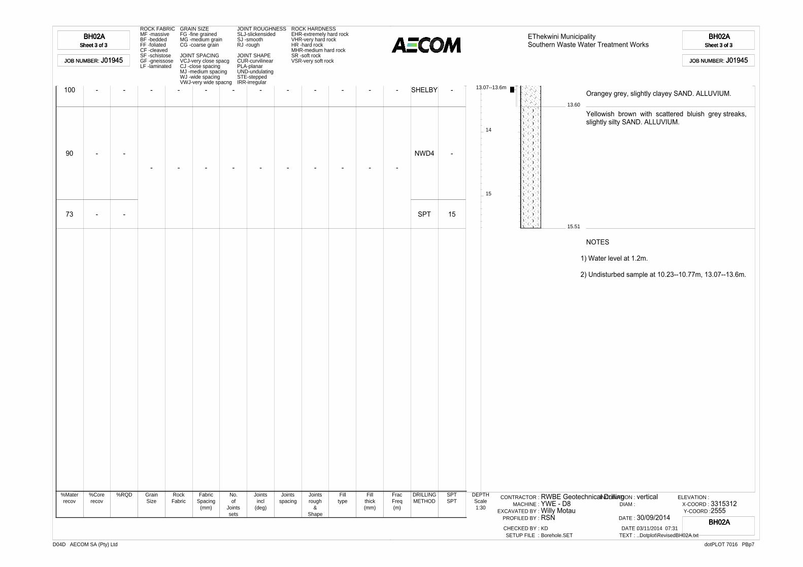
BH02ASheet 3 of 3
BH02ASheet 3 of 3
BH02ASheet 3 of 3
BH02ASheet 3 of 3
JOB NUMBER: J01945JOB NUMBER: J01945
ROCK FABRIC GRAIN SIZE JOINT ROUGHNESS ROCK HARDNESSMF -massive FG -fine grained SLJ-slickensided EHR-extremely hard rockBF -bedded MG -medium grain SJ -smooth VHR-very hard rockFF -foliated CG -coarse grain RJ -rough HR -hard rockCF -cleaved MHR-medium hard rockSF -schistose JOINT SPACING JOINT SHAPE SR -soft rockGF -gneissose VCJ-very close spacg CUR-curvilinear VSR-very soft rockLF -laminated CJ -close spacing PLA-planar
MJ -medium spacing UND-undulatingWJ -wide spacing STE-steppedVWJ-very wide spacng IRR-irregular
14
15
100
90
73
-
-
-
-
-
-
-
-
-
-
-
-
-
-
-
-
-
-
-
-
-
-
-
-
-
-
SHELBY
NWD4
SPT
-
-
15
%Materrecov
%Corerecov
%RQD GrainSize
RockFabric
FabricSpacing
(mm)
No.of
Jointssets
Jointsincl
(deg)
Jointsspacing
Jointsrough
&Shape
Filltype
Fillthick(mm)
FracFreq(m)
DRILLINGMETHOD
SPTSPT
DEPTHScale1:30
13.07--13.6m
EThekwini MunicipalitySouthern Waste Water Treatment Works
BH02ASheet 3 of 3
BH02ASheet 3 of 3
BH02ASheet 3 of 3
BH02ASheet 3 of 3
JOB NUMBER: J01945JOB NUMBER: J01945
13.60
15.51
Orangey grey, slightly clayey SAND. ALLUVIUM.
Yellowish brown with scattered bluish grey streaks,slightly silty SAND. ALLUVIUM.
NOTES
1) Water level at 1.2m.
2) Undisturbed sample at 10.23--10.77m, 13.07--13.6m.
CONTRACTOR :MACHINE :
EXCAVATED BY :PROFILED BY :
CHECKED BY :SETUP FILE :
RWBE Geotechnical DrillingYWE - D8Willy MotauRSNKDBorehole.SET
INCLINATION :DIAM :
DATE :
DATE :TEXT :
vertical
30/09/201403/11/2014 07:31..Dotplot\RevisedBH02A.txt
ELEVATION :X-COORD :Y-COORD :
33153122555
dotPLOT 7016 PBp7D04D AECOM SA (Pty) Ltd
BH02ABH02ABH02ABH02A

BH03Sheet 1 of 3
BH03Sheet 1 of 3
BH03Sheet 1 of 3
BH03Sheet 1 of 3
JOB NUMBER: J01945JOB NUMBER: J01945
ROCK FABRIC GRAIN SIZE JOINT ROUGHNESS ROCK HARDNESSMF -massive FG -fine grained SLJ-slickensided EHR-extremely hard rockBF -bedded MG -medium grain SJ -smooth VHR-very hard rockFF -foliated CG -coarse grain RJ -rough HR -hard rockCF -cleaved MHR-medium hard rockSF -schistose JOINT SPACING JOINT SHAPE SR -soft rockGF -gneissose VCJ-very close spacg CUR-curvilinear VSR-very soft rockLF -laminated CJ -close spacing PLA-planar
MJ -medium spacing UND-undulatingWJ -wide spacing STE-steppedVWJ-very wide spacng IRR-irregular
1
2
3
4
5
6
100
77
49
-
74
100
74
96
65
-
-
-
-
-
-
-
-
-
-
-
-
-
-
-
-
-
-
-
-
-
-
-
-
-
-
-
-
-
-
-
-
-
-
-
-
-
-
-
-
-
-
-
-
-
-
-
-
-
-
-
-
-
-
-
-
-
-
-
-
-
-
-
-
-
-
-
-
-
-
-
-
-
-
-
-
-
-
-
-
-
-
-
-
-
-
-
-
-
-
-
-
-
-
-
-
-
-
-
-
-
-
-
-
-
-
-
-
-
-
-
-
-
-
-
-
-
-
-
-
-
-
-
-
-
-
-
-
-
-
-
NXC
NXC
NWD4
SPT
NWD4
SHELBY
NWD4
SPT
NWD4
SHELBY
-
-
-
4
-
-
-
14
-
-
%Materrecov
%Corerecov
%RQD GrainSize
RockFabric
FabricSpacing
(mm)
No.of
Jointssets
Jointsincl
(deg)
Jointsspacing
Jointsrough
&Shape
Filltype
Fillthick(mm)
FracFreq(m)
DRILLINGMETHOD
SPT DEPTHScale1:30
3.1--3.64m
6.21--6.51m
EThekwini MunicipalitySouthern Waste Water Treatment Works
BH03Sheet 1 of 3
BH03Sheet 1 of 3
BH03Sheet 1 of 3
BH03Sheet 1 of 3
JOB NUMBER: J01945JOB NUMBER: J01945
0.18
0.00
0.52
0.62
1.82
1.97
2.42
3.10
3.64
4.05
4.50
5.60
Greyish brown, silty SAND. FILL.
Dark greyish brown, slightly clayey silty SAND. FILL.
Greyish brown, slightly gravelly silty SAND. FILL.
Orangey brown, slightly silty SAND with scatteredgravels. FILL.
Reddish brown, clayey silty SAND. FILL.
Interpreted as reddish brown, clayey silty SAND. FILL.
Reddish brown, clayey silty SAND. ALLUVIUM.
Reddish brown, clayey silty SAND. ALLUVIUM.
Dark grey, sandy silty CLAY with organic matter. ALLUVIUM.
Dark grey, slightly silty SAND. ALLUVIUM.
Dark grey, silty SAND with some organic matter.ALLUVIUM.
Light grey, slightly silty SAND. ALLUVIUM.
Scale1:30
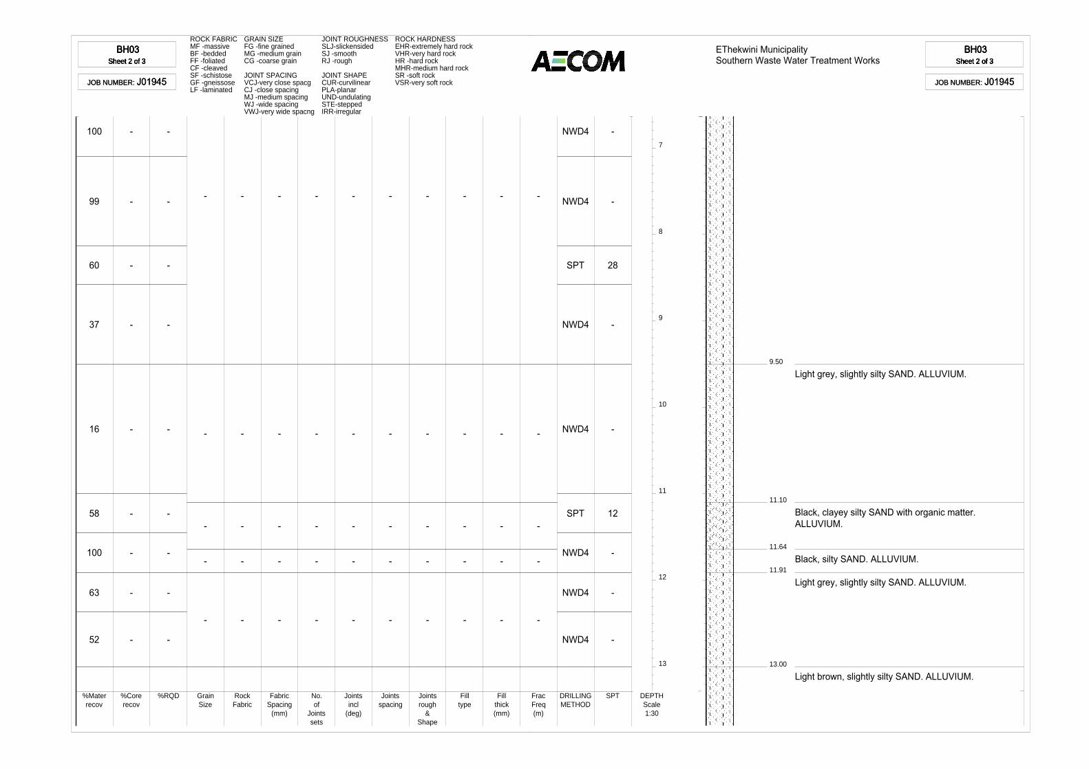
BH03Sheet 2 of 3
BH03Sheet 2 of 3
BH03Sheet 2 of 3
BH03Sheet 2 of 3
JOB NUMBER: J01945JOB NUMBER: J01945
ROCK FABRIC GRAIN SIZE JOINT ROUGHNESS ROCK HARDNESSMF -massive FG -fine grained SLJ-slickensided EHR-extremely hard rockBF -bedded MG -medium grain SJ -smooth VHR-very hard rockFF -foliated CG -coarse grain RJ -rough HR -hard rockCF -cleaved MHR-medium hard rockSF -schistose JOINT SPACING JOINT SHAPE SR -soft rockGF -gneissose VCJ-very close spacg CUR-curvilinear VSR-very soft rockLF -laminated CJ -close spacing PLA-planar
MJ -medium spacing UND-undulatingWJ -wide spacing STE-steppedVWJ-very wide spacng IRR-irregular
7
8
9
10
11
12
13
100
99
60
37
16
58
100
63
52
-
-
-
-
-
-
-
-
-
-
-
-
-
-
-
-
-
-
-
-
-
-
-
-
-
-
-
-
-
-
-
-
-
-
-
-
-
-
-
-
-
-
-
-
-
-
-
-
-
-
-
-
-
-
-
-
-
-
-
-
-
-
-
-
-
-
-
-
NWD4
NWD4
SPT
NWD4
NWD4
SPT
NWD4
NWD4
NWD4
-
-
28
-
-
12
-
-
-
%Materrecov
%Corerecov
%RQD GrainSize
RockFabric
FabricSpacing
(mm)
No.of
Jointssets
Jointsincl
(deg)
Jointsspacing
Jointsrough
&Shape
Filltype
Fillthick(mm)
FracFreq(m)
DRILLINGMETHOD
SPT DEPTHScale1:30
EThekwini MunicipalitySouthern Waste Water Treatment Works
BH03Sheet 2 of 3
BH03Sheet 2 of 3
BH03Sheet 2 of 3
BH03Sheet 2 of 3
JOB NUMBER: J01945JOB NUMBER: J01945
9.50
11.10
11.64
11.91
13.00
Light grey, slightly silty SAND. ALLUVIUM.
Black, clayey silty SAND with organic matter. ALLUVIUM.
Black, silty SAND. ALLUVIUM.
Light grey, slightly silty SAND. ALLUVIUM.
Light brown, slightly silty SAND. ALLUVIUM.

BH03Sheet 3 of 3
BH03Sheet 3 of 3
BH03Sheet 3 of 3
BH03Sheet 3 of 3
JOB NUMBER: J01945JOB NUMBER: J01945
ROCK FABRIC GRAIN SIZE JOINT ROUGHNESS ROCK HARDNESSMF -massive FG -fine grained SLJ-slickensided EHR-extremely hard rockBF -bedded MG -medium grain SJ -smooth VHR-very hard rockFF -foliated CG -coarse grain RJ -rough HR -hard rockCF -cleaved MHR-medium hard rockSF -schistose JOINT SPACING JOINT SHAPE SR -soft rockGF -gneissose VCJ-very close spacg CUR-curvilinear VSR-very soft rockLF -laminated CJ -close spacing PLA-planar
MJ -medium spacing UND-undulatingWJ -wide spacing STE-steppedVWJ-very wide spacng IRR-irregular
14
15
31
93
36
-
-
-
-
-
-
-
-
-
-
-
-
-
-
-
-
-
-
-
-
-
-
-
-
-
-
NWD4
SPT
NWD4
-
58
-
%Materrecov
%Corerecov
%RQD GrainSize
RockFabric
FabricSpacing
(mm)
No.of
Jointssets
Jointsincl
(deg)
Jointsspacing
Jointsrough
&Shape
Filltype
Fillthick(mm)
FracFreq(m)
DRILLINGMETHOD
SPT DEPTHScale1:30
EThekwini MunicipalitySouthern Waste Water Treatment Works
BH03Sheet 3 of 3
BH03Sheet 3 of 3
BH03Sheet 3 of 3
BH03Sheet 3 of 3
JOB NUMBER: J01945JOB NUMBER: J01945
14.45
15.03
Light grey, slightly silty SAND. ALLUVIUM.
NOTES
1) Water level at 1.5m.
2) Undisturbed samples at 3.1--3.64m and 6.21--6.51m.
CONTRACTOR :MACHINE :
EXCAVATED BY :PROFILED BY :
CHECKED BY :SETUP FILE :
RWBE Geotechnical DrillingYWE - D8Willy MotauRSNKDBorehole.SET
INCLINATION :DIAM :
DATE :
DATE :TEXT :
vertical
30/09/201403/11/2014 07:31..\Dotplot\RevisedBH03.txt
ELEVATION :X-COORD :Y-COORD :
33152872522
dotPLOT 7016 PBp7D04D AECOM SA (Pty) Ltd
BH03BH03BH03BH03

BH04Sheet 1 of 3
BH04Sheet 1 of 3
BH04Sheet 1 of 3
BH04Sheet 1 of 3
JOB NUMBER: J01945JOB NUMBER: J01945
ROCK FABRIC GRAIN SIZE JOINT ROUGHNESS ROCK HARDNESSMF -massive FG -fine grained SLJ-slickensided EHR-extremely hard rockBF -bedded MG -medium grain SJ -smooth VHR-very hard rockFF -foliated CG -coarse grain RJ -rough HR -hard rockCF -cleaved MHR-medium hard rockSF -schistose JOINT SPACING JOINT SHAPE SR -soft rockGF -gneissose VCJ-very close spacg CUR-curvilinear VSR-very soft rockLF -laminated CJ -close spacing PLA-planar
MJ -medium spacing UND-undulatingWJ -wide spacing STE-steppedVWJ-very wide spacng IRR-irregular
1
2
3
4
5
6
91
58
78
58
44
62
80
100
51
-
-
-
-
-
-
-
-
-
-
-
-
-
-
-
-
-
-
-
-
-
-
-
-
-
-
-
-
-
-
-
-
-
-
-
-
-
-
-
-
-
-
-
-
-
-
-
-
-
-
-
-
-
-
-
-
-
-
-
-
-
-
-
-
-
-
-
-
-
-
-
-
-
-
-
-
-
-
-
-
-
-
-
-
-
-
-
-
-
-
-
-
-
-
-
-
-
-
-
-
-
-
-
-
-
-
-
-
-
-
-
-
-
-
-
-
-
-
-
-
-
-
-
-
-
-
-
-
NXC
NWD4
NWD4
NWD4
NWD4
SPT
NWD4
NWD4
SPT
-
-
-
-
-
12
-
-
22
%Materrecov
%Corerecov
%RQD GrainSize
RockFabric
FabricSpacing
(mm)
No.of
Jointssets
Jointsincl
(deg)
Jointsspacing
Jointsrough
&Shape
Filltype
Fillthick(mm)
FracFreq(m)
DRILLINGMETHOD
SPT DEPTHScale1:30
EThekwini MunicipalitySouthern Waste Water Treatment Works
BH04Sheet 1 of 3
BH04Sheet 1 of 3
BH04Sheet 1 of 3
BH04Sheet 1 of 3
JOB NUMBER: J01945JOB NUMBER: J01945
0.15
0.00
0.60
0.93
1.60
2.05
2.18
3.10
4.15
4.85
5.04
Brown, silty SAND with scattered gravels. FILL.
Orangey brown, silty SAND with scattered gravels.FILL.
Light brown, slightly silty SAND. FILL.
Grey, silty SAND. FILL.
Light brown, slightly silty SAND. FILL.
Light grey, slightly silty SAND. FILL.
Light brown, slightly silty SAND. ALLUVIUM.
Light brown, silty SAND. ALLUVIUM.
Light brown, slightly silty SAND. ALLUVIUM.
Light brown, slightly clayey silty SAND. ALLUVIUM.
Orangey light brown, silty SAND. ALLUVIUM.
Scale1:30
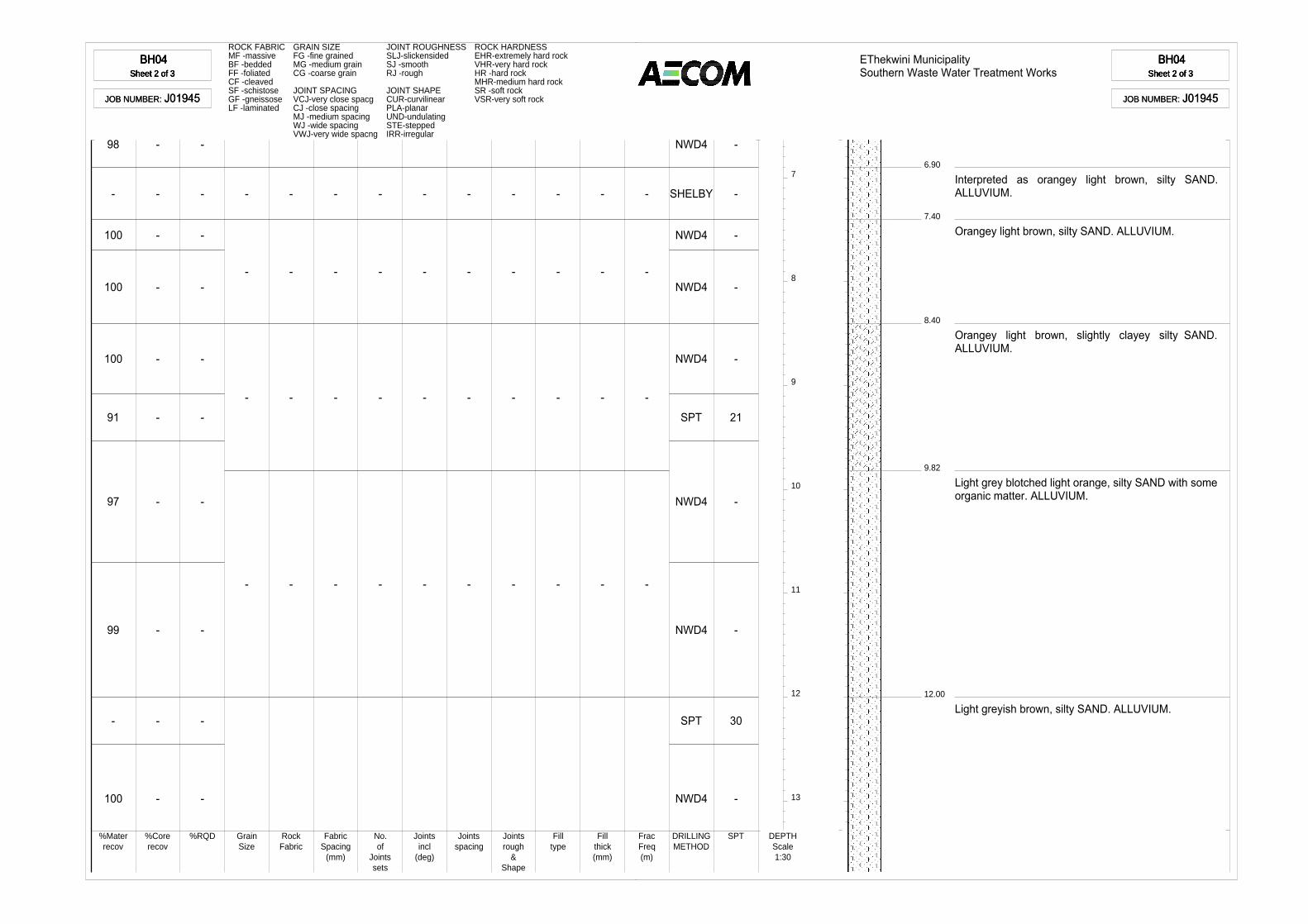
BH04Sheet 2 of 3
BH04Sheet 2 of 3
BH04Sheet 2 of 3
BH04Sheet 2 of 3
JOB NUMBER: J01945JOB NUMBER: J01945
ROCK FABRIC GRAIN SIZE JOINT ROUGHNESS ROCK HARDNESSMF -massive FG -fine grained SLJ-slickensided EHR-extremely hard rockBF -bedded MG -medium grain SJ -smooth VHR-very hard rockFF -foliated CG -coarse grain RJ -rough HR -hard rockCF -cleaved MHR-medium hard rockSF -schistose JOINT SPACING JOINT SHAPE SR -soft rockGF -gneissose VCJ-very close spacg CUR-curvilinear VSR-very soft rockLF -laminated CJ -close spacing PLA-planar
MJ -medium spacing UND-undulatingWJ -wide spacing STE-steppedVWJ-very wide spacng IRR-irregular
7
8
9
10
11
12
13
98
-
100
100
100
91
97
99
-
100
-
-
-
-
-
-
-
-
-
-
-
-
-
-
-
-
-
-
-
-
-
-
-
-
-
-
-
-
-
-
-
-
-
-
-
-
-
-
-
-
-
-
-
-
-
-
-
-
-
-
-
-
-
-
-
-
-
-
-
-
NWD4
SHELBY
NWD4
NWD4
NWD4
SPT
NWD4
NWD4
SPT
NWD4
-
-
-
-
-
21
-
-
30
-
%Materrecov
%Corerecov
%RQD GrainSize
RockFabric
FabricSpacing
(mm)
No.of
Jointssets
Jointsincl
(deg)
Jointsspacing
Jointsrough
&Shape
Filltype
Fillthick(mm)
FracFreq(m)
DRILLINGMETHOD
SPT DEPTHScale1:30
EThekwini MunicipalitySouthern Waste Water Treatment Works
BH04Sheet 2 of 3
BH04Sheet 2 of 3
BH04Sheet 2 of 3
BH04Sheet 2 of 3
JOB NUMBER: J01945JOB NUMBER: J01945
6.90
7.40
8.40
9.82
12.00
Interpreted as orangey light brown, silty SAND.ALLUVIUM.
Orangey light brown, silty SAND. ALLUVIUM.
Orangey light brown, slightly clayey silty SAND.ALLUVIUM.
Light grey blotched light orange, silty SAND with someorganic matter. ALLUVIUM.
Light greyish brown, silty SAND. ALLUVIUM.

BH04Sheet 3 of 3
BH04Sheet 3 of 3
BH04Sheet 3 of 3
BH04Sheet 3 of 3
JOB NUMBER: J01945JOB NUMBER: J01945
ROCK FABRIC GRAIN SIZE JOINT ROUGHNESS ROCK HARDNESSMF -massive FG -fine grained SLJ-slickensided EHR-extremely hard rockBF -bedded MG -medium grain SJ -smooth VHR-very hard rockFF -foliated CG -coarse grain RJ -rough HR -hard rockCF -cleaved MHR-medium hard rockSF -schistose JOINT SPACING JOINT SHAPE SR -soft rockGF -gneissose VCJ-very close spacg CUR-curvilinear VSR-very soft rockLF -laminated CJ -close spacing PLA-planar
MJ -medium spacing UND-undulatingWJ -wide spacing STE-steppedVWJ-very wide spacng IRR-irregular
14
15
95
67
-
-
-
-
- - - - - - - - - -
NWD4
SPT
-
5
%Materrecov
%Corerecov
%RQD GrainSize
RockFabric
FabricSpacing
(mm)
No.of
Jointssets
Jointsincl
(deg)
Jointsspacing
Jointsrough
&Shape
Filltype
Fillthick(mm)
FracFreq(m)
DRILLINGMETHOD
SPT DEPTHScale1:30
EThekwini MunicipalitySouthern Waste Water Treatment Works
BH04Sheet 3 of 3
BH04Sheet 3 of 3
BH04Sheet 3 of 3
BH04Sheet 3 of 3
JOB NUMBER: J01945JOB NUMBER: J01945
15.45
NOTES
1) Water level at 1.0m.
CONTRACTOR :MACHINE :
EXCAVATED BY :PROFILED BY :
CHECKED BY :SETUP FILE :
RWBE Geotechnical DrillingYWE - D8Willy MotauRSNKDBorehole.SET
INCLINATION :DIAM :
DATE :
DATE :TEXT :
vertical
02/10/201403/11/2014 07:32..\Dotplot\RevisedBH04.txt
ELEVATION :X-COORD :Y-COORD :
331531.452556
dotPLOT 7016 PBp7D04D AECOM SA (Pty) Ltd
BH04BH04BH04BH04
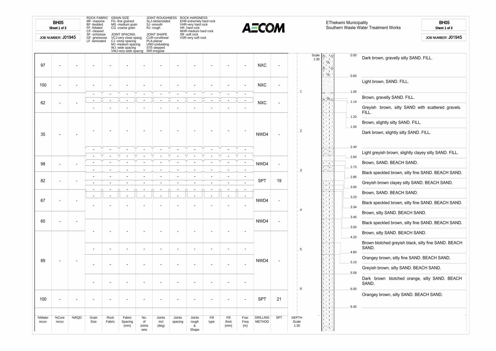
BH05Sheet 1 of 3
BH05Sheet 1 of 3
BH05Sheet 1 of 3
BH05Sheet 1 of 3
JOB NUMBER: J01945JOB NUMBER: J01945
ROCK FABRIC GRAIN SIZE JOINT ROUGHNESS ROCK HARDNESSMF -massive FG -fine grained SLJ-slickensided EHR-extremely hard rockBF -bedded MG -medium grain SJ -smooth VHR-very hard rockFF -foliated CG -coarse grain RJ -rough HR -hard rockCF -cleaved MHR-medium hard rockSF -schistose JOINT SPACING JOINT SHAPE SR -soft rockGF -gneissose VCJ-very close spacg CUR-curvilinear VSR-very soft rockLF -laminated CJ -close spacing PLA-planar
MJ -medium spacing UND-undulatingWJ -wide spacing STE-steppedVWJ-very wide spacng IRR-irregular
1
2
3
4
5
6
97
100
62
35
98
82
67
60
89
100
-
-
-
-
-
-
-
-
-
-
-
-
-
-
-
-
-
-
-
-
-
-
--
-
-
---
-----
-
-
-
-
-
-
-
-
--
-
-
---
-----
-
-
-
-
-
-
-
-
--
-
-
---
-----
-
-
-
-
-
-
-
-
--
-
-
---
-----
-
-
-
-
-
-
-
-
--
-
-
---
-----
-
-
-
-
-
-
-
-
--
-
-
---
-----
-
-
-
-
-
-
-
-
--
-
-
---
-----
-
-
-
-
-
-
-
-
--
-
-
---
-----
-
-
-
-
-
-
-
-
--
-
-
---
-----
-
-
-
-
-
-
-
-
--
-
-
---
-----
-
-
-
-
-
-
NXC
NXC
NXC
NWD4
NWD4
SPT
NWD4
NWD4
NWD4
SPT
-
-
-
-
-
19
-
-
-
21
%Materrecov
%Corerecov
%RQD GrainSize
RockFabric
FabricSpacing
(mm)
No.of
Jointssets
Jointsincl
(deg)
Jointsspacing
Jointsrough
&Shape
Filltype
Fillthick(mm)
FracFreq(m)
DRILLINGMETHOD
SPT DEPTHScale1:30
EThekwini MunicipalitySouthern Waste Water Treatment Works
BH05Sheet 1 of 3
BH05Sheet 1 of 3
BH05Sheet 1 of 3
BH05Sheet 1 of 3
JOB NUMBER: J01945JOB NUMBER: J01945
0.60
0.00
1.00
1.14
1.20
1.50
2.40
2.60
2.73
2.85
3.00
3.23
3.34
3.45
3.50
4.20
4.80
5.10
5.59
6.00
6.45
Dark brown, gravelly silty SAND. FILL.
Light brown, SAND. FILL.
Brown, gravelly SAND. FILL.
Greyish brown, silty SAND with scattered gravels.FILL.
Brown, slightly silty SAND. FILL.
Dark brown, slightly silty SAND. FILL.
Light greyish brown, slightly clayey silty SAND. FILL.
Brown, SAND. BEACH SAND.
Black speckled brown, silty fine SAND. BEACH SAND.
Greyish brown clayey silty SAND. BEACH SAND.
Brown, SAND. BEACH SAND.
Black speckled brown, silty fine SAND. BEACH SAND.
Brown, silty SAND. BEACH SAND.
Black speckled brown, silty fine SAND. BEACH SAND.
Brown, silty SAND. BEACH SAND.
Brown blotched greyish black, silty fine SAND. BEACHSAND.
Orangey brown, silty fine SAND. BEACH SAND.
Greyish brown, silty SAND. BEACH SAND.
Dark brown blotched orange, silty SAND. BEACHSAND.
Orangey brown, silty SAND. BEACH SAND.
Scale1:30

BH05Sheet 2 of 3
BH05Sheet 2 of 3
BH05Sheet 2 of 3
BH05Sheet 2 of 3
JOB NUMBER: J01945JOB NUMBER: J01945
ROCK FABRIC GRAIN SIZE JOINT ROUGHNESS ROCK HARDNESSMF -massive FG -fine grained SLJ-slickensided EHR-extremely hard rockBF -bedded MG -medium grain SJ -smooth VHR-very hard rockFF -foliated CG -coarse grain RJ -rough HR -hard rockCF -cleaved MHR-medium hard rockSF -schistose JOINT SPACING JOINT SHAPE SR -soft rockGF -gneissose VCJ-very close spacg CUR-curvilinear VSR-very soft rockLF -laminated CJ -close spacing PLA-planar
MJ -medium spacing UND-undulatingWJ -wide spacing STE-steppedVWJ-very wide spacng IRR-irregular
7
8
9
10
11
12
13
85
95
91
38
47
92
100
100
100
100
60
-
-
-
-
-
-
-
-
-
-
-
-
-
-
-
-
-
-
-
-
-
-
-
--
-
-
-
-
-
-
-
-
--
-
-
-
-
-
-
-
-
--
-
-
-
-
-
-
-
-
--
-
-
-
-
-
-
-
-
--
-
-
-
-
-
-
-
-
--
-
-
-
-
-
-
-
-
--
-
-
-
-
-
-
-
-
--
-
-
-
-
-
-
-
-
--
-
-
-
-
-
-
-
-
--
-
-
-
-
-
-
-
NWD4
NWD4
NWD4
NWD4
SPT
NWD4
NWD4
SHELBY
NWD4
SPT
NWD4
-
-
-
-
19
-
-
-
-
36
-
%Materrecov
%Corerecov
%RQD GrainSize
RockFabric
FabricSpacing
(mm)
No.of
Jointssets
Jointsincl
(deg)
Jointsspacing
Jointsrough
&Shape
Filltype
Fillthick(mm)
FracFreq(m)
DRILLINGMETHOD
SPT DEPTHScale1:30
11.08--11.47m
EThekwini MunicipalitySouthern Waste Water Treatment Works
BH05Sheet 2 of 3
BH05Sheet 2 of 3
BH05Sheet 2 of 3
BH05Sheet 2 of 3
JOB NUMBER: J01945JOB NUMBER: J01945
6.90
7.00
7.10
7.40
7.55
7.87
8.00
9.00
10.05
Light orangey brown blotched grey, silty SAND.BEACH SAND.
Dark grey, slightly clayey silty SAND. BEACH SAND.
Orangey blotched grey, silty SAND. BEACH SAND.
Orangey brown, silty SAND. BEACH SAND.
Orangey brown, slightly silty SAND. BEACH SAND.
Orangey brown, silty SAND. BEACH SAND.
Greyish brown, silty SAND. BEACH SAND.
Orangey brown, silty SAND. BEACH SAND.
Light grey, silty SAND. BEACH SAND.
Light grey, slightly clayey SAND. BEACH SAND.
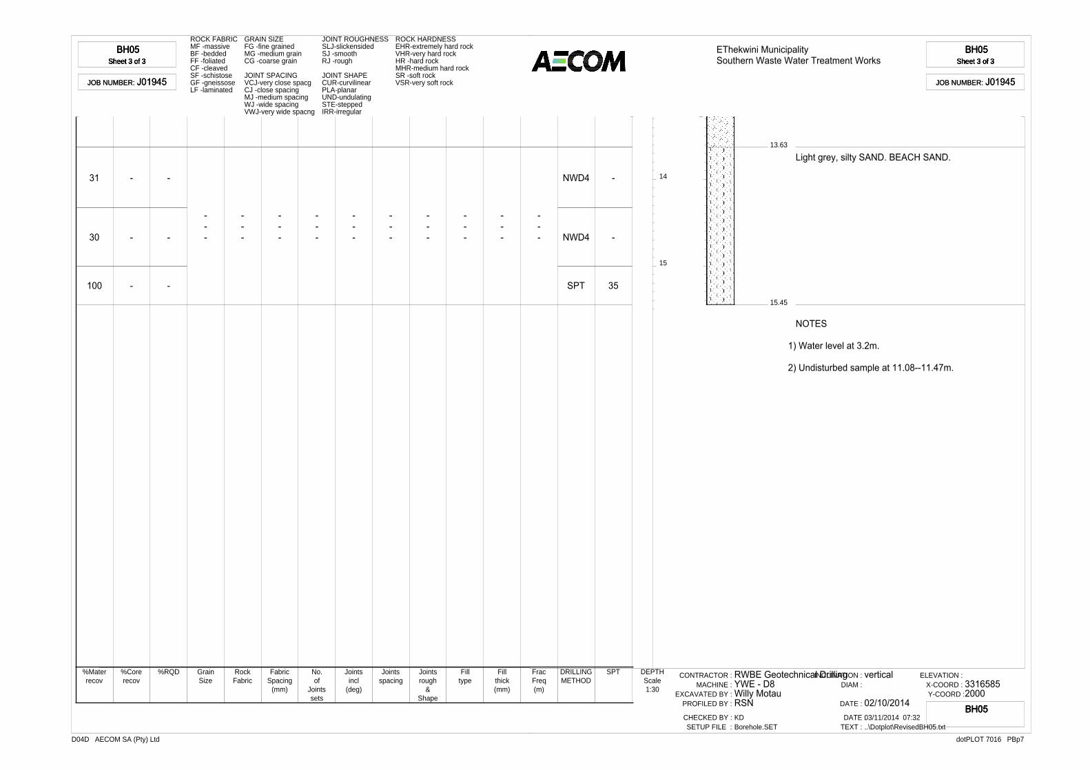
BH05Sheet 3 of 3
BH05Sheet 3 of 3
BH05Sheet 3 of 3
BH05Sheet 3 of 3
JOB NUMBER: J01945JOB NUMBER: J01945
ROCK FABRIC GRAIN SIZE JOINT ROUGHNESS ROCK HARDNESSMF -massive FG -fine grained SLJ-slickensided EHR-extremely hard rockBF -bedded MG -medium grain SJ -smooth VHR-very hard rockFF -foliated CG -coarse grain RJ -rough HR -hard rockCF -cleaved MHR-medium hard rockSF -schistose JOINT SPACING JOINT SHAPE SR -soft rockGF -gneissose VCJ-very close spacg CUR-curvilinear VSR-very soft rockLF -laminated CJ -close spacing PLA-planar
MJ -medium spacing UND-undulatingWJ -wide spacing STE-steppedVWJ-very wide spacng IRR-irregular
14
15
31
30
100
-
-
-
-
-
-
---
---
---
---
---
---
---
---
---
---
NWD4
NWD4
SPT
-
-
35
%Materrecov
%Corerecov
%RQD GrainSize
RockFabric
FabricSpacing
(mm)
No.of
Jointssets
Jointsincl
(deg)
Jointsspacing
Jointsrough
&Shape
Filltype
Fillthick(mm)
FracFreq(m)
DRILLINGMETHOD
SPT DEPTHScale1:30
EThekwini MunicipalitySouthern Waste Water Treatment Works
BH05Sheet 3 of 3
BH05Sheet 3 of 3
BH05Sheet 3 of 3
BH05Sheet 3 of 3
JOB NUMBER: J01945JOB NUMBER: J01945
13.63
15.45
Light grey, silty SAND. BEACH SAND.
NOTES
1) Water level at 3.2m.
2) Undisturbed sample at 11.08--11.47m.
CONTRACTOR :MACHINE :
EXCAVATED BY :PROFILED BY :
CHECKED BY :SETUP FILE :
RWBE Geotechnical DrillingYWE - D8Willy MotauRSNKDBorehole.SET
INCLINATION :DIAM :
DATE :
DATE :TEXT :
vertical
02/10/201403/11/2014 07:32..\Dotplot\RevisedBH05.txt
ELEVATION :X-COORD :Y-COORD :
33165852000
dotPLOT 7016 PBp7D04D AECOM SA (Pty) Ltd
BH05BH05BH05BH05
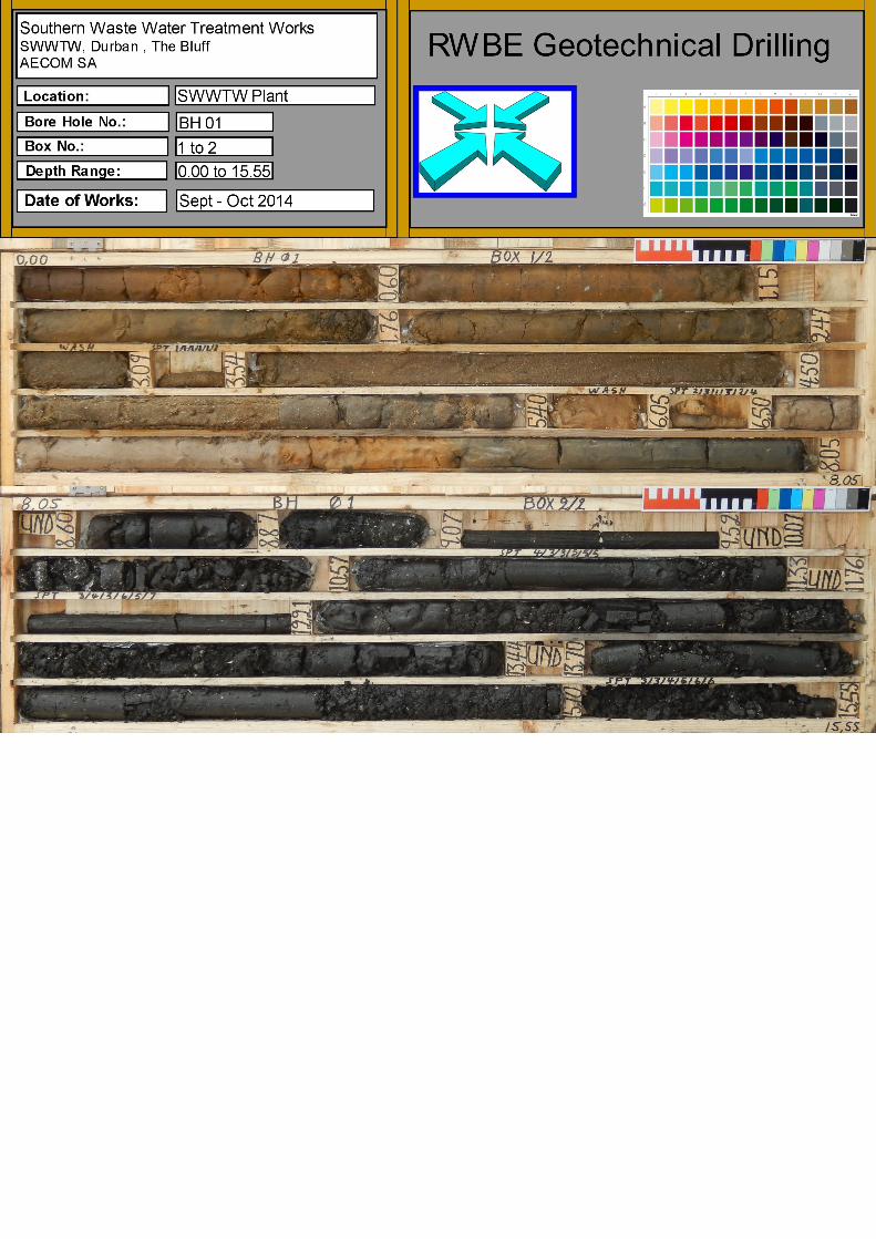
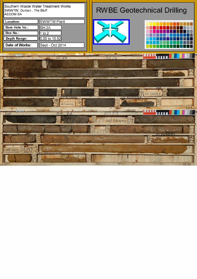


ANNEXURE C
DCP & DPSH RESULTS

DCP RESULTS
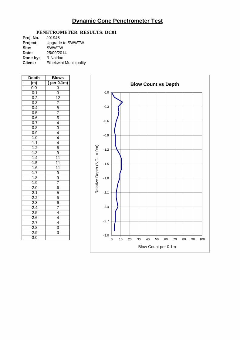
Proj. No. J01945Project: Upgrade to SWWTWSite: SWWTWDate: 25/09/2014Done by: R NaidooClient : Ethekwini Municipality
Depth Blows(m) ( per 0.1m)0.0 0-0.1 3-0.2 12-0.3 7-0.4 8-0.5 7-0.6 5-0.7 4-0.8 3-0.9 4-1.0 4-1.1 4-1.2 6-1.3 9-1.4 11-1.5 11-1.6 11-1.7 9-1.8 9-1.9 7-2.0 6-2.1 5-2.2 5-2.3 6-2.4 7-2.5 4-2.6 4-2.7 4-2.8 3-2.9 3-3.0
Dynamic Cone Penetrometer Test
PENETROMETER RESULTS: DC01
-3.0
-2.7
-2.4
-2.1
-1.8
-1.5
-1.2
-0.9
-0.6
-0.3
0.0
0 10 20 30 40 50 60 70 80 90 100
Rel
ativ
e D
epth
(N
GL
= 0
m)
Blow Count per 0.1m
Blow Count vs Depth
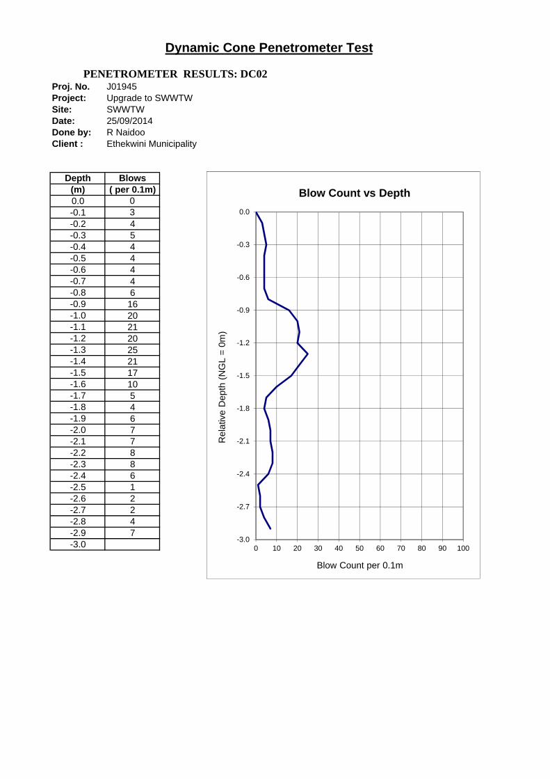
Proj. No. J01945Project: Upgrade to SWWTWSite: SWWTWDate: 25/09/2014Done by: R NaidooClient : Ethekwini Municipality
Depth Blows(m) ( per 0.1m)0.0 0-0.1 3-0.2 4-0.3 5-0.4 4-0.5 4-0.6 4-0.7 4-0.8 6-0.9 16-1.0 20-1.1 21-1.2 20-1.3 25-1.4 21-1.5 17-1.6 10-1.7 5-1.8 4-1.9 6-2.0 7-2.1 7-2.2 8-2.3 8-2.4 6-2.5 1-2.6 2-2.7 2-2.8 4-2.9 7-3.0
Dynamic Cone Penetrometer Test
PENETROMETER RESULTS: DC02
-3.0
-2.7
-2.4
-2.1
-1.8
-1.5
-1.2
-0.9
-0.6
-0.3
0.0
0 10 20 30 40 50 60 70 80 90 100
Rel
ativ
e D
epth
(N
GL
= 0
m)
Blow Count per 0.1m
Blow Count vs Depth

Proj. No. J01945Project: Upgrade to SWWTWSite: SWWTWDate: 25/09/2014Done by: R NaidooClient : Ethekwini Municipality
Depth Blows(m) ( per 0.1m)0.0 0
-0.1 2
-0.2 4
-0.3 5
-0.4 4
-0.5 3
-0.6 3
-0.7 3
-0.8 3
-0.9 3
-1.0 6
-1.1 7
-1.2 8
-1.3 8
-1.4 12
-1.5 13
-1.6 13
-1.7 14
-1.8 9
-1.9 10
-2.0 12
-2.1 10
-2.2 8
-2.3 8
-2.4 6
-2.5 5
-2.6 7
-2.7 9
-2.8 12
-2.9 8
-3.0
Dynamic Cone Penetrometer Test
PENETROMETER RESULTS: DC03
-3.0
-2.7
-2.4
-2.1
-1.8
-1.5
-1.2
-0.9
-0.6
-0.3
0.0
0 10 20 30 40 50 60 70 80 90 100
Rel
ativ
e D
epth
(N
GL
= 0
m)
Blow Count per 0.1m
Blow Count vs Depth

Proj. No. J01945Project: Upgrade to SWWTWSite: SWWTWDate: 25/09/2014Done by: R NaidooClient : Ethekwini Municipality
Depth Blows(m) ( per 0.1m)0.0 0
-0.1 2
-0.2 2
-0.3 6
-0.4 6
-0.5 9
-0.6 6
-0.7 5
-0.8 5
-0.9 3
-1.0 3
-1.1 4
-1.2 3
-1.3 4
-1.4 4
-1.5 3
-1.6 4
-1.7 4
-1.8 5
-1.9 7
-2.0 6
-2.1 8
-2.2 7
-2.3 6
-2.4 9
-2.5 11
-2.6 9
-2.7 3
-2.8 6
-2.9 6
-3.0
Dynamic Cone Penetrometer Test
PENETROMETER RESULTS: DC04
-3.0
-2.7
-2.4
-2.1
-1.8
-1.5
-1.2
-0.9
-0.6
-0.3
0.0
0 10 20 30 40 50 60 70 80 90 100
Rel
ativ
e D
epth
(N
GL
= 0
m)
Blow Count per 0.1m
Blow Count vs Depth
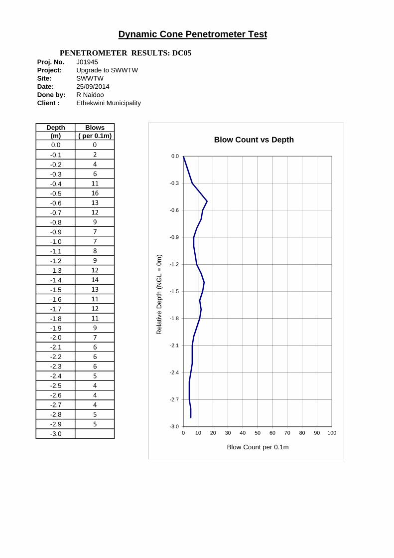
Proj. No. J01945Project: Upgrade to SWWTWSite: SWWTWDate: 25/09/2014Done by: R NaidooClient : Ethekwini Municipality
Depth Blows(m) ( per 0.1m)0.0 0
-0.1 2
-0.2 4
-0.3 6
-0.4 11
-0.5 16
-0.6 13
-0.7 12
-0.8 9
-0.9 7
-1.0 7
-1.1 8
-1.2 9
-1.3 12
-1.4 14
-1.5 13
-1.6 11
-1.7 12
-1.8 11
-1.9 9
-2.0 7
-2.1 6
-2.2 6
-2.3 6
-2.4 5
-2.5 4
-2.6 4
-2.7 4
-2.8 5
-2.9 5
-3.0
Dynamic Cone Penetrometer Test
PENETROMETER RESULTS: DC05
-3.0
-2.7
-2.4
-2.1
-1.8
-1.5
-1.2
-0.9
-0.6
-0.3
0.0
0 10 20 30 40 50 60 70 80 90 100
Rel
ativ
e D
epth
(N
GL
= 0
m)
Blow Count per 0.1m
Blow Count vs Depth
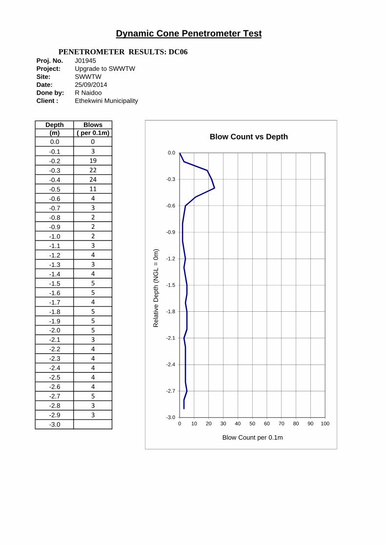
Proj. No. J01945Project: Upgrade to SWWTWSite: SWWTWDate: 25/09/2014Done by: R NaidooClient : Ethekwini Municipality
Depth Blows(m) ( per 0.1m)0.0 0
-0.1 3
-0.2 19
-0.3 22
-0.4 24
-0.5 11
-0.6 4
-0.7 3
-0.8 2
-0.9 2
-1.0 2
-1.1 3
-1.2 4
-1.3 3
-1.4 4
-1.5 5
-1.6 5
-1.7 4
-1.8 5
-1.9 5
-2.0 5
-2.1 3
-2.2 4
-2.3 4
-2.4 4
-2.5 4
-2.6 4
-2.7 5
-2.8 3
-2.9 3
-3.0
Dynamic Cone Penetrometer Test
PENETROMETER RESULTS: DC06
-3.0
-2.7
-2.4
-2.1
-1.8
-1.5
-1.2
-0.9
-0.6
-0.3
0.0
0 10 20 30 40 50 60 70 80 90 100
Rel
ativ
e D
epth
(N
GL
= 0
m)
Blow Count per 0.1m
Blow Count vs Depth
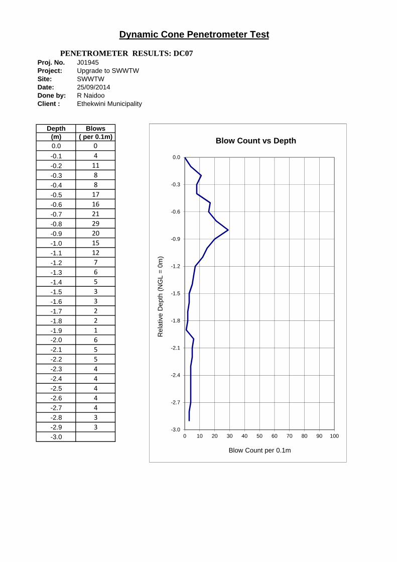
Proj. No. J01945Project: Upgrade to SWWTWSite: SWWTWDate: 25/09/2014Done by: R NaidooClient : Ethekwini Municipality
Depth Blows(m) ( per 0.1m)0.0 0
-0.1 4
-0.2 11
-0.3 8
-0.4 8
-0.5 17
-0.6 16
-0.7 21
-0.8 29
-0.9 20
-1.0 15
-1.1 12
-1.2 7
-1.3 6
-1.4 5
-1.5 3
-1.6 3
-1.7 2
-1.8 2
-1.9 1
-2.0 6
-2.1 5
-2.2 5
-2.3 4
-2.4 4
-2.5 4
-2.6 4
-2.7 4
-2.8 3
-2.9 3
-3.0
Dynamic Cone Penetrometer Test
PENETROMETER RESULTS: DC07
-3.0
-2.7
-2.4
-2.1
-1.8
-1.5
-1.2
-0.9
-0.6
-0.3
0.0
0 10 20 30 40 50 60 70 80 90 100
Rel
ativ
e D
epth
(N
GL
= 0
m)
Blow Count per 0.1m
Blow Count vs Depth

Proj. No. J01945Project: Upgrade to SWWTWSite: SWWTWDate: 25/09/2014Done by: R NaidooClient : Ethekwini Municipality
Depth Blows(m) ( per 0.1m)0.0 0
-0.1 3
-0.2 6
-0.3 10
-0.4 5
-0.5 6
-0.6 5
-0.7 4
-0.8 6
-0.9 5
-1.0 2
-1.1 8
-1.2 8
-1.3 12
-1.4 7
-1.5 7
-1.6 4
-1.7 6
-1.8 5
-1.9 6
-2.0 6
-2.1 7
-2.2 7
-2.3 7
-2.4 7
-2.5 7
-2.6 10
-2.7 11
-2.8 11
-2.9 12
-3.0
Dynamic Cone Penetrometer Test
PENETROMETER RESULTS: DC08
-3.0
-2.7
-2.4
-2.1
-1.8
-1.5
-1.2
-0.9
-0.6
-0.3
0.0
0 10 20 30 40 50 60 70 80 90 100
Rel
ativ
e D
epth
(N
GL
= 0
m)
Blow Count per 0.1m
Blow Count vs Depth

Proj. No. J01945Project: Upgrade to SWWTWSite: SWWTWDate: 25/09/2014Done by: R NaidooClient : Ethekwini Municipality
Depth Blows(m) ( per 0.1m)0.0 0
-0.1 3
-0.2 4
-0.3 4
-0.4 4
-0.5 5
-0.6 7
-0.7 7
-0.8 6
-0.9 5
-1.0 5
-1.1 4
-1.2 3
-1.3 3
-1.4 2
-1.5 3
-1.6 2
-1.7 2
-1.8 2
-1.9 3
-2.0 2
-2.1 3
-2.2 4
-2.3 3
-2.4 4
-2.5 3
-2.6 4
-2.7 4
-2.8 4
-2.9 4
-3.0
Dynamic Cone Penetrometer Test
PENETROMETER RESULTS: DC09
-3.0
-2.7
-2.4
-2.1
-1.8
-1.5
-1.2
-0.9
-0.6
-0.3
0.0
0 10 20 30 40 50 60 70 80 90 100
Rel
ativ
e D
epth
(N
GL
= 0
m)
Blow Count per 0.1m
Blow Count vs Depth
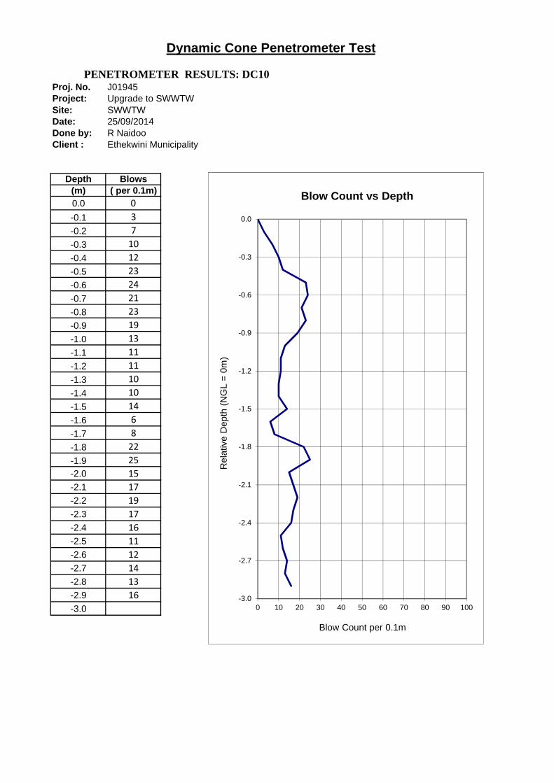
Proj. No. J01945Project: Upgrade to SWWTWSite: SWWTWDate: 25/09/2014Done by: R NaidooClient : Ethekwini Municipality
Depth Blows(m) ( per 0.1m)0.0 0
-0.1 3
-0.2 7
-0.3 10
-0.4 12
-0.5 23
-0.6 24
-0.7 21
-0.8 23
-0.9 19
-1.0 13
-1.1 11
-1.2 11
-1.3 10
-1.4 10
-1.5 14
-1.6 6
-1.7 8
-1.8 22
-1.9 25
-2.0 15
-2.1 17
-2.2 19
-2.3 17
-2.4 16
-2.5 11
-2.6 12
-2.7 14
-2.8 13
-2.9 16
-3.0
Dynamic Cone Penetrometer Test
PENETROMETER RESULTS: DC10
-3.0
-2.7
-2.4
-2.1
-1.8
-1.5
-1.2
-0.9
-0.6
-0.3
0.0
0 10 20 30 40 50 60 70 80 90 100
Rel
ativ
e D
epth
(N
GL
= 0
m)
Blow Count per 0.1m
Blow Count vs Depth
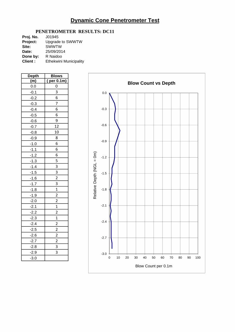
Proj. No. J01945Project: Upgrade to SWWTWSite: SWWTWDate: 25/09/2014Done by: R NaidooClient : Ethekwini Municipality
Depth Blows(m) ( per 0.1m)0.0 0
-0.1 3
-0.2 6
-0.3 7
-0.4 6
-0.5 6
-0.6 9
-0.7 12
-0.8 10
-0.9 8
-1.0 6
-1.1 6
-1.2 6
-1.3 5
-1.4 3
-1.5 3
-1.6 2
-1.7 3
-1.8 1
-1.9 2
-2.0 2
-2.1 1
-2.2 2
-2.3 1
-2.4 2
-2.5 2
-2.6 2
-2.7 2
-2.8 3
-2.9 3
-3.0
Dynamic Cone Penetrometer Test
PENETROMETER RESULTS: DC11
-3.0
-2.7
-2.4
-2.1
-1.8
-1.5
-1.2
-0.9
-0.6
-0.3
0.0
0 10 20 30 40 50 60 70 80 90 100
Rel
ativ
e D
epth
(N
GL
= 0
m)
Blow Count per 0.1m
Blow Count vs Depth

Proj. No. J01945Project: Upgrade to SWWTWSite: SWWTWDate: 25/09/2014Done by: R NaidooClient : Ethekwini Municipality
Depth Blows(m) ( per 0.1m)0.0 0
-0.1 3
-0.2 4
-0.3 4
-0.4 4
-0.5 12
-0.6 7
-0.7 7
-0.8 8
-0.9 6
-1.0 4
-1.1 3
-1.2 3
-1.3 2
-1.4 2
-1.5 2
-1.6 2
-1.7 3
-1.8 2
-1.9 3
-2.0 3
-2.1 3
-2.2 3
-2.3 3
-2.4 3
-2.5 4
-2.6 4
-2.7 4
-2.8 4
-2.9 4
-3.0
Dynamic Cone Penetrometer Test
PENETROMETER RESULTS: DC12
-3.0
-2.7
-2.4
-2.1
-1.8
-1.5
-1.2
-0.9
-0.6
-0.3
0.0
0 10 20 30 40 50 60 70 80 90 100
Rel
ativ
e D
epth
(N
GL
= 0
m)
Blow Count per 0.1m
Blow Count vs Depth
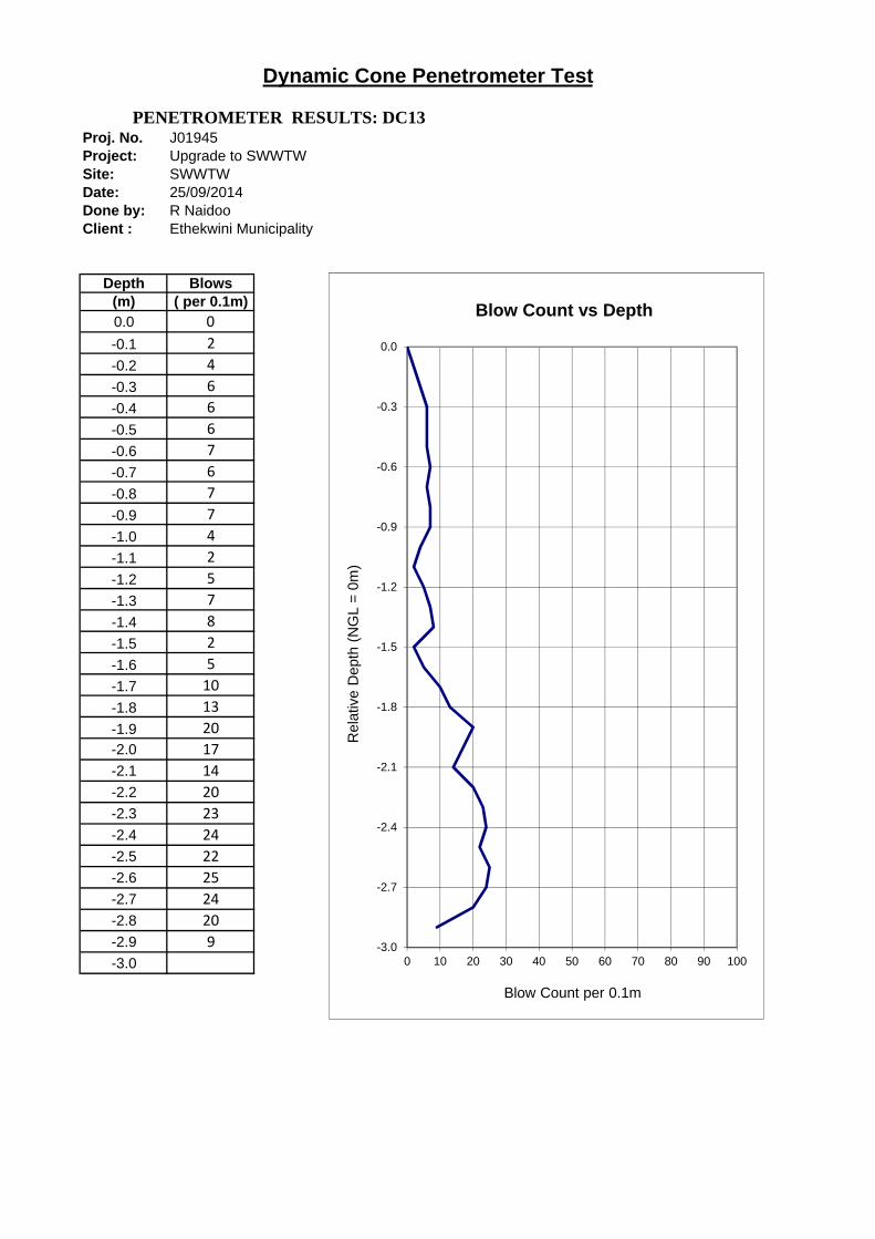
Proj. No. J01945Project: Upgrade to SWWTWSite: SWWTWDate: 25/09/2014Done by: R NaidooClient : Ethekwini Municipality
Depth Blows(m) ( per 0.1m)0.0 0
-0.1 2
-0.2 4
-0.3 6
-0.4 6
-0.5 6
-0.6 7
-0.7 6
-0.8 7
-0.9 7
-1.0 4
-1.1 2
-1.2 5
-1.3 7
-1.4 8
-1.5 2
-1.6 5
-1.7 10
-1.8 13
-1.9 20
-2.0 17
-2.1 14
-2.2 20
-2.3 23
-2.4 24
-2.5 22
-2.6 25
-2.7 24
-2.8 20
-2.9 9
-3.0
Dynamic Cone Penetrometer Test
PENETROMETER RESULTS: DC13
-3.0
-2.7
-2.4
-2.1
-1.8
-1.5
-1.2
-0.9
-0.6
-0.3
0.0
0 10 20 30 40 50 60 70 80 90 100
Rel
ativ
e D
epth
(N
GL
= 0
m)
Blow Count per 0.1m
Blow Count vs Depth

Proj. No. J01945Project: Upgrade to SWWTWSite: SWWTWDate: 25/09/2014Done by: R NaidooClient : Ethekwini Municipality
Depth Blows(m) ( per 0.1m)0.0 0
-0.1 3
-0.2 2
-0.3 2
-0.4 3
-0.5 9
-0.6 16
-0.7 22
-0.8 26
-0.9 21
-1.0 15
-1.1 10
-1.2 12
-1.3 10
-1.4 7
-1.5 7
-1.6 8
-1.7 7
-1.8 9
-1.9 8
-2.0 12
-2.1 16
-2.2 23
-2.3 24
-2.4 15
-2.5 21
-2.6 23
-2.7 24
-2.8 24
-2.9 22
-3.0
Dynamic Cone Penetrometer Test
PENETROMETER RESULTS: DC14
-3.0
-2.7
-2.4
-2.1
-1.8
-1.5
-1.2
-0.9
-0.6
-0.3
0.0
0 10 20 30 40 50 60 70 80 90 100
Rel
ativ
e D
epth
(N
GL
= 0
m)
Blow Count per 0.1m
Blow Count vs Depth

Proj. No. J01945Project: Upgrade to SWWTWSite: SWWTWDate: 25/09/2014Done by: R NaidooClient : Ethekwini Municipality
Depth Blows(m) ( per 0.1m)0.0 0
-0.1 1
-0.2 2
-0.3 3
-0.4 5
-0.5 4
-0.6 4
-0.7 1
-0.8 1
-0.9 0
-1.0 0
-1.1 2
-1.2 2
-1.3 4
-1.4 4
-1.5 11
-1.6 13
-1.7 17
-1.8 16
-1.9 16
-2.0 16
-2.1 16
-2.2 10
-2.3 10
-2.4 16
-2.5 17
-2.6 19
-2.7 20
-2.8 7
-2.9 7
-3.0
Dynamic Cone Penetrometer Test
PENETROMETER RESULTS: DC15
-3.0
-2.7
-2.4
-2.1
-1.8
-1.5
-1.2
-0.9
-0.6
-0.3
0.0
0 10 20 30 40 50 60 70 80 90 100
Rel
ativ
e D
epth
(N
GL
= 0
m)
Blow Count per 0.1m
Blow Count vs Depth
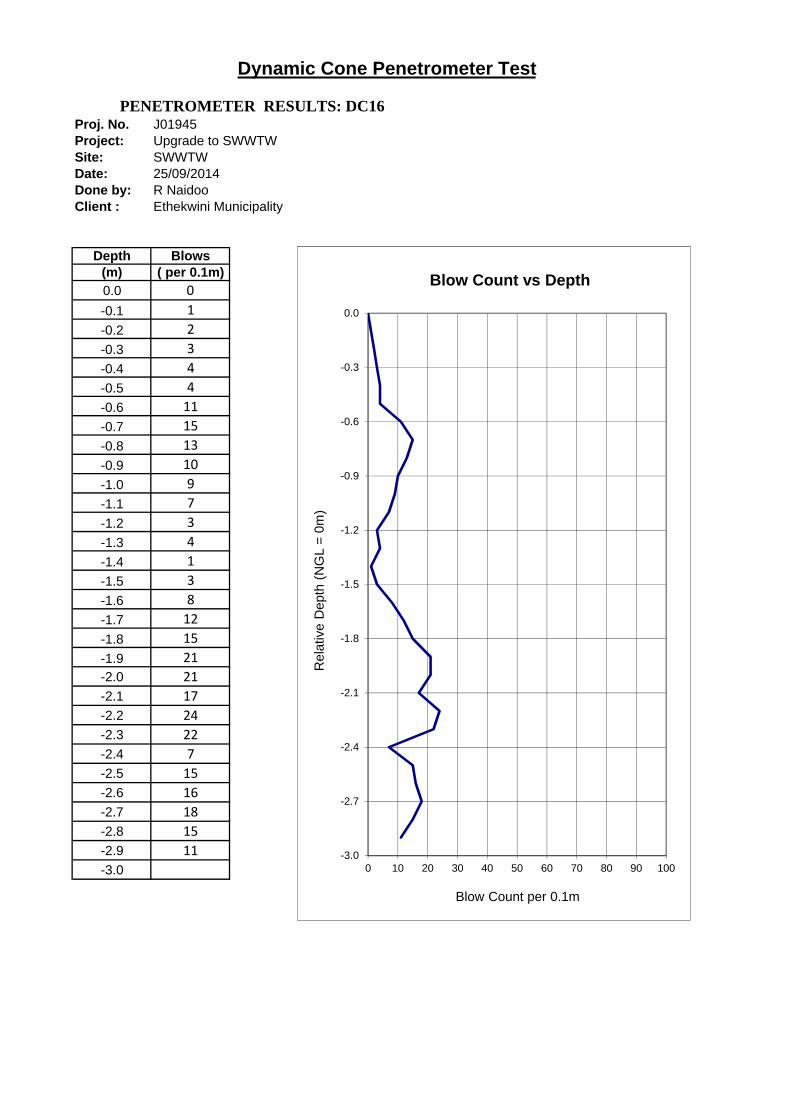
Proj. No. J01945Project: Upgrade to SWWTWSite: SWWTWDate: 25/09/2014Done by: R NaidooClient : Ethekwini Municipality
Depth Blows(m) ( per 0.1m)0.0 0
-0.1 1
-0.2 2
-0.3 3
-0.4 4
-0.5 4
-0.6 11
-0.7 15
-0.8 13
-0.9 10
-1.0 9
-1.1 7
-1.2 3
-1.3 4
-1.4 1
-1.5 3
-1.6 8
-1.7 12
-1.8 15
-1.9 21
-2.0 21
-2.1 17
-2.2 24
-2.3 22
-2.4 7
-2.5 15
-2.6 16
-2.7 18
-2.8 15
-2.9 11
-3.0
Dynamic Cone Penetrometer Test
PENETROMETER RESULTS: DC16
-3.0
-2.7
-2.4
-2.1
-1.8
-1.5
-1.2
-0.9
-0.6
-0.3
0.0
0 10 20 30 40 50 60 70 80 90 100
Rel
ativ
e D
epth
(N
GL
= 0
m)
Blow Count per 0.1m
Blow Count vs Depth
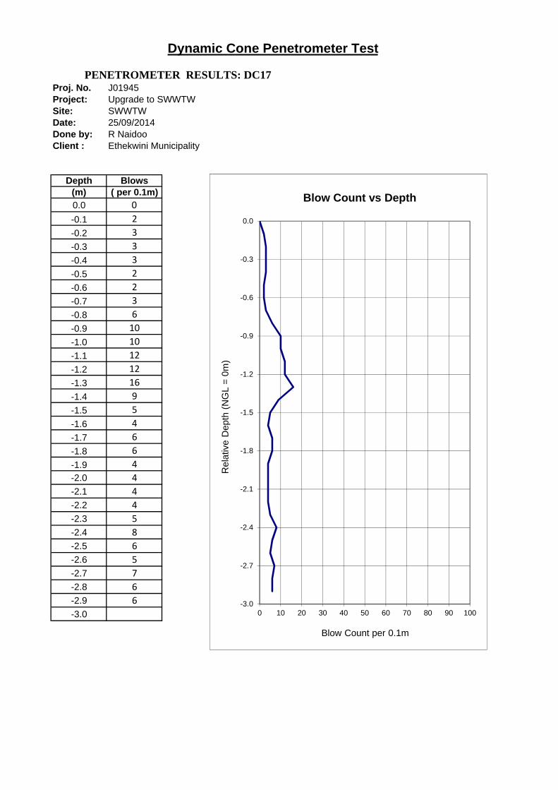
Proj. No. J01945Project: Upgrade to SWWTWSite: SWWTWDate: 25/09/2014Done by: R NaidooClient : Ethekwini Municipality
Depth Blows(m) ( per 0.1m)0.0 0
-0.1 2
-0.2 3
-0.3 3
-0.4 3
-0.5 2
-0.6 2
-0.7 3
-0.8 6
-0.9 10
-1.0 10
-1.1 12
-1.2 12
-1.3 16
-1.4 9
-1.5 5
-1.6 4
-1.7 6
-1.8 6
-1.9 4
-2.0 4
-2.1 4
-2.2 4
-2.3 5
-2.4 8
-2.5 6
-2.6 5
-2.7 7
-2.8 6
-2.9 6
-3.0
Dynamic Cone Penetrometer Test
PENETROMETER RESULTS: DC17
-3.0
-2.7
-2.4
-2.1
-1.8
-1.5
-1.2
-0.9
-0.6
-0.3
0.0
0 10 20 30 40 50 60 70 80 90 100
Rel
ativ
e D
epth
(N
GL
= 0
m)
Blow Count per 0.1m
Blow Count vs Depth

DPSH RESULTS
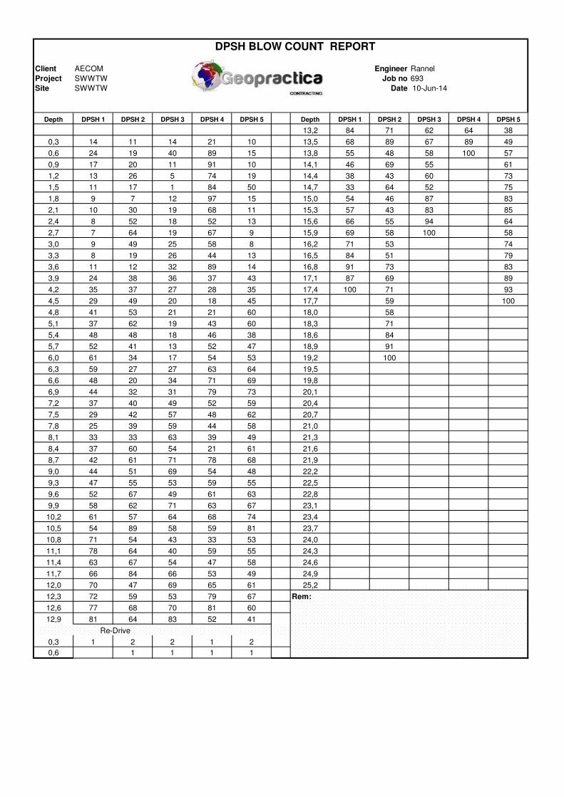
Client AECOM Engineer Rannel
Project SWWTW Job no 693
Site SWWTW Date 10-Jun-14
Depth DPSH 1 DPSH 2 DPSH 3 DPSH 4 DPSH 5 Depth DPSH 1 DPSH 2 DPSH 3 DPSH 4 DPSH 5
13,2 84 71 62 64 38
0,3 14 11 14 21 10 13,5 68 89 67 89 49
0,6 24 19 40 89 15 13,8 55 48 58 100 57
0,9 17 20 11 91 10 14,1 46 69 55 61
1,2 13 26 5 74 19 14,4 38 43 60 73
1,5 11 17 1 84 50 14,7 33 64 52 75
1,8 9 7 12 97 15 15,0 54 46 87 83
2,1 10 30 19 68 11 15,3 57 43 83 85
2,4 8 52 18 52 13 15,6 66 55 94 64
2,7 7 64 19 67 9 15,9 69 58 100 58
3,0 9 49 25 58 8 16,2 71 53 74
3,3 8 19 26 44 13 16,5 84 51 79
3,6 11 12 32 89 14 16,8 91 73 83
3,9 24 38 36 37 43 17,1 87 69 89
4,2 35 37 27 28 35 17,4 100 71 93
4,5 29 49 20 18 45 17,7 59 100
4,8 41 53 21 21 60 18,0 58
5,1 37 62 19 43 60 18,3 71
5,4 48 48 18 46 38 18,6 84
5,7 52 41 13 52 47 18,9 91
6,0 61 34 17 54 53 19,2 100
6,3 59 27 27 63 64 19,5
6,6 48 20 34 71 69 19,8
6,9 44 32 31 79 73 20,1
7,2 37 40 49 52 59 20,4
7,5 29 42 57 48 62 20,7
7,8 25 39 59 44 58 21,0
8,1 33 33 63 39 49 21,3
8,4 37 60 54 21 61 21,6
8,7 42 61 71 78 68 21,9
9,0 44 51 69 54 48 22,2
9,3 47 55 53 59 55 22,5
9,6 52 67 49 61 63 22,8
9,9 58 62 71 63 67 23,1
10,2 61 57 64 68 74 23,4
10,5 54 89 58 59 81 23,7
10,8 71 54 43 33 53 24,0
11,1 78 64 40 59 55 24,3
11,4 63 67 54 47 58 24,6
11,7 66 84 66 53 49 24,9
12,0 70 47 69 65 61 25,2
12,3 72 59 53 79 67 Rem:
12,6 77 68 70 81 60
12,9 81 64 83 52 41
Re-Drive
0,3 1 2 2 1 2
0,6 1 1 1 1
DPSH BLOW COUNT REPORT

-20,0
-18,0
-16,0
-14,0
-12,0
-10,0
-8,0
-6,0
-4,0
-2,0
0,0
0 10 20 30 40 50 60 70 80 90 100 110
DE
PT
H (
m)
BLOW COUNT
DPSH 1 DPSH 2 DPSH 3 DPSH 4 DPSH 5
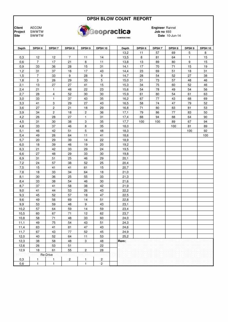
Client AECOM Engineer Rannel
Project SWWTW Job no 693
Site SWWTW Date 10-Jun-14
Depth DPSH 6 DPSH 7 DPSH 8 DPSH 9 DPSH 10 Depth DPSH 6 DPSH 7 DPSH 8 DPSH 9 DPSH 10
13,2 11 57 69 5 8
0,3 12 12 7 11 14 13,5 8 81 64 1 15
0,6 7 17 21 8 11 13,8 13 89 80 9 15
0,9 33 36 28 15 31 14,1 17 70 71 15 19
1,2 31 37 16 17 43 14,4 23 69 51 18 31
1,5 7 33 9 28 9 14,7 28 54 52 27 38
1,8 3 26 29 33 5 15,0 31 73 57 48 46
2,1 13 27 27 41 15 15,3 34 75 60 52 46
2,4 21 1 48 22 23 15,6 54 78 49 54 56
2,7 28 4 52 30 30 15,9 61 80 54 61 63
3,0 33 1 37 43 35 16,2 67 77 43 68 69
3,3 41 3 29 27 43 16,5 58 74 47 79 52
3,6 27 2 21 18 29 16,8 71 80 83 81 53
3,9 34 2 18 2 36 17,1 79 86 77 83 50
4,2 26 28 27 1 31 17,4 88 94 88 64 90
4,5 31 30 38 3 35 17,7 100 100 89 67 94
4,8 33 37 46 8 35 18,0 100 81 89
5,1 46 42 51 5 48 18,3 100 92
5,4 49 26 64 11 41 18,6 100
5,7 20 29 39 14 22 18,9
6,0 18 39 46 19 20 19,2
6,3 21 42 33 29 24 19,5
6,6 27 48 29 33 30 19,8
6,9 31 51 25 46 29 20,1
7,2 24 57 38 52 25 20,4
7,5 15 41 41 61 15 20,7
7,8 18 33 34 64 18 21,0
8,1 30 36 25 55 33 21,3
8,4 33 38 54 46 30 21,6
8,7 37 41 58 38 42 21,9
9,0 41 44 53 26 43 22,2
9,3 45 52 57 18 47 22,5
9,6 49 56 69 14 51 22,8
9,9 53 59 48 9 43 23,1
10,2 57 64 59 14 59 23,4
10,5 60 67 71 12 62 23,7
10,8 58 71 48 33 60 24,0
11,1 49 75 54 43 51 24,3
11,4 63 41 81 47 43 24,6
11,7 67 43 77 52 45 24,9
12,0 40 52 64 11 53 25,2
12,3 38 58 48 3 48 Rem:
12,6 26 53 51 22
12,9 18 61 55 2 28
Re-Drive
0,3 1 1 2 1 2
0,6 1 1 1 2
DPSH BLOW COUNT REPORT
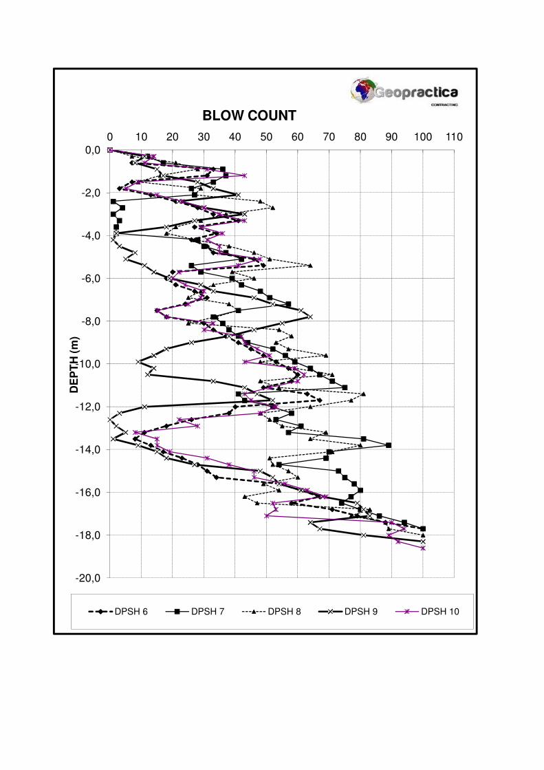
-20,0
-18,0
-16,0
-14,0
-12,0
-10,0
-8,0
-6,0
-4,0
-2,0
0,0
0 10 20 30 40 50 60 70 80 90 100 110
DE
PT
H (
m)
BLOW COUNT
DPSH 6 DPSH 7 DPSH 8 DPSH 9 DPSH 10

Client AECOM Engineer Rannel
Project SWWTW Job no 693
Site SWWTW Date 10-Jun-14
Depth DPSH 11 DPSH 12 DPSH 13 Depth DPSH 11 DPSH 12 DPSH 13
13,2 70 57
0,3 8 11 18 13,5 65 81
0,6 26 21 25 13,8 81 89
0,9 36 32 28 14,1 72 70
1,2 34 42 25 14,4 52 69
1,5 12 18 29 14,7 53 54
1,8 16 19 29 15,0 58 73
2,1 28 25 27 15,3 60 75
2,4 37 34 36 15,6 49 78
2,7 56 48 38 15,9 54 80
3,0 52 46 37 16,2 43 77
3,3 49 44 32 16,5 47 74
3,6 32 42 38 16,8 84 80
3,9 36 49 43 17,1 78 86
4,2 34 38 48 17,4 89 94
4,5 32 36 56 17,7 90 100
4,8 27 37 52 18,0 100
5,1 36 42 51 18,3
5,4 64 54 59 18,6
5,7 76 48 66 18,9
6,0 42 49 78 19,2
6,3 42 32 82 19,5
6,6 52 48 81 19,8
6,9 55 51 93 20,1
7,2 60 57 96 20,4
7,5 49 41 100 20,7
7,8 38 33 21,0
8,1 33 36 21,3
8,4 42 38 21,6
8,7 43 41 21,9
9,0 42 44 22,2
9,3 46 52 22,5
9,6 48 56 22,8
9,9 52 59 23,1
10,2 59 64 23,4
10,5 52 67 23,7
10,8 49 71 24,0
11,1 55 75 24,3
11,4 46 41 24,6
11,7 37 43 24,9
12,0 64 52 25,2
12,3 49 58 Rem:
12,6 52 53
12,9 56 61
Re-Drive
0,3 1 1 1
0,6 1 1 1
DPSH BLOW COUNT REPORT
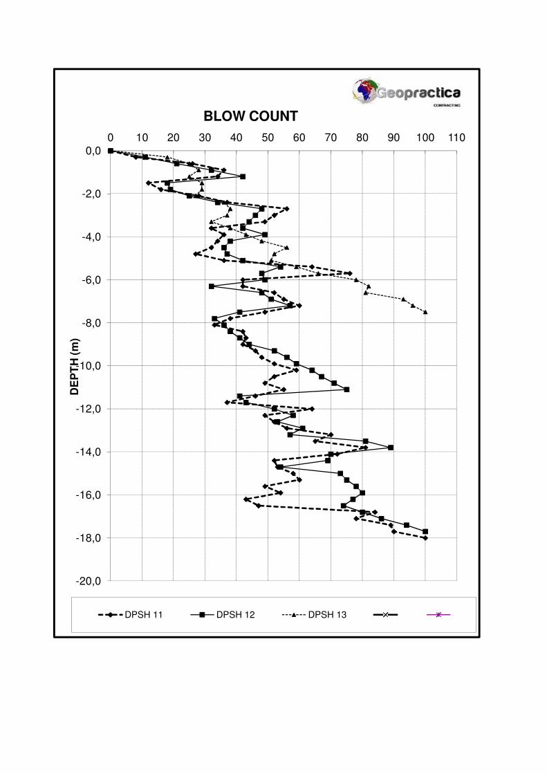
-20,0
-18,0
-16,0
-14,0
-12,0
-10,0
-8,0
-6,0
-4,0
-2,0
0,0
0 10 20 30 40 50 60 70 80 90 100 110
DE
PT
H (
m)
BLOW COUNT
DPSH 11 DPSH 12 DPSH 13

ANNEXURE D
LABORATORY RESULTS
FOUNDATION INDICATOR RESULT
Page 1 of 66
CLIENT : Aecom ADDRESS : 1st Floor, 17 The Boulevard Westway Office Park Westville 3630 ATTENTION : Mr R. Naidoo PROJECT : Southern Waste Water Treatment
TEST REPORT REFERENCE NUMBER: 19213 Dear Sir/Madam, Enclosed herewith, please find the original reports pertaining to the above-mentioned project. Date Received 08.10.2014 Date Tested 08.10.2014 to 28.10.2014 Sample Location Refer to Report Sampling Method N/A Sample Condition Moist Sampling Environmental Condition N/A Sampler(s) Name Client Total Number of Pages 30
Test Carried Out TMH1 Method A1, B4, A5
TMH1 Method C3
TMH1 Method A2, A3, A4
TMH1 Method C4a
TMH1 Method A7
TMH1 Method B6
TMH1 Method A8, A9
Hydrometer Analysis - ASTM D422
TMH1 Method A10(b) SANS 5863 TMH1 Method A13T + A14app SANS 5862-1 TMH1 Method A15d SANS 5860, 5861-1, 5861-2, 5861-3 TMH1 Method A13T + A16T TMH1 Method B9
- Tick denotes tests that were carried out. We would like to take this opportunity of thanking you for your continued support. Should you have any queries please do not hesitate to contact me. Yours faithfully
___________________ Technical Signatory, Kris Veeran for Geosure (Pty) Ltd. This report may not be reproduced except in full, without written permission from Geosure (Pty) Ltd. While every care is taken to ensure the correctness of all tests and reports, neither Geosure (Pty) Ltd or its employees shall be liable in any way whatsoever for any error made in the execution or reporting of tests or any erroneous conclusions drawn there from or any consequence thereof. This report relates only to the sample/s tested.
Head Office 122 Intersite Avenue, Umgeni Business Park, Durban 4091, South Africa PO Box 1461, Westville, 3630, South Africa Tel.: +27 (0)861 GEOSURE / 0861 436 7873 Fax: +27 (0)86 689 5506 Mobile: +27 (0)82 784 0544 E-mail: [email protected]
Civil Engineering Laboratory 122 Intersite Avenue, Umgeni Business Park, Durban, 4091, South Africa PO Box 1461, Westville, 3630, South Africa Tel: 031 701 9732 Fax: +27 (0) 86 684 9785 Mobile: 072 870 2621 E-mail: [email protected]
Gauteng Branch P. O. Box 32381, Kyalami 1684 Tel.: 0861 GEOSURE / 0861 436 7873 Fax: 086 689 8327 Mobile: 083 377 6559 Email: [email protected]

LABORATORY AND HEAD OFFICE ADDRESS: 122 Intersite Avenue, Umgeni Business Park, Durban, 4091
LABORATORY CONTACT INFO.: Tel.: +27(0) 31 701 9732 Fax: 086 684 9785Mobile: +27(0) 72 870 2621 e-mail: [email protected]
HEAD OFFICE CONTACT INFO.: Tel.: +27(0) 31 266 0458 Fax: 086 689 5506Mobile: +27(0) 82 784 0544 e-mail:[email protected]
WEBSITE: www.geosure.co.za
Client : Aecom Our Ref. : 19213Project : Your Ref. : -
Date Tested : 17.10.2014Attention : Ms R.Naidoo Date Reported : 20.10.2014
31242 31244 31245 31246 31247TP 01 TP 02 TP 02 TP 05 TP 07
1.3-1.9 0.6-1.6 1.6-2.9 2.6-2.7 1.5-2.8
63.0 mm 100 100 100 100 10053.0 mm 100 100 100 100 10037.5 mm 100 100 100 100 10026.5 mm 100 100 100 100 10019.0 mm 100 100 100 100 10013.2 mm 100 100 100 100 1004.75 mm 100 100 100 100 1002.00 mm 100 100 100 100 1000.425 mm 97 98 98 99 960.075 mm 9 17 17 26 6
0.060 mm 7 13 14 23 50.050 mm 5 11 11 21 40.040 mm 5 11 11 21 40.026 mm 5 11 11 21 40.015 mm 5 11 11 21 40.010 mm 5 11 9 21 40.0074 mm 5 11 9 20 30.0036 mm 5 9 9 20 30.0020 mm 5 9 8 20 30.0015 mm 4 7 8 18 2
% 3 2 1 1 4
% 30 29 23 20 26% 53 47 52 47 56% 6 6 6 7 8% 9 17 17 26 6
0.9 0.9 0.9 0.7 1.0
Liquid Limit % NP SP SP 19 NPPlasticity Index % NP SP SP 6 NPLinear Shrinkage % 0.0 0.5 0.5 3.5 0.0
AASHTO Classification (Group Index)* A-3(0) A-2-4(0) A-2-4(0) A-2-4(8) A-3(0)
SP-SM SM SM SM-SC SP-SMMoisture Content % 25.1 12.1 25.4 18.0 19.0Remarks: Date Received: 08.10.2014.
This report relates only to sample(s) received. This report shall not be reproduced, except in full, without the prior consent of GEOSURE (PTY) LTD.
Version 20/02/2014
Dark/Light Grey Slightly Clayey Sand
Grey Slightly Silty Sand
Dark/Light Grey Slightly Clayey Sand
Orange Brown Silty Sand
Soil Mortar Analysis
% P
assi
ng
Hydrometer Analysis ( ASTM - D422 )
% P
assi
ng
Sieve Analysis ( ASTM - D422 )
Sample No.
Southern Waste Water Treatment
Grey Orange Brown Silty Sand
Deviation from ASTMD422 - Material passing 0.425mm analysed by hydrometer
Atterberg Limits and Classification
Field No.Position in FieldDepth (m)
Material Description
Coarse SandCoarse Fine SandMedium Fine SandFine Fine Sand
Reg.No.: 92/03145/07
Page 2 of 30
*Opinions expressed herein fall outside the scope of SANAS accreditation.
Unified Classification*
Silt & ClayGrading Modulus
Sampled by Client.

LABORATORY AND HEAD OFFICE ADDRESS: 122 Intersite Avenue, Umgeni Business Park, Durban, 4091
LABORATORY CONTACT INFO.: Tel.: +27(0) 31 701 9732 Fax: 086 684 9785Mobile: +27(0) 72 870 2621 e-mail: [email protected]
HEAD OFFICE CONTACT INFO.: Tel.: +27(0) 31 266 0458 Fax: 086 689 5506Mobile: +27(0) 82 784 0544 e-mail:[email protected]
WEBSITE: www.geosure.co.za
Client : Aecom Job No. :Project : Southern Waste Water Treatment Your Ref.No. :
Date Tested :Attention : Ms R.Naidoo Date Reported :
Sample Number : 31242
: TP 01
Sample Description : Grey Orange Brown Silty Sand Equivalent PI : NP : 5
This report relates only to sample(s) received. This report shall not be reproduced, except in full, without the prior consent of GEOSURE (PTY) LTD.
Version 20/02/2014
Reg.No.: 92/03145/07
Clay fraction of whole sample (% <2µ)
Field No.
19213
-
17.10.2014
20.10.2014
Page 3 of 30
POTENTIAL EXPANSIVENESS GRAPH
PARTICLE SIZE DISTRIBUTION CHART
0
5
10
1520
25
30
35
40
45
5055
60
65
70
0 5 10 15 20 25 30 35 40 45 50 55 60 65 70
Clay fraction of whole sample ( % <2µ )
Equ
ival
ent P
I
0.0
10.0
20.0
30.0
40.0
50.0
60.0
70.0
80.0
90.0
100.0
110.0
0.000 0.001 0.010 0.100 1.000 10.000 100.000
% F
iner
Tha
n
LowMedium
HighVery High
FINE COARSE FINE MEDIUM COARSEMEDIUM FINE MEDIUM COARSE
CLAY FRACTION SILT FRACTION SAND FRACTION GRAVEL FRACTION
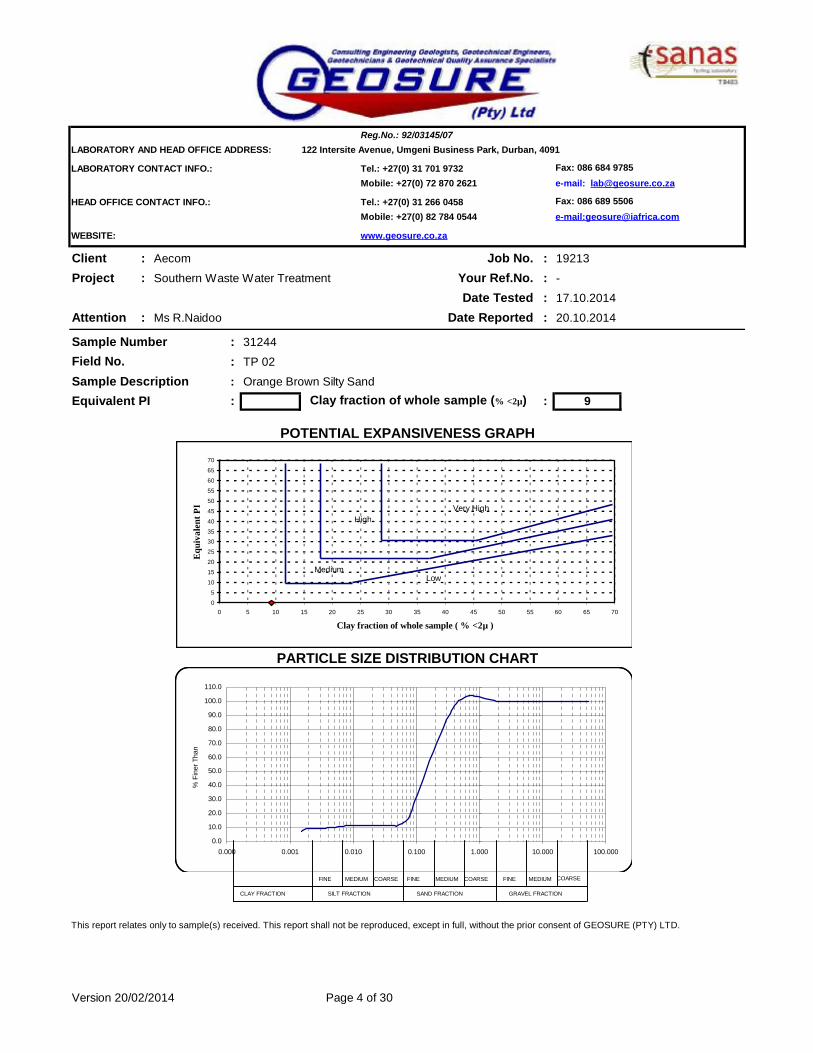
LABORATORY AND HEAD OFFICE ADDRESS: 122 Intersite Avenue, Umgeni Business Park, Durban, 4091
LABORATORY CONTACT INFO.: Tel.: +27(0) 31 701 9732 Fax: 086 684 9785Mobile: +27(0) 72 870 2621 e-mail: [email protected]
HEAD OFFICE CONTACT INFO.: Tel.: +27(0) 31 266 0458 Fax: 086 689 5506Mobile: +27(0) 82 784 0544 e-mail:[email protected]
WEBSITE: www.geosure.co.za
Client : Aecom Job No. :Project : Southern Waste Water Treatment Your Ref.No. :
Date Tested :Attention : Ms R.Naidoo Date Reported :
Sample Number : 31244
: TP 02
Sample Description : Orange Brown Silty Sand Equivalent PI : : 9
This report relates only to sample(s) received. This report shall not be reproduced, except in full, without the prior consent of GEOSURE (PTY) LTD.
Version 20/02/2014
Reg.No.: 92/03145/07
POTENTIAL EXPANSIVENESS GRAPH
PARTICLE SIZE DISTRIBUTION CHART
19213
Field No.
-
17.10.2014
20.10.2014
Clay fraction of whole sample (% <2µ)
Page 4 of 30
0
5
10
15
20
25
3035
40
45
50
55
60
65
70
0 5 10 15 20 25 30 35 40 45 50 55 60 65 70
Clay fraction of whole sample ( % <2µ )
Equi
vale
nt P
I
0.0
10.0
20.0
30.0
40.0
50.0
60.0
70.0
80.0
90.0
100.0
110.0
0.000 0.001 0.010 0.100 1.000 10.000 100.000
% F
iner
Tha
n
LowMedium
HighVery High
FINE COARSE FINE MEDIUM COARSEMEDIUM FINE MEDIUM COARSE
CLAY FRACTION SILT FRACTION SAND FRACTION GRAVEL FRACTION

LABORATORY AND HEAD OFFICE ADDRESS: 122 Intersite Avenue, Umgeni Business Park, Durban, 4091
LABORATORY CONTACT INFO.: Tel.: +27(0) 31 701 9732 Fax: 086 684 9785Mobile: +27(0) 72 870 2621 e-mail: [email protected]
HEAD OFFICE CONTACT INFO.: Tel.: +27(0) 31 266 0458 Fax: 086 689 5506Mobile: +27(0) 82 784 0544 e-mail:[email protected]
WEBSITE: www.geosure.co.za
Client : Aecom Job No. :Project : Southern Waste Water Treatment Your Ref.No. :
Date Tested :Attention : Ms R.Naidoo Date Reported :
Sample Number : 31245
: TP 02
Sample Description : Dark/Light Grey Slightly Clayey Sand Equivalent PI : : 8
This report relates only to sample(s) received. This report shall not be reproduced, except in full, without the prior consent of GEOSURE (PTY) LTD.
Version 20/02/2014
PARTICLE SIZE DISTRIBUTION CHART
Reg.No.: 92/03145/07
Field No.
Clay fraction of whole sample (% <2µ)
Page 5 of 30
POTENTIAL EXPANSIVENESS GRAPH
0
5
10
15
20
25
3035
40
45
50
55
60
65
70
0 5 10 15 20 25 30 35 40 45 50 55 60 65 70
Clay fraction of whole sample ( % <2µ )
Equi
vale
nt P
I
0.0
10.0
20.0
30.0
40.0
50.0
60.0
70.0
80.0
90.0
100.0
110.0
0.000 0.001 0.010 0.100 1.000 10.000 100.000
% F
iner
Tha
n
LowMedium
HighVery High
FINE COARSE FINE MEDIUM COARSEMEDIUM FINE MEDIUM COARSE
CLAY FRACTION SILT FRACTION SAND FRACTION GRAVEL FRACTION

LABORATORY AND HEAD OFFICE ADDRESS: 122 Intersite Avenue, Umgeni Business Park, Durban, 4091
LABORATORY CONTACT INFO.: Tel.: +27(0) 31 701 9732 Fax: 086 684 9785Mobile: +27(0) 72 870 2621 e-mail: [email protected]
HEAD OFFICE CONTACT INFO.: Tel.: +27(0) 31 266 0458 Fax: 086 689 5506Mobile: +27(0) 82 784 0544 e-mail:[email protected]
WEBSITE: www.geosure.co.za
Client : Aecom Job No. :Project : Southern Waste Water Treatment Your Ref.No. :
Date Tested :Attention : Ms R.Naidoo Date Reported :
Sample Number : 31246
: TP 05
Sample Description : Dark/Light Grey Slightly Clayey Sand
Equivalent PI : 6 : 20
This report relates only to sample(s) received. This report shall not be reproduced, except in full, without the prior consent of GEOSURE (PTY) LTD.
Version 20/02/2014
Reg.No.: 92/03145/07
POTENTIAL EXPANSIVENESS GRAPH
PARTICLE SIZE DISTRIBUTION CHART
19213
Field No.
-
17.10.2014
20.10.2014
Clay fraction of whole sample (% <2µ)
Page 6 of 30
0
5
10
1520
25
30
35
40
45
5055
60
65
70
0 5 10 15 20 25 30 35 40 45 50 55 60 65 70
Clay fraction of whole sample ( % <2µ )
Equ
ival
ent P
I
0.0
10.0
20.0
30.0
40.0
50.0
60.0
70.0
80.0
90.0
100.0
110.0
0.000 0.001 0.010 0.100 1.000 10.000 100.000
% F
iner
Tha
n
LowMedium
HighVery High
FINE COARSE FINE MEDIUM COARSEMEDIUM FINE MEDIUM COARSE
CLAY FRACTION SILT FRACTION SAND FRACTION GRAVEL FRACTION

LABORATORY AND HEAD OFFICE ADDRESS: 122 Intersite Avenue, Umgeni Business Park, Durban, 4091
LABORATORY CONTACT INFO.: Tel.: +27(0) 31 701 9732 Fax: 086 684 9785Mobile: +27(0) 72 870 2621 e-mail: [email protected]
HEAD OFFICE CONTACT INFO.: Tel.: +27(0) 31 266 0458 Fax: 086 689 5506Mobile: +27(0) 82 784 0544 e-mail:[email protected]
WEBSITE: www.geosure.co.za
Sample Number : 31247
: TP 07
Sample Description : Grey Slightly Silty Sand
Equivalent PI : NP : 3
This report relates only to sample(s) received. This report shall not be reproduced, except in full, without the prior consent of GEOSURE (PTY) LTD.
Version 20/02/2014 Page 7 of 30
Clay fraction of whole sample (% <2µ)
Field No.
Reg.No.: 92/03145/07
POTENTIAL EXPANSIVENESS GRAPH
PARTICLE SIZE DISTRIBUTION CHART
0
510
1520
2530
35
4045
5055
6065
70
0 5 10 15 20 25 30 35 40 45 50 55 60 65 70
Clay fraction of whole sample ( % <2µ )
Equi
vale
nt P
I
-10.0
0.0
10.0
20.0
30.0
40.0
50.0
60.0
70.0
80.0
90.0
100.0
110.0
0.000 0.001 0.010 0.100 1.000 10.000 100.000
% F
iner
Tha
n
LowMedium
HighVery High
FINE COARSE FINE MEDIUM COARSEMEDIUM FINE MEDIUM COARSE
CLAY FRACTION SILT FRACTION SAND FRACTION GRAVEL FRACTION

LABORATORY AND HEAD OFFICE ADDRESS: 122 Intersite Avenue, Umgeni Business Park, Durban, 4091
LABORATORY CONTACT INFO.: Tel.: +27(0) 31 701 9732 Fax: 086 684 9785Mobile: +27(0) 72 870 2621 e-mail: [email protected]
HEAD OFFICE CONTACT INFO.: Tel.: +27(0) 31 266 0458 Fax: 086 689 5506Mobile: +27(0) 82 784 0544 e-mail:[email protected]
WEBSITE: www.geosure.co.za
Client : Aecom Our Ref. : 19213Project : Your Ref. : -
Date Tested : 17.10.2014Attention : Ms R.Naidoo Date Reported : 20.10.2014
31248 31249 31250 31251 31252TP 08 TP 09 TP 10 TP 12 TP 13
1.3-2.8 1.8-3.0 2.4-2.8 2.4-2.5 1.7-3.0
63.0 mm 100 100 100 100 10053.0 mm 100 100 100 100 10037.5 mm 100 100 100 100 10026.5 mm 100 100 100 100 10019.0 mm 100 100 100 100 10013.2 mm 100 100 100 100 1004.75 mm 100 100 99 100 1002.00 mm 100 100 98 100 1000.425 mm 96 99 98 91 970.075 mm 34 36 38 60 7
0.060 mm 31 33 35 55 50.050 mm 29 31 31 48 30.040 mm 29 31 31 35 30.026 mm 29 31 31 33 30.015 mm 29 31 31 25 30.010 mm 29 31 30 20 30.0074 mm 28 31 30 18 30.0036 mm 26 29 30 13 30.0020 mm 26 27 28 10 30.0015 mm 23 27 28 8 2
% 4 1 1 9 2
% 15 14 8 8 36% 39 39 44 16 48% 9 10 8 6 6% 34 36 39 60 7
0.7 0.7 0.7 0.5 1.0
Liquid Limit % 25 27 34 69 NPPlasticity Index % 11 11 17 16 NPLinear Shrinkage % 5.1 5.0 8.3 7.5 0.0
AASHTO Classification (Group Index)* A-2-4(0) A-6(0) A-6(2) A-7-5(11) A-3(0)
SC SC SC MH SP-SM Moisture Content % 15.1 20.0 24.1 17.0 17.1Remarks: Date Received: 08.10.2014.
This report relates only to sample(s) received. This report shall not be reproduced, except in full, without the prior consent of GEOSURE (PTY) LTD.
Version 20/02/2014
Black Clayey Silt Greenish Brown Slightly Silty Sand
Red Brown Sandy Clayey Silt
Red Brown Sandy Clayey Silt
Soil Mortar Analysis
% P
assi
ng
Hydrometer Analysis ( ASTM - D422 )
% P
assi
ng
Sieve Analysis ( ASTM - D422 )
Sample No.
Southern Waste Water Treatment
Orange Grey Brown Clayey Silty Sand
Deviation from ASTMD422 - Material passing 0.425mm analysed by hydrometer
Atterberg Limits and Classification
Field No.Position in FieldDepth (m)
Material Description
Coarse SandCoarse Fine SandMedium Fine SandFine Fine Sand
Reg.No.: 92/03145/07
Page 8 of 30
*Opinions expressed herein fall outside the scope of SANAS accreditation.
Unified Classification*
Silt & ClayGrading Modulus
Sampled by Client.
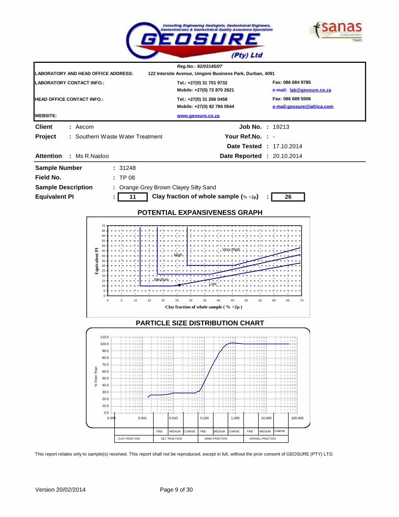
LABORATORY AND HEAD OFFICE ADDRESS: 122 Intersite Avenue, Umgeni Business Park, Durban, 4091
LABORATORY CONTACT INFO.: Tel.: +27(0) 31 701 9732 Fax: 086 684 9785Mobile: +27(0) 72 870 2621 e-mail: [email protected]
HEAD OFFICE CONTACT INFO.: Tel.: +27(0) 31 266 0458 Fax: 086 689 5506Mobile: +27(0) 82 784 0544 e-mail:[email protected]
WEBSITE: www.geosure.co.za
Client : Aecom Job No. :Project : Southern Waste Water Treatment Your Ref.No. :
Date Tested :Attention : Ms R.Naidoo Date Reported :
Sample Number : 31248
: TP 08
Sample Description : Orange Grey Brown Clayey Silty Sand Equivalent PI : 11 : 26
This report relates only to sample(s) received. This report shall not be reproduced, except in full, without the prior consent of GEOSURE (PTY) LTD.
Version 20/02/2014
Reg.No.: 92/03145/07
Clay fraction of whole sample (% <2µ)
Field No.
19213
-
17.10.2014
20.10.2014
Page 9 of 30
POTENTIAL EXPANSIVENESS GRAPH
PARTICLE SIZE DISTRIBUTION CHART
0
5
10
15
20
25
3035
40
45
50
55
60
65
70
0 5 10 15 20 25 30 35 40 45 50 55 60 65 70
Clay fraction of whole sample ( % <2µ )
Equi
vale
nt P
I
0.0
10.0
20.0
30.0
40.0
50.0
60.0
70.0
80.0
90.0
100.0
110.0
0.000 0.001 0.010 0.100 1.000 10.000 100.000
% F
iner
Tha
n
LowMedium
HighVery High
FINE COARSE FINE MEDIUM COARSEMEDIUM FINE MEDIUM COARSE
CLAY FRACTION SILT FRACTION SAND FRACTION GRAVEL FRACTION

LABORATORY AND HEAD OFFICE ADDRESS: 122 Intersite Avenue, Umgeni Business Park, Durban, 4091
LABORATORY CONTACT INFO.: Tel.: +27(0) 31 701 9732 Fax: 086 684 9785Mobile: +27(0) 72 870 2621 e-mail: [email protected]
HEAD OFFICE CONTACT INFO.: Tel.: +27(0) 31 266 0458 Fax: 086 689 5506Mobile: +27(0) 82 784 0544 e-mail:[email protected]
WEBSITE: www.geosure.co.za
Client : Aecom Job No. :Project : Southern Waste Water Treatment Your Ref.No. :
Date Tested :Attention : Ms R.Naidoo Date Reported :
Sample Number : 31249
: TP 09
Sample Description : Red Brown Sandy Clayey SiltEquivalent PI : 11 : 27
This report relates only to sample(s) received. This report shall not be reproduced, except in full, without the prior consent of GEOSURE (PTY) LTD.
Version 20/02/2014
Reg.No.: 92/03145/07
POTENTIAL EXPANSIVENESS GRAPH
PARTICLE SIZE DISTRIBUTION CHART
19213
Field No.
-
17.10.2014
20.10.2014
Clay fraction of whole sample (% <2µ)
Page 10 of 30
0
5
10
15
20
25
3035
40
45
50
55
60
65
70
0 5 10 15 20 25 30 35 40 45 50 55 60 65 70
Clay fraction of whole sample ( % <2µ )
Equi
vale
nt P
I
0.0
10.0
20.0
30.0
40.0
50.0
60.0
70.0
80.0
90.0
100.0
110.0
0.000 0.001 0.010 0.100 1.000 10.000 100.000
% F
iner
Tha
n
LowMedium
HighVery High
FINE COARSE FINE MEDIUM COARSEMEDIUM FINE MEDIUM COARSE
CLAY FRACTION SILT FRACTION SAND FRACTION GRAVEL FRACTION
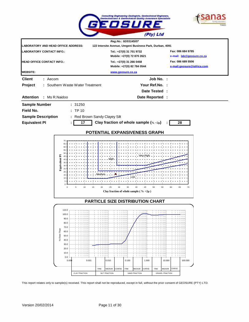
LABORATORY AND HEAD OFFICE ADDRESS: 122 Intersite Avenue, Umgeni Business Park, Durban, 4091
LABORATORY CONTACT INFO.: Tel.: +27(0) 31 701 9732 Fax: 086 684 9785Mobile: +27(0) 72 870 2621 e-mail: [email protected]
HEAD OFFICE CONTACT INFO.: Tel.: +27(0) 31 266 0458 Fax: 086 689 5506Mobile: +27(0) 82 784 0544 e-mail:[email protected]
WEBSITE: www.geosure.co.za
Client : Aecom Job No. :Project : Southern Waste Water Treatment Your Ref.No. :
Date Tested :Attention : Ms R.Naidoo Date Reported :
Sample Number : 31250
: TP 10
Sample Description : Red Brown Sandy Clayey SiltEquivalent PI : 17 : 28
This report relates only to sample(s) received. This report shall not be reproduced, except in full, without the prior consent of GEOSURE (PTY) LTD.
Version 20/02/2014
PARTICLE SIZE DISTRIBUTION CHART
Reg.No.: 92/03145/07
Field No.
Clay fraction of whole sample (% <2µ)
Page 11 of 30
POTENTIAL EXPANSIVENESS GRAPH
0
5
10
15
20
25
3035
40
45
50
55
60
65
70
0 5 10 15 20 25 30 35 40 45 50 55 60 65 70
Clay fraction of whole sample ( % <2µ )
Equi
vale
nt P
I
0.0
10.0
20.0
30.0
40.0
50.0
60.0
70.0
80.0
90.0
100.0
110.0
0.000 0.001 0.010 0.100 1.000 10.000 100.000
% F
iner
Tha
n
LowMedium
HighVery High
FINE COARSE FINE MEDIUM COARSEMEDIUM FINE MEDIUM COARSE
CLAY FRACTION SILT FRACTION SAND FRACTION GRAVEL FRACTION

LABORATORY AND HEAD OFFICE ADDRESS: 122 Intersite Avenue, Umgeni Business Park, Durban, 4091
LABORATORY CONTACT INFO.: Tel.: +27(0) 31 701 9732 Fax: 086 684 9785Mobile: +27(0) 72 870 2621 e-mail: [email protected]
HEAD OFFICE CONTACT INFO.: Tel.: +27(0) 31 266 0458 Fax: 086 689 5506Mobile: +27(0) 82 784 0544 e-mail:[email protected]
WEBSITE: www.geosure.co.za
Client : Aecom Job No. :Project : Southern Waste Water Treatment Your Ref.No. :
Date Tested :Attention : Ms R.Naidoo Date Reported :
Sample Number : 31251
: TP 12
Sample Description : Black Clayey Silt
Equivalent PI : 14 : 10
This report relates only to sample(s) received. This report shall not be reproduced, except in full, without the prior consent of GEOSURE (PTY) LTD.
Version 20/02/2014
Reg.No.: 92/03145/07
POTENTIAL EXPANSIVENESS GRAPH
PARTICLE SIZE DISTRIBUTION CHART
19213
Field No.
-
17.10.2014
20.10.2014
Clay fraction of whole sample (% <2µ)
Page 12 of 30
0
5
10
1520
25
30
35
40
45
5055
60
65
70
0 5 10 15 20 25 30 35 40 45 50 55 60 65 70
Clay fraction of whole sample ( % <2µ )
Equ
ival
ent P
I
0.0
10.0
20.0
30.0
40.0
50.0
60.0
70.0
80.0
90.0
100.0
110.0
0.000 0.001 0.010 0.100 1.000 10.000 100.000
% F
iner
Tha
n
LowMedium
HighVery High
FINE COARSE FINE MEDIUM COARSEMEDIUM FINE MEDIUM COARSE
CLAY FRACTION SILT FRACTION SAND FRACTION GRAVEL FRACTION

LABORATORY AND HEAD OFFICE ADDRESS: 122 Intersite Avenue, Umgeni Business Park, Durban, 4091
LABORATORY CONTACT INFO.: Tel.: +27(0) 31 701 9732 Fax: 086 684 9785Mobile: +27(0) 72 870 2621 e-mail: [email protected]
HEAD OFFICE CONTACT INFO.: Tel.: +27(0) 31 266 0458 Fax: 086 689 5506Mobile: +27(0) 82 784 0544 e-mail:[email protected]
WEBSITE: www.geosure.co.za
Sample Number : 31252
: TP 13
Sample Description : Greenish Brown Slightly Silty Sand
Equivalent PI : NP : 3
This report relates only to sample(s) received. This report shall not be reproduced, except in full, without the prior consent of GEOSURE (PTY) LTD.
Version 20/02/2014 Page 13 of 30
Clay fraction of whole sample (% <2µ)
Field No.
Reg.No.: 92/03145/07
POTENTIAL EXPANSIVENESS GRAPH
PARTICLE SIZE DISTRIBUTION CHART
0
510
1520
2530
35
4045
5055
6065
70
0 5 10 15 20 25 30 35 40 45 50 55 60 65 70
Clay fraction of whole sample ( % <2µ )
Equi
vale
nt P
I
-10.0
0.0
10.0
20.0
30.0
40.0
50.0
60.0
70.0
80.0
90.0
100.0
110.0
0.000 0.001 0.010 0.100 1.000 10.000 100.000
% F
iner
Tha
n
LowMedium
HighVery High
FINE COARSE FINE MEDIUM COARSEMEDIUM FINE MEDIUM COARSE
CLAY FRACTION SILT FRACTION SAND FRACTION GRAVEL FRACTION

LABORATORY AND HEAD OFFICE ADDRESS: 122 Intersite Avenue, Umgeni Business Park, Durban, 4091
LABORATORY CONTACT INFO.: Tel.: +27(0) 31 701 9732 Fax: 086 684 9785Mobile: +27(0) 72 870 2621 e-mail: [email protected]
HEAD OFFICE CONTACT INFO.: Tel.: +27(0) 31 266 0458 Fax: 086 689 5506Mobile: +27(0) 82 784 0544 e-mail:[email protected]
WEBSITE: www.geosure.co.za
Client : Aecom Our Ref. : 19213Project : Your Ref. : -
Date Tested : 17.10.2014Attention : Ms R.Naidoo Date Reported : 20.10.2014
31253 31255 31256 31257 31258TP 15 TP 16 TP 16 TP 17 BH 01
1.6-2.5 3.0-3.2 2.4-3.0 2.6-3.0 8.05-8.6
63.0 mm 100 100 100 100 10053.0 mm 100 100 100 100 10037.5 mm 100 100 100 100 10026.5 mm 100 100 100 100 10019.0 mm 100 100 100 100 10013.2 mm 97 100 100 100 1004.75 mm 97 100 100 100 1002.00 mm 97 100 100 100 1000.425 mm 95 100 98 97 1000.075 mm 4 97 20 13 83
0.060 mm 3 91 16 11 790.050 mm 3 86 14 9 710.040 mm 3 81 14 9 620.026 mm 3 73 14 9 520.015 mm 3 64 14 9 460.010 mm 2 59 14 9 420.0074 mm 2 51 14 9 350.0036 mm 1 43 12 7 270.0020 mm 1 38 10 5 250.0015 mm 1 30 10 5 21
% 3 0 2 2 0
% 33 1 24 19 1% 54 2 45 55 7% 6 0 8 10 8% 5 97 20 13 83
1.0 0.0 0.8 0.9 0.2
Liquid Limit % NP 57 SP SP 46Plasticity Index % NP 21 SP SP 27Linear Shrinkage % 0.0 10.1 0.5 0.5 13.5
AASHTO Classification (Group Index)* A-3(0) A-7-5(27) A-2-4(0) A-2-4(0) A-7-6(23)
SP MH SM SM CLMoisture Content % 17.0 86.0 16.1 19.1 46.0Remarks: Date Received: 08.10.2014.
This report relates only to sample(s) received. This report shall not be reproduced, except in full, without the prior consent of GEOSURE (PTY) LTD.
Version 20/02/2014
Grey Silty Sand Grey Black Silty Clay Greenish Grey
Brown Clayey Silty Clay
Black Clayey Silty
Soil Mortar Analysis
% P
assi
ng
Hydrometer Analysis ( ASTM - D422 )
% P
assi
ng
Sieve Analysis ( ASTM - D422 )
Sample No.
Southern Waste Water Treatment
Orange Brown Silty Sand
Deviation from ASTMD422 - Material passing 0.425mm analysed by hydrometer
Atterberg Limits and Classification
Field No.Position in FieldDepth (m)
Material Description
Coarse SandCoarse Fine SandMedium Fine SandFine Fine Sand
Reg.No.: 92/03145/07
Page 14 of 30
*Opinions expressed herein fall outside the scope of SANAS accreditation.
Unified Classification*
Silt & ClayGrading Modulus
Sampled by Client.

LABORATORY AND HEAD OFFICE ADDRESS: 122 Intersite Avenue, Umgeni Business Park, Durban, 4091
LABORATORY CONTACT INFO.: Tel.: +27(0) 31 701 9732 Fax: 086 684 9785Mobile: +27(0) 72 870 2621 e-mail: [email protected]
HEAD OFFICE CONTACT INFO.: Tel.: +27(0) 31 266 0458 Fax: 086 689 5506Mobile: +27(0) 82 784 0544 e-mail:[email protected]
WEBSITE: www.geosure.co.za
Client : Aecom Job No. :Project : Southern Waste Water Treatment Your Ref.No. :
Date Tested :Attention : Ms R.Naidoo Date Reported :
Sample Number : 31253
: TP 15
Sample Description : Orange Brown Silty SandEquivalent PI : NP : 1
This report relates only to sample(s) received. This report shall not be reproduced, except in full, without the prior consent of GEOSURE (PTY) LTD.
Version 20/02/2014
Reg.No.: 92/03145/07
Clay fraction of whole sample (% <2µ)
Field No.
19213
-
17.10.2014
20.10.2014
Page 15 of 30
POTENTIAL EXPANSIVENESS GRAPH
PARTICLE SIZE DISTRIBUTION CHART
0
5
10
1520
25
30
35
40
45
5055
60
65
70
0 5 10 15 20 25 30 35 40 45 50 55 60 65 70
Clay fraction of whole sample ( % <2µ )
Equ
ival
ent P
I
-10.0
0.0
10.0
20.0
30.0
40.0
50.0
60.0
70.0
80.0
90.0
100.0
110.0
0.000 0.001 0.010 0.100 1.000 10.000 100.000
% F
iner
Tha
n
LowMedium
HighVery High
FINE COARSE FINE MEDIUM COARSEMEDIUM FINE MEDIUM COARSE
CLAY FRACTION SILT FRACTION SAND FRACTION GRAVEL FRACTION

LABORATORY AND HEAD OFFICE ADDRESS: 122 Intersite Avenue, Umgeni Business Park, Durban, 4091
LABORATORY CONTACT INFO.: Tel.: +27(0) 31 701 9732 Fax: 086 684 9785Mobile: +27(0) 72 870 2621 e-mail: [email protected]
HEAD OFFICE CONTACT INFO.: Tel.: +27(0) 31 266 0458 Fax: 086 689 5506Mobile: +27(0) 82 784 0544 e-mail:[email protected]
WEBSITE: www.geosure.co.za
Client : Aecom Job No. :Project : Southern Waste Water Treatment Your Ref.No. :
Date Tested :Attention : Ms R.Naidoo Date Reported :
Sample Number : 31255
: TP 16
Sample Description : Black Clayey Silty Equivalent PI : 21 : 38
This report relates only to sample(s) received. This report shall not be reproduced, except in full, without the prior consent of GEOSURE (PTY) LTD.
Version 20/02/2014
Reg.No.: 92/03145/07
POTENTIAL EXPANSIVENESS GRAPH
PARTICLE SIZE DISTRIBUTION CHART
19213
Field No.
-
17.10.2014
20.10.2014
Clay fraction of whole sample (% <2µ)
Page 16 of 30
0
5
10
15
20
25
3035
40
45
50
55
60
65
70
0 5 10 15 20 25 30 35 40 45 50 55 60 65 70
Clay fraction of whole sample ( % <2µ )
Equi
vale
nt P
I
0.0
10.0
20.0
30.0
40.0
50.0
60.0
70.0
80.0
90.0
100.0
110.0
0.000 0.001 0.010 0.100 1.000 10.000 100.000
% F
iner
Tha
n
LowMedium
HighVery High
FINE COARSE FINE MEDIUM COARSEMEDIUM FINE MEDIUM COARSE
CLAY FRACTION SILT FRACTION SAND FRACTION GRAVEL FRACTION

LABORATORY AND HEAD OFFICE ADDRESS: 122 Intersite Avenue, Umgeni Business Park, Durban, 4091
LABORATORY CONTACT INFO.: Tel.: +27(0) 31 701 9732 Fax: 086 684 9785Mobile: +27(0) 72 870 2621 e-mail: [email protected]
HEAD OFFICE CONTACT INFO.: Tel.: +27(0) 31 266 0458 Fax: 086 689 5506Mobile: +27(0) 82 784 0544 e-mail:[email protected]
WEBSITE: www.geosure.co.za
Client : Aecom Job No. :Project : Southern Waste Water Treatment Your Ref.No. :
Date Tested :Attention : Ms R.Naidoo Date Reported :
Sample Number : 31256
: TP 16
Sample Description : Greenish Grey Brown Clayey Silty ClayEquivalent PI : : 10
This report relates only to sample(s) received. This report shall not be reproduced, except in full, without the prior consent of GEOSURE (PTY) LTD.
Version 20/02/2014
PARTICLE SIZE DISTRIBUTION CHART
Reg.No.: 92/03145/07
Field No.
Clay fraction of whole sample (% <2µ)
Page 17 of 30
POTENTIAL EXPANSIVENESS GRAPH
0
5
10
15
20
25
3035
40
45
50
55
60
65
70
0 5 10 15 20 25 30 35 40 45 50 55 60 65 70
Clay fraction of whole sample ( % <2µ )
Equi
vale
nt P
I
0.0
10.0
20.0
30.0
40.0
50.0
60.0
70.0
80.0
90.0
100.0
110.0
0.000 0.001 0.010 0.100 1.000 10.000 100.000
% F
iner
Tha
n
LowMedium
HighVery High
FINE COARSE FINE MEDIUM COARSEMEDIUM FINE MEDIUM COARSE
CLAY FRACTION SILT FRACTION SAND FRACTION GRAVEL FRACTION
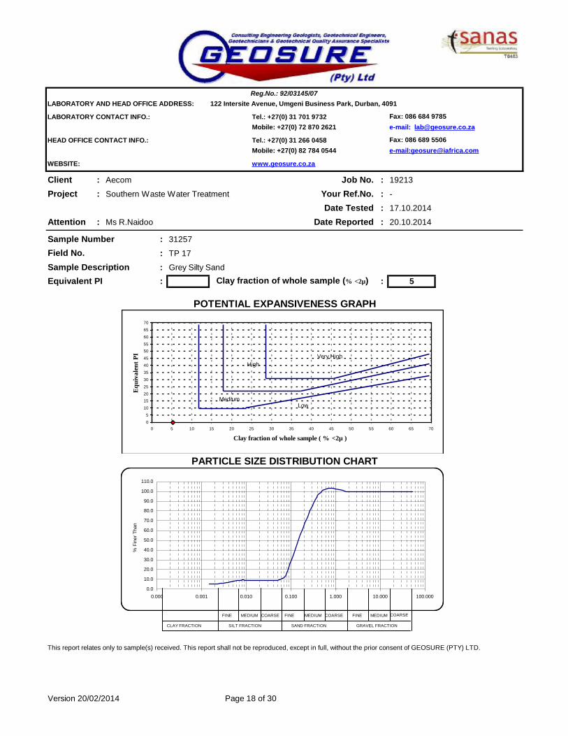
LABORATORY AND HEAD OFFICE ADDRESS: 122 Intersite Avenue, Umgeni Business Park, Durban, 4091
LABORATORY CONTACT INFO.: Tel.: +27(0) 31 701 9732 Fax: 086 684 9785Mobile: +27(0) 72 870 2621 e-mail: [email protected]
HEAD OFFICE CONTACT INFO.: Tel.: +27(0) 31 266 0458 Fax: 086 689 5506Mobile: +27(0) 82 784 0544 e-mail:[email protected]
WEBSITE: www.geosure.co.za
Client : Aecom Job No. :Project : Southern Waste Water Treatment Your Ref.No. :
Date Tested :Attention : Ms R.Naidoo Date Reported :
Sample Number : 31257
: TP 17
Sample Description : Grey Silty Sand
Equivalent PI : : 5
This report relates only to sample(s) received. This report shall not be reproduced, except in full, without the prior consent of GEOSURE (PTY) LTD.
Version 20/02/2014
Reg.No.: 92/03145/07
POTENTIAL EXPANSIVENESS GRAPH
PARTICLE SIZE DISTRIBUTION CHART
19213
Field No.
-
17.10.2014
20.10.2014
Clay fraction of whole sample (% <2µ)
Page 18 of 30
0
5
10
1520
25
30
35
40
45
5055
60
65
70
0 5 10 15 20 25 30 35 40 45 50 55 60 65 70
Clay fraction of whole sample ( % <2µ )
Equ
ival
ent P
I
0.0
10.0
20.0
30.0
40.0
50.0
60.0
70.0
80.0
90.0
100.0
110.0
0.000 0.001 0.010 0.100 1.000 10.000 100.000
% F
iner
Tha
n
LowMedium
HighVery High
FINE COARSE FINE MEDIUM COARSEMEDIUM FINE MEDIUM COARSE
CLAY FRACTION SILT FRACTION SAND FRACTION GRAVEL FRACTION
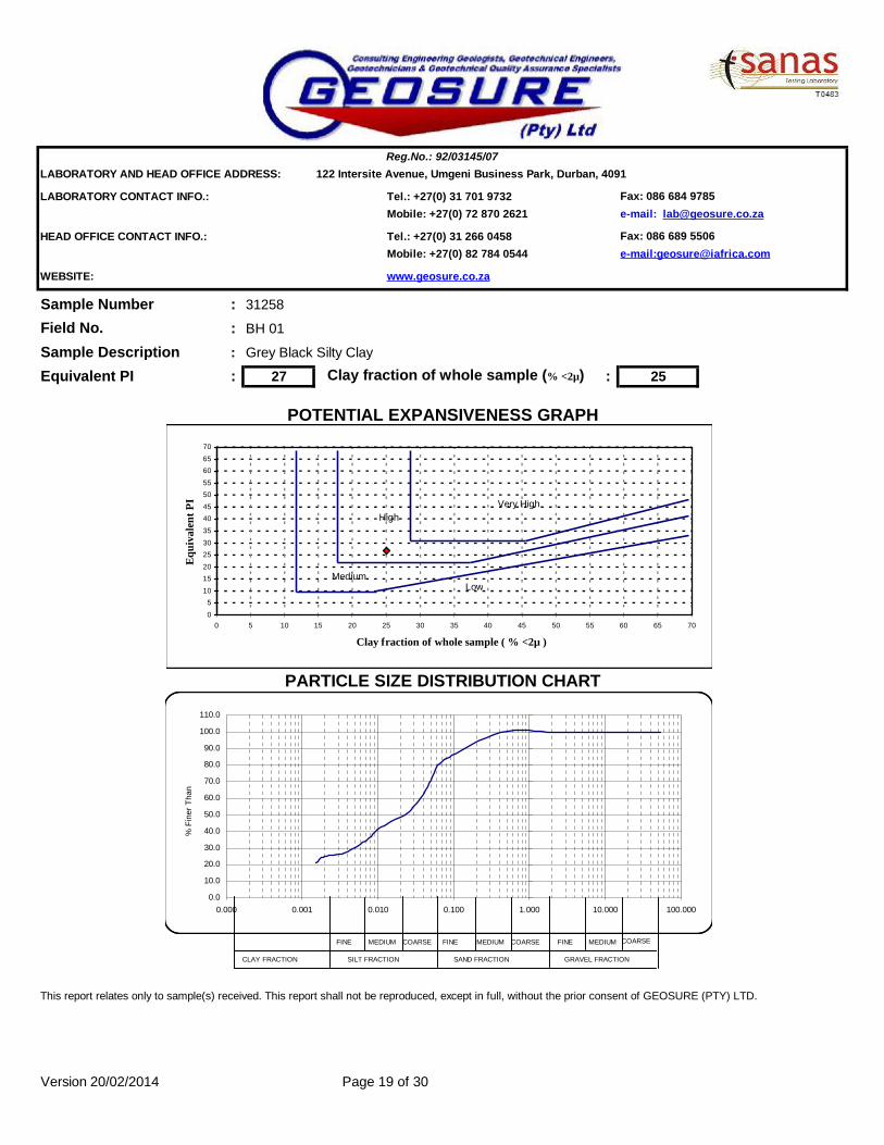
LABORATORY AND HEAD OFFICE ADDRESS: 122 Intersite Avenue, Umgeni Business Park, Durban, 4091
LABORATORY CONTACT INFO.: Tel.: +27(0) 31 701 9732 Fax: 086 684 9785Mobile: +27(0) 72 870 2621 e-mail: [email protected]
HEAD OFFICE CONTACT INFO.: Tel.: +27(0) 31 266 0458 Fax: 086 689 5506Mobile: +27(0) 82 784 0544 e-mail:[email protected]
WEBSITE: www.geosure.co.za
Sample Number : 31258
: BH 01
Sample Description : Grey Black Silty Clay
Equivalent PI : 27 : 25
This report relates only to sample(s) received. This report shall not be reproduced, except in full, without the prior consent of GEOSURE (PTY) LTD.
Version 20/02/2014 Page 19 of 30
Clay fraction of whole sample (% <2µ)
Field No.
Reg.No.: 92/03145/07
POTENTIAL EXPANSIVENESS GRAPH
PARTICLE SIZE DISTRIBUTION CHART
0
510
1520
2530
35
4045
5055
6065
70
0 5 10 15 20 25 30 35 40 45 50 55 60 65 70
Clay fraction of whole sample ( % <2µ )
Equi
vale
nt P
I
0.0
10.0
20.0
30.0
40.0
50.0
60.0
70.0
80.0
90.0
100.0
110.0
0.000 0.001 0.010 0.100 1.000 10.000 100.000
% F
iner
Tha
n
LowMedium
HighVery High
FINE COARSE FINE MEDIUM COARSEMEDIUM FINE MEDIUM COARSE
CLAY FRACTION SILT FRACTION SAND FRACTION GRAVEL FRACTION

LABORATORY AND HEAD OFFICE ADDRESS: 122 Intersite Avenue, Umgeni Business Park, Durban, 4091
LABORATORY CONTACT INFO.: Tel.: +27(0) 31 701 9732 Fax: 086 684 9785Mobile: +27(0) 72 870 2621 e-mail: [email protected]
HEAD OFFICE CONTACT INFO.: Tel.: +27(0) 31 266 0458 Fax: 086 689 5506Mobile: +27(0) 82 784 0544 e-mail:[email protected]
WEBSITE: www.geosure.co.za
Client : Aecom Our Ref. : 19213Project : Your Ref. : -
Date Tested : 17.10.2014Attention : Ms R.Naidoo Date Reported : 20.10.2014
31259 31260 31261 31262 31269BH01 BH01 BH02A BH02A BH05
0.52-10.07 11.33-11.76 10.23-10.77 13.07-13.60 11.08-11.47
63.0 mm 100 100 100 100 10053.0 mm 100 100 100 100 10037.5 mm 100 100 100 100 10026.5 mm 100 100 100 100 10019.0 mm 100 100 100 100 10013.2 mm 100 100 100 100 1004.75 mm 100 99 100 100 1002.00 mm 98 99 100 98 1000.425 mm 96 98 93 51 950.075 mm 88 92 21 15 24
0.060 mm 84 87 18 13 210.050 mm 72 79 15 12 190.040 mm 62 66 14 11 190.026 mm 53 59 14 11 190.015 mm 45 50 14 11 190.010 mm 43 48 14 11 190.0074 mm 38 42 12 11 190.0036 mm 29 31 11 10 190.0020 mm 24 28 11 10 190.0015 mm 22 26 11 10 17
% 2 1 7 48 5
% 2 1 23 15 27% 2 1 38 18 38% 4 4 11 4 6% 90 93 21 15 24
0.2 0.1 0.9 1.4 0.8
Liquid Limit % 56 53 SP 23 24Plasticity Index % 27 25 SP 8 9Linear Shrinkage % 12.9 11.4 0.5 3.2 4.9
AASHTO Classification (Group Index)* A-7-6(27) A-7-6(27) A-2-4(0) A-2-4(0) A-2-4(0)
CH CH SM SC SC Moisture Content % 51.0 42.8 22.2 20.1 15.9Remarks: Date Received: 08.10.2014.
This report relates only to sample(s) received. This report shall not be reproduced, except in full, without the prior consent of GEOSURE (PTY) LTD.
Version 20/02/2014
Grey Silty Sand Grey Slightly Clayey Silty Sand
Greenish Grey Brown Clayey Silty
ClayBlack Clayey Silty
Soil Mortar Analysis
% P
assi
ng
Hydrometer Analysis ( ASTM - D422 )
% P
assi
ng
Sieve Analysis ( ASTM - D422 )
Sample No.
Southern Waste Water Treatment
Orange Brown Silty Sand
Deviation from ASTMD422 - Material passing 0.425mm analysed by hydrometer
Atterberg Limits and Classification
Field No.Position in FieldDepth (m)
Material Description
Coarse SandCoarse Fine SandMedium Fine SandFine Fine Sand
Reg.No.: 92/03145/07
Page 20 of 30
*Opinions expressed herein fall outside the scope of SANAS accreditation.
Unified Classification*
Silt & ClayGrading Modulus
Sampled by Client.

LABORATORY AND HEAD OFFICE ADDRESS: 122 Intersite Avenue, Umgeni Business Park, Durban, 4091
LABORATORY CONTACT INFO.: Tel.: +27(0) 31 701 9732 Fax: 086 684 9785Mobile: +27(0) 72 870 2621 e-mail: [email protected]
HEAD OFFICE CONTACT INFO.: Tel.: +27(0) 31 266 0458 Fax: 086 689 5506Mobile: +27(0) 82 784 0544 e-mail:[email protected]
WEBSITE: www.geosure.co.za
Client : Aecom Job No. :Project : Southern Waste Water Treatment Your Ref.No. :
Date Tested :Attention : Ms R.Naidoo Date Reported :
Sample Number : 31259
: BH01
Sample Description : Orange Brown Silty SandEquivalent PI : 26 : 24
This report relates only to sample(s) received. This report shall not be reproduced, except in full, without the prior consent of GEOSURE (PTY) LTD.
Version 20/02/2014
Reg.No.: 92/03145/07
Clay fraction of whole sample (% <2µ)
Field No.
19213
-
17.10.2014
20.10.2014
Page 21 of 30
POTENTIAL EXPANSIVENESS GRAPH
PARTICLE SIZE DISTRIBUTION CHART
0
5
10
15
20
25
3035
40
45
50
55
60
65
70
0 5 10 15 20 25 30 35 40 45 50 55 60 65 70
Clay fraction of whole sample ( % <2µ )
Equi
vale
nt P
I
0.0
10.0
20.0
30.0
40.0
50.0
60.0
70.0
80.0
90.0
100.0
110.0
0.000 0.001 0.010 0.100 1.000 10.000 100.000
% F
iner
Tha
n
LowMedium
HighVery High
FINE COARSE FINE MEDIUM COARSEMEDIUM FINE MEDIUM COARSE
CLAY FRACTION SILT FRACTION SAND FRACTION GRAVEL FRACTION
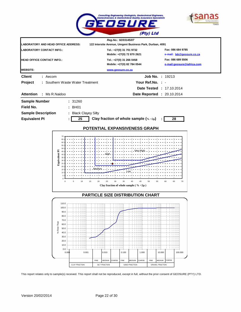
LABORATORY AND HEAD OFFICE ADDRESS: 122 Intersite Avenue, Umgeni Business Park, Durban, 4091
LABORATORY CONTACT INFO.: Tel.: +27(0) 31 701 9732 Fax: 086 684 9785Mobile: +27(0) 72 870 2621 e-mail: [email protected]
HEAD OFFICE CONTACT INFO.: Tel.: +27(0) 31 266 0458 Fax: 086 689 5506Mobile: +27(0) 82 784 0544 e-mail:[email protected]
WEBSITE: www.geosure.co.za
Client : Aecom Job No. :Project : Southern Waste Water Treatment Your Ref.No. :
Date Tested :Attention : Ms R.Naidoo Date Reported :
Sample Number : 31260
: BH01
Sample Description : Black Clayey Silty Equivalent PI : 25 : 28
This report relates only to sample(s) received. This report shall not be reproduced, except in full, without the prior consent of GEOSURE (PTY) LTD.
Version 20/02/2014
Reg.No.: 92/03145/07
POTENTIAL EXPANSIVENESS GRAPH
PARTICLE SIZE DISTRIBUTION CHART
19213
Field No.
-
17.10.2014
20.10.2014
Clay fraction of whole sample (% <2µ)
Page 22 of 30
0
5
10
15
20
25
3035
40
45
50
55
60
65
70
0 5 10 15 20 25 30 35 40 45 50 55 60 65 70
Clay fraction of whole sample ( % <2µ )
Equi
vale
nt P
I
0.0
10.0
20.0
30.0
40.0
50.0
60.0
70.0
80.0
90.0
100.0
110.0
0.000 0.001 0.010 0.100 1.000 10.000 100.000
% F
iner
Tha
n
LowMedium
HighVery High
FINE COARSE FINE MEDIUM COARSEMEDIUM FINE MEDIUM COARSE
CLAY FRACTION SILT FRACTION SAND FRACTION GRAVEL FRACTION

LABORATORY AND HEAD OFFICE ADDRESS: 122 Intersite Avenue, Umgeni Business Park, Durban, 4091
LABORATORY CONTACT INFO.: Tel.: +27(0) 31 701 9732 Fax: 086 684 9785Mobile: +27(0) 72 870 2621 e-mail: [email protected]
HEAD OFFICE CONTACT INFO.: Tel.: +27(0) 31 266 0458 Fax: 086 689 5506Mobile: +27(0) 82 784 0544 e-mail:[email protected]
WEBSITE: www.geosure.co.za
Client : Aecom Job No. :Project : Southern Waste Water Treatment Your Ref.No. :
Date Tested :Attention : Ms R.Naidoo Date Reported :
Sample Number : 31261
: BH02A
Sample Description : Greenish Grey Brown Clayey Silty ClayEquivalent PI : : 11
This report relates only to sample(s) received. This report shall not be reproduced, except in full, without the prior consent of GEOSURE (PTY) LTD.
Version 20/02/2014
PARTICLE SIZE DISTRIBUTION CHART
Reg.No.: 92/03145/07
Field No.
Clay fraction of whole sample (% <2µ)
Page 23 of 30
POTENTIAL EXPANSIVENESS GRAPH
0
5
10
15
20
25
3035
40
45
50
55
60
65
70
0 5 10 15 20 25 30 35 40 45 50 55 60 65 70
Clay fraction of whole sample ( % <2µ )
Equi
vale
nt P
I
0.0
10.0
20.0
30.0
40.0
50.0
60.0
70.0
80.0
90.0
100.0
110.0
0.000 0.001 0.010 0.100 1.000 10.000 100.000
% F
iner
Tha
n
LowMedium
HighVery High
FINE COARSE FINE MEDIUM COARSEMEDIUM FINE MEDIUM COARSE
CLAY FRACTION SILT FRACTION SAND FRACTION GRAVEL FRACTION

LABORATORY AND HEAD OFFICE ADDRESS: 122 Intersite Avenue, Umgeni Business Park, Durban, 4091
LABORATORY CONTACT INFO.: Tel.: +27(0) 31 701 9732 Fax: 086 684 9785Mobile: +27(0) 72 870 2621 e-mail: [email protected]
HEAD OFFICE CONTACT INFO.: Tel.: +27(0) 31 266 0458 Fax: 086 689 5506Mobile: +27(0) 82 784 0544 e-mail:[email protected]
WEBSITE: www.geosure.co.za
Client : Aecom Job No. :Project : Southern Waste Water Treatment Your Ref.No. :
Date Tested :Attention : Ms R.Naidoo Date Reported :
Sample Number : 31262
: BH02A
Sample Description : Grey Silty Sand
Equivalent PI : 4 : 10
This report relates only to sample(s) received. This report shall not be reproduced, except in full, without the prior consent of GEOSURE (PTY) LTD.
Version 20/02/2014
Reg.No.: 92/03145/07
POTENTIAL EXPANSIVENESS GRAPH
PARTICLE SIZE DISTRIBUTION CHART
19213
Field No.
-
17.10.2014
20.10.2014
Clay fraction of whole sample (% <2µ)
Page 24 of 30
0
5
10
1520
25
30
35
40
45
5055
60
65
70
0 5 10 15 20 25 30 35 40 45 50 55 60 65 70
Clay fraction of whole sample ( % <2µ )
Equ
ival
ent P
I
0.0
10.0
20.0
30.0
40.0
50.0
60.0
70.0
80.0
90.0
100.0
110.0
0.000 0.001 0.010 0.100 1.000 10.000 100.000
% F
iner
Tha
n
LowMedium
HighVery High
FINE COARSE FINE MEDIUM COARSEMEDIUM FINE MEDIUM COARSE
CLAY FRACTION SILT FRACTION SAND FRACTION GRAVEL FRACTION
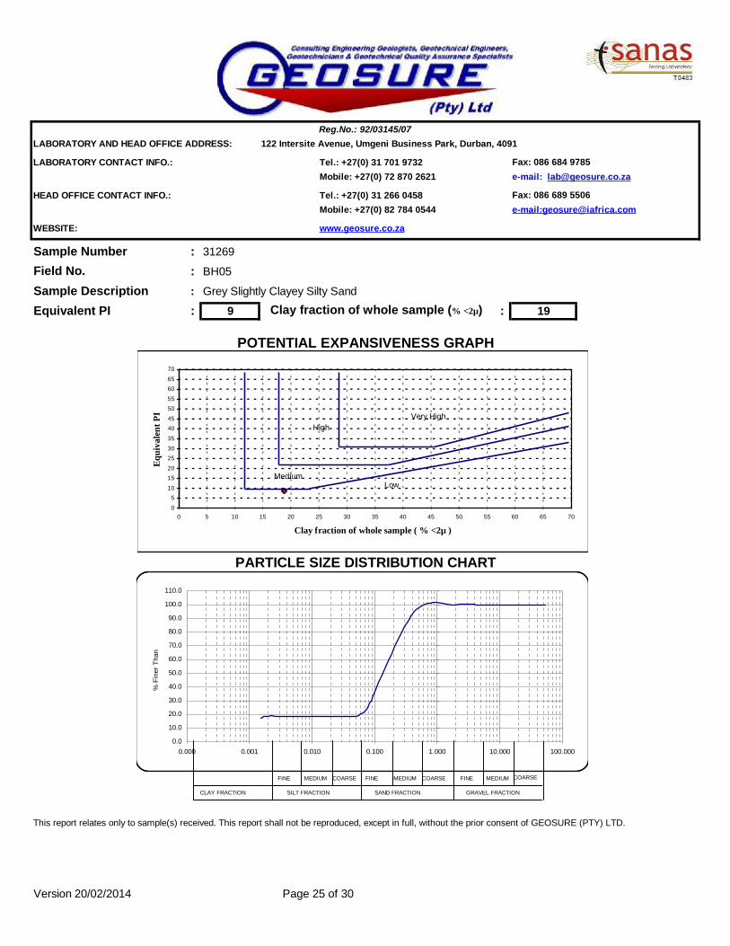
LABORATORY AND HEAD OFFICE ADDRESS: 122 Intersite Avenue, Umgeni Business Park, Durban, 4091
LABORATORY CONTACT INFO.: Tel.: +27(0) 31 701 9732 Fax: 086 684 9785Mobile: +27(0) 72 870 2621 e-mail: [email protected]
HEAD OFFICE CONTACT INFO.: Tel.: +27(0) 31 266 0458 Fax: 086 689 5506Mobile: +27(0) 82 784 0544 e-mail:[email protected]
WEBSITE: www.geosure.co.za
Sample Number : 31269
: BH05
Sample Description : Grey Slightly Clayey Silty Sand
Equivalent PI : 9 : 19
This report relates only to sample(s) received. This report shall not be reproduced, except in full, without the prior consent of GEOSURE (PTY) LTD.
Version 20/02/2014 Page 25 of 30
Clay fraction of whole sample (% <2µ)
Field No.
Reg.No.: 92/03145/07
POTENTIAL EXPANSIVENESS GRAPH
PARTICLE SIZE DISTRIBUTION CHART
0
510
1520
2530
35
4045
5055
6065
70
0 5 10 15 20 25 30 35 40 45 50 55 60 65 70
Clay fraction of whole sample ( % <2µ )
Equi
vale
nt P
I
0.0
10.0
20.0
30.0
40.0
50.0
60.0
70.0
80.0
90.0
100.0
110.0
0.000 0.001 0.010 0.100 1.000 10.000 100.000
% F
iner
Tha
n
LowMedium
HighVery High
FINE COARSE FINE MEDIUM COARSEMEDIUM FINE MEDIUM COARSE
CLAY FRACTION SILT FRACTION SAND FRACTION GRAVEL FRACTION

MOD AASHTO & CBR
RESULTS

LABORATORY: Reg. No. : 92/03145/07 HEAD OFFICE:122 Intersite Avenue, Umgeni Business Park, Durban, 4091 122 Intersite Avenue, Umgeni Business Park,P.O. Box 1461, Westville 3630 Durban, 4091, KwaZulu Natal, South Africa.Mobile: +27(0)72 870 2621 Fax: 086 684 9785 Tel: +27 (0)31 266 0458 Fax: 086 689 5506Tel.: +27 (0)31 701 9732 email: [email protected] email: [email protected] www.geosure.co.za
Client : Your Ref No. : -Project : Our Ref No. : 19213Attention : Date Reported : 21/10/2014
Sample_No1 Sample_No2 Sample_No3 Sample_No4 Sample_No5
Sample No. 31243 31254Field No. TP 01 TP 14PositionDepth ( m ) 0.5-1.3 0.8-1.9
Material Description
Orange Brown/Light
Brown (Slightly) Silty
Sand
Orange Brown/Light
Brown (Slightly) Silty
Sand
75.0063.0053.0037.5026.5019.0013.204.750 100 1002.000 99 990.425 62 900.075 5 13
Grading Modulus 1.33 0.98
Coarse Sand 2.000 - 0.425 37 9Coarse-Fine Sand 0.425 - 0.250 25 30Medium-Fine Sand 0.250 - 0.150 30 42Fine-Fine Sand 0.150 - 0.075 3 5Silt and Clay < 0.075 5 13
Liquid Limit % or symbol NP NPPlasticity Index % or symbol NP NPLinear Shrinkage % 0.0 0.0
Maximum Dry Density (kg/m³) 1856 1843Optimum moisture content (%) 9.6 8.8
CBR @100% Compaction % 20 37CBR @ 98% Compaction % 18 32CBR @ 97% Compaction % 17 30CBR @ 95% Compaction % 17 23CBR @ 93% Compaction % 16 17CBR @ 90% Compaction % 15 11Swell @100% Compaction % 0.0 0.0TRH 14 Classification (1985)** G7 G7AASHTO Classification (Group Index)** A-3 (0) A-2-4 (0)Unified Classification ** SP-SM SMThis report relates only to sample(s) received. This report shall not be reproduced, except in full, without the prior consent of GEOSURE (Pty) Ltd.
Remarks: *Subject to further testing as required by TRH14.
** Opinions and interpretations expressed herein are outside the scope of SANAS accreditationVersion 4.02 - 24 March 2014
Southern Waste Water Treatment WorksAecom
Ms R.Naidoo
Mechanical analysis - TMH1 - Method A5 - Percent of Soil Mortar (<2 mm) for Grain Size range
Atterberg Limits TMH 1 - Methods A2, A3, A4 on <0.425 mm fraction
Maximum Dry Density and Optimum Moisture Content - TMH1 - Method A7
California Bearing Ratio - TMH1 - Method A8
Test Report
Sieve Analysis ( Wet Preparation ) TMH1 - Method A1 (a) - Percent Passing Sieve Size
Siev
e A
pert
ure
(mm
)
Report31243 Page 26 of 30

LABORATORY: Reg. No. : 92/03145/07 HEAD OFFICE:122 Intersite Avenue, Umgeni Business Park, Durban, 4091 122 Intersite Avenue, Umgeni Business Park,P.O. Box 1461, Westville 3630 Durban, 4091, KwaZulu Natal, South Africa.Mobile: +27(0)72 870 2621 Fax: 086 684 9785 Tel: +27 (0)31 266 0458 Fax: 086 689 5506Tel.: +27 (0)31 701 9732 email: [email protected] email: [email protected] www.geosure.co.za
Client : Aecom Your Ref No.:Project : Southern Waste Water Treatment Works Our Ref No. :Attention : Ms R.Naidoo Date Reported :
0.1 50.2 8.30.3 380.4 62
2 994.8 10013192738536375
Thick Red Line is the Grading Curve (TRH 14 Classification = G7)Sieve Aperture Size 0.075 0.150 0.250 0.425 2.00 4.75 13.2 19.0 26.5 37.5 53 63 75Percentage Passing 5% 8% 38% 62% 99% 100%
Grading Curve for Sample 31243 – TMH1 Method A1 (a)
-1921321/10/2014
0
10
20
30
40
50
60
70
80
90
100
0.001 0.01 0.1 1 10 100
Grain Size (mm)
% P
assi
ng
Report31243 Page 27 of 30
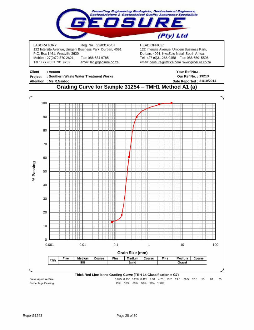
LABORATORY: Reg. No. : 92/03145/07 HEAD OFFICE:122 Intersite Avenue, Umgeni Business Park, Durban, 4091 122 Intersite Avenue, Umgeni Business Park,P.O. Box 1461, Westville 3630 Durban, 4091, KwaZulu Natal, South Africa.Mobile: +27(0)72 870 2621 Fax: 086 684 9785 Tel: +27 (0)31 266 0458 Fax: 086 689 5506Tel.: +27 (0)31 701 9732 email: [email protected] email: [email protected] www.geosure.co.za
Client : Aecom Your Ref No.:Project : Southern Waste Water Treatment Works Our Ref No. :Attention : Ms R.Naidoo Date Reported :
0.1 130.2 180.3 600.4 90
2 994.8 10013192738536375
Thick Red Line is the Grading Curve (TRH 14 Classification = G7)Sieve Aperture Size 0.075 0.150 0.250 0.425 2.00 4.75 13.2 19.0 26.5 37.5 53 63 75Percentage Passing 13% 18% 60% 90% 99% 100%
Grading Curve for Sample 31254 – TMH1 Method A1 (a)
-1921321/10/2014
0
10
20
30
40
50
60
70
80
90
100
0.001 0.01 0.1 1 10 100
Grain Size (mm)
% P
assi
ng
Report31243 Page 28 of 30
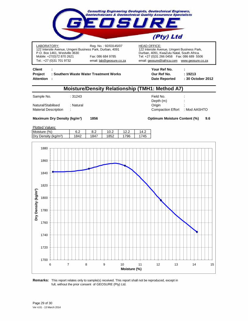
LABORATORY: Reg. No. : 92/03145/07 HEAD OFFICE:122 Intersite Avenue, Umgeni Business Park, Durban, 4091 122 Intersite Avenue, Umgeni Business Park,P.O. Box 1461, Westville 3630 Durban, 4091, KwaZulu Natal, South Africa.Mobile: +27(0)72 870 2621 Fax: 086 684 9785 Tel: +27 (0)31 266 0458 Fax: 086 689 5506Tel.: +27 (0)31 701 9732 email: [email protected] email: [email protected] www.geosure.co.za
Client : Your Ref No. : Project : Southern Waste Water Treatment Works Our Ref No. : 19213Attention : Date Reported
Sample No. : 31243 Field No. : Depth (m) :
Natural/Stabilised : Natural Origin : Material Description Compaction Effort : Mod AASHTO
Maximum Dry Density (kg/m³) 1856 9.6
Plotted Values:Moisture (%) 6.2 8.2 10.2 12.2 14.2Dry Density (kg/m³) 1842 1847 1852 1796 1745
Remarks:
Ver 4.01 - 13 March 2014Page 29 of 30
This report relates only to sample(s) received. This report shall not be reproduced, except in full, without the prior consent of GEOSURE (Pty) Ltd.
: 30 October 2012
Moisture/Density Relationship (TMH1: Method A7)
Optimum Moisture Content (%)
:
1700
1720
1740
1760
1780
1800
1820
1840
1860
1880
6 7 8 9 10 11 12 13 14 15Moisture (%)
Dry
Den
sity
(kg/
m³)

LABORATORY: Reg. No. : 92/03145/07 HEAD OFFICE:122 Intersite Avenue, Umgeni Business Park, Durban, 4091 122 Intersite Avenue, Umgeni Business Park,P.O. Box 1461, Westville 3630 Durban, 4091, KwaZulu Natal, South Africa.Mobile: +27(0)72 870 2621 Fax: 086 684 9785 Tel: +27 (0)31 266 0458 Fax: 086 689 5506Tel.: +27 (0)31 701 9732 email: [email protected] email: [email protected] www.geosure.co.za
Client : Your Ref No. : Project : Southern Waste Water Treatment Works Our Ref No. : 19213Attention : Date Reported
Sample No. : 31254 Field No. : Depth (m) :
Natural/Stabilised : Natural Origin : Material Description Compaction Effort : Mod AASHTO
Maximum Dry Density (kg/m³) 1843 8.8
Plotted Values:Moisture (%) 5.4 7.4 9.4 11.4 13.4Dry Density (kg/m³) 1826 1836 1841 1797 1738
Remarks:
Ver 4.01 - 13 March 2014Page 30 of 30
This report relates only to sample(s) received. This report shall not be reproduced, except in full, without the prior consent of GEOSURE (Pty) Ltd.
: 30 October 2012
Moisture/Density Relationship (TMH1: Method A7)
Optimum Moisture Content (%)
:
1700
1720
1740
1760
1780
1800
1820
1840
1860
5 6 7 8 9 10 11 12 13 14Moisture (%)
Dry
Den
sity
(kg/
m³)

TRIAXIAL TESTS
RESULTS

Test Report 11/6/2014
Deviatric Stress(kg/Sq.cm) vs Axial Strain(%)
BH5 (11.08-11.47m) Specimens were tested at 200, 400 & 600kPa
Remarks
Soil Type
Project Site (GEO-199) SWWTW
(910) Grey slightly clayey silty SAND-Estuarine
CUBar Test
Project Id
Test Type
Aecom
Project Description

Test Report 11/6/2014
Pore Pr.(kg/sq.cm) vs Axial Strain(%)
StressRatio vs Axial Strain(%)

Test Report 11/6/2014
Mohr-Columb Plot [c=0.42(kg/sq.cm) Phi=30.2(deg)]
mean stress vs shear stress [a=0.36(kg/sq.cm) alpha=26.7(deg)]
CONSOLIDATION TEST
RESULTS
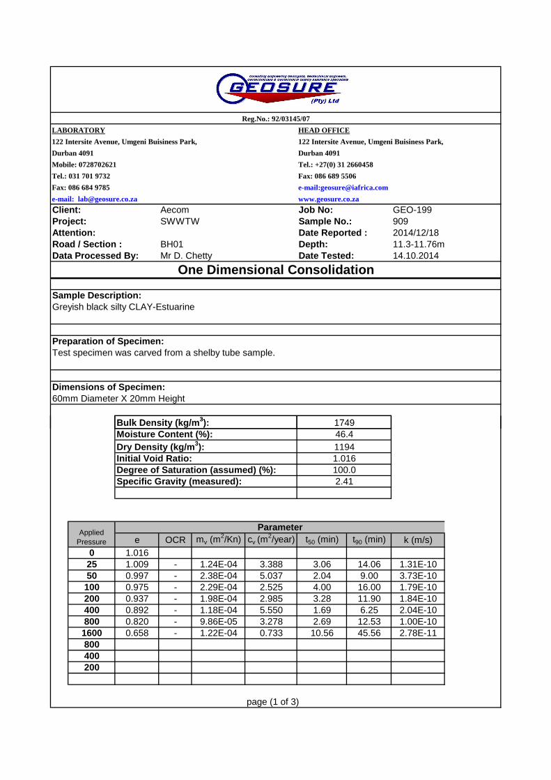
Fax: 086 684 9785
Client: Aecom Job No: GEO-199Project: SWWTW Sample No.: 909Attention: Date Reported : 2014/12/18Road / Section : BH01 Depth: 11.3-11.76mData Processed By: Mr D. Chetty Date Tested: 14.10.2014
Sample Description:
Preparation of Specimen:
Dimensions of Specimen:
Reg.No.: 92/03145/07
One Dimensional Consolidation
Bulk Density (kg/m3):
Test specimen was carved from a shelby tube sample.
122 Intersite Avenue, Umgeni Buisiness Park, 122 Intersite Avenue, Umgeni Buisiness Park,
Durban 4091 Durban 4091
1749
Mobile: 0728702621 Tel.: +27(0) 31 2660458
e-mail: [email protected] www.geosure.co.za
Tel.: 031 701 9732
LABORATORY HEAD OFFICE
60mm Diameter X 20mm Height
Fax: 086 689 5506
e-mail:[email protected]
Greyish black silty CLAY-Estuarine
e OCR mv (m2/Kn) cv (m
2/year) t50 (min) t90 (min) k (m/s)0 1.01625 1.009 - 1.24E-04 3.388 3.06 14.06 1.31E-1050 0.997 - 2.38E-04 5.037 2.04 9.00 3.73E-10100 0.975 - 2.29E-04 2.525 4.00 16.00 1.79E-10200 0.937 - 1.98E-04 2.985 3.28 11.90 1.84E-10400 0.892 - 1.18E-04 5.550 1.69 6.25 2.04E-10800 0.820 - 9.86E-05 3.278 2.69 12.53 1.00E-101600 0.658 - 1.22E-04 0.733 10.56 45.56 2.78E-11800400200
page (1 of 3)
Initial Void Ratio:Degree of Saturation (assumed) (%):Specific Gravity (measured):
1.016100.02.41
Bulk Density (kg/m3):Moisture Content (%):
1749
Dry Density (kg/m3): 1194
Applied Pressure
46.4
Parameter

Fax: 086 684 9785
Client: Aecom Job No: GEO-199Project: SWWTW Sample No. 909Attention: Date Reported : 2014/12/18Road / Section : BH01 Depth: 11.3-11.76mData Processed By: Mr D. Chetty Date Tested: 14.10.2014
Tel.: 031 701 9732
Mobile: 0728702621 Tel.: +27(0) 31 2660458
www.geosure.co.za
Fax: 086 689 5506
122 Intersite Avenue, Umgeni Buisiness Park, 122 Intersite Avenue, Umgeni Buisiness Park,
Durban 4091 Durban 4091
e-mail:[email protected]
e-mail: [email protected]
Reg.No.: 92/03145/07
LABORATORY HEAD OFFICE
0.750
0.800
0.850
0.900
0.950
1.000
1.050
Vo
id R
atio
(e)
Void Ratio Vs Pressure
Notes:
(page 2 of 3)
Dhiven Chetty Laboratory Technician
0.600
0.650
0.700
0.750
0.800
0.850
0.900
0.950
1.000
1.050
1 10 100 1000 10000
Vo
id R
atio
(e)
Pressure(kPa)
Void Ratio Vs Pressure
Fax: 086 684 9785
Client: Aecom Job No: GEO-199Project: SWWTW Sample No. 909Attention: Date Reported : 2014/12/18Road / Section : BH01 Depth: 11.3-11.76mData Processed By: Mr D. Chetty Date Tested: 14.10.2014
Definitions:
e OCRmv
cv
t50
t90
kCα
Mobile: 0728702621 Tel.: +27(0) 861 4367873
Tel.: 031 701 9732 Fax: 086 689 5506
coefficient of secondary compression
Coefficient of consolidation
time taken for 50% consolidation
time taken for 90% consolidationcoefficient of permeability
coefficient of volume compressibilty
e-mail: [email protected]
e-mail:[email protected]
www.geosure.co.za
Appendix
void ratiooverconsolidation ratio
Reg.No.: 92/03145/07
Durban 4091
LABORATORY HEAD OFFICE
122 Intersite Avenue, Umgeni Buisiness Park, 122 Intersite Avenue, Umgeni Buisiness Park,
Durban 4091
Cα
(page 3 of 3)
coefficient of secondary compression
Disclaimer: Please note that all values were done manually by hand calculation. All settlement graphs are available on request for own interpretation.