geotechnical hazard reports
TRANSCRIPT

APPENDIX D Geotechnical Hazard Reports
D.1Orange Bluff Evaluation Report

1011 N. Armando Street, Anaheim, CA 92806-2606 (714) 630-1626
formerly Albus-Keefe & Associates, Inc.
June 24, 2021 J.N.: 2609.03
Mr. Kevin Laney VP of Business Development Signal Hill Petroleum Inc. 2633 Cherry Ave. Signal Hill, CA 90755 Subject: “Revised” Geologic Hazards Evaluation Report, Orange Bluff Site, East 28th
Street and Orange Avenue, City of Signal Hill, California (Assessor Parcel Nos. 7212-008-049, 7212-008-051, 7212-010-010, 7212-010-019, and 7212-010-020).
Dear Mr. Laney, Pursuant to your request, Albus & Associates, Inc. is pleased to present to you our “revised” geologic hazards evaluation report for the Orange Bluff site. This report summarizes the site-specific potential for geologic hazards at the site. This report is intended to support the preparation of the Program Environmental Impact Report for the subject site. This report is not intended to provide geotechnical recommendations for design and construction associated with future site development. We appreciate this opportunity to be of service to you. If you should have any questions regarding the contents of this report, please do not hesitate to call our office. Sincerely yours, ALBUS & ASSOCIATES, INC. Michael O. Spira Principal Engineering Geologist

Signal Hill Petroleum Inc. June 24, 2021 J.N.: 2609.03 Page i
ALBUS-KEEFE & ASSOCIATES, INC.
TABLE OF CONTENTS
REPORT
1.0 INTRODUCTION .............................................................................................................. 1 1.1 PURPOSE AND SCOPE .................................................................................................. 1 1.2 PROJECT SITE DESCRIPTION ...................................................................................... 1
Site Location and Legal Description .......................................................................... 1 1.2.1 Physical Setting .......................................................................................................... 1 1.2.2
1.3 PROPOSED DEVELOPMENT ........................................................................................ 3 2.0 RESEARCH ........................................................................................................................ 3 3.0 GEOLOGIC SETTING ..................................................................................................... 4
3.1 REGIONAL GEOLOGY .................................................................................................. 4 3.2 LOCAL GEOLOGY ......................................................................................................... 6
Artificial Fill ............................................................................................................... 6 3.2.1 Topsoil ........................................................................................................................ 6 3.2.2 Lakewood Formation .................................................................................................. 6 3.2.3 San Pedro Formation .................................................................................................. 6 3.2.4
3.3 FAULTING ....................................................................................................................... 7 3.4 GROUNDWATER ............................................................................................................ 8
4.0 GEOLOGIC HAZARDS FINDINGS ............................................................................... 8 4.1 GENERAL ........................................................................................................................ 8 4.2 GROUND RUPTURE ....................................................................................................... 8 4.3 GROUND LURCHING .................................................................................................... 8 4.4 GROUND SHAKING ....................................................................................................... 9 4.5 LANDSLIDING ................................................................................................................ 9 4.6 LIQUEFACTION .............................................................................................................. 9 4.7 TSUNAMI AND SEICHES ............................................................................................ 10 4.8 GROUND SUBSIDENCE .............................................................................................. 10 4.9 EXPANSIVE SOILS ....................................................................................................... 10 4.10 CORROSIVE SOILS ................................................................................................... 10 4.11 SOIL EROSION .......................................................................................................... 11
5.0 LIMITATIONS ................................................................................................................. 11 REFERENCES ........................................................................................................................... 12
FIGURES and PLATES Figure 1 - Site Location Map Figure 2 – Regional Fault Map Plate 1 – Seismic Hazards Map

Signal Hill Petroleum Inc. June 24, 2021 J.N.: 2609.03 Page 1
ALBUS-KEEFE & ASSOCIATES, INC.
1.0 INTRODUCTION
1.1 PURPOSE AND SCOPE The purpose of our study was to evaluate the potential geologic hazards of the site. Geologic hazards are considered geologically related conditions that may present a potential danger to life and property. We understand the information from our evaluation will be utilized by Meridian Consultants in preparing a Program Environmental Impact Report in order to assist the city of Signal Hill with their Housing Element update. The scope of our geologic hazards evaluation generally included the following:
• Geologic site reconnaissance,
• Review of published and unpublished geologic literature and maps, and other readily available documents,
• Review of historical aerial photographs and topographic maps,
• Review of our previous fault studies for the site and neighboring properties,
• Review of the Phase I Environmental Site Assessment for the subject site,
• Preparation of this geologic hazards evaluation report.
1.2 PROJECT SITE DESCRIPTION
Site Location and Legal Description 1.2.1The Orange Bluff site is located southeast of the intersection of East 28th Street and Orange Avenue in the city of Signal Hill (Assessor Parcel Nos. 7212-008-049, 7212-008-051, 7212-010-010, 7212-010-019, and 7212-010-020). In general, the site is bordered by 28th Street to the north, Orange Avenue to the west, by light industrial/commercial property and Gundy Avenue to the east and by oil field property and light industrial/commercial property to the south. The site and its relationship to the surrounding area are shown on Figure 1, Site Location Map.
Physical Setting 1.2.2Topographically, the site is generally situated on the top of an uplifted hill that forms the northwest extension (nose) of Signal Hill. The site is relatively flat to gently sloping to the northwest and north. Ground surface elevations within the site, based on Google Earth imagery, currently range from approximately 150 feet above mean sea level at the southeastern margin of the site to approximately 113 feet above mean sea level at the northern margin of the site.

Signal Hill Petroleum Inc. June 24, 2021 J.N.: 2609.03
Page 2
ALBUS & ASSOCIATES, INC.
Source: 2021 Google Earth©
SITE LOCATION MAP FIGURE 1
Orange Bluff Site
Signal Hill, California
SITE
Scale Bar:

Signal Hill Petroleum Inc. June 24, 2021 J.N.: 2609.03
Page 3
ALBUS & ASSOCIATES, INC.
The site is largely being utilized for crude oil and natural gas production associated with the Long Beach Oil Field which began operations in the early 1920’s. Over the years, the site has been occupied by various oil field related improvements, many of which do not exist today. Ground modifications involving cut and fill grading have been made throughout the site in association with these improvements. Based on our geologic site reconnaissance on May 26, 2021, the surface of the site is covered with dirt, gravel, or asphalt grindings. The site is occupied by numerous active and abandoned oil wells, pumping units, above and below-ground pipelines, and a small building at the northeast corner of the property. Stormwater quality improvements consisting of straw wattles, silt fences, sandbag berms, and detention basins with associated piping are also present on the site. At the time of our visit, some shallow erosion rills where noted at the site where some sandbag berms had failed. Vegetation within the site generally consists of scattered trees and shrubs largely along the margins of the property.
1.3 PROPOSED DEVELOPMENT No specific plans for development are currently proposed. However, based on the referenced Orange Bluff Site Analysis Plan, dated October 13, 2020, and discussions with Signal Hill Petroleum Inc., the site is being considered for both residential and commercial/industrial development.
2.0 RESEARCH We have reviewed historical aerial photos, geologic publications, and maps for the site and surrounding areas. We also reviewed our recently completed fault study for the site (Albus, 2021), as well as other fault studies conducted in the project area by this firm (Albus, 2018 & 2019). In addition, we reviewed the referenced Phase I Environmental Site Assessment report (Mearns, 2021) for the site. A complete listing of the reviewed documents is presented in the references section of this report. The data from these sources were utilized to develop some of the findings and conclusions presented herein and are discussed in detail in later sections in this report. Our recent fault study for the site was conducted to assess fault rupture potential within the southern portion of the site, which is situated in a California-defined zone of required investigation referred to as the Alquist-Priolo Earthquake Fault Zone (EFZ) for the Cherry Hill fault. This study involved the excavation and logging of a single fault trench within the adjoining property to the south and east of the study area. This was due to the presence of abandoned oil wells and major underground oil pipelines within the southwest corner of the site. The fault trench was 335 foot long and 10 to 14 feet deep. The fault trench was excavated in a general north-south orientation and positioned to look for evidence of faulting that could project into the study area based on the regional trend of the Cherry Hill fault. The trench was extended far enough to the south so as to shadow the area at least 50 feet beyond the southwest corner of the site.

Signal Hill Petroleum Inc. June 24, 2021 J.N.: 2609.03
Page 4
ALBUS & ASSOCIATES, INC.
3.0 GEOLOGIC SETTING
3.1 REGIONAL GEOLOGY The site, as shown on the Regional Geologic Map, Figure 3, is located at the northwest extension of Signal Hill. Signal Hill forms part of a chain of northwest trending low hills and mesas that rise up above the low-lying flat terrain of the Los Angeles Basin within the coastal section of the Peninsular Ranges Geomorphic Province of California. These small hills and mesas extend southeasterly from the Cheviot Hills-Beverly Hills area in Los Angeles County to Newport Mesa, in Orange County and form the surface expression of the Newport-Inglewood Fault Zone (NIFZ). Subsidence and deposition within the Los Angeles Basin are believed to have initiated about 7 million years ago, in late Miocene time, as the San Andreas fault shifted eastward to its present location. As the basin subsided, it was filled with sediments that eroded from the surrounding highlands through the late Pleistocene. The inception of right-lateral displacement along the NIFZ is believed to have occurred some 2 to 5 million years ago (Wright, 1991), but the structural features along the NIFZ did not have topographic expression before late Pleistocene time (Yerkes et al., 1965). In the last 2 million years, during the Pleistocene epoch, the region was continually deformed and gradually uplifted along the fault zone to produce the geomorphic expression of Signal Hill and central portions of Long Beach (Yerkes et al., 1965; Wright, 1991). The Signal Hill area is underlain by up to about 15,000 feet of deep-water marine and shallow-water sediments that rest unconformably above metamorphic basement rock. The stratigraphic units exposed in the Signal Hill area consist of the lower Pleistocene-age San Pedro Formation and the upper Pleistocene-age Lakewood Formation. The San Pedro Formation is marine in origin and consists of sandstone approximately 800 feet in thickness. The estimated age for the upper part of this unit, based on Ponti and Lajoie (1992) is about 800,000 to 650,000 years old. The Lakewood Formation unconformably overlies the San Pedro Formation. The Lakewood Formation is both marine and non-marine in origin as a result of coastline fluctuations and uplift during the later Pleistocene and consists of poorly consolidated sandstone up to 300 feet in thickness (Thomas, 1961). Ponti and Lajoie (1992) estimate the age of the Lakewood Formation to be less than approximately 220,000 years old in the Signal Hill area. On the Regional Geologic Map, Figure 2, the old shallow marine deposits on a wave cut surface (map symbol Qom) represents the Lakewood Formation. The San Pedro Formation is not shown on the Regional Geologic Map in the Signal Hill area because it generally does not crop out at the surface. Structurally, Signal Hill rises about 300 feet above the surrounding terrain and forms a complex northwest-trending anticlinal dome structure overprinted on a larger preexisting anticlinal structure. As shown on the Regional Geologic Map, Figure 2, Signal Hill is bounded by two major northwest-trending step-over fault segments of the NIFZ; the Cherry Hill fault to the southwest and the Northeast Flank fault to the northeast. These surface faults are believed to be interconnected at depth to form one near vertical “master fault” (Barrows, 1974). In essence, this postulated vertical master fault, or fault zone flowers upward to form the near surface fault structures. The resulting compressive stresses formed between the step-over fault segments and flowering structures are believed to be at least partially responsible for the substantial fracturing and uplifting of Signal Hill (St. Peters and Whitney, 1992).

Signal Hill Petroleum Inc. June 24, 2021 J.N.: 2609.03
Page 5
ALBUS & ASSOCIATES, INC.
REGIONAL GEOLOGIC MAP FIGURE 2
Explanation: Contours Intervals: 10 Meters
From: Saucedo, J. G., Greene, H.G., Kennedy, M.P., Bezore, S.P., 2016, Geologic Map of the Long Beach 30’ x 60’ Quadrangle, California, Version 2, California Geological Survey
Northeast Flank Fault
Cherry Hill Fault Signal Hill
SITE
Reservoir Hill Fault
Scale Bar:

Signal Hill Petroleum Inc. June 24, 2021 J.N.: 2609.03
Page 6
ALBUS & ASSOCIATES, INC.
3.2 LOCAL GEOLOGY The geologic conditions of the site are based on review of our previous studies in the project area, our recent fault study for the site, and our geologic site reconnaissance. In general, bedrock assigned to the upper Pleistocene-age Lakewood Formation underlies the entire site. These sediments unconformably overlie the lower Pleistocene-age San Pedro Formation at depth. A relatively thin topsoil unit is typically present in the near surface where the original ground surface has not been significantly modified. Artificial fills associated with past oil field activity were also noted during our geologic site reconnaissance and are typically present on most oil field properties in the area. Descriptions of the geologic units observed on site are provided in the following sections.
Artificial Fill 3.2.1The artificial fill materials generally consist of locally derived silty sand and clayey sand. The artificial fills are typically brown, dark brown, and gray in color and from our experience can contain various amounts of pipe, wood, asphalt, brick, and concrete debris. The thicknesses of artificial fill materials can be extremely variable depending on the previous activity at the site. Based on our observations and experience in the project area, the artificial fills are anticipated to be on the order of 10 feet or less in thickness. However, in areas of abandoned wells and former sumps, the fill thicknesses can be much greater.
Topsoil 3.2.2The topsoil materials typically consist of silty sands that are gray-brown to dark brown in color, fine grained, medium dense, damp to moist, slightly porous to very porous, and friable. The thickness of the topsoil materials, based on our experience in the project area, is generally on the order of 3 feet or less.
Lakewood Formation 3.2.3The Lakewood formation generally consists of silty sandstone and sandstone that is yellow brown to light yellow brown in color, poorly consolidated, and massive. Within the near surface, the sediments of the Lakewood Formation are typically pedogenically altered forming a thick soil profile generally on the order of approximately 10 feet thick. This soil profile is characterized by a thick, well-developed argillic (Bt) soil horizon followed by a banded, laminar (Btlam) soil horizon at depth. The banded, laminar soil horizon consists of near-horizontal wavy to irregular Bt lamellae that are irregularly spaced between the layers of the poorly consolidated sandstone. The argillic soil horizon and the Bt lamellae within the banded, laminar soil horizon are easily recognized by their higher clay and iron oxide content than the parent materials, their reddish color hues, and their moderate to strong angular blocky soil structures.
San Pedro Formation 3.2.4The underlying San Pedro Formation typically consists of silty sandstone and sandstone that is pale yellow to yellow and light gray to white in color, massive to thinly bedded, locally cross-bedded, and micaceous. Based on our studies in the project area, the depth to the San Pedro Formation beneath the site could vary from approximately 15 feet at the northern portion of the site to approximately 30 feet at the southern portion of the site.

Signal Hill Petroleum Inc. June 24, 2021 J.N.: 2609.03
Page 7
ALBUS & ASSOCIATES, INC.
3.3 FAULTING The far southwestern portion of the site is located within the boundary of an Earthquake Fault Zone (EFZ) associated with the Cherry Hill fault (see Seismic Hazard Map, Plate 1). The Cherry Hill fault, as discussed in Section 3.1, is a major segment of the NIFZ. Based on our referenced fault study for the site (Albus, 2021), we found no evidence of faulting in our offsite fault trench. Thereby, demonstrating that there is no evidence of faulting that could project into the southwest corner of the site within the limits of EFZ as well as a distance of 50 feet beyond the southwest corner of the site, based on the regional trend of the Cherry Hill fault. In addition, results of previous fault studies in the area have also shown that there is no evidence of faulting projecting toward the site. Furthermore, some of the studies conducted west, south, and southeast of the immediate vicinity of the site have exposed the Cherry Hill fault in trenches. As a result, the Cherry Hill fault is moderately to well defined in the vicinity of the site and at its closest approach is approximately 250 feet southwest of the site. Table 3.1 presents a summary of all the known seismically active faults within 10 miles of the site based on the Third Uniform California Earthquake Rupture Forecast (UCERF3) USGS database (Field, E.H. et al., 2013). Although the USGS database indicates the Newport Inglewood, alt. 1 & 2 faults are present within the site boundary, the locations of these faults are very approximate on a local scale. Results of our fault studies for the site and project area confirm no active faults trend through the site.
TABLE 3.1 Summary of Seismically Active Faults
Name Dist. (miles)
Average Slip Rate (mm/yr.)
Average Dip
(degrees) Slip Sense
Rupture Top (km)
Trace Length (km)
Newport Inglewood, alt 2 0 1.23 90 strike slip 0 65.7
Newport-Inglewood, alt 1 0 1.5 88 strike slip 0 65.4
Compton 4.1 0.98 20 thrust 5.2 64.8
Palos Verdes 6.0 3.04 90 strike slip 0 107.1
Anaheim 7.9 1.04 71 thrust 3.8 15.7
Puente Hills (Santa Fe Springs) 7.2 0.71 29 thrust 2.8 11.5
Puente Hills (Coyote Hills) 9.5 0.82 26 thrust 2.8 17
Notes: 1. Source of data is from UCERF3. 2. Distance measured from the closest site boundary.

Signal Hill Petroleum Inc. June 24, 2021 J.N.: 2609.03
Page 8
ALBUS & ASSOCIATES, INC.
3.4 GROUNDWATER Groundwater was not reported in any of our previous investigations in the project area. In addition, California Seismic Hazard Zone Report 028 (CDMG, 1998) does not provide any data on shallowest historical groundwater levels in proximity to the site. Our review of the Los Angeles County Department of Public Works Well Data website identified an inactive groundwater monitoring well in the project vicinity. This well, referred to as State Well Number 929, is located southwest of the intersection of Gundry Avenue and East 27th Street, and may actually be located within or very near the southeastern portion of the site. The groundwater level from this well was initially measured at 127.3 feet below the ground surface (bgs) on October 15, 1957. The water level gradually declined over the years to 156.2 feet bgs when it was last measured on January 5, 1970.
4.0 GEOLOGIC HAZARDS FINDINGS
4.1 GENERAL Geologic hazards are defined as geologically related conditions that may present a potential danger to life and property. A number of pertinent factors could impact the site. The site-specific potential for each of these geologic hazards is discussed in the following sections.
4.2 GROUND RUPTURE The southwestern portion of the site is located within the boundary of an Earthquake Fault Zone associated with the Cherry Hill fault (See Seismic Hazards Map, Plate 1). Earthquake Fault Zones are delineated by the State of California to define areas where fault rupture hazard investigations are required prior to building structures for human occupancy. No structure for human occupancy is permitted over the trace of an “active” fault. An “active” fault, as defined by the state, is a fault that has had surface displacement during Holocene time (last 11,700 years). Results of our recent fault study for the site (Albus, 2021) have shown that there is no evidence of faults projecting toward the southwest corner of the site and at least 50 feet beyond the southwest corner of the site. Furthermore, results of previous fault studies in the area have also shown that there is no evidence of faulting projecting toward the site and that the main trace of the Cherry Hill fault is located approximately 250 feet southwest of the site at its closest approach. As such, the potential for future ground rupture associated with active faulting within the site is considered remote.
4.3 GROUND LURCHING Ground lurching is the horizontal and vertical movement of soil or bedrock due to strong ground shaking. Lurching can be both transitory and permanent and often forms cracks in the ground surface. The potential for ground lurching is most prevalent in areas underlain by soft or saturated loose soils but can also occur on steep slopes comprised of poorly consolidated or fractured rock formations. Horizontal and vertical ground deformation resulting from ground lurching can adversely impact structures and compromise the stability of slopes. The project site is anticipated to be constructed to a relatively level condition and is not located immediately adjacent steep or high slopes. Furthermore, the site is not underlain by soft or saturated loose soils or poorly

Signal Hill Petroleum Inc. June 24, 2021 J.N.: 2609.03
Page 9
ALBUS & ASSOCIATES, INC.
consolidated/fractured bedrock. As such, the potential for future ground lurching associated with strong ground shaking is considered remote.
4.4 GROUND SHAKING The site is situated in a seismically active area that has historically been affected by generally moderate to occasionally high levels of ground motion. The site lies in relative close proximity to several active faults. Therefore, during the life of the proposed developments, the property will probably experience similar moderate to occasionally high ground shaking from these fault zones, as well as some background shaking from other seismically active areas of the Southern California region. Design and construction in accordance with the current California Building Code (CBC) requirements is anticipated to adequately mitigate issues related to potential ground shaking.
4.5 LANDSLIDING The project site is relatively flat to gently sloping and is not located immediately adjacent steep terrain. As such, geologic hazards associated with landsliding are not anticipated at the site. The site is not located within an area identified by the California Geological Survey (CGS) as having potential for seismic slope instability (See Seismic Hazards Map, Plate 1).
4.6 LIQUEFACTION Liquefaction is the sudden decrease in the strength of cohesionless soils due to dynamic or cyclic shaking. Saturated soils behave temporarily as a viscous fluid (liquefaction) and, consequently, lose their capacity to support the structures founded on them. Engineering research of soil liquefaction potential (Youd, et al., 2001) indicates that generally three basic factors must exist concurrently in order for liquefaction to occur. These three factors are:
• A source of ground shaking, such as an earthquake, capable of generating soil mass distortions.
• Relatively loose, granular soils or sensitive clays having high moist contents. • A relative shallow groundwater table (within approximately 50 feet below ground surface) or
completely saturated soil conditions that will allow positive pore pressure generation.
The liquefaction susceptibility of the onsite soils was evaluated by analyzing the potential of concurrent occurrence of the above-mentioned three basic factors. The liquefaction evaluation for the site was completed under the guidance of Special Publication 117A: Guidelines for Evaluating and Mitigating Seismic Hazards in California (CDMG, 2008). Groundwater is anticipated to be more than 50 feet below the ground surface and the site is also underlain by relatively dense materials of the Lakewood and San Pedro Formations. As such, liquefaction is unlikely to occur at the site. The site is not located within a mapped California Geological Survey liquefaction hazard zone (See Seismic Hazards Map, Plate 1).

Signal Hill Petroleum Inc. June 24, 2021 J.N.: 2609.03
Page 10
ALBUS & ASSOCIATES, INC.
4.7 TSUNAMI AND SEICHES A tsunami is a sea wave generated by large-scale displacements of the ocean floor that causes a sudden surge of water onto the land. Tsunamis are most commonly caused by movement along faults and underwater landslides activated by earthquakes. Seiches are earthquake-induced displacements of water within an enclosed body of water such as a lake. Strong ground motions from an earthquake cause the water to slosh back and forth onto land. The site is elevated more than 113 feet above sea level and is located a substantial distance from a significant body of water within an enclosed basin. As such, geologic hazards associated with a tsunami or seiches are not anticipated at the site. Based on of the Tsunami Hazard Area Map of Los Angeles County prepared by CGS (2021), the site is not located within a Tsunami hazard area.
4.8 GROUND SUBSIDENCE Ground subsidence has been reported in areas of southern California as a result of gas, oil, or water extraction, as well as peat oxidation. The subject site is located in an area known to have experienced ground subsidence in the past largely due to oil extraction. Provided that oil field reservoir management strategies that include subsidence mitigation continue to be employed in the area, ground subsidence beneath the site that could result in damage to future site improvements is unlikely to occur at the site.
4.9 EXPANSIVE SOILS Expansive soils generally contain significant amounts of clay which tend to undergo swelling when wetted and shrinking when dried. Changes in moisture in expansive soils can cause volumetric changes in the soil leading to vertical and horizontal movement in overlying structures. Expansive soils can have detrimental effects on the performance of foundations, retaining walls, and flatwork. Based on our experience in the project area, the expansion characteristic of the near surface soils of the site are anticipated to exhibit Very Low to Low expansion potential (UBC 18-I-B). Given the expansion potential anticipated at the site, only nominal steps will be needed to mitigate adverse effects such as minor steel reinforcing of foundations and slabs, and moisture preparation and jointing details for flatwork.
4.10 CORROSIVE SOILS Corrosive soils possess properties that are reactive with construction materials such as metals and concrete. Generally, soils that contain clays have low electrical resistivity and can cause corrosion of metals in contact with such soils. Soils that contain high amounts of sulfates can cause degradation of concrete. Based on our general experience in the area, the site soils are likely Moderately to Highly corrosive to metals. Where site development may involve the use of metals that could be in contact with site soils, a variety of steps can be taken to mitigate the potential adverse effects including the use of coatings, membranes, and cathodic protection. With respect to sulfates, the site soils are anticipated to have Negligible soluble sulfate content. Concrete designed to follow the procedures provided in ACI 318, Section 4.3, Table 4.3.1 for negligible sulfate exposure are anticipated to be adequate for the mitigation of sulfate attack on concrete.

Signal Hill Petroleum Inc. June 24, 2021 J.N.: 2609.03
Page 11
ALBUS & ASSOCIATES, INC.
4.11 SOIL EROSION Soil erosion is the movement of near-surface soil particles generally by flowing water and in some cases high winds. Sandy soils are generally more susceptible to erosion than clayey soils. Much of the site is covered with sandy soils and the relatively flat to very gently sloping terrain makes the site susceptible to slight soil erosion during periods of significant rainfall. This was evident during our site reconnaissance by the presence of shallow erosion rills where concentrated runoff had occurred because some of the sandbag berms associated with the existing stormwater quality improvements at the site had failed. Typically, the potential for soil erosion can be mitigated during future development through several methods including use of proper vegetation and surface stabilizing products, grading to avoid concentrated flows, and construction of basins or structures to collect sediments prior to entering bodies of water. The site is not located in an area subject to frequent and sustained high winds that could result in significant erosion of surface soils.
5.0 LIMITATIONS This report presents of a summary of our geologic hazard evaluation of the site. This report is based on our review of data collected, our geologic site reconnaissance, and our engineering and geologic opinions from years of experience in the Signal Hill area. This report has been prepared for the use of the Signal Hill Petroleum Inc. and the project consultants. The information presented herein is intended to only assist in the preparation of a Program Environmental Impact Report. This report is not intended to satisfy the requirements of a site specific and detailed geotechnical investigation required for further planning and permitting. This report has been prepared consistent with that level of care being provided by other professionals providing similar services at the same locale and time period. The contents of this report are professional opinions and as such, are not to be considered a guaranty or warranty. Respectfully submitted, ALBUS & ASSOCIATES, INC Michael O. Spira David E. Albus Principal Engineering Geologist Principal Engineer C.E.G. 1976 G.E. 2455

Signal Hill Petroleum Inc. June 24, 2021 J.N.: 2609.03
Page 12
ALBUS & ASSOCIATES, INC.
REFERENCES Publications Barrows, A.G., 1974, A Review of the Geology and Earthquake History of the Newport-Inglewood
Structural Zone, Southern California, California Division of Mines and Geology Special Report 114, pp. 115.
California Division of Mines and Geology (CDMG), 1998, Seismic Hazard Report for the Long
Beach 7.5-Minute Quadrangle, Los Angeles County, California: Seismic Hazard Zone Report 028.
California Division of Mines and Geology (CDMG), 1986 Revised Official, State of California
(Special Studies) Earthquake Fault Zone Map, Long Beach Quadrangle, dated July 1, 1986, Scale: 1:24,000.
California Division of Mines and Geology (CDMG), 1999, Seismic Hazard Zones for the Long
Beach Quadrangle, Official Map released March 25, 1999, Scale: 1:24,000. California Geological Survey (CGS), Special Publication 117A, Guidelines for Evaluating and
Mitigating Seismic Hazards in California, 2008. California Geological Survey (CGS), 1999, Earthquake Zones of Required Investigation, Long
Beach Quadrangle, Earthquake Fault Zones Revised Official Map Released July 1, 1986, Seismic Hazard Zones Official Map Released March 25, 1999.
California Geological Survey (CGS), 2018 Revision, Earthquake Fault Zones, A Guide For
Government Agencies, Property Owners / Developers, And Geoscience Practitioners For Assessing Fault Rupture Hazards In California: Special Publication 42.
California Geological Survey (CGS), 2019, NOTE 48-Checklist for the Review of Engineering
Geology and Seismology Reports for California Public Schools, Hospitals and Essential Services Buildings, November.
California Geological Survey (CGS), 2021, Tsunami Hazard Area Map of Los Angeles County City of Signal Hill General Plan, 2016, Safety Element. Field, E.H., Biasi, G.P., Bird, P., Dawson, T.E., Felzer, K.R., Jackson, D.D., Johnson, K.M., Jordan,
T.H., Madden, C., Michael, A.J., Milner, K.R., Page, M.T., Parsons, T., Powers, P.M., Shaw, B.E., Thatcher, W.R., Weldon, R.J., II, and Zeng, Y., 2013, Uniform California earthquake rupture forecast, version 3 (UCERF3)—The time-independent model: U.S. Geological Survey Open-File Report 2013–1165, 97 p., California Geological Survey Special Report 228, and Southern California Earthquake Center Publication 1792, http://pubs.usgs.gov/of/2013/1165/.

Signal Hill Petroleum Inc. June 24, 2021 J.N.: 2609.03
Page 13
ALBUS & ASSOCIATES, INC.
REFERENCES (cont.)
Los Angeles County Department of Public Works Well Data (accessed 2021):
https://dpw.lacounty.gov/general/wells/ Ponti, D.J., and Lajoie K.R., 1992, Chronostratigraphic Implications for Tectonic Deformation of
Palos Verdes and Signal Hill, Los Angeles Basin, California, in Heath, E.G. and Lewis, W.L. (editors), The Regressive Pleistocene Shoreline, Coastal Southern California, South Coast Geological Society, Annual Field Trip Guide Book No. 20, pp. 157-161.
Saucedo, J. G., Greene, H.G., Kennedy, M.P., Bezore, S.P., 2016, Geologic Map of the Long Beach
30’ x 60’ Quadrangle, California, Version 2, California Geological Survey. St.Peters, K.S., and R.A. Whitney, 1992, Structural Analysis of the Newport-Inglewood Fault Zone
for Mitigation of Surface Rupture Hazard to Future Residential Development at Signal Hill, California, in Association of Engineering Geologists Southern California Section Engineering Geology Field Trips, Orange County Santa Monica Mountains and Malibu 35th Annual Meeting, Oct 2-9, pp. A45-A54.
The Working Group on California Earthquake Probabilities consists of the U.S. Geological Survey,
California Geological Survey, and Southern California Earthquake Center. Their report is available at www.wgcep.org.
Thomas, R.G., 1961, Planned Utilization of the Ground Water Basins of the Coastal Plain of Los
Angeles County, Appendix A- A Ground Water Geology: State of California, Department of Water Resources Ground Water Geology, Bulletin No. 104.
Wright, T.L., 1991, Strucutual Geology and Tectonic Evolution of the Los Angeles Basin, California
Overview, in Biddle, K.T. ed., Active Margin Basins: American Association of Petroleum Geologists Memoir 52, p. 35-134.
Yerkes, R.F., et al., 1965, Geology of the Los Angeles Basin – An Introduction, Geological Survey
Professional Paper 420-A. Youd, T.L., Idriss, I.M., Andrus, R.D., Arango, I., Castro, G., Christian, J., Dobry, R., Finn, W.D.L.,
Harder, L.F., Hynes, M.E., Ishihara, K., Koester, J.P., Liao, S.S.C., Marcuson, W.F., Martin, G.R., Mitchell, J.K., Moriwaki, Y., Power, M.S., Robertson, P.K., Seed, R.B., and Stokoe, K.H., 2001, “Liquefaction Resistance of Soils: Summary Report from the 1996 NCEER and 1998 NCEER/NSF Workshops on Evaluation of Liquefaction Resistance.

Signal Hill Petroleum Inc. June 24, 2021 J.N.: 2609.03
Page 14
ALBUS & ASSOCIATES, INC.
REFERENCES (cont.) Report Albus-Keefe & Associates, Inc., 2018, Geologic Assessment of Surface Fault Rupture Potential,
Driving Range Property, Located Southeast of the Intersection of East Willow Street and Orange Avenue, City of Signal Hill, California., dated June 1, (J.N. 2609.00).
______, 2019, Geologic Assessment of Surface Fault Rupture Potential, McAuley Property,
(Assessor Parcel Nos. 7212-010-014, 7212-010-015, 7212-010-018, and 7212-010-029) Located Northwest of the Intersection of East Willow Street and Gundry Avenue, City of Signal Hill, California, July 10, 2019, (J.N. 2609.00).
______, 2021, “Revised” Geologic Assessment of Surface Fault Rupture Potential, Orange Bluff
Site, 2771 Gundry Avenue, City of Signal Hill, California (Assessor Parcel Nos. 7212-008-049, 7212-008-051, 7212-010-010, 7212-010-019, and 7212-010-020)., dated June 23, 2021, (J.N. 2609.02).
Mearns Consulting Inc., 2021, Phase I Environmental Site Assessment, 2771 Gundry Avenue,
Orange Bluff, Signal Hill, California, 90755, dated February 5. Plan Orange Bluff Site Analysis Plan, prepared by ktgy Architects + Planning, current version dated
October 13, 2020. Topographic Maps Topographic Map, City of Signal Hill and Vicinity, Signal Hill, California, prepared by Pacific Air
Industries, Scale: 1” = 100’, dated June 29, 1960. Provided by Environmental Data Resources Inc. Search: USGS, Long Beach 7.5-minute Quadrangle, 2012 USGS, Long Beach 7.5-minute Quadrangle, 1981 USGS, Long Beach 7.5-minute Quadrangle, 1972 USGS, Long Beach 7.5-minute Quadrangle, 1964 USGS, Long Beach 7.5-minute Quadrangle, 1949 USGS, Downey 15-minute Quadrangle, 1947 USGS, Downey 15-minute Quadrangle, 1943 USGS, Downey 15-minute Quadrangle, 1942 USGS, Long Beach 7.5-minute Quadrangle, 1925 USGS, Downey 15-minute Quadrangle, 1902 USGS, Downey 15-minute Quadrangle, 1899 USGS, Downey 15-minute Quadrangle, 1896

Signal Hill Petroleum Inc. June 24, 2021 J.N.: 2609.03
Page 15
ALBUS & ASSOCIATES, INC.
REFERENCES (cont.) Aerial Photographs Source Date Flown Flight No. Photo No. Scale Continental 4-3-60 311-5 5 & 6 1"=1000' Continental 1-31-70 61-7 177 &178 1"=4000' Continental 5-12-79 FC-LA 127 & 128 1"=2800' Continental 4-9-81 ORA-5 3 Continental 1-27-86 F 351 & 352 1"=2800' Continental 7-7-88 AF 19210 1"=2200' Continental 1-29-92 C85-7 29 & 30 1"=2000' Continental 10-15-97 C117-35 240 1"=2000'
Provided by Environmental Data Resources Inc. Search: Source Date Flown Scale Fairchild 1928 1"=500' Fairchild 1947 1"=666' Fairchild 1956 1"=400' Teledyne 1968 1"=480' Teledyne 1976 1"=666' USGS 1989 1"=666' USGS 1994 1"=666

SITE LOCATION
1Plate:6/24/21Date:2609.03Job No.:
SEISMIC HAZARDS MAP
0 1500 3000 6000
SCALE : 1" = 3000' Liquefaction ZonesAreas where historical occurrence of liquefaction or localgeological, geotechnical and ground water conditionsindicate a potential for permanent ground displacementssuch that mitigation as defined in Public Resources CodeSection 2693(c) would be required.
Active Fault TracesFaults considered to have been active during Holocenetime and have potential for surface rupture: Solid Line inBlack or Red where accurately located; Long Dash inBlack or Solid Line in Purple where approximatelylocated; Short dash in black or solid line in orange whereinferred; Dotted line in black or solid line in rose whereconcealed; Query (?) indicates additional uncertainty.Evidence of historic offset indicated by year ofearthquake-associated event or C for displacementcaused by fault creep.
Earthquake Fault ZonesZone boundaries are delineated by straight-line segments;the boundaries define the zone encompassing active faultsthat constitute a potential hazard to structures from surfacefaulting or fualt creep such that avoidance as described inPublic Resources Code Section 2621.5(c) would berequired.
Earthquake-Induced Landslide ZonesAreas where previous occurence of landslide movement, orlocal topographic, geological, geotechnical and subsurfacewater conditions indicated a potential for permanent grounddisplacements such that mitigation as defined in PublicResources Code Section 2693(c) would be required.
Overlapping Earthquake Fault and Seismic Hazard ZonesOverlap of Earthqueak Fault Zone and Liquefaction ZonesAreas that are covered by both Earthquake Fault Zone andLiquefaction Zone.
Overlap of Earthquake Fault Zone and Earthquake-InducedLandslide Zone Areas that are covered by both EarthquakeFault Zone and Earthquake-Induced Landslide Zone.
Note: Mitigation methods differ for each zone - AP Act onlyallows avoidance; Seismic Hazard Mapping Act allowsmitigation by engineering geological design as well asavoidance.
California Geological Survey (CGS), 1999, Earthquake Zones of Required Investigation, Long Beach Quadrangle, Earthquake Fault Zones RevisedOfficial Map Released July 1, 1986, Seismic Hazard Zones Official Map Released March 25, 1999.

D.2Review of Orange Bluff Evaluation Report

1642 E. Fourth Street Santa Ana California 92701 Telephones: (714) 412-2654 & 544-5321 Facsimile: (714) 494-4930
www.earthconsultants.com
July 9, 2021 ECI Project No. 4107
To: City of Signal Hill – Community Development Department
2175 Cherry Avenue Signal Hill, California 90755
Attention: Ms. Colleen T. Doan, Community Development Director Submitted via e-mail at [email protected] To: Meridian Consultants
706 S. Hill Street, 11th Floor Los Angeles, California 90014
Attention: Ms. Christine Lan, Senior Project Manager Submitted via e-mail at [email protected] Subject: Review of Geohazards Report for the Property Referred to as the Orange Bluff Site
in the City of Signal Hill, California (APNs 7212-008-049, 7212-008-051, 7212-010-010, 7212-01-019 and 7212-010-020)
References: Albus & Associates Inc. (AA), 2021a, “Revised” Geologic Hazards Evaluation Report,
Orange Bluff Site, East 28th Street and Orange Avenue, City of Signal Hill, California (Assessor Parcel Nos. 7212-008-049, 7212-008-051, 7212-010-010, 7212-01-019, and 7212-010-020); consulting report prepared for Signal Hill Petroleum Inc.; AA Job No. 2609.03, dated June 24, 2021, signed by Michael O. Spira, CEG 1976, Principal Engineering Geologist and David E. Albus, G.E. 2455, Principal Engineer.
Albus & Associates Inc. (AA), 2021b, “Revised” Geologic Assessment of Surface Fault
Rupture Potential, Orange Bluff Site, City of Signal Hill, California (Assessor Parcel Nos. 7212-008-049, 7212-008-051, 7212-010-010, 7212-010-019, and 7212-010- 020); consulting report prepared for Signal Hill Petroleum Inc., AA Job No. 2609.02, dated June 23, 2021, signed by Michael O. Spira, CEG 1976, Principal Engineering Geologist.
Earth Consultants International, Inc., 2021, Review of Fault Investigation Report for the Property Referred to as the Orange Bluff Site, 2771 Gundry Avenue, in the City of Signal Hill; review letter report conducted on behalf of and for the City of Signal Hill Community Development Department, ECI Project No. 4107, dated July 9, 2021, signed by Tania Gonzalez, CEG 1859, Engineering Geologic Reviewer for the City of Signal Hill.
July 9, 2021 ECI Project No. 4107
Review of Geo-Hazards Report for EIR Purposes Proposed Orange Bluff Project, City of Signal Hill Page 2
PROJECT DESCRIPTION The Orange Bluff site is a property approximately 9.2 acres in area located between E 28th and the westward projection of E 27th streets to the north and south, respectively, and between Gundry and Orange avenues to the east and west, respectively. The property is comprised of five separate parcels, as follows: APNs 7212-008-049 and -051, and 7212-010-010, -019 and -020. The site is currently mostly vacant and unpaved, except for a small building in the northeast corner of the site, and various areas covered in asphalt used for parking of vehicles and oil-field and construction equipment. A relatively large debris basin is located in the west-central portion of the site, and two smaller ones in its northeastern quadrant. Eleven active and ten abandoned oil wells are reportedly scattered throughout the property. The Orange Bluff site is also referred to as the “C” site because of its shape: the north, west and south sides of the site wrap around an existing, long, narrow building and associated parking lot that faces Gundry Avenue (with street addresses 2727 through 2745 Gundry Avenue). It is our understanding that the property is going to be re-developed, with the bulk of the property used for flex uses and two acres set aside for multi-family residential purposes. The proposed maximum of 295 dwelling units would be set aside for very low, low and moderate income residents. PHYSICAL, GEOLOGIC and SEISMIC SETTING The property is located on the northwest extension (or “nose”) of Signal Hill, an area that has been uplifted above the Los Angeles Basin over hundreds of thousands of years as a result of movement on the Newport-Inglewood Fault Zone (NIFZ) and associated structures. The site is gently sloping to the north, with elevations varying from approximately 150 feet above mean sea level (amsl) near the southern portion of the site to about 113 feet amsl along the northern margin of the property (AA, 2021a). The ground surface at the site has been modified extensively in the past approximately 100 years as a result of oil field operations, which included the emplacement of oil wells, burial of pipelines, construction of roads, and grading related to the onsite debris basins and other stormwater quality improvement devices. There are no steep slopes at the site. Signal Hill, including the subject site, is underlain in the near surface by unconsolidated sediments, typically sandstone and silty sandstone, assigned to the Inglewood Formation. These sediments were deposited in a shallow marine environment about 600,000 to 200,000 years ago, and have since been uplifted as a result of both regional and localized uplift along the NIFZ. The uppermost section of the Inglewood Formation has been exposed to weathering and soil-forming processes for tens to hundreds of thousands of years, forming a well-developed, reddish clay-rich soil that is generally about 4 to 5 feet thick. Clay-enriched bands (referred to as Bt lamellae or Bt lams) that are sub-parallel to the ground surface are often observed below the clay-rich (argillic) soil profile to an approximate depth of 10 feet. These Bt lams are useful in fault studies as they often highlight breaks in the stratigraphy that would be difficult to see in the general massive-looking sandstone and the overlying clay-rich soil. Only small areas onsite are anticipated to still be capped by this clay-rich soil profile given that the ground surface has been extensively modified in the past century. The Inglewood Formation is underlain by an older marine deposit referred to as the San Pedro Formation that consists of bedded sandstone, silty sandstone and gravelly sandstone. Onsite geotechnical studies that would involve drilling through the Lakewood Formation have not been
July 9, 2021 ECI Project No. 4107
Review of Geo-Hazards Report for EIR Purposes Proposed Orange Bluff Project, City of Signal Hill Page 3
conducted to date, so information on the depth to the top of the San Pedro Formation is not currently available. However, AA (2021a) estimates that bedrock of the San Pedro Formation may occur at a depth of 15 feet in the northern reaches of the site, and approximately 30 feet near the southern portion of the site. Localized areas of artificial fill associated with oil wells, roadways, older foundations, and other past disturbances of the site are expected to occur onsite. The thickness of these deposits is variable, and currently unknown, but estimated to be 10 feet or less (AA, 2021a) Depth to groundwater information for the Signal Hill area is sparse. AA (2021a) reports that groundwater has not been reported in other previous geotechnical studies in the site vicinity. However, the depth to water was last measured in 1970 in a now inactive groundwater well included in the Los Angeles County Department of Public Works Well Data website that, based on its described location, appears to be within the site or immediately to the southeast of the site. The reported depth to groundwater in this well on January 1970 was 156.2 feet below the ground surface. Signal Hill is considered to be a pressure ridge at the left step between two sections or splays of the northwest-trending NIFZ. These faults are referred to as the Northeast Flank fault on the east side of the hill, and the Cherry Hill fault on the west side. The Cherry Hill fault is the fault closest to the site. AA (2021) conducted a fault trenching investigation to determine whether or not secondary faults associated with the Cherry Hill fault project through the southwestern portion of the site or within 50 feet of the southwestern corner of the site. The trench excavated for that study (AA, 2021b) showed that the portion of the site within the zone of required investigation (the Alquist-Priolo Earthquake Fault Zone; CDMG, 1986) is not impacted by active faults, and neither is the area 50 feet to the southwest of the site. The Cherry Hill fault has been well located in the immediate vicinity of the site in trenches excavated just north of Willow Street (Albus-Keefe & Associates, 2019), and at the property west of the site, west of Orange Avenue and north of the cemetery (Pacific Soils Engineering, 1992). These studies have shown that the fault is approximately 250 feet to the southwest of the site at its closest approach. Only very minor fractures with no offset were observed at depth in the trench excavated for this project (AA, 2021b). The proposed project is therefore not anticipated to experience ground deformation in the form of surface fault rupture should the NIFZ rupture during the lifetime of the project. HAZARD ASSESSMENT As part of their assessment for the site, AA (2021a) evaluated whether the site has the potential to be impacted by various geologic/geotechnical and seismic hazards. For a complete discussion of these hazards both in a general sense and as they pertain to the site, refer to AA’s (2021a) report for this project. The paragraphs below summarize only those hazards that are deemed to have a significant or potentially significant impact on the site and the proposed development. With the exception of surface ground rupture due to faulting, which, per State law requires avoidance, other geologic/geotechnical hazards can be mitigated with engineering solutions.
Trenching that shadows the portion of the property within the Alquist-Priolo Earthquake Fault Zone was conducted as part of these studies (AA, 2021b). The trench conclusively showed that there are no Holocene-active faults projecting into the site or within 50 feet to the southwest of the site. A few minor fractures were observed in the deeper section of the trench, but these did not extend upward into the soil section and are thus not considered active. Additional trenches have been excavated to the south and west of the property. These

July 9, 2021 ECI Project No. 4107
Review of Geo-Hazards Report for EIR Purposes Proposed Orange Bluff Project, City of Signal Hill Page 4
trenches demonstrated that the Cherry Hill fault is approximately 250 feet to the southwest of the site at its closest approach. The fault investigation conducted for this site was approved (ECI, 2021). The review letter indicates that a soils engineering report that provides design recommendations for the proposed development needs to be prepared and submitted to the City for approval. This is part of the plan check review process. In addition, a California-registered Professional Geologist shall observe the geologic conditions during grading to verify the conclusions of the fault investigation. If, during grading, faults are observed in the exposures, the City’s Geological Reviewer shall be notified immediately and a field meeting to discuss these observations shall be held. A final as-graded geological report that summarizes the observations made during construction needs to be prepared and submitted to the City’s Building Official. Finally, given the site’s location near the Cherry Hill fault, it is recommended that all habitable structures be designed with stiffened foundation systems that can accommodate minor secondary fracturing associated with ground shaking.
Given its location relative to the Cherry Hill fault and several other faults in the Southern California region, the site is anticipated to experience strong ground shaking if and when a moderate to large earthquake (of magnitude greater than about 6) occurs in the region. The hazard to the site posed by seismic ground shaking is similar to that of any other property in the area. The hazard of seismic shaking is typically managed by building following, at a minimum, the requirements of the most recent version of the building code adopted by the City of Signal Hill.
Regional ground subsidence as a result of oil and gas extraction occurred in the Long Beach and Wilmington areas in the 1930s and 1940s, during the boom of oil exploration. Now, oil producers generally manage and control ground subsidence above oil reservoirs by regularly monitoring ground surface elevations, and injecting brine water into the oil-producing zones to balance the volume of oil and gas extracted. These programs are designed to prevent or reduce the detrimental impacts of ground subsidence on infrastructure and structures.
Clay-rich soils near the ground surface, if still present in some areas of the site, may have a low expansion potential. The potential impact to structures from expansive soils is regularly managed during construction using a variety of engineered solutions, including excavation and mixing of the clay-rich, expansive soils with sandier materials, moisture preparation of the ground under and around foundations and hardscape, and, if deemed necessary by the geotechnical engineer of record, steel reinforcement of the foundations.
Based on their experience in the area, AA indicates that the near-surface soils at the site are likely to be moderately to highly corrosive to metals. This would be confirmed in advance of construction and appropriate mitigations would be recommended, such as the use of coatings, membranes and cathodic protection of metallic pipes and other metallic elements that could be in contact with the soil.
The sandy deposits of the Inglewood and San Pedro Formations, if exposed at the ground surface or in cut-slopes, could be susceptible to rills, gullies, and general erosion by running water or strong winds. Best management practices during construction, including regular wetting of the building pads, and sandbags at the perimeter of the project area would help control dust and offsite transport of sand by running water, respectively. Long-term management of erosion is generally achieved with the use of hardscaping and landscaping, and if deemed necessary by the project engineer, the installation of debris basins or other structures to catch and divert surface water and loose soils.

July 9, 2021 ECI Project No. 4107
Review of Geo-Hazards Report for EIR Purposes Proposed Orange Bluff Project, City of Signal Hill Page 5
FINDINGS Earth Consultansts International, Inc. (ECI) has reviewed the report by Albus & Associates Inc. (AA, 2021a) discussing the geohazards that the site is susceptible to, and finds that the study was conducted under the standard of care typical of these projects. Furthermore, ECI finds that AA’s study and report are acceptable for the purposes intended, and that additional analyses of the geologic and seismic conditions are not necessary in advance of preparing the Enviromental Impact Report for the proposed project. A project-specific geotechnical study that addresses the geologic and geotechnical conditions as they pertain to the proposed design will be required as part of the project approval process, but this study concludes that there are no significant hazards that would make this property undevelopable for the purposes intended. The project impacts to geology and soils, including thresholds of significance, are summarized in the table below.
Potentially Significant
Impact
Less Than Significant
with Project Mitigation
Less Than Significant
Impact
No Impact
GEOLOGY AND SOILS—Would the project: a. Expose people or structures to potential substantial
adverse effects, including the risk of loss, injury, or death involving:
1) Rupture of a known earthquake fault, as delineated on the most recent Alquist-Priolo Earthquake Fault Zoning map issued by the State Geologist for the area or based on other substantial evidence of a known fault? (Refer to Division of Mines and Geology Special Publication 42)
X
2) Strong seismic ground shaking X 3) Seismically induced ground failure, including
liquefaction or X
4) Landslides? X b. Result in substantial soil erosion or the loss of
topsoil?
X
c. Be located on a geologic unit or soil that is unstable, or that would become unstable as a result of the project, and potentially result in on- or off-site landslide, lateral spreading, subsidence, liquefaction or collapse?
X
d. Be located on expansive soil, as defined in Table 18-1-B of the Uniform Building Code (1994), creating substantial risks to life or property?
X

July 9, 2021 ECI Project No. 4107
Review of Geo-Hazards Report for EIR Purposes Proposed Orange Bluff Project, City of Signal Hill Page 6
We trust that the data provided above, together with the geohazards report submitted by Albus Associates Inc. (2021) provide you with the data you need at this time. If you need additional information, please do not hesitate to contact the undersigned. Respectfully submitted, EARTH CONSULTANTS INTERNATIONAL, INC. Registered Geologists and Certified Engineering Geologists
Tania Gonzalez, CEG 1859 Engineering Geologic Reviewer for the City of Signal Hill Earth Consultants International, Inc. References: Albus-Keefe & Associates, Inc. (AKA), 2019, Geologic assessment of surface fault rupture potential,
McCauley Property, (Assessor Parcel Nos. 7212-010-014, 7212-010-015, 7212-010-018, and 7212-010-029) located northwest of the intersection of East Willow Street and Gundry Avenue, City of Signal Hill, California; unpublished consulting report dated July 10, 2019, AKA Job No. 2609.00.
California Division of Mines and Geology (CDMG), 1986 (Revised Official), Alquist-Priolo Special
Studies Zone Map, Inglewood 7.5-Minute Quadrangle, California; Scale: 1:24,000. Pacific Soils Engineering, Inc. (PSE), 1992, Investigation of the Cherry Hill fault, limited liquefaction
evaluation and detention basin considerations, northeasterly of the intersection of Willow and California Avenues, portion of the proposed 405 Retail Center South, City of Long Beach, California; unpublished consulting report dated August 19, 1992, including Appendix “A” by Dr. Roy Shlemon, dated September 21, 1992, PSE Work Order No. 11445-A.

D.3Review of Orange Bluff Fault Investigation Report

1642 E. Fourth Street Santa Ana California 92701 Telephones: (714) 412-2654 & 544-5321 Facsimile: (714) 494-4930
www.earthconsultants.com
July 9, 2021 (Revised) ECI Project No. 4107
To: City of Signal Hill – Community Development Department
2175 Cherry Avenue Signal Hill, California 90755
Attention: Ms. Colleen T. Doan, Community Development Director Submitted via e-mail at [email protected] To: Meridian Consultants
706 S. Hill Street, 11th Floor Los Angeles, California 90014
Attention: Ms. Christine Lan, Senior Project Manager Subject: Review of Fault Investigation Report for the Property Referred to as the Orange
Bluff Site, 2771 Gundry Avenue, in the City of Signal Hill, California References: Albus & Associates Inc. (AA), 2021a, “Revised” Geologic Assessment of Surface
Fault Rupture Potential, Orange Bluff Site, City of Signal Hill, California (Assessor Parcel Nos. 7212-008-049, 7212-008-051, 7212-010-010, 7212-010-019, and 7212-010- 020); consulting report prepared for Signal Hill Petroleum Inc., AA Job No. 2609.02, dated June 23, 2021, signed by Michael O. Spira, CEG 1976, Principal Engineering Geologist.
Albus & Associates Inc. (AA), 2021b, Geologic Assessment of Surface Fault Rupture Potential, Orange Bluff Site, 2771 Gundry Avenue, City of Signal Hill, California 90755 (Assessor Parcel Nos. 7212-008-049, 7212-008-051, 7212-010-010, 7212-010-019, and 7212-010- 020); consulting report prepared for Signal Hill Petroleum Inc., AA Job No. 2609.02, dated May 5, 2021, signed by Michael O. Spira, CEG 1976, Principal Engineering Geologist. Earth Consultants International, Inc., 2021, Review of Fault Investigation Report for the Property Referred to as the Orange Bluff Site, 2771 Gundry Avenue, in the City of Signal Hill, California; review letter report conducted on behalf of and for the City of Signal Hill Community Development Department; ECI Project No. 4107, dated, May 27, 2021, signed by Tania Gonzalez, CEG 1859, Engineering Geologic Reviewer for the City of Signal Hill.
FINDINGS Report is Acceptable as Presented Report is Acceptable with the Following Conditions Response is Required (see below)

July 9, 2021 (Revised) ECI Project No. 4107
Review – Fault Trenching Study 2771 Gundry Avenue, Signal Hill Page 2 of 6
Dear Ms. Doan and Ms. Lan, This letter report summarizes the results of our review of the above-referenced study and report to determine whether or not the work conducted by the consultant complied with the requirements of Section 2623 of the Alquist-Priolo Earthquake Fault Zone Act (California Public Resources Code, Division 2, Chapter 7.5, Section 2621 et seq.), following the California Geological Survey guidelines for fault studies (CGS Note 42), and standards of practice. This final revised report, a previous final report, and two previous drafts, were submitted to us directly by Mr. Spira of Albus & Associates Inc. (AA). We received the first draft on May 7th, the second draft on May 16th, and the first final report on May 19th. We provided AA personnel with feedback on their drafts via email on May 12th and May 17th, respectively. On the basis of the original “final” report, we issued a review letter approving their report on May 27th. On or about June 21st, however, we received notification from Mr. Spira that he was reviewing his fault investigation report to be consistent with the data presented in the geologic hazards evaluation report he was completing for the site. This revised version of the report was submitted to us on July 6th. The “revised” final report prepared by AA provides a more in-depth description of their investigative approach and of the soils exposed in the trench, but their conclusions and recommendations did not change. As part of the review process the undersigned inspected the trench exposure that is the basis for AA’s conclusions. The field review was conducted on April 13th, 2021. Finally, as part of this analysis we reviewed various maps and publications, including the Fault Evaluation Report for the northern section of the Newport-Inglewood fault zone (Bryant, 1985) with an emphasis on the interpretation of possible fault-related geomorphic features interpreted from vintage aerial photographs in the immediate vicinity of the site. Background: The southwestern corner of the Orange Bluff site (also referred to as the “C” site) is located within the limits of the Alquist-Priolo Earthquake Fault Zone (APEFZ) established by the State Geologist for the Cherry Hill fault, one of the segments of the Newport-Inglewood fault zone (CDMG, 1986). Although the Cherry Hill fault itself is not mapped as extending through the site, in accordance with the Alquist-Priolo Act, the portion of the site located within the APEFZ had to be evaluated for active faulting before it is developed. The purpose of this and other similar fault studies is to ensure that structures meant for human occupancy are not placed across the trace of a Holocene-active fault. The State of California (CGS, 2018) defines an active fault as one that has ruptured the ground surface during an earthquake or as a result of aseismic creep in the past about 11,700 years, the time period referred to as the Holocene epoch. Based on information provided to us by Meridian Consultants, the Orange Bluff site is an irregularly shaped property approximately 9.2 acres in area located between E 28th and the westward projection of E 27th streets to the north and south, respectively, and between Gundry and Orange avenues to the east and west, respectively. The City of Signal Hill is considering developing the bulk of the property for flex uses, with two acres set aside for multi-family residential purposes. The proposed maximum of 295 dwelling units would be set aside for very low, low and moderate income residents.

July 9, 2021 (Revised) ECI Project No. 4107
Review – Fault Trenching Study 2771 Gundry Avenue, Signal Hill Page 3 of 6
The site is currently mostly vacant, except for a small building in the northeast corner of the property, and various areas covered in asphalt used for parking. A debris basin is located in the north-central portion of the site, outside the area evaluated for potential faulting. Eleven active and ten abandoned oil wells are also present onsite, with at least four of these located in the area where the residential structures are proposed. To avoid these wells and associated pipelines, and to extend the study area at least 50 feet south of the southwestern corner of the site, Albus & Associates Inc. (AA) excavated the trench for this study approximately 120 feet east of the property, along and to the south of the south-trending section of Brayton Avenue. If the consultant had excavated the trench on the property itself, they would have had to do a series of short, stepping trenches to avoid the oil wells, and more importantly, they would have not been able to evaluate the southwestern corner of the site, or the area 50 feet beyond the property boundary. As a result, they would have not been able to conduct the study in accordance with the standard of practice for these types of studies. The trench excavated by AA was approximately 335 feet long and between 10 and 14 feet deep, with the walls laid back for safety using 5-foot high benches. At depth, the trench exposed sandstone assigned to the Pleistocene-aged Lakewood Formation. The upper part of this unit, within about 5 to 12 feet of the ground surface, typically has clay-rich layers referred to as Bt lamellae. These are believed to have formed as a result of soil-forming processes, with illuviated (pedogenic) clay depositing and highlighting minor vertical and lateral changes in grain size, such as laminations and bedding, in the parent material (Dijkerman et al., 1966; Torrent et al., 1980). These lamellae are helpful in assessing and measuring small amounts of vertical offset due to faulting or folding that would be difficult to see in the otherwise massive-looking sandstone (Gonzalez, 1993). In undisturbed areas, the Lakewood Formation is capped by a thick clay-rich soil profile that developed over tens of thousands of years as a result of physical and chemical weathering. The argillic soil horizon(s) typically have colors in the 7.5 to 5YR hues using the Munsell soil color notation, strong angular blocky to prismatic ped structure, and moderately thick to thick clay films on ped faces. The trench excavated and reviewed for this study exposed Bt lamellae at depth, and a soil consisting of an E/Bt/Bt profile in the upper 2 to 4 feet. A few minor root-lined fractures were observed at depth, in the bottom bench, but none offset or truncated the Bt lamellae, and none extended up into the upper benches. The soil was traced across nearly the full length of the trench, and where it had been removed by modern processes, the underlying Bt lamellae were not disrupted. As a result of these observations, the consultant concluded that there are no active faults in the area investigated, which shadowed the entire portion of the site within the APEFZ, and an area approximately 50 feet beyond the property boundary to the south. To show the location of the Cherry Hill fault relative to the subject site, AA referred to studies previously conducted by them under the Albus-Keefe & Associates company name (AKA) for properties to the south and southeast (AKA, 2018, 2019, 2002 and others), in addition to a comprehensive study completed by Pacific Soils Engineering, Inc. (PSE, 1992) to the northwest. These studies exposed the Cherry Hill fault so its location in the area is well documented; the trace of the Cherry Hill fault as exposed in the McCauley site to the south is approximately 250 feet to the southwest of the southwestern corner of the site.

July 9, 2021 (Revised) ECI Project No. 4107
Review – Fault Trenching Study 2771 Gundry Avenue, Signal Hill Page 4 of 6
REMARKS In our opinion, the study conducted by Albus & Associates to look for secondary traces of the Cherry Hill fault through the site satisfies the requirements for fault investigations in Alquist-Priolo Earthquake Fault Zones (APEFZs). The consultant has evaluated the site and the area approximately 50 feet to the south, within the APEFZ, for the presence of Holocene-active faults and has presented conclusive data supporting their assessment that the Cherry Hill fault and associated faults do not extend through the portion of the site where a fault investigation was required prior to development. As a result of these findings, no structural setbacks are deemed necessary along the southwestern portion of the site. We find the referenced report to be acceptable provided the following items are complied with as part of the development process:
A soil engineering report that provides design recommendations for the proposed development shall be submitted to the City for approval prior to issuance of a development permit.
A California-registered Professional Geologist shall be present to observe the geologic conditions exposed during development of the site, to verify that the conclusions of the fault investigation are correct. If, during grading, faults are observed in the exposures, the City’s geological consultant shall be notified immediately and a site meeting scheduled. In all cases, a final as-graded geological report that summarizes the observations made during development of the project site shall be prepared and submitted by the Project Geologist of record.
Given the site’s location within a seismically active area, strong levels of ground shaking should be considered in the structural design of all habitable structures proposed in this area, taking into account the proposed use of the structure(s). Stiffened foundation systems that can accommodate minor secondary co-seismic faulting and/or fracturing associated with strong ground shaking should be considered.
Please note that, per California Code of Regulations, Title 14, Division 2, Chapter 8.1.3, Section 3603(f), the City needs to submit a copy of the referenced report and this review letter to the State Geologist within thirty (30) days following the report’s acceptance.

July 9, 2021 (Revised) ECI Project No. 4107
Review – Fault Trenching Study 2771 Gundry Avenue, Signal Hill Page 5 of 6
If you have any questions or comments regarding the above, please do not hesitate to contact the undersigned at your earliest convenience. On behalf of Earth Consultants International, we thank you for this opportunity to continue providing geologic review services for the City of Signal Hill. Respectfully submitted, EARTH CONSULTANTS INTERNATIONAL, INC. Registered Geologists and Certified Engineering Geologists
Tania Gonzalez, CEG 1859 Engineering Geologic Reviewer for the City of Signal Hill Earth Consultants International, Inc. Senior Project Consultant / Vice-President References: Albus-Keefe & Associates, Inc. (AKA), 2002, Fault investigation report, proposed residential
development, 2550 Gundry Avenue, Signal Hill, California; unpublished consulting report dated December 13, 2002, AKA Job No. 1208.00.
Albus-Keefe & Associates, Inc. (AKA), 2018, Geologic assessment of surface fault rupture
potential, Driving Range Property, located southeast of the intersection of East Willow Street and Orange Avenue, City of Signal Hill, California; unpublished consulting report dated June 1, 2018, AKA Job No. 2609.00.
Albus-Keefe & Associates, Inc. (AKA), 2019, Geologic assessment of surface fault rupture
potential, McCauley Property, (Assessor Parcel Nos. 7212-010-014, 7212-010-015, 7212-010-018, and 7212-010-029) located northwest of the intersection of East Willow Street and Gundry Avenue, City of Signal Hill, California; unpublished consulting report dated July 10, 2019, AKA Job No. 2609.00.
Bryant, W.A., 1985, Northern Newport-Inglewood Fault Zone, Los Angeles County, California,
California Division of Mines and Geology, Fault Evaluation Report, FER-173, dated November 15.
Bryant, W.A., 1988, Recently Active Traces of the Newport-Inglewood Fault Zone, Los Angeles
and Orange Counties, California, California Division of Mines and Geology, Open File Report 88-14, Sheet 1.
Expires: 10/2021

July 9, 2021 (Revised) ECI Project No. 4107
Review – Fault Trenching Study 2771 Gundry Avenue, Signal Hill Page 6 of 6
California Division of Mines and Geology (CDMG), 1986 (Revised Official), Alquist-Priolo Special Studies Zone Map, Inglewood 7.5-Minute Quadrangle, California; Scale: 1:24,000.
California Geological Survey (CGS), 2018 Revision, Earthquake Fault Zones | A Guide for
Government Agencies, Property Owners / Developers, and Geoscience Practitioners for Assessing Fault Rupture Hazards in California: Special Publication 42, 83p. + 2 plates.
Dijkerman, J.C., Cline, M.G., and Olson, G.W., 1966, Properties and genesis of textural subsoil
lamellae: Soil Science, Vol. 104, No. 1, pp. 7-16. Gonzalez, T.,1993, Use of soil lamellae as stratigraphic markers in fault investigations in the Los
Angeles and Ventura Basins: Proceedings and Abstracts of the 36th Annual Meeting of the Association of Engineering Geologists, San Antonio, Texas, 9-16 October.
Munsell Color Charts, 2000, GretagMacbeth, 617 Little Britain Rd, New Windsor, NY 12553. Pacific Soils Engineering, Inc. (PSE), 1992, Investigation of the Cherry Hill fault, limited
liquefaction evaluation and detention basin considerations, northeasterly of the intersection of Willow and California Avenues, portion of the proposed 405 Retail Center South, City of Long Beach, California; unpublished consulting report dated August 19, 1992, including Appendix “A” by Dr. Roy Shlemon, dated September 21, 1992, PSE Work Order No. 11445-A.
Torrent, J., Nettleton, W.D., and Borst, G., 1980, Clay illuvation and lamella formation in a
Psammentic Haploxeralf in Southern California: Journal of the Soil Science Society of America, Vol. 44, pp. 363-369.

D.4Walnut Bluff Evaluation Report

1011 N. Armando Street, Anaheim, CA 92806-2606 (714) 630-1626
formerly Albus-Keefe & Associates, Inc.
July 1, 2021 J.N.: 2963.00
Mr. Kevin Laney VP of Business Development Signal Hill Petroleum Inc. 2633 Cherry Ave. Signal Hill, CA 90755 Subject: Geologic Hazards Evaluation Report, Walnut Bluff Site, City of Signal Hill,
California (APN: 7212-010-038). Dear Mr. Laney, Pursuant to your request, Albus & Associates, Inc. is pleased to present to you our geologic hazards evaluation report for the Walnut Bluff site. This report summarizes the site-specific potential for geologic hazards at the site. This report is intended to support the preparation of the Program Environmental Impact Report for the subject site. This report is not intended to provide geotechnical recommendations for design and construction associated with future site development. We appreciate this opportunity to be of service to you. If you should have any questions regarding the contents of this report, please do not hesitate to call our office. Sincerely yours, ALBUS & ASSOCIATES, INC. Michael O. Spira Principal Engineering Geologist
Signal Hill Petroleum Inc. July 1, 2021 J.N.: 2963.00 Page i
ALBUS-KEEFE & ASSOCIATES, INC.
TABLE OF CONTENTS
REPORT
1.0 INTRODUCTION .............................................................................................................. 1 1.1 PURPOSE AND SCOPE .................................................................................................. 1 1.2 PROJECT SITE DESCRIPTION ...................................................................................... 1
Site Location and Legal Description .......................................................................... 1 1.2.1 Physical Setting .......................................................................................................... 1 1.2.2
1.3 PROPOSED DEVELOPMENT ........................................................................................ 3 2.0 RESEARCH ........................................................................................................................ 3 3.0 GEOLOGIC SETTING ..................................................................................................... 3
3.1 REGIONAL GEOLOGY .................................................................................................. 3 3.2 LOCAL GEOLOGY ......................................................................................................... 4
Artificial Fill ............................................................................................................... 4 3.2.1 Topsoil ........................................................................................................................ 6 3.2.2 Lakewood Formation .................................................................................................. 6 3.2.3 San Pedro Formation .................................................................................................. 6 3.2.4
3.3 FAULTING ....................................................................................................................... 6 3.4 GROUNDWATER ............................................................................................................ 7
4.0 GEOLOGIC HAZARDS FINDINGS ............................................................................... 7 4.1 GENERAL ........................................................................................................................ 7 4.2 GROUND RUPTURE ....................................................................................................... 7 4.3 GROUND LURCHING .................................................................................................... 8 4.4 GROUND SHAKING ....................................................................................................... 8 4.5 LANDSLIDING ................................................................................................................ 8 4.6 LIQUEFACTION .............................................................................................................. 8 4.7 TSUNAMI AND SEICHES .............................................................................................. 9 4.8 GROUND SUBSIDENCE ................................................................................................ 9 4.9 EXPANSIVE SOILS ......................................................................................................... 9 4.10 CORROSIVE SOILS ................................................................................................... 10 4.11 SOIL EROSION .......................................................................................................... 10
5.0 LIMITATIONS ................................................................................................................. 10 REFERENCES ........................................................................................................................... 11
FIGURES and PLATES Figure 1 - Site Location Map Figure 2 – Regional Fault Map Plate 1 – Seismic Hazards Map

Signal Hill Petroleum Inc. July 1, 2021 J.N.: 2963.00 Page 1
ALBUS-KEEFE & ASSOCIATES, INC.
1.0 INTRODUCTION
1.1 PURPOSE AND SCOPE The purpose of our study was to evaluate the potential geologic hazards of the site. Geologic hazards are considered geologically related conditions that may present a potential danger to life and property. We understand the information from our evaluation will be utilized by Meridian Consultants in preparing a Program Environmental Impact Report. The scope of our geologic hazards evaluation generally included the following:
• Geologic site reconnaissance,
• Review of published and unpublished geologic literature and maps, and other readily available documents,
• Review of historical aerial photographs and topographic maps,
• Review of our previous fault studies and geotechnical reports in site vicinity,
• Review of the Phase I Environmental Site Assessment report for the subject site,
• Preparation of this geologic hazards evaluation report.
1.2 PROJECT SITE DESCRIPTION
Site Location and Legal Description 1.2.1The site is located northwest of the intersection of Walnut Avenue and East Willow Street in the city of Signal Hill, California (APN: 7212-010-038). The site is bordered by light industrial/commercial properties to the north and west, Walnut Avenue to the east, and East Willow Street to the south. The site and its relationship to the surrounding area is shown on Figure 1, Site Location Map.
Physical Setting 1.2.2Topographically, the site is largely situated on the top of an uplifted hill that forms the northwest extension (nose) of Signal Hill. The site is relatively flat to very gently sloping to the north. Ground surface elevations within the site, based on Google Earth imagery, currently range from approximately 162 feet above mean sea level at the southeastern corner of the site to approximately 155 feet above mean sea level at the northern margin of the site. Site drainage is generally by sheet flow to the north. The site has been utilized for crude oil and natural gas production associated with the Long Beach Oil Field, beginning in the early 1920’s. Over the years, the site has been occupied by various field related improvements, many of which do not exist today. Ground modifications involving minor cut and fill grading have been made throughout the site in association with these improvements.

Signal Hill Petroleum Inc. July 1, 2021 J.N.: 2963.00
Page 2
ALBUS & ASSOCIATES, INC.
Source: 2021 Google Earth
SITE LOCATION MAP FIGURE 1
Walnut Bluff Site Signal Hill, California
SITE
East Willow Street
Walnut A
venue
Scale Bar:

Signal Hill Petroleum Inc. July 1, 2021 J.N.: 2963.00
Page 3
ALBUS & ASSOCIATES, INC.
Based on our geologic site reconnaissance on May 26, 2021, the surface of the site is covered with dirt, gravel, or asphalt grindings and is occupied by active and abandoned oil wells, pumping units, and above and below-ground pipelines. Stormwater quality improvements consisting of straw wattles, silt fences, concrete rubble berms, and shallow detention basins with associated piping are also present on the site. Vegetation within the Site generally consists of scattered trees and shrubs largely along the margins of the property.
1.3 PROPOSED DEVELOPMENT No specific plans for development are currently proposed at this time. However, based on the referenced Walnut Bluff Site Analysis Plan, dated September 17, 2020, and discussions with Signal Hill Petroleum Inc., the site is being considered for residential development.
2.0 RESEARCH We have reviewed historical aerial photos, geologic publications, and maps for the site and surrounding areas. We also reviewed some of our previous fault and geotechnical studies in the project area, including reports for the Town Center West Project located southeast of the site, across East Willow Street (Albus-Keefe, 1999a and 1999b). In addition, we reviewed the referenced Phase I Environmental Site Assessment report for the site that was prepared Mearns Consulting LLC. A complete listing of the reviewed documents is presented in the reference section of this report. The data from these sources were utilized to develop some of the findings and conclusions presented herein and are discussed in detail in later sections in this report.
3.0 GEOLOGIC SETTING
3.1 REGIONAL GEOLOGY The site, as shown on the Regional Geologic Map, Figure 3, is located at the northwest extension of Signal Hill. Signal Hill forms part of a chain of northwest trending low hills and mesas that rise up above the low-lying flat terrain of the Los Angeles Basin within the coastal section of the Peninsular Ranges Geomorphic Province of California. These small hills and mesas extend southeasterly from the Cheviot Hills-Beverly Hills area in Los Angeles County to Newport Mesa, in Orange County and form the surface expression of the Newport-Inglewood Fault Zone (NIFZ). Subsidence and deposition within the Los Angeles Basin are believed to have initiated about 7 million years ago, in late Miocene time, as the San Andreas fault shifted eastward to its present location. As the basin subsided, it was filled with sediments that eroded from the surrounding highlands through the late Pleistocene. The inception of right-lateral displacement along the NIFZ is believed to have occurred some 2 to 5 million years ago (Wright, 1991), but the structural features along the NIFZ did not have topographic expression before late Pleistocene time (Yerkes et al., 1965). In the last 2 million years, during the Pleistocene epoch, the region was continually deformed and gradually uplifted along the fault zone to produce the geomorphic expression of Signal Hill and central portions of Long Beach (Yerkes et al., 1965; Wright, 1991).

Signal Hill Petroleum Inc. July 1, 2021 J.N.: 2963.00
Page 4
ALBUS & ASSOCIATES, INC.
The Signal Hill area is underlain by up to about 15,000 feet of deep-water marine and shallow-water sediments that rest unconformably above metamorphic basement rock. The stratigraphic units exposed in the Signal Hill area consist of the lower Pleistocene-age San Pedro Formation and the upper Pleistocene-age Lakewood Formation. The San Pedro Formation is marine in origin and consists of sandstone approximately 800 feet in thickness. The estimated age for the upper part of this unit, based on Ponti and Lajoie (1992) is about 800,000 to 650,000 years old. The Lakewood Formation unconformably overlies the San Pedro Formation. The Lakewood Formation is both marine and non-marine in origin as a result of coastline fluctuations and uplift during the later Pleistocene and consists of poorly consolidated sandstone up to 300 feet in thickness (Thomas, 1961). Ponti and Lajoie (1992) estimate the age of the Lakewood Formation to be less than approximately 220,000 years old in the Signal Hill area. On the Regional Geologic Map, Figure 2, the old shallow marine deposits on a wave cut surface (map symbol Qom) represents the Lakewood Formation. The San Pedro Formation is not shown on the Regional Geologic Map in the Signal Hill area because it generally does not crop out at the surface. Structurally, Signal Hill rises about 300 feet above the surrounding terrain and forms a complex northwest-trending anticlinal dome structure overprinted on a larger preexisting anticlinal structure. As shown on the Regional Geologic Map, Figure 2, Signal Hill is bounded by two major northwest-trending step-over fault segments of the NIFZ; the Cherry Hill fault to the southwest and the Northeast Flank fault to the northeast. These surface faults are believed to be interconnected at depth to form one near vertical “master fault” (Barrows, 1974). In essence, this postulated vertical master fault, or fault zone flowers upward to form the near surface fault structures. The resulting compressive stresses formed between the step-over fault segments and flowering structures are believed to be at least partially responsible for the substantial fracturing and uplifting of Signal Hill (St. Peters and Whitney, 1992).
3.2 LOCAL GEOLOGY The geologic conditions of the site are based largely on review of our previous studies in the project area and our geologic site reconnaissance. In general, bedrock assigned to the upper Pleistocene-age Lakewood Formation underlies the entire site. These sediments unconformably overlie the lower Pleistocene-age San Pedro Formation at depths. A relatively thin topsoil unit is typically present in the near surface where the original ground surface has not been significantly modified. Artificial fills associated with past oil field activity were also noted during our geologic site reconnaissance and are typically present on most oil field properties in the area. Descriptions of the geologic units observed on site are provided in the following sections.
Artificial Fill 3.2.1The artificial fill materials generally consist of locally derived silty sand and clayey sand. The artificial fills are typically brown, dark brown, and gray in color and from our experience can contain various amounts of pipe, wood, asphalt, brick, and concrete debris. The thicknesses of artificial fill materials can be extremely variable depending on the previous activity at the site. Based on our observations and experience in the project area, the artificial fills are anticipated to be on the order of 10 feet or less in thickness. However, in areas of abandoned wells and former sumps, the fill thicknesses can be much greater.
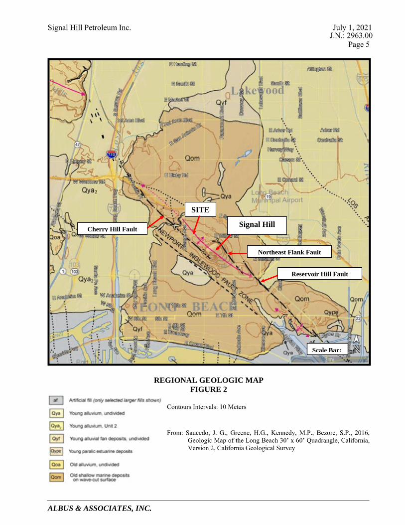
Signal Hill Petroleum Inc. July 1, 2021 J.N.: 2963.00
Page 5
ALBUS & ASSOCIATES, INC.
REGIONAL GEOLOGIC MAP FIGURE 2
Contours Intervals: 10 Meters
From: Saucedo, J. G., Greene, H.G., Kennedy, M.P., Bezore, S.P., 2016, Geologic Map of the Long Beach 30’ x 60’ Quadrangle, California, Version 2, California Geological Survey
SITE
Northeast Flank Fault
Cherry Hill Fault Signal Hill
Reservoir Hill Fault
Scale Bar:

Signal Hill Petroleum Inc. July 1, 2021 J.N.: 2963.00
Page 6
ALBUS & ASSOCIATES, INC.
Topsoil 3.2.2The topsoil materials typically consist of silty sands that are gray-brown to dark brown in color, fine grained, medium dense, damp to moist, slightly porous to very porous, and friable. The thickness of the topsoil materials, based on our experience in the project area, is generally on the order of 3 feet or less.
Lakewood Formation 3.2.3The Lakewood formation generally consists of silty sandstone and sandstone that is yellow brown to light yellow brown in color, poorly consolidated, and massive. Within the near surface, the sediments of the Lakewood Formation are typically pedogenically altered forming a thick soil profile generally on the order of approximately 10 feet thick. This soil profile is characterized by a thick, well-developed argillic (Bt) soil horizon followed by a banded, laminar (Btlam) soil horizon at depth. The banded, laminar soil horizon consists of near-horizontal wavy to irregular Bt lamellae that are irregularly spaced between the layers of the poorly consolidated sandstone. The argillic soil horizon and the Bt lamellae within the banded, laminar soil horizon are easily recognized by their higher clay and iron oxide content than the parent materials, their reddish color hues, and their moderate to strong angular blocky soil structures.
San Pedro Formation 3.2.4The underlying San Pedro Formation typically consists of silty sandstone and sandstone that is pale yellow to yellow and light gray to white in color, massive to thinly bedded, locally cross-bedded, and micaceous. Based on our studies in the project area, the depth to the San Pedro Formation beneath the site is anticipated to be approximately 20 to 30 feet.
3.3 FAULTING Based on our review, there are no known faults within and /or immediately adjacent the site. Futhermore, some of our fault studiesconducted west and southwest of the site have exposed the Cherry Hill fault in trenches. As a result, the Cherry Hill fault is moderately to well defined in the vicinity of the site and at its closest approach is approximately 500 feet southwest of the site. Table 3.1 presents a summary of all the known seismically active faults within 10 miles of the site based on the Third Uniform California Earthquake Rupture Forecast (UCERF3) USGS database (Field, E.H. et al. 2013). Although the USGS database indicates the Newport Inglewood, alt 2 fault is within the site and the Newport Inglewood, alt 1 fault is present very near the site boundary, the location of the faults are very approximate on a local scale.. Results of our previous fault studies in the project area have indicated that the Cherry Hill fault, the closest segment of the NIFZ in the project area, does not trend through the site.

Signal Hill Petroleum Inc. July 1, 2021 J.N.: 2963.00
Page 7
ALBUS & ASSOCIATES, INC.
TABLE 3.1
Summary of Seismically Active Faults
Name Dist. (miles)
Average Slip Rate (mm/yr.)
Average Dip
(degrees) Slip Sense
Rupture Top (km)
Trace Length (km)
Newport Inglewood, alt 2 0 1.23 90 strike slip 0 65.7
Newport-Inglewood, alt 1 0.02 1.5 88 strike slip 0 65.4
Compton 4.0 0.98 20 thrust 5.2 64.8
Palos Verdes 6.1 3.04 90 strike slip 0 107.1
Anaheim 7.3 1.04 71 thrust 3.8 15.7
Puente Hills (Santa Fe Springs) 7.9 0.71 29 thrust 2.8 11.5
Puente Hills (Coyote Hills) 9.6 0.82 26 thrust 2.8 17
Notes: 1. Source of data is from UCERF3. 2. Distance measured from the closest site boundary.
3.4 GROUNDWATER Groundwater was not reported in any of our previous investigations in the project area. In addition, California: Seismic Hazard Zone Report 028 (CDMG 1998) does not provide any data on shallowest historical groundwater levels in proximity to the site. Our review of the Los Angeles County Department of Public Works Well Data website identified an inactive groundwater monitoring well in the project vicinity. This well, referred to as State Well Number 929, is located southwest of the intersection of Gundry Avenue and East 27th Street, roughly 600 feet northwest of the site. The groundwater level from this well was initially measured at 127.3 feet below the ground surface (bgs) on October 15, 1957. The water level gradually declined over the years to 156.2 feet bgs when it was last measured on January 5, 1970.
4.0 GEOLOGIC HAZARDS FINDINGS
4.1 GENERAL Geologic hazards are defined as geologically-related conditions that may present a potential danger to life and property. A number of pertinent factors could impact the site. The site-specific potential for each of these geologic hazards is discussed in the following sections.
4.2 GROUND RUPTURE Based on our review, there are no known faults within and /or immediately adjacent the site. In addition, findings from our fault studies in the project vicinity west and southwest of the site

Signal Hill Petroleum Inc. July 1, 2021 J.N.: 2963.00
Page 8
ALBUS & ASSOCIATES, INC.
indicate the main trace of the Cherry Hill fault, a segment of the NIFZ, is located approximately 500 feet southwest of the site at its closest approach.. As such, the potential for future ground rupture associated with active faulting within the site is considered remote. The site, as shown on the Seismic Hazard Map, Plate 1, is not located within an Earthquake Fault Zone (EFZ).
4.3 GROUND LURCHING Ground lurching is the horizontal and vertical movement of soil or bedrock due to strong ground shaking. Lurching can be both transitory and permanent and often forms cracks in the ground surface. The potential for ground lurching is most prevalent in areas underlain by soft or saturated loose soils but can also occur on steep slopes comprised of poorly consolidated or fractured rock formations. Horizontal and vertical ground deformation resulting from ground lurching can adversely impact structures and compromise the stability of slopes. The project site is anticipated to be constructed to a relatively level condition and is not located immediately adjacent steep or high slopes. Furthermore, the site is not underlain by soft or saturated loose soils or poorly consolidated/fractured bedrock. As such, the potential for future ground lurching associated with strong ground shaking is considered remote.
4.4 GROUND SHAKING The site is situated in a seismically active area that has historically been affected by generally moderate to occasionally high levels of ground motion. The site lies in relative close proximity to several active faults. Therefore, during the life of the proposed developments, the property will probably experience similar moderate to occasionally high ground shaking from these fault zones, as well as some background shaking from other seismically active areas of the Southern California region. Design and construction in accordance with the current California Building Code (CBC) requirements is anticipated to adequately mitigate issues related to potential ground shaking.
4.5 LANDSLIDING The project site is relatively flat to gently sloping and is not located immediately adjacent steep terrain. As such, geologic hazards associated with landsliding are not anticipated at the site. The site is not located within an area identified by the California Geological Survey (CGS) as having potential for seismic slope instability (See Seismic Hazards Map, Plate 1).
4.6 LIQUEFACTION Liquefaction is the sudden decrease in the strength of cohesionless soils due to dynamic or cyclic shaking. Saturated soils behave temporarily as a viscous fluid (liquefaction) and, consequently, lose their capacity to support the structures founded on them. Engineering research of soil liquefaction potential (Youd, et al., 2001) indicates that generally three basic factors must exist concurrently in order for liquefaction to occur. These three factors are:
• A source of ground shaking, such as an earthquake, capable of generating soil mass distortions.
• Relatively loose, granular soils or sensitive clays having high moist contents.

Signal Hill Petroleum Inc. July 1, 2021 J.N.: 2963.00
Page 9
ALBUS & ASSOCIATES, INC.
• A relative shallow groundwater table (within approximately 50 feet below ground surface) or completely saturated soil conditions that will allow positive pore pressure generation.
The liquefaction susceptibility of the onsite soils was evaluated by analyzing the potential of concurrent occurrence of the above-mentioned three basic factors. The liquefaction evaluation for the site was completed under the guidance of Special Publication 117A: Guidelines for Evaluating and Mitigating Seismic Hazards in California (CDMG, 2008). Groundwater is anticipated to be more than 50 feet below the ground surface and the site is also underlain by relatively dense materials of the Lakewood and San Pedro Formations. As such, liquefaction is unlikely to occur at the site. The site is not located within a mapped California Geological Survey liquefaction hazard zone (See Seismic Hazards Map, Plate 1).
4.7 TSUNAMI AND SEICHES A tsunami is a sea wave generated by large-scale displacements of the ocean floor that causes a sudden surge of water onto the land. Tsunamis are most commonly caused by movement along faults and underwater landslides activated by earthquakes. Seiches are earthquake-induced displacements of water within an enclosed body of water such as a lake. Strong ground motions from an earthquake cause the water to slosh back and forth onto land. The site is elevated more than approximately 155 feet above sea level and is located a substantial distance from a significant body of water within an enclosed basin. As such, geologic hazards associated with a tsunami or seiches are not anticipated at the site. Based on of the Tsunami Hazard Area Map of Los Angeles County prepared by CGS (2021), the site is not located within a Tsunami hazard area.
4.8 GROUND SUBSIDENCE Ground subsidence has been reported in areas of southern California as a result of gas, oil, or water extraction, as well as peat oxidation. The subject site is located in an area known to have experienced ground subsidence in the past largely due to oil extraction. Provided that oil field reservoir management strategies that include subsidence mitigation continue to be employed in the area, ground subsidence beneath the site that could result in damage to future site improvements is unlikely to occur at the site.
4.9 EXPANSIVE SOILS Expansive soils generally contain significant amounts of clay which tend to undergo swelling when wetted and shrinking when dried. Changes in moisture in expansive soils can cause volumetric changes in the soil leading to vertical and horizontal movement in overlying structures. Expansive soils can have detrimental effects on the performance of foundations, retaining walls, and flatwork. Based on our experience in the project area, the expansion characteristic of the near surface soils of the site are anticipated to exhibit Very Low to Low expansion potential (UBC 18-I-B). Given the expansion potential anticipated at the site, only nominal steps will be needed to mitigate adverse effects such as minor steel reinforcing of foundations and slabs, and moisture preparation and jointing details for flatwork.

Signal Hill Petroleum Inc. July 1, 2021 J.N.: 2963.00
Page 10
ALBUS & ASSOCIATES, INC.
4.10 CORROSIVE SOILS Corrosive soils possess properties that are reactive with construction materials such as metals and concrete. Generally, soils that contain clays have low electrical resistivity and can cause corrosion of metals in contact with such soils. Soils that contain high amounts of sulfates can cause degradation of concrete. Based on our general experience in the area, the site soils are likely Moderately to Highly corrosive to metals. Where site development may involve the use of metals that could be in contact with site soils, a variety of steps can be taken to mitigate the potential adverse effects including the use of coatings, membranes, and cathodic protection. With respect to sulfates, the site soils are anticipated to have Negligible soluble sulfate content. Concrete designed to follow the procedures provided in ACI 318, Section 4.3, Table 4.3.1 for negligible sulfate exposure are anticipated to be adequate for the mitigation of sulfate attack on concrete.
4.11 SOIL EROSION Soil erosion is the movement of near-surface soil particles generally by flowing water and in some cases high winds. Sandy soils are generally more susceptible to erosion than clayey soils. Much of the site is covered with sandy soils and the relatively flat to very gently sloping terrain makes the site susceptible to slight soil erosion during periods of significant rainfall. Typically, the potential for soil erosion can be mitigated during future development through several methods including use of proper vegetation and surface stabilizing products, grading to avoid concentrated flows, and construction of basins or structures to collect sediments prior to entering bodies of water. The site is not located in an area subject to frequent and sustained high winds that could result in significant erosion of surface soils.
5.0 LIMITATIONS This report presents of a summary of our geologic hazard evaluation of the site. This report is based on our review of data collected, our geologic site reconnaissance, and our engineering and geologic opinions from years of experience in the Signal Hill area. This report has been prepared for the use of the Signal Hill Petroleum Inc. and the project consultants. The information presented herein is intended to only assist in the preparation of a Program Environmental Impact Report. This report is not intended to satisfy the requirements of a site specific and detailed geotechnical investigation required for further planning and permitting. This report has been prepared consistent with that level of care being provided by other professionals providing similar services at the same locale and time period. The contents of this report are professional opinions and as such, are not to be considered a guaranty or warranty. Respectfully submitted, ALBUS & ASSOCIATES, INC Michael O. Spira David E. Albus Principal Engineering Geologist Principal Engineer C.E.G. 1976 G.E. 2455

Signal Hill Petroleum Inc. July 1, 2021 J.N.: 2963.00
Page 11
ALBUS & ASSOCIATES, INC.
REFERENCES Publications Barrows, A.G., 1974, A Review of the Geology and Earthquake History of the Newport-Inglewood
Structural Zone, Southern California, California Division of Mines and Geology Special Report 114, pp. 115.
California Division of Mines and Geology (CDMG), 1998, Seismic Hazard Report for the Long
Beach 7.5-Minute Quadrangle, Los Angeles County, California: Seismic Hazard Zone Report 028.
California Division of Mines and Geology (CDMG), 1986 Revised Official, State of California
(Special Studies) Earthquake Fault Zone Map, Long Beach Quadrangle, dated July 1, 1986, Scale: 1:24,000.
California Division of Mines and Geology (CDMG), 1999, Seismic Hazard Zones for the Long
Beach Quadrangle, Official Map released March 25, 1999, Scale: 1:24,000. California Geological Survey (CGS), Special Publication 117A, Guidelines for Evaluating and
Mitigating Seismic Hazards in California, 2008. California Geological Survey (CGS), 1999, Earthquake Zones of Required Investigation, Long
Beach Quadrangle, Earthquake Fault Zones Revised Official Map Released July 1, 1986, Seismic Hazard Zones Official Map Released March 25, 1999.
California Geological Survey (CGS), 2018 Revision, Earthquake Fault Zones, A Guide For
Government Agencies, Property Owners / Developers, And Geoscience Practitioners For Assessing Fault Rupture Hazards In California: Special Publication 42.
California Geological Survey (CGS), 2019, NOTE 48-Checklist for the Review of Engineering
Geology and Seismology Reports for California Public Schools, Hospitals and Essential Services Buildings, November.
California Geological Survey (CGS), 2021, Tsunami Hazard Area Map of Los Angeles County City of Signal Hill General Plan, 2016, Safety Element. Field, E.H., Biasi, G.P., Bird, P., Dawson, T.E., Felzer, K.R., Jackson, D.D., Johnson, K.M., Jordan,
T.H., Madden, C., Michael, A.J., Milner, K.R., Page, M.T., Parsons, T., Powers, P.M., Shaw, B.E., Thatcher, W.R., Weldon, R.J., II, and Zeng, Y., 2013, Uniform California earthquake rupture forecast, version 3 (UCERF3)—The time-independent model: U.S. Geological Survey Open-File Report 2013–1165, 97 p., California Geological Survey Special Report 228, and Southern California Earthquake Center Publication 1792, http://pubs.usgs.gov/of/2013/1165/.

Signal Hill Petroleum Inc. July 1, 2021 J.N.: 2963.00
Page 12
ALBUS & ASSOCIATES, INC.
REFERENCES (cont.) Los Angeles County Department of Public Works Well Data (accessed 2021):
https://dpw.lacounty.gov/general/wells/ Ponti, D.J., and Lajoie K.R., 1992, Chronostratigraphic Implications for Tectonic Deformation of
Palos Verdes and Signal Hill, Los Angeles Basin, California, in Heath, E.G. and Lewis, W.L. (editors), The Regressive Pleistocene Shoreline, Coastal Southern California, South Coast Geological Society, Annual Field Trip Guide Book No. 20, pp. 157-161.
Saucedo, J. G., Greene, H.G., Kennedy, M.P., Bezore, S.P., 2016, Geologic Map of the Long Beach
30’ x 60’ Quadrangle, California, Version 2, California Geological Survey. St.Peters, K.S., and R.A. Whitney, 1992, Structural Analysis of the Newport-Inglewood Fault Zone
for Mitigation of Surface Rupture Hazard to Future Residential Development at Signal Hill, California, in Association of Engineering Geologists Southern California Section Engineering Geology Field Trips, Orange County Santa Monica Mountains and Malibu 35th Annual Meeting, Oct 2-9, pp. A45-A54.
The Working Group on California Earthquake Probabilities consists of the U.S. Geological Survey,
California Geological Survey, and Southern California Earthquake Center. Their report is available at www.wgcep.org.
Thomas, R.G., 1961, Planned Utilization of the Ground Water Basins of the Coastal Plain of Los
Angeles County, Appendix A- A Ground Water Geology: State of California, Department of Water Resources Ground Water Geology, Bulletin No. 104.
Wright, T.L., 1991, Strucutual Geology and Tectonic Evolution of the Los Angeles Basin, California
Overview, in Biddle, K.T. ed., Active Margin Basins: American Association of Petroleum Geologists Memoir 52, p. 35-134.
Yerkes, R.F., et al., 1965, Geology of the Los Angeles Basin – An Introduction, Geological Survey
Professional Paper 420-A. Youd, T.L., Idriss, I.M., Andrus, R.D., Arango, I., Castro, G., Christian, J., Dobry, R., Finn, W.D.L.,
Harder, L.F., Hynes, M.E., Ishihara, K., Koester, J.P., Liao, S.S.C., Marcuson, W.F., Martin, G.R., Mitchell, J.K., Moriwaki, Y., Power, M.S., Robertson, P.K., Seed, R.B., and Stokoe, K.H., 2001, “Liquefaction Resistance of Soils: Summary Report from the 1996 NCEER and 1998 NCEER/NSF Workshops on Evaluation of Liquefaction Resistance.
Report Albus-Keefe & Associates, Inc., 1999a, Preliminary Geotechnical Investigation, Proposed Retail
Center, Town Center West Project, Signal Hill, California”, dated November 17, (J.N.:1011.00).
______, 1999b, Fault Investigation - Town Center West Project, Southwest of Cherry Avenue and
Willow Street, Signal Hill, California, dated December 27, (J.N. 1011.00).

Signal Hill Petroleum Inc. July 1, 2021 J.N.: 2963.00
Page 13
ALBUS & ASSOCIATES, INC.
REFERENCES (cont.) ______, 2018, Geologic Assessment of Surface Fault Rupture Potential, Driving Range Property,
Located Southeast of the Intersection of East Willow Street and Orange Avenue, City of Signal Hill, California., dated June 1, (J.N. 2609.00).
______, 2019, Geologic Assessment of Surface Fault Rupture Potential, McAuley Property,
(Assessor Parcel Nos. 7212-010-014, 7212-010-015, 7212-010-018, and 7212-010-029) Located Northwest of the Intersection of East Willow Street and Gundry Avenue, City of Signal Hill, California, July 10, 2019, (J.N. 2609.00).
______, 2021a, “Revised” Geologic Assessment of Surface Fault Rupture Potential, Orange Bluff
Site, 2771 Gundry Avenue, City of Signal Hill, California (Assessor Parcel Nos. 7212-008-049, 7212-008-051, 7212-010-010, 7212-010-019, and 7212-010-020)., dated June 23, (J.N. 2609.02).
______, 2021b, “Revised” Geologic Hazards Evaluation Report, Orange Bluff Site, East 28th Street
and Orange Avenue, City of Signal Hill, California (Assessor Parcel Nos. 7212-008-049, 7212-008-051, 7212-010-010, 7212-010-019, and 7212-010-020), dated June 24, 9J.N. 2609.03).
______, 2021c, “Revised” Geologic Hazards Evaluation Report, Heritage Square Site, City of Signal
Hill, California (Assessor Parcel Nos.: 7214-005-010, and 7214-005-011; 7214-005-900, 7214-005-901, 7214-005-902, 7214-005-903, and 7214-005-904; 7214-006-014, 7214-006-015, 7214-006-019, and 7214-006-020), dated June 30, (J.N. 2557.01).
Mearns Consulting Inc., 2021, Phase I Environmental Site Assessment, 2771 Gundry Avenue,
Orange Bluff, Signal Hill, California, 90755, dated May 27. Plan Town Center Northwest Site Analysis Plan, prepared by ktgy Architects + Planning, current version
dated September 17, 2020.

Signal Hill Petroleum Inc. July 1, 2021 J.N.: 2963.00
Page 14
ALBUS & ASSOCIATES, INC.
REFERENCES (cont.) Topographic Maps Topographic Map, City of Signal Hill and Vicinity, Signal Hill, California, prepared by Pacific Air
Industries, Scale: 1” = 100’, dated June 29, 1960. Provided by Environmental Data Resources Inc. Search: USGS, Long Beach 7.5-minute Quadrangle, 2012 USGS, Long Beach 7.5-minute Quadrangle, 1981 USGS, Long Beach 7.5-minute Quadrangle, 1972 USGS, Long Beach 7.5-minute Quadrangle, 1964 USGS, Long Beach 7.5-minute Quadrangle, 1949 USGS, Downey 15-minute Quadrangle, 1947 USGS, Downey 15-minute Quadrangle, 1943 USGS, Downey 15-minute Quadrangle, 1942 USGS, Long Beach 7.5-minute Quadrangle, 1925 USGS, Downey 15-minute Quadrangle, 1902 USGS, Downey 15-minute Quadrangle, 1899 USGS, Downey 15-minute Quadrangle, 1896 Aerial Photographs Source Date Flown Flight No. Photo No. Scale Continental 4-3-60 311-5 5 & 6 1"=1000' Continental 1-31-70 61-7 177 &178 1"=4000' Continental 5-12-79 FC-LA 127 & 128 1"=2800' Continental 4-9-81 ORA-5 3 Continental 1-27-86 F 351 & 352 1"=2800' Continental 7-7-88 AF 19210 1"=2200' Continental 1-29-92 C85-7 29 & 30 1"=2000' Continental 10-15-97 C117-35 240 1"=2000' Provided by Environmental Data Resources Inc. Search: Source Date Flown Scale Fairchild 1928 1"=500' Fairchild 1947 1"=666' Fairchild 1956 1"=400' Teledyne 1968 1"=480' Teledyne 1976 1"=666' USGS 1989 1"=666' USGS 1994 1"=666

SITE LOCATION
1Plate:7/1/21Date:2963.00Job No.:
SEISMIC HAZARDS MAP
0 1500 3000 6000
SCALE : 1" = 3000' Liquefaction ZonesAreas where historical occurrence of liquefaction or localgeological, geotechnical and ground water conditionsindicate a potential for permanent ground displacementssuch that mitigation as defined in Public Resources CodeSection 2693(c) would be required.
Active Fault TracesFaults considered to have been active during Holocenetime and have potential for surface rupture: Solid Line inBlack or Red where accurately located; Long Dash inBlack or Solid Line in Purple where approximatelylocated; Short dash in black or solid line in orange whereinferred; Dotted line in black or solid line in rose whereconcealed; Query (?) indicates additional uncertainty.Evidence of historic offset indicated by year ofearthquake-associated event or C for displacementcaused by fault creep.
Earthquake Fault ZonesZone boundaries are delineated by straight-line segments;the boundaries define the zone encompassing active faultsthat constitute a potential hazard to structures from surfacefaulting or fualt creep such that avoidance as described inPublic Resources Code Section 2621.5(c) would berequired.
Earthquake-Induced Landslide ZonesAreas where previous occurence of landslide movement, orlocal topographic, geological, geotechnical and subsurfacewater conditions indicated a potential for permanent grounddisplacements such that mitigation as defined in PublicResources Code Section 2693(c) would be required.
Overlapping Earthquake Fault and Seismic Hazard ZonesOverlap of Earthqueak Fault Zone and Liquefaction ZonesAreas that are covered by both Earthquake Fault Zone andLiquefaction Zone.
Overlap of Earthquake Fault Zone and Earthquake-InducedLandslide Zone Areas that are covered by both EarthquakeFault Zone and Earthquake-Induced Landslide Zone.
Note: Mitigation methods differ for each zone - AP Act onlyallows avoidance; Seismic Hazard Mapping Act allowsmitigation by engineering geological design as well asavoidance.
California Geological Survey (CGS), 1999, Earthquake Zones of Required Investigation, Long Beach Quadrangle, Earthquake Fault Zones RevisedOfficial Map Released July 1, 1986, Seismic Hazard Zones Official Map Released March 25, 1999.

D.5Review of Walnut Bluff Evaluation Report

1642 E. Fourth Street Santa Ana California 92701 Telephones: (714) 412-2654 & 544-5321 Facsimile: (714) 494-4930
www.earthconsultants.com
July 8, 2021 ECI Project No. 4107
To: City of Signal Hill – Community Development Department
2175 Cherry Avenue Signal Hill, California 90755
Attention: Ms. Colleen T. Doan, Community Development Director Submitted via e-mail at [email protected] To: Meridian Consultants
706 S. Hill Street, 11th Floor Los Angeles, California 90014
Attention: Ms. Christine Lan, Senior Project Manager Submitted via e-mail at [email protected] Subject: Review of Geohazards Report for the Property Referred to as the Walnut Bluff Site,
2653 Walnut Avenue, Signal Hill, California 90755 (APN: 7212-010-038) References: Albus & Associates Inc. (AA), 2021, Geologic Hazards Evaluation Report, Walnut
Bluff Site, City of Signal Hill, California (APN: 7212-010-038); consulting report prepared for Signal Hill Petroleum Inc.; AA Job No. 2963.00, dated July 1, 2021, consulting report signed by Michael O. Spira, CEG 1976, Principal Engineering Geologist and David E. Albus, G.E. 2455, Principal Engineer.
PROJECT DESCRIPTION The Walnut Bluff site is a nearly square-shaped property located to the northwest of the intersection of Walnut Avenue and East Willow Street. The property occupies the southeastern quadrant of the block defined by the two streets mentioned above, East 27th Street to the north, and Gundry Avenue to the west. The site is located in the American Colony Tract, and has a street address of 2653 Walnut Avenue. Its Assessor’s Parcel Number (APN) is 7212-010-038. The site is approximately 310 feet long in a north-south direction, and 300 feet wide in the east-west direction along its northern boundary. The east-to-west width of the site along its southern boundary is at least 20 feet less to accommodate the wider width of Walnut Avenue in that area, and the rounded corner at the northwest intersection of East Willow Street and Walnut Avenue. The property is 2.0 acres in area. The site is bordered by light industrial/commercial properties to the north and west, commercial and residential properties to the south, across East Willow Street, and the proposed Town Center Northwest site to the east, across Walnut Avenue. According to the interactive well finder and well status database from the California Geologic Energy Management Division (CalGEM; https://maps.conservation.ca.gov/doggr/wellfinder/#openModal/-118.17018/33.80559/20), there are three plugged (abandoned), two active and two idle oil and gas wells within the site. There are no structures currently on the property, except for the oil pumping

July 8, 2021 ECI Project No. 4107
Review of Geo-Hazards Report for EIR Purposes Proposed Walnut Bluff Project, City of Signal Hill Page 2
units. Albus & Associates (AA, 2021) report that the site is unpaved, with its surface “covered with dirt, gravel, or asphalt gridings.” Various storm water quality control improvements, including concrete rubble berms, silt fences, straw wattles, and shallow depressions that collect runoff and sediment were reported onsite (AA, 2021). GoogleEarth images of the site dating from February 2, 2021 show that trees and shrubs are present along primarily the southern and eastern property boundaries, facing the streets, and a lone palm tree occurs in the central portion of the site, next to a pumping unit. The property is proposed to be developed for residential uses, with up to 90 housing units being considered. These residential units would be of low to very low affordability level, with a dwelling unit per acre ratio of up to 45. Given that the site is currently zoned for commercial industrial uses, it is our understanding that to accommodate residential development on the property will require a zoning ordinance amendment to the Special Purpose Housing (SP-7) Specific Plan, and a General Plan amendment to designate the property as Very High Density Residential. PHYSICAL, GEOLOGIC and SEISMIC SETTING This property, like most of the City of Signal Hill, is located on the northwest extension (or “nose”) of the geomorphic feature named Signal Hill, an area that has been uplifted above the Los Angeles Basin over hundreds of thousands of years as a result of movement on the Newport-Inglewood Fault Zone (NIFZ) and related structures. The site itself, being nearly at the top of the nose, is relatively flat to gently sloping to the north-northwest. AA (2021) reports elevations at the site varying from approximately 162 feet above mean sea level (amsl) near the southeastern corner of the site to about 155 feet amsl in the northern margin of the site. There are no steep slopes at the site. Signal Hill, including the subject site, is underlain in the near surface by unconsolidated sediments, typically sandstone and silty sandstone, assigned to the Inglewood Formation. These sediments were deposited in shallow marine and coastal (beach) environments about 600,000 to 200,000 years ago, and have since been uplifted as a result of both regional and localized uplift along the NIFZ. The uppermost section of the Inglewood Formation has been exposed to weathering and soil-forming processes for tens to hundreds of thousands of years, forming a well-developed, reddish clay-rich soil that is generally about 4 to 5 feet thick, but can be as much as 10 feet thick. Localized pockets of artificial fill associated with oil wells, older foundations, and other past disturbances of the site are expected to occur onsite. The thickness of these deposits is variable, but anticipated to be generally less than 10 feet. The Inglewood Formation is underlain by an older marine deposit referred to as the San Pedro Formation that consists of bedded sandstone, silty sandstone and gravelly sandstone. AA (2021) reports that the top of the San Pedro Formation is anticipated to occur at depths of between about 20 and 30 feet below the ground surface at the site. Shallow groundwater, within 50 feet of the ground surface, is not known to occur in the site vicinity. The depth to water in a groundwater well located approximately 600 feet to the northwest of the site was reportedly more than 150 feet when last measured in 1970 (AA, 2021). Signal Hill is considered to be a pressure ridge at the left step between two sections or splays of the northwest-trending NIFZ. These faults are referred to as the Northeast Flank fault on the east side of

July 8, 2021 ECI Project No. 4107
Review of Geo-Hazards Report for EIR Purposes Proposed Walnut Bluff Project, City of Signal Hill Page 3
the hill, and the Cherry Hill fault on the west side. The Cherry Hill fault is the fault closest to the site. The Cherry Hill fault has been well located in the immediate vicinity of the site using a series of trenches to expose the fault in the near surface. These studies have shown that the fault is more than 500 feet to the southwest of the site at its closest approach. The site is just outside the limits of the Alquist-Priolo Earthquake Fault Zone for the Cherry Hill fault (CDMG, 1986). Therefore, the proposed project is not anticipated to experience ground deformation in the form of surface fault rupture should the NIFZ rupture during the lifetime of the project. HAZARD ASSESSMENT As part of their assessment for the site, AA (2021) evaluated whether the site has the potential to be impacted by various geologic/geotechnical and seismic hazards. For a complete discussion of these hazards both in a general sense and as they pertain to the site, refer to AA’s (2021) report. The paragraphs below summarize only those hazards that are deemed to have a significant or potentially significant impact on the site and the proposed development. With the exception of surface ground rupture due to faulting, which, per State law requires avoidance, other geologic/geotechnical hazards are typically mitigated with engineering solutions.
Given its location relative to the Newport-Inglewood fault and several other faults in the Southern California region, the site is anticipated to experience strong ground shaking if and when a moderate to large earthquake (of magnitude greater than about 6) occurs in the area. The hazard to the site posed by seismic ground shaking is similar to that of any other property in the area. The hazard of seismic shaking is typically managed by following, at a minimum, the requirements of the most recent version of the California Building Code (CBC) adopted by the City of Signal Hill. Ground motion parameters for structural design will have to be calculated and provided to the structural engineer of record in accordance with the most recent versions of the CBC and the American Society of Civil Engineers’ (ASCE) Minimum Design Loads for Buildings and Other Structures Standards (ASCE 7) adopted by the City of Signal Hill at the time the project is first submitted for the plan check review process.
Regional ground subsidence as a result of oil and gas extraction occurred in the Long Beach and Wilmington areas in the 1930s and 1940s, during the boom of oil exploration. Now, oil producers generally manage and control ground subsidence above oil reservoirs by regularly monitoring ground surface elevations, and injecting brine water into the oil-producing zones to balance the volume of oil and gas extracted. These programs are designed to prevent or reduce the detrimental impacts of ground subsidence on infrastructure and structures.
The clay-rich soils near the ground surface may have a low expansion potential. The potential impact to structures from expansive soils is regularly managed during construction using a variety of standard-of-practice engineering solutions, including excavation and mixing of the clay-rich, expansive soils with sandier materials, moisture preparation of the ground under and around foundations and hardscape, and, if deemed necessary by the geotechnical engineer of record, steel reinforcement of the foundations to accommodate minor differential movements resulting from uneven shrinking and/or swelling of the soils below the foundation. Appropriate mitigation measures will be provided in the geotechnical study that is required as part of the plan check review process.
Based on their experience in the area, AA (2021) indicates that the soils underlying the site at shallow depths are likely to be moderately to highly corrosive to metals. This would be confirmed in advance of construction, as part of the required geotechnical investigation

July 8, 2021 ECI Project No. 4107
Review of Geo-Hazards Report for EIR Purposes Proposed Walnut Bluff Project, City of Signal Hill Page 4
during plan check, and appropriate mitigations would be recommended at that time, if deemed necessary. The mitigation measures provided would be consistent with standard-of-practice approaches, such as the use of alternate materials, encasing the metallic components in non-corrosive backfills, use of protective coatings, and cathodic protection of metallic pipes and other metallic elements that would be in contact with the soil.
The sandy deposits of the Inglewood and San Pedro Formations, if exposed at the ground surface or in cut-slopes, could be susceptible to rills, gullies, and general erosion by running water or strong winds. Best management practices during construction, including regular wetting of the building pads, and placing sandbags at the perimeter of the project area would help control dust and offsite transport of sediment by running water, respectively. Long-term management of erosion is generally achieved with the use of hardscaping and landscaping, and if deemed necessary by the project engineer, the installation of debris basins or other structures to catch and divert surface water and loose soils.
FINDINGS Earth Consultants International, Inc. (ECI) has reviewed the above-referenced report by Albus & Associates Inc. (AA) discussing the geohazards that could potentially impact the site and the proposed project, and finds that the study was conducted under the standard of care typical of these studies. ECI finds that AA’s study and report are acceptable for the purposes intended, and that additional analyses of the geologic and seismic conditions are not necessary in advance of preparing the Enviromental Impact Report for the proposed project. A project-specific geotechnical study that addresses the geologic and geotechnical conditions as they pertain to the proposed design will be required as part of the standard plan check process in accordance with the California Building Code, but this study concludes that there are no significant hazards that would make this property undevelopable for the purposes intended. The project impacts to geology and soils, including thresholds of significance, are summarized in the table below.

July 8, 2021 ECI Project No. 4107
Review of Geo-Hazards Report for EIR Purposes Proposed Walnut Bluff Project, City of Signal Hill Page 5
Potentially Significant
Impact
Less Than Significant
with Project Mitigation
Less Than Significant
Impact
No Impact
GEOLOGY AND SOILS—Would the project: a. Expose people or structures to potential substantial
adverse effects, including the risk of loss, injury, or death involving:
1) Rupture of a known earthquake fault, as delineated on the most recent Alquist-Priolo Earthquake Fault Zoning map issued by the State Geologist for the area or based on other substantial evidence of a known fault? (Refer to Division of Mines and Geology Special Publication 42)
X
2) Strong seismic ground shaking X 3) Seismically induced ground failure, including
liquefaction or X
4) Landslides? X b. Result in substantial soil erosion or the loss of
topsoil?
X
c. Be located on a geologic unit or soil that is unstable, or that would become unstable as a result of the project, and potentially result in on- or off-site landslide, lateral spreading, subsidence, liquefaction or collapse?
X
d. Be located on expansive soil, as defined in Table 18-1-B of the Uniform Building Code (1994), creating substantial risks to life or property?
X
We trust that the data provided above, together with the geohazards report submitted by Albus Associates Inc. (2021) provide you with the data you need at this time. If you need additional information, please do not hesitate to contact the undersigned. Respectfully submitted, EARTH CONSULTANTS INTERNATIONAL, INC. Registered Geologists and Certified Engineering Geologists
Tania Gonzalez, CEG 1859 Engineering Geologic Reviewer for the City of Signal Hill Earth Consultants International, Inc. Reference: California Geological Survey, 1986, State of California Earthquake Fault Zones, Revised Official
Map of the Long Beach Quadrangle; effective July 1, 1986, Scale: 1:24,000.

D.6Town Center NW Evaluation Report

1011 N. Armando Street, Anaheim, CA 92806-2606 (714) 630-1626
formerly Albus-Keefe & Associates, Inc.
July 2, 2021 J.N.: 2964.00
Mr. Kevin Laney VP of Business Development Signal Hill Petroleum Inc. 2633 Cherry Ave. Signal Hill, CA 90755 Subject: Geologic Hazards Evaluation Report, Town Center Northwest Site, City of
Signal Hill, California (APN #: 7212-011-034). Dear Mr. Laney, Pursuant to your request, Albus & Associates, Inc. is pleased to present to you our geologic hazards evaluation report for the Town Center Northwest site. This report summarizes the site-specific potential for geologic hazards at the site. This report is intended to support the preparation of the Program Environmental Impact Report for the subject site. This report is not intended to provide geotechnical recommendations for design and construction associated with future site development. We appreciate this opportunity to be of service to you. If you should have any questions regarding the contents of this report, please do not hesitate to call our office. Sincerely yours, ALBUS & ASSOCIATES, INC. Michael O. Spira Principal Engineering Geologist

Signal Hill Petroleum Inc. July 2, 2021 J.N.: 2964.00 Page i
ALBUS-KEEFE & ASSOCIATES, INC.
TABLE OF CONTENTS
REPORT
1.0 INTRODUCTION .............................................................................................................. 1 1.1 PURPOSE AND SCOPE .................................................................................................. 1 1.2 PROJECT SITE DESCRIPTION ...................................................................................... 1
Site Location and Legal Description .......................................................................... 1 1.2.1 Physical Setting .......................................................................................................... 1 1.2.2
1.3 PROPOSED DEVELOPMENT ........................................................................................ 3 2.0 RESEARCH ........................................................................................................................ 3 3.0 GEOLOGIC SETTING ..................................................................................................... 4
3.1 REGIONAL GEOLOGY .................................................................................................. 4 3.2 LOCAL GEOLOGY ......................................................................................................... 6
Artificial Fill ............................................................................................................... 6 3.2.1 Topsoil ........................................................................................................................ 6 3.2.2 Lakewood Formation .................................................................................................. 6 3.2.3 San Pedro Formation .................................................................................................. 6 3.2.4
3.3 FAULTING ....................................................................................................................... 7 3.4 GROUNDWATER ............................................................................................................ 7
4.0 GEOLOGIC HAZARDS FINDINGS ............................................................................... 8 4.1 GENERAL ........................................................................................................................ 8 4.2 GROUND RUPTURE ....................................................................................................... 8 4.3 GROUND LURCHING .................................................................................................... 8 4.4 GROUND SHAKING ....................................................................................................... 8 4.5 LANDSLIDING ................................................................................................................ 8 4.6 LIQUEFACTION .............................................................................................................. 9 4.7 TSUNAMI AND SEICHES .............................................................................................. 9 4.8 GROUND SUBSIDENCE ................................................................................................ 9 4.9 EXPANSIVE SOILS ....................................................................................................... 10 4.10 CORROSIVE SOILS ................................................................................................... 10 4.11 SOIL EROSION .......................................................................................................... 10
5.0 LIMITATIONS ................................................................................................................. 10 REFERENCES ........................................................................................................................... 12
FIGURES and PLATES Figure 1 - Site Location Map Figure 2 – Regional Fault Map Plate 1 – Seismic Hazards Map

Signal Hill Petroleum Inc. July 2, 2021 J.N.: 2964.00 Page 1
ALBUS-KEEFE & ASSOCIATES, INC.
1.0 INTRODUCTION
1.1 PURPOSE AND SCOPE The purpose of our study was to evaluate the potential geologic hazards of the site. Geologic hazards are considered geologically related conditions that may present a potential danger to life and property. We understand the information from our evaluation will be utilized by Meridian Consultants in preparing a Program Environmental Impact Report. The scope of our geologic hazards evaluation generally included the following:
• Geologic site reconnaissance,
• Review of published and unpublished geologic literature and maps, and other readily available documents,
• Review of historical aerial photographs and topographic maps,
• Review of our previous fault studies and geotechnical reports in site vicinity,
• Review of the Phase I Environmental Site Assessment report for the subject site,
• Preparation of this geologic hazards evaluation report.
1.2 PROJECT SITE DESCRIPTION
Site Location and Legal Description 1.2.1The site is located northeast of the intersection of Walnut Avenue and East Willow Street in the city of Signal Hill, California (APN #: 7212-011-034). The site is bordered by light industrial/commercial properties to the north and east, Walnut Avenue to the west, and East Willow Street to the south. The SHP Drill Site, which is located within the northeast portion of the site is not part of the project. The site and its relationship to the surrounding area is shown on Figure 1, Site Location Map.
Physical Setting 1.2.2Topographically, the site is largely situated on the top of an uplifted hill that forms the northwest extension (nose) of Signal Hill. The site is relatively flat to very gently sloping to the north. Ground surface elevations within the site, based on Google Earth imagery, currently range from approximately 162 feet above mean sea level at the southwest corner of the site to approximately 138 feet above mean sea level at the far northeastern corner of the site. Site drainage is generally by sheet flow to the north.

Signal Hill Petroleum Inc. July 2, 2021 J.N.: 2964.00
Page 2
ALBUS & ASSOCIATES, INC.
Source: 2021 Google Earth
SITE LOCATION MAP FIGURE 1
Town Center Northeast Site
Signal Hill, California
SITE
East Willow Street
Walnut A
venue
SHP Drill Site
Scale Bar:

Signal Hill Petroleum Inc. July 2, 2021 J.N.: 2964.00
Page 3
ALBUS & ASSOCIATES, INC.
The site has been utilized for crude oil and natural gas production associated with the Long Beach Oil Field, beginning in the early 1920’s. Over the years, the site has been occupied by various field related improvements, many of which do not exist today. Ground modifications involving minor cut and fill grading have been made throughout the site in association with these improvements. Based on our geologic site reconnaissance on May 26, 2021, the surface of the site is covered with dirt, gravel, or asphalt grindings and is occupied by several trailers, active and abandoned oil wells, pumping units, above and below-ground pipelines, various oil field related equipment, and stockpiles of assorted materials. Various stormwater quality improvements consisting of straw wattles, sandbag berms, silt fences, and shallow detention basins are also present on the site. Vegetation within the Site generally consists of scattered trees and shrubs largely along the margins of the property and around the SHP Drill Site.
1.3 PROPOSED DEVELOPMENT No specific plans for development are currently proposed at this time. However, based on the referenced Town Center Northwest Site Analysis Plan, dated September 17, 2020, and discussions with Signal Hill Petroleum Inc., the site is being considered for mixed-use commercial and residential development.
2.0 RESEARCH We have reviewed historical aerial photos, geologic publications, and maps for the site and surrounding areas. We also reviewed some of our previous fault and geotechnical studies in the project area, including reports for the Town Center West Project located southeast of the site, across East Willow Street (Albus-Keefe, 1999a and 1999b). In addition, we reviewed the referenced Phase I Environmental Site Assessment report for the site that was prepared Mearns Consulting LLC. A complete listing of the reviewed documents is presented in the reference section of this report. The data from these sources were utilized to develop some of the findings and conclusions presented herein and are discussed in detail in later sections in this report.
Signal Hill Petroleum Inc. July 2, 2021 J.N.: 2964.00
Page 4
ALBUS & ASSOCIATES, INC.
3.0 GEOLOGIC SETTING
3.1 REGIONAL GEOLOGY The site, as shown on the Regional Geologic Map, Figure 3, is located at the northwest extension of Signal Hill. Signal Hill forms part of a chain of northwest trending low hills and mesas that rise up above the low-lying flat terrain of the Los Angeles Basin within the coastal section of the Peninsular Ranges Geomorphic Province of California. These small hills and mesas extend southeasterly from the Cheviot Hills-Beverly Hills area in Los Angeles County to Newport Mesa, in Orange County and form the surface expression of the Newport-Inglewood Fault Zone (NIFZ). Subsidence and deposition within the Los Angeles Basin are believed to have initiated about 7 million years ago, in late Miocene time, as the San Andreas fault shifted eastward to its present location. As the basin subsided, it was filled with sediments that eroded from the surrounding highlands through the late Pleistocene. The inception of right-lateral displacement along the NIFZ is believed to have occurred some 2 to 5 million years ago (Wright, 1991), but the structural features along the NIFZ did not have topographic expression before late Pleistocene time (Yerkes et al., 1965). In the last 2 million years, during the Pleistocene epoch, the region was continually deformed and gradually uplifted along the fault zone to produce the geomorphic expression of Signal Hill and central portions of Long Beach (Yerkes et al., 1965; Wright, 1991). The Signal Hill area is underlain by up to about 15,000 feet of deep-water marine and shallow-water sediments that rest unconformably above metamorphic basement rock. The stratigraphic units exposed in the Signal Hill area consist of the lower Pleistocene-age San Pedro Formation and the upper Pleistocene-age Lakewood Formation. The San Pedro Formation is marine in origin and consists of sandstone approximately 800 feet in thickness. The estimated age for the upper part of this unit, based on Ponti and Lajoie (1992) is about 800,000 to 650,000 years old. The Lakewood Formation unconformably overlies the San Pedro Formation. The Lakewood Formation is both marine and non-marine in origin as a result of coastline fluctuations and uplift during the later Pleistocene and consists of poorly consolidated sandstone up to 300 feet in thickness (Thomas, 1961). Ponti and Lajoie (1992) estimate the age of the Lakewood Formation to be less than approximately 220,000 years old in the Signal Hill area. On the Regional Geologic Map, Figure 2, the old shallow marine deposits on a wave cut surface (map symbol Qom) represents the Lakewood Formation. The San Pedro Formation is not shown on the Regional Geologic Map in the Signal Hill area because it generally does not crop out at the surface. Structurally, Signal Hill rises about 300 feet above the surrounding terrain and forms a complex northwest-trending anticlinal dome structure overprinted on a larger preexisting anticlinal structure. As shown on the Regional Geologic Map, Figure 2, Signal Hill is bounded by two major northwest-trending step-over fault segments of the NIFZ; the Cherry Hill fault to the southwest and the Northeast Flank fault to the northeast. These surface faults are believed to be interconnected at depth to form one near vertical “master fault” (Barrows, 1974). In essence, this postulated vertical master fault, or fault zone flowers upward to form the near surface fault structures. The resulting compressive stresses formed between the step-over fault segments and flowering structures are believed to be at least partially responsible for the substantial fracturing and uplifting of Signal Hill (St. Peters and Whitney, 1992).

Signal Hill Petroleum Inc. July 2, 2021 J.N.: 2964.00
Page 5
ALBUS & ASSOCIATES, INC.
REGIONAL GEOLOGIC MAP FIGURE 2
Contours Intervals: 10 Meters
From: Saucedo, J. G., Greene, H.G., Kennedy, M.P., Bezore, S.P., 2016, Geologic Map of the Long Beach 30’ x 60’ Quadrangle, California, Version 2, California Geological Survey
SITE
Northeast Flank Fault
Cherry Hill Fault Signal Hill
Reservoir Hill Fault
Scale Bar:

Signal Hill Petroleum Inc. July 2, 2021 J.N.: 2964.00
Page 6
ALBUS & ASSOCIATES, INC.
3.2 LOCAL GEOLOGY The geologic conditions of the site are based largely on review of our previous studies in the project area and our geologic site reconnaissance. In general, bedrock assigned to the upper Pleistocene-age Lakewood Formation underlies the entire site. These sediments unconformably overlie the lower Pleistocene-age San Pedro Formation at depths. A relatively thin topsoil unit is typically present in the near surface where the original ground surface has not been significantly modified. Artificial fills associated with past oil field activity were also noted during our geologic site reconnaissance and are typically present on most oil field properties in the area. Descriptions of the geologic units observed on site are provided in the following sections.
Artificial Fill 3.2.1The artificial fill materials generally consist of locally derived silty sand and clayey sand. The artificial fills are typically brown, dark brown, and gray in color and from our experience can contain various amounts of pipe, wood, asphalt, brick, and concrete debris. The thicknesses of artificial fill materials can be extremely variable depending on the previous activity at the site. Based on our observations and experience in the project area, the artificial fills are anticipated to be on the order of 10 feet or less in thickness. However, in areas of abandoned wells and former sumps, the fill thicknesses can be much greater.
Topsoil 3.2.2The topsoil materials typically consist of silty sands that are gray-brown to dark brown in color, fine grained, medium dense, damp to moist, slightly porous to very porous, and friable. The thickness of the topsoil materials, based on our experience in the project area, is generally on the order of 3 feet or less.
Lakewood Formation 3.2.3The Lakewood formation generally consists of silty sandstone and sandstone that is yellow brown to light yellow brown in color, poorly consolidated, and massive. Within the near surface, the sediments of the Lakewood Formation are typically pedogenically altered forming a thick soil profile generally on the order of approximately 10 feet thick. This soil profile is characterized by a thick, well-developed argillic (Bt) soil horizon followed by a banded, laminar (Btlam) soil horizon at depth. The banded, laminar soil horizon consists of near-horizontal wavy to irregular Bt lamellae that are irregularly spaced between the layers of the poorly consolidated sandstone. The argillic soil horizon and the Bt lamellae within the banded, laminar soil horizon are easily recognized by their higher clay and iron oxide content than the parent materials, their reddish color hues, and their moderate to strong angular blocky soil structures.
San Pedro Formation 3.2.4The underlying San Pedro Formation typically consists of silty sandstone and sandstone that is pale yellow to yellow and light gray to white in color, massive to thinly bedded, locally cross-bedded, and micaceous. Based on our studies in the project area, the depth to the San Pedro Formation beneath the site is anticipated to be approximately 20 to 30 feet.

Signal Hill Petroleum Inc. July 2, 2021 J.N.: 2964.00
Page 7
ALBUS & ASSOCIATES, INC.
3.3 FAULTING Based on our review, there are no known faults within and/or immediately adjacent the site.Furthermore, some of our fault studies conducted west and southwest of the site have exposed the Cherry Hill fault in trenches. As a result, the Cherry Hill fault is moderately to well defined in the vicinity of the site and at its closest approach is approximately 700 feet southwest of the site. Table 3.1 presents a summary of all the known seismically active faults within 10 miles of the site based on the Third Uniform California Earthquake Rupture Forecast (UCERF3) USGS database (Field, E.H. et al. 2013). Although the USGS database indicates the Newport Inglewood, alt 2 fault is within the site and the Newport Inglewood, alt 1 fault is present very near the site boundary, the location of the faults are very approximate on a local scale. Results of our previous fault studies in the project area have indicated that the Cherry Hill fault, the closest segment of the NIFZ in the project area, does not trend through the site.
TABLE 3.1
Summary of Seismically Active Faults
Name Dist. (miles)
Average Slip Rate (mm/yr.)
Average Dip
(degrees) Slip Sense
Rupture Top (km)
Trace Length (km)
Newport Inglewood, alt 2 0 1.23 90 strike slip 0 65.7
Newport-Inglewood, alt 1 0.1 1.5 88 strike slip 0 65.4
Compton 4.1 0.98 20 thrust 5.2 64.8
Palos Verdes 6.2 3.04 90 strike slip 0 107.1
Anaheim 7.8 1.04 71 thrust 3.8 15.7
Puente Hills (Santa Fe Springs) 7.2 0.71 29 thrust 2.8 11.5
Puente Hills (Coyote Hills) 9.4 0.82 26 thrust 2.8 17
Notes: 1. Source of data is from UCERF3. 2. Distance measured from the closest site boundary.
3.4 GROUNDWATER Groundwater was not reported in any of our previous investigations in the project area. In addition, California: Seismic Hazard Zone Report 028 (CDMG 1998) does not provide any data on shallowest historical groundwater levels in proximity to the site. Our review of the Los Angeles County Department of Public Works Well Data website identified an inactive groundwater monitoring well in the project vicinity. This well, referred to as State Well Number 929, is located southwest of the intersection of Gundry Avenue and East 27th Street, roughly 900 feet west of the site. The groundwater level from this well was initially measured at 127.3 feet below the ground surface (bgs) on October 15, 1957. The water level gradually declined over the years to 156.2 feet bgs when it was last measured on January 5, 1970.

Signal Hill Petroleum Inc. July 2, 2021 J.N.: 2964.00
Page 8
ALBUS & ASSOCIATES, INC.
4.0 GEOLOGIC HAZARDS FINDINGS
4.1 GENERAL Geologic hazards are defined as geologically-related conditions that may present a potential danger to life and property. A number of pertinent factors could impact the site. The site-specific potential for each of these geologic hazards is discussed in the following sections.
4.2 GROUND RUPTURE Based on our review, there are no known faults within and /or immediately adjacent the site. In addition, findings from our fault studies in the project vicinity west and southwest of the site, indicate the main trace of the Cherry Hill fault, a segment of the NIFZ, is located approximately 700 feet southwest of the site at its closest approach. As such, the potential for future ground rupture associated with active faulting within the site is considered remote. The site, as shown on the Seismic Hazard Map, Plate 1, is not located within an Earthquake Fault Zone (EFZ).
4.3 GROUND LURCHING Ground lurching is the horizontal and vertical movement of soil or bedrock due to strong ground shaking. Lurching can be both transitory and permanent and often forms cracks in the ground surface. The potential for ground lurching is most prevalent in areas underlain by soft or saturated loose soils but can also occur on steep slopes comprised of poorly consolidated or fractured rock formations. Horizontal and vertical ground deformation resulting from ground lurching can adversely impact structures and compromise the stability of slopes. The project site is anticipated to be constructed to a relatively level condition and is not located immediately adjacent steep or high slopes. Furthermore, the site is not underlain by soft or saturated loose soils or poorly consolidated/fractured bedrock. As such, the potential for future ground lurching associated with strong ground shaking is considered remote.
4.4 GROUND SHAKING The site is situated in a seismically active area that has historically been affected by generally moderate to occasionally high levels of ground motion. The site lies in relative close proximity to several active faults. Therefore, during the life of the proposed developments, the property will probably experience similar moderate to occasionally high ground shaking from these fault zones, as well as some background shaking from other seismically active areas of the Southern California region. Design and construction in accordance with the current California Building Code (CBC) requirements is anticipated to adequately mitigate issues related to potential ground shaking.
4.5 LANDSLIDING The project site is relatively flat to gently sloping and is not located immediately adjacent steep terrain. As such, geologic hazards associated with landsliding are not anticipated at the site. The site is not located within an area identified by the California Geological Survey (CGS) as having potential for seismic slope instability (See Seismic Hazards Map, Plate 1).

Signal Hill Petroleum Inc. July 2, 2021 J.N.: 2964.00
Page 9
ALBUS & ASSOCIATES, INC.
4.6 LIQUEFACTION Liquefaction is the sudden decrease in the strength of cohesionless soils due to dynamic or cyclic shaking. Saturated soils behave temporarily as a viscous fluid (liquefaction) and, consequently, lose their capacity to support the structures founded on them. Engineering research of soil liquefaction potential (Youd, et al., 2001) indicates that generally three basic factors must exist concurrently in order for liquefaction to occur. These three factors are:
• A source of ground shaking, such as an earthquake, capable of generating soil mass distortions.
• Relatively loose, granular soils or sensitive clays having high moist contents. • A relative shallow groundwater table (within approximately 50 feet below ground surface) or
completely saturated soil conditions that will allow positive pore pressure generation.
The liquefaction susceptibility of the onsite soils was evaluated by analyzing the potential of concurrent occurrence of the above-mentioned three basic factors. The liquefaction evaluation for the site was completed under the guidance of Special Publication 117A: Guidelines for Evaluating and Mitigating Seismic Hazards in California (CDMG, 2008). Groundwater is anticipated to be more than 50 feet below the ground surface and the site is also underlain by relatively dense materials of the Lakewood and San Pedro Formations. As such, liquefaction is unlikely to occur at the site. The site is not located within a mapped California Geological Survey liquefaction hazard zone (See Seismic Hazards Map, Plate 1).
4.7 TSUNAMI AND SEICHES A tsunami is a sea wave generated by large-scale displacements of the ocean floor that causes a sudden surge of water onto the land. Tsunamis are most commonly caused by movement along faults and underwater landslides activated by earthquakes. Seiches are earthquake-induced displacements of water within an enclosed body of water such as a lake. Strong ground motions from an earthquake cause the water to slosh back and forth onto land. The site is elevated more than approximately 136 feet above sea level and is located a substantial distance from a significant body of water within an enclosed basin. As such, geologic hazards associated with a tsunami or seiches are not anticipated at the site. Based on of the Tsunami Hazard Area Map of Los Angeles County prepared by CGS (2021), the site is not located within a Tsunami hazard area.
4.8 GROUND SUBSIDENCE Ground subsidence has been reported in areas of southern California as a result of gas, oil, or water extraction, as well as peat oxidation. The subject site is located in an area known to have experienced ground subsidence in the past largely due to oil extraction. Provided that oil field reservoir management strategies that include subsidence mitigation continue to be employed in the area, ground subsidence beneath the site that could result in damage to future site improvements is unlikely to occur at the site.

Signal Hill Petroleum Inc. July 2, 2021 J.N.: 2964.00
Page 10
ALBUS & ASSOCIATES, INC.
4.9 EXPANSIVE SOILS Expansive soils generally contain significant amounts of clay which tend to undergo swelling when wetted and shrinking when dried. Changes in moisture in expansive soils can cause volumetric changes in the soil leading to vertical and horizontal movement in overlying structures. Expansive soils can have detrimental effects on the performance of foundations, retaining walls, and flatwork. Based on our experience in the project area, the expansion characteristic of the near surface soils of the site are anticipated to exhibit Very Low to Low expansion potential (UBC 18-I-B). Given the expansion potential anticipated at the site, only nominal steps will be needed to mitigate adverse effects such as minor steel reinforcing of foundations and slabs, and moisture preparation and jointing details for flatwork.
4.10 CORROSIVE SOILS Corrosive soils possess properties that are reactive with construction materials such as metals and concrete. Generally, soils that contain clays have low electrical resistivity and can cause corrosion of metals in contact with such soils. Soils that contain high amounts of sulfates can cause degradation of concrete. Based on our general experience in the area, the site soils are likely Moderately to Highly corrosive to metals. Where site development may involve the use of metals that could be in contact with site soils, a variety of steps can be taken to mitigate the potential adverse effects including the use of coatings, membranes, and cathodic protection. With respect to sulfates, the site soils are anticipated to have Negligible soluble sulfate content. Concrete designed to follow the procedures provided in ACI 318, Section 4.3, Table 4.3.1 for negligible sulfate exposure are anticipated to be adequate for the mitigation of sulfate attack on concrete.
4.11 SOIL EROSION Soil erosion is the movement of near-surface soil particles generally by flowing water and in some cases high winds. Sandy soils are generally more susceptible to erosion than clayey soils. Much of the site is covered with sandy soils and the relatively flat to very gently sloping terrain makes the site susceptible to slight soil erosion during periods of significant rainfall. Typically, the potential for soil erosion can be mitigated during future development through several methods including use of proper vegetation and surface stabilizing products, grading to avoid concentrated flows, and construction of basins or structures to collect sediments prior to entering bodies of water. The site is not located in an area subject to frequent and sustained high winds that could result in significant erosion of surface soils.
5.0 LIMITATIONS This report presents of a summary of our geologic hazard evaluation of the site. This report is based on our review of data collected, our geologic site reconnaissance, and our engineering and geologic opinions from years of experience in the Signal Hill area. This report has been prepared for the use of the Signal Hill Petroleum Inc. and the project consultants. The information presented herein is intended to only assist in the preparation of a
Signal Hill Petroleum Inc. July 2, 2021 J.N.: 2964.00
Page 11
ALBUS & ASSOCIATES, INC.
Program Environmental Impact Report. This report is not intended to satisfy the requirements of a site specific and detailed geotechnical investigation required for further planning and permitting. This report has been prepared consistent with that level of care being provided by other professionals providing similar services at the same locale and time period. The contents of this report are professional opinions and as such, are not to be considered a guaranty or warranty. Respectfully submitted, ALBUS & ASSOCIATES, INC Michael O. Spira David E. Albus Principal Engineering Geologist Principal Engineer C.E.G. 1976 G.E. 2455

Signal Hill Petroleum Inc. July 2, 2021 J.N.: 2964.00
Page 12
ALBUS & ASSOCIATES, INC.
REFERENCES Publications Barrows, A.G., 1974, A Review of the Geology and Earthquake History of the Newport-Inglewood
Structural Zone, Southern California, California Division of Mines and Geology Special Report 114, pp. 115.
California Division of Mines and Geology (CDMG), 1998, Seismic Hazard Report for the Long
Beach 7.5-Minute Quadrangle, Los Angeles County, California: Seismic Hazard Zone Report 028.
California Division of Mines and Geology (CDMG), 1986 Revised Official, State of California
(Special Studies) Earthquake Fault Zone Map, Long Beach Quadrangle, dated July 1, 1986, Scale: 1:24,000.
California Division of Mines and Geology (CDMG), 1999, Seismic Hazard Zones for the Long
Beach Quadrangle, Official Map released March 25, 1999, Scale: 1:24,000. California Geological Survey (CGS), Special Publication 117A, Guidelines for Evaluating and
Mitigating Seismic Hazards in California, 2008. California Geological Survey (CGS), 1999, Earthquake Zones of Required Investigation, Long
Beach Quadrangle, Earthquake Fault Zones Revised Official Map Released July 1, 1986, Seismic Hazard Zones Official Map Released March 25, 1999.
California Geological Survey (CGS), 2018 Revision, Earthquake Fault Zones, A Guide For
Government Agencies, Property Owners / Developers, And Geoscience Practitioners For Assessing Fault Rupture Hazards In California: Special Publication 42.
California Geological Survey (CGS), 2019, NOTE 48-Checklist for the Review of Engineering
Geology and Seismology Reports for California Public Schools, Hospitals and Essential Services Buildings, November.
California Geological Survey (CGS), 2021, Tsunami Hazard Area Map of Los Angeles County City of Signal Hill General Plan, 2016, Safety Element. Field, E.H., Biasi, G.P., Bird, P., Dawson, T.E., Felzer, K.R., Jackson, D.D., Johnson, K.M., Jordan,
T.H., Madden, C., Michael, A.J., Milner, K.R., Page, M.T., Parsons, T., Powers, P.M., Shaw, B.E., Thatcher, W.R., Weldon, R.J., II, and Zeng, Y., 2013, Uniform California earthquake rupture forecast, version 3 (UCERF3)—The time-independent model: U.S. Geological Survey Open-File Report 2013–1165, 97 p., California Geological Survey Special Report 228, and Southern California Earthquake Center Publication 1792, http://pubs.usgs.gov/of/2013/1165/.

Signal Hill Petroleum Inc. July 2, 2021 J.N.: 2964.00
Page 13
ALBUS & ASSOCIATES, INC.
REFERENCES (cont.) Los Angeles County Department of Public Works Well Data (accessed 2021):
https://dpw.lacounty.gov/general/wells/ Ponti, D.J., and Lajoie K.R., 1992, Chronostratigraphic Implications for Tectonic Deformation of
Palos Verdes and Signal Hill, Los Angeles Basin, California, in Heath, E.G. and Lewis, W.L. (editors), The Regressive Pleistocene Shoreline, Coastal Southern California, South Coast Geological Society, Annual Field Trip Guide Book No. 20, pp. 157-161.
Saucedo, J. G., Greene, H.G., Kennedy, M.P., Bezore, S.P., 2016, Geologic Map of the Long Beach
30’ x 60’ Quadrangle, California, Version 2, California Geological Survey. St.Peters, K.S., and R.A. Whitney, 1992, Structural Analysis of the Newport-Inglewood Fault Zone
for Mitigation of Surface Rupture Hazard to Future Residential Development at Signal Hill, California, in Association of Engineering Geologists Southern California Section Engineering Geology Field Trips, Orange County Santa Monica Mountains and Malibu 35th Annual Meeting, Oct 2-9, pp. A45-A54.
The Working Group on California Earthquake Probabilities consists of the U.S. Geological Survey,
California Geological Survey, and Southern California Earthquake Center. Their report is available at www.wgcep.org.
Thomas, R.G., 1961, Planned Utilization of the Ground Water Basins of the Coastal Plain of Los
Angeles County, Appendix A- A Ground Water Geology: State of California, Department of Water Resources Ground Water Geology, Bulletin No. 104.
Wright, T.L., 1991, Strucutual Geology and Tectonic Evolution of the Los Angeles Basin, California
Overview, in Biddle, K.T. ed., Active Margin Basins: American Association of Petroleum Geologists Memoir 52, p. 35-134.
Yerkes, R.F., et al., 1965, Geology of the Los Angeles Basin – An Introduction, Geological Survey
Professional Paper 420-A. Youd, T.L., Idriss, I.M., Andrus, R.D., Arango, I., Castro, G., Christian, J., Dobry, R., Finn, W.D.L.,
Harder, L.F., Hynes, M.E., Ishihara, K., Koester, J.P., Liao, S.S.C., Marcuson, W.F., Martin, G.R., Mitchell, J.K., Moriwaki, Y., Power, M.S., Robertson, P.K., Seed, R.B., and Stokoe, K.H., 2001, “Liquefaction Resistance of Soils: Summary Report from the 1996 NCEER and 1998 NCEER/NSF Workshops on Evaluation of Liquefaction Resistance.
Report Albus-Keefe & Associates, Inc., 1999a, Preliminary Geotechnical Investigation, Proposed Retail
Center, Town Center West Project, Signal Hill, California”, dated November 17, (J.N.:1011.00).
______, 1999b, Fault Investigation - Town Center West Project, Southwest of Cherry Avenue and
Willow Street, Signal Hill, California, dated December 27, (J.N. 1011.00).

Signal Hill Petroleum Inc. July 2, 2021 J.N.: 2964.00
Page 14
ALBUS & ASSOCIATES, INC.
REFERENCES (cont.) ______, 2018, Geologic Assessment of Surface Fault Rupture Potential, Driving Range Property,
Located Southeast of the Intersection of East Willow Street and Orange Avenue, City of Signal Hill, California., dated June 1, (J.N. 2609.00).
______, 2019, Geologic Assessment of Surface Fault Rupture Potential, McAuley Property,
(Assessor Parcel Nos. 7212-010-014, 7212-010-015, 7212-010-018, and 7212-010-029) Located Northwest of the Intersection of East Willow Street and Gundry Avenue, City of Signal Hill, California, July 10, 2019, (J.N. 2609.00).
______, 2021a, “Revised” Geologic Assessment of Surface Fault Rupture Potential, Orange Bluff
Site, 2771 Gundry Avenue, City of Signal Hill, California (Assessor Parcel Nos. 7212-008-049, 7212-008-051, 7212-010-010, 7212-010-019, and 7212-010-020)., dated June 23, (J.N. 2609.02).
______, 2021b, “Revised” Geologic Hazards Evaluation Report, Orange Bluff Site, East 28th Street
and Orange Avenue, City of Signal Hill, California (Assessor Parcel Nos. 7212-008-049, 7212-008-051, 7212-010-010, 7212-010-019, and 7212-010-020), dated June 24, 9J.N. 2609.03).
______, 2021c, “Revised” Geologic Hazards Evaluation Report, Heritage Square Site, City of Signal
Hill, California (Assessor Parcel Nos.: 7214-005-010, and 7214-005-011; 7214-005-900, 7214-005-901, 7214-005-902, 7214-005-903, and 7214-005-904; 7214-006-014, 7214-006-015, 7214-006-019, and 7214-006-020), dated June 30, (J.N. 2557.01).
______, 2021d, Geologic Hazards Evaluation Report, Walnut Bluff Site, City of Signal Hill,
California (APN: 7212-010-038), dated July 2, (J.N. 2964.00). Mearns Consulting Inc., 2021, Phase I Environmental Site Assessment, 2771 Gundry Avenue,
Orange Bluff, Signal Hill, California, 90755, dated May 27. Plan Town Center Northwest Site Analysis Plan, prepared by ktgy Architects + Planning, current version
dated September 17, 2020.

Signal Hill Petroleum Inc. July 2, 2021 J.N.: 2964.00
Page 15
ALBUS & ASSOCIATES, INC.
REFERENCES (cont.)
Topographic Maps Topographic Map, City of Signal Hill and Vicinity, Signal Hill, California, prepared by Pacific Air
Industries, Scale: 1” = 100’, dated June 29, 1960. Provided by Environmental Data Resources Inc. Search: USGS, Long Beach 7.5-minute Quadrangle, 2012 USGS, Long Beach 7.5-minute Quadrangle, 1981 USGS, Long Beach 7.5-minute Quadrangle, 1972 USGS, Long Beach 7.5-minute Quadrangle, 1964 USGS, Long Beach 7.5-minute Quadrangle, 1949 USGS, Downey 15-minute Quadrangle, 1947 USGS, Downey 15-minute Quadrangle, 1943 USGS, Downey 15-minute Quadrangle, 1942 USGS, Long Beach 7.5-minute Quadrangle, 1925 USGS, Downey 15-minute Quadrangle, 1902 USGS, Downey 15-minute Quadrangle, 1899 USGS, Downey 15-minute Quadrangle, 1896 Aerial Photographs Source Date Flown Flight No. Photo No. Scale Continental 4-3-60 311-5 5 & 6 1"=1000' Continental 1-31-70 61-7 177 &178 1"=4000' Continental 5-12-79 FC-LA 127 & 128 1"=2800' Continental 4-9-81 ORA-5 3 Continental 1-27-86 F 351 & 352 1"=2800' Continental 7-7-88 AF 19210 1"=2200' Continental 1-29-92 C85-7 29 & 30 1"=2000' Continental 10-15-97 C117-35 240 1"=2000' Provided by Environmental Data Resources Inc. Search: Source Date Flown Scale Fairchild 1928 1"=500' Fairchild 1947 1"=666' Fairchild 1956 1"=400' Teledyne 1968 1"=480' Teledyne 1976 1"=666' USGS 1989 1"=666' USGS 1994 1"=666

SITE LOCATION
1Plate:7/2/21Date:2964.00Job No.:
SEISMIC HAZARDS MAP
0 1500 3000 6000
SCALE : 1" = 3000' Liquefaction ZonesAreas where historical occurrence of liquefaction or localgeological, geotechnical and ground water conditionsindicate a potential for permanent ground displacementssuch that mitigation as defined in Public Resources CodeSection 2693(c) would be required.
Active Fault TracesFaults considered to have been active during Holocenetime and have potential for surface rupture: Solid Line inBlack or Red where accurately located; Long Dash inBlack or Solid Line in Purple where approximatelylocated; Short dash in black or solid line in orange whereinferred; Dotted line in black or solid line in rose whereconcealed; Query (?) indicates additional uncertainty.Evidence of historic offset indicated by year ofearthquake-associated event or C for displacementcaused by fault creep.
Earthquake Fault ZonesZone boundaries are delineated by straight-line segments;the boundaries define the zone encompassing active faultsthat constitute a potential hazard to structures from surfacefaulting or fualt creep such that avoidance as described inPublic Resources Code Section 2621.5(c) would berequired.
Earthquake-Induced Landslide ZonesAreas where previous occurence of landslide movement, orlocal topographic, geological, geotechnical and subsurfacewater conditions indicated a potential for permanent grounddisplacements such that mitigation as defined in PublicResources Code Section 2693(c) would be required.
Overlapping Earthquake Fault and Seismic Hazard ZonesOverlap of Earthqueak Fault Zone and Liquefaction ZonesAreas that are covered by both Earthquake Fault Zone andLiquefaction Zone.
Overlap of Earthquake Fault Zone and Earthquake-InducedLandslide Zone Areas that are covered by both EarthquakeFault Zone and Earthquake-Induced Landslide Zone.
Note: Mitigation methods differ for each zone - AP Act onlyallows avoidance; Seismic Hazard Mapping Act allowsmitigation by engineering geological design as well asavoidance.
California Geological Survey (CGS), 1999, Earthquake Zones of Required Investigation, Long Beach Quadrangle, Earthquake Fault Zones RevisedOfficial Map Released July 1, 1986, Seismic Hazard Zones Official Map Released March 25, 1999.
D.7 Review of Town Center NW Evaluation Report

1642 E. Fourth Street Santa Ana California 92701 Telephones: (714) 412-2654 & 544-5321 Facsimile: (714) 494-4930
www.earthconsultants.com
July 8, 2021 ECI Project No. 4107
To: City of Signal Hill – Community Development Department
2175 Cherry Avenue Signal Hill, California 90755
Attention: Ms. Colleen T. Doan, Community Development Director Submitted via e-mail at [email protected] To: Meridian Consultants
706 S. Hill Street, 11th Floor Los Angeles, California 90014
Attention: Ms. Christine Lan, Senior Project Manager Submitted via e-mail at [email protected] Subject: Review of Geohazards Report for the Property Referred to as the Town Center
Northwest Site in the City of Signal Hill, California (APN: 7212-011-034) References: Albus & Associates Inc. (AA), 2021, Geologic Hazards Evaluation Report, Site, City
of Signal Hill, California; consulting report prepared for Signal Hill Petroleum Inc.; AKA Job No. 2964.00, dated July 2, 2021, consulting report signed by Michael O. Spira, CEG 1976, Principal Engineering Geologist and David E. Albus, G.E. 2455, Principal Engineer.
PROJECT DESCRIPTION The Town Center Northwest site is located within a nearly square-shaped area to the northeast of the intersection of East Willow Street and Walnut Avenue, with its northern and eastern boundaries approximately defined by the eastern continuation of E. 27th Street and the northward extension of Rose Avenue, respectively. The entire area defined by these boundaries is approximately 9.6 acres, but in its northeastern quadrant, like an island in the middle of the property, is a rectangular parcel approximately 1.3 acres in size that is referred to as the SHP Drill Site. This drill site is not a part of the proposed project. The site is bordered by commercial and industrial properties to the north and east, commercial properties and vacant parcels to the west, and commercial and residential properties to the south. According to the interactive well finder and well status database from the California Geologic Energy Management Division (CalGEM; https://maps.conservation.ca.gov/doggr/wellfinder/#openModal/-118.17018/33.80559/20), there are at least 12 plugged oil and gas wells, one cancelled well, nine idle oil and gas wells, four active oil and gas wells, and one injection well within the site. In the SHP Drill Site there are at least five injection wells, four active oil and gas wells, three idle oil and gas wells, one idle waterflood injection well, and one cancelled oil and gas well. The site is currently used to store oil-field related equipment and vehicles. Vegetation in the form of shrubs, trees and
July 8, 2021 ECI Project No. 4107
Review of Geo-Hazards Report for EIR Purposes Proposed Town Center Northwest Project, City of Signal Hill Page 2
weeds typically occurs along the southern and western property boundaries, and around the SHP Drill Site. A few palm trees are also scattered throughout the site. Most of the site is unpaved, or, according to AA (2021) covered in asphalt grindings. The property is proposed to be developed for mixed commercial/residential uses, with up to 267 housing units being considered. These residential units would be of above-moderate affordability level, with a dwelling unit per acre ratio of about 32.2. Given that the site is currently zoned as a commercial corridor, it is our understanding that to accommodate commercial/residential development on the property, a General Plan amendment and a zoning ordinance amendment to the Town Center Northwest Specific Plan will be required. PHYSICAL, GEOLOGIC and SEISMIC SETTING The property, like most of the City of Signal Hill, is located on the northwest extension (or “nose”) of the geomorphic feature called Signal Hill, an area that has been uplifted above the Los Angeles Basin over hundreds of thousands of years as a result of movement on the Newport-Inglewood Fault Zone (NIFZ) and related structures. The site itself, being nearly the top of the nose, is relatively flat to gently sloping to the northeast. AA (2021) reports elevations at the site varying from approximately 162 feet above mean sea level (amsl) near the southwestern corner of the site to about 138 feet amsl in the northeastern portion of the site. There are no steep slopes at the site. Signal Hill, including the subject site, is underlain in the near surface by unconsolidated sediments, typically sandstone and silty sandstone, assigned to the Inglewood Formation. These sediments were deposited in shallow marine and coastal (beach) environments about 600,000 to 200,000 years ago, and have since been uplifted as a result of both regional and localized uplift along the NIFZ. The uppermost section of the Inglewood Formation has been exposed to weathering and soil-forming processes for tens to hundreds of thousands of years, forming a well-developed, reddish clay-rich soil that is generally about 4 to 5 feet thick, but can be as much as 10 feet thick. The Inglewood Formation is underlain by an older marine deposit referred to as the San Pedro Formation that consists of bedded sandstone, silty sandstone and gravelly sandstone. AA (2021) reports that the top of the San Pedro Formation is anticipated to occur at depths of between about 20 and 30 feet below the ground surface at the site. Localized pockets of artificial fill associated with oil wells, roadways, older foundations, and other past disturbances of the site are expected to occur onsite. The thickness of these deposits is variable, but anticipated to be generally less than 10 feet. Shallow groundwater, within 50 feet of the ground surface, is not known to occur in the site vicinity. The depth to water in a groundwater well approximately 900 feet west of the site was reportedly more than 150 feet when last measured in 1970 (AA, 2021). Signal Hill is considered to be a pressure ridge at the left step between two sections or splays of the northwest-trending NIFZ. These faults are referred to as the Northeast Flank fault on the east side of the hill, and the Cherry Hill fault on the west side. The Cherry Hill fault is the fault closest to the site. The Cherry Hill fault has been well located in the immediate vicinity of the site using a series of trenches to expose the fault in the near surface. These studies have shown that the fault is approximately 700 feet to the southwest of the site at its closest approach. The site is outside the Alquist-Priolo Earthquake Fault Zone for the Cherry Hill fault. The proposed project is therefore not
July 8, 2021 ECI Project No. 4107
Review of Geo-Hazards Report for EIR Purposes Proposed Town Center Northwest Project, City of Signal Hill Page 3
anticipated to experience ground deformation in the form of surface fault rupture should the NIFZ rupture during the lifetime of the project. HAZARD ASSESSMENT As part of their assessment for the site, AA (2021) evaluated whether the site has the potential to be impacted by various geologic/geotechnical and seismic hazards. For a complete discussion of these hazards both in a general sense and as they pertain to the site, refer to AA’s (2021) report. The paragraphs below summarize only those hazards that are deemed to have a significant or potentially significant impact on the site and the proposed development. With the exception of surface ground rupture due to faulting, which, per State law requires avoidance, other geologic/geotechnical hazards are typically mitigated with engineering solutions.
Given its location relative to the Newport-Inglewood fault and several other faults in the Southern California region, the site is anticipated to experience strong ground shaking if and when a moderate to large earthquake (of magnitude greater than about 6) occurs in the area. The hazard to the site posed by seismic ground shaking is similar to that of any other property in the area. The hazard of seismic shaking is typically managed by following, at a minimum, the requirements of the most recent version of the California Building Code (CBC) adopted by the City of Signal Hill. Ground motion parameters for structural design will have to be calculated and provided to the structural engineer of record in accordance with the most recent versions of the CBC and the American Society of Civil Engineers’ (ASCE) Minimum Design Loads for Buildings and Other Structures Standards (ASCE 7) adopted by the City of Signal Hill at the time the project is first submitted for the plan check review process.
Regional ground subsidence as a result of oil and gas extraction occurred in the Long Beach and Wilmington areas in the 1930s and 1940s, during the boom of oil exploration. Now, oil producers generally manage and control ground subsidence above oil reservoirs by regularly monitoring ground surface elevations, and injecting brine water into the oil-producing zones to balance the volume of oil and gas extracted. These programs are designed to prevent or reduce the detrimental impacts of ground subsidence on infrastructure and structures.
The clay-rich soils near the ground surface may have a low expansion potential. The potential impact to structures from expansive soils is regularly managed during construction using a variety of standard-of-practice engineered solutions, including excavation and mixing of the clay-rich, expansive soils with sandier materials, moisture preparation of the ground under and around foundations and hardscape, and, if deemed necessary by the geotechnical engineer of record, steel reinforcement of the foundations to accommodate minor differential movements resulting from uneven shrinking and/or swelling of the soils below the foundation. Appropriate mitigation measures will be provided in the geotechnical study that is required as part of the plan check review process.
Based on their experience in the area, AA (2021) indicates that the soils underlying the site near the ground surface are likely to be moderately to highly corrosive to metals. This would be confirmed in advance of construction, as part of the required geotechnical investigation during plan check, and appropriate mitigations would be recommended at that time, if deemed necessary. The mitigation measures provided would be consistent with standard-of-practice approaches, such as the use of alternate materials, encasing the metallic components in non-corrosive backfills, use of protective coatings, and cathodic protection of metallic pipes and other metallic elements that could be in contact with the soil.

July 8, 2021 ECI Project No. 4107
Review of Geo-Hazards Report for EIR Purposes Proposed Town Center Northwest Project, City of Signal Hill Page 4
The sandy deposits of the Inglewood and San Pedro Formations, if exposed at the ground surface or in cut-slopes, could be susceptible to rills, gullies, and general erosion by running water or strong winds. Best management practices during construction, including regular wetting of the building pads, and placing sandbags at the perimeter of the project area would help control dust and offsite transport of sand by running water, respectively. Long-term management of erosion is generally achieved with the use of hardscaping and landscaping, and if deemed necessary by the project engineer, the installation of debris basins or other structures to catch and divert surface water and loose soils.
FINDINGS Earth Consultants International, Inc. (ECI) has reviewed the above-referenced report by Albus & Associates Inc. (AA) discussing the geohazards that could potentially impact the site and the proposed project, and finds that the study was conducted under the standard of care typical of these studies. ECI finds that AA’s study and report is acceptable for the purposes intended, and that additional analysis of the geologic and seismic conditions are not necessary in advance of preparing the Enviromental Impact Report for the proposed project. A project-specific geotechnical study that addresses the geologic and geotechnical conditions as they pertain to the proposed design will be required as part of the standard plan check process in accordance with the California Building Code, but this study concludes that there are no significant hazards that would make this property undevelopable for the purposes intended. The project impacts to geology and soils, including thresholds of significance, are summarized in the table below.
Potentially Significant
Impact
Less Than Significant
with Project Mitigation
Less Than Significant
Impact
No Impact
GEOLOGY AND SOILS—Would the project: a. Expose people or structures to potential substantial
adverse effects, including the risk of loss, injury, or death involving:
1) Rupture of a known earthquake fault, as delineated on the most recent Alquist-Priolo Earthquake Fault Zoning map issued by the State Geologist for the area or based on other substantial evidence of a known fault? (Refer to Division of Mines and Geology Special Publication 42)
X
2) Strong seismic ground shaking X 3) Seismically induced ground failure, including
liquefaction or X
4) Landslides? X b. Result in substantial soil erosion or the loss of
topsoil?
X
c. Be located on a geologic unit or soil that is unstable, or that would become unstable as a result of the project, and potentially result in on- or off-site landslide, lateral spreading, subsidence, liquefaction or collapse?
X
d. Be located on expansive soil, as defined in Table 18-1-B of the Uniform Building Code (1994), creating substantial risks to life or property?
X

July 8, 2021 ECI Project No. 4107
Review of Geo-Hazards Report for EIR Purposes Proposed Town Center Northwest Project, City of Signal Hill Page 5
We trust that the data provided above, together with the geohazards report submitted by Albus Associates Inc. (2021) provide you with the data you need at this time. If you need additional information, please do not hesitate to contact the undersigned. Respectfully submitted, EARTH CONSULTANTS INTERNATIONAL, INC. Registered Geologists and Certified Engineering Geologists
Tania Gonzalez, CEG 1859 Engineering Geologic Reviewer for the City of Signal Hill Earth Consultants International, Inc.

D.8Heritage Square Evaluation Report

1011 N. Armando Street, Anaheim, CA 92806-2606 (714) 630-1626
formerly Albus-Keefe & Associates, Inc.
June 30, 2021 J.N.: 2557.01
Mr. Kevin Laney VP of Business Development Signal Hill Petroleum Inc. 2633 Cherry Ave. Signal Hill, CA 90755 Subject: “Revised” Geologic Hazards Evaluation Report, Heritage Square Site, City of
Signal Hill, California (Assessor Parcel Nos.: 7214-005-010, and 7214-005-011; 7214-005-900, 7214-005-901, 7214-005-902, 7214-005-903, and 7214-005-904; 7214-006-014, 7214-006-015, 7214-006-019, and 7214-006-020).
Dear Mr. Laney, Pursuant to your request, Albus & Associates, Inc. is pleased to present to you our “revised” geologic hazards evaluation report for the Heritage Square site. This report summarizes the site-specific potential for geologic hazards at the site. This report is intended to support the preparation of the Program Environmental Impact Report for the subject site. This report is not intended to provide geotechnical recommendations for design and construction associated with future site development. We appreciate this opportunity to be of service to you. If you should have any questions regarding the contents of this report, please do not hesitate to call our office. Sincerely yours, ALBUS & ASSOCIATES, INC. Michael O. Spira Principal Engineering Geologist

Signal Hill Petroleum Inc. June 30, 2021 J.N.: 2557.00 Page i
ALBUS & ASSOCIATES, INC.
TABLE OF CONTENTS
REPORT
1.0 INTRODUCTION .............................................................................................................. 1 1.1 PURPOSE AND SCOPE .................................................................................................. 1 1.2 PROJECT SITE DESCRIPTION ...................................................................................... 1
Site Location and Legal Description .......................................................................... 1 1.2.1 Physical Setting .......................................................................................................... 1 1.2.2
1.3 PROPOSED DEVELOPMENT ........................................................................................ 3 2.0 RESEARCH ........................................................................................................................ 3 3.0 GEOLOGIC SETTING ..................................................................................................... 4
3.1 REGIONAL GEOLOGY .................................................................................................. 4 3.2 LOCAL GEOLOGY ......................................................................................................... 6
General ........................................................................................................................ 6 3.2.1 Artificial Fill ............................................................................................................... 6 3.2.2 Engineered Artificial Fill ............................................................................................ 6 3.2.3 Topsoil ........................................................................................................................ 6 3.2.4 Lakewood Formation .................................................................................................. 6 3.2.5 San Pedro Formation .................................................................................................. 7 3.2.6
3.3 FAULTING ....................................................................................................................... 7 3.4 GROUNDWATER ............................................................................................................ 8
4.0 GEOLOGIC HAZARDS FINDINGS ............................................................................... 8 4.1 GENERAL ........................................................................................................................ 8 4.2 GROUND RUPTURE ....................................................................................................... 8 4.3 GROUND LURCHING .................................................................................................... 8 4.4 GROUND SHAKING ....................................................................................................... 9 4.5 LANDSLIDING ................................................................................................................ 9 4.6 LIQUEFACTION .............................................................................................................. 9 4.7 TSUNAMI AND SEICHES ............................................................................................ 10 4.8 GROUND SUBSIDENCE .............................................................................................. 10 4.9 EXPANSIVE SOILS ....................................................................................................... 10 4.10 CORROSIVE SOILS ................................................................................................... 10 4.11 SOIL EROSION .......................................................................................................... 11
5.0 LIMITATIONS ................................................................................................................. 11 REFERENCES ........................................................................................................................... 12
FIGURES and PLATES Figure 1 - Site Location Map Figure 2 – Regional Fault Map Plate 1 – Seismic Hazards Map

Signal Hill Petroleum Inc. June 30, 2021 J.N.: 2557.01 Page 1
ALBUS & ASSOCIATES, INC.
1.0 INTRODUCTION
1.1 PURPOSE AND SCOPE The purpose of our study was to evaluate the potential geologic hazards of the site. Geologic hazards are considered geologically related conditions that may present a potential danger to life and property. We understand the information from our evaluation will be utilized by Meridian Consultants in preparing a Program Environmental Impact Report. The scope of our geologic hazards evaluation generally included the following:
• Geologic site reconnaissance,
• Review of published and unpublished geologic literature and maps, and other readily available documents,
• Review of historical aerial photographs and topographic maps,
• Review of our previous fault studies and geotechnical reports in site vicinity,
• Review of the Phase I Environmental Site Assessment report for the subject site,
• Preparation of this geologic hazards evaluation report.
1.2 PROJECT SITE DESCRIPTION
Site Location and Legal Description 1.2.1The Heritage Square site is located northwest of the intersection of Cherry Avenue and Burnett Street in the city of Signal Hill, California (Assessor Parcel Nos.: 7214-005-010, and 7214-005-011; 7214-005-900, 7214-005-901, 7214-005-902, 7214-005-903, and 7214-005-904; 7214-006-014, 7214-006-015, 7214-006-019, and 7214-006-020). The site is bordered by Cherry Avenue to the east, Burnett Street to the south, Rose Avenue to the west and Crescent Heights Street to the north. Gardena Avenue bisects the site. The approximate site location is shown on the Location Map, Figure 1.
Physical Setting 1.2.2Topographically, the site is generally situated on the top of an uplifted hill that forms the northwest extension (nose) of Signal Hill. The site is relatively flat to gently sloping to the northeast. Ground surface elevations within the site vary from approximately 187 feet above mean sea level in the southwestern corner of the site to approximately 165 feet above mean sea level in the northeastern portion of the site. The site has been utilized for crude oil and natural gas production associated with the Long Beach Oil Field, beginning in the early 1920’s. Over the years, the site has been occupied by various oil

Signal Hill Petroleum Inc. June 30, 2021 J.N.: 2557.01
Page 2
ALBUS & ASSOCIATES, INC.
Source: 2021 Google Earth ©
SITE LOCATION MAP FIGURE 1
Heritage Square Site
Signal Hill, California
SITE
Scale Bar:

Signal Hill Petroleum Inc. June 30, 2021 J.N.: 2557.01
Page 3
ALBUS & ASSOCIATES, INC.
field related improvements, many of which do not exist today. Some large commercial buildings with an associated parking lot were also once present in the west-central portion of the site. Ground modifications involving minor cut and fill grading have been made throughout the site in association with these improvements. Based on our geologic site reconnaissance on May 26, 2021, most of the site is covered by dirt or gravel and is occupied by active and abandoned oil wells, pumping units, and above- and below-ground pipelines. Stormwater quality improvements consisting of shallow detention basins and sandbags along most of the dirt covered site margins are also present. Mother’s Market and an associated asphalt-paved parking lot are also currently present in the northeastern portion of the site. Vegetation on the site primarily consists of scattered shrubs, medium- to large-sized trees, and local weed growth. Vegetation within the northeastern portion of the site, occupied by Mother’s Market, is confined to landscape areas/islands and consists of small shrubs and trees.
1.3 PROPOSED DEVELOPMENT No specific plans for development are currently proposed. However, based on the referenced Heritage Square Site Analysis Plan, dated October 13, 2020, and discussions with Signal Hill Petroleum Inc., the site is being considered for “mixed-use” purposes involving residential and commercial/retail development. The existing Mother’s Market at the northeast corner of the site will remain in place.
2.0 RESEARCH We have reviewed historical aerial photos, geologic publications, and maps for the site and surrounding areas. We also reviewed the referenced environmental reports for the site that were prepared by Mearns Consulting LLC. in 2018 and our previous fault studies and geotechnical investigation reports for the site that were conducted from 2008 to 2018. Our previous fault studies for the site were conducted to assess fault rupture potential within and immediately adjacent the southwestern corner of the site, which is situated in the Alquist-Priolo Earthquake Fault Zone defined by the state of California for the Cherry Hill fault. These studies (four in total), collectively involved the excavation of numerous, long fault trenches within the property as well as offsite to the north. Our geotechnical studies for the site involved a percolation study for the northeast portion of the Site, presently occupied by the Mother’s Market (Albus-Keefe, 2008d), and a comprehensive geotechnical investigation for an earlier proposed “mixed-use” residential and commercial development (Albus-Keefe, 2018). These investigations involved the excavation of numerous exploratory borings within the site, laboratory testing and engineering analyses. A complete listing of the reviewed documents is presented in the references section of this report. The data from these sources were utilized to develop findings and conclusions presented herein and are discussed in detail in later sections in this report.

Signal Hill Petroleum Inc. June 30, 2021 J.N.: 2557.01
Page 4
ALBUS & ASSOCIATES, INC.
3.0 GEOLOGIC SETTING
3.1 REGIONAL GEOLOGY The site, as shown on the Regional Geologic Map, Figure 3, is located at the northwest extension of Signal Hill. Signal Hill forms part of a chain of northwest trending low hills and mesas that rise up above the low-lying flat terrain of the Los Angeles Basin within the coastal section of the Peninsular Ranges Geomorphic Province of California. These small hills and mesas extend southeasterly from the Cheviot Hills-Beverly Hills area in Los Angeles County to Newport Mesa, in Orange County and form the surface expression of the Newport-Inglewood Fault Zone (NIFZ). Subsidence and deposition within the Los Angeles Basin are believed to have initiated about 7 million years ago, in late Miocene time, as the San Andreas fault shifted eastward to its present location. As the basin subsided, it was filled with sediments that eroded from the surrounding highlands through the late Pleistocene. The inception of right-lateral displacement along the NIFZ is believed to have occurred some 2 to 5 million years ago (Wright, 1991), but the structural features along the NIFZ did not have topographic expression before late Pleistocene time (Yerkes et al., 1965). In the last 2 million years, during the Pleistocene epoch, the region was continually deformed and gradually uplifted along the fault zone to produce the geomorphic expression of Signal Hill and central portions of Long Beach (Yerkes et al., 1965; Wright, 1991). The Signal Hill area is underlain by up to about 15,000 feet of deep-water marine and shallow-water sediments that rest unconformably above metamorphic basement rock. The stratigraphic units exposed in the Signal Hill area consist of the lower Pleistocene-age San Pedro Formation and the upper Pleistocene-age Lakewood Formation. The San Pedro Formation is marine in origin and consists of sandstone approximately 800 feet in thickness. The estimated age for the upper part of this unit, based on Ponti and Lajoie (1992) is about 800,000 to 650,000 years old. The Lakewood Formation unconformably overlies the San Pedro Formation. The Lakewood Formation is both marine and non-marine in origin as a result of coastline fluctuations and uplift during the later Pleistocene and consists of poorly consolidated sandstone up to 300 feet in thickness (Thomas, 1961). Ponti and Lajoie (1992) estimate the age of the Lakewood Formation to be less than approximately 220,000 years old in the Signal Hill area. On the Regional Geologic Map, Figure 2, the old shallow marine deposits on a wave cut surface (map symbol Qom) represents the Lakewood Formation. The San Pedro Formation is not shown on the Regional Geologic Map in the Signal Hill area because it generally does not crop out at the surface. Structurally, Signal Hill rises about 300 feet above the surrounding terrain and forms a complex northwest-trending anticlinal dome structure overprinted on a larger preexisting anticlinal structure. As shown on the Regional Geologic Map, Figure 2, Signal Hill is bounded by two major northwest-trending step-over fault segments of the NIFZ; the Cherry Hill fault to the southwest and the Northeast Flank fault to the northeast. These surface faults are believed to be interconnected at depth to form one near vertical “master fault” (Barrows, 1974). In essence, this postulated vertical master fault, or fault zone flowers upward to form the near surface fault structures. The resulting compressive stresses formed between the step-over fault segments and flowering structures are believed to be at least partially responsible for the substantial fracturing and uplifting of Signal Hill (St. Peters and Whitney, 1992).

Signal Hill Petroleum Inc. June 30, 2021 J.N.: 2557.01
Page 5
ALBUS & ASSOCIATES, INC.
REGIONAL GEOLOGIC MAP FIGURE 2
Explanation: Contours Intervals: 10 Meters
From: Saucedo, J. G., Greene, H.G., Kennedy, M.P., Bezore, S.P., 2016, Geologic Map of the Long Beach 30’ x 60’ Quadrangle, California, Version 2, California Geological Survey
SITE
Northeast Flank Fault
Cherry Hill Fault Signal Hill
Reservoir Hill Fault
ScaleBar:

Signal Hill Petroleum Inc. June 30, 2021 J.N.: 2557.01
Page 6
ALBUS & ASSOCIATES, INC.
3.2 LOCAL GEOLOGY General 3.2.1
Based on our review of our previous studies for the site, bedrock assigned to the upper Pleistocene-age Lakewood Formation underlies the entire site. These sediments unconformably overlie the lower Pleistocene-age San Pedro Formation at depth. In the near surface, a relatively thin topsoil unit is present in portions of the site where the original ground surface has not been significantly modified. Also present within the site are numerous fills associated with past oil field activity and previous site development. Engineered artificial fill materials that were placed in association with the backfill of our fault trenches from our previous fault studies are also present at the site. Descriptions of the geologic units, based on our previous studies at the site, are provided in the following sections.
Artificial Fill 3.2.2The artificial fills encountered at the site generally consists of brown, dark brown, and gray silty sand and clayey sand that is generally dry to moist and loose to medium dense. Some of the fills are locally stained by petroleum product and contain various amounts of wood, asphalt, brick, and concrete debris. The thicknesses of artificial fills are generally on the order of 11 feet or less, based on our previous exploration at the site. However, in areas of abandoned wells and former sumps, the fill thicknesses can be much greater.
Engineered Artificial Fill 3.2.3Engineered artificial fill materials underlie portions of the Artificial Fill below a depth of 5 feet as exposed in the fault trenches excavated within the site. The backfill materials, which were derived from the trench spoils, were compacted to 90% or more of the maximum dry density under the observation and testing by this firm. A summary of our observations and testing services were provided in our referenced reports (Albus-Keefe, 2008a & 2008b).
Topsoil 3.2.4Topsoil was encountered within the site and generally consists of brown silty sand that is medium dense, dry to moist, locally porous, and contains scattered roots. The thickness of topsoil encountered varied from approximately 2 to 3.5 feet.
Lakewood Formation 3.2.5The Lakewood Formation encountered at the site consists of tan, pale-yellow-, and light-gray-colored silty sandstone and sandstone that is dry to damp and massive to locally thinly-bedded. Within the near surface, the sediments of the Lakewood Formation are typically pedogenically altered forming a thick soil profile generally on the order of approximately 10 feet thick. This soil profile is characterized by a thick, well-developed argillic (Bt) soil horizon followed by a banded, laminar (Btlam) soil horizon at depth. The banded, laminar soil horizon consists of near-horizontal wavy to irregular Bt lamellae that are irregularly spaced between the layers of the poorly consolidated sandstone. The argillic soil horizon and the Bt lamellae within the banded, laminar soil horizon are easily recognized by their higher clay and iron oxide content than the parent materials, their reddish color hues, and their moderate to strong angular blocky soil structures.
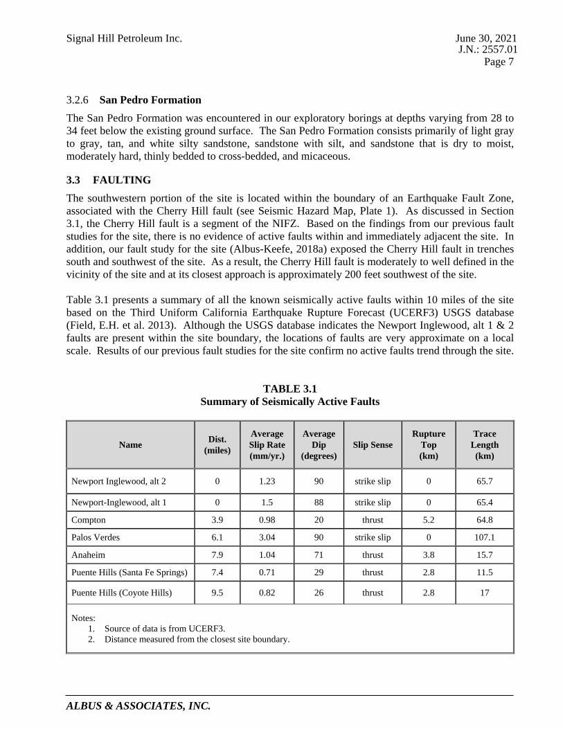
Signal Hill Petroleum Inc. June 30, 2021 J.N.: 2557.01
Page 7
ALBUS & ASSOCIATES, INC.
San Pedro Formation 3.2.6
The San Pedro Formation was encountered in our exploratory borings at depths varying from 28 to 34 feet below the existing ground surface. The San Pedro Formation consists primarily of light gray to gray, tan, and white silty sandstone, sandstone with silt, and sandstone that is dry to moist, moderately hard, thinly bedded to cross-bedded, and micaceous.
3.3 FAULTING The southwestern portion of the site is located within the boundary of an Earthquake Fault Zone, associated with the Cherry Hill fault (see Seismic Hazard Map, Plate 1). As discussed in Section 3.1, the Cherry Hill fault is a segment of the NIFZ. Based on the findings from our previous fault studies for the site, there is no evidence of active faults within and immediately adjacent the site. In addition, our fault study for the site (Albus-Keefe, 2018a) exposed the Cherry Hill fault in trenches south and southwest of the site. As a result, the Cherry Hill fault is moderately to well defined in the vicinity of the site and at its closest approach is approximately 200 feet southwest of the site. Table 3.1 presents a summary of all the known seismically active faults within 10 miles of the site based on the Third Uniform California Earthquake Rupture Forecast (UCERF3) USGS database (Field, E.H. et al. 2013). Although the USGS database indicates the Newport Inglewood, alt 1 & 2 faults are present within the site boundary, the locations of faults are very approximate on a local scale. Results of our previous fault studies for the site confirm no active faults trend through the site.
TABLE 3.1
Summary of Seismically Active Faults
Name Dist. (miles)
Average Slip Rate (mm/yr.)
Average Dip
(degrees) Slip Sense
Rupture Top (km)
Trace Length (km)
Newport Inglewood, alt 2 0 1.23 90 strike slip 0 65.7
Newport-Inglewood, alt 1 0 1.5 88 strike slip 0 65.4
Compton 3.9 0.98 20 thrust 5.2 64.8
Palos Verdes 6.1 3.04 90 strike slip 0 107.1
Anaheim 7.9 1.04 71 thrust 3.8 15.7
Puente Hills (Santa Fe Springs) 7.4 0.71 29 thrust 2.8 11.5
Puente Hills (Coyote Hills) 9.5 0.82 26 thrust 2.8 17
Notes: 1. Source of data is from UCERF3. 2. Distance measured from the closest site boundary.

Signal Hill Petroleum Inc. June 30, 2021 J.N.: 2557.01
Page 8
ALBUS & ASSOCIATES, INC.
3.4 GROUNDWATER Groundwater was not encountered during our previous geotechnical investigation of the site in 2018 to the maximum depths explored (41.5 feet below the existing ground surface). California: Seismic Hazard Zone Report 028 (CDMG 1998) does not provide any data on shallowest historical groundwater levels in proximity to the site. Our review of the Los Angeles County Department of Public Works Well Data website identified an inactive groundwater monitoring well in the project vicinity. This well, referred to as State Well Number 929, is located on a property southwest of the intersection of Gundry Avenue and East 27th Street, roughly 2,000 feet northwest of the site. The groundwater level from this well was initially measured at 127.3 feet below the ground surface (bgs) on October 15, 1957. The water level gradually declined over the years to 156.2 feet bgs when it was last measured on January 5, 1970.
4.0 GEOLOGIC HAZARDS FINDINGS
4.1 GENERAL Geologic hazards are defined as geologically-related conditions that may present a potential danger to life and property. A number of pertinent factors could impact the site. The site-specific potential for each of these geologic hazards is discussed in the following sections.
4.2 GROUND RUPTURE The southwestern portion of the site is located within the boundary of an Earthquake Fault Zone associated with the Cherry Hill fault (See Seismic Hazards Map, Plate 1). Earthquake Fault Zones are delineated by the State of California to define areas where fault rupture hazard investigations are required prior to building structures for human occupancy. No structure for human occupancy is permitted over the trace of an “active” fault. An “active” fault, as defined by the state, is a fault that has had surface displacement during Holocene time (last 11,700 years). Results of our previous fault studies performed for the site found no evidence of active faults within and immediately adjacent the site. Furthermore, results of our latest fault study (Albus-Keefe, 2018a), indicated that the Cherry Hill fault is located approximately 200 feet southwest of the site at its closest approach. As such, the potential for future ground rupture associated with active faulting within the site is considered remote.
4.3 GROUND LURCHING Ground lurching is the horizontal and vertical movement of soil or bedrock due to strong ground shaking. Lurching can be both transitory and permanent and often forms cracks in the ground surface. The potential for ground lurching is most prevalent in areas underlain by soft or saturated loose soils but can also occur on steep slopes comprised of poorly consolidated or fractured rock formations. Horizontal and vertical ground deformation resulting from ground lurching can adversely impact structures and compromise the stability of slopes. The project site is anticipated to be constructed to a relatively level condition and is not located immediately adjacent steep or high slopes. Furthermore, the site is not underlain by soft or saturated loose soils or poorly consolidated/fractured bedrock. As such, the potential for future ground lurching associated with strong ground shaking is considered remote.

Signal Hill Petroleum Inc. June 30, 2021 J.N.: 2557.01
Page 9
ALBUS & ASSOCIATES, INC.
4.4 GROUND SHAKING The site is situated in a seismically active area that has historically been affected by generally moderate to occasionally high levels of ground motion. The site lies in relative close proximity to several active faults. Therefore, during the life of the proposed developments, the property will probably experience similar moderate to occasionally high ground shaking from these fault zones, as well as some background shaking from other seismically active areas of the Southern California region. Design and construction in accordance with the current California Building Code (CBC) requirements is anticipated to adequately mitigate issues related to potential ground shaking.
4.5 LANDSLIDING The project site is relatively flat to gently sloping and is not located immediately adjacent steep terrain. As such, geologic hazards associated with landsliding are not anticipated at the site. The site is not located within an area identified by the California Geological Survey (CGS) as having potential for seismic slope instability (See Seismic Hazards Map, Plate 1).
4.6 LIQUEFACTION Liquefaction is the sudden decrease in the strength of cohesionless soils due to dynamic or cyclic shaking. Saturated soils behave temporarily as a viscous fluid (liquefaction) and, consequently, lose their capacity to support the structures founded on them. Engineering research of soil liquefaction potential (Youd, et al., 2001) indicates that generally three basic factors must exist concurrently in order for liquefaction to occur. These three factors are:
• A source of ground shaking, such as an earthquake, capable of generating soil mass distortions.
• Relatively loose, granular soils or sensitive clays having high moist contents. • A relative shallow groundwater table (within approximately 50 feet below ground surface) or
completely saturated soil conditions that will allow positive pore pressure generation.
The liquefaction susceptibility of the onsite soils was evaluated by analyzing the potential of concurrent occurrence of the above-mentioned three basic factors. The liquefaction evaluation for the site was completed under the guidance of Special Publication 117A: Guidelines for Evaluating and Mitigating Seismic Hazards in California (CDMG, 2008). Groundwater is anticipated to be more than 50 feet below the ground surface and the site is also underlain by relatively dense materials of the Lakewood and San Pedro Formations. As such, liquefaction is unlikely to occur at the site. The site is not located within a mapped California Geological Survey liquefaction hazard zone (See Seismic Hazards Map, Plate 1).

Signal Hill Petroleum Inc. June 30, 2021 J.N.: 2557.01
Page 10
ALBUS & ASSOCIATES, INC.
4.7 TSUNAMI AND SEICHES A tsunami is a sea wave generated by large-scale displacements of the ocean floor that causes a sudden surge of water onto the land. Tsunamis are most commonly caused by movement along faults and underwater landslides activated by earthquakes. Seiches are earthquake-induced displacements of water within an enclosed body of water such as a lake. Strong ground motions from an earthquake cause the water to slosh back and forth onto land. The site is elevated more than 113 feet above sea level and is located a substantial distance from a significant body of water within an enclosed basin. As such, geologic hazards associated with a tsunami or seiches are not anticipated at the site. Based on of the Tsunami Hazard Area Map of Los Angeles County prepared by CGS (2021), the site is not located within a Tsunami hazard area.
4.8 GROUND SUBSIDENCE Ground subsidence has been reported in areas of southern California as a result of gas, oil, or water extraction, as well as peat oxidation. The subject site is located in an area known to have experienced ground subsidence in the past largely due to oil extraction. Provided that oil field reservoir management strategies that include subsidence mitigation continue to be employed in the area, ground subsidence beneath the site that could result in damage to future site improvements is unlikely to occur at the site.
4.9 EXPANSIVE SOILS Expansive soils generally contain significant amounts of clay which tend to undergo swelling when wetted and shrinking when dried. Changes in moisture in expansive soils can cause volumetric changes in the soil leading to vertical and horizontal movement in overlying structures. Expansive soils can have detrimental effects on the performance of foundations, retaining walls, and flatwork. Based on results of laboratory testing during previous investigation of the site and our experience in the project area, the expansion characteristic of the near surface soils of the site are anticipated to exhibit Very Low to Low expansion potential (UBC 18-I-B). Given the expansion potential anticipated at the site, only nominal steps will be needed to mitigate adverse effects such as minor steel reinforcing of foundations and slabs, and moisture preparation and jointing details for flatwork.
4.10 CORROSIVE SOILS Corrosive soils possess properties that are reactive with construction materials such as metals and concrete. Generally, soils that contain clays have low electrical resistivity and can cause corrosion of metals in contact with such soils. Soils that contain high amounts of sulfates can cause degradation of concrete. Based on our general experience in the area, the site soils are likely Moderately to Highly corrosive to metals. Where site development may involve the use of metals that could be in contact with site soils, a variety of steps can be taken to mitigate the potential adverse effects including the use of coatings, membranes, and cathodic protection. Laboratory testing of site soils during the previous investigation of the site indicates the near surface soils have Negligible soluble sulfate content. Concrete designed to follow the procedures provided in ACI 318, Section 4.3, Table 4.3.1, for negligible sulfate exposure are anticipated to be adequate for the mitigation of sulfate attack on concrete.

Signal Hill Petroleum Inc. June 30, 2021 J.N.: 2557.01
Page 11
ALBUS & ASSOCIATES, INC.
4.11 SOIL EROSION Soil erosion is the movement of near-surface soil particles generally by flowing water and in some cases high winds. Sandy soils are generally more susceptible to erosion than clayey soils. No evidence of surface erosion was noted during our recent site visit. However, much of the site is covered with sandy soils and the relatively flat to very gently sloping terrain could be susceptible to slight soil erosion during periods of significant rainfall. Typically, the potential for soil erosion can be mitigated during future development through several methods including use of proper vegetation and surface stabilizing products, grading to avoid concentrated flows, and construction of basins or structures to collect sediments prior to entering bodies of water. The site is not located in an area subject to frequent and sustained high winds that could result in significant erosion of surface soils.
5.0 LIMITATIONS This report presents of a summary of our geologic hazard evaluation of the site. This report is based on our review of data collected, our geologic site reconnaissance, and our engineering and geologic opinions from years of experience in the Signal Hill area. This report has been prepared for the use of the Signal Hill Petroleum Inc. and the project consultants. The information presented herein is intended to only assist in the preparation of a Program Environmental Impact Report. This report is not intended to satisfy the requirements of a site specific and detailed geotechnical investigation required for further planning and permitting. This report has been prepared consistent with that level of care being provided by other professionals providing similar services at the same locale and time period. The contents of this report are professional opinions and as such, are not to be considered a guaranty or warranty. Respectfully submitted, ALBUS & ASSOCIATES, INC Michael O. Spira David E. Albus Principal Engineering Geologist Principal Engineer C.E.G. 1976 G.E. 2455

Signal Hill Petroleum Inc. June 30, 2021 J.N.: 2557.01
Page 12
ALBUS & ASSOCIATES, INC.
REFERENCES Publications Barrows, A.G., 1974, A Review of the Geology and Earthquake History of the Newport-Inglewood
Structural Zone, Southern California, California Division of Mines and Geology Special Report 114, pp. 115.
California Division of Mines and Geology (CDMG), 1998, Seismic Hazard Report for the Long
Beach 7.5-Minute Quadrangle, Los Angeles County, California: Seismic Hazard Zone Report 028.
California Division of Mines and Geology (CDMG), 1986 Revised Official, State of California
(Special Studies) Earthquake Fault Zone Map, Long Beach Quadrangle, dated July 1, 1986, Scale: 1:24,000.
California Division of Mines and Geology (CDMG), 1999, Seismic Hazard Zones for the Long
Beach Quadrangle, Official Map released March 25, 1999, Scale: 1:24,000. California Geological Survey (CGS), Special Publication 117A, Guidelines for Evaluating and
Mitigating Seismic Hazards in California, 2008. California Geological Survey (CGS), 1999, Earthquake Zones of Required Investigation, Long
Beach Quadrangle, Earthquake Fault Zones Revised Official Map Released July 1, 1986, Seismic Hazard Zones Official Map Released March 25, 1999.
California Geological Survey (CGS), 2018 Revision, Earthquake Fault Zones, A Guide For
Government Agencies, Property Owners / Developers, And Geoscience Practitioners For Assessing Fault Rupture Hazards In California: Special Publication 42.
California Geological Survey (CGS), 2019, NOTE 48-Checklist for the Review of Engineering
Geology and Seismology Reports for California Public Schools, Hospitals and Essential Services Buildings, November.
California Geological Survey (CGS), 2021, Tsunami Hazard Area Map of Los Angeles County City of Signal Hill General Plan, 2016, Safety Element. Field, E.H., Biasi, G.P., Bird, P., Dawson, T.E., Felzer, K.R., Jackson, D.D., Johnson, K.M., Jordan,
T.H., Madden, C., Michael, A.J., Milner, K.R., Page, M.T., Parsons, T., Powers, P.M., Shaw, B.E., Thatcher, W.R., Weldon, R.J., II, and Zeng, Y., 2013, Uniform California earthquake rupture forecast, version 3 (UCERF3)—The time-independent model: U.S. Geological Survey Open-File Report 2013–1165, 97 p., California Geological Survey Special Report 228, and Southern California Earthquake Center Publication 1792, http://pubs.usgs.gov/of/2013/1165/.

Signal Hill Petroleum Inc. June 30, 2021 J.N.: 2557.01
Page 13
ALBUS & ASSOCIATES, INC.
REFERENCES (cont.)
Los Angeles County Department of Public Works Well Data (accessed 2021):
https://dpw.lacounty.gov/general/wells/ Ponti, D.J., and Lajoie K.R., 1992, Chronostratigraphic Implications for Tectonic Deformation of
Palos Verdes and Signal Hill, Los Angeles Basin, California, in Heath, E.G. and Lewis, W.L. (editors), The Regressive Pleistocene Shoreline, Coastal Southern California, South Coast Geological Society, Annual Field Trip Guide Book No. 20, pp. 157-161.
Saucedo, J. G., Greene, H.G., Kennedy, M.P., Bezore, S.P., 2016, Geologic Map of the Long Beach
30’ x 60’ Quadrangle, California, Version 2, California Geological Survey. St.Peters, K.S., and R.A. Whitney, 1992, Structural Analysis of the Newport-Inglewood Fault Zone
for Mitigation of Surface Rupture Hazard to Future Residential Development at Signal Hill, California, in Association of Engineering Geologists Southern California Section Engineering Geology Field Trips, Orange County Santa Monica Mountains and Malibu 35th Annual Meeting, Oct 2-9, pp. A45-A54.
The Working Group on California Earthquake Probabilities consists of the U.S. Geological Survey,
California Geological Survey, and Southern California Earthquake Center. Their report is available at www.wgcep.org.
Thomas, R.G., 1961, Planned Utilization of the Ground Water Basins of the Coastal Plain of Los
Angeles County, Appendix A- A Ground Water Geology: State of California, Department of Water Resources Ground Water Geology, Bulletin No. 104.
Wright, T.L., 1991, Strucutual Geology and Tectonic Evolution of the Los Angeles Basin, California
Overview, in Biddle, K.T. ed., Active Margin Basins: American Association of Petroleum Geologists Memoir 52, p. 35-134.
Yerkes, R.F., et al., 1965, Geology of the Los Angeles Basin – An Introduction, Geological Survey
Professional Paper 420-A. Youd, T.L., Idriss, I.M., Andrus, R.D., Arango, I., Castro, G., Christian, J., Dobry, R., Finn, W.D.L.,
Harder, L.F., Hynes, M.E., Ishihara, K., Koester, J.P., Liao, S.S.C., Marcuson, W.F., Martin, G.R., Mitchell, J.K., Moriwaki, Y., Power, M.S., Robertson, P.K., Seed, R.B., and Stokoe, K.H., 2001, “Liquefaction Resistance of Soils: Summary Report from the 1996 NCEER and 1998 NCEER/NSF Workshops on Evaluation of Liquefaction Resistance.

Signal Hill Petroleum Inc. June 30, 2021 J.N.: 2557.01
Page 14
ALBUS & ASSOCIATES, INC.
REFERENCES (cont.) Report Albus-Keefe & Associates, Inc., 2008a, Compaction Report for Exploratory Trench Backfill,
Sullivan Property, Signal Hill, California, dated April 24 (J.N. 1661.00). ______, 2008b, Compaction Report for Exploratory Trench Backfill, T-1, T-2, T-3, T-4, Northeast
and Northwest Corners of Burnett Street and Gardena Avenue, Signal Hill, California, dated May 16, (J.N.: 1661.00).
______, 2008c, Fault Investigation Report, Proposed Retail Commercial Site, Northwest of the
Corner of Cherry Avenue and Burnett Avenue, Signal Hill, California, dated June 6, (J.N.: 1661.00).
______, 2008d, Geotechnical Investigation for Percolation, Fresh and Easy Site, Southwest Corner
of Cherry Avenue and 25th Street, City of Signal Hill, California, dated August 5, (J.N.: 1661.00).
______, 2010, Fault Evaluation Report, Sullivan Property, Southeast of Rose Avenue and Crescent
Heights Street, City of Signal Hill, California, dated September 21, (J.N.: 1898.00). ______, 2013, Geologic Assessment of Surface Fault Rupture Potential, The Gardena Avenue Site
(APN: 7214-005-900, 901, 902, 903, 904), Northwest of the Intersection of East Burnett Street and Gardena Avenue, City of Signal Hill, California, dated December 4, (J.N.: 1898.01).
______, 2018a, Geologic Assessment of Surface Fault Rupture Potential, Skyline Village Project,
Located Northeast of the Intersection of Rose Avenue and East Burnett Street, City of Signal Hill, California, dated February 1, (J.N.: 2557.00).
______, 2018b, Preliminary Geotechnical Investigation, Heritage Square Project, Signal Hill,
California, dated August 31, (J.N.: 2557.00). ______, 2021, “Revised” Geologic Hazards Evaluation Report, Orange Bluff Site, East 28th Street
and Orange Avenue, City of Signal Hill, California (Assessor Parcel Nos.: 7212-008-049, 7212-008-051, 7212-010-010, 7212-010-019, and 7212-010-020), dated June 24 (J.N. 2609.03).
Mearns Consulting LLC., 2018a, Phase I Environmental Site Assessment, Heritage Square Project,
Signal Hill, California 90755, dated February 1, 2018 ______, 2018b, Phase II Environmental Site Assessment, Heritage Square Project, Signal Hill,
California 90755, dated December, 21, 2018.

Signal Hill Petroleum Inc. June 30, 2021 J.N.: 2557.01
Page 15
ALBUS & ASSOCIATES, INC.
REFERENCES (cont.) Plans Heritage Square Site Analysis Plan, prepared by ktgy Architects + Planning, current version dated
October 13, 2020. Topographic Maps Topographic Map, City of Signal Hill and Vicinity, Signal Hill, California, prepared by Pacific Air
Industries, Scale: 1” = 100’, dated June 29, 1960. Provided by Environmental Data Resources Inc. Search: USGS, Long Beach 7.5-minute Quadrangle, 2012 USGS, Long Beach 7.5-minute Quadrangle, 1981 USGS, Long Beach 7.5-minute Quadrangle, 1972 USGS, Long Beach 7.5-minute Quadrangle, 1964 USGS, Long Beach 7.5-minute Quadrangle, 1949 USGS, Downey 15-minute Quadrangle, 1947 USGS, Downey 15-minute Quadrangle, 1943 USGS, Downey 15-minute Quadrangle, 1942 USGS, Long Beach 7.5-minute Quadrangle, 1925 USGS, Downey 15-minute Quadrangle, 1902 USGS, Downey 15-minute Quadrangle, 1899 USGS, Downey 15-minute Quadrangle, 1896 Aerial Photographs Source Date Flown Flight No. Photo No. Scale Continental 4-3-60 311-5 5 & 6 1"=1000' Continental 1-31-70 61-7 177 &178 1"=4000' Continental 5-12-79 FC-LA 127 & 128 1"=2800' Continental 4-9-81 ORA-5 3 Continental 1-27-86 F 351 & 352 1"=2800' Continental 7-7-88 AF 19210 1"=2200' Continental 1-29-92 C85-7 29 & 30 1"=2000' Continental 10-15-97 C117-35 240 1"=2000'
Provided by Environmental Data Resources Inc. Search: Source Date Flown Scale Fairchild 1928 1"=500' Fairchild 1947 1"=666' Fairchild 1956 1"=400' Teledyne 1968 1"=480' Teledyne 1976 1"=666' USGS 1989 1"=666' USGS 1994 1"=666

SITE LOCATION
1Plate:6/30/21Date:2557.01Job No.:
SEISMIC HAZARDS MAP
0 1500 3000 6000
SCALE : 1" = 3000' Liquefaction ZonesAreas where historical occurrence of liquefaction or localgeological, geotechnical and ground water conditionsindicate a potential for permanent ground displacementssuch that mitigation as defined in Public Resources CodeSection 2693(c) would be required.
Active Fault TracesFaults considered to have been active during Holocenetime and have potential for surface rupture: Solid Line inBlack or Red where accurately located; Long Dash inBlack or Solid Line in Purple where approximatelylocated; Short dash in black or solid line in orange whereinferred; Dotted line in black or solid line in rose whereconcealed; Query (?) indicates additional uncertainty.Evidence of historic offset indicated by year ofearthquake-associated event or C for displacementcaused by fault creep.
Earthquake Fault ZonesZone boundaries are delineated by straight-line segments;the boundaries define the zone encompassing active faultsthat constitute a potential hazard to structures from surfacefaulting or fualt creep such that avoidance as described inPublic Resources Code Section 2621.5(c) would berequired.
Earthquake-Induced Landslide ZonesAreas where previous occurence of landslide movement, orlocal topographic, geological, geotechnical and subsurfacewater conditions indicated a potential for permanent grounddisplacements such that mitigation as defined in PublicResources Code Section 2693(c) would be required.
Overlapping Earthquake Fault and Seismic Hazard ZonesOverlap of Earthqueak Fault Zone and Liquefaction ZonesAreas that are covered by both Earthquake Fault Zone andLiquefaction Zone.
Overlap of Earthquake Fault Zone and Earthquake-InducedLandslide Zone Areas that are covered by both EarthquakeFault Zone and Earthquake-Induced Landslide Zone.
Note: Mitigation methods differ for each zone - AP Act onlyallows avoidance; Seismic Hazard Mapping Act allowsmitigation by engineering geological design as well asavoidance.
California Geological Survey (CGS), 1999, Earthquake Zones of Required Investigation, Long Beach Quadrangle, Earthquake Fault Zones RevisedOfficial Map Released July 1, 1986, Seismic Hazard Zones Official Map Released March 25, 1999.

D.9Review of Heritage Square Evaluation Report

1642 E. Fourth Street Santa Ana California 92701 Telephones: (714) 412-2654 & 544-5321 Facsimile: (714) 494-4930
www.earthconsultants.com
July 9, 2021 ECI Project No. 4107
To: City of Signal Hill – Community Development Department
2175 Cherry Avenue Signal Hill, California 90755
Attention: Ms. Colleen T. Doan, Community Development Director Submitted via e-mail at [email protected] To: Meridian Consultants
706 S. Hill Street, 11th Floor Los Angeles, California 90014
Attention: Ms. Christine Lan, Senior Project Manager Submitted via e-mail at [email protected] Subject: Review of Geohazards Report for the Property Referred to as the Heritage Square
Site in the City of Signal Hill, California References: Albus & Associates Inc. (AA), 2021, “Revised” Geologic Hazards Evaluation Report,
Heritage Square Site, City of Signal Hill, California (Assessor Parcel Nos.: 7214-005-010, and 7214-005-011; 7214-005-900, 7214-005-901, 7214-005-902, 7214-005-903, and 7214-005-904; 7214-006-014, 7214-006-015, 7214-006-019, and 7214-006-020); consulting report prepared for Signal Hill Petroleum Inc.; AA Job No. 2557.01, dated June 30, 2021, consulting report signed by Michael O. Spira, CEG 1976, Principal Engineering Geologist and David E. Albus, G.E. 2455, Principal Engineer.
Albus-Keefe & Associates (AKA), 2018, Geologic Assessment of Surface Fault
Rupture Potential, Skyline Village Project, Located Northeast of the Intersection of Rose Avenue and East Burnett Street, City of Signal Hill, California; AKA Job No. 2557.00, dated February 1, 2018, consulting report signed by Michael O. Spira, CEG 1976, Principal Engineering Geologist, and Bryan Petry, PG 9435, Project Geologist.
Earth Consultants International, Inc., 2018, Review of Fault Investigation Report for the Skyline Village Project, Northeast Intersection of Rose Avenue and East Burnett Street, City of Signal Hill; ECI Project No. 3702, dated March 16, 2018, review letter report conducted on behalf of and for the City of Signal Hill Community Development Department, signed by Tania Gonzalez, CEG 1859, Engineering Geologic Reviewer for the City of Signal Hill.

July 9, 2021 ECI Project No. 4107
Review of Geo-Hazards Report for EIR Purposes Proposed Heritage Square Project, City of Signal Hill Page 2
PROJECT DESCRIPTION The Heritage Square property is a nearly square-shaped site located between E. Crescent Heights Street and E. Burnett Street to the north and south, respectively, and between Cherry Avenue and Rose Avenue to the east and west, respectively. Gardena Avenue runs through the site in a north-south direction. The project site is approximately 8.8 acres in area, and is comprised of eleven parcels (APNs: 7214-005-900, -901, -902, -903 and -904; 7214-005-010, and -011; and 7214-006-019, -020, -014, and -015). The site is currently mostly vacant, except for a grocery store (Mother’s Market) and associated parking in the northeastern quadrant. The site also currently houses four active oil and gas wells, and six abandoned wells. Several of these are surrounded by either block walls or fencing. With the exception of the paved parking lot to the west and south of the existing commercial building, and Gardena Avenue, the site is unpaved and locally covered with vegetation consisting of shrubs, trees and weeds. Stormwater quality improvements consisting of shallow basins, wattles and sandbags are present throughout the site, with the wattles and sandbags often along the property boundaries. The site is proposed to be developed for mixed commercial/residential uses, with up to 72 housing units being considered. These residential units would be of above-moderate affordability level, with a dwelling unit per acre ratio of about 8.2. It is our understanding that to accommodate housing on the property, a General Plan amendment and a zoning ordinance amendment to the Heritage Square Specific Plan will be required. PHYSICAL, GEOLOGIC and SEISMIC SETTING The property is located on the northwest extension (or “nose”) of Signal Hill, an area that has been uplifted above the Los Angeles Basin over hundreds of thousands of years as a result of movement on the Newport-Inglewood Fault Zone (NIFZ) and related structures. The site itself, being nearly at the top of the nose, is relatively flat to gently sloping to the northeast, with elevations varying from approximately 187 feet above mean sea level (amsl) near the southwestern corner of the site to about 165 feet amsl in the northeastern portion of the site (AA, 2021). There are no steep slopes at the site. Signal Hill, including the subject site, is underlain in the near surface by unconsolidated sediments, typically sandstone and silty sandstone, assigned to the Inglewood Formation. These sediments were deposited in shallow marine and coastal (beach) environments about 600,000 to 200,000 years ago, and have since been uplifted as a result of both regional and localized uplift along the NIFZ. The uppermost section of the Inglewood Formation has been exposed to weathering and soil-forming processes for tens to hundreds of thousands of years, forming a well-developed, reddish clay-rich soil that is generally about 4 to 5 feet thick. Clay-enriched bands (referred to as Bt lamellae or Bt lams) that are sub-parallel to the ground surface are often observed below the clay-rich (argillic) soil profile. These Bt lams are useful in fault studies as they often highlight breaks in the stratigraphy that would be difficult to see in the generally massive-looking sandstone and the overlying clay-rich soil. The Inglewood Formation is underlain by an older marine deposit referred to as the San Pedro Formation that consists of bedded sandstone, silty sandstone and gravelly sandstone. AA (2021) reports that the top of the San Pedro Formation occurs at depths of between about 28 and 34 feet below the ground surface at the site.

July 9, 2021 ECI Project No. 4107
Review of Geo-Hazards Report for EIR Purposes Proposed Heritage Square Project, City of Signal Hill Page 3
Localized pockets of both undocumented and documented artificial fill associated with oil wells, backfilled fault trenches, roadways, older foundations, and other past disturbances of the site are known and expected to occur onsite. The thickness of these deposits is variable, but reportedly between about 5 and 11 feet. The trench backfills associated with AKA’s fault studies were placed under engineering observation and testing, and compacted to 90% or more of the soils’ maximum dry density. For a more detailed discussion of the location and suitability of these deposits as foundation materials, refer to the reports by Albus & Associates (AA, 2018; 2021) and the Albus-Keefe & Associates (AKA, 2008a; 2008b; 2008c) reports referenced therein. According to AA (2021), groundwater was not encountered in any of the borings they previously drilled onsite to a total depth of 41.5 feet. Furthermore, they report that records from a groundwater well located about 2,000 feet from the site suggest that groundwater is more than 150 feet below the ground surface in the site vicinity. However, the water level in this well was last recorded in 1970 so the depth to water in the site vicinity could be significantly different, and likely deeper. Signal Hill is considered to be a pressure ridge at the left step between two sections or splays of the northwest-trending NIFZ. These faults are referred to as the Northeast Flank fault on the east side of the hill, and the Cherry Hill fault on the west side. The Cherry Hill fault is the fault closest to the site, with the approximately southwestern one-third of the site located within the Alquist-Priolo Earthquake Fault Zone for this fault (CDMG, 1986). Extensive trenching studies across this portion of the site, in addition to trenching studies to the south, southwest and west, across East Burnett Street and Rose Avenue (AKA, 2018), have demonstrated that the fault is approximately 200 feet to the southwest of the site at its closest approach. Several minor faults and fractures were observed in the trenches excavated on the property, but none of these were considered Holocene-active. A secondary fault sub-parallel to, and northeast of the Cherry Hill fault that projects toward the site was observed in a trench exposure to terminate at the base of the Lakewood Formation. Since the base of this unit is about 200,000 years old in the Signal Hill area, these observations indicate that the Northwest Flank fault, as it was informally named by AKA (2018), is not a Holocene-active fault. The proposed project is therefore not anticipated to experience ground deformation in the form of surface fault rupture should the NIFZ rupture during the lifetime of the project. Minor fracturing associated with strong ground shaking cannot be precluded, however. HAZARD ASSESSMENT As part of their assessment for the site, AA (2021) evaluated whether the site has the potential to be impacted by various geologic/geotechnical and seismic hazards. For a complete discussion of these hazards both in a general sense and as they pertain to the site, refer to AA’s (2021) report. The paragraphs below summarize only those hazards that are deemed to have a significant or potentially significant impact on the site and the proposed development. With the exception of surface ground rupture due to faulting, which, per State law requires avoidance, other geologic/geotechnical hazards can be mitigated with engineering solutions.
Although extensive trenching onsite and offsite has conclusively shown that Holocene-active faults do not extend across the site, several minor faults and fractures that could be related to earthquake-induced ground shaking were observed in the trenches excavated onsite. The fault investigation conducted for this site was approved with three provisions that need to be complied with as part of the development process. These provisions include: 1) that the

July 9, 2021 ECI Project No. 4107
Review of Geo-Hazards Report for EIR Purposes Proposed Heritage Square Project, City of Signal Hill Page 4
proposed structures be designed and built to accommodate strong levels of ground shaking; 2) that all habitable structures be designed with stiffened foundation systems that can accommodate minor secondary fracturing associated with ground shaking; and 3) that a California-registered Professional Geologist be present to observe the geological conditions exposed during development of the site, to verify that the conclusions of the fault investigation are correct. A final as-graded geological report that summarizes the observations made during development needs to be prepared and submitted to the City’s Building Official. If potentially active faults are observed during grading, the City’s Geological Reviewer shall be notified immediately and a field meeting to discuss these observations shall be held (Earth Consultants International, 2018).
Given its location relative to the NIFZ and several other faults in the Southern California region, the site is anticipated to experience strong ground shaking if and when a moderate to large earthquake (of magnitude greater than about 6) occurs in the area. The hazard to the site posed by seismic ground shaking is similar to that of any other property in the area. The hazard of seismic shaking is typically managed by following, at a minimum, the requirements of the most recent version of the California Building Code (CBC) adopted by the City of Signal Hill. Ground motion parameters for structural design will have to be calculated and provided to the structural engineer of record in accordance with the most recent versions of the CBC and the American Society of Civil Engineers’ (ASCE) Minimum Design Loads for Buildings and Other Structures Standards (ASCE 7) adopted by the City of Signal Hill at the time the project is first submitted for the plan check review process.
Regional ground subsidence as a result of oil and gas extraction occurred in the Long Beach and Wilmington areas in the 1930s and 1940s, during the boom of oil exploration. Now, oil producers generally manage and control ground subsidence above oil reservoirs by regularly monitoring ground surface elevations, and injecting brine water into the oil-producing zones to balance the volume of oil and gas extracted. These programs are designed to prevent or reduce the detrimental impacts of ground subsidence on infrastructure and structures.
The clay-rich soils near the ground surface may have a low expansion potential. The potential impact to structures from expansive soils is regularly managed during construction using a variety of standard-of-practice engineering solutions, including excavation and mixing of the clay-rich, expansive soils with sandier materials, moisture preparation of the ground under and around foundations and hardscape, and, if deemed necessary by the geotechnical engineer of record, steel reinforcement of the foundations to accommodate minor differential movements resulting from uneven shrinking and/or swelling of the soils below the foundation. Appropriate mitigation measures will be provided in the geotechnical study that is required as part of the plan check review process.
Based on their experience in the area, AA (2021) indicates that the soils underlying the site at shallow depths are likely to be moderately to highly corrosive to metals. This would be confirmed in advance of construction, as part of the required geotechnical investigation during plan check, and appropriate mitigations would be recommended at that time, if deemed necessary. The mitigation measures provided would be consistent with standard-of-practice approaches, such as the use of alternate materials, encasing the metallic components in non-corrosive backfills, use of protective coatings, and cathodic protection of metallic pipes and other metallic elements that would be in contact with the soil.
The sandy deposits of the Inglewood and San Pedro Formations, if exposed at the ground surface or in cut-slopes, could be susceptible to rills, gullies, and general erosion by running

July 9, 2021 ECI Project No. 4107
Review of Geo-Hazards Report for EIR Purposes Proposed Heritage Square Project, City of Signal Hill Page 5
water or strong winds. Best management practices during construction, including regular wetting of the building pads, and placing sandbags at the perimeter of the project area would help control dust and offsite transport of sand by running water, respectively. Long-term management of erosion is generally achieved with the use of hardscaping and landscaping, and if deemed necessary by the project engineer, the installation of debris basins or other structures to catch and divert surface water and loose soils.
FINDINGS Earth Consultants International, Inc. (ECI) has reviewed the above-referenced report by Albus & Associates Inc. (AA) discussing the geohazards that the site is susceptible to, and finds that the study was conducted under the standard of care typical of these projects. ECI finds that AA’s study and report are acceptable for the purposes intended, and that additional analyses of the geologic and seismic conditions are not necessary in advance of preparing the Enviromental Impact Report for the proposed project. A project-specific geotechnical study that addresses the geologic and geotechnical conditions as they pertain to the proposed design will be required as part of the project approval process, but this study concludes that there are no significant hazards that would make this property undevelopable for the purposes intended. The project impacts to geology and soils, including thresholds of significance, are summarized in the table below.
Potentially Significant
Impact
Less Than Significant
with Project Mitigation
Less Than Significant
Impact
No Impact
GEOLOGY AND SOILS—Would the project: a. Expose people or structures to potential substantial
adverse effects, including the risk of loss, injury, or death involving:
1) Rupture of a known earthquake fault, as delineated on the most recent Alquist-Priolo Earthquake Fault Zoning map issued by the State Geologist for the area or based on other substantial evidence of a known fault? (Refer to Division of Mines and Geology Special Publication 42)
X
2) Strong seismic ground shaking X 3) Seismically induced ground failure, including
liquefaction or X
4) Landslides? X b. Result in substantial soil erosion or the loss of
topsoil?
X
c. Be located on a geologic unit or soil that is unstable, or that would become unstable as a result of the project, and potentially result in on- or off-site landslide, lateral spreading, subsidence, liquefaction or collapse?
X
d. Be located on expansive soil, as defined in Table 18-1-B of the Uniform Building Code (1994), creating substantial risks to life or property?
X

July 9, 2021 ECI Project No. 4107
Review of Geo-Hazards Report for EIR Purposes Proposed Heritage Square Project, City of Signal Hill Page 6
We trust that the data provided above, together with the geohazards report submitted by Albus Associates Inc. (2021) provide you with the data you need at this time. If you need additional information, please do not hesitate to contact the undersigned. Respectfully submitted, EARTH CONSULTANTS INTERNATIONAL, INC. Registered Geologists and Certified Engineering Geologists
Tania Gonzalez, CEG 1859 Engineering Geologic Reviewer for the City of Signal Hill Earth Consultants International, Inc. Reference: California Geological Survey, 1986, State of California Earthquake Fault Zones, Revised Official
Map of the Long Beach Quadrangle; effective July 1, 1986, Scale: 1:24,000.