geophysical and geochemical methods used in the …
TRANSCRIPT

32. GEOPHYSICAL AND GEOCHEMICAL METHODS USED IN THE DISCOVERY OF THEISLAND COPPER DEPOSIT, VANCOUVER ISLAND, BRITISH COLUMBIA
K.E. WitherlyUtah Mines Ltd., Toronto, Ontario
Witherly, K.E., Geophysical and geochemical methods used in the discovery of the Island CopperDeposit, Vancouver Island, British Columbia; in Geophysics and Geochemistry in the Search forMetallic Ores; Peter J. Hood, editor; GeologicQl Survey of Canada, Economic Geology Report 31,p. 685-696, 1979.
Abstract
The Island Copper Mine of Utah Mines Ltd. is a large, low-grade copper-molybdenumdeposit located 354 km northwest of Vancouver, B.C. The deposit lies in the Bonanza Volcanicformation of lower to mid-Jurassic age. The ore zones are in andesitic, pyroclastic rocks in thehanging wall and footwall of a quartz-feldspar porphyry dyke. At the commencement ofproduction, ore reserves totalled 257 million tonnes averaging 0.52 per cent copper and 0.017 percent molybdenum.
Exploration work on the deposit began in early 1966 when Utah Construction and MiningCo. (now Utah Mines Ltd.) optioned approximately 175 claims located on the north side of RupertInlet. Initial work consisted of geological mapping, soil geochemistry, ground magnetic and IPsurveying. Considerable dependence was placed on the latter three tools due to the extensiveoverburden cover on the property. The geochemical and geophysical surveys produced anabundance of anomalies over the property.
During the first year of exploration, testing of geochemical and geophysical anomalies wasdone with a small company-owned diamond drill which could penetrate depths of up to 75 munder favourable conditions. Although copper and magnetite had a known association in the area,initial direct testing of the best magnetic anomalies located only subeconomic coppermineralization. The IP anomalies tested intersected some low-grade copper with pyrite, butmore often just barren pyrite. It was observed from the initial testing that the total sulphidecontent of the anomalies tested was fairly constant, i.e. when the chalcopyrite picked up, thepyrite content dropped. This made anomaly discrimination based on amplitudes quite difficult.
In view of the poor resolution the geophysical anomalies provided, it was decided to testthe copper soil geochemical anomalies before any more geophysical work would be done. Theorebody was discovered as a result of testing one such geochemical anomaly with several shallowdrillholes. Deeper drilling of the deposit was initiated soon after and the orebody was delineateda little more than two years later in the Spring of 1969. A VLF-EM survey over the deposit didnot respond to the ore mineralization itself but did show up a number of significant structuralfeatures.
Although geophysics did not assist directly in the discovery of the Island Copper deposit, itscontributions to the development of geological thinking in the area have been valuable. A largepart of the recent interest in the northern part of Vancouver Island stemmed from a joint BritishColumbia Department of Mines/Geological Survey of Canada aeromagnetic survey flown in 1962.Examination of the geophysical data made subsequent to the discovery of Island Copper showthat the geophysical results support and enhance information on structure, alteration andmineralization both in and around the orebody. Such information is not only of interest in its ownright but as well provides a valuable data base to draw upon for exploration in similar geologicalenvironments.
Resume
La mine de cuivre Island de l'Utah Mines Ltd. est formee d'un important gisement pauvre decUivre-molybdEme. 354 km au nord-ouest de Vancouver. en Colombie-Britannique. Le gisementrepose dans la formation volcanique Bonanza du Jurassique inferieur et moyen. Les zones deminerai se trouvent dans des roches pyroclastiques a andesite dans la levre superieure et la levreinferieure d'un dyke porphyrique de quartz-feldspath. Au debut de la production, les reserves deminerai atteignaient 257 millions de tonnes d'une teneur en cuivre d'environ 0,52 pour cent etd'une teneur en molybdene d'environ 0,017 pour cent.
Les travaux d'exploration du gisement ont commence au debut de 1966, lorsque l'UtahConstruction and Mining Co. (aujourd'hui l'Utah Mines Ltd.) a choisi environ 175 claims sur la rivenord de l'inlet Rupert. Les travaux preliminaires comprenaient la cartographie geologique,l'etude geochimique des sols, des leves magnetiques et des leves par methode PP. On avaitbeaucoup mise sur les trois dernieres methodes, etant donnee la couche importante du terrain decouverture.
Au cours de la premiere annee d'exploration, des verifications d'anomalies geochimiques etgeophysiques ont ete effectuees a l'aide d'un petit foret au diamant que possedait la societe; cetoutil de forage pouvait atteindre des profondeurs de 75 m dans des conditions favorables.

686 K.E. Witherly
Les leves geochimiques et geophysiques ont revele un grand nombre d'anomalies sur toutel'etendue du terrain. Bien que I'on ait su que, dans cette region, Ie cuivre et la magnetite etaientassocies, la verification directe initiale des meilleures anomalies magnetiques n'a indique qu'unemineralisation de cuivre non susceptible d'etre exploitee de faMon rentable.
Les anomalies verifiees par la methode PPont livre un peu de cuivre pauvre contenant dela pyrite, mais surtout de la pyrite sterile. On a remarque lors de la verification initiale que Iecontenu total en sUlfure des anomalies verifiees etait a peu pres constant, c'est-a-dire quelorsque la chalcopyrite augmentait, la pyrite diminuait. Cette constation a rendu assez difficilela distinction des anomalies en fonction des amplitudes.
Compte tenu du faible pouvoir de resolution qu'avaient fourni les anomalies geophysiques, ilfut decide de verifier les anomalies geochimiques des sols contenant du cuivre avant que d'autrestravaux geophysiques ne soient entrepris. Le gisement en amas fut decouvert a la suite de laverification d'une tel Ie anomalie geochimique au moyen de plusieurs trous de forage peuprofonds. Le forage du gisement a plus grande profondeur fut entrepris peu de temps apres, et Iegisement en amas fut delimite un peu plus de deux ans plus tard, au printemps de 1969.
Un leve electromagnetique a tres basse frequence efrectue sur l'ensemble du gisement n'apas reagi a la mineralisation elle-meme, mais a revele un nombre important de particularitesstructurales.
Bien que la geophysique n'ait pas contribue directement a la decouverte du gisement decuivre Island, elle a influe grandement sur l'opinion que se font les geologues de la structure de laregion. Une grande partie de l'interet manifeste dernierement a ce sujet dans la partie nord deI'ile Vancouver fait suite a un leve aeromagnetique effectue en 1962 par Ie ministere des Minesde la Colombie-Britannique et la Commission geologique du Canada. L'analyse des donneesgeophysiques effectuees a la suite de la decouverte de la mine de cuivre Island indique que lesresultats d'ordre geophysique corroborent des renseignements sur la structure, l'alteration et lamineralisation tant iJ. l'interieur qu'autow' du gisement en amas. De tels renseignements ne sontpas seulement interessants en eux-memes, mais ils fournissent egalement une base de donnees devaleur pour decider de travaux d'exploration dans des milieux geologiques semblables.
INTRODUCTION
The Island Copper (ISCU) deposit, controlled andoperated by Utah Mines Ltd. (formerly Utah Construction andMining), is located on the north shore of Rupert Inlet(50 0 36'N, 127°37'W) approximately 16 km south of Port Hardyon northern Vancouver Island (Fig. 32.1). The town of PortHardy is 354 km northwest of Vancouver, B.C. and is serviceddaily by scheduled flights from Vancouver. Port Hardy andthe northern portion of Vancouver Island can also be reachedby surface transportation using either public roads or acombination of provincial ferries and roads.
Elevations on the property range from sea level to150 m. The area around the deposit is heavily timbered withspruce, hemlock and cedar. Glacial deposits with thicknessesof up to 75 m cover most of the area. Average annualprecipitation at Port Hardy is 1900 mm, which includes anaverage of 600 mm of snow. The yearly temperature range isfrom -7°C minimum to 27°C maximum, with an annual meanof 8°C.
The ore body was discovered after more than four yearsof exploration activity that stemmed from the release ofresults of an aeromagnetic survey flown from July toSeptember 1962 over the whole northern portion of VancouverIsland. This survey was a joint effort between the BritiShColumbia Department of Mines and the Geological Survey ofCanada. Release of the aeromagnetic survey results in 1963stimulated considerable exploration interest in the area, withboth companies and individuals participating in the follow-up.As part of their programs, a number of major miningcompanies, including Utah Mines Ltd., reconnoitered theRupert Inlet area (Fig. 32.2), but found no encouragingevidence of economic mineralization. A small island, calledRed Island, located slightly less than 2 km to the southeast ofthe present pit, was known to have good copper gradesassociated with abundant magnetite in volcanics. Prospectorsat the time however, felt that the occurrence was only ahigh-grade pod and not part of a larger, mineralized system.
Soon aftcr the release of the aeromagnetic data,Gordon Milbourne, a local prospector, ran a dip-needle surveyover a localized magnetic high, situated just north of RupertInlet. Two years later, Milbourne returned to the area andlocated float and outcrops containing native copper andchalcopyrite, just west of Frances Lake (Fig. 32.2).Subsequent trenching revealed high-grade chalcopyrite involcanic rocks.
Utah Mines Ltd., examined Milbourne's ground inOctober 1965, and concluded that the property warrantedfollow-up. After some preliminary exploration work in theFall of 1965, Utah signed an agreement with Milbourne inJanuary] 966.
Because outcrops on the property were very sparse, dueto an extensive cover of glacial overburden, it was decidedthat an integrated geological, geochemical and geophysicalapproach should be used in evaluating the property. Tofacili tate this evaluation, a survey grid totalling 160 line kmwas established over the property. The lines were spaced152 m apart with survey stations every 30.5 m. The lineswere oriented N22°E, but local magnetic disturbancesoccasionally caused significant deflections in a surveyed line.
The choice of geochemical and geophysical parametersto be measured was based largely upon the initial test surveysdone in ] 965. Since only copper had been found in anysignificant amounts on the property, copper was the onlyelement for which the soil samples were analyzed. Magneticsurveys were considered an important tool, due to the knownaffinity copper 8nd magnetite showed in the area. Inducedpolarization was also felt to be useful, since considerablepyrite was found in association with the known coppermineralization.
Shallow drilling, with a company-owned X-ray machine,began early in 1966 to evaluate the mineralized area at thesouthwest end of Frances Lake. As geochemical andgeophysical surveys progressed, the X-ray drill was used totest anomalies located elsewhere on the property. The initialcriterion for drilling was that the anomalies be coincident

Island Copper Deposit, B.C. 687
with geochemical, magnetic and IP highs. On this premise,after some initial drilling north of Frances Lake, someinteresting observations were made. Firstly, testing of thebest magnetic anomalies encountered only low-grade coppermineralization; secondly, pyrite seemed ubiquitous in thearea, with its distribution on a local scale being apparentlyunrelated to economic copper mineralization. Thus, primarilyfor these reasons, it was decided early in 1966 to give thegeochemical anomalies the highest priority in the drillingprogram. Later that year, in the course of testing one suchgeochemical high located several kilometres to the southeastof the original prospect area, ore-grade mineralization wasencountered in three of four X-ray holes.
Soon after these first shallow intercepts wereconfirmed with deeper drilling, the exploration tempogradually built up, and by 1968 there were four largediamond-drill rigs working on the property. When drilling ofthe deposit was completed in May 1969, a total of 128 holeshad been drilled for an aggregate length of over 35 000 m.The results of the drilling program outlined a depositcontaining 240 million tonnes of copper and molybdenum ore,grading 0.52 per cent copper and 0.017 per cent molybdenum,extending from surface to a depth of 300 m, along a strikelength of about 1700 m. Mill construction began in late 1969and the first shipment of concentrates was made in December1971. The current production from the mill is approximately34 500 tonnes per day, and the current reserves (1976) areabout 230 million tonnes.
GEOLOGY OF NORTHERN VANCOUVER ISLAND ANDTHE ISLAND COPPER DEPOSIT
Regional Geology
The rocks of Vancouver Island, north of Rupert andHolberg Inlets, are primarily volcanic and sedimentary unitsranging in age from Upper Triassic to Lower Cretaceous(Muller et aI., 1974). Intrusive rocks of early to middleJurassic age intrude the central and upper portions of theNorth Island sequence and locally are associated with coppermolybdenum mineralization.
The Karmutsen Formation is the oldest rock unit in thearea and constitutes the largest volume of the various units.Rocks of the Karmutsen are predominantly porphyritic andamygdaloidal basalt flows. The next oldest unit is theQuatsino Formation, which is generally a massive limestonewith rare interbeds of tuffaceous material. Following theQuatsino Formation is the Parson Bay Formation. This is atransitional unit that separates the Quatsino Formation fromthe Bonanza Formation. The Parson Bay Formation iscomprised of black calcareous siltstones, shales and limestones with shaly interbeds.
The Bonanza Formation is mid to lower Jurassic in age.The volcanic unit consists of bedded and massive tuffs,formational breccias and rare amygdaloidal and porphyriticflows. Porphyritic dykes and sills intrude the lower part ofthe unit. Unconformably over the Bonanza lie rocks of LowerCretaceous age, consisting primarily of conglomerates,siltstones, sandstones and greywackes.
--.-
N.W.T.
U.S.A.
-- -'-
I
"_._ 1"-.-. \_.-._.-._.~._._.
B.C.
YUKON
ISLANDCOPPERMINE
300 kms t300 miles
PACIFICOCEAN
Figure 32.1. Location map - Island Copper Mine, northern Vancouver Island, British Columbia.

688 K.E. Witherly
lpoo
lO~k: 0
J.Lo"'b
ISLAND COPPERPROPERTY
MILES
METERS
PAIltSON BAYFOItMATION
QUAT$INOFORMATION
KARllUTSENLAVAS
~1:,:«,\
CRETACEOUS
LEGEND
INTRUSIVES
QUARTZ FELO-.SPAR PORPHYRY
fHll/IllU BONANZA VOLCANICS
Figure 32.2. Regional geology of Island Copper Mine (after Cargill et aI., 1976).
A northwest-trending zone of intrusive stocks extendsfrom the east end of Rupert Inlet to the Queen CharlotteSound in a zone about 56 km long and up to 6.5 km wide. Thestocks range in composition from diorite to quartz monzonite.
Quartz-feldspar porphyry dykes occur along thesouthern edge of the zone of stocks. These dykes tend to bequite small, usually less than 30 m wide and 150 m long.Felsic dykes and sills Dccur around the margins of some Df theintrusive stocks. They are generally a few metres wide andless than 100 m long and cut through rocks Df the Karmutsen,QuatsinD and Bonanza formations. Andesite dykes which cutthe Karmutserl, QuaLsino and Parson Bay formations areapparently feeders to Bonanza-age volcanism.
Geology and Mineralogy of the Island Copper Deposit
The geology on the north side of Rupert Inlet is arepresentative section of the rocks just discussed in theregional setting. The rocks increase in age going
northeasterly from the shoreline and dip at approximately 30°to the south. The regional strike is about N700W, withseveral Dther prominent northwesterly and northeasterlytrends superimposed on the regional strike. A smallgranodiorite stDck lies at the east end of Rupert Inlet(Fig. 32.2). The mineralized quartz-feldspar-porphyry dyke atISCU is 4 km to the northwest from this stock along a N70 0Wbearing. the ISCU dyke lies in the upper part of the BonanzaFormation and dips to the northeast approximately normal tothe bedding of the Bonanza rocks. Several kilometres to thenorthwest of the ISCU dyke lies another granodiorite body oflarger proportions than the one at the east end of RupertInlet. This intrusive body outcrops lower in the geologicalsection and lies predominantly in the Karmutsen Formation.
The ISCU deposit lies in the upper portion of theBonanza Volcanic Formation. The deposit is localized in andadjacent to a quartz-feldspar-porphyry dyke that strikos atN700W, and dips at about 60° to the northeast (Fig. 32.3).The dyke at the pre-mining bedrock surface has a strike

Island Copper Deposit, B.C. 689
GEOPHYSICAL SURVEYS OF THEISLAND COPPER DEPOSIT
therefore, the bulk of the magnetite is believed either tohave been introduced, or more likely, altered from originaliron-rich minerals. Recent magnetic susceptibility studiesconfirm in a qualitative way, the affinity between magnetiteand chalcopyrite in the area (J. Flemming,pel's. comm., 1977).
0111011
YIlIOI DOCBIICCIA
PfIOPlYILITInlCCII
OM=~...
f
Pit geology.
SCALE
~~....s,oo--_I-i0'O IEET150 lOO lITERS
Figure 32.3.
OM
g~....
Aeromagnetic Survey
The Federal/Provincial aeromagnetic survey was flownon north-south lines with a nominal 800 m (0.5 mile) linespacing. The total magnetic field was recorded at a meanelevation of 305 m above the ground surface. Results werediurnally corrected and compiled on 1:63 360 scaletopographic maps (Anonymous, 1964) with a 10 gammaminimum contour interval. The major feature of theaeromagnetic survey contours north of Holberg and RupertInlets (see Fig. 32.4) is a northwesterly-trending magnetichigh which correlates closely with the line of Jurassic stocksdiscussed in the Regional Geology portion of this report. Thestrongest magnetic responses occur along the edges of thestocks in contact with the Karmutsen rocks. Some skarnhighs also appear over the Quatsino Limestone Formation, butthese are generally small. The smaller stocks are generallyhomogeneous, low amplitude highs on the airborne data.Some of the larger stocks however, show considerablemagnetic zoning inside their boundaries. At the farsoutheasterly end of the major axis of the magnetic high andoffset slightly to the southwest, lies a small, isolated high.The ISCU deposit underlies the southern part of this magneticanomaly.
The aeromagnetic contours around the ISCU deposit(Fig. 32.4) show a prominent anomaly centred just northwestof the pit. The anomaly as defined by the 4000 gammacontour is shaped like a lopsided arrow head, with thesouthern side drooped down over the top of the deposit. Thepeak values of the zone lie roughly parallel to the north shoreof Frances Lake and extend some distance to the west andeast. The complete anomaly is approximately 6 km long,striking N65°W, with a width varying from 1 km to 1.5 km. Asmaller high dominates the southeast portion of the overallfeature and is situated at the edge of Rupert Inlet. Severalkilometres north of the ISCU high lies a larger but somewhatless intense anomaly. This correlates with a granodioritestock that straddles the Karmutsen and Quatsino formations.A third and much weaker high occurs at the east end ofRupert Inlet and correlates with the southeast edge of thegranodiorite stock mapped in the area.
-----j---------,-+----------+--l,500N
rmi;~1 ::~:::II POPrUIY..IT3JII
length of slightly over a kilometre and an irregular width thatvaries from 180 m to less than 20 m. The dyke is granodioritein composition, the same as the stock at the east end ofRupert Inlet. These two bodies are believed to be geneticallyof the same origin.
Several periods and directions of faulting are apparentin the vicinity of the deposit. The most prominent structureadjacent to the deposit is the End Creek fault (Fig. 32.3),which dips steeply to the south on the southwest side of thedyke. This fault is believed to be post-mineralization and hasan unknown magnitude and direction of offset. The EndCreek fault has a width of approximately 60 m and has astrike that has been mapped and inferred for a length ofseveral kilometres. A second major fault zone strikes N65°E,roughly through the centre of the deposit (Fig. 32.3). As withthe End Creek fault, this structure has a steep dip andpossesses an unknown amount of offset.
Two major stages of metamorphism have beenrecognized at ISCU (Cargill et aI., 1976). The first stage iscalled the contact metamorphic stage, which occurred whenthe dyke initially intruded the volcanic pile. The majoralteration minerals formed in the host rocks at this time werebiotite, chlorite and epidote, in a direction moving away fromthe dyke. After this initial alteration occurred, thehydrothermal system around the dyke changed as the dykecooled. As a result of further heating, a second stage ofalteration - the wall rock stage, took place. The characteristic . minerals formed during this stage were chlorite,sericite, pyrophyllite, dumortierite and a rusty-orangedolomite. This last alteration sequence affected both thequartz-feldspar-porphyry dyke as well as the surroundingvolcanic rocks.
There are three associated breccia phases identifiedwith the deposit: (1) pyrophyllite; (2) marginal; and(3) Yellow Dog breccia. The pyrophyllite breccia lies overthe top of the dyke in a hood-like fashion at the northwestend of the deposit and extends over 1100 m in a northwesterlydirection. The breccia fragments originate both from thedyke and from highly altered volcanic rocks. The marginalbreccias lie on both sides of the dyke in a sheet-like fashionand extend down-dip to a considerable depth. Compositionvaries from predominantly volcanic fragments, away from thedyke, to almost totally quartz-feldspar-porphyry fragments,adjacent to the dyke. The Yellow Dog breccia derives itsname from the rusty-brown colour of veinlets of ferroandolomite. The Yellow Dog breccia cuts through the middleof the deposit and has north and northeast trends. Thefragments are primarily highly altered volcanic rocks withquartz and carbonate vein fillings.
The ore minerals at Island Copper are chalcopyrite andmolybdenite. The orebody is composed of a hanging wall zoneand a footwall zone around the quartz-feldspar porphyrydyke. The ore zone, on both sides of the dyke, is about 60 mto 180 m wide and 1700 m long, extending to over 300 mbelow the surface. The bulk of the ore is found in thevolcanic rocks adjacent to the dyke, although some parts ofthe dyke are mineralized. Most of the chalcopyrite occurs inveinlets on slip surfaces and occasionally as disseminations.Molybdenite occurs primarily on slip surfaces, butoccasionally in quartz veinlets.
Other prominent minerals are pyrite and magnetite.Pyrite is two to three times more abundant than chalcopyritein the ore zone and is also locally abundant in the alterationhalo around the dyke. The mode of occurrence for pyrite isdisseminations and fracture fillings. Magnetite occurs in boththe volcanic rocks and in the dyke. In the volcanic rocks themagnetite is found as small disseminations and with chloritepseudomorphs of mafic minerals. There appears to be verylittle primary magnetite in the Bonanza volcanics themselves;

690 K.E. Witherly
Figure 32.4. Aeromagnetic survey over the Island Copper(from Aeromagnetic Map 1734G, Geo!. Surv. Can.).
Ground Magnetic &Lrveys
The ground magnetic surveys were carried out along the160 km of survey grid by several two-man crews who tookboth mognetic readings and obtoined soil samples. To extendthe survey data, 50 stations were observed over Frances Lakeusing an aluminum boat, so as to better define the anomalyimmedi3tely north of the lake. The instruments used were aJalander fiuxgate and an Askania Gfz torsion magnetometerboth are vertical field instruments with repeatable sensitivities of about ± 20 gammas and ± 5 gammas respectively. Thenormal diurnal corrections were applied to the readings andthe results plotted and contoured on 1:2400 scale bose maps.A background lcvel of 1000 gammas was selected toreference the local magnetic variations against.
The ground magnetic survey resolved the aeromagneticanomaly observed over thc ISCU deposit into two distinctzones of positive magnetic anomalies (Fig. 32.5). The largestand most continuous of the two zones lies several kilometresto the northwest of the orebody. This zone is called theFrances Lake Zone, having a strike of N73°W, a length of2.8 km and an irregular width that averages about 300 minside the 2500 gamma contour. The magnetic relief alongthe Frances Lake Zone is locally 4000 gammas abovebackground, with the most intense portion just northwest ofthe lake. This is the area that Milbourne originallyinvestigated with a dip-needle instrument. The other zone ofpositive magnetic anomalies is coiled the Pit Zone. This zoneis roughly parallel to the Frances Lake Zone, but is offset
oI
KILOMETERSI 2, « 3
I
about 700 m to the southwest with anoverlapping stagger of 1400 m. The PitZone strikes at N65°W and has an observedlength of 3.3 km. Observed length is asignificant qualification since the southeastend of the zone ends at the shoreline. RedIsland is located on the same southeasttrend at a distance of 1.2 km from theshoreline (Fig. 32.2). On the aeromagneticmap (Fig. 32.4) the extension of the PitZone to include Red Island is apparent sothe total length of the zone, both on landand underwater, is almost 5 km. The PitZone's width as defined by the 2500 gammacontour is variable but is generally slightlyless than 700 m (Fig. 32.6). Four majoranomalies stand out in the zone, of whichthe two central highs are located directlyover the orebody. A third high lies off thenorthwest end of the deposi t and the fourthhigh is a partially defined zone lying alongHOD m of shoreline.
Even though the Frances Lake and PitZones are spatially quite close to eachother, there are several differences in theirmagnetic expressions. In a semi-quantitative sense, the differences can be listed as:
1. The Frances Lake Zone is quitecontinuous in appearance; it is notbroken-up like the Pit Zone.
2. An examination of the anomalyfrequencies over the two zones showsthe magnetic sources in the FrancesLake Zone are very near surface, whilein the Pit Zone, particularly at itsnorthwest end, the bulk of the causativemagnetic body is located at 0 substan-
mine area tial depth. The anomaly over thenorthwest end of the pit has a sourcedepth based on the half-width rule(Riddell, 1966) of about 215 m.
With regard to the first point of differe~ce,
corroborating informotion was obtained from a detaIledmagnetic susceptibili ty mapping program on core and outcropin the pit at various bench levels. The instrument used was asmall, hand portable magnetic susceptibili ty meter model PP2A, manufactured by F:lliot Geophysical Company, Tucson.The survey results in general substantiated the interpretatlonof the surface magnetic data in that the distribution ofmagnetite around the orebody was found to be quite irregular.Drilling of the Fronces Lake and Pit Zones both before andafter the exploration phase substantioted the secondobscrvation - early testing of the Frances Lake Zoneencountered magnetite at a shallow depth, while more recentdrilling at the northwest end of the pit found the percentageof magnetite to increase sharply 240 m below the pre-miningsurface (vs 215 m based on the half-width rule).
Although there are apparent differences between theFrances Lake and the Pit Zones, there is also evidence fromthe magnetic data suggesting that the two zones are closelyrelated in origin and may at one time, have been a more orless continuous feature. Support for this hypothesis comes inpart from the geometrical relationships between themagnetic highs and lows around the deposit. The lows ofparticular interest are two magnetic troughs that trendN15°E; one commences from the southeast end of theFrances Lake Zone and strikes to the northeast and the othercommences 1400 m to the northwest of the Pit Zone ondextends to the southwest (Fig. 32.5). The sepamtion between

...!
Island Copper Deposit, B.C•
...lon...
691
the troughs on a northwest-southeast line is about .1400 mand the displacement on a northeast-southwest lIne IS about730 m. These figures are almost identical to the displacement and offset values between the Frances Lake Zone andthe Pit Zone. The conclusion then is that the two zones ofmagnetic high might well have originally formed togetheralong the same structural trend but that post-mineralizationfaulting has displaced the zones in a right lateral sense tothe present positions. The origin of the magnetic lows is notcertain, but they are probably due to the presence of amajor fault that was once active, resulting in the localdestruction or remobilization of magnetite. One otherprominent N15°E magnetic trend is a line normal to thesoutheast end of the Frances Lake Zone. If this lineament iscarried to the southwest, it lines up with the Yellow Dogbreccia in the pit, which, in turn separates the two magnetichighs in the deposit.
Other magnetic features of interest include the EndCreek fault which lies on the southern flank of the Pit Zone.This structure appears in profile form on a number of linesas a positive peak with a distinctive negative on the so~th
side. The amplitudes of the positive and negative variesconsiderably from line to line but the pattern indicates localremoval of magnetite along the fault zone with someremobilization to the footwall side. This signature lies onthe south side of the larger magnetic highs caused by deepersources from within the deposit. Another area of interest isaround the two highs located in the northern andnorthwestern portion of the survey area. The anomaly in thenorthwest part of the grid appears to be an extension of thewest end of the Frances Lake Zone. Interestingly, thenorthwest zone commences with a dog-leg from the FrancesLake Zone at a bearing of N29°W. The northern part of theoutlined anomaly lies adjacent to a granodiorite stockmapped off the northwestern corner of the survey grid. Thenorthern anomaly correlates with a mapped diorite stock andthe magnetic response seems to be due to the presence oforiginal magnetite in the rock.
Induced Polarization SJ.rvey
The eguipment used for all the induced polarization (IP)exploration work carried out on the !SCU. property .was aHewitt 100 time-domain IP system. ThiS Unit IS a physlcallylinked transmitter-receiver system with a rated output of 800watts. The receiver integration periods are similar to theNewmont standard (Dolan, 1967) and in comparison field tests,the conversion factor between the two systems was about 1:1.The Wenner electrode array was used except for the lastsurvey over the orebody when the pole-dipole array wasutilized. A regional survey along the logging roads useddipoles of 152 m and 183 m spacing while the pole-dipole workused a potential electrode spacing of 61 m with N=l and N=2separations. The extremely damp conditions on the pr~perty,
especially during the winter months, caused the IP equipmentto malfunction a number of times which was partly the reasonwhy the IP method was not utilized more in the initialexploration stage.
Figure 32.5. Regional ground magnetic survey.
20PO HETi--!lII!.!-....:,6~O _mil
Figure 32.6.
..o
~...IO,OIlON
.>3000
.2500-3000
~ 2000-2500
.1500-2000
GAMMAS
5,OOON
Pit area ground magnetic survey.

6_9_2 ~K~.E. Wit_h_e..:.r..-'Iy:...- _
III
g.n...
III
!...IIICICI
:;}-------------+-------- ----+-------------j20,OOO N
20-40MVIV
------------110,001 N
111>80m60- 80
S40-60
rnrm
ISCIDEPDSI'scale t
;5 i 1;0 MILE 5 I J l_._5 _1_,0 _1:_5 K_I_lO_IIE_'_ER_S-'--_____________________ _ -'
oIo
Figure 32.7. Regional IP survey.
The induced polarization technique was used initially toinvestigate specific areas of geological and geochemicalinterest around the west end of Frances Lake. Numerousanomalies were obtained and it was found by subsequentdrilling that the best IP highs were due mostly to pyrite.Although this information was useful in an indirect manner, inthat it could help outline zones of alteration, the magneticand geochemical survey results provided much less expensiveand more diagnostic means by which to locate coppermineralization. Largely for this reason, little IP work wasdone during 1966 and once the deposit was found, only theimmediate area of the deposit was surveyed using IP.
In 1968, as part of a program to evaluate the remainingground held by Utah Mines Ltd. around the deposit, a regionalIP survey was conducted utilizing the extensive system oflogging roads on the property. The results of this survey(Fig. 32.7) shows a large zone of clrJomalous chargeabili ty asoutlined by the 40 ms contour trending at N700W across theproperty. The zone has an observed length of 6.4 km and awidth of about 2 km. The anomaly ends 1500 m past thesoutheast end of the pit and is open to the northwest. Thereare several clusters of intense highs (>80 mv/v) within theoverall zone. These clusters vary in size, but there appear tobe at least four pairs with the members aligned at aboutN500E ± 10°. Interestingly, these pairs of IP highs allstraddle anomalous magnetic zones. The Frances Lake Zoneis straddled by two such pairs and the magnetic high in thenorthwestern corner of the property is almost encircled by anIP high, open only to the northwest.
The resistivity results provide little in the way ofunique diagnostic information, either on the structure ormineralization in a regional context. The dominant feature isa northwesterly-trending break running roughly across the
property, as indicated by the 500 ohm-metre contour.Northeast of the break, resistivities are generally greater than500 ohm-metres, while to the southwest of the contour, theytend to be less than 500 ohm-metres. This corresponds roughlyto the contact between the Bonanza-Parson's Bay formationsto the southwest and the Quatsino-Karmutsen formations tothe northwest.
The results shown in Figure 32.8 (chargeability) andFigure 32.9 (resistivity) are the N=1 data from the detailedpole-dipole survey over the deposit. The chnrgeability resultsaround the deposit show two bands of high straddling the dykeand the pyrophyllite breccia cap on a more or less continuousbasis, with the high on the north side of the dyke being muchmore intense and extensive than the zone on the south side.This difference is felt to be probably due in part to verticalmovement along the End Creek Fault which has removed mostof the pyritized wall rock on the southwest side of the dyke.
It is apparent from Figure 32.8 that there are severalpairs of charqeability highs straddling the orebody and thepyrophyllite cap in a similar fashion to those already noted inthe regional results. The pairs of anomalies around the depositare noticeably smaller in area and somewhat less in amplitudethan the pairs around Frances Lake and in the northwestcorner of the property, but they show the same northeasterlyalignment and similar straddling of magnetic highs.
Besides the major zone of anomalous IP, a secondanomalous zone is noted in Figure 32.7 at the far southeasterncorner of the survey. This anomaly is adjacent to thegranodiorite stock at the east end of the Inlet, and could beconsidered a continuation of the main chargeabili ty zone,interrupted by Rupert Inlet.
Island Copper Deposit, B.C. 693
SCALE
~_~19'~'_~2g.. fElT'" .lI I",.S
w
1f--'----!!iI-->SO
.60-S0
~40-60
.20-40
~ MVIV
~
1IIIi
w
!i
IO,OOON
f5,OOON
! !-c-1 1I I
I
I
I
L __-I
w...SCALE ~r 1000 2qOO fEET ~
o lOO 6ho Im.s L-~ ~~-- -- 10,000 N
H <250 II:m 250-500
~ 500-750 »• 750-1000 11
O'M-M II
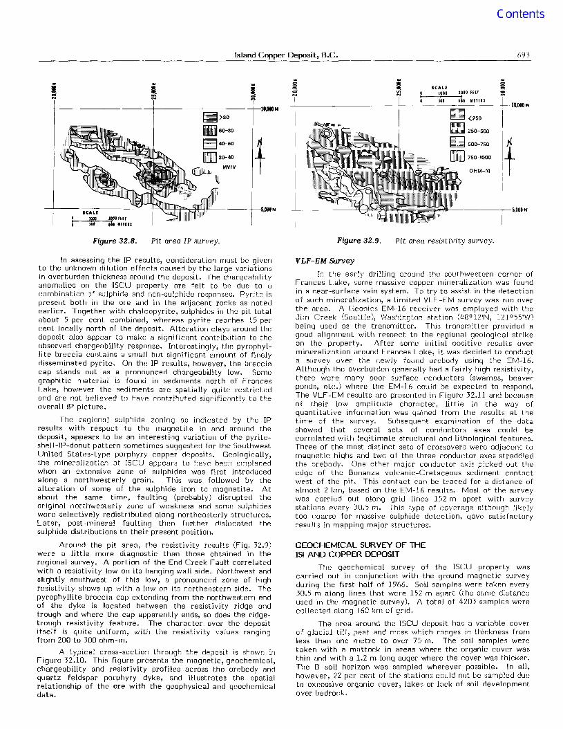
---f ".,Figure 32.8. Pit area IP survey. Figure 32.9. Pit area resistivit.y survey.
In assessing the IP results, consideration must be givento the unknown dilution effects caused by the large variationsin overburden thickness around the deposit. The chargeabilityanomalies on the ISCU property are felt to be due to acombination of sulphide and non-sulphide responses. Pyrite ispresent both in the ore and in the adjacent rocks as notedearlier. Together with chalcopyrite, sulphides in the pit totalabout 5 per cent combined, whereas pyrite reaches 15 percent locally north of the deposit. Alteration clays around thcdeposit also appear to make a significant contribution to theobserved chargeability response. Interestingly, the pyrophyllite breccia contains a small but significant amount of finelydisseminated pyrite. On the IP results, however, the brecciacap stands out as a pronounced chargeability low. Somegraphitic material is found in sediments north of FrancesLake, however the sediments are spatially quite restrictedand are not believed to have contributed significantly to theoverall IP picture.
The regional sulphide zoning as indicated by the IPresults with respect to the magnetite in and around thedeposit, appears to be an interesting variation of the pyriteshell-IP-donut pattern sometimes suggested for the SouthwestUnited States-type porphyry copper deposits. Geologically,the mineralization at ISCU appears to have been emplacedwhen an extensive zone of sulphides was first introducedalong a northwesterly grain. This was followed by thealteration of some of the sulphide iron to magnetite. Atabout the same time, faulting (probably) disrupted theoriginal northwesterly zone of weakness and some sulphideswere selectively redistributed along northeasterly structures.Later, post-mineral faulting then further dislocated thesulphide distributions to their present position.
Around the pit area, the resistivity results (Fig. 32.9)were a little more diagnostic than those obtained in theregional survey. A portion of the End Creek Fault correlatedwith a resistivity low on its hanging wall side. Northwest andslightly southwest of this low, 8 pronounced zone of highresistivity shows up with a low on its northeastern side. Thepyrophyllite breccia cap extending from the northwestern endof the dyke is located between the resistivity ridge andtrough and where the cap apparently ends, so does the ridgetrough resistivity feature. The character over the deposititself is quite uniform, with the resistivity values rangingfrom 200 to 300 ohm-m.
A typical cross-section through the deposit is shown inFigure 32.10. This figure presents the magnetic, geochemical,chargeability and resistivity profiles across the orebody andquartz feldspar porphyry dyke, and illustrates the spatialrelationship of the ore with the geophysical and geochemicaldata.
VLF-EM Survey
In the early drilling around the southwestern corner ofFrances Lake, some massive copper mineralization was foundin a near-surface vein system. To try to assist in the detectionof such mineralization, a limited VLF -EM survey was run overthe area. A Geonics EM-16 receiver was employed with theJim Creek (Seattle), Washington station (48°12'N, 121 °55'W)being used as the transmitter. This transmitter provided agood alignment with respect to the regional geological strikeon the property. After some initial positive results overmineralization around Frances Lake, it was decided to conducta survey over the newly found orebody using the EM-16.Although the overburden generally had a fairly high resistivity,there were many poor surface conductors (swamps, beaverponds, etc.) where the EM-16 could be expected to respond.The VLF-EM results 8re presented in Figure 32.11 and becauseof their low amplitude char8cter, little in the way ofquantitative information was gained from the results at thetime of the survey. Subsequent examination of the datashowed that several sets of conductors axes could becorrelated with legitimate structural and lithological features.Three of the most distinct sets of crossovers were adjacent tomagnetic highs and two of the three conductor axes straddledthe orebody. One other major conductor axis picked out theedge of the Bonanza volcanic-Cretaceous sediment cont8ctwest of the pit. This contact can be traced for a distance ofalmost 2 km, based on the EM-16 results. Most of the surveywas carried out along grid lines 152 m apart with surveystations every 30.5 m. This type of coverage although likelytoo coarse for massive SUlphide detection, gave satisfactoryresults in mapping major structures.
GEOCHEMICAL SURVEY OF THEISLAND COPPER DEPOSIT
The geochemical survey of the ISCU property wascarried out in conjunction with the ground magnetic surveyduring the first half of 1966. Soil samples were taken every30.5 m along lines that were 152 m apart (the same distanceused in the magnetic survey). A total of 4203 samples werecollected olong 160 km of grid.
The area around the ISCU deposit has a variable coverof glacial till, peat and moss which ranges in thickness fromless than one metre to over 75 m. The soil samples weretaken with a mattock in areas where the organic cover wasthin and with a 1.2 m long auger where the cover was thicker.The B soil horizon was sampled wherever possible. In all,however, 22 per cent of the stations could not be sampled dueto excessive organic cover, lakes or lock of soil developmentover bedrock.

694 K.E. Witherly
3500~ ~ ~1500E~ 3000 , Magnetics 1000 ~
~ 2500 5008
~~~~~==:?v~ --L----:=::- 0
100
E
"
80
60
40
20
>......>~
201------
o
N 18E
BEDDING IN PYROCLASTICVOLCANIC ROCK
LIMB OF ORE
( SCALE HORIZONTAL a VERTICAL)
r-------....,-!.~------400'
--------------- -1200'
~~t...:..;~~~ ~~~t--------------- 800'
OVERBURDEN
slew
------- -~:;~--------1';;..,~~~~~~~trffmllmmeeb;~[""~_:_------------... SEA LEVEL~~ /7
~ //
/
QUARTZ FELDSPARPORPHYRY SECTION 115
(LOOKING NW) 100
o
o
460 FEET
100 METERS
BONANZA VOLCANICS
Figure 32.10. Cross-section 175; showing geochemical, ground magnetic, IP and resistivity profiles.
The soil samples were first dried, ground and thensieved through an 80 mesh screen. Thc residues were thenanalyzed spectrographically for total copper content in partsper million (ppm). In order to assist in interpreting thegeochemiccd results, some statistical treatment of the datawas applied. A semilogarithmic frequency distributionhistogram of the geochemical data is presented inFigure 32.12. Based partly on the statistical analysis of thegeochemical, but more on empirical results derived from thedrilling, an anomalous threshold of 100 ppm was decided upon.Values between 100 to 200 ppm were considered slightlyanomalous, betwcen 200 to 500 ppm were anomalous andabove 500 ppm were considered significantly anomalous.
Several large anomalous zones were identified insidethe survey block (Fig. 32.13), the largest being a N75°Wtrending zone located roughly in the west central portion ofthe property (approximately 10 OOOW to 15 OOON, 10 OOOE, to25 OOOE). The zone is composed of a number of discreteanomalies linked together by an envelop of above-backgroundvalues. The zone terminates quite abruptly to the east butsplits into a number of small parallel-trending zones in thewest. Several relatively discrete geochemical anomalies withapproximately N700W trends were found to lie south ofFrances Lake (Fig. 32.2), one at the southwest end of the lakecentred at 9460N, 18 700E and the other several kilometresto the southeast centred at 6720N, 24 450E.

Island Copper Deposit, B.C. 695
IN PHASE
QUADRATURE
eZI"
[ -ZO"
SCALElOll ZI,II flIT
311 '~I IIHII-+----~
..lco...
Figure 32.11. VLF-EM survey.
..11on...
1200
100
800
(/)600w...JD-::!:«(/)
::;400
0:wIII::!::::>z200
10 50 200 1000 3000
RANGE OFGEOCHEMICALVALUES ppm
Figure 32.12. Histogram of copper geochemical data.
III III III III
III 0 g 0 ~l ~ 0 g~on oft on ...
on - .... C"I....
20,OOON
qlftb II )500
~ CD> IIQ 200-500
~ 100-200
[[IIll] 50-100\D([] ppm
10,000N
lb
0 fscale0 .5 1.0 MILESI i
,I i
I
0 .5 1.0 1.5 KILOMETERS
0
Figure 32.13. Regional geochemical survey.
696 K.E. Witherly
REFERENCES
Cargill, D.G., Lamb, J., Young, M.J., and Rugg, E.S.
Anonymous1964: Aeromagnetic Map 1734G, Geol. Surv. Can.,
Aeromagnet.ic Series, Scale 1:63 360.
Cargill, D.G.1975: Geology of th8 "Island Copper" Mine, Port Hardy,
British Columbia; unpubl. Ph.D. thesis, Univ.British Columbia.
Induced polarization surveys did not compare withqeochemical and magnetic surveys in their effectiveness indirectly locating mineralized bedrock at ISCU. However,after a regional perspective using IP was obt.ained, it allowedmore det.ailed work to be put into an intelligible context,which in turn direct.ed attention to some unique structuresand alteration effects in the area of the deposit.
A VLF-EM survey demonstrated its usefulness as an aidto tracing structures, even in the presence of thickoverburd8n and numerous poor near-surface conductors.
The author would like to acknowledge permission ofUtah International Inc., to publish and to thank the variouspeople who have assisted in the preparation of this paper.
Considerations concerning measurement standardsand design of pulsed IP equipment; in Proceedingsof a Symposium on Induced PolariZation, Univ.California, Berkeley.
Island Copper; in Porphyry Deposits of theCanadian Cordillera; Can. Inst. Min. Metall.Special Vol. 15, p. 206-218.
Dolan, W.1967:
1976:
CONCLUSIONS
The major geochemical anomaly, just north of FrancesLake, was tested in a number of places along strike and theunderlying bedrock was found to be mostly volcanic rockcontaining subeconomic copper (0.2% to 0.25% range) with avariable amount of magnetite. The Frances Lakc magneticzone is coincident with a large part of the geochemical zoneand based on the observed correlation between copper andmagnetite, it was felt that considerablc low-grade coppermight occur along the length of the magnetic anomaly. Alimited amount of drilling has tcnded to bear this hypothesisout.
The geochemical anomaly southwcst of Frances Lake,coincides in part with the more massive vein-type mineralization as was first located by Milbourne and later confirmedfrom drilling by Utah Mines Ltd.
The anomaly southeast of Frances Lake is centred overa portion of the ISCU deposit. Subsequent drilling of thisanomaly indicated the area of the anomaly above the 200 ppmlevel correspDnded fairly well with the part of the orebodyoverlain by less than 9 m of overburden.
Testing of other geochemical anomalies on the propertymost often encountered some low-grade coppermiOf~ralization in the bedrock. This observation encouragedthe reliance upon the geochemical anomalies as being a primesource of drill targets, since, even though much of the glacialtill had been transported, a signi ficant amount of the soil at agiven site Wi-lS apparently locally derived. Extensive drillingof the anomaly over t.he deposit did show, however, that morethan 15 m of the overburden could inhibit the surfaceexpression of even subcropping ore-grade mineralization.
Of all the survey techniques carried out in the discoveryof the Island Copper (ISCU) deposit, a soil geochemical surveywas the most successful due to its advantages of speed, costand detection of t.he specific element of interest. Theproblem of thick overburden subduing the geochemicalexpression was apparent on the property but did not present aserious problem.
Magnetic surveys were the most useful of thegeophysical tools used at ISCU; an aeromagnetic anomalyini tiall y focused attention on the area around ISCU, and laterboth during and after the exploration phase, ground magneticsurveys provided invaluable information concerning thestructure and mineralization around the deposit.
Hewitt, L.1965: Hewitt 100 I.P. System Technical Manual.
Muller, J.E. et al.1974: Geology and mineral deposits of Alert Bay - Cape
Scott map area, Vancouver Island, B.C.; Geol.Surv. Can., Paper 74-8.
Riddell, P.A.1966: Magnetic obs8rvations at the Dayton iron deposit,
Lyon County, Nevada; .i.Q Mining Geophysics, v. 1,Case Histories, Soc. Explor. Geophys., p. 418-428.
Young, M.J. and Rugg, E.S.1971: Geology and mineralization of the Island Copper
deposit;.i.Q Western Miner, v. 44 (2), p. 31-38.