geomorphology analysis: a compliment to the …. ayu narwastu.pdf · geomorphology analysis: a...
TRANSCRIPT

GEOMORPHOLOGY ANALYSIS: a compliment to the geotourism information
By:
Ayu Narwastu CiptaheningGeology Study Program, Faculty of Mineral Technology,
UPN “Veteran” Yogyakarta
OF MOUNT BROMO COMPLEX, EAST JAVA, INDONESIA
1. INTRODUCTION2. SITUATION AND PHYSIOGRAPHIC REVIEW3. GEOMORPHOLOGIC ANALYSIS4. VOLCANIC EVOLUSION BASED ON
GEOMORPHOLOGIC ANALYSIS5. CONCLUSIONS

In spite of Indonesia rich of natural resources and culture,this country is also rich of volcanoes.
This condition is caused by the tectonic setting of Indonesiathat is in the meeting point of three big lithosphere plates,i.e. Indo-Australia plate in the south, Eurasia plate in thenorth, and Pacific plate in the east.
The tectonic setting of Indonesia makes this country belongsto seismicity and volcanic active, on the other handIndonesia is also located in the “ring of fire”

Among the 129 active volcanoes of Indonesia, here is awell-known volcano, namely Mount Bromo.
This volcano is active and belongs to the most attractivetourism object in the East Java province, Indonesia.
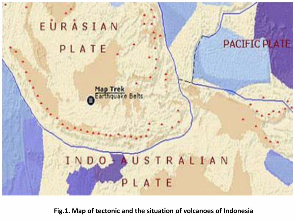
Fig.1. Map of tectonic and the situation of volcanoes of Indonesia
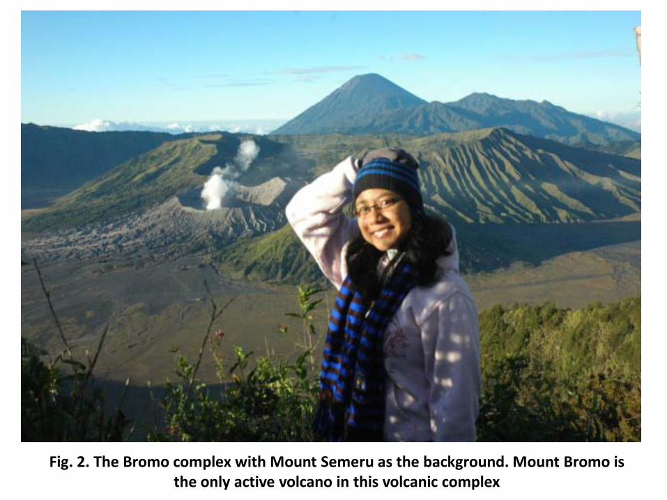
Fig. 2. The Bromo complex with Mount Semeru as the background. Mount Bromo is the only active volcano in this volcanic complex

Fig. 3. The location of the study area and Physiographic map of East Java (Van Bemmelem, 1949)

There is a large caldera with about 10 km x 8 km square. From the base of thecaldera grow some volcanic bodies with several eruption centers, they areMount (Kursi, Watangan, Widodaren, Bathok, and Mount Bromo).
Mount Watangan and Mount Widodaren are assumed to be previously onevolcanic body with more than one crater, Mount Kursi and Mount Bathok areother independent small volcanoes, and Mount Bromo is another center oferuption.
Among all of the volcanoes mentioned above, Mount Bromo is the only centerof eruption which is still active up to now.
By interpretation and analysis using topographic map and satellite image,geomorphology of the Bromo complex can be divided into six (6)geomorphologic units. The units are the main volcanic body, caldera, volcaniccone, parasitic cone, eccentric cone, and crater.

Fig. 4. Satellite image of the Bromo volcano complex

Fig. 5. Geomorphology map of Bromo Complex

Fig. 6. Parasitic and eccentric cones of a volcano(MacDonald, 1979, modified)
The evolution started from the existence of a big volcanonamely Mount Tengger. The volcano is Pliocene to Pleistocene,or more than 2,000,000 years age (Van Bemmelen, 1949).
Mount Tengger was very active, developed its body withpyroclastic deposits of breccias, sand, and tuffs, laharic breccias,and lava flows. In the end of its activity, the volcano eruptedparoxysmally, followed by collapse and subsidence of a part ofits body, brought about the formation of the Tengger caldera.
The volcanic processes were recycled, after such a silent period.New volcanic activity occurred, began from the born of the sonof Mount Tengger, called the ancient Bromo volcano.

The volcano involved Mount Watangan and Mount Widodaren.The ancient Bromo volcano activities were very dynamic, and thecenter of eruption had moved around for several times, as can beverified from the existence of some craters on Mount Watanganand Mount Widodaren.
Relatively in the same period with ancient Bromo activity, therewas a parasite eruption forming Mount Kursi. The volcanic activityof mount Kursi also coincided with the occurrence of an eccentriceruption of Mount Bathok.
The life time of Mount Bathok as the eccentric eruption of ancientBromo volcano was no longer. Finally the center of eruption hastransferred to the crater of Mount Bromo, the only volcano that isstill active up to now.

Fig.7: Volcanic development of the Bromo complex (Sari Bahagiarti K, et. al., 1990)

Fig. 8: Bromo eruption on November 2010, Strombolian type, and Mount Bathok

Pyroclastic materials
Mount Batok

The Crater of Mount Bromo
The Wall of Caldera Tengger

Mount Bromo
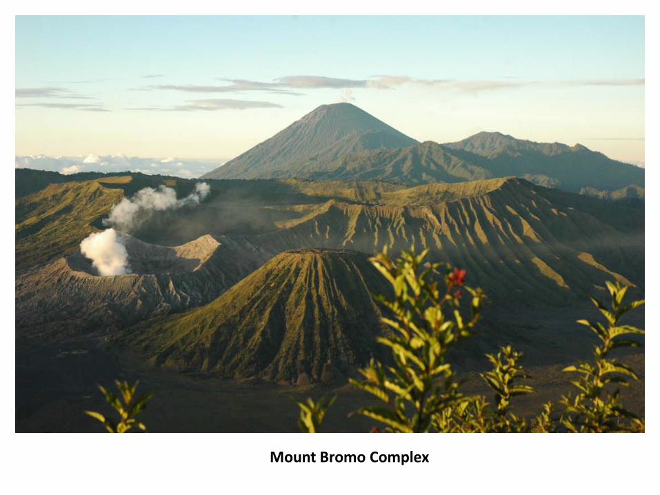
Mount Bromo Complex

Based on geomorphologic analysis, the geomorphology ofthe Bromo Complex can be divided into six units, they arethe main volcanic body, caldera, volcanic cone, parasiticcone, eccentric cone, and crater.
The evolution of the Bromo complex was started from theexistence of a very big volcano called Mount Tengger.Tengger volcano had ever erupted paroxysmally, followed bythe collapse and subsidence of the volcano forming theTengger caldera.

The volcanism was silent for a moment, continued byvolcanic activities of ancient Bromo volcano (MountWatangan-Widodaren), parasitic eruption of MountKursi, eccentric eruption of Mount Bathok, andactivities of the modern Mount Bromo respectively.
Mount Bromo is the youngest volcano in the Tenggercaldera, and still active in the present time.
These conclusions can be used to accomplishinformation needed to support the geotourism ofMount Bromo complex and surrounding areas.

REFERENCES 1. Ciptahening, A.N., Astas, M. H., Hadibroto, H., Murtyanto, I. W., 2010, Analisis
Geomorfologi untuk Menentukan Evolusi Kompleks Gunung Bromo, Jawa Timur,Program Kreativitas Mahasiswa – Artikel Ilmiah (PKM – AI), DP2M GeneralDirectorate of Higher Education (Ditjen Dikti).
2. Kusumadinata, K., Hadian, R., Hamidi, S., Reksowigoro, L.D., 1979, Database ofVolcanoes of Indonesia, Department of Mining and Energy of the Republic ofIndonesia, 820 p.
3. MacDonald, G. A., 1972, Volcanoes, Prentice – Hall, Inc, Englewood Cliffs, NewJersey, 510 p.
4. Purnomo, H., Sari Bahagiarti K., 1990, Morphology Identification of the BromoComplex Based on Landsat Image Interpretation, Faculty of Geology, UPN “Veteran”Yogyakarta Library, 15 p.
5. Sari Bahagiarti K., Pontjomojono K., Eko Teguh Paripurno, 1990, The Development ofBromo Volcanic Complex Based on Morphology and Petrology, Faculty of Geology,UPN “Veteran” Yogyakarta Library, 57 p.
6. Van Zuidam, R. A., 1983, Guide to Geomorphologic Aerial PhotographicInterpretation and Mapping, section of Geology and Geomorphology, ITC, Enschede,the Netherlands, 325 p.
7. Van Bemmelen, R.W., 1949, The Geology of Indonesia, Vol IA, Martinus Nijhoff, TheHague, 792 p.