geomatics delft university of technology
TRANSCRIPT

GeomaticsDelft University of Technology
March 2007

� QANU / Geomatics, Delft University of Technology
Quality Assurance Netherlands Universities (QANU)Catharijnesingel 56PO Box 80353503 RA UtrechtThe Netherlands
Phone: +31 (0) 30 �30 3100Telefax: +31 (0) 30 �30 31�9E-mail: [email protected]: www.qanu.nl
© �007 QANUText and numerical material from this publication may be reproduced in print, by photocopy-ing or by any other means with the permission of QANU if the source is mentioned.
3QANU / Geomatics, Delft University of Technology
Table of Contents
Foreword 5
Part I General Part 7
1. Introduction 9�. The Committee’s task and composition 113. Working method 134. Frame of reference 15
Part II Assessment of the Degree Course 19
1. The MSc degree course in Geomatics, Delft University of Technology �1
Appendices 47
Appendix A: Curricula Vitae 49Appendix B: Overview of courses 51Appendix C: Programme of the site visit 53Appendix D: Checklist for the assessment 55

4 QANU / Geomatics, Delft University of Technology

5QANU / Geomatics, Delft University of Technology
FOREWORD
This report is part of the quality assessment of university degree courses in the Netherlands. The purpose of this report is to present a reliable picture of the results of the degree courses submitted for this review, to give feedback to the internal quality assessment of the university concerned, and to serve as the basis for accreditation of the degree courses by the Accreditation Organisation of the Netherlands and Flanders (NVAO).
The foundation Quality Assurance Netherlands Universities (QANU) aims to ensure inde-pendent, unbiased, critically constructive assessments using identical quality criteria as far as possible, while taking specific circumstances into account.
The Assessment Committee Geomatics has fulfilled its tasks with great dedication. We expect the judgments and recommendations will be taken into careful consideration by the course providers and the management of the degree course concerned.
We thank the Chairman and members of the Assessment Committee for their willingness to participate in this assessment and for the dedication with which they carried out this task. We also thank the staff of the university for their carefully prepared documentation and for their co-operation during the assessments.
Quality Assurance Netherlands Universities
Mr. Chris J. Peels Dr. Jan G.F. VeldhuisDirector Chairman of the Board

6 QANU / Geomatics, Delft University of Technology

7QANU / Geomatics, Delft University of Technology
PART I: GENERAL PART

8 QANU / Geomatics, Delft University of Technology

9QANU / Geomatics, Delft University of Technology
1. Introduction
The Geomatics Assessment Committee (hereafter called: the Committee) presents an account of its observations and conclusions in this report. The report consists of a general part (I) and the report on the Master’s degree course that the Committee has assessed (II).
The general part briefly describes the task of the Committee, its composition and its working method. It also contains a description of the domain-specific frame of reference.

10 QANU / Geomatics, Delft University of Technology

11QANU / Geomatics, Delft University of Technology
2. The Committee’s task and composition
TaskThe task assigned to the Committee was to carry out an assessment of the MSc Geomatics (CROHO registration number 66954) at Delft University of Technology along the lines of the QANU Protocol (Quality Assurance Netherlands Universities). The Committee was formally installed by Mr. Frank Wamelink, coordinator of educational reviews at QANU. The Com-mittee started its activities in September �006.
MembersThe following experts were appointed as members of the Committee:
• Prof. R. (Reiner) Rummel, Professor of Astronomical and Physical Geodesy, Technische Universität Munchen, Germany;
• Prof. P. (Paul) Cross, Professor of Geomatic Engineering, University College London, United Kingdom;
• G. (Godfried) M.G.M. van Lieshout, programme director Civil Engineering, Universi-teit Twente;
• R. (Roel) Nicolai, senior researcher at Shell International Exploration and Production, Rijswijk;
• L. (Lucas) Grus, Msc, student of Geo-information Science, Wageningen Universiteit.
The following person was appointed as external advisor to the Committee:
• Prof. H.P. (Hans-Peter) Bähr, Professor of Photogrammetrie und Fernerkundung, Universität Karlsruhe, Germany.
Ms. M. (Marjolein) E. Boessenkool, QANU staff member, was appointed secretary of the Committee.
See Appendix A for the curricula vitae of the Committee members.

1� QANU / Geomatics, Delft University of Technology

13QANU / Geomatics, Delft University of Technology
3. Working method
PreparationThe preparatory meeting of the Committee was held on October �, �006. During this meeting, the Committee agreed on a number of important issues such as the domain-specific framework of reference and its working method. The QANU Protocol exercised a prominent influence on its choice of working methods. Mr. Frank Wamelink of QANU explained the general working method. The Committee discussed the self-assessment report and the selection of recent theses to be assessed. The Committee also examined additional materials relating to the programme such as course materials. The meeting was immediately followed by the site visit.
The Committee members received the self-evaluation report (and appendices) and a selec-tion of Master’s theses from the degree course. Before the site visit the secretary of the Committee compiled the members’ questions and provided the members with additional information as necessary. The members made preliminary assessments of the degree course and the theses.
Site visitThe programme for the site visit was prepared in cooperation with the programme director. The site visit took place on October � and 3, �006. The programme for the site visit can be found in the appendix of the report.
The Committee spoke to the department’s management team, members of the education com-mittee (Opleidingscommissie), examination committee (Examencommissie) and members of the support staff. Separate interviews were held with staff members, students, alumni and repre-sentatives of the professional field. The series of interviews ended with a discussion with the dean and the department’s management team. The Committee then formulated its prelimi-nary conclusions, which the chairman presented to the faculty at the end of the site visit.
The visit was pleasant and inspiring. The interviews were held in an open atmosphere, and the Committee was able to verify the self-evaluation report. We were provided with all the information requested. Decision rulesIn accordance with the NVAO’s accreditation framework, the Committee used a scale of one to four for its assessments of the �1 facets: Unsatisfactory – Satisfactory – Good – Excellent. The Com mittee’s default assessment is ‘satisfactory’; this means that the Committee did not observe anything notable or remarkable either in a posi tive or in a negative sense relating to that facet, or if any negative elements were present, they were clearly counter balanced by positive elements. A facet was assessed as ‘good’ if it had clear positive or remarkable elements and no negative elements. The score ‘excellent’ would have been assigned in the cases where the degree course clearly presented an example of best practice. The Committee is aware that this approach (with ‘satisfactory’ as the default assessment) may create the impression that it was not very impressed with the quality of the degree courses it assessed. It would like to stress that the main purpose of accreditation is to decide whether a degree course fulfils the criteria defined by the NVAO and not to establish how good a certain degree course is.
For each of the six subjects the Committee assessed the scores for the facets. It used a scale of two in accordance with the NVAO accreditation framework: Positive or Negative. Because of

14 QANU / Geomatics, Delft University of Technology
the relative weight of the various facets, it is possible that an unsatisfactory score for one facet can be counterbalanced by a good score for another facet in that subject. The Committee based its assessments on the self-evaluation reports, on other materials pro-vided by the institutes and on the interviews conducted during the site visits.
MaterialsThe Committee examined a variety of materials during the site visits. The institutes provided the latest �5 Master’s theses and the assessment forms; information material; study material (handbooks and syllabi, readers, study guides); examples of assignments, research papers, trainee reports and examinations; thesis guidelines; examination guidelines; annual reports; module and programme evaluations; minutes of programme committees’ and examination commit-tees’ meetings. The programme director provided additional information upon request.
ReportThe secretary of the Committee prepared a draft report. It was first commented on by all Committee members. After revision it was reviewed by the chairman. Finally, the committee agreed on the contents of the report via a written procedure. The Committee also finalised the general part of the report. After the comments put forward had been processed, the dean and the programme director were given the opportunity to identify possible misinterpretations and factual errors in the report. The final version of the report was produced in January �007.

15QANU / Geomatics, Delft University of Technology
4. Frame of reference
Geomatics is the discipline of gathering, storing, processing, and delivering geographic information, or spatially referenced information. The Committee has based the frame of reference for the assessment of the MSc Geomatics on several sources.To assess whether the degree course corresponds to the international requirements of a Mas-ter’s degree course in the field of geomatics, the Committee has used details of comparable degree courses from the University of Calgary and the University of Melbourne as well as its own international expertise to establish a frame of reference. The field of study is described in §4.1. Geomatics is an engineering degree. To assess whether the level of the Geomatics degree course corresponds to the accepted descriptions of the qualifications of a Master’s degree course in engineering, the Committee followed the “Criteria for Academic Bachelor’s and Master’s Curricula” established by the three Dutch universities of technology. These criteria give a more detailed interpretation of what is meant by academic education in engineering (§4.�). Some consequences of this frame of reference for the contents of the degree course are mentioned in §4.3.
4.1 Field of study
Geomatics is a modern discipline, which integrates the acquisition, modelling, analysis, and management of spatially referenced data, i.e. data identified according to location. Based on the scientific framework of geodesy, it uses terrestrial, marine, airborne, and satellite-based sensors to acquire spatial and other geo-referenced data. Geomatics includes the process of merging and transforming spatially referenced data from different sources into common infor-mation systems with well-defined accuracy characteristics.
A geomatics graduate has competence in disciplines, such as:
• Geodesy - determination of geometric forms (of all spatial scales from laboratory to glo-bal), orientation of geometric forms in space and their embedding in the earth’s gravity field; representation of this information in well-defined reference systems, monitoring and modelling of temporal changes of the above;
• Positioning and navigation (e.g. with GPS or inertial measuring techniques);• Digital imaging (extraction of information from images according to the application,
e.g. environmental studies or agricultural studies) and mapping (development and de-sign of conventional or electronic maps) using photogrammetry (geometry of shapes from terrestrial or areal photographs) or remote sensing (images taken by airborne or satellite sensors);
• Geographical information systems - assembling, storing, combining, manipulating, and displaying and transmitting geographically referenced information by modern computer systems ;
• Land tenure systems - land information management, land development, land planning and property rights;
• Use of geo-referenced data in fields such as civil engineering, agriculture, planning and geosciences.

16 QANU / Geomatics, Delft University of Technology
Acquisition and processing of geodetic data, modelling spatial geometry, determination and estimation of spatial positions and their uncertainty are key components of the Geomatics Engineering course. Since the world of geomatics is constantly evolving, it is also essential to keep up with the rapid development of technology, methodology and fields of applications of this interdisciplinary field.
4.2 Engineering at an academic Master’s degree level
Geomatics is an engineering degree. It should therefore comply with the general qualifica-tions for a master’s degree in engineering. These qualifications have been developed by the three Dutch universities of technology1. A master’s degree course of a university of technology should aim at seven areas of competence that characterise a university graduate.
He or she:
1. is competent in one or more scientific disciplines A university graduate is familiar with existing scientific knowledge as described above, and
has the competence to increase and develop this through study.2. is competent in doing research A university graduate has the competence to acquire new scientific knowledge through
research. For this purpose, research means: the development of new knowledge and new insights in a purposeful and methodical way.
3. is competent in designing As well as carrying out research, many university graduates will also design. Designing is a
synthetic activity aimed at the realisation of new or modified artefacts or systems with the intention of creating value in accordance with predefined requirements and desires (e.g. mobility, health).
4. has a scientific approach A university graduate has a systematic approach characterised by the development and use
of theories, models and coherent interpretations, has a critical attitude, and has insight into the nature of science and technology.
5. possesses basic intellectual skills A university graduate is competent in reasoning, reflecting, and forming a judgment.
These are skills which are learned or sharpened in the context of a discipline, and which are generically applicable from then on.
6. is competent in co-operating and communicating A university graduate has the competence of being able to work with and for others. This
requires not only adequate interaction, a sense of responsibility, and leadership, but also good communication with colleagues and non-colleagues. He or she is also able to parti-cipate in a scientific or public debate.
7. takes account of the temporal and the social context Science and technology are not isolated, and always have a temporal and social context.
Beliefs and methods have their origins; decisions have social consequences in time. A uni-versity graduate is aware of this, and has the competence to integrate these insights into his or her scientific work.
� “Criteria for Academic Bachelor’s and Master’s Curricula”. Joint publication of the three Dutch Technical Universities of Delft, Eindhoven and Twente, January �005.

17QANU / Geomatics, Delft University of Technology
4.3 Programme
The contents of the Master’s degree course should lead the student towards the frontiers of design and applications in the field, and/or towards the major research issues in the field. The students in the Master’s degree course will generally concentrate on subjects in a limited spe-cialisation within the field, or in the interface with adjacent fields.
There is always a strong relationship between the degree course and research activities, and researchers are active as lecturers and supervisors in the degree course. Even if a student who is awarded the degree does not aim to be a researcher, he will have a basic understanding of the nature of research, and he will have proven research skills. In each degree course there will be a final project which takes at least one-quarter [30 ec] of the entire programme. In the present programme of Geomatics, this research-related part is significantly larger. In the final project, students can display their capabilities in each of the fields of the Dublin descriptors (knowl-edge and understanding, application of knowledge and understanding, forming judgments, communication and learning skills).Talented and successful students must be educated to a level where they are eligible for a PhD position. Participation in research projects, especially during the final project, must be open to such students. The Master’s degree course must address the development of skills and competencies that are essential for a working professional. It must be possible for students to participate in cooperation with trade and industry, in particular during a final project. This requires the courses to have sufficient contact with trade and industry.

18 QANU / Geomatics, Delft University of Technology

19QANU / Geomatics, Delft University of Technology
PART II: ASSESSMENT OF THE DEGREE COURSE

�0 QANU / Geomatics, Delft University of Technology
�1QANU / Geomatics, Delft University of Technology
1. The MSc degree course in Geomatics, Delft University of Technology
Administrative data:
Name: GeomaticsCROHO registration number: 66954Level: MasterOrientation: Academic Study load: 1�0 ecGrade: Master of ScienceVariants: FulltimeLocation: DelftExpiry date of accreditation: 31 December �007
1.0. Introduction
The MSc degree in Geomatics at TU Delft developed from the former Geodesy degree course. In �00� the curriculum of this five-year degree course was changed to a three-year BSc and a two-year MSc degree course. Because of decreasing student numbers, the Board of the Uni-versity decided to phase out the Geodesy BSc degree course and to profoundly restructure the MSc degree course. The new interfaculty MSc degree course in Geomatics started in Sep-tember �005 and aims at students from different (technical) BSc degree courses, including students from abroad.
The new Geomatics degree course concentrates on geodetic data acquisition, the technical, computer-related and legal aspects of dealing with geo-information, and the use of geo-infor-mation for decision-making and modelling in the fields of civil engineering and applied geo-sciences. This makes an attractive degree course, according to the Committee, with sufficient depth and breadth because of the interfaculty structure. It is more focused than the former Geodetic Engineering degree course. Being a specialist subject, Geomatics is thought to be more appealing to candidates with some engineering background already than it would be to high-school graduates. As an interdisciplinary science, Geomatics can attract graduates from several disciplines.
1.1. Structure and organisation of the faculty
The MSc degree course in Geomatics is an interfaculty degree course. It is a joint effort between the Faculties of Aerospace Engineering (AE), Technology, Policy and Management (TPM) and Civil Engineering & Geosciences (CE&G).The Faculty of Aerospace Engineering, having taken the initiative for the degree course, has a leading role in the MSc in Geomatics. The Dean of Aerospace Engineering holds overall responsibility for Geomatics and appoints the programme director within the faculty. More-over, the Faculty of Aerospace Engineering is responsible for the development of marketing and PR-related materials, and appointed an officer for this task.The TPM faculty/OTB institute is in charge of all activities relating to visitation and accredi-tation. Educational support has been assigned to the Faculty of Civil Engineering & Geo-

�� QANU / Geomatics, Delft University of Technology
sciences. This includes all student administration tasks and extends to setting up education and examination regulations and providing management support for the Education Commit-tee and the Examination Committee, as well as assigning student advisors.
The Committee appreciates the supportive attitude that the faculties – especially Aerospace Engineering – show towards this degree course.
1.2. The single degree course and the BSc/MSc transition
Until September �00� the curriculum of the five-year degree course in Geodesy (CROHO registration number 6954) comprised a basic study programme of three years and a final study programme of two years, the latter having two specialisations, Geometry and Geoinforma-tion. In September �00� the Geodesy degree course was restructured into a BSc in Geodesy (CROHO registration number 56954) and an MSc in Geodetic Engineering (CROHO registration number 66954). The MSc degree course offered three specialisations: Geomatic Engineering, Geoinformation & Land Management, and Earth Observation.In December �00� a decision was made by the Board of the University to phase out the Geodesy BSc and the Geodetic Engineering MSc degree courses. After �00� no new students were accepted for the Geodesy BSc. The current BSc degree course ends on 31 December �007.The academic year �004-�005 was the last year the MSc course in Geodetic Engineering was offered. Since February �006 only Geomatics diplomas have been issued. On 31 December �005 19 students were still enrolled in the old Bachelor degree course, while on 1 Novem-ber �006 there were only six left. No students are still enrolled in the ‘doctoraalprogramma’. Appropriate measures are being taken to allow already enrolled students to complete their Bachelor’s degree or to place them in the Master’s degree course. The study advisor helps them to select the right study programme. The students did not make any objections.
1.3. Framework for Evaluation
1.3.1. Objectives of the degree course (subject 1)
F1: Domain-specific requirementsThe final qualifications of the degree course correspond to the requirements made to a degree course in the relevant domain (field of study/discipline and/or professional practice) by colleagues in the Netherlands and abroad and the professional practice.
FindingsThe MSc Geomatics defined its mission in the self-assessment report.
“.. to offer high-quality education across the entire geoinformation chain, as follows:
1. A systematic and geodetically sound approach to data acquisition and information extraction, covering state-of-the-art techniques in surveying, satellite positioning, photogrammetry and remote sensing from terrestrial, marine, airborne and space borne platforms, based on optical, laser, radar, acoustic and seismic sensors.

�3QANU / Geomatics, Delft University of Technology
�. An information systems approach to storage, processing, management, dissemination and visualisation of data and information, acting at the forefront of Data Analysis methodology and Spatio-temporal Database Management Systems technology, and also paying attention to legal and organisational aspects of geoinformation.
3. The role of geoinformation in decision-making within a broad spectrum of the fields of Civil Engineering & Geosciences, covering design & construction, hydraulic engineering, water management, transport & planning and geotechnology.
Graduates will be able to deliver valuable technological and methodological contributions to industry and the public sector and to society in general, in all domains concerned with the production, management, dissemination and application of geoinformation. The Geomatics MSc programme educates future engineers for participation in the design, realisation, operation and maintenance of multidisciplinary projects involving geographic information. They are trained in acquiring established knowledge and know-how, in deve-loping new knowledge through systematic research, and in applying this knowledge in the design of operational systems in response to the needs of industry and society.These contributions include the design and development of systems and methodologies in support of the geoinformation chain. As they become familiar with geoinformation issues in several application fields, graduates will appreciate similarities as well as differences between geomatics-related issues in those fields, and be able to judge the possibilities and limitations of expanding the application of methods, techniques and practices across applications.”
These goals have been further developed into final qualifications of the degree course (see facet �). These qualifications have been based on the general qualifications set by the three technical universities for Master’s degree courses.In the marketing plan the Geomatics degree course was compared to similar degree courses in the Netherlands and to several international courses. The degree courses in the Netherlands all have their own characteristics, different from the Delft degree course, and focus on different target groups.Geomatics is a new but rapidly growing field of engineering. A recent analysis of the labour market in the renowned scientific journal Nature consideres Geomatics to be one of the top three fastest developing disciplines. On the other hand, there does not exist yet a consolidated and generally accepted profile for the engineering discipline “Geomatics” (which has the draw-back that this field is largely unknown to high-school students). The Committee formulated its (domain-specific) description of Geomatics on a comparative analysis of the few existing course programmes, on documents of international organisations in this field and on own research. The Delft Geomatics degree course contributes to this discipline by aiming both at research and at applications and design for industry and society.
ConclusionsThe Committee has compared the goals and the final qualifications of the Geomatics degree course with several international MSc degree courses in this field, e.g. the University of Cal-gary and the University of Melbourne, and to the domain-specific frame of reference.A comparative analysis of this domain-specific description with the actual degree course at Delft University of Technology leads to the following findings:
• The degree course has chosen its own profile in the field and developed this into a well-defined set of final qualifications.

�4 QANU / Geomatics, Delft University of Technology
• The degree course is very complete as it covers data acquisition, data modelling (determi-nistic as well as stochastic part), data analysis and management and application. This is a complete chain that has not been realized so consistently in other international degree courses. The degree course exhibits a conclusive and convincing “line of thought”.
• Its level is high and research oriented, which is particularly important as Geomatics is a very young discipline that needs to be developed further conceptually.
• It addresses design skills. Thereby “design” has a meaning different from that in enginee-ring disciplines such as civil, mechanical or electrical engineering. Design means here the design of methods, data and processing structures. This element is also carefully imple-mented in the course.
In conclusion, from the analysis of the presented degree course and from comparison with competing degree courses such as those in Melbourne or Calgary, the Committee comes to the conclusion that the final qualifications exceed the internationally accepted descriptions in the field of geomatics.
The degree course also convincingly meets the general qualifications set by the three technical universities for Master’s degree courses.There is no doubt as to the professional field’s need for expertise of this level and domain.
The Committee concludes that the correspondence between the final objectives of the MSc degree course and the domain-specific requirements exceeds the criteria for accreditation. The score for this facet is Good.
F2: LevelThe final qualifications of the degree course correspond to general, internationally accepted descriptions of the qualifications of a Bachelor or a Master.
FindingsThe final qualifications of the degree course are described as follows:
“A graduate of the MSc in Geomatics:1. is competent in one or more scientific disciplines. A Geomatics graduate is familiar with existing scientific knowledge and has the competence
to increase and develop this through study.I. in-depth knowledge and understanding of systems and methodologies for the measurement
of positions, shapes and sizes of physical phenomena, structures and objects, natural and man-made, on, below or above the earth’s surface, as well as for the signalling and recording of changes over time, including the ability to design, implement and use systems and meth-odologies to analyse such measurements for the purpose of geoinformation extraction;
II. in-depth knowledge and understanding of systems and methodologies for handling spatial information, including the ability to design, implement and use systems for management, storage, processing, integration, exchange and dissemination of geoinformation;
III. the ability to select, combine and extend the above-mentioned systems and methodologies to meet geoinformation requirements, notably in civil engineering and geoscience applications, in the present and in the future;

�5QANU / Geomatics, Delft University of Technology
IV. context knowledge needed for the three main points above:- basic understanding of methodologies to measure the shape and the gravity field of the
earth, and their meaning for reference coordinate systems used for geoinformation;- basic understanding of the non-technological aspects of handling geoinformation, such
as the legal aspects of real estate property, utilities and registration systems, including legal implications and consequences of large civil engineering projects.
2. is competent in doing research. A Geomatics graduate has the competence to acquire new scientific knowledge through inde-
pendent research. For this purpose, research shall mean: the development of new knowledge and new insights in a purposeful and methodical way. Geomatics research requires, in addition to in-depth knowledge and understanding of the state of the above-mentioned disciplines, the competence to create feasible models of complex situations; to formulate hypotheses and research questions; to make judgments about similarities and differences concerning geoin-formation demand and supply between different applications and scenarios.
3. is competent in designing. As well as carrying out research, many Geomatics graduates will also design. Designing is a
synthetic activity aimed at the realisation of new or modified artefacts or systems with the intention of creating value in accordance with predefined requirements and desires. Geomat-ics graduates are able to independently perform the following design tasks in complex, large-scale applications:i. design, implement and use systems and methodologies to analyse above-mentioned
measurements for the purpose of geoinformation extraction;ii. design, implement and use systems for management, storage, processing, integration,
exchange and dissemination of geoinformation;iii. select, combine and extend above-mentioned systems and methodologies to meet geo-
information requirements, notably in civil engineering applications, in the present and in the future.
4. has a scientific approach. A Geomatics graduate has a systematic approach characterised by the development and use of
theories, models and coherent interpretations, has a critical attitude, and has insight into the nature of science and technology.
5. possesses basic intellectual skills. A Geomatics graduate is competent in reasoning, reflecting, and forming a judgment. These
are skills that are learned or sharpened in the context of a discipline, and are generically appli-cable from then on.
6. is competent in cooperating and communicating. A Geomatics graduate is able to work with and for others in multidisciplinary projects. This
requires not only adequate interaction, a sense of responsibility, and leadership, but also good communication with colleagues and non-colleagues. He or she is also able to participate in a scientific or public debate.
7. takes account of the temporal and the social context. Science and technology are not isolated, and always have a temporal and social context. Beliefs
and methods have their origins; decisions have social consequences in time. A Geomatics graduate is aware of this, and has the competence to integrate these insights into his or her scientific work.”
�6 QANU / Geomatics, Delft University of Technology
These final qualifications have been based on the criteria for academic Master’s curricula as developed by the three Dutch technical universities, which distinguish 7 competence areas (3TU criteria)�. These areas reflect the Dublin Descriptors.
The 3TU criteria have been employed in order to test whether the degree course offers all typi-cal engineering qualifications (scientifically driven, research skills, design qualification, coop-eration/communication, social and practical dimension of engineering) and whether these qualifications are offered at a level compliant with an academic Master’s degree.
ConclusionFrom an analysis of the self-assessment report and the interviews with Programme Commit-tee members, teachers and students, the Committee comes to the conclusion that the “3TU-criteria” have been very carefully taken into account. The MSc degree course in the field of Geomatics, based on the three domains of acquisition, processing and applications, is unique and attractive. According to the Committee the final qualifications are complete, homogenous and high-level. The course description and content of the programme show in addition that the final qualifications are of a high level and a high quality. Furthermore, by employing various different didactical forms, special attention is paid to final qualifications concerning individual research, design, teamwork, communication and contact with applications in prac-tice. All the documents and discussions provided gave the Committee the impression that the rationale of this degree course is logical, consistent and based on serious considerations.
The Committee concludes that the correspondence between the final objectives of the MSc degree course and the criteria for academic Master’s curricula as developed by the three Dutch technical universities exceeds the criteria for accreditation. The score for this facet is Good.
F3: OrientationThe final qualifications of the degree course correspond to the following descriptions of a Bachelor and a Master at universities:• The final qualifications are based on requirements made by the academic discipline, the international aca-
demic practice and, if applicable to the course, the relevant practice in the prospective professional field.• A University (WO) bachelor possesses the qualifications that allow access to a minimum of one further
University (WO) degree course at master’s level as well as the option to enter the labour market.• A University (WO) master possesses the qualifications to conduct independent academic research or to
solve multidisciplinary and interdisciplinary questions in a professional practice for which a University (WO) degree is required or useful.
FindingsThe entrance level of the students requires an academic bachelor’s degree with knowledge of mathematics comparable to all BSc degrees at Delft University. The academic orientation of the degree course is clearly reflected in final qualification �: “…to acquire new scientific knowledge through independent research”. The academic orientation of the Master’s degree course is further illustrated by the final qualifications concerning the abil-ity to reflect on scientific research and to form a judgment, as well as knowledge of the legal and social implications of large civil engineering projects.
� Source: Criteria Academic Bachelor's and Master's Curricula. Joint Publication of the three Dutch Technical Universities of Delft, Eindhoven and Twente, January �005, ISBN: 90-386-��17-1

�7QANU / Geomatics, Delft University of Technology
The final qualifications also describe competencies necessary for professional practice, includ-ing design skills at an academic level.
ConclusionThe academic and scientific orientation of the degree course is very well defined and described in all seven final qualifications of the course.The final qualifications reflect the required entry level for a PhD programme. The extensive and independently carried out research project (45 ec) ensures an in-depth orientation on research methods.
The Committee concludes that the final objectives of the MSc course exceed the criteria for university orientation as required for accreditation. The score for this facet is Good.
Assessment of subject ‘Aims and objectives’The Committee concludes that the overall score for the subject ‘Aims and objectives of the Master’s degree course’ is positive.
1.3.2. Programme of the Master’s degree course (subject 2)
The MSc degree course in Geomatics has been profoundly changed from its predecessor MSc in Geodetic Engineering. The degree course is divided into several elements: a core programme, a convergence programme, a synthesis project, free electives and the graduation project. An overview of the courses is given in appendix B.
The core programme consists of 48 ec covering the essential topics of geomatics. The courses are divided into three domains: acquisition, processing and applications. Students follow courses in each domain, but can choose within limits to put more emphasis on certain courses. To ensure a proper balance between breadth and depth within the programme, students are expected to choose a track: processing or acquisition.
In order to bring participants of different backgrounds up to the level necessary for attending the regular programme, while avoiding duplication in the individual student’s education, a convergence programme is offered within the timeframe of the Geomatics MSc curriculum. This programme is composed of existing courses at the Delft University of Technology. A maximum of 18 ec is reserved for this purpose. The following elements of a candidate’s prior knowledge will be considered:
• reference systems and cartographic projections;• acquisition: basics and physics of remote sensing, digital image processing;• processing: programming, DBMS, CAD/CAM, computer graphics;• basic GIS: cartography, spatial data structures and algorithms;• mathematics: geostatistics, probability and observation theory;• domain introduction: civil engineering, geosciences.
In the �nd year of the Geomatics MSc curriculum, students undertake a synthesis project in groups of about 5 students.

�8 QANU / Geomatics, Delft University of Technology
The synthesis project (9 ec) has the following aims:
• a synopsis of the different disciplines;• practising teamwork in small groups;• exposure to the entire chain: project definition, measurement (acquisition), data proces-
sing and analysis, presentation and delivery, and application;• skills in working in a team within an interdisciplinary environment;• understanding of how the results of the geoinformation process are used and applied.
The graduation project (45 ec) is an individual research assignment, executed under the guidance of a graduation professor and one or two supervisors. Graduation research topics that have a strong relation to an application field are encouraged and will be supervised by interfaculty teams. Carrying out research for graduation projects in organisations outside the TU Delft will also be encouraged.
Candidates who need less than 18 ec in the convergence programme have to use this space for free elective courses. Participants may use this opportunity:
• to deepen their knowledge further within their track by choosing remaining elective cour-ses in the corresponding domain;
• to broaden their view by choosing elective courses in the alternative domain;• to broaden their application knowledge by choosing from the remaining elective courses
in domain applications;• to deepen knowledge of a particular application by choosing from the free elective courses
in domain applications.
F4: Requirements The programme meets the following criteria applicable to a degree programme at a University (WO):• The students acquire knowledge on the interface between teaching and academic research within the
relevant disciplines;• The programme follows the developments in the relevant academic discipline(s), as it is demonstrated that
it incorporates current academic theories;• The programme ensures the development of skills in the field of academic research;• For those courses for which this is applicable, the course programme has clear links with the current pro-
fessional practice in the relevant professions.
FindingsThe final qualifications and programme structure have been designed by academically skilled experts who operate in internationally recognized research groups. The staff have strong links with the national and international scientific communities and participate in reviewed research programmes. Many courses that are taught have a strong link with the research programmes of the participating groups. The teachers explained to the Com-mittee that they benefit from bringing their research experiences into their teaching activities and getting feedback from the students.
The Committee studied the literature and testing material of the various courses.
The development of research skills is incorporated in several courses. The 9 ec synthesis project and the 45 ec MSc thesis offer students an excellent opportunity

�9QANU / Geomatics, Delft University of Technology
to tackle a real-life geomatics engineering or scientific problem, follow the complete research cycle and obtain relevant results that can be applied in practice.Students and alumni feel they were well prepared for doing research when starting their gra-duation project. The theses which were examined by the Committee clearly reflect the proper research skills of the students.
Representatives of the professional field gave advice on the final qualifications when the pro-gramme was being developed. Relations with the professional field are furthermore implemen-ted in the educational process by inviting guest lecturers. Many researchers have relations with the professional field through research activities for companies.
ConclusionThe fact that the staff have strong links with current research ensures that the programme ful-fils the requirements of an academic orientation at the MSc level. The Committee found that the courses have a strong link with this research. The link with current professional practice is ensured through their contacts with the professional field. The Committee studied the literature of the different courses and concludes that it incorpo-rates up to date literature on a high level: both specialized articles and well-known current textbooks are used. The testing material also shows that the courses are covered at an appropri-ate level for a Master’s degree.
The Committee observes that the training of research skills is done with very good results.
The Committee concludes that the programme exceeds the criteria for the requirements for university degree courses as required for accreditation. The score for this facet is Good.
F5: Relationship between aims and objectives and contents of the programme• The course contents adequately reflect the final qualifications, both with respect to the level and orienta-
tion, and with respect to domain-specific requirements.• The final qualifications have been translated adequately into learning targets for the programme or its
components.• The contents of the programme offer students the opportunity to obtain the final qualifications that have
been formulated.
FindingsThe Committee has studied the study guide and course material. Students receive training and feedback on each qualification on several occasions during the degree course. This is shown in the table presented in the self-assessment report. The qualifications are brought to the final level in the synthesis project and/or the graduation project.The synthesis project is judged an important feature of the programme as it brings together several skills, especially from the qualification domains 3 to 7.
Candidates for the MSc in Geomatics with diverse Bachelor’s degrees will have varying levels of knowledge and skills in different relevant fields. The Programme Committee has realized this and has responded by incorporating a convergence programme. This programme is designed to bring participants to the level necessary for attending the regular programme, while avoiding duplica-tion in the individual student’s education. It aims at safeguarding basic geodetic skills that are not taught in every BSc degree course giving entrance to the MSc Geomatics degree course.

30 QANU / Geomatics, Delft University of Technology
ConclusionBased on the above-mentioned findings, the Committee concludes that the courses offer stu-dents the opportunity to obtain the formulated final qualifications in every chosen track.The Committee remarks that to further strengthen the relationship between the objectives and the contents of the degree course, it is necessary to make systematic use of the learning targets that have been developed for each course. Although the learning targets do exist, they are not always written down and are not always communicated to the studentsThe convergence programme is an adequate response to safeguard that all students - regardless of their BSc degree - meet the required qualifications in basic geodetic skills.
The Committee concludes that the relationship between the aims and objectives and contents of the programme is satisfactory.
F6: Coherence of the programmeStudents follow a programme of study that is coherent in its contents.
FindingsThe coherence of the programme is monitored frequently through lecturer meetings, where new courses are introduced and their scope reviewed. If necessary, staff members take the ini-tiative to consult colleagues responsible for adjacent courses.The students report that no lectures overlap in the programme and feel that courses are well aligned to each other.
The elective courses (from other MSc degree courses in the area of civil engineering) have been chosen in such a way that they can be followed by the Geomatics students and comply with their knowledge and skills.
Coherence with regard to the electives is guaranteed by the Programme Director as all stu-dents have close contact with him when choosing their courses. When the number of students increases, this student counselling should be an important task of the proposed MSc-coordina-tor. It seems that students make sensible decisions about their programme as none of them felt pressured by the Programme Director or the Intake Committee to choose certain courses.
ConclusionThe Committee observes that the programme is not lacking in coherence, despite the fact that course contributions come from three different faculties. The coherence is strengthened through both the lecturers’ meetings and the monitoring of the chosen courses. The Com-mittee encourages the intention to organise these lecturers’ meetings at the beginning of each of the four blocks. The Committee considers the initiative put forward by civil engineering teachers to form packages of coherent courses worthy to be followed by other sections, too.
The Committee concludes that the coherence of the programme is satisfactory.

31QANU / Geomatics, Delft University of Technology
F7: Study loadThe programme can be successfully completed within the set time, as certain programme-related factors that may be an impediment to study progress are removed as much as possible.
FindingsWhile redesigning the Geomatics MSc degree course, attention was paid to spreading the workload of the courses equally over the four teaching periods, especially for the compulsory courses. The spread of the total workload of an individual student depends on his/her choice of electives and therefore may not be equally distributed.The workload is discussed in the programme evaluation, and measures are taken when com-plaints are heard. Students report that they felt that it was difficult to avoid block 3 being somewhat quiet and block 4 too busy. Because of this, the popular elective course “Spatial Information in Utilities” (GE473�) will be offered in block 3 instead of block 4.
There are no statistics available to make definitive conclusions about the total workload of the programme. Students told the Committee that they work hard, but they expressed no major concerns in this respect, nor did they report any impediments to study progress.
ConclusionThe Committee concludes that the study load is not excessive and that the students are highly committed to the programme. Study load is monitored by the programme director and the Education Committee, and measures are taken when necessary.
The Committee concludes that the study load of the programme is satisfactory.
F8: IntakeThe structure and contents of the programme are in line with the qualifications of the students that embark on the degree course:• Bachelor’s degree at a University (WO): VWO (pre-university education), propaedeutic certificate
from a University of Professional Education (HBO) or similar qualifications, as demonstrated in the admission process.
• Master’s degree at a University (WO): bachelor’s degree and possibly selection (on contents of the subject).
FindingsThe student profile is diverse and international.
The Committee has studied the information offered to the students regarding the admis-sion requirements. The content and length of the deficiency programme is ‘tailor-made’ and therefore not explicitly defined. It will be defined when more experience has been gained with admitting students.Students from the HBO Geodesy at the Hogeschool Utrecht can apply directly for the degree course if they received a grade point average of 8 for their Bachelor’s degree and a recommen-dation from the Hogeschool.
The admission procedure is as follows. An Intake Committee advises the Exam Committee on individual admissions. The Exam Committee decides about direct admission, a deficiency programme or non-admission of the applicant. When an admitted student applies to the de-gree course, a second evaluation is done to arrange the convergence programme, if necessary.

3� QANU / Geomatics, Delft University of Technology
ConclusionThe Committee concludes that the admission procedure is executed carefully and that the selected students have no problems in meeting the course requirements.Information about admission for students with a BSc in Civil Engineering, Aerospace Engineer-ing or Geodesy is clear. The Committee judges the information about the admission require-ments to be a little unclear because the relevant entrance degrees are only given by examples, which gives some uncertainty about the exact criteria for admission. It is understood that the “tailor-made” admission requirements are used to create flexibility. In general, the Committee has the impression that the selection of students is rather too strict than too lenient.
The Committee concludes that the score for this facet is satisfactory.
F9: DurationThe degree course complies with formal requirements regarding the size of the curriculum:• Bachelor of a University (WO): 180 credits as a rule.• Master of a University (WO): a minimum of 60 credits, dependent on the relevant degree course.
The Master’s degree course Geomatics is 1�0 ec divided over two years. This complies with formal requirements regarding the size of an academic Master’s degree curriculum.
The score for this facet is satisfactory.
F10: Coordination of structure and contents of the degree• The didactic concepts are in line with the aims and objectives.• The teaching methods correspond to the didactic concept.
FindingsDuring the site visit the Committee gained an overview of teaching methods by reading course materials and by discussion with students and teaching staff. Various teaching methods are applied: lectures, practicals, discussion groups, and self-study; and the methods involve both individual study and group work.
The synthesis project aims explicitly at realizing the final qualifications for design and com-munication skills. In small groups students learn to reflect, give and receive feedback, work together, exercise leadership and presentation skills, and report research. An introduction to project management is included as well. The electronic learning environment Blackboard is used intensely in this course.
The Master’s thesis work has to be carried out through strict project management: at the start a plan is made where the scope, structure and work plan of the thesis project are defined. During the thesis work, the student contributes to research either at Delft University or in a research and development lab of a company or research institute (TNO, etc.). The thesis work is super-vised by at least one member of the senior staff, who gives coaching on scientific issues, the method and organisation of the research, as well as feedback on personal attitude and capabili-ties. For thesis work being done outside the faculty, monitoring the quality also requires active involvement of a supervisor from the senior staff of the company or research institute where the project takes place. Usually, the student and the supervisor(s) meet every two weeks.
33QANU / Geomatics, Delft University of Technology
The Master’s thesis is written in English, and an oral presentation of the work is made at the end of the project to the Thesis Committee.
ConclusionVarious teaching methods are applied which are up to date and in line with the aims and objectives of the degree course. The course material shows that the teaching is on a high level since advanced books and journal articles are used. The Committee remarks that the teaching methods employed should be mentioned in every course description in the study guide and on the internet. The synthesis project is a valuable addition to the teaching methods as it aims explicitly at realizing the final qualifications for designing and communication skills.
The score for this facet is satisfactory.
F11: Assessments and examinationsThe system of assessments and examinations provides an effective indication whether the students have reached the learning targets of the course programme or its components.
FindingsFor each course the testing method is determined by the teacher responsible for that course. It includes determination of the test form: report, presentation, written examination with closed questions (multiple choice; right or wrong questions), calculations and/or open ques-tions (where an answer must be formulated by the students).While most courses are tested by a written or oral examination, other courses are assessed by an assignment resulting in a paper, a presentation, or a design. The Committee has seen a diverse set of assessments. In case of a written examination, students have two testing pos-sibilities a year.
The Committee has received an overview of assessment methods per course. Assessment meth-ods are not always specified in the course description of the study guide. Students mention that information about the assessment is always announced at the beginning of the course either in Blackboard or during the first lecture. Students are satisfied about the coherence between the assessments and the content of the courses. An example test is available in Blackboard. Stu-dents are encouraged to approach teachers during and between lectures with their questions. They point out that the staff members are very easy to approach and that they receive enough feedback on their achievements.
The Exam Committee is responsible for the pass/fail rules of the examinations, as well as the criteria for a cum laude degree. It also sets the regulations and guidelines for examinations. Three times per study year the Exam Committee determines which students have passed or failed the Master’s examinations. They apply the pass/fail rules but may deviate from these rules, in favour of the student only, if special circumstances lead to the conclusion that such a deviation is appropriate. The Exam Committee also decides on individual exemptions or replacement of courses.
The Master’s thesis is written in English, and an oral presentation of the work is made at the end of the project to the Thesis Committee. Based on the thesis, the presentation, and the project performance, the Thesis Committee decides on the final mark. The Thesis Committee consists of a full professor (head of the section), the thesis supervisor (staff member of the section), and a
34 QANU / Geomatics, Delft University of Technology
staff member from another section. In addition, the Thesis Committee may include an external advisor (in particular when the thesis work has been carried out at an external research institute) and the postdoc or PhD student who has provided daily assistance. The staff member from the other section has to ensure that grading of the work is consistent over various sections.
ConclusionThe Committee observes that the various assessments as a whole provide an effective indica-tion of whether students have achieved the final qualifications of the degree course. The syn-thesis project is very important to the consistency of assessing all final qualifications. Assessment methods should be mentioned for every course description in the study guide.The Committee has assessed 11 theses (Master/Doctoraal Geodetic Engineering) and agrees with the way they have been marked. The assessment process of the graduation work is clear and thorough. The Committee concludes that students receive adequate feedback on their achievements.
The score for this facet is satisfactory.
Assessment of subject ‘Programme of the Master’s degree course’The Committee concludes that the overall score for the subject ‘Programme of the Master’s degree course’ is Positive.
1.3.3. Deployment of staff (subject 3)
F12: Requirements for UniversityThe degree course meets the following criteria for the deployment of staff for a degree course at a University (WO):Teaching is largely provided by researchers who contribute to the development of the subject area.
FindingsThe Committee studied the list of staff members and the information about the staff in the self-assessment report. A strong link between scientific research and MSc education forms the basis of this degree course. The vast majority of the staff has a PhD degree (85%), and staff members participate in a reviewed research programme. Research and education interact: teachers mention that one of the strong points of the degree course is that they can teach about their research findings. Students agreed with this.
ConclusionThe scientific staff contribute highly to the development of the field of geomatics and have some international research leaders amongst them. Their research performance is very good on an international level. In the �001 research review3, the programme on Mathematical Geodesy and Positioning received straight fives (Excellent). The other programmes scored three (Good) or higher, indicating that the research has a high impact and is internationally leading. Several of the professors and members of the scientific staff are international leaders in their field and provide role models for the students. Research by staff members has an influence on the courses taught. The theses the Committee studied show a strong link to current research programmes.
3 Civil Engineering and Geodesy, assessment of research quality (VSNU, �001)

35QANU / Geomatics, Delft University of Technology
The Committee concludes that the requirements for university teachers exceed the criteria for accred-itation and are of high international standard. The score for this facet is Good.
F13: Quantity of staffThe staff levels are sufficient to ensure that the course is provided to the required standards.
FindingsThe table below gives an overview of the personnel involved in the degree course. In total �.35 fte is assigned to Geomatics for 3� staff members. Most of the courses are also part of other Master degree courses and have a lot of other participants. Each staff member devotes rela-tively little time specifically to Geomatics, because of the very small number of students.In �005 36 students were educated, and 10 degrees were awarded. The total staff-student ratio is 1:15.
Table: Overview of personnel involved in degree course as of 31 December 2005
Category M F Total With doctoratenumber FTEs number FTEs number FTEs
Professor 8 0.19 1 0.0� 9 0.�1 78%Senior Lecturer/Associate Professors
5 0.�3 - - 5 0.�3 80%
Lecturer/Assistant Professors
15 1.54 4 0.3� 19 1.87 74%
Teacher (Docent) � 0.0� - - � 0.0� 50%Researchers � 0.0� - - � 0.0� 50%Total 3� �.01 5 0.34 37 �.35
ConclusionThe Committee considers the staff involvement in the degree course to be more than adequate to run the programme. The staff-student ratio is favourable.
The Committee concludes that quantity of staff meets the criteria for accreditation. The score for this facet is Good.
F14: Quality of staffThe staff is sufficiently qualified to ensure that the aims regards contents, didactics and organization of the course programme are achieved.
FindingsStudents spoke positively about the teaching skills of the staff. In addition, they feel that their English language proficiency has improved considerably over the last two years.The range of specialisms available in the team covers the whole range of courses of the pro-gramme, and several international research leaders teach in the programme.In the appointment of academic staff, teaching skills play an important role in the selection procedure. The university (Department of Didactics & Educational Development in the Fac-ulty of Technology, Policy and Management) offers several didactic courses. Most staff mem-bers have attended one or more courses of this nature.

36 QANU / Geomatics, Delft University of Technology
Moreover, most staff members have relations with the working field through the commercial research projects they carry out.
The support staff are appointed in the different faculties with responsibilities for Geomatics. Civil Engineering take care of student counselling and student administration. Marketing and communications is covered by the Faculty of Aerospace Engineering.
ConclusionsIn view of the situation mentioned above, the Committee concludes that the staff is very well qualified for the programme. The university offers good support for the improvement of teaching skills.The support staff are well equipped to run the programme.
The Committee concludes that the quality of staff exceeds the criteria for accreditation. The score for this facet is Good.
Assessment of subject ‘Deployment of staff ’ The Committee concludes that the overall score for the subject ‘Deployment of staff ’ is Positive.
1.3.4. Facilities and provisions (subject 4)
F15: Material facilitiesThe accommodation and material facilities are sufficient to implement the programme.
FindingsThe Committee has seen the facilities and accommodations for this programme and discussed them with the students. The different locations spread over the three faculties seem to pose no major problems to the students. This was a concern of the Committee. Nor do students experience any shortage of computer and study places.The Committee studied the minutes of the evaluation meetings as well, but no remarks were made about this facet.
ConclusionThe newly opened Geolab is well suited for educational use and as a home base for the stu-dents. It might be too small though if the targeted student numbers are reached. The Com-mittee has noted that the available software is very complete and that modern observation and measurement equipment is available to students.
The Committee concludes that the material facilities exceed the criteria for accreditation. The score for this facet is Good.

37QANU / Geomatics, Delft University of Technology
F16: Student support and guidance• The student support and guidance, as well as the information given to students are adequate for the pur-
pose of students’ progress.• The student support and guidance, as well as the information given to students meet the requirements of
the students.
FindingsStudent counselling seems to weigh heavily on the shoulders of the Programme Director as he is the first contact person for students with questions about the programme and the choices to be made.
The Study Advisor stays more in the background. He systematically invites all foreign students and students that fall behind to discuss their situation. Because the Geomatics degree course just started a year ago, most of his clients are students of the “old” Geodesy degree courses. According to the students, his advice is very useful.
Students report that the staff members are very accessible when they have questions or need information. They also report that the information they receive on their schedules, marks and study progress is adequate and prompt: in August for block 1 and usually in October for the whole academic year. Students seem to encounter very few scheduling obstacles when com-bining different courses. As the schedule is available in advance, students can either choose a different course or try to solve the problem with the Programme Director.
The foreign students also report that they receive enough information and support for their studies and their stay in Delft. They would have liked a Geomatics start-up meeting in the first week. The Committee was informed that such an activity had been intended, but due to organisational problems it did not take place this year.
ConclusionsThe Committee concludes that student support is given mainly by the Programme Director and the teaching staff. The staff members are very accessible for questions or advice, and the Programme Director plays an important role in the personal guidance of students. The Study Advisor has a complementary task. He functions as safety net to guarantee that all students will be monitored if they fall behind.
The Geolab is well suited as a kind of home base for the students. Both staff members and the Programme Director deem it very important that staff and students meet in an informal way. They plan to organise activities in this respect. Students are for example invited to a monthly colloquium to meet with the staff. Activities concerning the introduction and start of the degree course will improve next year.
The Committee concludes that student support and guidance exceed the criteria for accreditation. The score for this facet is Good.
Assessment of subject ‘Facilities and provisions’The Committee concludes that the overall score for the subject ‘Facilities and provisions’ is Positive.
38 QANU / Geomatics, Delft University of Technology
1.3.5. Internal quality assurance (subject 5)
F17: Evaluation of resultsThe degree course is subject to a periodic review, which is partly based on verifiable targets.
FindingsAll courses and the degree course as a whole are subject to systematic student evaluation which is carried out at the evaluation meetings twice a year. All students are invited to participate, and the meetings are led by a member of the support staff for quality control. The Committee has read the minutes of these meetings. The results of these evaluation meetings are discussed at the Education Committee (opleidingscommissie) with the staff and the Programme Director.
Staff members discuss the programme at the annual lecturers’ meeting. The frequency of these meetings will increase to four times a year. Staff members interact with the students during the course to monitor the quality of their course and make immediate improvements if necessary.
Since the number of students is small, no numerical information about the evaluations is avai-lable. Quantitative quality indicators or criteria verifying whether the results are satisfactory cannot be created for such small numbers. Any remark or suggestion for improvements made by the students is discussed, and an impro-vement is sought.
Based on the interviews with the students and the members of the Education Committee, the Review Committee finds that on the whole lecturers are open to suggestions about the course they teach. If suggestions have been made by the Education Committee about areas of possible improvement, then these course- or lecturer-specific matters are dealt with by the Programme Director (and the Educational Advisor) in a personal consultation with the staff member concerned.
ConclusionsThe quality of the programme is periodically reviewed at the evaluation meetings. The evalu-ation process is informal but systematic. The minutes of the evaluation meetings are the basis of the process.Based on discussions with management, staff and students and having read the minutes of evaluation meetings, the Committee agrees with the management that this quite informal pro-cedure is adequate considering the small scale of the programme. It should be realised though that in the long run the evaluation process should become more formalized to make sure no aspects are overlooked or put aside too easily and to safeguard a certain standard over the years. A process could be developed to give feedback to the students about improvements made upon their comments at the evaluation meetings.
The Committee concludes that the evaluation of results meets the criteria for accreditation. The score for this facet is Satisfactory.
39QANU / Geomatics, Delft University of Technology
F18: Measures to effect improvementThe results of this evaluation form the basis for measures that can be demonstrated to improve the course and that will contribute to reaching the targets.
FindingsThe results of the student evaluation meetings are discussed with the student and staff repre-sentatives and the Programme Director in the Education Committee (see facet 19). Measures for improvement are proposed by this committee.The Programme Director will speak with staff members about improvements that have been decided on. In the case of more serious problems with the curriculum, the Programme Direc-tor will decide on a policy for tackling the problem. As a rule, an Expert Committee consisting of lecturers, students and the Educational Advisor will propose a solution.As teachers interact with the students during the course, they can make immediate improve-ments where necessary. Most improvement measures taken are based on this informal pro-cedure.
No serious problems were detected last year, but the student evaluation has nevertheless resulted in several improvement measures on smaller topics because of reports in the Educa-tion Committee:
• Students reported that they felt it was difficult to avoid block 3 being somewhat quiet and block 4 being too busy. Because of this, the popular elective course “Spatial Information in Utilities” (GE473�) will be offered in block 3 now instead of block 4.
• The Education Committee made suggestions to improve the information about the syn-thesis project.
• Fieldwork was added to a GPS course because of student suggestions.
ConclusionThe Committee observes that the outcome of the evaluation meetings is discussed in the Edu-cation Committee and forms the basis for improvement measures.
The Committee concludes that the measures for improvement meet the criteria for accreditation. The score for this facet is Satisfactory.
F19: Involvement of staff, students, alumni and the professional fieldStaff, students, alumni and the professional field in which graduates of the course are to be employed are actively involved in the internal quality assurance.
Findings
StudentsThe involvement of students in the internal quality assurance of their education is assured through the student evaluation meetings in which all students can take part. The students report that they feel very much involved through the direct connections between students and staff members. The Education Committee has three student representatives and meets regularly.

40 QANU / Geomatics, Delft University of Technology
StaffStaff members are involved in the internal quality assurance through direct consultation with students during their courses. They contribute to curriculum development and review activi-ties through the lecturers’ meetings. The Programme Director plays an active role when it comes to consulting staff members. Three staff members are represented on the Education Committee, and each faculty is represented on the Geomatics Board.
The Geomatics Education CommitteeTopics relating to internal quality assurance at the curriculum and course level are discussed within the Geomatics Education Committee. The Education Committee consists of three stu-dent members and three staff members. It makes an active contribution to finding solutions to educational problem areas. Furthermore, the Education Committee is the educational policy-making body for the medium to long term. The Programme Director and the Educational Advisor attend committee meetings but are not voting members.
AlumniDue to the new degree course, an alumni programme must be set up anew.Previously, alumni contacts were implemented by the student society. Discussion is currently underway into setting up this programme under the Space Department within the AE Society. Surveys conducted among alumni produce important information about how the degree course links up with the employment market. Student numbers are (and will remain) too small to draw useful conclusions from the general alumni questionnaire (WO monitor).
The working field The professional field has provided the management with useful suggestions about the way in which the degree course could be set up and structured. Academic staff maintain many contacts within their professional networks and among alumni. This guarantees that the department keeps its ears open to all kinds of suggestions. The depart-ment has set up a “bedrijvenplatform” (links with members of a representative number of companies).
ConclusionsIn view of the above-mentioned results, the Committee concludes that the important stake-holders of the degree course (students, staff, alumni and the professional field) are sufficiently involved.The relations with the working field are adequate, but should be optimized to a more strate-gic partnership with a view to attracting more students. The working field seems concerned about student numbers and seems willing to participate. The existing contacts should be more strongly used for marketing goals. The “bedrijvenplatform” is a good initiative, but meetings should be organised more regularly and the ties with the degree course strengthened.
The Committee mentioned that alumni contacts should be the responsibility of the manage-ment and not be left to the student society. In view of the small student numbers and the small professional field, other ways to conduct an alumni survey than the WO-monitor should be explored.
The Committee concludes that the involvement of students, staff, alumni and the working field meets the criteria for accreditation. The score for this facet is Satisfactory.

41QANU / Geomatics, Delft University of Technology
Assessment of subject ‘Internal quality assurance’ The Committee concludes that the overall score for the subject ‘Internal quality assurance’ is Positive.
1.3.6. Results (subject 6)
F20: Level that has been achievedThe final qualifications that have been achieved correspond to the targets set for the final qualifications in level, orientation and domain-specific requirements.
FindingsThe Committee examined the course material, the graduation regulations and eleven theses produced by students from �003 to �006. The theses were examples of the graduation work of the former (discontinued) degree course.
Graduation work is presented and defended publicly. The performance on this occasion is part of the assessment. Several aspects of the graduation work each contribute to the received mark: research weighs 3/6, the thesis, the presentation and the defence each weigh 1/6.Two or three staff members are involved in assessing the graduation project: the graduation professor, the daily supervisor and the co-reader/�nd assessor. A member of the Exam Commit-tee is present at the presentation and defence.
ConclusionsThe level demonstrated in the theses was good, concerning both research methods and com-mand of the English language. All theses showed an in-depth knowledge of the subject, a well formulated research proposal, and well presented research results and conclusions. Research was carried out on a high level, and conclusions were drawn clearly from the presented results. Most theses also discussed the relevance and validity of their data. Most topics were relevant to a development context of geo-information and contained proposals for further research. If some of the above-mentioned aspects were of a lesser level, it was reflected in the marking.
Most of the theses reviewed were written as part of the former, now discontinued, course pro-gramme and may therefore not be entirely representative of the new programme. However, the new degree course reflects the same level of standards, and since most members of the same staff are still involved, the focus on very well formulated research proposals and the strong emphasis on research methods will be maintained and lead to the same high level in the new course.
The Committee concludes that the achieved level of the degree course exceeds the criteria for accredi-tation. The score for this facet is Good.

4� QANU / Geomatics, Delft University of Technology
F21: Results of teachingTo measure the results of teaching, target figures have been set in comparison with relevant other degree courses.The results of teaching meet these targets.
FindingsThe degree course is composed in such a way that completing the study within two years is possible for motivated students. In general, the programme strives at the nominal duration of � years. An extension of the total duration to a maximum of �½ years is considered acceptable if the additional effort leads to a significant improvement of the result, for example a scientific publication.
A number of students entering directly into the Master’s degree course (with a BSc from poly-technic institutes or from abroad) have already successfully completed the degree course in the nominal time.When speaking with the students and the alumni, the Committee noticed a significant increase in reported study hours devoted to the degree course by the current students as compared to the former students (alumni). The ‘new’ students’ attitude indicates a change in mindset, as all students stated finding this high workload normal.
ConclusionsThe Committee concludes that target figures for the length of the actual study period have been set and that these figures can be met.The increase of reported actual study hours supports this conclusion.
The Committee concludes that the results of teaching meet the criteria for accreditation. The score for this facet is Satisfactory.
Assessment of subject ‘Results’ The Committee concludes that the overall score for the subject ‘Results’ is Positive.
1.3.7. Optional Assessment topic: Internationalisation and external contacts
Criteria optional topic Internationalisation:• An internationalisation policy exists for the programme, which is directly related to programme’s general
objectives and also has links with the policy in other fields.• The programme’s profile and final qualifications in terms of knowledge, skills and attitude are in line
with international norms, so that differences and similarities between the programme and those in other countries show up clearly.
• The programme makes use of the European Credit Transfer System (ECTS) and has adequate arrangements in place to include competences acquired abroad in individual courses of study.
• International student and teacher mobility (both incoming and outgoing) is at the intended level and receives the necessary promotion and support.
• Internationalisation has a clear place in the curriculum and is reflected in the teaching methods used.• The programme forms part of an international institutional network for high-quality educational
activities.• Participation in relevant international activities (e.g. networks, projects and congresses) can be realised.

43QANU / Geomatics, Delft University of Technology
The Board of the Delft University of Technology asked the Committee to review the aspects of internationalisation of the degree course.
Findings
Student exchangeThe MSc in Geomatics aims to attract students from abroad, both for the regular degree course as well as under the banner of the Erasmus/Socrates programme. A small number of foreign students have been admitted to the regular degree course, and every year a small number of Erasmus students take courses that belong to the Geomatics degree course. All organisational aspects of the programme are adapted to an intake of foreign students. Foreign students are provided with sufficient information and support to start their studies. It should be noted though that not all university information is in English.
The management expressed worries about the availability of scholarships for foreign non-EU students. The management finds it difficult to promote a two-year degree course without scholarships, and even more so for these who would have to enter the deficiency programme.The management tries to find scholarships funded by external stakeholders (NUFFIC, com-panies).
Regarding the Dutch students, only a few of them follow courses or undertake research for their final thesis at foreign universities. When these courses add a relevant subject to their edu-cational programme, they are incorporated in their Geomatics MSc degree course.Some students undertake an apprenticeship abroad, arrangements which meet with growing interest. These apprenticeships have to be arranged by the students themselves, though the staff does provide network contacts.
International staff exchangeThe staff consists of both Dutch and international members. They have international contacts and contacts with the working field mainly through their research activities.The Programme Director provided an overview of the international research activities of staff members. Several teachers of the Geomatics MSc degree course are regularly invited to teach at foreign universities or to participate in international cooperation projects. For example, members have contributed to the Vespucci Summer School in Italy (�005), have given courses in Poland (University of Warmia and Mazury, TU Warsaw), the Czech Republic (TU Prague), at the KT Stockholm, Malaysia University of Technology and Florida Atlantic University.
Staff members are requested to supervise foreign students who write their final thesis under the banner of the Socrates programme. They sometimes supervise PhD students who come to Delft for a research period. No target figures or intentions about student and staff mobility were presented.
International university cooperationDelft University is a member of the IDEA League in which the following universities cooper-ate: Imperial College London, Delft University of Technology, ETH Zürich (Swiss Federal Institute of Technology Zürich) and RWTH Aachen. ParisTech has recently joined this league. Cooperation with the ETH Zürich is especially relevant for the MSc in Geomatics.
44 QANU / Geomatics, Delft University of Technology
The Delft University of Technology has also initiated a structural cooperation with several universities of international reputation such as the TU Budapest, TU Prague, TU Warsaw, IT Bandung and KTH Stockholm. The partner faculties also have bilateral agreements with other universities, including the TU Bratislava, University of Warmia and Mazury, and London University. A clear rationale about the choice of these partnerships seems not to be available. In addition, so far there seems to be no major effect from these partnership on the Geomatics degree course.
Professors and teachers also function as board members, national delegates or as fellows of several international geomatics organisations including:
• Fédération International des Géomètres (FIG);• International Association of Geodesy (IAG);• International Society of Photogrammetry and Remote Sensing (ISPRS);• International Cartographic Association (ICA).
ConclusionsThe Committee finds that the requirements for a strong international acknowledgement of the MSc degree course are available, but they should be put into practice more intensely. The management seems to rely mainly on its strong research position to maintain international contacts. Active implementation of the international policy should take place to strengthen the international position of the Geomatics degree course and to recruit more students.
The degree course’s profile and final qualifications are in line with international norms, as is pointed out in facet 1. The degree course is prepared to be internationally open and acknowl-edged. The Committee suggests that some attention should be paid to cross-cultural commu-nication for both staff and students, although no complaints on this aspect were noted.
The arrangements to incorporate foreign students are adequate as outlined in facet 8.This includes the arrangements for outgoing students to incorporate study results acquired abroad in individual courses of study. However, Dutch students could be stimulated more to study abroad, do an apprenticeship or perform graduation work abroad, although it should be noted that thesis work performed abroad should always be carried out in cooperation and assessed in Delft.
The degree course takes part in the international institutional network of the Delft University of Technology. The staff participate in relevant international networks and have opportunities for staff mobility. Students can be stimulated more to make use of the possibilities to study abroad.
The Committee concludes that the internationalisation meets the criteria of the QANU protocol.
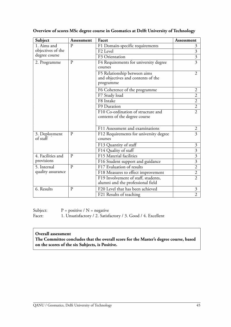
45QANU / Geomatics, Delft University of Technology
Overview of scores MSc degree course in Geomatics at Delft University of Technology
Subject Assessment Facet Assessment1. Aims and objectives of the degree course
P F1 Domain-specific requirements 3F� Level 3F3 Orientation 3
�. Programme P F4 Requirements for university degree courses
3
F5 Relationship between aims and objectives and contents of the programme
�
F6 Coherence of the programme �F7 Study load �F8 Intake �F9 Duration �F10 Co-ordination of structure and contents of the degree course
�
F11 Assessment and examinations �3. Deployment of staff
P F1� Requirements for university degree courses
3
F13 Quantity of staff 3F14 Quality of staff 3
4. Facilities and provisions
P F15 Material facilities 3F16 Student support and guidance 3
5. Internal quality assurance
P F17 Evaluation of results �F18 Measures to effect improvement �F19 Involvement of staff, students, alumni and the professional field
�
6. Results P F�0 Level that has been achieved 3F�1 Results of teaching �
Subject: P = positive / N = negative Facet: 1. Unsatisfactory / �. Satisfactory / 3. Good / 4. Excellent
Overall assessmentThe Committee concludes that the overall score for the Master’s degree course, based on the scores of the six Subjects, is Positive.

46 QANU / Geomatics, Delft University of Technology
47QANU / Geomatics, Delft University of Technology
APPENDICES

48 QANU / Geomatics, Delft University of Technology
49QANU / Geomatics, Delft University of Technology
Appendix A: Curricula vitae
Prof. Reiner Rummel (chairman)Professor Rummel is Professor of Astronomical and Physical Geodesy at the Department of Civil Engineering and Geodesy of the Technische Universität München since 1993.His research focus is on Physical Geodesy, and in particular determination of the gravitational field of the Earth by means of satellite techniques, i.e.
• spectral methods for the general analysis of modern techniques of satellite gravimetry;• development of semi-analytical analysis methods - in cooperation with George Balmino/
CNES proposal for a first satellite mission carrying a satellite gravity gradiometer and the preparation of this mission with colleagues from ten European institutes.
From 1980 to 1993 he was Professor of Physical Geodesy at the Delft University of Technol-ogy in the Netherlands. Professor Rummel received an honorary doctoral degree from the Universität Bonn (�005) and the Technische Universität Graz (�005). He is a member of the Deutsche Akademie der Naturforscher Leopoldina (�004).
Prof. Hans-Peter BährProfessor Bähr is a professor and head of department at the Institut für Photogrammetrie und Fernerkundung at the Universität Karlsruhe in Germany since 1983.His research focuses, among others, on Earth watch from space and image analysis, e.g.
• land-use change in Third World countries;• urban remote sensing;• information systems in disaster scenarios;• integration of language in geo-information systems.
From 1981 to 1983 he was a professor in Brazil (UFPR in Curitiba), where he established a PhD course in Geodesy. Since then he has maintained strong contacts to South America.Professor Bähr received a honorary doctorate in �001 from the University of Civil Engineer-ing, Bucuresti, Romania.
Prof. Paul CrossProfessor Cross is professor and Head of the Department of Geomatic Engineering at Univer-sity College London, a post he has held since 1997. He was previously Professor of Geomatics at the University of Newcastle, during which time he was Dean of Science from 199� to 1995. His current research concentrates on modelling and algorithms for GNSS-based positioning for a variety of applications including geodynamics, transport (especially marine, rail and air) and engineering. He is a member of the editorial boards of GPS World and Journal of Geodesy and is a Fellow of the Royal Institute of Navigation and of the Royal Institution of Chartered Surveyors.
Lukasz Grus, MScMr. Grus has recently started his PhD research at the group of Geo-information Science and Remote Sensing at Wageningen University in the Netherlands. In September �006 he graduated from the MSc Geo-information Science at Wageningen University. In �004 he also received an MSc in Landuse and GIS at Warsaw Agricultural University in Poland. In Wageningen he has been a student member of the Programme Committee and the Educational Board.

50 QANU / Geomatics, Delft University of Technology
Mr. Godfried M.G.M. van LieshoutMr. Van Lieshout is Director of Education of the Civil Engineering programmes of the Uni-versity of Twente. He also is Chairman of the Central Educational Committee of this univer-sity (an advisory committee to the university board). He has been a panel member of several educational audits of HBO and university programmes in the Netherlands and Belgium and contributed to the development of the accreditation system.
Mr. Roel NicolaiMr. Nicolai is principal geodesist at Shell International Exploration & Production B.V. He coordinates geodetic aspects of Shell’s geomatics and subsurface data management activities worldwide and represents Shell in several industry and standards bodies, such as the Open Geospatial Consortium, where he chaired a committee that designed a geodetic data model for geospatial software. He worked in London and the Middle East for a number of years in both offshore and onshore operationally oriented jobs.

51QANU / Geomatics, Delft University of Technology
Appendix B: Overview of courses
Domain 1: AcquisitionAE4-E08 Satellite Navigation (4 ec)AE4-E0� Advanced Remote Sensing (4 ec)AE4-E13 Acoustic Remote Sensing and Seafloor Mapping (4 ec)AE4-E05 Digital Terrain Modelling (4 ec)AES1650 Shallow Depth Geophysical Investigation (6 ec)GE448� Close Range Photogrammetry (3 ec)AE4-E14 Radar Remote Sensing & Deformation Analysis (4 ec)
Domain 2: ProcessingGE464� Geo DBMS (5 ec)AE4-E07 Location-Based Services (4 ec)GE461� Geo Information Infrastructure Technology (4 ec)AE4-E04 Multivariate Data Analysis (4 ec)GE46�� Quality of Geo-information (4 ec)AE4-E15 Digital Photogrammetry and 3D Reconstruction (4 ec)AE4-E17 Dynamic Data Processing (4 ec)IN4151 3D Computer Graphics and Virtual Reality (anticipated) (6 ec)
Domain 3: ApplicationsGE466� Organisational and Legal Aspects of Geo-information (4 ec)GE473� Spatial Information in Utilities (4 ec)AES16�0/1/� Engineering Geological Mapping (6 ec)CT4801 Transport & Spatial Modelling (6 ec)CT4300 Introduction to Coastal Engineering (4 ec)CT4450 Integrated Water Management (4 ec)CT4�51 Management in Building Industry (4 ec)AES1660 Subsidence (� ec)
Free electivesAES1480 Real-Time Decision-Making (� ec)CT48�1 Traffic Flow Theory and Simulation (4 ec)CT4831 Data Collection and Analysis (4 ec)CT4330 Ports and Waterways (1) (4 ec)CT4340 Computational Modelling of Flow and Transport (4 ec)CT4460 Polders and Flood Control (4 ec)CT4431 Hydrological Models (4 ec)CT4790 Subsurface Space Technology (4 ec)CT4�60 Building Informatics (4 ec)

5� QANU / Geomatics, Delft University of Technology

53QANU / Geomatics, Delft University of Technology
Appendix C: Programme of the site visit 2-3 October 2006
Monday 2 October 2006
11.00 Preparatory meeting of the Committee15.30 Review of study materials, tests, student evaluations, etc.16.30 Break17.00 Welcome by Prof. B.A.C. Droste, Dean of the Faculty of Aerospace
Engineering17.05 Meeting with the Programme Director, Co-ordinator Accreditation, Exam
Committee, Chair Education Committee18.00 Meeting with alumni and representatives of the work field.19.00 Closing19.30 Dinner organised by QANU
Tuesday 3 October 2006
09.00 Student representatives incl. representatives of the Education Committee (EC)
09.45 Representatives of teaching staff incl. representatives of the EC10.30 Break10.45 Educational support staff11.30 Visit to facilities (geolab + power point presentation of other facilities)
and Office hour (chairman and secretary)1�.45 Preparation of meeting with faculty board13.00 Lunch13.45 Final questions to Faculty Board and Programme Director14.30 Preparation of interim report16.30 Oral public presentation on findings16.45 Close

54 QANU / Geomatics, Delft University of Technology

55QANU / Geomatics, Delft University of Technology
Appendix D: Checklist
Checklist Master degree coursePanel member:………………………………………………..
Subject: Sufficient (+) or Insufficient (-)Facet: Poor (1), Adequate (�), Good (3), Excellent (4)
Subject Assessment Facet Assessment Remarks1. Aims and objectives of the degree course
1. Domain-specific requirements�. Level3. Orientation
�. Programme 4. Requirements for university degree courses5. Relationship between aims and objectives and contents of the programme6. Coherence of the programme7. Study load8. Intake9. Duration10. Co-ordination of structure and contents of the degree course11. Assessment and examinations
3. Deployment of staff
1�. Requirements for university degree courses13. Quantity of staff14. Quality of staff
4. Facilities and provisions
15. Material facilities16. Student support and guidance
5. Internal quality assurance
17. Evaluation of results18. Measures to effect improvement19. Involvement of staff, students, alumni and the professional field
6. Results �0. Level that has been achieved�1. Results of teaching