geology of volcanic rocks in the south half of the ... · pdf filethe monthly catalog...
TRANSCRIPT

Geology of Volcanic Rocks in the South Half of the Ishpeming Greenstone Belt, Michigan
U.S. GEOLOGICAL SURVEY BULLETIN 1904-P

AVAILABILITY OF BOOKS AND MAPS OF THE U.S. GEOLOGICAL SURVEY
Instructions on ordering publications of the U.S. Geological Survey, along with the last offerings, are given in the current-year issues of the monthly catalog "New Publications of the U.S. Geological Survey" Prices of available U.S. Geological Survey publications released prior to the current year are listed in the most recent annual "Price and Availability List." Publications that are listed in various U.S. Geological Survey catalogs (see back inside cover) but not listed in the most recent annual "Price and Availability List" are no longer available.
Prices of reports released to the open files are given in the listing "U.S. Geological Survey Open-File Reports," updated monthly, which is for sale in microfiche from the USGS ESIC-Open-File Report Sales, Box 25286, Building 810, Denver Federal Center, Denver, CO 80225
Order U.S. Geological Survey publications by mail or over the counter from the offices given below.
BY MAIL
Books
Professional Papers, Bulletins, Water-Supply Papers, Tech niques of Water-Resources Investigations, Circulars, publications of general interest (such as leaflets, pamphlets, booklets), single copies of periodicals (Earthquakes & Volcanoes, Preliminary De termination of Epicenters), and some miscellaneous reports, includ ing some of the foregoing series that have gone out of print at the Superintendent of Documents, are obtainable by mail from
USGS Map DistributionBox 25286, Building 810Denver Federal Center
Denver, CO 80225
Subscriptions to periodicals (Earthquakes & Volcanoes and Preliminary Determination of Epicenters) can be obtained ONLY from
Superintendent of DocumentsU.S. Government Printing Office
Washington, DC 20402
(Check or money order must be payable to Superintendent of Documents.)
Maps
For maps, address mail order to
USGS Map DistributionBox 25286, Building 810Denver Federal Center
Denver, CO 80225
Residents of Alaska may order maps from
U.S. Geological Survey, Map Sales101 Twelfth Ave., Box 12
Fairbanks, AK 99701
OVER THE COUNTER
Books
Books of the U.S. Geological Survey are available over the counter at the following U.S. Geological Survey offices, all of which are authorized agents of the Superintendent of Documents.
ANCHORAGE, Alaska-^230 University Dr., Rm. 101
ANCHORAGE, Alaska-605 West 4th Ave., Rm G-84
DENVER, Colorado-Federal Bldg., Rm. 169,1961 Stout St.
LAKEWOOD, Colorado-Federal Center, Bldg. 810
MENLO PARK, California-Bldg. 3, Rm. 3128,345 Middlefield Rd.
RESTON, Virginia-National Center, Rm. 1C402,12201 Sunrise Valley Dr.
SALT LAKE CITY, Utah-Federal Bldg., Rm. 8105, 125 South State St.
SPOKANE, VVashington-U.S. Courthouse, Rm. 678, West 920 Riverside Ave.
WASHINGTON, D.C.-U.S. Department of the Interior Bldg., Rm. 2650,1849 C St., NW.
MapsMaps may be purchased over the counter at the U.S. Geolog
ical Survey offices where books are sold (all addresses in above list) and at the following Geological Survey offices:
ROLLA, Missouri-1400 Independence Rd.
FAIRBANKS, Alaska-New Federal Building, 101 Twelfth Ave.

Chapter P
Geology of Volcanic Rocks in the South Half of the Ishpeming Greenstone Belt, Michigan
By THEODORE J. BORNHORST and RODNEY C. JOHNSON
U.S. GEOLOGICAL SURVEY BULLETIN 1904
CONTRIBUTIONS TO PRECAMBRIAN GEOLOGY OF LAKE SUPERIOR REGION
P.K. SIMS and L.M.H. CARTER, Editors

U.S. DEPARTMENT OF THE INTERIOR
MANUEL LUJAN, JR., Secretary
U.S. GEOLOGICAL SURVEY
Dallas L. Peck, Director
Any use of trade, product, or firm names in this publication is for descriptive purposes only and does not imply endorsement by the U. S. Government
UNITED STATES GOVERNMENT PRINTING OFFICE: 1993
For sale byUSGS Map Distribution Box 25286, Building 810 Denver Federal Center Denver, CO 80225
Library of Congress Cataloging-in-Publication Data
Bornhorst, Theodore J.Geology of volcanic rocks in the south half of the Ishpeming greenstone belt,
Michigan / by Theodore J. Bornhorst and Rodney C. Johnson.p. cm. (Contributions to Precambrian geology of Lake Superior region ;
ch. P) (U.S. Geological Survey bulletin ; 1904-P) Includes bibliographical references. Supt. of Docs, no.: 119.3:81904P1. Volcanic ash, tuff, etc. Michigan. 2. Geology, Stratigraphic Archaean.
3. Geology Michigan. 4. Kitchi Formation. 5. Mona Formation. I. Johnson, R.C. (Rodney C.) II. Title. III. Title: Ishpeming greenstone belt, Michigan. IV. Series. V. Series: U.S. Geological Survey bulletin ; 1904-P.
QE75.B9 no. 1904-P [QE461] 557.3 s dc20I552'.2'09774] 92-27841
CIP

CONTENTS
Abstract PI Introduction PI Acknowledgments PI Volcanic terminology P3 Structural framework P4 Volcanic stratigraphy P4
Kitchi Formation P4 Definition P4 Description PS
Basalt flow unit P6 Tuff unit P6 Lahar unit P7
Mona Formation P7 Definition P7 Description P8
Basalt flow unit P8 Lapilli-tuffunit P9Upper tuff unit (formerly Nealy Creek Member) P9
Related intrusive rocks P10 Deer Lake Peridotite P10 Gabbro P10
Geochemical character P10 Environmental interpretation P12 Volcanic history P12 References cited P13
FIGURES
1. Geologic map of west half of the Archean Superior province showing location of Ishpeming greenstone belt P2
2. Geologic map of Ishpeming greenstone belt, Michigan P33. Geologic map of southwest block of Ishpeming greenstone belt P54. Generalized stratigraphic column for the Kitchi Formation P65. Geologic map of southeast block of Ishpeming greenstone belt P86. Generalized stratigraphic column for the Mona Formation P97. Jensen cation plots for rocks of south half of Ishpeming greenstone belt Pll
Contents III


CONTRIBUTIONS TO PRECAMBRIAN GEOLOGY OF LAKE SUPERIOR REGION
Geology of Volcanic Rocks in the South Half of the Ishpeming Greenstone Belt, Michigan
By Theodore J. Bornhorst1 and Rodney C. Johnson 1 '2
Abstract
The south half of the Ishpeming greenstone belt is domi nated by a thick succession of subaqueously erupted volcanic rocks. A regional structural interpretation of the belt provides a framework for placing this succession in a stratigraphic order. The south half of the Ishpeming greenstone belt preserves the remnants of overlapping subaqueous volcanic complexes within an arc system.
The Kitchi Formation, as redefined herein, comprises the lower half of the volcanic succession and is subdivided into three informal units. The basal basalt flow unit is composed of pillowed, tholeiitic, basalt flows and minor banded iron-forma tion and dacitic tuff. It is overlain by the second and third units, which are tuff and lahar (volcanic debris flow) units that inter- finger with one another. These units range in composition from calc-alkalic basalt to dacite. The Kitchi Formation represents an evolving tholeiitic, mafic shield to calc-alkalic, mafic to fel- sic subaqueous volcano.
The Mona Formation, which is redefined herein, is in structural contact with the Kitchi Formation, but is likely younger. It is subdivided into three informal units. The base consists of a basalt flow unit, which is composed of pillowed, tholeiitic to magnesium-rich basalt flows and minor amounts of banded iron-formation and tuff. The basalt is overlain by a calc-alkalic dacite to rhyolite lapilli-tuff unit and a laterally continuous upper tuff unit of calc-alkalic basalt to andesite. The Mona Formation represents an evolving tholeiitic, mafic shield to mafic-felsic calc-alkalic, mafic to felsic subaqueous volcano. The Deer Lake Peridotite, an ultramafic sill complex that intrudes the Kitchi Formation, is speculatively interpreted as a subvolcanic ultramafic komatiite base of the Mona Formation.
INTRODUCTION
The Ishpeming greenstone belt occupies the southeast corner of the northern complex of the Marquette district (figs. 1, 2). The northern complex comprises the Archean crustal rocks north of the Great Lakes tectonic zone, an Archean continent-continent suture (Sims and others, 1980; Sims, 1991). Although the complex is composed of a wide variety of Archean igneous, sedimentary, and metamorphic rocks, it is best characterized as a green stone-granite terrane. The greenstone part occupies about an eighth of the surface area of the complex. These rocks are part of the Wawa subprovince of the Canadian Shield as defined by Card and Ciesielski (1986), and may be the southernmost Archean greenstone belt in the Superior province.
The Ishpeming greenstone belt is a 13-km-thick suc cession of subaqueous mafic flows, intermediate pyroclas- tics, and volcaniclastic sedimentary rocks. These rocks are intruded by mafic and felsic dikes, granitoid plutons, and two peridotite bodies. The rocks are Archean in age, dating from probably about 2,700 Ma or before (Morgan and DeCristoforo, 1980; Trow, 1979; Hammond, 1978). The Archean rocks are unconformably overlain by and in fault contact with Early Proterozoic sedimentary rocks, and they are cut by diabase dikes of Early and Middle Proterozoic ages.
The objective of this report is to present the volcanic stratigraphy of the south half of the Ishpeming greenstone belt Volcanic stratigraphy and related intrusive rocks are analyzed in terms of volcanic environment.
'Department of Geological Engineering, Geology, and Geophysics, Michigan Technological University, Houghton, MI 49931.
2Westem Mining Corporation (USA), Marquette, MI 49855.
ACKNOWLEDGMENTS
Geologic studies in the Ishpeming greenstone belt have been financially supported by the Michigan Geological
Volcanic Rocks, South Half of Ishpeming Greenstone Belt, Michigan PI

50°
PIKWITONEI ffff:fttlK-;i:matfy^V--f-fffA
UNITED STATES
LAKE SUPERIORIshpeming
GLTZ
MINNESOTA RIVER VALLEY
500 KILOMETERS
EXPLANATIONArchean subprovince type
Plutonic rocks
Volcanic-plutonic rocks
Metasedimentary rocks
High-grade gneiss
Superior province boundary
Subprovince boundary
Figure 1 . Geologic map of west half of the Archean Superior province showing location of Ishpeming greenstone belt in the east ern part of the northern complex of the Marquette district, Michigan. The belt is north of the Great Lakes tectonic zone (GLTZ). The high-grade gneiss in Minnesota is part of the Archean gneiss terrane. Unpatterned areas, post-Archean rocks. Modified from Card (1990).
P2 Precambrian Geology of Lake Superior Region

87°30'
46°30'
Bp RIVER FALLS SHEAR ZONE
R28W R27W R26W R25 W
10 KILOMETERS
EXPLANATION
Middle Proterozoic (900-1,600 Ma)
Jacobsville Sandstone (Midcontinentrift system)
Early Proterozoic (1,600-2,500 Ma)
Sedimentary rocks of Marquette RangeSupergroup
Archean
Granitoid rocks
Metavolcanic rocks
Contact
r^i r^> r^i Shear zone
-4 Approximate trace of axial plane of plunging anticline
- -$ Approximate trace of axial plane of plunging syncline
Figure 2. Geologic map of Ishpeming greenstone belt, Michigan, showing the major lithostratigraphic blocks, shear zones (SZ), and fold axes.
Survey, the COGEOMAP program of the U.S. Geological Survey, the Mineral Institute Program administered by the U.S. Bureau of Mines, Callahan Mining Corporation, Western Mining Corporation (USA), and Michigan Tech nological University. Our understanding of the geology has benefited from discussions with geologists of Callahan Mining Corporation, Western Mining Corporation, and Kerr-McGee Corporation, as well as several present and
former graduate students at Michigan Tech. Critical reviews by P.K. Sims, W.F. Cannon, and G.W. Johns improved the manuscript.
VOLCANIC TERMINOLOGY
In this report we follow the terminology for volcanic rocks presented by Easton and Johns (1986), which
Volcanic Rocks, South Half of Ishpeming Greenstone Belt, Michigan P3

commonly has been used to describe the volcanic rocks of the Superior province. In general, volcanic rocks are sub divided into extrusive (lava) and fragmental (explosive) rocks that are emplaced in either a subaerial or subaque ous environment. In the Ishpeming greenstone belt textural evidence suggests that all the volcanic rocks were emplaced in a subaqueous environment.
The distinction between pyroclastic and epiclastic materials can be difficult to determine in a subaqueous environment. Subaqueous pyroclastic rocks, transported at least in part in a water medium (Cas and Wright, 1987; Cas and others, 1990), will, when identifiable, be called herein by the pyroclastic rock names of Easton and Johns (1986). When genesis is unknown or obscure, a nonge- netic grain-size classification (pyroclastic breccia, >64 mm; lapilli-tuff, 2-64 mm; tuff, <2 mm) is used. No cor responding classification scheme exists for clearly rede- posited fragmental (epiclastic) but still volcanic-origin rocks. Some epiclastic rocks, such as many lahars (volca nic debris flows), may form by direct volcanic action. In the case of fine-grained schistose rocks, we distinguish pyroclastic from epiclastic protolith (Easton and Johns, 1986) using criteria of Ayres (1969). A volcanic deposit is considered pyroclastic (Schmid, 1981) if it is composed of less than 25 percent epiclasts+chemical sediment clasts. Pyroclastic names are given to rocks composed of volcanic fragments if evidence for an epiclastic origin is lacking.
The terminology for volcanic rock types such as basalt, andesite, dacite, and rhyolite is based on the Jensen cation plot (Grunsky, 1981). This system is commonly applied elsewhere to rocks of the Superior province.
STRUCTURAL FRAMEWORK
The rocks of the Ishpeming greenstone belt have been strongly deformed by at least two major events. The oldest recognized event (D,) was recumbent folding. This was followed by upright folding about east-west-oriented axes (D2) (Johnson and Bornhorst, 1991). Shear zones are inter preted to have formed during and later than D2 and may have been reactivated during the Early Proterozoic Penokean deformation. The structural history of the belt as determined by us is a critical component of stratigraphic reconstruction.
The Ishpeming greenstone belt consists of three litho- stratigraphic blocks (fig. 2) (Bornhorst, 1988). Each block has an internal stratigraphic continuity, but the strati- graphic relationships among separate blocks are less cer tain because of intervening shear zones. No evidence exists for stratigraphic repetition within blocks by thrust faults. The northern block of the belt, composed of the Lighthouse Point Basalt (Johnson and Bornhorst, 1991), is
dominated by pillowed, tholeiitic, basalt flows with minor massive flows. Subordinate interflow pyroclastic units and an iron-formation provide stratigraphic continuity within the block and are the basis for determining the structural history. The northern block is separated from the southern blocks by the Dead River shear zone (fig. 2). This ductile to brittle-ductile shear has north-side-up and right-lateral kinematics.
Regional structural studies by one of us (Johnson) sug gest that the steeply dipping Archean volcanic rocks of the southeast block are part of a large isoclinal D, fold (fig. 2). The strata and Sj foliation of the southwest block form a vertically plunging (closed) anticline.
The southeast and southwest blocks are separated by a shear zone, first recognized by Clark and others (1975), that follows the Carp River for a considerable distance. This shear zone (Carp River shear zone) is poorly exposed and its significance is uncertain. Recent interpretations of the stratigraphic framework of the belt by Bornhorst (1988) and Brozdowski (1989) used published geologic maps which suggest that rocks to the southwest of the Carp River shear zone (southwest block) face to the south east and those to the northeast (southeast block) face north. Thus, these authors interpreted the Carp River shear zone as a major shear separating two distinct litho- stratigraphic blocks that had unknown stratigraphic rela tionships. New field data gathered by us suggest, however, that the rocks directly south of this zone actually face north in the same way as those to the north of the zone; thus, stratigraphic continuity across the shear zone is a reasonable possibility. Within the southwest block stratigraphic continuity obtains about a D2 fold axis.
Rock units in all blocks are also cut by minor shear zones. These high-strain zones are characterized by rocks that are more intensely foliated than the surrounding rocks. In that these foliated rocks are a result of second ary processes and not original stratigraphy, they are not described further.
The stratigraphy for the south half of the Ishpeming greenstone belt can be constructed based on the structural framework. The oldest rocks (Kitchi Formation) are those that compose the southwest block (fig. 2). The rocks in the southeast block (Mona Formation) are younger than those of the southwest block.
VOLCANIC STRATIGRAPHY
Kitchi Formation
Definition
The Kitchi Schist was named by Van Rise and Bayley (1895) for the volcanic rock in the Kitchi Hills (sec. 33, T. 48 N., R. 27 W.). (Note that the name Kitchi Hills does not appear on modern topographic maps.) Puffett (1974)
P4 Precambrian Geology of Lake Superior Region

87°45' 87°40'
46°32'30"
* ^* «<Vj \ S , V -^ \ * " >" A:;.'.~.'fw.i-»x v--o-, ^ :-.V->::.->^-(-)iAO
t^fe^^ sm^^fem^E
EXPLANATION
Early Proterozoic
Undifferentiated metasedimentary rocks
Archean
Undifferentiated rocks
Metagabbro
Deer Lake Peridotite
Kitchi Formation
Lahar unit
65
Tuff unit
Basalt flow unit
Contact
Strike and dip of beds
Shear zone
-f- Approximate trace of axial plane of anticline
Note: All rocks are metamorphosed
Figure 3. Geologic map of southwest block of Ishpeming greenstone belt. Lettered localities are discussed in text. Modified from Brozdowski (1989), Cannon and Klasner (1977), Clark and others (1975), and Puffett (1974), with additions by the authors.
and Clark and others (1975) placed andesitic to dacitic volcaniclastic and pyroclastic rocks in the Negaunee and Negaunee SW l lk minute quadrangles, respectively, in the Kitchi Schist. Clark and others (1975) subdivided the Kit chi Schist into three informal map units: agglomerate; complex of dacitic tuff, flows, and probable hypabyssal intrusive rocks; and metabasalt.
Because the rocks assigned to the Kitchi Schist are het erogeneous and have recognizable parent lithologies, we propose that rocks previously known as Kitchi Schist be redefined the Kitchi Formation. The type area is the south west block of the Ishpeming greenstone belt in the vicinity of Deer Lake as shown in figure 3. Further, we propose to subdivide the Kitchi Formation into three informal rock units: (1) basalt flow unit (metabasalt and metagabbro of Clark and others, 1975, and the mafic-ultramafic complex of Cannon and Klasner, 1977); (2) tuff unit (complex of dacitic tuff, flows, and probable hypabyssal intrusive rocks within the Kitchi Schist of Clark and others, 1975); and (3) lahar unit (agglomerate within Kitchi Schist of Clark and others, 1975), which occurs as interlayers in the tuff unit (fig. 4).
Clark and others (1975) recognized and mapped an Archean rock unit within the Negaunee SW llk minute quadrangle that they termed metagabbro. These rocks con tinue to the southwest into the Diorite l lk minute quad rangle, where Cannon and Klasner (1977) called them the mafic-ultramafic complex. Detailed mapping and diamond drill coring by geologists with Callahan Mining Corpora tion (Brozdowski, 1989) show, however, that this unit is composed of basaltic flows that interfinger with the over lying rocks. Thus, we assign these rocks in the western most part of the southwest block to the basalt flow unit of the redefined Kitchi Formation.
Description
The Kitchi Formation is composed of three informal units, from oldest to youngest, basalt flow, tuff, and lahar units (fig. 3). The basalt flow unit is overlain by and inter- fingers with the tuff unit (fig. 4). The lahar unit occurs as layers and lenses within the thicker tuff unit. Rocks assigned to the Kitchi Formation underlie an area of
Volcanic Rocks, South Half of Ishpeming Greenstone Belt, Michigan P5

Kitchi Formation
METERS On
500-
100CH
Lahar unit
Lahar unit
Basalt flow unit
Banded iron-formation.,
^Gloraerophyric flow
Tuff unit
Figure 4. Generalized stratigraphic column for the Kitchi Formation.
approximately 29 km2 and extend from 1 km north of Negaunee to east of Gold Mine Lake. The eastern limit of the formation is the Carp River shear zone, the western limit is Archean granitoid intrusive rocks, the northern limit is Early Proterozoic sedimentary rocks, and the southern limit is the Carp River Falls shear zone and Early Proterozoic sedimentary rocks. The total thickness of the formation is estimated to be about 6,700 m.
Basalt Flow Unit
The lower part of the Kitchi Formation is a thick suc cession of pillowed and massive tholeiitic basalt flows. These flows crop out in an 8-km2-wide area east of Gold Mine Lake (fig. 3), in the extreme western part of this
block. The basalt flow unit has a maximum map width of between 1,700 and 1,800 m within the Diorite quadrangle. The typical dip of pillowed flows and interbedded sedi ments is 75° SE. to vertical (Brozdowski, 1989). The con tinuity of interflow units and the consistent southeast- facing direction suggest that the rocks in the unit are not structurally repeated. The exposed thickness is approxi mately 1,700 m, but inasmuch as the base of the unit is truncated by Archean granitoid intrusive rocks, this is a minimum thickness.
Brozdowski (1989) provided a detailed geologic map and a description of the basalt flow unit, as summarized following. The unit consists of pillowed basalt flows with lesser and relatively thin massive flows. The mineralogy of the basalt consists of plagioclase, hornblende, clinozo- isite, actinolite, and chlorite as well as a variety of minor minerals, all of which are consistent with upper green- schist facies metamorphism. Several gabbro sills occur in the basalt flow unit. Some of these so-called sills may be massive interiors to pillowed flows rather than intrusive rocks.
Several thin zones of chert and dacitic to rhyolitic tuff occur near the middle of the exposed rocks of the basalt flow unit. A lens of chlorite-magnetite rock up to 65 m thick occurs in the upper part of the unit; the lens is inter preted as a basaltic tuff, but it might be a fine-grained hyaloclastite. The latter is overlain by a 30-m-thick glom- erophyric basalt flow (fig. 4). This flow is characterized by plagioclase phenocrysts as much as 2 cm in diameter. As a whole, the basalt flow unit consists of subaqueously deposited basalt flows containing minor interbedded iron- formation and felsic tuffs, which were deposited during a hiatus in mafic volcanism.
Tuff Unit
The upper part of the Kitchi Formation is a succession of tuffs, which crop out in a 21 km2 area surrounding Deer Lake. The stratigraphic thickness of the tuff unit is poorly known, and is complicated by the intrusive Deer Lake Peridotite and by folding (fig. 3). The maximum exposed stratigraphic thickness of the tuff unit is about 5,000 m (fig. 4).
The rocks at the base of the tuff unit interfinger with the top of the basalt flow unit. As described by Brozdowski (1989), the lower part of the unit (northwest of the Deer Lake Peridotite) is dominated by dacite, crys tal to lithic tuff, which now is a quartz-sericite-plagioclase schist. At least two massive dacite lenses, containing pla gioclase phenocrysts set in a quartz-sericite matrix, have been recognized. One lens has a maximum thickness of about 100 m. Brozdowski (1989) has interpreted these lenses as flows. The stratigraphic section in the vicinity of the Ropes gold mine includes a few thin lapilli-tuff lenses
P6 Precambrian Geology of Lake Superior Region

as much as 5 m thick, and several fine-grained quartz-rich graywacke and siltstone lenses, one of which has a maxi mum thickness of about 60 m. In the same part of the stratigraphic section, several lenses of thin banded iron- formation are present; typical thickness of these is less than 5 m and maximum thickness is 20 m. The iron- formation is quartz-magnetite-chlorite rock with centime ter-wide bands. Pyrite is secondary and occurs as layers that are both discordant and concordant to banding and (or) bedding.
To the southeast of the Deer Lake Peridotite, the tuff unit consists of quartz-feldspar-sericite-chlorite schist. Feldspar phenocrysts are common. This unit contains crys tal, vitric, and lithic tuffs and lapilli tuffs. In sec. 21, T. 48 N., R. 27 W. (locality A, fig. 3), a repeated succession of lapilli tuff with pumice fragments in an ash and crystal matrix is overlain by laminated vitric tuff which fines and contains fewer crystals upwards. These features closely match those expected for a subaqueous pyroclastic flow. In sec. 35, T. 48 N., R. 27 W. (locality B, fig. 3), 20-cm- thick crystal tuff beds overlain by 3 cm of vitric tuff are repeated several times. Cas and others (1990) interpreted stratified crystal tuffs as multiple pyroclastic eruptions of ash hydraulically sorted during emplacement on the flank of the volcano by grainflows or turbidity currents. In S lk sec. 25, T. 48 N., R. 27 W. (locality C, fig. 3), several parallel-laminated and ripple cross-laminated tuff beds are exposed. They are a light-gray porcellaneous rock com posed of sericite and very fine grained quartz with altered phenocrysts of plagioclase and mafic minerals (Puffett, 1974). Grain size and textures match those expected for turbiditic ash deposits.
Puffett (1974) and Clark and others (1975) described areas of more massive porphyritic rock with phenocrysts like those found in the tuffs. These rocks may be either flows or dikes. Their origin and distribution are poorly known.
Lahars are interlayered within the tuff unit (fig. 4). The more prominent zones of lahars were mapped by Clark and others (1975) as a separate unit (discussed following), but the tuff unit includes subordinate lahars too thin to be mapped separately.
The existence of pillowed basalt flows that interfinger with the tuff unit and turbiditic volcanic deposits near the top of the unit supports a subaqueous deposition for the tuff. Although the extent of redeposition is uncertain, the tuff unit is interpreted as having been originally emplaced by volcanic action such as subaqueous pyroclastic flow and fall deposits.
Lahar Unit
Mappable lenses and beds of lahar are interlayered with tuffs of the tuff unit (fig. 4), and crop out in a 4 km2 area near Deer Lake (fig. 3). The maximum exposed
thickness of the lenses and beds within the stratigraphic section is approximately 1,000 m.
The lahar unit consists of angular to subrounded clasts of andesite to dacite. Although delicately shaped bombs are lacking, all fragments are volcanic in origin. The clasts range in size from sand to boulder; a maximum cross-sectional width is 1.3 by 0.6 m. Clasts 20 30 cm in diameter are quite common. The clasts are matrix sup ported, and their abundance ranges from a few percent to about 60 percent of the rock. Zones within the lahar unit, as much as 1 m thick, contain relatively larger clasts. Most clasts are quartz or quartz+feldspar phenocrystic andesite; some are aphyric and laminated. The ground- mass consists of schistose sericite, chlorite, feldspar, and quartz. The mineralogic composition of the matrix is the same as that of the tuffs of the tuff unit. The lahars were subaqueously emplaced as is indicated by the presence of a pillowed basalt layer situated between two lahar zones and by turbidites occurring higher in the stratigraphic sec tion within the tuff unit (fig. 4). The lahar unit is inter preted as subaqueous volcanic debris related to volcanic action.
Mona Formation
Definition
The formal name Mona Schist was first used by Van Hise and Bayley (1895) for basalt exposed in the Mona Hills (sees. 27 and 28, T. 48 N., R. 25 W.). (Note that the name Mona Hills does not appear on modern topographic maps.) Within the Marquette 7lk minute quadrangle, Gair and Thaden (1968) subdivided the Mona Schist into the lower member and the Lighthouse Point Member. Puffett (1974) extended the name Mona Schist to metavolcanic rocks in the Negaunee quadrangle to the west, and he sub divided it into four members: lower member, Nealy Creek Member, sheared rhyolite tuff member, and Lighthouse Point Member. The Lighthouse Point Member of the Mona Schist has been revised and redefined as the Light house Point Basalt by Johnson and Bornhorst (1991) and is part of the northern block (fig. 2). As revised by Johnson and Bornhorst (1991), the Mona Schist consists of two informal members (the lower and the sheared rhyo lite tuff members) and one formal member (Nealy Creek Member).
Because many rocks within the Mona Schist are not schists and because they have recognizable parent litholo- gies and are heterogeneous, we propose that rocks previ ously known as Mona Schist be redefined the Mona Formation. Further, we propose that all members be infor mal. The lower member of the Mona Schist is herein called the basalt flow unit of the Mona Formation, the sheared rhyolite tuff member of the Mona Schist is called the lapilli tuff of the Mona Formation, and the Nealy
Volcanic Rocks, South Half of Ishpeming Greenstone Belt, Michigan P7

46° 3587° 40' 87° 35'
~7T^ 87° 30'
r^TT:
1 r/s "&
^S?X' xr^^^iKv:^^^^^:.^^^ >?6c^v->:Del^I^^ 1Storase B->^^^^^ ^^m^mp, I
T^__ 2i^^%^^>S^^"^^/3^^^^^^H-^^?^__^^ ^_^<x7^^^^^-^-.^/^.^.^;;\; /<^'^ ---\ < ! ; |;'^ ^^SLsnr7^^46°32' 30" - T/^S
'/o ^,
I i s i ~,
>: 'r>+-.riJ: «* '^a^'A>'M> ^" CARP RIVER FALLS SHEAR ZONE*>U yS^>
46° 3D 1
^-<7Negaunee
olshpemmg u
01
5 10 KILOMETERS
EXPLANATIONEarly Proterozoic
Undifferentiated metasedimentary rocks
Archean
Undifferentiated rocks
Metagabbro
Mona Formation
Upper tuff unit
Lapilli-tuff unit
Basalt flow unit
- Contact Dotted where concealed
Shear zone
-± Approximate trace of axial plane of plunging syncline
Note: All rocks are metamorphosed
Figure 5. Geologic map of southeast block of Ishpeming greenstone belt. Lettered localities are discussed in text. Modified from Brozdowski (1989), Clark and others (1975), Puffett (1974), and Cair and Thaden (1968), with additions by the authors.
Creek Member of the Mona Schist is called the upper tuff of the Mona Formation. The type area is the same as that previously designated for the Mona Schist.
Description
The Mona Formation comprises three lithologically distinct and mappable informal units, from oldest to youngest, basalt flow, lapilli-tuff, and tuff units (fig. 5). The basalt flow unit is overlain by the lapilli-tuff unit, which in turn interfingers with and is overlain by the tuff unit (fig. 6). Rocks assigned to the Mona Formation underlie an area of approximately 65 km2 and extend from the city of Marquette, to the east, to about 5 km north of the city of Ishpeming, to the west. The eastern limit of the formation is Lake Superior, the western limit is the Carp River shear zone, the northern limit is the Dead River shear zone, and the southern limit is the Carp River Falls shear zone and Early Proterozoic sedimentary rocks (fig. 2). The estimated thickness of the formation is about 6,400 m.
Basalt Flow Unit
The lower part of the Mona Formation is a thick suc cession of metamorphosed tholeiitic pillow basalt flows. These flows crop out in an area of 54 km2, which extends from south of Marquette to 3 km north of Ishpeming (fig. 5). The pillows and interbedded sedimentary zones dip between 70° SE. and vertical (Gair and Thaden, 1968). The consistent stratigraphic facing direction and a lack of evidence supporting shearing associated with recumbent folding support a continuous stratigraphic succession, without significant repetition resulting from faulting or folding. The lack of stratigraphic marker zones makes thickness estimates difficult. The maximum exposed thick ness is approximately 5,500 m. The original thickness of the unit is unknown, as it is truncated on the south by the Carp River Falls shear zone.
Pillows are conspicuous throughout the basalt flow unit. They are bulbous or bun shaped, typically 0.3 to 1 m thick and 0.3 to 1 m long. Rarely, pillows are as much as 3.5 m thick. Vesicles are present in some places in the outer margins of pillows, and radial fractures occur in the
P8 Precambrian Geology of Lake Superior Region

Mona Formation
Lapilli-tuff unit
METERS On
500-
1000 J
Upper tuff unit
Basalt )> flow
unit
Figure 6. Generalized stratigraphic column for the Mona Formation.
outer parts of pillows. Cusps on pillows can be found in many exposures; they consistently indicate stratigraphic tops to the north. Interpillow void spaces are filled with various minerals, including quartz, carbonate, and epidote.
The proportion of massive basalt flows in the basalt flow unit is not well known, but is estimated to be consid erably less than pillowed basalt. Massive basalt is green on fresh surfaces; its composition is a fine- to coarse grained mixture of plagioclase, chlorite, actinolite, epidote, and sericite, with minor amounts of magnetite, quartz, leu- coxene, sphene, and carbonate. This mineralogy is consis tent with greenschist-facies metamorphism. Some bodies of gabbro within this unit mapped as metadiabase by Gair and Thaden (1968) and Puffett (1974) could represent massive interiors of flows rather than intrusions.
The basalt flow unit contains a zone of several thin iron-formation lenses and tuffaceous beds (not shown in fig. 6). Textures and field relations suggest that the tuf faceous beds are neither hyaloclastites nor sheared rocks. At the north end of the Pine Hill quarry (SE1ANW1/4 sec. 25, T. 48 N., R. 26 W.; locality A, fig. 5), several banded quartz-magnetite iron-formations having a maximum thickness of a few meters are exposed. Also, a few 10- to 15-cm-thick layers of red jasper banded iron-formation are present. The iron-formation units are interlayered with pil lowed basalt and basaltic tuff. In sec. 28, T. 48 N., R. 25 W. (locality B, fig. 5), Brozdowski (1989) and Gair and Thaden (1968) described several lenses of basaltic and dacitic tuffs. Just south of the city of Marquette along U.S.
Highway 41 (S'A sec. 23, T. 48 N., R. 25 W.; locality C, fig. 5) several red jasperoid and quartz-magnetite cherty iron-formation zones between 5 and 15 cm thick are exposed. The layering in these rocks ranges from a few millimeters to several centimeters in thickness. At this locality, the iron-formation units are interlayered with basaltic lapilli-ash tuff, tuff, and pillowed basalt. In sec. 21, T. 48 N., R. 25 W. (locality D, fig. 5), tuffaceous rocks and a graphitic zone crop out. The stratigraphic rela tionship among these localities is uncertain.
The basalt flow unit of the Mona Formation comprises a succession of subaqueously deposited flows. The thin tuff and iron-formation units represent more explosive vol- canism in the volcanic cycle during quiescent intervals in lava eruption.
Lapilli-tuff Unit
The basalt flow unit of the Mona Formation is over lain by the lapilli-tuff and upper tuff units, respectively (fig. 6). The lapilli-tuff unit crops out in a 3 km2 area at the east end of the Dead River storage basin (fig. 5). Its maximum map width, about 490 m, probably indicates the approximate stratigraphic thickness. The rocks in this unit are strongly foliated rocks because they are adjacent to the Dead River shear zone (fig. 2).
The lapilli-tuff unit is dominated by lapilli clasts set in a fine-grained quartz, sericite, and chlorite matrix. Elon gate clasts as much as about 20 cm long are present in some intervals. Quartz phenocrysts as much as 2 mm in diameter are common in the clasts and the matrix. Less abundant feldspar phenocrysts are of similar size. The composition of both the clasts and the matrix is rhyolitic. Puffett (1974) described green altered lapilli composed of sericite and iron-rich chlorite. These lapilli tuffs are inter preted as subaqueous pyroclastic deposits.
Upper Tuff Unit (Formerly Nealy Creek Member)
The lapilli-tuff unit grades upward and laterally into the upper tuff unit, which directly overlies both the lapilli- tuff unit and the basalt flow unit (fig. 6). It crops out in an 8 km2 area in the vicinity of the Dead River storage basin (fig. 5). Its maximum map width, about 900 m, approxi mates the stratigraphic thickness. Rocks that Gair and Thaden (1968) mapped as chloritic and felsitic schists and slates, Morgan and DeCristoforo (1980) and Brozdowski (1989) correlated with the upper tuff unit
The upper tuff unit consists of quartz-feldspar-sericite- chlorite schist. The proportion of these minerals varies; an average proportion is 3 [quartz]: 4 [feldspar and sericite]: 3 [chlorite and biotite] (Puffett, 1974). Most schist has
Volcanic Rocks, South Half of Ishpeming Greenstone Belt, Michigan P9

abundant fine-grained matrix containing scattered angular to subhedral quartz and feldspar grains. Possible primary layering from 1 mm to 60 cm thick is present in some exposures (Puffett, 1974). Based on sand-size, lenticular volcanic fragments, and lack of sand-size quartz and feld spar in an intact framework, most of these schist beds are interpreted as tuff. However, some rocks within this unit contain sand-size quartz and feldspar in an intact frame work, and these are interpreted as volcanic-derived graywacke. Sericitic slate within this unit may represent redeposited pyroclastic material based on compositional similarity with other rocks. The Nealy Creek Member comprises metamorphosed subaqueous pyroclastic and redeposited pyroclastic deposits.
RELATED INTRUSIVE ROCKS
The volcanic rocks of the Ishpeming greenstone belt are cut by a variety of intrusive rocks. Peridotite and gab- bro intrusions are interpreted as resulting from the mag- matic activity that caused the eruption of the volcanic rocks. In addition, margins of the volcanic belt are intruded by a tonalite to granite batholith, which has an arc geochemical signature (Wilkin and Bornhorst, 1990). Internally, the greenstone belt volcanic rocks are cut by porphyritic rhyolite dikes and stocks of coarse-grained granitoid rocks (Johnson and Bornhorst, 1991; Puffett, 1974).
Deer Lake Peridotite
Morgan and DeCristoforo (1980) proposed the name Deer Lake Peridotite for a 6 km2 body of serpentinized peridotite in vicinity of Deer Lake (fig. 3). Most of the peridotite is dark gray to green and composed of fine grained serpentine with minor opaque oxides. The serpen tine is a mixture of chrysotile and (or) lizardite with lesser amounts of antigorite (Bornhorst and others, 1986). In hand samples and thin sections, 1- to 5-mm serpentine pseudomorphs after olivine or pyroxene have been identi fied; primary olivine or pyroxene is absent. Cumulate tex tures indicate an intrusive origin. Textures indicative of extrusive komatiite, such as spinifex textures, flow con tacts, or polysuturing, have not been found. Based on CIPW normative minerals, olivine to pyroxene ratios range from 0.28 to 1.93, and all the calculated norms fall in or near the harzburgite field of Coleman and Keith (1971). Since calcium losses can occur during serpentini- zation, the ultramafic protolith may have had more cli- nopyroxene than indicated by the norms. The peridotite has high MgO, more typical of intrusive ultramafics than
extrusive komatiites (Bornhorst and others, 1986). Various altered varieties of peridotite occur in the vicinity of the Ropes gold mine (Bornhorst and others, 1986; Brozdowski, 1989).
Based on presumed discordant contacts, Clark and oth ers (1975) suggested that the Deer Lake Peridotite is an intrusive body. Bornhorst and others (1986) interpreted the body as a structurally emplaced Alpine-type peridotite. However, drilling and detailed surface mapping show that the contacts are conformable (Brozdowski, 1989). Morgan and DeCristoforo (1980) proposed a komatiitic flow origin for the peridotite because of pillow-like structures, that is, elongate pods of relatively unveined peridotite outlined by anastomosing crossfiber serpentine. These structures were later interpreted by Bornhorst and others (1986) as shear- polyhedra. They might also represent jointing in a shal- lowly emplaced sill. The ore host rock at the Ropes gold mine probably represents an interdigitated wedge of tuff unit of the Kitchi Formation (Brozdowski, 1989). Con formable contacts and intrusive textures support Brozdowski's conclusion that the Deer Lake Peridotite is a sill complex (Brozdowski, 1989).
Gabbro
The volcanic rocks of the belt contain numerous bodies of gabbro, some of which are clearly discordant to the sur rounding pillowed basalt flows; these bodies and sills of gabbro that cut the felsic volcanic rocks are definitely intrusive. However, most gabbroic bodies are conformable with the basalt flows and an intrusive relationship is uncertain. Although it is likely that some of these bodies are interiors of flows, most are interpreted as sills. The mineralogic composition of the gabbro bodies is similar to that of the basalts, but the gabbro bodies are coarser grained. In some massive interiors of basalt flows, grain sizes are intermediate between typical basalt and gabbro. Most gabbro bodies are interpreted as subvolcanic sills.
GEOCHEMICAL CHARACTER
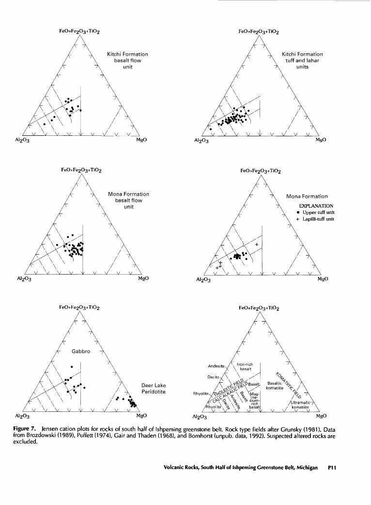
The volcanic and related intrusive rocks of the south half of the Ishpeming greenstone belt range in chemical composition from peridotite to rhyolite (fig. 7). The basalt flow unit of the Kitchi Formation is tholeiitic to iron-rich tholeiitic basalt. Several flows of calc-alkalic andesite occur near the top of the basalt flow unit. Thin interbed- ded tuffs are calc-alkalic dacite to rhyolite. The tuff and lahar units of the Kitchi Formation range from calc-alkalic basalt to dacite with andesite as the dominant rock type.
PI 0 Precambrian Geology of Lake Superior Region
Kitchi Formationbasalt flow
unit
Kitchi Formationtuff and lahar
units
A1203 MgO A1203 MgO
Mona Formationbasalt flow
unit
Mona Formation
EXPLANATION Upper tuff unit + Lapilli-tuff unit
A1203 MgO A1203 MgO
Deer Lake Peridotite
A1203 MgO A1203 MgO
Figure 7. Jensen cation plots for rocks of south half of Ishpeming greenstone belt. Rock type fields after Grunsky (1981). Data from Brozdowski (1989), Puffett (1974), Gair and Thaden (1968), and Bornhorst (unpub. data, 1992). Suspected altered rocks are excluded.
Volcanic Rocks, South Half of Ishpeming Greenstone Belt, Michigan P11
The stratigraphically higher basalt flow unit of the Mona Formation ranges from magnesium-rich to iron-rich tholeiitic basalt but is dominated by tholeiitic to magne sium-rich tholeiitic basalt. Limited data suggest that the lapilli-tuff unit of the Mona Formation is calc-alkalic dacite to rhyolite with intercalated tholeiitic basalt. The overlying and interfingering upper tuff unit is calc-alkalic basalt to andesite in composition.
The chemical composition of the Deer Lake Peridotite is within the range expected for komatiites (Arndt and Nisbet, 1982). However, field data indicate that it is not extrusive, but instead is a sill complex. The age relation ship between the Deer Lake Peridotite and other rock units is unknown. The peridotite intrudes the Kitchi Formation, which is older than the Mona Formation. The peridotite magmas may represent the ultramafic komatiite (fig. 7) subvolcanic base of a volcanic cycle that progressed with eruption of the basalt flow unit of the Mona Formation. Other interpretations are that (1) the peridotite may repre sent the residue of a basaltic magma chamber, or (2) the peridotite may represent part of a tectonically dismem bered Alpine-type intrusion.
The chemical composition of gabbro intrusions is simi lar to that of the basalts (fig. 7) and hence, the gabbros and basalts have been interpreted as comagmatic (Born- horst and Baxter, 1987).
In summary, the geochemical evolution of the south half of the Ishpeming greenstone belt was as follows: (1) tholeiitic basalt and calc-alkalic basalt to dacite (Kitchi Formation) followed by (2) tholeiitic to magnesium-rich tholeiitic basalt and calc-alkalic basalt, andesite, and rhyo lite (Mona Formation). Perhaps the base of (2) was peri- dotitic komatiite (Deer Lake Peridotite). Studies of other greenstone belts suggest that the silicic magmas in these volcanic piles may have no fractionation relationship with the basalts (Thurston and Chivers, 1990; Thurston and others, 1985). Further geochemical study of the volcanic rocks will aid in understanding magma genesis and in reconstructing the volcanic history of the belt.
ENVIRONMENTAL INTERPRETATION
Volcanic environments can be subdivided into four characteristic facies with respect to increasing distance from the volcanic vent: central or vent facies, proximal facies, distal facies, and epiclastic facies (Easton and Johns, 1986). The types of rocks that are characteristic of the various facies depend on the style of volcanic activity, for example, mafic plain volcanism versus mafic shield volcano versus intermediate to felsic composite volcano or caldera. Our environmental interpretation of the volcanic rocks of the Ishpeming greenstone belt is based on descriptions provided here and in references cited and on extensive unpublished field study of representative and
critical outcrops. We expect that future studies will pro vide more details but not significantly modify our environ mental interpretation.
The basalt flow units of both the Kitchi and Mona For mations are characterized by a large proportion of pil lowed flows, relatively thin massive flows, and sparse interlayered calc-alkalic intermediate to felsic tuff zones. Although some flows can be traced for distances of as much as several kilometers, none have been documented with extensive lateral continuity. Rare vesicles, lack of hyaloclastic breccias, and interbedded oxide-facies iron- formation are indicative of intermediate to deep-water paleoenvironment. Both basalt flow units are capped by calc-alkalic intermediate to felsic units. These features suggest that neither basalt flow unit represents mafic plain volcanism as described by Thurston and Chivers (1990). Rather, we interpret the basalt flow units as products of a submarine mafic shield volcano and part of mafic to felsic cyclical volcanism.
The interbedded tuff and lahar units of the Kitchi For mation are interpreted as being proximal facies based on dominance of tuffs, volcanic debris flows, and lava flows, and lack of sedimentary rocks. The abundance of lahar in the lower part of the stratigraphic column (fig. 4) and to the south contrasts with turbiditic rocks near the top and suggests deposition of the latter farther from the vent. We interpret these rocks as having been deposited in a subma rine fan on the flanks of the volcano.
The lapilli-tuff and upper tuff units of the Mona For mation are interpreted as representing a more distal envi ronment than the interbedded tuff and lahar units of the Kitchi Formation, based on the much higher proportion of sedimentary rocks, graywacke, and mudstone. We suggest that the environment is near the transition between proxi mal and distal (distal is more than 5-15 km from the vent) on the flank of the volcano.
The style of volcano for the intermediate to felsic units of both the Kitchi and Mona Formations may have been either submarine caldera or composite volcano and dome complex. Based on present data, the simplest interpretation is that the Kitchi and Mona Formations each represent a single overlapping volcano. Felsic zones interbedded within the basalt flow unit may be products of adjacent distal vol canoes not otherwise exposed in the Ishpeming greenstone belt. Although the intermediate to felsic units at the top of each formation were deposited in a subaqueous environ ment on the flank of a volcano, determining whether the vent itself was subaqueous or subaerial is not possible.
VOLCANIC HISTORY
The oldest Archean volcanic event recognized in the south half of the Ishpeming greenstone belt was the subaqueous eruption of tholeiitic basalt flows from a mafic
P12 Precambrian Geology of Lake Superior Region

shield volcano (basalt flow unit of the Kitchi Formation), probably before 2,700 Ma. As the volcano evolved, calc- alkalic andesite to dacite was erupted (tuff and lahar units of the Kitchi Formation). Later the Kitchi volcanic com plex was buried by subaqueous eruptions of tholeiitic basalt (basalt flow unit of the Mona Formation) derived from another mafic shield volcano. We speculate that ini tial peridotite magmas never erupted but rather were emplaced as subvolcanic sills (Deer Lake Peridotite). As this volcano evolved, calc-alkalic rhyolite and basalt were erupted and buried the tholeiitic basalt flows (lapilli-tuff and upper tuff units of the Mona Formation). During devel opment of the mafic shield volcanoes, comagmatic gabbro sills were intruded as subvolcanic bodies into the volcanic pile. These volcanic rocks were part of an arc developed in response to an inferred north-directed subduction of oce anic crust (Card, 1990). This magmatic arc system ceased with the initiation of deformation, which produced recum bent folding. The deformation may have been produced by collision along the Great Lakes tectonic zone.
REFERENCES CITED
Ayers, L.D., 1969, Geology of the Muskrat Dam Lake area: Ontario Department of Mines, Geological Report 74,74 p.
Arndt, N.T., and Nisbet, E.G., 1982, Komatiites: Boston, Mass., Alien and Unwin, 526 p.
Bornhorst, T.J., 1988, Geological overview of the Marquette greenstone belt, Michigan: 34th Institute on Lake Superior Geology, Marquette, Michigan, Field Trip Guidebook, v. 34, pt. 2, p. A1-A18.
Bornhorst, T.J., and Baxter, D.A., 1987, Geochemical character of Archean rocks from the east half of the northern complex, Upper Peninsula, Michigan: 33rd Institute on Lake Superior Geology, Wawa, Ontario, Proceedings and Abstracts, v. 33, pt. 1, p. 12.
Bornhorst, T.J., Shepeck, A.W., and Rossell, D.M., 1986, The Ropes gold mine, Marquette County, Michigan, U.S.A. An Archean hosted lode gold deposit, in Macdonald, A.J., ed., Proceedings of Gold '86, an International Symposium on the Geology of Gold, Toronto, p. 213-227.
Brozdowski, R.A., 1989, Ropes pyritic gold deposit in a dilational bend, Marquette greenstone belt, Michigan: London, Ontario, University of Western Ontario Ph. D. thesis, 592 p.
Cannon, W.F., and Klasner, J.S., 1977, Bedrock geologic map of the southern part of the Diorite and Champion 7'/i-minute quadrangles, Marquette County, Michigan: U.S. Geological Survey Miscellaneous Investigations Series Map 1-1058, scale 1:24,000.
Card, K.D., 1990, A review of the Superior Province of the Canadian Shield, a product of Archean accretion: Precambrian Research, v. 48, p. 99-156.
Card, K.D., and Ciesielski, Andre, 1986, DNAG No. 1 Subdivision of the Superior Province of the Canadian Shield: Geoscience Canada, v. 13, no. 1, p. 5-13.
Cas, R.A.F., Alien, R.L., Bull, S.W., Clifford, B.A., and Wright, J.V., 1990, Subaqueous, rhyolitic dome-top tuff cones A model based on the Devonian Bunga Beds, southeastern Australia and a modern analogue: Bulletin of Volcanology, v. 52, p. 159-174.
Cas, R.A.F., and Wright, J.V., 1987, Volcanic successions, modern and ancient: London, Alien and Unwin, 528 p.
Clark, L.D., Cannon, W.F., and Klasner, J.S., 1975, Bedrock geologic map of the Negaunee SW Quadrangle, Marquette County, Michigan: U.S. Geological Survey Geologic Quadrangle Map GQ-1226, scale 1:24,000.
Coleman, R.G., and Keith, T.E., 1971, A chemical study of serpentinization Burro Mountain, California: Journal of Petrology, v. 12, p. 311-328.
Easton, R.M., and Johns, G.W., 1986, Volcanology and mineral exploration The application of physical volcanology and facies studies: Ontario Geological Survey Miscellaneous Paper 129, p. l^M).
Gair, J.E., and Thaden, R.E., 1968, Geology of the Marquette and Sands Quadrangles, Marquette County, Michigan: U.S. Geological Survey Professional Paper 397, 77 p., scale 1:24,000.
Grunsky, E.G., 1981, No. 16 An algorithm for the classifica tion of subalkalic volcanic rocks using the Jensen cation plot: Ontario Geological Survey Miscellaneous Paper 100, p. 61-65.
Hammond, R.D., 1978, Geochronology and origin of Archean rocks in Marquette County, Upper Michigan: Lawrence, Kans., University of Kansas M.S. thesis, 69 p.
Johnson, R.C., and Bornhorst, T.J., 1991, Archean geology of the northern block of the Ishpeming greenstone belt, Marquette County, Michigan: U.S. Geological Survey Bulletin 1904-F, 20 p.
Morgan, J.P., and DeCristoforo, D.T., 1980, Geological evolution of the Ishpeming Greenstone Belt, Michigan, U.S.A.: Precambrian Research, v.ll, p. 23-41.
Puffett, W.P., 1974, Geology of the Negaunee Quadrangle, Marquette County, Michigan: U.S. Geological Survey Professional Paper 788, 53 p., scale 1:24,000.
Schmid, R., 1981, Descriptive nomenclature and classification of pyroclastic deposits and fragments Recommendations of the IUGS Subcommission on the systematics of igneous rocks: Geology, v. 9, p. 41-43.
Sims, P.K., 1991, Great Lakes tectonic zone in Marquette area, Michigan Implications for Archean tectonics in north- central United States: U.S. Geological Survey Bulletin 1904- E, 17 p.
Sims, P.K., Card, K.D., Morey, G.B., and Peterman, Z.E., 1980, The Great Lakes tectonic zone A major crustal structure in central North America: Geological Society of America Bulletin, v. 91, pt. 1, p. 690-698.
Thurston, P.C., Ayres, L.D., Edwards, G.R., Gelinas, L., Lud- den, J.N., and Verpaelst, P., 1985, Archean bimodal volca- nism: Geological Association of Canada Special Paper 28, p. 7-21.
Thurston, P.C., and Chivers, K.M., 1990, Secular variation in greenstone sequence development emphasizing Superior Province, Canada: Precambrian Research, v. 46, p. 21-58.
Trow, J., 1979, Final report of diamond drilling for geologic information in the Middle Precambrian basins in the western portion of Northern Michigan: Michigan Geological Survey, Department of Natural Resources, Open File Report UDOE OFRGJBX-162(79),44p.
Van Hise, C.R., and Bayley, W.S., 1895, Preliminary report on the Marquette iron-bearing district of Michigan: U.S. Geological Survey, 15th Annual Report, p. 485-650.
Wilkin, R.T., and Bornhorst, T.J., 1990, Geochemistry of Archean granitoids of the south-central Superior Province: Geologi cal Society of America Abstracts with Programs, v. 22, no. 7, p. A244.
AU.S. GOVERNMENT PRINTING OFFICE: 1993-774-049/66040 Volcanic Rocks, South Half of Ishpeming Greenstone Belt, Michigan P13


SELECTED SERIES OF U.S. GEOLOGICAL SURVEY PUBLICATIONS
Periodicals
Earthquakes & Volcanoes (issued bimonthly). Preliminary Determination of Epicenters (issued monthly).
Technical Books and Reports
Professional Papers are mainly comprehensive scientific reports of wide and lasting interest and importance to professional scientists and engineers. Included are reports on the results of resource studies and of topographic, hydrologic, and geologic investigations. They also include collections of related papers addressing different aspects of a single sci entific topic.
Bulletins contain significant data and interpretations that are of lasting scientific interest but are generally more limited in scope or geo graphic coverage than Professional Papers. They include the results of resource studies and of geologic and topographic investigations; as well as collections of short papers related to a specific topic.
Water-Supply Papers are comprehensive reports that present sig nificant interpretive results of hydrologic investigations of wide interest to professional geologists, hydrologists, and engineers. The series covers investigations in all phases of hydrology, including hydrology, availabil ity of water, quality of water, and use of water.
Circulars present administrative information or important scientif ic information of wide popular interest in a format designed for distribu tion at no cost to the public. Information is usually of short-term interest.
Water-Resources Investigations Reports are papers of an inter pretive nature made available to the public outside the formal USGS pub lications series. Copies are reproduced on request unlike formal USGS publications, and they are also available for public inspection at deposi tories indicated in USGS catalogs.
Open-File Reports include unpublished manuscript reports, maps, and other material that are made available for public consultation at de positories. They are a nonpermanent form of publication that maybe cit ed in other publications as sources of information.
Maps
Geologic Quadrangle Maps are multicolor geologic maps on to pographic bases in 7 1/2- or 15-minute quadrangle formats (scales main ly 1:24,000 or 1:62,500) showing bedrock, surficial, or engineering geology. Maps generally include brief texts; some maps include structure and columnar sections only.
Geophysical Investigations Maps are on topographic or planimet- ric bases at various scales, they show results of surveys using geophysi cal techniques, such as gravity, magnetic, seismic, or radioactivity, which reflect subsurface structures that are of economic or geologic signifi cance. Many maps include correlations with the geology.
Miscellaneous Investigations Series Maps are on planimetric or topographic bases of regular and irregular areas at various scales; they present a wide variety of format and subject matter. The series also in cludes 7 1/2-minute quadrangle photogeologic maps on planimetric bases which show geology as interpreted from aerial photographs. The series also includes maps of Mars and the Moon.
Coal Investigations Maps are geologic maps on topographic or planimetric bases at various scales showing bedrock or surficial geology, stratigraphy, and structural relations in certain coal-resource areas.
Oil and Gas Investigations Charts show stratigraphic informa tion for certain oil and gas fields and other areas having petroleum poten tial.
Miscellaneous Field Studies Maps are multicolor or black-and- white maps on topographic or planimetric bases on quadrangle or irreg ular areas at various scales. Pre-1971 maps show bedrock geology in re lation to specific mining or mineral-deposit problems; post-1971 maps are primarily black-and-white maps on various subjects such as environ mental studies or wilderness mineral investigations.
Hydrologic Investigations Atlases are multicolored or black-and- white maps on topographic or planimetric bases presenting a wide range of geohydrologic data of both regular and irregular areas; the principal scale is 1:24,000, and regional studies are at 1:250,000 scale or smaller.
Catalogs
Permanent catalogs, as well as some others, giving comprehensive listings of U.S. Geological Survey publications are available under the conditions indicated below from USGS Map Distribution, Box 25286, Building 810, Denver Federal Center, Denver, CO 80225. (See latest Price and Availability List)
"Publications of the Geological Survey, 1879-1961" may be pur chased by mail and over the counter in paperback book form and as a set microfiche.
"Publications of the Geological Survey, 1962-1970" may be pur chased by mail and over the counter in paperback book form and as a set of microfiche.
"Publications of the U.S. Geological Survey, 1971-1981" may be purchased by mail and over the counter in paperback book form (two volumes, publications listing and index) and as a set of microfiche.
Supplements for 1982, 1983, 1984, 1985, 1986, and for subse quent years since the last permanent catalog may be purchased by mail and over the counter in paperback book form.
State catalogs, "List of U.S. Geological Survey Geologic and Wa ter-Supply Reports and Maps For (State)," may be purchased by mail and over the counter in paperback booklet form only.
"Price and Availability List of U.S. Geological Survey Publica tions," issued annually, is available free of charge in paperback booklet form only.
Selected copies of a monthly catalog "New Publications of the U.S. Geological Survey" is available free of charge by mail or may be obtained over the counter in paperback booklet form only. Those wishing a free subscription to the monthly catalog "New Publications of the U.S. Geological Survey" should write to the U.S. Geological Survey, 582 Na tional Center, Reston, VA 22092.
Note.-Prices of Government publications listed in older catalogs, announcements, and publications may be incorrect. Therefore, the prices charged may differ from the prices in catalogs, announcements, and pub lications.
