geology of the gerlach-hualapai flat geothermal area...
TRANSCRIPT

GL02888 7
Geology of the Gerlach-Hualapai Flat Geothermal Area,
Northwestern Nevada
L. T. Grose and R. J. Sperandio
ABSTRACT
The 500-square mile (1,280 square km) area around Gerlach and Hualapai Flat in northwestern Nevada includes PermoTriassic metavolcanic and metasedimentary rocks disposed as roof pendants in Cretaceous granodiorite, Late Oligocene-Early Miocene rhyolitic, andesitic, and basaltic sequences, and Pliocene(?) and Quaternary alluvial and lacustrine sediments. The volcanic activity is far too old (23 my) to act as a source of heat in the area. Metasedimentary, granitic, volcanic, and alluvial clastic rocks may act as geothermal reservoirs. Thick lacustrine clays and alluvial-fluvial sediments as well as thick tuffaceous units have strong thermal insulating or cap rock properties.
The location of the Gerlach hot springs is controlled by quasiradial spreading effected by contemporaneous activity on intersecting major regional normal faults. The location of Fly Ranch hot springs is also fault controlled and in addition is associated with modern tectonic rifting. Geothermal convection systems occur in the area, not by virtue of volcanic heating, but by trapping high regional heat flow beneath thermally insulating layers and by creating and maintaining open fractures by recurrent tensional tectonic activity.
INTRODUCTION
This report sets out the general geologic framework of about 500 square miles (1,280 square km) centered around Gerlach and Hu~lap~i Flat in the southwestern part of the Black Rock Desert r-e~lOn m northwestern Nevada. (pI. I). The area lies about 85 l"lllies (136 km) north-northeast of Reno Nevada and about 30 miles (49 km) due east of the California:Nevada ~tate line. The Fault-block ~rrain is typical of many areas in the Basin and Range provmce. The Granite Range is the highest in north-
1
western Nevada, reaching an elevation of 9,056 feet (2,n7 m) and rising abruptly above the Black Rock Desert and the Smoke Creek Desert playas which are about 3,900 feet (1,170 m) elevation (fig. 1). Hualapai Flat is a relatively small (100 square mile or 200 square km) intermountain basin varying from 4,000 to 5,000 feet elevation (1,200 to 1,500 m) (fig. 2). <
From a geothermal standpoint this area is particularly interesting because: (1) it includes three thermal spring clusters; (2) it is part of a well-defined northeast-trending zone of thermal springs in northwest Nevada (Hose and Taylor 1974); (3) it lies in the middle of a region extending from southwest Idaho into northern California characterized by modern hydrothermal convection systems with indicated subsurface temperature above 150°C (Renner and others 1975); (4) it lies within the Battle Mountain Heat Flow province (Sass and others 1971; Diment and others 1975; Lachenbruch and Sass 1976); (5) it displays abundant evidence of Late Quaternary and Holocene normal faulting, some associated with the hot springs; (6) it is nonvolcanic insofar as Pliocene and Quaternary volcanic activity is concerned, hence volcanism as a heat source for the modern geothermal systems there can be ruled out; and (7) it is typical and representative of large regions in the Basin and Range province that have geothermal energy potential without associated volcanism.
Geologic field studies have been carried out in concert with the various geophysical and geochemical studies described in this volume. As work progressed, geological data were released in the following reports: Grose and Keller 1974, 1975; Keller and others 1974; Grose 1976; Sperandio and Grose 1976; and Keller and others 1978.
GEOLOGIC FORMATIONS
The Gerlach-Hualapai Flat area is underlain by complex and diversified formations that range from Late Paleozoic to Quater-

2 COLORADO SCHOOL OF MINES QUARTERLY
Figure I.-Oblique air view northward of: (1) Granite Range (GR), and its east-west profile reflecting four fault-block levels, and (2) Gerlach area of junction of Black Rock Desert (BRD), San
nary (pI. l). Different scales of mapping in the area to date have delineated different mappable units. More broadly defined units are indicated on the reconnaissance maps at scale 1:250,000 by Bonham (1969), Tatlock (1969), and Willden (1964), and on the Nevada State Geologic Map at scale 1:500,000 by Stewart and Carlson (1974). Greater subdivisions of rock units are presented on local maps in the general area by Anderson (1977), Crewdson (1974), Olmsted and others (1975), and Sperandio (1978). The geologic map accompanying this report (pl. l) was prepared at a scale of 1 :62,500 and is largely based on field mapping by Grose and Sperandio at scale 1:29,000. Ten formations are delineated and are discussed briefly in the following sections. For more information on various units in the area, refer to the above cited references.
PERMO. TRIASSIC META VOLCANIC AND METASEDIMENTARY ROCKS
The oldest formations exposed in the Gerlach-Hualapai Flat area are Permo-Triassic metavolcanic and metasedimentary rocks. Three lithologic assemblages are recognized as follows: (1) amphibolite and amphibolite gneiss in the western part of the Selenite Range, (2) meta-basalt and meta-andesite in the northeastern, northern, and northwestern parts ofthe Granite Range, and (3) metasedimentary and metavolcanic rocks interbedded in the northern part of the Granite Range and in the southwestern tip of the Calico Mountains. These three assemblages crop out as
Emidio Desert (SED), Smoke Creek Desert (SCD), and Gerlach (G), Gerlach hot springs (GHS); Calico Mountains (CM). (Photo: LTG 13275)
isolated roof pendants several miles apart in Cretaceous granodiorite, yet their internal bedding strikes rather consistently in an east-northeasterly direction where measurable mostly in the northern part of the area. Dips vary steeply on both sides of vertical, but appear to be more commonly to the north. The overall sequence crudely extrapolated among the scattered masses in the region suggests east-northeast-trending zones consisting of a southern zone of amphibolite, a middle zone of metavolcanic rocks, and a northern zone of interbedded metavolcanic and metasedimentary rocks. Neither top nor bottom nor stratigraphic succession of these rocks are known in the region. Bedding is preserved only in the metasedimentary sequences, thus internal structures of large areas of metavolcanic and amphibolitic rocks are unknown. The largest mass exposed, that in the northern part of the Granite Range, suggests a possible minimum thickness of25,000 feet (7,500 m). If the widely occurring masses all have near-vertical internal bedding structure and if the rocks are not repeated, the stratigraphic thickness originally would have approached 100,000 feet (30,000 m). That unlikely figure plus geometric constraints strongly suggest that the sequence has been tectonically thickened by isoclinal folding and! or thrusting.
The roof pendant masses have near-vertical sharp intrusive contact with adjacent granodioritic rocks, and these contacts appear to indiscriminately cut across various lithologies in the pendant masses.
Subsurface occurrence of these rocks is inferred by projection across covered areas. Both internal structure and alignment of

"
GEOLOGY OF THE GERLACH-HuALAPAI FLAT GEOTHERMAL AREA 3
Figure 2.-View northeastward from crest of Granite Range, toward central and northern parts of Hualapai Flat and Calico Mountains (CM). Light-colored rocks in Calico Mountains are
preserved pendant masses strongly suggest that'the central part of Hualapai Flat which includes Fly Ranch hot springs is underlain by metavolcanic and metasedimentary units.
Amphibolitic rocks locally in the western part of the Selenite Range are fine- to coarse-grained, massive, and locally schistose and gneissose. Hornblende, biotite, and plagioclase are the major minerals, but in small patches quartz, K-feldspar, and epidote occur. While not studied in detail, and. recognizing that correlation is tenuous at best, these rocks are tentatively regarded as a medium-grade, somewhat dynamothermally metamorphosed equivalent of the thermally metamorphosed basalts and andesites that occur several miles north.
Large areas of intermediate to mafic flows and flow breccias occur in and northeast of the Granite Range. The rocks are characteristically dark greeni/>h-gray, massive-directionless, dense, aphanitic to fine-grained, and rarely porphyritic. Green smudges, veins, and clots, caused largely by epidote, are ubiquitous except for within several hundred meters of contact with granodiorite, where epidote content decreases and actinolite increases. Original igneous textures are preserved although modified by crystaloblastic amphibole and epidote. Original minerals are largely destroyed by propylitization and epidotization associated with regional thermal (static) metamorphism accompanying the batholithic intrusions of Cretaceous granodiorite. The modal mineralogy of these rocks (Sperandio 1978) is consistent with that found in the albite-epidote hornfels facies of a contact metamorphic aureole for a mafic rock (Turner 1968, p. ]92). Mineralogy of the rocks within 1 km of the granodiorite indicates the higher grade hornblende-hornfels facies. The meta-
highly altered Middle Tertiary volcanics. BRD-Black Rock Desert; BRR-Black Rock Range; FRHS-Fly Range hot springs .. (Photo: LTG 14577)
volcanic rocks in the Gerlach-Hualapai Flat area resemble those described by Compton (1958) in the Northern Sierra Nevada (Bidwell Bar area).
The sequences of interbedded flows and metasediments comprise up to 5,000 feet (1,500 m) of highly deformed and weakly metamorphosed flows, limestone, calcareous shale, siltstone, sandstone, and chert. Limestone units in the northern part of the Granite Range are greater than 1,000 feet (300m) in thickness. In the northwest part they are 20 to 40 feet (6 to 12 m) thick sandwiched between mafic flows 50 to 200 feet (15 to 60 m) thick. At the southwestern tip of the Calico Mountains a complexly interbedded series over 1,000 feet thick (300 m) of chert, limestone, sandstone, fissile shale, mudstone, and mafic flows occurs wherein most of the contacts between the units are bedding faults. Although internally highly deformed, this entire volcanic-sedimentary sequence appears to be a major basement unit that may extend as a continuous band across the Hualapai Flat area.
No identifiable fossils were found in the Permo-Triassic sequences in the Gerlach-Hualapai Flat area. However, Bonham (1969, p. 5) reports that a cast of a Triassic ammonite had been uncovered in a small mine in the metasedimentary sequence occurring in the extreme northwestern end ofthe Granite Range. A volcanic and sedimentary section, remarkably lithologically similar to the section in the Hualapai Flat area, occurs at Black Ruck which is located 15 miles (24 km) on structural trend in an east-northeasterly direction from similar rocks in the southwestern part of the Calico Mountains. These strata yielded Permian brachiopods (Gianella and Larson 1960; Howe 1975). Other

4 COLORADO SCHOOL OF MINES QUARTERLY
sections in the region that generally lithologically resemble the Permo-Triassic section in the Hualapai Flat area include the Happy Creek Group and overlying units in the Jackson Mountains (Willden 1964),40 miles (64 km) northeast, and in the Pine Forest Range (Smith 1973) 60 miles (96 km) north-northeast.
CRETACEOUS GRANITIC ROCKS
Granitic rocks of batholithic proportions and included roof pendants of metavolcanic and metasedimentary rocks are believed to underlie at least the south half ofthe Gerlach-Hualapai Flat area. The cores of the Granite Range (figs. 1 and 3), the Selenite Range, and the Fox Range-all horst blocks-are composed of granodioritic to dioritic rocks. In the Selenite Range and in the northern part of the Granite Range these rocks are locally overlain on a surface of a few hundred feet of relief by Late Oligocene to Early Miocene silicic and mafic flows. In many places the plutonic rocks are in fault contact with younger rocks. Granodiorite at the southern end of the Granite Range is especially strongly jointed and faulted. The Gerlach hot springs system (fig. 4) occurs in these highly fractured rocks and alters them (Romberger 1978, this volume).
Granodiorite is volumetrically most abundant. Modal analyses indicated petrographic range from granite to diorite (Sperandio 1978). Biotite, hornblende, and quartz are ubiquitous minor minerals. It is medium-grained, massive-directionless, uniform, and strongly jointed in many directions. Near intrusive borders, however, texture varies, a slight gneissic or flow layering occurs, composition changes to quartz diorite and diorite, and aplites,
Fig-ure 3.-View south-southeastward along strike of major east-dipping normal fault on the eastern side of the Granite
pegmatites and xenoliths become abundant. Mineralogical vari. ation between granodiorite and diorite is gradual through a few .hundred feet which suggests origin from cooling a single pluton. Several properties of the batholith exposed in the Granite Range suggest that it was emplaced in the lower epizone and upper mesozone at a depth of 3 to 6 miles (5 to 10 km) (Buddington 1959). They are: (1) contacts between batholith and wall rock are discordant; (2) country rock several kilometers from the batho_ lith has been thermally metamorphosed to the albite-epidote-ac_ tinolite grade; (3) country rock in close proximity to the batholith has been contact metamorphosed to the hornblende-plagioclase hornfels facies; (4) there are no known exposures of cogenetic volcanic rocks; (5) there are no chilled borders or miarolitic cavities in the batholith; (6) planar foliation is generally absent but is weakly developed in the border zone subparallel to the contact; and (7) assimilation of wall rocks within the batholith is common and obvious.
Granitic rocks in the Gerlach-Hualapai Flat area have yielded K-Ar biotite ages of 89 my (Bonham 1969) and 91 my (Smith and others 1971). Petrographic, chemical, and geochronological characteristics of many Cretaceous plutonic rocks in northwestern Nevada are similar, and they resemble granitic rocks in the Sierra Nevada and Idaho batholiths (Smith and others 1971).
LATE OLIGOCENE-EARLY MIOCENE VOLCANIC ROCKS
A complex and highly varied volcanic assemblage comprises
Range. HF-southwest corner of Hualapai Flat. (Photo: LTG 13077)

GEOLOGY OF THE GERLACH-HUALAPAI FLAT GEOTHERMAL AREA 5
Figure 4.-;-ObIique air view nort.hwestward ofGe~I!lch hot ~pring area; GHS-Gerlach hot sprIngs (Great BOllIng sprIngs); MHS-Mud hot springs; G-edge of town of Gerlach; AR-al-
bedrock in the northern half of the Gerlach-Hualapai Flat area, and younger parts ofthe assemblage are exposed southwest of the Granite Range and low on the western flank of the Selenite Range. Three major units are herein mapped (pI. I). They are from oldest to youngest: (1) intermediate flows and flow breccias, (2) silicic flows, tuffs, and tuffaceous sedimentary rocks, and (3) basalt flows. In the main mass of volcanic rocks in the northern part of the area, southwest regional dip generally affects preservation ofthe oldest units in the north and an increasingly thicker sequence toward the south. The oldest unit crops out only around the northern end of Hualapai Flat, but it probably continues southward in the subsurface beneath Hualapai Flat and adjacent younger volcanic units. It has not been observed south of the Granite Range, however and in the Selenite Range it is absent since silicic rocks, probably correlative with the second unit, lie o~ granitic basement. The next youngest unit was much more Widespread, but at two localities-northwest end of the Granite Range and west flank of the Selenite Range-it is absent where the overlYing basalt lies directly on granitic basement. Struc~~ral dips in the silicic volcanic layers are usually moderate but
Ighly variable. In the southern part of the Calico Mountains, a l!everal-square_mile area of bleached altered silicic volcanics may represent a Source of some of the rocks of this unit. It has not i h::vest.igate~ in detail however. The youngest volcanic unit n t ~ urea IS a thm series of basalt flows that everywhere uncon-
tered rocks of old Gerlach hot spring system; GR-southern end of Granite Range; LS-Lake Lahontan recessional shorelines; FS-fault scarp. (Photo: LTG 32175).
formably overlies the silicic series, except for small areas in the northwestern part of the Granite Range and the Selenite Range where it lies on granitic basement.
The volcanic assemblage around Hualapai Flat is part of t' e southeastern most extent of the greater Modoc volcanic plate" Ll
area. These f(JCks almost certainly continue beneath most df Hualapai Flat and Smoke Creek Desert, but it is unknown whether or not, or to what extent, they occur beneath the southwest part of the Black Rock Desert.
Flows and flow breccias of hornblende-pyroxene andesite, biotite-hornblt,nde andesite, and leucite-augite andesite accumulated to thicknesses in excess of 2,000 feet (600 m). The breccias are rnonolithologic, crudely stratified to unstratified, and unsorted with fragments ranging in size from less than a centimeter to greater than 20 meters in diameter. Although most of the andesites are unaltered, a series of flows and breccias adjacent to thl: northwest part of Hualapai Flat exhibits pervasive propylitic alteration. Unaltered andesites overlie them.
The middle unit of silicic flows, tuffs, and tuffaceous sediments may exceed 4/.iOO feet (1,200 m) in thickness on the north flank of the Granite R:.mge. Poorly exposed white silicic airfall tuffs and interbedded fine-grained tuffaceous sediments comprise the great bulk or this unit, whereas rhyolite flows and ash-flows locally occur. !n the sou thern part ofthe Calico Mountains, where this silicic u;",it is unusually thick, it has been pervasively
6 COLORADO SCHOOL OF MINES QUARTERLY
silicified over a deeply exposed area of about 8 square miles (20 sq. km).
Basalt flows comprise the top and youngest unit. They are aphanivitric to microporphyritic with phenocrysts of plagioclase, olivine, and clinopyroxene. Preserved sections range up to several hundred feet thick on the north flank of the Granite Range.
The entire volcanic assemblage in the Hualapai Flat area was relegated by Bonham (1969) to the Oligocene South Willow Formation, his bottom unit of the Tertiary volcanic section in the northwestern Nevada region. The part of the basalt unit that occurs at high elevation in the northwest part of the Granite Range is believed to be equivalent to a basalt Bonham mapped in extensive areas of the greater Modoc Plateau and regarded as Upper Miocene and Pliocene. Two recently derived K-Ar age dates include andesite flow breccia from the east side of Hualapai Flat at 26.4 ±0.2 my and basalt from the northern part of Hualapai Flat at 23.4 ±0.2 my (McKee, E. H., personal communication, 1978). The silicic unit in between may represent a far south occurrence of the Ashdown Tuff dated at approximately 24 my (Noble and others 1970). Therefore, it appears that all of the preserved post-Cretaceous volcanic rocks in the GerlachHualapai Flat area testify to a 3 to 4 million-year period of volcanism in latest Oligocene and earliest Miocene. This volcanic
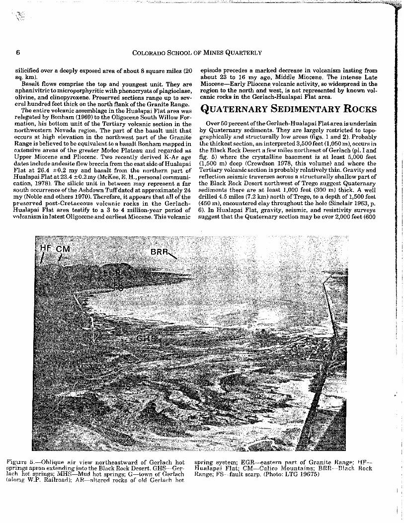
Figure 5.-0blique air view northeastward of Gerlach hot sprin$s .apro~ extend~ng into the Blac~ Rockpesert. G~s.-Ger. lach flOl:; sprmgs; MRS-Mud hot sprmgs; G-town of Gerlach (along W.P. Railroad); AR-altered rocks of old Gerlach hot
episode precedes a marked decrease in volcanism lasting from about 23 to 16 my ago, Middle Miocene. The intense Late Miocene-Early Pliocene volcanic activity, so widespread in the region to the north and west, is not represented by known volcanic rocks in the Gerlach-Hualapai Flat area.
QUATERNARY SEDIMENTARY ROCKS
Over 50 percent of the Gerlach-Hualapai Flat area is underlain by Quaternary sediments. They are largely restricted to topographically and structurally low areas (figs. 1 and 2). Probably the thickest section, an interpreted 3,500 feet (1,050 m), occurs in the Black Rock Desert a few miles northeast of Gerlach (pI. I and fig. 5) where the crystalline basement is at least 5,000 feet (1,500 m) deep (Crewdson 1978, this volume) and where the Tertiary volcanic section is probably relatively thin. Gravity and reflection seismic traverses across a structurally shallow part of the Black Rock Desert northwest of Trego suggest Quaternary sediments there are at least 1,000 feet (300 m) thick. A well drilled 4.5 miles (7.2 km) north of Trego, to a depth of 1,500 feet (450 m), encountered clay throughout the hole (Sinclair 1963, p. 6). In Hualapai Flat, gravity, seismic, and resistivity surveys suggest that the Quaternary section may be over 2,000 feet (600
spring system; EGR--eastern part of Granite Range; HFHualapai Flat; CM-Calico Mountains; BRR-B1ack Rock Range; FS-fault scarp. (Photo: LTG 19675)

GEOLOGY OF THE GERLACH-HUALAPAI FLAT GEOTHERMAL AREA 7
m) thick. Thicknesses of Quaternary in the Smoke Creek Desert are totally unknown. An anomalously elevated and isolated remnant of Quaternary alluvium occurs in a structural block within the southeastern part of the Granite Range 5 miles (8 km) north of Gerlach. Quaternary sediments are in both depositional and fault contact with all older rocks, and, except for local tilting associated with faulting, they exhibit low primary dips.
In this report the Quaternary sediments are illustrated on the geologic map (pl.l) by two units: (1) alluvium, colluvium, lacustrine deposits, dunes, and hot spring deposits, and (2) modern playa deposits. Locally derived alluvium of pre-Lahontan to modern vintage blankets the higher elevations around the margin of Hualapai Flat. Lahontan clays, shore-zone and near-shore silts, sands, and gravels and locally travertine are discontinuously exposed in the areas with elevations below the maximum height reached by Lake Lahontan, 4,380 feet (1,314 m). These areas include most of Hualapai Flat and a narrow zone along the margin of the Black Rock and Smoke Creek Deserts. Six hundred sixty feet of Lahontan (possibly including pre-Lahontan) clay and sand were penetrated in two temperature test holes within one mile of granodioriteoutcrop at Gerlach (Cordero Mining Co. 1974). Another drill hole of the same total depth nearly one mile northeast of Fly Ranch hot spring in the central area of Hualapai Flat encountered a clay and sand section that is probably entirely of Lahontan origin.
Figure B.-Oblique air view northwestward of Fly Ranch hot spring area, FRHS. SP-water storage pond artifically dammed at north and south ends; FS-fault scarp. Background is north-
Post-Lahontan sediments consist of clays in the modern playa depressions, alluvium, dunes covering a few square miles on the eastern margin of Hualapai Flat, and hot spring deposits at Gerlach and Fly Ranch (figs. 5 and 6).
STRUCTURAL GEOLOGY The deformational structures within the Gerlach-Hualapai
Flat area are numerous, widespread, and diversified, and they reflect several episodes of different and superimposed stressstrain fields. In this section we summarize the structural geology; a companion article (Grose 1978, this volume) treats the subject in some detail.
A persistent east-northeast strike of subvertical Permo-Triassic metasedimentary and metavolcanic beds occurs in the basement terrain. Within these beds are many faults that closely parallel bedding and cause local tectonic slivering and pinch-out. The entire sequence is pervasively sheared and compressed, though rarely is metamorphic foliation developed. Field relations (discussed previously) dictate that the sequence must have been isoclinally folded or imbricately thrust faulted-compressed on a
western re-entrant in Hualapai Flat underlain by Tertiary volcanic rocks. (Photo: LTG 18275)

8 COLORADO SCHOOL OF MINES QUARTERLY
regional scale along a north-northwest-south-southeast axis (assuming no later regional rotation). Cretaceous granitic intrusions cut across the older fabric and appear in no way to be geometrically or mechanically related. The Permo-Triassic rocks record a period of strong orogeny that occurred between Triassic and Mid-Cretaceous.
The granitic rocks are essentially massive-directionless. Contacts with the roof pendants are sharp and near-vertical, and the bedding in the pendants shows no deformation attributable to the emplacement ofthe pluton. Structures in the granitic masses are almost entirely joints and tensional block faults that were created in Late Cenozoic.
The volcanic sequence that overlies basement is irregularly and moderately tilted to the southwest in the northwestern part of the area. Elsewhere the dips are variable. Within the silicic unit some local dips are steep; they may reflect nontectonic deformation. However, the contact with overlying basalt is usually an angular unconformity that implies significant deformation and erosion concurrent with the volcanic activity.
Superimposed on older structures are major normal faults of Late Cenozoic age that outline several large structural-topographic units-basins and ranges (pI. I). Three major fault trends prevail: (1) a northeast trend associated with the Black Rock Desert, (2) a northwest trend associated with the Granite Range, and (3) a north-south trend associated with Hualapai Flat, Granite Range, and Selenite Range. The three fault zones intersect in the topographically low area around Gerlach at the junction of three grabens-the Black Rock Desert, the Smoke Creek Desert, and the San Emidio Desert (fig. 1). The adjacent ranges are horsts. The fault zones involve essentially normal dip slip with minimum vertical displacement of 5,000 feet (1,500 m).
The Granite Range uplift is composed off our blocks that step down toward the Black Rock Desert, structurally and topographically, from west to east along north-south, steeply eastdipping normal faults (figs. 1 and 3). The great northwest-trending normal fault at the base of the southwestern flank of the Granite Range is composed of several north-south en echelon normal faults which suggest a significant component of right lateral displacement. The south end of the Granite Range, where the major fault zones intersect and where the Gerlach hot springs system occurs, is transected by several east-west down-to-south normal faults (fig. 4). Within the western and highest block of the Granite Range, several prominent north-northwest trending normal faults extend for several miles and successively drop blocks down on the eastern flank toward Hualapai Flat (fig. 3). All of the major faults in the Gerlach area show evidence, mainly fault scarps, of Quaternary (including Holocene) movement. Since these major faults have moved essentially contemporaneously and since they are all normal and of trends that nearly box the compass, crustal extension must be in several directions, or in composite, must be quasiradial in this particular area around Gerlach.
Hualapai Flat is a north-south trending structural-topographic graben of intermediate level between the Granite Range and the Black Rock Desert (pI. I and fig. 2). The east side is a low horst (Steamboat Ridge) and the uplift of the Calico Mountains, whereas the west side is mainly a moderately elevated volcanic plateau block. The major north-south fault zone in the region passes along the western margin of Hualapai Flat and is expressed there by a variety offaults and uplifted blocks. Numerous Holocene normal fault scarps and open tectonic cracks (rifts) (fig. 6 and Grose, figs. 1 and 2) trend northeasterly in this north-south zone. These faults suggest a component of right lateral displace-
ment. The topographic low of Hualapai Flat is "Alkali Playa" in the southern part, but the bedrock low of Hualapai Flat is expressed by gravity studies appears to be in the northern part.
The subsurface structure of the Black Rock Desert graben is inferred from gravity and limited seismic data. (Crewdson 1978, this report). Crystalline basement is interpreted to lie at greatest depth, about 5,000 feet (1,500 m), along the northwest side of the playa about 4 miles (6.4 km) northeast of Gerlach (fig. 5). This area is also close to the topographically lowest part of the playa surface. To the northeast the basement gradually rises to about 3,000 feet (900 m) depth below ground surface northwest of Trego.
In summary, the Late Cenozoic deformation in the GerlachHualapai Flat area thoroughly broke up older structural elements, and it determines largely the modern physiographic, depositional, and structural regimes in the area. Furthermore, it greatly influences the location of hot springs and probably other geothermal systems in the- area.
HYDROGEOLOGIC SETTING
The Gerlach-Hualapai Flat area includes three groups of hot springs, Gerlach (figs. 4 and 5), Fly Ranch (fig. 6), and Trego (pI. I). Gerlach hot springs are used for bathing and local stock water supply; Fly Ranch hot springs are used for irrigation; and Trego hot spring is not used. Groundwater is pumped for irrigation at Hualapai Flat (Harrill 1969) (fig. 2), otherwise the ground waters of the region remain undeveloped.
Hydrogeologic studies pertaining to the groundwater resources of the Gerlach-Hualapai Flat area are presented in articles by Sinclair (1962; 1963), Harrill (1969), and the geothermal system at Gerlach in particular is discussed in considerable detail by Olmsted and others (1975). Hot springs in the region, first described by Waring (1965), were analyzed by Mariner and others (1974) and by Anderson (1977) for water characterization and geothermometry.
Groundwater, nonthermal and thermal, is stored in fractured crystalline basement and in the overlying Tertiary volcanic rocks and Quaternary sedifnents. The greatest groundwater accumulation occurs in the graben fill (volcanics and sediments) of the Black Rock Desert and of Hualapai Flat. Surficial playa and underlying Lahontan lacustrine clays have very high water content (high porosity), but low permeability and are therefore a barrier to horizontal and vertical flow. Alluvium beneath the clays and interstratified with the clays has high permeability and yields large quantities of water to wells in Hualapai Flat.
The underlying volcanic and volcaniclastic layers are probably extremely variable in porosity and permeability. They may have a large, at least local, potential for water storage, discharge, and recharge. The granitic, metavolcanic, and metasedimentary rocks of the basement have virtually no primary porosity or permeability. However, tensional fracturing of these relatively brittle rocks is extensive in the area and therefore storage in fracture stock works and permeability through fractures may locally affect significant groundwater reserves. The thermal springs of the area are probably localized by circulation through deep fractures (Hose and Taylor 1974; Olmsted and others 1975).
\

GEOLOGY OF THE GERLACH-HuALAPAI FLAT GEOTHERMAL AREA 9
Water recharge to storage basins and fracture zones is supplied by precipitation mainly as local runoff from the bordering mountain ranges. The Granite Range, receiving over 20 inches (508 mm) average yearly precipitation, is the major local source of recharge to the southwestern part of the Black Rock Desert (fig. 1). Several miles to the east of the Gerlach-Hualapai Flat area the Black Rock Desert playa is the sink for the Quinn River (fig. 5) which drains an extensive region to the northeast. Subsurface hydraulic continuity may exist through fractures and deep aquifers between the Quinn River and the Gerlach area. Lateral groundwater migration is suggested because discharge of local spring water at Gerlach (1,450 ± ac-ft/yr) far exceeds recharge from local drainages. Recharge to Hualapai Flat comes from precipitation in the roughly 200-square-mile area around the Flat. Recharge in the general area takes place by seepage from surface runoff in alluvial and piedmont slopes which border the impermeable playa clays in the lowest parts of the basins. Also a great deal of recharge is probably effected through fractures within the ranges that extend into the subsurface of the basins, such as from the Granite Range into the Black Rock Desert.
Groundwater discharges by evaporation, evapotranspiration, and nonthermal and thermal springs. Increased discharge in Hualapai Flat has occurred since the advent of irrigation in the early 1960s.
THERMOGEOLOGY The Gerlach-Hualapai Flat area is underlain by five major
lithologic groups each of which appears to have significant characteristics relative to the possible occurrence of geothermal energy resources. These groups are: (1) metavolcanic rocks, (2) metasedimentary rocks, (3) granitic rocks, (4) volcanic sequences, and (5) alluvial and lacustrine layers. None of them is a viable heat source. All of them could be reservoir rock for geothermal systems. The last two could serve as cap rocks.
The metavolcanic rocks are very dense and tight but locally are highly fractured. Propylitic alteration and epidotization are pervasive through the rock fabric and have affected fracture filling with clays and epidote. The rock is unusually reactive at epithermal temperatures and hence would tend to recrystallize and alter to more clayey materials. Only constantly renewed tectonic fracturing could keep the fractures open and hence maintain a reservoir. The carbonate sections of the metasedimentary sequence could serve as reservoirs by virtue of the relative solubility of carbonate. These sections may indeed occur in the basement of Hualapai Flat trending east-northeasterly (pi. l) at estimated depths of 3,000 or 4,000 feet (900 or 1,200 m) about one mile north of Fly Ranch hot spring. The abnormally large travertine mound at Fly Ranch suggests dissolved carbonate at depth. The other metasedimentary rocks are capable of brittle fracture, but are nonporous.
The granitic rocks have insignificant primary intercrystalline porosity and permeability. However, jointing and tensional faulting are widespread along the edges and in many zones within the plutonic masses in the area (fig. 3). Hydrothermal circulation, alteration, and deposition are evident in fracture zones associated with what is believed to be an ancestral Gerlach hot spring system at the base of the Granite Range (fig. 4) (Romberger 1978, this volume). The modern Gerlach thermal spring
system probably occurs in intensely and deeply fractured granitic rocks. Fracture-type geothermal reservoirs in granitic basement l may be common and typical in this region. -..J
The volcanic' sequences are too old (23 my) and cold to supply heat to the modern hot spring systems known in the area. The lower andesite flows and breccias are probably capable of maintaining open fractures of both primary and secondary origin. The middle silicic pyroclastic unit as a whole is probably relatively impermeable and hence could serve as a cap rock. However, individual layers of unaltered coarse pyroclastic and clastic debris may retain original porosity and permeability and hence serve as reservoirs. The upper volcanic unit, basalt flows, probably has many fractures preserved from cooling and from later deformation, at least locally, and could be an excellent fracturetype reservoir. Areas where these volcanic sequences could be geothermal reservoir rocks are in the northern half of Hualapai Flat and possibly within the grabens around Gerlach.
The alluvial and clay layers that overlie all older rocks in the grabens are believed to be very important reservoir rocks and cap rocks, respectively. Porous and permeable coarse to fine alluvium at least several hundred feet thick probably forms an extensive aquifer or reservoir beneath lacustrine clays of Hualapai Flat and the Black Rock Desert. The interbedded, but largely overlying clays, have accumulated to thicknesses of several hundred to over 1,500 feet (450 m). They are areally extensive (figs. 1 and 5), impermeable, water-saturated, and incapable of maintaining open fractures. Data from temperature test holes (Olmsted and others 1975) drilled into the playa clays reveal a thermal conductivity of about 2 x 10 -3 cal cm-Is-IOC-I and a thermal gradient of about 75°C km-I. These properties indicate that the lacustrine clay section is an effective cap. rock, a regional thermal insulator preventing the escape of water and heat from large areas. Therefore heat and fluids are probably trapped at relatively shallow depths beneath Hualapai Flat and on a larger scale beneath the Black Rock Desert (figs. 2 and 5).
In the foregoing discussion we point out that the rocks exposed in the Gerlach-Hualapai Flat area do not provide a source for shallow heat, (the way that Quaternary volcanic rocks do in many areas of the world), but they do provide reservoirs and entrapment of shallow heat. Recurrent tensional fracturing is essential to the maintenance of geothermal reservoirs. Tectonic. studies described herein and in a companion report (Grose 1978, this volume) reveal that the Gerlach-Hualapai Flat area has been undergoing normal faulting and rifting during the Late Quaternary, including historic time, and probably for a much longer time back into the Late Tertiary coincident with extension throughout the northern part of the Basin and Range province. The freshest fault scarps (presumably the youngest) in the area are in close proximity to the thermal springs. The springs issue from fractures within major throughgoing and presumably deeply penetrating fault zones. The largest and hottest spring system in the area (Gerlach) is situated at the junction of the three regional fault zones (fig. 1) where it can be shown that contemporaneous faulting has produced a degree of radial spreading centered in the hot spring area. Not only faulting, but modern rifting (a prelude to faulting?) is occurring in the central parts of Hualapai Flat (Grose, fig. 2) in the same zone as the Fly Ranch hot spring.
In this non volcanic region of high conductive heat flow and widespread thermal insulation, delineation of active and deep tensional fracturing zones should assist in the discovery of geothermal convection systems without surface manifestations.

10 COLORADO SCHOOL OF MINES QUARTERLY
R1t;FERENCES ..i h geological and geochemical study of the south-
Anderson, J. P., 191 i ii' ~ Rock Desert and its geothermal areas, Washoe, west part of the BI:'rjIIiJdt counties, Nevada: M.Sc. thesis T-1837, ColPershing, and Htill~ Holden. orado School Mitiltj;',:IIJOgy and mineral deposits of Washoe and Storey
Bonham,.H. F., 1969: t 'l/:v, Bu~. Mines Bull. 70, ~40 p. . counties, Nevada~, II I Gramte emplacement with special reference to
Buddington, A. F., 1::1: III, Soc. America Bull., v. 70, p. 671-748. North America: til; 1IIIicance of amphibole paragenesis in the Bidwell
Compton, ~., 1958" Sil'/Iil: Am. Mineralogist, v. 43, nos. 9-10, p. 890-907. Bar regIOn, Cahf':'/'I'he geology and mineral deposits of part of the
Crewdson, R. A., 19, I "Iling county, Nevada: M.Sc. thesis T-1528, ColSelenite Range, P, nolden. orado School Mim' ./, C., Sass, J. H., Marshall, B. V., Munroe, R. J.,
Diment, W. H., UrbaH;, Ii., 1975, Temperatures and heat contents based and Lache~bruch, 'jI"rt of heat, p. 84-103, in Assessment of geotheron conductive trail" I J nited States, 1975, White, D. E., and Williams, mal resources of t h (~irc. 726, 155 p.
. D. L" eds.: U.S.G,: ",1m, E. R., 1960, Marine Permian at Black Rock, Glanella, V. P. and LI America Bull., v. 71, no. 12, pt. 2
Nevada: Geol. Sor~'I/I,hermal energy: geology, exploration, and deGrose, L. T., 1971, t" ,i/l, Ind. Bull., v. 14, no. 6, 14 p., Colorado School
velopments, pt. 1: I Mines, Golden. ~I I/I,hermal energy: geology, exploration, and de
Grose, L. T., 1972, L, '"I, Ind. Bull., v. 15, no. I, 16 p. Colorado School velopments, pt. 2: I Mines, Golden. . "logic setting of the Gerlach and Fly Ranch hot
Grose,.L. T., 1976, GI'" II Rock Desert, Nevada: Abstracts for Conf. on spring systems, II. 'j II1lHervoir, May 4-5, NSF-Colorado School Mines, Explor. Geotherm:1
Golden. I' I, G. V., 1974, 1975, Nevada geothermal study Grose, L. T. and Kel ' Ilolorado School Mines, Golden.
progress repts. 1-'I~" n. V., 1975, Colorado School of Mines Nevada Grose, L. T. and Kel i,,'pgress r~pt. no. 3. ... ..
g~othermal study-llI.vdrologlC response to Irrigation pumpIng In Harrill, J. R., 1969. "lHIIl. Pershing, and Humboldt counties, Nevada:
Huala~ai Flat, W~\'''lIurces Bull. 37, 75 p. Nev. Dlv. Water it;, B. E., 1974, Geothermal systems of northern
Hose, R. K. and Tay!q'!llrvey open-file rept. 74-271. Nevada: U.s. Geo ,titillation of the fauna from the Middle.Permi~n
Howe, D. M., 1975, ('\\\pk, northwestern Nevada: MS theSIS, Umv. section at Black \\11. Nevada, Reno, urll\\ T., and Crewdson, R. A., 1974, The Colorado
Keller, G. V., ~rose, \ ;\dll geothermal study, p. 73-79, in Proc. conf. on School of MInes Nt If geothermal energy resources, NSF-Cal Tech., research for deveil\llil Calif. Sept. 23-25, Pasad,.\, ' lind Crewdson, R. A., 1978, Geophysical stud~es
Keller, G. V., Grose, L \.\\llIi Flat area, northwestern Nevada: GeophYSICS in the Gerlach-Hu,1 (in press).
Lachenbruch, A.H., and Sass, J.H., 1977, Regional heat flow in the United States; implications for thermal state and crustal processes: Amer. Geophys. Union Monograph 20 .
Mariner, R. H., Rapp, J. P., Willey, L. M., and Presser, T. S., 1974, The chemical composition and estimated minimum thermal reservoir temperatures of the principal hot springs of northern and central Nevada: U.S. Geol. Survey open-file rept.
Noble, D. C., McKee, E. H., Smith, J. G., Korringa, M. K., 1970, Stratigraphy and geochronology of Miocene volcanic rocks in northwestern Nevada: U.S. Geol. Survey Prof. Paper 700-D, p. 23-32.
Olmsted, F. H., Glancy, P. A., Harrill, J. R., Rush F. E., and Van Denburgh, A. S., 1975, Preliminary hydrogeologic appraisal of selected hydrothermal systems in northern and central Nevada: U.S. Geol. Survey open-file rept. 75-56.
Renner, J. L., White, D. E., and Williams, D. L., 1975, Hydrothermal convection systems, p. 5-57, in Assessment of geothermal resources of the United States, 1975, White, D. E. and Williams, D. L., eds.: U.S. Geol. Survey Circ. 726, 155 p.
Sass, J. H., Lachenbruch, A. H., Munroe, R. J., Green, G. W., and Moses, T. H., Jr., 1971, Heat flow in the western United States: Jour . Geophys. Research, v. 76, no. 26, p. 6376-6413.
Sinclair, W. C., 1962, Ground-water resources of Hualapai Flat, Washoe, Pershing, and Humboldt counties, Nevada: Nev. Dept. Conservation and Natural Resources, Ground-water Resources - Reconn. Series Rept.11.
Sinclair, W. C., 1963, Ground-water appraisal of the Black Rock Desert area, northwestern Nevada: Nev. Dept. of Conservation and Natural Resources, Ground-water Resources - Reconn. Series Rept. 20.
Smith, J. G., 1973, Geologic map of the Duffer Peak Quadrangle, Humboldt county, Nevada: U.S. Geol. Survey Misc. Geol. Inv. Map 1-606
Smith, J. G., McKee, E. H., Tatlock, D. B., and Marvin, R. F., 1971, Mesozoic granitic rocks in northwest Nevada: a link between the Sierra Nevada and Idaho batholiths: Geol. Soc. America Bull. v. 82, no. 10, p. 2933-44.
Sperandio, R., 1978, Geology of the Hualapai Flat area, Washoe, Humboldt, and Pershing counties, Nevada: Ph.D. thesis T-1986, Colorado School Mines, Golden.
Sperandio, R. J. and Grose, L. T., 1976, Tectonic controls on the Fly Ranch hot spring system, Hualapai Flat, northwest Nevada: Geol. Soc. America Abs. v., p. 1116, for GSA Ann. Mtg., Denver, Colo.
Stewart, J. H. and Carlson, J. E., 1974, Preliminary geologic map of Nevada: U.S. Geol. Survey Misc. Field Studies Map MF 609.
Tatlock, D. B., 1969, Preliminary geologic map of Pershing county, Nevada: U.S. Geol. Survey open-file rept.
Turner, F., 1968, Metamorphic petrology: McGraw-Hill, N.Y., 403 p. Waring, G. A., 1965, Thermal springs of the United States and other
countries of the world-a summary: U.S. Geol. Survey Prof. Paper 492,383 p.
Willden, R., 1964, Geology and mineral deposits of Humboldt county, Nevada: Nev. Bur. Mines Bull. 59, 154 p.