geology of the french gulch quadrangle shasta and trinity ... · pdf filefrench gulch...
TRANSCRIPT
Geology of theFrench Gulch QuadrangleShasta and Trinity CountiesCaliforniaBy JOHN P. ALBERS
CONTRIBUTIONS TO GENERAL GEOLOGY
GEOLOGICAL SURVEY BULLETIN 1141-J
Prepared in cooperation with the State of California, Department of Natural Resources, Division of Mines
UNITED STATES GOVERNMENT PRINTING OFFICE, WASHINGTON : 1964

UNITED STATES DEPARTMENT OF THE INTERIOR
STEWART L. UDALL, Secretary
GEOLOGICAL SURVEY
Thomas B. Nolan, Director
For sale by the Superintendent of Documents, U.S. Government Printing Office Washington, D.C. 20402

CONTENTS
PageAbstract_ __________---___---_----_------------_-----_-__-___-- JlIntroduction.._______.___._____.___--___--_._____._.__________.___ 3
Location and access.--.-.._____.______ --____-_.___._____._.____ 3Physical features_________-__------__--_--_--_-__---__-_____-_. 3Climate and vegetation____.._________-_._-___________.___._. 4Previous work....____-_________-_-_---____---___-_-__-________ 5Fieldwork and acknowledgments.__.__-_-___--___--_____-____-__ 5
Summary of geologic units _.____._-___-.._-_._____._____-______.. 6Rock units_______---_---_-_-_-_------_----_------_--_-_---____-_ 9
Abrams mica schist and Salmon (?)hornblende schist___.__.________-__----__-_-___-_____-_______ 9
Copley greenstone.___-_-_-_-___---_____-----__-____-__-____-_. 18
Kennett(?) formation____.__.___._______.___.....__.___________ 27Bragdon formation____________________________________________ 28Mule Mountain stock._________________________________________ 32
Location and general character...___________________________ 32Structural setting and mode of emplacement.-___________-_-_. 34Age.._._________________._._...___......... 36
Peridotite.....___..__.____.___.___-_._._--_-__-_-_.-.-_'_-.- 37Shasta Bally batholith.._._._____._____._____.____._.__.__... 37
Location and general character_______________-______________ 37Lithology and petrography.__.._._____.-._._________.______ 38Segregations and inclusions______--__-_--_____-_--__---._-_. 41Gneiss in the aureole of the batholith.__.________________...._ 42Phyllite in the aureole of the batholith_______________________ 44Zone of injected rock and breccia along southwest side of bath
olith.__________.________.-.--___-___.____..__ 45Mode of enplacement of the batholith--______.._______.____._ 45Age___________-.._-_-_---_____-._--_...____-. 49
Minor intrusive bodies._______________________________________ 50Metagabbro.__-___-_----__---__--_-_---_-_---__-.--______ 50Hornblende diorite porphyry..______________________________ 50Andesite porphyry_____-__-_-_____-_-___-_______________-__ 50Lamprophyre-_______--._._-_-___--________-_____________. 50Aplite___._____-_-_---__--_--__-____----____-___________ 51Quartz porphyry___--..-_____-____-____-_.___-__-__________ 51"Birdseye" porphyry_____________________________________ 51Hornblendite__ -_____-____---______-__-_-__-__-_.--_-__-- 52
Cretaceous rocks. __-_____.___._-_-_----__---___-___________-__ 53Red Bluff formation___________________________________________ 53Unconsolidated deposits._______________________________________ 53
Rock alteration.__________________________________________________ 54in

IV CONTENTS
Page Structure. __-_______-__-________---__----__---_--_--_----__-_-____ J56
General features______-_.._----_--------_-------_-------_--___ 56Cleavage and schistosity______________________________________ 58Foliation----__-__--_-_-----_--------_- -___--_-___ _..___ 59Folds. ____________________________ __ _ ____________________ 59
Folds of northeast trend_--__--_--_--___-__-__-___________ 59Folds of northerly trend_----_----_-_---__-----_----_------- 60Folds of northwest trend----------------------------------- 60Drag folds__________________________ _______ ___ 61Other fold structures..__---_-__-__-__-__-_-___-________,___ 62
Faults..._...-..________--_-----_-___---_-_---_----_-----_-_ 62General statement-_______-_--_--------_-_---_----__-__--__ 62Spring Creek thrust_ ..................................... 62High-angle normal faults.-_-________..______--_---___-_____. 64
Hoadley fault_____-----------__---------_------__-_-_- 65Shirttail fault. ___'_____ ___-----___________ 66French Gulch fault._________ ...................... 67Other faults_____________ _______________._-_ 67
Mineral deposits_________________________________________________ 68Literature cited__-_____-______-__--_--__-___--------__---_-__--__- 69
ILLUSTRATIONS
[Plates are in pocket]
PLATE 1. Geologic map and section of the French Gulch quadrangle.2. Sketch map of structural features of the French Gulch quadrangle.
FIGURE 1. Index map showing location of the French Gulch quadrangle. .2. Generalized section of rock formations.____________________3. Diagram showing intrusive rocks of the Shasta Bally batholith.4. Diagrammatic section across Shasta Bally batholith_________5. Sketch map showing location of French Gulch quadrangle in
relation to regional structural trends___ ...............
PageJ4
94047
57
TABLES
PageTABLE 1. Summary of petrographic data for typical volcanic, sedimen
tary, and metamorphic rocks of the French Gulch quad rangle______________________________________________ J12
2. Analyses of samples from the Shasta Bally batholith ________ 41
CONTRIBUTIONS TO GENERAL GEOLOGY
By JOHN P. ALBERS
ABSTRACT
The French Gulch quadrangle, in Shasta and Trinity Counties, northern California, contains rocks ranging in age from pre-Silurian (and possibly Pre- cambrian) to Recent. The oldest rocks are coarsely crystalline actinolite- and quartz-mica schists exposed in the southwestern part of the quadrangle; these rocks are correlated with the Abrams mica schist and possibly in part with the Salmon hornblende schist of Hershey.
Two formations that are probably much younger overlie these schists. These formations are the Copley greenstone and Balaklala rhyolite. The Copley greenstone of Devonian (?) age consists mostly of intermediate and mafic vol canic rocks and crops out over a large area in the east-central and southeastern parts of the quadrangle. It is at least 3,700 feet thick in the central part of the quadrangle, but the base of the formation has nowhere been recognized. The Devonian Balaklala rhyolite, which is composed of siliceous felsic volcanic rocks, overlies and intertongues with the Copley greenstone in an intricate manner. It is mainly extrusive but includes minor intrusive bodies. The main area of Balaklala exposure is in the eastern and northeastern part of the quadrangle.
Overlying the Balaklala in places in the east-central and northeastern parts of the quadrangle are beds of dark siliceous cherty shale of the Kennett(?) formation. This shale is lithologically similar to shale of the lower part of the Kennett formation at the type locality in Backbone Creek, east of the French Gulch quadrangle, and on this basis they are correlated. However, r.o fossils have been found, and because of its peculiar distribution, highly con torted character and position along a probable thrust fault, and similarity to cherty shale within the overlying Bragdon formation of the Backbone Creek area, it is possible that the cherty shale is highly deformed and altered Bragdon. The Kennett formation east of the French Gulch quadrangle is well dated by fossils as late Middle Devonian, and because the Kennett grades downward into tuffaceous rocks of the Balaklala rhyolite, the Balaklala is probably also Middle Devonian. Intertonguing of Balaklala rhyolite with Copley greenstone indicates further that if the Balaklala is of Middle Devonian age the Copley must also be nearly the same age.
The Bragdon formation, composed mainly of shale and siltstone in the lower part and of coarse grit and conglomerate along with shale and siltstone in the upper part, locally rests with marked structural discordance on Copley green-
Jl

J2 CONTRIBUTIONS TO GENERAL GEOLOGY
stone, Balaklala rhyolite, and Kennett(?) formation. The Bragdon is here divided into a lower unit and an upper unit for cartographic purposes. The formation has been dated as Mississippian by Diller from exposures outside the quadrangle, but no fossils were found within the area of this report.
Tabular bodies of .peridotite, partly altered to serpentine, intrude the schists and gneiss in the extreme southwestern part of the quadrangle, and two large plutons, the Mule Mountain stock and the Shasta Bally batholith, and subsidiary intrusives, occupy about 100 square miles of the map area. The Mule Mountain stock consists of trondhjemite and albite granite. It contains large pendants and many inclusions in various stages of reconstitution, all oriented in structural harmony with the wallrocks if projected along the strike. Metamorphic effects on surrounding rocks are restricted to within a few feet or tens of feet from the stock border, and chilled contacts are almost absent. The stock itself is highly altered. It seems to have most of the features of an epizone pluton, although granitization appears to have been the most im portant mechanism in its emplacement.
The Shasta Bally batholith consists mostly of quartz diorite but locally grades to granodiorite. The northeastern part of the batholith is rich in biotite and has conspicuous flow layering that dips northeastward parallel to the contact. In the southwestern part, hornblende predominates over biotite; weak flow banding and an inconspicuous steep lineation are present. The batholith is elongated northwest and southeast, and the flow banding suggests that it has the form of a crude arch, both limbs of which dip steeply toward the northeast. The northeast contact of the batholith is largely concordant and is in gontact with fine-grained gneiss as much as 3,500 feet thick, which was derived by contact metamorphism largely from the Copley, Balaklala, and Bragdon formations. The southwest contact is discordant and is marked by a zone 6f injected rock and breccia as much as 1,000 feet wide and by gneiss as much as 5,000 feet wide derived from schist. The batholith seems to have emplaced itself forcibly; it has the features of a mesozone pluton. Stratigraphic cover at the time of intrusion may have been as much as 35,000 feet thick, but was probably less if allowance is made for erosion. Dikes of diorite porphyry, dacite porphyry, andesite porphyry, metagabbro, hornblendite, lamprophyre, and aplite cut the Mule Mountain stock and rocks older than the stock. Aplite dikes cut the Shasta Bally batholith.
With the exception of the Shasta Bally batholith and some of the dike rocks, pre-Cretaceous rocks throughout the quadrangle are altered. Mafic and inter mediate rocks are albitized and chloritized; felsic rocks are albitized, are silici- fled in many places, and contain fine-grained white mica, epidote, and other sec ondary minerals as alteration products. In the Bragdon formation, fine-grained white mica is the principal alteration, but it is not a conspicuous feature.
In the aureole of the Shasta Bally batholith and locally near the Mule Mountain stock, mafic rocks are converted to amphibolite and epidote amphibo- lite, and more felsic rocks are characterized by quartzose gneiss containing some biotite.
The quadrangle lies in a large structural bend where the strike of the base ment volcanic rocks changes from northwest to northeast. The Mule Mountain stock is in this bend. The northwest-trending Shasta Bally batholith, and its gneissic aureole, dominates the structure of the western part of the quadrangle. A thrust fault is inferred to separate the Bragdon from underlying formations because beds in the Bragdon strike nearly at right angles to its lower contact

GEOLOGY OF THE FRENCH GULCH QUADRANGLE, CALIF. J3
at many places and indicate that part of the section has been cut out. This fault is named the Spring Creek thrust.
Folds are not conspicuous; most are hard to follow and do not seem to con* tinue for great distances. Folds of three trends northwest, north, and north east are recognized.
Faults are abundant and seem to be primarily of the normal type. These faults are common in all rocks except the Shasta Bally batholith and the schist southwest of the batholith. The largest are the Hoadley, Shirttail, and French Gulch faults. The French Gulch fault is one of a system of east- and northeast- trending faults that seem to control the distribution of massive sulflde deposits in the northeastern part of the quadrangle and gold quartz veins in the French Gulch mining district.
INTRODUCTION
LOCATION AND ACCESS
The French Gulch 15-minute quadrangle is in northern California in Shasta and Trinity Counties (fig. 1). It lies in the Klamath Mountains at the northwest end of the Sacramento Valley and is bounded by the 40°30' and 40°45' parallels and by the 122°30/ and 122°45' meridians. The principal town of the region is Kedding, about 6 miles east of the quadrangle boundary. Small settlements within the quadrangle include French Gulch, Whiskeytown, and Igo. U.S. Highway 299W, from Eedding to Eureka, extends across the quadrangle and is the principal means of access. This highway, supplemented by a network of secondary roads, which include nu merous logging roads built mostly during the years 1950-57, makes most of the quadrangle readily accessible with four-wheel-drive vehicles.
PHYSICAL FEATURES
Relief is rugged throughout the French Gulch quadrangle (pi. 1). Altitudes range from about 600 feet in the canyon of Clear Creek at the southeast corner of the quadrangle to 6,359 feet on Paradise Peak near the west edge. The dominant peak is Shasta Bally, altitude 6,209 feet, in the central part of the quadrangle. Iron and Sugar- loaf Mountains and Shirttail Peak are prominent landmarks in the northeastern part of the quadrangle. Clear Creek, which flows diag onally across the quadrangle from the north-central edge to the south east corner, is the principal stream. The drainage divide between Clear Creek and the Trinity Eiver to the west extends approximately north-south through the western part of the quadrangle. The overall drainage pattern is dendritic. Virtually all the streams are character ized by steep V-shaped canyons that generally pass into more gentle slopes within a few hundred feet above the canyon bottoms. A strik ing topographic feature is the deeply incised canyon of Clear Creek in the southeastern part of the quadrangle.

J4 CONTRIBUTIONS TO GENERAL GEOLOGY
FIGURE 1. Index map showing location of the French Gulch quadrangle, California, and its relation to the area previously reported on as the "West Shasta copper-zinc district."
CLIMATE AND VEGETATION
The climate of the quadrangle is characterized by a cool wet season from November to April and a hot dry season from May to October. The average annual precipitation ranges from 35 inches in the low lands to 60 inches at the higher altitudes. However, the Iron Moun tain mine, at an altitude of about 2,600 feet in the eastern part of the

GEOLOGY OF THE FRENCH GULCH QUADRANGLE, CALIF. J5
quadrangle, has received as much as 110 inches of precipitation during a single calendar year. Snow is common in the winter at altitudes above 1,500 feet, but, except on the highest mountains, it rarely stays for more than a few days.
Temperatures at the lower altitudes are generally above freezing during the winter months but decrease with increasing altitude. During the period of June to September, daytime temperatures of 100° F in the shade are not uncommon in the valleys and at lower altitudes. However, the nights are generally cool.
Most of the lower parts of the quadrangle and some of the highest ridges are covered by a dense growth of brush, including manzanita (Arctostaphylos sp.) and several varieties of scrub oak. Larger trees include digger pine (Pinus sabiniana) , which is common at low altitudes, and ponderosa pine (Pinus ponderosa) , sugar pine (Pinus lambertiana) , Douglas-fir (Pseudotsuga taxifoHa), California black oak (Qu&rcus kelloggii], canyon live oak (Quercus chrysolepis] , and interior live oak (Quercus wislizenii), which grow mainly on the higher slopes. Extensive logging, mostly since the World War II period, has greatly depleted the once-abundant timber in the quad rangle.
PREVIOUS WORK
The east half of the French Gulch quadrangle was mapped during the period 1946-51 by the U.S. Geological Survey in cooperation with the State of California, Department of Natural Kesources, Division of Mines, as part of a study of the West Shasta copper-zinc district. The report of this work, including a geologic map at a scale of 1:24,000, was written by Kinkel and others (1956). A detailed report on the Iron Mountain mine was published earlier (Kinkel and Albers, 1951). The only geologic map published prior to this work by the Survey is included in Hinds' study (1933) of the Kedding-Weaverville districts. Hinds' map includes a much larger area and is on a recon naissance scale of 1:250,000. Eeports by Ferguson (1914) and Averill (1933) contain descriptions of the more important gold mines of the quadrangle and information on the geology of local mine areas.
FIELDWORK AND ACKNOWLEDGMENTS
Field mapping of the west half of the quadrangle on a scale of 1:48,000 was conducted by the author and Avery A. Drake, Jr., from August to November 1,1956. All except the extreme northwest corner was mapped during this period. The author, assisted by William P. Irwin and Donald B. Tatlock, completed mapping of the west of the quadrangle and mapped important faults exposed in new roadcuts in the east half during June and July 1957. The geology of the east
713-195 64 2

J6 CONTRIBUTIONS TO GENERAL GEOLOGY
half of the quadrangle, which was originally mapped on a scale of 1:24,000 in 1945-47 (Kinkel and others, 1956), is here generalized to a scale commensurate with 1: 62,500 and is included on the quad rangle map to give continuity to the geologic pattern.
The study has benefited from field conferences with Thomas E. Gay, Gordon B. Oakeshott, and J. C. O'Brien of the California Division of Mines, Ira E. Klein of the U.S. Bureau of Eeclamation, and E. H. Bailey, R. J. Koberts, and P. B. King of the U.S. Geological Survey. We are indebted to Redding Pine Mills, Inc., and to Shasta Minerals and Chemical Co. for allowing access on private roads in various parts of the quadrangle.
The work was done in cooperation with the State of California, Department of Natural Resources, Division of Mines.
SUMMARY OF GEOLOGIC UNITS
The rocks in the French Gulch quadrangle include those of pre- Silurian (and possibly Precambrian), Devonian(?), Devonian, Mis- sissippian, Jurassic or Cretaceous, Cretaceous, Pleistocene, and Recent ages (pi. 1). The oldest rocks are probably the coarsely crystalline schists in the extreme southwestern part of the quadrangle. Some of these rocks were included in the Abrams mica schist and some were included in the Salmon hornblende schist by Hinds, who considered both formations to be of pre-Silurian and possibly Precambrian age (1933, p. 84). The area underlain by schist in the French Gulch quadrangle is too small and too poorly exposed to permit a reliable correlation of the various rock types with the Abrams and Salmon formations.
The Copley greenstone, probably of Devonian age, consists mostly of intermediate and mafic volcanic rocks. It crops out over a large area in the east-central and southeastern parts of the quadrangle. The Copley is at least 3,700 feet thick at its best exposed section in the Modesty Gulch-Grizzly Gulch area, but the base of the formation has nowhere been recognized. Moreover, because it is of volcanic origin, the thickness of the formation no doubt differs markedly from place to place.
The stratigraphic positions of rocks assigned to the Balaklala rhyolite vary. The thickest accumulations, which probably represent the major episode of rhyolitic activity, overlie the Copley greenstone; these crop out mostly in the northeastern part and locally in the northern and northwestern parts of the quadrangle. Elsewhere, silicic volcanic rocks indistinguishable from the Balaklala are intertongued and interlayered with the Copley in an intricate manner (pi. 1.). South and west of Tower House, rocks correlated with Balaklala on the

GEOLOGY OF THE FRENCH GULCH QUADRANGLE, CALIF. J7
basis of lithology seem to underlie a large thickness of Copley: A similar inverse relationship exists on O'Brien Mountain a few miles northeast of the French Gulch quadrangle (Albers and Kobertson, 1961). These relations indicate that silicic and mafic volcanic rocks were probably being erupted from several volcanic centers more or less contemporaneously, although the culmination of activity that gave rise to the main mass of silicic rocks occurred after the eruption of intermediate and basic material had died down. The distinction be tween the Copley and Balklala formations shown on the geologic map is thus a lithologic distinction and, except in the northern and north eastern part of the quadrangle, has no definite stratigraphic signifi cance. The Balaklala is considered to be of Middle Devonian age because of its relation to the overlying Kennett formation east of the French Gulch quadrangle, where the two formations are gradational (Kinkel and others, 1956, p. 19).
A discontinuous belt of gray to black siliceous cherty shale, tenta tively assigned to the Kennett formation, lies between the volcanic rocks of the Balaklala rhyolite and the Bragdon formation between Mad Mule Mountain and the northeast corner of the quadrangle. Lithologically this shale is similar to the cherty shale that makes up the lower part of the Kennett formation at its type locality in Backbone Creek in the West Shasta map area; it is tentatively cor related with the Kennett on the basis of this similarity. Peculiar features of this cherty shale are that virtually everywhere it is ex tremely contorted and faulted and also that it seems to be separated everywhere from the overlying Bragdon formation, which is much less deformed, by a marked structural discordance. This discordance, along with the failure of folds in the Bragdon to extend into the underlying rocks, and the fact that bedding in the Bragdon dips more steeply and is at an angle to the Bragdon contact with underlying volcanic rocks, suggest the possibility that the contorted cherty shale, which occupies a position of natural structural weakness between competent and incompetent units, marks a thrust zone beneath the Bragdon formation. If it does, the cherty shale may actually be part of the Bragdon formation, its siliceous character having resulted from the same hydrothermal alteration that also greatly affected the under lying Balaklala rhyolite.
The Bragdon formation, which consists mostly of fine- to coarse grained clastic sedimentary rocks, locally rests on the Copley green stone, the Balaklala rhyolite, and the Kennett(?) formation. Near the junction of Willow Creek and Trail Gulch, quartz keratophyre, tentatively correlated with the Balaklala rhyolite, is interlayed with phyllite of the Bragdon formation. Diller (1906, p. 3) dated the Bragdon as Mississippian, but no additional fossils were found in it during our recent studies. In this report, the Bragdon formation

J8 CONTRIBUTIONS TO GENERAL GEOLOGY
is differentiated into a lower unit consisting mainly of mudstone, siltstone, and minor sandstone and conglomerate, and an upper unit in which sandstone and conglomerate are about as abundant as the fine grained elastics.
The layered bedrock sequence was intruded, probably during Late Jurassic time, by two large plutonic masses of granitic rock and by dikes and sills of peridotite and hypabyssal rocks. The older intrusive mass is the Mule Mountain stock, a pluton about 50 square miles in area and consisting mostly of trondhjemite and albite granite. The stock is elongate in a north-south direction, and approximately the west half is in the French Gulch quadrangle. Its shape is highly irregular in detail and its boundaries markedly crosscutting. It is in general much faulted, crushed, and altered. It has most of the features characteristic of plutons of the mesozone, as defined by Buddington (1959).
Somewhat younger than the Mule Mountain stock is the Shasta Bally batholith, a concordant pluton of quartz diorite and granodio- rite that underlies approximately the southwest one-third of the quad rangle. As mapped by Hinds (1933), this batholith has a total areal extent of about 125 square miles. In the French Gulch quadrangle it intrudes schist and gneiss of the Abrams and Salmon formations, and the Copley, Balaklala, and Bragdon formations; appphyses from the .batholith cut the Mule Mountain stock. The batholith contains small inclusions of peridotite near its southwest margin; the inclusions suggest that the batholith is younger than the belt of ultramafic rock in the southwestern part of the quadrangle (pi. 1). The batholith seems to have features typical of mesozone plutons.
The intruded rocks 'along the margins of the Shasta Bally batholith, and locally along margins of the Clear Creek plug, which is believed to be an apophysis of the batholith, have been converted by contact metamorphism into fine-grained gneissic rocks. The rocks in the con tact aureole include amphibolite, hornblende gneiss, siliceous light- colored gneiss, quartz-biotite gneiss, and phyllite. The type of gneiss at any given locality is determined largely by the composition of its parent rock.
Hypabyssal intrusive rocks include tabular bodies of hornblendite, lamprophyre, andesite porphyry, diorite porphyry, dacite porphyry, quartz porphyry, and aplite. With the possible exception of the horn blendite and some of the quartz porphyry, all postdate deformation, for they are largely controlled by fractures and partially controlled by bedding planes and formation contacts. Some tabular bodies of quartz porphyry in the Copley greenstone probably were feeder dikes for the Balaklala rhyolite and are much older than the bulk of the hypabyssal rocks. However, only a few of these Balaklala feeder dikes were recognized.

GEOLOGY OF THE FRENCH GULCH QUADRANGLE, CALIF. J9
Conglomerate of Late Cretaceous age and well-cemented gravel belonging to the Ked Bluff formation of Pleistocene age overlie the basement rocks unconformably in the southeastern part of the quad rangle. Recent stream gravels, older gravels possibly correlative with the Red Bluff formation, slope wash, and landslide debris obscure the bedrock geology in many places. The relationship of rock units in the French Gulch quadrangle is shown diagrammatically in figure 2.
FIGURE 2. Generalized diagrammatic section of rock formations in the French Gulch quadrangle.
Formation Age No.Unconsolidated depos- Recent _____ 12
its.Red Bluff formation... Pleistocene._____ 11 Cretaceous rocks.. __ Cretaceous_____ 10 Dike rocks.-. .. Jurassic or Cretaceous. 9 Shasta Bally batholith. __do. ____ 8 Mule Mountain stock. __do________ 7 Bragdon formation (up- Mlsslssippian..__ 6
per and lower units).
Formation Age No.Eennett(?) formation.. Devonian.. _.. _. 5 Balaklala rhyolite. . _do _.._. 4 Copley greenstone . Devonian(?)....__. 3 Abrams mica schist.... Pre-Silurian Salmon hornblende
schist..do.
Schist that ranges in color from light gray and light green to greenish and grayish black underlies an area of about 1 square mile in the extreme southwestern corner of the quadrangle. It also crops out over large areas in adjoining quadrangles to the west and south.

J10 CONTRIBUTIONS TO GENERAL GEOLOGY
Most of this schist is coarsely crystalline, but some is fine grained. The schist is not homogeneous but consists mainly of four different rock types interlayered in beds a few feet to a few hundred feet thick. The main types are albite-actinolite-biotite schist, plagioclase-biotite- actinolite schist, quartz-muscovite schist, and albite-quartz-muscovite- chlorite-epidote schist. Because individual beds could not be mapped separately, owing to poor exposure, the schist is shown on the geologic map (pi. 1) as a single unit. It appears that albite-actinolite schist and plagioclase-biotite-actinolite schist are present in about equal amounts and together constitute a slightly higher proportion of the formation than quartz-muscovite schist and albite-quartz-muscovite- chlorite-epidote schist.
Much of the schist shows a thin banding caused by the segregation of light- and dark-mineral constituents into more or less discrete layers. This banding parallels contacts between different rock types as well as schistosity and is thought to represent original bedding. In places, lenticles and knots of quartz and pegmatitic material occur in the schist, and both replacement and dilation dikes of fine-grained hornblende-quartz diorite cut it locally. Crinkles, drag folds, and terrace folds in the schistosity are common; in places the schistosity is cut at a high angle by a conspicuous slip-cleavage.
Hinds (1933, p. 81-84, geologic map) mapped the schist in the southwestern part of the French Gulch quadrangle partly as Abrams mica schist and partly as Salmon hornblende schist. These forma tions were named by Hershey (1901) from exposures in the Trinity Alps northwest of the French Gulch quadrangle, and Hinds (1932) grouped them together as the Siskiyou terrane.
As described by Hershey (1901), the Abrams mica schist is overlain by the Salmon hornblende schist, and at the boundary between them is a gradational zone of graphitic and actinolite schist 5 to 15 feet thick. Whether Hershey recognized more than one layer of actinolite schist in the Abrams is not known, but there are several layers of albite-actinolite schist in the southwestern part of the French Gulch quadrangle. These may mark a thicker transition zone between the dominantly sedimentary Abrams and the dominantly volcanic Salmon than is present farther northwest where the formations were named by Hershey.
Irwin (1960a, p. B315), from detailed mapping in the Weaverville quadrangle west of the French Gulch, has found the Abrams mica schist to overlie rather than underlie the Salmon hornblende schist. He regards the albite-actinolite schist layers in the southwestern part of the quadrangle as part of the transitional zone between the Salmon and Abrams formations (oral communication, 1960).
Hornblende gneiss and amphibolite, interlayered in places with quartz-plagioclase gneiss and quartz-plagioclase-garnet gneiss, crop

GEOLOGY OF THE FRENCH GULCH QUADRANGLE, CALIF. Jll
out along the southwest side of the belt of ultramafic rock in the southwestern part of the quadrangle and also in places along the northeast side of this belt. This sequence represents a higher meta- morphic grade than the schists and, inasmuch as it has a close spatial relationship to the Shasta Bally batholith, it is interpreted as being in the contact aureole of the batholith. Whether the hornblendic rocks of this sequence represent part of the Salmon hornblende schist or simply part of a thick transitional zone between the Abrams and Salmon formations could not be determined in the French Gulch quadrangle, and therefore the two units are not differentiated on the geologic map (pi. 1).
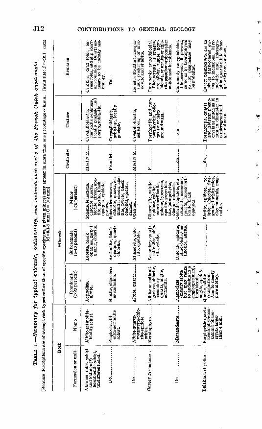
PETROGRAPHY
Study of thin sections reveals that the undifferentiated schist for mations include a variety of petrographic types, but that four general types predominate. These dominant types are albite-actinolite-biotite schist, plagioclase-biotite-actinolite schist, quartz-muscovite schist, and albite-quartz-muscovite-chlorite-epidote schist. The two actino- lite-bearing types are the most common. In the albite-actinolite- biotite schist, actinolite is the principal mafic mineral; in the plagio clase-biotite-actinolite schist, biotite predominates over actinolite. Most specimens of these two rock types show a mixture of the two mafic minerals the actinolite being partly altered to biotite. Actino lite is present in all specimens, whereas biotite is not. Other common minerals, include garnet, chlorite, sphene, leucoxene, black opaque minerals, pyrite, quartz, calcite, apatite, and zircon. The plagioclase is generally albite in the actinolite-rich rocks, but it ranges to oligo- clase and sodic andesine in the biotite-rich rocks. Twinning is absent in albite and rare in the more calcic plagioclase. Sieve texture is common, as also is helicitic structure, which shown by the alinement of included f erromagnesian minerals, sphene, and more rarely, quartz, in plagioclase porphyroblasts. The actinolite forms elongate needles that in most specimens are markedly alined, but in a few specimens form radiating clusters. It commonly is slightly pleochroic and shows a distinct bluish tint when oriented parallel to the Z vibration direction. The biotite is generally pale brown to reddish brown.
In the quartz-muscovite schist and the albite-quartz-muscovite- chlorite-epidote schist the proportion of the main minerals differs greatly among specimens. Albite forms irregular porphyroblasts and has alined inclusions of quartz and epidote that give a helicitic structure. Quartz forms mosaics of irregular grains mostly in and between albite porphyroblasts. Muscovite occurs as elongate tabular crystals in discrete layers. The crystals are strongly crumpled and bent. Epidote replaces muscovite and chlorite and occurs as inclu sions in albite porphyroblasts.
Petrographic data are summarized in table 1.
J12 CONTRIBUTIONS TO GENERAL GEOLOGY
H"os<N SA
13
* 8K p4O K>*K. **I"2 a>s I s 19 fe «9 *
in per
**>
®§^ o £ aIS oo«i
>s > 6,4
-lajS a§«a^c?!
i!l*llitS ilist! Bo
pi i;|!i| i" S~-i p S fl "^ o 53 3 o^§g IIsis3 Ill§!^3 3 o oPn axi-g g oP-iw®JWo o
'O
silla M oj-s-OP.;*.
2 «"o 0.
Balao O
phene, leucoxene, chlorite, quartz, biotite, zircon, apa tite, pyrite, black opaques, epidote,
, ac-j-Js"
gs|ssl&ls&rfll^uniir
iill3s a »<»§ « -4s M-^ S
IS!IllB
.«.82
1||"Sou j§H!go*,
HSIsao?
Ǥ 25
i^-sf ! .
O C3
3.3 1-S
ss .s °PH
£
l^^sa
1|"8 -I-S

Do..............
Do...............
Do.... _
__
......
Ken
nett
(?)
form
a
tion.
Bra
gdon
for
mat
ion.
..
Do.... .
.......
Do.
Do....... .
.......
Por
phyr
itic
qua
rtz
kera
toph
yre
con
ta
inin
g ph
eno-
cr
ysts
1-4
mm
in
dia
met
er.
quar
tz k
era
to
phyr
e (m
ay
cont
ain
mic
ro-
phen
ocry
sts
to l
mm
).
Tu
ff..
...
Bla
ck s
ilice
ous
shal
e.
Mud
ston
e (m
ost
ly
ver
y da
rk
gray
).
gray
to v
ery
dark
gra
y).
ceou
s sa
ndst
one.
....do..............
do..
clas
ts a
nd l
ithi
c fr
agm
ents
com
po
sed
chie
fly
of
quar
tz a
nd a
l-
bite
. Q
uart
z, c
arbo
na
ceou
s m
ater
ial.
Fine
-gra
ined
w
hite
mic
a, c
ar
bona
ceou
s m
ate-
er
ial,
clay
min
er
als.
frag
men
ts.
(alb
ite)
, cl
asts
of
opt
ical
ly c
on
tinu
ous
quar
tz
phen
ocry
sts,
fr
agm
ents
of
volc
anic
roc
ks.
clas
ts o
f opt
i
cally
con
tinu
ou
s qu
artz
, al
bite
, fr
ag
men
ts o
f vol
ca
nic
rock
s.
whi
te
mic
a (i
n hi
ghly
she
ared
fa
cies
), py
rite
.
whi
te m
ica,
ch
lori
te (
in
high
ly s
hear
ed
faci
es).
whi
te m
ica,
ch
lori
te.
Fine
-gra
ined
w
hite
mic
a.
Qua
rtz,
cla
y m
in
eral
s (s
ome
quar
tz lo
oks
like
clas
ts o
f qua
rtz
phen
ocry
sts)
.
mat
eria
l, fi
ne
grai
ned
whi
te
mic
a, f
elds
par,
ch
ert
frag
men
ts.
quar
tz c
last
s,
frag
men
ts o
f vol
ca
nic
rock
s,
acti
noli
tic
am-
phib
ole.
clas
ts o
f opt
i
cally
con
tinu
ou
s qu
artz
, al
bite
, ac
tino-
lit
e, b
lack
op
aque
s, ch
lori
te,
frag
men
ts o
f vo
lcan
ic ro
cks.
mic
a, p
yrit
e ep
idot
e,
chlo
rite
, cl
ay m
in
eral
s, o
rtho
clas
e(?)
zo
isite
, bi
otit
e, c
al-
cite
, mag
neti
te,
sphe
ne.
mic
a, c
hlor
ite,
clay
m
iner
als,
epi
dote
, gr
een
biot
ite,
mag
ne
tite
, ap
atit
e.
mic
a, c
hlor
ite,
ruti
le,
mag
neti
te,
biot
ite,
zeo
lites
, ka
olin
ite,
m
ontm
oril
loni
te .
Cla
y m
iner
als,
sph
ene,
ru
tile
, li
mon
ite.
Cla
y m
iner
als,
chl
o
rite
, le
ucox
ene,
gr
aphi
te.
rial
, fi
ne-g
rain
ed
whi
te m
ica,
fel
d
spar
, cl
ay m
iner
als,
bl
ack
opaq
ues.
eral
s, s
phen
e, l
eu
coxe
ne,
blac
k op
aque
s.
whi
te m
ica,
bla
ck
opaq
ues,
cla
y m
in
eral
s, s
phen
e, l
eu
coxe
ne,
acti
noli
te,
biot
ite,
pla
gioc
lase
.
--.d
o..
....
.
- do.......
F a
nd M
F.. ...
...
... ..do......
-. d
o......
F,
M,
and
C.
F a
nd M
Por
phyr
itic
, qu
artz
and
albi
te p
heno
cr
ysts
as
muc
h as
mm
in
pilo
taxi
tic,
mic
rogr
anito
id,
orgr
anop
hyri
c gr
ound
-m
ass.
PUot
axiti
c,
trac
hyti
c.m
icro
sphe
ruli
tic,
mic
rogr
anito
id;
mi-
crop
heno
crys
ts o
fqu
artz
and
alb
ite
1m
m d
iam
eter
may
be p
rese
nt.
Cla
stic
- do- .
..d
o.-
... .. .
~ d
o..
... -
Cla
stic
. G
ener
ally
cons
ists
of c
lose
lypa
cked
cla
sts
and
lith
ic f
ragm
ents
in
subo
rdin
ate
mat
rix.
Cla
stic
(co
mm
only
cons
ists
of s
ligh
tly
roun
ded
clas
ts a
nd(o
r) l
ithi
c fr
agm
ents
in m
atri
x of
chl
ori
te,
whi
te m
ica,
quar
tz,
and
am-
phib
ole)
.
Som
e m
yrm
ekit
ic
inte
r-
grow
ths.
Phe
nocr
ysts
lo
cally
oc
cur
in
clus
ters
gi
ving
a
glom
erop
orph
y-
riti
c te
xtu
re.
Loc
ally
fl
ow b
ande
d.
Flow
ba
ndin
g an
d co
arse
br
ecci
a co
mm
on. (
Gro
und-
m
ass
in a
ll ty
pes
of B
ala-
kl
ala
rhyo
lite
m
ay
be
high
ly s
ilici
fied
).
Gra
in s
ize
vari
able
, co
m
mon
ly
bedd
ed
in
out
cr
op.
Com
mon
ly
high
ly
con
to
rted
an
d fr
actu
red;
qu
artz
vei
nlet
s fil
l fr
ac
ture
s.So
me
show
s co
mpo
sitio
nal
band
ing
denn
ed b
y di
f
fere
nce
in g
rain
siz
e or
by
conc
entr
atio
ns o
f di
ffer
en
t m
iner
als
in d
iscr
ete
laye
rs.
Mos
tly
fine
ly b
ande
d ow
in
g to
co
ncen
trat
ion
of
cert
ain
min
eral
s in
di
s
cret
e la
yers
.
Spec
imen
s ha
ving
vi
rtu
al
ly a
ll an
gula
r gr
ains
are
cl
asse
d as
tu
ff.
Spec
i
men
s ha
ving
ro
unde
d gr
ains
are
cla
ssed
as
tuf-
fa
ceou
s se
dim
enta
ry
rock
s.V
irtu
ally
all
grad
atio
ns t
o tu
ffac
eous
se
dim
enta
ry
rock
s.
Bas
is o
f di
stin
c
tion
is
pres
ence
of
lith
ic
frag
men
ts o
f sed
imen
tary
m
ater
ial
in a
mou
nts
ex
ceed
ing
10 p
erce
nt.
Q
H
O
f
O
O w O W §
t-1
o 00

J14 CONTRIBUTIONS TO GENERAL GEOLOGY
V
1 1!
^ I
a|!A.a it00 a b"
05 J,
w oS» fM
I !
Subordln 5-10 perc
gpCO O.a S3 |a^A
,lMls&s-ila g^filill^gsi Iij-Lli
o ^s§
s SIS'9 c*3 .;llfllfel||ll|a§.23^"51g,§fia|g'§'S2 2~^ 0^:>>t3).2.S'o'3'8 .W W
O SNCD M4Jisgfeio? O1
l«% i5 *^ C ft 5am 0009 n
3 S
&
l.iiilfl s-s«rga&§-gs isgslgAflll si-s&o.asso'S S-S^a!
PH
I fl a'
lal

Per
idot
ite.
. _ _
_ .
Sha
sta
Bal
ly b
atho
li
th.
Do... ..
..
Do...
Do
..
Cle
ar C
reek
plu
g(s
atel
lite
of th
e S
hast
a B
ally
bat
h
olit
h).
Shas
ta B
ally
bat
h
olit
h.
Gne
iss
in a
ureo
le o
fth
e S
hast
a B
ally
ba
thol
ith.
Coa
rse
biot
ite
quar
tz d
iori
te
and
gran
odio
- ri
te.
horn
blen
de
quar
tz d
iori
te
and
gran
odio
- ri
te.
tite
qua
rtz
dio
ri
te a
nd g
rano
- di
orit
e.
rite
.
Gab
bro-
- __
__
Hor
nble
nde-
rich
m
afic
incl
usio
n.
Am
phib
olit
e ___
___
tine
min
eral
s (m
ostl
y an
tig-
orit
e).
Plag
iocl
ase
quar
tz,
biot
ite.
quar
tz.
quar
tz.
(An«
-H),
hor
n
blen
de.
calc
ic t
han
An
50),
horn
bl
ende
. Pl
agio
clas
e (A
n45-
{s),
horn
bl
ende
.
horn
blen
de
(2V
=70°
; n0
=1.
664±
0.
003)
. pl
agio
- cl
ase
(Anj
i-6o)
.
tine
min
eral
s,
actin
olite
, bl
ack
opaq
ues.
tite
, or
thoc
lase
.
tite
.
Bio
tite,
qua
rtz,
or
thoc
lase
.
Bio
tite
__
__
__
talc
.
blen
de,
blac
k op
aque
s, s
phen
e,
clay
min
eral
s, a
pa
tite
, zi
rcon
, fin
e
grai
ned
whi
te m
ica.
horn
blen
de,
blac
k op
aque
s, s
phen
e,
apat
ite,
zir
con,
cla
y m
iner
als,
fin
e
grai
ned
whi
te m
ica.
grai
ned
whi
te m
ica,
zi
rcon
.
biot
ite,
aug
ite,
sp
hene
, ap
atit
e, z
ir
con,
bla
ck o
paqu
es.
sphe
ne,
apat
ite,
zir
co
n, b
lack
opa
ques
.
Bio
tite
, or
thoc
lase
, bl
ack
opaq
ues,
sp
hene
, apa
tite
, ch
lori
te,
fine
gr
aine
d w
hite
mic
a.
calc
ite,
quar
tz,
chlo
rite
, or
thoc
lase
, ep
idot
e, m
agne
tite
.
d
o
-do
.d
o..
-
M.... . ..
.
. .d
o .
..
.... .d
o .
..
M..
. ._... -
ular
.
gran
ular
.
gran
ular
.
ular
.
gran
ular
, lo
cally
po
ikil
itic
.
gran
ular
.
Hyp
idio
mor
phic
gr
anul
ar, l
ocal
ly
poik
ilitic
; in
par
t cr
ysta
llob
last
ic.
loca
lly c
onta
ins
porp
hyro
blas
ts o
f nl
agio
clas
e an
d (o
r)
horn
blen
de i
n au
reol
e of
the
Cle
ar
Cre
ek p
lug.
pent
iniz
ed in
mos
t pla
ces.
Om
only
sh
ow
osci
llato
ry
o
zoni
ng, h
avin
g ri
ms
abou
t f
1 1
to 5
per
cent
mor
e so
dic
O
than
co
res.
C
omm
only
O
ha
s w
ell-
defi
ned
plan
ar
K{
stru
ctur
e.
mon
ly
show
os
cilla
tory
*3
zo
ning
, hav
ing
rim
s ab
out
1 to
5 p
erce
nt m
ore
sodi
c £J
th
an c
ores
. P
lana
r str
uc-
W
ture
po
orly
de
nned
or
El
ab
sent
.
colo
red
wit
h sh
redd
y bi
o-
W
tite
. N
o pl
anar
or l
inea
r g
st
ruct
ure.
5q
faci
es
of
the
bath
olit
h pC
j an
d in
sat
elli
tic
bodi
es.
O
regu
lar
bodi
es n
ear
the
t"1
mar
gin
and
in r
oof
rock
O
of
the
Cle
ar C
reek
plu
g.
ffi
Qua
rtz
and
horn
blen
de
com
mon
ly f
orm
larg
e op
- ^O
ti
call
y co
ntin
uous
cr
ys-
cj
tals
th
at
encl
ose
othe
r >
m
iner
als
givi
ng a
poi
ki-
O
liti
c
textu
re.
Horn
- ft)
bl
ende
lo
cally
bl
each
ed
>
colo
rles
s bu
t ra
nges
to
%
bl
ue
gree
n an
d gr
een.
O
P
lag
iocl
ase
stro
ngly
tr
1 zo
ned.
&)
cont
act
aure
ole;
der
ived
£-
, fr
om
Cop
ley
gree
nsto
ne
j>
and
prob
ably
in
pa
rt
t*
from
th
e Sa
lmon
sch
ist
M
of
Her
shey
(1
901)
. ?>
M
arke
d se
greg
atio
n of
diff
eren
t m
iner
als
indis
cr
ete
laye
rs.
*

J16 CONTRIBUTIONS TO GENERAL GEOLOGY
d p o> V
.2 ^0 05 O ^*
I
ao
OJ J,
Minerals
o ort
13a .05«
s3
X O
EH
05
gC3I*O
"3t* 05
9 1 §o^ lO
V
ibordinate 10 percent)
CQjA
C'
Dominant (>20 percen
05
!Z
."S
S g_o"S
aofa
&£ &>>& aCg-
P^Sl® w £^^5 a£-
,0 *E/f -4 iz5 9 wf3f-_4 03 Q} 0 m -2*Q
^ ^-j tf'C'S S C
sslclSSJ§2 S soiled 3 S os <yo Se ,2 co^
d a <* £a d °?(H d C5
.2 1 § S
Ptf iSS|^M 0*° °«
t?S 03 .Siso
c c
a j-
sjl
aT o oS 2 S .a 9
if IIa
si C-o 3"S.
C8.2
C?
e£
«f8 s 3 d crll-a
11!H
05 O
§.'
3aPS c dM
«°
s^rf 03
^^ r?
oSs
JS^l05 J3 33 d-wA
a
rt 0
a aM.J fl «
'S
.2
^ o*
1ftCQ
-0
03 _C5
stallobla taclastic
L"§O
I^rj
fa
05
itite, flne-gi rhite mica.
w
t
2 <»
«1 si3 0G?
0 w3"^5dM M345
23 uS
o
£* J2 ir|g
is l^lllg^- bo"g fa *j
d t>> *3 a 1̂ a c
M t^'S' *"* .^2 05 *^ "^
^ fl S a> * S 2 a-3 a D. C » f i" tT2,tJ »< o » >>£?S^S§3.E:- o tat; K o i. «<<
£.0
.a£2-£®Isl ^gs£?^«o
c"C
S
§t«03
^
f§
|1o~*
o-Ss§aj-Q
«
^
1
llM >
a s I
A§ ^^
^3
^Sd
^ r P3 > a0"
o
2 S *-w £ o
ol-S"sS'a^So 133
tn -S 05 'C '
8ja doSS j- o o^-?;^ £3-3 a~.^* K
.H -2 S -g -pJ3 J3 § >,<S si, Ci o X3 "o
^ |s|l-23 -23 |>f 2 c 3d fe'S>> ti t^BiESW K
I^13
§ fa
"3 .0 '" ^3 S E
'S. > « >>.*; '«
i!!!!!<) CO
. |i.l
llli"3 -2 S *» 'S,
t> PQ
i,
a|ililSgS&XSj^ x3 u^ 5? o^ ^
05
o &S £}
i 1 'I |Q> C
§ .4
« 05& '
3l|Sl a.|5 05 ^ -2 oT."^ 2d d ^ fl d *o ^'a) 2 "c3 "a, ^ >>^
'm S os '53 S *" <23S-33S55 ^an-gfcSSa a
-it? " 5^S«§ <!l3£3 " -H
3 « '? *" "5
.2 S Sort'2
illl!CO
S-fe g5d 3 §g§ ^JX
s
cr
§
2 aT
PQ
S
.d
o
kdlagioclase (A a), quartz, orthoclase.
PH
S"5, <
2a.S§0343 >» o
eG +* J3
1:0 ,0 o fl
oj 2 "3S-o-g
b^
os £ S""5 >>
-w S3 P^ 3§cSt) O C5-W
o
3»iagoS
sailIfiffe&iC.'o.W
;
Sd
S
^"leT
Ifp
5"Sllbo 'S O.C.3 d 0 05<)
te, serpen- e minerals.
'tjd3*3<1
i'
iornblende...
n
J
in*as3 Sow
;|
i-2j2D
S EoW

Intr
usiv
e m
ainl
y in
to t
he B
ragd
on
form
atio
n bu
t al
so
into
oth
er r
ock
unit
s.
Do.
...
Intr
usiv
e in
to S
hast
aB
ally
bat
holi
th
and
loca
lly in
to
othe
r ro
ck u
nits
.
Dik
es in
trus
ive
. mai
nly
into
the
C
ople
y gr
eens
tone
an
d M
ule
Mou
n
tain
sto
ck.
Dik
es a
nd s
ills
in a
llfo
rmat
ions
exc
ept
the
Shas
ta B
ally
ba
thol
ith.
Bio
tite-
horn
- bl
ende
dio
rite
("
bird
seye
")
porp
hyry
.
and
quar
tz
dior
ite
por
ph
yry
("bi
rds-
ey
e" p
orph
yry)
.
Hor
nble
nde
dio
rite
por
phyr
y.
And
esite
porp
hyry
.
Qua
rtz
porp
hyry
(sod
a gr
anit
e po
rphy
ry o
f F
ergu
son,
191
4,
p. 3
0-31
).
Plag
iocl
ase
(Ans
s-
53)
(com
mon
ly
show
s no
rmal
os
cilla
tory
zo
ning
), a
lbit
e.
M),
albi
te.
Plag
iocl
ase
(Anj
s-45
), ho
rnbl
ende
.
Hor
nble
nde,
Plag
iocl
ase
(An43-4
8).
Hor
nble
nde,
bi
otit
e.
quar
tz,
biot
ite.
Bio
tite
, qu
artz
, ep
i-
dote
, fi
ne-g
rain
ed
whi
te m
ica,
chl
o-
rite
, sp
hene
, ort
ho-
clas
e, c
alci
te,
mag
neti
te,
lim
onit
e,
leuc
oxen
e.
fine
-gra
ined
whi
te
mic
a, c
linoz
oisi
te,
sphe
ne, l
euco
xene
, bl
ack
opaq
ues,
or
thoc
lase
(?).
sphe
ne,
chlo
rite
, bl
ack
opaq
ues.
tite
, m
agne
tite
, zo
isite
, ca
lcite
, cl
ay
min
eral
s, c
hlor
ite.
mic
a, b
ioti
te,
chlo
ri
te,
calc
ite,
pyri
te,
sphe
ne, l
euco
xene
.
F an
d M
....
..d
o .
d
o
F..
.
..d
o. .
Hyp
idio
mor
phic
gr
anul
ar t
o gr
ano-
ph
yric
; co
mm
only
po
rphy
riti
c ha
ving
Pl
agio
clas
e, h
orn
bl
ende
, an
d bi
otit
e ph
enoc
ryst
s.
mic
rogr
anul
ar,
por
ph
yrit
ic h
avin
g .
phen
ocry
sts
of
Plag
iocl
ase,
qua
rtz,
an
d fe
rrom
agne
sian
m
iner
als.
porp
hyri
tic
havi
ng
euhe
dral
hor
n
blen
de p
heno
crys
ts
and
plag
iocl
ase
mic
roph
enoc
ryst
s.
phyr
itic
wit
h ph
enoc
ryst
s of
hor
n
blen
de t
o 6
mm
and
of
pla
gioc
lase
to
2 m
m.
gran
ular
, po
rphy
ri
tic
havi
ng p
heno
cr
ysts
of
quar
tz a
nd
albi
te.
Zon
ed
plag
iocl
ase
crys
tals
sh
ow
vari
ous
stag
es
of
albi
tiza
tion
in s
ame
spec
i m
en;
horn
blen
de
and
O
biot
ite
gene
rall
y ha
ve a
fe)
pa
le w
ashe
d-ou
t ap
pear
- O
an
ce
and
are
acco
mpa
- £1
ni
ed
by
vari
ous
alte
ra-
2
tion
min
eral
s.
H
stag
es
of
albi
tiza
tion
; Q
fe
rrom
agne
sian
m
iner
als
jd
have
pa
le
was
hed-
out
appe
aran
ce a
nd c
loud
ed
j
by
alte
rati
on
prod
ucts
; M
qu
artz
phe
nocr
ysts
muc
h B
ro
unde
d.
rode
d qu
artz
and
bio
tite
3
cr
ysta
ls
that
m
ay
be
£j
xeno
crys
ts.
' ^ G
in c
olor
. _
£ 8bi
te;
biot
ite
phen
ocry
sts
_
repla
ced p
seudom
or-
*^
ph
ousl
y by
fln
e-gr
aine
d ?
wh
ite
mic
a, calc
ite,
^
chlo
rite
, sp
hene
an
d M
le
ucox
ene;
thi
s pr
ophy
ry
^
indi
stin
guis
habl
e fr
om
15
porp
hyri
tic
quar
tz k
era-
£i
to
phyr
e of
the
Bal
akla
la
M
rhyo
llte
exc
ept
by p
res-
w
en
ce o
f al
tere
d bi
otit
e.
~ i

J18 CONTRIBUTIONS TO GENERAL GEOLOGY
COPLEY GREENSTONE GENERAL CHARACTER AND DISTRIBUTION
The overall distribution of volcanic rocks within and beyond the limits of the French Gulch quadrangle indicates that during probable Early Devonian time, much mafic material and a considerable volume of felsic material was erupted more or less contemporaneously, though probably from different volcanic centers. The eruption of these ma terials was followed by the eruption of a large volume of predominantly intermediate and mafic lavas and pyroclastic material that are mapped as Copley greenstone containing minor felsic material of the type mapped as Balaklala rhyolite; later, a great outpouring of felsic material formed the main mass of the Balaklala in the northeastern part of the quadrangle and adjacent areas. This overlapping age relationship between mafic and felsic volcanic rocks, characteristic of the Copley greenstone and the Balaklala rhyolite respectively, makes it necessary to distinguish between the two formations entirely on the basis of lithology. The mafic volcanic material is designated as Cop- ley greenstone on the geologic map (pi. 1), and the felsic volcanic material is shown as Balaklala rhyolite, regardless of its position in the volcanic sequence. Consequently, except in the northeastern part of the quadrangle and in the adjacent central part of the West Shasta mineral belt, the contact between Copley greenstone and Balaklala rhyolite has no time-stratigraphic significance.
The Copley greenstone crops out in a belt 1 to 2 miles wide that extends from near the southeast corner of the quadrangle northwest ward to Whiskeytown. This belt lies between the Shasta Bally batho- lith on the west and the Mule Mountain stock on the east (pi. 1). Near Whiskeytown, the dips are northeast at moderately low angles; farther south, the dips seem to be steeper to the northeast but reliable data on bedding are scarce. North and northwest of Whiskeytown, the outcrop area of the Copley broadens to a width of several miles, and near the latitude of Merry Mountain the formation passes beneath younger rocks. It reappears as inliers at several places in the extreme northern part of the quadrangle. From the map pattern (pi. 1), it seems likely that the Copley extends beneath the entire north third of the quadrangle.
The Copley consists of intermediate to mafic pillow lava, massive flows, flow breccia, coarse- and fine-grained pyroclastic material, minor tuffaceolis shale, and shale. Approximately the upper 1,000 feet of the formation is amygdaloidal pillow lava that contains subordinate lenses of fragmental material. Most of the lithologic units seem to be lenticular.
Within the aureole of the Shasta Bally batholith, the Copley has a conspicuous gneissic foliation and is strongly metamorphosed. Far-

GEOLOGY OF THE FRENCH GULCH QUADRANGLE, CALIF. J19
ther away from the batholith, the greenstone consists mostly of weakly schistose to nonschistose keratophyre, spilite, and meta-andesite. These petrographic types are not distinguishable from each other in the field and can be distinguished only with difficulty in thin section. A highly important fact bearing on origin and metamorphism is that although the keratophyre, spilite, and some meta-andesite are almost completely reconstituted mineralogically, they retain their original igneous textures and structures. Only in localized shear zones, where these textures and structures are obliterated by shearing, is there doubt as to the rock's original character.
STRATIGRAPHIC RELATIONS AND THICKNESS
In the northeastern part of the quadrangle and in adjacent areas to the northeast (Kinkel and others, 1956, pi. 1), the Copley green stone is overlain by the Balaklala rhyolite of Devonian age; elsewhere in the northern part of the quadrangle, the Copley is either overlain by, or is in fault contact with, the Bragdon formation of Mississippian age; in the central and southern parts of the quadrangle it is intruded by the Shasta Bally batholith and by the Mule Mountain stock of Jurassic or Cretaceous age.
In the southeastern part of the quadrangle, however, sheets of felsic rock similar to the Balaklala rhyolite are interlayered and apparently contemporaneous with the Copley greenstone. The best examples of this relationship are south of Mule Mountain and for several miles northwest of Monarch Mountain. Except in the vicinity of the upper part of Dry Creek, where the strike is anomalously northeast and the Balaklala is infolded in the Copley (pi. 1), these layers of felsic rock strike northwest and dip northeast in what seems to be a homoclinal sequence. Available structural and stratigraphic evidence indicates that many of these sheets of silicic rock are overlain by several thousand feet of Copley greenstone. Other layers of felsic material in the vicinity of Grizzly Gulch and on Merry Mountain are stratigraphically somewhat higher in the Copley section, but not at the top. The main mass of felsic rock south of Tower House (pi. 1) is overlain by the Copley greenstone, a relationship similar to that seen on the south side of O'Brien Mountain in the East Shasta copper-zinc district a few miles northeast of the French Gulch quadrangle (4Jbers and Kobertson, 1961, pi. 1).
Some sheets of felsic rock interlayered with greenstone northwest of Monarch Mountain are pyroclastic material and probably are of extrusive origin, but other sheets of quartz keratophyre in this same area are demonstrably intrusive. Nevertheless, the scarcity of intru sive crosscutting relationships and the local presence of pyroclastic

J20 CONTRIBUTIONS TO GENERAL GEOLOGY
material suggest that much of the felsic rock interlayered with Copley greenstone in this area is extrusive. The same origin may apply to some sheets of the f elsic rock interlayed with greenstone south of Mule Mountain, although here no pyroclastic material was seen and the possibility exists that these sheets may be sills.
In places in the northeastern part of the quadrangle, as well as in adjacent parts of the West Shasta copper-zinc district, the contact between the Copley greenstone and the overlying Balaklala rhyolite is transitional, marked by a layer of pyroclastic material ranging from a few feet to 150 feet thick. This pyroclastic layer contains abundant fragments of felsic quartz porphyry as well as fragments of amygdaloidal greenstone in a tuffaceous greenstone matrix. The proportion of greenstone to quartz porphyry fragments decreases upward and the pyroclastic bed is overlain conformably by quartz keratophyre of the Balaklala rhyolite.
Inasmuch as the base of the Copley greenstone has nowhere been recognized, only partial sections of the formation have been measured. Hinds (1933, p. 87) measured a partial section of 1,500 feet on Shirttail Peak, and Kinkel and others (1956, p. 10) measured a partial section of 3,700 feet in the Modesty Gulch area. Actually the thick ness may be much greater than 3,700 feet, if the wide area of green stone southwest from Modesty Gulch is included. However, original layering in the greenstone south of Modesty Gulch is largely destroyed by shearing and metamorphism, and any estimate of thickness in that area would have to rest on the assumption that schistosity parallels original layering. Although this relation might safely be assumed to exist in some localities, it is know to be absent in others.
I/ETHOLOGY AND PETROGRAPHY
All the rocks of volcanic origin assigned to the Copley greenstone are of intermediate or mafic composition. The greenstone consists of a wide variety of lithic types, including amygdaloidal pillow lava, massive flows, volcanic breccia, agglomerate, flow breccia, tuffaceous shale, and shale. Virtually all these lithic types are mineralogically and, to some extent, chemically reconstituted owing to regional hydro- thermal alteration and local contact metamorphism, but, except where schistosity is strong, primary structures and textures are preserved and the original lithic character of the rock can be determined.
Even though the various lithic types that make up the Copley could be distinguished with confidence in many places in the field, it was not possible to subdivide the volcanic components of the formation on the geologic map (pi. 1). Only the tuffaceous shale and shale lenses are shown separately.

GEOLOGY OF THE FRENCH GULCH QUADRANGLE, CALIF. J21
The lower part of the Copley is mainly fine-grained lava and tuff. Some flows are porphyritic and contain small phenocrysts of ferro- magnesian minerals in an aphanitic greenish-gray groundmass. Much of the fine-grained greenstone, especially in the belt between the Mule Mountain stock and the Shasta Bally batholith, is hard and massive in fresh outcrop. However, weathering, as in roadcut ex posures, commonly reveals a platy structure ranging in intensity from close-spaced jointing to strong schistosity. Generally, tuffa- ceous beds are more strongly schistose than lava flows, but in places the intensity of schistosity appears unrelated to the lithic character of the rock.
At least the upper part of the Copley consists predominantly of pillow lava that contains subordinate lenses of pyroclastic material. Several varieties of pillow lava have been described by Kinkel and others (1956, p. 11). Most of the pillow lava is amygdaloidal. The amygdules range from about 1 mm to as much as 25 mm in diameter. Minerals that commonly form amygdules include quartz, calcite, chlorite, epidote, clinozoisite, albite, and zeolite. The best exposures of the pillow lava sequence is in Modesty Gulch in the north-central part of the quadrangle. Practically all the greenstone exposed in the northwestern part of the quadrangle (pi. 1) consists of pillow lava and is believed to be in the upper part of the Copley section.
The upper part of the Copley greenstone also includes numerous lenses of coarse volcanic breccia consisting largely of blocks, bombs, lapilli, and ropy material in a greenish-gray matrix that has the same general appearance in outcrop as the fragments. The various kinds of fragments are rarely more than 6 inches in diameter and average about 4 inches. In places all gradations seem to occur between ropy lava, lava containing sparce fragments, and pyroclastic material composed almost entirely of bombs and blocks. The bombs in the pyroclastic f acies are commonly well rounded and of a slightly lighter color than the matrix (Kinkel and others, 1956, fig. 4). Accidental fragments of schistose and gneissic rock, possibly derived from the Salmon or Abrams formations, were seen in Copley fragmental rocks on Monarch Mountain.
A distinctive volcanic breccia as much as 150 feet thick that contains fragments of quartz keratophyre in a chloritic matrix is present in some places at the top of the Copley. Near the head of Modesty Gulch on Mad Mule Mountain, this breccia forms a transition zone between the Copley greenstone and the Balaklala rhyolite.
A few thin beds of shaly tuff and shale occur in what seems to be the lower part of the Copley from Brandy Creek northwest to Crystal Creek (pi. 1). Some of these beds on the west side of Monarch
713-195 64 4

J22 CONTRIBUTIONS TO GENERAL GEOLOGY
Mountain consist in part of felsic material and overlie sheets of quartz keratophyre correlated with Balaklala rhyolite. Others, too small to show at the map scale, are shaly greenstone tuff. A 25-foot thick bed of dark shale having a good slaty cleavage crops out in the roadcut west of Crystal Creek and appears to continue for about a mile south eastward along strike. This slaty shale is lithologically similar to shale in the nearby Bragdon formation, but it seems to be definitely interlayered with sheets and lenses of coarse and fine felsic pyro-
The petrography of the Copley greenstone is described in detail by Kinkel and others (1956, p. 13-16) and is briefly summarized in table 1.
AGE
No fossils have been found in the Copley greenstone, and its precise age has not been determined with certainty. However, it intertongues with and is overlain conformably by the Balaklala rhyolite, the upper most part of which is probably of Middle Devonian age. Therefore, the Copley is presumably at least in part of Middle Devonian age, but the lower part may be older than Middle Devonian.
BALAKLALA RHYOLITE
GENERAL CHARACTER AND DISTRIBUTION
The Balaklala rhyolite consists of light-colored siliceous lava flows interlayered with sheets and lenses of coarse and fine felsic pyro- clastic material. These flows and pyroclastic rocks, together with a few layers of greenstone mapped as Copley, form a volcanic pile overlying the main mass of the Copley greenstone in the northeastern part of the quadrangle (pi. 1) and in the adjacent area to the north east (Kinkel and others, 1956, pi. 1). In addition, a large tongue- like pendant of Balaklala rhyolite which is separated from the main body of Balaklala by the granitic rock of the Mule Mountain stock, extends from near White Rock Gulch (northeast of Whiskey town) southeastward to the vicinity of Orofino Gulch. Numerous smaller intrusive and extrusive sheets of felsic aphanitic rock, also mapped as Balaklala, are interlayered and locally infolded with Copley green stone south of Mule Mountain and for several miles northwest from Monarch Mountain. A body of similar rock as much as 2,000 feet thick underlies Copley greenstone from Boulder Creek northwestward to Trail Gulch.
STRATIGRAPHIC RELATIONS AND THICKNESS
The Balaklala rhyolite both overlies and intertongues with the Copley greenstone, as described on pages J19-J20. It is overlain by the Kennett( ?) formation of Devonian age in some places in the quad-

GEOLOGY OF THE FRENCH GULCH QUADRANGLE, CALIF. J23
rangle and by the Bragdon formation of probable Mississippian age in other places.
In the Backbone Creek area of the West Shasta copper-zinc district, which is the type locality of the Kennett formation, the Kennett con formably overlies the Balaklala rhyolite; the contact is gradational (Kinkel and others, 1956, p. 21 and pi. 1). Beds of fine-grained felsic pyroclastic material that form the uppermost part of the Balaklala rhyolite in Backbone Creek grade upward into tuffaceous shale and shale of the Kennett formation. The contact is placed where shale predominates over tuff.
In the northeastern part of the French Gulch quadrangle, a belt of rock consisting mostly of gray and black siliceous shale lithologically similar to that of the Kennett overlies the Balaklala rhyolite in most places. However, no fossils of Kennett age have been found in this shale, and for reasons given in the section on the Kennett (?) forma tion, there is some doubt that it is actually Kennett.
Felsic quartz porphyry tuff, which is identical to that forming the upper part of the Balaklala rhyolite in the Backbone Creek locality, also forms lenses between the Copley greenstone and the Bragdon formation on the west side of hill 3670 south of Shirttail Peak and in the vicinity of the Franklin and Washington mines in French Gulch. Here the tuff grades upward into the Bragdon formation. If the Bragdon formation in the French Gulch quadrangle is of Mississipian age, as found by Diller (1906, p. 3) in the Bedding quadrangle, and if the Kennett and Bragdon formations are separated by an uncon formity, there then exists an anomalous and seemingly irreconcilable situation whereby tuff of the Balaklala rhyolite grades upward into the Kennett formation of Middle Devonian age in the Backbone Creek area, but grades into the Bragdon formation of Mississippian age only a few miles away in the western part of the French Gulch quad rangle. The solution to this problem may become apparent when the Bragdon formation has been mapped in detail and its age and relations to underlying rocks have been studied over its entire area of outcrop.
Owing to its volcanic origin and the probable derivation of constitu ent lithic units from a number of vents, the thickness of the Balaklala rhyolite differs greatly from place to place. The maximum thickness is about 3,500 feet on Mammoth Butte 2 miles northeast of the quad rangle (Kinkel and others, 1956, p. 22). Within the quadrangle, the thickness may be nearly this 'great in the ridge south of Squaw Creek and in the large pendant east of Whiskeytown. However, bedding is rare in the Balaklala in both of these areas. Therefore, any esti mate of thickness is necessarily based on few stratigraphic and struc tural data and is applicable only to the specific locality where it is made.

J24 CONTRIBUTIONS TO GENERAL GEOLOGY
In the northwestern part of the French Gulch quadrangle, the Balaklala is absent in some places and in others consists of tuffaceous rock only a few feet thick.
L.ITHOLOGY AND PETROGRAPHY
The bulk of the Balaklala rhyolite consists of felsic siliceous lava flows, flow breccias, and pyroclastic rocks, most of which have the composition of quartz keratophyre. A subordinate percentage of the formation is represented by dikes and sills in the Copley green stone, and a very minor percentage is shaly tuff. The dikes and sills that cut the greenstone are lithologically and petrographically identi cal to the extrusive flows.
Much of the felsic material constituting the Balaklala is light-gray or light greenish-gray quartz keratophyre consisting of sparse to abundant megascopically visible quartz and feldspar phenocrysts in an aphanitic groundmass. A somewhat subordinate percentage of the for mation is nonporphyritic, although it has nearly the same composition and color as the porphyry. The presence of the quartz phenocrysts, along with the commonly lighter color, are the main characteristics that permit ready distinction of the porphyritic f acies of the Balaklala from the Copley greenstone. However, both porphyritic and nonpor phyritic facies of the Balaklala are in places more or less chloritized, and locally chloritization is intense. Conversely, the Copley green stone is silicified and its color made lighter in a few places. Where either or both of these types of alteration have affected the rocks, color is not a reliable criterion for distinguishing Balaklala from Copley. On the other hand, quartz phenocrysts in quartz keratophre and amyg- dules in greenstone survive alteration and remain as reliable criteria to distinguish their respective units. However, where phenocrysts and amygdules are lacking in altered rocks, the problem of distinguishing the rocks of the Balaklala from those of the Copley becomes acute and leads to considerable uncertainty; much of the rock between Boulder Creek (southeast of Tower House) and Bear Gulch (about 3 miles northwest of Tower House) is of this type. Some of the material mapped as Balaklala in this area (pi. 1) is, therefore, probably silici fied greenstone, and conversely, some rock mapped as Copley may be chloritized Balaklala rhyolite.
Kinkel and others (1956, p. 19-22) subdivided the Balaklala into three main map units, a lower unit, middle unit, and upper unit, on the basis of quartz phenocryst size. The lower unit is characterized by nonporphyritic rhyolite that may contain microphenocrysts as much as 1 m in diameter (quartz keratophyre) and rhyolitic pyroclastic material; the middle unit consists mostly of quartz porphyry (quartz keratophyre) that contains phenocrysts 1 to 4 mm in diameter and
GEOLOGY OF THE FRENCH GULCH QUADRANGLE, CALIF. J25
abundant pyroclastic material in the upper part of the unit; and the upper unit consists chiefly of quartz porphyry (quartz keratophyre) that contains phenocrysts more than 4 mm in diameter. Generally this lithologic sequence was found to hold throughout the district, al though in places, especially away from the center of the volcanic pile, one or two of the units may be missing. Also, rocks typical of a particular unit commonly contain sheets and lenses of material charac teristic of a different unit, and in places the contacts are gradational. The interlayering and gradation of f acies is especially typical of the lower nonporphyritic and middle, medium-phenocryst units of the Balaklala. Largely because of the complexities resulting from this relationship, it was impractical, for cartographic reasons, to distin guish between the lower and the middle units of Kinkel and others at the scale of the French Gulch quadrangle map. However, the coarse-phenocryst upper unit and the beds of fine-grained tuff in the Balaklala are mapped separately.
Included in the two nontuffaceous Balaklala rhyolite units shown on the geologic map (pi. 1) are numerous lenses, sheets, and irregular bodies of flow breccia and pyroclastic material. Most of the beds are only a few feet thick and extend for only a few hundred feet laterally, but a few are several hundred feet thick and continue for more than a mile. Fragments in most of the pyroclastic material are angular to subrounded and locally range up to 18 inches in diameter. However, the rounded fragments present in some pyroclastic layers suggest a volcanic conglomerate. The size of fragments in pyroclastic layers is rarely uniform. Many layers consist of coarse unstratified breccia interlayered with finer pyroclastic material and well-bedded tuff. Coarse pyroclastic material commonly shows an upward gra dation into finer material and then into tuff. The finer grained ma terial generally shows bedding and is of considerable importance in delineating the structure of local areas.
Virtually all the felsic rock of the Balaklala type that underlies and intertongues with the Copley greenstone in the western part of the quadrangle, south and west of Tower House, is either nonporphy ritic quartz keratophyre or porphyritic quartz keratophyre containing 1 to 4 mm phenocrysts, and thus it is characteristic of the lower and middle units as defined in the West Shasta map area. A large pro portion of the gneissic rock contiguous to this body of Balaklala in the contact aureole of the Shasta Bally batholith between Boulder Creek and Trail Gulch is very siliceous and was evidently derived from quartz keratophyre of the Balaklala rhyolite. The Balaklala is repre sented locally in the north-central and northwestern part of the quad rangle chiefly by lenses of quartz porphyry tuff that lie between the Copley greenstone and the Bragdon formation.
J26 CONTRIBUTIONS TO GENERAL GEOLOGY
Near the junction of Trail Gulch and Willow Creek in the western part of the quadrangle, lenses of quartz keratophyre are interlayered with phyllite derived from shaly rocks of the Bragdon formation by contact metamorphism. The largest of these lenses, and the only one of mappable scale, is about 100 feet thick and was traced for about a mile (pi. 1). The lens lies 150 to 200 feet above the base of the Bragdon, parallel to schistosity and probably parallel to bedding. In the ridge above the Greenhorn mine, it contains sparse medium-sized quartz phenocrysts, but in Bear Gulch to the east and also along U.S. Highway 299W to the west, phenocrysts are extremely rare. The quartz keratophyre has a weak platy structure that parallels the schistosity of the enclosing phyllite; this fact shows that the quartz keratophyre has undergone deformation and is therefore probably not a sill genetically related to the posttectonic quartz porphyry dikes of Late Jurassic or Cretaceous age. The absence of crosscutting relations and the proximity to a large mass of quartz keratophyre of probable though not demonstrable extrusive origin suggest that it may be a flow rather than a sill in the Bragdon.
The petrography of typical varieties of Balaklala rhyolite is sum marized in table 1. For a more detailed description of the lithology and petrography of the Balaklala, the reader is referred to Kinkel and others (1956, p. 19-31).
ORIGIN1 AND AGE
The origin of the Balaklala rhyolite, that is, whether it is intrusive or extrusive, has been a matter of controversy for many years. Diller, who first described and named the formation (1906, p. 6), considered it to be a series of siliceous lava and tuff beds underlying the Kennett formation of Devonian age. On the other hand, Graton (1910, p. 81) concluded after studying part of the West Shasta mining district that the Balaklala is a complex mass of alaskite and alaskite porphyry intrusive into the surrounding rocks.
The intrusive origin proposed by Graton was accepted by several geologists who later published information on the geology of the area (Averill, 1939, p. 122; Ferguson, 1914, p. 30; Hinds, 1933, p. 107; Seager, 1939, p. 1958). However, detailed mapping of the West Shasta district by Kinkel and others (1956, p. 31-32), has shown that Diller's interpretation of the Balaklala, as a pile of extrusive lavas and pyroclastic rocks containing subordinate feeder dikes and sills indistinguishable from extrusive facies, is correct.
The age of most of the Balaklala rhyolite is probably Middle De vonian or late Middle Devonian. The upward gradation in several localities outside the French Gulch quadrangle of tuff beds at the top of the Balaklala into shaly tuff and siliceous shale of the Kennett

GEOLOGY OF THE FRENCH GULCH QUADRANGLE, CALIF. J27
formation of late Middle Devonian age is interpreted to mean that deposition of the two formations was almost continuous and that the formations are of nearly the same age. The apparent interbedding of quartz keratophyre with Bragdon formation in the Trail Gulch area suggests, however, that the eruption of Balaklala-type rocks continued into Bragdon time.
KENNETT (P) FORMATION
DISTRIBUTION, UTHOLOGY, AND THICKNESS
A discontinuous belt of gray to black cherty shale lies between the Balaklala rhyolite and shaly rocks of the Bragdon formation between Mad Mule Mountain and the northeast corner of the quadrangle (pi. 1). This shale is tentatively correlated with the Kennett for mation; it is commonly made up of beds 1 to 2 inches thick, which are separated by parting planes or by thinly fissile shale. The cherty shale is commonly black on a fresh surface but weathers gray. A conspicuous feature of the cherty shale virtually everywhere in the French Gulch quadrangle is its highly contorted character.
The basis for correlating this contorted cherty shale with the Ken nett formation is its stratigraphic position and its lithologic similarity to black siliceous shale that forms the lower part of the Kennett at its type locality in Backbone Creek (Kinkel and others, 1956, p. 35- 38). At the type locality, however, the shale is not contorted, and it is overlain conformably by limestone containing fossils of Middle Devonian age. No fossils have been found in the black shale either in the Backbone Creek locality or in the French Gulch quadrangle.
The cherty shale consists mostly of quartz, carbonaceous material, and fine-grained white mica; minor constituents include clay minerals, sphene, rutile, and limonite. Most specimens contain angular quartz clasts averaging 0.1 mm in diameter in a matrix made up of grains averaging about 0.01 mm in diameter. Locally, the cherty shale con tains poorly preserved structures that are probably Eadiolaria. The shale is very commonly highly fractured as well as highly contorted and the fractures are filled with quartz. Although there is no obvious hydrothermal silicification of the cherty shale, the intense and wide spread silicification of the underlying Balaklala rhyolite indicates that the shale has not entirely escaped this alteration.
A close estimate of the thickness of the cherty shale is extremely difficult because of its highly deformed character. The maximum thickness, based on the outcrop width of the belt, is about 400 feet. However, if allowance is made for repetition of beds by folding and faulting, the true thickness is probably much less.

J28 CONTRIBUTIONS TO GENERAL GEOLOGY
STRATIGRAPHIC RELATIONS AND AGE
The dark cherty shale of the Kennett(?) formation overlies the Balaklala rhyolite everywhere except on the east side of Whiskey Creek where it apparently overlies Copley greenstone. The exact contact between the shale and the underlying rock is exposed in only a few places, and in all such places the underlying rock is felsic tuff. The contact between the tuff and the shale is gradational and is con formable in detail. A thin layer of tuff may be present everywhere beneath this shale, but the few exposures of the underlying rock sug gest that the tuff is discontinuous.
The possibility that the black siliceous shale belongs to the Bragdon formation rather than to the Kennett is suggested by the following features:1. North of Backbone Creek in the West Shasta map area (Kinkel
and others, 1956, p. 41), two layers of black cherty shale litho- logically identical to that between the Balaklala and Bragdon formations are interbedded with conglomerate and shale of the Bragdon; this shows that the black cherty shale lithology is not restricted to the Kennett formation.
2. The apparently uniform thickness of the black cherty shale where present, coupled with the absence of any other kind of known Kennett lithology in the French Gulch quadrangle, demands an unlikely coincidence: If the black cherty shale facies was orig inally discontinuous, perhaps being deposited only in basins be tween volcanic islands, it would seem that some recognizable variation in thickness should reflect this original lenticularity. On the other hand, if the shale was originally continuous and if erosion of the Kennett took place prior to deposition of the Brag don, it seems too much a coincidence that a fairly uniform thick ness of shale was preserved while all other rocks of the Kennett were stripped away.
The age of the Kennett formation has been established as MiddleDevonian on the basis of fossils found in the limestone at the BackboneCreek type locality of the Kennett formation in the West Shastacopper-zinc district (Kinkel and others, 1956, p. 38).
BRAGDON FORMATION
GENERAL CHARACTER AND DISTRIBUTION
Much of the northern part of the French Gulch quadrangle, as well as a large area north of the quadrangle, is underlain by the Bragdon formation presumably of Mississippian age. The formation was named by Hershey (1904, p. 347-360) from exposures at the community

GEOLOGY OF THE FRENCH GULCH QUADRANGLE, CALIF. J29
of Bragdon on the Trinity River about 10 miles north of the French Gulch quadrangle.
The lower part of the Bragdon consists mostly of shale, mudstone, and siltstone and subordinate sandstone, conglomerate, and mafic tuff. In the upper part, coarse clastic material, including sandstone, grit, and conglomerate, is interbedded with and about equal in abundance to the fine elastics. In Kinkel and others (1956,1:24,000-scale geologic map) individual beds of coarse clastic material in the Bragdon forma tion are delineated, but these could not be shown on the smaller scale map (pi. 1) accompanying the present report. In the French Gulch quadrangle, however, it is convenient to delineate at least a lower and an upper unit in the Bragdon on the basis of the difference in lithology just described.- The lower unit includes all rocks up to the base of the lowest prominent and continuous conglomerate beds. A few local conglomerate beds that have little continuity are considered part of the lower unit (pi. 1, cross section).
STRATTGRAPHIC RELATIONS AND THICKNESS
The Bragdon formation in some places rests directly dh the Copley greenstone or is separated from it only by intrusive sills or a few quartz veins. Elsewhere, it overlies the Balaklala rhyolite or con- tored cherty shale of the Kennett (?) formation. In a few places, flows of rhyolite tentatively mapped as Balaklala are included in the Bragdon. In the Hoadley Peaks area the Bragdon is intruded by the Shasta Bally batholith.
Where the Bragdon rests on Copley greenstone, mainly in the north western part of the quadrangle, the contact was seen in a few prospect pits, mine workings, and readouts. In virtually all these exposures, a few feet to a few tens of feet of the Bragdon are sheared and faulted, generally almost parallel to the contact. More commonly the two formations are separated by intrusive rock or by quartz veins. No exposures of sedimentary rock of the Bragdon formation were seen resting undisturbed in depositional contact with the greenstone. It appears that the contact between the greenstone and the relatively incompetent shaly rocks of the Bragdon formation was a plane of structural weakness along which movement readily took place during deformation, and it is inferred that a thrust fault separates the two units. The presence of sill-like sheets of intrusive rock or quartz veins of Late Jurassic or Cretaceous age in many places along this contact shows that the contact was not only a favorable locale for intrusion and mineralization, but also a plane of structural weakness.
On the west flank of peak 3670 south of Shirttail Peak, in places around the inlier of Copley greenstone in French Gulch, and south of Tower House, the Bragdon formation rests on a layer of felsic tuff a
713-195 64 5

J30 CONTRIBUTIONS TO GENERAL GEOLOGY
few feet thick; the contact is gradational. This tuff is correlated with the Balaklala ryholite and is markedly similar to the tuff layer as signed to the Balaklala that underlies the Kennett formation at its type locality in Backbone Creek. The gradational contact between the tuff and the overlying shaly sedimentary rocks is likewise similar to that in Backbone Creek.
Sheets of weakly sheared quartz keratophyre lithologically similar to the Balaklala rhyolite are interlayered parallel to schistosity and probably parallel to bedding in phyllitic rock of the Bragdon forma tion near the Greenhorn mine, between Bear Gulch and U.S. Highway 299W. Although the extrusive origin of these quartz keratophyre sheets cannot be proved, the lack of intrusive features, and the demon strable extrusive origin of the bulk of the Balaklala rhyolite, suggests that they are flows in the Bragdon. Similar sheets of weakly sheared quartz keratophyre which are interpreted as flows, are also interbedded with cherty shale in the Kennett formation east of the Mammoth mine in the West Shasta district (Kinkel and others, 1956, p. 36).
Diller (1906, p. 3) placed an unconformity between the Bragdon and Kennett formations because of the presence of cobbles of fossil- bearing limestone derived from the Kennett in conglomerates of the Bragdon. His conclusions were based mainly on relations in the Redding quadrangle east of the present map area. In the French Gulch quadrangle, (1) the presence of beds of quartz keratophyre tuff interbedded with mudstones (table 1), (2) the gradation of tuffaceous mudstone downward into tuff of the Balaklala rhyolite in some lo calities, and (3) the presence locally of sheets of quartz keratophyre lava interbedded in the lower unit of the Bragdon, indicate either (1) that the eruption of Balaklala rhyolite continued throughout Kennett and into Bragdon time uninterrupted by any significant ero- sional break, or (2) that some of the rocks we now consider as Bragdon in the French Gulch quadrangle are Kennett, the difference in Kennett lithology being due to a marked change in f acies between the Backbone Creek type locality and the western part of the French Gulch quad rangle. Interpretation (1) is here preferred because the lithology of the sedimentary rocks is in general more like the Bragdon than the Kennett and the lithology of the rhyolite is very similar to the Balaklala.
Available data are inadequate for a solution of the problem of the Kennett and Bradgon relationship, but careful mapping of the large area underlain mostly by Bragdon north and northwest of the French Gulch quadrangle may reveal the answer.
Diller (1906, p. 3) states that the maximum thickness of the Bragdon formation in the Redding quadrangle, where the top of the formation

GEOLOGY OF THE FRENCH GULCH QUADRANGLE, CALIF. J31
is exposed, is 6,000 feet. Kecent geologic work in the Shasta Copper- zinc district and in the French Gulch quadrangle has yielded little additional information on the thickness, partly because the top of the formation is not present in the area. Moreover, accurate estimates of the thickness are very difficult to make because of the abundance of large and small faults within and at the base of the formation, because of the lenticular character and lack of distinctive features of component beds, and because of poor outcrops in critical areas. Cross section A-A.' (pi. 1) indicates a thickness of about 4,500 feet for the lower unit of the Bragdon and at least 1,500 feet for the upper unit. This section, however, does not reflect the myriad of minor faults that cut the formation, some at very low angles and others at high angles to bedding. Therefore, the thickness, particularly the thickness of the lower unit, is at best only a rough approximation.
LITHOLOGY AND PETROGRAPHY
LOWER UNIT
The lower unit of the Bragdon formation is about 90 percent shale, mudstone, and siltstone and 10 percent sandstone, graywacke, con glomerate, tuff, and tuffaceous sedimentary rocks. On the ridge be tween Centennial Gulch and Boswell Gulch south of Highland Ridge (pi. 1), where there seems to be only minor faulting along the contact between Bragdon and underlying tuff, the lowest part of the Bragdon is dark-gray tuffaceous mudstone that grades downward into quartz porphyry tuff. The contact between this tuff and the underlying greenstone is not exposed. Above the tuff is a sequence of mudstone, siltstone, graywacke, tuff, and fine conglomerate beds ranging from a few inches to about 4 feet thick. About 150 feet above the tuff is a 5-foot-thick bed of chert conglomerate that contains chert pebbles as much as half an inch in maximum dimension. Overlying this conglomerate is a monotonous sequence of shale, mudstone, and silt- stone in beds a few inches to a few feet thick, interbedded with a few lenses of coarser clastic material. This sequence has an apparent maximum thickness of about 3,500 feet and extends to the top of the ridge, but the amount of duplication and omission of beds by many small faults not mappable at the quadrangle scale is unknown. The top of this unit is above the present erosion surface.
The petrography of various rocks in the lower unit of the Bragdon format ic n is summarized in table 1.
UPPER UNIT
The upper unit of the Bragdon formation is characterized by an abundance of coarse conglomerate, grit, and sandstone interbedded

J32 CONTRIBUTIONS TO GENERAL GEOLOGY
with about an equal amount of mudstone and siltstone. The conglom erate beds, which are commonly in shades of gray, are most distinctive. Some beds were traced for several miles. Other beds were traced for only a few hundred feet, until they either lens out or are cut off by faults. The beds generally range from 10 to 20 feet thick, but the overall range is from a few inches to possibly 100 feet. Chert in various colors is the principal component of most beds; other constitu ents, most common in the coarsest beds, include limestone, sandstone, shale, and vein quartz. The matrix is generally subordinate to the fragments and consists mostly of fine-grained quartz and white mica. Some beds show graded bedding, from conglomerate containing frag ments 1 to 2 inches in diameter at the base, upward through grit to sandstone or siltstone at the top. Other beds show no graded bedding and no sorting whatever. The coarsest beds, which include fragments as much as a foot in diameter, are characterized by abundant frag ments of limestone, sandstone, and other noncherty material. The limestone fragments commonly weather out, and leave solution cav ities that give the rock a pitted aspect. According to Diller (1906, p. 3), the limestone fragments, which commonly contain corals and other fossils, were derived from the Kennett formation.
Beds of dark-gray mudstone and siltstone, a few feet to 100 feet thick, are commonly interbedded with the coarse elastics in the upper unit of the Bragdon. The upper unit appears to be at least in part structurally discordant on the lower unit, but no thrust fault could be mapped with certainty.
AGE
No fossils were found in the Bragdon formation either in the French Gulch quadrangle or the adjoining Shasta copper-zinc district. About 12 miles to the northeast, where fossils were found by Diller (1906, p. 3), the age was determined as Mississippian. But, as was stated earlier, the age and correlation of rocks presently included in the lower part of the Bragdon at least, is by no means well established.
MULE MOUNTAIN STOCK
LOCATION AND GENERAL, CHARACTER
A stock consisting mostly of coarse-grained light-colored trondhje- mite (quartz-rich oligoclase-quartz diorite) and albite granite crops out in the eastern part of the French Gulch quadrangle and in the adjacent Eedding quadrangle to the east. The stock is roughly ellip tical, being about 10 miles long and 5 miles wide, elongate in a north erly direction. Approximately the west half of the stock is in the French Gulch quadrangle (pi. 1). Diller (1906, p. 8) mapped this stock an quartz-hornblende diorite. Hinds (1933, p. 105) named it

GEOLOGY OF THE FRENCH GULCH QUADRANGLE, CALIF. J33
the Mule Mountain stock from its prominent exposure on Mule Moun tain.
Most of the stock is coarse-grained holocrystalline rock with a gran itoid texture. In a few places, particularly near the borders, the rock is weakly foliated, 'but for the most part it has no planar struc ture or mineral alinement. The principal minerals are quartz, plagioclase, and epidote. Average grain size is about 2 mm, but some facies of both the trondhjemite and the albite granite have a poikilitic or pseudoporphyritic texture owing to the presence of irregular masses of glassy quartz as much as 10 mm in diameter. Except in Clear Creek and other deep stream canyons, the stock is deeply weath ered and tends to be crumbly in outcrop. Most of the stock is light- colored owing to its low content of ferromagnesian minerals, and the siliceous albite-granite facies is generally a brilliant white that con tains sparse splotches of green epidote as much as 6 mm in diameter. This facies is prominently exposed in roadcuts along U.S. Highway 299W near the west edge of the quadrangle.
A large pendant of Balaklala rhyolite about 4 miles long projects into the stock, and many inclusions of Copley greenstone and Bala klala ryholite measuring a few hundred to a few thousand feet in maximum dimension are contained in the stock. The inclusions of greenstone show various stages of assimilation or replacement by the granitic rock. No chilled contacts were seen. Relict layering, present in most of the large inclusions, shows that they are in structural harmony with each other as well as with country rock surrounding the stock and that they were not detached from the roof during emplace ment of the pluton.
Breccia, consisting of blocks or fragments of dark-colored hybrid dioritic rock in a matrix of light-colored granitoid rock, crops out along U.S. Highway 299W at the east edge of the quadrangle. This breccia is in a narrow belt about a mile long (pi. 1). Fragments range from a few inches to several feet in diameter. In places, irreg ular replacement dikes of coarse trondhjemite a few inches thick and having unmatched walls cut through the darker colored fragments. Similar breccia was mapped in the Democrat Mountain area of the West Shasta district (Kinkel and others, 1956, pi. 1 and fig. 23). In the area north of Democrat Mountain, some fragments only slightly metamorphosed show relict layering and are clearly derived from Copley greenstone. These fragments are structurally undisturbed in relation to each other; this fact coupled with the undisturbed large inclusions of country rock in the stock leads to the inference that breccia fragments in which no relict layering is preserved are also undisturbed. The distribution of the breccia bodies and their relation

J34 CONTRIBUTIONS TO GENERAL GEOLOGY
to the topography suggest a tabular shape; the breccia is interpreted as remnants of tabular bodies of greenstone that occupied a position close to the roof of the stock. The brecciation of the greenstone was probably caused partly by the passive injection of magmatic fluids into a myriad of crosscutting fractures and cleavage planes and partly by the subsequent partial replacement of the greenstone in the walls of these injected fractures.
About 50 percent of the part of the Mule Mountain stock that lies in the French Gulch quadrangle is trondhjemite consisting of quartz, oligoclase, and mafic minerals. Virtually all the remaining part of the stock within the quadrangle is albite granite that forms irregular, mostly elongate, masses and has gradational contacts with the trond hjemite (Kinkel and others, 1956, pi. 1).
Petrographic, chemical, and field data indicate that the albite granite was probably derived largely from trondhjemite and perhaps in part from quartz diorite by either deuteric or hydrothermal alteration. However, the distribution of albite granite also bears a broad relation ship to pendants and inclusions of the Balaklala rhyolite. Albite granite is most abundant in the area east of Whiskeytown, where the largest inclusions of Balaklala are present, and also southward from the vicinity of the Mount Shasta mine along the projected trend of the large pendant of Balaklala. This spatial relationship between the two rock types, and their chemical and mineralogical similarity, suggests that some bodies of albite granite may be derived from Balaklala rhyolite by isochemical recrystallization.
The petrography of typical facies of the Mule Mountain stock is summarized in table 1.
Aplite dikes are common in a few places near the borders of the Mule Mountain stock and on Mule Mountain, but are rare elsewhere. They are commonly only a few inches thick. Some aplite contains euhedral quartz phenocrysts as much as 2 mm in diameter in a fine-grained sugary groundmass of quartz, albite, epidote, sphene, leucoxene, and minor amounts of chlorite. The groundmass texture is microgranitoid. Myrmekitic and micrographic intergrowths of quartz and albite are common.
Metamorphism resulting from the emplacement of the Mule Moun tain stock is limited to the recrystallization, in a few areas, of Copley greenstone to granular amphibolite and epidote amphibolite for a few feet to a few tens of feet from the contact. In many places along the contact, little or no recrystallization has occurred.
STRUCTURAL SETTING AND MODE OF EMPiLACEMENT
The Mule Mountain stock is situated where the regional trend of enclosing rocks changes gradually from about N. 45° W. to north-

GEOLOGY OF THE FRENCH GULCH QUADRANGLE, CALIF. J35
northeast; it thus defines a broad irregular bend whose maximum in flection is where the stock occurs (fig. 5). South and southeast of the stock, the strike of rock units and schistosity is northwest and dips are northeast; along the west side, strikes are mostly a little west of north and dips are steeply east; north of Whiskeytown, and at the north end of the stock, strikes are northeast and dips are either northwest or southeast. Along the east side of the stock, lithic units in the Copley, Balaklala, and Kennett formations, as mapped by Kinkel and others (1956), and by V. F. Hollister \ define a nearly straight north-south pattern very slightly convex towards the east (fig. 5; Kinkel and others, 1956, pis. 1,3). It is inferred that the eastern and western con tacts of the stock dip steeply eastward nearly parallel to schistosity. Although the contact of the stock is highly irregular and crosscutting in detail and is characterized by many angular bends that suggest controls by fractures in the country rocks, it is from a broad viewpoint roughly concordant along its east and west borders and more markedly transgressive at the north and south ends. The position of the stock suggests that this large structural bend played an important part in its localization. Possibly the rocks in the inflection were more crum pled and fractured than elsewhere and therefore in a relatively dilated condition and structurally receptive to intrusion and replacement.
That metasomatic replacement was one important mechanism by which the Mule Mountain stock was emplaced is suggested by both structural and compositional evidence. The structural harmony be tween inclusions and pendants and the country rock surrounding the stock indicates that the emplacement was passive. Randomly oriented foundered blocks, which might be expected if stoping had been an active process, seem to be absent. Although the very slight and none too definite eastward convexity of rock units and schistosity on the east side of the stock (Kinkel and others, 1956, pis. 1, 3) could have resulted from a shouldering action by the intrusive, it is inter preted as a structural feature that predated the emplacement of the stock.
Further suggestion of a metasomatic origin is furnished by the com positional heterogeneity of the stock (which seems to be especially conspicuous in the vicinity of inclusions and pendants), the lack of chilled contacts, the common occurrence of replacement dikes, par ticularly along the northeast border of the stock, and the presence of undisturbed inclusions of Copley greenstone in various stages of recon- stitution. Without doubt, magma was also involved in the process, but a significant proportion of the stock is interpreted to be of replace ment origin.
iHollIster, V. F., 1949, Geology of the Shasta gold-silver district, Shasta County, Cali fornia : California Univ., Berkeley, Master's thesis, 45 p.

J36 CONTRIBUTIONS TO GENERAL GEOLOGY
The depth at which the emplacement took place cannot be as certained by direct evidence, for the rocks surrounding the stock are steeply dipping. The maximum thickness of strata that could have overlain the stock is estimated to be 25,000 to 30,000 feet. This thick ness includes all layered rocks of the region (through the Potem forma tion of Early and Middle Jurassic age) that predate the stock's em placement. The depth of emplacement was almost certainly less than 6 miles and probably much less.
The stock seems to have most of the features of a pluton of the epizone, as defined by Buddington (1959, p. 67T-680), notably the contacts, which are highly discordant in detail, the absence of internal foliation or lineation except very locally, the abundance of large in clusions and roof pendants, the small amount of metamorphism clearly associated with the stock, the absence of pegmatites, and the scarcity of aplite dikes. On the other hand, the absence of chilled borders and the probability that granitization was an important mechanism of the emplacement are more characteristic of zones deeper than the epizone.
AGE
The Mule Mountain stock cuts the Copley and Balaklala formations and is in turn cut by satellites of the Shasta Bally batholith of Late Jurassic or possibly Early Cretaceous age. On the basis of direct evidence, the age of the stock cannot be closely determined. However, granitic rocks correlated with the stock on the basis of similar lithol- ogy intrude the Baird formation of Mississippian age in the East Shasta copper-zinc district (Albers and Robertson, 1961) and, accord ing to Diller (1906, geologic map), similar rocks also intrude the Bully Hill rhyolite of Triassic age in the eastern part of the Redding 30-minute quadrangle. If the lithologic correlation is valid, the Mule Mountain stock is at least as young as Triassic. Moreover, the markedly crosscutting relationship of the stock to folded schistose Copley greenstone and Balaklala rhyolite in many places shows that the stock was probably emplaced after the main folding had occurred, and the Potem formation of Middle Jurassic (Bajocian) age according to A. F. Sanborn 2, is the youngest formation in this area affected by the folding. It is inferred that the stock was emplaced after Middle Jurassic time.
The age of the Shasta Bally batholith, apopheses of which cut the Mule Mountain stock, is probably very Late Jurassic. The Mule Mountain etock is apparently only slightly older.
8 Sanborn, Albert, 1952, The geology of the Big Bend area, Shasta County, California: Stanford Univ. Ph. D. thesis; microfilm available at Michigan Univ., Ann Arbor, Mlch.

GEOLOGY OF THE FRENCH GULCH QUADRANGLE, CALIF. J37
PERIDOTITE
In the southwestern part of the quadrangle are two elongate tabular masses of greenish-black slightly serpentinized periodotite that strike northwest parallel to the enclosing schist and gneiss. The larger, on the north side of Jerusalem Creek, has an outcrop width of about a third of a mile within the quadrangle and widens to nearly a mile in Bully Choop Mountain west of the quadrangle boundary. It encloses a body of gneiss about 100 feet wide and a mile long. The smaller peridotite mass southwest of Jerusalem Creek is only about 100 feet wide.
Both peridotite masses dip steeply and appear to lie in the foliation of the schists and gneisses. The larger mass dips steeply northeast; the smaller mass dips southwest near the crest of a schistosity anti cline in Jerusalem Creek. Much of the peridotite is crudely banded, and locally, near the contact, the banding parallels the foliation of en closing rocks. A petrographic description of typical peridotite is given in table 1.
SHASTA BALLY BATHOLITH
LOCATION AND GENERAL, CHARACTER
Most of the southwestern part of the French Gulch quadrangle is underlain by a batholith composed of light-colored quartz diorite and granodiorite. The batholith underlies Shasta Bally, the most promi nent mountain in the French Gulch quadrangle, and was named the Shasta Bally batholith by Hinds (1933, p. 105). The batholith is markedly elongate, trends about N. 45° W., and extends in both direc tions beyond the quadrangle boundaries (fig. 5). According to Hinds (1933, p. 105), its exposed length is 30 miles. Its maximum width within the quadrangle is about 9 miles. A short distance south of the quadrangle, the batholith is overlain nonconf ormably by rocks of Early Cretaceous age; hence its maximum southward extent is unknown.
At least six satellites, ranging from a few acres to a little more than a square mile in area of exposure and correlated with the batholith on the basis of lithology, crop out in the southeastern part of the quad rangle. The largest of these is the Clear Creek plug.
The batholith is concordant with foliation in the gneissic wallrocks along its northeast side, but along the southwest side it is slightly discordant and is bounded by a zone of injected rock and breccia. The satellites are mostly discordant. The grain size of the plutonic rock in the borders of some satellites is locally slightly finer than in the interior parts, but chilled contacts are in general rare; none were seen along the borders of the main batholith.

J38 CONTRIBUTIONS TO GENERAL GEOLOGY
The rocks that border that Clear Creek plug and the northeast side of the batholith are mostly fine-grained amphibolite and banded gneiss derived by contact metamorphism from Copley greenstone, Balaklala rhyolite, and Bragdon formation. Contacts between the batholith and gneiss are everywhere very sharp. Foliation banding in the wall- rocks dips northeast at angles ranging from 40° to 75°. Broadly, it is concordant with the contact and also parallel to flow banding within the batholith; however, over widths of a few inches, the intrusive contact cuts across the foliation in at least one place in a roadcut in Crystal Creek.
Along its southwest side, the batholith is bounded by a belt of dikes, sills, and coarse breccia a few hundred feet wide. This breccia con sists mostly of blocks of gneiss, schist, and peridotite. The matrix is equigranular coarse-grained diorite. The batholith for a few hundred feet inward from its southwest margin has a weakly defined flow band ing that dips northeast at angles of 70° to 80°. The overall topo graphic expression of the batholith and its local contact relations indicate that its western contact also dips very steeply northeast or vertically. Foliation in the gneissic rocks that lie just west of the belt of dikes and breccia dips northeastward toward the batholith at angles of only 50° to 80°; the batholith is evidently locally discordant with the wallrocks along its southwest side. From observation on the dip of the contacts and the attitudes of flow banding, it is inferred that the batholith (1) has the form of a northwest-trending east-dip ping arch whose southwest limb is steep and discordant and whose northeast limb is less steep and concordant, and (2) widens gradually with depth (pi. 1, cross section; fig. 4).
The batholith, like the Mule Mountain stock, is commonly deeply weathered, except in the bottom of canyons and on the main ridges. On most secondary ridges and hillslopes the rock weathers to grus.
Although the Shasta Bally batholith is in general a fairly homo geneous mass, three facies were distinguished in the field a coarse biotite facies, a fine biotite facies, and a biotite-hornblende facies. The coarse biotite facies, which has an average grain size of 2 mm and typically shows planar structure, forms a belt ranging from y2 mile to 4 miles wide in the northeastern part of the batholith (pi. 1); the fine biotite facies has an average grain size of slightly less than 1 mm and forms small masses as much as three-fourths of a mile wide and 3 miles long in the central part; and the biotite-hornblende facies, which also has a grain size of about 2 mm, makes up approximately the western two-thirds of the intrusive mass. The contact between the

GEOLOGY OF THE FRENCH GULCH QUADRANGLE, CALIF. J39
coarse biotite facies and the biotite-homblende facies is gradational over a wide area, but the limits of the fine biotite facies are rather sharply defined.
The most biotite-rich and darkest-colored facies is along the north east border of the batholith, and the percentage of biotite decreases from 20 to 5 percent within a few thousand feet inward from the border. Thin sections show that hornblende is present in very minor amounts in the biotite facies, although it is rarely noticeable in hand specimen. Planar structure, defined by preferred orientation of biotite plates parallel to the contact of the intrusive mass, is present through out the coarse biotite facies but is most conspicuous near the border. In addition to the preferred orientation of minerals, thin sections reveal the following local relict cataclastic structures: Plagioclase crystals and twin lamellae are bent; biotite books are locally bent and some have ragged ends as though they had been pulled apart; quartz is more or less segregated in discrete layers, and it consists of mosaics of small sutured crystals in contrast to the large, optically continuous crystals that are typical of rock elsewhere in the batholith, where little or no planar structure is present.
The coarse-biotite facies, by an increase in the amount of hornblende, grades over a distance of a few hundred feet into the biotite-homblende facies, which forms the bulk of the western part of the batholith. This facies contains 10 to 15 percent mafic minerals. Hornblende is generally more abundant than biotite, and locally it is the only mafic mineral. Planar structure, shown by preferred orientation of the mafic minerals, is absent or only weakly defined in the biotite-horn- blende facies, and its attitude could be determined only in blocky out crops of fresh rock.
The fine-grained biotite facies is lighter-colored than the two coarse grained facies. It forms rather small discrete masses (pi. 1) enclosed in one or the other of the coarse-grained types. The precise contact between the fine-grained facies and surrounding coarse-grained rock was seen at only one place, on the south slope of Little Bally at an altitude of 4,300 feet. Here the contact is sharp; the fine-grained facies either cuts or replaces the coarse biotite-hornblende facies, and schlieren of the coarse facies are enclosed in the fine-grained facies. Elsewhere, although no exposed contacts were seen, it appears from the distribution of float that the contacts are either sharp or grada tional over only a small distance.
The composition of the batholith ranges from quartz diorite to granodiorite. As shown in table 1, plagioclase, quartz, and orthoclase, along with biotite and hornblende are the chief minerals. The ortho clase, which is everywhere in irregular, optically continuous crystals

J40 CONTRIBUTIONS TO GENERAL GEOLOGY
as much as 5 mm in diameter, is interstitial to other minerals; it ranges from less than 1 to about 10 percent and averages about 5 percent. The rocks are near the dividing line between quartz diorite and grano- diorite. Figure 3 is a diagram of 17 specimens from the Shasta Bally batholith showing the modal variation of essential minerals. Table 2 gives analyses and norms of four samples from the Shasta Bally batholith.
Unlike the Mule Mountain stock, which is extensively albitized and silicified, the Shasta Bally batholith is little affected by hydro- thermal alternation. The only exceptions are in border f acies where a few miscroscopic veinlets of albite have formed in plagioclase and where fine-grained white mica is a minor alteration product on some plagioclase crystals.
Hornblende diorite containing as much as 40 percent hornblende and less than 5 percent quartz is common near the borders of the batholith and in satellite bodies in the southeastern part of the quadrangle. Coarse-grained hornblende gabbro forms small dikes and irregular bodies in the roof and near the margin of the Clear Creek plug. Much of the hornblende diorite and gabbro was evidently derived from the Copley greenstone by metamorphic processes, which are explained in detail by Kinkel and others (1956, p. 71).
PLAGIOCLASE / / 100 PERCENT 5
EXPLANATION
A Quartz diorite
B Granodiorite
C Quartz monzonite
D Granite
Sample, main part ofbatholith
See geologic map for
miorder facies symbol,
marking proportions of plagioclase, po tassium feldspar, and quartz,indicates field in classification
op end of line marks percentages of pla-
oclase and potas- um feldspar. Bot- >m end of line larks percentage of uartz. Slope dis- ince between ends ipresents percent- :e of mafic and cessory minerals
\ \ ORTHOCLASE 5 100 PERCENT
FIGURE 3. Diagram showing intrusive rocks of the Shasta Bally batholith according to proportions of essential minerals. Diagram modified after Johannsen (1939, p. 152).

GEOLOGY OF THE FRENCH GULCH QUADRANGLE, CALIF. J41
TABLE 2. Analyses, in percent, of samples from the Shasta Bally batholith[Samples L-6, D-24, BB-38, by U.S. Geological Survey rapid-analysis method (see Shapiro and Brannock,
1956) analysts, Paul L. D. Elmore and Katrine E. White. Sample A analyzed by T. M. Chatard (Clark and Hillebrand, 1897). See plate 1 for sample locations]
Laboratory No.. ___ . __
Field No .
150014
L-5
150014
D 24
150017
BB-38 A
Chemical constituents
8i02 -----------------------A.l203 ----------------------Fe->CK~FeO. ----------------------MgO__ --- --_ ---- -CaO. ........................Na20- ----- ......... -------K20_._ ~ --Ti02 _. .._.-._--. -------------PA--- - MnO ----------------------BaO-... --------------------HjO.- ------------------COa
Total----.--------.-----
64.516.31.62.52.94.14.02.0.48.10. 06
1. 6<. 05
100
68.016.01.51.52.04.13.82.2.33.09.04
.56<.05
100
70.415.9
.91.41.33.24.02.5.28.07.04
.56<.05
101
68. 1015. 181.341.702.064.663.711.48.35.18.20.06.55.0
99.57
Norms
[Computed by the CIPW system]
Orthoclase. _ _-_____-___-_----_Albite.--- ___ -- _ ----------Anorthite__ - ___-_______-_----_Corundum. ____-_____._-_-.-_-Ilmenite. ________________-----Magnetite ______-_______-_--_-
Hypersthene.-. ------- ------Diopside _ .- _--._-_ _._
Total ------ _ -------
19.6 11.0 34. 1 19.5
.4
.9 2.3 .3
9.8 .0
97.9
25.9 12.8 32.0 18.9
.3
. 6 2. 1 .3
6. 1 .0
99.0
31.2 15.0 29.9 15.0 1.0 .6
1.4 .3
4.4 .0
98.8
27.54 8.90
31.44 20.29
.0
.91 1.86 .34
6. 18 1.84
99.30
L-5. Biotite hornblende quartz diorite from Moon Fork, Cottonwood Creek. D-24. Biotite hornblende quartz diorite from Paradise Peak. BB-38. Hornblende quartz diorite from top of Shasta Bally. A. Analysis of Shasta Bally batholith from near Ono.
SEGREGATIONS AND INCLUSIONS
Small bodies of hornblende-rich and biotite-rich mafic material measuring a few inches to 1 to 2 feet in maximum dimension are scat tered throughout the coarse-grained biotite facies and biotite-horn- blende facies of the Shasta Bally batholith. None of these bodies of mafic material were seen in the fine-grained biotite facies.
Most of these small bodies are spheroidal or ellipsoidal in shape. Those in the coarse biotite facies of the batholith are commonly rich

J42 CONTRIBUTIONS TO GENERAL GEOLOGY
in biotite, whereas those in the biotite-hornblende facies are typically rich in hornblende, though they also contain some biotite. Thin sections show that the bodies of the mafic material have a texture similar to that of the enclosing host rock and differ only in having a higher mafic mineral content. Most of the bodies probably represent segregations formed during consolidation of the magma, but some may be reworked inclusions of rocks intruded by the batholith.
A few of the bodies of mafic material are spindle shaped, pancake shaped, tabular, or angular and are as much as 3 feet in maximum dimension. These inequidimensional types are commonly oriented parallel to planar or linear elements in the host rock and are grada- tional into the host. Some tabular bodies show a layering defined by alternating bands of dark- and light-colored minerals. As with the spheroidal and ellipsoidal bodies, the inequidimensional bodies in the coarse biotite facies of the batholith are rich in biotite, and those in the biotite-hornblende facies are rich in hornblende. The texture of some, but not all, of the bodies is similar to the texture of the enclosing rock. The bulk of the hornblende-rich inequidimensional bodies are mineralogically similar to the hornfolende-diorite and hornblende- gabbro facies of the batholith that Kinkel and others (1956, p. 71) have shown to be derived probably from Copley greenstone.
In addition to the hornblende- and biotite-rich inclusions, one in clusion of gneissic amphibolite and a few inclusions of peridotite were seen on Paradise Peak near the west margin of the batholith. The peridotite inclusions indicate that at least some peridotite is older than the batholith, and in view of the proximity of the inclusions to the belt of peridotite in the southwestern part of he quadrangle, it seems reasonable to assume that they were derived from it. The peridotite is, therefore, believed to be older than the batholith.
GNEISS IN THE AUREOLE OF THE BATHOLITH
A nearly continuous belt of slightly injected gneissic rock as much as a mile wide lies adjacent to the Shasta Bally batholith on its north east side for a distance of almost 20 miles in the French Gulch quad rangle (pi. 1). A belt of similar gneiss, a mile or more wide and separated from the batholith by a- zone of dikes and breccia, crops out parallel to the batholith in the southwestern part of the quadrangle. The Clear Creek plug is also partly surrounded by gneiss. Its spatial relationship to the intrusive masses, as well as its fairly systematic variation in composition, shows that most of the gneiss was derived by contact metamorphlsm of the intruded rocks. A small percentage, probably less than 5 percent, is in j ected material.
In outcrop, the gneiss is characterized chiefly by its fineness of grain (mostly 0.2 to 1.0 mm) and by its uncrumpled foliation banding.

GEOLOGY OF THE FRENCH GULCH QUADRANGLE, CALIF. J43
These two features, coupled with distribution, distinguish the gneiss in the contact aureole of the batholith from the generally much coarser grained, folded, and plicated schist of the Abrams and Salmon(?) formations in the extreme southwestern part of the quadrangle.
That the composition of the gneiss differs considerably from place to place, reflects mainly its derivation from different rock units and also, in part, minor changes during metamorphism. Along the northeast side of the batholith, about as far north as Brandy Creek, the gneiss consists mostly of amphibolite and hornblende gneiss formed from, the Copley greenstone. These rocks are in sharp contact with the intru sive, and they grade outward into epidote amphibolite, which in turn grades into green chloritic and actionolitic schist, and finally into greenstone. The epidote amphibolite, green schist, and greenstone do not have a well-defined metamorphic banding and are not included with the gneissic rocks on the geologic map (pi. 1). A detailed de scription of the mineralogical and textural changes involved in the metamorphism of Copley greenstone to amphibolite and hornblende gneiss in the aureole of the batholith is given by Kinkel and others (1956, p. 68-74).
From the vicinity of Brandy Creek northwestward to the quad rangle boundary, gneissic rocks derived from units other than Copley greenstone are included in the contact aureole. Just west of Brandy Creek, the southern part of a satellite of the Mule Mountain stock is changed to a well-foliated light-colored hornblende gneiss having an average grain size of 1 to 2 mm. Farther northwest, between Boulder Creek and Trail Gulch west of U.S. Highway 299W, much, though by no means all, of the gneiss is very siliceous and light-colored, and con tains only very minor amounts of dark minerals. In places, it grades into and was apparently derived from Balaklala rhyolite. Other gneissic rocks in this segment of the belt are rich in hornblende and doubtlessly represent metamorphosed facies of the greenstone inter- layered with the Balaklala.
In the extreme western part of the map, near Hoadley Peaks, the aureole consists of mainly dark fine-grained muscovite-biotite gneiss. The map pattern (pi. 1) indicates that this mica gneiss was probably derived mostly from shaly rocks of the Bragdon formation and rep resents a higher grade of metamorphism than the phyllite described in the succeeding section.
On the southwest side of the batholith, most of the rock in the gneiss zone is amphibolite, hornblende gneiss, and quartz-plagioclase gneiss. The proximity and gradational contact of these gneissic rocks to the coarse-grained Abrams and Salmon (?) schists in the southwest corner of the quadrangle suggest that the gneisses were derived at least in

J44 CONTRIBUTIONS TO GENERAL GEOLOGY
part by contact metamorphism of the coarse schist. However, they may also have been derived in part from the Copley greenstone and Balaklala rhyolite.
The petrography of the principal varieties of gneiss in the contact aureole is summarized in table 1. A characteristic feature of the gneiss that was mentioned previously, but which deserves further comment, is its uncrumpled foliation banding. In small- or medium-sized outcrops a few feet long, this banding appears as a very uniform alternation of different colored layers ranging from a few millimeters to a few inches thick and gives the impression that each discrete layer probably maintains a uniform thickness indefinitely along strike. However, a few critical exposures in canyons in the Branch Creek area and also in Dry Fork show that many layers lens out within 20 to 40 feet along strike. Thus, in gross aspect, the gneiss has a streaked appearance, characteristic of mylonitic foliation. This, together with the local presence of augen and the ubiquitous crystal- loblastic and locally relict cataclastic textures, suggests that the gneiss is in part a recrystallized mylonite; that is, a mylonite gneiss as de fined by Quensel (in Waters and Campbell, 1935, p. 478).
PHYIXITE IN THE AUREOLE OF THE BATHOLITH
A belt of phyllite having a maximum outcrop width of nearly a mile extends from Crystal Creek northwestward almost to the edge of the quadrangle. This phyllite is in the aureole of the Shasta Bally batholith and its composition, relict structures, distribution, and gradational relationship to the Bragdon formation show that it was derived from the Bragdon. It has a silky sheen caused by abundant fine-grained white mica parallel to cleavage. It also has a knotty appearance resulting from irregularly distributed small spherical or elliptical bodies about 1 mm in diameter. Thin sections reveal that these small bodies or knots consist mostly of carbonaceous material and quartz and that they probably represent discrete fragments of unsheared parent rock in a sheared recrystallized matrix consisting mostly of fine-grained white mica having a conspicuous crystallo- graphic orientation. A few fragments are almost connected to neigh boring ones by small trains of carbonaceous material in a way that suggests that they may have been rotated during shearing. Schistosity bends around the knots, and the mica in pressure shadows along the schistosity plane adjacent to the knots is more coarsely crystalline than elsewhere.
The phyllite was derived mainly from the lower unit of the Brag don, but a small segment of conglomerate, correlated with the upper unit in the upper part of Trail Gulch, also occurs in this zone of meta morphism. Fragments in the sheared conglomerate have a common

GEOLOGY OF THE FRENCH GULCH QUADRANGLE, CALIF. J45
orientation and are roughly ellipsoidal, their elongation ratio ranges from 4 or 5 to 1.
Generally, bedding is not discernible in the phyllite. However, in a few places, relict bedding in the phyllitic rock parallels the schistosity or cleavage, and in other places the schistosity cuts the bedding at a high angle.
ZONE OF INJECTED BOCK AND BRECCIA ALONG SOUTHWEST SIDE OFBATHOLITH
Bounding the Shasta Bally batholith on its southwest side is a belt of gneissic rock that is cut by innumerable intersecting dikes and sills of hornblende diorite and quartz diorite ranging from a few inches to a few feet thick. Although many of the dikes have unmatched walls and are at least in part of replacement origin, they clearly fol lowed a complex set of fractures in the gneiss. Likewise, the sills fol lowed foliation planes. In places the dikes and sills are so numerous that the country rock remains only as isolated fragments ranging from a few inches to a few feet across, and in outcrop they resemble frag ments of a breccia.
The zone of injected rock ranges from about 100 to 1,000 feet wide. The lithologies comprising it differ from place to place, depending on the character of the country rock. West of Eainbow Lake, near the south edge of the map area, the rocks have the character of a breccia and consist of coarse-grained rocks rich in hornblende crystals that range from a few millimeters to several inches in maximum dimension. On the south side of Paradise Peak, a breccialike rock that includes disoriented blocks of Abrams(?) mica schist as well as gneiss is cut by replacement dikes of coarse-grained hornblende diorite that is much less hornblendic than that near Rainbow Lake. Specimen 16a, plotted on figure 3, gives the composition of a typical specimen of this horn blende diorite. North of Paradise Peak, on the road to Bully Choop Mountain, quartz porphyry tuff( ?), and recrystallized greenstone(?) are cut by dikes of fairly light colored hornblende-quartz diorite.
The injected zone along the southwest edge of the batholith is also exposed west of the quadrangle boundary in roadcuts on Highway 299W and on the main road to Lewiston in the Weaverville quad rangle. The zone seems to be a feature that continues for many miles and possibly along the entire southwest edge of the batholith.
MODE OF EMPLACEMENT OF THE BATHOLITH
The Shasta Bally batholith is inferred to have been emplaced mainly by forcible injection and to some extent by piecemeal stoping. Grani- tization seems to have played only a minor role.

J46 CONTRIBUTIONS TO GENERAL GEOLOGY
The batholith is in the main a concordant intrusive along its entire northeast margin where the contact dips parallel to the adjoining gneissic rocks, some of which are mylonitic. Along the southwest margin, marked by the zone of dikes and breccia, the batholith is discordant; its boundary dips northeastward at an angle of 80° to 90°, and the gneiss dips in the same direction but at a lower angle (fig. 4). This difference in the character of the northeast and southwest borders of the batholith suggests that stresses and modes of emplacement were slightly different. The banding in the gneiss along the northeast side of the batholith was probably formed by stresses created in the wall- rocks at the time of intrusion.
These stresses are attributed to the upward push of magma, rather than to orogenic forces, because of the marked general concordance of the igneous contact to flow banding in the batholith and to gneissic banding in the wallrocks, and because of the restriction of the gneissic zone to the margins of the intrusive mass.
Some corroboration of this mechanism is furnished by the areal variation in the intensity of flow banding; it should be, and is, most conspicuous in marginal parts, where shearing was most intense, and progressively less conspicuous toward the interior.
Balk 1937, p. 122) states that:Dome and arch structures of primary flowage elements are due to an upward
current of magma, dragging and lengthening all suspensions in a viscous mush. The motion was strongest in the central apical section and was retarded along the relatively stationary walls.
In the Shasta Bally batholith, particularly in the northeastern part, flow banding is markedly parallel to and most pronounced near the walls. To the writer, this fact suggests that the magma moved up ward by lamellar flow, and that aided by heat and pressure, it partially mobilized the wallrocks along the northeast edge of the batholith and imparted to them a gneissic foliation parallel to the direction of lami nar flow and to the intrusive contact.
The gneiss on the southwest side of the batholith generally does not have such prominent gneissic banding, contains no mylonite, and is of somewhat different character than that on the northeast side. It also dips discordantly into the batholith at a lower angle than the contact of the batholith itself and is highly injected by dikes and sills and locally brecciated. Flow banding and lineation within the in trusive mass is less strongly formed than that in the opposite or north eastern part. These features suggest that the southwest side of the batholith may have moved upward somewhat more passively than the northeast side, and that the gneissic rock on the southwest side may have formed more by simple static recrystallization of schistose coun-

GEOLOGY OF THE FRENCH GULCH QUADRANGLE, CALIF. J47

J48 CONTRIBUTIONS TO GENERAL GEOLOGY
try rocks than by recrystallization accompanied by shearing and my- lonitization. The dikes, sills, and breccia formed mostly at a later stage than the gneissic banding and probably as a result of an upward surge or surges of the magma body. This surge apparently dilated the gneiss by opening it up along foliation planes and fracturing it across foliation; the fracturing in turn allows penetration of the magma to form the sills, dikes, and breccia (fig. 4).
This mechanism implies that stoping may have been an active process along the southwest side of the batholith, but, except for the zone of dikes, sills, and breccia at the very edge of the intrusive mass, neither inclusions nor segregations of country rock seem to be any more abundant in the southwestern part than in the northeastern part. By the time the stoped blocks had been incorporated in the batholith and transported away from the walls, they may have been completely assimilated, and only sparse small remnants of the blocks may now remain. Of interest in this connection are the few small inclusions of peridotite seen near the southwest border; these show that some stoping definitely did occur. That these inclusions, unlike most others, are virtually unaltered shows their mineralogical stability in the magma.
Evidence of granitization is almost entirely lacking, except in the injected zone along the southwest border where replacement dikes occur. The importance of granitization, like that of piecemeal stoping, is difficult to evaluate, but it is inferred to have been minor.
Although the batholith is represented by three slightly different facies, it 'probably was emplaced as two intrusions. The contact between the two main facies is everywhere highly gradational; a separate intrusion for each facies should have produced more sharply defined contacts. The relatively small differences in composition and in texture of the two facies may actually be due to differences in the amount of material assimilated rather than to differences in composi tion of the primary magma. The fine-grained biotite-quartz diorite and granodiorite facies have fairly sharp contacts with the other facies and may be a separate and slightly later phase of the plutonic activity.
The strata overlying the Shasta Bally batholith is estimated to have been not, more than 30,000 to 35,000 feet thick at the time of intrusion and may have been much less, depending on how much erosion of the section had taken place. This thickness is only about 5,000 feet more than the estimated maximum cover over the Mule Mountain stock and is the same as the thickness of the belt of eastward-dipping Copley greenstone, for it occurs between the stock and the batholith in the southeastern part of the quadrangle.
GEOLOGY OF THE FRENCH GULCH QUADRANGLE, CALIF. J49
The batholith has virtually all the features characteristic of plutons of the mesozone as defined by Buddington (1959, p. 695-697). It is of a composite character, the youngest phase being the most alkalic and siliceous; has complex relationships to the intruded country rock; has locally well developed planar structure in the outer parts, but is massive in the interior; has a probable archlike shape, as suggested by flow banding; has a contact metamorphic aureole of gneissic wall- rock with foliation parallel to the contact; has abundant aplite dikes; and lacks chilled borders. The batholith differs from Buddington's mesozone plutons in that the grade of metamorphism reached in the contact aureole is the amphibolite rather than the lower-grade epidote- amphibolite f acies.
It therefore seems likely that within about a mile of each other in the French Gulch quadrangle are two plutons of approximately the same age but of different origins: the Mule Mountain stock, which in many respects is typical of the epizone group of Buddington (1959), and the Shasta Bally batholith, which is typical of the mesozone. Whether the marked contrast between the two results merely from the possible mile or so of difference in depth of intrusion, or whether the structural environment or some other factor was responsible for the contrast can not be ascertained from data presently available.
AGE
Apophyses of the Shasta Bally batholith cut the Mule Mountain stock, and a small stock lithologically correlative with the Mule Mountain is in the aureole of the batholith between Brandy and Boulder Creeks (pi. 1) and has undergone contact metamorphism. For reasons stated on page J36, the Mule Mountain stock is inferred to be younger than the Potem formation, which is of Middle Jurassic (Bajocian) age (A. F. Sanborn, 1952 8 ). The batholith is in turn overlain nonconformably by Cretaceous sedimentary rocks that are of late Early Cretaceous (Hauterivian) age (Murphy, 1956, p. 2098). The batholith is thus probably post-Bajocian and certainly pre-Hau- terivian age; if allowance is made for time required by erosion to unroof the batholith, a Late Jurassic rather than Early Cretaceous age for both plutons seems likely.
Curtis and others (1958, p. 5) made a potassium-argon age deter mination on the Shasta Bally batholith of 134 million years; this age puts the intrusion at the end of the Jurassic and in good agreement with geologic data. An age determination of 97 million years by the lead-alpha method is reported in Kinkel and others (1956, p. 50), and ages of 81 and 101 million years by the same method are reported by
8 Sanborn, Albert, 1952, The geology of the Big Bend area, Shasta County, California: Stanford Univ. Ph. D. thesis; microfilm available at Michigan Univ., Ann Arbor, Blich.
J50 CONTRIBUTIONS TO GENERAL GEOLOGY
Jaffe and others (1959). These three dates are all incompatible with geologic evidence.
MINOR INTRUSIVE BODIES
The plutonic and older rocks of the quadrangle are cut by dikes and sills consisting of metagabbro, lamprophyre, aplite, diorite porphyry, dacite porphyry, andesite porphyry, and quartz porphyry. In table 1, the occurrence and petrography of these rocks is sum marized.
METAGABBRO
A few small generally tabular bodies of highly altered mafic rock that intrude the Copley greenstone, Balaklala rhyolite, and Ken- nett( ?) formation in the central and northeastern part of the quad rangle are classified as metagabbro. Kinkel and others (1956, p. 15), considered this rock to be preorogenic and probably an intrusive f acies of the Copley greenstone. However, roadcuts made on Sugarloaf Mountain after the field work of Kinkel and others was completed have revealed the presence of rocks of similar character along faults in the Balaklala rhyolite; this relation indicates that the metagabbro is postorogenic or at least very late orogenic, that is, Late Jurassic.
HORNBLENDE DIORITE PORPHYRY
A few hornblende diorite porphyry dikes, as much as 75 feet thick, intrude the Shasta Bally batholith near its west boundary in the vicinity of Paradise Peak. Practically all these dikes are along cross joints. The rock is characterized by markedly euhedral hornblende phenocrysts and abundant tiny plagioclase phenocrysts in a holocrys- talline sugary groundmass. Some specimens have extremely cor roded quartz phenocrysts or possibly xenocrysts.
ANDESITE PORPHYRY
Dikes of andesite porphyry as much as 50 feet thick and 1,000 feet long intrude the Copley greenstone and Balaklala rhyolite in the vicinity of Bull Gulch and Grizzly Gulch. Only two of these intru sions are large enough to show on the quadrangle map. They are dark greenish-gray rocks that contain hornblende phenocrysts as much as 6 mm long and plagioclase phenocrysts as much as 2 mm long in an aphanitic groundmass.
liAMPROPHYRE
A few very fine grained hard dark-gray to black lamprophyre dikes as much as 50 feet thick intrude the Copley greenstone, Balaklala rhyolite, and Mule Mountain stock. Thin sections show that they are much altered, although they appear fresh in hand specimen. Principal minerals are plagioclase (andesine and albite), biotite,

GEOLOGY OF THE FRENCH GULCH QUADRANGLE, CALIF. J51
chlorite, epidote, and a carbonate mineral. These dikes are most common in the Mule Mountain stock on Mule Mountain, but only a few are large enough to show on the geologic map (pi. 1). The lamprophyre dikes cut dikes of diorite and dacite porphyry in the Copley greenstone.
APLITE
Aplite dikes, a few inches to a few feet thick, are common in the Shasta Bally batholith and locally in adjoining country rocks. All the aplite dikes seen are tabular bodies along joints. In the inner part of the batholith, isolated individual dikes are common, but along the margins of the batholith they locally occur in swarms in cross joints at a high angle to the intrusive contact. One such swarm is well exposed west of the Greenhorn mine along U.S. Highway 299W.
QUARTZ PORPHYRY
Dikes and sills of light-gray to white quartz porphyry, commonly containing what appear in hand specimen to be biotite crystals, in trude the Bragdon and Copley formations in the northwestern part of the quadrangle. Dikes of similar rock intrude the Mule Mountain stock and the Copley greenstone south of Mule Mountain. The largest masses of this porphyry are sill-like bodies a few tens of feet thick and as much as a mile long, intruded mainly along the contact between the Bragdon and Copley formations in the Franklin and Milkmaid mines area in French Gulch. Ferguson (1914, p. 31) called this rock "soda granite porphyry" in his description of the gold lodes of the Weaverville quadrangle. I believe that quartz porphyry is a more descriptive name and one that bears no genetic connotation.
In its texture and mineralogy, this quartz porphyry is very similar to the quartz porphyry of the Balaklala rhyolite. Quartz and albite are the dominant minerals; they form phenocrysts and are the princi pal constituents of the microcrystalline groundmass. The main dif ference between this porphyry and the Balaklala rhyolite is the common, though not ubiquitous, presence of what seem to be biotite phenocrysts in the quartz porphyry dikes. Thin sections show that those "biotite" phenocrysts are virtually everywhere pseudomor- phously altered to secondary minerals, including fine-grained white mica, calcite, epidote, sphene, leucoxene, and magnetite.
"BmDSBYE" PORPHYRY
The most common dike rocks in the French Gulch quadrangle are light-gray porphyries containing abundant plagioclase, hornblende, and biotite phenocrysts and, locally, quartz phenocrysts, in a sugary to aphanitic groundmass. These porphyries are most abundant as dikes and sills in the Bragdon formation, particularly in the lower

J52 CONTRIBUTIONS TO GENERAL GEOLOGY
part of the Bragdon near,the gold deposits (pi. 1). In detail, many of the intrusive bodies are very irregular in shape, although in gross aspect they are tabular. Local gold miners have applied the name "birdseye" porphyry to these dike rocks (Ferguson, 1914, p. 31), probably because the centers of the zoned feldspar phenocrysts com monly weather out and leave a depression that somewhat resembles the pupil of an eye.
From the standpoint of composition, virtually every gradation was seen from nonquartzose diorite porphyry, through porphyry contain ing sparse rounded to lobate phenocrysts of quartz, to dacite porphyry or quartz diorite porphyry that contains abundant quartz pheno crysts. The proportion of other mineral components remains about the same regardless of the quartz content. Phenocrysts as much as 1 cm in maximum dimension are in a groundmass that ranges from sugary to aphanitic. The feldspar phenocrysts are intermediate plagioclase and commonly show normal oscillatory zoning. In places they are cut by a network of albite veinlets, and locally they are com pletely albitized.
In Mill Gulch, in the northwestern part of the quadrangle, a dike of coarse-grained biotite-hornblende-quartz diorite having a hypidi- omorphic granular texture intrudes the Bragdon formation. This dike is virtually identical in texture and composition to the biotite- horneblende fades of the Shasta Bally batholith, and it is very prob ably an offshoot of the batholith. The mineralogic similarity be tween other dikes of diorite porphyry, dacite porphyry, and quartz diorite porphyry to this coarse-grained dike and to the batholith sug gests a genetic relationship despite textural differences.
The "birdseye" porphyries occur along faults, joints, and bedding planes. They are cut by younger faults and by lamprophyre dikes and quartz veins. In places in the French Gulch mining district, they are intruded along the same structure as the quartz porphyry dikes described in the previous section. The relative age of the "birdseye" porphyries and quartz porphyry could not be established on the basis of crosscutting relationships, but the quartz porphyry seems to be more extensively altered and therefore older; calcic plagio clase crystals in the "birdseye" porphyries are in various stages of albitization, but in the quartz porphyry their alteration to albite is apparently complete.
HOBNBLENDITE
A few coarse-grained hornblendite dikes cut the gneissic rock along the northeast side of the Shasta Bally batholith between Brandy and Boulder Creeks. These dikes are as much as 200 feet thick and parallel the foliation of the enclosing rocks. The principal minerals

GEOLOGY OF THE FRENCH GULCH QUADRANGLE, CALIF. J53
are horneblende and plagioclase, the proportion of hornblende rang ing from 50 to 90 percent (see table 1).
CRETACEOUS ROCKS
The oldest postorogenic sedimentary rocks in the French Gulch quadrangle are the well-cemented sandstone and conglomerate of Cretaceous age that crop out in a small area about a mile north of the southeast corner (pi. 1). Kinkel and others (1956, p. 41) mapped these rocks as Chico formation of Late Cretaceous age, following Diller (1906, geologic map), who mapped rocks of similar lithology as Chico in a contiguous area. However, more recent work (Peter Kodda, University of California at Los Angeles, written communication, 1957) indicates that this conglomerate and sandstone belongs to Murphy's (1956) Ono formation of Early Cretaceous age. Kodda states that:
While the basal conglomerates of this section [in the French Gulch quadrangle] have as yet yielded no fossils, gray wackes about 300 feet stratigraphically above these conglomerates [half a mile south of the French Gulch map] have yielded good Lower Cretaceous fossils. These fossils are representatives of Murphy's [1956] Beaudanticeras Jiulense zone in the upper part of his Ono formation on Ruling Creek in the Ono quadrangle.
RED BLUFF FORMATION
Coarse, poorly to well-cemented gravel lithologically similar to the Red Bluff formation (Diller, 1906, p. 6) of Pleistocene age crop out in the extreme southeastern part of the quadrangle and at two localities along Clear Creek between Tower House and French Gulch (pi. 1). The gravel consists chiefly of well-rounded boulders and cobbles of various rock types, in an iron-stained matrix of sand and clay. It is very poorly sorted.
This gravel is correlated with the Red Bluff formation on the basis of its lithology. It is distinguished from younger stream gravel mainly by its reddish color and by its position on benches well above the present stream levels.
No fossils have been found in the Red Bluff formation but, accord ing to Anderson and Russell (1939, p. 238-239), the Red Bluff is usu ally assigned to the Pleistocene.
UNCONSOLIDATED DEPOSITS
Unconsolidated deposits of Recent age include slope wash or col- luvium, landslide debris, and stream gravel.
Large parts of almost every mountain slope and hillslope in the area are covered by slope wash, but in most places careful examination of the float and its spatial relation to sparse outcrops permits reason ably consident identification of the bedrock. Therefore, only where

J54 CONTRIBUTIONS TO GENERAL GEOLOGY
slope wash effectively obscures the bedrock and prevents its identifica tion is it shown on the geologic map (pi. 1). The largest areas of slope wash are in the north-central part of the quadrangle on Shirttail Peak, Merry Mountain, and Mad Mule Mountain, and south of Tower House in the Boulder Creek area.
In some places landslides are difficult to distinguish from slope wash, and in fact locally they are contiguous with areas of wash. However, practically all the areas mapped as landslide are on steep hillsides and are topped by a topographic bench that is either flat or slopes in ward toward the hill at a very gentle angle.
Unconsolidated alluvial gravel occupies most of the larger stream beds and some smaller ones. The largest area of such gravel is in the upper part of Clear Creek; it extends from near Tower House approxi mately to the north edge of the quadrangle. This gravel has been dredged for gold, and in Whiskey Creek and other places smaller areas have been sluiced for gold.
ROCK ALTERATION
Nearly all the rocks in the quadrangle have undergone some form of alteration since their consolidation. The Copley, Balaklala, Ken- nett( ?), and Bragdon formations, the Mule Mountain stock and most of the minor intrusive rocks have undergone some metamorphism as well as weathering. The Shasta Bally batholith is deeply weathered in most places but is otherwise virtually unaltered. Rocks of Cre taceous and Quaternary age in the southeastern part of the quadrangle are weathered but otherwise not altered.
The alteration of rocks in places along the borders of the Mule Mountain stock and in the aureole of the Shasta Bally batholith is at tributed to igneous metamorphism and has been discussed in previous sections describing the plutons. The alteration of the Mule Mountain stock to albite granite in many places, also described previously, is at tributed to late magmatic deuteric and hydrothermal processes.
In most places outside the aureoles of the plutons, the Copley green stone is composed mainly of albite and chlorite and lesser amounts of epidote, sphene, leucoxene, and calcite. Locally, actinolite rather than chlorite is the chief mafic mineral. Most of the Balaklala rhyo- lite consists of quartz, albite, and minor amounts of fine-grained white mica and chlorite. There is abundant evidence indicating that the Copley, which is now largely keratophyre, was originally andesitic, and that the Balaklala, now chiefly quartz keratophyre, was originally dacitic and probably rhyolitic (Albers and Robertson, 1961, 45-50; Kinkel and others, 1956, p. 9-32). The alteration of calcic plagioclase to nearly pure albite and a mineral of the epidote group normally in-
GEOLOGY OF THE FRENCH GULCH QUADRANGLE, CALIF. J55
volves a reduction in volume, recrystallization of the minerals, and development of metamorphic textures and structures. But in many places throughout the area where Copley and Balaklala rocks are mas sive or only slightly schistose, their original igneous structures and textures are almost perfectly preserved in spite of the nearly complete mineralogical reconstitution of the rocks. This fact and the absence of cataclastic and crystalloblastic structures show that no change in volume has occurred, that the alteration must therefore have been on a volume for volume basis, and that there must have been an introduc tion of sodium and perhaps silicon into the rocks, accompanied by the simultaneous removal of calcium and probably aluminum. The mechanism inferred is pervasive hydrothermal alteration affecting principally the feldspars and ferromagnesian minerals in the volcanic rocks. This alteration probably took place, at least in part, after the emplacement of the Mule Mountain stock, for the stock is extensively albitized. Moreover, it is a regional feature affecting rocks over hun dreds of square miles and seems to have no spatial relation either to the Mule Mountain stock or to the Shasta Bally batholith. Possibly it is related to a subjacent igneous mass as discussed by Albers and Eobertson (1961).
Although most of the alteration of the Copley and Balaklala, as well as minor intrusive bodies, is ascribed to metasomatism, the altera tion of rocks that are schistose was certainly effected in part by dyna- mothermal processes. In schistose rocks extensive recrystallization has taken place, and it was doubtless accompanied by some reduction in volume; in such places, the alteration may have been more nearly isochemical without much addition or removal of substances. Prob ably dynamothermal metamorphism and metasomatism were simul taneously active, but the importance of each in effecting the alteration of the rocks is difficult to evaluate.
In addition to being extensively albitized, the Balaklala rhyolite is strongly silicified in many places, and is sericitized or altered to fine-grained white mica and other clay minerals locally near massive sulfide deposits. The cherty siliceous character of the Kennett(?) formation may in part result from secondary silicification.
Except in the aureole of the Shasta Bally batholith, where it is con verted to phyllite and biotite schist, the Bragdon formation is but slightly altered. Fine-grained white mica along cleavage and bed ding and some secondary quartz are the main alteration products.

J56 CONTRIBUTIONS TO GENERAL GEOLOGY
STRUCTURE
GENERAL FEATURES
The dominant structural feature in the French Gulch quadrangle is the northwest-trending Shasta Bally batholith and its aureole of strongly foliated gneiss. East of the batholithic mass is a wide belt of metavolcanic rocks, including the Copley greenstone and Balaklala rhyolite, that dip generally eastward and define a broad irregular bend around the Mule Mountain stock. This bend, which predates the stock, is also reflected by the orientation of a pendant of Balaklala rhyolite and by the orientation of detached inclusions of the Balaklala and Copley formations within the stock (pi. 1). Overlying the meta- volcanic rocks with marked structural discordance is the large mass of Bragdon formation that occupies most of the northern part of the quadrangle; this mass is probably a thrust plate.
Viewed on a broad scale, the quadrangle occupies a critical position where the regional structural trend changes from northwest to north- northeast (fig. 5). The northwest trend, shown by the batholith and nearby rock units, dominates in the southern and western parts of the quadrangle and probably represents the prevailing trend of base ment rocks beneath younger rocks in the Central Valley southeast ward to the northern Sierra Nevada. A north-northeast trend dominates in the northeastern part of the quadrangle and an extensive area to the north and northeast. It is well shown by the strike of various rock units and by the strike of schistosity northeast of Whiskey town (see also Kinkel and others, 1956, pi. 1).
As shown by the maps (pi. 1 and fig. 5), the juncture of the two regional trends is not sharply angular, but instead has an arcuate shape concave toward the east-northeast. The axis of this arc has been traced for about 25 miles east-northeast across strike though the East Shasta copper-zinc district (Albers and Robertson, 1961, pi. 1). A map of northwestern California by Irwin and Tatlock (Irwin, 1960b) shows that this arcuate bend becomes broader but still persists soutliwestward beyond the limits of the French Gulch quadrangle for about 35 miles to South Fork Mountain in central Trinity County. Irwin (1960b, p. 59) has applied the name Klamath arc to this struc ture. At least four plutonic bodies the Mule Mountain stock and the Shasta Bally batholith in the French Gulch quadrangle, the Pit Eiver stock northeast of the quadrangle in the East Shasta copper-zinc dis trict, and an unnamed pluton southwest of the Shasta Bally batholith (Irwin, 1960b, geologic map) are spaced irregularly across the arc. Virtually all the important known base- and precious-metal deposits in the region are also in this segment of the arc (fig. 5).

GEOLOGY OF THE FRENCH GULCH QUADRANGLE, CALIF. J57
123° 122"
40 " Geology compiled and generalized from various sources including Diller (1906), Irwin 1960 b.Kirikel and others (1956), V. F. Hollister (written communication), and Albers and Robertson (1961)
EXPLANATION
Plutonic intrusive rocks of Late Jurassic or Early Cretaceous age
Preintrusive rocks
Fault, showing dip
-- } -- Anticline
h- Syncline
Structural trend lines, showing general dipIncludes foliation trends, formation boundaries
and bedding trends
Important sulfide mine
Important gold mine
FIGURE 5. Sketch map showing location of the French Oulch quadrangle, plutonlc intru- elves, and principal ore deposits in relation to regional structural trends.

J58 CONTRIBUTIONS TO GENERAL GEOLOGY
Although the Klamath arc is fairly simple when viewed on a re gional scale, the structure within the inflection is complex on the scale of a 15-minute quadrangle. Folds of three trends have been recog nized, and numerous shear zones of diverse trends are marked by a conspicuous secondary schistosity, which itself has locally been drag folded. In addition, the rocks are disrupted by a thrust fault near the base of the Bragdon formation and by abundant high-angle nor mal faults.
The rock deformation affects rocks as young as Middle Jurassic (Bajocian) age and is believed to have taken place during an orogeny in Late Jurassic time. Culminating the orogeny was the intrusion of the undef ormed Shasta Bally batholith.
CLEAVAGE AND SCHISTOSITY
A weak cleavage that is hardly more than close-spaced jointing and involves only scant development of platy minerals along parting sur faces is present at many places in the Copley and Balaklala formations. This weak cleavage commonly grades either into massive or into schist ose rock.
The schistose rock in the Copley and Balaklala formations is char acterized by parting planes spaced mostly 1 mm or less apart. Thin sections show that each parting plane is marked by an abundance of fine-grained platy minerals oriented approximately parallel to the parting plane. Between parting planes, platy minerals are sparse, and in places the original igneous texture of the rock is retained. Field mapping shows that some of these schistose rocks are in discrete zones separated from each other by massive rock or rock having only a weak cleavage. Some of these zones of schistose rock seem to have had much distributed movement concentrated along them, but the limits of most zones are too indefinite to be shown on the geologic map. In places, schistose rocks are crumpled and drag folded and possess a slip cleavage at a high angle to schistosity.
Weak cleavage at an angle to bedding cleavage is present locally in shaly rocks of the Bragdon formation in the north-central and north west part of the quadrangle, and a weak schistosity is present in the fine-grained phyllitic facies of the Bragdon near the Shasta Bally batholith. Much of the phyllite also has a knotty surface in hand specimen. Thin sections show that schistosity in the phyllite results from abundant fine-grained white mica along parting planes spaced about 0.1 mm apart. The knotty surface is due to clots of carbona ceous material rotated normal to the plane of schistosity. Virtually all the cleavage and schistosity in the Bragdon strikes northwest and dips northeast at moderate to moderately steep angles.

GEOLOGY OF THE FRENCH GULCH QUADRANGLE, CALIF. J59
The coarse-grained schist in the extreme southwestern part of the quadrangle has a pervasive schistosity that reflects the complete re- crystallization of the rock. Kather coarsely crystalline platy minerals are concentrated along parting planes spaced about a tenth of a milli meter apart, and the nonplaty minerals between parting planes show typically crystalloblastic forms. In many places, this schistosity is crinkled, contorted, and drag folded.
FOLIATION
In most of the gneissic rocks in the aureole of the Shasta Bally batholith there is a marked segregation of light- and dark-colored minerals in discrete layers a few millimeters to several inches thick. This segregation results in a conspicuous banding or foliation that parallels the batholith contacts and is straight and quite persistent along strike. Only in a few places, mostly near faults, is the foliation in the gneiss at all contorted. The lack of contortion, and the finer grain size and more banded character, distinguishes the gneiss of the aureole from the schists in the extreme southwestern part of the quadrangle.
FOLDS
Folds of three different trends have been recognized in the quad rangle. These trends are N. 40° to 60° E., north, and N. 50° to 80° W., as shown on plate 2. All the larger folds in the quadrangle are open folds. The only tight folds are small drag folds near the two large plutons and locally near faults.
FOUDS OF NORTHEAST TREND
The only northeast-trending folds recognized are between Whiskey- town and Sugarloaf Mountain and in the upper part of Dry Creek west of Whiskey town. These folds are revealed mainly by the pat tern of the Copley greenstone and Balaklala rhyolite and also by a few bedding attitudes in tuff layers. The most clearly defined fold is a broad anticline whose core, marked by Copley greenstone, lies just north of Iron and Sugarloaf Mountains (pi. 1). This fold is part of the broad northeast trending anticline, described by Kinkel and others (1956, p. 53), which extends along the West Shasta mineral belt. In the vicinity of Spring Creek, the anticline is cut by a large transverse fault striking N. 70° E., and the location of the fold crest north of that locality is not precisely known.
The elongate mass of Balaklala rhyolite extending northeastward through Iron and Sugarloaf Mountains is on the southeast flank of the anticline described above. Inasmuch as the rhyolite is also bounded along its southeast side by greenstone, it may be in a syncline

J60 CONTRIBUTIONS TO GENERAL GEOLOGY
or a combination syncline and graben; it is partly bounded by faults. Most of this mass of Balaklala, which is host to the largest known mas sive sulfide deposit of the area, is highly sheared and in places drag folded; this, and the extreme scarcity of bedding, prevents the satis factory unravelling of its internal structure.
Three northeast-trending bodies of extrusive Balaklala rhyolite, a few hundred feet wide and about a mile long in the upper part of Dry Creek west of Whiskeytown, probably mark a complex synclinal struc ture lying anomalously at nearly right angles to the dominating north west structural trend along the Shasta Bally batholith. Schistosity in these rhyolite bodies and in the intervening Copley greenstone also strikes northeast (pi. 1). The relation of this northeast-trending struc ture to the surrounding rocks of northwest trend is not known; it is al most on strike with the northeast-trending folds through the Iron Mountain-Sugarloaf area, but it is separated from these features by about 2 miles of Copley and Balaklala rocks that strike northwest. Possibly the structure represents an unconformity in the volcanic sequence, but if so, it seems unlikely that schistosity superimposed at a subsequent date would also strike northeast. Alternatively, it may have been thrust onto the northwest-trending rocks, but field evidence in support of such an interpretation is scanty.
FOUDS OF NORTHERLY TREND
The only fold of northerly trend is a syncline in the Bragdon formation. The syncline trough was traced from about three-quarters of a mile north of Merry Mountain to the west side of peak 3195, south of Shirttail Peak. It is revealed by opposed bedding attitudes and by the outcrop pattern of conglomerate beds in the Bragdon. The syn cline is cut off on the north by a large fault that brings the Copley greenstone into juxtaposition with the Bragdon. The fold could not be recognized in the Copley north of the fault. Toward the south, the syncline dies out north of Merry Mountain.
FOIJJS OF NORTHWEST TREND
Folds that trend northwest or west-northwest are most common in the Bragdon formation in the northwestern part of the quadrangle; few are present east of Shirttail Peak in the north-central part. These folds are defined only by opposed bedding attitudes. Most of the folds do not seem to persist for more than a few thousand feet along strike and none can be traced into rocks underlying the Bragdon. One fold, east of Hoadley Peaks, is shown on the map as extending for about 3 miles, but it is extrapolated at either end on the basis of scanty data. The amplitudes of these folds could not be precisely determined

GEOLOGY OF THE FRENCH GULCH QUADRANGLE, CALIF. J61
owing to the lack of marker beds, but most are probably on the order of a few hundred feet.
In addition to the northwest folds in the Bragdon formation, a northwest-trending schistosity anticline is indicated by opposed schistosity attitudes in the coarse-grained schist in the extreme south western part of the quadrangle. The axis of this anticline is about in Jerusalem Creek, and the fold apparently continues in both directions beyond the limits of the quadrangle. This fold, like others in the quadrangle, is an open fold.
DRAG FOLDS
Small drag folds, ranging from a few inches to a few feet in wave length, are fairly common in four localities: (1) the faulted and probably synclinal northeast-trending body of Balaklala rhyolite that extends through Iron Mountain and Sugarloaf; (2) the Balaklala rhyolite roof pendant in the Mule Mountain stock southeast of Whiskey town; (3) the Copley greenstone and Balaklala rhyolite out side the contact aureole of gneiss and extending approximately from Boulder Creek southeastward to Monarch Mountain; (4) the coarsely crystalline actinolite-biotite schist in the extreme southwestern part of the quadrangle. Only a few of these small drag folds are plotted on the map (pi. 1).
The drag folds are almost all in schistose rocks, or at least in rocks having conspicuous cleavage, and in virtually all places it is the schistosity rather than bedding that is folded. The plunge of most drag folds is fairly gentle, mostly 10° to 20°, but it ranges as high as 55° near the south end of the large pendant of Balaklala rhyolite in the Mule Mountain stock. The orientation of drag folds differs in the four individual areas just mentioned. In the belt of schistose Balaklala rhyolite extending through Iron and Sugarloaf Mountains, the drag folds plunge mostly east or northeast; in the Balaklala rhyolite roof pendant and in the Copley and Balaklala southeast of Boulder Creek, drag folds plunge southeast. The schists exposed in the extreme southwest corner of the quadrangle contain minor folds that plunge either to the east or to the west. Too small an area is covered by the French Gulch quadrangle to permit evaluation of the relation of the drag folds to larger scale structures.
Abundant small folds are also present in the Kennett( ?) formation, but with few exceptions they seem to be chaotic even within an in dividual outcrop. They may have formed contemporaneously with the thrust fault beneath the Bragdon formation.

J62 CONTRIBUTIONS TO GENERAL GEOLOGY
OTHER FOLD STRUCTURES
In addition to the folds just described, S-shaped and arcuate bends are defined by schistosity in a number of places. Most of these features are in the probably synclinal body of Balaklala rhyolite that extends through South Fork, Iron and Sugarloaf Mountains. Except on Sugarloaf Mountain, the schitosity in this elongate body of rhyolite strikes generally northeast and dips southeast (pi. 1), but at irregu lar intervals it bends north for a few tens or hundreds of feet and then resumes its northeast trend. The overall pattern suggests a series of sinistral bends. An example of this type of bend or fold occurs on Iron Mountain, where the largest massive sulfide deposit of the West Shasta copper-zinc district lies in the concave part of the fold. In view of their apparent role in the localization of this deposit, these folds or bends in schistosity deserve close scrutiny in prospecting for hidden sulfide deposits.
FAULTS
GENERAL STATEMENT
Faults are abundant in the rocks north and east of the Shasta Bally batholith but are rare within and southwest of the batholith. The faults are of two main types: the irregular low-angle fault, here called the Spring Creek thrust, that lies mainly beneath the Bragdon formation, and high-angle normal faults.
SPRING CREEK THRUST
One of the most puzzling structural relationships in the quadrangle is that of the Bragdon formation to the underlying rock units, particu larly the Kennett (?) formation. From Mad Mule Mountain to Spring Creek, the lower limit of the Bragdon trends generally northeast and is very irregular in plan (pi. 1). The lower contact swings broadly southward on the ridges and northward in the valleys and suggests a gentle northerly dip. However, inspection of the map reveals that in several places the reverse relationship exists; this reversal indicates that the lower contact of the Bragdon is by no means a smooth plane but must be quite irregular. This irregularity does not result from folds, and it is concluded that a low-angle fault of unknown displace ment separates the Bragdon formation from underlying rocks. Fea tures indicating this fault, in addition to the configuration of the contact just noted, are: (1) the apparent lack of continuity of folds and faults affecting the Bragdon into underlying rocks, (2) the marked divergence in many places between the attitude of bedding in the Bragdon and the attitude of the underlying contact, (3) the highly contorted shale of the Kennett (?) formation along the contact in the eastern part of the quadrangle, and (4) the common presence of dike
GEOLOGY OF THE FRENCH GULCH QUADRANGLE, CALIF. J63
rocks and quartz veins along the contact in the western part of the quadrangle. This low-angle fault is here named the Spring Creek thrust, because most of the features that serve to identify it may be seen in the general area where Spring Creek crosses the Bragdon contact (pi. 1).
The exact contact between sedimentary rocks of the Bragdon and underlying rock units is exposed in only a few places. The contact- between Bragdon and Kennett( ?) was nowhere seen, but locally, where shaly rocks of the Bragdon overlie Balaklala rhyolite, bedding in the shale seems to parallel the contact. The Kennett (?) formation, which is discontinuous between Mad Mule Mountain and Spring Creek, is in most places highly contorted; in a few places it is uncontorted, and where it is, as southwest of peak 3054 east of Whiskey Creek, the strike of bedding is northeast, parallel to the local strike of the Bragdon con tact (pi. 1). However, just to the north, bedding in the Bragdon strikes nearly at right angles for thousands of feet, which clearly indicates marked structural discordance.
From Spring Creek northward to the map boundary, the Kennett (?) formation is almost continuous as a narrow belt of highly contorted siliceous shale. Over a distance of 3 miles, the strikes of the Ken nett ( ?) outcrop and lower boundary of the Bragdon are approximately north, and are offset at Squaw Creek; in contrast, the strike of bedding in the Bragdon formation only a short distance west of the contact is consistently N. 30° to 45° W., and the dip is southwest over the 3-mile span. Within this area, each bed in the Bragdon, if projected south east along strike, would intersect the contact at a high angle. This relationship demands a fault beneath the Bragdon to explain the dis appearance of several thousand feet of stratigraphic section. The highly contorted character of the Kennett(?) formation is probably in large part a result of the movement on this fault, although the prin cipal surface of discordance, and therefore the main plain of movement in this area, must be between the Kennett(?) formation and the Bragdon.
In the north-central and northwestern parts of the quadrangle, the Bragdon in some places overlies the Copley greenstone, and in other places it is separated from the Copley by a few feet to a few tens of feet of felsic tuff that is correlated with the Balaklala rhyolite. Many contacts between the Bragdon and Copley are high-angle normal faults. Other contacts show distinct slickensiding and other evidence of minor faulting, but little indication of intense faulting. Commonly the minor faults show normal movement. The Bragdon formation that caps the ridge between Crystal Creek and Bear Gulch contains well-defined folds that are not reflected in the configuration of the

J64 CONTRIBUTIONS TO GENERAL GEOLOGY
contact with the underlying greenstone and that are not traceable in the greenstone. The single small exposure of this contact, in a pros pect adit on the ridge west of Crystal Creek, appears to be a mineral ized fault striking parallel to bedding in the overlying shale. In a few places where shale overlies tuff of the Balaklala rhyolite, the con tacts are not faulted, but the shale itself commonly contains abundant low-angle bedding plane faults for several tens of feet above the tuff. Most of these faults show normal movement.
The amount and direction of movement on the Spring Creek thrust cannot be ascertained from evidence presently available. In some areas, as between Whiskey and Spring Creeks, the conspicuous discord ance between bedding and the trend of the Bragdon contact indicates that thousands of feet of Bragdon are cut out. In other places, as locally south of Tower House, the Bragdon seems to rest conformably on the underlying tuff of the Balaklala rhyolite and, apparently, very little of the section is missing. In these places the main thrust is thought to lie beneath the thin tuff bed rather than beneath the Brag don, but exposures are so poor that this cannot be stated with assur ance. The lithology and structure of the entire outcrop area of the Bragdon formation need to be mapped in considerable detail before the problem of its relation to the underlying rock units and the mag nitude of offset on the Spring Creek thrust can be satisfactorily resolved.
HIGH-ANGLE NORMAL FAULTS
The rocks of the French Gulch quadrangle, particularly those north and east of the Shasta Bally batholith, are cut by a great many high- angle normal faults. Faults within and southwest of the batholith are comparatively rare. Most of the normal faults dip at angles greater than 45°, although, as mentioned on page J62, low-angle nor mal faults are locally abundant in the lower part of Bragdon formation.
The largest normal faults, which for convenient reference are given a name (pis. 1 and 2), are: (1) the Hoadley fault, which strikes north west, dips northeast, and has been traced across the quadrangle for a distance of about 18 miles; (2) the Shirttail fault, which strikes north east and dips southeast at about 65°; and (3) the French Gulch fault (the probable westward extension of the Shirttail fault), which strikes east-west and dips southward at an angle of about 80° (pi. 1). Be tween the Hoadley fault on the south and the Shirttail and French Gulch faults on the north is a downdropped block cut by numerous other faults. North of the Shirttail and French Gulch faults is a much-faulted structural high that is marked by windows and inliers of the Copley greenstone. This high is interrupted by another small east-northeast-trending graben of the Bragdon formation north of
GEOLOGY OF THE FRENCH GULCH QUADRANGLE, CALIF. J65
Shirttail Peak. Normal faults are also abundant on the southwest side of the Hoadley fault in the southeastern part of the quadrangle. A few normal faults occur even within the Shasta Bally batholith north of Andrews Creek.
HOADLEY FAULT
The most conspicuous and continuous fault in the quadrangle has been traced diagonally across the French Gulch quadrangle from the vicinity of Mule Mountain northwestward to a prominent saddle east of Hoadley Peaks. The name "Hoadley fault" is applied for con venience in reference; it is not meant to imply that the fault is particu larly well exposed in the Hoadley Peaks area. The average strike of the fault across the quadrangle is N. 50° to 55° W., and the dip is 60° to 65° NE., although the overall range in strike is from N. 40° W. to S. 85° W., and the dip ranges from 50° to 80° NE. The most marked bend in the fault is near the junction of Clear Creek and Paige Boulder Creek where the strike changes from N. 40° W. to S. 85° W. and then back to N. 45° W. within a distance of about 2 miles.
The Hoadley fault is marked topographically by a series of sharp saddles and draws all the way across the quadrangle (pi. 1). The topographic slot formed by these saddles may be seen clearly if one looks southeastward along its strike from where it crosses U.S. High way 299W west of the Greenhorn mine. The fault ranges from a poorly defined zone of cataclasite, where it cuts a promontory of the Shasta Bally batholith south of Trail Gulch, to a strong zone of gouge and breccia several hundred feet wide, where the bend in strike occurs at Paige Boulder Creek.
The Hoadley fault is also marked by small impotable saline springs at several places, chiefly in Salt Creek near its junction with Clear Creek, and where it crosses U.S. Highway 299W.
In spite of its prominence, the Hoadley fault is believed to have at most only a few hundred feet of displacement. The precise displace ment is impossible to determine because the fault nearly parallels the strike and dip of foliation throughout most of its length. Only where it cuts the Mule Mountain stock and the Shasta Bally batholith does it offset contacts that can be recognized on both the hanging wall and footwall sides, and these steeply dipping igneous contacts provide little information with which to determine the amount of displace ment. However, they do give some clue on the direction of offset, and they identify the fault as a normal fault having possibly some left- lateral strike-slip component. The west contact of the Mule Moun tain stock has been observed to dip steeply east in at least two places, and its intersection with topography also indicates a very steep dip.

J66 CONTRIBUTIONS TO GENERAL GEOLOGY
Therefore, where the north-dipping Hoadley fault cuts the contact, it should be offset toward the west in hanging wall if the fault is nor mal. This relation does exist near the junction of Clear Creek and Paige Boulder Creek.
The small promontory of Shasta Bally batholith cut by the Hoadley fault gives little evidence of the direction of movement because the batholith contact is so nearly parallel to the fault. However, the fact that the part of the promontory in the hanging wall seems somewhat smaller than it should be suggests that the hanging wall has been displaced downward.
Further indication that the Hoadley fault is normal is given by the Bragdon formation. Near Hoadley Peaks, conglomerate of the upper unit of the Bragdon is in the hanging wall and intersects the fault at an acute angle, but does not appear in the f ootwall. The gneissic rock of the footwall appears to have been derived from fine-grained mud- stone and siltstone characteristic of the lower unit of the Bragdon. Normal movement on the fault is indicated here.
The Hoadley fault is thought to be one of the youngest faults in the quadrangle because it cuts all the rocks it crosses as well as faults of various other trends. It is unmineralized except for local lacy networks of calcite veinlets in the gouge. It does not cut Cretaceous and Tertiary rocks southeast of the French Gulch quadrangle.
SHIETTAIL FAULT
Probably the second most conspicuous normal fault in the quad rangle, and possibly the fault having the largest offset, is the one that separates the Bragdon and Copley formations east of Shirttail Peak. This fault, here called the Shirttail fault, strikes about N. 45° E. near Shirttail Peak, but the strike changes to approximately east at Clear Creek. The dip is about 65° SE. West of Clear Creek the Shirttail fault seems to split into several strands that die out in the Bragdon formation. However, a strong zone of faulting, that probably rep resents the same system, continues westward through the French Gulch mining district to the edge of the quadrangle.
The Shirttail fault is poorly exposed, except in Clear Creek where it forms a zone of highly contorted and slickensided shale about 200 feet wide, and on the south side of Shirttail Peak where a similar but narrower zone of sheared shale is adjacent to a prominent straight cliff of Copley greenstone.
Displacement on the fault cannot be closely determined because the thickness of the Bragdon formation is not accurately known. How ever, beds of conglomerate that belong to the upper unit of the Brag don and are in juxtaposition against the Copley greenstone along the

GEOLOGY OF THE FRENCH GULCH QUADRANGLE, CALIF. J67
fault south of Shirttail Peak show that the hanging wall is down- dropped an amount at least equal to the thickness of the lower unit. The displacement is at least 2,000 feet and it may be as much as 4,000 feet, depending on the thickness of the lower unit.
FRENCH GULCH FAULT
The French Gulch fault strikes approximately east over most of its length and dips 80° S. Where it crosses the creek known as French Gulch, it forms the south boundary of a window of Copley greenstone. Because of its character, attitude, and location, the fault is thought to be a westward continuation of the Shirttail fault. The vertical dis placement on this fault must be at least 200 feet where it crosses French Gulch, because the contact between the Bragdon formation and Cop- ley greenstone is offset by at least this amount. How much more than 200 feet the contact is displaced depends on the thickness of the Brag don on the hanging wall side of the fault. The French Gulch fault seems to die out a short distance west of the Niagara mine, but expo sures are insufficient in that area to establish definitely the limit of the fault.
OTHER FAULTS
In addition to the three faults just described, many others are shown on the maps (pis. 1 and 2). Some of these faults may be even larger than the three described, and some certainly are greater in economic importance. Inspection of plates 1 and 2 reveals about four main trends. Most conspicuous is a N. 60° to 90° E. trend that dominates throughout the eastern part of the quadrangle and also in the extreme northern part of the quadrangle. Faults of this trend dip steeply either to the north or to the south but mainly to the north, and they may be the oldest normal faults in the quadrangle. They are largely premineral in age and marked by quartz veins, pyritized rock, or gos san. A few faults in this group are occupied by dikes of "birdseye" porphyry and quartz porphyry and hence were formed prior to the intrusion of these Late Jurassic rocks. Displacement on these faults ranges from a few feet to a few hundred feet; on most, however, the displacement is a few tens of feet.
A second conspicuous group of normal faults strikes in the range N. 10° to 25° W. and dips at high angles either east or west. These faults are most common in the Bragdon formation, but a few cut the Copley and Balaklala and the Mule Mountain stock. Few of these faults can be traced with assurance from the Bragdon into the under lying formations, and they are inferred to be cut off by the Spring Creek thrust.

J68 CONTRIBUTIONS TO GENERAL GEOLOGY
The best exposed faults of this group displace the Bragdon contact in the vicinity of Tower House. Those faults shown cutting the Brag don in the general vicinity of Whiskey Creek were not actually traced in the field, but they are necessary in order to explain the apparent repetition of the upper unit of the Bragdon formation three times be tween the upper part of Grizzly Gulch and Spring Creek. The dis placement on each of these faults is probably more than 1,000 feet. An alternative explanation that would nullify the necessity of the large northwest-trending faults in the general vicinity of Whiskey Creek is that the upper unit of the Bragdon is not actually repeated three times but is instead a great deal thicker than supposed. A sec tion drawn across strike from Clear Creek to the eastern Bragdon contact in the upper part of Squaw Creek would portray about 15,000 feet of Bragdon formation, if there were no repetition of beds by faulting. This stratigraphic thickness would necessitate a large dis placement on the Spring Creek thrust. Though this interpretation is highly attractive, its validity cannot be adequately appraised until the internal stratigraphy of the Bragdon has been studied over a larger area and more is known about variations in its thickness in this quad rangle. The N. 10° to 25° W. faults are rarely mineralized.
A third main group of normal faults strike N. 45° to 60° W., about parallel to the Hoadley fault, and dip either northeast or southwest. Faults of this group that cut the Bragdon formation are commonly occupied by quartz veins or by porphyry dikes. Displacement is prob ably small.
A fourth general group of faults strikes north to about N. 20° E. These faults are not abundant but are locally occupied by veins and are, therefore, of economic importance. These faults cut those that strike N. 60° to 90° E., and locally they also cut those that strike north west. The displacement on most is small.
In addition to the normal faults shown on the map (pi. 1), a great multitude of faults, too small to be mapped, are present in the Brag don formation and to a lesser extent in other formations. These faults include both high-angle and low-angle faults. The vast majority have normal movement.
MINERAL, DEPOSITS
Within the French Gulch quadrangle are several large massive sul- fide deposits, one of which, at Iron Mountain, was being worked in 1960. Five other deposits, the Balaklala, Early Bird, Keystone, Stowell, and Greenhorn, were worked in earlier years. With the ex ception of the Greenhorn, these deposits are described by Kinkel and others (1956). The Greenhorn deposit will be described in a report

GEOLOGY OF THE FRENCH GULCH QUADRANGLE, CALIF. J69
on the economic geology of the French Gulch quadrangle which is in preparation.
Numerous gold deposits, which have had a production of around $30 million, are also located in the quadrangle. None of these deposits was being worked in 1960. Most of the gold deposits are quartz veins containing free gold that cut the Bragdon formation or lie along the contact between the Bragdon formation and the Copley greenstone. A few deposits are veins in other rock units. These deposits also will be described in the forthcoming report on the economic geology of the quadrangle.
LITERATURE CITED
Al'bers, J. P., and Robertsou, J. F., 1961, Geology and ore deposits of the East Shasta copper-zinc district, Shasta County, California: U.S. Geol. Survey Prof. Paper 338,107 p. [1962].
Anderson, C. A., and Russell, R. D., 1939, Tertiary formations of northern Sacra mento Valley, California: California Jour. Mines and Geology, State Min eralogist Rept. 35, p. 219-253.
Averill, C. V., 1933, Gold deposits of the Redding and Weaverville quadrangles: California Jour. Mines and Geology, State Mineralogist Rept. 29, p. 1-76.
1939, Mineral resources of Shasta County, California: California Jour.Mines and Geology, v. 35, no. 2, p. 108-191.
Balk, Robert, 1937, Structural behavior of igneous rocks: Geol. Soc. AmericaMem. 5, 177 p.
Buddington, A. F., 1959, Granite emplacement with special reference to NorthAmerica: Geol. Soc. America Bull., v. 70, p. 671-748.
Clarke, F. W., and Hildebrand, W. F., 1897, Analyses of rocks, with a chapteron analytical methods, laboratory of the U.S. Geological Survey, 1880 to1896: U.S. Geol. Survey Bull. 148,306 p.
Curtis, G. H., Evernden, J. F., and Lipson, J., 1958, Age determinations of somegranitic rocks in California by the potassium-argon method: California Div.Mines Spec. Rept. 54,16 p.
Diller, J. S., 1906, Description of the Redding quadrangle [California] : U.S.Geol. Survey Geol. Atlas, Folio 138.
Ferguson, H. S., 1914, Gold lodes of the Weaverville quadrangle, California:U.S. Geol. Survey Bull. 540-A, p. 22-79.
Graton, L. C., 1910, The occurrence of copper in Shasta County, California:U.S. Geol. Survey Bull. 430-B, p. 71-111.
Hershey, O. H., 1901, Metamorphic formations of northwestern California: Am.Geologist, v. 27, p. 225-245.
1904, The Bragdon formation in northwestern California: Am. Geologist, v. 33, p. 248-256, 347-360.
Hinds, N. E. A., 1932, Paleozoic eruptive rocks of the southern Klamath Moun tains : California Univ., Dept. Geol. Sci. Bull., v. 20, p. 375-410.
1933, Geologic formations of the Redding-Weaverville districts, northern California: California Jour. Mines and Geology, v. 29, nos. 1-2, p. 76-122.
Irwin, W. P., 1960a, Relations between Abrams mica schist and Salmon horn blende schist in Weaverville quadrangle, California, in Short papers in the geological sciences: U.S. Geol. Survey Prof. Paper 400-B, p. B315-B316.

J70 CONTRIBUTIONS TO GENERAL GEOLOGY
Irwin, W. P., 1960b, Geologic reconnaissance of the northern Coast Ranges and Klamath Mountains, California: California Div. Mines Bull. 179, 80 p.
JafEe, H. W., Gottfried, David, Waring, C. L., and Worthing, H. W., 1959, Lead- alpha age determinations of accessory minerals of igneous rocks (1953-1957) : U.S. Geol. Survey Bull. 1097-B, p. 65-148.
Johannsen, Albert, 1939, A descriptive petrography of igneous rocks: Univ. Chicago Press, v. 1,318 p.
Kinkel, A. R., Jr., and Albers, J. P., 1951, Geology of the massive sulflde deposits at Iron Mountain, Shasta County, California: California Div. Mines Spec. Rept. 14,19 p.
Kinkel, A. R., Jr., Hall, W. E., and Albers, J. P., 1956, Geology and base metal deposits of the West Shasta copper-zinc district, Shasta County, California: U.S. Geol. Survey Prof. Paper 285,156 p.
Murphy, M. A., 1956, Lower Cretaceous stratigraphic units of northern Cali fornia : Am. Assoc. Petroleum Geologists Bull., v. 40, no. 9, p. 2098-2119.
Seager, G. F., 1939, Petrology of the Balaklala chonolith, Shasta County, Cali fornia [abs.]: Geol. Soc. America Bull., v. 50, p. 1958-1959.
Shapiro, Leonard, and Brannock, W. W., 1956, Rapid analysis of silicate rocks: U.S. Geol. Survey Bulletin 1036-C, 37 p.
Waters, A. C., and Campbell, C. D., 1935, Mylonites from the San Andreas fault zone: Am. Jour. Sci., 5th ser., v. 29, no. 174, p. 473-503.
O