geology of the duluth complexmille066/teaching/5100_07/articles/ri_58.6.pdf · 107 figure 6.1....
TRANSCRIPT
106
Chapter 6
GEOLOGY OF THE DULUTH COMPLEX
James D. Miller, Jr. and Mark J. Severson
Duluth Complex intrusions (the Greenwood Lake,Osier Lake, Western Margin, and Boulder Lakeintrusions). Moreover, the geologic descriptionsof these and other poorly exposed Duluth Complexintrusions rely heavily on interpretations of theiraeromagnetic characteristics.
In this chapter we provide brief summaries ofthe various intrusive components that make up theDuluth Complex. These summaries focus ondefining the areal extent of the intrusions, theirrelationship to surrounding rocks, their internalstructure and igneous stratigraphy, and aninterpretation of their crystallization histories.
TECTONOMAGMATIC SETTING
The intrusive rocks and comagmatic floodbasalts underlying most of northeastern Minnesotawere emplaced during the development of theMesoproterozoic (Keweenawan) Midcontinent riftabout 1.1 billion years ago. The Midcontinent riftcan be traced by its geophysical signature from itsexposure in the Lake Superior region along a 2,000-kilometer-long, segmented, arcuate path fromKansas to lower Michigan. Geologic mapping and,more critically, geophysical modeling ofaeromagnetic, gravity, and seismic data show therift to be composed of a deep (30 kilometers)asymmetric basin infilled with a lower sequenceof volcanic rocks, locally as much as 20-kilometers-thick, and an upper sequence of fluvialsedimentary rocks (Cannon and others, 1989; Allenand others, 1997). Conceptually, the evolution ofthe Duluth Complex and related igneous rocks isinterpreted in terms of the interactions betweena deep mantle plume and mature continentallithosphere (Nicholson and Shirey, 1990; Shirey andothers, 1994). Geochronologic studies indicate thatthe magmatic activity occurred in four distinctstages within the span of about 23 million years(Davis and Paces, 1990; Paces and Miller, 1993;Davis and Green, 1997; Zartman and others, 1997).Field observations and petrologic evidence relateeach of these stages, termed the early, latent, main,and late magmatic stages (Miller and Vervoort, 1996),to thermal and dynamic changes within the plumeand plume-impacted lithosphere.
The Duluth Complex and associatedKeweenawan intrusions in northeastern Minnesotaconstitute one of the largest mafic intrusivecomplexes in the world, second only to theBushveld Complex of South Africa. These rockscover an arcuate area of over 5,000 squarekilometers (Fig. 6.1) and give rise to two stronggravity anomalies (+50 and +70 milligals) thatimply intrusive roots more than 13-kilometers-deep(Allen and others, 1997). Since the publication ofthe 1:250,000-scale geologic map of the TwoHarbors sheet (Green, 1982), many new insightshave been gained about the geology, petrology,structure, and intrusive history of this magmaticsystem. The new geologic map of northeasternMinnesota (M-119, Miller and others, 2001) and thisreport summarize these new insights.
The geologic picture of the Duluth Complexportrayed on map M-119 includes both newmapping and information that dates back to Groutand Schwartz’s outcrop maps of Cook County(Grout and others, 1959). Recent detailed mappingin the complex has included remapping the typelocality of the Duluth Complex at Duluth (Millerand others, 1993b), reconnaissance mapping in thesouthern Duluth Complex (Severson, 1995), andmapping and core logging along the northwesternmargin of the complex (Miller, 1986; Severson andHauck, 1990; Severson, 1994; Severson and Miller,1999). U-Pb dating of zircons from mafic and felsicintrusions (Paces and Miller, 1993; Green andothers, 2001; Sandland and others, 2001) has aidedinterpretation of the intrusive history of the DuluthComplex. In addition, many petrologic studies(Chalokwu and Grant, 1990; Miller and Weiblen,1990; Chalokwu and others, 1993; Lee and Ripley,1996; Miller and Ripley, 1996) have led to a betterunderstanding of the crystallization histories of thevarious intrusions of the complex. But the mostsignificant new insights into the geology of theDuluth Complex comes from interpretations ofhigh-resolution aeromagnetic data gathered overmuch of the glacially masked central and southernareas (see Chapter 3). This database, which wasacquired as the Two Harbors geologic map wasbeing published in 1982, forms the primary basisfor the identification of several newly recognized

107
Figure 6.1. Generalized geology of northeastern Minnesota highlighting individual intrusions of theDuluth Complex. Layered series intrusions are:
BEI—Bald Eagle intrusion BLI—Boulder Lake intrusion DLS—Layered series at DuluthGLI—Greenwood Lake intrusion L1T—Lake One troctolite OLI—Osier Lake intrusionPRI—Partridge River intrusion SKI—South Kawishiwi intrusion TI—Tuscarora intrusionWMI—Western Margin intrusion WLI—Wilder Lake intrusion
Felsic Series intrusions:
BL—Beth Lake granophyre (and Wine Lake monzodiorite) CL—Cucumber Lake granophyreFB—Fairbanks/Brimson granophyres I—Isabella granophyre MH—Misquah Hills granophyreMW—Mt. Weber granophyre WL—Whitefish Lake granophyre
Duluth Complex
Layeredseries
North Shore Volcanic Group
MESOPROTEROZOIC(KEWEENAWAN)
PALEOPROTEROZOICve/Virginia/Thomson Fmnflint/Biwabik Iron-Fm
ARCHEANGranitoid intrusions
Metasedimentary rocks
ic rocks
sic rocks
Gabbroic cumulates
sic series
Beaver Bay Complex andmiscellaneous intrusions
90°
91°92°
48°
47°
0 10 20 30 40 50 km
0 10 20 30 mi
N
Logan sills
Diabase dike
Troctolitic cumulates
orthositic series
Ni-(PGE) deposits
ly gabbroic series
Metavolcanic rocks
L AK
E S
UP
ER
I OR
DLS
BLI
WMI
OLIGLI
MW
BEI
PRI
SKI
WLI
I
WL
BL
MH
TICL
L1T
FB
Fault
Two Harbors
LittleMarais
Schroeder
Tofte
Lutsen
GrandMarais
Duluth
GrandPortage

108
The early magmatic stage (1109 to 1107 Ma)occurred during a time of reversed magneticpolarity and was characterized by the rapid andvoluminous eruption of initially primitive magmasderived directly from the plume. This quickly gaveway to more evolved and crustally contaminatedmafic magmas as well as felsic melts. This stageis thought to represent the impact of the mantleplume head with the initially cool and brittlelithosphere, the rapid heating of the lithosphereby mantle-derived melts, and the eventualcontamination of those melts by their staging inthe lower crust. This mafic underplating likelyresulted in felsic melts being formed by partialmelting of the lower crust.
The latent magmatic stage (1107 to 1102 Ma) wasa period during which volcanic activity was largelydormant, except for possibly rhyolitic volcanism.This stage is thought to represent a period ofcontinued mantle plume upwelling and melting,extensive crustal underplating, and lower crustalmelting. Crustal anatexis created a rheological anddensity barrier to the passage of mafic magmasto the upper crust. The lack of significantdownwarping during this volcanic hiatus suggeststhat the upper crust and lower crust becamedecoupled and that crustal dilation was occurringonly in the lower crust.
The main magmatic stage (1102 to 1094 Ma) wasa period of normal magnetic polarity conditionsduring which volcanic activity was renewed. Thisstage was characterized by moderate rates oferuption of uncontaminated (except for rhyolite)but diverse magma compositions. It is thoughtto represent the onset of upper crustal separation,the evacuation of lower crustal magma chambers,and continued mantle plume melting.
The late magmatic stage (1094 to 1086 Ma) wasa period of waning volcanic activity but continuedsubsidence of the rift basin. This led to thedevelopment of evolved composite volcanoes andthe interbedding of lava flows and basinsediments. This period probably represents theloss of the plume heat source by plate drift (Davisand Green, 1997) and the thermal collapse of therift basin.
U-Pb ages indicate that various intrusions ofthe Duluth Complex were emplaced during theearly and main magmatic stages of theMidcontinent rift (Paces and Miller, 1993; Vervoort,unpub. data, 2001). Early stage intrusions includethe large granophyre bodies occurring in the roofzone of the Duluth Complex (the Cucumber Lake,Misquah Hills, and Whitefish Lake granophyres;
see M-119) and the gabbroic intrusions occurringat the northeastern end of the Duluth Complex (theCrocodile Lake and Poplar Lake intrusions; see M-119). Gradational relationships between the roofzones of these gabbros and the overlyinggranophyre bodies imply that the felsic rockspreceded emplacement of the gabbros. The overallevolved nature of these mafic and felsic intrusionsimplies that they were emplaced late in the earlymagmatic stage, probably contemporaneous withthe eruption of the evolved and contaminatedHovland lavas (M-119). A precise age of 1106.9 ±0.8 Ma for the basal gabbro of the Poplar Lakeintrusion (formerly Nathan’s layered series) isconsistent with this interpretation. The largevolume of anorthositic rocks and the elevendiscrete mafic layered intrusions that make up theremainder of the Duluth Complex were emplacedduring the main magmatic stage. Despite fieldrelationships that typically imply that anorthositicrocks were emplaced before troctolitic to gabbroiccumulates of the various mafic intrusions, five U-Pb zircon ages of these rocks taken from thenorthwestern and southern parts of the DuluthComplex are basically indistinguishable, clusteringaround 1099 Ma (Paces and Miller, 1993; Green andDavis, 2001).
GENERAL DEFINITION OF THEDULUTH COMPLEX
Over the years, many misperceptions anduncertainties have existed about what defines theDuluth Complex. Although Keweenawanintrusive igneous rocks compose more than 60percent of the bedrock geology of northeasternMinnesota (Fig. 6.1), only about half of thatpercentage constitutes the Duluth Complex, asdefined here. Some of these misperceptions havegrown from publications that portrayed the DuluthComplex as comprising all Keweenawan intrusiverocks in northeastern Minnesota (for exampleWeiblen, 1982; Chalokwu and Grant, 1990).Although this generalizing was typically done tosimplify the geologic picture, it has perpetratedthe idea that the Duluth Complex is larger andmore homogeneous than it is. Uncertainties aboutthe limits of the Duluth Complex, evident in theTwo Harbors map, for example (Green, 1982), havebeen due either to insufficient exposures orinadequate mapping. We attempt to clarify thisuncertainty on map M-119 with the incorporationof new mapping in the roof zone of the DuluthComplex, recent geochronologic data, andinterpretations of the high-resolution aeromagneticdata.

109
Some past uncertainty about the DuluthComplex came from the lack of detailed mappingin the transition between the deep-seatedintrusions of the Duluth Complex and the morehypabyssal bodies emplaced higher in the volcanicpile. Much of this uncertainty was resolved withthe mapping conducted by Boerboom and Miller(1994) and Miller and others (1994). This mappingshowed that the upper part of the Duluth Complexis characterized by a mixed assemblage ofgranophyre, gabbroic anorthosite cumulates, andstrongly recrystallized mafic hornfels. Beaver BayComplex intrusions (Chapter 7), on the other hand,more commonly are hypabyssal, non-cumulaterocks that are largely enclosed within volcanicrocks. Although some notable cumulate rock unitsoccur in the Beaver Bay Complex (the Sonju Lakeand Silver Bay intrusions, Houghtaling Creektroctolite, and phases of the Cloquet Lake layeredseries; see M-119), these are the exceptions.
Bedrock mapping of the contact between theBeaver Bay Complex and central Duluth Complexhas assisted in the projections of the unexposedroof zone of the Duluth Complex to the south (Fig.6.1) using aeromagnetic data. Semi-continuoussepta of recrystallized volcanic rocks lying aboveanorthositic and felsic rocks can be inferredsouthward from areas of exposure (Boerboom andMiller, 1994) by their elevated aeromagneticanomaly pattern and by rare outcrop and drill core(Miller and Chandler, 1999; Chandler, 2001; M-119).
One of the most significant changes to whathad been considered to be the Duluth Complexoccurs along its northeastern extent. Rocksformerly regarded as part of the eastern DuluthComplex (Davidson, 1972; Green, 1982), namelythe Brule Lake–Hovland gabbro and related felsicintrusions (the Eagle Mountain and Pine Mountaingranophyre bodies), are now classified asmiscellaneous intrusions (M-119). These rocks areclearly situated above the main mass ofanorthositic and felsic rocks that mark the roofzone of the central Duluth Complex. Moreover,recent U-Pb ages (Sandland and others, 2001; J.Vervoort, unpub. data, 2001) show that granophyrebodies occurring within and along the roof zoneof the complex (Mt. Weber, Whitefish Lake,Misquah Hills, and Cucumber Lake granophyres;see M-119) have distinctly older ages (1109 to 1106Ma) than the Eagle Mountain and Pine Mountaingranophyres (1098 ± 4 and 1095 ± 4 Ma,respectively; J. Vervoort, unpub. data, 2001).Additionally, the higher-level granophyres areroughly contemporaneous with felsic and maficphases of the Beaver Bay Complex (Finland
granophyre—1092 ± 7 Ma, J. Vervoort, unpub. data,2001; Sonju Lake intrusion—1096.1 ± 0.8 Ma, SilverBay intrusions—1095.8 ± 1.2 Ma, Paces and Miller,1993). More detailed mapping of these wellexposed, higher level rocks will be needed beforeit is clear whether they should be grouped withthe Beaver Bay Complex or whether they constitutean intrusive complex distinct from either theDuluth or Beaver Bay suites.
As reinterpreted, the Duluth Complex isphysically defined as a more or less continuousmass of mafic to felsic plutonic rocks that extendsin an arcuate fashion from Duluth nearly to GrandPortage. It is bounded by a footwall ofpredominantly Paleoproterozoic and Archeanrocks, a hanging wall of largely mafic volcanicrocks and hypabyssal intrusions, and internally,it contains only scattered bodies of stronglygranoblastic mafic volcanic and sedimentaryhornfels. Defining the Duluth Complex moregenetically, it is composed of multiple discreteintrusions of mafic to felsic tholeiitic magmas thatwere episodically emplaced into the base of acomagmatic volcanic edifice between 1108 and1098 Ma.
Within the nearly continuous mass of intrusiveigneous rock forming the Duluth Complex, fourgeneral rock series are distinguished on the basisof age, dominant lithology, internal structure, andstructural position within the complex.
Felsic series—Massive granophyric granite andsmaller amounts of intermediate rock thatoccur as a semicontinuous mass of intrusionsstrung along the eastern and central roof zoneof the complex emplaced during early stagemagmatism (~1108 Ma).
Early gabbro series—Layered sequences ofdominantly gabbroic cumulates that occuralong the northeastern contact of the DuluthComplex that were also emplaced during earlystage magmatism (~1108 Ma).
Anorthositic series—A structurally complex suite offoliated, but rarely layered, plagioclase-richgabbroic cumulates that was emplacedthroughout the complex during main stagemagmatism (~1099 Ma).
Layered series—A suite of stratiform troctolitic toferrogabbroic cumulates that comprises at least11 variably differentiated mafic layeredintrusions and occurs mostly along the baseof the Duluth Complex. These intrusions wereemplaced during main stage magmatism, butgenerally after the anorthositic series (~1099Ma).

110
This chapter describes the four main rock seriesand emphasizes the various intrusions of thelayered series, especially those lying outside theBoundary Waters Canoe Area Wilderness. Thesebodies host all of the known mineralizationpresently identified in the complex and have thebest potential for hosting undiscoveredmineralization (see Chapter 8).
FELSIC SERIES
Known for decades as the “red rock” of theDuluth Complex (Winchell, 1899; Grout and others,1959), the felsic and less abundant intermediaterocks that form a semi-continuous mass ofgranophyre bodies in the eastern and central roofzone of the Duluth Complex are collectivelyreferred to as the felsic series (Fig. 6.1). The majorindividual intrusions that comprise the felsic seriesare (from east to west): the Cucumber Lakegranophyre, the Misquah Hills granophyre, theWine Lake monzodiorite, the Beth Lakegranophyre, the Whitefish Lake granophyre, theIsabella granophyre, the Mt. Weber granophyre,and the Fairbanks/Brimson granophyres. Exceptfor the Isabella granophyre and the Fairbanks/Brimson granophyres, these bodies are generallywell exposed and form regional topographic highs.The Cucumber Lake granophyre was mapped inreconnaissance by Babcock (1959) and Grout andothers (1959). Extensive reconnaissance mappingby Davidson (1977a-e) and Davidson and Burnell(1977) established the extent of the Misquah Hillsgranophyre and the intermingled Wine Lakemonzodiorite and Beth Lake granophyre. TheWhitefish Lake granophyre was mapped in detailby Boerboom and Miller (1994), although therelationship between it and the Beth Lakegranophyre remains unclear. Bonnichsen (1971)and Venske (unpub. data) mapped the poorlyexposed Mt. Weber granophyre in reconnaissance.The Isabella granophyre is unexposed and inferredfrom two drill cores and a subdued aeromagneticanomaly expression. The Fairbanks/Brimsongranophyre bodies are completely inferred fromaeromagnetic data. As mentioned above, theyounger Pine Mountain and Eagle Mountaingranophyre bodies (M-119), previously assignedto the felsic series by Davidson (1972), are notconsidered part of the Duluth Complex.
The granophyre bodies of the felsic seriesexhibit three general types of contact relationshipswith surrounding rocks. Where granophyre is in
contact with mafic volcanic rocks, the contacts aresharp, the granophyre has a leucogranitecomposition and may be chilled, and the volcanicrock is typically recrystallized to a granoblastictexture (Davidson, 1972; Boerboom and Miller,1994). Where granophyre is in contact with earlygabbroic series rocks (the Poplar Lake intrusionand Crocodile Lake gabbro), contact relationshipsare very gradational over tens of meters or moreand the contact zone is marked by an interval ofvarious intermediate rock types. Where thegranophyre is in contact with gabbroic anorthositicrocks of the anorthositic series, contact relationsvary from broadly to narrowly gradationaldepending on proximity to the Duluth Complexroof zone. Although Davidson (1972) notedbroadly gradational contacts in two smallgranophyre bodies occurring far into the extensivearea of anorthositic series rocks in the Perent Lake(Davidson, 1969b) and Long Island Lake (Moreyand others, 1981) quadrangles, he also noted thepresence of fine-grained norite and gabbro, whichmay be volcanic hornfels. Closer to the roof zone,the contact between felsic series and anorthositicseries rocks is more abrupt and shows theanorthositic series to be younger. For example,in the Wilson Lake quadrangle (Boerboom andMiller, 1994) this contact is characterized by thegabbroic anorthosite becoming medium fine-grained and well-foliated parallel to a meter-widecontact zone of heterogeneously blendedgranophyre and fine-grained mafic rock.
Except for the intermediate rocks that occurin gradational contact zones with early gabbrointrusions, most of the felsic series granophyrebodies are remarkably homogeneous, composedof a reddish, micrographic leucogranite andtypically containing less than 5 percent maficphases. The one notable exception to this is theWine Lake monzodiorite (Wine Lake intrusion ofGrout and others, 1959 and Davidson, 1977d),which occurs in the roof zone of the complex wherethe upper contact curves from northerly to easterlyin the Kelso Mountain quadrangle (Fig. 6.1).Davidson (1977d) noted that the intermediate rocksappear to underlie the granitic rocks in the areaand thus may be older. Whether theseintermediate rocks represent a distinct intrusionor perhaps a thicker, shallow-dipping contact zonebetween granitic rocks (Beth Lake granophyre) andanorthositic series rocks will require more detailedmapping.

111
Emplacement and origin of felsic seriesmagmas
Early magmatic stage ages (~1108 Ma) andcontact relationships with other units of the DuluthComplex noted above imply that the felsic seriesintrusions may be the earliest Duluth Complexintrusions. The consistently gradationalrelationship between felsic series and early gabbroseries rocks implies that the granophyres wereemplaced before the gabbroic intrusions. If thefelsic rocks were younger than the early gabbroseries intrusions, sharp intrusive contacts shouldhave developed between the two rock types. Infact, it is likely that the granophyre bodies causedthe gabbroic magmas to intrude beneath them byacting as density and rheological barriers.Anorthositic series rocks display a chilled intrusivecontact with felsic series granophyre. Such a chillis logical given the long period of time (~8 millionyears) between their intrusions. Where thegranophyre bodies became enveloped byanorthositic series magma, their more gradationalcontact relationships can be explained byprolonged heating and local melting of thegranophyre by the anorthositic series magmas.
The origin of these granophyre bodies hasreceived little attention until recently. Sm-Nd data
from the felsic series granophyres (Fig. 6.2) showthem to have near mantle εNd values (-1 to -5;Vervoort and Green, 1997; Sandland and others,2001). This implies possible origins by: 1. Extremecrystallization differentiation of Keweenawanmagmas; 2. Partial melting of Keweenawan rocks;3. Partial melting of high Sm/Nd ratio Archeanrocks (such as greenstone) in the lower crust; or4. Partial melting of Paleoproterozoic rocks in thelower crust.
The enormous volume of granophyres makestheir formation by extreme differentiation, eitherin situ or in some deeper crustal setting, unlikely.The early gabbros are volumetrically inadequateto have generated the large volume of felsic meltthat produced the Misquah Hills and CucumberLake granophyres. Moreover, the igneousstratigraphy of the Poplar Lake intrusion does notshow the progression of cumulate rock typesexpected to lead to such extreme differentiation(Nathan, 1969). Additionally, the granophyres ofthe central Duluth Complex have no associatedearly gabbro bodies. The creation of large volumesof extremely felsic melts by differentiation in adeeper staging chamber also seems unlikely as itrequires the complete closure of large magmachambers at a time when enormous volumes of
2.5
1 0
5
0
-5
-10
-15
-2 0
-2 5
0 0.5 1.51.0 2.0 3.0
Nd(T)ε
CHUR
Midcontinent rift system plume
Age (Ga)
Measured εNd values today
2.7 Gajuvenile crust
Low Sm/NdPaleoproterozoic crust
Low Sm/NdLate Archean crust
High Sm/NdLate Archean crust
1.8 Gajuvenile crust
Original εNd values at 1.1 Ga
Figure 6.2. εNd compositions of felsic series granophyres and evolutionary trends of possible sourcematerials. Modified from Vervoort and Green (1997). CHUR = chondritic uniform reservoir.

112
mafic melt were being generated from the plumehead during the early magmatic stage of theMidcontinent rift.
An origin by partial melting of the lower crustis a more plausible explanation, but the nature andage of the source material must be defined. Giventhe early age of the granophyres in the evolutionof the Midcontinent rift, it is unlikely that asufficient volume of Keweenawan intrusive rocksor sufficiently buried volcanic rocks could haveremelted to generate such magma. If the sourcematerials were Archean rocks, their very low εNdvalues would require that the source materials beexclusively Archean mafic rocks with high Sm/Nd ratios (Fig. 6.2). It is unlikely that such rockswould be selectively melted from the Archeancrust. A third possible source is Paleoproterozoicrocks; however, because of their low Sm/Nd ratioand position in the uppermost crust, it is unlikelythat melting of Animikie sedimentary rocksproduced the felsic series melts. Alternatively,Miller and Vervoort (1996) speculated that thePaleoproterozoic source may have beenamphibolitized mafic material that formed withigneous activity related to the Kenora–Kabetogamadike swarm at 2.1 Ga, or to volcanic activityevident in rocks of the Marquette RangeSupergroup (2.2 to 1.85 Ga) in east-centralMinnesota (Morey, 1996).
EARLY GABBRO SERIES
In a detailed field-mapping study conductedon the Duluth Complex, Nathan (1969)documented the presence of an early intrusive suiteof interlayered oxide-rich gabbro, olivine gabbro,troctolite, and anorthosite in the Gunflint Trail areaof northeastern Minnesota. Nathan recognizedthat this suite (which came to be called the layeredseries of Nathan [Weiblen and Morey, 1980] butis now termed the Poplar Lake intrusion) wascrosscut by gabbroic anorthosite andleucotroctolitic rocks to the west that are nowclassified as part of the anorthositic series and theTuscarora intrusion of the layered series,respectively. Rocks of the Poplar Lake intrusionhave reversed magnetic polarity (Beck, 1970) andthus are generally correlative with lower lavas ofthe North Shore Volcanic Group and Loganintrusions. This general correlation wassubstantiated by a precise U-Pb zircon age of 1106.9± 0.6 Ma for the lower part of the Poplar Lakeintrusion (Paces and Miller, 1993). The poorlymapped gabbroic rocks east of the Poplar Lake
intrusion are distinguished as the Crocodile Lakeintrusion, although they may prove to be acontinuation of the Poplar Lake body.
As defined by Nathan (1969), the Poplar Lakeintrusion is composed of at least 27 sheetlike unitsof mafic cumulates and intermediate to felsic rocks.These have been simplified into six major unitson the geologic map (M-119). A basal contact zoneis composed of varitextured, nonfoliated, biotiticand sulfide-bearing olivine gabbro, augitetroctolite, and gabbronorite (unit plcz, M-119).Immediately above the contact zone arepredominantly oxide-olivine gabbro to oxidetroctolite cumulates (unit plfg, M-119), includingsome intervals very rich in Fe-Ti oxide (unit plox,M-119). These ferrogabbroic cumulates give wayup-section to predominantly gabbroic cumulates(unit plgb, M-119) with multiple intervals oftroctolitic cumulates (unit pltc, M-119) and severalintervals of anorthositic cumulates (unit plas, M-119). As mentioned above, the contact betweenthe gabbroic cumulates and the overlying MisquahHills granophyre is marked by a narrow intervalof intermediate rocks (unit fmhm, M-119; Nathan,1969; Davidson, 1977b, c, e; Davidson and Burnell,1977).
Nathan (1969) interpreted the interbedding andlocal crosscutting of various cumulate rock typesas indicative of multiple, discrete, sheetlikeintrusions of varied magma types that experiencelittle in situ differentiation. Although hispetrographic descriptions were very detailed,Nathan collected little microprobe data and nowhole rock geochemistry to confirm hisinterpretations. A new geologic and geochemicalstudy of the Poplar Lake intrusion (Jerde andothers, 2001) should reveal more information onits mode of formation.
What little is known about the igneousstratigraphy of the Crocodile Lake intrusion comesfrom investigations by Babcock (1959), wherein heexamined the petrography of rocks collected acrossfour traverses of the intrusion and the overlyingCucumber Lake granophyre. He found locallyfoliated, olivine-poor gabbro in the lower sectionthat became irregularly more granophyric up-section and ultimately blended into overlyinggranophyre. Babcock interpreted this gradationalrelationship as the result of fractionalcrystallization and differentiation of a singlemagma. More detailed study of this intrusion isneeded.

113
ANORTHOSITIC SERIES
The anorthositic series of the Duluth Complexis a structurally complex suite of medium- tocoarse-grained, variably foliated, plagioclase-richcumulates that occurs over the entire breadth ofthe complex from the western edge of the PoplarLake intrusion to the southern terminus of theDuluth Complex at Duluth (Fig. 6.1). The uppercontact of the anorthositic series against volcanicor granophyric rocks is typically sharp andsomewhat chilled. The lower contact is commonlyformed against layered series rock, although in theOjibway Lake quadrangle, anorthositic series rocksare in direct contact with Archean granite (Greenand others, 1966). Some layered series intrusionsare completely enveloped by anorthositic seriesrocks (such as the Wilder Lake, Greenwood Lake,and Osier Lake intrusions). Over the entireexposure area of the anorthositic series, itslithologic character, internal structure, and contactrelationships with adjacent rocks remainfundamentally constant. The series seems to havebeen emplaced more or less synchronously overits entire extent, as two samples from very differentparts of the complex (one from the north-centralpart, the other from the Duluth area) have nearlyidentical U-Pb ages of 1099.1 ± 0.6 Ma and 1099.3± 0.6 Ma (Paces and Miller, 1993).
The typical rock type of the anorthositic seriesis an altered, coarse-grained, moderately foliated,ophitic olivine leucogabbro composed of about 80percent plagioclase. With the exception of someoccurrences of granular olivine in subcotecticabundance, subhedral to euhedral plagioclase isthe only cumulus phase in these rocks. Lithologicvariability on a small (outcrop) scale is aubiquitous feature of the anorthositic series (Millerand Weiblen, 1990). The rocks vary in plagioclasemode (from 70 to 99 percent); in mafic mineralproportions; in olivine texture from granular topoikilitic (oikocrysts up to 15 centimeters across);in grain size from medium to very coarse; and inabundance of felsic mesostasis from 0 to 20 percent.Moreover, moderate to nearly completehydrothermal alteration of olivine, pyroxene and,to a lesser degree, plagioclase is evident in mostrocks of the anorthositic series. Despite variationsin texture and modal mineralogy, and the complexzoning of individual crystals, the averageplagioclase composition remains constant at An65-62(Miller and Weiblen, 1990; Saini-Eidukat, 1991).This constancy in An content contrasts with thevariability in the mg# of mafic silicates, and defines
a distinct trend of An-Fo variation compared tolayered series rocks, which more closely resemblenormal gabbroic differentiation trends (Fig. 6.3).In general, mineralogic and chemical variationsindicative of in situ differentiation due to fractionalcrystallization are lacking in anorthositic seriesrocks (Miller and Weiblen, 1990).
Characteristic rocks other than olivine gabbroicanorthosite and leucogabbro are associated withthe anorthositic series in different areas of thecomplex. In the Allen and Babbitt SW quadrangles,there is a coarse-grained, ophitic to intergranular,olivine-oxide gabbro, which Bonnichsen (1974)referred to as the Powerline gabbro. Although thisgabbro cuts anorthositic rocks, it occurs withanorthositic rocks and volcanic hornfels as largeinclusions within troctolitic rocks of the PartridgeRiver intrusion (Severson and Miller, 1999). Thismixed assemblage of olivine oxide gabbro,gabbroic anorthosite, and mafic hornfels gives riseto a very complex aeromagnetic signature, whichhas been used to infer similar rocks in poorlyexposed parts of the complex (unit asmx, M-119).
Another distinctive rock type of theanorthositic series is a poikilitic olivine gabbroicanorthosite, which contains olivine oikocrysts upto 10 centimeters in diameter. This rock typeoccurs throughout the anorthositic series, but isusually mixed with other anorthositic lithologies.Where it exclusively occurs over large areas in thenorthwestern part of the complex, it isdistinguished as map unit aspa (M-119). Anotherunique anorthositic rock type is a poikilitic noriticanorthosite that occurs in an oval-shaped area nearthe northwestern contact of the complex (unit asna,M-119) and cuts other anorthositic rocks (Phinney,1972). The Katydid Lake gabbroic anorthosite andthe Scott Creek leucogabbro are mappableexamples of porphyritic rock types (units akga andaslg, respectively, M-119; also see Boerboom andMiller, 1994; Miller and others, 1994) that arecharacteristic of the upper contact zone of theanorthositic series. The roof zone of theanorthositic series at Duluth is marked by amedium-grained, variably porphyritic, ophiticolivine gabbro (unit aspg, M-119).
Although they are rarely layered, anorthositicseries rocks typically have discernible plagioclasefoliation. The attitude of this foliation is extremelyvariable on an outcrop-to-outcrop scale (Fig. 6.4).Furthermore, contrasting rock types are in contactacross sharp (but unchilled) to gradationalboundaries. Discrete inclusions of one type of

114
40 50 60 70
30
40
50
60
70
Fo
An
Fractionalcrystallization
Trapped liquidshift
Ol fractional crystallization +Pl equilibrium crystallization
Layered series at Duluth Gabbro zone Cyclic zone Troctolite zone
Anorthositic series AS (Duluth) AS (Snowbank Lake quad)
Skaergaard intrusion Upper zone Lower zone
Pl + Ol
Pl + Ol + Cpx
Figure 6.3. Covariation of Fo in olivine and An in plagioclase in the layered series at Duluth, anorthositicseries, and Skaergaard intrusion rocks. Arrows indicate the compositional effects of igneous processesthat may give rise to the trends observed. Layered series and anorthositic series data from Duluthare based on the average of multiple microprobe analyses (Miller and others, 1993b, unpub. data).Anorthositic series data from the Snowbank Lake quadrangle in the northwestern part of the DuluthComplex are from Miller (1986); Skaergaard data are from McBirney (1989).
Figure 6.4. Schematic diagramsummarizing the structural relationshipsbetween anorthositic series rockscommonly seen on an outcrop scale in theSnowbank Lake quadrangle (modifiedfrom Miller, 1986). Relationships: 1.Gradual to abrupt stratiform change inlithology; 2. Crosscutting foliationindicating an intrusive relationship; 3.Inclusions with enclosing rock showingconcordant foliation; 4. Variation infoliation orientation in the absence oflithologic change; 5. Irregular distributionof intercumulus mafic phases independentof foliation orientation.

115
anorthositic rock (typically a more leucocratic type)in another are common (Taylor, 1964; Miller andWeiblen, 1990). In the Snowbank Lake quadrangle,at least three intrusive episodes of anorthositicseries rock formation can be distinguished (Miller1986; Miller and Weiblen, 1990). Each successiveepisode produced less leucocratic compositions.Because of these outcrop-scale structuralcomplexities, it is difficult to divide the anorthositicseries into lithologic subunits. Althoughanorthositic series rocks commonly contain manyauto-inclusions (Fig. 6.4), they contain relativelyfew inclusions of non-anorthositic rocks. In thenorthwestern part of the Duluth Complex,anorthositic and gabbroic rocks occur together withmafic hornfels bodies as inclusions in layered seriesrocks, but within this mixed assemblage, thehornfels rarely occur as isolated blocks within theanorthositic rocks (Miller, 1986; Severson andMiller, 1999).
Origin of anorthositic series rocksNearly every previous geologist studying this
area has interpreted the rocks of the anorthositicseries as a product of the multiple emplacementand static crystallization of plagioclase crystalmushes. Grout (1918a) attributed the erraticorientation of plagioclase alignment, which hetermed “fluxion structure,” to crystal suspensionin a convecting, viscous magma. Taylor (1964)described the anorthositic rocks at Duluth ashaving the appearance of an “igneous breccia.” Heinterpreted the concordant alignment of plagioclasein one anorthositic rock type around an inclusionof another as evidence that the former wasintruded as a crystal mush. Davidson (1969a, 1972)and Phinney (1969, 1972) noted similar featuresin the northern and northwestern parts of thecomplex and also attributed them to crystal mushflow. Miller and Weiblen (1990) cited field,petrographic, and mineral chemical evidence tosupport the theory that the anorthositic series wasformed from multiple intrusions of variablydifferentiated basaltic magma physically enrichedin intratelluric plagioclase of a near constantcomposition. The apparent lack of compositionalcharacteristics of anorthositic series rocks thatwould indicate in situ differentiation is probablyrelated to the highly viscous nature of these crystalmushes. The compositional variability that isevident in these rocks and their hyperfeldspathicnature is probably related to differentiation andthe physical enrichment of plagioclase in deeperstaging chambers. Under higher pressures of the
lower crust, plagioclase should be buoyant inbasaltic magmas (Kushiro, 1980).
Most previous studies of the Duluth Complexinterpreted the anorthositic series as having formedsignificantly earlier than layered series rocks, andby magmatic processes unrelated to the youngerstratiform intrusions. In most areas of the complex,inclusions of anorthositic series rocks aboundwithin layered series intrusions, and in some areasthese anorthositic series inclusions occur alongwith blocks of volcanic hornfels. Althoughanorthositic rocks occur as layers within somelayered series troctolite (such as units skta and tutaof the South Kawishiwi and Tuscarora intrusions,respectively, M-119), inclusions of troctolite havenot been reported within anorthositic series rocks.These observations and a well-documented chilledmargin of the layered series against the anorthositicseries at Duluth (Taylor, 1964) seemed to imply thatanorthositic rocks were cold and considerablyolder than the layered series (Miller and Weiblen,1990). However, this interpretation had to berevised when precise U-Pb dates showed theanorthositic series and layered series hadessentially the same age of 1099 Ma (Paces andMiller, 1993). Miller and Ripley (1996) later notedthat composition of the chilled margin at Duluthwas too evolved to be parental to the layered series.Instead of representing thermal quenching, theysuggested that the chilled margin probablyrepresents quenching of an evolved, hydrousmagma due to decompression attending magmaventing from the chamber.
The common age of the anorthositic series andthe layered series, and local observations ofinterlayered troctolitic and anorthositic rock typessuggest that the two series may be genetically aswell as temporally linked. One way that they maybe linked is for the layered series and theanorthositic series to have formed from the samebatch of moderately plagioclase-enriched magma.Upon emplacement, intratelluric plagioclase mayhave segregated to the roof zone by flotation, andthe underlying magma evolved by fractionalcrystallization from the floor up. This model seemsto best explain the Tuscarora intrusion along thenorthern contact of the Duluth Complex (M-119).As described in detail below, troctolitic rocks atthe basal contact (tuta and tutr, M-119) gradeupward into a zone of interlayered troctolitic andanorthositic cumulates (tuat, M-119) and then intotypical anorthositic series rocks (Morey and others,1981).

116
Another possible link between the anorthositicand layered series is for both series magmas tohave been tapped from the same deep crustalchamber that was initially highly charged withsuspended plagioclase. Whereas early extractionsfrom this deep staging chamber had high crystalloads, such crystal suspensions were progressivelyflushed out, resulting in successively less crystal-rich magmas. This model seems best able toexplain the lithologic and structural attributes andcontact relationships of the Duluth Complex atDuluth and along the northwestern contact area.Additionally, because the 1099-Ma age of theDuluth Complex approximately marks thetransition from the latent stage to the mainmagmatic stage of Midcontinent rift evolution, thismodel fits well with the latent stage being a periodof extensive underplating of the crust.
LAYERED SERIES
The layered series is a suite of stratiform,troctolitic to ferrogabbroic cumulates that consistsof at least eleven discrete mafic layered intrusionsdispersed throughout the Duluth Complex (Fig.6.1). All were emplaced during the main stage ofMidcontinent rift magmatism, although only thelayered series at Duluth has been precisely datedat about 1099 Ma (Paces and Miller, 1993; Greenand others, 2001)1. Rocks of the layered series werepreviously referred to as the troctolitic series(Bonnichsen, 1972; Weiblen, 1982) and thetroctolite-olivine gabbro series (Davidson, 1972).We adopt the layered series designation first usedby Taylor (1964) for the stratiform mafic rocksbecause it is less restrictive. The level of exposureof layered series intrusions varies from very good
for those along the northern and northwesternmargin of the Duluth Complex (the Tuscarora,Lake One, Wilder Lake, South Kawishiwi, andPartridge River intrusions) to very poor for thosein the central and southern part (the GreenwoodLake, Osier Lake, Western Margin, and BoulderLake intrusions). The layered series at Duluth andthe Bald Eagle intrusion vary from well exposedto poorly exposed over their areal extents. Forthose intrusions that are poorly exposed, ourconclusions about internal structure and igneousstratigraphy are interpreted from aeromagneticdata integrated with sparse outcrop and drill coredata.
Most layered series intrusions are thick (3 to7 kilometers), sheetlike bodies in which foliationand layering dip gradually southeastward towardthe axis of the Midcontinent rift. The exceptionsare the Bald Eagle intrusion, which is largelyfunnel-shaped, the Osier Lake intrusion, which hasa plug-like shape, and the Wilder Lake gabbro,which is sheetlike, but dips to the north. Manyintrusions were emplaced between a cap ofanorthositic series rocks and a floor of pre-Keweenawan rocks (the Tuscarora, Lake One,South Kawishiwi, Partridge River, Western Margin,and Boulder Lake intrusions and the layered seriesat Duluth). The Bald Eagle and Greenwood Lakeintrusions were emplaced between earlier-formedlayered series intrusions and the anorthositic series,and the Wilder Lake and Osier Lake intrusionswere emplaced entirely within the anorthositicseries. Crosscutting relationships of aeromagneticpatterns associated with the various intrusions(Figs. 6.5 and 6.6) suggest that emplacementoccurred by sequential northwest to southeast
Figure 6.5. Shaded-relief map of total magnetic field data over the south-central Duluth Complexand generalized geologic map (from M-119) at the same scale. Solid lines denote inter-intrusion contacts;dashed lines denote intra-intrusion contacts. See M-119 for subunits of intrusions. UTM coordinates(NAD 83 datum) border the area. Layered series intrusions:
1Paces and Miller (1993) also dated a gabbro sample (PG-2, 1098.6 ± 0.5 Ma) thought to be associated with thePartridge River intrusion, but subsequent mapping showed this rock (the Powerline gabbro of Bonnichsen, 1974)to be more closely associated with the anorthositic series.
BLI—Boulder Lake intrusion DLS—Layered series at Duluth WMI—Southern part of Western Margin intrusion
Also shown:AS—Anorthositic series rocks CLLS—Cloquet Lake layered series FB—Fairbanks/Brimson granophyre bodiesSC—Silver Creek gabbro/granophyre SL—Sawmill Lake gabbro/granophyreT/V—Thomson/Virginia Formations V—Volcanic rocks

117
560000 570000 580000 590000 600000 610000
560000 570000 580000 590000 600000 610000
5200
000
5210
000
5220
000
5230
000
5240
000
52000005210000
52200005230000
5240000
560000 570000 580000 590000 600000 610000
560000 570000 580000 590000 600000 610000
5200
000
5210
000
5220
000
5230
000
5240
000
52000005210000
52200005230000
5240000
DLS
DLSBLI
BLI
WMI
AS
AS
AS
AS
AS
SL SC
FB
FB
V
V
V
VV
V
V
T/V
T/V
AS
CLLS

118
565000 570000 575000 580000 585000 590000 595000 600000 605000 610000 615000 620000
565000 570000 575000 580000 585000 590000 595000 600000 605000 610000 615000 620000
5240
000
5245
000
5250
000
5255
000
5260
000
5265
000
5270
000
5275
000
52400005245000
52500005255000
52600005265000
52700005275000
565000 570000 575000 580000 585000 590000 595000 600000 605000 610000 615000 620000
565000 570000 575000 580000 585000 590000 595000 600000 605000 610000 615000 62000052
4000
052
4500
052
5000
052
5500
052
6000
052
6500
052
7000
052
7500
05240000
52450005250000
52550005260000
52650005270000
5275000
GLI
BEIBEI
CLLS
WMI
PRI SKI
OLIMW
AS
AS
AS
AS
VF
VFBIF
V
AS
V
PRI
WMI
MW

119
overplating of older intrusions by younger ones.More precise age dating is needed to confirm thisinterpretation.
Intrusions of the layered series range frompoorly differentiated troctolitic bodies such as thePartridge River and South Kawishiwi intrusions,to well-differentiated systems such as the layeredseries at Duluth and the Greenwood Lake intrusion(Miller and Ripley, 1996). The igneousstratigraphies of layered series intrusionsdemonstrate a general sequence of cumulusmineral crystallization that is typical of tholeiiticintrusions (Wager and Brown, 1968):
Olivine ± Cr-spinel →Plagioclase + Olivine →Plagioclase + Clinopyroxene + Fe-Ti Oxide ±
Olivine ± Pigeonite →Plagioclase + Clinopyroxene + Fe-Ti Oxide +
Apatite ± OlivineHowever, noteworthy differences exist among theintrusions in the relative order and timing ofcumulus arrivals, primarily those of augite (Cpx)and Fe-Ti oxide (Ox). The observed variations incumulus phase and cryptic layering largely reflectdifferences in the openness of the systems torecharge, eruption, and country rock assimilation,but also may have been influenced by differencesin parent magma composition, the efficiency offractional crystallization, and the conditions ofcrystallization (such as Ptotal, fO2, PH2O).
In the discussion below, we focus on thegeologic setting and igneous stratigraphy of thevarious layered series intrusions. For moredetailed petrologic discussions of the genesis andcrystallization histories of the layered seriesmagmas, see Chalokwu and Grant (1990),Chalokwu and others (1993), and Miller and Ripley(1996).
Layered series at DuluthThe well-exposed gabbroic rocks that form the
escarpment above the city of Duluth have longbeen recognized as the type section of the DuluthComplex. Early surveys recognized the presenceof two distinct rock types in the Duluth area(Winchell, 1899), but Grout was the first to interpretthe layered gabbros as a product of convection andmagma differentiation (Grout, 1918a-c). Taylor(1964) produced the first detailed (1:24,000-scale)geologic map of the complex in the Duluth areaand defined the main distinctions between thelayered and anorthositic series. Moreover, basedon field, petrographic, and limited geochemicaldata, Taylor recognized basic similarities betweenthe layered series at Duluth and the Skaergaardintrusion, which Wager and Deer (1939) hadestablished as the definitive example of fractionalcrystallization of a tholeiitic magma. Morerecently, detailed mapping in the Duluth area byMiller and Green has delineated much more aboutthe structure and cumulate stratigraphy of thelayered series (Miller and others, 1993b; Miller andRipley, 1996).
The layered series at Duluth is a well-differentiated, 3- to 4.5-kilometer-thick, east-dipping, sheetlike mafic layered intrusion; thesouthernmost intrusion of the Duluth Complex.Exposure is very good along the 600-foot (183-meter) escarpment above Lake Superior and theSt. Louis River estuary, but is intermittent inland.Aeromagnetic data show that the layered seriesat Duluth has a north–south strike length of about60 kilometers and eventually pinches out into theBoulder Lake intrusion (Figs. 6.1, 6.5, and 6.7). Thehanging wall of the layered series at Duluthconsists of olivine gabbroic and troctoliticanorthosite of the anorthositic series, whichaccording to U-Pb dating was emplaced just prior
Figure 6.6. Shaded-relief map of total magnetic field data over the central Duluth Complex andgeneralized geologic map (from M-119) at the same scale. Solid lines denote inter-intrusion contacts;dashed lines denote intra-intrusion contacts. See M-119 for subunits of intrusions. UTM coordinates(NAD 83 datum) border the area. Layered series intrusions:BEI—Southern Bald Eagle intrusion GLI—Greenwood Lake intrusion OLI—Osier Lake intrusionPRI—Partridge River intrusion SLI—Southern South Kawishiwi WMI—Northern part of Western
intrusion Margin intrusion
Also shown:AS—Anorthositic series rocks BIF—Biwabik Iron Formation CLLS—Cloquet Lake layered seriesMW—Mt. Weber granophyre V—Volcanic rocks VF—Virginia Formation

120
5500
0055
5000
5600
0056
5000
5700
0057
5000
5800
0058
5000
5500
0055
5000
5600
0056
5000
5700
0057
5000
5800
0058
5000
51700005175000518000051850005190000519500052000005205000521000052150005220000
51700005175000518000051850005190000519500052000005205000521000052150005220000
5500
0055
5000
5600
0056
5000
5700
0057
5000
5800
0058
5000
5500
0055
5000
5600
0056
5000
5700
0057
5000
5800
0058
5000
51700005175000518000051850005190000519500052000005205000521000052150005220000
51700005175000518000051850005190000519500052000005205000521000052150005220000
DLS
BLI
AS
AS
ES
AS
V
V
V
V
DLS
TF

121
to the intrusion of the layered series at Duluth at1099 Ma (Paces and Miller, 1993). The footwallof the layered series at Duluth at its southern endis composed of reversed polarity lavas of the Ely’sPeak basalts. Layering and foliation in the layeredseries at Duluth, which dip 20º to 40º to the east,and modeling of aeromagnetic and gravity data,indicate that the basal contact is not conformablewith shallow-dipping (~15°) Keweenawan basaltflows in the footwall, but instead dips at a greaterthan 35° angle (Miller and others, 1993b).Aeromagnetic data further imply that the basaltis cut out by the layered series at Duluth to thenorth, where the footwall becomes graywacke andslates of the Thomson Formation.
The layered series at Duluth is divided intofive major zones based on dominant rock type (Fig.6.8; M-119). The basal contact zone (unit dlsb, M-119) is composed of coarse-grained, taxitic olivinegabbro and augite troctolite. The lowermostcumulate sequence is the troctolite zone (unit dlst,M-119). It is 1- to 2-kilometers-thick, consistsmostly of homogeneous foliated troctolitic (PO)cumulates, and locally displays modal and texturallayering, especially in its lower third. The cycliczone forms the medial section of the layered seriesat Duluth (unit dlsc, M-119) and is characterizedby cyclical variations in cumulus mineralogybetween troctolitic and gabbroic (PCFO) cumulates(Fig. 6.9). The persistent occurrence of gabbroiccumulates defines the gabbro zone (unit dlsg, M-119). Gabbroic cumulates, in turn, grade upwardinto unlaminated (noncumulate) apatitic quartzferromonzodiorite, which composes most of theupper contact zone (unit dlsu, M-119). This quartzferromonzodiorite complexly mixes with a fine-grained biotitic ilmenite ferrodiorite, whichultimately forms a “chilled” contact withanorthositic series rocks. A body ofmelanogranophyre (unit dlsm, M-119) thatirregularly cuts through the anorthositic seriesprobably represents the uppermost differentiate
of the layered series at Duluth. This igneousstratigraphy is complimented by cryptic layeringof cumulus mineral compositions (Fig. 6.8), andtogether these imply the layered series at Duluthgenerally formed by bottom-up fractionalcrystallization of a moderately evolved, olivinetholeiitic parent magma.
Although the layered series at Duluth is overalla well-differentiated intrusion, the repeatedprogression from troctolitic to gabbroic cumulatesin the cyclic zone indicates that it did notfractionally crystallize as a closed system. Thecyclic zone consists of at least five macrocycles(each 50- to 200-meters-thick) within whichtroctolitic cumulates grade upward to gabbroiccumulates (Fig. 6.9). Macrocycle boundaries aremarked by the abrupt regression in the cumulusmineralogy from gabbroic back to troctoliticcumulates. The gabbroic parts of the macrocyclescommonly contain inclusions of anorthositic seriesrocks and the very uppermost parts of themacrocycles locally have discontinuous layers offine-grained gabbroic adcumulate (microgabbro).This cyclicity in phase layering does notcorrespond to a complementary cryptic variationin mineral chemistry (Miller and Ripley, 1996).Based on these characteristics, Miller and Ripley(1996) suggested that the macrocyclic phaselayering is predominantly related todevolatilization and decompression that attendedmagma venting events from a shallow chamber(less than 5-kilometers-deep), with magmarecharge possibly having a secondary effect.
Boulder Lake intrusionAt least five exploration areas were drilled (29
holes with 22,161 feet [6.75 kilometers] of core) inthe Boulder Lake area between 1968 and 1971, andare described in detail by Severson (1995). Thisdrill core has been integrated with aeromagneticdata to infer the existence of a southeast-dipping,sheetlike intrusion we term the Boulder Lake
Figure 6.7. Shaded-relief map of total magnetic field data over the southern Duluth Complex andgeneralized geologic map (from M-119) at the same scale. Solid lines denote inter-intrusion contacts;dashed lines denote intra-intrusion contacts. See M-119 for subunits of intrusions. UTM coordinates(NAD 83 datum) border the area. Layered series intrusions:DLS—Layered series at Duluth BLI—Southern part of the Boulder Lake intrusion
Also shown:AS—Anorthositic series rock ES— Endion diabase sill V—Volcanic rocks TF—Thomson Formation

122
intrusion2 (Fig. 6.1). The intrusion is interpretedto be composed of two macrocycles of troctoliteto oxide-rich gabbro. A subdued aeromagneticsignature characterizes the outer (lower) troctoliticparts of each cycle and a narrow magnetic highcorresponds to gabbroic intervals (Fig. 6.5).Drilling on the magnetic highs intersected well-foliated and modally bedded, oxide-bearing gabbrocumulates (Severson, 1995). Much of the drillinginto the Boulder Lake intrusion focused on circularhighs related to transgressive oxide-ultramaficbodies (OUIs, see Chapter 8). The uppermost
gabbro interval appears to be in contact withanorthositic series rocks. Scattered outcrop ofanorthositic and gabbroic rocks and a large areaof mafic volcanic hornfels (near Bear Lake;Severson, 1995) imply a mixed anorthositic seriesassemblage (unit asmx, M-119), which is consistentwith the busy aeromagnetic signature over thisarea (Fig. 6.5).
The outline and contact relationships of theBoulder Lake intrusion to adjacent rock types isbased entirely on interpretation of aeromagnetic
Base
1
3
4
5
6
Kilometersabove base
V
10 40 30
mg #
Augite
Olivine
40 30 20
An
Ano
c
Gabbroic
zone
Troctolitic
zone
ctBasal contaczone
North ShoreVol
Laye
red
seri
es a
t Dul
uth
Laye
red
seri
esat
Dul
uth
Figure 6.8. Igneous stratigraphy and cryptic variation of olivine, pyroxene, and plagioclase compositionthrough the layered series at Duluth. Mg values of olivine and pyroxene and An content of plagioclaseare based on multiple microprobe analyses (error bars indicate one standard deviation).
2In a geologic map of the central Duluth Complex, Miller and Chandler (1999) referred to this body as the PequaywanLake intrusion, but it was later realized that anorthositic series rocks underlie the Pequaywan Lake area.

123
Attitude of layering/lamination
GZTZCYCLIC ZONE
US 2
I-35
I-35
MN 2
3
Cyclic zone rock types
Intergranular olivine gabbro - PCOF
Ophitic olivine gabbro - PcOf
Ophitic augite troctolite - POcf
Gabbroic anorthosite - PPcof
— microgabbro
III IVI II V
Phase layering
Cumulate reversal
N
33
40421
15
525
15
2727 232
14114
3030
2662
1511
10
14
2614
25
188888117
27
21
40
22
161
1711
25
23 2525 313321
70730
26
1420
34 1520
2512
272
22
555
222
11
2525
28224
15
28 19
25
303 1515
32331
2322229
2022
o
kCreekCC ekek
Kingsbury
Creekk
Skyline
Par
Park
way
Par
way
way
Paw
ay
2 km0 1
0 1 mi
Figure 6.9. Geology of the layered series at Duluth cyclic zone in the vicinity of Interstate 35, U.S.Highway 2, and Skyline Parkway.

124
data (Fig. 6.5). A pronounced aeromagnetic“ledge” marks the basal contact of the intrusionagainst argillaceous sedimentary rocks in thevicinity of Boulder Lake. From there, the contactextends north for 15 kilometers and then arcs tothe east–northeast and appears to cut across theaeromagnetic grain of the Western Marginintrusion and into the busy aeromagnetic signalof the anorthositic series. The easternmostextension of the lower contact appears to abut theSawmill Lake gabbro, another intrusive unitinterpreted largely from aeromagnetic data.
The southern margin of the Boulder Lakeintrusion is sharply truncated by troctolitic rocksof the layered series at Duluth. A strong magnetichigh is developed where the layered series atDuluth cuts across gabbroic intervals in theBoulder Lake intrusion and overlying anorthositicseries rocks. This may be a metamorphic effectenhancing the magnetite content of these oxide-bearing rocks. A similar thermal effect is inferredwhere the northernmost projection of the layeredseries at Duluth appears to cut back across theBoulder Lake intrusion (M-119). The intrusion ofthe layered series at Duluth would explain whythe two linear magnetic anomalies associated withtwo gabbro intervals merge into one large anomalysouthwest of American Lake (T. 55 N., R. 13 W.,sec. 29).
Western Margin intrusionWith only a handful of outcrops in the 50-
kilometer distance between the Allen–Babbitt areaand the Boulder Lake area, the geology of thewestern margin of the Duluth Complex hasremained unknown. In the first attempt tointerpret high-resolution aeromagnetic data overthe central Duluth Complex, Chandler (1990)recognized that the internal structure of thesouthern Partridge River intrusion is overrun byanother anomaly emanating from the basal contact(Fig. 6.6). He speculated in his geologicinterpretation that one or two troctolitic intrusionsmight compose the western margin of the DuluthComplex (see Chapter 2, Fig. 2.2). Afterreevaluating the aeromagnetic data and reviewingavailable drill core and outcrop along the westernmargin, Miller and Chandler (1999) concluded thata single, large, troctolitic intrusion forms thewestern margin of the complex, and named it theWestern Margin intrusion.
Knowledge of this body comes from itsaeromagnetic signature, 37 drill cores (23,365 feet[7.1 kilometers] of core) and very rare outcrop. The
intrusion is 5 to 10 kilometers in width and has astrike length of over 40 kilometers (Fig. 6.1). Likeother predominantly troctolitic bodies, the WesternMargin intrusion has a subdued aeromagneticpattern and a subtle striping that probably reflectssome stratiform variability in rock type. Anaeromagnetic “ledge” characterizes the basalcontact. Drilling and some outcrop in the LinwoodLake area (Severson, 1995) show the basal contactis against strongly recrystallized graywacke andslate of the Virginia Formation. The basal contactand the internal striping of aeromagnetic anomaliesare offset in several places by inferred east–northeast-and west–northwest-trending faults (M-119).
To the north, the Western Margin intrusion cutsacross the subdued anomaly pattern of thePartridge River intrusion and also projects into anarea inferred to consist of mixed anorthositic,gabbroic, and hornfels rocks (unit asmx, M-119; alsoFig. 6.6). In the southeast corner of the Allenquadrangle, an augite-poor troctolite cutsanorthositic and gabbroic rocks that form the roofzone of the Partridge River intrusion (Severson andMiller, 1999). The aeromagnetic signature of thistroctolite is similar to that of the basal zone of theWestern Margin intrusion. The Boulder Lakeintrusion apparently cuts the Western Marginintrusion on the south (Fig. 6.5). The south-trending internal anomaly pattern of the WesternMargin intrusion is truncated by a thin cuspatemagnetic high interpreted to be caused by contactmetamorphism of the Boulder Lake body.
The hanging wall of the Western Marginintrusion is inferred to consist of mixedanorthositic, gabbroic, and hornfelsic rocks (unitasmx, M-119) based on a heterogeneous magneticsignature, a few drill cores, and rare outcrop. Thisaeromagnetic pattern contrasts sharply with thesubdued pattern and subtle striping thatcharacterizes the intrusion. A drill core taken nearOtto Lake (OL-1) near the inferred upper contactof the Western Margin body shows aheterogeneous mix of troctolitic rocks andanorthositic inclusions.
The igneous stratigraphy of the WesternMargin intrusion is poorly known, but appears toconsist mainly of troctolitic cumulates. Explorationdrilling (Chapter 2, Fig. 2.3), which targetedaeromagnetic anomalies associated with oxideultramafic rocks (OUIs) and basal sulfidemineralization (Severson, 1995), also tended toencounter troctolite with minor occurrences ofanorthositic and melanocratic rocks. Thick

125
intersections of pyrrhotite-rich sulfidemineralization were encountered in troctolitic rocksin the Whiteface Reservoir area at the northern endof the intrusion. Toward the midsection of theintrusion, a thick, subhorizontal package ofserpentinized melatroctolite and peridotite withinternal troctolitic to anorthositic layers wasintersected in the Harris Lake exploration area. Alarge, oxide-bearing, ultramafic plug (OUI) thatintrudes anorthositic rocks was drilled in theSection 34 exploration area near the southern partof the intrusion. Igneous units intersected at theBoulder Creek exploration area at the south endof the intrusion include heterogeneous troctoliticrocks, well-foliated troctolite and olivine gabbrocumulates, and a disjointed stratabound OUI. TheBoulder Creek area is the only place wherecumulus augite-bearing gabbro was observed. Thepredominance of troctolitic cumulates and theoccurrence of melanocratic intervals high up in thesequence such as at Harris Lake imply a very openmagmatic system. This attribute, along with minorbasal sulfide mineralization and its structuralposition relative to the Partridge River intrusion,all suggest that the Western Margin intrusion maycorrelate with the South Kawishiwi intrusion intime and style of emplacement.
Partridge River intrusionThe Partridge River intrusion (Bonnichsen,
1974) has been studied in detail because it hostsat least four sub-economic copper-nickel depositsand at least seven potential Fe-Ti deposits. ThePartridge River intrusion consists mainly oftroctolitic cumulates that are exposed in an arc-shaped area that extends from the Water Hen Fe-Ti deposit area (T. 57 N., R. 14 W., sec. 27) to theBabbitt copper-nickel deposit (T. 60 N., R. 12 W.,secs. 31-33; Fig. 6.1). Miller and Ripley (1996)estimated that the Partridge River intrusion is 2.5-kilometers-thick. Its footwall includes thePaleoproterozoic Virginia Formation (slate andgraywacke), and to a lesser extent, the Biwabik IronFormation. The top of the Partridge Riverintrusion is in complex contact with anorthositicrocks (unit asau, M-119), gabbroic rocks (unit asgb,M-119), mafic volcanic hornfels (magnetic and non-magnetic varieties; units nsmb and nsbh, M-119),and in one location, an unusual, fine-grained andcross-bedded sedimentary hornfels (Colvin Creekhornfels of Bonnichsen, 1972; Patelke, 1996; unitnssh, M-119). This assemblage of anorthositic,gabbroic, and hornfelsic rocks are also present aslarge inclusions within the interior of the Partridge
River intrusion (Severson and Miller, 1999) and arethought to represent earlier roof zone septa thatwere overplated by later emplacement of PartridgeRiver intrusion magmas.
The basal 900 meters of the Partridge Riverintrusion are known in great detail from theabundance of exploration drill core. This marginalzone, consisting of varied troctolitic and gabbroicrock types, is subdivided into seven stratigraphicunits (Severson and Hauck, 1990, 1997; Geerts,1991; Severson, 1991, 1994) that can be correlatedover a strike length of 24 kilometers (Fig. 6.10).All of these igneous units generally exhibit shallowdips (10º to 20°) to the southeast. The stratigraphyshown in Figure 6.10 is based on the relogging ofalmost 700 drill holes, or 672,000 feet (205kilometers) of drill core. The units of the PartridgeRiver marginal zone are briefly described belowstarting at the base of the Partridge River intrusion.For locations of ore deposit areas mentioned below,see Figure 2.3 in Chapter 2.
Unit I (unit prcz, M-119)—Unit I is the dominantsulfide-bearing member of the Partridge Riverintrusion. It consists of a heterogeneousmixture of ophitic troctolitic to gabbroic rocksthat contain abundant inclusions of hornfelsicsedimentary footwall rocks and minor thin,discontinuous layers of melatroctolite andperidotite. Noritic rocks are common at thebasal contact and peripheral to sedimentaryhornfels inclusions, probably due tocontamination of the magma. An ultramaficinterval, consisting of an oxide-bearingperidotite overlying an oxide-bearingpyroxenite, is present at the base of Unit I inareas where the Partridge River intrusion isin direct contact with the Biwabik IronFormation (the extreme southeastern portionof the Babbitt deposit).
Unit II (unit prmt, M-119)—This unit exhibitsconsiderable variation from one copper-nickeldeposit to the next. At the Dunka Road andBabbitt deposits, Unit II consists ofhomogeneous troctolitic rocks, with minorsulfide mineralization, and a fairly persistentbasal ultramafic layer that separates Unit IIfrom Unit I. The upper contact with Unit IIIis gradational at the Dunka Road deposit. Atthe Wetlegs deposit, Unit II is either a singleultramafic layer immediately beneath Unit III,and/or the Wetlegs layered interval (Fig. 6.10),which consists of repeated, thin cyclic unitsthat internally grade upward from ultramafic

126
Figu
re 6
.10.
G
ener
aliz
ed s
trat
igra
ph
y of
th
e m
argi
nal
zon
e of
th
e P
artr
idge
Riv
er i
ntr
usi
on (
mod
ifie
d f
rom
Sev
erso
n, 1
994)
. St
rati
grap
hic
rela
tion
ship
s fo
r th
e ar
ea b
etw
een
th
e W
yman
Cre
ek d
epos
it a
nd
th
e W
ater
Hen
dep
osit
ar e
poo
rly
un
der
stoo
d a
nd
are
not
por
tray
ed o
nth
is f
igu
re.
Mar
gina
l zon
e of
the
Par
trid
ge R
iver
intr
usio
n
Wym
an C
reek
Wet
legs
Dun
ka R
oad
Bab
bitt
Long
nose
Long
ear
Sec
tion
17
SW
Ext
ensi
on o
re z
one
and
Bat
htub
ore
zon
eLo
cal B
oy o
re z
one
Tig
er B
oyor
e zo
ne
Heterogeneous Heterogeneous
Heterogeneous
Grano fault zone
South Kawishiwi intrusion
Biw
ab
ik I
FV
irg
inia
Fo
rma
tio
nF
oo
twa
ll r
ock
s
OU
I
Mel
atro
ctol
ite
Hor
nfel
s
Hor
nfel
s
Hor
nfel
sHor
nfel
s
Hor
nfel
s
Mel
atro
ctol
iteM
elat
roct
olite
grad
atio
nal
OU
I
OU
I
15 m
iles
(24
km)
??
?
?
?
?
?
Mel
atro
ctol
ite/P
erid
otite
Mel
atro
ctol
ite/P
erid
otite
Mel
atro
ctol
ite
Wet
legs
laye
red
inte
rval
II?
Bas
al
ultr
amaf
ic
Bat
htub
laye
red
inte
rval

127
rock to troctolite. Still farther to the west atthe Wyman Creek deposit, Unit II consists ofa single ultramafic horizon that separatessulfide-bearing and heterogeneous troctoliticrocks of Unit I from homogeneous troctoliticrocks of Unit IV.
Unit III (unit prpt, M-119)—This unit consists ofpoikilitic leucotroctolite that commonly gradesinto poikilitic/ophitic augite troctolite.Because of its fine-grained texture anddistinctive olivine oikocrysts that impart amottled appearance, Unit III is a useful markerhorizon, although it is absent from the WymanCreek deposit and portions of the Babbittdeposit. Hornfelsed basalt inclusions, or roofrocks, are commonly associated with Unit IIIat the Dunka Road deposit. This relationship,and the highly gradational contact of Unit IIIwith Unit II, suggest that Unit III may haveformed as a roof cumulate duringcrystallization of Unit II.
Unit IV (unit prat, M-119)—Homogeneous ophiticaugite troctolite that contains a local basal unitof ultramafic rock. Unit IV typically exhibitsa highly gradational upper contact with UnitV. A cyclic sequence of alternating troctoliticand ultramafic layers, termed the Bathtublayered interval (Fig. 6.10), is present in theBathtub ore zone of the Babbitt deposit.
Unit V (unit prct, M-119)—Unit V consists ofhomogeneous, coarse-grained leucotroctolite.At the Wyman Creek deposit, drill holerelationships suggest that Unit V cutsdownward into the lower units (Fig. 6.10).
Units VI and VII (unit prtr, M-119)—Each of theseunits consist of homogeneous leucotroctolitethat locally grades into ophitic augite troctolite;both also contain a fairly persistent ultramaficbase. Several other similar units (Unit VIII andup) are present above these two units, but theyare not defined by drilling.
Oxide ultramafic intrusions (OUI)—Several late-stagepegmatitic plugs and vertical lenses of oxide-bearing ultramafic intrusions intrude thetroctolitic rocks of the Partridge Riverintrusion. Severson and Hauck (1990) firstused the acronym OUI to designatecrosscutting pegmatitic bodies of peridotite,melatroctolite, melagabbro, andclinopyroxenite that contain a high percentageof coarse-grained oxides (15 to 100 percent).Known OUI bodies in the Partridge Riverintrusion with Fe-Ti potential occur at: Section
17, Longnose, Longear, Wyman Creek, Section22, Skibo, Skibo-South, and Water Hen (seeChapter 2, Fig. 2.3). In all instances, the OUIare spatially arranged along linear trends,suggesting that structural control wasimportant to their genesis. In addition, theLongnose–Longear–Section 17 group of OUIsis positioned over a window in the basalcontact where the Biwabik Iron Formation isthe footwall rock. This relationship suggestsa genetic link between assimilation of iron-formation at the basal contact and formationof OUI along a coincident fault zone.Attributes of the more heterogeneous units (I
and II) near the base of the Partridge Riverintrusion are interpreted to indicate rapid magmareplenishment in a progressively developingmagma chamber, and magmatic contaminationfrom assimilated footwall rocks. The morehomogeneous upper units (IV through VII), eachfloored by a persistent ultramafic layer, wereprobably emplaced later in a well-developedmagma chamber. The ultramafic layers in theupper units, and abundant ultramafic layers of theWetlegs and Bathtub layered intervals, probablyrepresent the inception of episodic magma injectionthat crystallized more primitive ultramafic layersbefore mixing with the resident magma.
The contact zone between the Partridge Riverintrusion and South Kawishiwi intrusion is poorlyexposed and poorly drilled (Fig. 6.1). All of theunits of the Partridge River intrusion marginalzone, including the upper units, becomeunrecognizable in the contact zone with the SouthKawishiwi intrusion, and correlation of igneousunits in one drill hole to another is difficult.Severson (1994) reasoned that the heterogeneouscontact zone of the Partridge River intrusion (unitprhz, M-119) originally formed at the contact withpre-Keweenawan footwall rocks, and that lateremplacement of the South Kawishiwi intrusioneffectively removed the footwall portion andpositioned South Kawishiwi intrusion intrusiverocks up against Partridge River intrusion intrusiverocks. Complicating the picture of the contact zoneis the coincident Grano fault zone (Fig. 6.10; alsoChapter 2, Fig. 2.3), which appears to have beenrepeatedly reactivated during and afteremplacement of the Partridge River and SouthKawishiwi intrusions. The Grano fault may havealso served as a feeder channel to the massivesulfides of the Local Boy ore zone at the Babbittdeposit (see Chapter 8).

128
More petrologic studies have been conductedon the Partridge River intrusion than any otherintrusion in the Duluth Complex. These studiespertain to drill holes in the Babbitt deposit (Grantand Molling, 1981; Tyson and Chang, 1984; Ripleyand Alawi, 1986; Chalokwu and Grant, 1987, 1990;Martineau, 1989; Grant and Chalokwu, 1992;Chalokwu and others, 1993), and one studypertains to the Dunka Road deposit (Rao andRipley, 1983). Most of the studies investigate astratigraphic section intersected in one or a fewdrill holes that represents only a small fraction ofthe Partridge River intrusion magmatic system.Divergent progenetic interpretations have resultedfrom these studies and have been summarized byMiller and Ripley (1996).
South Kawishiwi intrusionThe South Kawishiwi intrusion, as defined by
Green and others (1966), hosts at least five sub-economic copper-nickel deposits and a potentialplatinum group element-copper-nickel deposit(Chapter 2, Fig. 2.3). The South Kawishiwiintrusion is dominantly composed of troctoliticcumulates that are exposed in an 8- by 32-kilometerarcuate band (Fig. 6.1; M-119). Footwall rocksinclude the Virginia Formation in the Serpentineand Dunka Pit deposits, the Biwabik IronFormation in the Dunka Pit and Birch Lakedeposits, and the Archean Giants Range batholithin the Dunka Pit deposit north to the Spruce Roaddeposit. The presence of Biwabik Iron Formationas inclusions as far north as the Spruce Roaddeposit indicates that the majority ofPaleoproterozoic units were assimilated andremoved from the footwall during emplacementof the South Kawishiwi intrusion, leaving theGiants Range batholith as the dominant footwallrock type. Also present as inclusions in the DunkaPit and Serpentine deposits are mafic volcanic
hornfels (probably North Shore Volcanic Group)and quartz sandstone hornfels (probablyequivalents to the Puckwunge and NopemingSandstones). Anorthositic rocks (unit asau, M-119)abut the South Kawishiwi intrusion on thenortheast and enclose a possible South Kawishiwiintrusion feeder dike (units sktr and skgp, M-119)that extends farther northeast. To the east, theSouth Kawishiwi intrusion is inferred to be insemi-conformable contact with the Bald Eagleintrusion (Fig. 6.11). However, based on theirrelative crosscutting relationships to theGreenwood Lake intrusion, it is clear that the BaldEagle intrusion is younger than the SouthKawishiwi intrusion (Chandler, 1990; Meints andothers, 1993).
The South Kawishiwi intrusion consists of fivemajor map units (Green and others, 1966; Phinney,1967; Bonnichsen, 1971; Morey and Cooper, 1977;Foose and Cooper, 1978). These are, from the baseupward:1. A basal contact zone that is a heterogeneous mix
of sulfide-bearing troctolitic, gabbroic, andnoritic rocks with abundant hornfels inclusions(unit skcz, M-119);
2. A thick unit of subophitic to ophitic augitetroctolite (unit skat, M-119) that contains aninternal ophitic olivine gabbro unit (unit skog,M-119);
3. A discontinuous and localized layer of poikiliticleucotroctolite (unit skpt, M-119);
4. A thick, homogeneous sequence of ophitictroctolite (unit sktr, M-119);
5. An uppermost, thick sequence of homogeneoustroctolite (unit skta, M-119) that containsnumerous lensoidal layers and inclusions ofanorthositic rocks.Severson (1994) and Zanko and others (1994)
further subdivided the marginal zone of the South
Figure 6.11. Shaded-relief map of total magnetic field data over the northwestern Duluth Complexand generalized geologic map (from M-119) at the same scale. Solid lines denote inter-intrusion contacts;dashed lines denote intra-intrusion contacts. See M-119 for subunits of intrusions. UTM coordinates(NAD 83 datum) border the area. Layered series intrusions:BEI—Bald Eagle intrusion GLI—Northern part of the Greenwood Lake intrusion and its eastern extensionOLI—Osier Lake intrusion PRI—Northeastern part of the Partridge River intrusionSKI—South Kawishiwi intrusion WLI—Wilder Lake intrusion
Also shown:AS—Anorthositic series rocks BIF—Biwabik Iron Formation GRG—Giants Range GraniteHT—Houghtaling Creek troctolite IG—Isabella granophyre MW—Mt. Weber granophyreV— Volcanic rocks VF—Virginia Formation

129
580000 585000 590000 595000 600000 605000 610000 615000 620000 625000 630000
580000 585000 590000 595000 600000 605000 610000 615000 620000 625000 630000
5265
000
5270
000
5275
000
5280
000
5285
000
5290
000
5295
000
5300
000
52650005270000
52750005280000
52850005290000
52950005300000
580000 585000 590000 595000 600000 605000 610000 615000 620000 625000 630000
580000 585000 590000 595000 600000 605000 610000 615000 620000 625000 630000
5265
000
5270
000
5275
000
5280
000
5285
000
5290
000
5295
000
5300
000
52650005270000
52750005280000
52850005290000
52950005300000
SKI
SKI
BEI
BEI
PRI
GLI
GLI
OLI
WLIAS
AS
AS
MW
IGV
V HT
GRG
BIF
VF
AS
AS
ASAS
AS
AS
V

130
Kawishiwi intrusion (including units skcz, skat,skog, and sktr, M-119) into 17 differentlithostratigraphic units (Fig. 6.12) that are presentin over 180 drill holes over a strike length of 31kilometers. Sulfide mineralization is confined tothe BH, BAN, UW, and U3 units, and to a lesserextent the U1 and U2 units. Major marker horizonsthat are correlated in drill holes include threehorizons with abundant cyclic ultramafic layers(U1, U2, and U3 units) and a pegmatite-bearingunit (PEG unit) that was initially recognized byFoose (1984). A large, anorthositic inclusion (lessthan 1-kilometer-thick) is intersected in six deepdrill holes in the State Highway One corridor area(AN-G unit, Fig. 6.12).
The lowest units of the marginal zone (Fig.6.12) are the most varied with respect to textures,rock type, and sulfide content. They are unevenlydistributed along the strike length of the SouthKawishiwi intrusion in a “compartmentalized”fashion, suggesting a complicated intrusive history.The lowest units were emplaced early into severalrestricted magma chambers via repeated and close-spaced magmatic pulses. The U1, U2, and U3 units(Fig. 6.12) represent periods of rapid andcontinuous magma injection that crystallized moreprimitive ultramafic layers before mixing with theresident magma. The U3 unit is unique amongthe lower units in that it contains several massiveoxide pods (titanomagnetite-rich) along its entirelength. A spatial correspondence between the U3unit and footwall iron-formation suggests thatmost of the massive oxide pods are iron-rich“restite” produced by the magmatic digestion ofiron-formation. The U3 unit also contains themajority of the high platinum group elementvalues that have been sampled within the SouthKawishiwi intrusion. The upper units of the SouthKawishiwi intrusion are continuous throughout theintrusion. Their continuity and monotonoustroctolitic composition suggest that theycrystallized in a more quiescent and openmagmatic system characterized by widely spacedmagmatic pulses.
Lake One troctoliteFollowing reconnaissance-scale mapping by
Phinney (1972, unpub. data), Miller (1986)identified a multiply emplaced suite of troctoliticcumulates centered on Lake One. Fullcharacterization of this intrusion will requireadditional mapping to the east, therefore wedesignate this body as the Lake One troctolite.
The footwall of the Lake One troctolite consistsof Archean granite, greenstone, andmetasedimentary rocks. However, scatteredinclusions of iron formation and bedded,cordierite-bearing sedimentary hornfels,presumably of Paleoproterozoic age, occur withina kilometer of the basal contact. Their occurrenceand the more common occurrence of basaltichornfels implies that some thickness of the BiwabikIron Formation and Virginia Formation weresandwiched between basal Keweenawan volcanicrocks and Archean basement rocks, and that thesesubhorizontally layered rocks were effectivelydelaminated by troctolitic intrusions.
The hanging wall of the Lake One troctoliteis composed of various rock types of theanorthositic series. The contact between thetroctolitic rocks and the anorthositic series is veryirregular in shape and character. Green and others(1966) did not distinguish troctolitic fromanorthositic rocks in the northeast part of theGabbro Lake 15-minute quadrangle (Ojibway Lake7.5-minute quadrangle), but based on the southeastdipping structure and hornfels occurrences, thecontact can be inferred to extend from Pagami Laketo the southwestern corner of Lake One. In theSnowbank Lake quadrangle, the contact curvessoutheast to Rock Island Lake and the westernshore of Lake Three, and then irregularly back tothe north through Lake Two. From Lake Two, itcurves to the east and more or less parallels thebasal contact. Despite the irregular shape of thecontact, the troctolitic rocks consistently strike tothe northeast (roughly parallel to the basal contact)and dip to the southeast, except in the Rock IslandLake area where the dip locally reverses to thenorth to define a synform/antiform pair. Wherethe contact between the Lake One troctolite andthe anorthositic series is structurallydisconformable, the change in lithology is abrupt,but the two rocks are rarely observed in contact.This suggests possible fault contacts, especially inplaces where the troctolite strikes at right anglesto the inferred contact. However, in a few placeswhere the contact can be approximated to withinseveral meters, troctolitic rocks are somewhat finergrained, nonfoliated, and host scattered anorthositeinclusions, thus implying a normal intrusiverelationship. In the southern Lake Two area,however, contacts are locally marked by zones oftroctolite with abundant anorthosite inclusions(unit l1mx, M-119); and in another area of LakeTwo, the foliation in the troctolite is semi-
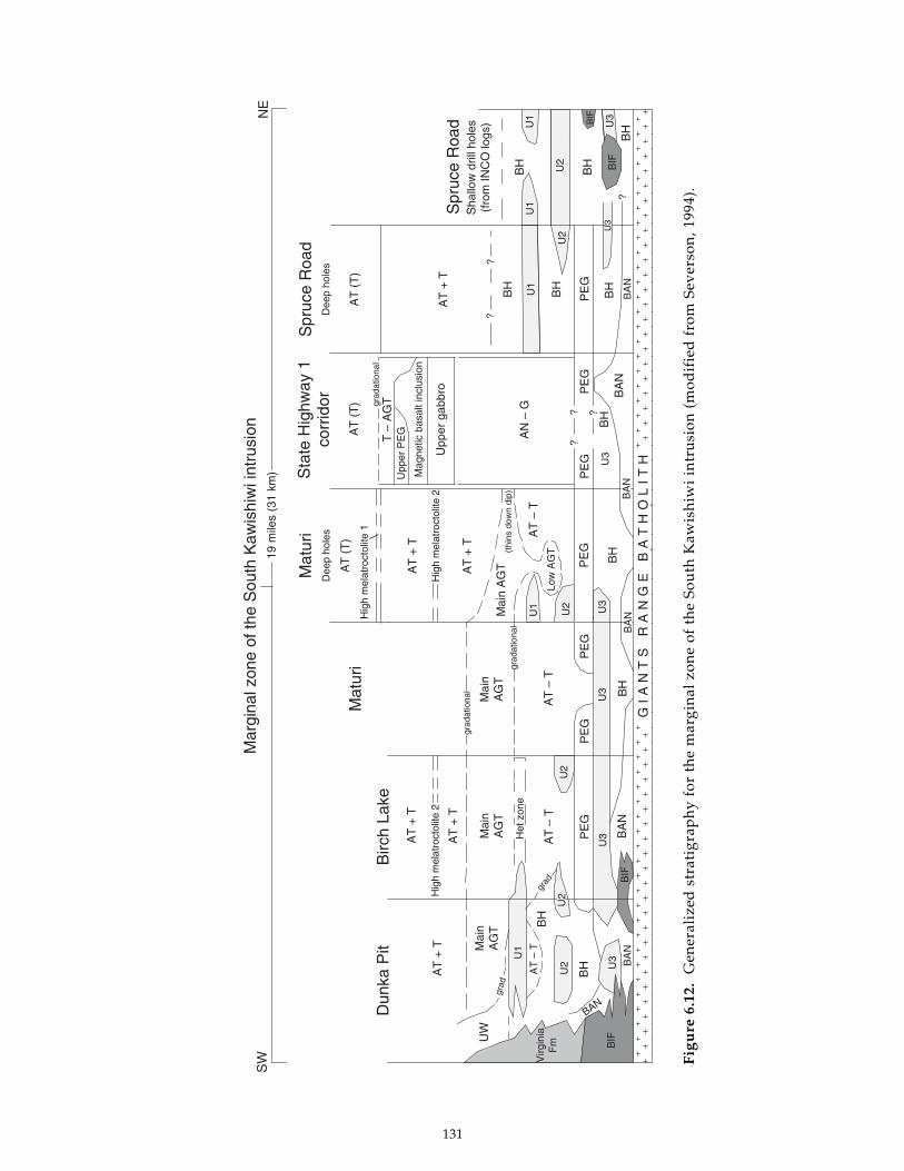
131
Figu
re 6
.12.
G
ener
aliz
ed s
trat
igra
ph
y fo
r th
e m
argi
nal
zon
e of
th
e So
uth
Kaw
ish
iwi
intr
usi
on (
mod
ifie
d f
rom
Sev
erso
n, 1
994)
.
U3
U1
U2
U3
BIF
Virg
inia
Fm
U2
U1
Mar
gina
l zon
e of
the
Sou
th K
awis
hiw
i int
rusi
onS
WN
E
Dun
ka P
itB
irch
Lake
Mat
uri
Mat
uri
Sta
te H
ighw
ay 1
corr
idor
Spr
uce
Roa
d
19 m
iles
(31
km)
Spr
uce
Roa
dA
T +
T
UW
Mai
nA
GT B
H
BH
AT
+ T
AT
+ T
Mai
nA
GT
AT
– T
AT
– T
AT
– T
AT
+ T
AT
+ T
Mai
nA
GT
Mai
n A
GT
AT
– T
BAN
BA
N
grad
Hig
h m
elat
roct
olite
2H
igh
mel
atro
ctol
ite 2
Hig
h m
elat
roct
olite
1
Het
zon
e
grad
PE
GP
EG
PE
G
BH
BA
N
grad
atio
nal
grad
atio
nal BA
NB
H
PE
GP
EG
PE
GP
EG
BA
N
BH
(thi
ns d
own
dip)
Low
AG
T
AT
(T
)
Dee
p ho
les
AT
(T
)
T –
AG
Tgrad
atio
nal
Upp
er P
EG
Mag
netic
bas
alt i
nclu
sion
Upp
er g
abbr
o
AN
– G
AT
+ T
AT
(T
)
Dee
p ho
les
BH
BH
BH
BH
BH
BH
BA
NB
AN
BIF
Sha
llow
dril
l hol
es(f
rom
INC
O lo
gs)
GI
AN
TS
R
AN
GE
B
AT
HO
LI
TH
?
??
?? ?
BIF
U1
U2
U2
U3
U3
U3
U3
U2
U1
U3
U1
U2
BIF

132
conformable to a steep contact and a moregradational contact relationship is inferred.
A stratiform sequence of troctolitic cumulatesover 1.5-kilometers-thick is exposed between thebasal contact and the axis of the synformalstructure in the vicinity of Rock Island Lake.Figure 6.13 shows the modal variations across thisstratigraphic section. The generalized map unitsshown in M-119 are also noted. Except for aheterolithic basal contact zone (unit l1cz, M-119)and an overlying zone of medium- to coarse-grained ophitic olivine gabbro to augite troctolite(unit l1og, M-119), the Lake One troctolite iscomposed of homogeneous to intermittentlylayered, medium-grained, well-foliated, ophiticmelatroctolite, troctolite, and augite troctolite.However, subtle variations in the distribution ofmodal layering and the abundance of ophiticaugite define three macrocyles (Fig. 6.13). The
basal cycle grades from the lower medium- tocoarse-grained olivine gabbro to augite troctolitecumulates (PcOf, POcf), to intermittently layered,medium-grained, ophitic troctolite (PO), andfurther to intermittently layered augite troctolite(POcf) that becomes medium coarse-grained nearthe top. The second cycle starts abruptly with anarrow interval of medium-grained troctolite thatcontains augite troctolite inclusions; this gradesabruptly to rhythmically layered troctolite andmelatroctolite (PO/OP). This troctolite gives wayto medium-grained, coarsely ophitic augitetroctolite (POcf) that contains augite oikocrysts upto 15-centimeters-wide. Another abrupt changein mode and texture marks the base of the thirdmacrocycle. The basal zone of this uppermostcycle is composed of homogeneous, well-laminatedgranular oxide-bearing troctolite (POF). This rockgrades into a medium-grained ophitic augite-
0
500
1000
1500
0 50 100
MODAL PERCENT
ME
TE
RS
Plagioclase
Olivine
Augite
Orthopyroxene
Fe-Ti oxide
Map unit name
l1cz
l1og
l1tr
l1ft
l1ftl1tr
l1tr
l1m
x
Biotite
EXPLANATION
Figure 6.13. Modal variations throughthe Lake One troctolite (modified fromMiller, 1986). Units are those definedon M-119. Isomodal olivine layeringis schematically portrayed as beingintermittent (occasional peaks) andrhythmic (regular peaks).

133
bearing troctolite, the uppermost unit of the LakeOne troctolite preserved in the synformal axisnorth of Rock Island Lake. The oxide troctolitesthat reappear on the south limb of this synformalstructure display a strong modal layering notobserved on the north limb. These cyclical changesin mode and texture and limited data on mineralcompositions (Miller, 1986) suggest that a leastthree major episodes of magma emplacement wereresponsible for the formation of the Lake Onetroctolite.
Tuscarora intrusionTroctolitic and interlayered anorthositic rocks
that cut the Poplar Lake intrusion of the earlygabbro series and locally underlie it have beentermed the Tuscarora intrusion by Weiblen andothers (1972) and Morey and others (1981).Although its western limit is unknown, a sufficientstrike length of these stratiform rocks (greater than20 kilometers) has been mapped to warrantretention of the “intrusion” label. The Tuscarorais distinct among layered series intrusions becauseof its abundance of anorthositic as well astroctolitic cumulates.
The Tuscarora intrusion has been mapped inthe Gunflint Lake quadrangle (Morey and Nathan,1978), the Long Island Lake quadrangle (Moreyand others, 1981), and the Gillis Lake quadrangle(Weiblen and Beitsch, unpub. data). The easterncontact of the Tuscarora intrusion irregularly cutsacross the layered gabbros of the Poplar Lakeintrusion in the western Gunflint Lake quadrangle(Nathan, 1969; Morey and Nathan, 1978). Nathan(1969) mapped a late intrusive sheet of anorthositicrocks emplaced into the basal zone of the PoplarLake intrusion that may be related to the Tuscaroraintrusion. The western extent of the Tuscaroraintrusion is unknown, but reconnaissance mappingby Phinney in the Ogishkemuncie Lake andKekekabic Lake quadrangles and a continuity inthe aeromagnetic signature suggest that it mayextend for at least 30 kilometers. In the Fraser Lakearea of the Kekekabic Lake quadrangle, Phinney(1972) noted a chilled contact of one troctolitic rockagainst another. It is unclear if this is a majorcontact between two layered series intrusions (suchas the Tuscarora and the Lake One). Because ofthis uncertainty, however, the basal zone oftroctolitic rocks between the Lake One area andthe Gillis Lake quadrangle are mapped asundifferentiated troctolite (unit trct, M-119). Whereit has been mapped, the basal contact of theTuscarora intrusion is predominantly against the
Paleoproterozoic Rove Formation and GunflintIron Formation, and the early Keweenawan Logansills within them (Morey and others, 1981). In theGillis Lake quadrangle, the Tuscarora intrusioncuts through the Paleoproterozoic section andcomes into contact with Archean metasedimentaryand metavolcanic rocks.
Morey and others (1981) recognized three mainunits of the Tuscarora intrusion in the Long IslandLake quadrangle. A basal zone is composed offine- to medium-grained, ophitic olivine gabbroto augite troctolite that is locally enriched in sulfide(unit tuta, M-119). Above this thin interval is a unitof medium- to fine-grained, well-foliated troctolite(unit tutr, M-119), the lower part of which isgenerally finer-grained. These troctolites are inturn overlain by a 100-meter-thick sequence ofinterlayered anorthositic gabbro (leucogabbro) andtroctolite (unit tuat, M-119). Morey and others(1981) noted, “These two rock types areinterlayered on a scale of several centimeters toseveral meters. Contacts between layers are sharp.The general dip of the layering is nearhorizontal...” The authors interpreted this unit astransitional between the troctolite unit and theanorthositic rocks exposed in the southern part ofthe quadrangle. The anorthositic rocks weredescribed as, “Medium-grained anorthositicgabbro. Contains 75 to 80% cumulus plagioclase(An55-60) and varying proportions of augite, olivine,and iron oxides in a poikilitic texture.” Morey andothers (1981) interpreted these anorthositic rocksto be the upper unit of the Tuscarora intrusion(their unit tag); however, in generalized maps ofthe complex (for example Davidson, 1972; Weiblenand Morey, 1980), these anorthositic rocks weregrouped with the anorthositic series. Map M-119also portrays these anorthositic rocks as part ofthe anorthositic series. The interlayered nature ofthe transition between troctolitic and anorthositiccumulates in the Tuscarora intrusion suggests moreclearly than elsewhere in the Duluth Complex thatthe layered series and anorthositic series rocks maybe linked petrogenetically, as implied by theirsimilar ages (Paces and Miller, 1993).
Scattered throughout the Tuscarora intrusionare mafic volcanic hornfels bodies of varied size(the largest is about 2.5-kilometers-wide). Hornfelsbodies are abundant in the troctolitic rocks of thenorthern Duluth Complex, composing up to 15percent of the zone according to estimates by Grout(1930). Most bodies, like the ones in the Tuscaroraintrusion, are recrystallized mafic volcanic rocks

134
of the North Shore Volcanic Group. They havegabbroic mineral assemblages and locally displayrelict volcanic structures (such as meta-amygdules).Some inclusions along the northern troctolite zonewere evidently derived from Paleoproterozoicsedimentary rocks; one notable footwall inclusionis an 8-kilometer-long band of recrystallized iron-formation (unit Pif, M-119). The abundance andlateral continuity of this and other inclusions alongparticular horizons in the troctolitic cumulatessuggest that the Tuscarora and related troctoliticrocks to the west were emplaced as multiple, semi-conformable sheetlike intrusions into the base ofthe volcanic pile and into the shallow-dippingPaleoproterozoic sedimentary rocks immediatelybeneath them.
Wilder Lake intrusionReconnaissance mapping in the northwestern
part of the Duluth Complex (Phinney, 1972, unpub.data; Miller, 1986) has revealed a mafic layeredintrusion, termed the Wilder Lake intrusion, thatis distinct in its structural setting, cumulatestratigraphy, and cryptic layering from otherlayered series intrusions of the complex. Thismapping and a distinctively striped aeromagneticpattern (Fig. 6.11) indicate that the Wilder Lakeintrusion extends at least 10 kilometers from NorthWilder Lake east-southeast to Arrow Lake.
The Wilder Lake intrusion differs from otherlayered series intrusions because it dips to thenortheast rather than the southeast. Also, insteadof being sandwiched between pre-Keweenawanbasement rocks and a cap of anorthositic seriesrocks, the Wilder Lake intrusion is completelyenveloped by plagioclase cumulates of theanorthositic series (Fig. 6.1). The northeasterly dipof the intrusion may reflect the control of anunderlying southeast-trending structural ridge ofArchean rocks, which has been postulated byMiller and Chandler (1997) to be an extension ofthe Giants Range batholith. The reversed directionof dip, higher level of emplacement, and chilledlower margin suggest that the Wilder Lakeintrusion is younger than the layered seriesintrusions along the base of the Duluth Complex.
Another distinctive characteristic of the WilderLake intrusion is its cumulate stratigraphy (Fig.6.14): Fe-Ti oxide arrives as a cumulus phase beforeaugite. A fine- to medium-grained, non-foliatedto poorly foliated, subophitic olivine gabbro formsa 25- to 100-meter-thick basal contact zone (unitwlog, M-119). Above this is a 100-meter-thickinterval of intermittently layered ophitic augite
troctolite cumulates (POc; unit wllt, M-119) thatgrades upward to a homogeneous augite-poortroctolite cumulate (PO; unit wltr, M-119). Theadcumulate troctolite grades over a few meters intoa well-foliated ilmenite troctolite (POF) that isabout 50-meters-thick and contains about 8 percentmodal ilmenite. The abrupt cumulus arrival ofaugite marks the most differentiated unit, a 25-meter-thick interval of well-foliated, olivine oxidegabbro (PCOF). The POF and PCOF cumulatesare combined as the wlfg unit on the geologic map(M-119). The PCOF cumulate abruptly gives wayto well laminated and locally modally layered,augite-poor troctolite (unit wllt, M-119) that persistsupward through the rest of the section and intoa structurally complex, anorthositic inclusion-richroof zone (unit wlrz, M-119). Gabbroic anorthositeinclusions are observed in all units exposed aroundNorth Wilder Lake, but are particularly abundantin the roof zone.
In addition to the cumulus arrival of ilmenitebefore augite, a distinctive and anomalous featureof the Wilder Lake intrusion is the reversed crypticvariation of mg# in both olivine and augiteupwards through the cumulate sequence (Fig.6.14). The result is that the most primitive olivineand augite compositions occur in the mostmineralogically evolved cumulates. Olivine in thePCFO cumulate has an Fo content almost 15percent greater than olivine from the basal contactzone. The mg# of augite in the oxide troctolitecumulate (POF) is almost 10 mole percent greaterthan augite at the upper and lower contacts.Interestingly, where augite is cumulus (PCFO unit),it is more iron-rich than in adjacent units whereit is intercumulus and in minor abundance. Millerand Ripley (1996) suggested that this may indicateless trapped liquid in the cumulates andconsequently less of a trapped-liquid shift.
Bald Eagle intrusionAnother layered series intrusion that displays
a distinctive cumulate stratigraphy is the BaldEagle intrusion (Weiblen, 1965; Weiblen and Morey,1980). It occurs inboard of the northwesternmargin of the Duluth Complex (Fig. 6.1) and wasemplaced partially within rocks of the anorthositicseries and partially within the South Kawishiwiand Greenwood Lake intrusions. Steep foliationand layering (Weiblen, 1965; Green and others,1966) and a subtle gravity anomaly over the areaimply that the northern part of this intrusion hasa funnel shape that necks down to a steep feeder.Aeromagnetic data imply that the Bald Eagle

135
intrusion extends considerably south of the areaof exposure (Fig. 6.11) and flattens out to a shallow-dipping sheet.
As mapped by Weiblen (1965) in the northernarea of exposure, the Bald Eagle intrusion consistsof an outer zone of troctolitic adcumulates (unitbetr, M-119) and an inner core of olivine gabbroadcumulates (unit begb, M-119). The rocks arewell-foliated and locally display a downdiplineation. Isomodal layering of olivine andplagioclase abundance is common in the troctoliteunit, especially where it is steeply dipping. Gradedlayering is rare. Interstitial Fe-Ti oxide composesless than 1 percent of either rock type andchromium spinel occurs exclusively in thetroctolite. The transition from PO to PCOcumulates occurs over a 100-meter-wide zonewithin which interstitial pyroxene increases inabundance, leucocratic compositions becomecommon, and olivine gabbroic and troctolitic rocktypes become interlayered. Weiblen (1965) noted
general cryptic differences in mafic silicatesbetween these two cumulate rock types, but notin plagioclase. Microprobe analyses show thatolivine in the troctolite zone varies between Fo77and Fo70, and in the gabbro core between Fo69 toFo62. However, a systematic study of the crypticvariation through the intrusion was not conducted.
In contrast to other layered series intrusionswhere the cumulus arrival of Fe-Ti oxide is closeto that of augite (such as the layered series atDuluth and Wilder Lake intrusion), oxide neverappears in the Bald Eagle intrusion despite abouthalf the intrusion being composed of PCOcumulates. Because of its upright funnel shapeand the depth of erosion, whatever upperdifferentiates may have existed in the intrusionhave not been preserved. Despite an incompletecumulate sequence, it is nevertheless remarkablethat about 50 percent of the approximately 2.5kilometers of stratigraphic section is composed ofPCO cumulates. The cause of the extended delay
Figure 6.14. Modal and cryptic variation of mg# (MgO/[MgO+FeO]) in olivine and augite in theWilder Lake intrusion (modified from Miller, 1986 and Miller and Ripley, 1996). Units are those definedon M-119.
0
100
200
300
400
500
600
80 70 60 50
mg#
0 50 100
Cumulative volume percent
Plagioclase Olivine Augite
wlog
wllt
wltr
wlfg
wllt
wlrz
M-119
Fe-Ti Oxide
Olivine
Augite
ME
TE
RS
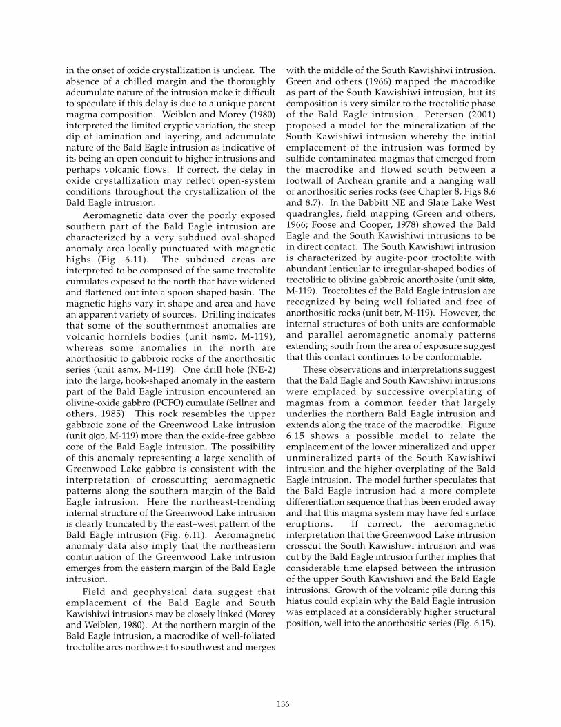
136
in the onset of oxide crystallization is unclear. Theabsence of a chilled margin and the thoroughlyadcumulate nature of the intrusion make it difficultto speculate if this delay is due to a unique parentmagma composition. Weiblen and Morey (1980)interpreted the limited cryptic variation, the steepdip of lamination and layering, and adcumulatenature of the Bald Eagle intrusion as indicative ofits being an open conduit to higher intrusions andperhaps volcanic flows. If correct, the delay inoxide crystallization may reflect open-systemconditions throughout the crystallization of theBald Eagle intrusion.
Aeromagnetic data over the poorly exposedsouthern part of the Bald Eagle intrusion arecharacterized by a very subdued oval-shapedanomaly area locally punctuated with magnetichighs (Fig. 6.11). The subdued areas areinterpreted to be composed of the same troctolitecumulates exposed to the north that have widenedand flattened out into a spoon-shaped basin. Themagnetic highs vary in shape and area and havean apparent variety of sources. Drilling indicatesthat some of the southernmost anomalies arevolcanic hornfels bodies (unit nsmb, M-119),whereas some anomalies in the north areanorthositic to gabbroic rocks of the anorthositicseries (unit asmx, M-119). One drill hole (NE-2)into the large, hook-shaped anomaly in the easternpart of the Bald Eagle intrusion encountered anolivine-oxide gabbro (PCFO) cumulate (Sellner andothers, 1985). This rock resembles the uppergabbroic zone of the Greenwood Lake intrusion(unit glgb, M-119) more than the oxide-free gabbrocore of the Bald Eagle intrusion. The possibilityof this anomaly representing a large xenolith ofGreenwood Lake gabbro is consistent with theinterpretation of crosscutting aeromagneticpatterns along the southern margin of the BaldEagle intrusion. Here the northeast-trendinginternal structure of the Greenwood Lake intrusionis clearly truncated by the east–west pattern of theBald Eagle intrusion (Fig. 6.11). Aeromagneticanomaly data also imply that the northeasterncontinuation of the Greenwood Lake intrusionemerges from the eastern margin of the Bald Eagleintrusion.
Field and geophysical data suggest thatemplacement of the Bald Eagle and SouthKawishiwi intrusions may be closely linked (Moreyand Weiblen, 1980). At the northern margin of theBald Eagle intrusion, a macrodike of well-foliatedtroctolite arcs northwest to southwest and merges
with the middle of the South Kawishiwi intrusion.Green and others (1966) mapped the macrodikeas part of the South Kawishiwi intrusion, but itscomposition is very similar to the troctolitic phaseof the Bald Eagle intrusion. Peterson (2001)proposed a model for the mineralization of theSouth Kawishiwi intrusion whereby the initialemplacement of the intrusion was formed bysulfide-contaminated magmas that emerged fromthe macrodike and flowed south between afootwall of Archean granite and a hanging wallof anorthositic series rocks (see Chapter 8, Figs 8.6and 8.7). In the Babbitt NE and Slate Lake Westquadrangles, field mapping (Green and others,1966; Foose and Cooper, 1978) showed the BaldEagle and the South Kawishiwi intrusions to bein direct contact. The South Kawishiwi intrusionis characterized by augite-poor troctolite withabundant lenticular to irregular-shaped bodies oftroctolitic to olivine gabbroic anorthosite (unit skta,M-119). Troctolites of the Bald Eagle intrusion arerecognized by being well foliated and free ofanorthositic rocks (unit betr, M-119). However, theinternal structures of both units are conformableand parallel aeromagnetic anomaly patternsextending south from the area of exposure suggestthat this contact continues to be conformable.
These observations and interpretations suggestthat the Bald Eagle and South Kawishiwi intrusionswere emplaced by successive overplating ofmagmas from a common feeder that largelyunderlies the northern Bald Eagle intrusion andextends along the trace of the macrodike. Figure6.15 shows a possible model to relate theemplacement of the lower mineralized and upperunmineralized parts of the South Kawishiwiintrusion and the higher overplating of the BaldEagle intrusion. The model further speculates thatthe Bald Eagle intrusion had a more completedifferentiation sequence that has been eroded awayand that this magma system may have fed surfaceeruptions. If correct, the aeromagneticinterpretation that the Greenwood Lake intrusioncrosscut the South Kawishiwi intrusion and wascut by the Bald Eagle intrusion further implies thatconsiderable time elapsed between the intrusionof the upper South Kawishiwi and the Bald Eagleintrusions. Growth of the volcanic pile during thishiatus could explain why the Bald Eagle intrusionwas emplaced at a considerably higher structuralposition, well into the anorthositic series (Fig. 6.15).

137
Figure 6.15. Interpretive model for the emplacement and mineralization of the South Kawishiwi andBald Eagle intrusions via a common feeder system.A. Emplacement of plagioclase crystal mushes to create anorthositic series rocks.B. Emplacement of the lower part of the South Kawishiwi intrusion beneath the anorthositic series;the marginal zone becomes sulfide mineralized due to contamination by Paleoproterozoic footwallrocks.C. Emplacement of the unmineralized upper part of the South Kawishiwi intrusion.D. Emplacement and in situ differentiation of the Bald Eagle intrusion; the complete differentiationsequence is not preserved at the present erosion level.
A. Anorthositic series
emplacement of viscousplagioclase crystal mush
minor sulfide
North Shore Volcanic Group
Archean granite/greenstone
Biwabik Iron Formation
Virginia Formation
volcanic eruption?
B. Early South Kawishiwi intrusion
basal sulfidemineralization
feeder zonemineralization?
C. Late South Kawishiwi intrusion
minor intraformationalsulfide mineralization
enriched feederzone mineralization?
D. Bald Eagle intrusion
differentiatedcumulates
zone mineralization?very enriched feeder
present erosion surface
Bald Eagleintrusion

138
Greenwood Lake intrusionThe Greenwood Lake intrusion is one of the
largest and most differentiated intrusions in theDuluth Complex. Being almost completelyunexposed, its existence was recognized onlyrecently as a result of drilling and a reinterpretationof aeromagnetic data (Meints and others, 1993;Miller and Chandler, 1999). The only exposure ofthe Greenwood Lake intrusion are scatteredoutcrops of olivine oxide gabbro cumulatesexposed along the LTV Mining railroad grade oneither side of Lake County Highway 2. Bonnichsen(1972) first described these gabbros, but did notspeculate as to what intrusive system they maybelong. Weiblen and Morey (1980) interpretedthese gabbro exposures to be upper differentiatesof the Bald Eagle intrusion.
The identification of the Greenwood Lakeintrusion occurred soon after the acquisition ofhigh-resolution aeromagnetic data in 1981. Oneof the more distinctive aeromagnetic anomaliesover the Duluth Complex is a 30-kilometer-long,sinuous, strong magnetic high that cutsnortheasterly across Greenwood Lake (Fig. 6.6) andis referred to as the Snake anomaly (Vadis andothers, 1981). The Snake anomaly straddlesoutcrops of granophyre forming Mt. Weber to theeast and the gabbro exposures along the LTVrailroad grade to the west. The anomaly wasdrilled in 1981 by U.S. Steel near Lake CountyHighway 2 (DDH 27015) and by the MinnesotaDepartment of Natural Resources (DNR) about 7kilometers to the southwest (DDH S-1). The DNRdrill hole encountered 30 feet (9 meters) ofmedium-grained, olivine-bearing oxide gabbrocumulates that contain about 10 percent oxide, butare locally layered with oxide-rich bands (up to30 percent) and sulfide (pyrrhotite and chalcopyriteup to 4 percent; Vadis and others, 1981). Drill holeSE-2 was drilled by the DNR in 1986 near thesouthern terminus of the Snake anomaly. This 554-foot (169-meter) drill core intersected medium- tofine-grained oxide gabbro and oxide troctolite thatcontains abundant inclusions of anorthositic rocks.
The first attempt to interpret the geology ofthe Greenwood Lake area from the newaeromagnetic data and the drill holes into theSnake anomaly was by Chandler (1990). Herecognized that the east-dipping gabbro exposureswere part of a busy aeromagnetic pattern thatprojected beneath the entire length of the Snakeanomaly (Fig. 6.6). Chandler interpreted theferrogabbros of the Snake anomaly to be extreme
differentiates of the underlying gabbro cumulates.He also recognized that this gabbro/ferrogabbroterrane was not part of the Bald Eagle intrusion,but rather was truncated by the subdued anomalypattern of the troctolitic rocks forming the southernpart of the Bald Eagle intrusion (Figs. 6.6 and 6.11).Lacking outcrop or drill core and drawinganalogies to subdued anomaly patterns over thelarge area of anorthositic rocks in the north-centralcomplex, Chandler attributed the similarlysubdued aeromagnetic anomaly northwest of(beneath) the gabbro terrane to anorthositic seriesrocks (Chapter 2, Fig. 2.2).
In 1991, the Minnesota Geological Surveyconducted a shallow drilling project that revealedthat the subdued northwestern anomaly wasactually related to troctolitic cumulates, notanorthositic series rocks. A total of four 10-foot(3-meter) drill cores were acquired west of (downsection of) the Snake anomaly in what would cometo be regarded as the Greenwood Lake intrusion(Meints and others, 1993). Two holes (CDC-40 andCDC-54) were drilled into oxide olivine gabbrocumulates and confirmed Chandler ’s (1990)interpretation that the gabbroic cumulates exposedin the railroad cuts to the north extend to the southbeneath the Snake anomaly. A drill hole near theinferred contact with the Bald Eagle intrusion(CDC-48) yielded a puzzling rock—varitexturedophitic olivine gabbro with poikilitic olivine. Themost informative drill hole, however, was CDC-52, which was drilled into the subduedaeromagnetic anomaly previously interpreted asanorthositic rocks. This hole yielded a medium-grained, moderately foliated ophitic troctolite.With this discovery, a complete differentiationsequence was identified beneath the Snakeanomaly and the body was termed the GreenwoodLake intrusion in a subsequent map of the centralDuluth Complex (Miller and Chandler, 1999).
Foliation in outcrop and in drill core from theGreenwood Lake intrusion dips from 10º to 30ºeast–southeast. Estimating an average dip of 15º,the total stratigraphic thickness of the GreenwoodLake intrusion is over 7 kilometers, making it oneof the thickest layered series intrusions. Based onthe transition from a subdued to busyaeromagnetic pattern, troctolitic and gabbroiccumulates appear to compose subequalthicknesses. Based exclusively on the magneticdata, the southern part of the intrusion appearsto narrow down abruptly to a width of 2 kilometersor less. This suggests that the southern limit of

139
the intrusion may be controlled by a syn-magmaticor post-solidification fault. As mentioned above,the Greenwood Lake intrusion is truncated by theBald Eagle intrusion on the north. However, asimilar anomaly pattern to that associated with themain body of the Greenwood Lake intrusion canbe traced east of the Bald Eagle intrusion. Theanomaly arcs to the southeast, narrows in width,and appears to merge with the Wilson Lakeferrogabbro of the northern Beaver Bay Complex(Figs. 6.6 and 6.11). A genetic link is possible giventhat the Greenwood Lake intrusion appears to beone of the youngest in the Duluth Complex andthe Wilson Lake ferrogabbro is one of the earliestintrusions in the Beaver Bay Complex.
Osier Lake intrusionJust west of Osier Lake and near the inferred
upper contact of the central Duluth Complex is asubcircular aeromagnetic anomaly that is about 5kilometers across and is composed of an outermagnetic low and a central magnetic high (Figs.6.6 and 6.11). Two drill holes into the anomalyindicate the presence of a concentrically zoned,well-differentiated mafic stock termed the OsierLake intrusion (Miller and Chandler, 1999).
In 1985, the Minnesota Department of NaturalResources drilled a 954-foot (291-meter) drill hole(NR-1) into the central magnetic high (Sellner andothers, 1985). Beyond a 224-foot-thick (68-meter)cover of glacial overburden, the entire drill coreconsists of well-foliated, commonly layered,medium-grained oxide gabbro to olivine oxidegabbro (PCF ± O cumulate). The average rockcontains 50 to 60 percent foliated plagioclase, 30percent granular augite, 7 to 15 percent Fe-Ti oxide,0 to 3 percent olivine, and traces of chalcopyrite.The Minnesota Geological Survey drilled a 303-foot (92-meter) drill hole (CDC-14b) in 1991 intothe outer magnetic low (Meints and others, 1993).Beneath a thick glacial overburden of 275 feet (84meters) and 20 feet (6 meters) of regolith, a 5-foot(1.5-meter) core of bedrock was recovered. Therock is a deeply weathered, coarse-grained,moderately foliated, ophitic oxide-rich augitemelatroctolite.
An outer ring of troctolitic cumulates and aninner core of olivine oxide gabbro cumulates isconsistent with the Osier Lake intrusion being awell differentiated stock. The internal structureof the intrusion is difficult to determine becauseNR-1 was drilled at an angle of 52º to the northeast(roughly at a right angle to the outer contact of
the intrusion). Layering and foliation are at a 70ºto 80° angle to the core axis. Foliation is poorlydeveloped and difficult to see in the weatheredmelatroctolite (CDC-14b).
Because it is isolated within anorthositic seriesrocks, the age of the Osier Lake intrusion relativeto other layered series intrusions is unknown. Itshigh structural position suggests that it may beone of the youngest intrusions. Also, its circularform may indicate that it is a deeply eroded feederto a larger sheetlike intrusion.
REFERENCES
Allen, D.J., Hinze, W.J., Dickas, A.B., and Mudrey,M.G., Jr., 1997, Integrated geophysicalmodeling of the North American Midcontinentrift system: New interpretations for westernLake Superior, northwestern Wisconsin, andeastern Minnesota, in Ojakangas, R.W., Dickas,A.B., and Green, J.C., eds., Middle Proterozoicto Cambrian rifting, central North America:Geological Society of America Special Paper312, p. 47-72.
Babcock, R.C., Jr., 1959, Petrogeny of thegranophyre and intermediate rock in theDuluth Gabbro of northern Cook County,Minnesota: Madison, Wis., University ofWisconsin, M.S. thesis, 47 p.
Beck, M.E., 1970, Paleomagnetism of Keweenawanintrusive rocks, Minnesota: Journal ofGeophysical Research, v. 75, no. 26, p. 4985-4996.
Boerboom, T.J., and Miller, J.D., Jr., 1994, Bedrockgeologic map of the Silver Island Lake, WilsonLake, and western Toohey Lake quadrangles,Cook and Lake Counties, Minnesota:Minnesota Geological Survey MiscellaneousMap M-81, scale 1:24,000.
Bonnichsen, B., 1971, Outcrop map of southern partof Duluth Complex and associatedKeweenawan rocks, St. Louis and LakeCounties, Minnesota: Minnesota GeologicalSurvey Miscellaneous Map M-11, scale1:125,000.
———1972, Southern part of the Duluth Complex,in Sims, P.K., and Morey, G.B., eds., Geologyof Minnesota: A centennial volume: MinnesotaGeological Survey, p. 361-387.
———1974, Geology of the Ely–Hoyt Lakesdistrict, northeastern Minnesota: MinnesotaGeological Survey Open-File Report, 29 p.

140
Cannon, W.F., Green, A.G., Hutchinson, D.R., Lee,M.W., Milkereit, B., Behrendt, J.C., Halls, H.C.,Green, J.C., Dickas, A.B., Morey, G.B., Sutcliffe,R.H., and Spencer, C., 1989, The NorthAmerican Midcontinent rift beneath LakeSuperior from GLIMPCE seismic reflectionprofiling: Tectonics, v. 8, no. 2, p. 305-332.
Chalokwu, C.I., and Grant, N.K., 1987,Reequilibration of olivine with trapped liquidin the Duluth Complex, Minnesota: Geology,v. 15, no. 1, p. 71-74.
———1990, Petrology of the Partridge Riverintrusion, Duluth Complex, Minnesota: 1.Relationships between mineral compositions,density and trapped liquid abundance: Journalof Petrology, v. 31, no. 2, p. 265-293.
Chalokwu, C.I., Grant, N.K., Ariskin, A.A., andBarmina, G.S., 1993, Simulation of primaryphase relations and mineral compositions inthe Partridge River intrusion, Duluth Complex,Minnesota: Implications for the parent magmacomposition: Contributions to Mineralogy andPetrology, v. 114, no. 4, p. 539-549.
Chandler, V.W., 1990, Geologic interpretation ofgravity and magnetic data over the central partof the Duluth Complex, northeasternMinnesota: Economic Geology, v. 85, no. 4, p.816-829.
———2001, Superimposed magnetic on gravityanomaly map of the central Duluth Complexand western part of the Beaver Bay Complex,Lake and St. Louis Counties, Minnesota:Minnesota Geological Survey MiscellaneousMap M-117, scale 1:100,000.
Davidson, D.M., Jr., 1969a, Geologic map of theKawishiwi Lake quadrangle, Lake and CookCounties, Minnesota: Minnesota GeologicalSurvey Miscellaneous Map M-7, scale 1:24,000.
———1969b, Geologic map of the Perent Lakequadrangle, Lake County, Minnesota:Minnesota Geological Survey MiscellaneousMap M-8, scale 1:24,000.
———1972, Eastern part of Duluth Complex, inSims, P.K., and Morey, G.B., eds., Geology ofMinnesota: A centennial volume: MinnesotaGeological Survey, p. 354-360.
———1977a, Reconnaissance geologic map of theBeth Lake quadrangle, Cook County,Minnesota: Minnesota Geological SurveyMiscellaneous Map M-26, scale 1:24,000.
———1977b, Reconnaissance geologic map of theCherokee Lake quadrangle, Cook County,
Minnesota: Minnesota Geological SurveyMiscellaneous Map M-30, scale 1:24,000.
———1977c, Reconnaissance geologic map of theEagle Mountain quadrangle, Cook County,Minnesota: Minnesota Geological SurveyMiscellaneous Map M-28, scale 1:24,000.
———1977d, Reconnaissance geologic map of theKelso Mountain quadrangle, Cook County,Minnesota: Minnesota Geological SurveyMiscellaneous Map M-27, scale 1:24,000.
———1977e, Reconnaissance geologic map of theLima Mountain quadrangle, Cook County,Minnesota: Minnesota Geological SurveyMiscellaneous Map M-32, scale 1:24,000.
Davidson, D.M., Jr., and Burnell, J.R., Jr., 1977,Reconnaissance geologic map of the Brule Lakequadrangle, Cook County, Minnesota:Minnesota Geological Survey MiscellaneousMap M-29, scale 1:24,000.
Davis, D.W., and Green, J.C., 1997, Geochronologyof the North American Midcontinent rift inwestern Lake Superior and implications for itsgeodynamic evolution: Canadian Journal ofEarth Sciences, v. 34, no. 4, p. 476-488.
Davis, D.W., and Paces, J.B., 1990, Time resolutionof geologic events on the Keweenaw Peninsulaand implications for development of theMidcontinent rift system: Earth and PlanetaryScience Letters, v. 97, p. 54-64.
Foose, M.P., 1984, Logs and correlation of drillholes within the South Kawishiwi intrusion,Duluth Complex, northeastern Minnesota:U.S. Geological Survey Open-File Report 84-14, variously paged, 1 pl.
Foose, M.P., and Cooper, R.W., 1978, Preliminarygeologic report on the Harris Lake area,northeastern Minnesota: U.S. GeologicalSurvey Open-File Report 78-385, 24 p., 1 pl.,scale 1:12,000.
Geerts, S.D., 1991, Geology, stratigraphy, andmineralization of the Dunka Road Cu-Niprospect, northeastern Minnesota: NaturalResources Research Institute, Technical ReportNRRI/TR-91/14, 61 p.
Grant, N.K., and Chalokwu, C.I., 1992, Petrologyof the Partridge River intrusion, DuluthComplex, Minnesota: II. Geochemistry andstrontium isotope systematics in drill coreDDH-221: Journal of Petrology, v. 33, no. 5,p. 1007-1038.
Grant, N.K., and Molling, P.A., 1981, A strontiumisotope and trace element profile through the

141
Partridge River troctolite, Duluth Complex,Minnesota: Contributions to Mineralogy andPetrology, v. 77, no. 3, p. 296-305.
Green, J.C., comp., 1982, Geologic map ofMinnesota, Two Harbors sheet: MinnesotaGeological Survey, scale 1:250,000.
Green, J.C., Davis, D.W., and Schmitz, M.D., 2001,Three new zircon dates for the Midcontinentrift, North Shore, Minnesota: More data, morequestions [abs.]: Institute on Lake SuperiorGeology, 47th Annual Meeting, Madison, Wis.,Proceedings, v. 47, Program and Abstracts, pt.1, p. 29.
Green, J.C., Phinney, W.C., and Weiblen, P.W., 1966,Gabbro Lake quadrangle, Lake County,Minnesota: Minnesota Geological SurveyMiscellaneous Map M-2, scale 1:31,680.
Grout, F.F., 1918a, Internal structures of igneousrocks; their significance and origin; withspecial reference to the Duluth Gabbro:Journal of Geology, v. 26, p. 439-458.
———1918b, Two-phase convection in igneousmagmas: Journal of Geology, v. 26, p. 481-499.
———1918c, A type of igneous differentiation:Journal of Geology, v. 26, p. 626-658.
———1930, Probable extent of abyssalassimilation: Geological Society of AmericaBulletin, v. 41, no. 4, p. 675-694.
Grout, F.F., Sharp, R.P., and Schwartz, G.M., 1959,The geology of Cook County Minnesota:Minnesota Geological Survey Bulletin 39, 163p., 16 pls.
Jerde, E.A., Salvato, D.J., Thole, J., and Wirth, K.R.,2001, The early gabbroic series of theMidcontinent rift system: Continuedassessment of magmatic origins: Institute onLake Superior Geology, 47th Annual Meeting,Madison, Wis., Proceedings, v. 47, Program andAbstracts, pt. 1, p. 36-37.
Kushiro, I., 1980, Viscosity, density, and structureof silicate melts at high pressures, and theirpetrological applications, in Hargraves, R.B.,ed., Physics of magmatic processes: PrincetonUniversity Press, p. 93-120.
Lee, I., and Ripley, E.M., 1996, Mineralogic andoxygen isotopic studies of open systemmagmatic processes in the South Kawishiwiintrusion, Spruce Road area, Duluth Complex,Minnesota: Journal of Petrology, v. 37, no. 6,p. 1437-1461.
Martineau, M.P., 1989, Empirically derived controlson Cu-Ni mineralization: A comparison
between fertile and barren gabbros in theDuluth Complex, Minnesota, U.S.A., inPrendergast, M.D., and Jones, M.J., eds.,Magmatic sulphides—The Zimbabwe volume:London, Institute of Mining and Metallurgy,p. 117-137.
McBirney, A.E., 1989, The Skaergaard layeredseries: I. Structure and average compositions:Journal of Petrology, v. 30, no. 2, p. 363-397.
Meints, J.P., Jirsa, M.A., Chandler, V.W., and Miller,J.D., Jr., 1993, Scientific core drilling in partsof Itasca, St. Louis, and Lake Counties,northeastern Minnesota—1989-1991: Summaryof lithologic, geochemical, and geophysicalresults: Minnesota Geological SurveyInformation Circular 37, 159 p.
Miller, J.D., Jr., 1986, The geology and petrologyof anorthositic rocks in the Duluth Complex,Snowbank Lake quadrangle, northeasternMinnesota: Minneapolis, University ofMinnesota, Ph.D. dissertation, 585 p.
Miller, J.D., Jr., Boerboom, T.J., and Jerde, E.A.,1994, Bedrock geologic map of the Cabin Lakeand Cramer 7.5-minute quadrangles, Lake andCook Counties, Minnesota: MinnesotaGeological Survey Miscellaneous Map M-82,scale 1:24,000.
Miller, J.D., Jr., and Chandler, V.W., 1997, Geology,petrology, and tectonic significance of theBeaver Bay Complex, northeastern Minnesota,in Ojakangas, R.W., Dickas, A.B., and Green,J.C., eds., Middle Proterozoic to Cambrianrifting, central North America: GeologicalSociety of America Special Paper 312, p. 73-96.
———1999, Bedrock geologic map of the centralDuluth Complex and western part of theBeaver Bay Complex, Lake and St. LouisCounties, Minnesota: Minnesota GeologicalSurvey Miscellaneous Map M-101, scale1:100,000.
Miller, J.D., Jr., Green, J.C., and Chandler, V.W.,1993b, Preliminary geologic map of the Dulutharea, St. Louis County, Minnesota: MinnesotaGeological Survey Open-File Report 93-2, 1 pl.,scale 1:48,000.
Miller, J.D., Jr., Green, J.C., Severson, M.J.,Chandler, V.W., and Peterson, D.M., 2001,Geologic map of the Duluth Complex andrelated rocks, northeastern Minnesota:Minnesota Geological Survey MiscellaneousMap M-119, scale 1:200,000.

142
Miller, J.D., Jr., and Ripley, E.M., 1996, Layeredintrusions of the Duluth Complex, Minnesota,USA, in Cawthorn, R.G., ed., Layeredintrusions: Amsterdam, Elsevier Science, p.257-301.
Miller, J.D., Jr., and Vervoort, J.D., 1996, The latentmagmatic stage of the Midcontinent rift: aperiod of magmatic underplating and meltingof the lower crust: Institute on Lake SuperiorGeology, 42nd Annual Meeting, Cable, Wis.,Proceedings, v. 42, Program and Abstracts, pt.1, p. 33-35.
Miller, J.D., Jr., and Weiblen, P.W., 1990,Anorthositic rocks of the Duluth Complex:Examples of rocks formed from plagioclasecrystal mush: Journal of Petrology, v. 31, no.2, p. 295-339.
Morey, G.B., 1996, Continental margin assemblage,in Sims, P.K., and Carter, L.M.H., eds., Archeanand Proterozoic geology of the Lake Superiorregion, U.S.A., 1993: U.S. Geological SurveyProfessional Paper 1556, p. 30-43.
Morey, G.B., and Cooper, R.W., 1977, Bedrockgeology of the Hoyt Lakes–Kawishiwi area, St.Louis and Lake Counties, northeasternMinnesota: Minnesota Geological SurveyOpen-File Report, scale 1:48,000.
Morey, G.B., and Nathan, H.D., 1978, Geologic mapof the Gunflint Lake quadrangle, Cook County,Minnesota: Minnesota Geological SurveyMiscellaneous Map M-42, scale 1:24,000.
Morey, G.B., Weiblen, P.W., Papike, J.J., andAnderson, D.H., 1981, Geologic map of theLong Island Lake quadrangle, Cook County,Minnesota: Minnesota Geological SurveyMiscellaneous Map M-46, scale 1:24,000.
Nathan, H.D., 1969, The geology of a part of thenortheast segment of the Duluth Complex:Minneapolis, University of Minnesota, Ph.D.dissertation, 198 p.
Nicholson, S.W., and Shirey, S.B., 1990,Midcontinent rift volcanism in the LakeSuperior region: Sr, Nd, and Pb isotopicevidence for a mantle plume origin: Journalof Geophysical Research, v. 95, no. 7, p. 10851-10868.
Paces, J.B., and Miller, J.D., Jr., 1993, Precise U-Pbages of Duluth Complex and related maficintrusions, northeastern Minnesota:Geochronological insights to physical,petrogenetic, paleomagnetic andtectonomagmatic processes associated with the
1.1 Ga Midcontinent rift system: Journal ofGeophysical Research, v. 98, no. B8, p. 13997-14013.
Patelke, R.L., 1996, The Colvin Creek body, ametavolcanic and metasedimentary maficinclusion in the Keweenawan Duluth Complex,northeastern Minnesota: Duluth, Minn.,University of Minnesota Duluth, M.S. thesis,232 p.
Peterson, D.M., 2001, Development of a conceptualmodel of Cu-Ni-PGE mineralization in aportion of the South Kawishiwi intrusion,Duluth Complex, Minnesota: Society ofEconomic Geologists, Second Annual PGEWorkshop, Sudbury, Ontario.
Phinney, W.C., 1967, Reconnaissance geologic mapof part of the Kangas Bay quadrangle:Minnesota Geological Survey Open-File Map,scale 1:24,000.
———1969, The Duluth Complex in the GabbroLake quadrangle, Minnesota: MinnesotaGeological Survey Report of Investigations 9,20 p.
———1972, Northwestern part of DuluthComplex, in Sims, P.K., and Morey, G.B., eds.,Geology of Minnesota: A centennial volume:Minnesota Geological Survey, p. 335-345.
Rao, B.V., and Ripley, E.M., 1983, Petrochemicalstudies of the Dunka Road Cu-Ni deposit,Duluth Complex, Minnesota: EconomicGeology, v. 78, no. 6, p. 1222-1238.
Ripley, E.M., and Alawi, J.A., 1986, Sulfidemineralogy and chemical evolution of theBabbitt Cu-Ni deposit, Duluth Complex,Minnesota: Canadian Mineralogist, v. 24, pt.2, p. 347-368.
Saini-Eidukat, B., 1991, Platinum group elementsin anorthositic rocks of the Duluth Complex,Minnesota: Petrogenetic and economicimplications: Minneapolis, University ofMinnesota, Ph.D. dissertation, 146 p.
Sandland, T.O., Wirth, K.R., Vervoort, J.D., Gehrels,G.E., Kennedy, B.C., and Harpp, K.S., 2001,Roles of fractional crystallization andassimilation in the production of Midcontinentrift granophyres: Institute on Lake SuperiorGeology, 47th Annual Meeting, Madison, Wis.,Proceedings, v. 47, Program and Abstracts, pt.1, p. 85-86.
Sellner, J.M., Lawler, T.L., Dahlberg, E.H., Frey,B.A., and McKenna, M.P., 1985, 1984-1985geodrilling report: Minnesota Department of

143
Natural Resources, Division of Minerals Report242, 75 p.
Severson, M.J., 1991, Geology, mineralization, andgeostatistics of the Minnamax/Babbitt Cu-Nideposit (Local Boy area), Minnesota, part I:Geology: Natural Resources Research Institute,Technical Report NRRI/TR-91/13a, 96 p.
———1994, Igneous stratigraphy of the SouthKawishiwi intrusion, Duluth Complex,northeastern Minnesota: Natural ResourcesResearch Institute, Technical Report NRRI/TR-93/34, 210 p., 15 pls.
———1995, Geology of the southern portion of theDuluth Complex: Natural Resources ResearchInstitute, Technical Report NRRI/TR-95/26,185 p.
Severson, M.J., and Hauck, S.A., 1990, Geology,geochemistry, and stratigraphy of a portion ofthe Partridge River intrusion: NaturalResources Research Institute, Technical ReportNRRI/GMIN-TR-89-11, 236 p., 4 pls.
———1997, Igneous stratigraphy andmineralization in the basal portion of thePartridge River intrusion, Duluth Complex,Allen quadrangle, Minnesota: NaturalResources Research Institute, Technical ReportNRRI/TR-97/19, 102 p., 4 pls.
Severson, M.J., and Miller, J.D., Jr., 1999, Bedrockgeologic map of Allen quadrangle, Minnesota:Minnesota Geological Survey MiscellaneousMap M-91, scale 1:24,000.
Shirey, S.B., Klewin, K.W., Berg, J.H., and Carlson,R.W., 1994, Temporal changes in the sourcesof flood basalts: Isotopic and trace elementevidence from the 1100 Ma old KeweenawanMamainse Point Formation, Ontario, Canada:Geochimica et Cosmochimica Acta, v. 58, no.20, p. 4475-4490.
Taylor, R.B., 1964, Geology of the Duluth GabbroComplex near Duluth, Minnesota: MinnesotaGeological Survey Bulletin 44, 63 p., 1 pl.
Tyson, R.M., and Chang, L.L.Y., 1984, Thepetrology and sulfide mineralization of thePartridge River troctolite, Duluth Complex,Minnesota: Canadian Mineralogist, v. 22, pt.1, p. 23-38.
Vadis, M.K., Gladen, L.W., and Meineke, D.G.,1981, Geological, geophysical, and geochemicalsurveys of Lake, St. Louis and Cook Counties,Minnesota, for the 1980 Drilling Project:Minnesota Department of Natural Resources,Division of Minerals Report 201, 13 p.
Vervoort, J.D., and Green, J.C., 1997, Origin ofevolved magmas in the Midcontinent riftsystem, northeast Minnesota: Nd-isotopeevidence for melting of Archean crust:Canadian Journal of Earth Sciences, v. 34, no.4, p. 521-535.
Wager, L.R., and Deer, W.A., 1939, Geologicalinvestigations in East Greenland: Meddelelserom Groenland, v. 105, 335 p.
Wager, L.R., and Brown, G.M., 1968, Layeredigneous rocks: San Francisco, W.H. Freeman,588 p.
Weiblen, P.W., 1965, A funnel-shaped, gabbro-troctolite intrusion in the Duluth Complex,Lake County, Minnesota: Minneapolis,University of Minnesota, Ph.D. dissertation,161 p.
———1982, Keweenawan intrusive igneous rocks,in Wold, R.J., and Hinze, W.J., eds., Geologyand tectonics of the Lake Superior basin:Geological Society of America Memoir 156, p.57-82.
Weiblen, P.W., Davidson, D.M., Jr., Morey, G.B., andMudrey, M.G., Jr., 1972, Geology of CookCounty, in Field trip guidebook forPrecambrian geology of northeastern CookCounty, Minnesota: Minnesota GeologicalSurvey Guidebook Series, no. 6, p. 1-61.
Weiblen, P.W., and Morey, G.B., 1980, A summaryof the stratigraphy, petrology, and structure ofthe Duluth Complex: American Journal ofScience, v. 280-A, p. 88-133.
Winchell, N.H., 1899, The geology of Minnesota:Geological and Natural History Survey ofMinnesota, Final Report, v. 4, 629 p., 100 pls.
Zanko, L.M., Severson, M.J., and Ripley, E.M., 1994,Geology and mineralization of the Serpentinecopper-nickel deposit: Natural ResourcesResearch Institute, Technical Report NRRI/TR-93/52, 90 p., 3 pls.
Zartman, R.E., Nicholson, S.W., Cannon, W.F., andMorey, G.B., 1997, U-Th-Pb zircon ages of someKeweenawan Supergroup rocks from the southshore of Lake Superior, in Bornhorst, T.J., ed.,Petrology and metallogeny of intraplate maficand ultramafic magmatism: Canadian Journalof Earth Sciences, v. 34, no. 4, p. 549-561.