geology of central eleuthera, bahamas: a field trip guide
TRANSCRIPT

Smith ScholarWorks Smith ScholarWorks
Geosciences: Faculty Publications Geosciences
2010
Geology of Central Eleuthera, Bahamas: A Field Trip Guide Geology of Central Eleuthera, Bahamas: A Field Trip Guide
Pascal Kindler University of Geneva
John E. Mylroie Mississippi State University
H. Allen Curran Smith College, [email protected]
James L. Carew College of Charleston
Douglas W. Gamble University of North Carolina - Wilmington
See next page for additional authors
Follow this and additional works at: https://scholarworks.smith.edu/geo_facpubs
Part of the Geology Commons
Recommended Citation Recommended Citation Kindler, Pascal; Mylroie, John E.; Curran, H. Allen; Carew, James L.; Gamble, Douglas W.; and Rothfus, Thomas A., "Geology of Central Eleuthera, Bahamas: A Field Trip Guide" (2010). Geosciences: Faculty Publications, Smith College, Northampton, MA. https://scholarworks.smith.edu/geo_facpubs/86
This Conference Proceeding has been accepted for inclusion in Geosciences: Faculty Publications by an authorized administrator of Smith ScholarWorks. For more information, please contact [email protected]

Authors Authors Pascal Kindler, John E. Mylroie, H. Allen Curran, James L. Carew, Douglas W. Gamble, and Thomas A. Rothfus
This conference proceeding is available at Smith ScholarWorks: https://scholarworks.smith.edu/geo_facpubs/86

Geology of Central Eleuthera, Bahamas: A Field Trip Guide
by
Pascal Kindler, John E. Mylroie, H. Allen Curran, James L. Carew, Douglas W. Gamble, Thomas A. Rothfus, Michael
Savarese, and Neil E. Sealey
15th Symposium on the Geology of the Bahamas and Other Carbonate Regions
Gerace Research Centre San Salvador, Bahamas
2010

COVER PHOTOGRAPH: Ph.D. student Fabienne Godefroid at an outcrop called ‘Big Rock’. Fabienne is presently completing a Ph.D. thesis on the geology of Mayaguana and a significant part of the introduction section of the guidebook is derived from her research. Big Rock is an enigmatic and unresolved geological feature of Eleuthera. This boulder-like rock body is located about 20 km away from the suite of megaboulders observed in the Glass Window area, but it is one order of magnitude smaller than all but one of those. It rests in the middle of the island, which is about 800 m wide at this location. It consists of altered bioclastic limestone characterized by an early generation of phreatic marine cement and yielded an A/I ratio indicating a late MIS 5e or 5a age. It shows a low-angle bedding dipping towards the W, i.e. parallel to the strike of the island in this area. It rests on a pedogenically altered oolitic substrate, very similar to the rocks belonging to the Grotto Beach Formation. Unlike the other boulders, no cave occurs at the base of Big Rock. The re-entrant that can be seen below the boulder is actually carved in the oolitic substrate. Big Rock store sells remarkably fresh drinks that will certainly fuel the discussion about this peculiar feature.
15th Symposium on the Geology of the Bahamas and Other Carbonate Regions
Geology of Central Eleuthera, Bahamas: A Field Trip Guide
by
Pascal Kindler John E. Mylroie H. Allen Curran Earth & Environmental Dept. of Geosciences Dept. of Geosciences Science Section Mississippi State Univ. Smith College University of Geneva Mississippi State, MS 39762 Northampton, MA 01063 Geneva, Switzerland James L. Carew Douglas W. Gamble Thomas A. Rothfus Dept. of Geology Dept. Geography & Geology Gerace Research Centre College of Charleston UNC Wilmington San Salvador, Bahamas Charleston, SC 29424 Wilmington, NC 28405
Michael Savarese Neil Sealey Dept. of Marine & Ecological Science Media Enterprises Ltd. Florida Gulf Coast University P.O. Box N-9240 Ft. Myers, FL 33965 Nassau, Bahamas
Copyright 2010 by the Gerace Research Centre, San Salvador, Bahamas ISBN 0-935909-91-5 All Rights Reserved. Printed in USA.
No part of this publication may be reproduced or transmitted in any form or by any means, electronic or mechanical, including photocopy, recording or any information
and retrieval system, without permission in written form.

Figure 1. Map of the Bahamian Archipelago, showing the location of Eleuthera and San Salvador Island. From Walker, 2006.

Figure 2. Field stop locations and the major settlements of The Eleutheras.
Rainbow Inn
Stop 6
Stop 5 Stop 4
Stops 1-3
Gregory Town
Hatchet Bay
Rock Sound
Governor’s Habor
James Cistern
The Bluff
Tarpum Bay
Savannah Sound
Schooner Cays
15 km
N
Spanish Wells
Harbor Island

FOREWARD
This field trip guidebook contains 3 sections. Part I presents short introductions to each of the stops with what we hope are enticing tidbits about the controversies and problems associated with each field trip locality. Part II provides a general background to the geology of the Bahamas and Eleuthera. The third section, Part III, provides a thorough consideration of each of the trip localities. The field trip leaders have many years of experience studying the geology of the Bahamas. However, with this experience we may have inadvertently developed some inaccurate or inappropriate preconceptions. So, in attempt to avoid biasing your observations and interpretations, and perhaps gain some new insights concerning these outcrops and the geological events they represent, we have provided Part I of this field guide. Part I is intended to provide everyone with the minimum background to view an outcrop impartially, without the established explanations. This should also provide an interesting and stimulating field experience. We suspect new explanations may emerge, while some established ones will be reaffirmed. What is the best way to prepare for this adventure? We recommend that you read the Part I introduction prior to arriving at each stop. Part II can be read at any time and is perhaps best consumed in advance of the field trip. Part III should perhaps be avoided initially, particularly if you’d like to approach each stop without fore-knowledge. Nonetheless, Part III contains a vast amount of information and will serve as a great resource during the trip and for years to come. Enjoy the day, and we look forward to your questions, insights, and discussion.
PROCEDURES AND GUIDELINES Many of the sites we will visit are on private or restricted lands and special permission is necessary for entry to some of these areas. For these reasons, it may not be possible for someone who is using a copy of this field guide at a later date to follow precisely in our footsteps. Last-minute changes owing to weather conditions or time constraints may result in our field trip taking alternate routes and visiting a slightly different selection of sites than presented in the text. We are guests on Eleuthera, and all field trip participants are urged to treat the areas we visit with the utmost respect. It is illegal to undertake scientific research in the Bahamas without a government research permit. PLEASE DO NOT MAKE ANY SAMPLE COLLECTIONS AT ANY FIELD STOP WITHOUT ASKING THE FIELD TRIP LEADERS IN ADVANCE. WE REQUEST THE SAME LEVEL OF RESPECT FOR PRESERVATION OF THESE GEOLOGIC SITES FROM ALL SUBSEQUENT USERS OF THIS GUIDEBOOK. The official name for the country we are in is “The Bahamas”, but “Bahamas” will be used in this field guide, as experience has taught us that readers get confused when “The” is used; as they assume a new sentence has begun. The depositional events of the Bahamas are tied to Quaternary sea-level position. As a result, the Marine Isotope Stage or MIS (formally the Oxygen Isotope Stage or OIS) designation for Quaternary sea-level events is utilized in this field guide. The term “carbonates” is used in the text to include the common mineralogies of calcite, aragonite, and dolomite. The Late Quaternary carbonate units of the Bahamas have significant aragonite, as their young age has preserved the original depositional mineralogy of the allochems, and inversion to calcite has not proceeded to a conclusion as in

2
older rocks in continental settings. Dolomite is rare in the subaerially exposed carbonate rocks. The Gerace Research Centre has undergone a series of name changes since its’ founding in the early 1970’s. What began as the College Center of the Finger Lakes field station, or CCFL, became in the late 1980’s the Bahamian Field Station. In 2002, in honor of its founder, Dr. Donald T. Gerace, the field station was renamed the Gerace Research Center as a 30th anniversary recognition. In 2007, as a result of closer oversight by the College of the Bahamas, the word “Center” in the title became “Centre”, the British spelling. Understanding the evolution of the field station name is important for sorting out publications from the field station cited in the literature. The field station website is now www.geraceresearchcentre.com
PART I. AN INTRODUCTION TO THE INTERPRETATION
Stop 1 – Two Pines Outcrop “Welcome to the World of Subaerial Carbonates” If you are new to the geology of the Bahamian islands, this first outcrop will serve as a wonderful introduction to subaerial carbonate deposits and processes, including eolianites, paleosols, and karstification. The road-cuts before you expose a cross section of a ridge composed of Pleistocene limestones from Marine Isotope Substage (MIS) 5e. These rocks belong to the Grotto Beach Formation (see Stratigraphy later in this guide), deposited during the Sangamonian sea-level highstand. Elsewhere throughout the Bahamas, this formation contains subtidal deposits, including well-developed coral reefs, subtidal shoals, lagoonal sediments, and beach-face facies. The ridge sits at considerable elevation with respect to modern sea level, and too high to have
experienced marine processes even during the acme of the Sangamonian highstand of sea level. The upper unit (refer to Fig. 16) has been interpreted as eolianites deposited as sand dunes. (1) Are you satisfied with this interpretation? (2) What sedimentologic and stratigraphic features are present and consistent with this interpretation? These eolianites have been further interpreted as having been deposited during the regressive phase of the MIS 5e sea-level highstand, as sea-level fell and the shoreline retreated toward the platform margin. (3) Is there any evidence present supporting this interpretation? The lower unit has also been interpreted as an eolianite, but there are features present that may suggest marine influence. (4) What marine indicators, if any, are present? Lastly, the horizon found at the outcrop’s weathering break between the two units (Fig. 16) is thought to be a calcarenite protosol (a weakly-developed soil deposit that lacks terra rossa, and was formed during a relatively short lull in dune accumulation during the sea-level highstand). (5) What soil indicators are present? (6) Are distinct soil-profile features evident? Proceed further into the guidebook for Stop 1 to read about the experts’ descriptions and hypotheses . . . Stop 2 – North Twin Coves Cliffs “Solution Pipes, Tree Trunk Molds, or Something Entirely Different?” The rocks exposed at Stop 2 belong to the Late Holocene Hanna Bay Member of the Rice Bay Formation (see Stratigraphy later in the guide). Hanna Bay limestones were formed in foreshore, backshore, and dune environments

3
with the latter two being most common and the former being somewhat controversial. The Hanna Bay rocks here appear to be eolian deposits, although the expected sedimentary structures are not always obvious in these friable sands. Within these rocks there are numerous, relatively narrow, vertical cylindrical voids. These have been interpreted as tree-trunk molds formed around silver thatch palms, which are common coastal strand plants throughout the Bahamas, by quick burial by migrating dunes. They also look, at least superficially, like dissolution features (dissolution pipes related to karstification). Possibly there are other, yet-to-emerge, alternative explanations. Based on what you see here: (1) What features are consistent or inconsistent with each interpretation? (2) Are there other viable hypotheses that have escaped our attention? (3) Can you propose one or more definitive hypothesis-tests to help resolve this problem? Proceed further into the guidebook for Stop 2 to read some proposed interpretations . . . Stop 3 – Tombolo and Bluff Cay “Late Pleistocene Coral Reefs and Their Demise” There are two features of geologic interest at this locality. The first is the tombolo that connects Bluff Cay to Eleuthera, and the second is the limestone composing the core of the cay. Our visit here will concentrate on the latter. The rocks exposed on Bluff Cay belong to the Upper Pleistocene, MIS 5e, Cockburn Town Member of the Grotto Beach Formation. The periphery of the cay is composed of subtidal, shell-rich calcarenites, representing a reef facies rich with scleractinian coral colonies and the red coralline alga, Neogoniolithon strictum. Rocks at a slightly higher stratigraphic position in the
interior of the island, though poorly exposed, appear to represent non-reefal environments. Two recurring themes arise when studying MIS 5e reefs in the Bahamas. The first is whether the fossil reef represents a genuine bank-barrier structure, or is a less-wave-exposed lagoonal patch reef. Details concerning the sedimentology and paleontology should provide clues. The second concerns the seemingly abrupt termination of reef history. Bahamian fossil reefs are often entombed by nearshore sediments suggesting possible storm inundation, or rapid shoreline regression associated with sea-level fall. Please invest some time investigating these possibilities: (1) Does the Bluff Cay reef facies represent a patch or bank-barrier type reef system? (2) Is there evidence for entombment of the reef? Proceed further into the guidebook for Stop 3 to acquire the opinions of the field guide authors . . . Stop 4 – The Cliffs “Constraining the Ages of Multiple Eolianite Packages” Even with extensive exposure, the stratigraphic relationships among Bahamian limestones can remain elusive! The Cliffs exposes thick packages of eolianites, separated by reddish pedogenic horizons, suggesting that multiple glacial / interglacial or stadial / interstadial cycles are represented (Fig. 28). Some geochronologic control has been obtained through whole-rock amino acid racemization analyses, but interpreting these data is not always straightforward. In the swale landward of The Cliffs there is an oolitic outcrop that resembles a beach foreshore deposit that reasonably dates to MIS 5e. The relative location of these limestones with respect to

4
those composing The Cliffs (Fig. 31) implies that these MIS 5e rocks reside above, and are therefore stratigraphically younger than the rocks of The Cliffs themselves. Within The Cliffs exposures, the reddish pedogenic horizons may be fully developed terra rossa paleosols, or merely calcarenite protosols. In addition, their lateral extensiveness is subject to interpretation. Precisely which interglacial or interstadial sequences are represented here depends upon how the pedogenic horizons are interpreted, and upon the stratigraphic relationship of the aforementioned foreshore oolitic limestone. Unfortunately, climbing the seaward exposures of The Cliffs to carefully observe the pedogenic horizons is dangerous and not something to be attempted during this trip. Stratigraphic relationships can be observed from afar, by viewing the opposite sides of the coves (reentrants in the cliff line), and the rocks can be observed within the swale, along the backside of The Cliffs, and in the small cut running perpendicular to the shoreline. Questions for your attention: (1) What is the stratigraphic relationship of the oolitic limestones behind The Cliffs relative to the eolianites exposed within The Cliffs? (2) Do the oolites in the swale exhibit characteristics consistent with a marine foreshore interpretation? (3) What is the nature of the pedogenic horizons, and do they exhibit characteristics of paleosols? (4) Are these horizons laterally extensive and traceable? Read further into Stop 4 for additional details . . . Stop 5 – Hatchet Bay Cave “An Elevation Too High, A Ceiling Too Tall...” Hatchet Bay Cave is the largest dry cave in the Bahamas. Fortunately, it is easily accessed for viewing of the speleothems and dissolution
features. The origin of this cave is somewhat puzzling, because of its elevation. The cave shows the typical characteristics of phreatic dissolution associated with a flank margin genesis (flank margin caves form in association with discharging margin of the phreatic fresh-water lens and therefore form close to the position of sea level at the time of their formation); however, its high elevation is inconsistent with such an origin. The cave lies 10-15 m above current sea level, which is considerably higher than any sea-level position proposed for the Quaternary. (1) Does its existence support a hypothesis for an otherwise unrecognized sea-level highstand in recent history? Or (2) are there other hypotheses for its formation? An alternative explanation has been conceived. Read further for Stop 5 for this alternative scenario . . . Stop 6 – The Boiling Hole “Too Many Carbonates, Not Enough Time...” Boiling Hole makes an ideal “last stop” for the field trip because it provides a synthetic overview of much of the stratigraphy seen at the former stops. The exposures here also reveal a variety of depositional paleoenvironments, carbonate lithologies, and body and trace fossils. As with many exposures of Bahamian Quaternary carbonates, it is difficult to constrain the ages of stratigraphic sequences. Sequence architecture is calibrated against sea-level history based upon the presence of disconformities, represented most notably by paleosols, carbonate petrology (regressive-phase and transgressive-phase packages are sometimes composed of different types of allochems), and stratigraphic ordering, rather than via absolute dates that are often difficult or

5
impossible to obtain. At Boiling Hole, three or more depositional sequences are present and comprise the Owl’s Hole, Grotto Beach, and Whale Point formations (MIS 9 or 11, 5e, and 5a respectively). As you explore this section, note the following: (1) Where are the disconformities and how are they manifested? (2) Are shallowing-upward sequences observable, and how do the sedimentary structures, limestone lithologies, and fossils vary? (3) Is the assignment of these sequences to their respective lithostratigraphic units (Owl’s Hole, Grotto Beach, and Whale Point formations) reasonable? (4 ) Because deposits from paleoenvironments that are regarded as good sea-level indicators are thought to be present (e.g., foreshore deposits), is the assignment of each sequence to a specific interglacial interval logical given the presumed sea-level height? There is much more to consider at The Boiling Hole. Read further into Stop 6 for additional points of interest.

6
PART II. INTRODUCTION The island of Eleuthera (N 25°, W 76˚) is 95 km east of Nassau , approximately 177 km long, and less than 3 km wide (Figs. 1 and 2). The island, along with Abaco, is considered the most popular Outer Island for tourism. Eleuthera is one of three islands, with Harbor Island and Spanish Wells, collectively called The Eleutheras. Current population estimates for The Eleutheras range from 8,000 to 10,500 people. Lucayan Arawak Indians were likely the first inhabitants of the island but this population was decimated after Spanish contact in 1492 and essentially disappeared by the early 1500s (Riley, 1983). The first permanent settlers after the Lucayans was a group of 70 Religious Independents from Bermuda, led by Captain William Sayle, that landed at Cupid Cay, Harbor Island in 1648 (Craton, 1986). The group, known as the Eleutheran Adventurers, sought to develop a settlement based upon ‘Articles and Orders of Incorporation’ that guaranteed freedom of religion and opinion, the development of a republic political system, and land for each signing member. Due to the Eleutheran Adventurers desire for and focus upon freedom, the settlers chose to name the island Eleuthera, Greek for freedom. Soon after reaching Harbor Island, Captain Sayle and his party decided to move to the northern portion of Eleuthera, wrecking on the Devil’s Backbone Reef off of Spanish Wells. After this wreck the settlers sought shelter in nearby Preacher’s Cave (a popular tourist destination today) on the north side of Eleuthera where they attempted to build a permanent settlement. Eventually this settlement was not sustainable and the settlers moved back to Bermuda in the 1650s. After the initial attempt to settle Eleuthera multiple attempts followed and eventually a population was established on Eleuthera. The population remained fairly small until an influx
of Loyalists after the War for Independence in the United States. The population cobbled an existence together through farming, ship building, wreck salvaging, and trade. In the mid-1800s, the Bahamas as a whole become one of the first successful commercial producers of pineapple on a large scale and dominated the global market (Craton, 1986). So important was the pineapple that it was featured with the conch on the first Bahamian stamp. Eleuthera quickly became the center of Bahamian pineapple production. Bahamian pineapple production peaked in 1892 with 700,000 dozen pineapples exported for £60,000. However, a glut in world pineapple supply and tariffs introduced by the United States soon stifled pineapple production and large scale pineapple production facilities left the Bahamas, replaced by cheaper operations in Hawaii and Central America. Despite the loss of large-scale production, small-scale pineapple production can be seen on Eleuthera (several fields can be found near the Hatchet Bay Cave entrance). Further, the reminders of this past agricultural activity can be seen on Eleuthera in the remaining canning cooperative and annual Pineapple Festival (Labor Day) in Gregory Town. Other historical events which created significant landmarks to be seen during the field trip include the excavation of Hatchet Bay Harbour, establishment of the Hatchet Bay Company, and the establishment of the NAVFAC base in Governor’s Harbor. Hatchet Bay Harbour is a manmade feature constructed at the end of WW I (Young, 1966). English Major George Benson moved to Eleuthera and was responsible for the ninety feet wide, 18 feet deep cut that turned Hatchet Bay Lake into a harbour at Alice Town. Benson’s original plan was to quarry and export limestone building blocks. This venture failed and in disappointment he wanted to fill in the cut, but the Bahamian Government prevented him from doing so. The original Hatchet Bay Lake

7
contained salt water and was used as a turtle crawl where turtles from all over the region where brought and held until fished out with a seine net. Close to Hatchet Bay cave is a series of silos, an uncommon site on a Bahamian island. These silos were built as part of the Hatchet Bay Company operations. American textile millionaire Austin T. Levy arrived from Rhode Island in 1937, and formed the "Hatchet Bay Plantations", a combined dairy and later poultry farm (Eneas, 1998). He cleared 2400 acres and imported topsoil from Savannah, Georgia, to improve 500 acres. The land was ripped and pulverized (‘scarified’) to provide tillable land and planted with select grasses. Levy brought in 1000 cows, mostly Holsteins from his own stock farm in Massachusetts, but also Guernsey dairy cows from South Carolina, to produce milk and dairy products. Milk stands were set up in Nassau and four boats transferred the products to the capital on regular basis. Due to the high costs of imports and a shortage of water the farm never made a profit. Chocolate drink and ice cream were also produced and continued into the 1980s, although imported milk powder was used once the cattle had gone. Large silos lining the road were for the storage of green silage from the adjacent pastures, but these never worked well enough and grain and fodder had to be imported continually to support the farm. The venture created a small town with a school, stores, and cottages for the workers. Dock and shipping facilities were developed and are still used today. About 200 people were employed in Eleuthera and Nassau at its peak. Once the dairy farm was established a large poultry farm was added by the Levy Estate capable of holding 100,000 chickens for broiling and eggs (Eneas, 1998). Some 12 large airy sheds were built just east of Hatchet Bay. Seventy tons of feed imported every week made the project unsustainable, especially once
poultry farmers on New Providence began producing. Levy died in 1951 and his family had little interest in maintaining the farms. By 1975 continuing losses threatened total closure of the operation so the Bahamian government bought out the Levy Estate. It then became an increasing burden on the Bahamian treasury and was largely sustained on the political grounds of employment and food self-sufficiency. It was closed down completely in 1984. Remnants of the farm can still be seen today, but the area never had enough fresh water (this is one of the narrowest parts of Eleuthera) to sustain the farming operation and over-pumping destroyed the shallow water lens, causing salt intrusion of the water supply. By the 1970s salt in the water was causing increasing mortality among the chickens. Naval Facility (NAVFAC) Eleuthera, Bahamas was commissioned on 1 September 1957, with a complement of 150 officers and enlisted men. Approximately twenty Pan-American Airway, RCA and Western Electric personnel, and 45 Bahamian employees also supported the base. NAVFAC Eleuthera was decommissioned 31 March 1980 after 23 years of dedicated service. Buildings originally built for the NAVFAC, sit adjacent to the Governor’s Harbor Airport. Today, the major economic activity is tourism. Harbour Island has the greatest concentration of tourism facilities and has been labeled the ‘Nantucket of the Caribbean’ (Inowlocki, 1999). In tandem with tourism, real estate and building of vacation homes has become more important to the island’s economy with many new developments across the island. Outside of tourism, Spanish Wells has a population of white Bahamians who are very successful at commercial fishing, especially lobster, and are considered the wealthiest ‘native’ Out Island community in the Bahamas (Craton, 1986).

8
REGIONAL SETTING
Morphology of the Bahamas
The Bahama Islands comprise a 1,000 km long portion of a NW-SE trending archipelago that extends from Little Bahama Bank off the coast of Florida to Great Inagua Island, just off the coast of Cuba (Fig. 1). The archipelago extends farther southeast as the Turks and Caicos Islands, a separate political entity, and terminates with Silver Bank and Navidad Bank. The modern topography of the Bahamas is characterized by two distinct realms: the shallow-water banks and the deep-water troughs. The shallow areas are composed of several flat-topped, steep-sided carbonate platforms that have been sites of carbonate deposition since at least Cretaceous time, resulting in a minimum sedimentary rock thickness of 5.4 km (Meyerhoff and Hatten, 1974) and perhaps as much as 10 km (Uchupi et al., 1971). Great Bahama Bank, the largest of these banks, extends continuously over more than 400 km from N to S and 250 km from W to E. The relief of the banks is low and most submerged areas are covered with less than 10 m of water (Newell et al., 1960). Small islands cap the banks mainly on their windward, eastern margins. Their area sums up to about 11,400
km2 (Meyerhoff and Hatten, 1974). Channels and re-entrants, together with the peri-platform ocean, make up the deep-water realm. In Exuma Sound and Tongue of the Ocean, the two embayments that cut into Great Bahama Bank (Fig. 1), water depths exceed 1000 m. These deep-water areas are separated from the banks by steeply dipping slopes that generally show higher angles on the eastern (windward) flanks of the platforms. Below the platform edge (40-60 m), the slopes dip almost vertically down to depths of around 135-145 m ("the wall"; Grammer and Ginsburg, 1992), where the slope angle decreases again. Where facing the open Atlantic Ocean (Bahama Escarpment), the slopes reach depths greater than 4000 m. The
northwestern Bahama islands are isolated landmasses that project above sea level from Little Bahama Bank and Great Bahama Bank. To the southeast, beginning in the area of San Salvador, the Bahamas comprise small isolated platforms capped by islands that cover a significant portion of the available platform area. Origin and tectonic setting of the Bahamas
Early workers assumed a continental basement for the Bahamas. However, this hypothesis was questioned by the first plate-tectonic reconstructions of the area (e.g. Bullard et al., 1965) where the Bahamas entirely overlap the African continent. Dietz et al. (1970) therefore suggested an oceanic composition for the underlying crust. Based on seismic, gravimetric and paleomagnetic data, Meyerhoff and Hatten (1974) nevertheless demonstrated the continental nature of the Bahamian substrate. Their hypothesis was later confirmed by Mullins and Lynts (1977) who resolved the overlap problem by a pre-rift reconstruction involving rotation of the region, thus obtaining a perfect fit with Africa. It is now admitted that the archipelago rests on the stretched continental crust of the North American plate. The striking present-day configuration of banks and troughs of the Bahamas was also the subject of a long-lasting controversy, from which three main theories have evolved. This peculiar topography was initially interpreted as an inherited subaerial drainage pattern (Hess, 1960). Later, Mullins and Lynts (1977) put forward the "graben hypothesis”, which explains this morphology as resulting from an initial horst and graben pattern consistent with continental rifting during the opening of the Atlantic Ocean. Finally, several authors (Meyerhoff and Hatten, 1974; Schlager and Ginsburg, 1981; Sheridan et al., 1988) proposed the “megabank hypothesis”, which holds that the modern Bahamas are a

9
segmented remnant of a much larger and continuous Mesozoic carbonate platform. Recent work by Eberli and Ginsburg (1987), Mullins and Hine (1989), and Manfrino and Ginsburg (2001) has demonstrated that the Bahama banks are undergoing both depositional progradation and erosional segmentation. Most studies (e.g. Uchupi et al., 1971; Mullins and Lynts, 1977; Carew and Mylroie, 1995a) praise the tectonic stability, or slow subsidence of the Bahamas archipelago, which makes it a perfect gauge for Quaternary sea-level studies. This may well be true for the northern Bahamas, but less so for the southern islands (see Masaferro et al., 1999), some of which stand less than 100 km to the north of the oblique convergence zone between the North American and the Caribbean tectonic plates (Dolan et al., 1998). Significant earthquakes have been felt on Great Inagua (the southernmost Bahamian island) as recently as 1957 (Pierson, 1982), and the uneven elevation of last interglacial marine deposits on this island suggests it could have been tilted (Kindler et al., 2007).
SUBAERIAL GEOLOGY OF THE BAHAMAS
Research on the ancient limestones forming the Bahamas islands always lagged behind that concerned with modern platform sediments. Bahamian cays were long thought to essentially consist of oolitic eolianites formed during the last interglacial period (e.g. Newell and Rigby, 1957; Bathurst, 1975). This notion was however refuted when older carbonates of skeletal composition and marine origin were discovered onshore (Garrett and Gould, 1984; Carew and Mylroie, 1985; Kindler and Hearty, 1995). The first major paper on island geology was published less than 30 years ago (Garrett and Gould, 1984). Since about that time, biannual geological symposia, organized at the Bahamian Field Station (now the Gerace Research Centre) on San Salvador, favoured the exchange of ideas
on Bahamian island geology. Building on earlier work by Titus (1980; 1983), Carew and Mylroie (1985) proposed a tri-partite stratigraphic model comprising Holocene, Sangamonian and pre-Sangamonian lithologic units, essentially based on observations from San Salvador. This model was challenged by Hearty and Kindler (1993) from work on this and other islands, which resulted in a heated debate regarding the number of stratigraphic units, the occurrence of marine deposits predating the last interglacial, and methodological approaches (e.g. Carew and Mylroie 1994; Hearty and Kindler 1994). These conflicting studies nonetheless agreed that the exposed rocks of the Bahamas were all of mid- to late-Quaternary age (Hearty and Kaufman, 2009; Mylroie, 2008). This basic view was recently invalidated by Kindler et al. (2008a; submitted) who found exposed upper Miocene, Pliocene and lower Pleistocene strata on Mayaguana Island.
Depositional models
Carbonate sedimentation and glacio-eustasy The Bahamas Islands consist of vertically stacked and/or laterally juxtaposed carbonate units, mostly eolianites, separated by thin red to brown layers generally interpreted as paleosols (Fig. 3). One fundamental principle of Bahamian island geology, derived from a glacio-eustatic model initially developed from observations in Bermuda (Bretz, 1960; Land et al., 1967; Vacher and Rowe, 1997), is that carbonate deposits accumulate during interglacial highstands of sea level, when the platform tops are flooded by a shallow water layer (e.g. Titus, 1983; Carew and Mylroie, 1995a; 2001). This model remains certainly valid for the Quaternary, but the recent discovery of elevated marine deposits of Miocene and Pliocene age on Mayaguana suggests that, on some banks and during these time intervals, carbonate production and deposition occurred during lowstands, but

10
stalled during highstands that were much higher than present sea level (Godefroid et al., 2009; Kindler et al., submitted). Significance of paleosols. The paleosols of the Bahamas have been classified in various ways (e.g. Boardman et al., 1995; Nawratil de Bono, 2008), but two main types are commonly recognized: terra-rossa paleosols and calcarenite protosols (Carew and Mylroie, 1991a). The former term refers to red to brown earthy material and associated pedogenic structures such as rhizoliths, micritic crusts, and disarticulated blocks of parent material. The latter term, coined by Vacher and Hearty (1989), designates white to tan, unstructured sandy layers, locally containing abundant fossil pulmonate snails. Another basic concept of Bahamian island geology holds that terra-rossa paleosols develop during prolonged episodes of subaerial exposure characteristic of glacial periods, whereas calcarenite protosols can form at any time during an interglacial, and correspond to brief pauses in carbonate
sedimentation (Carew and Mylroie, 1995b). Terra-rossa paleosols thus seem to have a stratigraphic significance, but should be used with caution when reconstructing the stratigraphic record of the Bahamas islands because they can bifurcate, merge, or be piped down in karstic conduits (Carew and Mylroie, 1991a). The paleosol question is indeed complex. Godefroid et al. (2010a) recently demonstrated that some clay-rich breccia layers interpreted so far as Wisconsinian paleosols represent in reality colluvial deposits of Holocene age. Confirming earlier reports (Hearty and Kindler, 1995a; Kindler and Hearty, 1997; Hearty 1998), recent research further shows that paleosols of intermediate maturity can be found between carbonate units deposited during distinctive interstadials of the same interglacial. Deposition phases during one sea-level cycle Carew and Mylroie (1995b; 1997) proposed an empirical model of island development that can be used for deciphering the stratigraphy of the Bahamas archipelago. According to these authors, carbonate packages deposited during interglacial periods comprise three parts: a transgressive phase, a stillstand phase, and a regressive phase. These phases each contain subtidal, intertidal and eolian sediments, the latter ones being in general most extensively represented. Deposits of each phase allegedly present distinctive sedimentological characteristics (e.g. preservation of fine-scale eolian structures, abundance of plant remains; occurrence of interstratified protosols; Carew and Mylroie, 1997) that facilitate their recognition in the field. The author of this section considers this model as valuable, but would like to emphasize that the history of sea-level fluctuations during one single interglacial (e.g. MIS 5e) can be more complex than a simple rise, stillstand and fall (Neumann and Hearty, 1996; Thompson and Goldstein, 2005; Blanchon et al., 2009), and thus generate a more intricate stratigraphic record. In addition,
Figure. 3. Photograph showing the building blocks of the Bahamian stratigraphic record on the upper part of the Glass Window cliff, in northern Eleuthera (see also additional Stop 1). Carbonate units, mostly eolianites, that may be over 10 m thick, form during relatively short (10-15 kyr) episodes of high sea level characterizing the interglacial periods of the Quaternary. Intervening paleosols mostly develop during protracted intervals of exposure (85-90 kyr) during glacials. Standing person is 1.60 m tall. Photo Pascal Kindler.

11
geological evidence from Eleuthera clearly shows that some of the deposits presumably correlated with the MIS 5e regression, and used as case examples in the presented model (Carew and Mylroie, 1995b, 1997), actually correspond to a younger sea-level event, probably during MIS 5a (Dorale et al., 2010). Morphostratigraphic principles Several authors (e.g. Titus, 1980; Garrett and Gould, 1984; Hearty and Kindler, 1993) have used the morphostratigraphic principles of lateral accretion (Itzhaki, 1961; Vacher 1973) and of catenary growth (Garrett and Gould, 1984; Carew and Mylroie, 1997) to unravel the sequence of deposition exposed on Bahamian islands. The former principle states that, on a prograding shoreline, deposits become younger seaward. In contrast, the latter one asserts that catenary ridges are younger than their anchoring headlands. Carew and Mylorie (1995b) have discussed the limitations of this method pertaining to the varying height of sea level at times of deposition and the composite nature of some ridges. It follows that the morphostratigraphic approach using topographic maps or air photographs can be helpful to get a first approximation of depositional sequences, but it has to be complemented by detailed field, sedimentological and petrographic studies.
Dating methods
14C dating Radiocarbon dating has been used to unravel the Bahamian stratigraphic record spanning the latest Pleistocene and the Holocene. Analyses were performed on whole-rock samples collected from eolianites (Carew and Mylroie, 1987) or beachrock (Kindler and Bain, 1993), shell fragments of terrestrial snails (Hearty and Kaufman, 2009), and micritic crusts (Aalto and Dill, 1996; Godefroid et al. 2010a). Providing whole-rock samples have been leached to reduce the possibility of contamination by diagenetic cement, obtained ages reflect the
average time of formation of constitutive grains. The actual time of deposition of a specific rock body may thus be constrained by the age of constituent particles and that of colonizing organisms, such as land snails (Hearty and Kaufman, 2009). U-series dating In the Bahamas, U-series methods have been frequently employed to obtain ages from coral specimens (Neumann and Moore, 1975; Carew and Mylroie, 1987; Chen et al., 1991; Kindler et al., 2007), and, less commonly, from speleothem (Carew and Mylroie, 1987; Li et al., 1989) and whole-rock samples (Muhs and Bush, 1987). Thanks to the advent of thermal ionisation mass spectrometry (Edwards et al. 1987), the error margins on last-interglacial ages have now been narrowed down to less than 1000 yrs. The moot point of this method, however, is that coral specimens may not necessarily represent closed geochemical systems after death (Fruijtier et al., 2000). Precipitation of a late cement phase in the coral porosity (Kindler et al., 2007), or migration of radio-nuclides following subtle diagenetic modifications (e.g. aragonite recrystallization) of the analyzed samples may produce erroneous ages. Such difficulties might nonetheless be overcome by analyzing many samples from the same outcrop, and even from the same coral, to check the reproducibility of the method, and also by applying an open-system age model (Thompson et al., 2003). Amino-acid racemization (AAR) dating This technique relies on the slow post-mortem interconversion (racemization) of L-amino acids, within indigenous proteins preserved in the analyzed sample, to increasing proportions of their respective D-configurations until an equilibrium mixture of D- and L-amino acids is attained. The rate of this chemical reaction depends on both time and ambient temperature within the geological deposit. If the temperature history of a region is known, D/L

12
ratios can thus provide an estimation of the sample age. Several authors (e.g. Carew 1983; Hearty and Kindler, 1993; Goodfriend and Gould, 1996; Hearty and Kaufman, 2000, 2009; Hearty, 2010) have analyzed the amino-acid composition of marine shells, coral fragments, land snails (Cerion sp.), and whole-rock samples to decipher the stratigraphic record of the Bahamas and/or to constrain evolutionary trends. These attempts, in particular the use of whole-rock samples, resulted in a heated and somewhat sterile debate on the reliability of the method (see summary and references in Carew and Mylroie, 1997). The author of this paragraph agrees with Carew and Mylroie (1995b) that amino-acid racemization dating should not be used singlehandedly to define Bahamian stratigraphic units. However, the consistency of D/L values and 14C ages measured on Cerion shells of Holocene age (Goodfriend and Gould, 1996; Hearty and Kaufman, 2009), and the fact that over 90% of whole-rock alloisoleucine/isoleucine (A/I) ratios obtained from Bermuda and the Bahamas in the past 20 years (Hearty et al., 1992; Hearty and Kaufman, 2000) are consistent with the physical stratigraphy of these regions, both indicate that the AAR method has some validity. Paleontology Due to the widespread occurrence of the terrestrial gastropod Cerion (Fig. 4) in paleosols
and eolianites, several attempts have been made to use paleontological criteria for establishing the stratigraphy of the Bahamas islands. These efforts have only been partly successful because of the very large number (~600) of Cerion species (e.g. http://invertebrates.si.edu/cerion), and the influence of geographical and ecological factors on the snail morphology (Rose, 1983; Gould, 1997; Hearty, 2010). Based on species recognition, Garrett and Gould (1984) identified three sequential Cerion fauna in the dunal deposits of New Providence Island, characterizing the pre-Sangamonian, the Sangamonian, and the Holocene, respectively. Unfortunately, this biozonation is only valid for New Providence: Pleistocene deposits on Inagua include a different Cerion fauna (Goodfriend and Gould, 1996), and the fossil specimens found on San Salvador are indistinguishable from modern species occurring in the same place (Gould, 1997). Approaches based on morphometric and statistical methods (Hearty et al., 1993; Fronabarger et al., 1997; Hearty and Schellenberg, 2008; Hearty, 2010) produced conflicting results, but further demonstrated that changes in the morphology of Cerion shells are mostly related to geographical and ecological factors (moisture, temperature, wind, population density). Magnetostratigraphy Several researchers have tried to use paleomagnetic criteria to date and correlate Bahamian eolianites and paleosols. These studies were essentially conducted on San Salvador and Eleuthera, and obtained results have to be viewed with guarded optimism (Panuska et al., 1995). Early evidence for a reversed polarity in a paleosol on San Salvador (Carew and Mylroie, 1985) was later proved erroneous (Stowers et al., 1989; Carew and Mylroie, 1995b). Based on paleomagnetic directions (i.e. inclination and declination), Panuska et al. (1999) identified three distinct
Figure 4. Modern Cerion sp. snails collected from Mayaguana and Inagua Islands. Note variability in size, colour and rib relief. Scale in cm. Photo Pascal Kindler.
13
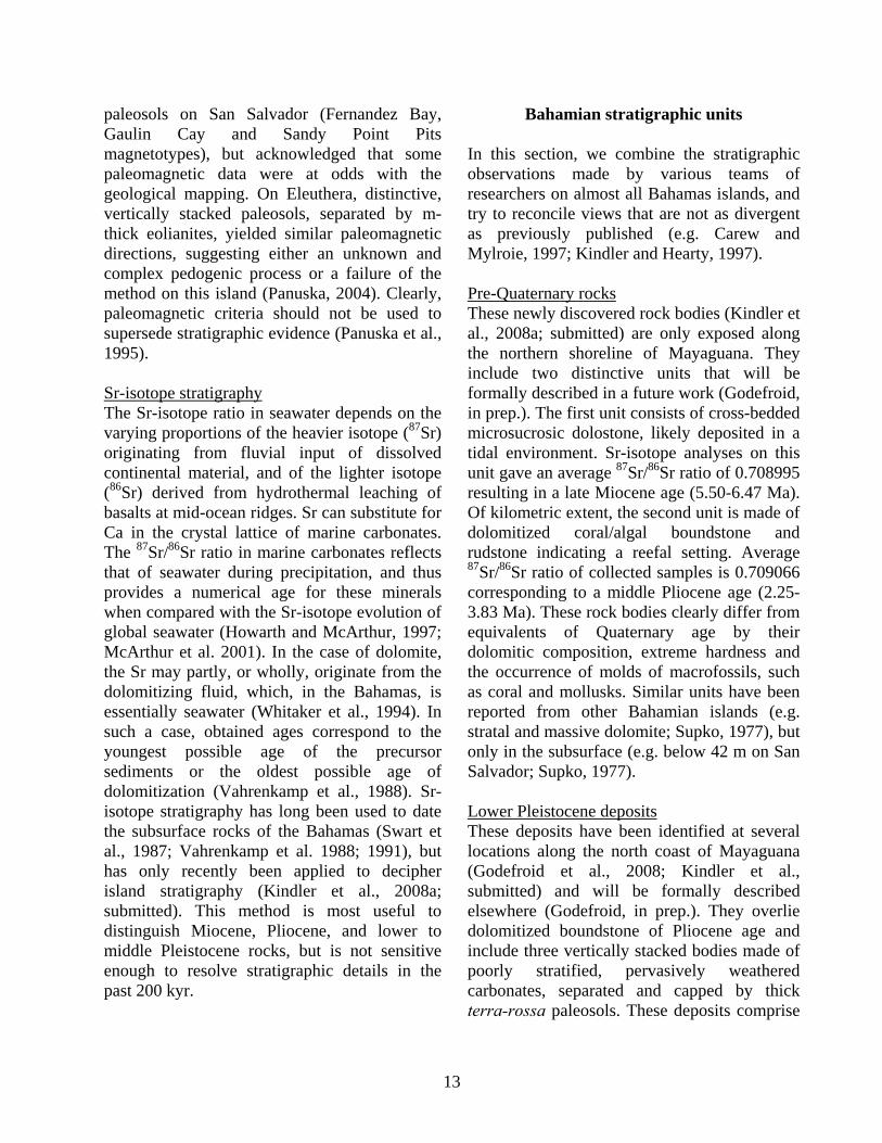
paleosols on San Salvador (Fernandez Bay, Gaulin Cay and Sandy Point Pits magnetotypes), but acknowledged that some paleomagnetic data were at odds with the geological mapping. On Eleuthera, distinctive, vertically stacked paleosols, separated by m-thick eolianites, yielded similar paleomagnetic directions, suggesting either an unknown and complex pedogenic process or a failure of the method on this island (Panuska, 2004). Clearly, paleomagnetic criteria should not be used to supersede stratigraphic evidence (Panuska et al., 1995). Sr-isotope stratigraphy The Sr-isotope ratio in seawater depends on the varying proportions of the heavier isotope (87Sr) originating from fluvial input of dissolved continental material, and of the lighter isotope (86Sr) derived from hydrothermal leaching of basalts at mid-ocean ridges. Sr can substitute for Ca in the crystal lattice of marine carbonates. The 87Sr/86Sr ratio in marine carbonates reflects that of seawater during precipitation, and thus provides a numerical age for these minerals when compared with the Sr-isotope evolution of global seawater (Howarth and McArthur, 1997; McArthur et al. 2001). In the case of dolomite, the Sr may partly, or wholly, originate from the dolomitizing fluid, which, in the Bahamas, is essentially seawater (Whitaker et al., 1994). In such a case, obtained ages correspond to the youngest possible age of the precursor sediments or the oldest possible age of dolomitization (Vahrenkamp et al., 1988). Sr-isotope stratigraphy has long been used to date the subsurface rocks of the Bahamas (Swart et al., 1987; Vahrenkamp et al. 1988; 1991), but has only recently been applied to decipher island stratigraphy (Kindler et al., 2008a; submitted). This method is most useful to distinguish Miocene, Pliocene, and lower to middle Pleistocene rocks, but is not sensitive enough to resolve stratigraphic details in the past 200 kyr.
Bahamian stratigraphic units
In this section, we combine the stratigraphic observations made by various teams of researchers on almost all Bahamas islands, and try to reconcile views that are not as divergent as previously published (e.g. Carew and Mylroie, 1997; Kindler and Hearty, 1997). Pre-Quaternary rocks These newly discovered rock bodies (Kindler et al., 2008a; submitted) are only exposed along the northern shoreline of Mayaguana. They include two distinctive units that will be formally described in a future work (Godefroid, in prep.). The first unit consists of cross-bedded microsucrosic dolostone, likely deposited in a tidal environment. Sr-isotope analyses on this unit gave an average 87Sr/86Sr ratio of 0.708995 resulting in a late Miocene age (5.50-6.47 Ma). Of kilometric extent, the second unit is made of dolomitized coral/algal boundstone and rudstone indicating a reefal setting. Average 87Sr/86Sr ratio of collected samples is 0.709066 corresponding to a middle Pliocene age (2.25-3.83 Ma). These rock bodies clearly differ from equivalents of Quaternary age by their dolomitic composition, extreme hardness and the occurrence of molds of macrofossils, such as coral and mollusks. Similar units have been reported from other Bahamian islands (e.g. stratal and massive dolomite; Supko, 1977), but only in the subsurface (e.g. below 42 m on San Salvador; Supko, 1977). Lower Pleistocene deposits These deposits have been identified at several locations along the north coast of Mayaguana (Godefroid et al., 2008; Kindler et al., submitted) and will be formally described elsewhere (Godefroid, in prep.). They overlie dolomitized boundstone of Pliocene age and include three vertically stacked bodies made of poorly stratified, pervasively weathered carbonates, separated and capped by thick terra-rossa paleosols. These deposits comprise

14
shell-rich rudstone-floatstone, with some large in-situ coral build-ups, bioturbated coral-rich floatstone, exposed between +7 and +8.5 m, and cross-bedded calcarenites, interpreted as a beach facies, reaching up to +10 m above modern sea level. The main bioclastic components include red and green algae, echinoids, benthic foraminifers, corals, and mollusks. Average 87Sr/86Sr ratios measured on these carbonates range from 0.709127 to 0.709136 corresponding to an early Pleistocene age (~0.75-1.35 Ma). In the field, they can be distinguished from younger Pleistocene units by their stratigraphic position, high degree of diagenetic alteration and induration, poor stratification and predominance of marine facies. These deposits have not been identified on the surface of any other Bahamian islands, but could possibly be found at the base of high sea cliffs in northern Eleuthera. The Owl's Hole Formation The Owl's Hole Formation was originally defined on San Salvador (Carew and Mylroie, 1985) to designate a predominantly bioclastic eolianite (Stowers et al., 1989; Hearty and Kindler, 1993) exposed in a deep solution pit in the SW portion of this island. Similar deposits were later found on most Bahamian islands and shown to be much more extensive than previously thought (Schwabe et al., 1993; Carew and Mylroie, 1995; Kindler and Hearty, 1995; 1996). We propose here to regroup under this label all rock bodies occurring above lower Pleistocene deposits and below the Grotto Beach Formation (see next section). In addition to the bioclastic eolianite previously mentioned, this formation would include several paleosol-capped, moderately weathered calcarenite units of various petrographic composition (oolitic-peloidal, bioclastic-peloidal, bioclastic) deposited in shallow-marine and terrestrial settings. These units can be observed in vertical superposition in northern Eleuthera (Fig. 5; Kindler and Hearty, 1997; Hearty, 1998; Panuska et al., 2002), but they occur also in
lateral juxtaposition on most Bahamian islands. Marine facies associated with this formation have been identified on New Providence (Garrett and Gould, 1984; Hearty and Kindler 1997), Eleuthera (Hearty and Kindler, 1995a; Hearty, 1998; Hearty et al., 1999; Kindler and Hearty, 2000), and Great Inagua (Fig. 6; Kindler et al., 2007). Tentative U-Th dating of whole-rock samples collected from the Owl's Hole Formation gave ages between about 200 kyr (Muhs and Bush, 1987) and 316 kyr (Kindler et al., 2007), whereas paleomagnetic analyses revealed a normal polarity (Stowers et
Figure 5. Synthetic stratigraphic column of the Bahamas Islands (Mb. = Member; Fm. = Formation; Qua. = Quarry; pel. = peloidal).

15
al., 1989; Panuska, 2004). The A/I ratios measured from these calcarenites range from 0.87 to 0.55 (Hearty and Kaufman, 2000; Hearty, 2010), suggesting a middle Pleistocene age. This age is further supported by a two 87Sr/86Sr values obtained from exposures of this formation on Mayaguana and Great Inagua averaging at 0.709158 (0.28-0.88 Myr; Kindler et al., submitted). The Owl's Hole Formation thus comprises deposits formed during interglacial highstands of the middle Pleistocene, spanning oxygen isotope stage 7 to possibly 15 (Hearty and Kaufman, 2000; Hearty 2010). It is identifiable by its position below the Grotto Beach Formation, its modest degree of diagenetic alteration compared to older units, and the predominance of bioclastic-peloidal eolianites. The Grotto Beach Formation First identified on San Salvador (Titus, 1980; 1983), this formation is the most conspicuous
stratigraphic unit in the Bahamas, forming the highest elevation of the archipelago (63 m, Mt Alvernia on Cat Island) and blanketing many islands. It includes all deposits found above the Owl's Hole Formation and below the Rice Bay Formation (see next section), and comprises two distinctive members: the French Bay and the Cockburn Town members. The French Bay Member (Carew and Mylroie, 1985) is made of a well-preserved oolite commonly showing pristine sedimentary structures typical of the subtidal, intertidal, and predominantly eolian depositional environments (e.g. Caputo, 1995; Kindler and Hine, 2008). It has been attributed to the early part of the last interglacial period (Marine Isotope Stage 5e), based on its stratigraphic position relative to the radiometrically dated Cockburn Town Member (see next section) and whole-rock A/I ratios averaging at 0.48 throughout the Bahamas islands (Hearty and Kaufman, 2000). The French Bay Member has been interpreted as the transgressive-phase eolianite of the Grotto Beach Formation (Carew and Mylroie, 1985; 1995b; 1997), and, alternatively, as representing an early highstand phase during MIS 5e (Hearty and Kindler, 1993; Kindler and Hearty, 1996; Hearty and Kaufman, 2000). The Cockburn Town Member (Carew and Mylroie, 1985) mainly comprises coral boundstone/rudstone and shell-rich floatstone, corresponding to ancient reefal and lagoonal settings, respectively. The latter facies commonly drapes the interior of many Bahamian islands such as on Mayaguana, Great Inagua, and New Providence. U-Th ages obtained from well-preserved coral specimens range between 130 and 117 kyr (Chen et al., 1991; Kindler et al., submitted), allowing correlation with MIS 5e. Older ages have been reported from one site in Great Inagua (Kindler et al., 2007), suggesting that some reef portions could span two interglacial periods. These ages,
Figure 6. Coastal exposure to the E of Devil's Point, Great Inagua (N21°01.667'; W73°40.271'). The Owl's Hole Formation is exposed below the reefal facies of the Cockburn Town Member (Grotto Beach Formation, MIS 5e). The boundary between the two units (white arrow) corresponds to a pronounced karstic surface overlain by a terra-rossa paleosol (Kindler et al., 2007). At this locality, the Owl's Hole Formation consists of bioclastic beach facies identified by low-angle crossbeds with a seaward dip (black arrow) and an early phase of phreatic marine cement. Photo Pascal Kindler.

16
however, appear to be questionable (B. Thompson, pers. comm., 2007). A/I ratios measured on samples collected from the rudstone matrices average at 0.40 (Hearty and Kaufman, 2000). In many localities (e.g. at the type section of the Grotto Beach Formation in San Salvador), predominantly oolitic calcarenites, displaying a shallowing-upward succession of facies from subtidal to eolian, conformably overlie the aforementioned reefal facies. These rocks were lumped in the Cockburn Town Member, and interpreted as the regressive-phase deposits of the Grotto Beach Formation by Carew and Mylroie (1985; 1995b; 1997). Other authors (Hearty and Kindler, 1993; Kindler and Hearty, 1996; Hearty and Kaufman, 2000) regard these deposits as a separate entity corresponding to a late MIS 5e highstand. Considering the complex sea-level history of the last interglacial (Neumann and Hearty, 1996; Thompson and Goldstein, 2005; Blanchon et al., 2009), the necessity of creating this new stratigraphic subdivision remains an open question. The Whale Point Formation The Whale Point Formation (new name) includes vegemorph-rich, paleosol-capped bioclastic eolianites overlying or juxtaposed to the Grotto Beach Formation. The occurrence of a paleosol and/or a calcrete at the base and at the top of this unit indicates that it post-dates the Grotto Beach Formation, but predates the Rice Bay Formation (see next section). A/I ratios obtained from whole-rock samples collected from these calcarenites average at 0.31 (Hearty and Kaufman, 2000), suggesting a correlation with MIS 5a. This unit was initially identified on San Salvador and named the Almgreen Cay Formation by Hearty and Kindler (1993). This addition to the Bahamian stratigraphic record known at that time (Carew and Mylroie, 1985) generated much controversy in the subsequent decade (e.g. Carew and Mylroie, 1994; Hearty and Kindler, 1994; Panuska et al., 2002; Mylroie et al., 2008) mostly because, on San
Salvador, stratigraphic relationships are not straightforward and this new formation was essentially defined on the basis of petrologic and geomorphologic criteria, and AAR data. By contrast, on Eleuthera, the Whale Point and the Grotto Beach Formations occur in vertical superposition and are separated by a fairly mature paleosol that probably developed over a few 10 ka (Kindler and Hearty, 1995a; Hearty and Kindler 1995; Hearty, 1998; Brentini, 2008). We chose to rename this unit "the Whale Point Formation" because it is at Whale Point, in northern Eleuthera, that stratigraphic relationships are most clear (Fig. 7). The
Figure 7. Type section of the Whale Point Formation along the dirt road leading to Whale Point (N25°27’28.74’’; W76°37’10.28’’).The Grotto Beach Formation consists of an oolitic-peloidal eolianite. Note high-angle crossbeds with an apparent dip toward the NW in the lower right-hand corner of the photograph. The top of this unit is brecciated and covered by a paleosol, studied in detail by Brentini (2008), in which a fossil tree (black arrow) is rooted. The overlying Whale Point Formation is a bioclastic eolianite showing high-angle crossbeds with an apparent dip toward the SE. This formation includes numerous vegemorphs (white arrow) originating from an overlying terra-rossa paleosol. Alloisoleucine/isoleucine (A/I) ratios obtained from the Grotto Beach and the Whale Point formations correlate with MIS 5e and MIS 5a, respectively (Hearty, 1998). A similar section can be observed along Queens Highway near Rainbow Cay (N25°20.034'; W76°24.954'). Hammer for scale is 36 cm long. Photo Maud Brentini.

17
definitive attribution of isolated exposures of paleosol-capped, vegemorph-rich, bioclastic eolianites to the Whale Point Formation or to the regressive-phase deposits of the Grotto Beach Formation is a task awaiting the next generation of Bahamian geologists. The Rice Bay Formation The Rice Bay Formation (Carew and Mylroie, 1985) may overlie any paleosol-capped stratigraphic unit (usually the Grotto Beach Formation), but is only covered by a mm-thin micritic crust, a protosol, or a modern soil. This unit comprises two members, the North Point and the Hanna Bay Members, both defined on San Salvador (Carew and Mylroie, 1985), that can be vertically stacked, as on Eleuthera, or laterally juxtaposed, as at the type section. The North Point Member (Carew and Mylroie, 1985) consists of transgressive-phase oolitic eolianites displaying pristine small-scale structures such as grain fall, grain flow, and climbing wind-ripple laminae (White and Curran, 1988; Kindler 1992; 1995). Foreset beds of this member can be seen to extend at leaste two meters below present sea level. These oolites differ petrographically from those forming the French Bay Member by the occurrence of many thinly-coated grains and more abundant peloids and bioclasts (Kindler and Hearty, 1996). Most recent 14C data obtained from whole-rock samples and Cerion sp. shells suggest these sediments were formed on the shallow platforms around 6.2 kyr and deposited on islands in the next 1000 years or less (Hearty and Kaufman, 2009). The Hanna Bay Member (Carew and Mylroie, 1985) is represented by predominatly bioclastic calcarenites deposited in a beach-dune environment, usually in equilibrium with modern sea level (Davaud and Strasser, 1984; Carew and Mylroie, 1985). Locally, however, low-angle planar beach beds including phreatic cements, and correlated with the Hanna Bay
Member, have been observed up to 2 m above present sea level (Kindler et al., submitted). Recently obtained 14C ages (Hearty and Kaufman, 2009) show that these sediments were generated between 4.7 and 3.8 kyr ago, and deposited subsequently on the islands. A model accounting for the depositional break between the two members of the Rice Bay Formation and their distinctive petrographic composition has been presented by Kindler (1992; 1995). KARST, CAVES, AND LANDFORM DEVELOPMENT IN THE BAHAMAS The Bahama Islands have landscapes that are dominated by original depositional features, and are only slightly modified by subsequent dissolutional (karst) processes. The high porosity of the limestones that form the islands results in rapid infiltration of meteoric water and the absence of surface streams and related erosional features such as valleys and channels. Classic surface karst landforms such as sinking fresh-water streams, blind valleys, and dissolution sinkholes are absent. The karst features of the Bahamas fall into four main categories: karren, depressions, caves, and blue holes. The youthfulness of Bahamian carbonate rocks creates different water-flow dynamics than are found in the dense, diagenetically-mature carbonates of continental interiors. The Bahamas exemplify what has been described as eogenetic karst, defined by Vacher and Mylroie (2002, p. 183) as “the land surface evolving on, and the pore system developing in, rocks undergoing eogenetic, meteoric diagenesis.” The term “eogenetic” was taken from Choquette and Pray (1970, p. 215) who defined the three time-porosity stages of carbonate rock evolution: “the time of early burial as eogenetic, the time of deeper burial as mesogenetic, and the late stage associated with long-buried carbonates as telogenetic.”

18
Eogenetic carbonate rocks have not been extensively compacted or cemented and retain much of their primary depositional porosity. Most carbonate islands, and almost all carbonate islands found in tropical or subtropical locations, are made up of eogenetic limestones (Late Cenozoic) that were deposited proximal to the setting in which they presently occur. The Bahamas, being primarily Middle to Late Quaternary in age in a non-tectonic environment, display this eogenetic character extremely well. The Fresh-Water Lens In any essentially homogeneous body of rock like that of the carbonates forming the Bahamian islands, the fresh-water lens floats on underlying, denser seawater that permeates the subsurface. The model for the ideal behavior of such water masses is the Dupuit-Ghyben-Herzberg model (Vacher, 1988). In reality, variations in rock permeability and other factors result in distortion of the ideal lens shape in the Bahamas (e.g. Wallis et al., 1991). Nonetheless, the Dupuit-Ghyben-Herzberg model serves as a useful first approximation of the relationship between the fresh water and underlying marine groundwater in an island. Figure 8 is a cartoon showing how the fresh-water lens is configured. During past, higher stands of the sea, the fresh groundwater lens in each island was as high or higher than it is today. Beneath the surface of those past fresh-water lenses, within the limestone rock of the islands, caves were produced by dissolution. Each time sea level fell, the caves became abandoned and dry. Under today's climatic conditions the Earth is warm and sea level is relatively high, but not quite as high as at some times in the relatively recent past. We can therefore enter dry caves today throughout the Bahamas. In contrast, the blue holes of the Bahamas lead into caves that are currently flooded by seawater. These blue
holes represent the cumulative dissolution and collapse that has occurred during many sea-level fluctuations. The complexity of cave passages found in blue holes is the result of overprinting of repeated marine, fresh water, and subaerial conditions throughout Quaternary time. Conversely, the presently dry caves of the Bahamas formed during the relatively short time periods of the late Pleistocene when sea level was higher than at present. Today, Bahamian caves that formed above modern sea-level elevation prior to MIS 5e time lie below modern sea level owing to isostatic subsidence of the platforms (Carew and Mylroie, 1995b); however some data can be marshaled that call this interpretation into question (Lascu, 2005) and earlier highstands (e.g. MIS 11) may be involved. Taking isostatic subsidence into account, sea level was high enough to produce the observed subaerial caves for a maximum of about 12,000 years of the MIS 5e time period (or less, given the possible fluctuations of that highstand). In addition, during that sea-level highstand, only the eolian ridges and a few beach and shoal deposits stood above sea level, and island size in the Bahamas was dramatically reduced compared to that of today's islands. As a consequence, fresh water lens volumes and discharges were comparably reduced. An end result of this scenario is recognition that dry Bahamian caves seen today represent development during a very short time period in
Figure 8. Cartoon of the fresh-water lens in a carbonate island. Dashed arrows indicate flow within the lens

19
association with small fresh water lenses and with minimal overprinting by later events. Any model that attempts to explain development of these dissolutional caves must operate under extremely tight constraints of time and space. Carbonate Island Karst Model (CIKM) The Bahamas were the starting point for the development of what has become the Carbonate Island Karst Model (Jenson et al., 2006) or CIKM. The salient points of this model are shown in Table 1 and Figure 9. The key aspects are that cave and karst development in islands in eogenetic carbonate rocks is very different from that found in the telogenetic carbonate rocks of continental interiors, where most karst research has traditionally been done. Basically, karst development under the CIKM is controlled by the youthful age of the eogenetic rock involved (almost always Cenozoic, commonly Quaternary), the dissolutional aggressivity provided by mixing of fresh water and seawater, the elevated mircrobial activity associated with the mixing zone, and the change in sea level created by glacio-eustasy and tectonics. Island configuration, especially as regards carbonate and non-carbonate rocks, is also crucial. Island karst has been defined as that which forms under the constraints of the CIKM, whereas karst that develops in the interior of
islands, removed from CIKM controls, is karst on islands (Vacher and Mylroie, 2002). For example, the caves and karst found in the Bahamas is island karst, but the cockpit karst of Jamaica, or the Mogote karst of Cuba and Puerto Rico, is karst on islands, as that karst differs little from what would be found in a tropical, continental interior such as in Belize, or Vietnam. In the Bahamas, tectonics and non-carbonate rocks are not a factor, and application of the CIKM is greatly simplified. Karren Karren are dissolutional sculpturing at the centimeter to meter scale found on exposed and soil-covered carbonate rocks of all ages and types. A variety of etched and fretted surfaces develop; on exposed surfaces this etching is sharp and jagged, whereas on soil-mantled, or recently exhumed, surfaces it tends to be smooth and curvilinear. Taboroši et al. (2004) reviewed the various terms and mechanisms proposed over the years to describe and explain karren on carbonate islands and coasts, and they provide updated interpretations. The term eogenetic karren has been applied by them to the unique etching and dissolution of surface carbonates on eogenetic carbonate islands and coasts. This term replaces the traditional “phytokarst” of Folk et al. (1973) or “biokarst” of Viles (1988). Eogenetic coastal karren is
Table 1. Components of the Carbonate Island Karst Model (Jenson et al., 2006).
(Fig. 9A)
(Fig. 9B)
(Fig. 9C)
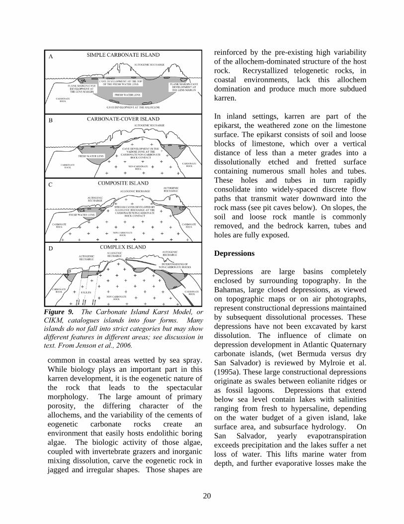
20
common in coastal areas wetted by sea spray. While biology plays an important part in this karren development, it is the eogenetic nature of the rock that leads to the spectacular morphology. The large amount of primary porosity, the differing character of the allochems, and the variability of the cements of eogenetic carbonate rocks create an environment that easily hosts endolithic boring algae. The biologic activity of those algae, coupled with invertebrate grazers and inorganic mixing dissolution, carve the eogenetic rock in jagged and irregular shapes. Those shapes are
reinforced by the pre-existing high variability of the allochem-dominated structure of the host rock. Recrystallized telogenetic rocks, in coastal environments, lack this allochem domination and produce much more subdued karren. In inland settings, karren are part of the epikarst, the weathered zone on the limestone surface. The epikarst consists of soil and loose blocks of limestone, which over a vertical distance of less than a meter grades into a dissolutionally etched and fretted surface containing numerous small holes and tubes. These holes and tubes in turn rapidly consolidate into widely-spaced discrete flow paths that transmit water downward into the rock mass (see pit caves below). On slopes, the soil and loose rock mantle is commonly removed, and the bedrock karren, tubes and holes are fully exposed. Depressions Depressions are large basins completely enclosed by surrounding topography. In the Bahamas, large closed depressions, as viewed on topographic maps or on air photographs, represent constructional depressions maintained by subsequent dissolutional processes. These depressions have not been excavated by karst dissolution. The influence of climate on depression development in Atlantic Quaternary carbonate islands, (wet Bermuda versus dry San Salvador) is reviewed by Mylroie et al. (1995a). These large constructional depressions originate as swales between eolianite ridges or as fossil lagoons. Depressions that extend below sea level contain lakes with salinities ranging from fresh to hypersaline, depending on the water budget of a given island, lake surface area, and subsurface hydrology. On San Salvador, yearly evapotranspiration exceeds precipitation and the lakes suffer a net loss of water. This lifts marine water from depth, and further evaporative losses make the
Figure 9. The Carbonate Island Karst Model, or CIKM, catalogues islands into four forms. Many islands do not fall into strict categories but may show different features in different areas; see discussion in text. From Jenson et al., 2006.

21
lakes hypersaline (Davis and Johnson, 1989). The fresh-water lens is consequently partitioned into smaller bodies underlying the remaining dry land. Some of these constructional depressions are linked to caves (lake drains, see below) that connect to the sea; tidal pumping causes exchange of waters that keeps some of these lakes at marine salinity. Lake margins are little modified by dissolutional processes when lake waters are hypersaline, as on San Salvador, but on wetter Quaternary eolian islands, such as Bermuda, depressions with fresh water enlarge laterally by dissolution (Mylroie et al., 1995a). CAVES There are four main types of caves in the Bahamas: pit caves, flank margin caves, banana holes, and lake drains. The first three cave types are well understood, but lake drains remain something of a mystery. Figure 10 is an idealized representation of the major cave features found in the Bahamas, excepting lake drains. Pit Caves Pit caves are found throughout the Bahamas, sometimes in very dense clusters, and occasionally at the tops of hills. As the name suggests, these are vertical, or near-vertical, shafts that typically drop 5 to 10 m (Fig. 11), often descending in a stair-step fashion, with
occasional small chambers. They rarely intersect other cave types, or penetrate to the fresh-water lens. Their walls show classic vertical grooves formed by supercritical laminar flow of descending vadose water. During major rain events, they can be observed to efficiently collect water from the epikarst and conduct it downward as vadose fast-flow routes. Their high density in places was initially thought, based on water budget considerations, to indicate much higher rainfall conditions at a past time. The high pit cave density is now understood to reflect competition and piracy among pit caves, such that some lose their recharge to “upstream” competitors (Harris et al., 1995). These caves can be complex as a result of this competition,
Figure 10. Cartoon representation of the three main cave types found on a simple carbonate island: pit caves, flank margin caves, and banana holes. Changing sea level moves the fresh-water lens and its dissolutional environments vertically. From Mylroie and Carew, 1995.
Figure 11. Triple Shaft Cave, Sandy Point Pits, San Salvador Island, a typical Bahamian pit cave. Note the shallow epikarst water collection system, and the interconnected shaft system. From Harris et al., 1995.

22
which commonly leads to intersection of pit caves by one another. Pit caves form independently of sea level and fresh-water lens position, and can form in any exposed carbonate rock on an island. They are absent from Holocene rocks, but penetrate a variety of Pleistocene eolianites. Flank Margin Caves The largest of the caves that develop in simple carbonate islands form at the distal margin of the fresh water lens, under the flank of the enclosing landmass, so they are called flank margin caves (Mylroie and Carew, 1990; Fig. 12). These large caves are commonly entered where a hillside has been breached by erosion, or a portion of the cave roof has collapsed. The caves are commonly found at 1 to 7 m elevation, which is in agreement with the position of at least one earlier sea level highstand during the Quaternary, the last interglacial associated with MIS 5e, which lasted from 130 to 117 kyr (Chen et al., 1991). However, examples exist at higher elevations, such as St. Francis Grotto on Cat Island (Mylroie et al., 2006) or Conch Bar Cave on Middle Caicos (Smart et al., 2008), and no single explanation encompasses them all. That sea level reached 6 m higher than at present, as glacial ice melted back a bit more than it has today. Given that the Bahamas are tectonically stable, only a glacioeustatic sea-level highstand could have elevated the fresh-water lens above modern sea level, and so placed the fresh-water lens at, and slightly above, that +6 m elevation. The resulting cave morphology is predictable and consistent: large chambers near the edge of the hill containing the cave, numerous ramifying passages near the back of the cave, and many cross-links and connections. Cave chambers are wider than they are high, with curvilinear and cuspate margins. Remnant bedrock pillars are common. Passages heading inland commonly end in blank bedrock walls. As important as what the caves contain is what they do not contain: no turbulent flow markings such as
wall scallops, no stream-laid sediments, no sinking stream or spring entrances. To explain these caves, the flank margin cave model was developed to interpret the size, shape, position and configuration of the caves (Mylroie and Carew, 1990; 1995). The caves develop in the distal margin of the fresh-water lens, just under the flank of the enclosing landmass (Fig. 10). At the distal margin of the fresh-water lens, the mixing environment of the vadose input to the water table is superimposed on the mixing environment of the fresh-water lens with underlying marine water, thereby increasing dissolution beyond what either environment could do alone. Additionally, the lens cross section decreases at the lens margin, so flow velocities increase, transporting reactants in, and products out, faster than elsewhere in the lens (Raeisi and Mylroie, 1995). Finally, both the top of the lens, and the halocline, are density interfaces that can trap organic material. Oxidation and microbial consumption of the organics creates CO2 that can drive more dissolution (Schwabe et al., 2008); in addition excess organics can create anoxic conditions and drive H2S-mediated dissolution. The H2S model appears supported by 34S analysis of intergranular gypsum from flank margin caves on San Salvador, which showed depletion values associated with biomediation of sulfur in anoxic zones (Bottrell et al., 1993). There has been debate in the literature regarding the relative importance of the three mechanisms (e.g. Schwabe et al., 2006, 2008), but recently it has been suggested that the hydrologic condition of rapid lens-margin discharge alone, and not the geochemistry, is the critical factor (Moore et al., 2007). Flank margin caves, as described earlier, have a variety of morphological features, all consistent with a non-turbulent, phreatic origin. The oval or globular chambers that are oriented parallel to the longitudinal trend of, and just under the flank of, the ridge in which they have formed,

23
indicate the importance of the lens margin (Figs. 12 and 13). Small radiating tubes extend from these large chambers into the ridge interior where they end abruptly or pinch out. These passages represent individual diffuse flow paths that delivered fresh water into the flank margin mixing area. The abrupt end of these passages reflects the position of the mixing front when sea level fell and the caves became subaerial. One final interesting aspect of flank margin caves is that they occur on scales from small chambers up to immense caves without loss of their general morphology or position with respect to the land surface. Size rank plots reveal that the caves self-select in three size groups based on growth of the initial voids, amalgamation of voids, and then amalgamation of clusters of voids (Roth et al., 2006). Computer modeling of void genesis creates the same plot, but adds a fourth group of tiny caves that were ignored by cave surveyors (Labourdette et al., 2007). The general morphology of flank margin caves is similar to that of other caves formed under
different mixed-water conditions (Mylroie and Carew, 1995), such as in the Guadalupe caves of New Mexico. This pattern of globular chambers, maze-like passage connections, thin wall partitions, and dead-end passages are called spongework or ramiform caves. Their development independent of surface conditions is termed hypogenic (Palmer, 1991). More complete discussion of the fresh-water lens, cave development, and the flank margin model can be found in Mylroie and Carew (1990; 1995), and Mylroie and Mylroie (2007). Banana Holes Abundant, but smaller caves that develop at the top of the lens, away from the lens margin are called banana holes. Banana holes are circular to oval chambers 5 to 10 m in diameter, and 1 to 3 m high, with phreatic morphologies but
Figure 12. Images from Bahamian flank margin caves. A, Hamiltons Cave, Long Island, showing horizontal dissolutional roof cutting eolian beds, brown horizon is where guano was mined; B, phreatic dissolutional fretwork, Harry Oakes Cave, New Providence; C, Chambers, pockets, and vugs, Ten Bay Cave, Eleuthera; D, paleokarst infill cut smooth by dissolution, 1702 Cave, Crooked Island (compass in circle 8 cm long).
Figure 13. Map of Lighthouse Cave, San Salvador Island. The flank margin cave has one large central chamber with interconnected and ramifying dead-end passages. The cave follows the flank of the hill contour, the position of the distal margin of the fresh-water lens when the cave formed during MIS 5e. Gray areas contain standing marine water today.

24
lacking the size and passage ramifications found in flank margin caves (Fig. 14). They are located 1 to 7 m above sea level, but laterally they are well away from where the lens margin would have been, under current topography, with sea level at that elevation. They are entered where their ceilings have collapsed, or rarely where a pit cave has intersected them. They can be found in dense concentrations, up to 3000/km2 (Harris et al., 1995). Occasionally, a collapsed banana hole has a connection with an adjacent, uncollapsed banana hole. In the Bahamas, they commonly develop in the broad, low-elevation regions that make up significant parts of these islands. As a result, their roofs are thin and prone to collapse. Once collapsed, banana holes collect soil and vegetative debris, as well as water and are favored for the growing of specialty crops, such as bananas, which is how their name was derived (Harris et al.,
1995). The initial interpretation (Harris et al., 1995) was that their smaller size relative to flank margin caves was a result of their position away from the higher flow velocities of the lens margin. That they existed at all seemed to indicate that vadose-phreatic mixing of fresh water, and biogeochemical activity, are still important in carbonate dissolution. Recently, it has been proposed that banana holes are found preferentially in subtidal units overlain by beach and dune sands (Mylroie, et al., 2008a), and formed syndepositionally as lagoons were infilled by prograding sands, and the fresh-water lens followed. The small size of these features reflects the transient time they were in the lens margin before the progradation continued seaward. Current research is examining this hypothesis. Lake Drains Lake drains are a contrived term used to describe small, un-enterable conduits that carry water into and out of lakes in a pattern related to tides. Their presence results in lakes that commonly maintain marine salinity despite climatic conditions that might favor fresh water, such as in the northwestern Bahamas, or hypersaline water, such as in the more arid southeastern Bahamas. Some lakes are large, and their lake drains are small, such that the conduit flow from the sea is not sufficient to greatly modify the lake salinity. Unlike flank margin caves and banana holes, lake drains are true conduits. Their mode of origin and configuration are poorly understood, but their influence can be important on lake geochemistry and as a result, lake ecology (Davis and Johnson, 1989). They remain cryptic features. Depressions Revisited In most telogenetic carbonate settings found in continental interiors, the smaller closed contour depressions, sinkholes (American terminology)
Figure 14. Map of Big Well Cave, San Salvador Island, a typical banana hole with one low, wide oval chamber. Note the thin roof, which promotes collapse. Cartography by M. Lace.

25
or dolines (European terminology), form quite differently than those in eogenetic carbonate islands such as the Bahamas. Sinkholes form by three main methods: 1) carbonate dissolution by focused epikarst flow to create small, saucer-shaped depressions; 2) collapse and subsidence of a thick soft sediment or soil mantle into a small dissolutional opening; and 3) collapse of the bedrock roof of a dissolutional chamber. In telogenetic continental carbonates, the longer time span available results in both a thick residual soil mantle, and more time for bedrock dissolution. The telogenetic character of the bedrock results in epikarst flow focusing to joint intersections and related flow pathways. Sinkholes formed by dissolution and soil subsidence are very common. In contrast, cave passages are relatively rare (less than 1% of the porosity), so collapses into bedrock voids are also relatively rare. In the Bahamas and related eogenetic environments, there are no thick soils to subside downward, and dissolutional openings, even large ones like pit caves, open flush to the land surface. There has been little time since bedrock deposition for dissolution of saucer-shaped sinkholes. In contrast, because flank margin caves and banana holes are extremely common, often with relatively thin bedrock roofs, collapse sinkholes are common, and they are the dominant small depression type in the Bahamas. The rule of thumb in the Bahamas for depressions is: large ones are constructional, and small ones are cave collapses. Blue Holes Famous karst features of the Bahamas are the blue holes. The term "blue hole" has been used in a variety of ways. A complete review of the history of blue hole studies, and the various uses of the term, can be found in Mylroie et al. (1995b). A different approach to defining and describing blue holes can be found in Schwabe and Carew (2006). Blue holes are defined here as: "subsurface voids that are developed in
carbonate banks and islands; are open to the earth's surface; contain tidally-influenced waters of fresh, marine, or mixed chemistry; extend below sea level for a majority of their depth; and may provide access to submerged cave passages." (Mylroie et al., 1995b, p. 225). Blue holes are found in two settings: “ocean holes open directly into the present marine environment and contain marine water, usually with tidal flow; inland blue holes are isolated by present topography from marine conditions, and open directly onto the land surface or into an isolated pond or lake, and contain tidally-influenced water of a variety of chemistries from fresh to marine” (Mylroie et al., 1995b, p. 225). The most common alternative use of the term “blue hole” is to describe large and deep karst springs in continental interiors (Mylroie et al., 1995b). In the northwestern Bahamas, blue holes with depths in the 100-125 m range are common, and it was thought that their depth was limited by the position of the lowest glacial sea-level lowstand, which was about 125 m below present sea level. However, exploratory wells commonly intersect voids below that depth (e.g. depths of 21 to 4082 m; the deepest of these voids was large enough to accept 2,430 m of broken drill pipe [Meyerhoff and Hatten, 1974]). Dean's Blue Hole on Long Island is known to be over 200 m deep, ending in a vast chamber (Wilson, 1994). Blue holes commonly lead into major horizontal cave systems, such as Lucayan Caverns on Grand Bahama Island, and Conch Blue Hole on North Andros Island (Palmer, 1985). Blue holes are flooded karst features of polygenetic origin. They have developed in a variety of ways (Fig. 15). 1) Pit caves that formed during sea-level lowstands are flooded during sea-level highstands to form some blue holes. 2) In places, failure of the steep margins of the Bahama banks produces bank-margin fractures. Wide gaps along these fractures can
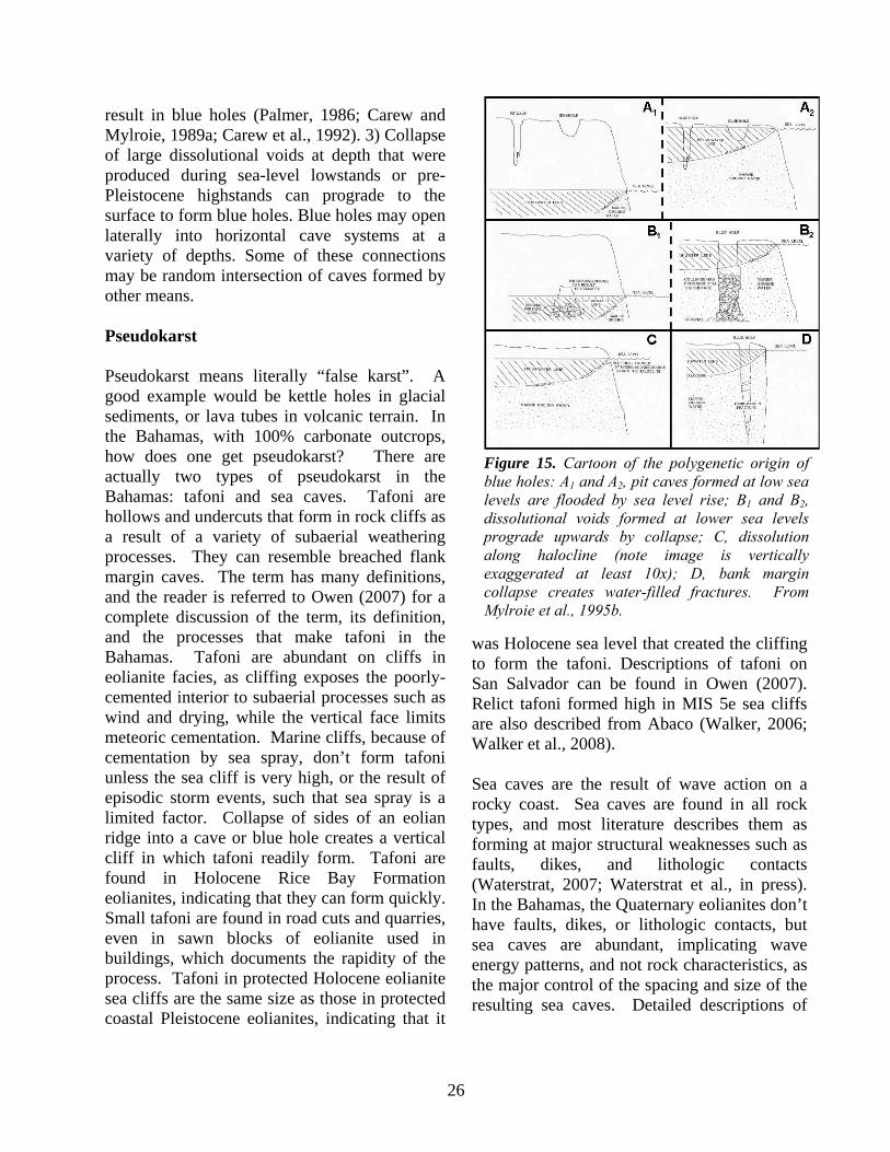
26
result in blue holes (Palmer, 1986; Carew and Mylroie, 1989a; Carew et al., 1992). 3) Collapse of large dissolutional voids at depth that were produced during sea-level lowstands or pre-Pleistocene highstands can prograde to the surface to form blue holes. Blue holes may open laterally into horizontal cave systems at a variety of depths. Some of these connections may be random intersection of caves formed by other means. Pseudokarst Pseudokarst means literally “false karst”. A good example would be kettle holes in glacial sediments, or lava tubes in volcanic terrain. In the Bahamas, with 100% carbonate outcrops, how does one get pseudokarst? There are actually two types of pseudokarst in the Bahamas: tafoni and sea caves. Tafoni are hollows and undercuts that form in rock cliffs as a result of a variety of subaerial weathering processes. They can resemble breached flank margin caves. The term has many definitions, and the reader is referred to Owen (2007) for a complete discussion of the term, its definition, and the processes that make tafoni in the Bahamas. Tafoni are abundant on cliffs in eolianite facies, as cliffing exposes the poorly-cemented interior to subaerial processes such as wind and drying, while the vertical face limits meteoric cementation. Marine cliffs, because of cementation by sea spray, don’t form tafoni unless the sea cliff is very high, or the result of episodic storm events, such that sea spray is a limited factor. Collapse of sides of an eolian ridge into a cave or blue hole creates a vertical cliff in which tafoni readily form. Tafoni are found in Holocene Rice Bay Formation eolianites, indicating that they can form quickly. Small tafoni are found in road cuts and quarries, even in sawn blocks of eolianite used in buildings, which documents the rapidity of the process. Tafoni in protected Holocene eolianite sea cliffs are the same size as those in protected coastal Pleistocene eolianites, indicating that it
was Holocene sea level that created the cliffing to form the tafoni. Descriptions of tafoni on San Salvador can be found in Owen (2007). Relict tafoni formed high in MIS 5e sea cliffs are also described from Abaco (Walker, 2006; Walker et al., 2008). Sea caves are the result of wave action on a rocky coast. Sea caves are found in all rock types, and most literature describes them as forming at major structural weaknesses such as faults, dikes, and lithologic contacts (Waterstrat, 2007; Waterstrat et al., in press). In the Bahamas, the Quaternary eolianites don’t have faults, dikes, or lithologic contacts, but sea caves are abundant, implicating wave energy patterns, and not rock characteristics, as the major control of the spacing and size of the resulting sea caves. Detailed descriptions of
Figure 15. Cartoon of the polygenetic origin of blue holes: A1 and A2, pit caves formed at low sea levels are flooded by sea level rise; B1 and B2, dissolutional voids formed at lower sea levels prograde upwards by collapse; C, dissolution along halocline (note image is vertically exaggerated at least 10x); D, bank margin collapse creates water-filled fractures. From Mylroie et al., 1995b.

27
sea caves on San Salvador can be found in Waterstrat (2007). It is important to be able to differentiate tafoni from sea caves, and both from flank margin caves. Both sea caves and flank margin caves are a measure of sea level at their time of formation, but only flank margin caves provide information on the nature of the fresh-water lens that formed them. Sea caves and flank margin caves found in island interiors from a past, higher sea level event(s) provide information on denudation rates. If an open chamber is found at the base of an eolianite ridge, and it is identified as a sea cave, then erosive denudation has been minimal. If the chamber is a flank margin cave, then enough hillside has been eroded away to breach into the cave. Mis-identifying sea caves as flank margin caves, or vice versa, can create problems in interpreting denudation rates and paleohydrology. Tafoni are not restricted to sea level, and so misidentifying a tafoni as a paleo sea cave or a breached flank margin cave will result in an incorrect sea level interpretation. Tafoni misidentified as breached flank margin caves also will lead to incorrect paleohydrology interpretations. Owen (2007) and Waterstrat et al. (in press) provide a quantitative methodology using area to perimeter ratios of cave maps, and entrance width to maximum width ratios, to differentiate the three cave types. Island Area Versus Cave Development Cave divers report large and long conduit cave systems in the Bahama banks at depths averaging 20 m or deeper (Palmer, 1985). Such active conduit caves are not found in the Bahamas today at or near modern sea level. At a sea level position of -20 m, the Bahama Banks would be mostly exposed, and most current islands would become significantly larger, or join into a group of mega-islands. Today, 11,400 km2 is the sum of the island area; if the banks were exposed, that area would increase
more than an order of magnitude to 136,000 km2 (Meyerhoff and Hatten, 1974). As an island becomes larger, its perimeter increases linearly, but its area, and hence catchment, increases by the square. Mylroie and Mylroie (2007) suggest that at some point, as islands enlarge, diffuse flow in the fresh-water lens to the island perimeter cannot adequately address the water budget, and that conduit flow initiates. In contrast, flank margin caves can be found in islands as small as a few hundred meters long and a few tens of meters wide. The cave diver data indicate that at some size threshold, the diffuse flow that makes flank margin caves becomes too inefficient, and turbulent conduit flow initiates. Such long conduit caves have been also found at 20 m depth on Bermuda (Mylroie et al. 1995a), where a drop of 20 m would expose the large lagoon north of the present island. The area to perimeter ratio of islands may create conditions that favor conduit flow for larger islands. Blue holes, especially the large, deep circular ones, are most likely the result of progradational collapse from deep-seated voids. Some of these voids may relate to large conduits developed during Quaternary glacioeustatic lowstands, and as a result, most deep blue holes end at about -100 m. Deeper blue holes such as Deans Blue Hole at 200 m, may relate to older, deeper voids such as those described by Meyerhoff & Hatten (1974). Such deep voids may have formed in a shallower environment, and subsided with the platform to their present location. In any event, progradational collapse allows blue holes to integrate cave systems at a variety of levels without requiring a dissolutional mechanism for that integration. Dissolutional voids may have initiated the collapse process, but the linkage of shallow and deep cave systems, as well as with the surface, is a non-dissolutional action. Therefore blue holes represent an old, laterally and vertically complex environment that can penetrate a variety of depths, with a

28
variety of organic loadings, and a variety of water chemistries. Karst Summary Island karst as seen in the Bahamas is dominated by sea-level position, the fresh-water lens, and the eogenetic nature of the carbonate rocks. The caves and karst features that form on islands differ dramatically from similar features in continental interiors. Because island karst occurs in or near the carbonate depositional environment, preservation of such karst as paleokarst is more likely than preservation of karst features in continental situations.
PART III. FIELD TRIP STOPS After our arrival at Governor’s Harbour Airport, you will clear Bahamas customs, please have documents ready. After clearing customs, you may make a short rest stop, and then board vehicle(s) for the field trip. The airport is about 8 miles northwest of Governor’s Harbour, the largest town on Eleuthera, and we will travel southeast (right out of the Airport) on the Queen’s Highway toward Stop 1, the Two Pines road-cut outcrop. Once you pass the Workers hotel, look for a bright yellow building on the left side of the road (6.4 miles from the Airport) and turn left onto the paved side road perpendicular to the main road. Go straight for
a short distance, then jog to the right by a small nursery school then left and follow the road uphill to the prominent road-cut outcrops on both sides of the road (N 25º 12.775’, W 76º 15.080’). Park on either side of the road – traffic is light here. Our attention will be directed primarily to the long outcrop on the northern side of the road. STOP 1 – TWO PINES OUTCROP. The Two Pines road-cuts run perpendicular to the axis of a large eolian ridge and provide excellent exposures of a typical Bahamian eolianite sequence. Based on stratigraphic position, petrographic composition, and whole-rock amino acid racemization data, Hearty and Kindler (1995a) assigned an MIS 5e (Sangamon or Eemian) age to these eolianites. They have the highest elevations on the island and form the NW-SE topographic spine of the mid-section of Eleuthera, with older Pleistocene highstand deposits present to the west and younger deposits seaward (Neumann and Hearty, 1996, fig. 2A). Figure 16 shows the middle section of the northern side of the road-cut outcrop. It consists of two oolitic eolianites separated by a calcarenite protosol layer (denoted by arrow in photo) that is largely unstratified. These eolianites display typical bedforms indicative of wind deposition. However, reports of local
Figure 16. The Two Pines outcrop on the northern side of the road. The arrow points to the prominent calcarenite protosol layer that separates the lower eolianite unit from the upper one. Letters A and B indicate the “tree trunk” structures described in the text. Photo by Mike Savarese.

29
occurrence of fenestral porosity in the lower unit suggest the possibility of marine washover. The recon team did not find marine shells in this unit, so the fenestral porosity might also be the result of rainfall slurries within dune deposits, as suggested by Bain and Kindler (1994) for occurrences of fenestral porosity in eolianites on San Salvador and elsewhere in the Bahamas. Although the bedding patterns within the outcrop are quite complex, beds on the windward (eastern) end of the outcrop exhibit dominant low-angle dips, reflecting the transport of sand from the Atlantic shelf by the prevailing Northeast Trade Winds. Many of the beds in the middle and western parts of the outcrop have higher angle, westward dips (as exemplified in the photo), indicating deposition on the leeward sides of dunes.
Figure 17. Close view of the protosol layer on the southern wall of the Two Pines roadcut. Note the preserved soil profile comprising an E (leached) horizon, a B horizon, where organic matter and oxides have accumulated, and a Ck horizon containing well-preserved fragments of the parent oolitic rock. Hammer length = 36 cm. Photo by Pascal Kindler.
Figure 18. Two Pines “tree trunks.” A) The western-most structure – rhizomorphs are common; note their distributional pattern. B) Another structure on the eastern side of the outcrop. Scale = 1 m; both views are to the northwest. Photos by Al Curran.
B A

30
The up to 30 cm-thick calcarenite protosol layer is prominent in the lower third of the outcrop and can be traced across it almost continuously from east to west (Fig. 17). This layer locally shows a well-preserved soil profile including the E (eluviated), B (illuviated), and Ck horizons, the latter being characterized by brecciated fragments of the underlying oolitic eolianite unit (Fig. 17). Fossils are present, including land snails (mostly Cerion sp., with less common Poecilozonites), rhizomorphs or vegemorphs, and occasional crab claws. Hearty and Kindler (1995a) considered this calcarenite protosol to represent exposure and slow sediment accumulation over a significant period of time (“some thousands of years”) and corresponding to a marine regression during MIS 5e. A mid-MIS 5e sea-level fluctuation has been a topic of discussion and controversy in the literature for more than two decades. It is tempting to propose correlation of this well developed calcarenite protosol with the short-duration Devil’s Point regression event
unconformity in the fossil coral reefs at Cockburn Town on San Salvador and Devil’s Point on Great Inagua described by White et al. (1998) and Wilson et al. (1998), or with the phreatic dissolution of Bahamian subaerial cave speleothems in this time window as described by Carew and Mylroie (1999). Neumann and Hearty (1996) essentially made such a correlation. However, although such protosols represent deposition over a relatively short time span (100s to a few 1000s of years) during a single glacioeustatic sea-level highstand (Carew and Mylroie, 1995, 1997), there is no need to tie such features to a fall in sea level. As evidence of this, many MIS 1 (Holocene) transgressive-phase eolianites throughout the Bahamas today have significant modern calcarenite protosols on them that have developed during the current sea-level stillstand. Whether the unit above the calcarenite protosol at this outcrop represents a regressive-phase eolianite is unclear. Regressive-phase eolianites are generally recognized by some or
Figure 19. Karst disolution and fill structures are prominent in the upper part of the section toward the eastern end of the Two Pines outcrop. Note low-angle dips of beds in the lower section of the photo that likely were deposited on the windward slopes of dunes. Scale = 1 m; view is to the northwest. Photo by Al Curran.

31
all of the following: abundant rhizomorphs, the presence of calcarenite protosols, obvious overstepping of a reefal deposit, and a position close to present sea level (Carew and Mylroie, 1997). At this site there is a protosol and there are some rhizomorphs, but not in the number commonly seen elsewhere in regressive-phase dune deposits. However, the dune cannot be seen to overstep a reefal deposit, and it is very high in the section. Perhaps the lack of rhizomorphs is because this outcrop represents a location very high above sea level at the time of dune formation. At such a location vegetation may have been sparse, and access to groundwater would have been far below the surface. For additional discussion of such issues see Carew and Mylroie (1997, 2001). In the upper eolianite layer, there are two prominent, vertical structures (labeled A and B in Fig. 18). Structure A (Fig. 18A) was interpreted as a buried tree trunk by Hearty and Kindler (1995a) and was figured as such by Neumann and Hearty (1996, Fig. 6). This structure has a dense development of rhizomorphs along both sides and at the top and bottom. As noted by Kindler and Strasser (1997), bedding planes and fine eolian strata appear to cross the “fill” of the structure, clearly indicating that it postdates dune emplacement. Furthermore, there is no obvious trunk molding or concave surface present. This structure does not look at all like the structures to be seen at Stop 2 of this trip nor like structures described by Curran et al. (2008) as palm trunk molds. Our interpretation is that the structure was initiated post-lithification by development of two closely spaced, vertical fractures in the eolianite. Concentration of moisture along the fractures initiated a dense occurrence of plant roots that led to development of rhizomorphs. Rhizomorphs are common within the eolianites of this outcrop, particularly in this upper unit. Unanswered is why just two closely spaced vertical fractures and not more. Discussion and alternate interpretations are welcome.
Hearty and Kindler (1995) and Neumann and Hearty (1996, fig. 7) also reported the presence of palm frond molds within this outcrop. The field trip recon team observed several small, poorly formed palm frond molds just to the west and at the mid-level of structure A, and others likely occur in these extensive road-cut outcrops (field trip participants – do some looking). Palm frond molds have been reported from numerous other Pleistocene and Holocene localities in the Bahamas (Curran et al., 2008). Hearty and Kindler (1995a) and Neumann and Hearty (1996) used the buried “tree trunk” of this outcrop along with other characteristics of the upper 5e eolianites of Eleuthera as indicators of unusually rapid wind-generated sedimentation with sea-level regression following a rapid and high sea-level transgression that they proposed to have occurred at the end of the Last Interglacial (MIS 5e). Whether or not this outcrop supports such interpretation also is a valid point of discussion for field trip participants. Figure 18B illustrates structure B, also with vertical orientation and located toward the eastern end of the Two Pines outcrop. Although not previously figured, this structure also may have originally been interpreted as a buried tree trunk, but it does not have the prominent rhizomorph concentrations as seen with structure A. The structure extends to the
Figure 20. The Pleistocene-Holocene discon-formity at the north end of the North Twin Coves cliffs. Boch Hoeflein has his feet on Upper Pleistocene rock and his right hand on Holocene rock. Photo by Al Curran.

32
upper surface of the outcrop, and it is definitely a karst dissolution pit, rather than a buried trunk. The base of the feature shows some original eolian bedding, which is consistent with how these dissolution features develop downward into the rock. Some interesting and complex karst features are located at the far eastern end of the outcrop. Figure 19 shows an infilled dissolution pit developed downward from the overlying terra rossa paleosol that caps the outcrop. Return to the vehicle(s) and continue east and downhill to a “T” intersection with the coastal sand road. The estate just to the south of the intersection is Twin Coves (the tombolo of Stop
3 is on the seaside front of the estate). Turn left (north) on the sand road and travel about 80 m ahead to a small parking area with public access to the coast (N 25º 12.953’, W 76º 14.932’). Park here and walk the short distance to the beach. STOP 2 – NORTH TWIN COVES CLIFFS. In fair weather, this location provides a beautiful coastal Eleuthera viewpoint. To the southeast are the Twin Coves beach and a tombolo that connects with Bluff Cay. Cliffs of calcarenite extend virtually unbroken to the northwest for about 1.1 mi (1.76 km) until reaching a low area along the coast that provides easy access to the beach (N 25º 13.478’; W 76º 15.815’). Owing to time constraints, this part of the coast and cliffs will not be visited today. However, it is an area of interest because the disconformable contact between underlying Upper Pleistocene and overlying Holocene beds is well exposed there (Fig. 20). The purpose of this stop is to investigate the rocks that lie immediately adjacent to our present location. These steep cliffs consist of poorly lithified, very fine- to medium-grained bioclastic eolianite. Rocks higher in the section show a relatively high-angle, westward dip (Fig. 21). Many of the beds are well laminated, but other parts of the outcrop are friable, show little if any bedding, and exhibit instead a spongiform texture as described by Curran et al. (2008). There is no paleosol horizon present at the top of these cliffs, and the dip angle of beds decreases in the lower part of the section, becoming essentially horizontal at the water’s edge (Fig. 21). These facts indicate that the rocks of the North Twin Coves cliffs are Holocene in age and can be assigned to the Hanna Bay Member of the Rice Bay Formation, the youngest unit of the stratigraphy of Bahamian islands (Carew and Mylroie, 1995).
Figure 21. Holocene bioclastic eolianite forms the North Twin Coves cliffs. Note the abundance of cylindrical structures present here. Hammer length = 28 cm. Photo by Al Curran.

33
The most striking feature of these coastal cliffs is the presence in these rocks of numerous large, vertical, cylindrical holes (Figs. 21-23). Similar structures occur along this entire reach of coast and also have been reported elsewhere in the Bahamas, most notably on Long Island, Lee Stocking Island, and the south end of Cat Island (Curran et al., 2008). More recently, similar structures also were reported from Rum Cay (Mylroie, et al., 2008b, Stop 9). The obvious question is – what is the origin of these structures? It turns out that this question is not so easily answered. Curran et al. (2008) suggested that these structures are the molds of palm trunks, formed by burial of stands of coastal palms by the drifting sands of dunes. Rapid lithification and decay of the relatively soft wood of the palms, and likely other types of trees and/or shrubs, resulted in formation of the cylindrical structures. This idea is not new in that there are many previous reports in the literature of ancient trees and even forests preserved by rapid burial, beginning with the oldest known trees of New York State’s mid-Devonian Gilboa forest (Meyer-Berthaud and Decombeix, 2007). Preservation scenarios range from trees buried in volcanic ash to burial of forests by late Holocene beach and dune sands, as reported from the Oregon coast (Hart and Peterson, 2007). The alternate hypothesis is that cylindrical structures such as these form in Quaternary carbonates, mostly eolianites, by dissolution in the vadose zone along focused flow paths, to produce features commonly called “solution pipes,” but which should more properly be referred to as dissolution pipes, as the formative process is dissolution (Lundberg and Taggart, 1995). In their study, which included a thorough review of the literature, Lundberg and Taggart (1995) described dissolution pipes in upper Quaternary carbonate eolianites and
Figure 22. Outcrop of Holocene beds at the base of the North Twin Coves cliffs. Cylindrical structures have diameters of 5 to 9 cm. Photo by Al Curran.
Figure 23. North Twin Coves cliffs: A) Mike Savarese (left) and Boch Hoeflein making “nearest neighbor” measurements for occur-rence of holes in a large slab of bioclastic eolianite from the North Twin Coves cliffs; B) Close-up showing holes with apparent lee-side obstruction structures, either ridge-like shadow dune molds or wind-erosion depressions. Scale = 1 m. Photos by Al Curran.
A
B
34
beach deposits from Puerto Rico. More recently, Grimes (2004) described similar features from Quaternary carbonate eolianites of South and Western Australia. Specifically, Grimes reinterpreted the origin of the “Petrified Forest” at Cape Duquesne, Victoria, and he favored a dissolution origin over the previous interpretation of tree burial and trunk-mold formation. For the case at hand, observations against the dissolution origin include the following: 1) Highly variable shapes are reported for the diameters and lengths of the “pipes” from Puerto Rico and Australia and, in both of those cases, the structures are on average much larger in diameter and longer than what we see here at Twin Coves. 2) The Puerto Rico structures were described as having calcrete linings and zones of indurated rock of micrite and microspar up to several centimeters thick. Though some linings are present in the Twin Coves structures, these linings are not continuous or well developed. Another significant issue concerning these structures is whether there is sufficient time available for the amount of dissolution required to form so many of these relatively large void structures in rocks that are no more than a few thousand years old. With respect to the tree trunk mold hypothesis, Curran et al. (2008) proposed the silver thatch palm, Coccothrinax argentata, as a modern analogue for the buried trees that led to the formation of the cylindrical structures. Silver thatch is a common tree of the coastal strand coppice flora throughout the Bahamas, and these trees can occur in near monospecific stands along parts of the Eleuthera coast near Twin Coves. In order to begin to test this hypothesis, Curran et al. (2008, fig. 7) reported data on the diameters of both modern silver thatch palms and cylindrical structures from several places in the Bahamas. For Twin Coves, 154 diameter measurements were made of structures in rock, with most diameters being
between 5 to 9 cm and largest diameter was about 15 cm (Curran et al., 2008; Figs. 22 and 23A and B herein). The diameters of modern silver thatch trees from coastal coppices on both Eleuthera and San Salvador were measured for comparison. The diameters measured on San Salvador were very similar to those of the rock structures, but the diameters from a silver thatch stand at the south end of Club Med beach on Eleuthera, not far south of this present location, averaged 15 to 20 cm, which is larger than those of the rock structures. If the structures in question were formed by burial of tree trunks in sand, one might suspect that there would be sedimentary structures formed by wind or wind-blown sand on the lee sides of the obstructing trunks. Until our February reconnaissance for this field trip, no such structures had been reported. Figure 22B documents a relevant discovery; note the aligned, tail-like structures present with many of the holes on this large slab of eolianite from this location. This slab needs to be examined further to determine if it is a top or bottom surface, but the indication is that these are either the molds of small shadow dunes, as described by Hesp (1981, Fig. 2) or are downwind-scour structures. Regardless, the indication is that an obstruction such as a tree trunk was present to cause formation of these aligned structures. However, other problems remain with the tree-trunk model. Root structures have not been found at the bases of the cylindrical structures, and the spacing of the structures seems too close for that of trees in a forest. Silver thatch palms can grow very close together, but can they consistently be this close, and where are the roots? So, the mysteries of young Bahamian rocks persist. Cylindrical structures like these seen at Twin Coves are common along many reaches of rocky coast in the Bahamas, but the jury is still out on the question of their mode of origin. These

35
questions and more are all points for discussion for field trip participants. After completion of our examination of the Twin Coves cliffs, walk the short distance south along the Twin Coves beach to the tombolo. STOP 3 – TOMBOLO and BLUFF CAY. This classic tombolo ties Bluff Cay to the beach and defines the “twin coves” (Fig. 24). Tombolos form by wave refraction as waves enter shallow water where there is an offshore island. If circumstances are right, waves refract or “bend” around the opposite ends of the island, in this case Bluff Cay. The convergence of waves and longshore currents in the energy shadow created by the island results in sediment deposition to form spits that extend seaward from the beach and landward from the lee of the island. If they join to form a connection between beach and island, the feature is called a tombolo, as found here in periods of fair weather. Although tombolos are not common coastal features in the Bahamas, they do occur elsewhere, such as along the southwest coast of Cat Island. Cross the tombolo for a brief survey of Bluff Cay. The cay is composed largely of shelly calcarenite with numerous fossil corals and other marine fossils throughout. Although the corals here have not been dated, based on stratigraphic position, these rocks are Upper Pleistocene (MIS 5e) and can be assigned to the Cockburn Town Member of the Grotto Beach Formation. Fossil coral colonies, both in situ and fragmented, are scattered throughout the shelly calcarenite matrix and are easily viewed as one walks around the periphery of Bluff Cay. The
assemblage of coral species is typical of that found in the patch reef facies of the Cockburn Town Member elsewhere in the Bahamas. Although the larger coral colonies on Bluff Cay are scattered, the “reef” species assemblage is essentially like that found at the Sue Point fossil patch reef on San Salvador described by White (1989) and the Cotton Field Point fossil reef on Rum Cay (Mylroie et al., 2008, Stop 3). The diversity of corals preserved on Bluff Cay is low, with colonies of the brain coral, Diploria strigosa, and the star corals, Montastraea cavernosa and M. annularis, being the most obvious and common. Other fossil corals noted during a brief reconnaissance included: Agaricia agaricites, Diploria clivosa, Eusmilia fastigiata, and Porites porites.
Figure 24. A) View looking southeast along the Twin Coves beach toward the tombolo and Bluff Cay; B) Crossing the tombolo to Bluff Cay. Photos by Jim Carew (top) and Al Curran.
B
A
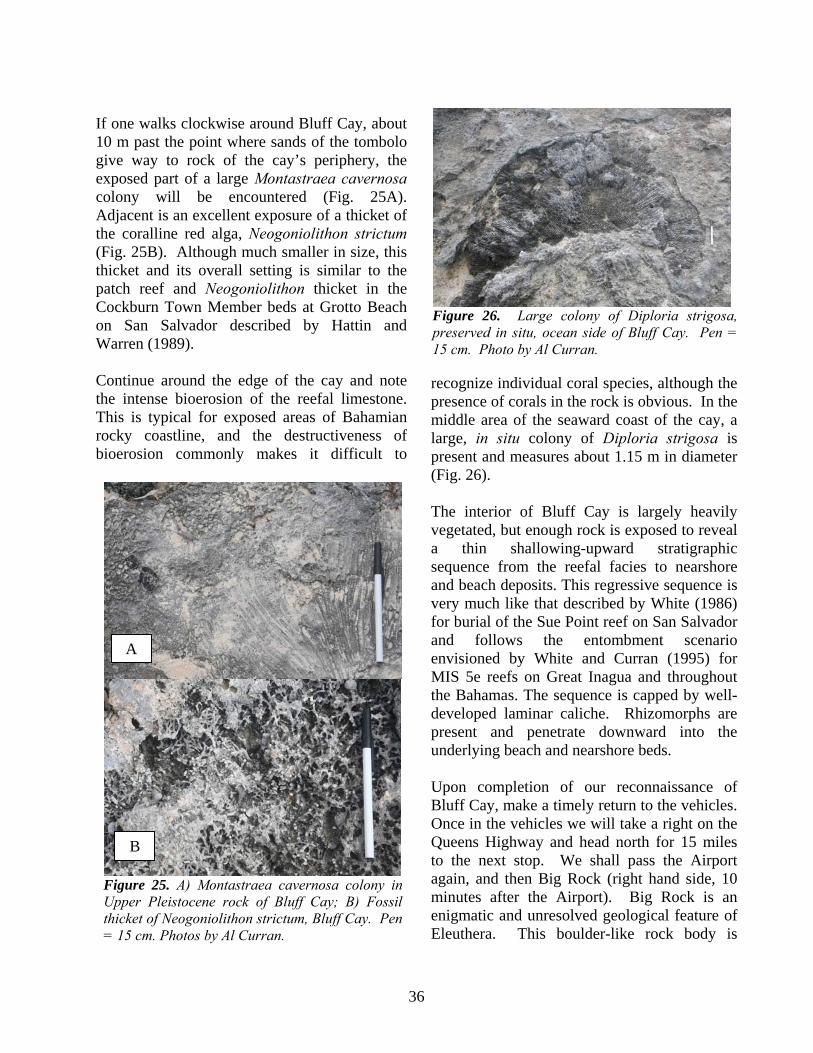
36
If one walks clockwise around Bluff Cay, about 10 m past the point where sands of the tombolo give way to rock of the cay’s periphery, the exposed part of a large Montastraea cavernosa colony will be encountered (Fig. 25A). Adjacent is an excellent exposure of a thicket of the coralline red alga, Neogoniolithon strictum (Fig. 25B). Although much smaller in size, this thicket and its overall setting is similar to the patch reef and Neogoniolithon thicket in the Cockburn Town Member beds at Grotto Beach on San Salvador described by Hattin and Warren (1989). Continue around the edge of the cay and note the intense bioerosion of the reefal limestone. This is typical for exposed areas of Bahamian rocky coastline, and the destructiveness of bioerosion commonly makes it difficult to
recognize individual coral species, although the presence of corals in the rock is obvious. In the middle area of the seaward coast of the cay, a large, in situ colony of Diploria strigosa is present and measures about 1.15 m in diameter (Fig. 26). The interior of Bluff Cay is largely heavily vegetated, but enough rock is exposed to reveal a thin shallowing-upward stratigraphic sequence from the reefal facies to nearshore and beach deposits. This regressive sequence is very much like that described by White (1986) for burial of the Sue Point reef on San Salvador and follows the entombment scenario envisioned by White and Curran (1995) for MIS 5e reefs on Great Inagua and throughout the Bahamas. The sequence is capped by well-developed laminar caliche. Rhizomorphs are present and penetrate downward into the underlying beach and nearshore beds. Upon completion of our reconnaissance of Bluff Cay, make a timely return to the vehicles. Once in the vehicles we will take a right on the Queens Highway and head north for 15 miles to the next stop. We shall pass the Airport again, and then Big Rock (right hand side, 10 minutes after the Airport). Big Rock is an enigmatic and unresolved geological feature of Eleuthera. This boulder-like rock body is
Figure 25. A) Montastraea cavernosa colony in Upper Pleistocene rock of Bluff Cay; B) Fossil thicket of Neogoniolithon strictum, Bluff Cay. Pen = 15 cm. Photos by Al Curran.
A
Figure 26. Large colony of Diploria strigosa, preserved in situ, ocean side of Bluff Cay. Pen = 15 cm. Photo by Al Curran.
B

37
located about 20 km away from the suite of megaboulders observed in the Glass Window area, but it is one order of magnitude smaller than all but one of those. It rests in the middle of the island, which is about 800 m wide at this location. It consists of altered bioclastic limestone characterized by an early generation of phreatic marine cement, and yielded an A/I ratio indicating a young age (late MIS 5e or 5a). It shows low-angle bedding dipping toward the W, i.e. parallel to the strike of the island in this area. It rests on a pedogenically altered oolitic substrate, very similar to the rocks belonging to the Grotto Beach Formation. Unlike the other boulders, no cave occurs at the base of Big Rock. The re-entrant that can be seen below the boulder is actually carved in the oolitic substrate. STOP 4 - THE CLIFFS. Fifteen miles from where we entered the road at Two Pines turn right onto a dirt road that branches off from Queens' highway and drive north to the ocean shoreline. This location is not named on the official topographic chart of Eleuthera, but is identified on widely distributed tourist maps, and a Bahamas Heritage Site sign marking The Cliffs was next to Queens
Highway in February 2010. The Cliffs exposure (lat. 25°20'11"N, long. 76o24'19"W; Fig. 27) comprises a stretch of cliffs with several re-entrants at the western end of the up to 15 m-high, 3 km-long, and mostly unstudied W-E oriented cliff section extending to the west of James Point, on the Atlantic coast of central Eleuthera (Figs. 2 and 27). The high cliffs and rough karstic terrain require caution while exploring this outcrop. Also, be alert for large waves. Several studies (Kindler and Hearty, 1995; Hearty, 1998; Panuska et al., 2002; Ersek, 2004; Nawratil de Bono, 2008;
Figure 27. Geologic map of The Cliffs area (modified from Kindler and Hearty, 1995).
Figure 28. General view of the most accessible cove of The Cliffs. Numbers designate individual eolianites identified at this exposure. Black arrows point to important southward-dipping discontinuity capping eolianite #1. A more subtle discontinuity can be seen between eolianites #2 and #3. White arrow indicates one large, storm-deposited boulder. Car (in white ellipse) for scale. The depression on the landward side of the eolianite stack is covered by loose sand and vegetation. An interesting section is nonetheless visible to the south of the car. Photo by Pascal Kindler.

38
Mylroie, 2008) were made at this particular location, probably because of easy access from Queens' highway. The Cliffs section displays an impressive vertical succession of several m-scale eolian rock bodies that are bounded by thinner reddish pedogenic horizons (Fig. 28). The leeward side of these eolianites is well preserved, still showing their original slope, but their windward side has been removed by shoreline retreat. Because some of the intervening paleosols are discontinous, the number of vertically-stacked eolianites varies laterally (Nawratil de Bono, 2008). The eolianites, labeled 1 through 3 on Fig. 28, were identified on the basis of their overall morphology and large-scale sedimentary structures which include thick (> 2 m) sets of steep (> 30o), predominantly landward-dipping, convex-upward foresets. Rare low-amplitude wind-ripples (ripple index > 25; Figure 8b in Kindler and Hearty, 1995) and pervasive rhizomorphs, especially in the upper two units, further indicate the eolian nature of these deposits. A pronounced paleokarstic surface (arrows of Fig. 28) can be observed at elevations varying between 1 and 15 m in the eastern part of the exposure, but leveling out at about 7 m toward the west. This surface is
overlain by a thin micritic crust and a clayey to sandy reddish layer, up to 30 cm thick (Fig. 29). This layer contains numerous black pebbles of various sizes and nature (Fig. 29), including one fragment of lithified algal mat (Nawratil de Bono, 2008). In addition, this horizon, which yielded tall, finely-ribbed land snails (Cerion sp.), has been interpreted as a composite paleosol (Nawratil de Bono, 2008), probably developed during more than one glacial/interglacial cycle. Surprisingly, Ersek (2004) measured an elevated SiO2/Al2O3 ratio in this layer, which is indicative of minor leaching. This result was not corroborated by Nawratil de Bono (2008), who reported a low pedogenic index (i.e., illite/vermiculite ratio) and a high leaching index (Al2O3/[Al2O3 + MgO + Na2O]·100) for this paleosol. The paleosol overlying the uppermost eolian unit (eolianite 3 of Fig. 28), and forming the upper surface of The Cliffs exposure, represents also an important discontinuity and epikarst, whereas those covering the other eolianites are less prominent, discontinuous, and only show
Figure 29. Closer view of the main discontinuity exposed at The Cliffs. Note the corrugated upper surface of eolianite #1, and the thin micritic crust (arrows) lining it. The white ellipse encloses one black pebble. Scale bar is 20 cm. Photo by Pascal Kindler.
Figure 30. Microscopic view of the lower eolianite exposed on the sea cliff (eolianite #1 of Fig. 28). Sample was collected in low-angle crossbeds at about 5 m above sea level. This bioclastic calcarenite predominantly contains benthic foraminifers (sor = soritid), micritized bioclasts (micr) and leached Halimeda grains (Hal). Note high primary porosity and rare calcitic meniscus cement (between the two arrows). Scale bar is 350 µm. Photo by Pascal Kindler.

39
patchy ferruginous crusts and/or mottled zones. The petrographic composition of the eolianites exposed at The Cliffs is constant throughout the section. All units are made of medium to coarse-grained, well-lithified bioclastic limestone containing numerous abraded benthic foraminifers (soritids, miliolids, rotaliids) and abundant coral and algal debris (Fig. 30). Mollusk fragments also occur, but they are commonly leached and replaced by sparry calcite. Allochems are bound by LMC equant spar located at grain contacts and locally filling intergranular pores. In a few samples from the lower part of the succession (i.e., up to about 2 m above sea level), this calcitic cement is overlain (and obscured) by isopachous fibrous fringes typical of a marine phreatic setting (Fig. 31). XRD analyses indicate that The Cliffs limestones are essentially made of low-Mg calcite. This result, along with other petrographic data (e.g. spar-filled micrite envelopes), shows that these rocks have been altered by meteoric waters . An interesting stratigraphic succession can be found in the elongated depression on the leeward side of the stacked eolianites forming the sea cliff (Figs. 28 and 32). Unfortunately, it is partly covered by recent washover and dunal
sand, and by large eolianite blocks ripped off from the nearby cliff during hurricanes (Figs. 28 and 32). Its lower part consists of well-lithified, highly weathered, mottled bioclastic
Figure 32. Landward side of The Cliffs exposure showing the weathered bioclastic limestone, the last-interglacial oolite (Grotto Beach Formation), and modern, storm-transported sand and boulders (arrow). Person for scale is 1.58 m tall. Photo by Pascal Kindler.
Figure 31. Microscopic view of the lower eolianite (eolianite #1 of Fig.28) exposed on the sea cliff. Sample was collected in high-angle crossbeds at about 2 m above sea level. This bioclastic eolianite first underwent an episode of fresh-water diagenesis indicated by the occurrence of spar-filled micritic envelopes (env), followed by a later phase of marine phreatic diagenesis represented by isopachous fibrous rims (arrows). These were formed when sea level was higher than present, either during MIS 5e or during the middle Holocene (red a = red algal fragment; benth = benthic foraminifer). Scale bar is 350 µm. Photo by Pascal Kindler.

40
calcarenites devoid of sedimentary structures. These rocks are overlain by well-bedded oolitic limestone showing a low-angle dip toward the south (i.e., the bank side of the island), and containing numerous fenestrae. The boundary separating this oolite from the underlying bioclastic calcarenites is very sharp (Fig. 33), and likely corresponds to an erosional surface. The homogeneous grain size and the lack of large marine fossils suggest an eolian origin for the lower bioclastic calcarenite. The overlying oolitic beds are interpreted as lagoon-facing beach and/or washover deposits. Due to modern sediment cover and subdued topography, precise correlation of the lower bioclastic calcarenites from this section with any of the eolian units exposed on the sea cliff is difficult. The high degree of induration and weathering of these calcarenites is unique in this area and they could represent a lower unit, unexposed on the cliff face. It would imply that the rhizomorph-rich eolianite forming the top unexposed on the cliff face. It would imply that the rhizomorph-rich eolianite forming the top of the sea cliff pinches out a few m to the north of the oolite outcrop. This new and unpublished interpretation awaits challenges and discussion from fieldtrip participants. The lowest eolian unit exposed on the sea cliff gave one reliable A/I ratio of 0.576, whereas two samples from the uppermost eolianite gave unreliable A/I values (i.e. low concentration of amino acids) of 0.382 and 0.352 (Hearty, 1998). No AAR data has so far been retrieved from the stratigraphic section exposed in the backside swale. Based on stratigraphic (i.e., position below a paleosol) and petrographic (predominatly oolitic composition) criteria, the well-bedded deposits exposed in the flat area on the backside of The Cliffs can be correlated with the Grotto Beach Formation, and must thus date from the last interglacial period (MIS 5e). Because of the occurrence of these oolites, previous authors
have correlated the bioclastic eolianites forming the sea cliff with pre-Sangamonian interglacials. Interpretations, however, have been quite variable: the eolianites occurring below and respectively above the mid-cliff discontinuity were attributed to MIS 7 and MIS 9 by Kindler and Hearty (1995), entirely to MIS 7 by Hearty (1998), and to MIS 7 and MIS 13 by Kindler and Hearty (1997) and Nawratil de Bono (2008). A/I ratios are unfortunately not very helpful for a better understanding of this exposure. The value (0.576) measured from the lowest eolianite (one sample so far) correlates with MIS 7 which is not consistent with the physical stratigraphy, unless one considers that the complex paleosol at mid-cliff level was formed during a MIS 7 interstadial (Hearty, 1998). Ratios obtained from low-concentration samples collected from the uppermost unit suggest a late MIS 5e or MIS 5a age, which would agree with the physical stratigraphy if it could be clearly demonstrated that this unit pinches out southward, and does not dip below the Grotto Beach Formation on the backside of The Cliffs. The highly altered bioclastic rocks observed below this oolite could be as old as MIS 11, if one adopts Kindler and Hearty's initial interpretation, or MIS 15, if their later hypothesis is verified. Considering the recent discoveries made on Mayaguana (Kindler et al., submitted), an older age (i.e., early Pleistocene) cannot be excluded. Clearly more detailed work is needed on this extensive outcrop to better constrain stratigraphic correlations. Preliminary Sr-isotope data obtained from samples collected during the reconnaissance trip in February indicate an age as old as 270 kyr (MIS 7 to 9) for the lowermost eolianite on the cliff face, and between 280 and 613 kyr (MIS 9 to 15) for the lower unit underlying the oolite on the backside of the exposure. The marine phreatic cement found in the lower reaches of The Cliffs exposure has not been dated yet. It could have precipitated during MIS 5e, but might also represent additional evidence for the mid-

41
Holocene highstand that has so far eluded most Bahamian researchers (White and Curran, 1993; Godefroid et al., 2010a; Kindler et al., submitted). The cliff exposures all have a number of cave openings on the seaward side. These have been interpreted as flank margin caves, which are being overprinted by current wave erosion (Stafford et al., 2004), and demonstrate the difficulty in separating dissolutional processes from wave processes in carbonate coastal areas. Please head back to the vehicles and we will head north on the Queens Highway 3 miles to our lunch stop, the restaurant at the Rainbow Inn. STOP 5: HATCHET BAY CAVE. From the Rainbow Inn, we will head north again on the Queen’s Highway 5.5 miles to Hatchet Bay Cave. The entrance to the Cave is found shortly after the Hatchet Bay settlement, and is marked by a Bahamas Heritage Site sign on the
left hand side of the road. The part of Hatchet Bay Cave to be visited on this field trip is an exceptionally easy cave to traverse. Having said that, traversing a cave takes care and a little bit of skill. There will be no crawling necessary, only one short 2 m section of stooping, and only one climb down, which has a short steel ladder. All the rest is easy, upright walking. There will be no wading or swimming in water. The cave floor is a bit uneven, and care will be necessary to avoid stumbling or falling. A light source is a necessity, each person should have one and a back-up would be useful. The trip leaders will have extra lights. Typical caving gear, such as ropes, knee pads, helmets, etc. are not necessary for the experience we have planned. Hatchet Bay Cave has been open to the public in the past as an occasional self-lighted tour. Eco-tour and student groups are sometimes encountered here. Its location is given on Sheet 4 of the topographic map of Eleuthera and has resulted in much visitation and some vandalism, primarily spray paint and graffiti. Dates as old as 1847 can be found in some places. Hatchet Bay Cave, at 2.02 km of survey, and with an areal footprint of 70,622 m2, is the largest of all the dry caves of the Bahamas (Fig. 34). It is distinctive in having only two entrances, one of which may be artificial, and by having an extremely linear pattern, especially west of the main entrance. The main entrance has cut steps, and remains of a hand rail, that lead downward into the first chamber. The walls exhibit phreatic dissolutional surfaces, yet the elevation of the cave here is 10 to 15 m above sea level, which is higher than such features would be expected to be located, given past Quaternary sea-level positions, and the tectonic stability of the Bahamas. Slightly farther into the cave, to the east, the ceiling had a significant bat colony as recently as 2004. From the east side of the entrance chamber, two main routes exist. To the southeast, and downward over breakdown,
Figure 33. Microscopic view of the sharp boundary (white and black arrows) between the weathered bioclastic limestone and the overlying oolite. Note truncated grains (g) in the lower unit. Micritic coatings of the limestone grains show that it has been pedogenically altered. However, the paleosol was removed by marine erosion prior to the deposition of the overlying oolite. Scale bar is 700 µm. Photo by Pascal Kindler.

42
a passage leads to the east half of the cave, a seldom-visited part of the cave to be described later. To the north is a steeply sloping tubular passage that descends to the main level of the cave; old electrical cables here are used by spleunkers (the term for rank amateurs, as opposed to serious explorers, called “cavers”) as a handline. The tube descends to a step down and opens out into the major passageway of the cave, Eleuthera Expressway (Fig. 34). Eleuthera Expressway is a walking-height tubular passage that trends southwest for 300 m and becomes progressively larger to the southwest. The passage initially braids somewhat to form a series of bedrock pillars. After 50 m, a small, short dead-end passage trends back toward the entrance. At 100 m, the passage opens out into a large room to the southeast. Across to the northwest side of
Eleuthera Expressway, the only passage trending to the north side of the cave goes for 40 m. Continuing onward 50 m, another series of rooms and chambers trends to the south and southeast at the Carlsbad Room, leading into further chambers to the south (Fig. 35). At the east end of these chambers, a small “handshake hole” connects back to the chamber entered at the 100 m mark; it is a handshake hole as one can shake hands through it but it is too small to traverse. These rooms and chambers are big, and in places, well decorated with secondary calcite speleothems. They show a variety of phreatic dissolutional surfaces, and features such as cusps, bell holes, and cupolas. Continuing southwest from the Carlsbad Room there is a very wide continuation of Eleuthera Expressway that narrows after 50 m to a hole in the floor, with a smaller passage continuing
Figure 34. New map of Hatchet Bay Cave, surveyed March, 2010. The dashed line shows the orientation of the terra rossa paleosol within the cave; the dotted line shows the trend of the hillside containing the cave. The cave penetrates the paleosol only in one spot.
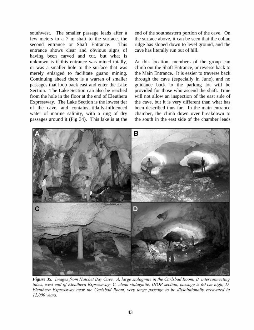
43
southwest. The smaller passage leads after a few meters to a 7 m shaft to the surface, the second entrance or Shaft Entrance. This entrance shows clear and obvious signs of having been carved and cut, but what is unknown is if this entrance was mined totally, or was a smaller hole to the surface that was merely enlarged to facilitate guano mining. Continuing ahead there is a warren of smaller passages that loop back east and enter the Lake Section. The Lake Section can also be reached from the hole in the floor at the end of Eleuthera Expressway. The Lake Section is the lowest tier of the cave, and contains tidally-influenced water of marine salinity, with a ring of dry passages around it (Fig 34). This lake is at the
end of the southeastern portion of the cave. On the surface above, it can be seen that the eolian ridge has sloped down to level ground, and the cave has literally run out of hill. At this location, members of the group can climb out the Shaft Entrance, or reverse back to the Main Entrance. It is easier to traverse back through the cave (especially in June), and no guidance back to the parking lot will be provided for those who ascend the shaft. Time will not allow an inspection of the east side of the cave, but it is very different than what has been described thus far. In the main entrance chamber, the climb down over breakdown to the south in the east side of the chamber leads
Figure 35. Images from Hatchet Bay Cave. A, large stalagmite in the Carlsbad Room; B, interconnecting tubes, west end of Eleuthera Expressway; C, clean stalagmite, IHOP section, passage is 60 cm high; D, Eleuthera Expressway near the Carlsbad Room, very large passage to be dissolutionally excavated in 12,000 years.
44
to some modest-sized rooms that quickly become low and wide. These passages continue south for almost 50 m before turning northeast. The cave becomes very small at a narrow fissure through which mild airflow can be detected. This airflow could be barometric, or indicate another entrance (so far not located). Once past this constriction, the cave again opens up as a series of wide, low chambers and passages. This part of the cave was completely explored and surveyed in March of 2010, and the unexplored passages are blocked by speleothems (stalactites, stalagmites, etc.). The floor is covered with guano, which unlike most large Bahamian caves, was not mined in the 1800s because of the difficulty of access to this section. The ceiling of the cave is flat or undulating, with the dipping beds of the eolian unit containing the cave planed-off by dissolution at a constant horizon. Such horizontality was provided by the distal margin of the fresh-water lens. This region of the cave is called IHOP, for “International House of Pancakes”, because there is only one place to stand up in the entire section. Hatchet Bay Cave was for many years a bit of a geologic mystery. The west side of the cave was large, the Eleuthera Expressway was unusually straight, and there were almost no side passages going to the north, or into the eolian ridge. The east side of the cave was low, wide, maze-like, and had side passages in all directions. The east side of the cave displays the typical passage configuration associated with flank margin caves in the Bahamas. The west side of the cave is very unusual for Bahamian flank margin caves. Field work in 2003 and 2004 eventually provided evidence for the development of these different passage configurations. The northwest wall of Eleuthera Expressway is following a thick, well-developed terra rossa paleosol. During the MIS 5e sea-level highstand, this paleosol acted as an aquiclude, or an aquitard, for the fresh-water lens, such that
the lens in this part of the eolian ridge was distorted. The lens ramped up on the paleosol, and the dissolutional potential of the lens margin was compressed into a narrow band. The result was large passages developed to a higher elevation than expected; no side passages, but a single small one through the paleosol to the north; and the extreme linearity of the Eleuthera Expressway. As Figure 34 demonstrates, as the cave is followed to the northeast, the paleosol trend (seen as the trend of Eleuthera Expressway and at one extreme northern position in IHOP) goes more toward the interior of the ridge, and away from the margin of the lens. The paleosol strikes northeast, but the hillside strikes east-northeast (Fig. 34), so the hillside and the paleosol diverge in the easterly direction. This divergence placed the active dissolutional environment of the lens margin away from the lens-distorting paleosol, and the east side of the cave dissolved in a more traditional flank margin manner. Hatchet Bay Cave has abundant calcite speleothems, and in places, massive calcite spelothems. The cave is located in an area with thick soils, and the cave itself has only two known entrances, indicating that the rock over the cave is thick. Both eolianites seen in the cave are bioclastic, with a predominance of algal and foraminiferal fragments. The overlying or younger dune, which holds most of the cave, could be Grotto Beach Formation rocks, but it is most likely that both are eolianites of the Owl’s Hole Formation from two separate sea-level highstands. The passages in Hatchet Bay Cave, especially in the west section, are very large. Dissolution has been voluminous. A very large amount of rock was removed during the 12,000 years of MIS 5e, and even if dissolution also took place during earlier sea-level highstands (e.g. MIS 11), the maximum time available for the dissolution to occur remains only a few tens of

45
thousands of years. The conditions associated with the distal margin of the fresh-water lens creates, under the flank of carbonate coasts and islands, very large caves in a very short amount of time. All the carbonate lost was removed by dissolution, there was no turbulent stream flow or other mechanism to excavate the cave. Flank margin caves have implications for carbonate island fresh-water resources, and for paleokarst as a host for hydrocarbons. STOP 6 - THE BOILING HOLE From Hatchet Bay Cave we will head north again on the Queen’s Highway seven miles to the Boiling Hole. The turnoff for the Boiling Hole on the right shortly after the Leaving Gregory Town sign. The Boiling Hole (lat. 25°25’56”N, long. 76°35’54”) is a 75 m-wide cove on the eastward, ocean-facing shoreline of northern Eleuthera, situated about 800 m to the southeast of the Glass Window bridge (Fig. 36). The back end of the cove comprises a large sea cave that is only accessible during fair weather and at low tide. The outcrop includes three vertically stacked stratigraphic units (Fig. 37)
that were first identified by Kindler and Hearty (1995). The lower unit corresponds to the Owl's Hole Formation. It forms a chain of deeply karstified eolian dunes of middle Pleistocene age that nonetheless exhibit original topography. The ancient dune crests may reach
Figure 36. Geological map of the Boiling Hole area (modified from Kindler and Hearty, 1997).
Figure 37. Southeastern end of the Boiling Hole cove; background cliff height is 20 m. The dotted line emphasizes the boundary between the Owl's Hole (OH Fm.) and the Grotto Beach (GB Fm.) formations, which is dipping toward the southwest; WP Fm. = Whale Point Formation (modified from Kindler and Hearty, 1995).

46
elevations of up to 25 m above sea level, whereas the interdune swales, such as the Boiling Hole cove, are partly submerged. The northwestern and southeastern flanks of the cove consist of peloidal-oolitic and bioclastic eolianites, respectively, that may correspond to discrete depositional events during separate interglacials (possibly MIS 9/11 and 13, respectively; Hearty, 1998). The upper surface of these limestones is capped by a calcrete and breccia-rich paleosol that commonly has been stripped away by marine erosion particularly at low elevations. The Grotto Beach Formation comprises the middle unit. It is composed of light-grey beds that partly fill the interdunal depression corresponding to the Boiling Hole cove (Fig. 37). Its thickness varies from zero on the sides of the depression, to over six meters in the trough axis. These beds consist of well-cemented, oolitic-peloidal limestone (Fig. 38A) including a small, but remarkable proportion of radial ooids (Kindler and Hearty, 1995; Fig. 38B). On the SE end of the exposure, this formation exhibits two shallowing-upward depositional sequences separated, at about 4 m, by a pronounced erosional surface dipping toward the southwest and overlain by a thin conglomerate (Fig. 39). Each sequence includes subtidal, beach and eolian facies, identified by sedimentary structures characteristic of these depositional environments. The subtidal deposits display small-scale cross beds generated by the action of waves and currents. The overlying beach sediments are represented by large-scale, fenestrae-rich, planar cross beds with a low-angle dip towards the southwest and occur between 2.5 and 3.3 m in the lower sequence and between 5 and 7 m in the upper one. The eolian beds dip mainly toward the southwest and further comprise unusual polygonal structures with a diameter of up to 0.5 m, already observed by Kindler and Hearty (1995),
and resembling prism or desiccation cracks (Demicco and Hardie, 1994). The lower
Figure 38. a. Microscopic view of oolite from the Grotto Beach Formation at Boiling Hole. Note the abundance of normal (i.e. thickly coated ooids = no); scale bar = 200 μm. b. Peculiar radial ooid with a miliolid nucleus. Such ooids are typical of a low energy setting; scale bar = 100 μm. c. Microscopic view of the Whale Point Formation. Note the good preservation of bioclasts and meteoric meniscus cement (arrow) binding the grains; scale bar = 200 μm (modified from Kindler et al., 2008).

47
sequence disappears toward the back end of the cove (i.e., toward the southwest). The basal beach beds from the upper sequence form the floor of the large sea cave carved in the back wall of the Boiling Hole cove. Near the southeastern entrance of the cave, the upper surface of one of these beds exhibits fossil bird tracks (Fig. 40; Kindler et al., 2008b). PLEASE DO NOT TRY TO COLLECT THESE TRACKS. They are preserved in an oolitic grainstone with an early generation of isopachous fibrous cement of marine origin, rare cubic molds that could represent an early halite cement, and late blocky spar precipitated in a meteoric phreatic setting. On the footprint-bearing surface, a total of 19 bird tracks were
recognized. Some of the prints are moderately to fairly well preserved, but none show anatomical details such as digital nodes or webbing traces. Nonetheless, all footprints are believed to be true tracks, as it is very unlikely that underprints would form in an unlaminated oolitic grainstone. All but one can be attributed to an about 2 m long trackway. Footprint length varies from 3 to 5.5 cm (average 4.2 cm), and width from 4.5 to 7 cm (average 6 cm). Digit III usually is the most deeply impressed (up to 0.8 cm). The digits are relatively broad and their tips are U- to V-shaped and without claw impressions. Tracks with three digit prints mostly have a relatively pronounced heel region where the three digits merge together. This rock unit has been correlated with MIS 5e because of its stratigraphic position, the predominantly oolitic composition, the presence of elevated marine facies, and also because it yielded whole-rock A/I ratios that are consistent with the last interglacial period (Hearty, 1998; Hearty and Kaufman, 2000). The Whale Point Formation overlies the Grotto Beach Formation along the back wall of the Boiling Hole cove. In this exposure, only a thin calcrete occurs between the two units, whereas at Whale Point, 3.5 km to the NW,
Figure 39. Stratigraphic section logged in the southeastern end of the Boiling Hole exposure (Fig. 37). Setting column: s = subtidal, b = beach, e = eolian. Dots indicate sample locations. Inverted Ys correspond to rhizomorphs (modified from Kindler and Hine, 2008).
Figure 40. Part of the bird trackway showing well-preserved footprints. These have relatively broad digits and a wide divarication, but show no evidence for webbing of the foot.

48
they are separated by a 30 cm thick paleosol (Fig. 5 in Introduction section). It consists of small (up to 3 m high) bioclastic eolianites (Fig. 38C) bearing numerous root casts and it is capped by a calcrete. Constituent grains have retained their original mineralogy (aragonite or high-Mg calcite). This difference in petrographic characteristics, the presence of an intervening paleosol, and distinctive whole-rock amino-acid ratios (Hearty, 1998), all indicate that these two vertically stacked formations represent separate depositional events and suggest a correlation of the latter unit with MIS 5a. The Boiling Hole exposure is a perfect site to discuss the following points: Sea-level history during the last interglacial: The recognition of two shallowing-upward sequences in the MIS 5e strata from the Boiling Hole (Fig. 39) appears to support earlier reports on the occurrence of two distinctive sea level high stands in the Bahamas region during the last interglacial period (Chen et al., 1991; Hearty and Kindler, 1993, 1995b; Neumann and Hearty, 1996; White et al., 1998; Wilson et al., 1998; Carew and Mylroie, 1999; Hearty et al., 2007). Due to the lack of suitable material, these sequences could not be precisely dated with the U-series methods. Nonetheless, the intervening erosional surface at 4 m can tentatively be correlated with the sea-level lowstand defined by White et al. (2001) as the Devil’s Point Event, and dated at about 125-124 ka. However, one single but complex sea-level highstand comprising a plateau and then a rise, such as that reconstructed from reefal terraces in Yucatan (Blanchon et al., 2009) and Mayaguana (Godefroid and Kindler, 2010) could account for the observed stratigraphic succession. In any case, the major point of interest of the MIS 5e record from the Boiling Hole is the occurrence of well-expressed beach facies that even more than coral reefs, provides a precise estimate of past sea-level stands. Thus, the
elevation of beach bedding suggests that mean relative sea level stood at about +3 m during deposition the lower sequence, and at about +6 m during accumulation of the upper one. Consideration of the estimated subsidence rates (Carew and Mylroie, 1995) places the first sea-level stand at +5 m and the later one at +8 m above modern datum. These values are consistent, albeit somewhat higher, with those derived from coral data by White et al. (2001), despite the uncertainty related to the depth at which the corals thrived. Bird track preservation: The bird tracks described here represent the first reported occurrence of fossil vertebrate footprints from the Bahama Archipelago (Fig. 40). All footprints are wider than long, which is characteristic of shorebird tracks (Abassi and Lockley, 2004). They do match closely with the ichnotaxon Avipeda that exhibits three forward directed digits of similar length with a total interdigital spacing of less than 95° (Sarjeant and Langston, 1994). For these reasons, we tentatively assign them to this ichnotaxon, using the designation cf. Avipeda. Although the tracks are moderately well preserved, we do not propose a new ichnotaxon or ichnospecies at this time. Observations by Al Curran of similar tracks on a modern sand flat on the bank side of Long Island, Bahamas, indicates that the cm-sized tridactyle footprints exposed in the Boiling Hole cave were likely produced by an extant shorebird species. This trackmaker probably belonged to the Order Charadriiformes and was quite possibly one of the following: American oystercatcher (Haematopus palliates), greater yellowlegs (Tringa melanoleuca), black-necked stilt (Himantopus mexicanus), or stilt sandpiper (Calidris himantopus). Nonetheless, the precise trackmaker species cannot be identified with the evidence presently in hand. The preservation of the bird footprints in an oolitic grainstone is surprising, as is the conservation of the large polygonal prisms or desiccation

49
cracks in the associated eolianites (Kindler and Hearty, 1995). In modern settings, such footprints remain discernible for a few hours to days in cohesive sand, just a few centimeters above the normal high tide line. Subsequent burial by younger (? subtidal) sediment in a low-energy setting could ensure their preservation in the fossil record. In the Boiling Hole case, the footprint-bearing sands could have been quickly cemented by halite crystals precipitated out of marine pore waters and then rapidly buried and preserved by a younger sediment layer. The rare occurrence of square pores, possibly resulting from the dissolution of early halite crystals, appears to support this hypothesis. Origin of ooids and sediment transport: The dip of MIS 5e beach deposits strongly suggests that their constituent grains originated from the interior of the bank, to the southwest. The eolian strata dip in the same direction. However, they are not foresets, as figured earlier in Kindler and Hearty (1995) and Hearty (1998), but backsets draped over the pre-existing middle Pleistocene topography. Thus, their component particles were also brought up from the bank interior from the west, and not from the open ocean side by the prevailing easterly winds, as previously interpreted. Further, the unusual occurrence of radial ooids (Fig. 38B) in these deposits suggests a relatively low-energy production locus (Flügel, 2004), thus strengthening the idea of a bank side source for these deposits. The case is even clearer at Cotton Hole (Fig. 36), one km to the northwest, where bankward-dipping beach sediments exposed on the ocean-facing cliffs can be traced all the way to the bank-facing shoreline of the island. The Boiling Hole outcrop reveals that a large amount of sediments dating from the last interglacial period has been transported onto the island from the west, opposite to the main transport vector (from east to west) that is prevailing on Great Bahama Bank today. Moreover, ooids were not carried eastward
during a single and catastrophic depositional event, such as a storm or a northwesterly gale, but by a sustained flux from the west that lasted long enough for the shoreline to prograde significantly toward the southwest. Re-board the vehicles and make the short drive to the airport waiting area. Board the planes and fly to San Salvador Island. IMPORTANT OUTCROPS THAT WILL NOT BE VISITED Because of the relatively large size of Eleuthra and the limited time available, it is not possible to visit all the outcrops of significance that have been reported in the literature. Below are descriptions of the most significant and intersting of these localities. GLASS WINDOW. Setting The section of interest (25°26'17.64''N and 76°36'17.39''W) is located at about 80 m to the north of the Glass Window bridge (Fig. 41), which is famous for having been moved by
Figure 41. Oblique air view of the Glass Window area showing the location of the described section. The promontory in the upper part of the photo is Whale Point; GBB = Great Bahamas Bank (source: Google Earth).

50
hurricanes over the years. Rogue waves up to 80 feet high (25 m) have been known to arrive unexpectedly and wash over the bridge and nearby cliffs, killing one man in March 1996. Be always alert when visiting this exposure, and stay away from it on windy days. The geology of the Glass Window area has been recently reviewed by Godefroid et al. (2010b). Earlier studies are referenced in this publication from which the following descriptions and interpretations are borrowed. Field and petrographic observations This 22 m-high sea cliff exposes four distinctive carbonate units separated by reddish paleosols, (studied in detail by Nawratil de Bono (2008)), and/or erosional surfaces (Fig. 42). Unit 1 is visible from sea level up to an elevation of 12 to 14 m. It is made of a well-lithified, laminated, bioclastic-peloidal grainstone exhibiting moderately to well-inclined foresets dipping in a bankward direction. Cement (up to 30% of the rock volume) comprises partly preserved, early fibrous or bladed fringes rimming the grains, and late low-Mg calcite crystals filling pores and developing polygonal boundaries. Unit 2 is exposed between 12 and 15 m. It is separaed from Unit 1 by an erosional surface (Fig. 42), and is capped by a 50 cm-thick, sandy paleosol. This unit can be subdivided in two parts. Unit 2a is made of a coarse-grained, laminated, bioclastic grainstone showing low-angle, trough-cross bedding at the base of the unit (Fig. 43) and, higher up, large-scale planar cross-beds dipping towards the SW with a low angle (just below the white arrow in Fig. 42), and containing rare fenestrae. The cement pattern of this rock contains an early generation of fibrous isopachous rims (partly preserved and recrystallized), overlain by thin, non-isopachous rims of undulating micrite, and a late generation of sparry calcite filling pores and/or forming menisci at grain contacts (Fig. 44).
Unit 2b represents the upper 20 to 50 cm of Unit 2, where the bioclastic grainstone composing this unit is capped and penetrated by a cm-thick laminated crust (Fig. 45A to C).
Figure 42. View of the most impressive section in the Glass Window area showing vertically stacked carbonate units and intervening paleosols (p1 to p3). White dotted line emphasizes the erosional surface between Units 1 and 2. White arrow points to one of the sampling sites of the laminar crust presented and discussed below (Unit 2b). Cliff is 22 m high. Person for scale (in circle) is 1.75 m tall.
Figure 43. Trough cross-strata (white arrows) exposed near the base of Unit 2a. The current that generated these structures ran perpendicularly to the plane of the photo. White dotted line emphasizes the boundary between Units 2 and 3, below which a well-developed paleosol (p1) can be observed. Hammer length is 36 cm.

51
This crust exhibits two kinds of mm-scale, undulating laminae: (1) light-coloured, porous laminae, commonly including carbonate allochems and filamentous structures with a cellular texture, and (2) dark, dense, micritic laminae, comprising peculiar, micron-scale, spherical to elongated calcitic bodies commonly interpreted as spherulites of cyanobacterial origin (Fig. 45C; Verrecchia et al. 1995). Unit 3 is about 5 m thick. It is made of a moderately lithified, bioclastic limestone, showing large foresets dipping toward the bank interior with a ca. 30° angle. This rock is essentially composed of bioclasts, often leached or micritized, among which benthic foraminifers (miliolids, rotaliids) and red-algal fragments are predominant. Constituent grains are bound by gravitational and meniscus cements composed of equant crystals of low-Mg calcite.
Unit 4 forms the upper 2 m of the sea cliff and becomes somewhat thinner bankward. Its upper boundary corresponds to a well-marked karstic surface (p3 in Fig. 42). It consists of a medium-grained, well-lithified, oolitic-peloidal grainstone, showing large foresets dipping toward the SW near its base, and subhorizontal beds near its top. Ooids, most of which are partly calcified, and peloids represent up to 60% of the constituent grains. Intergranular pores are filled by an equant to drusy mosaic of low-Mg calcite crystals. Scattered rhizoliths can be observed in this unit. Depositional setting of observed units Unit 1: The occurrence of m-scale foresets dipping toward the bank interior, and the overall good sorting of grains, indicate that Unit 1 was formed in an eolian setting. Constituent particles were probably derived from a low-energy lagoonal environment, and
Figure 44. Sample FAb 74, Unit 2a, collected from a parallel section located to the south of the Glass Window bridge (Godefroid et al., 2010). Thin-section view of Unit 2a microfacies. Note large Halimeda fragments. Cement succession includes: (1) recrystallized, isopachous fibrous cement rimming the grains (white arrows), (2) undulating micrite forming locally bridges between particles (black arrows), and (3) drusy calcite mosaic (dcm) partly filling the remaining pore spaces (scale bar = 600 µm; slightly modified from Godefroid et al., 2010b).
Figure 45. Sample TM3, Unit 2b, see Figure 42 for sample location. Oriented (top is up) thin-section view of one laminated crust forming Unit 2b. A. Microscopic view illustrating the two types of mm-scale, undulating laminae forming this unit; white arrow points to one elongated pore interpreted as a small, horizontal dessication crack. B. Closer view of porous lamina showing one gastropod fragment (gd) and a filamentous structure with a cellular texture (white arrow) interpreted as an algal remain. C. Close-up on dense, micritic lamina showing fibro-radial spherulites of cynobacterial origin (slightly modified from Godefroid et al., 2010b).

52
then deposited on a coastal dune. Interestingly, the diagenetic history of this eolianite took place, first, in a marine phreatic zone, as illustrated by the preserved early fibrous rim cement, and then in a fresh-water phreatic setting, as shown by the late drusy calcite mosaic and polygonal boundaries. Unit 2a: The presence of trough-cross bedding (Fig. 43) and of low-angle, SW-dipping, planar cross-stratification lead to interpretation of this unit as bank-facing subtidal and intertidal deposits. This hypothesis is further corroborated by the early generation of fibrous rim cement of marine origin found in these beds (Fig. 44). Unit 2b: The beige to brown crust forming this unit could tentatively be interpreted as a pedogenic calcrete, which would be coherent with the presence of the overlying paleosol. However, the alternation of porous laminae, commonly including carbonate allochems and filamentous structures with a cellular texture, and of dense laminae comprising spherulites of cyanobacterial origin (Fig. 45), as well as the scarcity of typical pedogenic structures, rather suggest this layer corresponds to a fossil, low-energy, lacustrine (or pond) deposit formed under the influence of algal and cyanobacterial activity. Units 3 and 4: Large landward-dipping cross stratifications, occasional root traces, and widespread low-Mg calcite cements identify the uppermost two units of this section as eolianites. The constituent grains of Unit 3, dominated by benthic foraminifers, red-algal and coral fragments, were probably derived from a reefal environment, whereas those forming Unit 4 (ooids and peloids) originated most probably from an ooid shoal. Age of stratigraphic units Knowing that, in the Bahamas, terra-rossa paleosols usually separate carbonate deposits formed during distinct interglacial sea-level
highstands (Carew and Mylroie, 1997), and applying the basic principle of stratigraphic superposition, the following correlations can be proposed. Units 1 and 2 occur below one paleosol supporting two paleosol-capped carbonate units (Units 3 and 4; Fig. 42). Providing none of these paleosols is composite, or bifurcates (Carew and Mylroie, 1991), Units 1 and 2 could thus be attributed to MIS 9. Following the same reasoning, Units 3 and 4 could be correlated with MIS 7 and MIS 5e, respectively. Consideration of the amino-acid racemization data presented by Hearty (1998) and Nawratil de Bono (2008) leads to a somewhat different interpretation. Samples gathered from Units 1 and 2 yielded A/I ratios between 0.616 and 0.707, suggesting a correlation with Aminozones G/H (Hearty and Kaufman, 2000), which span MIS 9 and 11. The reversed stratigraphic order of the ratios obtained from Unit 1 (0.674, 0.616) and Unit 2 (0.707) could be linked to a temperature effect due to the superficial location of the sample collected from Unit 2. A/I values obtained from Unit 3 range between 0.467 and 0.581, indicating a correlation with Aminozone F, or MIS 7 (Hearty and Kaufman, 2000), which is consistent with the stratigraphy. Hearty (1998) reports an A/I value of 0.569 for Unit 4, suggesting also a correlation with MIS 7. However, the analyzed sample is a bioclastic grainstone (Table 1; Hearty, 1998) that Hearty could have mistakenly picked up from Unit 3, rather than from Unit 4, which is oolitic. Using our lithostratigraphic nomenclature, Unit 4 is tentatively correlated with the Grotto Beach Formation, despite the lack of associated marine deposits, whereas all underlying units are assigned to the Owl's Hole Formation. Implications for sea-level history during the middle Pleistocene
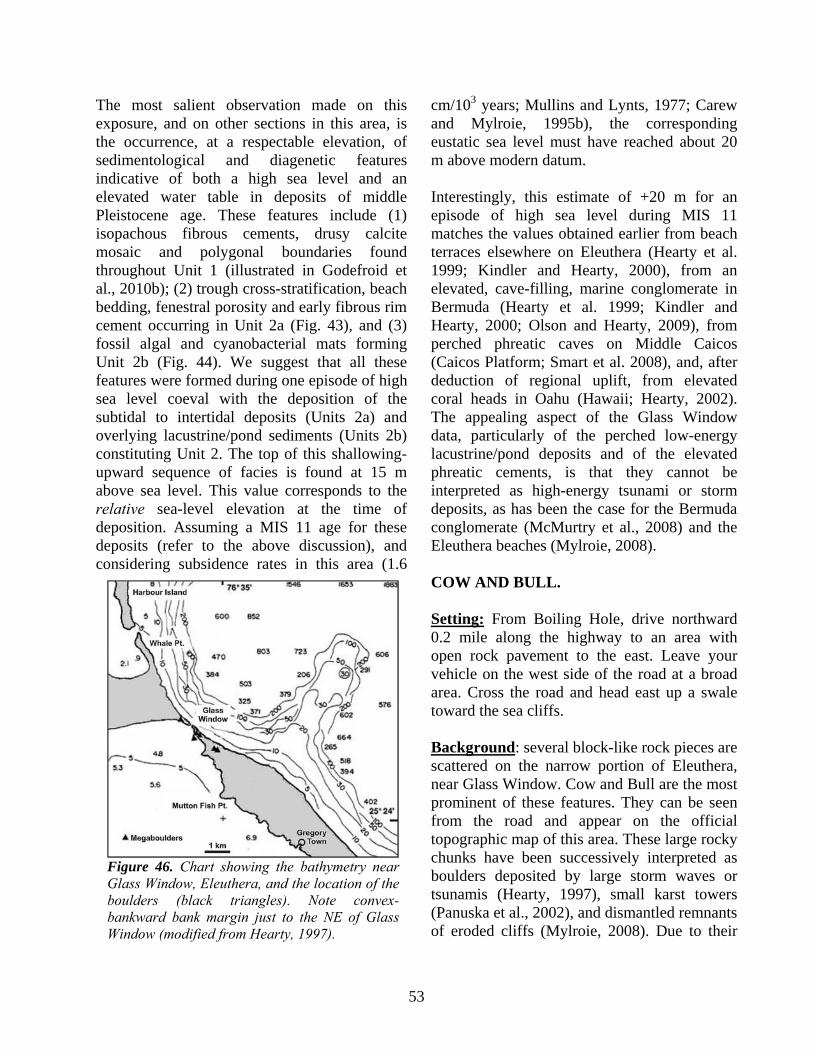
53
The most salient observation made on this exposure, and on other sections in this area, is the occurrence, at a respectable elevation, of sedimentological and diagenetic features indicative of both a high sea level and an elevated water table in deposits of middle Pleistocene age. These features include (1) isopachous fibrous cements, drusy calcite mosaic and polygonal boundaries found throughout Unit 1 (illustrated in Godefroid et al., 2010b); (2) trough cross-stratification, beach bedding, fenestral porosity and early fibrous rim cement occurring in Unit 2a (Fig. 43), and (3) fossil algal and cyanobacterial mats forming Unit 2b (Fig. 44). We suggest that all these features were formed during one episode of high sea level coeval with the deposition of the subtidal to intertidal deposits (Units 2a) and overlying lacustrine/pond sediments (Units 2b) constituting Unit 2. The top of this shallowing-upward sequence of facies is found at 15 m above sea level. This value corresponds to the relative sea-level elevation at the time of deposition. Assuming a MIS 11 age for these deposits (refer to the above discussion), and considering subsidence rates in this area (1.6
cm/103 years; Mullins and Lynts, 1977; Carew and Mylroie, 1995b), the corresponding eustatic sea level must have reached about 20 m above modern datum. Interestingly, this estimate of +20 m for an episode of high sea level during MIS 11 matches the values obtained earlier from beach terraces elsewhere on Eleuthera (Hearty et al. 1999; Kindler and Hearty, 2000), from an elevated, cave-filling, marine conglomerate in Bermuda (Hearty et al. 1999; Kindler and Hearty, 2000; Olson and Hearty, 2009), from perched phreatic caves on Middle Caicos (Caicos Platform; Smart et al. 2008), and, after deduction of regional uplift, from elevated coral heads in Oahu (Hawaii; Hearty, 2002). The appealing aspect of the Glass Window data, particularly of the perched low-energy lacustrine/pond deposits and of the elevated phreatic cements, is that they cannot be interpreted as high-energy tsunami or storm deposits, as has been the case for the Bermuda conglomerate (McMurtry et al., 2008) and the Eleuthera beaches (Mylroie, 2008). COW AND BULL. Setting: From Boiling Hole, drive northward 0.2 mile along the highway to an area with open rock pavement to the east. Leave your vehicle on the west side of the road at a broad area. Cross the road and head east up a swale toward the sea cliffs. Background: several block-like rock pieces are scattered on the narrow portion of Eleuthera, near Glass Window. Cow and Bull are the most prominent of these features. They can be seen from the road and appear on the official topographic map of this area. These large rocky chunks have been successively interpreted as boulders deposited by large storm waves or tsunamis (Hearty, 1997), small karst towers (Panuska et al., 2002), and dismantled remnants of eroded cliffs (Mylroie, 2008). Due to their
Figure 46. Chart showing the bathymetry near Glass Window, Eleuthera, and the location of the boulders (black triangles). Note convex-bankward bank margin just to the NE of Glass Window (modified from Hearty, 1997).
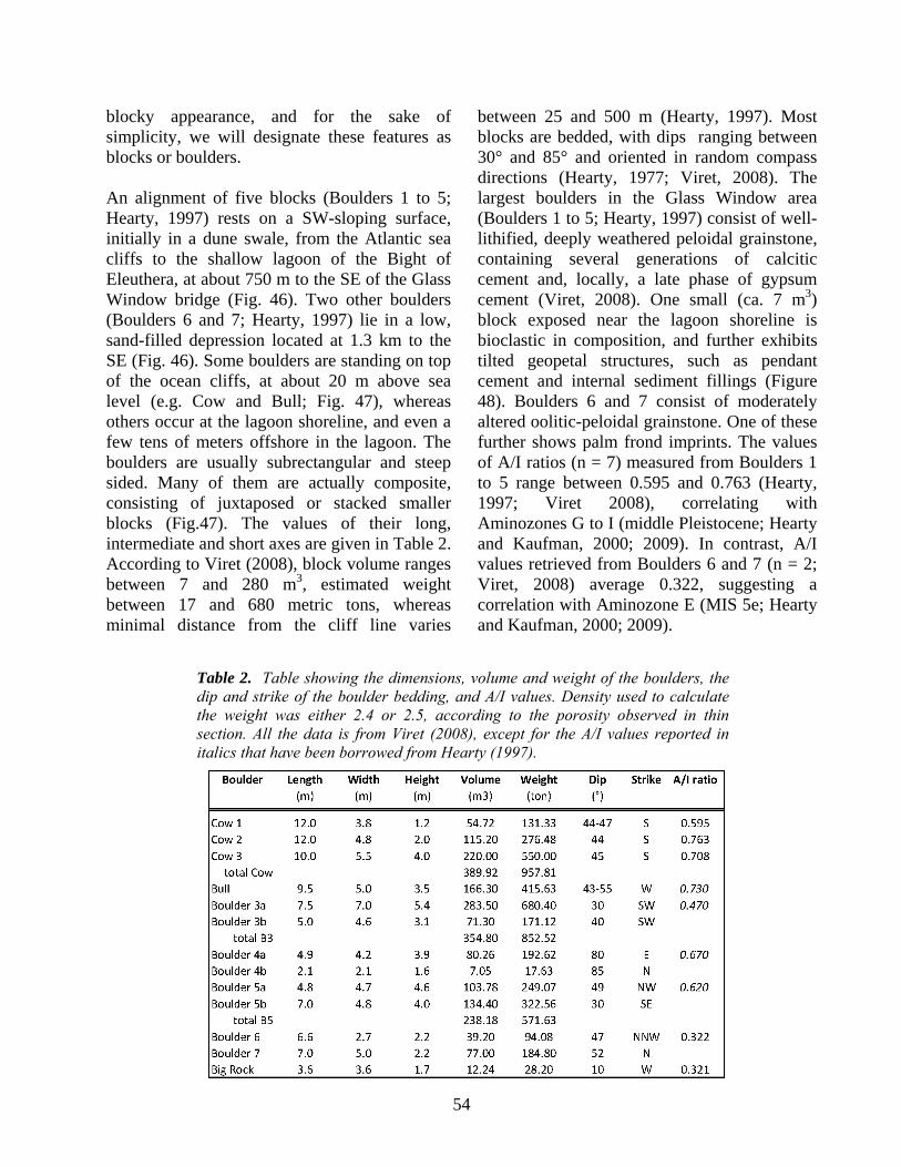
54
blocky appearance, and for the sake of simplicity, we will designate these features as blocks or boulders. An alignment of five blocks (Boulders 1 to 5; Hearty, 1997) rests on a SW-sloping surface, initially in a dune swale, from the Atlantic sea cliffs to the shallow lagoon of the Bight of Eleuthera, at about 750 m to the SE of the Glass Window bridge (Fig. 46). Two other boulders (Boulders 6 and 7; Hearty, 1997) lie in a low, sand-filled depression located at 1.3 km to the SE (Fig. 46). Some boulders are standing on top of the ocean cliffs, at about 20 m above sea level (e.g. Cow and Bull; Fig. 47), whereas others occur at the lagoon shoreline, and even a few tens of meters offshore in the lagoon. The boulders are usually subrectangular and steep sided. Many of them are actually composite, consisting of juxtaposed or stacked smaller blocks (Fig.47). The values of their long, intermediate and short axes are given in Table 2. According to Viret (2008), block volume ranges between 7 and 280 m3, estimated weight between 17 and 680 metric tons, whereas minimal distance from the cliff line varies
between 25 and 500 m (Hearty, 1997). Most blocks are bedded, with dips ranging between 30° and 85° and oriented in random compass directions (Hearty, 1977; Viret, 2008). The largest boulders in the Glass Window area (Boulders 1 to 5; Hearty, 1997) consist of well-lithified, deeply weathered peloidal grainstone, containing several generations of calcitic cement and, locally, a late phase of gypsum cement (Viret, 2008). One small (ca. 7 m3) block exposed near the lagoon shoreline is bioclastic in composition, and further exhibits tilted geopetal structures, such as pendant cement and internal sediment fillings (Figure 48). Boulders 6 and 7 consist of moderately altered oolitic-peloidal grainstone. One of these further shows palm frond imprints. The values of A/I ratios (n = 7) measured from Boulders 1 to 5 range between 0.595 and 0.763 (Hearty, 1997; Viret 2008), correlating with Aminozones G to I (middle Pleistocene; Hearty and Kaufman, 2000; 2009). In contrast, A/I values retrieved from Boulders 6 and 7 (n = 2; Viret, 2008) average 0.322, suggesting a correlation with Aminozone E (MIS 5e; Hearty and Kaufman, 2000; 2009).
Table 2. Table showing the dimensions, volume and weight of the boulders, the dip and strike of the boulder bedding, and A/I values. Density used to calculate the weight was either 2.4 or 2.5, according to the porosity observed in thin section. All the data is from Viret (2008), except for the A/I values reported in italics that have been borrowed from Hearty (1997).

55
Boulders 6 and 7 are partly covered by modern sands, and their substrate can thus not be investigated. In contrast, the boulders nearest to Glass Window overlie a Cerion-rich, sandy paleosol developed in oolitic deposits forming a shallowing-upward succession of facies from subtidal to eolian (Fig. 49). This oolite is rather well preserved and yielded A/I ratios (n = 3) averaging about 0.40 (Hearty, 1997; Viret, 2008). This value allows a correlation of these oolitic deposits with the last interglacial period. One cm-thick micritic crust can also be observed capping the oolitic substrate in the vicinity of the boulders. However, the geometric relationship between this crust and the boulders is not always clear, and the nature of the crust
itself (i.e., pedogenic versus biogenic) has not been firmly established. Some blocks lie on limestone “pedestals” (e.g., Boulder 4, Fig. 49), generally 0.5 to 2 m above the surrounding rocks. Peculiar features further observed at the base of several boulders are truncated, meter-scale, phreatic caves that contain some calcite speleothems (Figs. 49 and 50; Panuska et al., 2002). The core and the outer layer of one small stalactite collected from below a ledge in Boulder 2 (Bull) gave U-Th ages of 81.7 +1 kyr and 55.7+0.4 kyr, respectively (Viret, 2008). Finally, Boulder 5, which lies in the bank lagoon in 1 to 2 m of calm waters, shows an erosional notch between 0.6 and 1 m above sea level (Fig. 51). Discussion: Nature and origin of the blocks. In addition to their overall morphology, the dip of the bedding observed in the boulders (up to 85°; Viret, 2008), which far exceeds the angle of repose of wind-deposited sands (McKee, 1979), and the occurrence of rotated geopetal structures (Fig. 48), both indicate that these “topographic projections” (Mylroie, 2008) are truly limestone blocks that have experienced transport. The blocky nature of Boulders 1 to 5 is further corroborated by their higher diagenetic grade and more elevated A/I ratios than those observed or measured from the underlying substrate. Careful sampling at the base of the boulders, and the pronounced difference in A/I ratios (> 0.3), both exclude that this age inversion is related to abnormal surface heating of the boulders, as advocated by Mylroie (2008). Consequently, they cannot be interpreted as dissolved remnants of an in-situ rock body (Panuska et al., 2002; Mylroie, 2008), despite the common occurrence of small caves at their base (see further discussion below). The petrographic and geochemical (A/I ratios) characteristics of Boulders 1 to 5 match those of the Owl’s Hole Formation (middle Pleistocene), but clearly differ from those of the Grotto Beach and Whale Point Formations
Figure 47. Megaboulders Cow and Bull (2), seen from a headland to the NE. Note that Cow comprises three distinctive smaller blocks numbered 1a through 1c. In addition, a one-m thick conglomerate layer consisting of dm-sized clasts can be observed on the bank side of this composite megaboulder. The white dotted line emphasizes the boundary between the Owl's Hole and the Grotto Beach Formations. Person for scale (in white ellipse) is 1.58 m tall. Cliff height is about 20 m.

56
(late Pleistocene) forming their substrate and/or exposed nearby. In contrast, Boulders 6 and 7 show numerous similarities with the rocks from the Grotto Beach Formation. Consequently, Boulders 1 to 5 were carved from the underlying ocean-facing cliffs, where the Owl's Hole Formation is exposed at elevations of up to 10
m (Fig. 47; Kindler and Hearty, 1995; Hearty, 1997, 1998), whereas Boulders 6 and 7 must be derived from the Grotto Beach Formation, which likely represents their substrate below the cover of modern sands filling the depression where they lie. Transportation of the blocks. Hearty (1997) suggested the boulders were brought up onto the island by large waves, and speculated these waves could have been triggered by a tsunami of distant origin, by local bank-margin slumping, or by giant storms in the Atlantic Ocean. He and other authors (Hearty et al.,1998) later considered extreme storms and attendant waves as the most probable agents of block transport, and situated the boulder emplacement near the end of MIS 5e. However, the studied boulders are, in average, about 2 to 10 times larger and heavier than the blocks observed within the limits of recent storm-wave action in the area (Viret, 2008) and elsewhere (e.g., Jones and Hunter, 1992). The storm-wave hypothesis thus appears rather doubtful, unless one considers that waves were generated by a "hypercane" triggered by sea-surface temperatures in excess of 36°C, and
Figure 48. A) Weathered bioclastic grainstone forming Boulder 4b located near the lagoon (Figs. 46 and 49). On this oriented view (top is up), one non-cemented pore (po) has been partly filled by vadose silt (vs). The upper surface of this filling (black dotted line) forms a ca. 80° angle with the horizontal plane, demonstrating that the block has been rotated (white arrow emphasizes the amount of rotation; dcm = drusy calcite mosaic; scale bar = 300 µm; B) Other oriented thin-section view (top is up) showing tilted pendant cement (pc) that further suggests block rotation (white arrow emphasizes the amount of tilting; mc = early meniscus cement; scale bar = 300 µm).
Figure 49. Megaboulder 4 is located close to the lagoon shoreline. It comprises two composite blocks (a and b), the former further exhibiting a small cave at its base. It stands on a 1.5 m high pedestal consisting of pedogenically altered, oolitic beach deposits. Person for scale is 1.75 m tall.

57
outflow temperatures lower than -110°C (Parks Camp and Montgomery, 2001). The possible existence of such conditions within the past 130 kyr has not been demonstrated up to now (Frohlich et al., 2009). Mylroie (2008) proposed that the blocks have just been ripped up from the top, and rolled down the backside of old eolianite cliffs that once extended farther seaward, and higher up. However, the existence of ancient cliffs presenting such a geometry at this specific location appears unlikely. Indeed the upper 5 m of the present-day sea cliff directly below Cow and Bull (Fig. 47) are carved in the Grotto Beach oolite, the petrographic composition of which is clearly different from that of the boulders. The Owl's Hole Formation, the most likely source for the boulders, is only exposed at mid-cliff level and its upper surface is sloping seaward (Fig. 47). This hypothesis, where blocks are mostly moved by a gravitational process, can therefore not explain the emplacement of Boulders 1 to 5, but could account for the transportation of Boulders 6 and 7 that display the same lithology as the Grotto Beach Formation. The studied boulders match in volume and weight blocks deposited by far-field Holocene tsunamis on Whale Point, just north of Glass Window, and on the east coast of Long Island (Kelletat et al., 2004). They are also very similar by their size, localized occurrence, elevation above sea level, and distance from the shoreline to large blocks recently described on Tongatapu, in the Tonga Islands, which have been emplaced by a Holocene tsunami triggered by the collapse of a nearby submarine volcano (Frohlich et al., 2009). Blocks transported 800 m landward have been noted on the south coastal plain of Isla de Mona, Puerto Rico (Taggart et al., 1993). The limited lateral extent of the Eleuthera boulders suggests also a proximal source for the waves that transported them. Because there are no submarine volcanoes at close proximity to the
eastern edge of Great Bahama Bank, we suggest that local bank-margin collapse is the culprit ultimately responsible for the occurrence of these blocks. The scalloped (i.e. convex-bankward) shape of the platform edge near Glass Window (Fig. 46), which shows an embayment about 6 km across, suggests recent collapse of this part of the platform (Mullins and Hine, 1989) and tends to support this
Figure 50. Phreatic features in the megaboulders. A) Phreatic passage in the “Bull”. B) Passage 2.5 m high with bell hole, inside “Boulder 3”.
Figure 51. Elevated notch carved on the SW flank of Boulder 5 which is located in the Bight of Eleuthera, about 100 m offshore.

58
hypothesis. Nature of the basal caves Boulders 1 to 4 all have small phreatic caves within them (Fig. 50). These caves are formed at the contact of the boulder with the paleosol-covered pedestal supporting the boulders, and the caves extend upward into and through the boulders. At Boulder 3 cave, passage height exceeds 2.5 m (Fig. 50). The curvilinear nature of the passages, with classic phreatic dissolutional forms of cusps and pendants, demonstrate that these features are not sea caves or other pseudokarst features, such as tafoni. Their presence was the primary reason that Panuska et al. (2002) advanced the tower karst hypothesis, which Mylroie (2008) also reported. The bedding and petrologic data indicate that the blocks have rotated from their original depositional position, and the tower karst model no longer can be supported. However, the cave passages contain speleogenetic geopetal structures (bellholes; Fig. 50) that are in agreement with the current position of the boulders. Therefore the cave development occurred after the boulders were emplaced and stable. One aspect of the Panuska et al. (2002) and Mylroie (2008) tower karst argument seems to be workable, which is that the paleosol acted as an aquiclude or aquitard to focus meteoric water flow through the base of the boulders. Simple rainfall dissolution beneath objects resting on limestone surfaces, as described by Matsukura et al. (2007), is not capable of producing the large passage sizes and relief seen in the caves within the boulders, which require a phreatic zone over 2 m thick. As the caves are above the paleosol, but at the base of the boulders, they cannot be paleo-epikarst features. If the boulders were emplaced by wave action (either tsunami or landward cliff failure), the original deposit probably consisted of a mixture of sands and blocks of different sizes (Kelletat et al., 2004) of great lateral extent. Such a deposit, resting on a micritic paleosol, could well hold water as a perched water table, even
during glacioeustatic sea-level lowstands. The position of boulders 1, 2 and 3 in a swale in the Grotto Beach dune supports this argument. Therefore dissolution could work in a phreatic environment to create the caves. It is tempting to say that with the return of sea level to modern elevations, wave action would preferentially remove the medium and small grained particles of the debris field, and the boulders would be left behind with phreatic cave segments in them. An interesting scenario can be made to create the boulders, and the debris field they rested in, by wave action on one sea-level highstand, and after speleogenesis, isolate and truncate the caves and boulders by wave action on a different sea-level highstand. These caves would be the surviving remnants of a more extensive system that permeated the perched water body. The problem with this scenario is that the boulders rest on pedestals up to 2 m high, which indicate a significant amount of subaerial denudation; lateral wave action doesn’t leave boulders on pedestals. Additionally, the caves were sealed until 55 kyr, so wave action could not unseal the caves as there was no sea-level highstand between MIS 5a and MIS 1. A typical denudation rate for eogenetic limestones in the subtropics is 50 mm/kyr (Purdy and Winterer, 2001). Given the erosionally-resistant nature of the micitric paleosol that covers the Grotto Beach Formation at the Cow and Bull, this rate is likely a maximum value. Still, there is plenty of time from 55 kyr to the present to create a 2000 mm high pedestal. Sequence of events The time necessary to create paleosols requires that the boulders were emplaced on the MIS 5e Grotto Beach Formation after a significant duration of Grotto Beach exposure. Cave development in a perched water body would be independent of sea level position. The caves were in existence by 80 kyr as the stalactite core date indicates, and were still sealed chambers at 55 kyr to promote stalactite
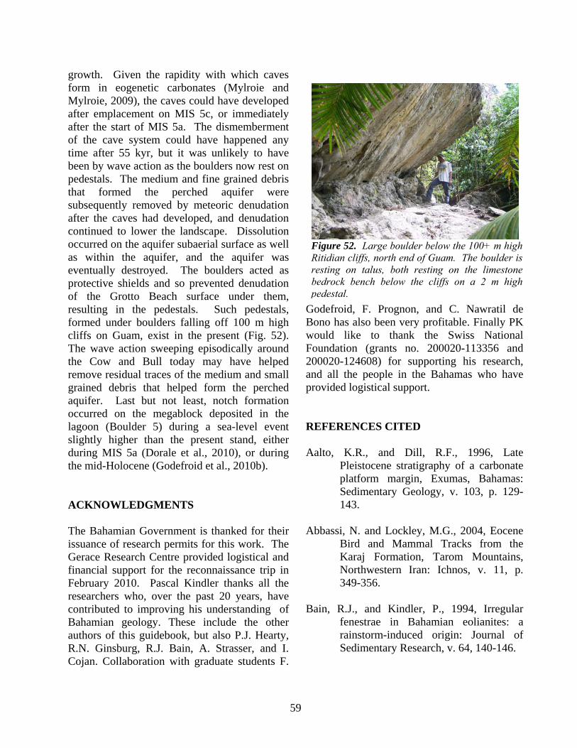
59
growth. Given the rapidity with which caves form in eogenetic carbonates (Mylroie and Mylroie, 2009), the caves could have developed after emplacement on MIS 5c, or immediately after the start of MIS 5a. The dismemberment of the cave system could have happened any time after 55 kyr, but it was unlikely to have been by wave action as the boulders now rest on pedestals. The medium and fine grained debris that formed the perched aquifer were subsequently removed by meteoric denudation after the caves had developed, and denudation continued to lower the landscape. Dissolution occurred on the aquifer subaerial surface as well as within the aquifer, and the aquifer was eventually destroyed. The boulders acted as protective shields and so prevented denudation of the Grotto Beach surface under them, resulting in the pedestals. Such pedestals, formed under boulders falling off 100 m high cliffs on Guam, exist in the present (Fig. 52). The wave action sweeping episodically around the Cow and Bull today may have helped remove residual traces of the medium and small grained debris that helped form the perched aquifer. Last but not least, notch formation occurred on the megablock deposited in the lagoon (Boulder 5) during a sea-level event slightly higher than the present stand, either during MIS 5a (Dorale et al., 2010), or during the mid-Holocene (Godefroid et al., 2010b). ACKNOWLEDGMENTS The Bahamian Government is thanked for their issuance of research permits for this work. The Gerace Research Centre provided logistical and financial support for the reconnaissance trip in February 2010. Pascal Kindler thanks all the researchers who, over the past 20 years, have contributed to improving his understanding of Bahamian geology. These include the other authors of this guidebook, but also P.J. Hearty, R.N. Ginsburg, R.J. Bain, A. Strasser, and I. Cojan. Collaboration with graduate students F.
Godefroid, F. Prognon, and C. Nawratil de Bono has also been very profitable. Finally PK would like to thank the Swiss National Foundation (grants no. 200020-113356 and 200020-124608) for supporting his research, and all the people in the Bahamas who have provided logistical support. REFERENCES CITED Aalto, K.R., and Dill, R.F., 1996, Late
Pleistocene stratigraphy of a carbonate platform margin, Exumas, Bahamas: Sedimentary Geology, v. 103, p. 129-143.
Abbassi, N. and Lockley, M.G., 2004, Eocene
Bird and Mammal Tracks from the Karaj Formation, Tarom Mountains, Northwestern Iran: Ichnos, v. 11, p. 349-356.
Bain, R.J., and Kindler, P., 1994, Irregular
fenestrae in Bahamian eolianites: a rainstorm-induced origin: Journal of Sedimentary Research, v. 64, 140-146.
Figure 52. Large boulder below the 100+ m high Ritidian cliffs, north end of Guam. The boulder is resting on talus, both resting on the limestone bedrock bench below the cliffs on a 2 m high pedestal.

60
Bathurst, R.G.C., 1975, Carbonate sediments and their diagenesis: Developments in Sedimentology, v. 12, Amsterdam, Elsevier, 658 p.
Blanchon, P., Eisenhauer, A., Fietzke, J., and
Liebetrau, V., 2009, Rapid sea-level rise and reef back-stepping at the close of the last interglacial highstand: Nature, v. 458, p. 881-885.
Boardman, M.R., McCartney, R.F., and Eaton,
M.R., 1995 , Bahamian paleosols: origin, relation to paleoclimate, and stratigraphic significance, in Curran, H.A., and White, B., eds, Terrestrial and Shallow Marine Geology of the Bahamas and Bermuda: Geological Society of America Special Paper, v. 300, p. 33-49.
Bottrell, S.H., Carew, J.L., Mylroie, J.E., 1993,
Bacterial sulphate reduction in flank margin environments: Evidence from sulphur isotopes. in White, B., ed., Proceedings of the 6th Symposium on the Geology of the Bahamas: Port Charlotte, Florida, Bahamian Fie1d Station, p. 17-21.
Brentini, M., 2008, Pétrographie sédimentaire et
géochimie isotopique de paléosols et d'éolianites d'Eleuthera (Bahamas) d'âge Pléistocène supérieur à Holocène. Implication sur la paléo-circulation atmosphérique: Unpublished MS Thesis, University of Geneva, Geneva, 115 pp.
Bretz, J.H., 1960, Bermuda: a partially drowned, late mature, Pleistocene karst: Geological Society of America Bulletin, v. 71, p. 1729-1754.
Bullard, E., Everett, J.E., and Smith, A.G.,
1965, The fit of the continents around the Atlantic: Royal Society of London
Philosophical Transactions A, v. 258, p. 41-51.
Caputo, M.V., 1995, Sedimentary architecture
of Pleistocene eolian calcarenites, San Salvador Island, Bahamas, in Curran, H.A., and White, B., eds, Terrestrial and Shallow Marine Geology of the Bahamas and Bermuda: Geological Society of America Special Paper, v. 300, p. 63-76.
Carew, J.L., 1983, The use of amino acid
racemization dating for unraveling the chronostratigraphy of San Salvador, Bahamas, in Gerace, D.T., ed, Proceedings of the First Symposium on the Geology of the Bahamas, CCFL Bahamas Field Station, San Salvador, p. 12-17.
Carew, J.L., Curran, H.A., Mylroie, J.E.,
Sealey, N.E., and White, B., 1996, Field guide to sites of geological interest, western New Providence Island, Bahamas. San Salvador Island, Bahamas, Bahamian Field Station, 36 p.
Carew, J.L., and Mylroie, J.E., 1985,
Pleistocene and Holocene stratigraphy of San Salvador Island, Bahamas, with reference to marine and terrestrial lithofacies at French Bay, in Curran, H. A., ed., Guidebook for Geological Society of America, Orlando Annual Meeting Field Trip #2: Fort Lauderdale, FL, CCFL Bahamian Field Station, p. 11-61.
Carew, J.L., and Mylroie, J.E., 1987, A refined
geochronology for San Salvador Island, Bahamas, in Curran, H. A., ed., Proceedings of the Third Symposium on the Geology of the Bahamas: Fort Lauderdale, FL, CCFL Bahamian Field Station, p. 35-44.

61
Carew, J.L., and Mylroie, J.E., 1989, The
geology of eastern South Andros Island, Bahamas: A preliminary report, in Mylroie, J. E., ed., Proceedings of the Fourth Symposium on the Geology of the Bahamas: Port Charlotte, Florida, Bahamian Field Station, p. 73-81.
Carew, J.L., and Mylroie, J.E., 1991a, Some
pitfalls in paleosol interpretation in carbonate sequences: Carbonates and Evaporites, v. 6, p. 69-74.
Carew, J.L., and Mylroie, J.E., 1991b, A
stratigraphic model of the Bahama Islands: Geological Society of America Abstracts with Programs, v. 23, no. 1, p. 14.
Carew, J.L., and Mylroie, J.E., 1994, Discussion
of: Hearty, P.J. and Kindler, P., 1993. New perspectives on Bahamian Geology: San Salvador, Bahamas. Journal of Coastal Research, v. 9, 577-594: Journal of Coastal Research, v. 10, 1087-1094.
Carew, J.L., and Mylroie, J.E., 1995a, A
stratigraphic and depositional model for the Bahama Islands. in Curran, H. A. and White, B., eds., Terrestrial and Shallow Marine Geology of the Bahamas and Bermuda, Geological Society of America Special Paper 300, p. 5-31.
Carew, J.L., and Mylroie, J.E., 1995b,
Quaternary tectonic stability of the Bahamian Archipelago: Evidence from fossil coral reefs and flank margin caves: Quaternary Science Reviews, v. 14, p. 144-153.
Carew, J.L. and Mylroie, J.E., 1997, Geology of
the Bahamas. in Vacher, H.L., and
Quinn, T.M., eds., Geology and Hydrogeology of Carbonate Islands, Amsterdam, Elsevier Science Publishers, p. 91-139.
Carew, J. l., and Mylroie, J. E., 1999, A review
of the last interglacial sea-level highstand (oxygen isotope substage 5e): Duration, magnitude and variability from Bahamian data, in Curran, H. A. and Mylroie, J. E., eds., Proceedings of the Ninth Symposium on the Geology of the Bahamas and Other Carbonate Regions (1998): San Salvador, Bahamas, Bahamian Field Station, p.14-21.
Carew, J.L., and Mylroie, J.E., 2001,
Quaternary carbonate eolianites of the Bahamas: useful analogs for the interpretation of ancient rocks?, in Abegg, F.E., Loope, D.B., and Harris, P.M., eds, Modern and Ancient Carbonate Eolianites: Sedimentology, Sequence Stratigraphy, and Diagenesis: SEPM Special Publication, v. 71, p. 33-45.
Carew, J.L., Mylroie, J.E., and Sealey, N.E.,
1992, Field guide to sites of geological interest, western New Providence Island, Bahamas; Field Trip Guidebook, Sixth Symposium on the Geology of the Bahamas: Port Charlotte, Florida, Bahamian Field Station, p. 1-23.
Chen, J.H., Curran, H.A., White, B. and
Wasserburg, G.J., 1991, Precise chronology of the last intergalcial period: 234U-230Th data from fossil coral reefs in the Bahamas: Geological Society of America Bulletin, v. 103. p. 82-97.
62
Choquette, P.W., and Pray, L.C., 1970, Geologic nomenclature and classification of porosity in sedimentary carbonates: American Association of Petroleum Geologists Bulletin, v. 54, p. 207-250.
Craton, M., 1986, A history of the Bahamas.
Waterloo, San Salvador Press, 332 p. Curran, H.A., Wilson, M.A., and Mylroie, J.E.,
2008, Fossil palm frond and tree trunk molds: occurrence and implications for interpretation of Bahamian Quaternary carbonate eolianites, in Park, L.E. and Freile, D., eds., Proceedings of the Thirteenth Symposium on the Geology of the Bahamas and Other Carbonate Regions, San Salvador, Bahamas, Gerace Research Centre, p. 183-195.
Davaud, E., and Strasser, A., 1984,
Progradation, cimentation, érosion: évolution sédimentaire et diagénétique récente d'un littoral carbonaté (Bimini, Bahamas): Eclogae Geologicae Helvetiae, v. 77, p. 449-468.
Demicco, R.V., and Hardie, L.A., 1994,
Sedimentary structures and early diagenetic features of shallow marine carbonate deposits: Tulsa, OK, SEPM Atlas Series, no. 1, 265 p.
Davis, R.L,. and J. Johnson, C.R., 1989, Karst
hydrology of San Salvador, in Mylroie, J.E., ed., Proceedings of the Fourth Symposium on the Geology of the Bahamas. San Salvador Island, Bahamas, Bahamian Field Station, p. 118-135.
Dietz, R.S., Holden, J.C., and Sproll, W.P.,
1970, Geotectonic evolution and subsidence of Bahamas Platform:
Geological Society of America Bulletin, v. 81, p. 1915-1928.
Dolan, J.F., Mullins, H.T., and Wald, D.J.,
1998, Active tectonics of the north-central Caribbean: oblique collision, strain partitioning and opposing subducted slabs, in Dolan, J.F., and Mann, P., eds, Active strike-slip and collisional tectonics of the Northern Caribbean Plate Boundary Zone: Geological Society of America Special Paper 326, p. 1-61.
Dorale, J.A., Onac, B.P., Fornos, J.J., Ginés, J.,
Ginés, A., Tuccimei, P., and Peate, D.W., 2010, Sea-level highstand 81,000 years ago in Mallorca: Science, v. 327, p. 860-863.
Eberli, G.P., and Ginsberg, R.N., 1987,
Segmentation and coalesence of Cenozoic carbonate platforms, northwestern Great Bahama Bank: Geology, v. 15, p. 75-79.
Edwards, R.L., Chen, J.H., Ku, T.L., and
Wasserburg, G.J., 1987, Precise timing of the last interglacial period from mass spectrometric determination of thorium-230 in corals: Science, v. 236, p. 1547-1553.
Eneas, W.J.G., 1998, Agriculture in the
Bahamas: Historical development 1492-1992: Nassau, Media Publishing, 152 p.
Ersek, V., 2004, Analyses of common elements
and oxides in the paleosols of the Bahamas and of the Northern Mariana Islands. Unpublished Masters Thesis. Mississippi State University, 110 pp.
Flügel, E., 2004, Microfacies of Carbonate
Rocks: Berlin, Springer Verlag, 976 p.

63
Folk, R.L., Roberts, H.H. and Moore, C.H., 1973. Black phytokarst from Hell, Cayman Islands, British West Indies: Geological Society of America Bulletin, v. 84, p. 2351-2360.
Frohlich, C., Hornbach, M.J., Taylor,F.W.,
Shen, C.-C., Moala, A., Morton, A.E., and Kruger, J., 2009, Huge erratic boulders in Tonga deposited by a prehistoric tsunami: Geology, v. 37, p. 131-134.
Fronabarger, A.K., Carew, J.L., and Haborak,
K., 1997, Morphology of fossil and modern Cerion from San Salvador Island, Bahamas, in Carew, J.L., ed, Proceedings of the Eight Symposium on the Geology of the Bahamas and Other Carbonate Regions: San Salvador, Bahamas, Bahamian Filed Station, p. 59-72.
Garrett, P., and Gould, S.J., 1984, Geology of
New Providence Island, Bahamas: Geological Society of America Bulletin , v. 95, p. 209-220.
Godefroid, F., Géologie de Mayaguana, PhD
Thesis, University of Geneva, Geneva, in preparation.
Godefroid, F., and Kindler, P., 2010, Evidence
for continuously growing bank-barrier reefs on Mayaguana and Great Inagua (SE Bahamas) during the last interglacial : implications for MIS 5e sea-level history. Abstracts and Programs of the Fifteenth Symposium on the Geology of the Bahamas and Other Carbonate Regions: San Salvador, Bahamas, Gerace Research Center, in print.
Godefroid, F., Kindler, P., Chiaradia, M.,
Hasler, C.-A., and Samankassou, E., 2008, Discovery of Lower Pleistocene
shallow-marine deposits on Mayaguana Island, Bahamas. Implications for eustatic sea-level curves derived from deep-sea oxygen-isotope records: Eos Transactions American Geophysical Union, v. 89, (Fall Meet. Suppl.), Abstract PP13C-1478.
Godefroid, F., Kindler, P., Hasler, C.A., and
Samankassou, E., 2009, Mayaguana Island, SE Bahamas: a record of lowstand and highstand carbonate-platform production from the late Miocene to the present, in Pascucci, V., and Andreucci, S., eds, Abstract book, 27th IAS Meeting of Sedimentology, Alghero, Italy, p. 187.
Godefroid, F., Kindler, P., and Samankassou,
E., 2010a, Soil colluvium and elevated fossil algal-microbial mat near Alice Town (Eleuthera, Bahamas): possible evidence for extreme events and a high sea level during the middle Holocene, in Martin, J.B., and Siewers, F.D., eds, Proceedings of the Fourteenth Symposium on the Geology of the Bahamas and Other Carbonate Regions: San Salvador, Bahamas, Gerace Research Centre, in print.
Godefroid, F., Kindler, P., and Nawratil de
Bono, C., 2010b, Further evidence for a +20 m sea-level highstand during Marine Isotope Stage 11 from fossil lacustrine sediments: Glass Window, Eleuthera, Bahamas, in Martin, J.B., and Siewers, F.D., eds, Proceedings of the Fourteenth Symposium on the Geology of the Bahamas and Other Carbonate Regions: San Salvador, Bahamas, Gerace Research Centre, in print.
Goodfriend, G.A., and Gould, S.J., 1996,
Paleontology and chronology of two evolutionary transitions by hybridization

64
in the Bahamian land snail Cerion: Science, v. 274, p. 1894-1897.
Gould, S.J., 1997, The taxonomy and
geographic variation of Cerion on San Salvador (Bahama Islands), in Carew, J.L. ed., Proceedings of the Eighth Symposium on the Geology of the Bahamas and Other Carbonate Regions, p. 73-91.
Grammer, G.M., and Ginsburg, R.N., 1992,
Highstand versus lowstand deposition on carbonate platform margins: insight from Quaternary foreslopes in the Bahamas: Marine Geology, v. 103, p. 125-136.
Grimes, K.G., 2004, Solution pipes or petrified
forests? Drifting sands and drifting opinions!: The Victorian Naturalist, v. 121, p. 14-21.
Hart, R., and Peterson, C., 2007, Late-Holocene
buried forests on the Oregon coast: Earth Surface Processes and Landforms, v. 31, p. 210-229.
Harris, J.G., Mylroie, J.E., and Carew, J.L.,
1995, Banana holes: Unique karst features of the Bahamas: Carbonates and Evaporites, v. 10, p. 215-224.
Hattin, D.H., and Warren, V.L., 1989,
Stratigraphic analysis of a fossil Neogoniolithon-capped patch reef and associated facies, San Salvador, Bahamas: Coral Reefs, v. 8, p. 19-30.
Hearty, P.J., 1997, Boulder deposits from large
waves during the last interglaciation on North Eleuthera Island, Bahamas: Quaternary Research, v. 48, p. 326-33
Hearty, P.J., 1998, The geology of Eleuthera
island, Bahamas: a rosetta stone of Quaternary stratigraphy and sea-level
history: Quaternary Sciences Reviews, v. 17, p. 333-355.
Hearty, P.J., 2002, The Ka'ena highstand of
O'ahu, Hawai'i: further evidence of Antarctic ice collapse during the middle Pleistocene: Pacific Science, v. 56, p. 65-81.
Hearty, P., 2010, Chronostratigraphy and
morphological changes in Cerion land snail shells over the past 130 ka on Long Island, Bahamas: Quaternary Geochronology, v. 5, p. 50-64.
Hearty, P.J., Hollin, J.T., Neumann, A.C.,
O'Leary, M.J., and McCulloch, M., 2007, Global sea-level fluctuations during the Last Interglaciation (MIS 5e): Quaternary Science Reviews, v. 26, p. 2090-2112.
Hearty, P.J., and Kaufman, D.S., 2000, Whole-
rock aminostratigraphy and Quaternary sea-level history of the Bahamas: Quaternary Research, v. 54, p. 163-173.
Hearty, P.J., and Kaufman, D.S., 2009, A
Cerion-based chronostratigraphy and age model from the central Bahama Islands: amino acid racemization and 14C in land snails and sediments: Quaternary Geochronology, v. 4, p. 148-159.
Hearty, P.J., and Kindler, P., 1993, New
perspectives on Bahamian geology: San Salvador Island, Bahamas: Journal of Coastal Research, v. 9, p. 577-594.
Hearty, P.J., and Kindler, P., 1994, Straw Men,
Glass Houses, Apples and Oranges: a response to Carew and Mylroie's comment on Hearty and Kindler (1993): Journal of Coastal Research, v. 10, p. 1095-1104.
65
Hearty, P.J., and Kindler, P., 1995a, The
Geology of North Eleuthera, Bahamas: a "Rosetta Stone" of Quaternary Stratigraphy and Sea Levels: First SEPM Congress on Sedimentary Geology, Field Trip #3 Guidebook, St. Petersburg Beach, Florida, 23 p.
Hearty, P.J., and Kindler, P., 1995b, Sea-level
highstand chronology from stable carbonate platforms (Bermuda and The Bahamas): Journal of Coastal Research, v. 11, p. 675-689.
Hearty, P.J., and Kindler, P. 1997, The
stratigraphy and surficial geology of New Providence and surrounding islands, Bahamas: Journal of Coastal Research, v. 13, p. 798-812.
Hearty, P.J., Kindler, P., Cheng, H. and
Edwards, R.L., 1999, A +20m middle Pleistocene sea-level highstand (Bermuda and the Bahamas) due to partial collapse of Antarctic ice: Geology, v. 27, p.375-378.
Hearty, P.J., Kindler, P., and Schellenberg, S.A.,
1993, The late Quaternary evolution of surface rocks on San Salvador Island, Bahamas, in White, B., ed., Proceedings of the 6th Symposium on the Geology of the Bahamas: San Salvador, Bahamas, Bahamian Field Station, p. 205-222.
Hearty, P.J., Neumann, A.C., and Kaufman,
D.S., 1998, Chevron ridges and runup deposits in the Bahamas from storms late in oxygen-isotope substage 5e: Quaternary Research, v. 50, p. 309-322.
Hearty, P.J., and Schellenberg, S.A., 2008,
Integrated Late Quaternary chronostratigraphy for San Salvador Island, Bahamas: patterns and trends of
morphological change in the land snail Cerion: Paleogeography, Paleoclimatology, Paleoecology, v. 267, p. 41-58.
Hearty, P.J., Vacher, H.L., and Mitterer, R.M.,
1992, Aminostratigraphy and ages of Pleistocene limestones of Bermuda: Geological Society of America Bulletin, v. 104, p. 471-480.
Hesp, P.A., 1981, The formation of shadow
dunes: Journal of Sedimentary Petrology, v. 51, p. 101-112.
Hess, H.H., 1960, Caribbean research project:
progress report: Geological Society of America Bulletin, v. 71, p. 235-240.
Howarth R.J., and McArthur J.M., 1997,
Statistics for strontium isotope stratigraphy. A robust LOWESS fit to the marine Sr-isotope curve for 0 - 206 Ma, with look-up table for the derivation of numerical age: Journal of Geology, v. 105, p. 441-456.
Inowlocki, T., ed., 1999, Fodor’s The
Bahamas: New York, Random House, 222 p.
Itzhaki,Y., 1961, Pleistocene shorelines in the
coastal plains of Israel: Geological Survey of Israel Bulletin, v. 32, p. 1-9.
Jenson, J.W., Keel, T.M., Mylroie, J.R.,
Mylroie, J.E., Stafford, K.W., Taborosi, D., and Wexel, C., 2006, Karst of the Mariana Islands: The interaction of tectonics, glacioeustasy and fresh-water/sea-water mixing in island carbonates: Geological Society of America Special Paper 404, p. 129-138.
Jones, B., and Hunter, I.G., 1992, Very large
boulders on the coast of Grand Cayman:

66
the effects of giant waves on rocky coastlines: Journal of Coastal Research, v. 8, p. 763-774.
Kelletat, D., Scheffers, A., and Scheffers, S.,
2004, Holocene tsunami deposits on the Bahaman Islands of Long Island and Eleuthera: Zeitschrift für Geomorphologie, N.F., v. 48, p. 519-540.
Kindler, P., 1992, Coastal response to the Holocene transgression in the Bahamas: episodic sedimentation versus continuous sea-level rise: Sedimentary Geology, v. 80, p. 319-329.
Kindler, P., 1995, New data on the Holocene
stratigraphy of Lee Stocking Island (Bahamas) and its relation to sea-level history, in Curran, H.A., and White, B. eds., Terrestrial and Shallow Marine Geology of the Bahamas and Bermuda: Geological Society of America Special Paper 300, p. 105-116.
Kindler, P., and Bain, R.J., 1993, Submerged
Upper Holocene beachrock on San Salvador Island, Bahamas: implications for recent sea-level history: Geologische Rundschau, v. 82, p. 241-247.
Kindler, P., Godefroid, F., Chiaradia, M.,
Hasler, C.-A., and Samankassou, E., 2008a, New constraints on dolomitization models and Neogene tectono-eustatic events in the SE Bahamas from exposed Messinian and Upper Pliocene dolostones on Mayaguana Island: Eos Transactions American Geophysical Union, 89, (Fall Meet. Suppl.), Abstract PP13C-1480.
Kindler, P., Curran, H.A., Marty, D., and
Samankassou, E., 2008b, Multiple sedimentary sequences, bird tracks and
lagoon beaches in last interglacial oolites, Boiling Hole, North Eleuthera, Bahamas, in Park, L., and Freile, B, eds, Proceedings of the 13th Symposium on the Geology of the Bahamas and Other Carbonate Regions, San Salvador, Bahamas, Gerace Research Center, p. 169-181.
Kindler, P., Godefroid, F., Chiaradia, M.,
Ehlert, C., Eisenhauer, A., Frank, M., Hasler, C.A., and Samankassou, E., The geology of Mayaguana Island, SE Bahamas: a complex record of shifting sea level, tectonic activity and/or collapse-related isostatic rebound from the Miocene to the Present, submitted to Geology, in revision.
Kindler, P., and Hearty, P.J., 1995, Pre-
Sangamonian eolianites in the Bahamas? New evidence from Eleuthera Island: Marine Geology, v. 128, p.73-86.
Kindler, P., and Hearty, P.J., 1996, Carbonate
petrography as an indicator of climate and sea-level changes: new data from Bahamian Quaternary units: Sedimentology, v. 43, p.381-399.
Kindler, P., and Hearty, P.J., 1997, Geology of
the Bahamas: Architecture of Bahamian Islands, in Vacher, H.L., and Quinn, T.M., eds., Geology and Hydrogeology of Carbonate Islands: Amsterdam, Elsevier Science Publishers, p. 141-160.
Kindler, P., and Hearty, P.J., 2000, Elevated
marine terraces from Eleuthera (Bahamas) and Bermuda: sedimentological, petrographic and geochronological evidence for important deglaciation events during the middle Pleistocene: Global and Planetary Change, v. 24, p. 41-58.
67
Kindler, P., and Hine, A.C., 2008, The
paradoxical occurrence of oolitic limestone on the eastern islands of Great Bahama Bank: where do the ooids come from?: IAS Special Publication, v. 40, p. 113-122.
Kindler, P., Reyss, J.-L., Cazala, C., and
Plagnes, V., 2007, Discovery of a composite reefal terrace of middle and late Pleistocene age in Great Inagua Island, Bahamas. Implications for regional tectonics and sea-level history: Sedimentary Geology, v. 194, p. 141-147.
Kindler, P., and Strasser, A., 1997, Rapid sea-
level changes at the close of the last interglacial (substage 5e) recorded in Bahamian island geology: comment: Geology, v. 25, p. 1147-1149.
Labourdette, R., Lascu, I., Mylroie, J., and Roth
M., 2007, Process-like modeling of flank margin caves: From genesis to burial evolution: Journal of Sedimentary Research, v 77, p. 965-979.
Land, L.S., MacKenzie, F.T., and Gould, S.J.,
1967, Pleistocene history of Bermuda: Geological Society of America Bulletin, v. 78, p. 993-1006.
Lascu, I., 2005, Speleogenesis of large flank
margin caves of the Bahamas, Unpublished Masters Thesis. Mississippi State University, Mississippi State, MS, 218 p.
Li, W.-X., Lundberg, J., Dickin, A.P., Ford,
D.C., Schwarcz, H.P., McNutt, R., and Williams, D., 1989 , High-precision mass-spectrometric uranium-series dating of cave deposits and implications
for palaeclimate studies: Nature, v. 339, p. 534-536.
Lundberg, J., and Taggart, B.E., 1995,
Dissolution pipes in northern Puerto Rico: an exhumed paleokarst: Carbonates and Evaporites, v. 10, p. 171-183.
Manfrino, C.M., and Ginsburg, R.N., 2001,
Pliocene to Pleistocene deposition history of the upper platform margin, in Ginsburg, R.N., ed., Subsurface Geology of a Prograding Carbonate Platform Margin, Great Bahama Bank: Results of the Bahamas Drilling Project. Society for Sedimentary Geology Special Publication No. 70, p. 17-39
Masaferro, J.L., Poblet, J., Bulnes, M., Eberli,
G.P., Dixon, T.H., and McClay, K., 1999, Palaeogene-Neogene/present day(?) growth folding in the Bahamian foreland of the Cuban fold and thrust belt: Journal of the Geological Society of London, v. 156, p. 617-631.
Matsukura, Y., Maekado, A., Aoki, H., Kogure,
T., and Kitano, Y., 2007, Surface lowering rates of uplifted limestone terraces estimated from the height of pedestals on a subtropical island of Japan: Earth Surface Processes and Landforms, v. 32, p. 1110-1115.
McArthur J.M., Howarth R.J., and Bailey T.R.,
2001, Strontium isotope stratigraphy: LOWESS Version 3. Best-fit line to the marine Sr-isotope curve for 0 to 509 Ma and accompanying look-up table for deriving numerical age: Journal of Geology, v. 109, p. 155-169.
McKee, E.D., 1979, Sedimentary structures in
dunes, in, McKee, E.D., ed, A study of

68
global sand seas: US Geological Survey Professional Paper, v. 1052, p. 83-113.
McMurtry, G.M., Tappin, D.R., Sedwick, P.N.,
Wilkinson, I., Fietzke, J., and Sellwood, B., 2008, Elevated marine deposits in Bermuda record a late Quaternary megatsunami: Sedimentary Geology, v. 200, p. 155-165.
Meyer-Berthaud, B., and Decombeix, A-L.,
2007, A tree without leaves: Nature, v. 446, p. 861-862.
Meyerhoff, A.A., and Hatten, C.W., 1974,
Bahamas salient of North America: Tectonic framework, stratigraphy, and petroleum potential: American Association of Petroleum Geologists Bulletin, v. 58, p. 1201-1239.
Muhs, D.R., and Bush, C.A., 1987, Uranium-
series age determinations of Quaternary eolianites and implications for sea-level history, New Providence Island, Bahamas: Geological Society of America Abstracts with Programs, v. 19, p. 780.
Mullins, H.T., and Hine, A.C., 1989, Scalloped
bank margins: Beginning of the end for carbonate platforms?: Geology, v. 17, p. 30-39.
Mullins, H.T., and Hine, A.C., 1990, Reply to
comments by M.M. Ball: Geology, v. 18, p. 95-96.
Mullins, H.T., and Lynts, G.W., 1977, Origin of
the Northwestern Bahama Platform: Review and Reinterpretation: Geological Society of America Bulletin, v. 88, p. 1447-1461.
Mylroie, J.E., 2008, Late Quaternary sea-level
position: evidence from Bahamian
carbonate deposition and dissolution cycles: Quaternary International, v. 183, p. 61-75.
Mylroie, J.E. and Carew, J.L., 1990, The flank
margin model for dissolution cave development in carbonate platforms: Earth Surface Processes and Landforms, v. 15, p. 413-424.
Mylroie, J.E., and Carew, J.L., 1995, Chapter 3,
Karst development on carbonate islands. in Budd, D. A., Harris, P. M., and Saller, A., eds., Unconformities and Porosity in Carbonate Strata: American Association of Petroleum Geologists Memoir 63, p. 55-76.
Mylroie, J.E., and Carew, J.L., 2008, Field
guide to the geology and karst geomorphology of San Salvador: Mississippi State, MS, Mississippi State University, 88 p.
Mylroie, J.E., Carew, J.L., Curran, H.A., Freile,
D., Sealey, N.E., and Voegeli, V.J., 2006, Geology of Cat Island, Bahamas: A Field Trip Guide, San Salvador Bahamas, Gerace Research Center, 43 p.
Mylroie, J.E., Carew, J.L., Curran, H.A.,
Martin, J.B., Rothfus, T.A., Sealey, N.E., and Sievers, F.D., 2008b, Geology of Rum Cay, Bahamas: a field trip guide, 14th Symposium on the Geology of the Bahamas and Other Carbonate Regions, Gerace Reseach Center, San Salvador, Bahamas, 50 p.
Mylroie, J.E., Carew, J.L., and Moore, A.I.,
1995b, Blue holes: Definition and genesis: Carbonates and Evaporites, v. 10, no. 2, p. 225-233.
Mylroie, J. E., Carew, J. L., and Vacher, H. L.,

69
1995a, Karst development in the Bahamas and Bermuda, in Curran, H. A. and White, B., eds., Terrestrial and Shallow Marine Geology of the Bahamas and Bermuda, Geological Society of America Special Paper 300, p. 251-267.
Mylroie, J.E. and Mylroie J.R., 2007,
Development of the Carbonate Island Karst Model: Journal of Cave and Karst Studies, v. 69, p. 59-75.
Mylroie, J. E. and Mylroie, J. R., 2009, Flank
margin cave development as syndepositional caves: Examples from The Bahamas, in White, W.B., ed., Proceedings of the 15th International Congress of Speleology: Huntsville, Alabama, National Speleological Society, v. 2, p. 533-539.
Mylroie, J. E., Mylroie, J. R., Owen, A. M., and
Waterstrat, M. J., 2008a, Cave and karst inventory of the Primeval Forest, New Providence Island, Bahamas: Unexpected discoveries, in Freile, D., and Park, L., eds., Proceedings of the 13th Symposium on the Geology of the Bahamas and Other Carbonate Regions, San Salvador, Bahamas, Gerace research Centre, p. 107-118.
Nawratil de Bono, C., 2008, Pétrographie,
micromorphologie et minéralogie des paleosols pléistocènes d'Eleuthera, Bahamas: enseignements paléoclimatiques, stratigraphiques et sédimentologiques: Terre & Environnement, v. 75, 26 p.
Neumann, A.C., and Hearty, P.J., 1996, Rapid
sea-level changes at the close of the last interglacial (substage 5e) recorded in Bahamian island geology: Geology, v. 24, p. 775-778.
Neumann, A.C., and Moore, W.S., 1975; Sea
level events and Pleistocene coral ages in the Northern Bahamas: Quaternary Research, v. 5, p. 215-224.
Newell, N.D., Purdy, E.G., and Imbrie, J.,
1960, Bahamian oolitic sand: Journal of Geology, v. 68, p. 481-496.
Newell, N.D., and Rigby, J.K., 1957,
Geological studies on the Great Bahama Bank, in Le Blanc, R.J., and Breeding, J.G., eds, Regional aspects of carbonate deposition: SEPM Special Publication, v. 5, p. 15-79.
Olson, S.L., and Hearty, P.J., 2009, A sustained
+21 m sea-level highstand during MIS 11 (400 ka): direct fossil and sedimentary evidence from Bermuda: Quaternary Science Reviews, v. 28, p. 271-285.
Owen, A. M., 2007, Tafoni caves in Quaternary
carbonate eolianites: Examples from The Bahamas. Masters thesis, Mississippi State University, 187 p. http://sun.library.msstate.edu/ETD-db/theses/available/etd-05142007-143443/
Palmer, A.N., 1991, Origin and morphology of
limestone caves: GSA Bulletin, v. 103, p. 1-25.
Palmer, R.J., 1985, The blue holes of the
Bahamas, London, Jonathan Cape, 184 p.
Palmer, R.J., 1986, Hydrology and
speleogenesis beneath Andros Island: Cave Science, v. 13, p. 7-12.
Panuska, B.C., 2004, Paleomagnetic
reconnaissance data from Eleuthera
70
Island, Bahamas, in Lewis, R.D., and Panuska, B.C., eds, Proceedings of the Eleventh Symposium on the Geology of the Bahamas and Other Carbonate Regions, San Salvador, Bahamas, Gerace Research Center, p. 171-178.
Panuska, B.C., Boardman, M.R., Carew, J.L.,
Mylroie, J.E., Sealey, N.E., and Voegeli, V., 2002, Eleuthera Island Field Trip Guide, Eleventh Symposium on the Geology of the Bahamas and Other Carbonate Regions. Gerace Research Center, San Salvador, Bahamas, 20 p.
Panuska, B.C., Mylroie, J.E., and Carew, J.L.,
1999, Paleomagnetic evidence for three Pleistocene paleosols on San Salvador Island. in Curran, H.A. and Mylroie, J.E., eds., Proceedings of the Ninth Symposium on the Geology of the Bahamas and Other Carbonate Regions: San Salvador, Bahamas, Bahamian Field Station, , p. 93-100.
Panuska, B.C., Mylroie, J.E., Kirkova, J.T., and
Carew, J.L., 1995, Correlation of paleosols on San Salvador Island using paleomagnetic directions, in Boardman, M., ed, Proceedings of the Seventh Symposium on the Geology of the Bahamas, San Salvador, Bahamian Field Station, p. 82-88.
Parks Camp, J., and Montgomery, M.T., 2001,
Hurricane maximum intensity: past and present: Monthly Weather Review, v. 129, p. 1704-1717.
Pierson, B.J., 1982, Cyclic sedimentation,
limestone diagenesis and dolomitization in upper Cenozoic carbonates of the southeastern Bahamas: Unpublished PhD Thesis, University of Miami, Florida, USA, 286 p.
Purdy, E.G., Winterer, E.L., 2001, Origin of atoll lagoons. Geological Society of America Bulletin, 113, p. 837-854.
Raeisi, E., and Mylroie, J.E., 1995,
Hydrodynamic behavior of caves formed in the fresh-water lens of carbonate islands: Carbonates and Evaporites, v. 10, p. 207-214.
Riley, S., 1983, Homeward bound: A history
of the Bahamas Islands to 1850 with a definitive study of Abaco in the American Loyalist Plantation period: Miami, Island Research, 308 p.
Rose, J., 1983, Variation of Cerion populations
on San Salvador, in Gerace, D.T., ed, Proceedings of the First Symposium on the Geology of the Bahamas, San Salvador, Bahamas, CCFL Bahamas Field Station, p. 42-44.
Roth, M.J., Mylroie, J.E., Mylroie, J.R., Ersek,
V., Ersek, C.C., and Carew, J.L., 2006, Flank margin cave inventory of the Bahamas, in Davis, R. L., and Gamble, D. W., eds., Proceedings of the Twelfth Symposium on the Geology of the Bahamas and Other Carbonate Regions: San Salvador, Bahamas, Gerace Research Center, p. 153-161.
Sarjeant, W.A.S. and Langston, W. Jr, 1994,
Vertebrate footprints and invertebrate traces from the Chadronian (Late Eocene) of Trans-Pecos Texas: Austin, Texas Memorial Museum Bulletin, v. 36, 86 p.
Schlager, W., and Ginsburg, R.N., 1981,
Bahama carbonate platforms - the deep and the past: Marine Geology , v. 44, p. 1-24.

71
Schwabe, S.J. and Carew, J.L., 2006, Blue Holes: An Inappropriate Moniker for Water-filled Caves in the Bahamas, in Davis, R.L., and Gamble, D.W., eds., Proceedings of the Twelfth Symposium on the Geology of the Bahamas and Other Carbonate Regions, San Salvador, Bahamas, Gerace Research Center, p.179-187.
Schwabe, S.J., Carew, J.L., and Mylroie, J.E.,
1993, The petrology of Bahamian Pleistocene eolianites and flank margin caves: implications for Late Quaternary island development, in White, B., ed., Proceedings of the Sixth Symposium on the Geology of the Bahamas: San Salvador, Bahamas, Bahamian Field Station, p. 149-164.
Schwabe, S. J., Herbert, R. A., and Carew, J. L.,
2007, Biogenic explanation for the development of secondary porosity in limestones: Geological Society of America Abstracts with Programs, v. 39, no. 2, p. 69.
Schwabe, S. J., Herbert, R. A., and Carew, J. L.,
2008, A hypothesis for biogenic cave formation: a study conducted in the Bahamas, in Park, L. E., and Friele, D., eds., Proceedings of the 13th Symposium on the Geology of the Bahamas and Other Carbonate Regions (2006): San Salvador, Bahamas, Gerace Research Centre, p. 141-152.
Sheridan, R.E., Mullins, H.T., Austin, J.A. Jr.,
Ball, M.M., and Ladd, J.W., 1988, Geology and geophysics of the Bahamas, in Sheridan, R.E., and Grow, J.A., eds., The Geology of North America, vol. I-2, The Atlantic Continental Margin: U.S. Geological Society of America, p. 329-364.
Smart, P.L., Moseley, G.E., Richards, D.A., and Whitaker, F.F., 2008, Past high sea-stands and platform stability: evidence from Conch Bar Cave, Middle Caicos, in Morgan, W.A. and Harris, P.M., eds, Developing models and analogs for isolated carbonate platforms - Holocene and Pleistocene carbonates of Caicos Platform, British West Indies: SEPM Core Workshop, no. 22, p. 203-210.
Stafford, K. W., Mylroie, J. E., Mylroie, J. R.,
Jenson, J. W. and Taborosi, D., 2004, Coves and pocket beaches: Littoral erosion and flank margin caves: Geological Society of America Abstracts and programs, v. 36, no. 5, p. 284.
Stowers, R.E., II, Mylroie, J.E., and Carew,
J.L., 1989, Pleistocene stratigraphy and geochronology southwestern San Salvador Island, Bahamas, in Mylroie, J.E., ed, Proceedings of the Fourth Symposium on the Geology of the Bahamas, San Salvador, Bahamas, Bahamian Field Station, p. 323 - 330.
Supko, P.R., 1977, Subsurface dolomites, San
Salvador, Bahamas: Journal of Sedimentary Petrology, v. 47, p. 1063-1077.
Swart, P.K., Ruiz, J., and Holmes, C.W., 1987,
Use of strontium isotopes to constrain the timing and mode of dolomitization of upper Cenozoic sediments in a core from San Salvador, Bahamas: Geology, v. 15, p. 262-265.
Taborosi, D., Jenson, J.W. and Mylroie, J.E.
2004, Karren features in island karst: Guam, Mariana Islands: Zeitschrifft fur Geomorphologie. N.F. v. 48, p. 369-389.

72
Taggart, B. E., Lundberg, J., Carew, J. L., and Mylroie, J. E., 1993, Holocene reef-rock boulders on Isla de Mona, Puerto Rico transported by a hurricane or seismic sea wave: Geological Society of America Abstracts with Programs, v. 25, no. 6, p. A-61.
Thompson, W.G., and Goldstein, S.L., 2005,
Open-system coral ages reveal persistent suborbital sea-level cycles: Science, v. 308, p. 401-404.
Thompson, W.G., Spiegelman, M.W.,
Goldstein, S.L., and Speed, R.C., 2003, An open-system model for U-series age determination of fossil corals: Earth and Planetary Science Letters, v. 210, p. 365-381.
Titus, R., 1980, Emergent facies patterns on San
Salvador Island, Bahamas, in Gerace, D.T., ed., Field Guide to the Geology of San Salvador: Miami, CCFL Bahamian Field Station, Miami, p. 92-105.
Titus, R., 1983, Quaternary stratigraphy of San
Salvador, Bahamas, in Gerace, D.T., ed, Proceedings of the First Symposium on the Geology of the Bahamas, San Salvador, Bahamas, CCFL Bahamas Field Station, p. 1-5.
Uchupi, E., Milliman, J. D., Luyendyk, B. P.,
Brown, C. O., and Emery, K. O., 1971, Structure and origin of the southeastern Bahamas: American Association of Petroleum Geologists Bulletin, v. 55, p. 687-704.
Vacher, L., 1973, Coastal dunes of Younger
Bermuda, in Coates, D.R., ed., Coastal Geomorphology: Publications in Geomorphology, State University of New York, p. 355-391.
Vacher, H. L., 1988, Dupuit-Ghyben-Herzberg analysis of strip-island lenses: Geological Society of America Bulletin, v. 100, p. 223-232.
Vacher, H.L., and Hearty, P., 1989, History of
Stage 5 sea level in Bermuda: review with new evidence of a brief rise to present sea level during substage 5A: Quaternary Science Reviews, v. 8, p. 159-168.
Vacher, H.L., and Mylroie, J.E., 2002,
Eogenetic karst from the perspective of an equivalent porous medium: Carbonates and Evaporites: v. 17, p. 182-196.
Vacher, H.L., and Rowe, M.P., 1997, Geology
and hydrogeology of Bermuda, in Vacher, H.L., and Quinn, T.M., eds, Geology and Hydrogeology of Carbonate Islands: Developments in Sedimentology, v. 54: Amsterdam, Elsevier, p. 35-90.
Vahrenkamp, V.C., Swart, P.K., and Ruiz, J.,
1988, Constraints and interpretations of 87Sr/86Sr ratios in Cenozoic dolomites: Geophysical Research Letters, v. 15, p. 385-388.
Vahrenkamp, V.C., Swart, P.K., and Ruiz, J.,
1991, Episodic dolomitization of Late Cenozoic carbonates in The Bahamas: evidence from strontium isotopes. Journal of Sedimentary Petrology, v. 61, p. 1002-1014.
Verrecchia, E.P., Freytet, P., Verrecchia, K.E.,
and Dumont, J.L., 1995, Spherulites in calcrete laminar crusts: biogenic CaCO3 precipitation as a major contributor to crust formation: Journal of Sedimentary Research, v. A65, p. 690-700.

73
Viret, G., 2008, Mégablocs au nord d'Eleuthera (Bahamas): preuve de vagues extrêmes au sous-stade isotopique 5e ou restes érosionnels? Unpublished MS thesis, University of Geneva, 93 pp.
Viles, H.A., 1988, Organisms and karst
geomorphology. in Viles, H. A. ed., Biogeomorphology New York, Basil Blackwell Ltd., p. 319-350.
Walker, L.N., 2006, The caves, karst and
geology of Abaco Island, Bahamas. Unpublished Masters Thesis, http://library.msstate.edu/etd/show.asp?etd=etd-03292006-153441
Walker, L. N., Mylroie, J. E., Walker, A. D.,
and Mylroie, J. R., 2008, A preliminary geologic reconnaissance of Abaco Island, Bahamas, in Freile, D., and Park, L., eds., Proceedings of the 13th Symposium on the Geology of the Bahamas and Other Carbonate Regions, San Salvador, Bahamas, Gerace Research Center, p. 89-97.
Wallis, T.N., Vacher, H.L., and Stewart, M.T.,
1991, Hydrogeology of the fresh-water lens beneath a Holocene strandplain, Great Exuma, Bahamas: Journal of Hydrology, v. 125, p. 93-100.
Waterstrat, W.J., 2007, Morphometric
differentiation of flank margin caves and littoral, or sea caves. Unpublished Masters Thesis, Mississippi State University, 201 p. http://library.msstate.edu/etd/show.asp?etd=etd-04052007-150907
Waterstrat, W. J., Mylroie, J. E., Owen, A. M.,
and Mylroie, J. R., in press, Coastal caves in Bahamian eolian calcarenites: Differentiating between sea caves and flank margin caves using quantitative
morphology: Journal of Cave and Karst Studies.
Whitaker, F.F., Smart, P.L., Vahrenkamp, V.C.,
Nicholson, H, and Wogelius, R.A., 1994, Dolomitization by near-normal seawater? Field evidence from the Bahamas: IAS Special Publication, v. 21, p. 111-132.
White, B., 1988, Field guide to the Sue Point
fossil coral reef, San Salvador Island, Bahamas, in Mylroie, J.E., ed., Proceedings of the Fourth Symposium on the Geology of the Bahamas: San Salvador, Bahamian Field Station, p. 353-365.
White, B., and Curran, H.A., 1988, Mesoscale
physical sedimentary structures and trace fossils in Holocene eolianites from San Salvador, Bahamas: Sedimentary Geology, v. 55, p. 163-184.
White, B., and Curran, H.A., 1993,
Sedimentology and ichnology of Holocene dune and backshore deposits, Lee Stocking Island, Bahamas, in White, B.,ed., Proceedings of the Sixth symposium on the Geology of the Bahamas, San Salvador, Bahamas, Bahamian Field Station, p. 181-191.
White, B., and Curran, H.A., 1995,
Entombment and preservation of Sangamonian coral reefs during glacioeustatic sea-level fall, Great Inagua Island, Bahamas, in Curran, H.A., and White, B., eds., Terrestrial and Shallow Marine Geology of the Bahamas and Bermuda, Geological Society of America , Special Paper 300, p. 51-61.
White, B., Curran, H.A., and Wilson, M.A.,
1998, Bahamian coral reefs yield

74
evidence of a brief sea-level lowstand during the last interglacial: Carbonates and Evaporites, v. 13, p. 10-22.
White, B., Curran, H.A. and Wilson, M.A.,
2001, A sea-level lowstand (Devils' Point Event) recorded in Bahamian reefs: comparison with other last interglacial climate proxies, in Greenstein, B.J. and Carney, C.K., eds, Proceedings of the 10th Symposium on the Geology of the Bahamas and other carbonate regions, San Salvador, Bahamas, Gerace Research Center, San Salvador, Bahamas, p. 109-128.
White, K.S., 1995, An imprint of Holocene
transgression in Quaternary carbonate eolianites on San Salvador Island, Bahamas, in Curran, H.A. and White, B., eds., Terrestrial and Shallow Marine Geology of the Bahamas and Bermuda, Geological Society of America Special Paper 300, p. 125-138.
Wilson, W.L., 1994, Morphology and hydrology
of the deepest known cave in the Bahamas: Dean's Blue Hole, Long Island, in Boardman, M.R., ed., Seventh Symposium on the Geology of the Bahamas: San Salvador, Bahamas, Bahamian Field Station, p. 21
Wilson, M.A., Curran, H.A., and White, B.,
1998, Paleontological evidence of a brief global sea-level event during the last interglacial: Lethaia, v. 31, 241-250.
Young, E., 1966, Eleuthera: The island called
Freedom: Nassau, Media Publishing, 200 p.

75
Indisputable evidence of Hatchet Bay Cave’s earliest inhabitants.
The first hypothesis was that the birds used automobiles to forage … this was disproven when the keys were picked up.
3rd Joint Natural History/Geology Conference
Field Trip to Eleuthera Island, June 7, 2019
The Eleuthera field trip is designed to show participants some spectacular sites on the island, including lagoonal and eolian deposits, trace fossils, paleosols, caves, and unique rock formations. The controversial Cow and Bull will be seen, as will the true Glass Window. We will also visit the Leon Levy Native Plant Preserve which contains numerous features of interest to both geologists and biologists. We will end the day at Sweetings Pond to view interesting geology there, but most importantly, to see the amazing sea horse population. We will spend the night in the Rainbow Bay area, and depart the morning of June 8th to reach Nassau and board flights to San Salvador for the Symposium. We will be on Eleuthera during their famous Pineapple Festival, and will have an opportunity to join in the fun the evening of June 7th for those who are interested. The festival activities are just a few mile north of where we are staying at Rainbow Bay. The field trip will require typical field clothing and equipment for a day in the field in June in the Bahamian Archipelago: sun protection (hats, sunblock, long sleeves), proper footwear, a day pack, perhaps some bug spray. A flashlight is necessary to view Hatchet Bay Cave, the longest and largest subaerial cave in The Bahamas (we will view the easiest portion, all walking passage). We will have water bottles in the vehicles, as well as a box lunch. Viewing the sea horses will require a mask and snorkel, but not fins, wetsuit booties or water shoes will be fine. The seahorse viewing is planned as the last stop of the day to avoid having people get wet in the middle of the trip. Participants can change into a swimsuit (or wear it under their field clothes) at Sweetings Pond. From there we head back to Rainbow Bay and end the trip at dusk. Dinner will be either at the Rainbow Inn, or at the Pineapple Festival as participants choose. Sample collecting is not possible during the field trip unless participants have a valid BEST permit; even if permitted ask the field trip leaders before taking any sample. The Bahamian government has recently instituted a moratorium on collection of biological specimens for export. On arrival, each participant will receive a hard copy of the Eleuthera 2010 field guide with an insert describing the Leon Levy Native Plant Preserve and Sweetings Pond. That field guide and insert can be sent in advance as a pdf for participants who want to get a good background study done prior to arriving on the island.

Field Trip Itinerary 1. Early morning pick up at the Governors Harbour Airport. 2. Drive south to Governors Harbour and Banks Road to the Leon Levy Native Plant Preserve. Take a tour led by Dr. Ethan Freid, Chief Scientist of the Preserve to see medicinal plants, poisonous plants, mangrove, an artificial wetland, epikarst and other geologic features as well as the occasional lizard and bird. 3. Drive north and east to North Twin Coves, a coastal outcrop displaying Holocene Hanna Bay Member eolianites with palmetto stump trace fossils, a tombolo, and a Late Pleistocene Cockburn Town Member MIS 5e fossil reef. Drive a short distance to a large road cut displaying Grotto Beach Formation MIS 5e eolianites, terra rossa paleosols, calcarenite protosols, rhizomorphs and land snail fossils. 4. Drive north to The Cliffs near the community of James Cistern to view spectacular coastal cliffs in the Grotto Beach and Owls Hole Formation eolianites and see rhizomorphs, paleosols and sea caves. 5. Drive north to Rainbow Bay, drop off luggage and have lunch. 6. Drive north to the Glass Window Bridge and visit the true Glass Window, The Queens Bath, and the Cow and Bull and related boulders. The Queens Bath is in the Grotto Beach Formation and has fossil bird trackways, the Cow and Bull have created a bit of controversy, and the Glass Window Bridge will be revealed as not the true Glass Window but still an interesting engineering site. 7. Drive south and visit Hatchet Bay Cave, and Sweetings Pond. The cave will not get you dirty and will display spacious passages and chambers, many mineral formations, some bats, termite trails, and a paleosol. Get wet and see seahorses at Sweetings Pond, where fossil reefs and lagoonal facies are present. Drive back to Rainbow Bay and check in at the accommodations, clean up, and decide how to do dinner (Rainbow Inn or Pineapple Festival). Crash for the night. 8. Early morning pick up to drive to Governors Harbour Airport and fly to Nassau and on to San Salvador.
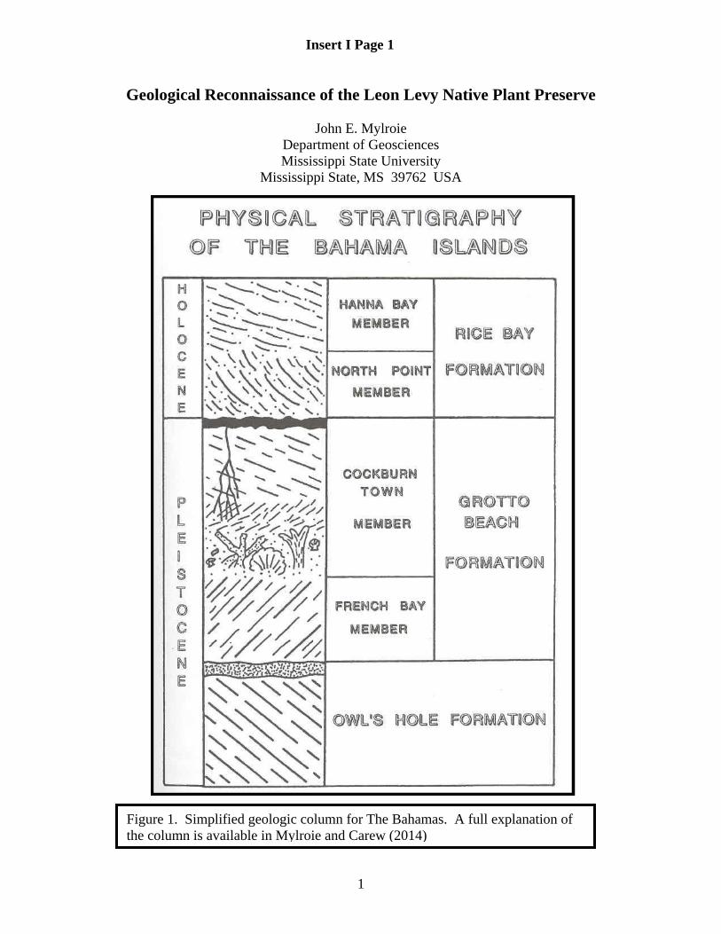
1
Geological Reconnaissance of the Leon Levy Native Plant Preserve
John E. Mylroie Department of Geosciences Mississippi State University
Mississippi State, MS 39762 USA
Figure 1. Simplified geologic column for The Bahamas. A full explanation of the column is available in Mylroie and Carew (2014)
Insert I Page 1

2
Introduction A simple geological reconnaissance was conducted at the Leon Levy Native Plant Preserve, Eleuthera Island, The Bahamas, on May 15-17, 2013. The purpose of the reconnaissance was to provide background information on the geology of the Preserve, and to provide input on how that geology affected the Preserve. In addition, the findings of this report can be used to create a geologic component to the interpretations provided by Preserve staff to the visiting public. This report is not a detailed examination, which would require many more samples to be collected, and also would utilize sophisticated analysis of rock samples involving absolute dating techniques, petrography, and element analysis. The goal of this initial study was to provide a broad geologic framework so that the Preserve could be fit into the currently accepted model of the geology of The Bahamas. The results reported here may also help in managing the resource.
Figure 2. Topographic map of the Leon Levy Native Plant Preserve. A) Setting of the preserve with the Atlantic Ocean to the north. B) Enlargement of the Leon Levy Native Plant Preserve, showing 10 hectares (25 acres) of area. Recent property purchases have gained the ~5 acre area between the preserve and Banks Road (upper right).
Insert I Page 2

3
The Geology of the Leon Levy Native Plant Preserve Figure 1 is a simplified geologic column for use in real time in the field without waiting for sophisticated petrographic analysis or dating by 14C, AAR, U/Th, paleomagnetics, etc. Compare to the more detailed Figure 5 in Kindler et al., 2010, considered state of the art. The Leon Levy Native Plant Preserve originally covered a little over 10 hectares (25 acres) of area just inland from the beach and Banks Road east of Governors Harbour. The Preserve extends inland over a hilly topography (Figure 2). Three basic geologic units were observed on the Preserve. The low ridge crossed by the access road at the main gate is eolianite of the Rice Bay Formation (Figure 1). The eastern bedrock margin at the pond and waterfall at the Welcome Centre is made up of lagoon material, including fossil corals, of the Cockburn Town Member of the Grotto Beach Formation (Figure 1). From this point inland, the entire Preserve is made up of Pleistocene eolianites which cannot easily be differentiated (i.e. cannot be separated into the Grotto Beach and Owl’s Hole Formations). The interior of the reserve is highly disturbed, with several quarries or barrow pits, a cistern, piles of bulldozed rock, old debris (such as vehicle bodies), abandoned fencing, and current development projects which have imported soil from elsewhere on the island. As a result, only in situ (in place) outcrops can be trusted to yield reliable geological information. There is a well developed epikarst on all Pleistocene rocks, both marine and eolianite. No flank margin caves were located by this investigation, and Preserve staff knew of none. Small dissolution pits and holes were found in certain locations; the pits were not humanly enterable. Figure 2 provides a view of the topography of the Preserve and the immediate surrounding area. The low ridge of Holocene Rice Bay Formation rock can be seen running east-west along the access route to the Preserve (top of the images). A low trough exists between the Holocene ridge, and the Pleistocene high ground to the south. This low area is where the pond and waterfall have been installed, and where the Late Pleistocene marine rocks are located. A large hill with elevations up to 40 feet (12 m) trends east to west through the central portion of the reserve. This hill has a quarry on the top, clearly shown on the map of Figure 2. At the south end of the property, a low hill 20 feet (6 m) high joins a larger hill which rises to the highest elevation in the Preserve at ~55 feet (17 m). These hills are all eolianites with well-developed terra rossa paleosols. Rock Sampling The rock samples were collected to provide aerial coverage of the preserve. Figure 3 shows the sample locations. The samples were taken to assess the Holocene ridge at the Preserve entrance, the fossil reef and associated material at the pond and waterfall, and the eolian hills and swales between them on the southern part of the Preserve. Three samples were taken in the quarry (LLP-1 through LLP-3 on Figure 3), along the south wall (Figure 4). The grains making up the rock are sand-sized, well sorted, and appear to be oolitic, that is, made up of ooids. Oolitic dunes are common in the Grotto Beach Formation throughout the Bahamas, so this dune may be from that unit, but numerous exceptions exist. Therefore the most conservative interpretation is to say the
Insert I Page 3

4
rocks are undifferentiated Pleistocene, which means this investigation cannot for certain, with the data at hand, give them a formation name. Two samples were collected on the lower portions of the dune ridge hosting the end of the Epiphyte Trail, between that trail and the beginning of the western portion of Ethan’s Tower Trail (LLP-4 and LLP-5 on Figure 3). In this area a low bench separates the rising hill to the north from the low swale to the south. This bench has many small karst features, including pits up to a meter deep and wide (Figure 5). Samples were collected from two of these pits, both were highly altered and re-cemented, most likely as a result of their position in a lower, wetter location than the quarry at the top of the hill. The grains making up the rock could not be clearly determined, but the rocks did not appear to be oolitic. Commonly in the Bahamas, later dunes form on earlier, older dunes. In some cases, the nature of the grains available to the wind changes with time, so that a single dune can contains a variety of grain types. All that can be said at this location, with the data available, is that the rocks are eolian and Pleistocene in age as a red terra rossa paleosol is present.
Figure 3. Location map of the samples collected for the geological reconnaissance. A) Sample Locations on the public pamphlet map. B) Sample locations on the topographic map.
Insert I Page 4

5
A sample was taken on the west side of Ethan’s Tower Trail near a hill crest (LLP-6 on Figure 3). This rock is well-cemented, and appears to be made of shell particles and fragments (called bioclasts). Terra rossa paleosol is present, indicating a Pleistocene rock age. The sample location, being on a hill crest, is well drained so the high degree of cementation may indicate older rock, in which case it may be Owl’s Hole Formation, but the limited data do not allow a conclusive identification.
Figure 4. Quarry at location LLP-1 through LLP-3. Three samples were collected at this location because the high vertical quarry face allows comparisons between samples.
Insert I Page 5

6
A single sample was taken just a few meters east of Ethan’s Tower near the crest of the highest hill in the Preserve (LLP-7 on Figure 3). The rock was well-cemented, and appeared to have appreciable ooids. The sample was collected from just beneath the surface, with a terra rossa paleosol present, and may have been influenced by wetting and drying that resulted in significant hardening of the rock. The best identification is undifferentiated Pleistocene. Downhill from Ethan’s Tower, a wide (2 m) and shallow (0.5 m) dissolution feature is immediately adjacent to the northeast side of the trail (Figure 6); one sample was collected here (LLP-11, Figure 3). This sample is low in elevation, and is well cemented and appears to be made up of bioclasts and related particles, with few ooids. The sample is similar to LLP-4 and LLP-5. While the sample could be Owl’s Hole Formation, the best answer at this stage is undifferentiated Pleistocene. North of Cactus Trail, where it turns sharply west, and south of the Preserve maintenance area is a recently dug shallow barrow pit (or quarry), where a sample was taken (LLP-8, Figure 3). This sample is well cemented and oolitic, and is most likely from the Grotto Beach Formation. The barrow pit wall has a well-developed epikarst with a terra rossa paleosol (Figure 7) that has filtered downward into the rock. The sample is definitely Pleistocene, and the bedding structures and well-sorted nature of the outcrop indicate an eolian origin. [Note that today, this wall is highly weathered and algae covered] To the west of the access road as it ascends the small hill south of Banks Road, two samples were collected (LLP-9 and LLP-10, Figure 3). The rock is poorly lithified, and lacks a terra rossa paleosol. The grains are shells and other bioclasts, some grains are coated. This rock is almost certainly Holocene in age, and therefore part of the Rice Bay
Figure 5. Two of the small karst features located at sample sites LLP-4 and LLP-5. A) A small cave opening in a low ledge (LLP-5). B) Looking down at a small pit cave, 1 m (3 feet) deep (LLP-4). Hammer is 30 cm long for scale in both images.
Insert I Page63

7
Formation. The rock also contains straight, cylindrical holes that can be confused with dissolution features, but which are actually the casts of palmettos that were entombed by the dune when it was active and growing (Figure 8). The 2010 Eleuthera field guide provides a complete discussion of these features at the Stop 2 site, North Twin Coves. Directly across from the Welcome Centre, a bare rock area with an extremely well-developed epikarst is directly in front of the pond and the artificial waterfall. The rock has a very complex terra rossa paleosol that drapes over and into the epikarst (Figure 9A&B). Here two samples were collected (LLP-12 and LLP-13, Figure 3). Both samples are poorly sorted, with large shells and shell fragments, pieces of coral, and other marine species all mixed together. One large coral head (Diploria sp ?) is present (Figure 9C), as well as perhaps a Strombus gigas shell (Figure 9D). The rocks represent a fossilized lagoonal deposit with perhaps a small patch reef present (it is difficult to determine if the large coral head is in situ). Being a marine deposit positioned above modern sea level, but beneath a terra rossa paleosol, makes these rocks Cockburn Town Member of the Grotto Beach Formation. Summary Leon Levy Native Plant Preserve presents many of the basic geological elements that make up the landscape of The Bahamas. The topography is controlled by eolianites, with
Figure 6. Sample site LLP-11, a shallow sinkhole low on the slope north of Ethan’s Tower. Ruler in white circle 10 cm (4 inches) long for scale, the sinkhole is about 2 m (6 feet) in diameter.
Insert I Page 7

8
Figure 7. Barrow pit or shallow quarry north of the maintenance building, at sample site LLP-8. Ruler in black circle 10 cm (4 inches) long for scale. To the right of the ruler is a small dissolution pit infilled with terra rossa soil and paleosol.
Figure 8. Holocene dune at sample sites LLP-9 and LLP-10. Ruler 10 cm (4 inches) long for scale. A) The eolian layering of the rock is visible at LLP-9. B) Looking down on the outcrop at LLP-9 to show the cylindrical holes formed by burying palmetto trunks during dune formation in addition to later-developing dissolution features of the epikarst.
Insert I Page 8

9
a Holocene dune at the Preserve entrance, and Pleistocene dunes dominating the central and southern portions of the Preserve. Subtidal or lagoonal rocks are present in front of the Welcome Centre, including fossil corals. Karst features are primarily restricted to epikarst surfaces, which in places are complex (as on the fossil lagoon rocks). A few small pits and sinkholes are found at lower elevations in the central area of the Preserve (LLP-4 & 5, LLP-11, Figure 6), but no pit caves, banana holes, or flank margin caves were located. The Pleistocene dunes appear to be both Grotto Beach and Owl’s Hole Formation rocks, but these designations are at best educated guesses. What to Tell the Public In terms of how to present the geology of the Preserve to the public, it is important to tie rock deposition to the sea-level cycles of the last few million years. When glaciations or ice ages are occurring, the growth of ice sheets results in a fall of sea level of over 125 m (400 feet), and all the various banks and platforms in the Bahamas are exposed as steep-sided plateaus. During this time, slow, gradual collection of atmospheric dust, primarily from the Sahara Desert of North Africa, deposits the material that makes up the insoluble portion of the soils. The red color of the soils and fossil soils (or terra rossa paleosols) are the result of iron oxide that came in with that dust. It takes only a little bit of iron oxide to make the soil a deep red. As the dust was gradually accumulating, the rock surface itself was subjected to rainfall, which dissolved the surface into an intricate set of pits, hollows and spikes called epikarst, into and around which the soil could collect. When the glaciations ended, and the ice sheets melted, sea level rose. Once sea level rose far enough so that the tops of the banks and platforms in The Bahamas were flooded, then the productive reef and lagoon ecosystem could initiate and create large amounts of carbonate sediment. In The Bahamas, this sediment was washed up into beaches, where the wind could blow it up into large dunes. These dunes stabilized quickly, as wetting by rainfall and subsequent drying quickly cemented their surfaces. In the past, as during the last interglacial, the ice melted back a bit more than today, and sea level was 6 m (20 feet) higher than today. Coral reefs grew, and lagoons filled with marine sediment. When sea level fell, these corals and sediments were fossilized, and because today’s sea level is lower, can be seen as in front of the Welcome Centre. The ridge at the entrance is the youngest rock in the Preserve, deposited probably in the last 5000 years. It lacks a terra rossal paleosol, and is weakly cemented. The Preserve shows the various cycles of climate and sea level that have helped create the Bahamas as we see them today. The Pleistocene rocks are old, and have collected atmospheric dust for tens of thousands of years, so their soils tend to be better developed than the soils found on Holocene rocks, which have little dust component. As a result, plant growth on the young Holocene rocks would be expected to be less, or at the very least different, than that on the older Pleistocene rocks. Because the site has undergone so many different land use techniques in the last 300 years, and because the surface in many places is so disturbed, it may be difficult to correlate plant type and abundance with the underlying geology. The Leon Levy Native Plant Preserve is a highly altered site, the last alteration being the introduction of many native plant species in a controlled and patterned manner. Therefore any attempt to correlate plant type and rock type is likely not possible.
Insert I Page 9

10
References Kindler, P., Mylroie J. E., Curran , H. A., Carew, J. L., Gamble, D. W., Rothfus, T. A., Savarese, M., and Sealey, N. E., 2010, Geology of Central Eleuthera, Bahamas: A Field Trip Guide. Gerace Research Centre, San Salvador Bahamas, 74 p. Mylroie, J. E., and Carew, J. L., 2014, Field Guide to the Geology and Karst Geomorphology of San Salvador Island, 4th printing. Gerace Research Centre, San Salvador, Bahamas, 89 p.
Figure 9. Epikarst and lagoon sediments at the Welcome Centre pond, sample sites LLP-12 and LLP-13 (ruler 10 cm [4 inches] for scale when present). A) The smooth, rounded holes, pits, and openings common to epikarst developed beneath a soil surface. Block in upper left 15 cm (6 inches) wide for scale. B) Close up of the epikarst surface, showing the terra rossa paleosol crust as a lining on the rock and in the holes. C) Fossil coral, most likely a brain coral (Diploria sp ?). The coral is highly weathered and terra rossa paleosol has infiltrated its structure. D) Possible queen conch (Strombus gigas) shell entombed and infilled with coarse sands.
Insert I Page 10

Geology of the Sweetings Pond Area
Joan Mylroie and John Mylroie Department of Geosciences Mississippi State University
Mississippi State, MS 39762 USA [email protected]
As with most high ground in The Bahamas, the Sweetings Pond area is dominated by eolian ridges of various ages going back at least 500,000 years. Between Sweetings Pond and the bank side of Eleuthera to the southwest is a long, narrow eolian ridge trending northwest-southeast which is 1 mile long (1.6 km) and is only ~500 feet (~200 m) wide and ~75 feet (~22 m) high at its highest point (Figure 1). To the northeast, across the road is a wider, more gently rolling terrain that is also an eolianite trending northwest, with elevations over 100 feet (30 m) and a width of 0.6 miles (1 km). The southeast end of Sweetings Pond is a low wetland followed by a few low ridges that separate the pond from Hatchet Bay. To the northwest, a broad eolian ridge trending northeast, up to 110 feet (33 m) high, bounds that end of Sweetings Pond, and the ridge contains Hatchet Bay Cave, the longest dry flank margin cave in the Bahamas (see Kindler et al., 2010). Figure 1: Map of the Sweetings Pond area, Eleuthera, modified from Figure 1: Map of the Sweetings Pond area, Eleuthera,
modified from the Lands and Surveys 1975 topographic map
Insert II Page 1

Detailed geologic assessment has not been performed in this area, but initial reconnaissance has demonstrated a major fossil coral reef, most likely from MIS 5e 124-115 ka, and other lagoonal deposits such as shell facies dominated by Codakia sp. are found at the north end of Sweetings Pond (Figure 2). If from MIS 5e, these rocks are Cockburn Town Member of the Grotto Beach Formation. Small flank margin caves have been found on both the southwest and northeast sides of Sweetings Pond as a result of this reconnaissance work (Figure 3), and most likely originated during MIS 5e; both the fossils and the caves indicate that the Sweetings Pond basin was occupied by marine water during the MIS sea level highstand. At one fossil coral outcrop, the corals are attached to the sloping bed of an eolianite unit, indicating growth immediately after inundation by sea level rise. The eolianite is therefore either French Bay Member (transgressive-phase eolianite) of the Grotto Beach Formation, or the older Owls Hole Formation. The lack of an erosion surface or terra rossa paleosol between the corals and the underlying eolianite beds would favor a French Bay Member interpretation if initial marine flooding had not removed such paleosol evidence. The site also displays an eolianite partially covering the fossil corals, which would make that unit a regressive-phase eolianite of the Cockburn Town Member as it is in turn covered by a terra rossa paleosol, which eliminates a Holocene interpretation for the covering dune. This sort of sequence of events, an eolianite-coral-eolianite sequence from a single sea-level highstand event, is very rare in the Bahamas and this outcrop is the best example currently known.
Figure 2. Sweetings Pond fossil corals and mollusks. A. Large adjoining Montastrea sp corals. B. Codakia sp in growth position. C. Dipping eolianite bed with fossil corals. D. Montastrea sp in situ on dipping eolianite bed.
Insert II Page 2
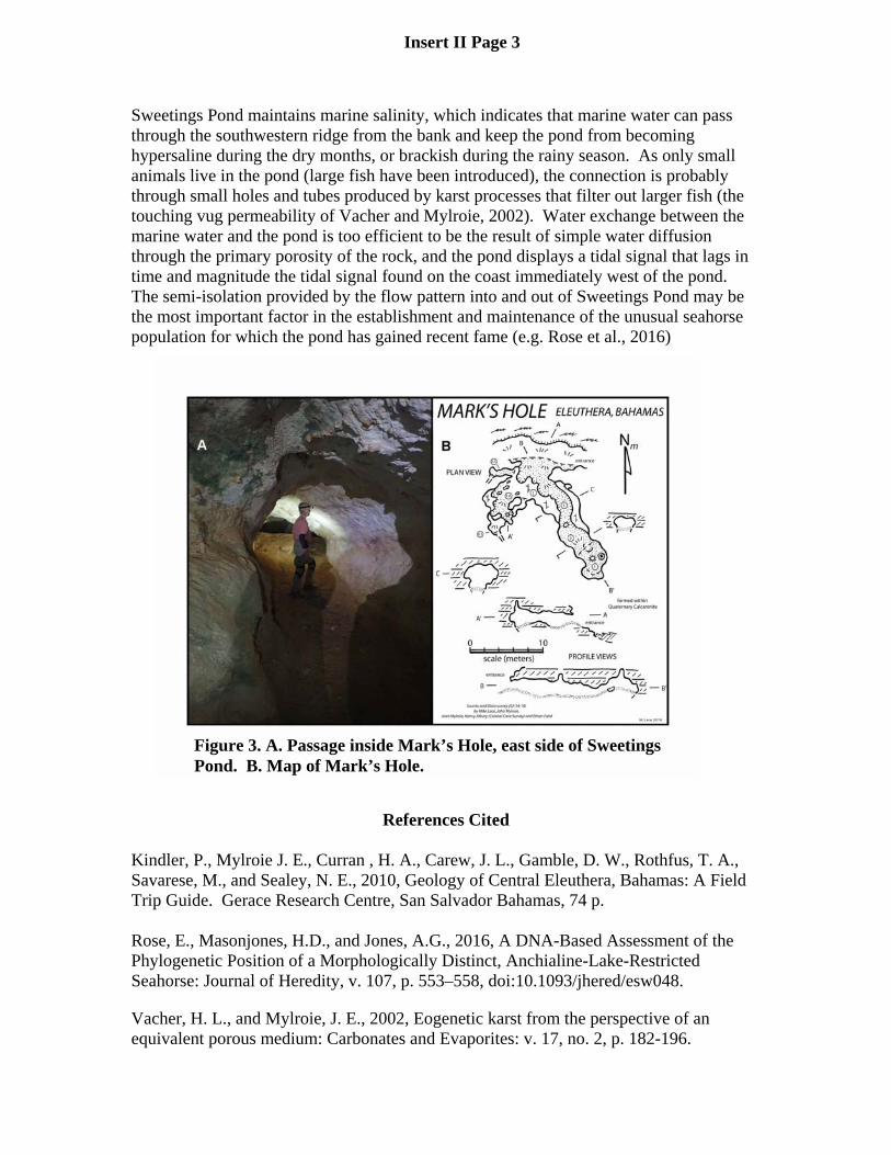
Sweetings Pond maintains marine salinity, which indicates that marine water can pass through the southwestern ridge from the bank and keep the pond from becoming hypersaline during the dry months, or brackish during the rainy season. As only small animals live in the pond (large fish have been introduced), the connection is probably through small holes and tubes produced by karst processes that filter out larger fish (the touching vug permeability of Vacher and Mylroie, 2002). Water exchange between the marine water and the pond is too efficient to be the result of simple water diffusion through the primary porosity of the rock, and the pond displays a tidal signal that lags in time and magnitude the tidal signal found on the coast immediately west of the pond. The semi-isolation provided by the flow pattern into and out of Sweetings Pond may be the most important factor in the establishment and maintenance of the unusual seahorse population for which the pond has gained recent fame (e.g. Rose et al., 2016)
References Cited Kindler, P., Mylroie J. E., Curran , H. A., Carew, J. L., Gamble, D. W., Rothfus, T. A., Savarese, M., and Sealey, N. E., 2010, Geology of Central Eleuthera, Bahamas: A Field Trip Guide. Gerace Research Centre, San Salvador Bahamas, 74 p. Rose, E., Masonjones, H.D., and Jones, A.G., 2016, A DNA-Based Assessment of the Phylogenetic Position of a Morphologically Distinct, Anchialine-Lake-Restricted Seahorse: Journal of Heredity, v. 107, p. 553–558, doi:10.1093/jhered/esw048.
Vacher, H. L., and Mylroie, J. E., 2002, Eogenetic karst from the perspective of an equivalent porous medium: Carbonates and Evaporites: v. 17, no. 2, p. 182-196.
Figure 3. A. Passage inside Mark’s Hole, east side of Sweetings Pond. B. Map of Mark’s Hole.
Insert II Page 3