geological and natural history survey
TRANSCRIPT

� University of Wisconsin-Extension
GEOLOGICAL AND NATURAL HISTORY SURVEY
Geoscience Wisconsin
Volume 4
April 1980

Cover: An oblique photograph of a plastic raised relief map
of Wisconsin by Hans J. Stolle a graduate student in the
Geography Department, University of Wisconsin - Madison.
Volume 4
Geoscience Wisconsin
April 1980
CONODONTS AND STRATIGRAPHIC RELATIONSHIPS
OF THE READSTOWN MEMBER OF THE
ST. PETER SANDSTONE IN WISCONSIN by
William J. Grether and David L. Clark
LATE PLEISTOCENE AND HOLOCENE
VERTEBRATE FOSSIL RECORD OF WISCONSIN by
Robert M. West and John E. Dallman
Available from:
University of Wisconsin-Extension
Ge ological and Natural History Surve y
1815 Unive rsity Ave. Madison, WI 53706
un="

CONTENTS
PREFACE
CONODONTS AND STRATIGRAPHIC RELATIONSHIPS OF THE READSTOWN MEMBER OF THE ST . PETER SANDSTONE IN WISCONSIN by William J. Grether and David L. Clark
Abstrac t . . . . Introduction. •
Stratigraphy and Previous Work. Description. . •
Prairie du Chien - S t . Peter Contact Summary .
Present Study •
Results . . . . Lithologic Conodonts.
Special Notes Regarding Conodont Samples . Summary • • •
Conclusions • • • • • •
Acknowledgements • • • •
Systematic Paleontology References Cited . • • •
Appendix : Sample Localities . Photomicrographs of Described Conodonts - Plate 1
LATE PLEISTOCENE AND HOLOCENE VERTEBRATE FOSSIL RECORD OF WISCONSIN by Robert M. West and John E . Dallman
Abs tract . • • . •
Introduction. • •
Vertebrate Localities Discussion. • • •
Acknowledgements. References Cited.
i
ii
1 1 3 3 3 6 6 6 6 9
11 12 12 12 13 14 18 47
25 25 27 36 44 45

PREFACE
"Geoscience Wisconsin" is a serial that addresses itself to the geology of Wisconsin -- geology in the broadest sense to include rocks and rocks as related to soils , water , climate, environment , and so forth. It is intended to present timely information from knowledgeable sources and make it accessible with minimal time in review and production to the benefit of private citizens , government, scientist s , and industry.
Manuscripts are invited from scientists in academic , government , and industrial field s . Once a manuscript has been reviewed and accepted , the authors will submit a revised copy of the paper. All illustrations will be submitted in final form by the authors . The Geological and Natural History Survey will prepare final camera-ready copy, will publish the paper as funds permit , distribute copies at a nominal cost , and maintain the publication as a part of the Survey list of publications . This will help to insure that results of research are not lost in the archival systems of large libraries , or lost in the musty drawers of an open-file.
The two papers in this issue are oriented towards the fossil record in Wisconsin. William Grether and David Clark add additional confirming evidence that an unconformity exists between the Readstown Member of the St . Peter Sandstone and the basal units of the Prairie du Chien Group . This was achieved by detailed analysis of conodonts recovered from appropriate outcrops . A new species and a new genus are described. Photomicrographs of described conodonts (Plate 1) are found on page 47 . Bob West and John Dallman provide summary informat ion and literature references to existing late Pleistocene and Holocene vertebrate fossils . Although the diversity of species of recovered fossils is high , species diversity of fossils in Iowa is higher , probably due to the somewhat less rigorous late Pleistocene environment in Iowa .
VIe encourage submission of manuscripts relating to Wisconsin geology. Special consideration will be given papers which deal with timely topics , present new ideas , and have regional or statewide implications .
Wisconsin Geological and Natural History Survey
ii
CONODONTS AND STRATIGRAPHIC RELATIONSHIPS OF THE READSTOWN MEMBER OF THE
ST . PETER SANDSTONE IN HISCONSIN
by
William J. Grether1 and David L. Clark2
ABSTRACT
The Readstown Member of the St . Peter Sandstone is a conglomeratic sandy shale that overlies the irregular surface of the Prairie du Chien Group and lines channel-like structures which cut into the Prairie du Chien. These observations , and others , support the interpretation that an unconformity exists between the two units and that the Readstown developed as a partially reworked residuum on the Prairie du Chien surface.
Thirty-nine samples of the Readstown from twenty-five localities yielded conodonts belonging to 27 species and 12 genera . The conodonts of the Reads town correspond to both Fauna C and Fauna D o f Ethington and Clark (1971) but the Faunas were never mixed in the same sample. The Readstown directly overlying the Oneota Formation yielded Fauna C (Oneota) conodonts and the Readstown overlying the Shakopee Formation yielded Fauna D (Shakopee) conodonts. Such distributions best support the interpretation that the Readstown fauna is a reworked Prairie du Chien fauna . Thus , the age of the Reads town and the time span represented by the unconformity at its base cannot be determined from the conodont fauna present within the unit.
INTRODUCTION
The St. Peter Sandstone , named by Owen in 1847 (Wilmarth, 1938 , p. 1884-1885) for exposures along the Minnesota River (formerly St. Peter's River) , i s the lower formation of the Ancell Group (Templeton & Willman, 1963 , p. 29-45; Ostrom , 1970) . In Wisconsin, it consists of a basal conglomeratic shale named the Readstown Hember and an overlying mature quartz sandstone named the Tonti Member (Ostrom, 1967) . The Reads town Member (Fig . 1) proposed by Ostrom (1967) for exposures near Readstown , Wisconsin, unconformably overlies Lower Ordovician dolomite of the Prairie du Chien Group and contains abundant conodonts . The pronounced unconformity between the St. Peter and the Prairie du Chien is considered the boundary between the Early Ordovician (Canadian) and the Middle Ordovician (Champlainian) rocks in Wisconsin and the Upper Mississippi River Valley in general (Sloss , 1963 , p. 95-98, Fig. 1) .
Clark and Miller (1971, p. 14) recovered conodonts from the Readstown at a single Wisconsin locality . They found species that are characteristic of the underlying Prairie du Chien Group and also a few species similar to those present in the middle part of the El Paso Formation of West Texas (Ethington and Clark, 1964) . Some diagnostic species of the Prairie du Chien (for example ,
Ipresent address , Arco, Houston, Texas 7 7001
2University of Wisconsin, Madison 53706
1

NORT H AMERICAN
SERIES
Z <l: U > o Cl a:: o
W .....J Cl Cl
�
FORMATIONS WISCONSIN
GALENA
DECORAH
PLAT T EVILLE
.J .J
GLEN
WOOD
EUREKA
w �"""T"""--1 ? u __ -v Z CRYSTAL PK.
<t II:: WATSON
W RANCH
... ... I-....:r=:.:.:...-U w z a. 0
...: f/)
T EXAS
READSTOWN;! z
a.
::::> WAHWAH
o 1I::�---1 <l:
u > o Cl a:: o
a:: w 3: o .....J
Z <l:
Cl <l: Z <l: U
z w - SHAKOPEE
:I: U
W
II::
?
<t ONEOTA II:: a.
(!)
a.
z o
(!)
o
a.
F ILL
MORE
HOUSE
EL PASO
NOR T H AMERICAN GREAT CONODONT FAUNAS BRITAIN
ETHINGTON & SWEET ET. CLARK,I971 AL.,1971
9
8
SERIES
/I-__ --l CARADOC
E
o
c
B
A
7
6
5 4
:3 2 I
LLANDEILO
LLANVIRN
ARENIG
T REMADOC
Figure 1 . Lower and Middle Ordovician stratigraphy o f Wisconsin, its classification and correlat ion with other important Ordovician stratigraphy and faunal units .
2

Loxodus and Acanthodus) and diagnostic species of the El Paso (for example, Gothodus and Oepikodus) which first occur in Europe in early Arenigian rocks were absent from the Readstown (Figure 1).
This combination of conodonts actually present , plus those anticipated but absent , suggested that a detailed study o f the Readstown could provide firm data on the magnitude and nature of the unconformity between the Prairie du Chien and the S t . Peter . Particularly, an indigenous Readstown conodont fauna could help define the age of the overlying and conformable but largely unfossiliferous S t . Peter .
STRATIGRAPHY AND PREVIOUS WORK
Description
The Readstown Member was called the Kress Member by Buschbach (1964 , p . 51-52) but this name was rejected by Ostrom (1967) because the type section of the Kress was taken from a well instead of an outcrop . The Readstown consists o f a chert (in part oolitic) and dolomite-clast conglomerate in a clay o r sand matrix interbedded with red and green shale and medium- to coarse-grained sandstone (Buschbach , 1964 , p . 52 ; Templeton and Willman, 1963 , p . 45) . The Readstown shows considerable lithologic variation laterally and also changes drastically in thickness . In Wisconsin it ranges from a few cm (or total absence) to several meters (Dake, 1921) and in Illinois attains a maximum o f 4 0 meters (Buschbach, 196 4 , p . 52) . Generally the greater thicknesses of the Readstown occur beneath thick sections of overlying pure quartz sandstone of the Tonti Member and also in possible solution depressions and valley channels in the underlying dolomite (Templeton and Willman, 1963 , p. 45) . In such thick sequences, the Readstown may lie in contact with Cambrian sandstones (Thwaites , 1961, p . 205; Ostrom, 1967) but typically th e Readstown overlies dolomite o f the Prairie du Chien Group . The upper contact is gradational with th.e Tonti.
The contact between the Readstown and the underlying Prairie du Chien dolomites in Wisconsin, Iowa , Minnesota , Missouri and Illinois is sharply undulatory showing pronounced relief locally (for example, 70 m of relief between wells a few hundred meters apart has been noted by Buschbach [1964] in Illinois) . The top of the S t . Peter and the bottom of the Prairie du Chien are parallel and nearly flat lying , however (Trowbridge, 1917 , p . 177) .
Prairie du Chien-St . Peter Contact
Considerable attention has been focused on the contact zone of the Prairie du Chien and the S t . Peter resulting in two interpretations: (1) no depositional unconformity exists between the Prairie du Chien and the Readstown and the apparent unconformity resulted from subsurface solution of the Prairie du Chien or from stromatolite-controlled primary deposition; and , (2) the Readstown represents a reworked residuum overlying an unconformity formed by the extensive erosion of the Prairie du Chien and older unit s . Because o f the important sedimentologic differences implied i n the two theories , a review of the evidence for each o f the two interpretations follows.
1 . No unconformity -- Flint (1956 , p . 396-399) reviewed the literature and cited the early workers , including McGee (1891, p . 330-331) , Percival (1855L Hall and Whitney (1851, p. 51 ; 1862 , p . 23-31) , Calvin (1894 , P. 63) . Leonard (1905 , p . 243 ) , Chamberlin (187 7 , p . 268-290; 188 3 , p . 138-140) , and Sardeson
3
(1916, p . 5-6 ) , who reported no unconfonnable relations or evidence of extensive subaerial erosion of the Prairie du Chien Dolomite. Flint (1956) examined the contact at 24 localities in Wisconsin and Iowa . He concluded that no unconformity is indicated and that the contact zone is gradational into units both above and below (P. 408, 420) . He proposed that the observed irregularity of the contact ( in places a local relief of more than 20 m) resulted from compaction of lime muds over resistant algal (stromatolite) domes of the underlying Prairie du Chien . These structures were referred to as tlcone domes:l by Sardeson (1926, p . 27) and "petrous billows" by Chamberlin (1877, p . 27) . According to these authors, this initial relief was accentuated by subsurface solution under considerable load, causing compaction in Shakopee beds . Such interpretations followed from observations that the algal domes which consist of a central brecciated core are draped or mantled with quaquaversal, thinbedded calcareous strata. Also, the contact zone beds are drag-folded (folds as much as two feet across) , the basal St. Peter Sandstone contains shear zones and small scale faults (a few inches of offset ) , the sandstone beds in the contact zone are "stretched, thinned and pinched off into isolated lenticular b locks", dolomite beds below the contact show "pressure solution fluting on movement surfacesH, and shale and sandstone beds "are gently contorted, faulted, s lickensided and squeezed" (p . 419) . This deformation was explained as internal adjustment of rigid sandstone beds to volume reduction by solution of underlying carbonates .
Flint (1956, p . 420) also concluded that the shales and fine sandstones of the contact zone were derived from solution of the Shakopee and showed no indication of reworking by the S t . Peter sea . Evidence for solution included (1) lateral changes in individual carbonate beds from hard crystalline rocks to punky material concentrated in insoluble clay and quartz sand, (2) progressive vertical changes of Shakopee strata j ust below the contact similar to the above mentioned lateral changes (p . 419 ) , (3) resemblance of the contact zone material to a residuum of clay, silt and sand left from solution of the carbonate fraction of the rock (p. 400), and (4) the advanced leaching of chert to the cotton rock stage and concentration of bedded chert to layers in the contact zone (p . 400) . These conclusions were substantiated by Hart (1963) . In addition, Hart concluded that "the St. Peter deposition b egan at or near the close of Prairie du Chien time over much of the area" ( p . 134) .
2 . Unconformity -- Early workers who reported the presence of an unconformity between the S t . Peter and the Shakopee include Trowbridge (1917, p . 177-182), Dake (1921, p . 206-207), Thwaites (1923, p . 541) , Lamar (1928, p . 25) and Stauffer and Thiel (1941). Flint (1956) noted that such interpretations were based primarily on large-scale features of the two formations such as gross combined thickness of the two units (combined thickness is relatively constant but thickness of the separate units i s highly variable) , magnitude of relief at the contact, and subsurface data from deep wells. He noted that "none of the investigators recorded a specific location of erosionally truncated beds of the Shakopee." Later Ostrom (1967) cited several localities ( including the type locality) in southwestern Wisconsin where the Readstown lined erosion channels in the underlying Prairie du Chien (Ostrom, 1965 , p . 50; 1970, p . 17, 31, 82-83; 1976) . This included a sandstone bed in the Shakopee Dolomite that was deformed dO''llward under a channel like structure cutting out several feet of the Shakopee Formation near Prairie du Chien, Wisconsin. Also, the St. Peter Sandstone and some of the sandstone beds in the Shakopee on the west side of the channel were observed to show small-scale faulting. This same channel structure was observed and described by Hart (1963) but he
4
attributed this to subsurface solution rather than subaerial erosion. Ostrom interpreted these dipping Shakopee beds to result from pre-St. Peter solution of the Shakopee dolomite beds causing collapse of the sandstone layers toward the channel. He suggested that the deformation in the Shakopee and St. Peter sandstones could have been accomplished at a much later geologic date by additional solution caused by water moving along the permeable channel phase of the St. Peter. Thus , Ostrom combined both sub�erial erosion and subsurface solution in his interpretation whereas Hart (1963) and Flint (1956) assumed only subsurface solution.
Thwaites (1961) studied the base of the St. Peter in the same area discussed by Flint. He concluded that the basal beds conformed with and were therefore a part o f the overlying St. Peter Sandstone and were unconformable with the underlying Prairie du Chien. Evidence for his conlusions included the occurrence o f sandstone layers extending down to the contact and the truncation , by the contac t , of older formations down to the Franconia Sandstone (p. 215) .
In direct contrast to Flint's interpretation, Thwaites concluded that the conglomerates and shales of the contact zone were a reworked residuum (p. 215). Several lines of evidence were cited by Thwaites to support this hypothesis (1) residual soils developing on modern exposures of the Prairie du Chien Dolomite closely resemble the clays of the contact zone (the modern residual soils have a decidedly brown color, a feature thought by Thwaites to reflect climate differences) , (2) some areas of concentrated chert rubble are too free of clay to have formed without reworking , (3) chert fragments are not well rounded but show varying degrees of weathering which occurred prior to deposition, and (4) sand layers or interbeds occur within the contact zone.
Templeton and Willman (1963, p. 45) , in support of a reworked residuum hypothesis , cited the presence of "alternating layers of red sandy clay and red argillaceous sandstone at the base of the St. Peter Sandstone" at a number of Illinois and Wisconsin localities. Other localities showed well-bedded red and green shales containing thin (less than a cm) sandstone interbeds.
Buschbach (1964, p. 52) studied subsurface records in seven counties in northeastern Illinois and observed thick sections of the Readstown in many of the wells (p. 68-87) . The general appearance and distribution of the Readstown suggested that it formed as an insoluble residuum on a karst surface and later concentrated in solution valleys by St. Peter seas. Buschbach (1961, p. 83-89; 1964, p. 48) proposed that stream erosion, subsurface solution and solution producing karst topography may all have contributed to relief of the sub-St. Peter surface.
Sloss (1963) discussed interregional unconformities in the continental interior of North America and noted the presence of six major unconformities in the sedimentary record. The sub-Tippecanoe unconformity (corresponding to the St. Peter-Prairie du Chien contact) was considered difficult to recognize in some places because (1) the basal Tippecanoe sequence lacks a distinctive basal lithology, (2) confusion exists between the regressive unit of the Sauk and the transgressive unit of the Tippecanoe and (3) karst topography and slump structures developed at the unconformity. Sloss (p. 98) further stated that "it is impossible to make correct interpretations from the data from limited outcrops of small groups of wells , and it is necessary to consider regional relationships through the detailed correlation and tracing of individual rock units."
5

Summary
The contact of the sub-St . Peter surface is highly irregular but the causes for the irregularity seem to differ in different areas . Interpretations range from Karst solution, stream erosion, stromatolite development and subsurface solution. The extreme relief of the contact and the associated thickness variations of the St . Peter and Prairie du Chien units have been used as criteria indicating the presence of an extensive unconformity . Such relief has been shown by some workers to be formed by stromatolites and subsurface solution and does not necessarily imply the presence of an unconformity (Hart , 1963; Flint , 1956) . The different origins suggested for the irregularity and the nature of the contact zone sediment above the irregular surface have resulted in the emergence of two interpretations regarding the genesis of the Readstown: (1) the Readstown represents a reworked residuum overlying an extensive unconformity which may or may not have been modified by subsurface solution and (2) the Readstown was formed by subsurface solution or primary deposition and no sub-S t . Peter unconformity exists .
PRESENT STUDY
Because of the different interpretations published for the Readsto,vn and its lower contact , a study of the conodont fauna was initiated . A total of 91 samples was collected from 42 localities in Wisconsin (see Figure 2, and Appendix). Because most localities exposed only a few cm of Readstown, commonly only a single sample represents a locality .
Exposure of the contact zone at most localities required the removal of considerable sand which had weathered from the overlying S t . Peter . Once exposed , detailed stratigraphic descriptions of the contact zone sediments were made. Samples ( averaging three kilograms) of the prominent shale layers were collected with care to avoid mixing so vertical faunal changes within the Readstown, if present , could be determined . Because of the tendency for the Readstown to become covered by sand from the overlying Tonti Member, exposure of the Readstown in 24 of the localities was restricted to excavations a meter wide or les s . Such limited exposure prevented observation of local lateral changes in the unit . Even observations of the 11 better exposed localities were limited by colluvial cover . Sand layers in the contact zone sediment were found to lack conodonts or have very poor yields . Green shale layers and lenses within the Prairie du Chien were sampled for comparison.
RESULTS
Lithologic
Our work confirms that physical aspects of lithology and thickness of the Readstown Member are as reported by previous workers . However, observations made during this study lend support to the presence of unconformity at the base of the St . Peter .
Completely exposed or nearly completely exposed stratigraphic sequences extending from the Prairie du Chien surface to the Tonti Sandstone were present at only l70f the localities . At 4 localities (4, 7 , 13, and 16) the Readsto,vn was present only in the colluvium between laterally separated outcrops of the Prairie du Chien and S t . Peter . Six localities (8, 25, 27, 28, 35 and 40) consisted of Prairie du Chien and S t . Peter exposures close enough in proximity
6

III
EXPLANATION SAMPLE OF THE READSTOWN MEMBER WHICH DID YIELD CONODONTS
SAMPLE OF THE READSTOWN MEMBER WHICH DID NOT YIELD CONODONTS SAMPLE OF THE PRAIRIE DU CHIEN GROUP WHICH DID YIELD CONODONTS
SAMPLE OF THE PRAIRIE DU CHIEN GROUP WHICH DID NOT YIELD CONODONTS
VE R N O N 1141
01:20 7 • lOll 18 fA9
128 II CRAWFORD RICHLAND 1142 141113
6 \;1525
033 WINNEBAGO
r---l .38
GREEN LAKE
37
D O D G E
JEFFERSON 8 22 lIal30
40 29 •
3 . � - . 5 �16 • � D A NE
I O W A I •• • 28 32 .17
.35 34
4 LAFAYE T T E
2�=-�---�---r--�
G R E E N R O C K 1121
Figure 2. Location of Readstown exposures studied for this report. Occurrence of conodonts at Readstown localities indicated.
7

to have provided good stratigraphic sections of the Readstown but excessive colluvial cover prevented excavation. Three localities (10 , 17 and 18) showed only the contact of the Readstown with the underlying Prairie du Chien and five localities (22, 29 , 38 , 41 and 42) showed only the contact of green or brown clay of the Readstown with the overlying Tonti Member . A few Prairie du Chien localities were studied for comparative purposes (see Appendix) .
Thickness of the Readstown was observed to range from approximately 2 cm (locality 1) to more than 4 m ( locality 26) . The Readstown generally tends to be thicker in depressions or "channels" in the surface of the Prairie du Chien than on flat or high areas . Lithologic units comprising the Readstown also show considerable variability among the localities . The maj ority of the Readstown localities consist of a sequence of interbedded sandstones and green or red shales bounded by Prairie du Chien Dolomite below and Tonti Sandstone above . The sandstone and shale interbeds contain varying amounts of oolitic chert , sandstone and dolomite fragments .
Sedimentologic observations supporting the presence of an unconformity at the base of the S t . Peter include:
(1) truncation, at seven localities (2 , 5, 11 , 2 0 , 3 2 , 3 6 , and 39t of the Prairie du Chien Dolomite by channel-like structures filled with S t . Peter Sandstone; at two of these localities (20 and 39) the channels occur down to the Sunset Point Member of the Oneota Formation and at three other localities ( 1 , 10 and 18) the Readstown overlies but does not distinctly truncate the Oneota
(2) the occurrence of distinct irregularity of the dolomite surface beneath the Readstown at all localities where the Prairie du Chien was present; the irregularity is both large scale (hundreds of meters) and small scale (about a cm)
(3) the presence of interbeds of often rather pure sand and shale and the pres, lce of variable amounts of oolitic cher t , dolomite and sandstone fragments within the sand and shale interbeds of the contact zone
(4) the orientation of p lanar features such as bedding planes, contacts between interbeds and planar fissility in the shales parallel or subparallel to the dolomite surface
(5) the greater concentration of shale in valleys or channels in the dolomite surface suggesting transport of the shales .
The s even channel-like structures which truncate beds of the Prairie du Chien have certain features in common . Each channel , although filled with sandstone of the Tonti Member , is lined with shale, conglomeratic shale and/or interbedded sand and shal e . The contacts between sandstone and shale interbeds within the Readstown and the orientation of planar fissility of the shales parallel the slope of the truncated dolomite surface.
The Readstown consists of clay, cher t , and sand which are the insoluable constituents present in the Prairie du Chien and which would be expected to be concentrated at a dolomite surface when subj ected to subaerial erosion. Recent residual soils developed on the Prairie du Chien surface consist of
8

similar insoluble constituents . Also, the chert present in the Readstown shows varying degrees of weathering and at some localities the entire Readstown has unsorted and incoherent appearance that characterizes a residual or colluvial depo si t .
In addition, the Readstown shows evidence o f reworking indicated b y the presence of interbedded sand and shale layers, the greater concentration of shale in lows or depressions in the dolomite, and the presence of laminated sandstone, siltstone and shale. Such observations were also made by Thwaites (1961) in Wisconsin, Templeton and Willman (1963) in Illinois and Wisconsin, Buschbach (1964) in Illinois and Ostrom (1967; 1970) in Wisconsin. These features (especially laminations) would be unlikely to develop if subsurface solution is assumed responsible for concentrating the insoluble constituents in the contact zone .
Evidence suggesting subsurface solution was observed at only two localities (26 and 36) during this study, Locality 36 has already been discussed by Ostrom (1970) , who suggested that both subsurface solution and subaerial erosion were involved in development of the features observed. Locality 26 i s a S t . Peter quarry having up to 4 m o f Readstown sand and shale interbeds below the pure quartz sand of the Tonti Member . The shale interbeds , which average 15 em thick, are thinly laminated, well lithified and are irregularly undulatory, having a local relief of a meter in a 3 m lateral interval. Such undulatory shale beds may have resulted from adjustment of the Readstown interbeds to subsurface solution of the underlying dolomite . Lack of exposure of the underlying Shakopee Dolomite prevents a more exact interpretation.
In summary, our field observations confirming an unconformity at the base of the Readstown Member largely agree with those made by Buschbach (1964) in Illinois, Thwaites (1961) in Wisconsin, Templeton and Willman (1963) in Illinois and Hisconsin, and Ostrom (1965; 1967; 1970) in Wisconsin.
Conodonts
Additional evidence for an unconformity is furnished by study of the Readstown conodonts (Tables 1-4). Some 27 species were identified, only 3 of which were definitely identifiable as multielement species (Plate 1) . Seven of the 42 localities are of Prairie du Chien and were collected for comparison . Seventy-two samples were taken from the 35 Readstown localities . Only 10 localities yielded nO conodonts but the maj ority of Readstown conodonts in this study were taken from 28 samples at 15 localities . The maj ority of shales from which these samples were taken are relatively pure. A total of 9060 conodonts was recovered.
Ethington and Clark (1971) examined Early and Middle Ordovician conodonts from the Pogonip Group in the "Ibex Area" of western Utah and designated five faunas ( Fauna A through Fauna E) . This faunal succession has been used as a s tandard for correlation with otber less continuous conodont occurrences .
Fauna C consists primarily of distacodontids but some of the cordylodids of Fauna B occur ,,,i th Fauna C. Two compound elements, Loxodus and Acanthodus, also characterize Fauna C . Drepanodus Pander and Oistodus Pander first appear in Fauna C and continue as important elements throughout the Ordovician . PaZtodus bassZeri Furnish, Acodus oneotensis Furnish and "Oistodus"? tri-
9

angularis Furnish probably constitute a multielement species common in Fauna C . Less common Fauna C conodonts include Clavohamulus densus Furnish, Paltodus spurius Ethington and Clark, Acontiodus propinquus Furnish , Acontiodus stauffer{ Furnish and Chosonodina herfurthi Mliller .
Fauna D consists of a wide variety of distacondontids many of which also occur in Faunas C and/or E . Drepanodus homocurvatus, D. suberectus and Acontiodus staufferi occur in Fauna C through Fauna E . Two undescribed species of Paltodus and several form species of Ulrichodina are restricted to Fauna D as are three elements constituting a multielement species (Distacodus stola LindstrBm, Acodus sp. A , and Acontiodus sp. A) . The remaining elements of Fauna D , including species of Drepanodus, Oistodus, Paltodus and Scandodus, persist into Fauna E where they generally decrease in abundance .
Ethington and Clark (1971, p . 76) cited a number of localities in the thick continental margin sequences from which Fauna D conodonts had been documented . Localities cited included the upper Mons and lower Sarbach Formations of Alberta (Ethington and Clark , 1965), the Tie Gulch Hember of the Manitou Formation in central Colorado, the El Paso Formation in southeastern Arizona , the subsurface of the \.Jilliston Basin (Lochman , 1966), and the Narathon Formation of west Texas. Fauna D conodonts were also described from the midcontinent by Branson and Mehl (1933) and by Furnish (1938), in the Prairie du Chien , immediately beneath the Readstown.
Our collections from the Readstown contain either Fauna C (Table 1) or Fauna D (Table 2) conodonts but never a mixture of the two. The fauna characteristic of the Prairie du Chien unit immediately underlying the Readstown is the same as the fauna that is found in the Readstown . These observations strongly support the interpretation that the Readstot<ll fauna consists entirely of reworked conodonts of the Prairie du Chien Group and raise questions as to whether any of the Readstown fauna is indigenous .
It is recognized that the time difference between the top of the Prairie du Chien and the Readstot<ll could be very minor, but if there were an indigenous Readstown fauna, the species should be common in the Readstown regardless of whether sediment was deposited on Oneota or Shakopee. Such is not the case.
Another observation is the similarity in color and state of preservation between conodonts in the Readstown and those in the Shakopee and/or Oneota . None of the conodonts in this study showed appreciably greater abrasion than any others, although about 10% of all the conodonts were broken beyond recognition. Also, the re.lative numbers of different species in each sample of the Shakopee or Oneota sampled at 7 localities were the same as the relative abundances for the species in each of the Readstown samples where this unit overlay either Shakopee or Oneota.
Only a single sample (lo c . 3) consisted of typical Fauna D conodonts plus non-D fauna species . This sample yielded three denticulate elements, not found in any of the other samples and evidently new. These elements sugRest that the fauna of the sample may represent a slightly younger fauna than the typical Fauna D and could represent the only indigenous Readstown conodont. However, this new species may also be construed as j ust a new addition to the Shakopee fauna .
10

Because the Reads town contains almost exclusively a conodont fauna of the underlying Prairie du Chien unit, the time span represented by the unconformity at i ts base cannot be resolved . The St. Peter is bounded by the Shakopee which contains Fauna D conodonts and the Glenwood which contains Fauna 7 conodonts (Sweet and others, 1971) . Fauna D corresponds to the middle Canadian (early Arenigian) Series and Fauna 7 corresponds to the Blackriverian stage or middle Champlainian (Llandeilian) Series . The Readstown, therefore, is somewhere between middle Canadian and middle Champlainian in age (Figure 1).
SPECIAL NOTES REGARDING CONODONT SAMPLES
Of special interest was a peculiar crystalline coating or crust f0und on conodonts from locality 29 (an Oneota sample) . This proved to be carbonate apatite (SEM analysis) . The cusps of some of the more stout distacodontids were completely encased in a single, large , clear , hexagonal crystal with the C-axis of the crystal coinciding with the axis of the cusp (See Plate 1, No . 37) . To our knowledge crusts of this nature have not been reported by previous workers� On other conodonts the crusts were sugary granular, a condition observed on conodonts from some of the other localities as well . Development of such crusts requires a source of carbonate apatite (possibly other conodonts) and the presence of concentrated solutions allowing transfer and slow recrystallization of the carbonate apatite.
Locality 32 (a Readstown sample) yielded only one conodont identified as the oistodid element of a multielement assemblage named Drepanodus suberectus by Bergstr�m and Sweet (1966) . The assemblage consists of three form species , Drepanodus suberectuB, Drepanodus homocurvatus and Oistodus inclinatus. This assemblage has been found in rocks as low as the base o f the Glenwood Member. The two drepanodid elements have been found in older Ordovician rocks but the oistodid element has not . The single specimen found in this sample was taken from a 15 em brown sand layer overlain by � m of sandstone, 15 em of dark brown silts tone and about 15 em of Platteville Formation. The specimen is considered to be a contaminant slumped from the dark brown siltstone layer assumed to be the Glenwood .
Samples from locality 34 contain conodonts characteristic of Fauna 8 of Sweet and others (1971) . The samples were taken from green shaly sand overlying the Prairie du Chien Dolomite in a ravine. The conodonts are assumed to have washed down the ravine from the overlying Platteville and to have been incorporated into the sediment that waS sampled .
Thirty six Readstown samples (locality 32 and 34 excluded) from 23 localities contain conodonts belonging to Faunas C and D Ethington and Clark (1971) . The two faunas were never found mixed within the same sample� Five of the samples were taken from localities where the Readstown directly overlies the Oneota Dolomite which was cited by Ethington and Clark ( 1971, p. 731 as containing Fauna C conodonts (locality 1, 10, 18, 20 and 39). Each of these five samples contained conodonts characteristic of Fauna C. The remaining 31 Readstown samples from 18 localities all overlie the Shakopee Dolomite which Ethington and Clark (1971 , p . 76) cited as possessing Fauna D conodonts . All of the 3 1 samples contained Fauna D conodonts .
11

Summary
S tudies of thick marginal sedimentary sequences in North America have led to the recognition of a succession of five conodont faunas (labeled Fauna A through E) for the Lower Ordovician . These faunal assemblages have allowed correlation with incomplete sections in the midcontinent (Ethington and Clark, 1971). The youngest conodonts recovered from the Readstown Member of the S t . Peter Sandstone in Wiscons-in correspond to the assemblage recognized as Fauna D (Ethington and Clark, 1971). The Shakopee Formation, which directly underlies the Readstown, also contains Fauna D conodonts suggesting that the Shakopee and Readstown are of comparable Lower Orodovician age . The similarity in age of the two units raises questions regarding (1) the materials and even the presence of the generally accepted large-scale unconformity between the Shakopee and basal st. Peter Sands tone and (2) the placement of the Lower Ordovician - Middle Ordovician boundary at the Shakopee-St . Peter contact . The next conodont bearing unit above the Readstown is the Glenwood Member which contains Middle Orodovician conodonts of Fauna 7 as defined by Sweet and o thers (1971). Thus, several faunal assemblages (Fauna E of Ethington and Clark and Faunas 1 through 6 of Sweet and others) are absent in the Wisconsin Ordovician section.
CONCLlJSIONS
1 . The Readstown , in Wisconsin, unconformably overlies the Prairie du Chien and seems to represent a residuum which developed on a subaerial erosion surface and which shows some evidence of partial subaqueous reworking.
2. Evidence strongly suggests that the conodonts of the Readstown in Wisconsin are reworked from the underlying Prairie du Cbien. Readstown conodonts overlying the Oneota Formation belong to Fauna C and Readstown conodonts overlying the Shakopee Formation belong to Fauna D .
3 . The age of Readstown cannot be determined by examining the conodonts because the conodonts are reworked .
4. The basal S t . Peter in Wisconsin may indeed be early Ordovician but because the conodonts are reworked the time span represented by the unconformity between the Prairie du Chien and st . Peter cannot be determined .
ACKNOWLEDGMENTS
Dr . M . E . Ostrom, Wisconsin State Geologist , helped in many ways . Lloyd Pray criticized an earlier draft of this manuscrip t . Field research during the summer of 1976 was financed by grants from Exxon Oil Company through the Department of Geology & Geophysics, University of Wisconsin-Madison.
12

SYSTEMATIC PALEONTOLOGY
DREPANODUS n. sp.
Figure 3 No. 20-23
Remarks.--Bergstrllm and Sweet (1966, p. 330) studied Middle Orodovician conodonts of Kentucky and recognized a multielement assemblage consisting of Drepa:nodus sUberectus (Branson and Mehl), Drepanodus homocurvatus Li.ndstrlim and Oistodus inclinatus Branson and MenI. Our Lower Ordovician samples nave not yielded Oistodus incZinatus (except one leak) so the multielement assemblage of Bergstrllm and Sweet cannot be applied here. The two drepanodid elements do occur rather abundantly in our samples and show considerable variation in form. Bergstrllm and Sweet (1966, p. 332) interpreted tnese two form-species to be completely intergradational because the wide variation expressed by each prevented division into mutually exclusive subordinate groups. Berstrllm and Sweet also observed that these two species occur together in rocks older than the earliest known occurrence of Oistodus inclinatus. They suggested that the drepanodid elements in tnese older strata may represent homeomorphs of younger elements which occur with Oistodus incZinatus in tne multielement assemblage Drepanodus sUberectus.
The two drepanodid elements usually occur together in the samples and are assumed to represent an early evolutionary stage of the multielement assemblage which eventually developed an oistodid element.
The ratio of homocurvatid to suberectid elements in samples is 562:65 . This is nearly the same as the ratio between the drepanodid elements (6 , 106:592) of BergstrHm and Sweet's three element species.
The form-species D. homocurvatus shows considerable morphological variation and can superficially appear quite similar to some other species such as Drepanodus amoenus, Drepanodus arcuatus and Drepanodus planus. D. homocurvatus can be differentiated from D. amoenus by tne phrygian-cap-like basal cavity of D. amoenus and the straight or only slightly convex basal margin found in D. homocurvatus. D. arcuatus differs from D. homocurvatus in having sub-parallel oral and basal-anterior margins. D. planus has a sharper anterobasal angle, shallower basal cavity and more flattened sides than D. homocurvatus.
Diagnostic features of the form-species D. homocurvatus include: a base extended both anteriorly and posteriorly although in some specimens the anterior extension is most prominent; a cusp which may have one lateral side flattened and depressed at the edges; a blade that is thin, long and curved throughout its length; a base that is flaired laterally more on one side than the other; and a basal cavity tnat is moderately deep, wide and roughly triangular in outline.
Specimens of the form-species Drepa:nodus sUberectus are distinguished by the nearly erect, symmetrical, sharp-edged cusp and the base that is flaired in all directions.
Drepanodus homocurvatus and Drepanodus sUberectus were found by Ethington and Clark to first occur in Fauna C and to continue as important elements throughout the Ordovician.
13
Occurrence,--562 specimens of the homocurvatid element from localities 2, 3, 5, 6, 9, 12, 14, 15, 20, 25, 26, 32, 34, 35, 36, 38 and 40; 65 specimens of the suberectid element from samples 3, 5, 6, 14, 15, 20, 23, 25, 29, 32 and 36,
Repository.--uw 1677/6.
NEW GENUS
Plate 1. �o . 44, 45
Diagnosis.--A compound , asymmetrical, laterally compressed element with one or three denticles and no prominent cusp . Anteroposterior length at base is equal to or slightly greater than the height . Lower outline is triangular due to lateral deflection of the anterior margin. The anterolateral length of the basal outline is the shortest of the three sides . The basal cavity is shallow but conical with an anteriorly directed , sharp point near the anterior margin . In specimens with the single denticle, the denticle appears to have formed by folding a cusp down , posteriorly onto the base forming a sharp angle between the upper margin and the lower edge of the denticle . The denticle consists of white matter and the base is hyaline . The axes of the denticles of all the specimens parallel or subparallel the plane of the base .
Remarks. _-The species occurs in the middle and upper part of Fauna D and in Fauna E in the El Paso , Jefferson City and West Spring Creek Formations in Texas, Missouri and Oklahoma .
Occurrence. --3 specimens from locality 3.
Repository,--UW 1677/21.
REFERENCES CITED
Barnes, C,R . , Jackson, D . E . , and Norford, B . S . , 1976, Correlation between Canadian Ordovician zonations based on graptolites , conodonts and benthic macrofossils from key successions , in Basset , M . G . (ed . ) , The Ordovician system, Proceedings of a Paleontological Association symposium, M . G. Basse t , Ed . : Birmingham, University o f Wales Press and Natural Museum of Wales: p . 209-226.
BergstrBm, S .M. and Sweet , W . C . , 1966, Conodonts from the Lexington Limestone (Middle Ordovician) of Kentucky and its lateral equivalents in Ohio and Indiana . Bulletins of American Paleontology , v . 50, no . 229, p . 441.
Branson , E . B . and Nehl , M . G . , Ordovician) of Missour i .
1933, Conodonts from the Jefferson City (Lower University of Missouri Studies , v, 8, p . 53-64.
Buschbach , T . C" 1961, eastern Illinois . p . 83-89.
The Morphology of the sub-St . Peter surface of NorthIllinois Academy of Science Transactions, v . 54, no. 1,2:
1964, Cambrian and Ordovician strata of Northeastern Illinois: Illinois Geological Survey Report of Investigations No. 218, 90 p .
14

Calvin, Samuel, 1894, Geology of Allamakee County, Iowa: Iowa Geological Survey Annual Report, v. 4, p. 35-120.
Chamberlin, T.C., 1877-1883, Geology of llfisconsin, Wisconsin Geological and Natural History Survey, v. 1, p. 138-140; v. 2, p. 268-290 ..
Clark, D.L. and Miller, J.F. , 1971, Conodonts of the Readstown Member of the St. Peter Sandstone; in Conodonts and Biostratigraphy of the Wisconsin Paleozoic, D.L. Clark Ed. , Wisconsin Geological and Natural History Survey Information Circular 19, p. 14.
Dake, C. L. , 1921, The Problem of the St. Peter Sandstone: University of Missouri School of Mines and Metallurgy, Bulletin, Technical Series v, 6, no. 1, 224 p.
Ethington, R.L. and Clark, D. L., 1964, Conodonts from the El Paso Formation (Ordovician) of Texas and Arizona; Journal of Paleontology, v. 38, no. 4,
p . 685-704.
__ --,, ' 1965, Lower Ordovician conodonts and other microfossils from the Columbia Ice Fields Section, Alberta Canada: Brigham Young University Geology Studies, v. 12, p. 185-210.
---, 1971) Lower Ordovician conodonts in North America: in Symposium on conodont biostratigraphy, \-i.C. Sweet and S .}f. Bergstrllm Eds., Geological Society of America Memoir No. 127, p. 63-82.
Flint, A. E., 1956, Stratigraphic relations of the Shakopee Dolomite and the St. Peter Sandstone in southwestern Wisconsin: Journal of Geology v. 64, no. 4, p. 396-421.
Furnish, W.M. , 1938, Conodonts from the Prairie du Chien (Lower Ordovician) beds of the upper Mississippi Valley: Journal of Paleontology v. 12, no. 4, p. 318-340.
Hall, J.W. , and Whitney, J. D. , 1858, Report on the geological survey of the state of Iowa, embracing the results of investigations made during portions of the years 1855, 1856, and 1857: Iowa Geological Survey, v. 1, pt. 1, 472 p.
and Whitney, J.D. , 1862, Report on the geological survey of the state of Wisconsin: Albany, N.Y. printed by authority of the Legislature of Wisconsin, v. 1, 455 p.
Hart, R. R. , 1963, Biostratigraphic relations of the basal St. Peter Sandstone in northeast Iowa and southwest Wisconsin: Unpub. Ph.D, diss. , University of Iowa, Iowa City, Iowa, 220 p.
Lamar, J.E. , 1928, Geology and economic resources of the St. Peter Sandstone of Illinois: Illinois Geological Survey, Bulletin 53, 175 p.
Leonard, A.G., 1905, Geology of Clayton County: Iowa Geological Survey Annual Report No. 16, p. 213-307.
Lochman, C. R., 1966, Lower Ordovician (Arenigian) Faunas from the Williston Basin, Montana and North Dakota: Journal Paleontology, v. 40, p. 512-548.
15

McGee, W. J. , 1891, The Pleistocene history of northeastern Iowa: U.S, Geological Survey, Annual Report 11, pt. 1, p. 189-577.
Ostrom, H. E. , 1965, Cambro-Ordovician stratigraphy of Southwest Wisconsin: Wisconsin Geological and Natural History Survey Information Circular 6, 57 p.
, 1967, Paleozoic stratigraphic nomenclature for Wisconsin� Wisconsin ---;; Geological and Natural History Survey Information Circular 8.
__ __ ��' ed., 1970. Field trip guidebook for Cambrian-Ordovician Geology of Western Wisconsin: Wisconsin Geological and Natural History Survey Information Circular 11, 131 p.
____ 0:' 1976, Paleozoic rocks, in l1ineral and water resources of Wisconsin, C. E. Dutton, Ed.: Report prepared by the United States Geological Survey in collaboration with the Wisconsin Geological and Natural History Survey at the request of Senator William Proxmire for the U,S, Senate Committee on Interior and Insular Affairs, November 1976, 94th Congress, 2nd Session, 185 p. , U.S. G.P. O., p. 23-38.
Percival, J . G., Wisconsin:
1855, Annual report on the geological survey of the state of Wisconsin Geological Survey, 101 p.
Ross, R. J., Jr., 1976, Ordovician sedimentation in the western United States: in The Ordovician System, Proceedings of a Palaeontological Association Symposium, M.G. Basset, Ed. , Birmingham, University of Wales Press and Natural Huseum of Wales, p. 7 3-106.
Sardeson, F �W., Minnesota: Folio 201,
1916, Description of the Hinneapolis and St. Paul district, U.S. Geological Survey Geological Atlas, Hinneapolis-St. Paul
p. 5-6.
1926, Shakopee Dolomite and its cone-domes: Pan American Geologist, v. 45, pt. 1, p. 29-48.
Sloss, L . L . , 1963, Sequences in the cratonic interior of North America: Geological Society of America Bulletin, v. 74, pt. 2, p. 93-114.
Stauffer, C.R. and Thiel, G. A. , 1941, The Paleozoic and related rocks of southeastern Hinnesota: Hinnesota Geological Survey Bulletin 29, 261 p.
Sweet, W.C . and BergstrBm, S.H., 1976, Conodont biostratigraphy of the Hiddle and Upper Ordovician of the United States Hidcontinent: in The Ordovician System, Proceedings of a Paleontological Association Symposium, M. G. Basset Ed., Birmingham, University Wales Press and Natural Huseum of Wales, p. 121-151.
, Ethington, R .L . , and Barnes, C . R., 1971, North American Hiddle and Upper ---0-Ordovician conodont Faunas: Geological Society of America Hemoir No. 127,
p. 163-193.
Templeton, J. S. and Willman, H.B., 1963, Champlainian (Middle Ordovician) series in Illinois: Illinois Geological Survey Bulletin 89, 260 p.
16
Thwaites, F.T. , 1923, Paleozoic rocks found in deep wells in Wisconsin and northern Illinois: Journal of Geology, v. 31, p. 529-555.
, 1961, The base of the St. Peter Sandstone in southwestern Wisconsin; ��� Wisconsin Academy of Sciences, Arts and Letters, v. 50, p. 203-219.
Trowbridge, A. C., 1917, The Prairie du Chien-St. Peter unconformity in Iowa; Iowa Academy of Sciences Proceedings, v. 24, p. 177-182.
Wilmarth, M.C&, 1938, Lexicon of Geologic Names of the United States: U.S. Geological Survey Bulletin 896, 2396 p.
17

APPENDIX: SAMPLE LOCALITIES
l(BL-DR) . Roadcut 3.2 km south o f Daleyvi11e on Drumon Valley Road, Blanchardville quadrangle, NE �, NW \, Sec. 30, T. 5 N., R. 6 E. (5 cm of Readstown) .
2(BL-F) . Roadcut 0.8 km west of Foreward on Dane County Highway A, Blanchardville quadrangle, SE \, NE \, Sec. 22, T. 5 N., R. 6 E. (Shakopee and � m of Readstown) .
3(BL-RQ). Ryan quarry 2.7 km WW of Hollandale on S tate Highway 191, Blanchardville quadrangle, NE \, Sec. 24, T. 5 N., R. 5 E., Flint (1956, p. 406) described this locality (Shakopee and 5 cm of Readstown) .
4 (BL-SM) • Roadcut 4.8 km south of Blanchardville, just south of Sm" Mill Creek on S tate Highway 78, Blanchardville quadrangle, NE \, SE \, Sec. 2, T. 3 N., R. 5 E. Flint (1956, p. 404) described this locality (several cm of Readstown) .
5(BM-MC) . Roadcut 3.2 km northwest of Mt. Horeb on Dane County Highway JG, Blue Mounds quadrangle, SE \, SW \, Sec. 35, T. 7 N., R. 6 E. (several cm of Readstown) .
6(BM-TK) . Sandpit on the Tom Keep farm 0.8 km south of the j unction of Dane County Highway JG and North S treet, Blue Mounds quadrangle, NW \, SE \, Sec. 34, T. 7 N., R. 6 E. (Shakopee and 45 cm of Readstown).
7(BZ-CH) . Roadcut 1.2 km southwest along Coulter Hollow road from the j unction with Richland county road A, Boaz quadrangle, W �, Sec. 7, T. 11 N., R. 1 W. (several cm of Readstown) .
8(BO-CR) . Roadcut 3.2 km southwest of Castle Rock, Boscobel quadrangle, SW \, NE \, Sec. 1, T. 6 N., R. 2 W. (several cm of Readstown) .
9(BZ-BS) . Roadcut 0.2 km west of Bosstown on U.S. Highway 14, Boaz quadrangle, N �, NE \, Sec. 33, T. 11 N., R. 2 W. (Shakopee) .
10(BZ-BT) . Roadcut 1.2 km west of Bosstown on U.S. Highway 14, Boaz quadrangle, NW \, NW \, Sec. 33, T. 11 K., R. 2 W. (Oneota) .
11(BZ-RG). Roadcut 2.0 km east of Rolling Ground, Boaz quadrangle, center, Sec. 22, T. 10 N., R. 3 W. (4 m of slumped St. Peter and Readstown) .
12(BZ-SH) . Roadcut east of Rolling Ground at the intersection of S tate Highway 171 and sleepy Hollow road, Boaz quadrangle, NW \, SW \, Sec. 22, T. 10 N., R. 3 W. (� m of Readstown) .
13(Cp-Kp) . Roadside 1.2 km northeast of Table Bluff on Dane County Highway KP, Cross Plains quadrangle, SE \, NW \, Sec. 21, T. 8 N., R. 7 E. (several cm of Readstown) .
14(Cp-P) . Roadcut 0.8 km north of U.S. Highway 151-18 on Dane County Highway P, south of K1evenvi1le, Cross Plains quadrangle, NE \, SW \, Sec. 9, T. 7 N., R. 7 E., (� m of Readstown) .
18
15(Cp-PB) . Roadcut 4 km south o f Cross Plains, 1. 6 km northeast of Pine Bluff Observatory, Cross Plains quadrangle, NW �, SW �, Sec. 15, T. 7 N. , R. 7 E. (several cm of Readstown) .
l6(Cp-TL). Irrigation ditch 1. 2 km north of White School along Timber Lane, Cross Plains quadrangle, SE �, SE �, Sec. 6, T. 6 N., R. S E. (several cm of Readstown) .
17(E-E ) . Roadcut O. S km east o f Ellenboro on State Highway Sl, Ellenboro quadrangle, NW �, NW �, Sec. 34, T. 4 N., R. 2 W. (\ m of Readstown) .
18(GM-B) . Roadcut west of Rising Sun on County Road B, dirt road north toward southwest Prairie Church, Gays Mills quadrangle, NE �, SE �, Sec. 20, T. 1 1 N. , R. 5 W. (several cm of Readstown).
19(GM-F) . Roadcut 2.4 km northeast of Fargo on State Highway 27, Gays Mills quadrangle, NW �, NE �, Sec. 2, T. 11 N., R. 5 W. (Shakopee) .
20(GM-RD). Type locality of the S. 6 km northwest of Readstown on NE �, Sec. 27, T. 12 N. , R. 4 W. Readstown) .
Readstown Member (Ostrom, 1967) , roadcut U. S. Highway 14, Gays Mills quadrangle, W \,
(several m o f slumped St. Peter and
2l(J-H). Sandpit O. S km south of Hanover, Janesville quadrangle, S \, Sec. 14, T. 2 N. , R. 11 E. (several cm of Readstown) .
22(Mu-Hi). Roadcut 4. S km west of Highland, Muscoda quadrangle, SE �, Sec. 26, T. 7 N., R. 1 W. (several cm of Readstown).
23(NG-K) . the Kvamme R. 7 E. (
Roadcut O. S km southeast of Mt. Pleasant across the road from Farm, New Glarus quadrangle, SW �, SW �, Sec. 23, T. 5 N. ,
1 m of Readstown) .
24(M-BS ) . Quarry O. S km south of Burke S tation, Madison quadrangle, NE �, SE �, Sec. 26, T. S N., R. 10 E . (Shakopee) .
25(M-Mc) . Housing development excavation at the end of McKenna Boulevard, west and down slope from a Platteville quarry O •. S km north of Dane County Highway PD, Madison quadrangl e , Sec. 1, T. 6 N. , R. S E. ( 1 m of Readstown) .
26(M-ML) . Quarry at the intersection of Milwaukee S treet and 1-90, Madison quadrangle, SW �, Sec. 2, T. 7 N. , R. IDE. (1 to 4 m of Readstown) .
27(M-W) . Ravine 3.2 km north of Maple Grove S chool in Windsor township, Madison quadrangle, Sec. 13, T. 9 N. , R. 10 E. (several cm of Readstown) .
2S(MH-K) . Quarry 0. 4 km west of Grant County Highway K, j ust north of the Grant River, 3.2 km northwest of Lancaster, Mount Hope, and Fennimore quadrangles, NW �, SW �, Sec. 2S, T. 5 N. , R. 3 H . (several cm of Readstown.
29(Mu-c ) . Quarry 2. 0 km southwest of Centerville, Muscoda quadrangle, SE �, SE�, Sec. 11, T. 6 N., R. 1 W. (Shakopee) .
1 9
30(Mu-C) . S tream bank 3 . 2 km northwest of Centerville, Muscoda quadrangle, NW \, SW \, Sec . 2 , T . 6 N . , R . 1 W . ( 1 m of Readstown) .
3l (NG-Mv) . Quarry 0 . 4 km north of Mt . Vernon on S tate Highway 9 2 , New Glarus quadrangle, SE \, NW \, Sec . 34 , T . 6 N . , R . 7 E . (Shakopee) .
32 (NG-MV) . Roadcut on Dane County New Glarus quadrangle, Nl-J \, NW \, cut was described by Ostrom ( 1965)
Highway Sec . 3 ,
(30-60
G, 0 . 3 km west of T . 5 N . , R . 7 E . cm of Readstown) .
Mt . Vernon, This road-
33(OK-AG) . Quarry , junction of Winnebago County Road AG with State High-way 1l0 , Oshkosh NW quadrangle , SW \, Sec . 36 , T . 20 N . , R . 15 E . (Shakopee) .
34 (P-R) . Natural ravine 2y, miles east of Rockville, Potosi quadrangle , SE \, SW \, Sec . 17 , T . 3 N . , R . 2 W . ( � l m of Readstown) .
35 (P-RV) . Roadcut 4 . 0 km east of Rockville on Grant County Road B, Potosi quadrangle, NW \, SW \, Sec . 17 , T. 3 N . , R . 2 W. (5 to 15 cm of Readstown) .
36 (Pc-Pc) . Roadcut 2 . 4 km northeast of Prairie du Chien on S tate Highway 2 7 , Prairie du Chien quadrangle, NE �, Sec . 29 , T . 7 N . , R . 6 W . This locality was described by Ostrom (19 7 0 , p . 82) ( � l m of Readsto.m) .
37 (R-NN) . Roadcut along gravel road 0 . 2 km west of Winnebago County Road NN, lY, miles southwest of the Village of Rush Lake , Ripon quadrangle , SW \, SW \, Sec . 29 , T . 17 N . , R . 14 E . (Shakopee) .
38 (R-S) . Sandpit due south of Starr S chool , 0 . 4 km south of S tate Highway 116 , Ripon quadrangle, NW \, SE \, Sec . 3 , T . 17 N . , R . 14 E . (10 cm of Readstown) .
39 (Sp-No) . road called T . 9 N . , R .
Quarry Norway II E .
4 . 8 km north of Sun Prairie at the end of a dead end Road , Sun Prairie quadrangl e , SE \, SE \, Sec . 1 8 , ( 8 cm o f Readstown) .
40(ST-A) . Roadcut 0 . 8 km southwest of Annaton along Grant County Road E , S titzer quadrangle , N Y" SE \, Sec . 18 , T . 5 N . , R . 1 W . (several cm of Readstown) .
4 l (V-VQ) . Small sandpit 1 . 6 km southeast of Viroqua on Vernon County Road J , Viroqua quadrangle, NE \, NW \, Sec . 8 , T . 12 N . , R . 4 W . (several cm of Readstown) .
42 (WA-0) . Small sandpit 4 . 8 km east of Eastman on State Highway 179 , 0 . 8 km east of Otter Creek , 50 meters north on dirt road j o ining S tate Highway 1 7 9 , SW \, SE \, Sec . 9 , T . 8 N . , R . 5 W . (several cm of Readstown) .
20

Table 1 . The following conodonts are present in the Readstown where the Readstown overlies the Oneota* . This includes the same species as the assemblage of Fauna C of Ethington and Clark (1971) . Localities of occurrence noted in parenthesis .
Cordylodus angulatus Pander (39)
Acodus oneotensis Furnish ( 1 , 10, 18, 20, 39)
oistodid element (18)
paltodid element ( 1 , 10 , 20, 39)
scolopodid element ( 1 , 20, 39)
Loxodus bransoni Furnish (20, 39)
Clavohamulus densus Furnish ( 20)
Acontiodus iowensis Furnish ( 2 0 , 39)
Acontiodus propinquus Furnish (39)
Oneotodus simplex Furnish (39)
*Species are also present in the Oneota at localities 9 , 2 4 , 29 , 31 , and 39
21

Table 2 . The following conodonts are present in the Readstown where the Readstown overlies the Shakopee* . This includes the same species as the assemblage of Fauna D of Ethington and Clark (1971) . Localities of occurrence noted in parenthesis .
Acodus sto1a LindstrBm ( 3 , 23 , 38)
Drepanodus conu1atus LindstrBm ( 3 , 5 , 14 , 2 3 , 25 , 28)
?Drepanodus scu1ponea LindstrBm ( 3 , 25)
Pa1todus sp . ( 3 , 5 , 6 , 14 , 25 , 26 , 3 2 , 35 , 36 , 40)
Ulrichodina def1exus Furnish ( 2 , 6 , 12 , 14 , 15 , 2 5 , 3 2 , 36)
U1richodina prima Furnish ( 2 , 3 , 5 , 6 , 14 , 1 5 , 25 , 3 2 , 35)
U1richodina wisconsinensis Furnish ( 3 , 5 , 14)
*Species present in the Shakopee at localities 2 , 3 , 6 , 14 , 2 5 , 3 2 , 36 and 37
22

Table 3 . The following conodonts range through zones C , D , and E of Ethington and Clark (1971) and occur in the Readstown at the localities indicated .
Acontiodus staufferi Furnish ( 2 , 3 , 5 , 14 , 15 , 1 7 , 20 , 2 5 , 32 , 40)
Drepanodus subarcuatus Furnish ( 2 , 3 , 5 , 12 , 14 , 1 5 , 2 0 , 2 3 , 2 5 , 26 , 32 , 3 5 , 36 , 39 , 40)
Drepanodus n . sp . ( 2 , 3 , 5 , 1 2 , 14 , 1 5 , 20 , 23 , 2 5 , 2 6 , 32 , 3 5 , 3 6 , 3 8 , 40)
(Drepanodus homocurvatus
and Drepanodus suberectus)
New Genus (3)
23

Table 4 . The following conodonts range through zones D and E, according to Ethington and Clark (1971) and occur in the Readstown at the localities indicated, and in the Shakopee.
Drepanodus parallelus Branson and Meh1 (2, 5 , 6 , 1 5, 23 , 25, 3 2 , 3 6)
Oistodus sp , aff. O. forceps LindstrBm (3 , 25)
Oistodus sp . aff. O. inaequalis Pander (2 , 3 , 5 , 6 , 14 , 1 5 , 20, 2 3 , 2 5 , 36 , 38)
Scolopodus sp. aff. S. cornutiformis Branson and Mehl (2 , 3, 5 , 26)
32 ,
Scolopodus quadraplicatus Branson and Mehl (2 , 3 , 4 , 5 , 6 , 12, 14 , 1 5 , 1 7 , 2 3 , 2 5 , 2 6 , 2 7 , 3 2 , 36)
Scolopodus triplicatus Ethington and Clark 0 , 3, 5, 6 , 12, 14 , 15 , 1 7 , 2 3 , 25 , 26 , 3 2 , 36)
Scolopodus triangularis Ethington and Clark (25 , 32 , 3 6 , 40)
Scandodus furnishi Lindstrllm (2 , 3 , 5, 6 , 15, 25)
24

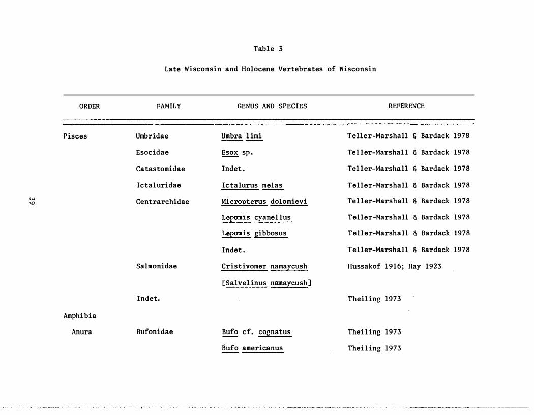
LATE PLEISTOCENE AND HOLOCENE VERTEBRATE FOSSIL RECORD OF WISCONSIN
by
1 2 Robert M . West and John E . Dallman
ABSTRACT
Wisconsin ' s late Pleistocene and Holocene vertebrate fossil record has been investigated sporadically since before the Civil War. Much material collected prior to the 1950 ' s has been lost , and records on what remains generally are poor. More recently collected specimens have better data and permit compilation of faunal lists and formulation of some general paleoecologic conclusions .
Vertebrate fossils have been found in Pleistocene sediment , post-glacial streams , ponds and lakes , and fissures in Paleozoic carbonate rocks . Occurrences in post-glacial stream, pond and lake sediments hold substantial promise for articulated larger mammals within a stratigraphic contex t , while fissures are excellent prospects for the collection of large population samples of smaller vertebrates.
INTRODUCTION
Late Pleistocene and Holocene vertebrate fossils have been known from Wisconsin since before the Civil War and were first published by Hall and Whitney (1862) who reported large mammal remains from Blue Mounds , west of Madison , as well as other areas of southwestern Wisconsin and adjacent parts of Illinois and Iowa. Other specimens were reported through the early part o f the Twentieth Century; these are su��arized by Hay (1923) who listed specimens held by museums , universities and individuals . Most of these materials came from the southern and western parts of the state.
Repositories were not always indicated by Hay, but the Milwaukee Public Museum, the University of Wisconsin and the Smithsonian Institutions are known to have possessed many of the specimens . Over the course of the last century the rate of loss has been high. Many causes were responsible for the disappearances : the 1878 fire at old Science Hall in Madison, inadequate curatorial practices , and individual negligence. The result is that a substantial portion of the records listed by Hay (1923) cannot be confirmed , either for taxonomic identification or for locality information . In addition, the quality of locality data accompanying the remaining specimens in the older collections is generally inadequate by current standards .
I Department of Geology , Milwaukee Public Museum, Milwaukee, WI 53233
2 Department of Zoology , University of Wisconsin-Madison, Madison, WI 53706
25

The specimens reported by Hay (1923) are mainly of large mammals (proboscideans , artiodactyls and carnivores) , though some rodents are recorded from southwestern Wisconsin. A lake trout was collected near Menomonie in Dunn County (Hassako f , 1916) . The collecting techniques of the time did not promot e the discovery of remains of smaller vertebrates.
During the middle part of the Twentieth Century (1920 ' s to 1960 ' s) late Pleistocene and Holocene vertebrates were collected sporadically within Wisconsin , but very little was published . A modest number of specimens were catalogued into the collections of the Milwaukee Public Museum and the University of Wisconsin during this interval. Typical finds were of isolated bones or teeth of large mammals , included in glacial deposits, and usually encountered in the process of large-scale excavation. Most of this material is s till extant , so the identifications can be confirmed , but locality data tends to be poor . We are not aware of any systematic programs anywhere in the state for following up on these discoveries other than a 1954 paper by Palmer describing a Holocene bison occurrence excavated in 1936 at Interstate Park in Polk County.
Over the past decade interest in the faunas of the Wisconsin late Pleistocene and Holocene has increased , and several controlled investigations have b een undertaken. One of us (Dallman, 1968 , 1969 and unpublished) has excavated several proboscideans and a giant beaver near Madison , gathering detailed stratigraphic and paleoecologic data in the process . Palmer (1974 , and unpublished) has been examining caves in southwestern Wisconsin. Several new sites, fissures and cavities in porous Paleozoic limestone of the Driftless Area, have produced substantial numbers of specimens of smaller vertebrates and mollusc s . This work was initiated by D . L . Rasmussen, then of the University of Kansas , and has been continued as graduate research proj ects by S . Theiling and R . Foley of the University of Iowa. The Milwaukee Public Museum opened a third small vertebrate locality near Cave of the Mounds in 197 7 . Teller-Marshall and Bardack (1978) recently reported on a suite of fishes collected in 1966 by J . Emielity of the Milwaukee Public Museum in a s ewer excavation in Milwaukee. J . Stoltman of the Department of Anthropology. University of Wisconsin-Madison, is currently investigating a mastodon site for indications of possible human activity. No clear evidence for men killing or using these animals has been reported yet for Wisconsin.
This recent work is producing specimens with adequate geologic information, associated f loral and faunal data for paleoecologic analysis , and radiometric dates . Thus it is now becoming possible to correlate Wisconsin localities with better known surrounding areas , to analyze the changing glacial and post-glacial environments , and , to a limited extent , be able to predict promising areas for further investigations .
VERTEBRATE LOCALITIES
The geologic setting of Wisconsin, with its substantial cover of glacial deposits, has had an effect on the Pleistocene and Holocene fossil record . Mos t , if not all , of the state has been covered by ice within the past
26

several tens of thousands of year s . The most recent ice retreat was not more than 10, 000 to 13, 000 years ago . The deposits left during this last part of the Wisconsinan age have concealed earlier Pleistocene animal remains in all but the Driftless Area in the southwestern part of the state . Thus post-glacial environments have been generally present for only some 10, 000 to 13 , 000 years .
As can readily be seen on the distribution maps (Fig s . 1 , 2 , and 3 ) , Wisconsin ' s late Pleistocene and Holocene vertebrate localities are concentrated in the southern part of the state. Sixty-six of 78 localities identified at this time are in the three tiers of counties immediately north of the Illinois state line. Several reasons for this pattern may be advanced : (1) The population centers and areas of longest intensive human habitation are in the south. ( 2 ) Milwaukee and Madison, the primary cultural and educational centers (which support active professional scientists) , are in this region. (3) The southeastern part of the state was freed from glaciation sooner than the northern part , permitting earlier and perhaps denser vertebrate populations .
Three primary environments have preserved most of the late Pleistocene and Holocene vertebrates of Wisconsin. The least informative is glacial deposits ; many fragments of animals (Fig . 4) were caught up in the moving glacial materials (both ice and rock) , moved from their original location, abraided , and deposited at the time of glacial retreat . Other fossils are parts of animals that lived on the broad glacial outwash plains and were disarticulated and moved by the strong water action. These specimens have no stratigraphic context , and thus are of relatively little geological utility , although they do provide general distributional records , especially for larger vertebrates . Most of the proboscidean and many of the artiodactyl records are from such glacial deposits.
Post-glacial lake and stream deposits produce specimens preserved approximately where the animals died , and occasionally in articulation. These are the most useful large-vertebrate sites within the state, and include both mammals and fish.
The more important Wisconsin large-mammal sites include three proboscidean localities and one Bison locality . Dallman ' s (1968) excavation of two partially articulated mastodon specimens near Deerfield in Dane County produced significant paleoecological data. The specimens were buried beneath four feet of peat and two feet of clay along the shore of a post-glacial lake that apparently waS open water until at least 9 , 000 years ago . Radiocarbon dates of 9480 ± 100 years of B . P . and 9630 ± 110 years B . P . (Table 1) were derived directly from the mastodon bones . In an adj acent excavation, in the same lake just 100 yards from the first two , a third mastodon (Fig . 5) lay between two dated strata: sticks carried by the modern species beaver (Caston canadensis) and deposited in the old lake bottom were dated at 10, 905 ± 105 years B .P . ; a spruce log encountered four feet deeper in the same pit gave a date of l3 , 120-� 130 years B . P . More than 14 feet of clay underlay the bones . The sediments which held the mastodon remains also contained numerous molluscs and pollen grains, permitting reconstruction of the burial site as lake surrounded by a spruce-dominated boreal forest .
27

• 0
• o
0 tit 0 0
0 .. em r:9 •
M a m m ut 0 � E l e p h as • 0 ••
Figure 1 . Distribution of proboscidean localities.
28

..
0 ...
b.
"
V
• 0
•
..
0
Bison 0 Ovibos
Symbos
Peccary
Castoro ides "
Castor .. � V
0 " Odocoileus
Cervus
R a n g ifer
Figure 2 . Dis tribution o f large mammal localities.
29

• •
.. Fish local ity
• Screen-washing sites
Figure 3 . Distribution o f small mammal and fish localities .
30

Figure 4 . MPM 2 , a mastodon molar from Fond du Lac , typical of finds in glacial drif t .
31

Study of the second and third proboscidean localities, near Lake Mills and Jefferson in Jefferson County, is not complete . Each of these sites yielded an incomplete mammoth skeleton occurring under conditions virtually identical to those of the Deerfield mastodons . The bones are in clay rather than in till (the usual matrix for mammoth remains) , suggesting that these animals likewise were buried on the fringe of a post-glacial lake . Molluscan remains were not recovered from the matrix surrounding the mammoth remains . Radiocarbon dates (Table 1 ) and the similar stratigraphic associations suggest that these mammoths were contemporary with the Deerfield mastodons .
A single complete skull with mandibles of the giant beaver , Castoroides ohioensis (Fig . 6) . was discovered in 1968 during construction of a fish pond near Hope , 10 miles east of Madison (Dallman , 1969 ) . The skull was not discovered until after its removal so that its original location can only be estimated at 4 to 6 feet below the surface in a marly clay deposit somewhat similar to the deposits encountered in the mastodon excavations . No radiocarbon dates were attempted because of the disturbed situation, but the date is presumed to be approximately 10 , 000 years B . P . Two other fragmentary mandibles of Castoroides ohioensis are recorded from Wisconsin, one from the Lincoln-Estabrook area, Milwaukee County and another from Plain, Sauk County.
The Interstate Park (Polk County) Bison locality produced approximately 300 Bison occidentalis specimens from a depth of three to four feet in a post-glacial peat bog (Palmer , 1954) . Unlike the proboscidean localities , paleo-Indian artifacts were found in direct association with the Bison bones , but no radiocarbon dating was done. The occurrence is one of the relatively larger known samples of post-glacial Bison. The site is no longer available due to development of the park.
A recent study (Teller-Marshall and Bardack, 1978) considered 7 7 postglacial fish specimens from a sewer excavation in Milwaukee . An assemblage of eight species was collected 45 to 50 feet below the present ground surface, and 40 to 45 feet above the present level of Lake Michigan. A radiocarbon date on associated wood is 7 750 ± 125 years B .P . , making this the oldest known fish locality in the Lake Michigan Basin. Molluscs and plant remains occur along with the fish, but they have not yet been thoroughly studied . The species present , pJ_us the nature of the sediment , indicates deposition in a slowly moving prairie stream, well above the level of glacial Lake Chippewa . The completeness of the specimens at this site attests to the calm conditions at the time of death and during the subsequent rapid burial. This site is also now unavailable for further excavation.
The third fossiliferous depositional environment seems to be limited to the Driftless Area where porous Paleozoic carbonate rock is exposed at the surface without a veneer of obscuring drift . Fissures , sink holes and caves in this carbonate rock apparently have been open through much of the late Pleistocene and on into the Holocene, so many have been natural traps which have preserved stratified sequences of Pleistocene life.
32
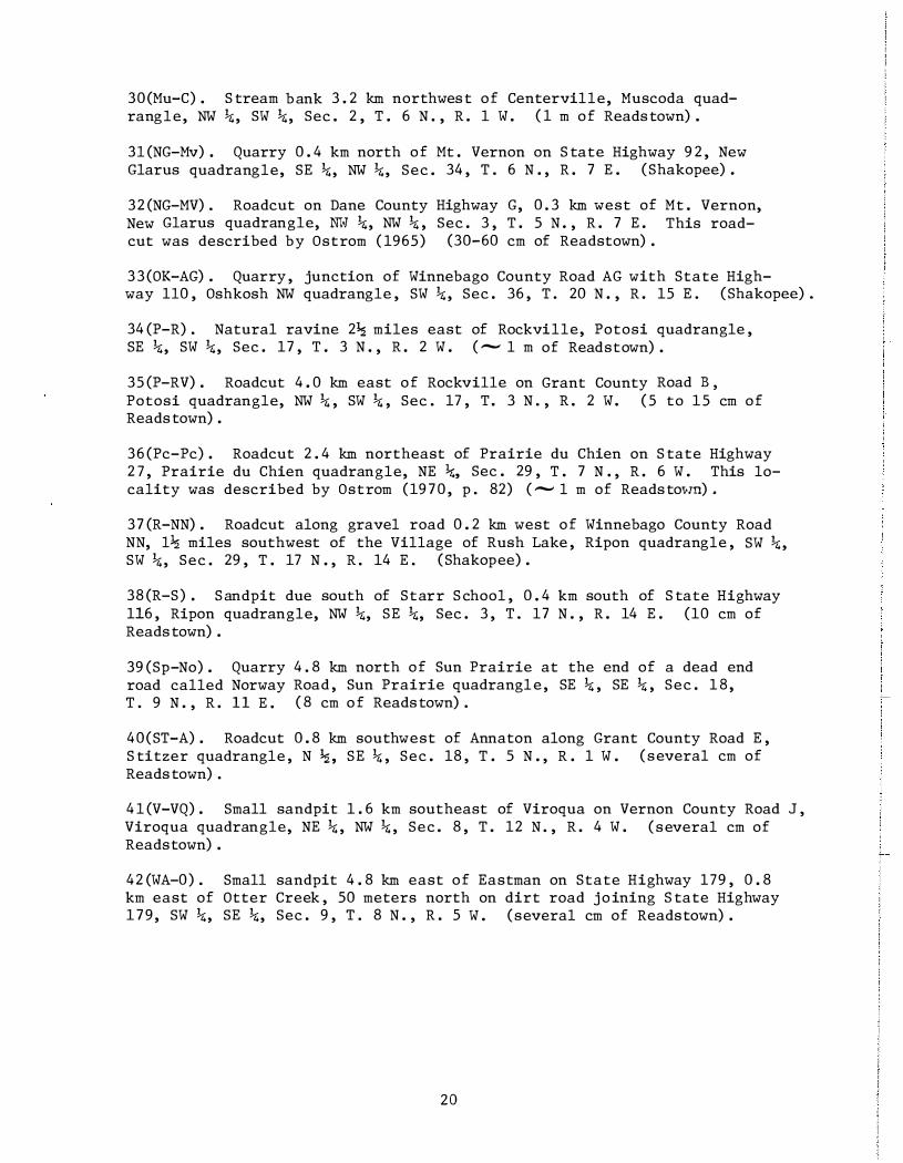
Figure 5 . UWZP 20500 , a mastodon recovered from Deerfield , Wisconsin, representative of specimens found in or adjacent to postglacial lakes. Skull 89 cm in length.
33

Table 1
Ages of Wisconsin Late Pleistocene and Holocene Vertebrate Localities
Site
Lost River S ink
Milwaukee Fish
Deerfield Mastodons
Lake Mills Mammoth
Moscow Fissure
Date, Years B . P .
Level 3
Level 4
2 , 720 ±
3 , 97 0 ±
7 , 750 ±
9 , 480 ± 9 , 63 0 +
10, 095 ±
+ l3 , 120 _
9 , 065 ±
390
240
125
100
llO
105
l30
90
17 , 050 ± 1 , 500
34
Laboratory Reference
Teledyne Isotopes , 1-6622
Teledyne Isotopes , 1-6623
Teledyne Isotopes , 1-9545
Wisconsin - 265
Wisconsin - 267
Wisconsin - 424
Wisconsin - 431
Wisconsin - 704
Teledyne I sotopes , 1-10, 153

Figure 6 . UWZP 20000, skull o f the giant beaver discovered in postglacial sediments near Hope, Wisconsin. Maximum skull length, 28 em.
35

So far , three places have produced vertebrate fossil s : Moscow Fissure, near Blanchardville; Los t River S ink, near Blue Mounds ; and an unnamed fissure near Cave of the Mounds . All of these are in Iowa County, at the eastern edge of the Driftless Area, and all yield abundant small-vertebrate remains (Fi g . 7) when the sand and clay fillings of the cavities are wet-sieved through screen-bottomed washing boxes .
These microvertebrate sites have produced a much greater diversity of vertebrates than have any of the large vertebrate sites . Moscow Fissure has produced 20 mammalian species , two of which are rodents presently restricted to tundra areas , as well as snakes , frogs and salamander s . Lost River Sink has yielded 27 mammalian species, plus toad s , frog s , snakes and lizards . Cave of the Mounds , which has been worked only in a preliminary fashion, has produced four mammal s , a bird and a turtle. These abundant specimens already in hand now permit detailed comparisons of Moscow Fissure and Lost River Sink with similar fissure localities elsewhere in North America . The center for sympatry for Lost River Sink is modern southwestern Wisconsin; the fauna is a modern one, which corresponds well with radiocarbon dates on bone of 2720 ± 390 years B . P . and 3970 ± 1500 years B . P . On the other hand , Moscow Fissure gave a date of 17, 050 ± 1500 years B . P . and has a zone of sympatry in the area of the southern part of the Ontario-Manitoba boundary , excluding the two species of tundra rodents . The presence o f such old fauna and indications of rodent endemism in this assemblage show that the fissures have great potential for pushing the Wisconsin vertebrate record well back into the Wisconsinan and for revealing the nature of community evolution during the Wisconsinan glacial advances and retreats .
DISCUSSION
The diversity of vertebrates already recovered from the Wisconsin late Pleistocene and Holocene is rather high (Tables 2 and 3), especially when compared with geologically similar Michigan, which has been worked much more consistently than has Wisconsin. However , the total number of specimens , particularly of larger vertebrates , is much higher- for Michigan. In both Michigan and Wisconsin much of the diversity comes from the few screen-washing sites , and these, other than Moscow Fissure, tend to be considerably younger geologically than the large-mammal sites. Two Michigan sites (Fenton Lake, 1000-3000 years B . P . ; and Sleeping Bear Dunes, 730 ± 250 years B . P . ) contain 29 of the 53 reported species (Dorr and Eschman , 1969) . In Wisconsin, Moscow Fissure (17 , 500 � 1500 years B . P . ) and Lost River Sink (2720 : 390 and 3970 : 240 years B .P . ) contain 39 of 60 reported Wisconsin species. The Milwaukee fish locality (7750 : 125 years B . P . ) is the only locality in the state to show any taxonomic diversity of aquatic vertebrates, as all eight species from there are fish.
There is a marked contrast between the Wisconsin-Michigan records and those from Iowa (Table 2 ) . Certainly both the intensity o f collecting efforts and the somewhat less rigorous late Pleistocene environment in Iowa account for much of this difference.
36

Figure 7 . Specimens of small mammals , mostly rodents , from Lost River Sink, representative of collections of vertebrates made from s ink holes and fissures in the Driftless Area.
3 7

Table 2
Wisconsinan and Holocene Vertebrate Diversity
Wisconsin Michiganl Iowa 2
Families Species Families Species Families Species
Pisces 6 9 8 11 8 16
Amphibia 2 7 4 12
Reptilia 3 3 3 4 6 9
Aves 3 3 6 8
Mammalia
Insectivora 2 6 1 1 2 8
Edentata 1 1
Rodentia 4 16 3 13 7 37
Carnivora 4 5 4 6 5 14
Pinnepedia 1 1
Cetacea 3 3
Proboscidea 2 2 2 2 1 3
Artiodactyla 3 9 3 9 3 14
Perissodactyla 1 1
Chiroptera 1 2 1 6
Lagomorpha 1 1 1 2
28 60 31 53 4 6 131
�ata from Dorr and Eschman, 1969
2 Data from Leslie P . Fay, personal communication, April 25, 1978
38
ORDER
Pisces
w '"
Amphibia
Anura
Table 3
Late Wisconsin and Holocene Vertebrates of Wisconsin
FAMILY
Umbridae
Esocidae
Catastomidae
Ictaluridae
Centrarchidae
Salmonidae
Indet.
Bufonidae
GENUS AND SPECIES
Umbra l imi
Esox sp .
Indet .
Ictalurus melas
Micropterus dolomievi
Lepomis cyanel lus
Lepomis gibbosus
Indet .
Cristivomer namaycush
[Salvel inus narnaycush]
Bufo cf. cognatus
Bufo americanus
REFERENCE
Teller-Marshall & Bardack 1978
Tel ler-Marshal l & Bardack 1978
Tel ler-Marshall & Bardack 1978
Teller-Marshall & Bardack 1978
Tel ler-Marshall & Bardack 1978
Teller-Marshall & Bardack 1978
Teller-Marshall & Bardack 1978
Teller-Marshall & Bardack 1978
Hussakof 1916; Hay 1923
Theil ing 1973
Thei l ing 1973
Thei l ing 1973

ORDER FAMILY
Ranidae
Caudata Indet.
'" Rept i l ia
0 Lacertilia Anguidae
Squamata Co1ubridae
Crotalidae
Indet.
Aves
Indet.
Mammalia
Insectivora Ta1pidae
Soricidae
GENUS AND SPECIES
Bufo sp .
Rana catesbeiana
Rana pipiens
Rana pa1ustris/sylvatica
Rana sp .
Ophisaurus attenuatus
Indet .
Indet .
Sca10pus aquaticus
B1arina brevicauda
REFERENCE
Thei l ing 1973
Thei l ing 1973
Thei l ing 1973
Theiling 1973
Rasmussen 1971 ; Thei 1 ing 1973
Rasmussen 1971
Thei l ing 1973
Thei l ing 1973
Thei l ing 1973
Rasmussen 1971
Thei l ing 1973
Rasmussen 1971 ; Thei 1 ing 1973
Rasmussen 1971 ; Thei 1 ing 1973
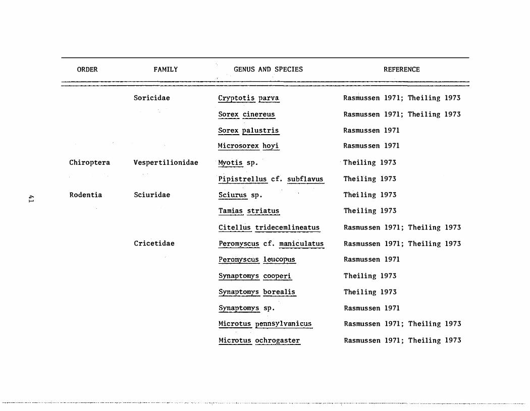
ORDER FAMILY GENUS AND SPECIES REFERENCE
Soricidae Cryptotis parva Rasmussen 197 1 ; Theiling 1973
Sorex cinereus Rasmussen 1971 ; Thei l ing 1973
S� palustris Rasmussen 1971
Microsorex hoyi Rasmus sen 1971
Chiroptera Vespertil ionidae Myotis sp . Theiling 1973
Pipistrel lus cf. subflavus Theiling 1973
'" Rodentia Sciuridae S_cJ_�rll.� sp . Thei ling 1973 i-'
Tamias striatus Theiling 1973
Citel lus trideceml ineatus Rasmus sen 1971 ; Theil ing 1973
Cricetidae Peromyscus cf. maniculatus Rasmussen 1971 ; Theiling 1973
Peromyscus l eucopus Rasmussen 1971
Synaptomys cooperi Theiling 1973
Synaptomys borealis Thei l ing 1973
Synaptomys sp . Rasmussen 1971
Microtus pennsylvanicus Rasmussen 1971 ; Theiling 1973
Microtus ochrogaster Rasmussen 1971 ; Theiling 1973

ORDER FAMILY GENUS AND SPECIES REFERENCE
P itymys pinetorum Theiling 1973
C1eithronomys �eri Rasmussen 1971
Phenacomys cf. ungava Rasmussen 1971
Geomyidae Thomomys ta1poides Rasmussen 1971
Castoridae Castor canadensis Hay 1923
Castoro ides ohioensis Dal lman 1969
Lagomorpha Leporidae Indet • The i l ing 1973 .0-N
Sy1vi1agus cf. f10ridanus Rasmus sen 1971
Proboscidea Mammutidae Mummut americanum Hay 1914 , 1923 ; Dal lman 1968
E1ephantidae E l ephas primigenius Hay 1914, 1923
Artiodactyla Tayussuidae Tayussu Hay 1914 , 1923
P1atygonus Palmer 1974
Cervidae Odocoi leus Hay 191 4 , 1923
Cervus canadensis Hay 1914 , 1923
Rangifer tarandus Hay 1923; West 1978
Bovidae Bison occidental is Palmer 1954
Bison bison Hay 1923
Ovibos Unpublished

.". W
ORDER
Carnivora
FAMILY
Ursidae
Procyonidae
Mustel idae
Canidae
GENUS AND SPECIES REFERENCE
Symbos Unpublished
Ursus americanus Theiling 1973
Procyon lotor Thei l ing 1973
Mephitis mephitis Thei l ing 1973
Vu1� fu1va Thei l ing 1973
Canis Al len 1876; Hay 1914

In summary, the late Pleistocene and Holocene vertebrate record of Wisconsin is at this point relatively poorly known . This is due in part to historical accident and in part to the geologic configuration of the state. Those sites and occurrences which have been studied, and those which are under active investigation at present , d o , however , give hope for the future. In particular , careful examination of post-glacial lake deposits in southern Wisconsin and late Pleistocene to Holocene caves . and fissures in the Driftless Area should be productive. A j oint effort of the University of WisconsinMadison and the Milwaukee Public Museum is intended to substantially increase our knowledge of the recent part of this state.
ACKNOWLEDGMENTS
We are most grateful for information on unpublished specimens furnished by H . A. Palmer , University of Wisconsin-Platteville, and P . Sander , Kenosha Public Museum. H . Semken and L. P . Fay, University of Iowa, provided lists of Iowa Pleistocene vertebrates and the radiocarbon date for Lost River Sink. The senior author ' s work on Wisconsin vertebrates is supported by the Friends of the Museum, Inc . , Milwaukee.
REFERENCES CITED
Allen, J . A . , 187 6 , Description of some remains of an extinct species of wolf and an extinct species of deer from the Lead Region of the Upper Mississippi: American Journal of Science, ser . 3 , v . 11, p . 47-51 .
Dallman, J . E . , 1968 , Mastodons in Dane County: Wisconsin Academy Review, v. 15, no . 2 , p . 9-13 .
, 1969 , Giant beaver from a post-Woodfordian lake near Madison, Wisconsin: Journal of Mammology, v. 50, no . 4, p . 826-830 .
Dorr , J . A. and D . F . Eschman, 1971. Geology o f Michigan : The University of Michigan Press , Ann Arbor.
Hal l , James and J . D . �Thitney , 1862 , Report on the Geological Survey of the State of Wisconsin, v. 1 , 455 p .
Hay, D . P . , 1914, The Pleistocene mammals o f Iowa: Iowa Geological Survey, Annual Report , 1912 , v . 23 , p . 1-499 .
________ ��-' 1923 , The Pleistocene of North America and its vertebrated animals from the states east of the Mississippi River and from the Canadian provinces east of longitude 95° : Carnegie Institute of Washington Publication 322 , p . 1-499.
Hussako f , Louis , 1816 , Discovery o f the great lake trout, Cristivomer namaycush, in the Pleistocene of Wisconsin: Journal of Geology, v. 24, p . 685-689 .
44

Palmer , H .A. , 1954 , A review of the Interstate Park, Wisconsin bison find: Proceedings of the Iowa Academy of Science, v. 61, p. 313-319.
, 1974, Implications of an extinct peccary-early archaic artifact -------a-s-s-o-c-
l�· a-
tion from a Wisconsin cave : Wisconsin Archeologist � v. 55, no. 3 , p . 218-230.
Rasmussen, D . L . , 1971 , Microvertebrates from a f issure deposit in the "Driftless Area" of southwestern Wisconsin (abstract) : Geological Society of America, Abstracts with Programs , v. 3 , no . 4 , p . 275-276.
Teller-Marshall , Susan , and David Bardack, 1978 , Postglacial fishes from a Lake Michigan drainage in Milwaukee, 1'lisconsin: Milwaukee Public Museum, Contributions to Biology and Geology, 15, p. 1-19.
Thieling , S . C . , 1973 , The Pleistocene fauna o f Lost River Sink, Iowa County, Wisconsin: Unpub . M. S . Thesis, University of Iowa , Iowa City, Iowa.
West , R.M. , 1978, Late Pleistocene (Wisconsinan) caribou from southeastern Wisconsin: Transactions of the Wisconsin Academy , v . 68 , p . 50-53.
45

Plate 1. Explanation. All figures are SEM micrographs.
1,2 - Clavohamulus densus Furnish. 1, posterior view of element coated with calcium phosphate crystals (x70) , UW 1677/40; 2, posterior view (x70), UW 1677/39, both from locality 29.
3,12,13 - Ulrichodina wisconsinensis Furnish. 3, lateral view (x75), UW 1677/18; 12, posterior view showing flat, rather than depressed, anterobasal extension (x40) , UW 1677/17; 13, lateral view showing an atypical projection from the keel like posterior edge (x75), UW 1677/19, all from locality 3.
4,5 - Ulrichodina prima Furnish. 4, posterior view (x40), UW 1677/29; 5, lateral view (x50), UW 1677/8, both from locality 25.
6 - Ulrichodina deflexus Furnish. Posterior view showing longitudinal posterior groove (x50), UW 167717, locality 25.
7-10 - Paltodus sp. Lateral views of four different elements showing a sequence of increasing costae development (all x40), UW 1677/11, 12, 24, 25 respectively, all from locality 3.
11 - Cordylodus angulatus Pander. Lateral view (x55), UW 1677/4, locality 39.
14,15 - Oistodus sp. aff. O. inaequalis Pander. 14, lateral view (x50), UW 1677/9, locality 3; 15, lateral view (x70), UW 1677/45, locality 14.
16 - Oistodus sp. cf. O. forceps Lindstrom. Lateral view (x85), UW 1677/10, locality 3.
17,25-27 - Acodus oneotensis (Furnish) . 17, Iateral view of "Oistodus" triangularis element (x60), UW 1677/64; 25, lateral view of Acodus oneotensis element (x70), UW 1677/62; 26, lateral view of Paltodus bassleri element (x50), UW 1677/60; 27, lateral view of Paltodus variabilis element (x50), UW 1677/61, all from locality 39.
18,19 - Scolopodus quadraplicatus Branson & Meh!. 18, posterior view (x25), UW 1677/16; 19, lateral view (x25), UW 1677/15, both from locality 3.
20-23 - Drepanodus n. sp. 20, lateral view of homocurvatid element (x50), UW 1677/28, locality 3; 21, lateral view of suberectid element (x70), UW 1677/46, locality 14; 22, lateral view of suberectid element (x50), UW 1677/6, locality 14; 23, lateral view of homocurvatid element (x65), UW 1677/26, locality 3.
46
24,31-33 - Acodus stoia (Lindstrom) . 24, lateral view of distacodid element (x60), UW 1677/55, locality 23; 31, lateral view of acodid element (x50), UW 1677/27, locality 3; 32, posterior view of acontiodid element (x70), UW 1677/34, locality 3; 33, lateral view of acontiodid element (x70), UW 1677/33, locality 3 .
28 - Scolopodus sp. aff_ S. comuti/ormis Branson & Meh!_ lateral view (x45), UW 1677/63, locality 5.
29 - Drepanodus parallelus Branson & Meh!. Lateral view (x35), UW 1677/37, locality 25.
30 - Oneotodus simplex Furnish. Lateral view (x70), UW 1677/52, locality 6.
34,35 - Scolopodus triplicatus Ethington & Clark. 34, lateral view (x50), UW 1677/32; 35, lateral view (x50), UW 1677/31, both from locality 3.
36 - Scandodus furnishi Lindstrom. Lateral view (x 45), UW 1677/23, locality 25.
37 - Unidentified distacodontid showing single apatite crystal coating the cusp (x90) , UW 1677/42, locality 29.
38 - ? Drepanodu8 scuiponea Lindstrom. Lateral view (x60), UW 1677/65, locality 3.
39 - Loxodus bransoni Furnish. Lateral view (x50), UW 1677/2, locality 39.
40,42 - Drepanodus subarcuatus Furnish . 40, lateral view (x50), UW 1677/58, locality 2; 42, lateral view (x30), UW 1677/38, locality 25.
41 - Scolopodus triangularis Ethington & Clark. Lateral view (x60), UW 1677/56, locality 36.
43 - Drepanodus conulatus Lindstrom. Lateral view (x75), UW 1677/3, locality 3.
44,45 - New genus, new species. 44, lateral view of specimen with single denticle (x85), UW 1677/21 ; 45, lateral view of specimen with three dentieles (xllO), UW 1677/22, both from locality 3.
46 - A contiodus iowensis Furnish. Posterior view (x 60), UW 1677/59, locality 20.
47,48 - Acontiodus bicurvatus ( Stauffer) . 47, posterior view (x45) , UW 1677/14; 48, lateral view (x45), UW 1677/13, both from locality 3.
49 - Acontiodus staufferi Furnish. Posterior view (x 65), UW 1677/47, locality 2.
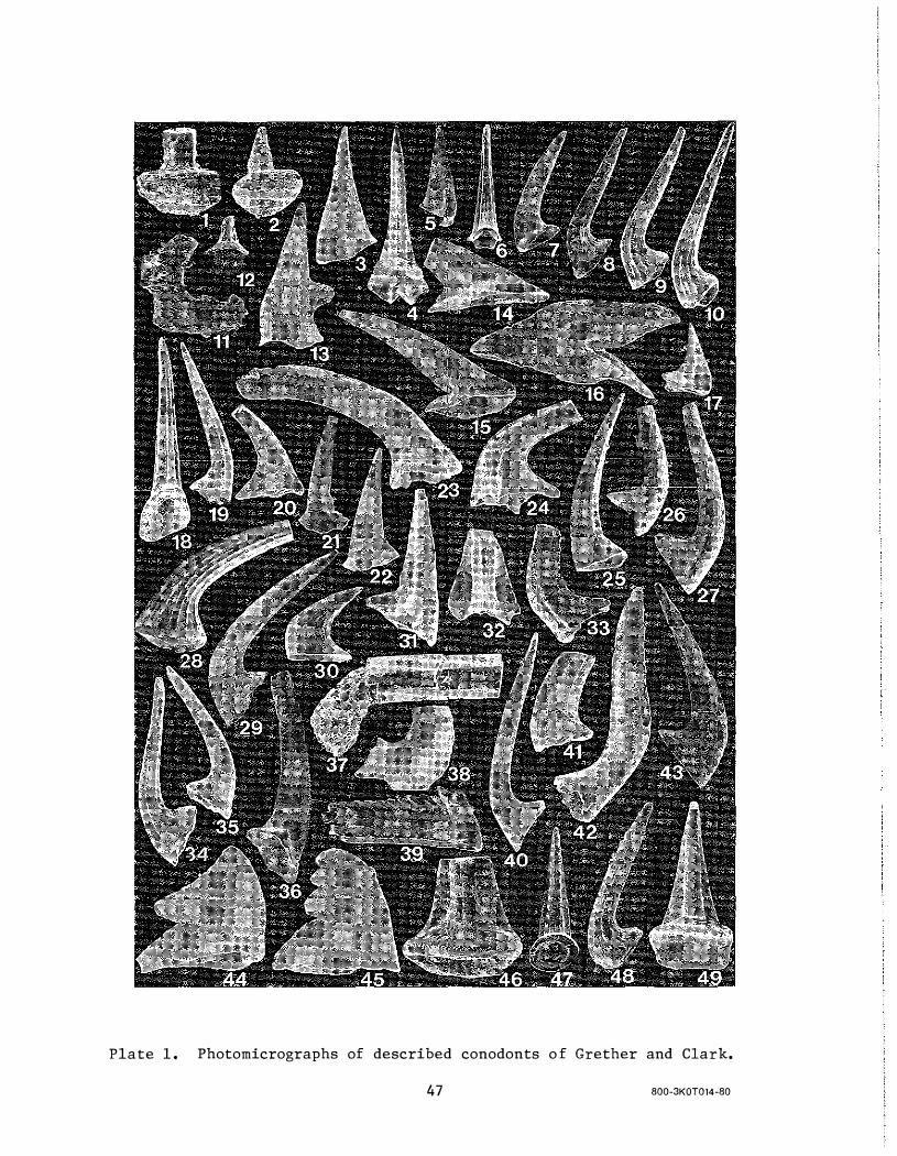
Plate 1 . Photomicrographs of described conodonts o f Grether and Clark.
47 800-3KOT014-80


Geoscie n ce Wiscons i n Ed itor ia l and Pub l icat ion Po l icy General Information
"Geoscience Wisconsin", a report series covering sign ificant geoscience research pertaining to Wisconsin geology, is publ ished by the Wisconsin Geological and Natural H istory Su rvey, U n iversity of Wisconsin-Extension. The pu rpose of the series is to provide increased awareness of the geoscience research done in Wisconsin and to provide a vehicle for the commun ication of scholarly geologic research pertinent to Wisconsin. Although compilations and review papers wil l be considered for pu b l ication, the main object of the series is to publ ish high-qual ity, original research papers of general interest on all phases of the geology of Wisconsin.
Scope and Length of Papers
All phases of geoscience research done i n Wisconsin or very closely related to Wisconsin interests w i l l be considered for publ icati on. A l l mem bers of the professional geoscience commu nity are encouraged to submit their scholarly papers for publ ication in "Geoscience Wisconsin". Students are also encou raged to submit papers on their completed thesis research.
Papers should be no longer than 25 pages in length including al l figures, references, abstracts, and so forth. Manuscripts exceed ing 25 pages should have the approval of the editors before submission to "Geoscience Wisconsin". Draft copies for review wil l be double spaced with ample margins; this includes references cited. For final publication, camera-ready copy of all papers wi l l be prepared by the Wisconsin Geological and Natural History Survey. There are no page charges.
Admin istrative Framework
Editors Co-editors of the publ ication series are David M.
Mickelson and Michael G. Mudrey, Jr. The coeditors wil l be responsible for receiving manuscripts which are subm itted. The co-editors w i l l examine the manuscript for general style, length requ i rements and suitabil ity for publ ication i n "Geoscience Wisconsin", The manuscript wi l l then either be rejected, returned to the author for modification, or sent to one of the associate editors for review.
After the manuscript has been reviewed by the associate editor and reviewers (special ists in the field add ressed by the paper), a decision on a�ceptance or rejection wi l l be made by the associate editor and the editors. The manuscript, if accepted, wil l be returned to the author for modification, based on the recommendations of the associate editor, and for preparation of th e final copy. The final manuscript will then be submitted to the co-editors who wi l l see the manuscript through its publ ication stages.
Associate Editors Associate editors have been selected from a pool
of geoscientists interested in Wisconsin geology. They are:
1 . Douglas S. Cherkauer U n iversity of Wisconsin-Milwaukee
2. C. Patrick Ervin Northern I l l i nois University
3. Gene L. LaBerge Un iversity of Wisconsin-Oshkosh
4. Robert M. West M i lwaukee Public Museum
The associate editors receive manuscripts from the co-editors. The manuscripts are reviewed by the associate editor and also sent out to reviewers in the field of interest. The editor wi l l then collate the reviews and with the coeditors make a decision about publication. If the manuscript is rejected, it w i l l be returned to the author with a detailed explanation of why the paper was rejected. If the paper is accepted, the technical editor wi l l collate recommended changes and return the manuscript to the author.
The associate editors serve for two years. This length of term al lows new and d ifferent technical phi l osophies and expertise to be introduced into the review process.
Geoscience Wisconsin Geological & Natural H istory Survey University of Wisconsin-Extension 1 8 1 5 U n iversity Avenue Madison, Wisconsin 53706 Phone: (608) 262-1 705

< o r C $: m -i»
Gl m o C/) n m Z n m � C/) n o z C/) z
� <.0 00 o