geologic setting and hydrocarbon potential of north sinai
TRANSCRIPT

BULLETIN OF CANADIAN PETROLEUM GEOLOGYVOL 44, NO.4 (DECEMBER 1996), P 615-631
Geologic setting and hydrocarbon potential of north Sinai, Egypt
A.S. ALSHARHANFaculty of Science
UAE UniversityP.O. Box 17551
Al-Ain, United Arab Emirates
M.G. SALAHDesert and Marine Environment Research Center
p.o. Box 17777Al-Ain, United Arab Emirates
ABSTRACT
The Sinai Peninsula is bounded by the Suez Canal and Gulf of Suez rift to the west, the transfonn Dead Sea-Aqabarift to the east and the Mediterranean passive margin to the north. The stratigraphic section in North Sinai ranges in agefrom Precambrian to Recent and varies in thickness between 2000 m of mostly continental facies in the south to almost8000 m of marine facies in the north. Four main tectonic trends reflect the influence of regional tectonic movements onthe study area: 1) ENE-WSW-trending nonnal faults at the Triassic, Jurassic and Early Cretaceous levels; 2) NE-SW-trending anticlines at the Late Cretaceous and Early Tertiary levels; 3) NNW-SSE-trending nonnal faults at theOligocene and Early Miocene levels; and 4) NNW-SSE-trending transfonn faults during the Late Miocene. Several oiland gas fields have been discovered in North Sinai since 1955. The Oligo-Miocene shales, the Early Cretaceous car-bonates and the Jurassic fine clastics are rich source rocks yielding oil and gas in deep source kitchens. The sandstonesof the Miocene, Oligocene, Cretaceous and Jurassic ages, the Jurassic carbonates and the Cretaceous carbonates fonnthe reservoirs in north Sinai. The intrafonnational Mesozoic and Cenozoic shales and dense carbonates and the middleMiocene anhydrite fonn the seals. Structural, stratigraphic and combination traps are encountered in the study area.The north Sinai district has a good oil exploration potential. Only a few plays have been tested.
4
REsuME
La peninsule du Sinal est limitee par Ie canal de Suez et Ie fosse ouest du golfe de Suez, Ie fosse transfonnant de lamer Morte-Aqaba a l'est et la marge passive de la Mediterranee au nord. La section stratigraphique dans Ie Sinal dunord
s'echelonne de Precambrien a Holocene et varie en epaisseur de 2000 m de facies surtout continentaux dans Ieslid a pres de 8000 m de facies marins au nord. Quatre tendances tectoniques principales refletent l'influence des mou-vements
tectoniques regionaux dans la region etudiee : 1. les directions ENE-OSO des failles nonnales aux niveaux duTriassique, Jurassique et du Cretace precoce; 2. les directions NE-SO anticlinales aux niveaux du Cretace tardif et duTertiaire precoce; 3. la direction NNO-SSE des failles nonnales aux niveaux de l'Oligocene et du Miocene precoce; et4.
la direction NNO-SSE des failles transfonnantes pendant Ie Miocene tardif. Plusieurs champs petrolireres et de gaznaturel ont ete decouverts dans Ie Sinal du nord depuis 1955. Les schistes du Oligo-Miocene, les carbonates du Cretaceprecoce et les clastiques a grains fins du Jurassique sont de riches roches-mere produisant du petrole et du gaz dans Iecuisines-mere profondes. Les gres d'age Miocene, Oligocene, Cretace et Jurassique, les carbonates du Jurassique et lescarbonates du Cretace fonnent les reservoirs dans Ie Sinal du nord. Les schistes intrafonnationels du MesozoIque et duCenozoIque et les carbonates denses et Ie Miocene moyen deshydrates fonnent les obturations. Les pieges structuraux,stratigraphiques et line combinaison des deux se trouvent dans la region etudiee. Le district du Sinal du nord possedede bonne possibilite pour I' exploitation de petrole. Seuls quelques jeux ont ete testes.
Traduit par Marie-Louise Tomas
1962) (Fig. 1). The central and northern sectors of the SinaiPeninsula are covered with a northward-draining limestone
plateau with a series of northeast-trending anticlinal and syn-clinal jebels (mountains). These folds, extending from theWestern Desert in the west to Jordan and Syria in the east, fol-low the Syrian Arc System. Generally, the elevation of thesejebels
decreases northwards to 1090, 890 and 735 m in Jebels
lNTRODUcnON
The Sinai Peninsula, the common part of Africa and Asia,is triangular in shape and occupies an area of almost 60 000km2 (Fig. 1). It is separated geographically from Africa by theSuez Canal and the Gulf of Suez rift. The southern sector ofthe peninsula is occupied by rigid Precambrian basementrocks that reach elevations of 2640 m in Jebel Katherine (Said,
615

A.S. ALSHARHAN and M.G. SAlAH
STRAllGRAPHYYelleg, Halal and Maghara, respectively (Fig. 1). These Syrianarc folds sink seawards under a Quaternary coastal plain.Farther north, a broad tract of sand dunes runs parallel to theMediterranean coast and the Bardwail Sabkha (known asBardwail Lake) (Fig. 1) and ranging in elevation from 10 to1000 m.
The study area is located in the northern part of EgyptianSinai and is delineated by longitudes 32°35' and 34°25' E andlatitudes 29°55' and 31°30' N, embracing an area of almost28000 km2 that averages 175 km in length and 150 km inwidth. The northern part of the study area is located in the off-shore Mediterranean (Fig. 1).
The main target of this paper is to describe the geology,hydrocarbon potential and tectonic influence on hydrocarbongeneration, migration and accumulation within the north Sinaiarea. This study covers in detail the geology and hydrocarbonhabitat of the onshore and offshore areas of north Sinai. As theauthors are aware, most of the previous work was mainlylocalized or focused on certain geological aspects, e.g., stratig-raphy, structure, sedimentology, etc.
,XPLORATION HISTORY
In addition to being very close to the prolific Gulf of Suezoil basin in which the first discovery, Gemsa oil field, wasmade in 1886, north Sinai contains several interesting surfacegeologic features which made it an attractive explorationprospect. The exploration for oil in Sinai began in 1910 whenthe Sinai Petroleum Syndicate (SPS) drilled a dry hole Tanka-1 near an oil seep in west Sinai (EGPC, 1986). Since then, theAnglo Egyptian Oil Fields, Standard Oil of Egypt and theSocony Vacuum Oil Company (the Egyptian subsidiaries ofShell, Esso and Mobil, respectively) conducted detailed sur-face geologic mapping, carried out several gravity and mag-netic surveys and drilled several wells in the central and north-ern Sinai without any success. The drilling ceased during theSecond World War (WWII) and attention was focused to theeastern coast of the Gulf of Suez, south of the study area,where three oil fields, Sudr, Asl and Matarma, were discov-ered between 1945 to 1948 (Fig. 1). During the occupation ofSinai by Israel (1967-1979), the Israeli explorationists con-ducted several additional gravity, magnetic and seismic sur-veys over the onshore and offshore parts of north Sinai anddrilled 17 wells, resulting in the discovery of Sadot gas field in1975 (Fig. 1). Since 1979, the Egyptian General PetroleumCorporation (EGPC) launched an exploration program andawarded exploration rights to several western oil companies toexplore for hydrocarbons in north Sinai, e.g., Conoco, Amoco,Total, BP, Elf Aquitaine and IEOC (the International EgyptianOil Company). These resulted in the discovery of the Tineh,Port Fouad, Abu Zakin, Wakar, South Rafah and Mango oiland gas discoveries (Fig. 1). In addition to these discoveries,several wells have encountered good oil and/or gas shows(EGPC, 1986) (Fig. 2).
The lithostratigraphic units of the north Sinai district have
been defined from examination of measured sections and sub-
surface cores, electric logs tied to microfaunal and palynologi-
cal studies of ditch samples and thin sections (Shata, 1956;
Said, 1962, 1990; Al Far, 1966; Neev, 1975, 1977; Beyth,
1981; Jenkins et ai., 1982; Aromar and Afifi, 1992; Zaghloul
and Khidr, 1992; EGPC, 1994). In this study, the lithostrati-
graphic units in the north Sinai district have been divided into
four major sequences which vary in both thickness and facies
within the northern and central sectors of the north Sinai area.
A lithostratigraphic column of the study area is given in Figure
3.
PALEOZOIC SEQUENCE
The Paleozoic succession has been penetrated mostly in the
southern wells in the study area, Nakhl-l, Abu Hamth-1 and
El Hamra-1, with an average thickness of 550 m. It is present
in the surface exposures at Durba-Araba and Jebel Urn
Bogma, southwest Sinai. Farther north, the Paleozoic section
is assumed to lie at great depths as the well Waker-1 (Fig. 2)
was bottomed in the Oligocene rocks at depth of 4733 m.
Generally, the thickness of the Paleozoic section increases
northwards and there is a greater marine influence on the
facies (Fig. 4). This succession is subdivided into the follow-
ing groups and formations: Qebliate Group (Cambro-
Ordovician), represents the oldest Phanerozoic regressivemarine facies terminating in a fluviatile facies and includes
two formations, the Araba and Naqus (Hassan, 1967); Urn
Bogma Formation (Lower Carboniferous); Ataqa Group
(Upper Carboniferous), proposed by Soliman and El Fetouh(1970), includes two formations, the Abu Durba and Rod El
Hamal; and Budra Formation (Permian?)
TRIASSIC TO EARLY CRETACEOUS SEQUENCE
This sequence is the thickest section in the stratigraphic col-
umn of the onshore part of the study area as indicated from the
well Halal N-1 (Fig. 2), which started in the Upper Cretaceous
section and bottomed at 4313 m in the Triassic sediments. It
contains potential source, reservoir and seal rocks. It is present
on the surface as well as the subsurface and consists of the fol-
lowing units: 1) Arif El Naqa Formation (Triassic), continental
clastics and marine limestones exposed in Jebel Arif El Naqa in
the southeastern part of the study area with vertebrate bone frag-
ments and plant remains recorded in the upper and lower parts,
respectively, is encountered in the Abu Hamth-1, Nakhl-1, El
Hamra-1 and Halal N-l wells (Fig. 2); 2) Maghara Group
(Jurassic To Early Cretaceous), shallow shelf limestone and flu-
vial to continental clastics cover a broad area of north Sinai and
extend from the Western Desert of Egypt, through north Sinai,
to Negev Desert, Jordan and Syria. In north Sinai, Jurassic rocks
are exposed in the cores of several structures (Jebels Maghara,
Rizan Aneiza, Minsherah and Arif El Naqa) (Fig. 1) and are
encountered in 17 wells in the onshore and offshore parts of the
study area. The thickest and most complete section of the

HYDROCARBON POTENTIAL OF NORTH SINAI, EGYPT 617
~~I}j)@@@
)-
,~I!.. n00 U WJ t!\ IN! 51JI
0:!l@iIj)~~
I
........-..
II
EASTERNDESERT
~
~'-
RED(J
<\ SEA
...
PRECAMBRIAN BASEMENTJEBEL
@
.
OIL AND/OR GAS DISCOVERY
0 40 80 Km
TOWN
.
WELL LOCATION
Fig. 1. Generalized geological map and oil fields in northern Sinai.

A.S. ALSHARHAN and M.G. SAlAH618
34°1 30"32°130' 33°' 30'
MEDITERRANEANN
+
\
SEA \--+-
Bravo-1
-L *Heltzi~-1+ Sharsheret-,
Neirim +
~1Halutsa
1#2+.t Hazeram-1
-1+Oeren-1
-.-Arif-1
ISRAEL
Sinaf.1...
Kabrit-1'Central Sinai
Giddi-1
+SUEZ
Attaqt, ~ +EI Hamra-1 Abu Hamth-t -+-Nakhl-1-+- Darag-1
/.City...Dry Well
+ Oil Well"* Gas Well
.
CD
20km0
STUDY'IAREA' ~Sub-Basin , '(j'REI)\\
Fig. 2. Well locations and major subbasins in the study area.
Jurassic rocks in north Sinai is that of Jebel Maghara, where itreaches to almost 2000 m (AI Far, 1966), and is used in thisstudy as a reference section. The Maghara Group is subdividedinto the following formations, in ascending order: MashabaFormation (Lower Lias); Rajabiah Formation (Lower Lias);Shusha Formation (Upper Lias); Bir Maghara Formation(Bajocian to Early Bathonian); Safa Formation (EarlyBathonian); Masajid Formation; Rakeib Formation (Neocornianto Barrarnian); and Rizan Aneiza Formation (Aptian to Albian).
UPPER CRETACEOUS TO LATE EOCENE SEQUENCE
This sequence is characterized by the predominance of car-bonates in the lithostratigraphic units of the onshore part of thestudy area several of which are potential reservoirs. It is pre-sent on the surface and the subsurface of north Sinai (Fig. 4)and consists of two groups, in ascending order: Nezzazat(Cenomanian to Santonian) with thicknesses of 732, 845 and945 m in the Jebels Maghara, Arif Al Naqa and Minsherah,

HYDROCARBON POTENTIAL OF NORTH SINAI, EGYPT
f~I C.0
I~
DepositionalSettina
POTENTIAL~CKUNIT LITHOLOGY ~
FM. MBR.
J:Co)
0c..U.J
I !;
I gI a:
I ~UJa:
KAFR
ABU MADI-e
LATEROSETTA/OAWASIM eMIDDLE .SIDI SALEM .I .TAYIBA RED BEDS
MAADI / TANKAMOKATTAM
KHABOBA
DARAT
THEBESLEOCEN ESNASUDR .
DUWII THELMET« MATULLA f
w N .-I- « WATA .< N-J N A.OADA
WZ RAHA/HALAL
EARLY RIZAN ANEIZARAKEIB .LATE MASAJID .
oct SAFA .GMIDI a:oct BIR MAGHARA .G
-'c(UJ(/)GROUP MBR.MBR.
-~.;.\~"G\}'
KAFR EL SHEIKHPLEISTOCENE I
PLIOCENE I
ROSETTA I OAWASIM~I
ROSETTA I OAWASIM
III
SIDI SALEMO
,~ ~ ~ EARLY
~I OLIGOCENEWi
t.)l
TAYIBA RED BEDS
I~ LATE
~ MIDDLE0w
EARLY oct I
PAl
MOKATTAM
KHABOBA
001 w
II
0w
MATULLA'oJ
I
N I A~:::A~ ~ ~ WATA1::1 A.OADA
v
ctlIN I A~:::A~~ ~ ~ WATAI::j A.OADAul
IZI
RAHA/HALAL
[,:JRAKEIB
N f I 0 (),
cn
w
~ SA FAucn
I~ I---I~I~
JLEBIR
MAGHARA
SHUSHA
~ASHABA
~ EARLY ~~ ,'::::::, J
RAJABIAH
~
ARIF EL NAOATRIASSIC
PERMIAN BUDRA
w ROD() '< EL HAMAL--l
0 N :
0 i UMBOGMAW '
I
RODEL HAMAL
w~oJ
ABU DURBA
In~0w~w~
Z0 >-IX} ..J~ CI:< <
~ --,-~t) woS', -"-
m~INAOUS
ARAB A
[ZJ~.Erosion~ Volcanics--
[]I] Sandstone
..g-~~~ Coarse sandstoneEJ Siltstone
--~~-
Fig. 3. Generalized stratigraphic column, depositional environments and hydrocarbon potential of the northern Sinai area (modified after sev-
eral authors).
1
0) ,
CU I
or. 1Co
~~)hale)olomi
619
c. --.

A.S. ALSHARHAN and M.G. SALAH620
40 km0::::::::~~~,. Paleocene',".'.'.'.'.'.'::.':::::::':::: to Eocene~ Paleozoic ~ Jurassic
Post -~ Eocene~ Precambrian
Basement~ CretaceousDTriassic
Line of Section
Fig. 4. Schematic cross-section across the north Sinai area. (modifiec
respectively (Fig. 1), and El Egma (Campanian to Middle
Eocene) with various thicknesses, facies and conformity with
the overlying and underlying lithostratigraphic units reflecting
the influence of tectonism.
OLIGOCENE TO LATE MIOCENE SEQUENCE
The Oligocene sediments, known as Tayiba Red Beds
(Barakat et ai., 1988), are absent in the southern part of the
onshore area due to the emergence of this sector as a result of the
influence of the early stages of the Gulf of Suez rifting. They
average to 90 m in the eastern part of the study area but increase
abruptly to the west to an average of 750 m and reach up to 1075
m west of the Suez Canal (Zaghloul and Khidr, 1992).
The Miocene section is well developed in most of the study
area and is 1100, 1260 and 1350 m thick in the Gal-I, Bardawil-
1 and Sneh-l wells, respectively. A much thinner Miocene
sequence was drilled in wells located over old structural highs
(most probably of Syrian Arc trend) that remained highs during
the Miocene, as in the wells Slave-I, Gofer-l and AI-Arish-l,
where it reaches 270, 180 and 200 m, respectively. The Miocene
section is subdivided into two formations, in ascending order:
Sidi Salem Formation (Lower to Middle Miocene) and
Qawasim/Rosetta Formation (Middle to Upper Miocene).
PosT-MIOCENE SEQUENCE
The post-Miocene sediments show marked variations from
one area to another but generally increase in thickness to the
west in the Nile Delta area, following the same trend seen in
I
after Shata, 1956).
the Oligocene and Miocene sequences. The thicknesses of thepost-Miocene sequence are 400, 250, 1250 and 1700 m inwells Gal-I, Sneh-l, Qantara-l and El Temsah-l, respectively.The post-Miocene section is thin in wells located on old struc-tural highs, e.g., Malha-l, where it has a thickness of only 88m. The post-Miocene section is subdivided into the followingformations, in ascending order: Abu Madi Formation(Pliocene) and Kafr El Sheikh (Pleistocene) (Said, 1962).
STRUCTURE AND TECTONISM
The present analyses of the structural geology in the northSinai are based on the interpretation of both geophysical (mag-netic, gravity and processed seismic) and geological data,including subsurface information from wells drilled in, andclose to, the study area, surface outcrops and aerial photographexamination of the structural configuration of the region.
The study area was the subject of intensive surface and sub-surface geological and geophysical investigations duringhydrocarbon prospecting and exploration. Among these stud-ies are those by Said (1962, 1990), Al Far (1966), Smith(1971), El Shazly et ai. (1974), Bartov et ai. (1980), Eyal etai. (1981), May (1991), Moustafa and Khalil (1987), Aal etai. (1992) and Aal and Lelek (1994). The results are incorpo-rated in the current study.
The Sinai Peninsula has attracted the attention of manygeologists as it is bounded by major tectonic elements. These

HYDROCARBON POTENTIAL OF NORTH SINAI, EGYPT
are the Mesozoic-Early Cenozoic tectonically-active TethysSea to the north, the Oligo-Miocene Gulf of Suez rifted basinto the west, and the late Miocene to Recent transform DeadSea-Gulf of Aqaba rift to the east. Each of these major ele-ments has affected dramatically the structure and tectonic evo-lution of the north Sinai area, which has been subdivided intofour tectonic phases, as follows:
PHASE I: The breakup of north Africa-Arabia in LateTriassic-Liassic time and the opening of the Tethys took placeand reactivated ENE- WSW-oriented deep-seated faults. Thesouthern and central sectors of Sinai were uplifted, relative tothe northern (onshore and offshore) (Bartov et aI., 1980). Theinfluence resulted in the development of a thick wedge of theEarly and Middle Mesozoic sediments (Triassic, Jurassic andEarly Cretaceous) in the northern sector and its abrupt thin-ning to the south (Fig. 5). Structurally, this phase was domi-nated by Jurassic NW-SE left-lateral oblique extension whichresulted in ENE- to NE-trending normal faulting (Aal and
Lelek, 1994).PHASE II: During the Late Cretaceous to Early Tertiary
(Laramide) time, Africa moved west-northwest relative toEurasia, which closed the Tethys Sea and produced a right-lat-
eral shear couple between north Africa and Eurasia (Smith,1971). This shear couple started in the Turonian, climaxed inthe Late Cretaceous and decreased into the Early Tertiary,causing the right-lateral rejuvenation of the deep-seated faultsin north Egypt (Smith, 1971) (Fig. 5). This tectonic event,known in the Middle East as Syrian arc system, produced aseries of asymmetrical NE-trending, doubly-plunging anti-clines in the study area, e.g., Jebels Maghara, Yelleq, Halal,Minsherah and Fallig (Fig. 6).
PHASE ill: The rifting of the Gulf of Suez, started between24 and 21 Ma, during the latest Oligocene to the earliestMiocene (Evans, 1990), was caused by ENE-WSW-trendingtensional stresses transmitted through the lithosphere, in addi-tion to an upwelling of hot asthenosphere (Harnmouda, 1992).Between 20 and 17 Ma, the flanks of this future basin began tobe uplifted in response to heating. Both the crustal extensionand tectonic subsidence of the axial trough reached their peaksbetween 19 and 15 Ma. This tectonic phase is very clear in thesouthern and southwestern parts of Sinai and dominatedNNW-trending normal faults (Fig. 6).
PHASE IV: This phase is represented by the Late Miocene toRecent Gulf of Aqaba rifting, which was formed by left-lateral
A'
A Central SinaiTransitional Area
South SinaiStable ShelfNorth Sinai
Unstable Shelf Area.J Faulta Upper
Cretaceous
WJ Lower
Cretaceous
AFTER LARAMIDE DEFORMATION
~ Jurassic
Triassic
~ Paleozoic
B PrecambrianBasement
"""...,,'"""""""
, , , , , , , , , "",,',',',',',',',',',',',',',',',',',','."'," ""'" """" ""'" """ "'",,"'" ""'" "" """""'" ""'" ",.
r' '" """ '" """""" """ "'" ""'"
r,',',',',',',',',',',',',',',',',',',',',',',',',',',',',',',',',',',',',',',',',',',',',..""""""""""""""""""""""'"
., ",','," """"""""""""","""""""""'"
.'"',',',',',',',','f",',',',',',',',',',',',',.",,.,',',',',',',',',',',',',',',',',',',',',',',',',',',',',',',',',',',',',',',',',',',',',',~""'" """'" """" """ '" """'" "" "" """ """""""""".""'" "'" """"""'" """ """"""""""""'" """""'" "'""""'" "'" '" """" """ '" "" "'" ""'" "" "" """""""""'"""""'" """""""" """""'" """"""" """"""""""'""""",',',','",'",',',',','",','"",',',',','"",',','",',','"",','""",',',',',',',',',',',',',',',',',',',',',',',',',',',',',',',',',',',',', L' '" " """" ":E
~0
.r
50 KMTRIASSIC PASSIVE CONTINENTAL MARGIN
, , '.., ,""",,',...,.. ",,"""""i
"""""""'" """"""""'"
, , ,,','. , '" "" '" ,',',',',',',',',',',',',',',',',',',',',',',',',',',',',',',',',',',',',J'~', ,',',',',',',', '" '" ",,',','~ ,'~',',',', ,..-,..',',',',',',',',',',',',',',',',',',',',',',',',',',',',',',',',',',',',',',',',',',',',',',J
""""""""""""""""""""""""""""""""""""""" ,
""""""""',," """"" "..., """"",',','~',','~" ,'",.""""""""""""""""""""",. """"""""""""""""""""""""""""""""""".""",,'" V"""""""""""""""""""""""""""""""""""""""""""'" ,"""""""""""""""""""""""""""""""""""" ,
""""""""""""""""""""",.-""""""",,""""""" ,,".',",',','c',','..'.',' .','. '.,~~.~~~~c~~~~~,~,',',',','""' -" ., .',',','.',',',',','1',' '.~' ..~',",','.',',','
Fig. 5. Evolutionary stages of the study area (modified after Bartov et al., 1980; Moustafa and Khalil, 1987; Aal et al., 1992). See Figure 6 for
regional relationships.

A.S. ALSHARHAN and M.G. SAlAH622
Fig. 6. Major tectonic elements in the northern Sinai District (modified after Neev, 1975).

623HYDROCARBON POTENTIAL OF NORTH SINAI, EGYPT
oblique-slip movement along the Dead Sea (Levant) Shearzone along which approximately 105 kIn of left-lateral offsethas been documented (Eyal et ai., 1981). Such tectonism dom-inated several E-W-trending faults rejuvenated with right-later-al movement, and are observed in central Sinai (Fig. 6).
Magnetic, gravity, seismic, surface and subsurface datafrom the north Sinai area delineate the geometry of the faultsystems in the basin. According to structural setting andregional trends, the Sinai Peninsula can be subdivided intofour provinces that are separated by three NNE-SSW- andENE-WSW-trending major tectonic dislocation "shear zones"(Fig. 6). Moustafa and Khalil (1990) recognized less-extendedfold belts and named them as subbelts. The major fold beltsare:
ates permits an acquisition of reliable seismic reflections and,consequently, enables the geophysicists to map the subsurfacestructures with fair to good reliability. The geophysical dataestablished typically similar structures in the subsurface of theonshore and offshore Sinai to those present on the surface. Themost dominant subsurface structure is the NE-SW-trendingfolds with almost similar sizes as the surface ones (Zaghloul
and Khidr, 1992).Four main types of structures are reported in the north
Sinai area: 1) thin-skinned thrust-related features; 2) base-ment-involved forced folds; 3) flower structures; and 4) purewrench faults. The distribution and the morphology of thesestructures depend mainly on the type of the dominant tecton-ics, i.e., whether compressional or wrench tectonics (Aal and
Lelek, 1994).The interpretation of gravity, magnetic, seismic and well data
show that northern Sinai consists of elongated troughs (sourcekitchens) that contain several high trends (elongated structuralhighs). Both troughs and highs are trending NE-SW. The ageand distinctive structural and stratigraphic features within thesesubbasins vary from basin to basin. These subbasins are subdi-vided into onshore and offshore ones, as follows:
Onshore subbasins: These are, from south to north, theCentral Sinai, South Yelleq, North Fallig, East Maghara, NorthMaghara and Northeast Sinai (Fig. 2). The northern onshoresubbasins, formed in the Early Jurassic time due to the tecton-ic activities that affected North Africa, reach down to 5000 m.The most southern ones (Central Sinai and South Yelleq) areEocene and Late Cretaceous subbasins and range in depthfrom 1500 to 2000 m. They were formed due to the marinetransgression from the north.
Offshore subbasins: Generally, the whole offshore northSinai area is considered as a deep basin, relative to the onshorearea, with two very deep subbasins (Fig. 2): 1) the Walker-PortFouad Subbasin, where some of the drilled wells bottomed inthe Oligocene section at 4700 m, is located at the northwesternpart of the study area and 2) the Tineh-Mango Subbasin,extending from the well Tineh-l (bottomed in the Eocene sec-tion at 4200 m), through the NS2l-l well (bottomed in theCretaceous section at 4500 m), to Mango-l (bottomed in theJurassic section at 4650 m).
HYDROCARBON HABITAT
The hydrocarbon potential of the study area is generallypromising because the tectonic activity produced favourableconditions for rich source rock deposition and a heat regimeplacing these source rocks in the hydrocarbon generation win-dow. The different tectonic phases resulted in the developmentof carbonate and sandstone reservoirs, presence of potentialfine clastics, dense carbonates and evaporite seals and severaltypes of trap for accumulation of oil and/or gas.
SOURCE ROCK POTENTIAL
This section aims to evaluate the source rock richness,kerogen type, maturity regime and hydrocarbon (oil and/or
a. Ragabet EI-Naam Shear Zone, named Central SinaiShear Zone by some authors, is the most southern belt and isprobably a reactivated Paleozoic trend (Beyth, 1981) (Fig. 6).Dominance of E-W- and ENE-WSW-trending wrench faultsand folds are interpreted by Aal and Lelek (1994) as a result ofpure shear forces. This shear zone separates the southern sec-tor of the Sinai Peninsula, known as the stable shelf area bySaid (1962), with the exposed Precambrian basement from the
transitional zone.b. Minsherah-Abu Kandu Shear Zone separates the transi-
tional zone, where both compressive and wrench stressesaffected central Sinai and resulted in creating flower structuresalong prominent right-lateral shear zones (Harding, 1985) andthe unstable shelf in north Sinai (Fig. 6). Such flower struc-tures have a remarkable thinning of the sedimentary sectionalong the ENE-trending Jurassic wedge-edge, e.g., Jebel El-
Minsherah (Aal and Lelek, 1994).c. Pelusium Shear Zone, proposed by Neev (1975), trends
NE-SW and isolates the offshore structures trending NE-SWfrom others trending NW-SE (Fig. 6). This hinge zone truncatesthe Miocene Messinian evaporites and forms their southeasternboundary. Neev (1977) extrapolated the Pelusium line northwestof the Bardwail lagoon until the Western Desert of Egypt.Furthermore, it was traced southwest, through West Africa, tothe Atlantic Ocean and, hence, is a transcontinental shear.
The southern part of the unstable shelf area is characterizedby the abundance of ENE- and NE-trending, doubly plunging,asymmetric anticlines with relatively gentle dip on their NWflanks (5°-20°) and steeper dips on their SE flank. The latter isvertical, and even overturned in some of the anticlines, and isfaulted down to the south by means of NE-SW-trending faults(Moustafa and Khalil, 1987). The north Sinai folds vary in sizefrom 10 km long and 5 km wide (such as Jebels Rizan Anizaand Libni) to 50 km long and 20 km wide, e.g., Jebels Yelleg,Maghara and Halal (Fig. 1). The outcropping folds suffereddifferent degrees of erosion in the core. The maximum record-ed erosion is that of Jebel Maghara, where the Lower Jurassicsection is exposed, but in other places the Upper Cretaceoussediments are exposed in the core of the fold.
The contrast between the Upper Tertiary clastics and theunconformably underlying Late Cretaceous to Jurassic carbon-~

A.S. AUHARHAN and M.G. SALAH624
gas) composition and correlation. The source rock potential ofthe northern Sinai has been studied by Abdin and Aal (1992),Aal and Lelek (1994) and Tammam (1994).
1) Source Rock RichnessThe geochemical parameters of 12 wells drilled in the
onshore and offshore of north Sinai found organic-rich sourcerocks within four stratigraphic sequences (Fig. 7) with oiland/or gas kerogen type (types II and III) (Fig. 8), as follows:
JURASSIC: The Jurassic section is penetrated in a fewwells drilled in the study area. Most of the Jurassic section hasbeen identified as having rich potential source rocks (morethan 1.5% TOC) in the Shusha, Bir Maghara, Safa andMasajid formations. The Jurassic shales and carbonates yieldan average TOC value of 2.0% and the recorded TOC valuesare 3.0%, 1.94%, 2.64% and 1.6% in the N. Fallig-l, El-Mazar-l, Misri-l and Mango-l wells, respectively (Fig. 7).The available pyrolysis yield (S2) for the Jurassic source rocksare rarely less than 5 kgmltonne, which matches the TOCreadings. In other areas, the Jurassic Masajid and Bir Magharacarbonates have not been analyzed and are described as: a)light brown to black, b) fine-grained, and c) laminated lime-stones (Oehler, 1984). They show lower formation density andhigher gamma ray in comparison with the overlying carbon-
ates (Meyer and Nederlof, 1980). These Jurassic carbonatesare considered as typical carbonate source rocks.
LOWER CRETACEOUS: The Lower Cretaceous section isconsidered to have the most prolific source rocks, especially inthe offshore part of north Sinai (Tammam, 1994). The avail-able geochemical data for the shales of the upper part of theRakeib Formation and shales of Rizan Aneiza Formation showgood to excellent source units. The average TOC of this inter-val in the study area is 1.7%. The maximum recorded TOCvalue is 5.2% in the well Abu Roda-l (Fig. 7).
OLIGOCENE: The Oligocene shales are well developed inthe western part of the study area and contain total organiccarbon up to 7.01 % and 6.0% in the wells Abu Roda-l andWakar-l, respectively (Fig. 7). Elsewhere, the Oligoceneshales contain poor to fair source rock potential in the rest ofthe offshore and onshore area.
MIOCENE: The Miocene shales follow the same trend ofthe Oligocene rich shales. The maximum recorded TOC valueis 5.37% in the well Abu Roda-l and the recorded TOC valuesare 0.6%,0.4%, 1.2%,0.8% and 1.0% in the Enab-l, NS2l-l,Wakar-l, El-Mazar-l and Misri-l wells, respectively (Fig. 7).
2) Kerogen TypeThe available hydrogen and oxygen indices of the candidate
I!I!
~ L=:j~::I~zarlREMARKS
KAFR EL SHEIKH
ABU MADI -I
-RO~E;;A I:A-:;;AS~
FairPotentiality(1.0-1.5% TOC,4-5 kgiTon 52)
""'"
rzzzzj
SIDI SALEM
GoodPotentiality(1.5-2 % TOC,5 kgiTon 52)
V//////.A
M~~~~~~~KA I
PLEISTOCENE
PLIO ENEw
U z LATE
0N
0ZWU
pU)~0 Ww I-
Iu u :5-c(
MATULLAWATA
A.OADAExcellentPotentiality(>2.0)% TOC,>5 kg/Ton 52~ """"
ZZZ2JED
Index Map
UMBOGMA
Fig. 7. Source rock richness through stratigraphic column in the northern Sinai area (based on information from EGPC, 1994).

625HYDROCARBON POTENTIAL OF NORTH SINAI. EGYPT
Fig. 8. Source rock types in northern Sinai (modified after Van Krevele
source rock units in 13 wells (Fallig-l, Misri-l, Bardawil-l,NS2l-l, Mellaha-l, Abu Roda-l, Enab-l, EI Mazhar-l,Kersh-I, Mango-I, Teneh-2, Halal-l and Water-I) were plot-ted on Van Krevelen diagram to detect the kerogen type andthe most likely-generated hydrocarbons (Fig. 8). The Jurassicsource rocks display an oil and gas-prone (type II) kerogentype. The Lower Cretaceous, Oligocene and Miocene richsource rocks are oil and/or gas-prone (types II, III).
3) Source Rock MaturityMaturity was estimated on the basis of vitrinite reflectance
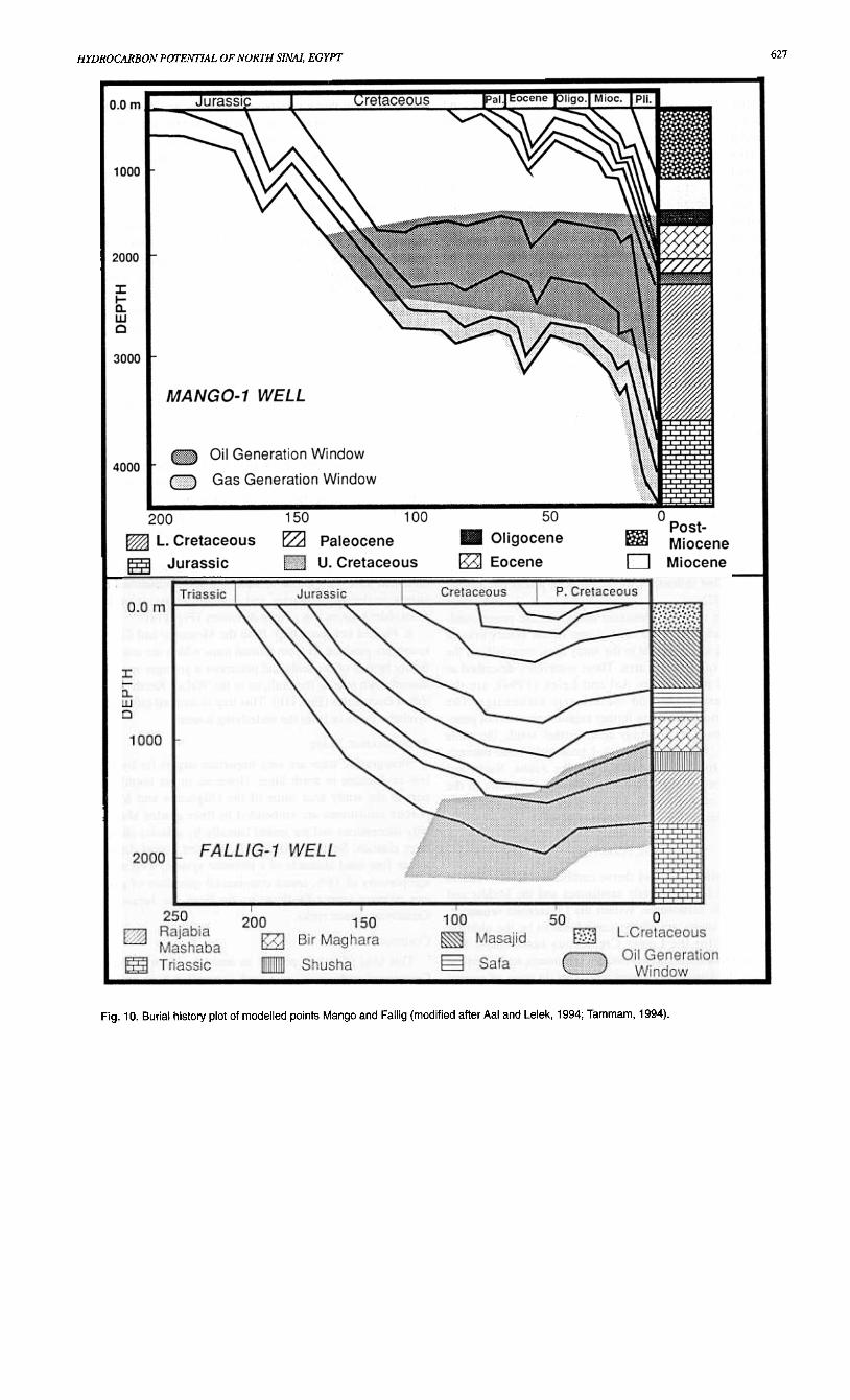
(Ro) and thermal alteration index (TAl) measurements. Theavailable vitrinite reflectance data of six wells was plottedagainst depth to detect the boundries of the oil generation win-dow (Fig. 9). The time-temperature index proposed by Waples(1985) was calculated first from the combined use of a burialhistory plot and geothermal gradient data, and then the equiva-lent isothermal value was estimated for several modelledpoints (Fig. 10). To substitute for the maturity estimate inundrilled areas (particularly in structurally deeper areas), thedepths of the stratigraphic units in these modelled points wereestimated from seismic and well data.
The main Jurassic and Lower Cretaceous source kitchensare: the East Maghara, North Maghara, Northeast Sinai andTineh-Mango troughs. The Jurassic and the Lower Cretaceous
n diagram).
source rocks are marginally mature to immature in the CentralSinai and North Fallig troughs. In the Wakar-Port Fouadtrough, they are overmature.
The Oligocene and Miocene source kitchens in north Sinaiare theWakar-Port Fouad and Tineh-Mango troughs. TheOligocene source rocks are mature in the northern part of theNorth Maghara trough.
The Water-Port Fouad trough in the Mediterranean Sea isthe deepest kitchen in the study area where the Oligocenereaches to approximately 4700 m (Figs. 1, 2) at parts whichplace the Jurassic and Lower Cretaceous source rocks in thegas generation window and even deeper. The oil generationthreshold (OGT) took place approximately 100 Ma for theJurassic and Lower Cretaceous sources and around 5 m.y. agofor the Oligocene and Miocene sources (Fig. 10). The depth tothe onset of oil generation ranges from about 1800 to over4100 m (Fig. 9).
4) Oil StudyTarnmam (1994) used crude oil samples from the Mango
discovery and Aal and Lelek (1994) used fluid inclusion anal-ysis results in Fallig-l well to geochernically assess the genet-ic relation(s) between source rocks and hydrocarbons in thenorth Sinai area. The former concluded that the Mango-l oil issourced from the Lower Cretaceous sources, while Aal and

A.S. ALSHARHAN and M.G. SALAH626
Fig. 9. Depth-vitrinite reflectance curves for some wells in north Sinai area (based on information from EGPC, 1994).
Lelek determined a match between the Jurassic source rocksand the fluid inclusion analysis.
RESERVOIR POTENTIAL
of Mashaba, Rajabiah and Shusha formations. These sand-stones are present in the central and northeastern parts ofonshore north Sinai and have strong gas shows in the Qeren-lwell Gust east of the study area). They have porosities rangingfrom 15 to 23% in the Halal-l well and are nominated as goodreservoirs by Aal and Lelek (1994). The quality of such reser-voirs depends mainly on the depth of the sandstone, theamount of argillaceous matter and/or calcareous cement con-tent.
B. Early Cretaceous sandstones: The Early Cretaceoussandstones range up to 200 m and are fine- to coarse-grained,crossbedded, highly jointed and of high porosity and perme-ability (Ammar and Afifi, 1992). These sandstones belong tothe Rakeib and Rizan Aneiza formations. The sandstones test-ed oil in the Mango-l discovery and produced from the IsraelHeItz oil field Gust northwest of the study area). The net sandthickness in the Mango discovery reaches 35 m with an aver-age porosity of 25%.
C. Oligocene sandstones: These sandstones have goodpotential over the western offshore and onshore parts of the
The north Sinai province is known for several stratigraphicunits which produce, test and/or show hydrocarbons (oiland/or gas). Some authors found that gas discoveries are gen-erally associated with Tertiary, Miocene and Oligocene sand-stones, while oil discoveries are found in Mesozoic carbonatesand sandstones. The recent discovery EI Temsah (northwest ofthe study area), producing oil from the Miocene sandstones,and the Zohar and Sadot gas fields (northeast of the studyarea), producing gas from the Jurassic and Cretaceous, respec-tively, break the old rule. The potential reservoirs in northSinai are classified into sandstone and carbonate reservoirs.
SANDSTONE RESERVOIRSThe major sandstone reservoirs range in age and characters
as described below:A. Early Jurassic sandstones: These include the sandstones
627HYDROCARBON POTENTIAL OF NORTH SINAI, EGYPT
150 100
fZ) Paleocene
--U. Cretaceous
~D
Fig. 10. Burial history plot of modelled points Mango and Fallig (modified after Aal and Lelek, 1994; Tammam, 1994).

A.S. ALSHARHAN and M.G. SAlAH628
1988). A small throw juxtaposes the shales and dense carbon-ates of some stratigraphic units on the downthrown side of thefault against the porous carbonates and/or the sandstones ofthe same unit on the uplifted block. A large throw will bringyoung seal rocks juxtaposing older reservoirs on the upliftedblock (Figs. 11,12).
The Miocene Sidi Salem and Qawasim shales can act assealing agents for the Oligocene and Miocene porous sand-stones. These Miocene shaly intervals will become verticaland/or horizontal seals, depending on the magnitude of thethrow of the fault. The Miocene shales also play an importantrole in stratigraphic traps where they laterally face a body ofsandstone. The Qawasim equivalent Rosetta anhydrite isanother seal for the Oligocene and Miocene sandstones.
TRAPPING MECHANISM
study area. They tested oil in Tineh discovery with a net sandthickness of 50 m. They have porosities ranging from 18 to23% and permeabilities of between 216 to 1729 md.
D. Miocene sandstones: The Sidi Salem, Qawasim and AbuMadi sandstones produce oil and/or gas from seven fields inand nearby the north Sinai area: Port Fouad, Walker, Temsah,Kersh, Qantara, Abu Madi and Naf. These sandstone reservoirsare well developed in the western sector of the study area. Theaverage reservoir thickness is 30 m with porosities rangingbetween 15 and 25%. The quality of reservoir depends on theamount of argillaceous matter and/or calcareous cement.
CARBONATE RESERVOIRS
Carbonate reservoirs are restricted to the Middle JurassicBir Maghara, Late Jurassic Masajid and Late Cretaceous Wata
and Matulla formations.The Bir Maghara limestones have oil shows and were
recorded as oil staining in some of the drilled wells in the east-ern side of the study area. The porosity of these limestonesdepends mainly on secondary diagenetic processes.
The Late JuraSsic carbonates produced oil from the HeItzfield of Israel and have strong oil shows in most of the coastalwells. These carbonates are reefal limestones and weredescribed as good reservoirs by Aal and Lelek (1994).
The Wata and Matulla carbonates are the main reservoir inSadot gas field and Raad discovery where reefal facies withalmost 35 m net pay thickness and average porosity and per-meability of 13% and 81 md, respectively, contain 30 billioncubic feet of gas. These carbonates are described as vuggy,microcrystalline dolomites in the onshore jebels by Ammar
and Afifi (1992).In addition to these Mesozoic and Cenozoic major sand-
stone and carbonate reservoirs, some minor reservoirs arerecorded with less potential in the study area, especially in theoffshore part of the study area. These reservoirs, described ashaving good potential by Aal and Lelek (1994), are thePaleozoic sandstones and the Triassic carbonates. ThePaleozoic section, deserving further exploration, was not pene-trated or exposed in the study area. Farther south, the wellsAbu Hamth-l, Nakhl-l and Darag-l penetrated some interest-ed Paleozoic rocks. The sandstones of the Araba, Naqus andAbu Durba formations may form potential reservoirs in thesouthern part of north Sinai. Fair to good porosity was pene-trated in the Arif El Naqa carbonates of Halal-l.~
SEALParnNTIAL
The Jurassic shales and dense carbonates act as verticalseals over the Lower Jurassic sandstones and the Middle andUpper Jurassic carbonates. Within the Cretaceous sequence,the Nezzazat shales are always considered to be the ultimatevertical seal for the Lower Cretaceous sandstones. ThePaleocene Esna shale and the Eocene carbonates act as verticalseals over the Upper Cretaceous reservoirs. In areas of normalfaulting, the magnitude of throw on the clysrnic fault is verycritical in the effective sealing mechanism (Meshref et ai.,
The hydrocarbon entrapment in the northern onshore andoffshore Sinai can be regarded as structural, stratigraphic and
combination traps.
STRUCTURAL TRAPS
Structural traps are the most important type in the northSinai district, where most of the discoveries are in structures(Figs. 11, 12). These traps are represented by:
a. Four-way dip closures: This trap is present as 1) foldcore sealed vertically and laterally by the overlying shalesand/or dense carbonates and sourced from an older sourcerock, e.g., Sadot gas field (Fig. 12a); and 2) the hanging wallanticlinal reservoirs sealed vertically by intraformational mud-stones or dense carbonates and sourced across or up faultsfrom older sources, e.g., Tineh discovery (Fig. 1 1 a).
b. Faulted structural trap: Both the Mesozoic and Cenozoicreservoirs produce oil from faulted traps which are sealed ver-tically by one of the seals and juxtapose a younger seal on thedownthrown side of the fault, as in the Wakar, Kersh and AbuZakin discoveries (Fig. lIb). This trap is sourced either acrosssynthetic faults or from the underlying sources.
STRAllGRAPHIC TRAPS
Stratigraphic traps are very important targets for hydrocar-bon exploration in north Sinai. However, in the northwesternpart of the study area some of the Oligocene and Mioceneporous sandstones are embedded in finer graded shaly andsilty successions and are sealed laterally by a facies change tofiner clastics. Such an example is the Port Fouad discoverywhere four sand channels of a turbidite system, with an aver-age porosity of 18%, tested commercial quantities of gas. Oilcan migrate across faults or up dip from the Jurassic and
Cretaceous source rocks.
COMBINAllON TRAPS
This kind of trap is present as reefal buildups of the LateCretaceous carbonates on a fault-controlled high sealed byintraformational mudstones or dense carbonates and chargedfrom Jurassic and/or Early Cretaceous sources.


A.S.
ALSHARHAN and M.G. SAlAH630
TINEH..,
/32 50
~'\."~/
~ /".// , ~~
./
NI
././
;000 "
I
""
~
.,31 20
A
-+- Oil Well -<:>- Dry Well'* Gas Well/ Contour Line
Fig. 12. A. Time map on top Cenomanian in the Sadot and Raad gas fields (modified after EGPC, 1994). B. Structure contour map on topAlbian in the Mango discovery (modified after EGPC, 1994).

631HYDROCARBON POTENTIAL OF NORTH SINAI, EGYPT
CONCLUSIONS
The Sinai Peninsula, the common part of Africa and Asia,is bounded by the Gulf of Suez rifted basin to the west, thetransform Dead Sea-Aqaba rift to the east and theMediterranean passive margin to the north. The North Sinailithostratigraphic units range in age from Precambrian toRecent. These units vary in lithology, thickness, areal distribu-tion and depositional settings.
The interpretation of both geological and geophysical datashows four main tectonic trends (normal and transform faultsand folds) reflecting the influence of regional tectonic move-ments on the North Sinai. These trends are: 1) ENE-WSW-trending normal faults, mapped at the Triassic, Jurassic andEarly Cretaceous levels; 2) NE-SW-trending anticlines at theLate Cretaceous and Early Tertiary levels; 3) NNW-SSE-trending normal faults at the Oligocene and early Miocene lev-els; and 4) NNW-SSE-trending transform faults mapped on theLate Miocene.
Three main rich source units: 1) the Jurassic shales; 2) theEarly Cretaceous carbonates; and 3) the Oligo-Miocene fineclastics, could yield oil and/or gas and are mature enough inthe deep kitchens to generate hydrocarbons. In addition to theJurassic and Cretaceous carbonates, the sandstones of theMiocene, Oligocene, Cretaceous and Jurassic rocks form themajor reservoirs in the north Sinai. The intraformationalMesozoic and Cenozoic shales and dense carbonates and themiddle Miocene anhydrite form the seals for hydrocarbons.Trap types include structural, stratigraphic and combination
traps.It is fair to say that the north Sinai remains high in hydro-
carbon potential with many untested plays.
ACKNOWLEDGMENTS
The authors are grateful to the Egyptian General PetroleumCorporation for allowing them to publish this work. Specialgratitude is due to A.E.M. Nairn, University of SouthCarolina, for reviewing the manuscript. We thank Bulletinreviewers Dr. McMillan and an anonymous reviewer for theirconstructive comments which improved our paper.
REFERENCES
Aal, A.A., Day, R.A. and Lelek, J.J. 1992. Structural evolution and styles ofthe northern Sinai, Egypt. 11th EGPC Exploration Seminar, Egypt, v. 1, p.546-563.
and Lelek, J. J. 1994. Structural development of the northern Sinai,Egypt and its implication on the hydrocarbon prospectivity of theMesozoic. GEO 94, the Middle East Geosciences Conference, Bahrain, v.I, p. 15.30.
Abdin, S. and Aal, A. 1992. Impact of oil exploration on Sinai development.3rd Conference on Sinai Development, Ismailia, v. 1, p. 281-288.
Al Far, D.A. 1966. Geology and coal deposits of Gebel El Maghara (northSinai). Egyptian Geological Survey, Rep. No. 37, 59p.
Alsharhan, A.S. and Salah, M.G. 1995. Geology and hydrocarbon habitat inrift setting: northern and central Gulf of Suez, Egypt. Bulletin of CanadianPetroleum Geology, v. 43, p.156-176.
Ammar, G. and Afifi, T. 1992. Early-Late Cretaceous reef complex facies innorth Sinai, Egypt (a model for oil exploration). 11th EGPC ExplorationSeminar, Egypt, v. 1, p. 577..587.
Barakat, M.G., Darwish, M. and EI-Outefi; N.S. 1988. Eocene tectono.:stratig-raphy and basin evaluation in the Gulf of Suez petroliferous province. 9thEGPC Exploration Seminar, Egypt, v. I, 22p.
Bartov, Y., Steinitz, G., Ayal, M. and Ayal, Y. 1980. Sinistral movement alongthe Gulf of Aqaba: its age and relation to the opening of the Red Sea.Nature, v. 285, p. 220-222.
Beytb, M. 1981. Paleozoic vertical movement in Urn Bogma area, southern Sinai.American Association of Petroleum Geologists, Bulletin v. 65, p. 160-165.
EGPC 1986. Activity of oil exploration in Egypt (1886-1986). 8th EGPC
Exploration Seminar, Egypt, 175p.1994. Nile Delta and North Sinai Fields, Discoveries and
Hydrocarbon Potential. The Egyptian General Petroleum Corporation, 387p.El Shazly, E.M., Hady, A.A., El Ghawaby, M.A., EI Kassas, I.A. and El
Shazly, M.M. 1974. Geology of the Sinai Peninsula from ERTs-1 satelliteimages. Egyptian Acdemy of Science, Rep. No. 76, 61p.
Evans, A.L. 1990. Miocene sandstone provenance relations in the Gulf ofSuez: insights into synrift unroofing and uplift history. AmericanAssociation of Petroleum Geologists, Bulletin, v. 74, p. 1386-1400.
Eyal, M., Eyal, Y., Bartov, Y. and Steinitz, G. 1981. The tectonic developmentof the western margin of the Gulf of Elat (Aqba) rift. Tectonophysics, v.80, p. 39-66.
Harnmouda, H. 1992. Rift tectonics in the Gulf of Suez: gravity and magneticcontribution. 11th EGPC Exploration Seminar, Egypt, v. I, p. 17-28.
Harding, T.P. 1985. Seismic charactistics and identification of negative flowerstructures, positive flower structures and positive structural inversion.American Association of Petroleum Geologists, Bulletin, v. 69, p. 458-600.
Hassan, A.A. 1967. A new Carboniferous occurrence in Abu Durba, Sinai,
Egypt. 6th Arab Petroleum Congress, Baghdad, II, 39 (B-3), 8p.
Jenkins, M., Harms, J.C. and Oesleby, T.W. 1982. Mesozoic sediments ofJebel Maghara, north Sinai, Egypt. 6th EGPC Exploration Seminar, Egypt,v. I,p. 1-23.
May, R.R. 1991. The eastern Mediterranean basin; evolution and oil habitat.
American Association of Petroleum Geologists, Bulletin, v. 75, p. 1215-1232.
Meshref, W.M., Abu Karamat, M.S. and Gindi, M.K. 1988. Exploration con-cepts for oil in the Gulf of Suez. 9th EGPC Exploration Seminar, Egypt, v.
1, p. 1-23.Meyer, B.L. and Nederlof, M.H. 1980. Identification of source rocks on wire-
line logs, by density/resistivity and sonic transit time/resistivity crossplots.American Association of Petroleum Geologists, Bulletin, v. 64, p. 916-926.
Moustafa, A.R. and Khalil, M.H. 1987. North Sinai structures and tectonicevolution. 25th Annual Meeting, Geological Society of Egypt, p. 3-4.
and 1990. Structural characteristics and tectonic evolu-tion of north Sinai fold belts. In: Geology of Egypt. R. Said (ed.). p. 381-391.
Neev, D. 1975. Tectonic evolution of the Middle East and Lavantine basin(easternmost Mediterranean). Geology, v. 3, p. 683-686.
1977. The Pelusium line, a major transcontinental shear.Tectonophysics, v. 38, p. 49-66.
Oehler, J.H. 1984. Carbonate source rocks in the Jurassic Smackover trend ofMississippi, Alabama, and Florida. In: Petroleum Geochemistry andSource Rock Potential of Carbonate Rocks J.G. Palacasa (ed.). AmericanAssociation of Petroleum Geologists, Studies in Geology 18, p. 63-71.
Said, R. 1962. The Geology of Egypt. Elsevier, Amsterdam, New York, 317p.
1990. The Geology of Egypt. Balkema, Rutterdam, 734p.Shata, A. 1956. Structural development of the Sinai Peninsula, Egypt. Desert
Institute of Egypt, Bulletin, v. 6, 22p.Smith, A.G. 1971. Alpine deformation and the oceanic areas of the Tethys,
Mediterranean and Atlantic. Geological Society of America, Bulletin, v.82, p. 2039-2070.
Soliman, S.M. and EI Fetouh, M. 1970. Carboniferous of Egypt and lithofa-cies maps. American Association of Petroleum Geologists, Bulletin, v. 54,p. 1818-1930.
Tarnmam, M.T. 1994. Oil window and souce rock of north Sinai province.12th EGPC Exploration Seminar, Egypt, v. 2, p. 175-197.
Waples, D.G. 1985. Geochemistry in Petroleum Exploration. IHRDC, Boston,
22Op.Zaghloul, Z. and Khidr, I. 1992. Subsurface geological setting of the
Mesozoic-Cenozoic formations and hydrocabon potentials, north Sinai.11 th EGPC Exploration Seminar, Egypt, v. 1, p. 563-577.
Manuscript received: July 4, 1995Revised manuscript accepted: November 15, 1995