geologic resources inventory report - nps history
TRANSCRIPT
National Park Service U.S. Department of the Interior Natural Resource Stewardship and Science
Weir Farm National Historic Site Geologic Resources Inventory Report
Natural Resource Report NPS/NRSS/GRD/NRR—2012/487
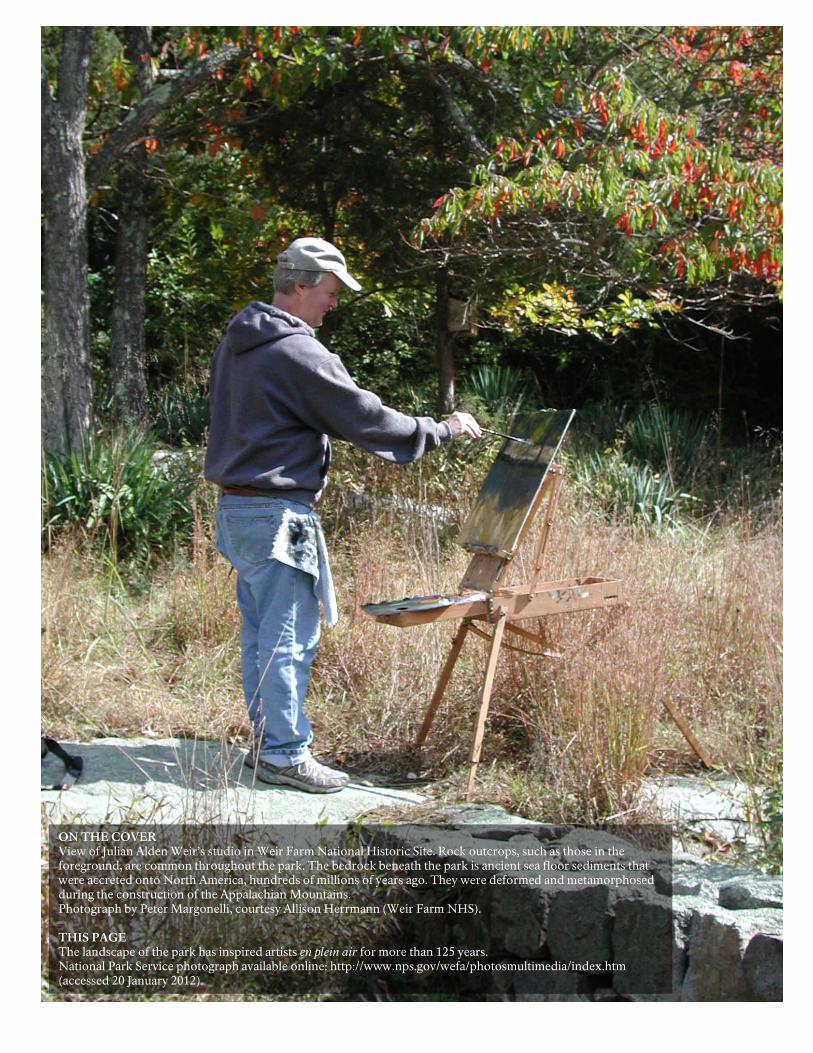
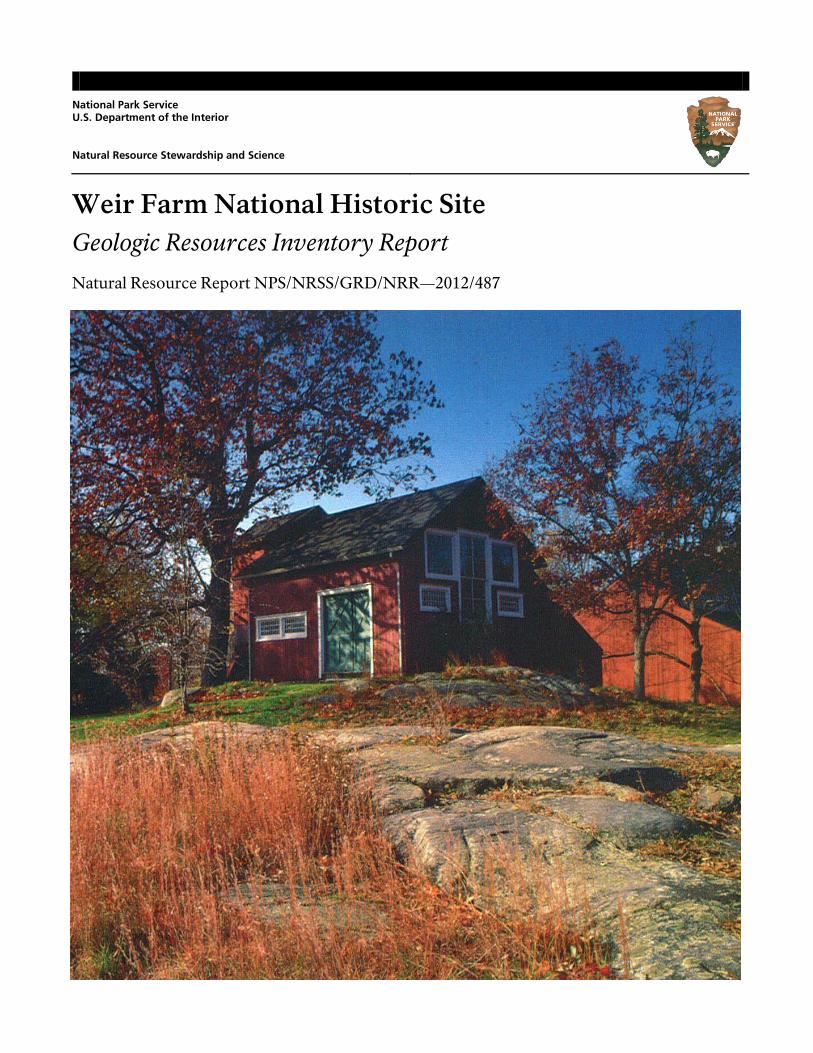
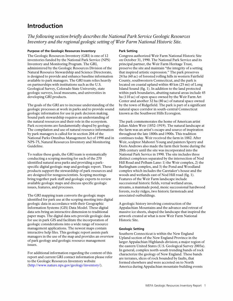
ON THE COVER View of Julian Alden Weir’s studio in Weir Farm National Historic Site. Rock outcrops, such as those in the foreground, are common throughout the park. The bedrock beneath the park is ancient sea floor sediments that were accreted onto North America, hundreds of millions of years ago. They were deformed and metamorphosed during the construction of the Appalachian Mountains. Photograph by Peter Margonelli, courtesy Allison Herrmann (Weir Farm NHS). THIS PAGE The landscape of the park has inspired artists en plein air for more than 125 years. National Park Service photograph available online: http://www.nps.gov/wefa/photosmultimedia/index.htm (accessed 20 January 2012).
Weir Farm National Historic Site Geologic Resources Inventory Report
Natural Resource Report NPS/NRSS/GRD/NRR—2012/487
National Park Service Geologic Resources Division PO Box 25287 Denver, CO 80225
January 2012
U.S. Department of the Interior National Park Service Natural Resource Stewardship and Science Fort Collins, Colorado
ii NPS Geologic Resources Division
The National Park Service, Natural Resource Stewardship and Science office in Fort Collins, Colorado publishes a range of reports that address natural resource topics of interest and applicability to a broad audience in the National Park Service and others in natural resource management, including scientists, conservation and environmental constituencies, and the public.
The Natural Resource Report Series is used to disseminate high-priority, current natural resource management information with managerial application. The series targets a general, diverse audience, and may contain NPS policy considerations or address sensitive issues of management applicability.
All manuscripts in the series receive the appropriate level of peer review to ensure that the information is scientifically credible, technically accurate, appropriately written for the intended audience, and designed and published in a professional manner. This report received informal peer review by subject-matter experts who were not directly involved in the collection, analysis, or reporting of the data.
Views, statements, findings, conclusions, recommendations, and data in this report do not necessarily reflect views and policies of the National Park Service, U.S. Department of the Interior. Mention of trade names or commercial products does not constitute endorsement or recommendation for use by the U.S. Government.
Printed copies of this report are produced in a limited quantity and they are only available as long as the supply lasts. This report is available from the Geologic Resources Inventory website (http://www.nature.nps.gov/geology/inventory/ gre_publications.cfm) and the Natural Resource Publications Management website (http://www.nature.nps.gov/publications/nrpm/).
Please cite this publication as:
Thornberry-Ehrlich, T. 2012. Weir Farm National Historic Site: geologic resources inventory report. Natural Resource Report NPS/NRSS/GRD/NRR—2012/487. National Park Service, Fort Collins, Colorado.
NPS 413/112546, January 2012
WEFA Geologic Resources Inventory Report iii
Contents
List of Figures ................................................................................................................ iv
Executive Summary ....................................................................................................... v
Acknowledgements ...................................................................................................... vi Credits ........................................................................................................................................................................ vi
Introduction ................................................................................................................... 1 Purpose of the Geologic Resources Inventory ............................................................................................................... 1 Park Setting ................................................................................................................................................................. 1 Geologic Setting .......................................................................................................................................................... 1
Geologic Issues .............................................................................................................. 7 Water Issues ................................................................................................................................................................ 7 Disturbed Lands and Adjacent Land Use ....................................................................................................................... 8 Geologic Hazards ......................................................................................................................................................... 8 Suggestions for Geologic Work at Weir Farm National Historic Site ............................................................................... 9
Geologic Features and Processes ................................................................................ 13 Glacial Features .......................................................................................................................................................... 13 Geology and History Connections ............................................................................................................................... 13
Geologic History .......................................................................................................... 19 Proterozoic Eon (2,500–542 million years ago): Ancient Mountain Building and Iapetus Ocean Formation ................... 19 Paleozoic Era (542–251 million years ago): Building the Appalachians and Assembling Pangaea .................................. 19 Mesozoic Era (251–65.5 million years ago): Pangaea Separation, Atlantic Ocean Formation, and Appalachian Mountain Erosion ............................................................................................................................ 20 Cenozoic Era (the past 65.5 million years): Appalachian Mountain Erosion and Ice Age Glaciation .............................. 21
Geologic Map Data ...................................................................................................... 27 Geologic Maps ........................................................................................................................................................... 27 Source Maps .............................................................................................................................................................. 27 Geologic GIS Data ...................................................................................................................................................... 27 Geologic Map Overview Graphics ............................................................................................................................... 28 Map Unit Properties Table .......................................................................................................................................... 28 Use Constraints .......................................................................................................................................................... 28
Geologic Map Overview Graphics .............................................................................. 29
Map Unit Properties Table .......................................................................................... 31
Glossary ........................................................................................................................ 35
Literature Cited ............................................................................................................ 41
Additional References ................................................................................................. 45 Geology of National Park Service Areas ...................................................................................................................... 45 Resource Management/Legislation Documents ........................................................................................................... 45 Geological Survey and Society Websites ..................................................................................................................... 45 Other Geology/Resource Management Tools .............................................................................................................. 45
Appendix: Scoping Session Participants .................................................................... 47
Attachment 1: Geologic Resources Inventory Products CD
iv NPS Geologic Resources Division
List of Figures
Figure 1. Park maps. .................................................................................................................................................... 3 Figure 2. Map of terranes in Connecticut ...................................................................................................................... 4 Figure 3. Geologic map of Cameron’s Line ................................................................................................................... 5 Figure 4. Map of management zones ......................................................................................................................... 10 Figure 5. Photographs of the pond ............................................................................................................................. 11 Figure 6. Photographs of slopes and stone walls ......................................................................................................... 12 Figure 7. Graphic illustrating drumlin features ............................................................................................................ 15 Figure 8. Photograph of en plein air painting .............................................................................................................. 15 Figure 9. “The Truants” (1895) ................................................................................................................................... 16 Figure 10. “Upland Pasture” (1905) and “untitled” (1971) .......................................................................................... 17 Figure 11. “Spring Landscape, Branchville” (1882) ...................................................................................................... 18 Figure 12. Geologic timescale..................................................................................................................................... 22 Figure 13. Graphic showing tectonic evolution ........................................................................................................... 23 Figure 14. Paleogeographic maps of North America ................................................................................................... 24 Figure 15. Map of glacial retreat ................................................................................................................................ 25 Figure 16. Map of glacial lakes in Connecticut ............................................................................................................ 26
WEFA Geologic Resources Inventory Report v
Executive Summary
This report accompanies the digital geologic map data for Weir Farm National Historic Site in Connecticut, produced by the Geologic Resources Division in collaboration with its partners. It contains information relevant to resource management and scientific research. Published and unpublished geologic data were used during the preparation of this report. The Geologic Resources Division did not conduct fieldwork in association with this report. The rock record at Weir Farm National Historic Site preserves chapters of geologic history including episodes of Appalachian Mountain building and ocean basin formation along eastern North America. Geologic features such as hills, valleys, bedrock outcrops, and glacial erratics figured prominently in Julian Alden Weir’s paintings at his Branchville Farm. Painting outdoors (en plein air), Weir was inspired by the rolling, forested hills separated by fields, meadows, small lakes and shallow stream valleys that characterize the landscape of southwest Connecticut. The park’s geologic history developed its inspiring landscape. Generations of artists have come to Weir Farm National Historic Site for similar inspiration. This Geologic Resources Inventory (GRI) report is written for resource managers, to assist in resource management and science-based decision making, but it may also be useful for interpretation. The report discusses geologic issues facing resource managers at the park, distinctive geologic features and processes within the park, and the geologic history leading to the park’s present-day landscape. An overview graphic illustrates the geologic data; a map unit properties table summarizes the main features, characteristics, and potential management issues for all the rocks and unconsolidated deposits on the digital geologic map for the park. This report also provides a glossary. Additionally, a geologic timescale shows the chronologic arrangement of major geologic events, with the oldest events and time units at the bottom and the youngest at the top. Situated in the Connecticut towns of Ridgefield and Wilton, Weir Farm National Historic Site preserves a significant portion of open space in the Southwest Hills Ecoregion. This area is part of the New England Upland section of the New England Province in the larger Appalachian Highlands. The region is characterized by north-south trending bands of rock reflecting a long history of Appalachian mountain building and ice age glaciation. The oldest rocks exposed west of the park are Proterozoic gneisses (metamorphic rocks) of the highlands. The western uplands area of western Connecticut contains Cameron’s Line, a large regional thrust fault that separates continental shelf and slope materials from deep ocean basin sediments. Cameron’s Line is mapped about 3 km (2 mi) northwest of Weir Farm National Historic Site. East of Cameron’s Line, including Weir Farm, the rocks are metamorphosed into micaceous schist, granite, and hornblende gneiss
intricately folded with amphibolite gneiss, and occasional gabbro and serpentinite. These rocks display a higher degree of deformation and metamorphism than the continental shelf and slope deposits located west of Cameron’s Line because of the effects of successive Paleozoic mountain-building episodes. West of Cameron’s Line, the rocks are metamorphosed gneiss, quartzites, marble, schist, and phyllite. During the Pleistocene ice ages of the past 2 million years, glacial ice scoured and reworked the preexisting landscape of New England. At the last glacial maximum, approximately 19,000 to 26,000 years ago, the Hudson-Champlain ice lobe completely covered Connecticut, obscuring evidence of earlier glacial events and depositing vast amounts of glacial sediments atop much older bedrock units. In the extended Weir Farm National Historic Site area, ice age deposits include well-sorted outwash gravels and deltaic deposits, layered lacustrine silts and clays, and at least two distinct, unsorted, clay-rich tills (only till is mapped in the park’s immediate vicinity). More recent surficial deposits—alluvium and swamp deposits—are associated with modern processes within the highlands of the Norwalk River watershed. Geology is fundamental to the management of the scenic, natural, and cultural resources of the park. Geology contributes to climate, natural hazards, hydrology, and topography. During a geologic resources scoping meeting in 2007, geologic issues of particular significance for resource management at Weir Farm National Historic Site were identified and are discussed in greater detail in this report:
• Water Issues. Several streams and wetlands cross the park. Understanding the hydrogeologic system of the park can help manage water resources and predict potential results from the introduction of contaminants. A now-leaking earthen dam, constructed by Weir, impounds a large pond. A park goal is to repair the integrity of the dam and restore the pond to its historic state.
• Disturbed Lands and Adjacent Land Use. Many of the features which would traditionally be considered disturbed are in fact cultural resources and targets for preservation and interpretation. Residential development abuts some areas of the park causing concern of potentially negative impacts stemming from these areas.
• Geologic Hazards. Although not common, earthquakes can and have occurred in the park area.
vi NPS Geologic Resources Division
The geologic framework (rocks and structures) beneath the park contribute to a relatively high potential for dangerous radon accumulation in park
buildings. Mass wasting can occur on the park’s steep slopes and erosion degrades footpaths within the park.
Acknowledgements
The Geologic Resources Inventory (GRI) is one of 12 inventories funded by the National Park Service Inventory and Monitoring Program. The GRI is administered by the Geologic Resources Division of the Natural Resource Stewardship and Science Directorate. The Geologic Resources Division relies heavily on partnerships with institutions such as the U.S. Geological Survey, Colorado State University, state geologic surveys, local museums, and universities in developing GRI products. Special thanks to: Margaret Thomas (State Geologic and Natural History Survey of Connecticut) for coordinating her agency’s review of the document; Allison Herrmann (Weir Farm National Historic Site) provided many of the images used in the report.
Credits
Author
Trista Thornberry-Ehrlich (Colorado State University)
Review
Randolph Steinen (State Geologic and Natural History Survey of Connecticut) Jason Kenworthy (NPS Geologic Resources Division) Greg Waters (Weir Farm National Historic Site)
Editing
Jeffrey Matthews (Write Science Right)
Digital Geologic Data Production
David Plume (NPS Geologic Resources Division) Heather Stanton (Colorado State University) Georgia Hybels (NPS Geologic Resources Division)
Digital Geologic Data Overview Layout Design
Heather Stanton (Colorado State University) Philip Reiker (NPS Geologic Resources Division)
WEFA Geologic Resources Inventory Report 1
Introduction
The following section briefly describes the National Park Service Geologic Resources Inventory and the regional geologic setting of Weir Farm National Historic Site. Purpose of the Geologic Resources Inventory
The Geologic Resources Inventory (GRI) is one of 12 inventories funded by the National Park Service (NPS) Inventory and Monitoring Program. The GRI, administered by the Geologic Resources Division of the Natural Resource Stewardship and Science Directorate, is designed to provide and enhance baseline information available to park managers. The GRI team relies heavily on partnerships with institutions such as the U.S. Geological Survey, Colorado State University, state geologic surveys, local museums, and universities in developing GRI products. The goals of the GRI are to increase understanding of the geologic processes at work in parks and to provide sound geologic information for use in park decision making. Sound park stewardship requires an understanding of the natural resources and their role in the ecosystem. Park ecosystems are fundamentally shaped by geology. The compilation and use of natural resource information by park managers is called for in section 204 of the National Parks Omnibus Management Act of 1998 and in NPS-75, Natural Resources Inventory and Monitoring Guideline. To realize these goals, the GRI team is systematically conducting a scoping meeting for each of the 270 identified natural area parks and providing a park-specific digital geologic map and geologic report. These products support the stewardship of park resources and are designed for nongeoscientists. Scoping meetings bring together park staff and geologic experts to review available geologic maps and discuss specific geologic issues, features, and processes. The GRI mapping team converts the geologic maps identified for park use at the scoping meeting into digital geologic data in accordance with their Geographic Information Systems (GIS) Data Model. These digital data sets bring an interactive dimension to traditional paper maps. The digital data sets provide geologic data for use in park GIS and facilitate the incorporation of geologic considerations into a wide range of resource management applications. The newest maps contain interactive help files. This geologic report assists park managers in the use of the map and provides an overview of park geology and geologic resource management issues. For additional information regarding the content of this report and current GRI contact information please refer to the Geologic Resources Inventory website (http://www.nature.nps.gov/geology/inventory/).
Park Setting
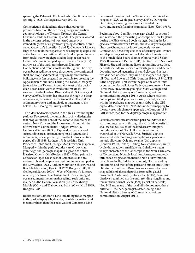
Congress authorized Weir Farm National Historic Site on October 31, 1990. The National Park Service and its principal partner, the Weir Farm Heritage Trust, preserve the site and maintain “the integrity of a setting that inspired artistic expression.” The park preserves 24 ha (60 ac) of forested rolling hills in western Fairfield County, southwestern Connecticut, and the park is located on coastal upland within 40 km (25 mi) of Long Island Sound (fig. 1). In addition to the land protected within park boundaries, abutting natural areas include 45 ha (110 ac) of open space owned by the Weir Farm Art Center and another 32 ha (80 ac) of natural space owned by the town of Ridgefield. The park is part of a significant natural space corridor in south-central Connecticut known as the Southwest Hills Ecoregion. The park commemorates the home of American artist Julian Alden Weir (1852–1919). The natural landscape at the farm was an artist’s escape and source of inspiration throughout the late 1800s and 1900s. This tradition continues today. Weir received the farm in 1882. After Weir, sculptor Mahonri Young and painters Sperry and Doris Andrews also made the farm their home during the 20th century until the site was incorporated into the National Park Service in 1990. The site includes three distinct complexes separated by the intersection of Nod Hill Road and Pelham Lane: 1) the Weir complex, 2) the Burlingham complex, and 3) the Pond and Woodland complex which includes the Caretaker’s house and the woods and wetlands east of Nod Hill road (fig. 1). Features of the Weir Farm landscape include successional historic fields, vernal wetland areas, streams, a manmade pond, mesic successional hardwood forests, rocky ridges, two historic farmsteads and associated outbuildings. A geologic history involving construction of the Appalachian Mountains and the advance and retreat of massive ice sheets, shaped the landscape that inspired the artwork created at what is now Weir Farm National Historic Site.
Geologic Setting
Southern Connecticut is within the New England Upland section of the New England Province in the larger Appalachian Highlands division; a major region of the eastern United States (U.S. Geological Survey 2003a). In general, complex north-south trending bands of rock characterize the geology of New England. These bands are terranes, slices of rock bounded by faults, that formed elsewhere and were accreted on to North America during Appalachian mountain-building events
2 NPS Geologic Resources Division
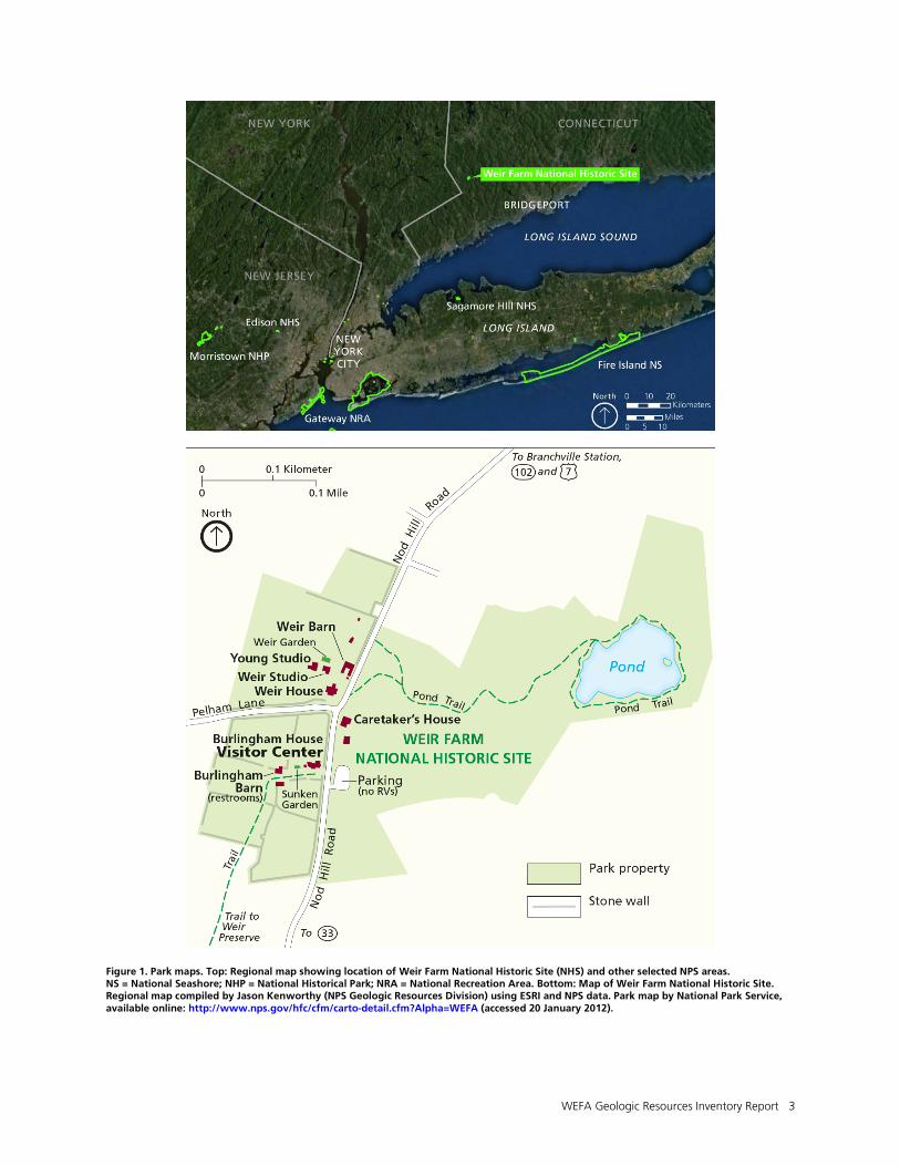
spanning the Paleozoic Era hundreds of millions of years ago (fig. 2) (U.S. Geological Survey 2003a). Connecticut is divided into three physiographic provinces based on the bedrock geology and surficial geomorphology: the Western Uplands; the Central Lowlands; and the Eastern Uplands. The park is located in the western uplands of western Connecticut immediately east of a significant geologic feature; a fault called Cameron’s Line (figs. 2 and 3). Cameron’s Line is a large thrust fault that separates rocks originally deposited as shallow marine continental shelf and slope sediments from rocks that were deposited in deep ocean basins. Cameron’s Line is mapped approximately 3 km (2 mi) northwest of the park, runs through Danbury, Connecticut, and trends north-south (fig. 3). The deep ocean basin sediments were thrust over the continental shelf and slope sediments during a major mountain-building event (an orogeny) responsible for creating the Appalachian Mountains. During the Taconic Orogeny (named for the Taconic Mountains west of the park) deep ocean rocks were shoved some 80 km (50 mi) westward to the Hudson River Valley (U.S. Geological Survey 2003b). Erosion has since cut through the deep ocean rocks, exposing the continental shelf and slope sedimentary rocks and much older basement rocks below (U.S. Geological Survey 2003b). The oldest bedrock exposed in the area surrounding the park are Proterozoic metamorphic rocks called gneiss that crop out in the core of the Taconic Mountains in eastern New York and the Housetonic Mountains in northwestern Connecticut (Rodgers 1985; U.S. Geological Survey 2003b). Exposed in the park and surrounding areas are metamorphosed igneous and sedimentary rocks primarily from the Ordovician time period (Kroll 1969; Rodgers 1985; see Map Unit Properties Table and Geologic Map Overview graphics). Mapped within the park boundary are Ordovician granitic gneiss (geologic map unit Og) and the older Harrison Gneiss (Oh) (Rodgers 1985). Other primarily Ordovician-aged rocks east of Cameron’s Line are metamorphosed deep ocean basin sediments mapped as the Row Schist (OCr), Ratlum Mountain Schist (Or), and Brookfield Gneiss (Ob) (Kroll 1969; Rodgers 1985; U.S. Geological Survey 2003b). West of Cameron’s Line are relatively shallower Cambrian- and Ordovician-aged ocean sediments metamorphosed into rock units and mapped as the Dalton Formation (Cd), Stockbridge Marble (OCs), and Walloomsac Schist (Ow) (Kroll 1969; Rodgers 1985). Rocks east of Cameron’s Line (including those mapped in the park) display a higher degree of deformation and metamorphism than the rocks west of Cameron’s Line
because of the effects of the Taconic and later Acadian orogenies (U.S. Geological Survey 2003b). During the Devonian, younger igneous rocks intruded the surrounding rock forming pegmatites (Dp) (Kroll 1969). Beginning about 2 million years ago, glacial ice scoured and reworked the preexisting landscape of New England during the Pleistocene Epoch ice ages. During the last glacial advance between 19,000 and 26,000 years ago, the Hudson-Champlain ice lobe completely covered Connecticut, obscuring evidence of earlier glacial events and depositing vast amounts of glacial sediments on top of the much older bedrock units (Connally and Sirkin 1973; Bierman and Dethier 1986). At Weir Farm National Historic Site and the immediate surrounding area, these deposits include well-sorted outwash gravels and deltaic deposits, layered lacustrine silts and clays, and at least two distinct, unsorted, clay-rich tills mapped as Upper till (Qtu) and Lower till (Qtl) (London 1984a, 1984b). Till is the only glacial unit within the park, the other units occur in the Norwalk River Valley, approximately 3 km (2 mi) away (R. Steinen, geologist, State Geologic and National History Survey of Connecticut, written communication, August 2011). Areas where bedrock outcrops and till deposits are closely spaced, such as within the park, are mapped as unit Qtbc in the GRI digital data. Stone et al. (2005) has updated mapping for the park area which may supersede the London (1984) GRI source map for the digital geologic map product. Several seasonal streams within park boundaries and surrounding areas cut through the surficial deposits in shallow valleys. Much of the land area within park boundaries east of Nod Hill Road is within the watershed of the Norwalk River. Surficial deposits associated with modern geomorphologic processes include alluvium (Qal) and swamp (Qs) deposits (London 1984a, 1984b). Rolling, forested hills separated by fields, meadows, small lakes and shallow stream valleys characterize the landscape in the Weir Farm area of Connecticut. Notable local landforms, undoubtedly influenced by glaciation, include Nod Hill within the park, Branchville, Biddle (a drumlin), Florida, and Ivy Hills north and west of the park, and Sunset and Honey Hills to the southeast. Drumlins are elongated whale-shaped hills of glacial deposits, formed by glacial movement. As defined by Stone et al. (2005), drumlins display streamlined north-south trending ridgelines and thicker than normal (>5 m [15 ft] glacial till deposits). Nod Hill and many of the local hills do not meet these criteria (R. Steinen, geologist, State Geologic and National History Survey of Connecticut, written communication, August 2011).
WEFA Geologic Resources Inventory Report 3
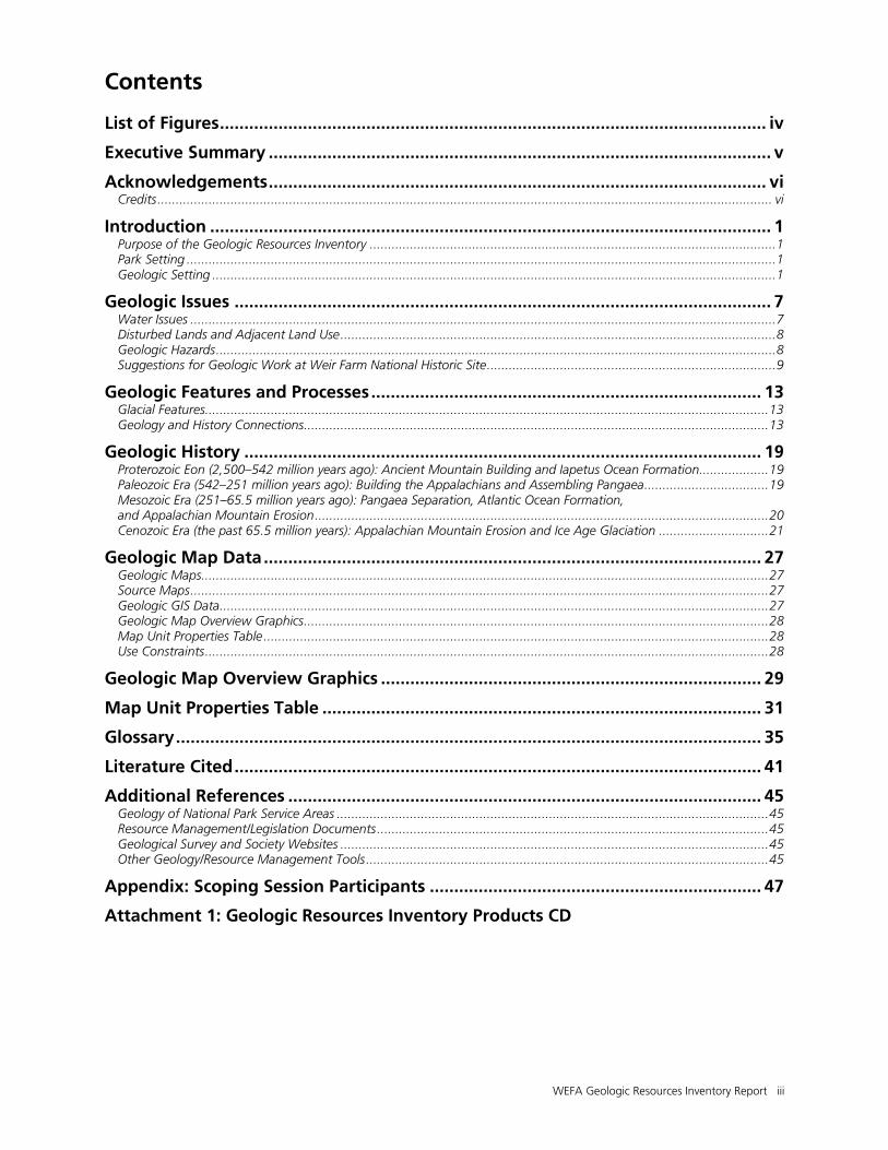
Figure 1. Park maps. Top: Regional map showing location of Weir Farm National Historic Site (NHS) and other selected NPS areas. NS = National Seashore; NHP = National Historical Park; NRA = National Recreation Area. Bottom: Map of Weir Farm National Historic Site. Regional map compiled by Jason Kenworthy (NPS Geologic Resources Division) using ESRI and NPS data. Park map by National Park Service, available online: http://www.nps.gov/hfc/cfm/carto-detail.cfm?Alpha=WEFA (accessed 20 January 2012).
4 NPS Geologic Resources Division
Figure 2. Map of terranes in Connecticut. Different colors represent different terranes—slices of rock bounded by faults, that formed elsewhere and share a similar history of deformation and metamorphism. Rocks were originally sediments deposited in the Iapetus Ocean and shoved onto North America during Appalachian Mountain building. Thick gray lines are significant faults that form the boundary between terranes. Cameron’s Line in west Connecticut is a major thrust fault that separates rocks that were originally part of deep Iapetus Ocean or volcanic rocks from rocks representing shallower ocean deposits. Cameron’s Line is also visible on the Geologic Map Overview graphics. Refer to the Geologic History section for more information. Weir Farm NHS is located within the Connecticut Valley Synclinorium which refers to a broad U-shaped regional fold, composed of many smaller folds. Compiled by Jason Kenworthy (NPS Geologic Resources Division) from Connecticut Geologic Survey data and ESRI Arc Image Service USA Basemap and World Shaded Relief layers.
WEFA Geologic Resources Inventory Report 5
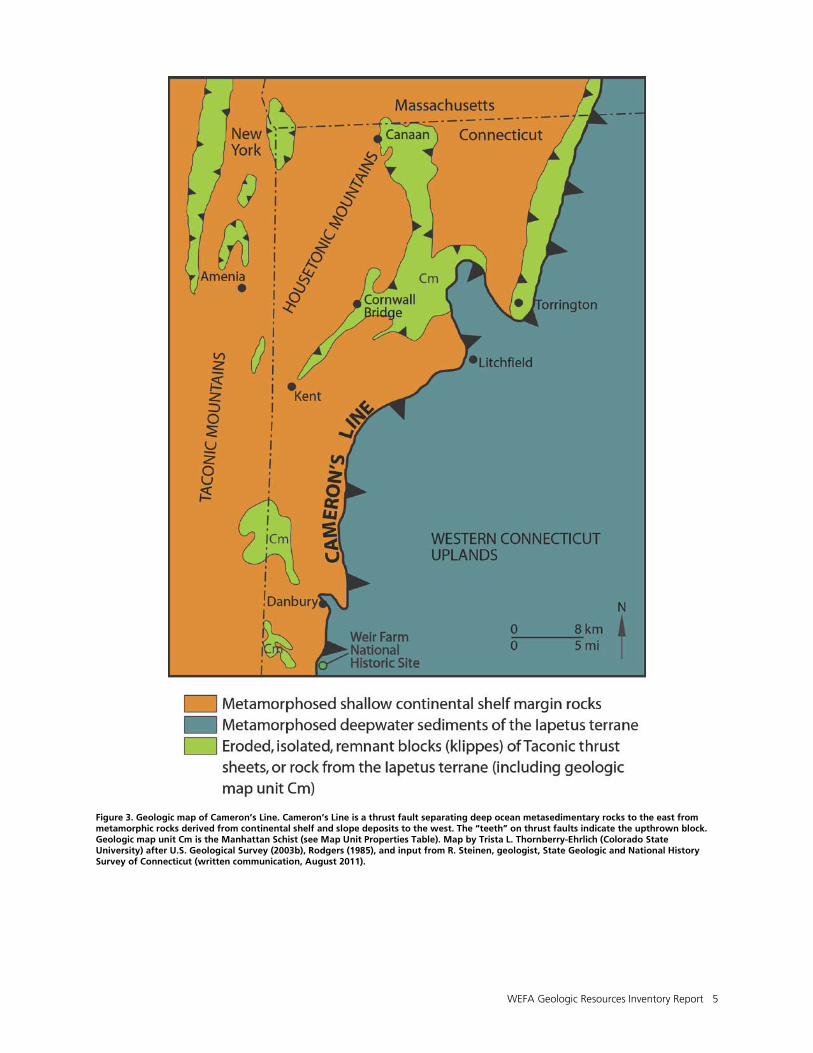
Figure 3. Geologic map of Cameron’s Line. Cameron’s Line is a thrust fault separating deep ocean metasedimentary rocks to the east from metamorphic rocks derived from continental shelf and slope deposits to the west. The “teeth” on thrust faults indicate the upthrown block. Geologic map unit Cm is the Manhattan Schist (see Map Unit Properties Table). Map by Trista L. Thornberry-Ehrlich (Colorado State University) after U.S. Geological Survey (2003b), Rodgers (1985), and input from R. Steinen, geologist, State Geologic and National History Survey of Connecticut (written communication, August 2011).

WEFA Geologic Resources Inventory Report 7
Geologic Issues
The Geologic Resources Division held a Geologic Resources Inventory scoping session for Weir Farm National Historic Site on July 9, 2007, to discuss geologic resources, address the status of geologic mapping, and assess resource management issues and needs. This section synthesizes the scoping results, in particular those issues that may require attention from resource managers. Contact the Geologic Resources Division for technical assistance. Water Issues
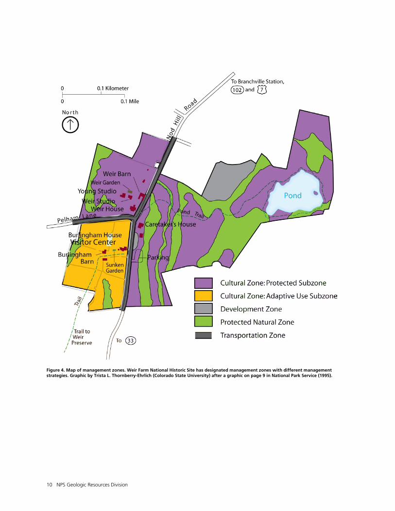
Most of Weir Farm National Historic Site lies atop a north-south ridge (Nod Hill) with several seasonal streams traversing the area. The landscape drains to the north to the Cooper Pond Brook, which flows into the Norwalk River and to the south to the Barrets Brook, which flows into Streets Pond, and ultimately into the Norwalk River via Comstock Brook (National Park Service 1995). Because the park’s waterways are the headwaters for the regional drainage, flooding is not a significant threat to park infrastructure. The park does contain some depressions and two north-south trending wetland areas cross the property, flanking ridges providing specialized habitat (National Park Service 1990, 1995). There are seven wetland areas within park boundaries comprising approximately one-third of the park’s total area (National Park Service 1995). All are currently part of designated protected natural zones (fig. 4) because of their fragility and ecological significance. Human access to these zones is minimized as much as possible (National Park Service 1995). Understanding the hydrogeologic system could help resource managers predict potential responses to landscape change both within and adjacent to park boundaries.
Groundwater
Aquifers in southwestern Connecticut tend to be present in two types: 1) shallow aquifers in unconsolidated surficial deposits, and 2) deeper aquifers in fractured, crystalline bedrock (Mullaney 2003). In rural areas of Fairfield County, new upland developments rely on individual private water-supply wells drilled into the fractured crystalline-bedrock aquifer. Aquifers in the surficial, unconsolidated glacial deposits are limited in areal extent and discontinuous in southwest Connecticut (Mullaney 2003). Stratified glacial deposits, such as those deposited by glacial lakes and outwash streams are more productive aquifers than till deposits (Mullaney 2003), which tend to be less permeable to groundwater flow. Information is sparse on recharge rates to the bedrock aquifers in the park area. Natural recharge is derived primarily from precipitation that infiltrates from the land surface to the water table and from water that infiltrates from surficial water features (Mullaney 2003). Recharge rates are greatest during the nongrowing season in Connecticut from October to May when water needs from trees and plants (evapotranspiration) are lowest
(Mullaney 2003). Natural factors affecting recharge rates include slope, vegetation cover, local variations in geologic framework, and soil moisture. In developed areas human activities can affect recharge rates and change the groundwater budget for a particular basin particularly by adding impervious surfaces (parking lots, roads, buildings, etc.), introducing wastewater, and increasing groundwater withdrawals (Mullaney 2003). For the Greenwich area of Fairfield County, southwest of Weir Farm National Historic Site, the U.S. Geological Survey developed a groundwater-flow model to track water budgets, and to estimate hydraulic conductivity of the fractured, crystalline bedrock aquifer and recharge to the overlying, unconsolidated deposits. Data collection involved stream-flow measurements, groundwater level measurements, water-quality samples, and water-use data. This model yielded a groundwater budget and greater understanding of the hydrologic system (Mullaney 2003). Weir Farm National Historic Site has similar bedrock and surficial geology (Kroll 1969; Rodgers 1985; London 1984a, 1984b; Mullaney 2003). Such a study at the park could increase understanding of the groundwater flow system. It could also be used to predict responses to increased surrounding development or introduction of contaminants such as nitrogen, phosphorous, chloride, bacteria, and pesticides which tend to increase with urbanization in a particular basin (Mullaney 2003). Groundwater appears to contribute a significant amount of the base flow to the artificial pond at Weir Farm National Historic Site (National Park Service 1995).
Pond Maintenance
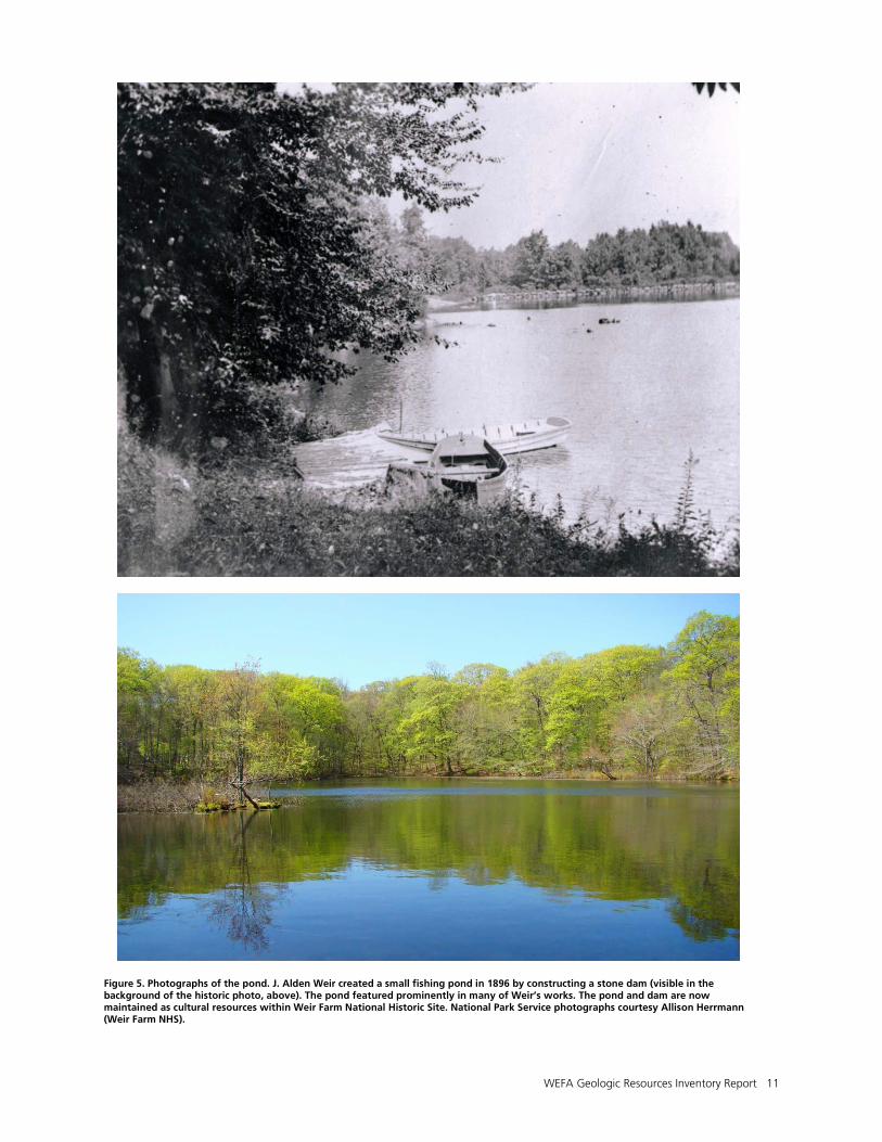
In 1896, using a $2,500 award that he won from the Boston Art Club for a painting, Julian Alden Weir constructed a small fishing pond, approximately 1.6 ha (4 ac) in area, on his property by damming a small seasonal stream, some springs, and a wetland area (fig. 5; National Park Service 1990, 1995). The remnants of the stone dam still exist today on the northeast corner of the pond, which has remained relatively free of siltation because of low sediment influx and because it is fed by intermittent streams (National Park Service 1990). The pond is featured in many of Weir’s artistic endeavors (Child Associates and Zaitzevsky 1996). At some later point in its history, the spillway may have been raised to elevate the pond’s water level, although no direct evidence exists (Greg Waters, horticulturist, Weir Farm
8 NPS Geologic Resources Division
National Historic Site, written communication, November 2011). Lowering the spillway was a recommendation in the park’s 1995 General Management Plan (National Park Service 1995). The deepest point in the shallow pond is 2 m (7 ft) (National Park Service 1995). Dam failure would not pose a significant downstream flood hazard. Because the pond is now an important cultural resource at the site, park staff propose to repair the leaking dam and, depending on the degree of siltation, potentially dredge the pond to restore its historic appearance (Thornberry-Ehrlich 2007).
Disturbed Lands and Adjacent Land Use
In the late 20th century, as the towns of Wilton and Ridgefield slowly transitioned from farming communities to suburban residential areas, the Weir Farm area was at risk of being developed. Sperry and Doris Andrews, over their four-decade tenure at the farm, organized a preservation movement that ultimately saved much of the landscape now incorporated into the national historic site. The area surrounding Weir Farm National Historic Site is currently experiencing a population surge as people move from urban areas such as New York City to more rural and suburban spaces. Development and land use changes adjacent to the national historic site can impact park resources. The park is a component of a larger contiguous open space, but is bisected by small, winding roadways that receive significant travel. Residential development has encroached on the northwestern and southeastern boundaries (National Park Service 1995). Some residences are visible from the pond. Prior to the 1990 establishment of the site as part of the National Park Service, residential development created disturbed land areas within the park. Trees and vegetation were removed from around the pond to maintain water views from surrounding homes. Invasive plants such as Asiatic barberry (Berberis asiatica), winged Euonymus (Euonymus alata), bittersweet (Solanum dulcamara), and black swallowwort (Vincetoxicum) colonized disturbed areas (National Park Service 1995; Thornberry-Ehrlich 2007). At present, the NPS Geologic Resources Division is working with the park staff to remediate impacts of disturbed lands and invasive species (Thornberry-Ehrlich 2007). Disturbed features within the park include an old wagon road that leads to the pond from the barn. This and other historic features at Weir Farm National Historic Site are managed as cultural features and will not be remediated. According to Kroll (1977), lead and silver were mined in the Wilton area, though mapping has not revealed the location of these mine features. Other materials mined locally were talcose slate (used as paint pigment) and granite-gneiss quarried for building materials. Additional disturbed features in the area include abandoned pegmatite mines located adjacent to park boundaries. Local, coarse-grained pegmatite rocks (such as geologic map unit Dp located within geologic map unit Oh [occurs within the park]) contain rich deposits of
feldspar, mica, quartz, and tourmaline which were mined for industrial use. Connecticut pegmatites were first mined for feldspar beginning in 1825 and the Branchville quarry (close to the park) produced gem-quality tourmaline and other previously-unidentified minerals (Jones 2011). Mindat, a large international mineral database and mineralogy reference organization, maintains a website (http://www.mindat.org) detailing mineralogical information. The Branchville pegmatite quarry has a long history of excavation (see discussion under Features and Processes). Included within in the GRI digital geologic map data are mine point and line features such as quarries, gravel pits, test holes and water wells (see Geologic Map Data section). A quarry line feature is present less than 2 km (1 mi) from the park’s eastern boundary.
Geologic Hazards
Radon Potential
According to the U.S. Environmental Protection Agency (EPA) radon website (http://www.epa.gov/radon/) exposure to radon in buildings and drinking water is responsible for an estimated 20,000 lung cancer deaths each year. Radon is a radioactive, toxic, colorless, gaseous product of the decay of radium, itself a radioactive decay product of uranium. Uranium naturally occurs in many minerals and can be found in low levels within essentially all rock, soil, and water. When uranium decays in the regolith surrounding a basement or foundation, the radon typically moves up through the ground to the air above often becoming trapped inside the structure. Radon can also enter a building through well water (Environmental Protection Agency 2010). The EPA has an action guideline of 4 picocuries of radon per liter of air (pCi/L), above which the EPA recommends steps to reduce radon levels. Ideally, levels should be lower than 2 pCi/L. The Connecticut Geological and Natural History Survey produced a radon potential map for the state (Thomas and McHone 1997). Utilizing radon measurements in combination with geological and geophysical factors, the map can be used for focusing interest and resources. Factors included in the mapping were surface radiation, surficial materials (gravel, sand, clay, etc.), and bedrock well water measurements (used as potential radon source in the bedrock). The map presents a compiled radon potential rating which indicates the percentage of tested homes in these areas with basement air radon greater than or equal to the EPA action guideline (4.0 pCi/L). For the Weir Farm National Historic Site area, the radon potential rating is moderate-high to high (33–48%). The map also indicates several sites of naturally occurring radioactive minerals referenced in the geologic literature in the park area, including one in Ridgefield about 4 km (2 mi) north and west of the park and several near the triple point between Ridgefield, Redding, and Wilton towns, just a few kilometers east of the park (Cooper 1958; Grauch and Zarinski 1976). The map authors suggest contacting the Connecticut Department of
WEFA Geologic Resources Inventory Report 9
Public Health for radon evaluation, testing, and mitigation services, if necessary. The park has contracted for radon gas mitigation in both air and water in the Burlingham house, and in the water of the Caretaker’s and Weir houses to be completed in fall 2011 (Greg Waters, horticulturist, Weir Farm National Historic Site, written communication, November 2011).
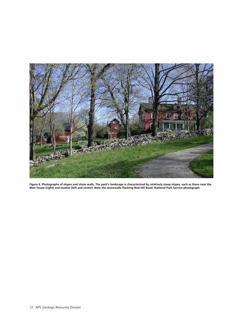
Mass Wasting
Mass wasting refers to the dislodging and downslope movement of soil and rock material, such as during a rockfall, slump, debris flow, or landslide. The steeper slopes, characteristic of the rolling hills at Weir Farm National Historic Site, and parallel to Nod Hill Road in particular, may be susceptible to mass wasting events such as slumps, and slope creep. Slopes in the park range from 3 to 50 percent (fig. 6) (National Park Service 1995). Child Associates and Zaitzevsky (1996) prepared a slope landform analysis map available in the park’s cultural landscape report. Gravity, frost heaving, root wedging, and erosion are primary causes of natural slope instability in the park area. Features such as geologic units that dip (recorded as attitude measurements in the GRI digital geologic map data) with the same attitude as local slopes as well as undercut bedrock, deeply weathered bedrock, and natural groundwater seeps all create unstable settings on steep slopes. Care should be taken to ensure that human activities such as landscaping, road construction, facilities development, and recreation (trail use) do not lead to new mass wasting and reactivation of old landslide features. Overused trails and off-trail hiking may funnel sheet flow and increase local erosion. Construction may cut into the toe of a slope or load the top of a slope. Diverting water into certain areas may lubricate slopes causing saturated, unconsolidated material to slide over a resistant layer at depth. Despite trail maintenance structures in place to counteract regolith loss and surface degradation, several trails at the site experience erosion. In the chapter about hill slope monitoring in Geological Monitoring, published by the Geological Society of America, Wieczorek and Snyder (2009) suggested five methods and vital signs that the park should consider if monitoring slope movements becomes necessary: types of landslides, landslide triggers and causes, geologic materials in landslides, measurement of landslide movement and assessing landslide hazards and risks. In addition, the authors provided a summary of seismic monitoring methods, including needed expertise, special equipment, cost, needed personnel, and labor intensity of each method.
Seismicity
Earthquakes are not common along the passive margin of the east coast of the United States. However, in the Weir Farm National Historic Site area, small earthquakes are occasionally felt. According to the U.S. Geological Survey’s earthquake database (http://earthquake.usgs.gov/), the largest local
earthquake in the past 35 years was magnitude 4.0 in 1985 with an epicenter 56 km (35 mi) from the park. A magnitude 3 (approximate) earthquake occurred near Danbury, Connecticut approximately 18 km (11 mi) northwest of the park in 2007 (Thornberry-Ehrlich 2007). At Weir Farm National Historic site, moderate seismic events could damage cultural resources at the park such as buildings, foundations, rock walls, and dams. According to the U.S. Geological Survey’s national seismic hazard map of 2008, Weir Farm National Historic Site is located in an area of moderately low hazard that trends throughout New England (Peterson et al. 2008a, 2008b). Seismic monitoring data can be used for many purposes such as determining the frequency of earthquake activity, evaluating earthquake risk, interpreting the geologic and tectonic activity of an area, and providing an effective vehicle for public information and education (Braile 2009). In the chapter about seismic monitoring in Geological Monitoring, published by the Geological Society of America, Braile (2009) highlighted methods for seismic monitoring such as monitoring earthquake activity, analysis and statistics of earthquake activity, analysis of historical and prehistoric earthquake activity, earthquake risk estimation, and geomorphic and geologic indications of active tectonics. In addition, Braile (2009) provided a summary of seismic monitoring methods, including needed expertise, special equipment, cost, needed personnel, and labor intensity of each method.
Suggestions for Geologic Work at Weir Farm National Historic Site
• Submit a proposal to the NPS Geologic Resources Division, Geoscientists-in-the-Parks (GIP) program to develop an interpretive trail guide map focusing on geologic controls of landscape evolution and how the landscape inspired many works of art at Weir Farm National Historic Site (Contact Lisa Norby, GIP website: http://nature.nps.gov/geology/gip/index.cfm). Such a product may include maps showing points where artists created artworks en plein air to allow visitors to understand the natural setting that artists found inspirational.
• In places where land records are insufficient, the lichen on stonewalls at Weir Farm may be used to determine timing of their construction.
• Layer the digital geologic map data with vegetation map data to determine correlations between vegetation patterns and the underlying geologic framework, or identify areas in need of more detailed mapping. The park’s vegetation map is available for viewing with Google Earth on the network website: http://science.nature.nps.gov/im/units/NETN/. Large-scale vegetation maps exist for the national historic site at: http://biology.usgs.gov/npsveg/wefa/index.html. These can also be combined with the park’s soils map and database (National Park Service 2006).
10 NPS Geologic Resources Division
Figure 4. Map of management zones. Weir Farm National Historic Site has designated management zones with different management strategies. Graphic by Trista L. Thornberry-Ehrlich (Colorado State University) after a graphic on page 9 in National Park Service (1995).
WEFA Geologic Resources Inventory Report 11
Figure 5. Photographs of the pond. J. Alden Weir created a small fishing pond in 1896 by constructing a stone dam (visible in the background of the historic photo, above). The pond featured prominently in many of Weir’s works. The pond and dam are now maintained as cultural resources within Weir Farm National Historic Site. National Park Service photographs courtesy Allison Herrmann (Weir Farm NHS).
12 NPS Geologic Resources Division
Figure 6. Photographs of slopes and stone walls. The park’s landscape is characterized by relatively steep slopes, such as these near the Weir house (right) and studios (left and center). Note the stonewalls flanking Nod Hill Road. National Park Service photograph.
WEFA Geologic Resources Inventory Report 13
Geologic Features and Processes
This section describes the most prominent and distinctive geologic features and processes in Weir Farm National Historic Site. Glacial Features
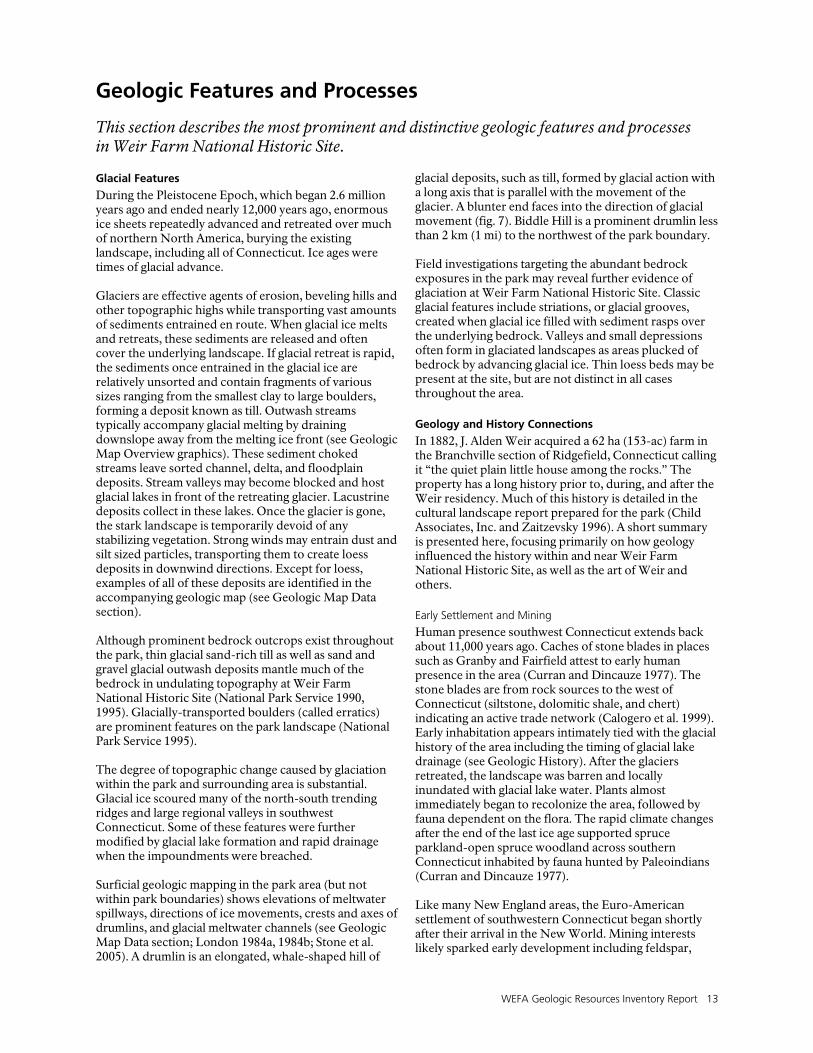
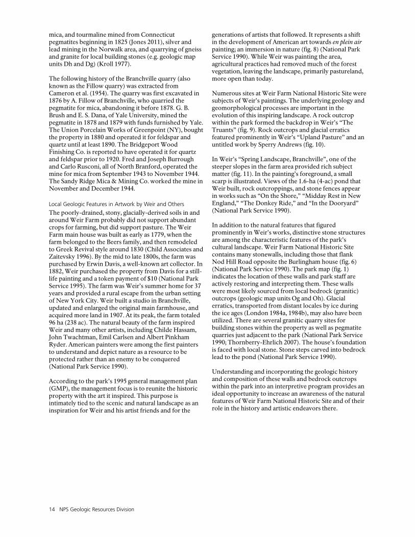
During the Pleistocene Epoch, which began 2.6 million years ago and ended nearly 12,000 years ago, enormous ice sheets repeatedly advanced and retreated over much of northern North America, burying the existing landscape, including all of Connecticut. Ice ages were times of glacial advance. Glaciers are effective agents of erosion, beveling hills and other topographic highs while transporting vast amounts of sediments entrained en route. When glacial ice melts and retreats, these sediments are released and often cover the underlying landscape. If glacial retreat is rapid, the sediments once entrained in the glacial ice are relatively unsorted and contain fragments of various sizes ranging from the smallest clay to large boulders, forming a deposit known as till. Outwash streams typically accompany glacial melting by draining downslope away from the melting ice front (see Geologic Map Overview graphics). These sediment choked streams leave sorted channel, delta, and floodplain deposits. Stream valleys may become blocked and host glacial lakes in front of the retreating glacier. Lacustrine deposits collect in these lakes. Once the glacier is gone, the stark landscape is temporarily devoid of any stabilizing vegetation. Strong winds may entrain dust and silt sized particles, transporting them to create loess deposits in downwind directions. Except for loess, examples of all of these deposits are identified in the accompanying geologic map (see Geologic Map Data section). Although prominent bedrock outcrops exist throughout the park, thin glacial sand-rich till as well as sand and gravel glacial outwash deposits mantle much of the bedrock in undulating topography at Weir Farm National Historic Site (National Park Service 1990, 1995). Glacially-transported boulders (called erratics) are prominent features on the park landscape (National Park Service 1995). The degree of topographic change caused by glaciation within the park and surrounding area is substantial. Glacial ice scoured many of the north-south trending ridges and large regional valleys in southwest Connecticut. Some of these features were further modified by glacial lake formation and rapid drainage when the impoundments were breached. Surficial geologic mapping in the park area (but not within park boundaries) shows elevations of meltwater spillways, directions of ice movements, crests and axes of drumlins, and glacial meltwater channels (see Geologic Map Data section; London 1984a, 1984b; Stone et al. 2005). A drumlin is an elongated, whale-shaped hill of
glacial deposits, such as till, formed by glacial action with a long axis that is parallel with the movement of the glacier. A blunter end faces into the direction of glacial movement (fig. 7). Biddle Hill is a prominent drumlin less than 2 km (1 mi) to the northwest of the park boundary. Field investigations targeting the abundant bedrock exposures in the park may reveal further evidence of glaciation at Weir Farm National Historic Site. Classic glacial features include striations, or glacial grooves, created when glacial ice filled with sediment rasps over the underlying bedrock. Valleys and small depressions often form in glaciated landscapes as areas plucked of bedrock by advancing glacial ice. Thin loess beds may be present at the site, but are not distinct in all cases throughout the area.
Geology and History Connections
In 1882, J. Alden Weir acquired a 62 ha (153-ac) farm in the Branchville section of Ridgefield, Connecticut calling it “the quiet plain little house among the rocks.” The property has a long history prior to, during, and after the Weir residency. Much of this history is detailed in the cultural landscape report prepared for the park (Child Associates, Inc. and Zaitzevsky 1996). A short summary is presented here, focusing primarily on how geology influenced the history within and near Weir Farm National Historic Site, as well as the art of Weir and others.
Early Settlement and Mining
Human presence southwest Connecticut extends back about 11,000 years ago. Caches of stone blades in places such as Granby and Fairfield attest to early human presence in the area (Curran and Dincauze 1977). The stone blades are from rock sources to the west of Connecticut (siltstone, dolomitic shale, and chert) indicating an active trade network (Calogero et al. 1999). Early inhabitation appears intimately tied with the glacial history of the area including the timing of glacial lake drainage (see Geologic History). After the glaciers retreated, the landscape was barren and locally inundated with glacial lake water. Plants almost immediately began to recolonize the area, followed by fauna dependent on the flora. The rapid climate changes after the end of the last ice age supported spruce parkland-open spruce woodland across southern Connecticut inhabited by fauna hunted by Paleoindians (Curran and Dincauze 1977). Like many New England areas, the Euro-American settlement of southwestern Connecticut began shortly after their arrival in the New World. Mining interests likely sparked early development including feldspar,
14 NPS Geologic Resources Division
mica, and tourmaline mined from Connecticut pegmatites beginning in 1825 (Jones 2011), silver and lead mining in the Norwalk area, and quarrying of gneiss and granite for local building stones (e.g. geologic map units Dh and Dg) (Kroll 1977). The following history of the Branchville quarry (also known as the Fillow quarry) was extracted from Cameron et al. (1954). The quarry was first excavated in 1876 by A. Fillow of Branchville, who quarried the pegmatite for mica, abandoning it before 1878. G. B. Brush and E. S. Dana, of Yale University, mined the pegmatite in 1878 and 1879 with funds furnished by Yale. The Union Porcelain Works of Greenpoint (NY), bought the property in 1880 and operated it for feldspar and quartz until at least 1890. The Bridgeport Wood Finishing Co. is reported to have operated it for quartz and feldspar prior to 1920. Fred and Joseph Burrough and Carlo Rusconi, all of North Branford, operated the mine for mica from September 1943 to November 1944. The Sandy Ridge Mica & Mining Co. worked the mine in November and December 1944.
Local Geologic Features in Artwork by Weir and Others
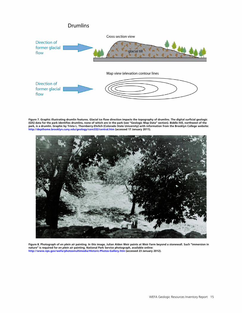
The poorly-drained, stony, glacially-derived soils in and around Weir Farm probably did not support abundant crops for farming, but did support pasture. The Weir Farm main house was built as early as 1779, when the farm belonged to the Beers family, and then remodeled to Greek Revival style around 1830 (Child Associates and Zaitevsky 1996). By the mid to late 1800s, the farm was purchased by Erwin Davis, a well-known art collector. In 1882, Weir purchased the property from Davis for a still-life painting and a token payment of $10 (National Park Service 1995). The farm was Weir’s summer home for 37 years and provided a rural escape from the urban setting of New York City. Weir built a studio in Branchville, updated and enlarged the original main farmhouse, and acquired more land in 1907. At its peak, the farm totaled 96 ha (238 ac). The natural beauty of the farm inspired Weir and many other artists, including Childe Hassam, John Twachtman, Emil Carlsen and Albert Pinkham Ryder. American painters were among the first painters to understand and depict nature as a resource to be protected rather than an enemy to be conquered (National Park Service 1990). According to the park’s 1995 general management plan (GMP), the management focus is to reunite the historic property with the art it inspired. This purpose is intimately tied to the scenic and natural landscape as an inspiration for Weir and his artist friends and for the
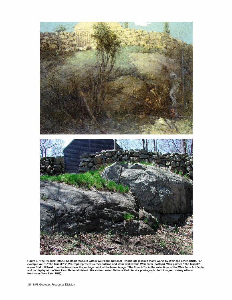
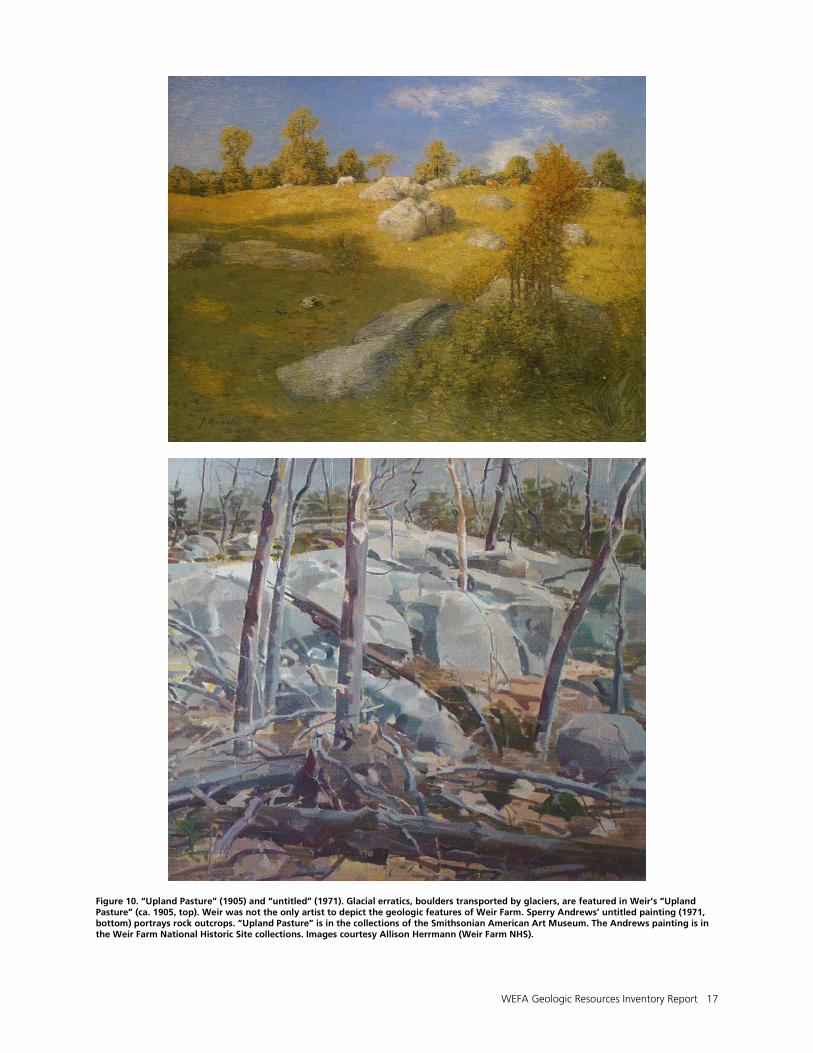
generations of artists that followed. It represents a shift in the development of American art towards en plein air painting; an immersion in nature (fig. 8) (National Park Service 1990). While Weir was painting the area, agricultural practices had removed much of the forest vegetation, leaving the landscape, primarily pastureland, more open than today. Numerous sites at Weir Farm National Historic Site were subjects of Weir’s paintings. The underlying geology and geomorphological processes are important in the evolution of this inspiring landscape. A rock outcrop within the park formed the backdrop in Weir’s “The Truants” (fig. 9). Rock outcrops and glacial erratics featured prominently in Weir’s “Upland Pasture” and an untitled work by Sperry Andrews (fig. 10). In Weir’s “Spring Landscape, Branchville”, one of the steeper slopes in the farm area provided rich subject matter (fig. 11). In the painting’s foreground, a small scarp is illustrated. Views of the 1.6-ha (4-ac) pond that Weir built, rock outcroppings, and stone fences appear in works such as “On the Shore,” “Midday Rest in New England,” “The Donkey Ride,” and “In the Dooryard” (National Park Service 1990). In addition to the natural features that figured prominently in Weir’s works, distinctive stone structures are among the characteristic features of the park’s cultural landscape. Weir Farm National Historic Site contains many stonewalls, including those that flank Nod Hill Road opposite the Burlingham house (fig. 6) (National Park Service 1990). The park map (fig. 1) indicates the location of these walls and park staff are actively restoring and interpreting them. These walls were most likely sourced from local bedrock (granitic) outcrops (geologic map units Og and Oh). Glacial erratics, transported from distant locales by ice during the ice ages (London 1984a, 1984b), may also have been utilized. There are several granitic quarry sites for building stones within the property as well as pegmatite quarries just adjacent to the park (National Park Service 1990; Thornberry-Ehrlich 2007). The house’s foundation is faced with local stone. Stone steps carved into bedrock lead to the pond (National Park Service 1990). Understanding and incorporating the geologic history and composition of these walls and bedrock outcrops within the park into an interpretive program provides an ideal opportunity to increase an awareness of the natural features of Weir Farm National Historic Site and of their role in the history and artistic endeavors there.
WEFA Geologic Resources Inventory Report 15
Figure 7. Graphic illustrating drumlin features. Glacial ice flow direction impacts the topography of drumlins. The digital surficial geologic (GIS) data for the park identifies drumlins, none of which are in the park (see “Geologic Map Data” section). Biddle Hill, northwest of the park, is a drumlin. Graphic by Trista L. Thornberry-Ehrlich (Colorado State University) with information from the Brooklyn College website: http://depthome.brooklyn.cuny.edu/geology/core332/central.htm (accessed 17 January 2011).
Figure 8. Photograph of en plein air painting. In this image, Julian Alden Weir paints at Weir Farm beyond a stonewall. Such “immersion in nature” is required for en plein air painting. National Park Service photograph, available online: http://www.nps.gov/wefa/photosmultimedia/Historic-Photos-Gallery.htm (accessed 23 January 2012).
16 NPS Geologic Resources Division
Figure 9. “The Truants” (1895). Geologic features within Weir Farm National Historic Site inspired many works by Weir and other artists. For example Weir’s “The Truants” (1895, top) represents a rock outcrop and stone wall within Weir Farm (bottom). Weir painted “The Truants” across Nod Hill Road from the barn, near the vantage point of the lower image. “The Truants” is in the collections of the Weir Farm Art Center and on display at the Weir Farm National Historic Site visitor center. National Park Service photograph. Both images courtesy Allison Herrmann (Weir Farm NHS).
WEFA Geologic Resources Inventory Report 17
Figure 10. “Upland Pasture” (1905) and “untitled” (1971). Glacial erratics, boulders transported by glaciers, are featured in Weir’s “Upland Pasture” (ca. 1905, top). Weir was not the only artist to depict the geologic features of Weir Farm. Sperry Andrews’ untitled painting (1971, bottom) portrays rock outcrops. “Upland Pasture” is in the collections of the Smithsonian American Art Museum. The Andrews painting is in the Weir Farm National Historic Site collections. Images courtesy Allison Herrmann (Weir Farm NHS).
18 NPS Geologic Resources Division
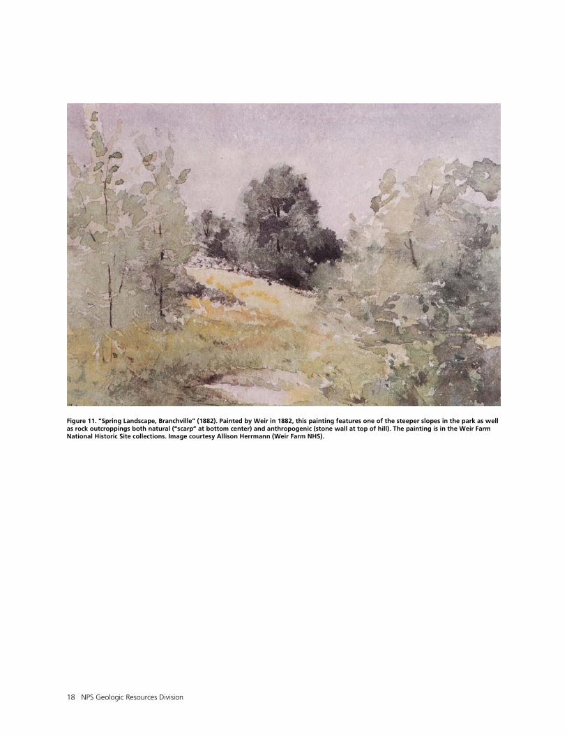
Figure 11. “Spring Landscape, Branchville” (1882). Painted by Weir in 1882, this painting features one of the steeper slopes in the park as well as rock outcroppings both natural (“scarp” at bottom center) and anthropogenic (stone wall at top of hill). The painting is in the Weir Farm National Historic Site collections. Image courtesy Allison Herrmann (Weir Farm NHS).
WEFA Geologic Resources Inventory Report 19
Geologic History
This section describes the rocks and unconsolidated deposits that appear on the digital geologic map of Weir Farm National Historic Site, the environment in which those units were deposited, and the timing of geologic events that formed the present landscape. The geologic history of Weir Farm National Historic Site includes several major mountain-building events (orogenies) that led to the formation of the Appalachian Mountains and the assembly of the supercontinent Pangaea hundreds of millions of years ago. Much more recently, over the past 2 million years, glacial ice sculpted the landscape during the ice ages. In and around the park, this geologic history is reflected in rocks that span from the Proterozoic (approximately one billion years ago) to the present (fig. 12). Coleman (2005) provides a comprehensive summary of the bedrock geologic history of Connecticut. Stone et al. (2005) provides an updated interpretation of the surficial (glacial) geology of the Weir Farm area.
Proterozoic Eon (2,500–542 million years ago): Ancient Mountain Building and Iapetus Ocean Formation
The banded and foliated gneiss of Highlands massifs (geologic map unit Yg) and other rocks of North America’s ancient core (craton) west of the park, form an area uplifted and metamorphosed during the Grenville Orogeny, over one billion years ago (Clark 1956; Rodgers 1985; Karabinos et al. 1999). These ancient rocks were progressively modified, deformed, and metamorphosed by the tectonic forces responsible for the formation of the younger Appalachian Mountains, described below (Doolan 1996). As an illustration of just how much rock from this time period is now missing, rocks metamorphosed during the Grenville Orogeny, now exposed at the surface in Vermont, may have been buried beneath 35 km (22 mi) of rock (Doolan 1996). Approximately 590 million years ago, continental rifting in the area began to open an ocean basin that eventually became the Iapetus Ocean. This caused the Grenville highlands to become the eastern margin of the proto-North American continent (Laurentia) for nearly 100 million years (Coleman 2005; Kim and Wunsch 2009). The Grenville continental margin persisted until approximately 510 million years ago, when the geologic forces changed from extension and spreading to convergence (fig. 13; Coleman 2005; Kim and Wunsch 2009). Rocks east of the Proterozoic Grenville rocks, including those in the park area, formed after the development of the eastern continental margin of ancient North America (Doolan 1996).
Paleozoic Era (542–251 million years ago): Building the Appalachians and Assembling Pangaea
At the dawn of the Paleozoic Era, continued rifting, subsidence, and marine incursion established a depositional basin where marine sediments were deposited atop rift-stage sediments, persisting for
approximately 100 million years (Doolan 1996). These deposits were initially a blanket of beach or tidal-flat sandstones (later metamorphosed into quartzite and gneiss such as the Cambrian Dalton Formation and Manhattan Schist, geologic map units Cd and Cm, respectively), which are sporadically exposed along a north-south trending belt throughout New England. Their deposition coincided with the opening of the Iapetus Ocean adjacent to the North American continental margin (Doll et al. 1961; Rodgers 1985; Doolan 1996). Other marine deposits, including Cambrian and Lower Ordovician carbonates such as that in the Stockbridge Marble (OCs), collected in shallow marine tidal-flats atop the sandstone deposition (Mehrtens 1985; Rodgers 1985; Doolan 1996). The deposition of carbonates and mixed sediments continued into the Ordovician Period as part of a well-developed Cambrian-Ordovician shallow-ocean platform adjacent to the continental margin. Units from this time in the park area include the Walloomsac Schist (Ow) (Rodgers 1985). Meanwhile, a series of volcanic arcs and sediments within the Iapetus Ocean were approaching the North American continent (figs. 13A and 14). Prior to their contact with the continent, internal deformation, plutonism, and possibly metamorphism were already taking place within the rocks of the Iapetus basin (Spinek 1988). The rising sea level associated with the beginning of the Taconic Orogeny approximately 475 to 470 million years ago drowned the longstanding eastern margin of North America (Karabinos et al. 1998). Volcanic arcs were also active in the Iapetus Ocean basin during this time (fig. 13B) (Kim and Wunsch 2009). The timing, extent, and exact nature of collisions between numerous volcanic arcs and the North American continent of the Taconic Orogeny (and other Paleozoic orogenies) in New England is debatable and the subject of ongoing study. Wintsch et al. (1993) provides a comprehensive look at the timing of terrane accretion in southeastern New England. In general, it involved the collision of one or more volcanic arcs with the North American continent, subduction of oceanic crust, and the eventual destruction of the Iapetus Ocean (Skehan 2008). Ocean basin sediments were disrupted and in some cases transported long distances (tens of kilometers) to the west by thrust faults (figs. 13 and 14). Approximately 460 to 440 million years ago, deep water sediments were transported thus onto the Cambrian-Ordovician carbonate platform that formed on the
20 NPS Geologic Resources Division
continental margin as part of the Iapetus terrane (Doolan 1996; Coleman 2005). Cameron’s Line, a large thrust fault feature just west of Weir Farm National Historic Site, separates the continental shelf and slope deposits on the west from the similarly aged, deep ocean basin and volcanic arc rocks to the east (figs. 13 and 14) (Amenta and Mose 1985; U.S. Geological Survey 2003b). Thrusting along this line deformed a mixture (mélange) of rocks that are exposed in the park area (Spinek 1988). Rocks from this period, east of Cameron’s Line, include the Cambrian and Lower Ordovician Row Schist (OCr), the Ratlum Mountain Schist (Or), and the Harrison Gneiss (Oh) (Kroll 1977; Rodgers 1985; Kroll 1994). Volcanic arcs formed above subduction zones and fragments of crust that formed elsewhere (terranes) were accreted to the North American craton. As a result of the additional land and tremendous compressive forces, the eastern margin of the continent grew eastward and formed the Taconic Mountains just west of the park area in New York (Doolan 1996; U.S. Geological Survey 2003b; Coleman 2005; Kim and Wunsch 2009). The delineations of individual terranes and the timing of their addition to the continent is a complex topic and is still subject matter for debate and study among geologists. After the Taconic Orogeny ended around 430 million years ago, the majority of Connecticut was situated on the western shore of the Iapetus Ocean basin (figs. 13B and 14). At this time, lands east of the Taconic Mountains and Green Mountains of Vermont to the north began to stretch and subside (Doolan 1996). The Connecticut Valley trough (synclinorium) formed during the Silurian Period (approximately 444 to 416 million years ago) as a result of rifting or extensional episodes between periods of collisions or compressional events (Sevigny and Hanson 1993; Wintsch et al. 1993; Karabinos et al. 2003). This elongate basin extended from New England and Quebec as far north as the Gaspé Peninsula (Doolan 1996). The basin filled with sediments shed from the western highlands. The sediments that would later be metamorphosed to form the Middle Ordovician Brookfield Gneiss (Ob) and other granitic and felsic gneisses (including geologic map unit Og) collected at this time (Rodgers 1985). By the early Devonian Period, about 375 million years ago, landmasses were converging again along the eastern seaboard of ancient North America while the Iapetus Ocean was rapidly disappearing (Doolan 1996). Crustal heating generated vast amounts of magma beneath Earth’s surface. This marked the onset of the Acadian Orogeny, when the Nashoba volcanic arc and Avalonia ultimately collided with the Taconic margin of Laurentia (proto North America) (fig. 13C) (Sevigny and Hanson 1993; Karabinos et al. 1999; Coleman 2005). Devonian rocks in the park area include coarsely-crystalline pegmatite (Dp), dark hornblendite (Dh), and pink-colored, banded granodiorite gneiss (Dgog) (Rodgers 1985). These rocks, as well as a series of felsic and mafic bodies of once-molten rock (called plutons) along Cameron’s Line, formed as a result of the magma
generation and intrusion prior to the culmination of the Acadian Orogeny (Amenta and Mose 1985; Sevigny and Hanson 1993). Compression, deformation, and melting along the convergent zone associated with the orogeny metamorphosed the rocks in the park area (Sevigny and Hanson 1993). Cameron’s Line may have experienced renewed movement or deformation during this time (Amenta and Mose 1985). During the Acadian Orogeny, compressional tectonic forces deformed and folded the sediments deposited in the Connecticut Valley trough and metamorphosed the igneous intrusions into gneisses. The Acadian Orogeny resulted in the final assembly of the various small continental blocks (terranes) of New England (Doolan 1996). Later in the Paleozoic, approximately 315 to 295 million years ago, the African continent (part of Gondwana) collided with the North American continent during the Alleghany Orogeny (figs. 13D and 14). Most of the effects of this collisional event were focused elsewhere, generally in the central and southern Appalachian Mountains, though some folding and other deformation may have taken place in the park area (Wintsch et al. 1993; Doolan 1996). There is some evidence of metamorphism and small-scale igneous intrusion in southwestern Connecticut (Sevigny and Hanson 1993; Moecher et al. 1997). At this time, New England was in the core of the supercontinent Pangaea, until extensional forces began again at the dawn of the Mesozoic Era (fig. 14) (Doolan 1996).
Mesozoic Era (251–65.5 million years ago): Pangaea Separation, Atlantic Ocean Formation, and Appalachian Mountain Erosion
When rifting pulled Africa away from North America forming the Atlantic Ocean during the Triassic and Jurassic Periods, predominantly north-south trending normal faults were active in much of New England (figs. 12E and 13) (Thompson et al. 1993). A prominent fault to the east of the park possibly formed at this time (R. Steinen, geologist, State Geologic and National History Survey of Connecticut, written communication August 2011). Rifting included the formation of many extensional basins including the Hartford Basin to the east (fig. 12E) (Hubert et al. 1978; Coleman 2005; Schoene et al. 2010; Tweet et al. 2010). These rifts marked the break-up of Pangaea. Steeply dipping normal faults typically form the boundaries of these basins, which quickly fill with sediment eroded from the surrounding highlands. Following the Mesozoic rifting, the park area of Connecticut became relatively passive with occasional seismicity. Erosion caused by the incision of local rivers began to wear away the mountains formed during the Paleozoic orogenic events. Weathering and erosion dominate the geologic history of the park area throughout the Mesozoic and most of the following Cenozoic Era (fig. 14). At the dawn of the Cenozoic Era, the crystalline and sedimentary rocks of Connecticut were likely covered by a nearly continuous mantle of weathered bedrock and saprolite (Stone et al. 2005).
WEFA Geologic Resources Inventory Report 21
Cenozoic Era (the past 65.5 million years): Appalachian Mountain Erosion and Ice Age Glaciation
Repeated glaciations (ice ages) during the Pleistocene Epoch (between 2.6 million years ago and approximately 12,000 years ago) scoured and reworked the preexisting topography of most of New England. Stone et al. (2005) provides a comprehensive study of the glacial history of the area. Thick sheets of ice repeatedly advanced and retreated over the landscape. The most recent glacial advance of the area was by the Hudson-Champlain lobe of the Laurentide Ice Sheet (fig. 15; Connally and Sirkin 1973; Dyke and Prest 1987). It obscured and overprinted previous glacial signatures and deposited a great quantity of glacial sediments that may be a source for fossils (mammal bones, plant fragments, pollen, spores, algal and invertebrate fossils) at Weir Farm National Historic Site (Tweet et al. 2010). This thick mantle of sediments covers much of the bedrock (PZPCbro) throughout the area (London 1984a, 1984b). The character and distribution of the glacial deposits of Connecticut is largely determined by the bedrock geologic foundation (Stone et al. 2005). More resistant bedrock tends to persist as ridges surrounded by thick glacial deposits. As glacial ice retreated from the Weir Farm area of Connecticut for the last time approximately 20,000 calendar years ago, vast glacial lakes of meltwater formed in valleys dammed by ice and sediment (Deevey 1939; Connally and Sirkin 1973; Stone et al. 2005; Faux and Joyce 2006). Glacial Lake Danbury and Glacial Lake Kenosia, both north in the Housatonic River Valley, were locally important (fig. 16). In southern Connecticut, glacial sediments can be divided into different depositional basins: the Saugatuck River (Qsr7, Qsr6, Qws, Qus, Qsp, and Qup), Norwalk River (Qnr6, Qnr5, Qnr4, Qnr3, Qgs, Qesm, and Qcb), and Housatonic River basins (Qkb, Qdsb, Qsb, Qn, and Qwb). The geologic map data (GIS) for Weir Farm NHS includes these deposits (see Geologic Map Data section and Map Unit Properties Table). Deposits in the Saugatuck River basin include coarse-grained gravel and cobble beds, occasional till lenses, and thin sand and pebble deposits mostly deposited in fluvial-deltaic settings as braided river channels flowing into glacial lakes (London 1984b). Deposits in the Norwalk River basin include sand, silt, and clay layers with occasional coarser-grained beds of cobbles, pebbles, and boulders along with lenses of till from glacial lakes and ice-front river deltas persistent in the area throughout the Pleistocene glacial retreat (London 1984a, 1984b). Within the Housatonic River Basin, fine-grained, layered (varves) lacustrine deposits collected in Glacial Lake Danbury (Qdsb) and Glacial Lake Kenosia (Qkb). Coarser cobble gravels represent ice-contact deltas (sediments shed directly from the glacier into the lake) into ice-marginal lakes locally (London 1984b). Glaciolacustrine varve deposits contain trace fossils that record the timing of re-inhabitation of New England by fish and associated invertebrates (Benner et al. 2009), which in turn has implications for the succession of
vegetation and eventually human habitation of the Connecticut area. Locally, colonization of the recently deglaciated and newly formed lacustrine environments occurred in at least four successional stages: 1) invertebrates, 2) initial presence of fish, 3) crustacean and ichnofauna, and 4) more fish species specific to non-glacial water sources (Benner et al. 2009). Gaudreau (1982) indicated that physiography strongly influenced the vegetational history of a given area. Valleys tended to have greater biodiversity and more rapid succession of plants, whereas uplands were less prone to diversity and rapidly changing flora (Gaudreau 1982; Curran and Dincauze 1977). This may have been due to less unconsolidated regolith or higher drainage atop bedrock ridges, harsher conditions (wind and temperature) on ridgetops, or bare bedrock surfaces as opposed to deep drifts of glacial sediment. Weir Farm National Historic Site is located in the highlands between large drainage systems and was likely never inundated by glacial lakes. Lake sediments do appear on the digital geologic map near the park and contribute to the overall story of the landscape. Glaciers also left several vast deposits of till and scattered glacial erratics (painted by Weir and other artists) on the Weir Farm landscape including an older, lower till (Qtl), and a younger, upper till (Qtu). Glacial till locally contains poorly sorted, non-stratified, mixtures of sediments ranging in size from clay to boulders (London 1984a; 1984b). Since the glaciers melted away from southern Connecticut, local rivers have incised channels through the glacial sediments and slope erosion is continually subduing the topographic expression. Throughout the Holocene, deposits of alluvium (Qal), swamp (Qs), and floodplain deposits accumulated on the park’s landscape (London 1984a, 1984b; Stone et al. 2005). These deposits include sand, gravel, silt, and local peat and muck (London 1984 a, 1984b). Soils, including stony and loamy types, continue to develop on the landscape mainly sourced from glacial till (National Park Service 1995, 2006). Humans first appeared in New England over ten thousand years ago and left behind carved stones, stone blades, burial sites, and campsites (Curran and Dincauze 1977; Calogero and Philpotts 1998; Calogero et al. 1999). Human alteration of the landscape included deforestation, damming of waterways, and draining of swamps. Artificial fill (Qaf and Qafg) and graded areas represent a fraction of the impact humans have on the landscape in the Weir Farm area (London 1984a; 1984b). Geologic processes of continental collision and weathering shaped the landscape at Weir Farm National Historic Site. The geologic history and framework at the park, in concert with the climate and soils, are integral to the development of the landscape that so inspired the many resident artists from Julian Alden Weir, Mahonri Young, Dorothy and Sperry Andrews, to current artists and visitors to the park.
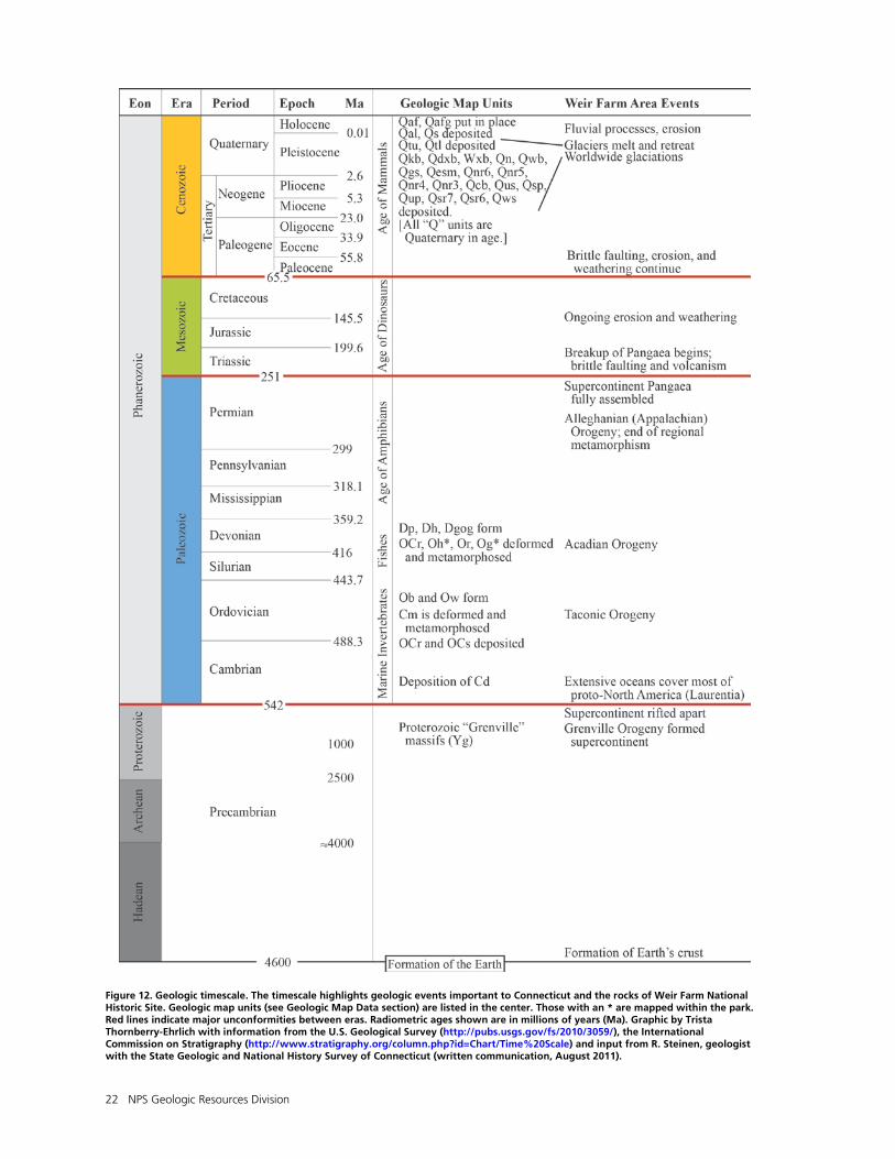
22 NPS Geologic Resources Division
Figure 12. Geologic timescale. The timescale highlights geologic events important to Connecticut and the rocks of Weir Farm National Historic Site. Geologic map units (see Geologic Map Data section) are listed in the center. Those with an * are mapped within the park. Red lines indicate major unconformities between eras. Radiometric ages shown are in millions of years (Ma). Graphic by Trista Thornberry-Ehrlich with information from the U.S. Geological Survey (http://pubs.usgs.gov/fs/2010/3059/), the International Commission on Stratigraphy (http://www.stratigraphy.org/column.php?id=Chart/Time%20Scale) and input from R. Steinen, geologist with the State Geologic and National History Survey of Connecticut (written communication, August 2011).
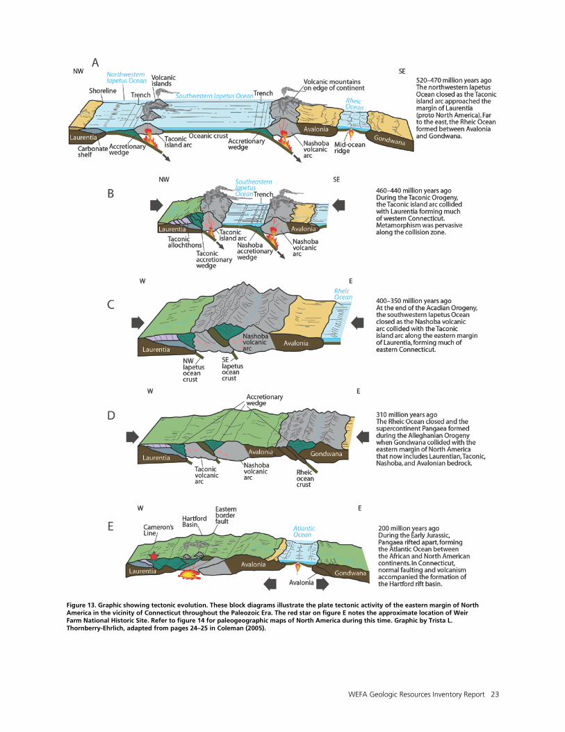
WEFA Geologic Resources Inventory Report 23
Figure 13. Graphic showing tectonic evolution. These block diagrams illustrate the plate tectonic activity of the eastern margin of North America in the vicinity of Connecticut throughout the Paleozoic Era. The red star on figure E notes the approximate location of Weir Farm National Historic Site. Refer to figure 14 for paleogeographic maps of North America during this time. Graphic by Trista L. Thornberry-Ehrlich, adapted from pages 24–25 in Coleman (2005).
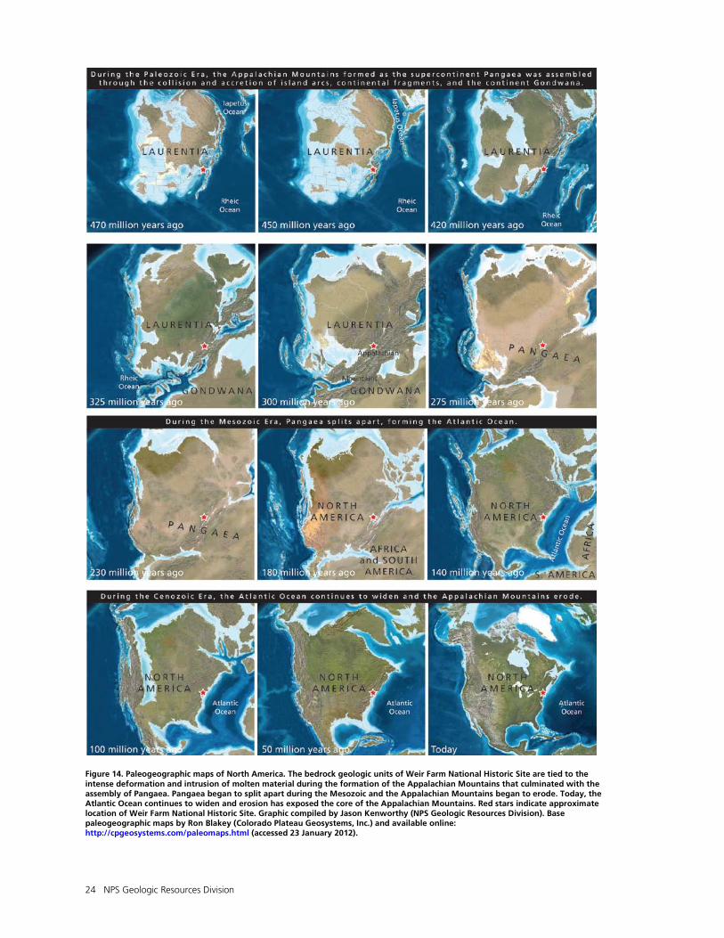
24 NPS Geologic Resources Division
Figure 14. Paleogeographic maps of North America. The bedrock geologic units of Weir Farm National Historic Site are tied to the intense deformation and intrusion of molten material during the formation of the Appalachian Mountains that culminated with the assembly of Pangaea. Pangaea began to split apart during the Mesozoic and the Appalachian Mountains began to erode. Today, the Atlantic Ocean continues to widen and erosion has exposed the core of the Appalachian Mountains. Red stars indicate approximate location of Weir Farm National Historic Site. Graphic compiled by Jason Kenworthy (NPS Geologic Resources Division). Base paleogeographic maps by Ron Blakey (Colorado Plateau Geosystems, Inc.) and available online: http://cpgeosystems.com/paleomaps.html (accessed 23 January 2012).
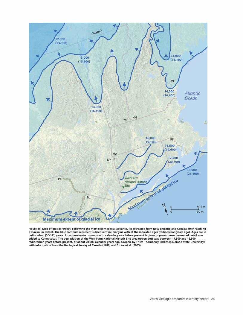
WEFA Geologic Resources Inventory Report 25
Figure 15. Map of glacial retreat. Following the most recent glacial advance, ice retreated from New England and Canada after reaching a maximum extent. The blue contours represent subsequent ice margins with at the indicated ages (radiocarbon years ago). Ages are in radiocarbon (“C-14”) years. An approximate conversion to calendar years before present is given in parentheses. Increased detail was added to Connecticut. The deglaciation of the Weir Farm National Historic Site area (green dot) was between 17,500 and 16,500 radiocarbon years before present, or about 20,000 calendar years ago. Graphic by Trista Thornberry-Ehrlich (Colorado State University) with information from the Geological Survey of Canada (1986) and Stone et al. (2005).
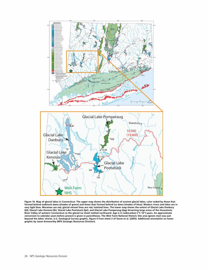
26 NPS Geologic Resources Division
Figure 16. Map of glacial lakes in Connecticut. The upper map shows the distribution of ancient glacial lakes, color coded by those that formed behind sediment dams (shades of green) and those that formed behind ice dams (shades of blue). Modern rivers and lakes are in very light blue. Moraines are red, glacial retreat lines are red, hatched lines. The lower map shows the extent of Glacial Lake Danbury (ld), Glacial Lake Kenosia (lk), Glacial Lake Pootatuck (lpt), and Glacial Lake Pomperaug (lpg) drowning large areas of the Housatonic River Valley of western Connecticut as the glacial ice sheet melted northward. Age is in radiocarbon (“C-14”) years. An approximate conversion to calendar years before present is given in parentheses. The Weir Farm National Historic Site area (green star) was just beyond the lakes’ shores. U.S. Geological Survey graphic, figure 4 from sheet 2 of Stone et al. (2005). Additional annotation on lower graphic by Jason Kenworthy (NPS Geologic Resources Division).
WEFA Geologic Resources Inventory Report 27
Geologic Map Data
This section summarizes the geologic map data available for Weir Farm National Historic Site. It includes a fold-out geologic map overview and a summary table that lists each map unit displayed on the digital geologic map for the park. Complete GIS data are included on the accompanying CD and are also available at the Geologic Resources Inventory (GRI) publications website: http://www.nature.nps.gov/geology/inventory/ gre_publications.cfm. Geologic Maps
Geologic maps facilitate an understanding of an area’s geologic framework and the evolution of its present landscape. Using designated colors and symbols, geologic maps portray the spatial distribution and relationships of rocks and unconsolidated deposits. Geologic maps also may show geomorphic features, structural interpretations, and locations of past geologic hazards that may be prone to future activity. Additionally, anthropogenic features such as mines and quarries may be indicated on geologic maps.
Source Maps
The Geologic Resources Inventory (GRI) team converts digital and/or paper source maps into the GIS formats that conform to the GRI GIS data model. The GRI digital geologic map product also includes essential elements of the source maps including unit descriptions, map legend, map notes, references, and figures. The GRI team used the following source maps to create the digital geologic data for Weir Farm National Historic Site: Kroll, R. L. 1969. Bedrock geology of the Norwalk north
quadrangle, Connecticut (scale 1:24,000).Quadrangle Report 34, plate 1. Connecticut Geological and Natural History Survey, Hartford, Connecticut, USA.
Rodgers, J. 1985. Bedrock geological map of Connecticut
(scale 1:125,000). Connecticut Natural Resources Atlas Series. Connecticut Geological and Natural History Survey, Hartford, Connecticut, USA.
London, E. H. 1984. Surficial geologic map of the
Norwalk North quadrangle, Connecticut (scale 1:24,000). Miscellaneous Field Studies Map MF-1520. U.S. Geological Survey, Reston, Virginia, USA.
London, E. H. 1984. Surficial geologic map of the Bethel
quadrangle, Connecticut (scale 1:24,000). Miscellaneous Field Studies Map MF-1519. U.S. Geological Survey, Reston, Virginia, USA.
These source maps provided information for the “Geologic Issues,” “Geologic Features and Processes,” and “Geologic History” sections of this report.
Geologic GIS Data
The GRI team implements a GIS data model that standardizes map deliverables. The data model is included on the enclosed CD and is also available online (http://science.nature.nps.gov/im/inventory/geology /GeologyGISDataModel.cfm). This data model dictates GIS data structure including layer architecture, feature attribution, and relationships within ESRI ArcGIS software. The GRI team digitized the data for Weir Farm National Historic Site using data model version 2.0. GRI digital geologic data for Weir Farm National Historic Site are included on the attached CD and are available through the NPS Integrated Resource Management Applications (IRMA) Portal (http://irma.nps.gov/App/Reference/ Search?SearchType=Q). Enter “GRI” as the search text and select Weir Farm National Historic Site from the unit list. The following components and geology data layers are part of the data set:
• Bedrock and surficial (glacial) geology data.
• Compiled data are noted by a “WEFA” prefix. Data are also available in component maps, identified by the following prefixes: BETH - Bethel Quadrangle (bedrock), BTHE -Bethel Quadrangle (surficial), NONR - northern third of the Norwalk North Quadrangle (surficial), and NWNO - northern third of the Norwalk North Quadrangle (bedrock).
• Data in ESRI geodatabase and shapefile GIS formats.
• Layer files with feature symbology.
• Federal Geographic Data Committee (FGDC)–compliant metadata.
• A help file (.hlp) document that contains all of the ancillary map information and graphics, including geologic unit correlation tables and map unit descriptions, legends, and other information captured from source maps.
• ESRI map document files (.mxd) that display the digital geologic data. The compiled “wefa_geology.mxd” displays surficial geologic data.
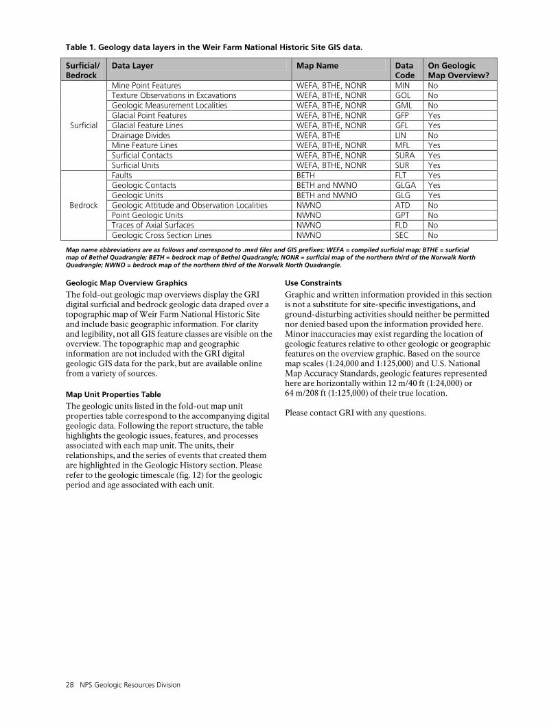
28 NPS Geologic Resources Division
Table 1. Geology data layers in the Weir Farm National Historic Site GIS data.
Surficial/ Bedrock
Data Layer Map Name Data Code
On Geologic Map Overview?
Surficial
Mine Point Features WEFA, BTHE, NONR MIN No Texture Observations in Excavations WEFA, BTHE, NONR GOL No Geologic Measurement Localities WEFA, BTHE, NONR GML No Glacial Point Features WEFA, BTHE, NONR GFP Yes Glacial Feature Lines WEFA, BTHE, NONR GFL Yes Drainage Divides WEFA, BTHE LIN No Mine Feature Lines WEFA, BTHE, NONR MFL Yes Surficial Contacts WEFA, BTHE, NONR SURA Yes Surficial Units WEFA, BTHE, NONR SUR Yes
Bedrock
Faults BETH FLT Yes Geologic Contacts BETH and NWNO GLGA Yes Geologic Units BETH and NWNO GLG Yes Geologic Attitude and Observation Localities NWNO ATD No Point Geologic Units NWNO GPT No Traces of Axial Surfaces NWNO FLD No Geologic Cross Section Lines NWNO SEC No
Map name abbreviations are as follows and correspond to .mxd files and GIS prefixes: WEFA = compiled surficial map; BTHE = surficial map of Bethel Quadrangle; BETH = bedrock map of Bethel Quadrangle; NONR = surficial map of the northern third of the Norwalk North Quadrangle; NWNO = bedrock map of the northern third of the Norwalk North Quadrangle. Geologic Map Overview Graphics
The fold-out geologic map overviews display the GRI digital surficial and bedrock geologic data draped over a topographic map of Weir Farm National Historic Site and include basic geographic information. For clarity and legibility, not all GIS feature classes are visible on the overview. The topographic map and geographic information are not included with the GRI digital geologic GIS data for the park, but are available online from a variety of sources.
Map Unit Properties Table
The geologic units listed in the fold-out map unit properties table correspond to the accompanying digital geologic data. Following the report structure, the table highlights the geologic issues, features, and processes associated with each map unit. The units, their relationships, and the series of events that created them are highlighted in the Geologic History section. Please refer to the geologic timescale (fig. 12) for the geologic period and age associated with each unit.
Use Constraints
Graphic and written information provided in this section is not a substitute for site-specific investigations, and ground-disturbing activities should neither be permitted nor denied based upon the information provided here. Minor inaccuracies may exist regarding the location of geologic features relative to other geologic or geographic features on the overview graphic. Based on the source map scales (1:24,000 and 1:125,000) and U.S. National Map Accuracy Standards, geologic features represented here are horizontally within 12 m/40 ft (1:24,000) or 64 m/208 ft (1:125,000) of their true location. Please contact GRI with any questions.
WEFA Geologic Resources Inventory Report 31
Map Unit Properties Table: Weir Farm National Historic Site
Colored rows indicate units mapped within Weir Farm National Historic Site. Stone et al. (2005) provides an updated interpretation of the surficial geology and glacial history of the park area.
Age Unit Type
Map Unit (Symbol)
Geologic Description Geologic Issues Geologic Features and Processes Geologic History
HO
LOC
ENE
Surf
icia
l Geo
logi
c U
nits
Artificial fill (Qaf)
Artificial fill-graded
(Qafg)
Qaf includes earth materials and/or manmade materials used as fill along roads, dams, railroads, and other construction sites. Qafg also includes areas of significant land surface excavation where natural slopes were destroyed. Variable erosion resistance.
Disturbed lands and Adjacent Land Use—Units are primarily associated with infrastructure and sometimes constructed to alleviate potential hazards. Some exposures may have been quarried in gravel pits.
Modern roadway and borrow ditch habitat. Units are evidence of modern anthropogenic activities altering the natural landscape.
Post
Gla
cial
Dep
osits
Alluvium (Qal)
Swamps
(Qs)
Qal contains gravel, sand, and silt in modern stream channel and floodplain deposits with scant organic matter. Beds of this unit are typically less than 3 m (10 ft) thick. Qs contains organic matter intermixed with sand, silt, and clay. Deposits of Qs are typically less than 3 m (10 ft) thick, but can reach as much as 19 m (61 ft) of peat and muck locally. Low erosion resistance.
Water Issues—Units are associated with fragile riverine and wetland environments and are associated with flooding and regular water saturation.
Units are associated with riparian and wetland habitats. Swamps and wetlands often contain records of paleoclimate and other environmental conditions. Stream channel and floodplain deposits record the evolution of modern waterways.
PLEI
STO
CEN
E
Gla
cial
Ice
Dep
osits
Upper till (Qtu)
Lower till
(Qtl)
Till and bedrock outcrops (Qtbc)
In general, the till mapped throughout the area contains poorly sorted, non-stratified mixtures of rock particles ranging in size from clay to boulders. Color in outcrops ranges from yellowish gray to olive gray and brown. Till mantles bedrock in exposures less than 3 to 5 m (10 to 15 ft) thick, but can be much thicker in drumlin deposits, upwards of 30 m (100 ft). Qtu is loose to moderately compact sand and stony material with lenses of sorted sand and gravel. Qtl is moderately to extremely compact and is finer grained, less stony, and darker in color than Qtu. Qtbc contains mixed exposures of glacial till and bedrock, which are in some areas too numerous or closely spaced to discern at the map scale. Low to moderately low erosion resistance for more compact Qtl. Qtbc is mapped within the park.
Water Issues—Drainage may be poor for particularly clay-rich portions. Geologic Hazards—Units may be prone to slumps and slides where undercut by stream action and exposed on slopes. Disturbed Lands and Adjacent Land Use—Some exposures may have been mined or quarried in gravel pits.
Glacial Features—Deposits associated with glacial history of the area. Till deposits may underlie poorly drained areas such as wetlands. Geology and History Connections—May contain historic to prehistoric remains, and may have provided clay for early brick and pottery. Sand, gravel, silt, clay, boulders, pebbles, iron-manganese stained joints in Qtl. Bedrock outcrops featured in artwork by Weir and others.
Upper till is most prevalent and is associated with the last glacial advance. Lower till is associated with earlier glacial advances. Umpawaug Hill contains more than 30 m (100 ft) of glacial till in a drumlin. Till composition and color reflects those of the local bedrock (parent material). Grumman Hill is strewn with boulders, common on till deposits.
Gla
cial
Str
eam
and
Lak
e D
epos
its
Uncorrelated meltwater deposits
(Qgu)
Qgu contains localized (small), mixed, ice-contact deposits associated with the environments at the retreating edge of the glacier. Lake deposits are typically fine-grained and layered, whereas stream deposits are more coarse and sorted. Low erosion resistance.
Geologic Hazards—Units may be prone to slumps and slides where undercut by stream action and exposed on slopes. Disturbed Lands and Adjacent Land Use—Some exposures may have been quarried in gravel pits.
Glacial Features—Deposits associated with glacial history of the area. Geology and History Connections—Sand, silt, gravel, clay mineral resources may have been quarried.
Deposited near retreating edge of glacier.
Dep
osits
in th
e H
ousa
toni
c R
iver
ba
sin
Glacial Lake Kenosia deposits (Qkb)
Glacial Lake Danbury deposits (Qdsb)
Sympaug Brook area deposits (Qsb)
Nashville Road area deposits (Qn)
Wolfpit Brook area deposits (Qwb)
Qkb contains up to 35 m (116 ft) of interbedded sand, silt, and clay as lake-bottom sediments increasing in thickness from north to south. Swamp deposits (2 to 19 m [8 to 61 ft] thick) underlie Qkb locally. Odsb consists of sand, silt, clay, and some local gravel in deposits 3 to more than 41 m (10 to 135 ft) thick. Local deposits of peat and muck overlie the lacustrine sediments. Qsb contains sand deposits between 3 and 18 m (40 and 60 ft) thick. Some fluvial cobble-pebble gravels are present locally. All are part of individual ice-contact deltas in an ice-marginal lake. Qn contains cobble gravel in deposits as much as 10 m (30 ft) thick. Qwb consists of sand with occasional pebble-cobble gravel lenses. Individual deposits may reach 15 m (50 ft) thick. Low erosion resistance.
Water Issues—Units are of variable permeabilities. Geologic Hazards—Units may be prone to slumps and slides where undercut by stream action and exposed on slopes. Disturbed Lands and Adjacent Land Use—Some exposures may have been quarried in gravel pits.
Glacial Features—Deposits associated with glacial history of the area. Geology and History Connections—Sand, silt, gravel, clay mineral resources may have been quarried.
Qkb records the presence of glacial Lake Kenosia, which occupied the Mill Plain Swamp drainage. It may have drained through the spillway southeast of Spruce Mountain, but later drained eastward into glacial Lake Danbury. Qdsb are from the Saugatuck River stage of glacial Lake Danbury that drained south at the head of Sympaug Brook valley. The ice-marginal lake that collected Qsb drained south through a spillway in the Housatonic-Saugatuck drainage divide; the unit appears some 10 km (6 mi) from the park. Qn was deposited as fluvial sediments in the stagnant ice margin and are exposed more than 10 km (6 mi) northeast of the park. Qwb contains collapsed bedding structures and were deposited along the stagnant ice margin just north of the Housatonic-Saugatuck drainage divide, some 10 km (6 mi) northeast of the park.
Colored rows indicate units mapped within Weir Farm National Historic Site. Stone et al. (2005) provides an updated interpretation of the surficial geology and glacial history of the park area.
WEFA Geologic Resources Inventory Report 32
Age Unit Type
Map Unit (Symbol)
Geologic Description Geologic Issues Geologic Features and Processes Geologic History PL
EIST
OC
ENE
Surf
icia
l Geo
logi
c U
nits
Dep
osits
in th
e N
orw
alk
Riv
er b
asin
Great Swamp area deposits (Qgs)
East Branch Silvermine River area deposits (Qesm)
Norwalk River area deposits:
unit 6 (Qnr6) unit 5
(Qnr5) unit 4
(Qnr4) unit 3
(Qnr3)
Comstock Brook valley meltwater deposits (Qcb)
Qgs contains 4 to 24 m (13 to 80 ft) thick sand, silt, and clay layers that underlie wetland areas. Deposition was likely in a lake and fills a closed bedrock basin. Qesm consists of 15 m (50 ft) thick sand deposits that are likely lacustrine filling closed bedrock basins. Qnr6 contains coarse, fluvial gravel containing cobbles, pebbles, and boulders interlayered with poorly sorted till lenses grading into sandy deposits downstream. Unit is 8 to 26 m (25 to 84 ft) thick. Qnr5 contains 14 m (45 ft) of interbedded sand and gravel. Qnr4 contains coarse fluvial sand and gravel in deposits ranging from 2 to 10 m (5 to 32 ft) thick. Gravel can reach boulder and cobble size. Qnr3 contains beds of sand and gravel that can be as thick as 12 m (40 ft) deposited as part of a meltwater terrace. Qcb contains mixed glacial meltwater deposits at indiscernible scales. Low erosion resistance.
Geologic Hazards—Coarser-grained deposits within these units are prone to collapse. Disturbed Lands and Adjacent Land Use—Some exposures may have been quarried as gravel pits.
Glacial Features—Deposits associated with glacial history of the area. Geology and History Connections—Sand, silt, gravel, clay mineral resources may have been quarried.
Units record intermittent glacial lakes and ice-front river deltas persistent throughout the area during the Pleistocene. Their different levels (successively lower) record ancient spillways active at different times during glacial advance and retreat over the area. Great Swamp deposits occur in the marsh area 3 km (2 mi) northwest of the park. Qesm is exposed almost 3 km (2 mi) southwest of the park; the Norwalk River area deposits occur along its length to the east of the park; and Qcb is exposed less than 5 km (3 mi) due south of the park boundary.
Dep
osits
in th
e Sa
ugat
uck
Riv
er B
asin
Upper Saugatuck River area deposits
(Qus) Starrs Plain Road area
deposits (Qsp)
Umpawaug Pond area deposits
(Qup)
Saugatuck River area deposits:
unit 7 (Qsr7) unit 6
(Qsr6)
West Branch Saugatuck River deposits (Qws)
Qus is chiefly gravel deposits in beds as much as 15 m (50 ft) thick. Grain size reaches cobble and boulder dimensions. Qsp is 8 m (25 ft) thick gravel deposits that occupy a shallow trough in the upland bedrock surface. Unit is mostly well sorted layers of variable grain size intermixed with occasional till lenses. Qup contains mixed sand and gravel deposits in beds up to 15 m (50 ft) thick. Grain size can reach pebble to boulder dimensions. Qsr7 consists of sand and gravel interlayered with thin beds of pure sand probably deposited in deltaic to lacustrine environments. Qsr6 consists of fluvial sand and gravel. Qws consists of relatively thin deposits of sand and pebble gravel deposited in mixed fluvial to lacustrine environments. Low erosion resistance.
Geologic Hazards—Coarse-grained deposits within these units are prone to collapse, particularly around swamp areas (old kettles).
Glacial Features—Deposits associated with glacial history of the area.
Units record braided river channels and deltas into glacial lakes persistent throughout the area during the Pleistocene. Their different depositional settings reflect shifting environments during glacial advance and retreat over the area. Qus is exposed less than 8 km (5 mi) due north of the park; Qsp occurs less than 6 km (4 mi) due north of the park; Qup deposits are approximately 4 km (2 mi) north of the park; and the Saugatuck River units are exposed along its valley which trends northwest-southeast to the northeast of the park area.
PALE
OZO
IC-P
REC
AM
BRIA
N
Bedrock outcrops (PZPCbro)
Mixed areas of large or nearly continuous bedrock outcrops in areas mantled by discontinuous, thin deposits of glacial till. Moderate to high erosion resistance.
Geologic Hazards—If exposed on slopes, unit may be prone to landsliding and blockfall. Disturbed Lands and Adjacent Land Use—Some exposures may have been mined.
Geology and History Connections—Unit may have been mined.
Unit represents resistant portions of bedrock that remained exposed whereas less resistant layers were eroded and mantled by till.
Colored rows indicate units mapped within Weir Farm National Historic Site. Stone et al. (2005) provides an updated interpretation of the surficial geology and glacial history of the park area.
WEFA Geologic Resources Inventory Report 33
Age Unit Type
Map Unit (Symbol)
Geologic Description Geologic Issues Geologic Features and Processes Geologic History D
EVO
NIA
N
Bed
rock
Geo
logi
c U
nits
Pegmatite
(Dp) Hornblendite
(Dh) Granodiorite gneiss
(Dgog)
Dp consists of unfoliated, coarse- to very coarse-grained rock in discrete intrusions. Dh contains medium- to coarse-grained, poorly foliated, dark-colored, crystalline rock. Dgog consists of medium- to coarse-grained, poorly foliated, pink-colored rock with alternating light and dark bands. Moderately high erosion resistance.
Geologic Hazards—If exposed on slopes, unit may be prone to landsliding and blockfall. Radon potential. Disturbed Lands and Adjacent Land Use—Some exposures may have been mined.
Geology and History Connections—Pegmatites were sources for minerals in local quarries including some adjacent to the park boundary.
Pegmatite forms as mineral-laden fluids inject into surrounding rock deep beneath the surface. Units record deformation and metamorphism events during the Paleozoic.
MID
DLE
ORD
OV
ICIA
N
Ordovician? granitic gneiss: (Og)
massive felsic gneiss (Ogmsg)
porphyroblastic gneiss (Ogpg)
mixed felsic gneiss (Ogmxg)
Og contains poorly foliated and foliated granitic gneiss that ranges in color from white, light gray, buff, or pink. Ogmsg contains medium- to coarse-grained, poorly foliated gneiss that appears gray to buff in color. Ogpg includes medium- to coarse-grained, porphyroblastic, foliated gneiss that appears gray to buff in outcrop. Ogmxg contains medium- to coarse-grained, poorly to well-foliated gneiss that appears gray to buff in color. High erosion resistance. Og is mapped within the park and is probably intruded into Oh.
Geologic Hazards—If exposed on slopes, unit may be prone to landsliding and blockfall, especially where foliation is parallel to the slope. Radon potential. Disturbed Lands and Adjacent Land Use—Some exposures may have been mined.
Geology and History Connections— Quarried for building stone and stone walls. Bedrock outcrops featured in artwork by Weir and others.
Og is part of the Iapetus (Oceanic) Terrane/Connecticut Valley Synclinorium that accreted onto the North American continent during the Paleozoic.
Brookfield Gneiss (Ob)
Ob contains medium- to coarse-grained, massive to poorly foliated gneiss that appears in dark and light, distinctly speckled, and banded outcrops. Unit is locally associated with amphibolite or hornblende schist layers. High erosion resistance.
Geologic Hazards—If exposed on steep slopes, unit may be prone to landsliding and blockfall, especially where foliation is parallel to the slope. Radon potential. Disturbed Lands and Adjacent Land Use—Some exposures may have been mined.
Geology and History Connections—Units may have been mined.
Ob is part of the Iapetus (Oceanic) Terrane/Connecticut Valley Synclinorium that accreted onto the North American continent during the Paleozoic.
Walloomsac Schist: (Ow)
Basal marble member
(Owm)
Ow contains scantly layered schist or phyllite that appears black to dark or silvery gray and is locally feldspathic or calcareous near its base, and strongly retrograded to secondary minerals. Owm consists of massive to layered schistose or phyllitic marble that appears dark gray to white in outcrop. Moderate erosion resistance.
Geologic Hazards—Marble and calcareous layers can be prone to preferential dissolution and may weaken areas of the rock. Schistose nature of units may render them unstable on slopes. Radon potential. Disturbed Lands and Adjacent Land Use—Some exposures may have been mined.
Geology and History Connections—Marble may have been quarried locally.
Ow and Owm are part of the Proto-North American (Continental) Terrane/Ordovician and Cambrian Shelf Sequence.
Harrison Gneiss: (Oh)
Pumpkin Ground Member
(Ohp) pillow zone
(Ohpz) garnet-gedrite rock
(Ohgg)
Oh consists of interlayered medium-grained, well-foliated gneiss that appears in bands of dark and light-gray rock in outcrop. Ohp contains medium- to coarse-grained, well-layered and foliated gneiss, intermixed with some garnetiferous schist and gneiss locally. Ohpz contains medium- to coarse-grained, moderately to well foliated gneiss that appears gray to black in outcrop with some fine cross laminations. Ohpz can appear as granular pods 4 cm to 1 m (2 in. to 3 ft) in diameter. Ohgg contains medium- to coarse-grained, moderately to well foliated gneiss that appears gray to black with fine laminations and locally contains brown silvery schist. Moderately high erosion resistance. Oh is mapped within the park.
Geologic Hazards—If exposed on steep slopes, unit may be prone to landsliding and blockfall, especially where foliation is parallel to the slope. Radon potential. Disturbed Lands and Adjacent Land Use—Some exposures may have been mined.
Geology and History Connections—Units may have been quarried for building stone and stone walls. Bedrock outcrops featured in artwork by Weir and others.
Units originally deposited by marine volcanoes or sedimentation during the Paleozoic prior to accretion onto the North American continent.
LOW
ER O
RDO
VIC
IAN
Ratlum Mountain Schist: (Or)
Amphibolite unit (Ora)
calc-silicate gneiss (Orcs)
coticule-bearing granulite interlayers (Orct)
uncertain stratigraphic position (Oru)
Or is medium-grained, interlayered schist and granofels that appears gray to buff in outcrop with many layers of darker amphibolite and quartz-spessartine (coticule) and calc-silicate rock. Ora contains massive amphibolite and hornblende gneiss that appears black or mottled in outcrop. Orcs is medium-grained, poorly foliated, interlayered quartzo-feldspathic granular rock and medium-grained rusty schist. Layers appear gray to buff in outcrop. Orct contains medium-grained, poorly foliated, quartzo-feldspathic granular rock interlayered with coarse-grained, rusty schist. Oru is similar to Orct, but with uncertain stratigraphic position. Moderate erosion resistance.
Geologic Hazards—Calcite-rich layers can be prone to preferential dissolution and may weaken areas of the rock. Heterogeneous and/or schistose nature of units may render them unstable on slopes. Radon potential. Disturbed Lands and Adjacent Land Use—Some exposures may have been mined.
Geology and History Connections—Units may have been mined.
Units are part of the Iaeptus (Oceanic) Terrane/Connecticut Valley Synclinorium. Units record deformation and metamorphism accompanying accretion onto the North American eastern continental margin during the early Paleozoic.
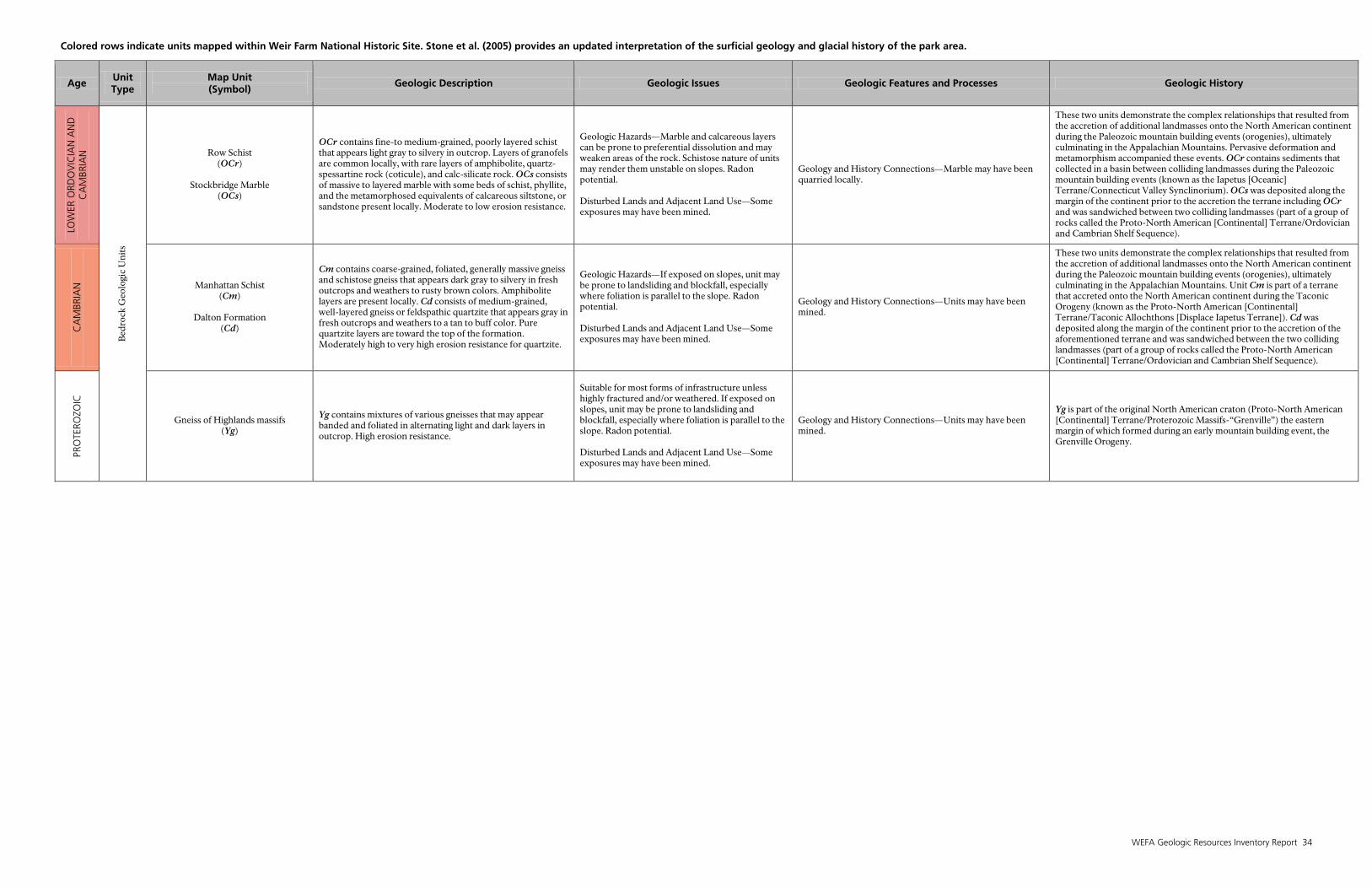
Colored rows indicate units mapped within Weir Farm National Historic Site. Stone et al. (2005) provides an updated interpretation of the surficial geology and glacial history of the park area.
WEFA Geologic Resources Inventory Report 34
Age Unit Type
Map Unit (Symbol)
Geologic Description Geologic Issues Geologic Features and Processes Geologic History LO
WER
ORD
OV
ICIA
N A
ND
C
AM
BRIA
N
Bed
rock
Geo
logi
c U
nits
Row Schist (OCr)
Stockbridge Marble
(OCs)
OCr contains fine-to medium-grained, poorly layered schist that appears light gray to silvery in outcrop. Layers of granofels are common locally, with rare layers of amphibolite, quartz-spessartine rock (coticule), and calc-silicate rock. OCs consists of massive to layered marble with some beds of schist, phyllite, and the metamorphosed equivalents of calcareous siltstone, or sandstone present locally. Moderate to low erosion resistance.
Geologic Hazards—Marble and calcareous layers can be prone to preferential dissolution and may weaken areas of the rock. Schistose nature of units may render them unstable on slopes. Radon potential. Disturbed Lands and Adjacent Land Use—Some exposures may have been mined.
Geology and History Connections—Marble may have been quarried locally.
These two units demonstrate the complex relationships that resulted from the accretion of additional landmasses onto the North American continent during the Paleozoic mountain building events (orogenies), ultimately culminating in the Appalachian Mountains. Pervasive deformation and metamorphism accompanied these events. OCr contains sediments that collected in a basin between colliding landmasses during the Paleozoic mountain building events (known as the Iapetus [Oceanic] Terrane/Connecticut Valley Synclinorium). OCs was deposited along the margin of the continent prior to the accretion the terrane including OCr and was sandwiched between two colliding landmasses (part of a group of rocks called the Proto-North American [Continental] Terrane/Ordovician and Cambrian Shelf Sequence).
CA
MBR
IAN
Manhattan Schist (Cm)
Dalton Formation
(Cd)
Cm contains coarse-grained, foliated, generally massive gneiss and schistose gneiss that appears dark gray to silvery in fresh outcrops and weathers to rusty brown colors. Amphibolite layers are present locally. Cd consists of medium-grained, well-layered gneiss or feldspathic quartzite that appears gray in fresh outcrops and weathers to a tan to buff color. Pure quartzite layers are toward the top of the formation. Moderately high to very high erosion resistance for quartzite.
Geologic Hazards—If exposed on slopes, unit may be prone to landsliding and blockfall, especially where foliation is parallel to the slope. Radon potential. Disturbed Lands and Adjacent Land Use—Some exposures may have been mined.
Geology and History Connections—Units may have been mined.
These two units demonstrate the complex relationships that resulted from the accretion of additional landmasses onto the North American continent during the Paleozoic mountain building events (orogenies), ultimately culminating in the Appalachian Mountains. Unit Cm is part of a terrane that accreted onto the North American continent during the Taconic Orogeny (known as the Proto-North American [Continental] Terrane/Taconic Allochthons [Displace Iapetus Terrane]). Cd was deposited along the margin of the continent prior to the accretion of the aforementioned terrane and was sandwiched between the two colliding landmasses (part of a group of rocks called the Proto-North American [Continental] Terrane/Ordovician and Cambrian Shelf Sequence).
PRO
TERO
ZOIC
Gneiss of Highlands massifs (Yg)
Yg contains mixtures of various gneisses that may appear banded and foliated in alternating light and dark layers in outcrop. High erosion resistance.
Suitable for most forms of infrastructure unless highly fractured and/or weathered. If exposed on slopes, unit may be prone to landsliding and blockfall, especially where foliation is parallel to the slope. Radon potential. Disturbed Lands and Adjacent Land Use—Some exposures may have been mined.
Geology and History Connections—Units may have been mined.
Yg is part of the original North American craton (Proto-North American [Continental] Terrane/Proterozoic Massifs-“Grenville”) the eastern margin of which formed during an early mountain building event, the Grenville Orogeny.
WEFA Geologic Resources Inventory Report 35
Glossary
This glossary contains brief definitions of technical geologic terms used in this report. Not all geologic terms used are referenced. For more detailed definitions or to find terms not listed here please visit: http://geomaps.wr.usgs.gov/parks/misc/glossarya.html. Definitions are based on those in the American Geological Institute Glossary of Geology (fifth edition; 2005). accretion. The gradual addition of new land to old by the
deposition of sediment or emplacement of landmasses onto the edge of a continent at a convergent margin.
accretionary prism. A wedge-shaped body of deformed rock consisting of material scraped off of subducting oceanic crust at a subduction zone. Accretionary prisms form in the same manner as a pile of snow in front of a snowplow.
active margin. A tectonically active margin where lithospheric plates come together (convergent boundary), pull apart (divergent boundary) or slide past one another (transform boundary). Typically associated with earthquakes and, in the case of convergent and divergent boundaries, volcanism. Compare to “passive margin.”
adit. A horizontal passage from the surface into a mine. allochthon. A mass of rock or fault block that has been
moved from its place of origin by tectonic processes; commonly underlain by décollements.
allochthonous. Describes rocks or materials formed elsewhere and subsequently transported to their present location. Accreted terranes are one example.
alluvial fan. A fan-shaped deposit of sediment that accumulates where a hydraulically confined stream flows to a hydraulically unconfined area. Commonly out of a mountainous area into an area such as a valley or plain.
alluvium. Stream-deposited sediment. anticline. A convex-upward (“A” shaped) fold. Older
rocks are found in the center. anticlinorium. A large, regional feature with an overall
shape of an anticline. Composed of many smaller folds.
aquifer. A rock or sedimentary unit that is sufficiently porous that it has a capacity to hold water, sufficiently permeable to allow water to move through it, and currently saturated to some level.
arc. See “volcanic arc” and “magmatic arc.” basalt. A dark-colored, often low-viscosity, extrusive
igneous rock. base flow. Stream flow supported by groundwater; flow
not attributed to direct runoff from precipitation or snow melt.
base level. The lowest level to which a stream can erode its channel. The ultimate base level for the land surface is sea level, but temporary base levels may exist locally.
basement. The undifferentiated rocks, commonly igneous and metamorphic, that underlie rocks exposed at the surface.
basin (structural). A doubly plunging syncline in which rocks dip inward from all sides.
basin (sedimentary). Any depression, from continental to local scales, into which sediments are deposited.
bedrock. A general term for the rock that underlies soil or other unconsolidated, surficial material.
brittle. Describes a rock that fractures (breaks) before sustaining deformation.
calcareous. Describes rock or sediment that contains the mineral calcium carbonate (CaCO3).
calc-silicate rock. A metamorphic rock consisting mainly of calcium-bearing silicates and formed by metamorphism of impure limestone or dolomite.
calcite. A common rock-forming mineral: CaCO₃ (calcium carbonate).
cementation. Chemical precipitation of material into pores between grains that bind the grains into rock.
chemical weathering. Chemical breakdown of minerals at Earth’s surface via reaction with water, air, or dissolved substances; commonly results in a change in chemical composition more stable in the current environment.
clast. An individual grain or rock fragment in a sedimentary rock, produced by the physical disintegration of a larger rock mass.
clastic. Describes rock or sediment made of fragments of pre-existing rocks (clasts).
clay. Can be used to refer to clay minerals or as a sedimentary fragment size classification (less than 1/256 mm [0.00015 in]).
claystone. Lithified clay having the texture and composition of shale but lacking shale’s fine layering and fissility (characteristic splitting into thin layers).
clinopyroxene. A group name for pyroxene minerals crystallizing in the monoclinic system. Important rock-forming minerals; common in igneous and metamorphic rocks.
colluvium. A general term for any loose, heterogeneous, and incoherent mass of soil material and/or rock fragments deposited through the action of surface runoff (rainwash, sheetwash) or slow continuous downslope creep.
contact metamorphism. Changes in rock as a result of contact with an igneous body.
continental crust. Crustal rocks rich in silica and alumina that underlie the continents; ranging in thickness from 35 km (22 mi) to 60 km (37 mi) under mountain ranges.
continental rifting. Process by which a region of crust undergoes extension (pulling apart), resulting in the formation of many related normal faults, and often associated with volcanic activity.
36 NPS Geologic Resources Division
continental rise. Gently sloping region from the foot of the continental slope to the deep ocean abyssal plain; it generally has smooth topography but may have submarine canyons.
continental shelf. The shallowly submerged part of a continental margin extending from the shoreline to the continental slope with water depths less than 200 m (660 ft).
continental shield. A continental block of Earth’s crust that has remained relatively stable over a long period of time and has undergone minor warping compared to the intense deformation of bordering crust.
continental slope. The relatively steep slope from the outer edge of the continental shelf down to the more gently sloping ocean depths of the continental rise or abyssal plain.
convergent boundary. A plate boundary where two tectonic plates are colliding.
country rock. The rock surrounding an igneous intrusion or pluton. Also, the rock enclosing or traversed by a mineral deposit.
craton. The relatively old and geologically stable interior of a continent (also see “continental shield”).
crystalline. Describes a regular, orderly, repeating geometric structural arrangement of atoms.
crystal structure. The orderly and repeated arrangement of atoms in a crystal.
debris flow. A moving mass of rock fragments, soil, and mud, in which more than half the particles of which are larger than sand size.
deformation. A general term for the processes of faulting, folding, and shearing of rocks as a result of various Earth forces such as compression (pushing together) and extension (pulling apart).
detachment fault. Synonym for décollement. Widely used for a regionally extensive, gently dipping normal fault that is commonly associated with extension in a metamorphic core complex.
dike. A narrow igneous intrusion that cuts across bedding planes or other geologic structures.
dip. The angle between a bed or other geologic surface and horizontal.
dip-slip fault. A fault with measurable offset where the relative movement is parallel to the dip of the fault.
divergent boundary. An active boundary where tectonic plates are moving apart (e.g., a spreading ridge or continental rift zone).
dolomite. A carbonate sedimentary rock of which more than 50% by weight or by areal percentages under the microscope consists of the mineral dolomite (calcium-magnesium carbonate).
dolomitic. Describes a dolomite-bearing rock, or a rock containing dolomite.
drainage basin. The total area from which a stream system receives or drains precipitation runoff.
drift. All rock material (clay, silt, sand, gravel, boulders) transported by a glacier and deposited directly by or from the ice, or by running water emanating from a glacier. Includes unstratified material (till) and stratified deposits (outwash plains and fluvial deposits).
drumlin. A low, smoothly rounded, elongate oval hill, mound, or ridge of compact glacial till built under the margin of the ice and shaped by the flow of the glacier. The drumlin’s long axis is parallel to the direction of ice movement.
ductile. Describes a rock that is able to sustain deformation (folding, bending, or shearing) before fracturing.
entrainment. The process of picking up and transporting sediment, commonly by wind or water.
eugeosyncline. A geosynclines in which volcanism is associated with clastic sedimentation; the deep-water, offshore portion of a passive-margin basin.
extension. A type of strain resulting from forces “pulling apart.” Opposite of compression.
facies (metamorphic). The pressure and temperature conditions that result in a particular, distinctive suite of metamorphic minerals.
fault. A break in rock along which relative movement has occurred between the two sides.
feldspar. A group of abundant (more than 60% of Earth’s crust), light-colored to translucent silicate minerals found in all types of rocks. Usually white and gray to pink. May contain potassium, sodium, calcium, barium, rubidium, and strontium along with aluminum, silica, and oxygen.
felsic. Describes an igneous rock having abundant light-colored minerals such as quartz, feldspars, or muscovite. Compare to “mafic.”
floodplain. The surface or strip of relatively smooth land adjacent to a river channel and formed by the river. Covered with water when the river overflows its banks.
fold. A curve or bend of an originally flat or planar structure such as rock strata, bedding planes, or foliation that is usually a product of deformation.
foliation. A preferred arrangement of crystal planes in minerals. In metamorphic rocks, the term commonly refers to a parallel orientation of planar minerals such as micas.
footwall. The mass of rock beneath a fault surface (also see “hanging wall”).
formation. Fundamental rock-stratigraphic unit that is mappable, lithologically distinct from adjoining strata, and has definable upper and lower contacts.
fracture. Irregular breakage of a mineral. Any break in a rock (e.g., crack, joint, fault).
frost wedging. The breakup of rock due to the expansion of water freezing in fractures.
gabbro. A group of dark-colored, intrusive igneous rocks. The intrusive equivalent of basalt.
garnet. A hard mineral that has a glassy luster, often with well defined crystal faces, and a variety of colors, dark red being characteristic. Commonly found in metamorphic rocks.
glacial erratic. Boulders transported by glaciers some distance from their point of origin.
glaciomarine. Describes the accumulation of glacially eroded, terrestrially derived sediment in the marine environment.
WEFA Geologic Resources Inventory Report 37
gneiss. A foliated rock formed by regional metamorphism with alternating bands of dark and light minerals.
granite. An intrusive igneous (plutonic) rock composed primarily of quartz and feldspar. Mica and amphibole minerals are also common. Intrusive equivalent of rhyolite.
graben. A down-dropped structural block bounded by steeply dipping, normal faults (also see “horst”).
granodiorite. A group of intrusive igneous (plutonic) rocks containing quartz, plagioclase, and potassium feldspar minerals with biotite, hornblende, or, more rarely, pyroxene, as the mafic components.
hanging wall. The mass of rock above a fault surface (also see “footwall”).
hornblende. The most common mineral of the amphibole group. Hornblende is commonly black and occurs in distinct crystals or in columnar, fibrous, or granular forms.
hornfels. A fine-grained rock composed of a mosaic of grains that are the same size in each dimension without preferred orientation. Typically formed by contact metamorphism, which occurs near the contact with an intrusion of molten material.
hydraulic conductivity. Measure of permeability coefficient.
hydrogeologic. Refers to the geologic influences on groundwater and surface water composition, movement and distribution.
igneous. Refers to a rock or mineral that originated from molten material; one of the three main classes of rocks—igneous, metamorphic, and sedimentary.
intrusion. A body of igneous rock that invades (pushes into) older rock. The invading rock may be a plastic solid or magma.
island arc. A line or arc of volcanic islands formed over and parallel to a subduction zone.
isostacy. The condition of equilibrium, comparable to floating, of the units of the lithosphere above the asthenosphere. Crustal loading (commonly by large ice sheets) leads to isostatic depression or downwarping; removal of the load leads to isostatic uplift or upwarping.
joint. A break in rock without relative movement of rocks on either side of the fracture surface.
kame delta. A flat-topped, steep-sided hill of well-sorted sand and gravel deposited by a meltwater stream flowing into a proglacial or other ice-marginal lake. The proximal margin of the delta was built in contact with glacier ice.
klippe. An erosional remnant of a thrust sheet that is completely surrounded by exposure of the footwall.
lacustrine. Pertaining to, produced by, or inhabiting a lake or lakes.
landslide. Any process or landform resulting from rapid, gravity-driven mass movement.
left lateral fault. A strike slip fault on which the side opposite the observer has been displaced to the left Synonymous with “sinistral fault.”
limestone. A sedimentary rock consisting chiefly of calcium carbonate, primarily in the form of the mineral calcite.
lithification. The conversion of sediment into solid rock. lithify. To change to stone or to petrify; especially to
consolidate from a loose sediment to a solid rock through compaction and cementation.
lithofacies. A lateral, mappable subdivision of a designated stratigraphic unit, distinguished from adjacent subdivisions on the basis of rock characteristics (lithology).
lithology. The physical description or classification of a rock or rock unit based on characters such as its color, mineral composition, and grain size.
lodgment till. The plastering beneath a glacier of successive layers of basal till commonly characterized by compact fissile structure and containing stones oriented with their long axes generally parallel to the direction of ice movement.
loess. Windblown silt-sized sediment, generally of glacial origin.
mafic. Describes dark-colored rock, magma, or minerals rich in magnesium and iron. Compare to “felsic.”
magma. Molten rock beneath Earth’s surface capable of intrusion and extrusion.
magmatic arc. Zone of plutons or volcanic rocks formed at a convergent boundary.
mass wasting. A general term for the downslope movement of soil and rock material under the direct influence of gravity.
mechanical weathering. The physical breakup of rocks without change in composition. Synonymous with “physical weathering.”
member. A lithostratigraphic unit with definable contacts; a member subdivides a formation.
meta–. A prefix used with the name of a sedimentary or igneous rock, indicating that the rock has been metamorphosed.
metamorphic. Describes the process of metamorphism or its results. One of the three main classes of rocks—igneous, metamorphic, and sedimentary.
metamorphism. Literally, a change in form. Metamorphism occurs in rocks through mineral alteration, formation, and/or recrystallization from increased heat and/or pressure.
mineral. A naturally occurring, inorganic crystalline solid with a definite chemical composition or compositional range.
miogeocline. A wedge of shallow-water sediment building outward from the edge of the continent.
moraine. A mound, ridge, or other distinct accumulation of unsorted, unstratified glacial drift, predominantly till, deposited by glacial ice movement.
nappe. A sheetlike, allochthonous (manufactured elsewhere) rock unit that has moved along a predominantly horizontal surface. The mechanism may be thrust faulting, recumbent folding, or gravity sliding.
nonconformity. An erosional surface preserved in strata in which crystalline igneous or metamorphic rocks underlie sedimentary rocks.
normal fault. A dip-slip fault in which the hanging wall moves down relative to the footwall.
38 NPS Geologic Resources Division
oblique fault. A fault in which motion includes both dip-slip and strike-slip components (also see “dip-slip fault” and “strike-slip fault”).
oceanic crust. Earth’s crust formed at spreading ridges that underlies the ocean basins. Oceanic crust is 6 to 7 km (3 to 4 miles) thick and generally of basaltic composition.
orogeny. A mountain-building event. outcrop. Any part of a rock mass or formation that is
exposed or “crops out” at Earth’s surface. outwash. Glacial sediment transported and deposited by
meltwater streams. paleogeography. The study, description, and
reconstruction of the physical landscape from past geologic periods.
passive margin. A margin where no plate-scale tectonism is taking place; plates are not converging, diverging, or sliding past one another. An example is the east coast of North America (compare to “active margin”).
pegmatite. An exceptionally coarse-grained intrusive igneous rock, with interlocking crystals, usually found in irregular dikes, lenses, and veins, especially at the margins of batholiths.
perched aquifer. An aquifer containing unconfined groundwater separated from an underlying main body of groundwater by an unsaturated zone.
permeability. A measure of the relative ease with which fluids move through the pore spaces of rocks or sediments.
phyllite. A metamorphosed rock, intermediate in grade between slate and mica schist, with minute crystals of graphite, sericite, or chlorite that impart a silky sheen to the surfaces (“schistosity”).
plastic. Describes a material capable of being deformed permanently without rupture.
pluton (plutonic). A body of intrusive igneous rock that crystallized at some depth beneath Earth’s surface.
pull-apart basin. A topographic depression created by an extensional bend or extensional overstep along a strike-slip fault.
pyroxene. A common rock-forming mineral. It is characterized by short, stout crystals.
quartzite. Metamorphosed quartz sandstone. recharge. Infiltration processes that replenish
groundwater. regolith. General term for the layer of rock debris,
organic matter, and soil that commonly forms the land surface and overlies most bedrock.
regression. A long-term seaward retreat of the shoreline or relative fall of sea level.
rift. A region of crust where extension results in formation of many related normal faults, often associated with volcanic activity.
rift valley. A depression formed by grabens along the crest of an oceanic spreading ridge or in a continental rift zone.
rock. A solid, cohesive aggregate of one or more minerals. rock fall. Mass wasting process where rocks are
dislodged and move downslope rapidly; it is the fastest mass wasting process.
sand. A clastic particle smaller than a granule and larger than a silt grain, having a diameter in the range of 1/16 mm (0.0025 in) to 2 mm (0.08 in).
sandstone. Clastic sedimentary rock of predominantly sand-sized grains.
scarp. A steep cliff or topographic step resulting from displacement on a fault, or by mass movement, or erosion. Also called an “escarpment.”
schist. A strongly foliated metamorphic rock that can be readily be split into thick flakes or slabs. Micas are arranged in parallel, imparting a distinctive sheen, or “schistosity” to the rock.
schistose. A rock displaying schistosity, or foliation. seafloor spreading. The process by which tectonic plates
pull apart and new lithosphere is created at oceanic ridges.
sediment. An eroded and deposited, unconsolidated accumulation of rock and mineral fragments.
sedimentary rock. A consolidated and lithified rock consisting of clastic and/or chemical sediment(s). One of the three main classes of rocks—igneous, metamorphic, and sedimentary.
shale. A clastic sedimentary rock made of clay-sized particles that exhibit parallel splitting properties.
shear zone. A zone of rock that has been crushed and brecciated by many parallel fractures due to shear strain.
silt. Clastic sedimentary material intermediate in size between fine-grained sand and coarse clay (1/256 to 1/16 mm [0.00015 to 0.002 in]).
siltstone. A variably lithified sedimentary rock composed of silt-sized grains.
slope. The inclined surface of any geomorphic feature or measurement thereof. Synonymous with “gradient.”
slump. A generally large, coherent mass movement with a concave-up failure surface and subsequent backward rotation relative to the slope.
soapstone. A soft metamorphic rock with fibrous or flakey texture and a soapy feel; composed primarily of talc with variable amounts of other minerals. Frequently used as dimension or building stone.
sodic. Pertaining to minerals and igneous rocks containing a relatively high proportion of sodium.
soil. Surface accumulation of weathered rock and organic matter capable of supporting plant growth and often overlying the parent material from which it formed.
spreading center. A divergent boundary where two lithospheric plates are spreading apart. It is a source of new crustal material.
spring. A site where water issues from the surface due to the intersection of the water table with the ground surface.
strata. Tabular or sheet-like masses or distinct layers of rock.
stratification. The accumulation, or layering of sedimentary rocks in strata. Tabular, or planar, stratification refers to essentially parallel surfaces. Cross-stratification refers to strata inclined at an angle to the main stratification.
WEFA Geologic Resources Inventory Report 39
stratigraphy. The geologic study of the origin, occurrence, distribution, classification, correlation, and age of rock layers, especially sedimentary rocks.
striations. Parallel scratches or lines. strike. The compass direction of the line of intersection
of an inclined surface with a horizontal plane. strike-slip fault. A fault with measurable offset where the
relative movement is parallel to the strike of the fault. Said to be “sinistral” (left-lateral) if relative motion of the block opposite the observer appears to be to the left. “Dextral” (right-lateral) describes relative motion to the right.
subduction zone. A convergent plate boundary where oceanic lithosphere descends beneath a continental or oceanic plate and is carried down into the mantle.
subsidence. The gradual sinking or depression of part of Earth’s surface.
suture. The linear zone where two continental landmasses become joined via obduction.
syncline. A downward curving (concave-up) fold with layers that dip inward; the core of the syncline contains the stratigraphically-younger rocks.
synclinorium. A composite synclinal structure of regional extent composed of lesser folds.
talus. Rock fragments, usually coarse and angular, lying at the base of a cliff or steep slope from which they have been derived.
tectonic. Relating to large-scale movement and deformation of Earth’s crust.
terrace. A relatively level bench or step-like surface breaking the continuity of a slope (also see “stream terrace”).
terrane. A large region or group of rocks with similar geology, age, or structural style.
thrust fault. A contractional dip-slip fault with a shallowly dipping fault surface (less than 45°) where the hanging wall moves up and over relative to the footwall.
till. Unstratified drift, deposited directly by a glacier without reworking by meltwater, and consisting of a mixture of clay, silt, sand, gravel, and boulders ranging widely in size and shape.
topography. The general morphology of Earth’s surface, including relief and locations of natural and anthropogenic features.
trace (fault). The exposed intersection of a fault with Earth’s surface.
transgression. Landward migration of the sea as a result of a relative rise in sea level.
trend. The direction or azimuth of elongation of a linear geologic feature.
unconfined groundwater. Groundwater that has a water table; i.e., water not confined under pressure beneath a confining bed.
unconformity. An erosional or non-depositional surface bounded on one or both sides by sedimentary strata. An unconformity marks a period of missing time.
volcanic arc. A commonly curved, linear, zone of volcanoes above a subduction zone.
water table. The upper surface of the saturated zone; the zone of rock in an aquifer saturated with water.
weathering. The physical, chemical, and biological processes by which rock is broken down.
window. An eroded area of a thrust sheet that displays the rocks beneath the thrust sheet.

WEFA Geologic Resources Inventory Report 41
Literature Cited
This section lists references cited in this report. A more complete geologic bibliography is available from the National Park Service Geologic Resources Division. Aleinikoff, J. N., R. P. Wintsch, R. P. Tollo, D. M. Unruh,
C. M. Fanning, and M. D. Schmitz. 2007. Ages and origins of rocks of the Killingworth Dome, south-central Connecticut: implications for the tectonic evolution of southern New England. American Journal of Science 307(1):63–118.
Amenta, R. V. and D. G. Mose. 1985. Tectonic
implications of Rb-Sr ages of granitic plutons near Cameron's Line in western Connecticut. Northeastern Geology 7(1):11–19.
Benner, J. S., J. C. Ridge, and R. J. Knecht. 2009. Timing
of post-glacial reinhabitation and ecological development of two New England, USA, drainages based on trace fossil evidence. Palaeogeography, Palaeoclimatology, Palaeoecology 272(3-4):212–231.
Bierman, P. R. and D. P. Dethier. 1986. Lake Bascom and
the deglaciation of northwestern Massachusetts. Northeastern Geology 8(1–2):32–43.
Braile, L.W. 2009. Seismic monitoring. Pages 229–244 in
R. Young, R. and L. Norby, editors. Geological Monitoring. Geological Society of America, Boulder, Colorado, USA. http://www.nature.nps.gov/geology/ monitoring/seismic.cfm (accessed 23 January 2012).
Calogero, B. L. and A. R. Philpotts. 1998. They came with
gifts: material analysis of two cremation cemeteries. Abstracts with Programs - Geological Society of America 30(1):9-10.
Calogero, B. L., A. R. Philpotts, K. L. Feder, N. F.
Bellantoni, S. Paustian, and C. Wickman. 1999. Stone blades caches in Connecticut. Geological Society of America Abstracts with Programs 31(2):A-8.
Cameron, E. N., D. M. Larrabee, A. H. McNair, J. J. Page,
G. W. Stewart, and V. E. Shainin. 1954. Pegmatite Investigations 1942–45 New England. Professional Paper 255. U.S. Geological Survey, Reston, Virginia, USA. http://pubs.er.usgs.gov/publication/pp1255 (accessed 23 January 2012).
Child Associates, Inc. and C. Zaitzevsky. 1996. Cultural
Landscape Report for Weir Farm National Historic Site. Cultural Landscape Publication 6. Olmstead Center of Landscape Preservation, National Park Service.
Clarke, J. W. 1956. Geology of the Danbury and Bethel
quadrangles, Connecticut. Geological Society of America Bulletin 67(12, Part 2):1812.
Coleman, M. E. 2005. The Geologic History of Connecticut’s Bedrock. Special Publication #2. Connecticut Department of Energy & Environmental Protection, Hartford, Connecticut, USA.
Connally, G. G. and L. A. Sirkin. 1973. Wisconsinan
history of the Hudson-Champlain Lobe. Pages 47-69 in Black, R. F., R. P. Goldthwait, and H. B. Willman, editors. The Wisconsinan Stage. Geological Society of America, Boulder, CO. Memoir 136.
Cooper, M. 1958. Bibliography and index of literature on
uranium and thorium and radioactive occurrences in the United States, Part 5: Connecticut, Delaware, Illinois, Indiana, Maine, Maryland, Massachusetts, Michigan, New Hampshire, New Jersey, New York, Ohio, Pennsylvania, Rhode Island, Vermont, and Wisconsin. Geological Society of America Special Paper 67.
Curran, M. L. and D. F. Dincauze. 1977. Paleoindians
and paleo-lakes: new data from the Connecticut drainage. Annals of the New York Academy of Sciences 288:333–348.
Deevey, E. S., Jr. 1939. Studies on Connecticut lake
sediments. I. A postglacial climate chronology for southern New England. American Journal of Science 237:691-724.
Doolan, B. 1996. The geology of Vermont. Rocks &
Minerals 71(4):218–225. Online. http://www.anr.state.vt.us/dec/geo/pdfdocs/VermontGeoWebDoolan.pdf (accessed 24 March 2010).
Dyke, A. S. and V. K. Prest (compilers). 1987. Late
Wisconsinan and Holocene Retreat of the Laurentide Ice Sheet (scale 1:5,000,000). Map 1702A, Geological Survey of Canada, Ottawa, Canada.
Faux, C. and W. G. Joyce. 2008. Connecticut's
Pleistocene horse reassigned to the 19th Century. Peabody Museum of Natural History Bulletin 49(1):131–132.
Gaudreau, D. C. 1982. Holocene vegetational history of
central New England and the Hudson River valley. American Quaternary Association Program and Abstracts 7:93.
42 NPS Geologic Resources Division
Grauch, R. I., and K. Zarinski. 1976. Generalized descriptions of uranium-bearing veins, pegmatites, and dissemination in non-sedimentary rocks, eastern United States. Open-File Report 76-582. U.S. Geological Survey, Reston, Virginia, USA. http://pubs.usgs.gov/of/1976/0582/report.pdf (accessed 23 January 2012).
Hubert, J. F., A. A. Reed, W. L. Dowdall, and J. M.
Gilchrist. 1978. Guide to the redbeds of Central Connecticut: 1978 field trip, Eastern Section of SEPM. University of Massachusetts, Amherst, MA. Contribution - Geology Department, University of Massachusetts 32.
Jones, B. 2011. New England Pegmatites, They Have
Been Mined Since America's Earliest Days. Rock & Gem online. http://www.rockhounds.com/ rockgem/articles/pegmatites.html (accessed 24 February 2011).
Karabinos, P., J. N. Aleinikoff, and C. M. Fanning. 1999.
Distinguishing Grenvillian basement from pre-Taconian cover rocks in the Northern Appalachians. American Journal of Science 299(6):502–515.
Karabinos, P., S. D. Samson, J. C. Hepburn, and H. M
Stoll. 1998. Taconian Orogeny in the New England Appalachians: collision between Laurentia and the Shelburne Falls Arc. Geology 26(3):215–218.
Kim, J. and D. Wunsch. 2009. Physiography and bedrock
geology. Pages 5–11in Brown, R. A., editor. Where the great river rises: an atlas of the Connecticut River watershed in Vermont and New Hampshire. Dartmouth College Press, Lebanon, New Hampshire, USA.
Kroll, R. L. 1969. Bedrock geology of the Norwalk north
quadrangle, Connecticut (scale 1:24,000).Quadrangle Report 34, plate 1. Connecticut Geological and Natural History Survey, Hartford, Connecticut, USA.
Kroll, R. L. 1977. The bedrock geology of the Norwalk
North and Norwalk South quadrangles. Quadrangle Report 34. State Geological and Natural History Survey of Connecticut, Hartford, Connecticut, USA.
Kroll, R. L. 1994. Orogenic evolution of the New
England Appalachians of southwestern Connecticut: Discussion and reply. Geological Society of America Bulletin 106:1229.
London, E. H. 1984a. Surficial geologic map of the
Norwalk North quadrangle, Connecticut (scale 1:24,000). Miscellaneous Field Studies Map MF-1520. U.S. Geological Survey, Reston, Virginia, USA. http://ngmdb.usgs.gov/Prodesc/proddesc_7314.htm (accessed 23 January 2012).
London, E. H. 1984b. Surficial geologic map of the Bethel quadrangle, Connecticut (scale 1:24,000). Miscellaneous Field Studies Map MF-1519. U.S. Geological Survey, Reston, Virginia, USA. http://ngmdb.usgs.gov/Prodesc/proddesc_7313.htm (accessed 23 January 2012).
Mindat.org. 2012. Fillow Quarry (Branchville Quarry;
Branchville Mica Mine), Branchville, Redding, Fairfield Co., Connecticut, USA. Webpage. Mindat http://www.mindat.org/loc-6816.html (accessed 23 January 2012).
Moecher, D. P., M. A. Cosca, and G. N. Hanson. 1997.
Petrologic and 40Ar/39Ar geochronological constraints on the middle to late Paleozoic thermotectonic history of the southern Connecticut Valley zone, New England Appalachians. Geological Society of America Bulletin 109(2):164–175.
Mullaney, J. R. 2004. Water Use, Ground-Water
Recharge and Availability, and Quality of Water in the Greenwich Area, Fairfield County, Connecticut and Westchester County, New York, 2000–2002. Water-Resources Investigations Report 03-4300. U.S. Geological Survey, Reston, Virginia, USA. http://pubs.usgs.gov/wri/wri034300/ (accessed 23 January 2012).
National Park Service. 1990. Weir Farm Historic Site,
National Park Service Suitability/Feasibility Study. National Park Service, North Atlantic Regional Office, Boston, Massachusetts, USA.
National Park Service. 1995. Weir Farm National
Historic Site, General Management Plan/Environmental Impact Statement. Weir Farm National Historic Site, North Atlantic Region, National Park Service, Wilton, Connecticut, USA.
National Park Service. 2006. Soil Resources Inventory-
Soil Survey Geographic (SSURGO) Database for Weir Farm National Historic Site, Connecticut. National Park Service, Inventory and Monitoring Program, Fort Collins, CO. http://irma.nps.gov/App/Reference/Profile/1048996 (accessed 23 January 2012).
Petersen, M. D., A. D. Frankel, S. C. Harmsen, C. S.
Mueller, K. M. Haller, R. L. Wheeler, R. L. Wesson, Y. Zeng, O. S. Boyd, D. M. Perkins, N. Luco, E. H. Field, C. J. Wills, and K. S. Rukstales. 2008a. 2008 United States National Seismic Hazard Maps. Fact Sheet 2008-3018. U.S. Geological Survey, Reston, Virginia, USA. http://pubs.usgs.gov/fs/2008/3018/ (accessed 30 December 2010).
WEFA Geologic Resources Inventory Report 43
Petersen, M. D., A. D. Frankel, S. C. Harmsen, C. S. Mueller, K. M. Haller, R. L. Wheeler, R. L. Wesson, Y. Zeng, O. S. Boyd, D. M. Perkins, N. Luco, E. H. Field, C. J. Wills, and K. S. Rukstales. 2008b. Documentation for the 2008 Update of the United States National Seismic Hazard Maps. Open-File Report 2008–1128. U.S. Geological Survey, Reston, Virginia, USA. http://pubs.usgs.gov/of/2008/1128/ (accessed 31 December 2010).
Rodgers, J. 1985. Bedrock geological map of Connecticut
(scale 1:125,000). Connecticut Natural Resources Atlas Series. Connecticut Geological and Natural History Survey, Hartford, Connecticut, USA.
Schoene, B., J. Guex, A. Bartolini, U. Schaltegger, and T.
J. Blackburn. 2010. Correlating the end-Triassic mass extinction and flood basalt volcanism at the 100 ka level. Geology 38(5):387-390.
Sevigny, J. H. and G. N. Hanson. 1993. Orogenic
evolution of the New England Appalachians of southwestern Connecticut. Geological Society of America Bulletin 105(12):1591–1605.
Skehan, J. W. 2008. Roadside Geology of Connecticut
and Rhode Island. Mountain Press Publishing Company, Missoula, Montana. USA.
Spinek, T. R. 1988. Polydeformed and
polymetamorphosed melange within the Cameron's Line thrust sheet, southwestern Connecticut. Geological Society of America Abstracts with Programs 20(1):71.
Stone, J. R., J. P. Schafter, E. H. London, M. L.
DiGiacomo-Cohen, R. S. Lewis, and W. B. Thompson.2005. Quaternary Geologic Map of Connecticut and Long Island Sound Basin. Scientific Investigations Map 2784. U.S. Geological Survey, Reston, Virginia, USA. http://pubs.usgs.gov/sim/2005/2784/ (accessed 23 January 2012).
Thomas, M. A., and N. W. McHone. 1997. Indoor Radon Potential Map of Connecticut (scale 1:250,000). Connecticut Geological and Natural History Survey, Department of Environmental Protection, Hartford, Connecticut, USA.
Thornberry-Ehrlich, T. L. 2007. Geologic Resource Evaluation [Inventory] Scoping Summary, Weir Farm National Historic Site. National Park Service, Geologic Resources Division, Denver, Colorado, USA. Online. http://www.nature.nps.gov/geology/inventory/ publications/s_summaries/WEFA_gre_scoping _summary_2008-0717.pdf (accessed 10 January 2011).
Tweet, J. S., V. L. Santucci, and J. P. Kenworthy. 2010.
Paleontological resource inventory and monitoring: Northeast Temperate Network. Natural Resource Technical Report NPS/NRPC/NRTR—2010/326. National Park Service, Fort Collins, Colorado, USA.
U.S. EPA. 2010. A Citizen’s Guide to Radon. U.S.
Environmental Protection Agency. http://www.epa.gov/radon/pubs/citguide.html #howdoes (accessed 6 December 2010).
U.S. Geological Survey (USGS). 2003a. Physiographic
Provinces. USGS, Reston, Virginia, USA. http://tapestry.usgs.gov/physiogr/physio.html (accessed 2 June 2010).
U.S. Geological Survey (USGS). 2003b. Highlands Sites
in Western Connecticut. USGS, Reston, Virginia, USA. http://3dparks.wr.usgs.gov/nyc/highlands/ connecticut.htm (accessed 2 June 2010).
Wieczorek, TG. F. and J. B. Snyder. 2009. Monitoring
slope movements. Pages 245–271 in R. Young and L. Norby, editors. Geological Monitoring. Geological Society of America, Boulder, Colorado, USA. http://www.nature.nps.gov/geology/monitoring/ slopes.cfm (accessed 23 January 2012).
Wintsch, R. P., J. F. Sutter, M. J. Kunk, J. N. Aleinikoff,
and J. L. Boyd. 1993. Alleghanian assembly of Proterozoic and Paleozoic lithotectonic terranes in south central New England: new constraints from geochronology and petrology. Pages H.1-H.30 in Cheney, J. T. and J. C. Hepburn, editors. Field trip guidebook for the northeastern United States. Contribution 67. Geology Department, University of Massachusetts, Amherst, Massachusetts, USA.

WEFA Geologic Resources Inventory Report 45
Additional References
This section lists additional references, resources, and web sites that may be of use to resource managers. Web addresses are current as of January 2012. Geology of National Park Service Areas
National Park Service Geologic Resources Division (Lakewood, Colorado). http://nature.nps.gov/geology/
NPS Geologic Resources Inventory.
http://www.nature.nps.gov/geology/inventory/gre_publications.cfm
Harris, A. G., E. Tuttle, and S. D. Tuttle. 2003. Geology of
National Parks. Sixth Edition. Kendall/Hunt Publishing Co., Dubuque, Iowa, USA.
Kiver, E. P. and D. V. Harris. 1999. Geology of U.S.
parklands. John Wiley and Sons, Inc., New York, New York, USA.
Lillie, R. J. 2005. Parks and Plates: The geology of our
national parks, monuments, and seashores. W.W. Norton and Co., New York, New York, USA. [Geared for interpreters].
NPS Geoscientist-in-the-parks (GIP) internship and
guest scientist program. http://www.nature.nps.gov/geology/gip/index.cfm
Resource Management/Legislation Documents
NPS 2006 Management Policies (Chapter 4; Natural Resource Management): http://www.nps.gov/policy/mp/policies.html#_Toc157232681
NPS-75: Natural Resource Inventory and Monitoring
Guideline: http://www.nature.nps.gov/nps75/nps75.pdf
NPS Natural Resource Management Reference Manual
#77: http://www.nature.nps.gov/Rm77/ Geologic Monitoring Manual
R. Young and L. Norby, editors. Geological Monitoring. Geological Society of America, Boulder, Colorado. http://nature.nps.gov/geology/monitoring/index.cfm
NPS Technical Information Center (Denver, repository
for technical (TIC) documents): http://etic.nps.gov/
Geological Survey and Society Websites
Connecticut Geological and Natural History Survey: http://www.ct.gov/dep/cwp/view.asp?a=2701&q=323434&depNav_GID=1641.
U.S. Geological Survey: http://www.usgs.gov/ Geological Society of America:
http://www.geosociety.org/ American Geological Institute: http://www.agiweb.org/ Association of American State Geologists:
http://www.stategeologists.org/
Other Geology/Resource Management Tools
Bates, R. L. and J. A. Jackson, editors. American Geological Institute dictionary of geological terms (3rd Edition). Bantam Doubleday Dell Publishing Group, New York.
U.S. Geological Survey National Geologic Map Database
(NGMDB): http://ngmdb.usgs.gov/ U.S. Geological Survey Geologic Names Lexicon
(GEOLEX; geologic unit nomenclature and summary): http://ngmdb.usgs.gov/Geolex/geolex_home.html
U.S. Geological Survey Geographic Names Information
System (GNIS; search for place names and geographic features, and plot them on topographic maps or aerial photos): http://gnis.usgs.gov/
U.S. Geological Survey GeoPDFs (download searchable
PDFs of any topographic map in the United States): http://store.usgs.gov (click on “Map Locator”).
U.S. Geological Survey Publications Warehouse (many
USGS publications are available online): http://pubs.er.usgs.gov
U.S. Geological Survey, description of physiographic
provinces: http://tapestry.usgs.gov/Default.html

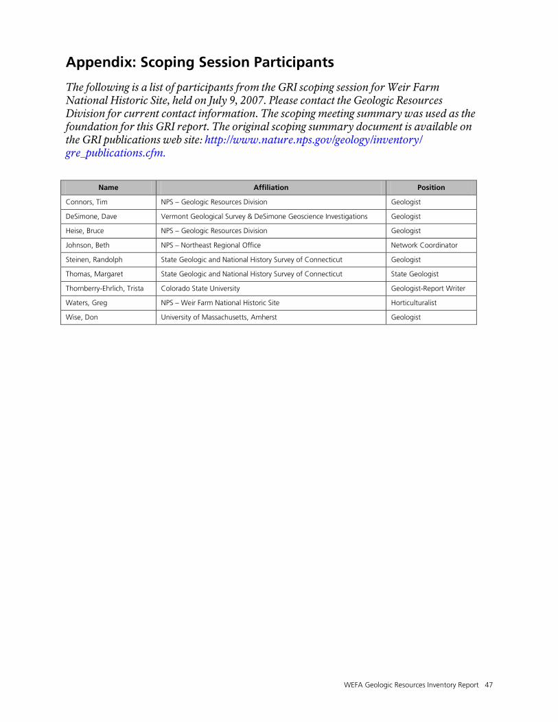
WEFA Geologic Resources Inventory Report 47
Appendix: Scoping Session Participants
The following is a list of participants from the GRI scoping session for Weir Farm National Historic Site, held on July 9, 2007. Please contact the Geologic Resources Division for current contact information. The scoping meeting summary was used as the foundation for this GRI report. The original scoping summary document is available on the GRI publications web site: http://www.nature.nps.gov/geology/inventory/ gre_publications.cfm.
Name Affiliation Position
Connors, Tim NPS – Geologic Resources Division Geologist
DeSimone, Dave Vermont Geological Survey & DeSimone Geoscience Investigations Geologist
Heise, Bruce NPS – Geologic Resources Division Geologist
Johnson, Beth NPS – Northeast Regional Office Network Coordinator
Steinen, Randolph State Geologic and National History Survey of Connecticut Geologist
Thomas, Margaret State Geologic and National History Survey of Connecticut State Geologist
Thornberry-Ehrlich, Trista Colorado State University Geologist-Report Writer
Waters, Greg NPS – Weir Farm National Historic Site Horticulturalist
Wise, Don University of Massachusetts, Amherst Geologist


The Department of the Interior protects and manages the nation’s natural resources and cultural heritage; provides scientific and other information about those resources; and honors its special responsibilities to American Indians, Alaska Natives, and affiliated Island Communities. NPS 413/112546, January 2012
National Park Service U.S. Department of the Interior
Natural Resource Stewardship and Science 1201 Oakridge Drive, Suite 150 Fort Collins, CO 80525 www.nature.nps.gov
EXPERIENCE YOUR AMERICA TM