geologic resource evaluation report - nps filethe natural resource publication series addresses...
TRANSCRIPT
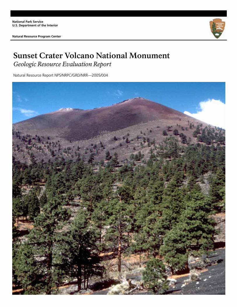
Sunset Crater Volcano National Monument Geologic Resource Evaluation Report
Natural Resource Report NPS/NRPC/GRD/NRR—2005/004
National Park Service U.S. Department of the Interior Natural Resource Program Center
Sunset Crater Volcano National Monument Geologic Resource Evaluation Report
Natural Resource Report NPS/NRPC/GRD/NRR—2005/004 Geologic Resources Division Natural Resource Program Center P.O. Box 25287 Denver, Colorado 80225
September 2005 U.S. Department of the Interior Washington, D.C.
The Natural Resource Publication series addresses natural resource topics that are of interest and applicability to a broad readership in the National Park Service and to others in the management of natural resources, including the scientific community, the public, and the NPS conservation and environmental constituencies. Manuscripts are peer-reviewed to ensure that the information is scientifically credible, technically accurate, appropriately written for the intended audience, and is designed and published in a professional manner. Natural Resource Reports are the designated medium for disseminating high priority, current natural resource management information with managerial application. The series targets a general, diverse audience, and may contain NPS policy considerations or address sensitive issues of management applicability. Examples of the diverse array of reports published in this series include vital signs monitoring plans; "how to" resource management papers; proceedings of resource management workshops or conferences; annual reports of resource programs or divisions of the Natural Resource Program Center; resource action plans; fact sheets; and regularly-published newsletters. Views and conclusions in this report are those of the authors and do not necessarily reflect policies of the National Park Service. Mention of trade names or commercial products does not constitute endorsement or recommendation for use by the National Park Service. Printed copies of reports in these series may be produced in a limited quantity and they are only available as long as the supply lasts. This report is also available from the Geologic Resource Evaluation Program website (http://www2.nature.nps.gov/geology/inventory/gre_publications) on the internet, or by sending a request to the address on the back cover. Please cite this publication as: Thornberry-Ehrlich, T. 2005. Sunset Crater Volcano National Monument Geologic Resource Evaluation Report. Natural Resource Report NPS/NRPC/GRD/NRR—2005/004. National Park Service, Denver, Colorado. NPS D-54, September 2005
SUCR Geologic Resource Evaluation Report iii
Table of Contents List of Figures .............................................................................................................. iv Executive Summary ...................................................................................................... 1 Introduction ................................................................................................................... 3
Purpose of the Geologic Resource Evaluation Program ............................................................................................3 Geologic Setting .........................................................................................................................................................3
Geologic Issues............................................................................................................. 6
Recreation Demands..................................................................................................................................................6 Slope Failures and Erosion ........................................................................................................................................6 Pumice Mining Issues.................................................................................................................................................6 Seismicity and Volcanism...........................................................................................................................................7 Noise Pollution............................................................................................................................................................7 Water Issues...............................................................................................................................................................7 Wind Erosion and Deposition .....................................................................................................................................8 General Geology ........................................................................................................................................................8 Air Issues....................................................................................................................................................................8
Geologic Features and Processes............................................................................... 9
Sunset Crater .............................................................................................................................................................9 Archaeological Geology..............................................................................................................................................9 Ecosystem Rebound ..................................................................................................................................................9 Unique Volcanic Features ........................................................................................................................................10
Map Unit Properties .................................................................................................... 14
Map Unit Properties Table........................................................................................................................................15 Geologic History.......................................................................................................... 19 References................................................................................................................... 23 Appendix A: Geologic Map Graphic .......................................................................... 25 Appendix B: Scoping Summary................................................................................. 27 Attachment 1: Digital Geologic Map CD

NPS Geologic Resources Division iv
List of Figures Figure 1: Location of Sunset Crater Volcano National Monument..................................................................................5 Figure 2: Aerial view of Sunset Crater Volcano............................................................................................................11 Figure 3: Aerial view of Sunset Crater Volcano............................................................................................................11 Figure 4: View of lava flow in Sunset Crater Volcano National Monument...................................................................12 Figure 5: Photo of a fumarole deposit near the summit of Sunset Crater Volcano.......................................................12 Figure 6: Photo of a lava tube entrance .......................................................................................................................13 Figure 7: Geologic time scales. ....................................................................................................................................21 Figure 8: Major uplifts and basins present during the Pennsylvanian age in the southwestern United States. ............22 Figure 9: Cross section of Sunset Crater Volcano National Monument. ......................................................................22
SUCR Geologic Resource Evaluation Report 1
Executive Summary This report has been developed to accompany the digital geologic map produced by Geologic Resource Evaluation staff for Sunset Crater Volcano National Monument. It contains information relevant to resource management and scientific research. Between A.D. 1064 and 1180, a series of earthquakes and volcanic eruptions brought the dormant San Francisco Volcanic Field back to life. These events were the only eruptions in the Southwest indisputably witnessed by early native peoples. The earthquakes and eruptions probably profoundly changed their way of life. Billowing ash, falling cinders, and forest fires blackened the landscape. When the volcanism was over, a classic example of a cinder cone, Sunset Crater Volcano, loomed over an altered land of lava flows, ash layers, and cinders. Today Sunset Crater Volcano National Monument represents the Colorado Plateau’s most recent volcanic eruption. Much of the ground surface is covered by lava flows or deep volcanic ash and cinder deposits (all of alkali olivine basalt composition). The landscape still appears stark and inhospitable. However, within the volcanic geologic features are small islands of pine and aspen trees, desert shrubs, and wildflowers that provide small but unique habitats for wildlife. The ecosystem is adapting to the new landscape. The experience of Sunset Crater Volcano begins with the geological processes that established the groundwork from which present- day environments and scenery arise. Understanding the geologic resources can directly impact resource management decisions pertaining to the park, future scientific research projects, interpretive needs, and economic resources associated with Sunset Crater Volcano National Monument. Humans have modified the forest landscape surrounding Sunset Crater Volcano and consequently have modified its geologic system. This system is dynamic and obviously capable of noticeable change within a human life span. Geology provides the foundation of the entire ecosystem. The geology at Sunset Crater Volcano is dominated by volcanic rock. The crater is the youngest, best- preserved cinder cone in the San Francisco Volcanic Field. It is not surprising that some of the principal geologic issues and concerns pertain to protecting the park’s delicate volcanic features. The following features, issues, and processes were identified as having the most geological importance and the highest level of management significance within the park: • Slope failures and erosion.
Dry, volcanic environments are especially susceptible
to slumping and landslides because they lack stabilizing plant growth. Intense seasonal storms produce flash floods that dramatically alter the landscape, creating new hazard areas in the process. Road and trail construction also impacts the stability of a slope. Predominantly unconsolidated units such as the cinders and ash forming the slopes of Sunset Crater are prone to fail when saturated with water.
Erosion degrades the slopes of the cinder cone. The loose, unconsolidated volcanic debris is easily washed away during a storm. Lava flows and other large blocks of volcanic ejecta can be undercut by erosion. When this happens, large blocks of the overlying rocks can collapse. Rockfalls and slope failures are likely almost anywhere these units are exposed on a slope.
• Pumice mining issues.
Pumice mines dot the landscape around Sunset Crater Volcano National Monument, affecting the viewshed of the park. Mining and illegal removal of unique and delicate volcanic specimens from within the park are a concern for resource management.
• Recreation demands.
In northern Arizona the population is increasing the environmental impacts of recreation. Certain trails within the monument have had to be closed due to preferential erosion. Off- road recreational vehicles are being used just outside the monument boundaries. Their use affects the monument’s viewshed and creates noise, dust, and engine exhaust. Resource management concerns include balancing the preservation of the environment with recreational demands of visitors to the monument area.
• Seismicity and volcanism.
Seismicity is often a precursor to volcanic activity. The chances for further activity in the San Francisco Volcanic Field are great. The recurrence interval for the volcanoes in Arizona is approximately 1,000 years, making long term prediction difficult. Seismographs like the one on Sunset Crater Volcano measure seismic waves and can help predict upcoming volcanic activity.
Earthquakes can also create hazardous landslide and rockfalls. Unconsolidated material on the slopes of Sunset Crater Volcano is especially susceptible to failure.

NPS Geologic Resources Division 2
Other geologic parameters and issues including wind erosion and deposition, noise pollution, air pollution, geological research, and water issues were also identified as management issues for Sunset Crater Volcano National Monument. These are listed in detail on pages 6- 8 along with recommendations for inventories, monitoring, and research.
Geologic interpretation is an important part of visitor use in the park. A detailed geologic map and road log and a guidebook to tie Sunset Crater Volcano National Monument to other parks in the Colorado Plateau would enhance visitors’ appreciation of the geologic history and dynamic processes that created Sunset Crater Volcano and the spectacular landscape of the entire region. Strategically placed wayside exhibits would help explain the geology to the visitor.

SUCR Geologic Resource Evaluation Report 3
Introduction The following section briefly describes the regional geologic setting and the National Park Service Geologic Resource Evaluation program. Purpose of the Geologic Resource Evaluation Program Geologic features and processes serve as the foundation of park ecosystems and an understanding of geologic resources yields important information needed for park decision making. The National Park Service Natural Resource Challenge, an action plan to advance the management and protection of park resources, has focused efforts to inventory the natural resources of parks. Ultimately, the inventory and monitoring of natural resources will become integral parts of park planning, operation and maintenance, visitor protection, and interpretation. The geologic component is carried out by the Geologic Resource Evaluation (GRE) Program administered by the NPS Geologic Resources Division. The goal of the GRE Program is to provide each of the identified 274 “Natural Area” parks with a digital geologic map, a geologic resource evaluation report, and a geologic bibliography. Each product is a tool to support the stewardship of park resources and is designed to be user friendly to non- geoscientists. In preparing products the GRE team works closely with park staff and partners (e.g., USGS, state geologic surveys, and academics). GRE teams hold scoping meetings at parks to review available data on the geology of a particular park and to discuss specific geologic issues affecting the park. Park staff are afforded the opportunity to meet with experts on the geology of their park during these meetings. Scoping meetings are usually held for individual parks although some meetings address an entire Vital Signs Monitoring Network. Bedrock and surficial geologic maps and information provide the foundation for studies of groundwater, geomorphology, soils, and environmental hazards. Geologic maps describe the underlying physical habitat of many natural systems and are an integral component of the physical inventories stipulated by the National Park Service (NPS) in its Natural Resources Inventory and Monitoring Guideline (NPS- 75) and the 1997 NPS Strategic Plan. The NPS GRE is a cooperative implementation of a systematic, comprehensive inventory of the geologic resources in National Park System units by the Geologic Resources Division, the Inventory and Monitoring (I&M) Program of the Natural Resource Information Division, the U.S. Geological Survey, and state geological surveys. For additional information regarding the content of this report please refer to the Geologic Resources Division of the National Park Service, located in Denver, Colorado with up- to- date contact information at the following website: http://www2.nature.nps.gov/geology/inventory/
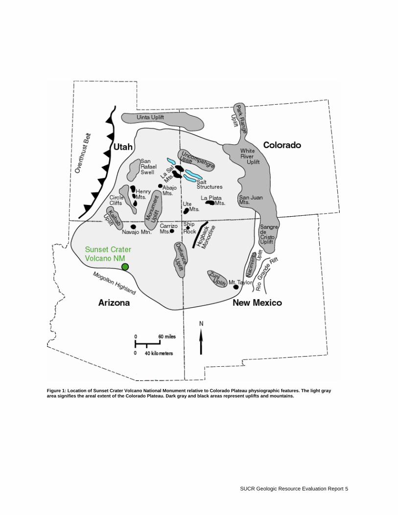
Geologic Setting John Wesley Powell named “Sunset Mountain” in 1892 during his famous expedition (Colton, 1945). President Herbert Hoover established Sunset Crater Volcano as a National Monument on May 26, 1930, to protect both the delicate volcanic features and any archaeological resources in the area. The land was transferred from the U.S. Forest Service to the National Park Service August 10, 1933, and was renamed on November 16, 1990. The primary natural resources of the park are the volcanic flows, ashfalls, craters, and ridges. This park is part of the Geologic Resource Evaluation program because of the unique geologic resources and human impacts to these resources. Information gathered at this park may also be used to represent other parks with similar resources or patterns of use, especially when the findings are evaluated for Servicewide implications. At an average elevation of 305 m (1,000 ft) above the valley floor, the rim of Sunset Crater Volcano dominates the landscape of the 3,040 acre national monument. It is part of a N 60 W trending 10 km long chain that includes Rows of Cones, Gyp Crater, and Vent512 (Blaylock, 1996). The base of the volcano is at 2,134 m (7,000 ft) above sea level (Hodges, 1962). The monument, located in north- central Arizona, is along the very southern edge of a feature called the Colorado Plateau Province (Figure 1). Covering parts of Colorado, Utah, Arizona, and New Mexico, the Colorado Plateau is a region of high plateaus and broad, rounded uplands separated by vast rangelands. The rangelands are underlain by large elliptical stratigraphic basins. The structural fabric of gently warped, rounded folds contrasts with the intense deformation and faulting of the terranes bordering the Colorado Plateau. Northeast and east of the Colorado Plateau are the jagged peaks of the Rocky Mountains. The Mesozoic- age overthrust belt marks the west- northwest edge of the Colorado Plateau (Figure 1). The extensional, normal- faulted Basin and Range Province borders the Colorado Plateau to the west and south. The Rio Grande Rift, tearing a ragged scar in the landscape, forms the southeastern border. The Colorado Plateau is also known for its laterally extensive monoclines that formed during the Late Cretaceous – Tertiary (Figure 1). The basins adjacent to the steep limbs of the monoclines have been filled with sediment eroded from these folds. Many of the features present on the Colorado Plateau today were molded by the processes of erosion. The destructive forces of wind and rain, running water, and freezing temperatures attacked the uplifts as soon as all
NPS Geologic Resources Division 4
the tectonic havoc started in the Late Cretaceous. The Colorado Plateau has been uplifted about 3,660 m (12,000 ft) since the end of the Cretaceous about 66 million years ago (Fillmore, 2000). Some of this uplift occurred geologically rapidly. The rate of erosion increased as the rate of uplift increased. The Colorado River carved its present course within the last 6 million years. With uplift, streams throughout the Colorado Plateau began to dissect the topography with unprecedented vigor, carving the rocks and carrying away the dismantled strata into the landscape we see today. The Grand Canyon located northwest of Sunset Crater Volcano is a relatively recent development on the plateau. However, few geologic features are more recent than the cinder cone at Sunset Crater Volcano National Monument, the youngest volcano in Arizona. Last erupting around A.D. 1064, Sunset Crater Volcano is part of northern Arizona’s San Francisco Volcanic Field, much of which lays within Coconino and Kaibab national forests. This is an area of young volcanoes. Volcanism dates from late Miocene or Pliocene to recent (Hodges, 1962). Nearly all the hills and mountains between Flagstaff and the Grand Canyon are the young (geologically) but extinct volcanoes of the San Francisco Volcanic Field. The field covers about 4,662 square km (1,800 square miles) of northern Arizona’s piñon- juniper and ponderosa pine to fir and bristlecone pine forested, semi- arid landscape. This field has produced more than 550 basaltic vents during its 6 million years of volcanic activity (Holm and Moore, 1987). Extreme volcanic activity has created a topographically varied landscape. The most prominent regional landmark is San Francisco Mountain. This stratovolcano rises to 3,851 m (12,633 ft). As Arizona’s highest peak, it dominates the high, semi- arid horizon. Most volcanoes are located near boundaries of the Earth’s lithospheric tectonic plates, including the Cascades in Washington and Oregon and the New
Zealand volcanoes. However, Arizona is well within the interior of the North American Plate. Similar to Yellowstone National Park, a site of localized melting, or “hot spot,” is fixed deep within the Earth beneath northern Arizona. As the North American Plate moves slowly westward over this stationary source of hot, molten rock in Arizona, eruptions produce volcanoes that extend progressively eastward in a roughly linear fashion. This is similar to the string of volcanics crossing southern Idaho including Craters of the Moon National Monument. The first volcanoes began to erupt about 6 million years ago in the vicinity of the current Williams, Arizona. Following these early eruptions, a belt (several km wide) of successively younger eruptions migrated eastward for about 80 km (50 mi). At present the belt of volcanoes stretches just beyond the area of modern Flagstaff. Although there has been no significant volcanic activity in the San Francisco Volcanic Field for nearly 1,000 years, it is likely that eruptions will continue in the future. The average interval between large eruptions is several thousand years. Predicting future events is difficult. Future activity may produce a cinder cone like the one at Sunset Crater Volcano. Cinder cones are relatively small structures. They are usually less than 1,000 feet tall and form quickly, within months to years. They are built as a result of gas- charged frothy blobs of basalt magma rising quickly to the surface. These blobs are erupted as an upward spray or lava fountain. As projectiles during flight, the lava blobs cool and fall back to the ground. As the fragments accumulate, they build a cone- shaped hill. The eruptive activity at Sunset Crater was no doubt witnessed by Native Americans inhabiting the Wupatki area. The rapid geomorphological change must have affected their way of life. The aftermath of a volcanic eruption is pristinely preserved at Sunset Crater Volcano National Monument.
SUCR Geologic Resource Evaluation Report 5
Figure 1: Location of Sunset Crater Volcano National Monument relative to Colorado Plateau physiographic features. The light gray area signifies the areal extent of the Colorado Plateau. Dark gray and black areas represent uplifts and mountains.
NPS Geologic Resources Division 6
Geologic Issues A Geologic Resource Evaluation scoping session was held for Sunset Crater Volcano National Monument on June 28- 29, 2001, to discuss geologic resources, to address the status of geologic mapping, and to assess resource management issues and needs. The following section synthesizes the scoping results, in particular, those issues that may require attention from resource managers. Recreation Demands Sunset Crater Volcano National Monument is located 19 km (12 mi) north of Flagstaff, Arizona, and 241 km (150 mi) north of Phoenix, a rapidly growing metropolitan area of more than 2 million people. The Flagstaff community has a population of approximately 55,000. Flagstaff acts as the focal point of providing numerous services for the extensive ranching, lumber, and tourist activities of north- central Arizona. Sunset Crater Volcano National Monument is a relatively small space within a geographic area dominated by the Coconino National Forest. The preservation of the regional ecosystem requires close coordination with the U.S. Forest Service. The private lands between Flagstaff and Sunset Crater Volcano National Monument are subject to increasing residential and business development. These increased urban influences threaten to degrade the integrity of the natural systems and processes. Furthermore, as population and development increase both locally and regionally, demand for all types of recreation on public lands will increase accordingly. Although volcanic features and natural resources within monument boundaries remain relatively undisturbed, the situation is quite different immediately outside the monument boundaries. An off- highway vehicle use area is located just adjacent to the monument within the Coconino National Forest. Heavy use of this popular area causes increased noise levels, dust clouds, and long-term scarring and erosion to the landscape of cinder cones and other geological features. These features are closely related to the Sunset Crater Volcano eruption. The impact of these vehicular scars is long- lasting and not easily remedied.
Inventory, Monitoring, and/or Research Needs for Recreation Demands • Perform a comprehensive study of the surrounding
recreation demands and determine their potential threats to the monument’s ecosystem and preservation.
• Initiate a spatter cone inventory to discern the current
condition of each cone and which cones should be closed to visitors in an attempt to better stabilize and preserve them.
Slope Failures and Erosion The potential for landslides and rockfalls exists along most, if not all, roads and trails at Sunset Crater Volcano National Monument. These movements can cause road and trail problems and closures at the monument. Similarly, slumps and other forms of slope failure are common for volcanic units. Loosely packed or unconsolidated materials are especially vulnerable to failure when exposed on a slope. Precipitation necessary to produce flash flooding at Sunset Crater Volcano loosens rock and soil on slopes lacking stabilizing plant and tree roots. Rock and soil suddenly saturated with water slip down the slope to cause a slump or flow. Steep cinder cones are highly susceptible to erosion and are especially hazardous when undercut by a road or a trail. Hiking is prohibited on the cinder cone. The trail that once existed to the top of Sunset Crater Volcano was closed in 1973 because of excessive erosion. Similar to most trails over delicate volcanic features, foot traffic and erosion had turned the trail into a hip- deep rut. The trace is still clearly visible on the side of the volcano despite intensive efforts to obliterate the trail.
Inventory, Monitoring, and/or Research Needs for Slope Failures and Erosion • Perform a comprehensive study of the
erosion/weathering processes active at Sunset Crater Volcano National Monument, taking into account rock formations, slope aspects, location, and likelihood of instability.
• Create a rockfall susceptibility map using rock unit
versus slope aspect in a GIS; use the map in determining future developments and current resource management including trails, buildings, and recreational use areas.
Pumice Mining Issues Pumice is mined for industrial use and landscaping materials. Pumice mining on the slopes of San Francisco Mountain affects the viewshed of Sunset Crater Volcano National Monument. This is particularly noticeable from the Lava Flow trail. The Lava Flow trail is the most interpretive trail in the park where the story of Sunset Crater Volcano and its

SUCR Geologic Resource Evaluation Report 7
relation to the greater San Francisco Volcanic Field is explained. The trail probably receives the most visitors interested in the geological history of the area. Visitors can also have an impact on the volcanic rock resources within the park. Rocks are at risk of being removed from the park as souvenirs because there are unique, freshly preserved, volcanic rocks present.
Inventory, Monitoring, and/or Research Needs for Pumice Mining Issues • Work closely with local mining companies to remedy
the viewshed problems. Plant trees and create other buffers to help alleviate the situation.
• Inventory the unique volcanic rock “hotspots” along
roads, trails, near picnic areas, restrooms, etc. to determine visitor removal of these resources.
Seismicity and Volcanism Prior to the 1065 A.D. eruption, the local inhabitants probably felt the earth shake in a number of seismic events leading up to the volcanic release. Seismicity is often a precursor to volcanic activity because of the rising tensions and pressures within the earth caused by the movement of molten material (magma) and the buildup of gas pressure as the magma approaches the surface. Seismographs measure movements within the earth and can predict, in part, upcoming volcanic activity. Seismographs located on many of the Cascade volcanoes aided in the Mt. Saint Helens evacuation. There is a seismograph on the crater rim at Sunset Crater Volcano National Monument. It measured eight different seismic events in one day on October 18, 1998. The chances for further activity in the San Francisco Volcanic Field are great because of the successive nature of hotspot volcanism. An excellent example of hotspot activity is in the Hawaiian Islands. The Pacific lithospheric plate is moving over the hotspot and creating a linear chain of islands. A new island is being formed off the coast of Hawaii. The recurrence interval for the volcanoes in Arizona is approximately 1,000 years, making long- term prediction difficult. The seismograph at Sunset Crater Volcano will give a short-term warning of an impending event. Earthquakes can also create hazardous landslides and rockfalls. Unconsolidated material found on the slopes of Sunset Crater Volcano is especially susceptible to failure when the earth trembles.
Inventory, Monitoring, and/or Research Needs for Seismicity and Volcanism • Perform engineering studies using a strain meter to
assess possible hazards of slope collapse and to evaluate the potential for new volcanism.
• Use high resolution Global Positioning System (GPS) to detect moving, swelling, and collapse in areas of the monument.
• Obtain and evaluate regular seismic activity reports in
the surrounding areas to measure and monitor activity in the region.
Noise Pollution The off- road vehicle use area just outside the monument boundaries creates significant noise pollution. Low flying military jet aircraft often cause sonic booms in low population density areas of northern Arizona. Sonic booms are so powerful they can affect geological features. Much like seismic waves, sound waves are transmitted through rock. In an area with delicate, unconsolidated, pristine volcanic features such as those on the slopes of Sunset Crater Volcano National Monument, any disturbance is of concern to management.
Inventory, Monitoring, and/or Research Needs for Noise Pollution • Monitor decibel levels in the monument. • Contact local, military, and other groups to establish a
working relationship to help alleviate some of the noise pollution problems.
• Conduct stress studies to determine effects of sound
waves on the cinder cone slopes.
Water Issues The area around Sunset Crater Volcano National Monument is semi- arid and receives an average of 270-300 mm of precipitation annually (Doolittle, 1998). Water resource management is an important task at the monument. The regional water table occurs predominantly in the Coconino Sandstone at altitudes of about 1,524 m (5,000 ft) above sea level at Sunset Crater Volcano. The groundwater flow is generally northeastward. Some perched aquifers persist in the Moenkopi Formation, but these are not reliable water sources for the monument (Cosner, 1962).
Inventory, Monitoring, and/or Research Needs for Water Issues • Conduct hydrogeologic studies to define subsurface
flow patterns, regional and local flow systems. • Monitor water quality at multiple sample locations
within the monument. Drinking water sources are especially important for monitoring.
• Install wells for testing and for access to drinking
water.

NPS Geologic Resources Division 8
• Identify and study potential sources that could impact groundwater quality for the entire monument.
• Install transducers and dataloggers in wells. • Investigate additional methods to characterize
groundwater recharge areas and flow directions.
Wind Erosion and Deposition Wind is a major force that can redistribute soil and soil resources (e.g., litter, organic matter, and nutrients) within and among ecosystems. Erosion and deposition by wind are important at Sunset Crater Volcano and can be accelerated by human activities. Accelerated losses of soil and soil resources by erosion are degrading to arid-land ecosystems because ecosystem health is dependent on the retention of these resources. Park management practices limit or prohibit off- road vehicular travel so human impacts within the parks are primarily associated with off- trail hiking in high- use areas. Wind erosion and sediment transport may be strongly affected by land- use practices outside the parks. Eolian sand from disturbed surfaces may saltate onto undisturbed ground, burying and killing vegetation and/or biological soil crusts, or breaking biological soil crusts to expose more soil to erosion.
Inventory, Monitoring, and/or Research Needs for Wind Erosion and Deposition • Monitor movement of soil materials. • Investigate ecosystem consequences of soil movement. • Investigate natural range of variability of soil
movement in relation to landscape configuration and characteristics.
General Geology The unique geology of Sunset Crater Volcano National Monument lends itself to scientific research. Included are aftermath of volcanic eruptions, regional and local volcanic features and ejecta types, dating of different flow and eruption events, lava composition, and weathering/erosion rates. The landscape was profoundly affected by the eruption of Sunset Crater Volcano. The ecosystem response to such a recent event is of interest to geologists and biologists alike. In a landscape that looks barren and inhospitable, islands of vegetation and animal life are
testament to the adaptation of the biological components to the geologic processes. Low volume volcanoes like Sunset Crater were previously thought to produce monogenetic flows and ejecta- - very simple compositions with little variability throughout the eruption. Geologists are questioning whether or not this scenario is the case at Sunset Crater where the different compositions of the lava flows, cinders, pyroclastic flows, etc. are of continuing scientific interest (Larson and Holm, 1989; Smith et al., 1996; Blaylock, 1996).
Inventory, Monitoring, and/or Research Needs for General Geology • Perform rock color studies. • Develop more graphics and brochures emphasizing
geology for the average enthusiast. • Perform an archaeological inventory of any artifacts
found within and around the monument. • Inventory the different rock compositions at macro
(outcrop) and micro (thin section) scale. Create a digital coverage of the variability in composition to determine a sequence of events based on chemical genesis.
Air Issues Harmful chemicals and particulates are responsible for increased acid deposition in northern Arizona. Sources of these contaminants include the numerous power plants supplying electricity to the ever increasing local population. Acid rain can dramatically affect the geologic landscape by preferentially eroding and weathering soluble rock layers including carbonates, intergranular cements, and entire rock units. This preferential erosion, accelerated by the increasing acidity of precipitation, can destabilize slopes and cliffs and result in a greater frequency of rock falls and slope failures.
Inventory, Monitoring, and/or Research Needs for Air Issues • Monitor rainwater pH, noting spikes or changes. • Establish a working relationship with the appropriate
industries in an attempt to decrease the level of pollutants in the air over the monument.
SUCR Geologic Resource Evaluation Report 9
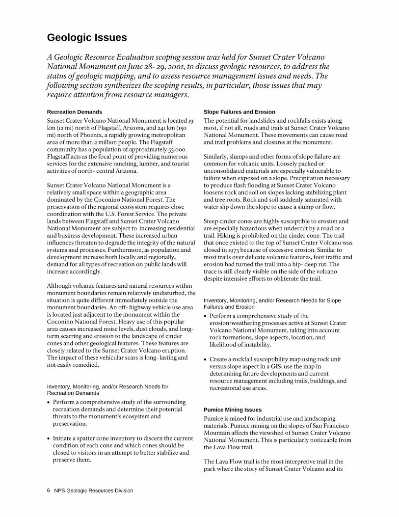
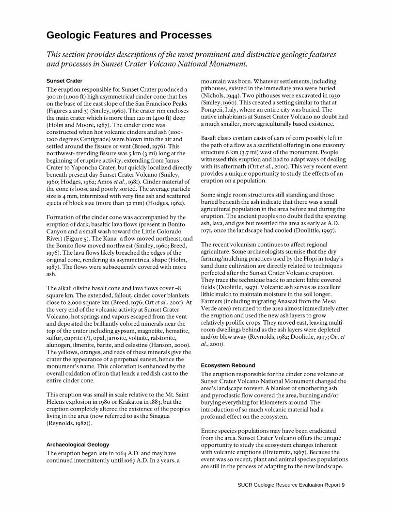
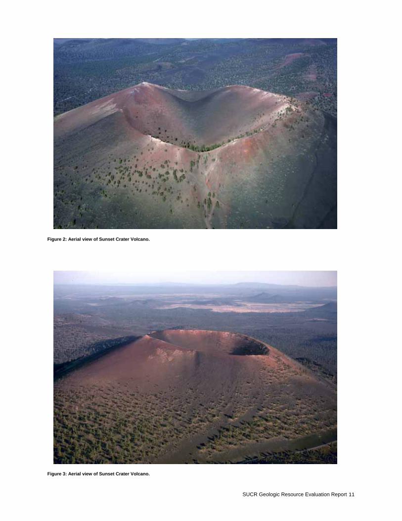
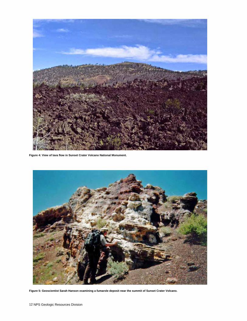
Geologic Features and Processes This section provides descriptions of the most prominent and distinctive geologic features and processes in Sunset Crater Volcano National Monument. Sunset Crater The eruption responsible for Sunset Crater produced a 300 m (1,000 ft) high asymmetrical cinder cone that lies on the base of the east slope of the San Francisco Peaks (Figures 2 and 3) (Smiley, 1960). The crater rim encloses the main crater which is more than 120 m (400 ft) deep (Holm and Moore, 1987). The cinder cone was constructed when hot volcanic cinders and ash (1100-1200 degrees Centigrade) were blown into the air and settled around the fissure or vent (Breed, 1976). This northwest- trending fissure was 5 km (3 mi) long at the beginning of eruptive activity, extending from Janus Crater to Yaponcha Crater, but quickly localized directly beneath present day Sunset Crater Volcano (Smiley, 1960; Hodges, 1962; Amos et al., 1981). Cinder material of the cone is loose and poorly sorted. The average particle size is 4 mm, intermixed with very fine ash and scattered ejecta of block size (more than 32 mm) (Hodges, 1962). Formation of the cinder cone was accompanied by the eruption of dark, basaltic lava flows (present in Bonito Canyon and a small wash toward the Little Colorado River) (Figure 5). The Kana- a flow moved northeast, and the Bonito flow moved northwest (Smiley, 1960; Breed, 1976). The lava flows likely breached the edges of the original cone, rendering its asymmetrical shape (Holm, 1987). The flows were subsequently covered with more ash. The alkali olivine basalt cone and lava flows cover ~8 square km. The extended, fallout, cinder cover blankets close to 2,000 square km (Breed, 1976; Ort et al., 2001). At the very end of the volcanic activity at Sunset Crater Volcano, hot springs and vapors escaped from the vent and deposited the brilliantly colored minerals near the top of the crater including gypsum, magnetite, hematite, sulfur, cuprite (?), opal, jarosite, voltaite, ralstonite, alunogen, ilmenite, barite, and celestine (Hanson, 2000). The yellows, oranges, and reds of these minerals give the crater the appearance of a perpetual sunset, hence the monument’s name. This coloration is enhanced by the overall oxidation of iron that lends a reddish cast to the entire cinder cone. This eruption was small in scale relative to the Mt. Saint Helens explosion in 1980 or Krakatoa in 1883, but the eruption completely altered the existence of the peoples living in the area (now referred to as the Sinagua (Reynolds, 1982)).
Archaeological Geology The eruption began late in 1064 A.D. and may have continued intermittently until 1067 A.D. In 2 years, a
mountain was born. Whatever settlements, including pithouses, existed in the immediate area were buried (Nichols, 1944). Two pithouses were excavated in 1930 (Smiley, 1960). This created a setting similar to that at Pompeii, Italy, where an entire city was buried. The native inhabitants at Sunset Crater Volcano no doubt had a much smaller, more agriculturally based existence. Basalt clasts contain casts of ears of corn possibly left in the path of a flow as a sacrificial offering in one masonry structure 6 km (3.7 mi) west of the monument. People witnessed this eruption and had to adapt ways of dealing with its aftermath (Ort et al., 2001). This very recent event provides a unique opportunity to study the effects of an eruption on a population. Some single room structures still standing and those buried beneath the ash indicate that there was a small agricultural population in the area before and during the eruption. The ancient peoples no doubt fled the spewing ash, lava, and gas but resettled the area as early as A.D. 1071, once the landscape had cooled (Doolittle, 1997). The recent volcanism continues to affect regional agriculture. Some archaeologists surmise that the dry farming/mulching practices used by the Hopi in today’s sand dune cultivation are directly related to techniques perfected after the Sunset Crater Volcanic eruption. They trace the technique back to ancient lithic covered fields (Doolittle, 1997). Volcanic ash serves as excellent lithic mulch to maintain moisture in the soil longer. Farmers (including migrating Anasazi from the Mesa Verde area) returned to the area almost immediately after the eruption and used the new ash layers to grow relatively prolific crops. They moved east, leaving multi-room dwellings behind as the ash layers were depleted and/or blew away (Reynolds, 1982; Doolittle, 1997; Ort et al., 2001).
Ecosystem Rebound The eruption responsible for the cinder cone volcano at Sunset Crater Volcano National Monument changed the area’s landscape forever. A blanket of smothering ash and pyroclastic flow covered the area, burning and/or burying everything for kilometers around. The introduction of so much volcanic material had a profound effect on the ecosystem. Entire species populations may have been eradicated from the area. Sunset Crater Volcano offers the unique opportunity to study the ecosystem changes inherent with volcanic eruptions (Breternitz, 1967). Because the event was so recent, plant and animal species populations are still in the process of adapting to the new landscape.

NPS Geologic Resources Division 10
This volcano and its relatively undeveloped landscape provide an unparalleled opportunity to study plant succession and ecological change in a dry volcanic landscape.
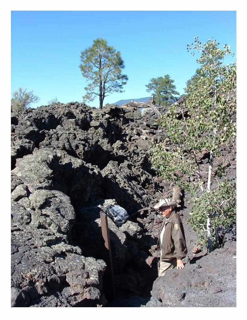
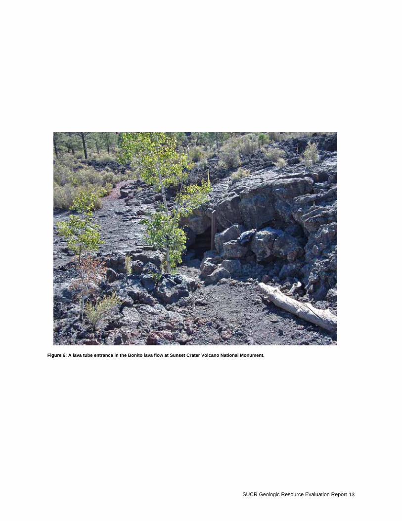
Unique Volcanic Features In addition to the cinder cone and fresh lava flows, other phenomena associated with volcanism including lava bombs, lava tubes, and xenoliths are abundant at Sunset Crater Volcano National Monument. Xenoliths of the host or country rock including limestones and sandstones are embedded in the flows. They are easily recognized by their contrast in color with the lava. Lava bombs are large blobs of molten rock ejected during violent eruptions. During their fall to earth, they revolve,
spin, and become elongate. They often form football or other rounded shapes and range in size from a few centimeters to several meters in diameter. These bombs can be ejected quite far from the volcano’s center. They are found littering the slopes and lava flows of Sunset Crater Volcano. A crust builds over the top of the lava as it flows downhill (Breed, 1976). Beneath the crust, the molten lava is still flowing. When the source is depleted or the flow diverts elsewhere, the material remaining under the crust drains and the remnant tube or lava conduit remains hollow. The tube at Sunset Crater is commonly referred to as an “ice cave” because the air inside is usually below freezing. Any water present in the tube freezes and typically remains frozen due to the insulating properties of the lava (Breed, 1976).
SUCR Geologic Resource Evaluation Report 11
Figure 2: Aerial view of Sunset Crater Volcano.
Figure 3: Aerial view of Sunset Crater Volcano.
NPS Geologic Resources Division 12
Figure 4: View of lava flow in Sunset Crater Volcano National Monument.
Figure 5: Geoscientist Sarah Hanson examining a fumarole deposit near the summit of Sunset Crater Volcano.
SUCR Geologic Resource Evaluation Report 13
Figure 6: A lava tube entrance in the Bonito lava flow at Sunset Crater Volcano National Monument.
NPS Geologic Resources Division 14
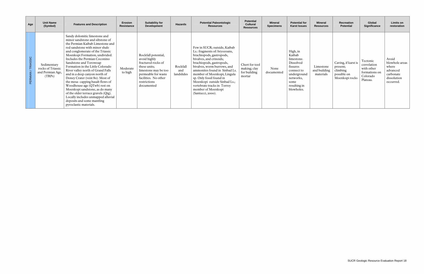
Map Unit Properties This section provides a description for and identifies many characteristics of the map units that appear on the digital geologic map of Sunset Crater Volcano National Monument. The table is highly generalized and is provided for informational purposes only. Ground disturbing activities should not be permitted or denied on the basis of information contained in this table. More detailed unit descriptions can be found in the help files that accompany the digital geologic map or by contacting the NPS Geologic Resources Division. Though entirely covered by volcanics, Sunset Crater Volcano National Monument is underlain almost entirely by Triassic and Permian age, clastic, sedimentary rocks. The sedimentary strata include the Permian Kaibab Limestone and red sandstone with minor shale and conglomerate of the Triassic Moenkopi Formation. Locally, these beds include the Permian Coconino Sandstone and Toroweap Formation. A variety of volcanic rocks are deposited atop these sedimentary rock units. These include the fallout and flows of the Sunset Crater Volcano eruption (alkali olivine basalt flows, pyroclastic sheets, and cinders); the earlier O’Leary Peak flows and pyroclastics; the Deadman Mesa flows; the San Francisco Mountain basalts, ash and flows from Strawberry; and O’Neill craters and various other vents, cones, and fissures within the vast San Francisco Volcanic Field of northern Arizona.
Quaternary terrace gravels, alluvium and colluvium, are exposed where not covered along stream beds, at the bases of slopes, and in ancient abandoned fields. Eolian deposits, blown into dunes of fine- grained sand derived from the fresh volcanic cinders of the Sunset Crater eruption, are the most recent additions to the landscape. The following pages present a table view of the stratigraphic column and an itemized list of features per rock unit. This sheet includes several properties specific to each unit present in the stratigraphic column including: map symbol, name, description, resistance to erosion, suitability for development, hazards, potential paleontologic resources, cultural and mineral resources, potential karst issues, recreational use potential, and global significance.
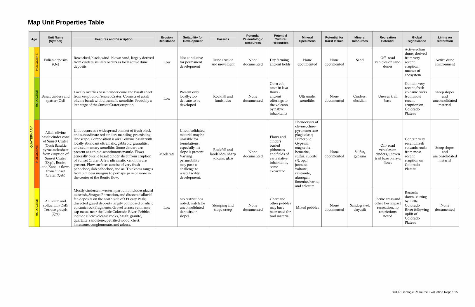
Map Unit Properties Table
Age Unit Name (Symbol) Features and Description Erosion
Resistance Suitability for Development Hazards
Potential Paleontologic
Resources
Potential Cultural
Resources Mineral
Specimens Potential for Karst Issues
Mineral Resources
Recreation Potential
Global Significance
Limits on restoration
HO
LOC
EN
E
Eolian deposits (Qe)
Reworked, black, wind- blown sand, largely derived from cinders; usually occurs as local active dune deposits.
Low Not conducive for permanent development
Dune erosion and movement
None documented
Dry farming ancient fields
None documented
None documented
Sand
Off- road vehicles on sand
dunes
Active eolian dunes derived from very recent eruption, nuance of ecosystem
Active dune environment
HO
LOC
EN
E
Basalt cinders and spatter (Qsl)
Locally overlies basalt cinder cone and basalt sheet from eruption of Sunset Crater. Consists of alkali olivine basalt with ultramafic xenoliths. Probably a late stage of the Sunset Crater eruption.
Low
Present only locally; too delicate to be developed
Rockfall and landslides
None documented
Corn cob casts in lava flows -ancient offerings to the volcano by native inhabitants
Ultramafic xenoliths
None documented
Cinders, obsidian
Uneven trail base
Contain very recent, fresh volcanic rocks from most recent eruption on Colorado Plateau
Steep slopes and
unconsolidated material
HO
LOC
EN
E
Alkali olivine basalt cinder cone of Sunset Crater (Qsc); Basaltic
pyroclastic sheet from eruption of
Sunset Crater (Qsp) , Bonito
and Kana- a flows from Sunset Crater (Qsb)
Unit occurs as a widespread blanket of fresh black and subordinate red cinders mantling preexisting landscape. Composition is alkali olivine basalt with locally abundant ultramafic, gabbroic, granulitic, and sedimentary xenoliths. Some cinders are present as a thin discontinuous mantle. Flows generally overlie basalt cinder sheet from eruption of Sunset Crater. A few ultramafic xenoliths are present. Flow surfaces consist of very fresh pahoehoe, slab pahoehoe, and aa. Thickness ranges from 2 m near margins to perhaps 30 m or more in the center of the Bonito flow.
Moderate
Unconsolidated material may be unstable for foundations, especially if a slope is present. Varying permeability may pose a challenge to waste facility development.
Rockfall and landslides, sharp
volcanic glass
None documented
Flows and cinders buried pithouses and fields of early native inhabitants, some excavated
Phenocrysts of olivine, clino-pyroxene; rare plagioclase; Fumerolic: Gypsum, magnetite, hematite, sulfur, cuprite (?), opal, jarosite, voltaite, ralstonite, alunogen, ilmenite, barite, and celestite
None documented
Sulfur, gypsum
Off- road vehicles on
cinders; uneven trail base on lava
flows
Contain very recent, fresh volcanic rocks from most recent eruption on Colorado Plateau
Steep slopes and
unconsolidated material
QU
ATE
RN
AR
Y
HO
LOC
EN
E
Alluvium and colluvium (Qal); Terrace gravels
(Qtg)
Mostly cinders; in western part unit includes glacial outwash, Sinagua Formation, and dissected alluvial fan deposits on the north side of O’Leary Peak; dissected gravel deposits largely composed of silicic volcanic rock fragments. Gravel terrace remnants cap mesas near the Little Colorado River. Pebbles include silicic volcanic rocks, basalt, granite, quartzite, sandstone, petrified wood, chert, limestone, conglomerate, and arkose.
Low
No restrictions noted, watch for unconsolidated deposits on slopes.
Slumping and slope creep
None documented
Chert and other pebbles may have been used for tool material
Mixed pebbles None
documented Sand, gravel,
clay, silt
Picnic areas and other low impact
recreation, no restrictions
noted
Records down- cutting by Little Colorado River following uplift of Colorado Plateau
None documented
SUCR Geologic Resource Evaluation Report 15

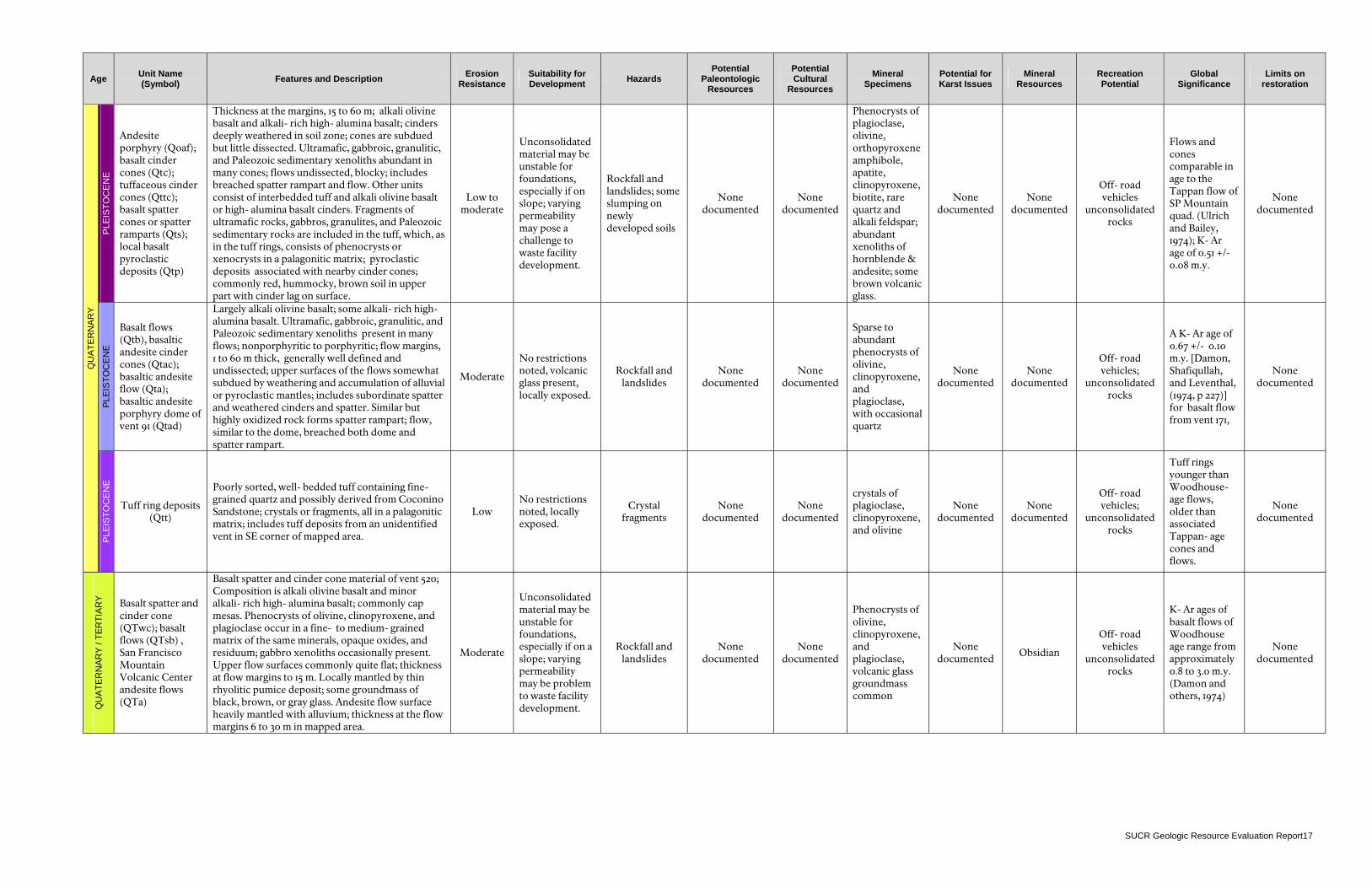
Age Unit Name (Symbol) Features and Description Erosion
Resistance Suitability for Development Hazards
Potential Paleontologic
Resources
Potential Cultural
Resources Mineral
Specimens Potential for Karst Issues
Mineral Resources
Recreation Potential
Global Significance
Limits on restoration
PLE
ISTO
CE
NE
Basalt cinder
cones & spatter from vent 127 (Qmc); basalt
pyroclastic sheet (Qms); basalt of vent 130 (Qmp);
Basalt flows (Qmpv); basaltic andesite cinder
and spatter cones (Qmb), Basaltic andesite flows
(Qmac); Vitrophyre plugs of O'Neill Crater (vent 109) (Qma); and Strawberry Crater (vent 77)
(Qmr)
Includes local spatter and tuff deposits. Composition is generally alkali olivine basalt with minor alkali- rich high- alumina basalt. Cones have sharp rims and are virtually uneroded. Includes little cinder material. Flows are usually black; smooth, relatively uneroded, continuous over large areas; upper part brown because of soil formation. Includes local dune deposits in lee of Woodhouse- and Tappan- age flows. Includes red mantling cinders and basaltic andesite spatter and cinders. Plug- like feature composed of approximately horizontal alkali olivine basalt flow units that may have been uplifted after ponding in the vent; relatively fresh pahoehoe and aa flows. Scattered ultramafic nodules occur in some flows. Thickness at flow edges ranges from 2 to 12 m. Flows have breached east sides of Strawberry (vent 77) and 0'Neill (vent 109) Craters. Apparently extruded as small viscous spines after breaching of the cones by basaltic andesite flows. Chemically, plug of 0'Neill Crater is rhyodacite and Strawberry Crater plug is dacite. Inclusions of basaltic andesite spatter occur in the vitrophyre.
Moderate
Unconsolidated material may be unstable for foundations, especially if a slope is present. Varying permeability may pose a challenge to waste facility development.
Rockfall and landslides; sharp volcanic glass in flows and unconsolidated cinder layers
None documented
None documented
Phenocrysts of olivine, clinopyroxene, orthopyroxene, and rare plagioclase, also ultramafic nodules, some volcanic glass locally
None documented Obsidian
Off- road vehicles on
cinders, uneven trail base on lava
flows
K- Ar dates include 50,000 +/- 14,000 years for the O'Neill flow and 46,000 +/- 46,000 years for the Strawberry flow (Damon et al., 1974)
None documented
PLE
ISTO
CE
NE
Rhyodacite flow of Deadman
Mesa (Qor), Vent facies of
rhyodacite flow of Deadman Mesa (Qorv);
Rhyodacite dome of Robinson
Crater (Qorr)
Plagioclase and orthopyroxene microphenocrysts are scattered in a microcrystalline to cryptocrystalline groundmass. Flow top, which is relatively flat, is largely mantled by alluvium and Sunset Crater cinders. Flow thickness at margin ~90 m. Flow erupted along a fissure marked by reddish oxidation of the rhyodacite and by a steep narrow ridge; includes obsidian and cryptocrystalline to microcrystalline rhyodacite. Dome is mantled by angular fragments. Exposed height of dome ~150 m.
Moderate
No restrictions noted; volcanic glass present, locally exposed.
Rockfall and landslides; angular fragments
None documented
None documented
Phenocrysts of Fe- olivine & plagioclase; obsidian & pumice common
None documented
Obsidian Pumice
Off- road vehicles
unconsolidated rocks
Dating of Deadman Mesa and Robinson Crater
None documented
QU
ATE
RN
AR
Y
PLE
ISTO
CE
NE
Andesite pyroclastic deposits of O'Leary Peak (Qoap); rhyo- dacite obsidian flow north of O'Leary Peak (Qoo); vent facies of rhyodacite obsidian flow north of O'Leary Peak (Qoov); Rhyodacite porphyry domes of O'Leary Peak (Qord); chaotic rock debris (Qoch); dacite flow north of O'Leary Peak (Qoch)
Red scoria with abundant xenoliths of O'Leary rhyodacite porphyry and quartz xenocrysts and scattered xenoliths of the andesite porphyry flow; occurs as crudely bedded deposits on the south and west flanks of O'Leary Peak. Obsidian is banded and largely devitrified. Flow top consists of frothy, pumiceous material. Flow is heavily mantled with Sunset Crater cinders and some alluvium. Maximum flow thickness is about 90 m. Flow erupted along fissure marked by reddish oxidation of the rhyodacite and by a steep high ridge. Two domes are present. The younger southeast dome contains rare xenoliths identical in lithology to the andesite porphyry flow. The higher northwest dome, ~ 600 m high, deeply gullied on north slope, porphyry unusually decomposed, possibly because of hydrothermal alteration; elsewhere domes are undissected.
Low to moderate
No restrictions noted; volcanic glass present; watch for unconsolidated deposits on slopes.
Rockfall and landslides, volcanic glass and other sharp rocks bad for trails and camping
None documented
None documented
Phenocrysts of plagioclase, orthopyroxene, amphibole, and quartz, sanidine, allanite, biotite. Volcanic glass and obsidian. Red to gray hornblende xenoliths are common.
None documented
Obsidian
Off- road vehicles
unconsolidated rocks
Sanidine from porphyry of northwest dome dated at 233,000 +/- 37,000 years by K- Ar (Damon et al., 1974)
None documented
SUCR Geologic Resource Evaluation Report 16
Age Unit Name (Symbol) Features and Description Erosion
Resistance Suitability for Development Hazards
Potential Paleontologic
Resources
Potential Cultural
Resources Mineral
Specimens Potential for Karst Issues
Mineral Resources
Recreation Potential
Global Significance
Limits on restoration
PLE
ISTO
CE
NE
Andesite porphyry (Qoaf); basalt cinder cones (Qtc); tuffaceous cinder cones (Qttc); basalt spatter cones or spatter ramparts (Qts); local basalt pyroclastic deposits (Qtp)
Thickness at the margins, 15 to 60 m; alkali olivine basalt and alkali- rich high- alumina basalt; cinders deeply weathered in soil zone; cones are subdued but little dissected. Ultramafic, gabbroic, granulitic, and Paleozoic sedimentary xenoliths abundant in many cones; flows undissected, blocky; includes breached spatter rampart and flow. Other units consist of interbedded tuff and alkali olivine basalt or high- alumina basalt cinders. Fragments of ultramafic rocks, gabbros, granulites, and Paleozoic sedimentary rocks are included in the tuff, which, as in the tuff rings, consists of phenocrysts or xenocrysts in a palagonitic matrix; pyroclastic deposits associated with nearby cinder cones; commonly red, hummocky, brown soil in upper part with cinder lag on surface.
Low to moderate
Unconsolidated material may be unstable for foundations, especially if on slope; varying permeability may pose a challenge to waste facility development.
Rockfall and landslides; some slumping on newly developed soils
None documented
None documented
Phenocrysts of plagioclase, olivine, orthopyroxeneamphibole, apatite, clinopyroxene, biotite, rare quartz and alkali feldspar; abundant xenoliths of hornblende & andesite; some brown volcanic glass.
None documented
None documented
Off- road vehicles
unconsolidated rocks
Flows and cones comparable in age to the Tappan flow of SP Mountain quad. (Ulrich and Bailey, 1974); K- Ar age of 0.51 +/- 0.08 m.y.
None documented
PLE
ISTO
CE
NE
Basalt flows (Qtb), basaltic andesite cinder cones (Qtac); basaltic andesite flow (Qta); basaltic andesite porphyry dome of vent 91 (Qtad)
Largely alkali olivine basalt; some alkali- rich high-alumina basalt. Ultramafic, gabbroic, granulitic, and Paleozoic sedimentary xenoliths present in many flows; nonporphyritic to porphyritic; flow margins, 1 to 60 m thick, generally well defined and undissected; upper surfaces of the flows somewhat subdued by weathering and accumulation of alluvial or pyroclastic mantles; includes subordinate spatter and weathered cinders and spatter. Similar but highly oxidized rock forms spatter rampart; flow, similar to the dome, breached both dome and spatter rampart.
Moderate
No restrictions noted, volcanic glass present, locally exposed.
Rockfall and landslides
None documented
None documented
Sparse to abundant phenocrysts of olivine, clinopyroxene, and plagioclase, with occasional quartz
None documented
None documented
Off- road vehicles;
unconsolidated rocks
A K- Ar age of 0.67 +/- 0.10 m.y. [Damon, Shafiqullah, and Leventhal, (1974, p 227)] for basalt flow from vent 171,
None documented
QU
ATE
RN
AR
Y
PLE
ISTO
CE
NE
Tuff ring deposits (Qtt)
Poorly sorted, well- bedded tuff containing fine-grained quartz and possibly derived from Coconino Sandstone; crystals or fragments, all in a palagonitic matrix; includes tuff deposits from an unidentified vent in SE corner of mapped area.
Low No restrictions noted, locally exposed.
Crystal fragments
None documented
None documented
crystals of plagioclase, clinopyroxene, and olivine
None documented
None documented
Off- road vehicles;
unconsolidated rocks
Tuff rings younger than Woodhouse-age flows, older than associated Tappan- age cones and flows.
None documented
QU
ATE
RN
AR
Y /
TER
TIA
RY
Basalt spatter and cinder cone (QTwc); basalt flows (QTsb) , San Francisco Mountain Volcanic Center andesite flows (QTa)
Basalt spatter and cinder cone material of vent 520; Composition is alkali olivine basalt and minor alkali- rich high- alumina basalt; commonly cap mesas. Phenocrysts of olivine, clinopyroxene, and plagioclase occur in a fine- to medium- grained matrix of the same minerals, opaque oxides, and residuum; gabbro xenoliths occasionally present. Upper flow surfaces commonly quite flat; thickness at flow margins to 15 m. Locally mantled by thin rhyolitic pumice deposit; some groundmass of black, brown, or gray glass. Andesite flow surface heavily mantled with alluvium; thickness at the flow margins 6 to 30 m in mapped area.
Moderate
Unconsolidated material may be unstable for foundations, especially if on a slope; varying permeability may be problem to waste facility development.
Rockfall and landslides
None documented
None documented
Phenocrysts of olivine, clinopyroxene, and plagioclase, volcanic glass groundmass common
None documented
Obsidian
Off- road vehicles
unconsolidated rocks
K- Ar ages of basalt flows of Woodhouse age range from approximately 0.8 to 3.0 m.y. (Damon and others, 1974)
None documented
SUCR Geologic Resource Evaluation Report17
Age Unit Name (Symbol) Features and Description Erosion
Resistance Suitability for Development Hazards Potential Paleontologic
Resources
Potential Cultural
Resources Mineral
Specimens Potential for Karst Issues
Mineral Resources
Recreation Potential
Global Significance
Limits on restoration
PE
RM
IAN
/ TR
IAS
SIC
Sedimentary rocks of Triassic
and Permian Age, (TRPs)
Sandy dolomitic limestone and minor sandstone and siltstone of the Permian Kaibab Limestone and red sandstone with minor shale and conglomerate of the Triassic Moenkopi Formation, undivided. Includes the Permian Coconino Sandstone and Toroweap Formation in the Little Colorado River valley north of Grand Falls and in a deep canyon north of Doney Crater (vent 80). Most of the mesa- capping basalt flows of Woodhouse age (QTwb) rest on Moenkopi sandstone, as do many of the older terrace gravels (Qtg). Locally includes unmapped alluvial deposits and some mantling pyroclastic materials.
Moderate to high
Rockfall potential, avoid highly fractured rocks of these units; limestone may be too permeable for waste facilities. No other restrictions documented
Rockfall and
landslides
Few in SUCR; outside, Kaibab Ls.: fragments of: bryozoans, brachiopods, gastropods, bivalves, and crinoids; brachiopods, gastropods, bivalves, worm burrows, and ammonites found in Sinbad Ls. member of Moenkopi; Lingula sp. Only fossil found in Moenkopi outside Sinbad Ls.; vertebrate tracks in Torrey member of Moenkopi (Santucci, 2000).
Chert for tool making; clay for building mortar
None documented
High, in Kaibab limestone. Dissolved fissures connect to underground networks, some resulting in blowholes.
Limestone and building
materials
Caving, if karst is present; climbing possible on Moenkopi rocks
Tectonic correlation with other formations on Colorado Plateau.
Avoid blowhole areas where advanced carbonate dissolution occurred.
SUCR Geologic Resource Evaluation Report 18
SUCR Geologic Resource Evaluation Report 19
Geologic History This section highlights the map units (i.e., rocks and unconsolidated deposits) that occur in Sunset Crater Volcano National Monument and puts them in a geologic context in terms of the environment in which they were deposited and the timing of geologic events that created the present landscape. Striking geologic features including stark black lava flows, eolian sand dunes, and cinder cones dominate the landscape of Sunset Crater Volcano National Monument. In geologic time, the eruption responsible for the present day landscape was practically instantaneous - a snapshot in time. The story of Sunset Crater Volcano National Monument begins much earlier. The sedimentary strata in the monument region record the growth of the North American continent as part of the geological region known as the Colorado Plateau. The geologic history of the area began in the Precambrian Era when sediments and volcanic rocks were deposited in oceans and scattered island arcs (Figure 7). These deposits, once buried to great depths, were changed by heat and pressure. The deposits became metamorphosed and were further intruded by large bodies of molten magma solidifying into granite. Rocks of this age are exposed in the deepest depths of the Grand Canyon (Reynolds, 1982). Shallow seas covered the region about 1.1 billion years ago. The sedimentation responsible for the Grand Canyon Supergroup occurred at this time along with intrusions and eruptions of basaltic lava. The region became part of a Western Interior Basin as land accreted to the western margin of the North American continent during the Paleozoic faulting and deformation.. A shallow sea covered the area leading to vast deposits of mudstones, sandstones, limestones, and siltstones (Reynolds, 1982). The 240 million- year- old Kaibab Formation is made of Permian limestone deposited in the large inland seas. The ancestral Rocky Mountains were uplifted and supplied sediment to the Sunset Crater Volcano area near the end of the Paleozoic as the crustal landmasses on the globe sutured together into one big supercontinent, Pangaea. The Uncompahgre Uplift was part of the Ancestral Rocky Mountains that formed as the last land masses sutured together to form the supercontinent, Pangaea, beginning in the Pennsylvanian Period. South America joined with the southern part of North America near Texas and Oklahoma, generating the Ouachita Orogeny. The Marathon- Ouachita- southern Appalachian mountain chain resulted from this event. The effects were felt in the interior of the continent as well, where jagged peaks split the skyline as the Ancestral Rocky Mountains were thrust from the plain. Two principal mountain ranges, the Uncompahgre and the
Front Range uplifts (Figure 8), formed along northwest-southeast trending high- angle reverse faults. The broad coastal plain present in the area during the early part of the Mesozoic Era was the site of the deposition of the Triassic age Moenkopi Formation, present at Sunset Crater Volcano National Monument. Well- preserved ripple patterns, abundant mud cracks, and fossilized burrow traces are seen in the layered sandstone and shale of the formation. This deep red rock layer reflects a period of meandering rivers, tidal flats, and other near- shore deposits laid down on top of the Kaibab after the ocean regressed westward. Following Moenkopi deposition, the area to the south experienced a mountain- building event otherwise known as an orogeny. This orogeny created an erosional surface, and the stream- carried deposits resulting from that erosion form the Chinle Formation. As Pangaea began to break apart in the late Triassic Period and the landmasses began to drift to their present positions, the climate affecting the monument area became more humid. Sand dunes transformed into river systems, swamps, beaches, and broad level plains. Dinosaurs and other reptiles inhabited the region, and periodically ash drifted into the area from volcanoes far to the west. Rippling effects of lithospheric plate collisions on the western margin of North America caused the Western Interior of North America to be flexed into a shallow basin in the Cretaceous. By Late Cretaceous time, about 97 million years ago, the Western Interior Seaway or Basin had drowned the previously continental deposits, and the monument region was an ocean basin, collecting fine- grained sediments that drifted far from the shoreline to the west and southwest. This Western Interior Basin or Seaway was flooded by seawater from the Arctic region and from the ancestral Gulf of Mexico as Africa and South America rifted away from North America. Oscillations in the shoreline, either from increased sedimentation coming off the highlands to the west or from tectonic response to collisions on the western continental margin, caused the shoreline to prograde and recede several times during the next 13 million years. Thick sequences of shale, siltstone, and thin limestone beds accumulated on the margin deposited by streams, wind, and ocean currents. These make up the widespread San Rafael Group, Dakota Sandstone, and Mancos Shale. These units are useful in correlating
NPS Geologic Resources Division 20
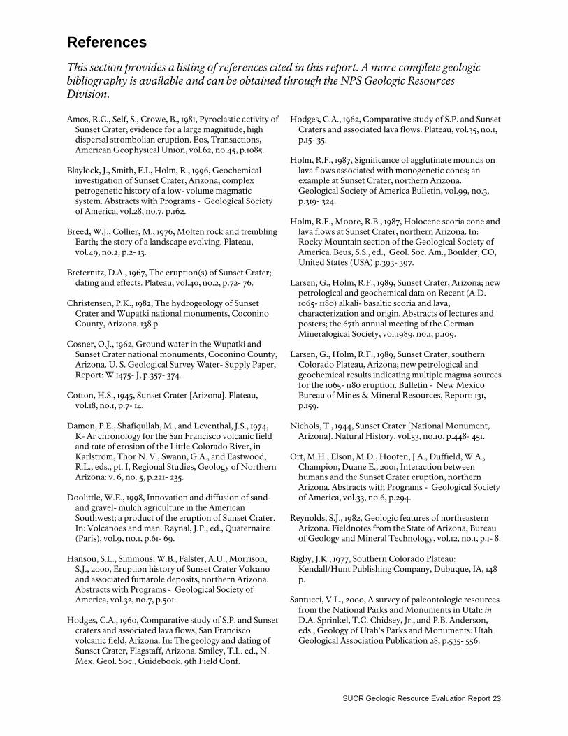
depositional environments across the Four Corners region. Mesaverde Group deposits of siltstone and shale were next deposited by the shallow seas pervasive during the late Mesozoic. Near the end of the Mesozoic Era as the Cretaceous Period came to a close, compressive forces outside the borders of the Colorado Plateau caused the region to bow upward as a relatively coherent unit during the Late Cretaceous to Mid- Tertiary Laramide Orogeny. The seas retreated from Arizona at this time. The Rocky Mountains rose to the east. Great folds and faults formed in the orogeny; the Doney fault and Black Point monocline in nearby Wupatki National Monument are examples of such features (Figure 9). The Black Point Monocline was not present in the late Paleozoic, but formed a broad, north- south trending, regional anticline during the Laramide Orogeny in late Cretaceous to Tertiary time. Regional uplift started the intense erosion whose resulting landforms define the Colorado Plateau. The magnificent canyons and sculptured rock formations began to develop with the plateau's mass of marine and coastal rocks now exposed to weathering by rain, river, and wind. Orogenic compression ceased about 35 - 40 million years ago. Erosion stripped the Tertiary and Mesozoic strata from the area of Sunset Crater and left the older sedimentary rocks exposed at the surface. Most of the erosion occurred during the last 6 million years when the Colorado Plateau began to rise. The sea retreated from the continent, and horizontal forces thrust the Rocky Mountains skyward. As the plateau rose, the Colorado River and its tributaries cut through the relatively soft sedimentary rocks and effectively entrenched their meandering patterns into the underlying bedrock. River channels incised into the underlying sediments and filled with Tertiary gravels. Violent volcanic eruptions soon followed as the San Juan Mountains exploded in the mid- Tertiary followed by hot spot volcanism in the San Francisco Volcanic Field of northern Arizona. Extensional tectonics resulted in the opening of the Rio Grande Rift near the southeastern margin of the Colorado Plateau. As the mountains rose, the processes of weathering and erosion began to bevel the mountain front into a
relatively flat landscape (peneplain) gently sloping to the southwest. A combination of glaciation, increased runoff, a rising Colorado Plateau, and a subsequent lowering of the Colorado River’s baselevel carved the present- day topography. During the Pleistocene Epoch of the Quaternary Period (1.64 million – 10,000 years before present) the climate of northern Arizona was wetter and cooler, and runoff from nearby glaciers caused massive, catastrophic flooding in the canyons. The hydraulic force of the rivers, coupled with other erosion processes such as frost wedging, root growth, and groundwater seepage, caused extreme erosion of the landscape. The Little Colorado River left terrace gravel deposits behind as it cut down through the sedimentary layers over the last two million years. These deposits form flat-topped mesa- like caps of grayish gravel over many of the red Moenkopi hills. Geologic processes and resulting landforms continue to shape the ecosystem today. Volcanic mountain building continues with the formation of Sunset Crater Volcano only 900 years ago, a snapshot in geologic time (Reynolds, 1982). The slow, sometimes imperceptible erosional processes are still at work wearing down mesa tops and deepening the canyons. Uplift and buckling of the Colorado Plateau resulted in fracturing of the sedimentary rock layers. Water seeped through the cracks in the Kaibab limestone, dissolving the carbonate rock to form long, interconnected, vertical fractures, similar to how a cave forms. Small surface openings to this fracture system, called blowholes, breathe as the underground air responds to changes in the temperature and pressure. One such blowhole may be seen along the Wupatki Pueblo trail. The stratigraphic relationships, hydrology, and tectonics offer research projects that might benefit the park. They also create some potential geological issues that need to be addressed. The cinder cone and surrounding landscape at Sunset Crater Volcano National Monument stand as a monument to the grand expression of deep time, that time that surpasses our understanding but reminds us that Earth is not static but is subject to change.
SUCR Geologic Resource Evaluation Report 21
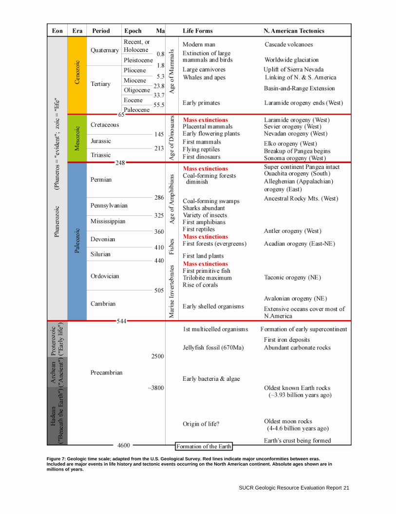
Figure 7: Geologic time scale; adapted from the U.S. Geological Survey. Red lines indicate major unconformities between eras. Included are major events in life history and tectonic events occurring on the North American continent. Absolute ages shown are in millions of years.
NPS Geologic Resources Division 22
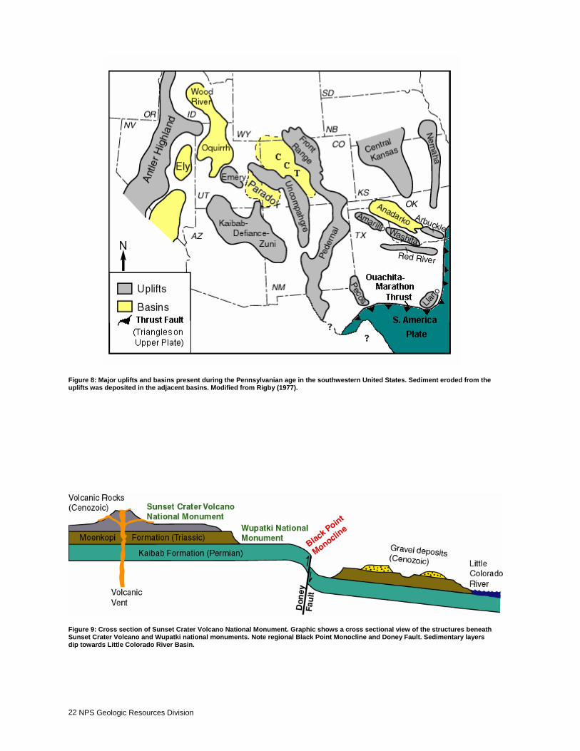
Figure 8: Major uplifts and basins present during the Pennsylvanian age in the southwestern United States. Sediment eroded from the uplifts was deposited in the adjacent basins. Modified from Rigby (1977).
Figure 9: Cross section of Sunset Crater Volcano National Monument. Graphic shows a cross sectional view of the structures beneath Sunset Crater Volcano and Wupatki national monuments. Note regional Black Point Monocline and Doney Fault. Sedimentary layers dip towards Little Colorado River Basin.
SUCR Geologic Resource Evaluation Report 23
References This section provides a listing of references cited in this report. A more complete geologic bibliography is available and can be obtained through the NPS Geologic Resources Division. Amos, R.C., Self, S., Crowe, B., 1981, Pyroclastic activity of
Sunset Crater; evidence for a large magnitude, high dispersal strombolian eruption. Eos, Transactions, American Geophysical Union, vol.62, no.45, p.1085.
Blaylock, J., Smith, E.I., Holm, R., 1996, Geochemical
investigation of Sunset Crater, Arizona; complex petrogenetic history of a low- volume magmatic system. Abstracts with Programs - Geological Society of America, vol.28, no.7, p.162.
Breed, W.J., Collier, M., 1976, Molten rock and trembling
Earth; the story of a landscape evolving. Plateau, vol.49, no.2, p.2- 13.
Breternitz, D.A., 1967, The eruption(s) of Sunset Crater;
dating and effects. Plateau, vol.40, no.2, p.72- 76. Christensen, P.K., 1982, The hydrogeology of Sunset
Crater and Wupatki national monuments, Coconino County, Arizona. 138 p.
Cosner, O.J., 1962, Ground water in the Wupatki and
Sunset Crater national monuments, Coconino County, Arizona. U. S. Geological Survey Water- Supply Paper, Report: W 1475- J, p.357- 374.
Cotton, H.S., 1945, Sunset Crater [Arizona]. Plateau,
vol.18, no.1, p.7- 14. Damon, P.E., Shafiqullah, M., and Leventhal, J.S., 1974,
K- Ar chronology for the San Francisco volcanic field and rate of erosion of the Little Colorado River, in Karlstrom, Thor N. V., Swann, G.A., and Eastwood, R.L., eds., pt. I, Regional Studies, Geology of Northern Arizona: v. 6, no. 5, p.221- 235.
Doolittle, W.E., 1998, Innovation and diffusion of sand-
and gravel- mulch agriculture in the American Southwest; a product of the eruption of Sunset Crater. In: Volcanoes and man. Raynal, J.P., ed., Quaternaire (Paris), vol.9, no.1, p.61- 69.
Hanson, S.L., Simmons, W.B., Falster, A.U., Morrison,
S.J., 2000, Eruption history of Sunset Crater Volcano and associated fumarole deposits, northern Arizona. Abstracts with Programs - Geological Society of America, vol.32, no.7, p.501.
Hodges, C.A., 1960, Comparative study of S.P. and Sunset
craters and associated lava flows, San Francisco volcanic field, Arizona. In: The geology and dating of Sunset Crater, Flagstaff, Arizona. Smiley, T.L. ed., N. Mex. Geol. Soc., Guidebook, 9th Field Conf.
Hodges, C.A., 1962, Comparative study of S.P. and Sunset Craters and associated lava flows. Plateau, vol.35, no.1, p.15- 35.
Holm, R.F., 1987, Significance of agglutinate mounds on
lava flows associated with monogenetic cones; an example at Sunset Crater, northern Arizona. Geological Society of America Bulletin, vol.99, no.3, p.319- 324.
Holm, R.F., Moore, R.B., 1987, Holocene scoria cone and
lava flows at Sunset Crater, northern Arizona. In: Rocky Mountain section of the Geological Society of America. Beus, S.S., ed., Geol. Soc. Am., Boulder, CO, United States (USA) p.393- 397.
Larsen, G., Holm, R.F., 1989, Sunset Crater, Arizona; new
petrological and geochemical data on Recent (A.D. 1065- 1180) alkali- basaltic scoria and lava; characterization and origin. Abstracts of lectures and posters; the 67th annual meeting of the German Mineralogical Society, vol.1989, no.1, p.109.
Larsen, G., Holm, R.F., 1989, Sunset Crater, southern
Colorado Plateau, Arizona; new petrological and geochemical results indicating multiple magma sources for the 1065- 1180 eruption. Bulletin - New Mexico Bureau of Mines & Mineral Resources, Report: 131, p.159.
Nichols, T., 1944, Sunset Crater [National Monument,
Arizona]. Natural History, vol.53, no.10, p.448- 451. Ort, M.H., Elson, M.D., Hooten, J.A., Duffield, W.A.,
Champion, Duane E., 2001, Interaction between humans and the Sunset Crater eruption, northern Arizona. Abstracts with Programs - Geological Society of America, vol.33, no.6, p.294.
Reynolds, S.J., 1982, Geologic features of northeastern
Arizona. Fieldnotes from the State of Arizona, Bureau of Geology and Mineral Technology, vol.12, no.1, p.1- 8.
Rigby, J.K., 1977, Southern Colorado Plateau:
Kendall/Hunt Publishing Company, Dubuque, IA, 148 p.
Santucci, V.L., 2000, A survey of paleontologic resources
from the National Parks and Monuments in Utah: in D.A. Sprinkel, T.C. Chidsey, Jr., and P.B. Anderson, eds., Geology of Utah’s Parks and Monuments: Utah Geological Association Publication 28, p.535- 556.

NPS Geologic Resources Division 24
Smiley, T.L., 1960, Geology and Dating of Sunset Crater, Flagstaff, Arizona. In: The geology and dating of Sunset Crater, Flagstaff, Arizona. Smiley, T.L. ed., N. Mex. Geol. Soc., Guidebook, 9th Field Conf.
Smith, E.I., Blaylock, J., Boland, K., Morikawa, S.,
Sanchez, A., 1996, Complex behavior of low- volume mafic magma systems; polycyclic, polygenetic, and complex monogenetic quaternary cinder cones in the Western US and Mexico. Abstracts with Programs - Geological Society of America, vol.28, no.7, p.502.
Ulrich, G.E., and Bailey, N.G., 1974, Geologic map of the SP Mountain quadrangle: U. S. Geol. Survey open- file map, p.74- 75.
SUCR Geologic Resource Evaluation Report 25
Appendix A: Geologic Map Graphic This image provides a preview or “snapshot” of the geologic map for Sunset Crater Volcano National Monument. For a detailed digital geologic map, see included CD.
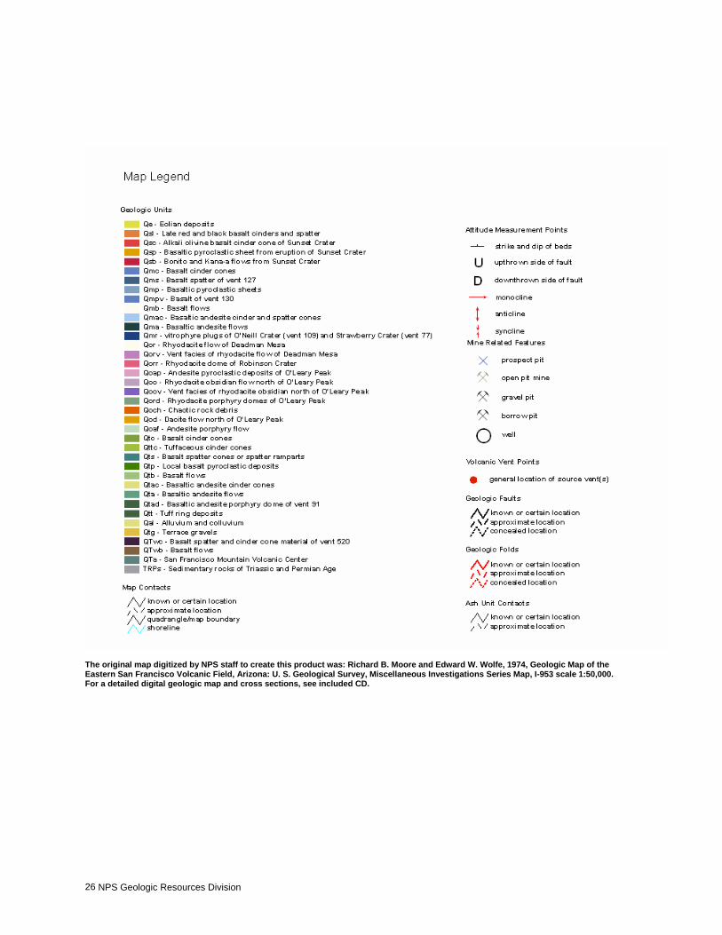
NPS Geologic Resources Division 26
The original map digitized by NPS staff to create this product was: Richard B. Moore and Edward W. Wolfe, 1974, Geologic Map of the Eastern San Francisco Volcanic Field, Arizona: U. S. Geological Survey, Miscellaneous Investigations Series Map, I-953 scale 1:50,000. For a detailed digital geologic map and cross sections, see included CD.
SUCR Geologic Resource Evaluation Report 27
Appendix B: Scoping Summary The following excerpts are from the GRE scoping summary for Sunset Crater Volcano National Monument. The scoping meeting occurred on June 28- 29, 2001; therefore, the contact information and Web addresses referred to herein may be outdated. Please contact to the Geologic Resources Division for current information. Executive Summary A geologic resources inventory workshop was held for the three Flagstaff area NPS units (Walnut Canyon NM, Wupatki NM, Sunset Crater NM) on June 28th and 29th, 2001, to view and discuss the park’s geologic resources, to address the status of geologic mapping for compiling both paper and digital maps, and to assess resource management issues and needs. Cooperators from the NPS Geologic Resources Division (GRD), NPS Flagstaff area office, Colorado State University, and United States Geologic Survey (GS) were present for the workshop. This was part of a multi- park scoping session also involving Petrified Forest NP, Pipe Spring NM, and Navajo NM. On Friday June 29th, scoping involved a half- day field trip to view the geology of Sunset Crater NM and Wupatki NM, led by Sarah Hanson (Adrian College) and Helen Fairley (NPS). On June 28th scoping included another half- day session to present overviews of the NPS Inventory and Monitoring (I&M) program, the Geologic Resources Division, and the on- going Geologic Resource Evaluation (GRE). Round table discussions involving geologic issues for Flagstaff area parks included interpretation, natural resources, the status of geologic mapping efforts, sources of available data, geologic hazards, and action items generated from this meeting. Currently, the major geologic issues facing the Flagstaff area parks are as follows: • acquiring digital geologic maps at a large scale suitable
for resource management needs; • production of an interpretive product that could be
sold in visitor centers showcasing the geologic map of each area and its significance to the other resources;
• evaluating potential volcanic hazards in the Flagstaff area and how they might affect park resources, and
• an inventory of the paleontological resources at each park
For a list of meeting attendees, see below (List of Attendees for Geological Resources Evaluation Workshop, June 25- 29, 2001)
Geologic Mapping All three Flagstaff area parks are included on the USGS publication "Map Showing Geology, Structure, and Uranium Deposits of the Flagstaff 1 x 2 degree quadrangle, Arizona; USGS Map I- 1446; scale 1:250,000). While this small scale is not necessarily conducive for
resource management, it is an excellent compilation map and was developed based upon larger scale mapping. However, larger scale mapping (at least 1:24,000 scale) is desirable for each of the three parks. Also, the USGS published the "Geologic Map of the Eastern San Francisco volcanic field, Arizona; USGS Map I- 953" that is at a scale of 1:50,000 that also covers the areas of the three parks, but does not necessarily include geologic mapping of each park. Specifically, the only park that is fully covered on this sheet is Sunset Crater NM. Walnut Canyon NM is completely uncovered and Wupatki NM is only partially covered. Park staff were interested in seeing a map showing travertine deposits because it has numerous implications for the cultural significance in population distributions and the history of water in the area, so it should be a component of any new mapping. Additionally, volcanic- and other features should be included (vents, flows, lava tubes, ice caves, etc.) as they are important in deducing a potential for volcanic hazards in the area as well as providing baseline data for what types of features exist in the park.
Digital Geologic Map Coverage It is not known if any of the USGS maps (I- 953 and I-1446) for the area have been converted to a digital format. If they have not it is suggested that they be scanned, registered and rectified for preliminary use in a GIS until new mapping is accomplished as they are the best available source of baseline geologic data for each park.
Other Desired GIS Data Nicole Tancreto had served as the Flagstaff GIS support person, but is now in a GIS position for the Southern Colorado Plateau network. She mentioned at the meeting that the boundary for Walnut Canyon NM was incorrect on our maps, so she supplied GRE staff with the correct boundary as ESRI shape files. Aerial photography is desired for the entire area and would assist in any future needed geologic mapping. It was suggested to contact the Vegetation Mapping program and the USFS to see if they have such data for the area.
NPS Geologic Resources Division 28
Miscellaneous Items of Interest Current natural resource staff at Flagstaff area parks are Helen Fairley (archeologist), Paul Whitefield, and Todd Metzger. Geothermal development is a hot topic for the Flagstaff area, and could have effects on each parks management plan.
Sunset Crater National Monument • Dick Holm (NAU retired professor) has done research
at SUCR on the lava flows. However, much of this work is not digital at the present time. His 1987 GSA article "Holocene scoria cone and lava flows at Sunset Crater, northern Arizona", has a map showing the vent deposits and lava flows and would be a good map to get into digital format. For the most part, it is the same map portrayed on I- 953.
• Sarah Hanson (SUCR- GIP, Adrian College) has been
assisting the park with their geological interpretation program for the past few summers, and has added important knowledge of the geochemistry of the park. She has been successful in translating her research into layman's terms for the park staff.
• Steep cinder cones are very susceptible to erosion.
Over the years, park visitors have used these resources for recreational activities and it has resulted in some degradation of the resources. It was suggested that a spatter cone inventory be initiated to attempt to discern what condition the cones are in and which ones should be closed to visitor use in an attempt to better stabilize them and protect them.
Wupatki National Monument • An Arizona State University student (Amos) published
on "Pyroclastic activity of Sunset Crater; evidence for a large magnitude, high dispersal strombolian eruption" in 1981. According to Michael Ort (NAU- Geology Department), this produced a map that is now digital and can be supplied to the NPS from him. It also has isopach lines that the parks are interested in obtaining digitally.
• Daniel McCormack (NAU) published "The geology of
Wupatki National Monument, northern Arizona" as his masters thesis; a copy of this is desired by GRE staff and could serve as the geologic map for WUPA as it was apparently done at 1:24,000 scale and encompasses the Doanie Cliffs area.
• Cynthia Blythe (NAU, 1995) did a Masters thesis on
gravels east of the Doanie Cliffs. • A paper on the structural geology of the region is
"Geomorphology and structure of the East Kaibab monocline," Arizona and Utah: Geological Society of America Bulletin, No. 2; Scale: 1:160,000.
• Dick Holm (NAU- retired) mapped along Deadman Wash for the cinder cones, however its not known if this was published or not.
• Gorden Haxel (USGS) may have worked on an
interpretive guide for Wupatki with the Arizona GS; we need to contact the AZ GS for specifics.
• Karst features including Earth cracks, lava tubes and
ice caves are a unique geologic feature in the Wupatki area and are of concern because of risks to visitor safety. It has been suggested that a cave inventory be completed for the area, as it is known that WUPA contains one of the largest caves in northern Arizona. Nicole Tancreto mentioned that many of these features have had GPS locations taken for them, so they exist in a digital layer.
• Many of the blowholes at WUPA have been negatively
affected over the years because of serving as dumping grounds and now some need restoration work. Additionally, they may also be potential hazards because of their depth.
• There are also several borrow pits (~12) that need
restoration; Dave Steensen (NPS- GRD, Disturbed Lands Program) has made numerous recommendations on how best to reclaim these areas.
• The Water Resources Division (USGS or NPS ??) has
been studying recharge in the area as it is critical to sustaining wildlife populations. Contact is Christiansen; unsure of first name though. Additionally, it was noted that the existing water well at WUPA is approximately 1500- 1700 feet deep and the water quantity and quality leaves much to be desired.
• Helen Fairley (archeologist) is interested in
determining the provenance of the various clays and stones used in mortars over the years and how it relates to the cultural and geologic resources of the area. It was suggested that this would make a good MS topic.
Both WUPA and SUCR have gravel deposits that are considered by many to have commercial value and external pressure may be exerted to exploit these resources and could cause resource management problems in the future. • There may be uranium and petroleum potential on
WUPA lands. Mineral rights were not acquired for the area when the land became federal. Any mineral rights apparently belong to the Arizona land office.

SUCR Geologic Resource Evaluation Report 29
Walnut Canyon National Monument • General geology of WACA consists of the Kaibab,
Toroweap, Coconino, Moenkopi formations, as well as some igneous cinders.
• I- 953 does not cover the geology of WACA, and thus a
large- scale geologic map is definitely needed. • Paleontological resources do exist in exposures along
WACA trails and have been subjected to pilferage over the years. A paleontological survey is advised for the park.
• Detailed studies of the alluvial deposits in the canyons are desired. Richard Hereford (USGS) is the most likely qualified candidate to do this and should be consulted for his interest.
• George Billingsley mentioned that there is a dam in the
park that should be restored and incorporated into the parks interpretive story.
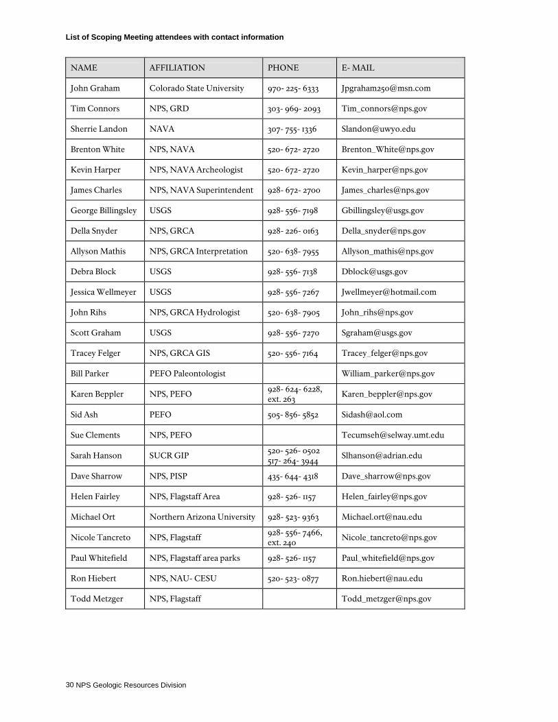
NPS Geologic Resources Division 30
List of Scoping Meeting attendees with contact information
NAME AFFILIATION PHONE E- MAIL
John Graham Colorado State University 970- 225- 6333 [email protected]
Tim Connors NPS, GRD 303- 969- 2093 [email protected]
Sherrie Landon NAVA 307- 755- 1336 [email protected]
Brenton White NPS, NAVA 520- 672- 2720 [email protected]
Kevin Harper NPS, NAVA Archeologist 520- 672- 2720 [email protected]
James Charles NPS, NAVA Superintendent 928- 672- 2700 [email protected]
George Billingsley USGS 928- 556- 7198 [email protected]
Della Snyder NPS, GRCA 928- 226- 0163 [email protected]
Allyson Mathis NPS, GRCA Interpretation 520- 638- 7955 [email protected]
Debra Block USGS 928- 556- 7138 [email protected]
Jessica Wellmeyer USGS 928- 556- 7267 [email protected]
John Rihs NPS, GRCA Hydrologist 520- 638- 7905 [email protected]
Scott Graham USGS 928- 556- 7270 [email protected]
Tracey Felger NPS, GRCA GIS 520- 556- 7164 [email protected]
Bill Parker PEFO Paleontologist [email protected]
Karen Beppler NPS, PEFO 928- 624- 6228, ext. 263
Sid Ash PEFO 505- 856- 5852 [email protected]
Sue Clements NPS, PEFO [email protected]
Sarah Hanson SUCR GIP 520- 526- 0502 517- 264- 3944
Dave Sharrow NPS, PISP 435- 644- 4318 [email protected]
Helen Fairley NPS, Flagstaff Area 928- 526- 1157 [email protected]
Michael Ort Northern Arizona University 928- 523- 9363 [email protected]
Nicole Tancreto NPS, Flagstaff 928- 556- 7466, ext. 240
Paul Whitefield NPS, Flagstaff area parks 928- 526- 1157 [email protected]
Ron Hiebert NPS, NAU- CESU 520- 523- 0877 [email protected]
Todd Metzger NPS, Flagstaff [email protected]

The Department of the Interior protects and manages the nation’s natural resources and cultural heritage; provides scientific and other information about those resources; and honors its special responsibilities to American Indians, Alaska Natives, and affiliated Island Communities.
Sunset Crater Volcano National Monument Geologic Resource Evaluation Report Natural Resource Report NPS/NRPC/GRD/NRR—2005/004 NPS D-54, September 2005
National Park Service Director • Fran P. Mainella
Natural Resource Stewardship and Science Associate Director • Michael A. Soukup
Natural Resource Program Center The Natural Resource Program Center (NRPC) is the core of the NPS Natural Resource Stewardship and Science Directorate. The Center Director is located in Fort Collins, with staff located principally in Lakewood and Fort Collins, Colorado and in Washington, D.C. The NRPC has five divisions: Air Resources Division, Biological Resource Management Division, Environmental Quality Division, Geologic Resources Division, and Water Resources Division. NRPC also includes three offices: The Office of Education and Outreach, the Office of Inventory, Monitoring and Evaluation, and the Office of Natural Resource Information Systems. In addition, Natural Resource Web Management and Partnership Coordination are cross-cutting disciplines under the Center Director. The multidisciplinary staff of NRPC is dedicated to resolving park resource management challenges originating in and outside units of the national park system.
Geologic Resources Division Chief • David B. Shaver Planning Evaluation and Permits Branch Chief • Carol McCoy
Credits Author • Trista Thornberry-Ehrlich Editing • Paul Vohs and Sid Covington Digital Map Production • Stephanie O’Meara and Todd Sander Map Layout Design • Melanie Ransmeier

Geologic Resources Division Natural Resource Program Center P.O. Box 25287 Denver, CO 80225 http://www.nature.nps.gov/geology/inventory/ (303) 969-2090
EXPERIENCE YOUR AMERICATM
National Park Service U.S. Department of the Interior