geologic map of the snoqualmie pass 30 60 … · geologic map of the snoqualmie pass 30 ......
TRANSCRIPT
U.S. DEPARTMENT OF THE INTERIORU.S. GEOLOGICAL SURVEY
TO ACCOMPANY MAP I–2538
GEOLOGIC MAP OF THE SNOQUALMIE PASS 30 × 60 MINUTEQUADRANGLE, WASHINGTON
ByR.W. Tabor, V.A. Frizzell, Jr., D.B. Booth,
and R.B. Waitt
*Recent Mapping and stratigraphic revisions by Eric Cheney(Cheney, 1999; see also Cheney, 2000) in the vicinity of Easton suggestthat the Straight Creek Fault continues more or less straight southfrom the northern part of Lake Kachess. The interested reader maywant to evaluate this new work.
INTRODUCTION
GEOLOGIC OVERVIEW
The Cascade Range of Washington State, a westernrampart of the North American Cordillera, comprisesan older basement of accreted terranes and a coverof sedimentary and volcanic rocks. The SnoqualmiePass quadrangle (fig. 1, on map sheet) lies at the northedge of the volcanic cover, where the regional structuraluplift to the north elevated the older rocks to erosionallevels. Most of the quadrangle is underlain by Ter-tiary rocks, but mélanges of Paleozoic and Mesozoicrocks are exposed in structural highs in the northernpart of the quadrangle.
North of the quadrangle, the north-trending StraightCreek Fault cuts the mosaic of accreted terranes and mostlyseparates higher grade metamorphic rocks of the NorthCascade crystalline core to the east from lower gradeand unmetamorphosed rocks to the west. Rocks westof the fault are further partitioned by a Late Cretaceousand (or) Paleogene suture (the Helena-Haystack mélange)and coincident Paleogene, high-angle Darrington-DevilsMountain Fault Zone. Rocks north and east of the sutureare in the Northwest Cascade System of Misch (1966),as modified by Tabor and others (1989). Rocks in thesuture zone itself comprise the Helena-Haystack mélangeof Tabor and others (1988, 1989; also Tabor, 1994), androcks southwest of the suture form the western and easternmélange belts (Frizzell and others, 1987; Tabor and others,1993). These latter named three fundamental westernterranes are represented sparingly in the Snoqualmie Passquadrangle.
The Straight Creek Fault, and its probable exten-sions in Canada and Alaska (Price and others, 1985,p. 3-48, 3-49), is a major strike-slip fault with post-mid-Cretaceous to pre-middle Eocene(?) right-lateraldisplacement variously estimated between 180 and 90km (Misch, 1977; Frizzell, 1979; Vance and Miller,1981). The zone of faulting, representing the prob-able southward extension of the Straight Creek Faultexposed in the Snoqualmie Pass quadrangle, haspossibly also been the locus of strike-slip faulting inthe Darrington-Devils Mountain Fault Zone, whichintersects the Straight Creek Fault at an acute angle(fig. 1). The Darrington-Devils Mountain Fault Zone,
1
mostly coincident with the Helena-Haystack mélange,is recognized in the Manastash Ridge area in thesouthwest corner of the quadrangle. Tabor (1987) andTabor and others (1989, p. 13) discuss the possibil-ity that the Darrington-Devils Mountain Fault Zonehas been the most recently active structure, locallyfollowing the Straight Creek trend, but in fact trun-cating the earlier structure. We will continue to re-fer to the north-south zone of faulting as the StraightCreek Fault Zone (leaving out the and(or) Darrington-Devils Mountain Fault Zone).
Near the southeast corner of the quadrangle, theStraight Creek Fault Zone intersects the Olympic-Wallowa Lineament of Raisz (1945; see also Kienleand others, 1977; Tabor and Frizzell, 1979) in a complexof curving faults and folds. The Olympic-Wallowalineament, as originally defined, is expressed physi-ographically from the Wallowa Mountains in Oregonto the Strait of Juan de Fuca between the OlympicPeninsula and Vancouver Island (see for example, Pikeand Thelin, 1989). The lineament traverses the Sno-qualmie Pass quadrangle almost diagonally from thesoutheast to northwest (fig. 1) and is expressed bya broad zone of faults and folds in rocks ranging inage from Jurassic to Miocene. The lineament is moststrongly expressed in the faulted and folded rocks ofthe Manastash River Block (fig. 2, on map sheet; Taborand others, 1984, fig. 2) where the lineament meetsthe Straight Creek Fault Zone.
Faults in the Straight Creek Fault Zone appearto swing southeastward into the lineament trend* (Taborand Frizzell, 1979). The lineament loses definitionwhere it crosses the Cascade Crest just west of thethe Straight Creek Fault, but it appears to be expressedin broad northwest-trending folds and faults in Mi-ocene volcanic rocks between the South Fork of theSnoqualmie and White Rivers. The nature of the deep-seated structure or structures producing the lineamentis uncertain. It may contain elements of structures ofdifferent ages, including the Darrington-Devils Moun-tain Fault Zone.
Pre-arc rocks of the North Cascades to the northof the Snoqualmie Pass quadrangle are offset rightlaterally across the Straight Creek Fault and, in thequadrangle terranes of the Northwest Cascade Sys-tem, crop out east of the fault.
During the early to early middle Eocene, when theStraight Creek Fault and the Darrington-Devils MountainFault Zone were most active, regional extensional andtranstensional faulting dominated the Pacific North-west (Tabor and others, 1984; Johnson, 1985; Hellerand others, 1987; Tabor, 1994). The faulting promotedthe formation of local basins wherein fluvial feldspathicsediments and subordinate volcanic materials accumu-lated. By the middle Oligocene, movement on the majorstructures had waned and the north-trending Cascade
2
South
River
Fork
Sn oqualmie
White
River
Gr een
River
Greenwater
HowardHansonReservoir
NorthBend
Enumclaw
Cedar
20
10 12
6
13
1217
7
7
A
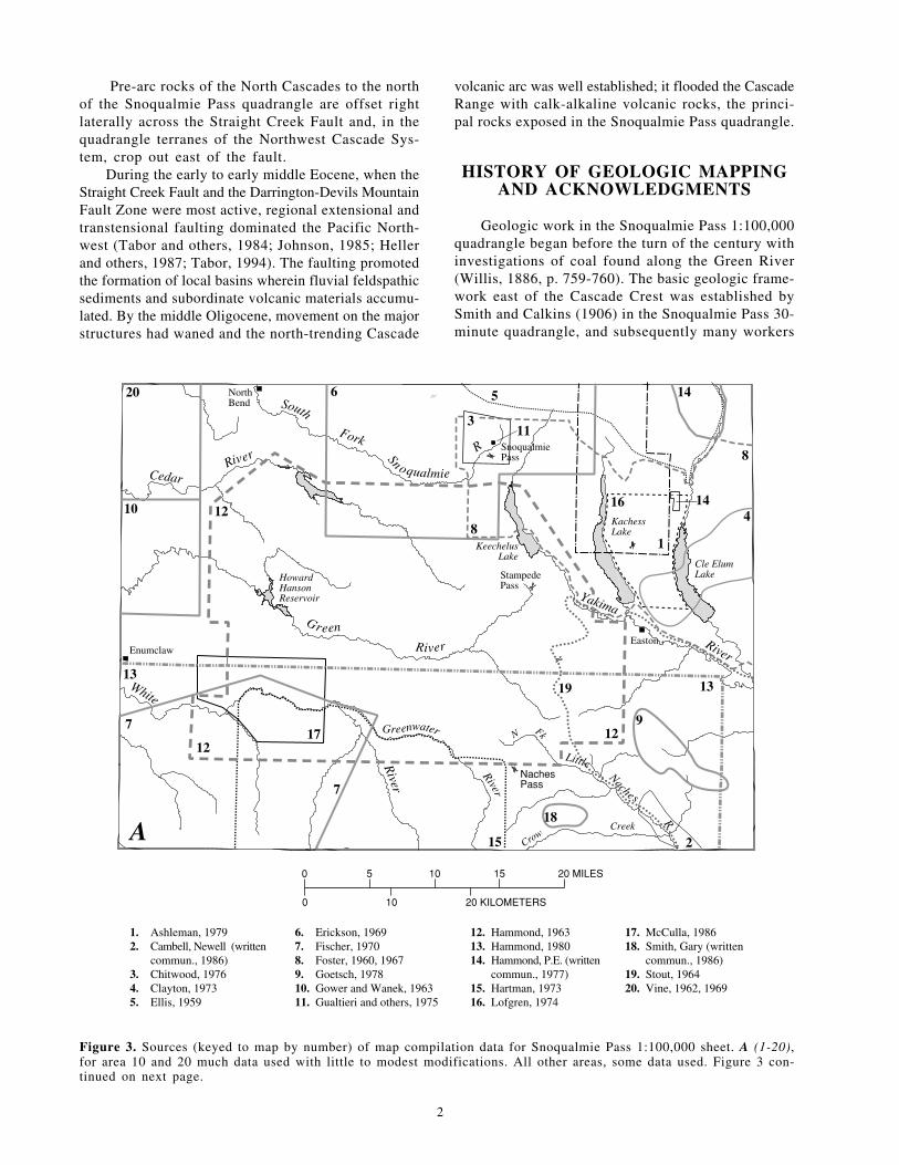
1. Ashleman, 19792. Cambell, Newell (written
commun., 1986)3. Chitwood, 19764. Clayton, 19735. Ellis, 1959
6. Erickson, 19697. Fischer, 19708. Foster, 1960, 19679. Goetsch, 197810. Gower and Wanek, 196311. Gualtieri and others, 1975
0
0 10
5 10
Figure 3. Sources (keyed to map by number) of map compilfor area 10 and 20 much data used with little to modest modtinued on next page.
volcanic arc was well established; it flooded the CascadeRange with calk-alkaline volcanic rocks, the princi-pal rocks exposed in the Snoqualmie Pass quadrangle.
HISTORY OF GEOLOGIC MAPPINGAND ACKNOWLEDGMENTS
Geologic work in the Snoqualmie Pass 1:100,000quadrangle began before the turn of the century withinvestigations of coal found along the Green River(Willis, 1886, p. 759-760). The basic geologic frame-work east of the Cascade Crest was established bySmith and Calkins (1906) in the Snoqualmie Pass 30-minute quadrangle, and subsequently many workers
R
Yakima
River
River
LittleNaches
R
KachessLake
Cle ElumLake
KeechelusLake
CrowCreek
NFk
SnoqualmiePass
StampedePass
NachesPass
Easton
5
311
81
16
19
14
14 4
13
8
912
18
15 2
12. Hammond, 196313. Hammond, 198014. Hammond, P.E. (written
commun., 1977)15. Hartman, 197316. Lofgren, 1974
17. McCulla, 198618. Smith, Gary (written
commun., 1986)19. Stout, 196420. Vine, 1962, 1969
20 KILOMETERS
15 20 MILES
ation data for Snoqualmie Pass 1:100,000 sheet. A (1-20),ifications. All other areas, some data used. Figure 3 con-

(see fig. 3) have drawn on their ideas. Fuller (1925)was one of the first to address the complexities ofwhat we call the western mélange belt and to developthe idea that some of the bodies of magma that ul-timately formed the Tertiary batholiths vented to formthe Tertiary volcanic cover rocks, a theme since ex-panded upon (Cater, 1960, 1969; Fiske and others,1963; Tabor and Crowder, 1969). Hammond (1963)was the first to attack the difficult problems of re-gional correlation presented by post-Eocene volcanicrocks, and he has continued his regional studies insubsequent years (Hammond, 1977, 1980). Detailedmapping in the western foothills was begun on modernbase maps by Vine (1962) and Gower and Wanek(1963).
3
Figure 3—Continued. Sources (keyed to map by number) of mB (21-45), areas consulted extensively but not used directly
0
0 10
5 10
30 22
26
39
42
25
37
27
45
36
44
32 & 38
23
29
43
4
29
South
River
Fork
Sn oqualmi
White
River
G reen
River
Greenwater
HowardHansonReservoir
NorthBend
Enumclaw
Cedar
B
21. Beikman and others, 196122. Bethel, 195123. Crandell, 197324. Danner, 196625. Fuller, 192526. Gualtieri and Simmons, 198927. Hirsch, 1975
28. Kinnison and Sceva, 196329. Koesters, 198430. Kremer, 195931. Lewellen, 1983; Lewellen
and others, 198532. Livingston, 197133. Miller and Mogk, 1987
Our work, begun in 1975, is part of a larger projectthat includes mapping the Wenatchee 2° quadrangleat 1:100,000 scale (Tabor and others, 1982b, 1987a,1993). Frizzell, Tabor, and Booth, with the ongoingassistance of Kathleen Ort, compiled and mapped mostof the bedrock geology. Booth mapped the unconsoli-dated deposits in the northwestern third of the maparea and Waitt mapped unconsolidated deposits else-where in the quadrangle.
Our field work was considerably aided by the ef-forts of Sharon Allshouse and Eduardo Rodriquez in1975, Jay Coburn and Ron Tal in 1976, Bill Gaum,Margaret Goddard, and Kim Marcus in 1977, Eliza-beth L. Mathieson and Nora Shew in 1978, SteveConnally, Stephen A. Sandberg, Fred Beall, Frederika
ap compilation data for Snoqualmie Pass 1:100,000 sheet.in compilation.
20 KILOMETERS
15 20 MILES
24 34
33
21
31
41
28
35
0
e
R
Yakima
River
River
LittleNaches
R
KachessLake
Cle ElumLake
KeechelusLake
CrowCreek
N Fk
SnoqualmiePass
Stampede Pass
NachesPass
Easton
34. Mogk, 197835. Newcomb, 197036. Phillips, 198437. Porter, 197638. Richardson and others,
196839. Rosengreen, 1965
40. Smith and Calkins, 190641. Treat, 198742. Walsh, 198443. Walsh and others, 198744. Warren and others, 194545. Williams, 1971

C. Moser, and Susan Cook in 1981, and by Carol Eddy,Kathleen Ort, and Tad Schirmer in 1982. M. JeanHetherington, Steve Connelly, Bill Gaum, Mark Gor-don, and Kathleen Ort also helped with lab and officework; Catherine R. McMasters provided drafting sup-port. Dennis H. Sorg and Betty Hamachi made radio-metric dating experiments feasible by supplying cleanmineral separates. The late Jack Johnson, helicopter pilotextraordinary, flew us to the rocks in 1979 and 1981.
We benefited from conversations with many col-leagues including Newell Campbell, Larry Chitwood,Eric Erickson, Sheri Goetsch, Howard Gower, DaryllGuzzi, Paul Hammond, Ralph Haugerud, Bob Miller,Bill Phillips, Don Turner, Joe Vance, Tim Walsh, RayWells, John Whetten, and Jim Yount. Donald A.Swanson provided unpublished data on the Colum-bia River Basalt Group. Jim Mattinson, Joe Vance,and Bob Zartman graciously discussed and sharedisotopic data with us.
GEOLOGIC SUMMARY
PRE-TERTIARY ACCRETED TERRANES
The pre-Tertiary rocks of the Snoqualmie Pass quad-rangle crop out in several isolated tracts. In the northeastcorner of the quadrangle at the edge of continuous out-crops of uplifted metamorphic and plutonic rocks ofthe North Cascades crystalline core (figs. 1, 2), a tectonicmélange of serpentinite, serpentinized peridotite, gabbro,diabase, and greenstone is continuous with the IngallsTectonic Complex, which is exposed to the east andnortheast (Tabor and others, 1982b; Tabor and others,1993). The Ingalls Tectonic Complex is a dismemberedophiolite containing mostly Late Jurassic components.In the mid-Cretaceous, it was thrust over the protolithof the Chiwaukum Schist (Miller, 1980a) of the NorthCascade crystalline core, prior to the Late Cretaceousmetamorphic event documented by Mattinson (1972).The relation of the Ingalls Tectonic Complex to the otherrocks of the Northwest Cascade System is unknown.
Definite rocks of the Northwest Cascade Systemcrop out adjacent to and east of the Straight CreekFault Zone. The Easton Metamorphic Suite and struc-turally underlying unnamed metavolcanic rocks onNorth Peak [14; number in brackets indicates posi-tion on location map, fig. 4] are exposed in anticli-nal cores of Eocene rocks. The North Peak rocks areprobably correlative with the Chilliwack Group ofCairnes (1944), an extensive component of the North-west Cascade System exposed across the Straight CreekFault Zone to the northwest of the quadrangle. TheEaston, composed of phyllite, greenschist, and blue-amphibole schist, previously referred to as the ShuksanMetamorphic Suite by Misch (1966), is thought to havea protolith age of Middle and Late Jurassic and ametamorphic age of Early Cretaceous (Brown andothers, 1982). Just south of Easton, the greenschist
4
grades into fine-grained amphibolite in a tectonic zone,and the amphibolite appears to be derived from horn-blende tonalite orthogneiss that yields 150-Ma (LateJurassic) zircons.
Near Manastash Ridge the rocks of the NorthwestCascade System are truncated by a northwest-trendingzone of high-angle faults that bound slivers of metavolcanicand metaplutonic rocks, as well as metasedimentary rocksand serpentinite in a tectonic mélange referred to as thetectonic complex by Stout (1964). Tabor (1987; 1994) cor-related the tectonic complex with the Helena-Haystackmélange and the coincident Darrington-Devils MountainFault Zone exposed to the northwest. Northwest of thequadrangle, the Helena-Haystack mélange and Darrington-Devils Mountain Fault Zone separate the Northwest Cas-cade System from the western and eastern mélange belts.In the Snoqualmie Pass quadrangle, Tertiary intrusionsand eruptive rocks isolate outcrops of western andeastern mélange belts from the Helena Haystack mélange(tectonic complex of Stout, 1964) and the Darrington-Devils Mountain Fault Zone. On Manastash Ridge, theLookout Mountain Formation of Stout (1964) lies adjacentto, and is incorporated in, the tectonic complex. TheLookout Mountain Formation is mostly aluminium-richstaurolite-garnet mica schist containing lenses of gneissicamphibolite. It was intruded by the 157-Ma Quartz Moun-tain stock prior to metamorphism.
The western and eastern mélange belts crop out inlimited exposures along the north margin of the quad-rangle. We correlate thermally metamorphosed chert,basalt, and marble north of Snoqualmie Pass with theeastern mélange belt more widely exposed for about 80km to the north (Frizzell and others, 1982, 1987; Ta-bor and others, 1988, 1993). In the northwest part ofthe quadrangle, exposures of graywacke, argillite, chert,and metagabbro represent the western mélange belt, whichis also extensively exposed to the north. In those morenorthern areas, the mélange belts contain Permian marblesas well as Late Jurassic to Early Cretaceous chert, argillite,and gabbro components, all of which were accreted toNorth America, probably after the Early Cretaceous andbefore the middle Eocene (Tabor, 1987).
PALEOGENE TRANSTENSIONAL DEPOSITS
The most complete geologic record in the Sno-qualmie Pass quadrangle was recorded during theTertiary, a period marked in the early Paleogene bythe development of local fluviatile basins filled withfeldspathic sandstone and conglomerate, and subor-dinate volcanic rocks. The region was undergoingextension, cut by right-lateral, north-trending strike-slipfaults (Tabor and others, 1984; Johnson, 1985; Hellerand others, 1987), although earlier workers referred thevolcanic rocks to the Challis Volcanic Arc (Armstrong,1978; Vance, 1982). By the late Paleogene, the northtrending Cascade Arc dominated the region (Frizzelland Vance, 1983; Vance and others, 1987).

5
Cle
Elum
Lake
Kachess
Lake
Keechelus
Lake
HowardHansonReservior
Green
River
Gre
en River
White
River
Yakima
Greenwater
River
Huc
kleb
erry
Creek
Chester MorseLake
North Fork
Little
NachesSouth ForkWes
t
Fork
ClearwaterR
iver
WestFork
Teanaway R
Elum
Riv
er
Cedar
River
Raging
River
M
iddle Fk SnoqualmieR
South
Fork
Snoqualmie
Riv
er
South
Prairi e
Creek
East
Fork
Canyon
Cr
Scatt
er
Cr
Coa
l
Creek
TaylorCreek
Bou
lder
Cr
Gra
niteC
r
Pratt
River
LakeCaroline
SnowLake
FishLake
CooperLake
LittleKachessLake
WaptusLake
Gol
dC
re
ek
W
aptusR iver
Fortune Cr
Cooper
River
Cle
Litt
le
Cre
ek
Big
Creek
Cabin
Creek
Snow
Creek
Cedar
River
Bear
Creek
Sand Creek
Maggie Creek
Crow Creek River
Qua
rtz
Cr
North
Fork
Taneum Creek
Sout
hFork Taneum Cr
SFkManastash
Cr
Enumclaw
Cumberland
Ravensdale
Cedar Falls
NorthBend
Hobart
Hyak
EastonRonald
Roslyn
CleElum
River
River
Pino
leCr
Carbon RiverCarbon Ridge
The Three Sisters
SunTop
TheDalles
Dalles
Ridge
Naches Pass
HuckleberryMountain
CougarMtn
Tacoma Pass
South Cle Elum Ridge
SilverPass
Kachess
Ridge
CooperPass
StampedePass
SnoqualmiePass
Ram
part
Rid
ge
KeechelusR
idgeA
mabillis
Mtn
DennyMtn
Goat
Mtn
RattlesnakeM
tn
Enum
clawM
tn
Middle ForkSnoqualmieRiver
Green Valle
y
Mineral Creek
MilkyCreek
Chenius Creek
1
2
3 4
5
67
8 9
17
1816
20
19
21
2223
24
2627
25
10
11 1213
14
15
0
0 10 20 KILOMETERS
5 10 15 20 MILESFigure 4. Generalized geographic map of obscure place names, SnoqualmiePass quadrangle, Washington. Number indicates locality referred to in text.

Most rocks of Tertiary age can be assigned to threestructural blocks distinguished in part by stratigraphyand in part by differing degrees of Tertiary deforma-tion. East of the Straight Creek Fault Zone, the old-est Paleogene rocks crop out in two uplifted structuralblocks: the Teanaway River Block and the ManastashRiver Block (fig. 2; Tabor and others, 1984). In theTeanaway River Block, the tightly folded and faultedearly and middle Eocene Swauk Formation consistsof fluvial feldspathic subquartzose sandstone, siltstone,and conglomerate and the interbedded and overlyingdacite and andesite flows, breccia, and tuff of its earlyEocene Silver Pass Volcanic Member. The relativelyundeformed middle Eocene Teanaway Formation ofandesite and basalt flows, tuff, and breccia with minorrhyolite unconformably overlies the Swauk. The fluvialmiddle and late Eocene Roslyn Formation conform-ably overlies the Teanaway and is composed of sub-quartzose feldspathic sandstone, is conglomerate richin its lowermost part, and contains extensively minedcoal beds in the uppermost of its three subunits.
The lower part of the sequence in the TeanawayRiver Block—clastic rocks, silicic and intermediatevolcanic rocks, and basalt—is repeated in the ManastashRiver Block (fig. 3, 5) where all the rocks are tightlyfolded and faulted along structures that help definethe intersection of the Straight Creek Fault Zone withthe Olympic-Wallowa Lineament (Tabor and Frizzell,1979; Tabor and others, 1984). In the Manastash RiverBlock, the feldspathic subquartzose to quartzose sand-stone and lesser amounts of siltstone, conglomerate,and bituminous coal of the early Eocene ManastashFormation are partly correlative with the Swauk For-mation. Andesite, dacite, and rhyolite in flows, tuff,and breccia of the early Eocene Taneum Formationconformably overlie the Manastash Formation and arecorrelative with the Silver Pass Volcanic Member.Above the Taneum, the conformable, middle Eocenebasalt of Frost Mountain correlates with the TeanawayFormation (fig. 5).
West of the Straight Creek Fault Zone, the earlyEocene nonmarine part of the section is missing. Inthe eastern part of the Green River-Cabin Creek Block,near the Straight Creek Fault Zone, the strongly de-formed Naches Formation consists of middle Eoceneto early Oligocene(?) volcanic rocks and interbeddedfluvial feldspathic subquartzose sandstone. The Naches,in part, correlates with the relatively undeformed RoslynFormation of the Teanaway River Block (fig. 5).
In the western foothills of the Cascade Range, onthe west margin of the quadrangle, the mildly deformedrocks of the middle and late Eocene Puget Group arelithologically similar to the Naches, but separated fromthat unit by a cover of younger Tertiary volcanic rocks.Both the Naches Formation and the Puget Group arerecognized by their distinct bimodal volcanic constitu-ent, consisting prominently of basaltic and rhyolitic
6
rocks. Whereas, the Naches overlies pre-Tertiarymetamorphic and granitic rocks, the Puget Groupconformably overlies middle Eocene shallow marinevolcanic lithic subquartzose sandstone of the RagingRiver Formation. The Raging River Formation is some-what younger than the terriginous Swauk and ManastashFormations, east of the Straight Creek Fault. The NachesFormation and the Puget Group are nowhere seen incontact with each other, but they may be continuousunder the younger volcanic cover. Both sequences mayhave been deposited by a single middle to late Eocenefluvial-deltaic system along the Eocene continentalmargin (see Johnson, 1985, p. 292).
The volcanic rocks of Mount Persis, mostly exposednorth of the quadrangle (Tabor and others, 1993), arein fault contact with the Puget Group on RattlesnakeMountain, and the mild deformation of the former unitcontrasts with the pronounced deformation of the PugetGroup rocks suggesting an appreciable age difference.The volcanic rocks of Mount Persis appear to be late(?)Eocene in age and thus be at least partly contempo-rary with volcanic rocks in the middle and late EocenePuget Group.
CASCADE ARC
A thick sequence of Oligocene and Miocene volcanicrocks of the Cascade Arc underlies most of the Sno-qualmie Pass quadrangle (fig. 1, 2) and forms the bulkof the southern Cascade Range in Washington andOregon. In the quadrangle, these rocks crop out mostlyin the Green River-Cabin Creek Block, but this blockis traversed by the northwest-trending White River Fault,which separates the volcanic rocks into two slightlydifferent sequences.
The sequence of rocks south of the White RiverFault is in part equivalent to, and continuous with, rocksmapped south of the quadrangle near and around Mt.Rainier (fig. 1; Fiske and others, 1963). These rocksunderlie the youngest component of the Cascade Arc,the Quaternary volcanoes that give the southern CascadeRange its striking profile. The oldest unit, the OligoceneOhanapecosh Formation, consists mostly of colorful,highly altered, well-bedded andesite to dacite brec-cia, volcaniclastic sedimentary rocks, and locallyabundant altered basalt and andesite flows (fig. 2). Rela-tively fresh basalt and andesite flows, breccias, andsubordinate rhyodacite ash-flow tuff and breccia, andvolcanic sedimentary rocks of the early Miocene FifesPeak Formation, as redefined by Vance and others(1987), unconformably overlie the Ohanapecosh andflank a structural high in the White River area. Aprominent Fifes Peak member, herein called the SunTop unit, was deposited in pronounced canyons cutinto the Ohanapecosh Formation; another prominentinterbed in the upper part of the Fifes Peak Forma-tion, herein called the rhyolite unit of Clear West Peak,appears to be an extracaldera ash-flow tuff equiva-

lent to rhyolite ash flow tuffs and intrusions fillinga caldera on Clear West Peak [21] (Fiske and others,1963; Fischer, 1970; Mattinson, 1977; McCulla, 1986).
We assign well-bedded tuff, breccia, and minorflows of highly altered andesite, basalt, and dacite northof the White River Fault to the Ohanapecosh Formationfound south of the fault. Likewise, we assign theoverlying flows of generally fresh porphyritic andesite,subordinate breccia, and locally conspicuous interbedsof mudflow breccia to the Fifes Peak Formation, but,as mapped north of the White River Fault, some flows
7
Figure 5. Correlation of selected Tertiary units in Snoqualmie and others (1985). Modified from Tabor and others (1984, fig
?
Yakima Basalt Subgroup(of Columbia Riv Basalt Group)
Fifes PeakFormation Fifes Peak
Formation
OhanapecoshFormation
OhanapecoshFormation
Renton Formation
Tiger Mountain Formation
Raging RiverFormation
Pre-Tertiary rocks
NachesFormation,undivided
GuyeSedimentary Member
GREEN RIVER-CABIN CREEK BLOCKWEST EAST
MountCatherineRhyoliteMember
50
38
24
40
OLI
GO
CE
NE
Late
Ear
lyM
iddl
e
EO
CE
NE
MIO
CE
NE
AGE(Ma)
Sun Top
TukwilaFormation
Chenuis Ridge unit
assigned here to the lowermost part of the Fifes Peakmay actually be deposits of Ohanapecosh eruptions.
Among the few outliers of the Oligocene to Miocenevolcanic cover that crop out north of the extensive Cas-cade Arc rocks exposed south of Snoqualmie pass isa prominent accumulation of volcanic rocks east ofthe Straight Creek Fault Zone. Andesite and dacitebreccia and tuff in the Goat Mountain area are con-tinuous with the volcanic rocks of Mount Daniel justto the north (Tabor and others, 1993). A partial ringdike on Goat Mountain and nearby catastrophic breccias
Pass quadrangle, Wash. Absolute time scale from Berggren. 7).
er
Yakima Basalt Subgroup(of Columbia River Basalt Group)
Naches(?)Formation
Basalt of Frost Mountain
TaneumFormation
ManastashFormation
Pre-Tertiary rocks Pre-Tertiary
rocks
Wenatchee Formation
RoslynFormation
TeanawayFormation
SwaukFormation
MANASTASH RIVER BLOCK
TEANAWAYRIVER BLOCK
unit
Yakima Basalt Subgroup
SilverPassVolcanicMember
(of Columbia River Basalt Group)

of probable landslide origin suggest that these vol-canic materials were deposited in a tectonovolcanicdepression (Hammond, 1965; Tabor and others, 1984).
The Miocene Grande Ronde Basalt of the ColumbiaRiver Basalt Group overlies the Fifes Peak Formationalong the lower Little Naches River. Along the southwestside of the Manastash River Block, this flood basalthas been offset vertically more than 1,000 m alongnorth-northwest-trending high-angle faults that parallelthe Olympic-Wallowa Lineament.
Although the isotopic ages obtained from mappedunits of the Oligocene to Miocene volcanic rocks areimprecise, they suggest that these units have consid-erable temporal overlap, and that the overlap ham-pers exact correlation and reconstruction of eruptiveevents. The eruption of these volcanic rocks in theSnoqualmie Pass quadrangle appears to have begunabout 35 Ma (early Oligocene) and ended about 20Ma (early Miocene) (Vance, 1982; Frizzell and Vance,1983; Turner and others, 1983).
The Oligocene and Miocene Snoqualmie batholithand related stocks intrude the volcanic rocks of theCascade Arc north of the White River Fault. Rocksof the arc are also intruded by the Miocene CarbonRiver stock (a pluton in the Tatoosh volcanic-plutoniccomplex of Mattinson, 1977), which is exposed southof the quadrangle) and related plugs near the south-west corner of the quadrangle. Intrusive events at 25and 17-20 Ma formed the Snoqualmie and Tatooshbodies; a 14-Ma event is recorded in a Tatoosh plu-ton (Mattinson, 1977). Numerous smaller intrusivebodies invaded the volcanic pile between these largeplutons and may be high-level apophyses connectedin the subsurface to a continuous batholith.
An outlier of late Miocene volcanic rocks and as-sociated dikes, the Howson Andesite, crops out onridge tops on both sides of Cle Elum Lake. Plioceneand Pleistocene flows and pyroclastic deposits of olivinebasalt overlie flows of the Fifes Peak Formation onridge tops of Dalles Ridge and above Canyon Creek.
A thick flow of early Pleistocene andesite, an earlylava of the Mount Rainier volcano, caps a ridge nearHuckleberry Creek. In the past 10,000 yr, numerousmudflows swept down the White River valley fromMount Rainier (Crandell, 1969), and several eruptionshave blanketed the southern part of the area with variousthicknesses of tephra (Mullineaux, 1974).
Moraines and outwash deposits record as manyas three alpine glaciations in the high Cascades. LatePleistocene and Holocene alpine glacial deposits occupymany of the higher mountain valleys and cirques. Inthe west quarter of the quadrangle, multiple advancesof the Puget lobe of the Cordilleran ice sheet left arecord dominated by the most recent invasion of iceabout 14,000 yr B.P. (Crandell, 1963; Waitt andThorson, 1983) during the Vashon stade of the Fraserglaciation (Armstrong and others, 1965). Marginal and
8
submarginal drainage has blanketed much of this areawith waterlain ice-contact deposits and recessionaloutwash, which, together with a sequence of chan-nels, spillways, and terraces, express the progressivenorthwest retreat of the Vashon ice margin duringdeglaciation (Booth, 1984).
GENERAL DESCRIPTION OFTHE UNITS
PRE-TERTIARY ROCKS
ROCKS NORTHEAST OF THE DARRINGTON-DEVILS MOUNTAIN FAULT ZONE
The Northwest Cascade System in the SnoqualmiePass quadrangle (see geologic overview) consists ofmetavolcanic rocks of North Peak, the Easton Meta-morphic Suite, tonalite gneiss of Hicks Butte, asso-ciated tectonic zone, and banded gneiss. Because theaffinity of the Ingalls Tectonic Complex is unknown,that unit is included here for convenience. A smalltonalite stock at Fortune Creek intrudes the Ingallsand is a terrane overlap unit (Tabor and others, 1987a).
Ingalls Tectonic Complex
The Ingalls Tectonic Complex crops out only inthe northeast corner of the Snoqualmie Pass quadrangle,but is extensively exposed to the east (Tabor and others,1982b) where tectonically mixed sandstone and argillite,radiolarian chert, pillow basalt, and ultramafic rocksindicate that the unit is an ophiolite complex or mélange(Hopson and Mattinson, 1973; Southwick, 1974; Miller,1977; Miller and Frost, 1977, p. 187; and Miller, 1980b,1985). The tectonic emplacement of the Ingalls overhigher grade metamorphic rocks of the North Cascadecrystalline core (fig. 1) is discussed by Miller (1980a,b,1985), Whetten and others (1980), Vance and others(1980), and Tabor and others (1987b).
Foliated serpentinite (shown with pattern on thegeologic map) forms a band across the southern outcropsof ultramafic rocks in the Ingalls Tectonic Complex.At the south margin of the belt, Miller and Mogk (1987,fig. 1) identify partially serpentinized harzburgite anddunite. The north edge of the serpentinite belt gradesinto a zone of mylonitized hornblende peridotite andlherzolite that in turn grades to the north into unserpen-tinized lherzolite and harzburgite, which correspond toMiller’s (1980b, p. 52-69) South Peak unit. Cowan andMiller (1980), and in greater detail, Miller and Mogk(1987, p. 286-287) infer that the ultramafic rocks formedin an oceanic fracture zone. The mylonitic rocks arederived from the lherzolite and harzburgite by shearingin the evolving fracture zone, and the foliated ser-pentinite formed during a later metamorphism of themantle materials either at the upper mantle-lower crustcontact or in the shallower reaches of the fracture zone.

On the basis of isotopic ages of gabbro and ra-diolarians in chert in the Wenatchee quadrangle,components of the Ingalls Tectonic Complex are LateJurassic in age (Tabor and others, 1982b; Miller andothers, 1993). Although the complex could containtectonic components of different ages, we accept theseages for the protolith. North of the quadrangle, thecomplex is intruded by the Late Cretaceous MountStuart batholith. The age of tectonic mixing of thecomplex is, thus, Late Jurassic or Early Cretaceous.Correlations of the Ingalls with units of the North-west Cascade System to the northwest is uncertain.Other correlations are discussed by Vance and oth-ers (1980), Whetten and others (1980), Brandon (1989),and Miller and others (1993).
Easton Metamorphic Suite
First described and named by Smith and Calkins(1906, p. 2), the Easton Schist included rocks of variedcomposition and metamorphic history. Stout (1964,p. 322-323) restricted the formation to greenschist,blue amphibole schist, and phyllite. The low-gradeschist and phyllite of the Easton have been tracednorthward for 100 km (Ellis, 1959; Yeats, 1958a; Vance,1957a) and correlated across the Straight Creek Faultwith the Shuksan Metamorphic Suite of Misch (1966)(Yeats, 1977; Dungan and others, 1983). Tabor andothers (1993) revised the Easton Schist as the EastonMetamorphic Suite and adopted Misch’s (1966) names“Shuksan Greenschist” for its greenschist and blueschistcomponent and “Darrington Phyllite” for its phyllitecomponent. Misch (1966), Haugerud and others (1981),Brown and others (1982), Dungan and others (1983),and Brown (1986) cite evidence for the basaltic ocean-floor origin of the greenschist (and blueschist) andthe marine shale and sandstone origin of the phyllite.Ashelman (1979) describes a similar origin for green-schist and phyllite in what is now called the EastonMetamorphic Suite along Kachess Lake.
Brown and others (1982) and Brown (1986) inter-preted a collection of K-Ar ages and Rb-Sr isochron dataand zircon U-Pb ages from the Easton Metamorphic Suiteexposed many kilometers north of the Snoqualmie Passquadrangle as indicating a protolithic age of Middle andLate Jurassic and a metamorphic age of Early Creta-ceous. They suggested that the high-pressure metamor-phism of the Easton occurred in a deep subduction-zoneenvironment. Ages have not been obtained from rocksin the area of the map, but we assume that the ages andthe metamorphic history are the same as those describedby Brown and his coworkers.
Tonalite gneiss of Hicks Butte and rocks of thetectonic zone
Biotite hornblende tonalite and tonalite gneiss onHicks Butte [23] display uniform textures and com-position indicating an igneous plutonic origin, although
9
we did not see intrusive contacts. On the southwestside, the pluton is mostly unconformably overlain byTertiary sandstone. A small exposure of banded gneissadjacent to the pluton suggests a primary contact, butthe actual contact is not exposed. The contact on thenortheast side appears to be tectonic and reveals someenigmatic features. The relatively undeformed granitoidrock grades northeastward into a tectonic zone ofblastomylonitic gneiss that in turn grades through azone of very fine grained amphibolite into rocks typicalof the Shuksan Greenschist of the Easton Metamor-phic Suite. The contact of the tonalite gneiss with theShuksan Greenschist to the northeast, thus, appearsto be a deep-seated fault. Highly deformed, partiallyrecrystallized rocks are exposed in the tectonic zoneover a width of 1 km. In the vicinity of Big Creek,we show the contact of the tonalite gneiss and theShuksan Greenschist as a single fault, because thetectonic zone appears to be missing.
Although Smith and Calkins (1906, p. 4) felt thatthe tonalite had intruded the Shuksan Greenschist priorto faulting in the tectonic zone, Stout (1964, p. 321-322) astutely noted that the contact rocks are nothornfelsic but have been recrystallized in the green-schist facies during and after penetrative shear.
J.M. Mattinson and C.A Hopson (written commun.,1980; table 1, no. 66) obtained relatively concordantU-Pb ages of 153 Ma from zircon separated from thetonalite gneiss of Hicks Butte. This Late Jurassicprotolith age for the tonalite gneiss is similar to theprobable protolith age of the Easton Metamorphic Suite(see discussion of that unit) and suggests a relatedorigin for these two rock units. Amphibolite from thegneiss near the tectonic zone yields a 128-Ma K-Arhornblende age (table 1, no. 63), which may be aminimum. Correlative amphibolite, associated with simi-lar Late Jurassic tonalite in the Helena-Haystackmélange exposed about 100 km to the northwest, yieldsa K-Ar hornblende age of about 141 Ma (Tabor andothers, 1988). We consider this older age more re-liable but also a minimum cooling age for the am-phibolite metamorphism.
In a detailed study, Treat (1987, p. 76-80) con-cluded that the amphibolite was probably derived byshearing and recrystallization from a mafic phase ofthe Hicks Butte pluton, and, because the pluton andthe amphibolite contained no evidence of the high-pressure metamorphism of the Shuksan Greenschist,she considered the pluton to have been juxtaposed withthe Shuksan along a deep-seated fault in post-Shuksanmetamorphism time (post-130 Ma). The recently deter-mined age of the hornblende in the amphibolite seemsto preclude this history. Indeed relicts of hornblende inthe greenschist described by Treat (1987, p.23) confirmthe earlier amphibolite event.
Gallagher and others (1988) describe a Middle Ju-rassic tonalite 150 km to the north that they conclude

was root material of a volcanic arc that supplied detri-tus to metatuffs interbedded with rocks in the EastonMetamorphic Suite. The Hicks Butte pluton and Eastoncould represent a similar association, but the data in theSnoqualmie Pass quadrangle indicate only that the plutoncrystallized about the same time that the protolith of theShuksan Greenschist formed, that these two units werejuxtaposed along a deep-seated fault shortly after intrusionof the pluton, and that they were then later metamor-phosed in the blueschist facies about 130 Ma. The lackof blue amphiboles indicative of low-pressure metamorphicminerals in the Hicks Butte pluton may be due to itsbulk composition and resistance to deformation in thesecond metamorphism. Miller and others (1993) discussthe juxtaposition of the pluton with the Easton Meta-morphic Suite in detail and offer several other hypoth-eses to explain the relations of these rocks.
Banded gneiss
A narrow outcrop belt composed of fine-grainedand granoblastic gneiss and schist crops out along thesouthwest side of the tonalite gneiss of Hicks Butte.The banded gneiss lacks cataclastic textures or evi-dence of strong penetrative deformation common inthe other rocks of the Manastash Ridge area. Texturesin the banded gneiss suggest that it was predominantlyrecrystallized under static conditions. The protolithof the banded gneiss could have been calcareoussediments. Although we observed no contacts withthe tonalite gneiss of Hicks Butte, the protolith of thebanded gneiss may have been intruded and metamor-phosed by the pluton.
Metavolcanic rocks of North Peak
Low-grade metavolcanic rocks and impure marblecropping out west of Cle Elum Lake may be the oldestrocks in the Snoqualmie Pass quadrangle, althoughthey are considerably less metamorphosed than thesurrounding Easton Metamorphic Suite. Smith andCalkins (1906, p. 2-3) thought that the North Peak[14] rocks were younger than the phyllite and green-schist of the Easton and tentatively included them inthe Peshastin and Hawkins Formations (now part ofthe Ingalls Tectonic Complex) exposed a few kilo-meters east of the quadrangle. They and later work-ers (Foster, 1960, p. 102; Lofgren, 1974, p. 15-18)considered the unit to be unconformable on the Easton,preserved as an infolded and infaulted block. Our workconfirms Ashelman’s (1979, p. 27) conclusion thatthe North Peak rocks structurally underlie the EastonMetamorphic Suite and are exposed in the core of aTertiary anticline. Their relatively low degree ofrecrystallization, abundant lawsonite and pumpellyite,and only incipient actinolite and blue amphibole indicatethat they are of lower metamorphic grade than theoverlying rocks of the Easton Metamorphic Suite andsuggest that they have been overthrust by the Easton
1
after its regional metamorphism (Ashelman, 1979, p.25-26).
Ashelman (1979, p. 25) suggested that the originalvolcanic rocks were silicic to mafic in compositionwith minor sedimentary and limestone interbeds. TheChilliwack Group of Cairns (1944), exposed along theSauk River about 100 km to the north and west acrossthe Straight Creek Fault (Vance 1957a; Brown andothers, 1987), is of similar lithology and metamor-phic grade. Along the Sauk River and farther to thenorth, the Chilliwack also tectonically underlies theEaston Metamorphic Suite. If the metavolcanic rocksof North Peak are indeed correlative with the ChilliwackGroup, then their protolith age is Devonian to Per-mian (Danner, 1966, p. 64-65). The age of metamor-phism of the Chilliwack is thought to be aboutmid-Cretaceous (Smith, 1986, p. 131-134).
Tonalite
As originally described by Smith and Calkins (1906,p. 4), a small tonalite stock exposed at Fortune Creekon the Cle Elum River is a satellite of the Mount Stuartbatholith exposed about 6 km east of the quadrangle.A K-Ar hornblende age of about 84 Ma (table 1, no.61) confirms its affinity with the batholith.
ROCKS IN THE DARRINGTON MOUNTAINFAULT ZONE
Tectonic complex of Stout (1964) and ultramaficrocks
On Manastash Ridge, separated from the Hicks Buttepluton and other rocks of the Northwest Cascade Systemby early Tertiary volcanic rocks, a mixture of stronglydeformed rocks cut by high-angle faults was calledthe tectonic complex by Stout (1964). Cataclastic toblastomylonitic elongate blocks of fine-grained schistoseamphibolite and highly foliate serpentinite and ser-pentinized pyroxenite or peridotite and dunite (Goetsch,1978, p. 45-47) in slivers and pods are characteris-tic. Also abundant are phyllite, greenstone, blue-am-phibole schist, tonalite gneiss, leucogreenstone, silicicmetatuff, and metasandstone.
The tectonic complex contains blocks of silicicmetatuff petrographically identical to blocks of metatuffin the Helena-Haystack mélange exposed 100 km to thenorthwest (Tabor, 1994). The Helena-Haystack mélangeis cut by and coincident with high-angle Tertiary faultsof the Darrington-Devils Mountain Fault Zone, and thesimilarity of lithology and structure between Helena Ridgeand Manastash Ridge led J.A. Vance (in Tabor, 1987)to suggest that the high-angle faults at Helena Ridgeand faults at Manastash Ridge could be connected byundoing right lateral offset along the Straight Creek Fault.Because most of the Straight Creek Fault is obscuredby younger plutons and deposits in the region of thisoffset and because of the acute angle of intersection
0

between the two major fault zones, Tabor (1987) andTabor and others (1989) suggested that the Darrington-Devils Mountain Fault Zone truncated the Straight CreekFault or moved concurrently with it.
ROCKS SOUTHWEST OF DARRINGTON-DEVILS MOUNTAIN FAULT ZONE
Lookout Mountain Formation of Stout (1964)
Fine-grained graphitic andalusite-staurolite-garnet-biotite schist and hornblende schist and amphiboliteexposed on Lookout Mountain [24] and Quartz Mountain[26] were named the Lookout Mountain Formation byStout (1964, p. 320), who felt that Smith and Calkins(1906, p. 2-3) erred in assigning these rocks to thePeshastin Formation, a unit that we have included inthe Ingalls Tectonic Complex (Tabor and others, 1982b).The schist of the Lookout Mountain Formation retainssedimentary features, such as graded bedding, load casts,and clastic textures even though it reached staurolite-andalusite zone of Buchan-type regional metamorphism(Goetsch, 1978, p. 32). Metadacite porphyry sills anddikes are abundant and small masses of metagabbroto gabbro scattered throughout the formation werethought by Goetsch (1978) to have been intrusive intothe schist or its protolith, but their origin is obscure.
Along the northeastern margin of the LookoutMountain Formation, mica schist (map unit pTlm)appears to be interlayered (Stout, 1964, p. 321) or im-bricated (Goetsch, 1978, p. 31) with very fine grainedamphibolite and metatonalite or metagabbro, lithologi-cally similar to rocks in adjacent amphibolite andhornblende tonalite gneiss (pTla) (hereinafter calledthe amphibolite for simplicity). Miller and others (1993)consider the fine-grained mica schist of the LookoutMountain Formation and the adjacent amphibolite unitto be in fault contact on the basis of differences inmetamorphic history. The amphibolite is made up offine-grained schistose amphibolite, hornblendemetatonalite, metadiorite, and metagabbro that has beenunevenly penetratively sheared and recrystallized toblastomylonitic gneiss and amphibolite. Some fine-grained amphibolite and minor biotite-hornblende schisthave no relict textures that suggest derivation fromcoarser grained rocks such as diorite or gabbro; theycould have been derived from mafic volcanic rocks.Goetsch (1978, p. 17) suggested that the protolith ofthe amphibolite unit was a mixture of basalt flowsand mafic intrusions. The amphibolite grades intothe tectonic complex of Stout (1964) by increase inpenetrative shear and increase in disparate rock typessuch as ultramafic rocks, phyllite, greenschist, andmetasandstone. Goetsch (1978, p. 41-49) has describedthe tectonic complex in detail, and much of the mappedgradational contact with the amphibolite and horn-blende tonalite gneiss of the Lookout Mountain For-mation is from her mapping.
11
Stout (1964, p. 321) proposed that the LookoutMountain Formation might correlate with the TongaFormation of Yeats (1958b) exposed 60 km to the northon the east side of the Straight Creek Fault (fig. 1).The Tonga is locally associated with greenschist andblue-amphibole schist that has been correlated withthe Easton Metamorphic Suite (Yeats 1958a; see alsoTabor and others, 1982a, 1987a). Tabor and others(1993) discuss the correlation of the Tonga with theEaston, but conclude that the Tonga is unlikely to bepart of the Easton and that it is more likely a low-grade equivalent of the Chiwaukum Schist exposedin the higher grade core of the North Cascades (seealso Duggan, 1992a, b). The Tonga Formation is ametapelite with an early, greenschist synkinematicmetamorphism overprinted by a late-kinematic to staticmetamorphism producing biotite and stuarolite. Thislatter Barrovian event was shared by the metamor-phic rocks in the crystalline core of the North Cas-cades, exposed mostly north of the map area. Thepresence of metatonalite in the Tonga, which mightcorrelate with the Quartz Mountain stock (see below;Tabor and others, 1993), and the general lithologicsimilarity of the Tonga and the Lookout Mountain maketheir correlation attractive. However, according toGoetsch (1978, p. 26, 80), the Lookout MountainFormation displays a late greenschist overprint thatis lacking in the Tonga. Further difficulties lie in tryingto juxtapose the Tonga and the Lookout Mountain byundoing offset on any of the major faults such as theStraight Creek Fault or the Darrington-Devils MountainFault Zone. The Straight Creek Fault Zone appearsto merge and bend into faults aligned with the north-west-trending Olympic-Wallowa Lineament (Tabor andFrizzell, 1979; Tabor and others, 1984). If the mainstrand passes northeast of the schist of the LookoutMountain Formation, as seems likely, the schist couldonly have been separated from the Tonga Formationby significant left-lateral movement on the StraightCreek Fault, contrary to all other evidence of right-lateral movement. If the ancestral Straight Creek Faultoriginally extended south along its modern trend, thenthe Lookout Mountain Formation is on the same (east)side of the fault as the Tonga Formation and couldnot have been separated from the Tonga by offset onthe Straight Creek Fault. A similar argument can bemade for offset on the Darrington-Devils MountainFault Zone.
An amphibolite block in the tectonic complex ofStout (1964) yields a hornblende K-Ar age of about113 Ma (table 1, no. 65). Presuming that the blockis derived from the amphibolite and tonalite gneisssubunit of the Lookout Mountain Formation, the ageprobably represents a minimum age of metamorphismfor the formation. The Lookout Mountain Formationis intruded by the Late Jurassic Quartz Mountain stock(see below) and both are metamorphosed. Late Cre-

taceous metamorphism (at about 90 Ma) for much ofthe North Cascades is well documented (see Taborand others, 1987a, b), but considering the probableminimum age of metamorphism (Early Cretaceous)documented in the amphibolite block and the uncer-tain correlation of the Lookout Mountain Formationwith other units of the North Cascades, its metamor-phism may be Late Jurassic to Early Cretaceous inage and its protolithic age is pre-Late Jurassic butotherwise unknown.
Quartz Mountain Stock
The small intrusive stock on Quartz Mountain wasfirst mapped by Smith and Calkins (1906), who con-sidered it a satellite of the Late Cretaceous Mount Stuartbatholith. We now know its protolithic age to be 157Ma (Late Jurassic) on the basis of relatively concor-dant U-Pb ages of zircon by J.M. Mattinson and C.A.Hopson (written commun., 1980; table 1, no. 64). Thepluton sharply intrudes schist of the Lookout Moun-tain Formation of Stout (1964), but contains garnetand considerable signs of recrystallization such aspoikilitic sodic plagioclase rims on more calcic pla-gioclase and K-feldspar and aggregates of biotite, allof which indicate that it may have been metamorphosedalong with the schist. The composition of the plutonis not well known. Smith and Calkins (1906, p. 4)classified it a granodiorite and described both crys-tals and intergranular K-feldspar, whereas Goetsch (1978,p. 40-41) found no K-feldspar. We noted considerableK-feldspar in our one sample, mostly found as orthoclasecores surrounded by sodic plagioclase. Zonally arrangedclinozoisite in the core of the K-feldspar suggest thatK-feldspar has replaced an earlier calcic plagioclase.
Western and eastern mélange belts
In the north-central part of the Snoqualmie Passquadrangle and in the western foothills of the NorthCascades to the north, highly disrupted oceanic rocksunderlie much of the pre-Tertiary terrane west of theStraight Creek Fault. Although these oceanic rockshave been assigned a variety of names and ages byearly workers, the varied association of rock typesand overall penetrative deformation indicates that theyare mélanges. On the basis of their overall litholo-gies and geographic positions, we have separated therocks into the western and eastern mélange belts.Frizzell and others (1982, 1987) and Tabor and oth-ers (1993) summarize and discuss the characteristicsand tectonic history of these rocks.
Rocks of the western mélange belt
The western mélange belt consists of argillite andgraywacke with generally lesser amounts of metavol-canic rocks, conglomerate, chert, marble, metagabbro,and rare serpentinite. Outcrop- to mountain-size phacoidsof metagabbro, metadiabase, and metatonalite and
12
megaclasts of sandstone, chert, and marble stand outboldly in a matrix of poorly foliated argillite or dis-rupted thin-bedded argillite and sandstone.
Fuller (1925, p. 29-39, 46-55) described extremedeformation, characterized by blocks of graywackeimbedded in contorted argillite, in rocks exposed inthe vicinity of the South and Middle Forks of the Sno-qualmie River. This deformation and lithology is typicalof the western mélange belt.
Bethel (1951, p. 22-56) mapped feldspathic graywackeand argillite at the southern outcrop limit of the west-ern mélange belt, but he incorrectly correlated the rockswith the Swauk Formation (see discussion below).Working just north of this quadrangle and drawingupon the work of Danner (1957), Kremer (1959, p.40-62) also recognized the high degree of deforma-tion in these rocks and assigned the graywacke andassociated argillite and chert a Late Jurassic and EarlyCretaceous age. The mostly hornfelsic argillite andgraywacke exhibit bedding, and some relatively subtlesedimentary features survive in disrupted sedimen-tary rocks adjacent to the Snoqualmie batholith nearGranite Creek. Resistant blocks of metavolcanic rockson Little Si [3] and metagabbro on Mount Si formbold ridges just north of this quadrangle. Inclusionsof metagabbro in Tertiary volcanic breccia indicatethat the mélange extends in the subsurface at leastas far south as Chester Morse Lake.
Jett and Heller (1988, p. 52) inferred that the west-ern mélange belt consists of three distinct petrofaciesthat were “mixed together in an accretionary wedgewithin an active subduction belt.” Miller (1989) describedisolated outcrops in the Rim Rock Lake inlier, about45 km to the south of the Snoqualmie Pass quadrangle,which have components of both the eastern and west-ern mélange belts, and he (p. 1303) noted especiallydistinctive lithic similarities with rocks of the west-ern mélange belt.
A heterogeneous gabbro body, exposed on theSouth Fork of the Snoqualmie River, southwest ofMount Defiance [5], is mostly recrystallized by thermalmetamorphism, and in some samples secondary ground-mass quartz replaces cloudy plagioclase suggestingconsiderable silicification. Erickson (1965, 1968, and1969) included this gabbro in his early mafic phaseof the Snoqualmie batholith. However, because of itsmetamorphic features, we consider it to be a large tec-tonic block of metagabbro of the western mélange belt,which has been partially engulfed by the batholith.
Components of the western mélange belt have beendated from localities north and south of this quad-rangle (Frizzell and others, 1987; Miller, 1989; Taborand others, 1993). Most clastic sedimentary compo-nents appear to be Late Jurassic to Early Cretaceousin age on the basis of megafossils in argillite and ra-diolarians found in chert pods. Many marble outcropsin the western mélange belt well north of this quad-

rangle yield mid- and Late Permian fusulinids (Weibe,1963, p. 6; Danner, 1966, p. 319-322, 325). Fourmetatonalite-metagabbro masses north of the quadrangleyield U-Th-Pb zircon ages in the range of 150-170 Ma.Hornblende from uralitic metagabbro bodies yields con-ventional K-Ar ages of about 160 Ma. Newly formedsericite in a well-recrystallized phyllite from the westernmélange belt about 47 km north of the quadrangleyielded a 48-Ma K-Ar age determination. This maybe a minimum age for the formation of the mélangeif the phyllite assemblage represents the highest gradeattained during penetrative deformation.
The western mélange belt is overlain by the gentlydeformed volcanic rocks of Mount Persis (late Eocene)and is in fault contact with middle and late Eocenerocks of the Puget Group. In the Rimrock Lake areato the south of the quadrangle, rocks probably cor-relative with the western mélange belt (Miller, 1989)appear to be overlain unconformably by well-datedmiddle Eocene volcanic rocks (Vance and others, 1987).Thus, formation of the mélange, emplacement againstthe continent, and, possibly, significant strike-sliptranslation must have occurred between the EarlyCretaceous and the middle Eocene.
Rocks of the eastern mélange belt
Rocks of the eastern mélange belt crop out justnorth of Snoqualmie Pass as three discrete fault-boundedexposures engulfed by intrusive plutonic rocks. Theseconsiderably deformed and metamorphosed rocksconsist of metagraywacke, metabasalt, metachert,marble, and metagabbro. Ultramafic rocks, scatteredthroughout the eastern mélange belt north of theSnoqualmie Pass quadrangle (Tabor and others, 1988,1993), have not been found in this part of the mélange.
Smith and Calkins (1906, p. 7) included rocks com-prising the eastern mélange belt in what they calledthe Guye Formation (now called the Guye Sedimen-tary Member of the Naches Formation by Tabor andothers, 1984) and reservedly considered them to beMiocene, although they also indicated that the rockscould be Paleozoic in age. Foster (1957, p. 111) re-named small bodies of marble, hornfels, and chert adjacentto Denny Mountain the Denny Formation. Partly on thebasis of other’s work, he concluded that these rocks couldbe either Permian or Jurassic to Cretaceous in age.
Few fossils have been found in the eastern mélangebelt, and no fossils have been recovered from itsmetasedimentary components in the Snoqualmie Passquadrangle. Danner (1957, p. 249-255; 1966, p. 375-386) investigated the marble outcrops at Denny Mountainin some detail and suggested that, although barren, theassociation of limestone, basalt, and chert suggestedcorrelation with his Trafton sequence. Danner (1977,p. 497, 500) and Whetten and Jones (1981) now considerthe Trafton to contain fossils ranging in age fromDevonian to Middle Jurassic.
1
Tabor and others (1993) consider the easternmélange belt north of the Snoqualmie Pass quadrangleto be roughly correlative with the Trafton sequence,but note that the relative stratigraphic coherence inthe eastern mélange belt contrasts with the morepervasive disruption in the Trafton. However, in contrastto the Trafton (see above), most components of theeastern mélange belt to the north are Mesozoic in age,including the marble. A distinctive metachert and meta-andesite sequence is Late Triassic in age. Zircons froma small unmapped metagabbro body on Cave Ridge[6] yielded U-Th-Pb ages of about 165 Ma (MiddleJurassic; Frizzell and others, 1987; table 1, no. 69),which we interpret to be the age of magmatic crys-tallization of that component.
Direct evidence for the timing of tectonic mix-ing and emplacement of the eastern mélange belt islacking. The mélange may have been emplaced as earlyas the mid-Cretaceous (Vance and others, 1980; Whettenand others, 1980). Emplacement, at least by the middleEocene, is indicated by the unconformable relationbetween the rocks of the eastern mélange belt and thoseof the Naches Formation and the partially correlativeBarlow Pass Volcanics of Vance (1957a,b), 60 km northof the Snoqualmie Pass quadrangle. In summary, agesfrom the western and eastern mélange belts and fromterrane overlap units indicate that the mélanges wereemplaced between the Early Cretaceous and the middleEocene.
TERTIARY ROCKS
EARLY TERTIARY ROCKS
Early Tertiary sedimentary and volcanic materi-als in the quadrangle likely were deposited in basinsformed by strike-slip faulting along the continentalmargin; they crop out in three structural blocks eastand west of the Straight Creek Fault (figs. 1, 2)—theTeanaway River Block, the Manastash River Block,and the Green River-Cabin Creek Block. The TeanawayRiver and Manastash River Blocks, east of the StraightCreek Fault, contain the oldest Tertiary rocks in themap area. In the Teanaway River Block, stronglydeformed early Eocene sandstone and siltstone of theSwauk Formation and the interbedded intermediatevolcanic rocks of its Silver Pass Volcanic Memberare succeeded upsection by the relatively undeformedlava flows of the middle Eocene Teanaway Forma-tion that are in turn overlain by the coal-bearing fluvialsandstone beds of the Roslyn Formation. The Swauk-Silver Pass-Teanaway sequence in the Teanaway RiverBlock is repeated in the Manastash River Block bysandstone, siltstone, and coal beds of the ManastashFormation, andesitic to rhyolitic volcanic rocks of theTaneum Formation, and the basalt of Frost Mountain.Rocks of this latter sequence are all tightly folded andfaulted along structures that help define the intersection
3

of the Straight Creek Fault and the Olympic-WallowaLineament.
Complexely deformed Paleogene sedimentary andinterbedded volcanic rocks occur west of the StraightCreek Fault in two parts of the Green River-CabinCreek Block (previously discussed as the Cabin CreekBlock of Tabor and others, 1984, and the Green RiverBlock of Frizzell and others, 1984). The early middleEocene shallow-marine Raging River Formation andthe overlying middle and late Eocene Puget Groupoccur near the west margin of the map. These rocksare separated from the strongly deformed middle Eoceneto early Oligocene(?) Naches Formation by an inter-vening cover of mildly deformed late Oligocene andearly Miocene volcanic rocks. The Naches crops outimmediatly west of the Straight Creek Fault. Simi-larities in sandstone petrology, fossil flora, and agedeterminations, all support a persuasive model for thedeposition of these deformed units in a single fluvial-deltaic basin—the Puget-Naches basin of Johnson(1985).
Basaltic intrusions
Mapped diabasic, gabbroic, and basaltic intrusivebodies and numerous unmapped dikes that invadedthe early and middle Tertiary sedimentary and vol-canic rocks east of the Straight Creek Fault may bethe intrusive equivalents of the Teanaway Formationand likely were intruded before deposition of the RoslynFormation, because such intrusions have not been foundin the Roslyn Formation. West of the Straight CreekFault, lithologically similar rocks that intrude the Nachesalso may be related genetically to the TeanawayFormation, but this seems improbable because signifi-cant movement on the Straight Creek Fault likely wouldhave displaced 47-Ma rocks well to the north. AlthoughStout (1961) suggested that relatively fresh diabaseintrusions on both sides of the Straight Creek Faultfed flows of the Columbia River Basalt Group, thepreponderance of evidence suggests that these Mioceneflows came from the southeast (Swanson and Wright,1978, p. 54-55; Tabor and others, 1982b, p. 13). Inthe Puget Lowland, intrusive rocks may represent morethan one igneous event.
ROCKS EAST OF THE STRAIGHT CREEKFAULT
Teanaway River Block
Swauk Formation
Dark-colored feldspathic to lithofeldspathic sub-quartzose sandstone characterizes the early and middleEocene, nonmarine Swauk Formation, which alsocontains interbeds of less abundant siltstone, pebblysandstone, and conglomerate. Tightly folded beds ofthe Swauk occupy a belt between an uplifted blockof the Easton Metamorphic Suite north of Cle Elum
1
Lake and an uplifted block of sheared serpenteniteof the Ingalls Tectonic Complex in the northeast cornerof the quadrangle.
Outcrops of the Swauk Formation in the Sno-qualmie Pass quadrangle are continuous with thosenear Swauk Creek (Tabor and others, 1982b), the typelocality, where Russell (1900, p. 118-119) first usedthe name Swauk in reference to the sandstone sequence.Smith (1904, p. 5) and Smith and Calkins (1906, p.4-5) extended the Swauk into the area of this map.Ellis (1959, p. 21-24), Foster (1960, p. 103-104),Lofgren (1974, p. 19-23), and Ashleman (1979, p. 38-43) also mapped the Swauk here and provided use-ful descriptions of the unit; Pongsapich (1970) andFrizzell (1979) studied the sandstone petrology of theSwauk and other Paleogene nonmarine sandstone units.Tabor and others (1984) discussed the depositionalhistory of the Swauk and related early and middleTertiary units. Taylor and others (1988, fig. 17), onthe basis of work near Swauk Pass, east of this quad-rangle, present a more detailed model for depositionfor the Swauk in alluvial fan, braided river, mean-dering river(?), lacustrine-deltaic, and lacustrineenvironments in a strike-slip basin (see also, Johnson,1985). Tabor and others (1982b, 1984) describe severalsubunits of the Swauk, and two of these, basal iron-stone subunit and the Silver Pass Volcanic Member,warrant discussion here.
Thin discontinuous beds of iron-rich (limonite, he-matite, and magnetite) sandstone, shale, and conglom-erate occur where the Swauk Formation unconformablyoverlies serpentinite of the Ingalls Tectonic Complex.These ironstone deposits attest to relative stability ofthe region and, perhaps, low relief in pre-Swauk time,and they may have been derived by recrystallizationof transported laterite (Lupher, 1944; Lamey and Hotz,1951, p. 56-57). Lupher (1944) considered the basalironstone beds to be considerably older than the Swaukand called them the Cle Elum Formation. We foundthat the ironstone beds are locally interbedded withcharacteristic sandstone of the Swauk and consider themthe lowest part of the formation as did Smith (1904,p. 5), Lamey (1950), and Lamey and Hotz (1951). Theseand other basal beds of the Swauk were undoubtablydeposited on the pre-Tertiary basement rocks, and theresulting contacts are generally depicted as depositional.Minor faulting (“shearing off” of Misch, 1966, p. 137)between the Swauk and basement likely occurred inmany localities.
The Silver Pass Volcanic Member of the SwaukFormation comprises mostly dacitic to andesitic flowsand pyroclastic rocks exposed between Lake Kachessand Cle Elum Lake and ribs of lithologically similarvolcanic rocks and scattered outcrops of mafic tuff tothe east, especially north of Swauk Creek about 25km to the east of the Snoqualmie Pass quadrangle (Taborand others, 1982b). The area between Kachess and Cle
4

Elum Lakes was regarded by Smith and Calkins (1906,p. 5) as the so-called type of the now-abandoned KachessRhyolite; Foster (1960, p. 105-107) called these rocksthe Silver Pass volcanic rocks for exposures near SilverPass. Foster (1960) and Lofgren (1974, p. 323-334)considered the rocks to unconformably overlie theSwauk, a theme since championed by Cheney (1994,p. 121-125). However, we believe that the interbeddingof the silicic tuffs of Silver Pass age within the Swauksandstone is well established and that the unit rep-resents a unique lithology in the Swauk. For this reason,Tabor and others (1984, p. 32-33) adopted and revisedthe name of the unit to that used herein—the SilverPass Volcanic Member of the Swauk Formation.
Tabor and others (1984) estimated the thicknessof a homoclinal sequence of the Swauk Formation,about 10 km east of this map area, at a maximum of4,800 m from the basal unconformity to a tongue ofvolcanic rocks (Silver Pass Volcanic Member, itselfabout 1,800 m thick at Silver Pass) near its top. Theyinferred several thousand meters of section overly-ing the Silver Pass in the Swauk Creek area, and Taylorand others (1988) measured more than 3,200 m ofsection above the lowest Silver Pass interbed there.The Swauk, therefore, may approach 8,000 m in totalstratigraphic thickness.
Palynomorph assemblages from the Swauk For-mation indicate an early Eocene to middle Eocene age(Newman, 1975). Fission-track ages on zircon fromthe formation’s medial Silver Pass Volcanic Membermostly indicate 50- to 52-Ma ages (early Eocene)(Vance and Naeser, 1977; Tabor and others, 1984; table1, nos. 58, 59). On the basis of the established strati-graphic thickness of the Swauk above the latest earlyEocene Silver Pass Volcanic Member, we now con-sider the Swauk everywhere to be early and middleEocene in age.
Apparently, the 8,000 m thickness of the SwaukFormation was deposited after uplift of the Mount Stuartbatholith (55 Ma: Erikson and Williams, 1976; Ta-bor and others, 1984, p. 41) and before the eruptionof the volcanic rocks of the Teanaway Formation (seebelow). This scenario indicates a very high, minimumsediment accumulation rate for the Swauk: about 96to 160 cm/1,000 yr for the part below the Silver PassVolcanic Member and 64 to 160 cm/1,000 yr for thepart above it—an overall average rate of about 100cm/1,000 yr for the formation.
Teanaway Formation and Teanaway dike swarm
The Teanaway Formation contains lava flows thatrange compositionally from basalts to rhyolites (Ortand others, 1983); dark-colored flows of basalt and(or) andesite predominate in some exposures. Tuff andbreccia constitute much of the unit, and minor feld-spathic sedimentary rocks are also present (Clayton,1973, p. 35-36). The unit crops out along the east edge
15
of the map and is mostly exposed in the steep westlimb of a broad southeasterly plunging faulted syn-cline that is more completely exposed east of thequadrangle (Tabor and others, 1982b). Smith and Willis(1901, p. 359) named the unit the Teanaway Basaltfor the Teanaway River just east of this map. Becauseof the variation in composition and lithology, Taborand others (1984, p. 33) renamed the unit the TeanawayFormation. Smith (1904, p. 5-6), Clayton (1973, p.16-30), and Lofgren (1974, p. 41-46) have describedthe Teanaway in detail.
Dense swarms of diabase dikes crop out in thenortheast corner of the map area. We use differentdensity of symbols to depict the proportion of terrainunderlain by the dikes. Chemical analysis of dikes andthe absence of dikes in the Roslyn Formation indi-cate that the dikes were feeders for the TeanawayFormation. Tabor and others (1982b, p. 11) summa-rized previous investigations of the dikes.
On the basis of K-Ar age determinations, Taborand others (1984, p. 40, table 1; table 1, no. 56) considerthe Teanaway Formation to be 47 Ma (middle Eocene)in age. Estimated thickness for the unit ranges fromless than 10 m near Table Mountain, about 25 km eastof the Snoqualmie Pass quadrangle (Tabor and oth-ers, 1982b) to at least 2,500 m near Lake Kachess.The Teanaway is overlain conformably by the middleand late Eocene Roslyn Formation.
Roslyn Formation
Willis (1886) first mentioned the mining of coalfrom the so-called Roslyn beds, which were, he said,similar to those in the Puget Sound area. The mainbody of the Roslyn Formation, characterized by white,thick-bedded lithofeldspathic sandstone, crops out eastof this map (Tabor and others, 1982b), but the once-active coal mining areas of Roslyn and Ronald arein the Snoqualmie Pass quadrangle. Russell (1900, p.123-127) named the formation that was describedsubsequently by Smith (1904, p. 6-7) and Smith andCalkins (1906, p. 4). Bressler (1951, 1956) studiedthe Roslyn definitively, documented its fluvial ori-gin, and divided it into three sandstone subunits, whichconsist of a lower member with abundant conglom-erate, a middle member, and an upper coal-bearingmember. The three members total some 2,000 m inthickness. Pongsapich (1970) and Frizzell (1979)reported sandstone clast compositions from thesemembers. Walker (1980) described the Roslyn and itscoal beds and, on the basis of structural interpreta-tions, estimated its thickness to be 2,590 m.
We believe that interbedded basaltic materials andsandstone layers reported by Clayton (1973, p. 13)indicate a conformable relation between the RoslynFormation and the underlying Teanaway Formation,although Bressler (1951, p. 441) felt the contact wasdisconformable.

Foster (1960, p. 109) considered the Roslyn For-mation to be of middle and (or) late Eocene age onthe basis of fossil leaves and sparse vertebrate remains.Palynomorph assemblages led Newman (1981, p. 58)to correlate the upper coal-bearing member with partof the Franklin coal zone (of Vine, 1969) of the PugetGroup, and we concur with his conclusion that theRoslyn is middle and late Eocene in age.
Manastash River Block
Manastash Formation
Smith (1904, p. 7) applied the name “ManastashFormation” to a unit of subquartzose to quartzose sand-stone with minor siltstone, chert- and quartz-bearingconglomerate, and coal exposed in the area of Manastashand Taneum Creeks, 2 to 3 km east of the SnoqualmiePass quadrangle (see Tabor and others, 1982b). Theunit was further described by Saunders (1914, p. 119-129, 133-136), Beikman and others (1961, p. 25, 33),Stout (1964, p. 324), and Lewellen (1983, p. 15-16).Tabor and others (1984, p. 37-39 ) discussed thenomenclatural history of the unit.
The Manastash Formation rests unconformably onphyllite and greenschist of the Easton MetamorphicSuite and the tonalite gneiss of Hicks Butte. The TaneumFormation overlies the Manastash. Diabase dikes thatintrude the Manastash were the bane of early coalprospectors; these dikes may be related either to eruptiverocks of the Taneum Formation or to the basalt of FrostMountain.
The Manastash Formation varies considerably in thick-ness. A section approximately 550 m thick is presenton pre-Tertiary rocks in the vicinity of Little Creek. An-other section approximately 750 m thick is exposed inthe faulted northern limb of the northwest-trending synclineon Manastash Creek about 4 km east of this map area,where Lewellen and others (1985, p. 12) calculated thatthe unit may be thicker than 950 m.
Sandstone in the Manastash Formation exhibitsan uncommon sparkle because it contains relativelymore quartz than do other major Paleogene nonma-rine sandstone units in Washington (Frizzell, 1979,fig. 8, table 1). Lewellen (1983, p. 38-51, table 1) feltthat the composition of sandstone in upper TaneumCreek differed significantly from that in the ManastashCreek area and that otherwise equivalent rocks in thetwo areas should be considered different formations.Although the rocks in the Manastash Creek area aresomewhat coarser grained and richer in monocrystallinequartz than those in the Taneum Creek area, plagio-clase and mica content and the amount and ratios ofdifferent lithic clasts do not differ significantly (Frizzell,1979). Tabor and others (1984, p. 41) considered theManastash a distal equivalent of the Swauk Forma-tion; the differences in framework grain compositionbetween the suggested Manastash-equivalent “facies”of the Swauk and the composition of the overall Swauk
1
are greater than the differences perceived within theManastash.
Leaves of plants collected from the Manastash For-mation have not been recognized in either the Swaukor the Roslyn Formations, but palynological data suggestthat the Manastash is equivalent to the lower part ofthe Swauk (Newman, 1977), and we consider the ageof the Manastash Formation everywhere to be earlyEocene.
Taneum Formation
A sequence of dacitic to andesitic lavas and py-roclastic rocks overlies the Manastash Formation withapparent conformity, although, on the basis of bed-ding inclinations, Lewellen and others (1985, p. 13-14) felt that an angular unconformity separates thetwo units. Too little data exist to confirm an uncon-formity, but generally steeper dips in the Manastashprobably indicate some deformation before deposi-tion of the Taneum Formation. We accept the earlyEocene age and correlation of the Taneum with theSilver Pass Volcanic Member of the Swauk Forma-tion as proposed by Tabor and others (1984, fig. 7,section A). Unit thickness varies considerably alongstrike, but an estimated minimum section of 1,000 mis present on Taneum Ridge. Tabor and others (1984,p. 38) discussed the nomenclatural history and cor-relations of the Taneum.
Basalt of Frost Mountain
A sequence of basalt and andesite flows and brecciawas informally referred to as the basalt of Frost Moun-tain by Tabor and others (1982b, p. 11), describinggood exposures in the vicintity of Frost Mountain [Notnamed on map; 27]. These volcanic rocks are best ex-posed in the core of the northwest-trending synclinewhose southwest limb is juxtaposed against the LookoutMountain Formation and the tectonic complex of Stout(1964, see above) by splays of the Straight Creek Faultand (or) faults in the Darrington-Devils Mountain FaultZone.
The basalt of Frost Mountain appears to overliethe Taneum Formation conformably. Pronouncedthinning of the Taneum Formation along strike to thewest either may be erosional and indicative of anunconformity, or it may represent thinning away fromthe vent areas. Variations in strike of bedding makeaccurate estimates of thickness impossible in theapparently thickest part of the sequence between theSouth Fork of Taneum Creek and the South Fork ofManastash Creek, but a minimum thickness of about400 m is exposed in the faulted section that crossesLittle Creek. Despite ambiguities in isotopic data (table1, no. 57), Tabor and others (1984, p. 38, 39) con-cluded that the basalt of Frost Mountain is correlatedwith the Teanaway Formation and is about 47 Ma(middle Eocene) in age.
6

ROCKS WEST OF THE STRAIGHT CREEK FAULT
Green River-Cabin Creek Block
Raging River Formation
The lower(?) and middle Eocene Raging River For-mation (Vine, 1962, p. 7-11; Johnson and O’Conner,1994) is the only Tertiary unit of predominantly marineorigin in the map area. The unit comprises marine andalluvial sedimentary rocks that conformably under-lie the rocks of the Puget Group. The sandstone,siltstone, shale, and minor conglomerate comprisingthis unit are exposed in a faulted northwesterly plunginganticline in the northwestern corner of the SnoqualmiePass quadrangle. Volcanic detrital materials predominatein the sandstone and conglomerate, contrasting withthe conspicuously feldspathic fluviatile sandstones ofmiddle Eocene age found east of the Puget Lowland.Although no more than 300 m of the Raging RiverFormation are exposed in any exposure, the projec-tion of outcrops into a composite section indicates thatthe unit is at least 700 m thick (Johnson and O'Conner1994, p. A26).
W.W. Rau (in Johnson and O’Conner, 1994, p. A6)considered benthonic foraminifera from the upper partof the Raging River Formation to be early Narizianin age (early middle Eocene), and Johnson and O’Conner(1994, p. A6) considered underlying unfossiliferousstrata to be early(?) and early middle Eocene in age.
Johnson and O’Conner (1994) divided the RagingRiver Formation into three informal units and, on thebasis of fossil content and sedimentological features, con-cluded that the lowest unit of interbedded sandstone,mudstone, and conglomerate was mostly deposited ina shallow marine environment; the middle unit of sandstoneand conglomeratic sandstone was probaly fluviatile, butthe uppermost unit of predominently sandstone and shalewas deposited in the transition from marine shelf to slopeat bathyal depths (500 to 2,000 m).
The Raging River Formation demonstrates a ma-jor ocean transgression in its upper part, probably con-trolled by tectonism (Johnson and O’Conner, 1994), anda final regression with the influx of the predominentlyterrestrial deposits of the Puget Group.
Puget Group
The Puget Group predominates along the west mar-gin of the Snoqualmie Pass quadrangle where it is dis-continuously covered by unconsolidated glacial depositsand consists of three interbedded units, from oldestto youngest, the Tiger Mountain, Tukwila, and RentonFormations. Coal-bearing arkosic sedimentary rocksof the Puget Group in the Green River and TigerMountain [1] area consist of micaceous feldspathicsubquartzose sandstone, siltstone, claystone, and coal(Vine, 1969, p. 6-13). The Tukwila Formation in theTiger Mountain area consists of andesitic volcaniclasticrocks and tuff-breccia beds that form resistant ledges.
17
Most of the rocks of the Puget Group were depos-ited in a terrestrial environment, but Johnson andO’Conner (1994) considered the lower part of the TigerMountain Formation to have formed in a marineprodelta shelf setting.
Willis (1886, p. 759-760) referred to these rocksas the Coal Measures of Puget Sound and correlatedthem with rocks of Late Cretaceous age in the RockyMountain region. White (1888, p. 446), while discussingthe estuarine nature of fossil mollusks, first used thename “Puget Group” for outcrops in the Puget [Sound]Lowland, and Willis and Smith (1899, p. 2) properlyassigned them an Eocene age. Subsequent workerscontinued this, or closely similar, nomenclature untilWaldron (1962) named the Eocene volcanic rocks inthe Seattle area the Tukwila Formation and includedthe formation in the Puget Group. Waldron (1962) alsonamed the Renton Formation for the coal-bearingarkosic sedimentary rocks that overlie the TukwilaFormation and included them in the Puget Group aswell. Arkosic sandstone that underlies the volcanicrocks of the Tukwila Formation on Tiger Mountainwas named the Tiger Mountain Formation by Vine(1962, p. 12) and included in the Puget Group.
In the northwest part of the map, we depict areasunderlain by interfingering rocks of the Tiger Moun-tain and Tukwila Formations as a separate map unit.Just south of the Snoqualmie Pass quadrangle, Gard(1968) named the Carbonado, Northcraft, and SpiketonFormations as correlatives of the formations comprisingthe Puget Group.
The Puget Group has a minimum composite thick-ness of about 3,400 m in the vicinity of Tiger Mountain(Vine, 1969, p. 17, 20, 24), whereas, in the Green Riverarea, Vine (1969, p. 6) estimated a minimum thick-ness of about 1,900 m. Immediately south of the maparea, the Puget Group attains a minimum thicknessof about 3,200 m (Gard, 1968, p. B6, B8, B11). Theabsence of volcanic units in the Green River area atleast partly explains the relative thinness of the PugetGroup there. In comparison, the section at TigerMountain contains volcanic units with maximum thick-ness of about 2,100 m.
Buckovic (1979, fig. 5-7) and Johnson (1985, fig.9) elegantly modeled the depositional environment ofthe Puget Group as a middle to late Eocene delta plainprograding over and covering shallow marine strataof the Raging River Formation. Local accumulationsof andesitic volcanic rocks were inundated by youngerfluvial deltaic deposits. Deposition occurred at a ratherrapid rate; unit thicknesses and isotopic determinationsled Johnson (1985, p. 292) to suggest sedimentationrates of 50 to 110 cm/1,000 yr for the Puget Group.
We do not completely understand the contact sepa-rating the Puget Group from the overlying OhanapecoshFormation. South of Cedar Falls, attitudes in both ofthese units more or less parallel the contact separat-

ing them. Between Coal Creek and the Green River,the sandstone-clast composition changes rapidly upwardacross that contact from feldspathic sandstone tovolcanic sandstone that is interbedded with siltstonesrich in organic material reminiscent of those in thePuget. These two facts indicate a conformable con-tact, but differences in severity of deformation be-tween the two units suggest that the contact could bean unconformity.
Abundant plant fossils provided the basis for theage assignments of early Eocene to early Oligoceneto the Puget Group (Wolfe, 1968). Wolfe (1981, p.41-42, fig. 5) revised these assignments to a rangefrom late early Eocene to late Eocene, using an Eocene-Oligocene boundary of 32 Ma. In this report, we usethe following boundary ages: early-middle Eocene,52 Ma; middle-late Eocene, 40 Ma; and Eocene-Oligocene, 36.6 Ma (Berggren and others, 1985). Thus,K-Ar and fission-track ages from ash partings in coalbeds of the Green River area, with a time span of about41 Ma to 45 Ma, indicate a middle Eocene age (Turnerand others, 1983, fig. 2; table 1, nos. 40-44). The TigerMountain Formation overlies the Raging River For-mation and, thus, is likely mostly middle Eocene inage as indicated by Turner and others (1983, fig. 3),who erred in their text (p. 528) by also refering theTiger Mountain to the late early Eocene. West of themap area, breccia of the Tukwila Formation has yieldeda zircon fission-track age of 41 Ma and an averageK-Ar age of about 42 Ma (late Eocene; Frizzell andothers, 1979; Turner and others, 1983). The Tukwilalikely ranges into the middle Eocene as well. TheRenton Formation is also likely middle and late Eocenein age (Turner and others, 1983, p. 528, fig. 3).
Volcanic rocks of Mount Persis
On the basis of overall similarity of thickness andappearance, we consider the highly altered two-py-roxene andesite flows and breccias forming Rattle-snake Mountain south of North Bend equivalent tothe volcanic rocks of Mount Persis of Tabor and others(1993) in the Skykomish River quadrangle, althoughlittle distinguishes the rocks at Rattlesnake Mountainfrom fresh flow rocks in any of the middle and lateTertiary units mapped elsewhere in the SnoqualmiePass quadrangle. Previously, the rocks on RattlesnakeMountain were either correlated with flows of theCascade Arc such as the Ohanapecosh or Fifes PeakFormations (Tabor and others, 1982a) or informallycalled the volcanic rocks of Rattlesnake Mountain(Walsh, 1984).
The age of the volcanic rocks of Mount Persisremains enigmatic despite several attempts to deter-mine it (Tabor and others, 1993). The rocks appearto be about the same age as the Tukwila Formation(about 42 Ma) of the Puget Group against which theyare faulted, but they lack the micaceous and felds-
18
pathic sandstone interbeds and the pronounced defor-mation exhibited by the Tukwila. On the other hand,although the lack of strong deformation in the MountPersis rocks suggest that the unit is younger than theTukwila, it cannot be younger than the 34-Ma Indexbatholith, which intrudes it north of the SnoqualmiePass quadrangle (Tabor and others, 1993). The MountPersis rocks are considered to be late(?) Eocene inage in this report.
Naches Formation
The complexly deformed nonmarine Naches For-mation spans the map from south to north immedi-ately west of the Straight Creek Fault. The Nachesis characterized by mostly rhyolitic to basaltic vol-canic rocks with interbedded feldspathic subquartzosesandstone and siltstone and minor coal. Tabor and others(1984, p. 35-37) resolved a confused nomenclaturalhistory and more fully described the Naches subunitsthat are briefly presented here.
Complex faulting and tight folding in the Nachesmake accurate estimates of thickness difficult, butinspection of cross sections through the probablethickest part of the unit southeast of Rampart Ridgeindicate between 1,500 and 3,000 m of section. Basalticbreccia and rhyolitic ash-flow tuff unconformablyoverlie mica schist and tonalite of the Lookout MountainFormation of Stout (1964) in the sparse exposures ofcontacts with pre-Tertiary rocks. The contact betweenthe Naches Formation and the Ohanapecosh Forma-tion is a marked angular unconformity.
Two members of the Naches Formation crop outnear Snoqualmie Pass. Tabor and others (1984, p. 36-37) reduced the Guye Formation, as restricted by Foster(1957, 1960, p. 111-112), in rank to the Guye Sedi-mentary Member of the Naches, retaining the unit’sgeographic designation, although Guye Peak [7] is notunderlain by the member. Interbedded leaf-bearingcarbonaceous argillite, dark sandstone, and chert-richconglomerate characterize this member. Clasts in theconglomerate probably originated from chert bodiesin the eastern mélange belt, now mostly engulfed bythe Snoqualmie batholith. Rocks of the Guye Sedi-mentary Member are interbedded with volcanic rocksof the Naches, including its Mount Catherine Rhyo-lite Member.
Tabor and others (1984, p. 37) redesignated theMount Catherine [9] Rhyolite of Foster (1957, 1960)as the Mount Catherine Rhyolite Member of the NachesFormation because it also intertongues with other rocksof the Naches Formation. Just south of SnoqualmiePass, this distinctive ash-flow tuff sequence forms boldoutcrops and delineates an arcuate pattern that definesan anticline; the tuff also underlies Guye Peak.
Fossil leaves from the redefined Naches Forma-tion indicate an Eocene age for the unit. Fission-trackages on zircon from rhyolite ash-flow tuff and whole-
rock K-Ar ages on basalt, both low in the Naches section,indicate a 40- to 44-Ma age for the Naches (middleand late Eocene; Tabor and others, 1984, table 1 and2, nos. 16-20; table 1, nos. 45-49, 53-55); the upperparts of the Naches may be as young as early Oli-gocene(?). The Naches is, therefore, considered to bemiddle Eocene to early Oligocene(?) in age in this report.
MIDDLE AND LATE TERTIARY ROCKS
Mildly deformed Oligocene and Miocene volca-nic and sedimentary rocks cover the area betweenexposures of the Puget Group and the Naches For-mation and dominate the Cascade Range south of theSnoqualmie Pass quadrangle. Smith and Calkins (1906)assigned part of this heterogeneous sequence of post-Eocene rocks to their Keechelus Andesitic Series.Warren and others (1945) used the name “Keechelus”for rocks along the west margin of our map. TheKeechelus Andesitic Series spawned several units offormational rank, including the Ohanapecosh and FifesPeak Formations discussed below, before being aban-doned by Tabor and others (1984, p. 35) followingthe suggestion and arguments of Waters (1961, p. 56).
Ohanapecosh Formation
Multicolored andesitic to dacitic tuff and breccia,volcaniclastic sedimentary rocks, and basaltic to andesiticlava flow and mudflow complexes dominate the Oli-gocene Ohanapecosh Formation in the central and southcentral parts of the map. The formation was namedfor rocks some 28 km south of the Snoqualmie Passquadrangle in the vicinity of Ohanapecosh Hot Springssoutheast of Mt. Rainier (Fiske and others, 1963, p.4-20). North of the White River Fault, the Ohanapecoshconsists of rocks previously called the EnumclawVolcanic Series by Weaver (1916, p. 84, 232-235), calledthe Enumclaw (in part), Huckleberry Mountain, andSnow Creek Formations by Hammond (1963, p. 77-163; 1964), and called the unnamed volcanic rocks byVine (1969, p. 27-29). Frizzell and others (1984) in-formally called the rocks comprising all of these units,the volcanic rocks of Huckleberry Mountain and sug-gested that they probably were correlative with theOhanapecosh Formation. South of the White River Fault,Fischer (1970, p. 25-34) and Hartman (1973) describedseveral occurrences of Ohanapecosh rocks. Rocks re-ferred to the Ohanapecosh underlie large parts of thesouthern Washington Cascades south of the SnoqualmiePass quadrangle (Wise, 1970; Hammond, 1980; Evartsand others, 1987; Walsh and others, 1987; Vance andothers, 1987; and Smith, 1993). The eruption of theserocks marked the end of Eocene strike-slip faulting andmagmatism (Tabor and others, 1984; Johnson, 1985) inthe Pacific Northwest and the initiation of the Cascade[Magmatic] Arc (Vance, 1982; Frizzell and Vance, 1983).
The Ohanapecosh Formation is not always eas-ily distinquished from the underlying Naches Formation
19
or Puget Group, and the contact between these unitsis rarely exposed. We mapped the Ohanapecosh onthe basis of abundant multicolored volcaniclastic beds,lack of feldspathic sandstone interbeds, and less de-formation where lithologic criteria were scarce. Theapparently conformable contact with the underlyingPuget Group is described in the section on the Puget.The unconformable contact with the Naches can bebest observed on the geologic map and in the fieldnorth of the Little Naches River and Tacoma Pass.Locally, the Ohanapecosh is overlain unconformablyby the revised Fifes Peak Formation (Vance and others,1987; and see discussion below).
Fiske (1963) considered that most of the well-beddedvolcaniclastic materials of the Ohanapecosh Forma-tion were deposited as subaqueous pyroclastic flowsderived from active underwater volcanoes, and thataccumulations of tuff-breccia represented the remnantsof those volcanoes. Although sedimentary structuresin many exposures clearly indicate the reworking ofmaterials in aqueous environments, Vance and others(1987) likely are correct that much of the unit wasdeposited subareally.
The Ohanapecosh Formation is here consideredto be Oligocene in age, although on the basis of pa-leontological data, Fiske and others (1963, p. 20)concluded that the rocks of the Ohanapecosh in Mt.Rainier National Park to the south ranged in age frommiddle Eocene to early Oligocene, but were mostlylate Eocene. The lower part of the Ohanapecosh justwest of Enumclaw Mountain contains fossil plantremains assigned to the Kummerian Stage (lowerOligocene; Wolfe, 1968, 1981; Vine, 1969, p. 28). Nearthe middle of the quadrangle, zircon from a tuff at Stam-pede Pass yielded fission-track ages of 30 to 32 Ma(Tabor and others, 1984; table 1, nos. 33), and zir-cons from near Bear Creek in the Little Naches Riverarea produced an age of 32 Ma (Vance and others, 1987;table 1, no. 35). Similarly, a whole-rock K-Ar deter-mination on altered andesite from a flow breccia eastof Cumberland indicated a minimum age of about 35Ma (Turner and others, 1983; table 1, no. 38). In thenortheastern exposures of the quadrangle, the tuffmember of Lake Keechelus, in part equivalent to theStampede Tuff of Hammond (1963, p. 123-144; 1964),who described the member in detail, contained zirconsthat indicate a 30-Ma age (Tabor and others, 1984;table 1, no. 34). Numerous fission-track ages on zir-con from tuff south of the quadrangle, have indicatedthat the rocks of the Ohanapecosh erupted from 36 to28 Ma (Vance and others, 1987), mostly in the earlyand middle Oligocene. In light of these numerousdeterminations and the likely age (early Miocene) forthe overlying Fifes Peak Formation in the quadrangle,the ages of the tuff west of Chester Morse Lake (25Ma, table 1, no. 31) and in the area of the upper LittleNaches River (26 Ma; table 1, no. 30) seem too young.
Argon loss from the biotite (no. 30) could explain itsapparent discrepancy, but the youthful fission-trackage (no. 31) is not as easily explained.
Volcanic rocks of Mount Daniel
Bedded volcanic breccia, tuff, and flows, here calledthe volcanic rocks of Mount Daniel, overlie the earlyand middle Eocene Swauk Formation with pronouncedangular unconformity on Goat Mountain and extend9-10 km north of the Snoqualmie Pass quadrangle toMount Daniel (Tabor and others, 1993). These rocksare mostly dacite and andesite with lesser amountsof rhyolite. Simonson (1981, p. 41-42), who has madethe most recent study to date, considered the mainmass of volcanic rocks in the Mount Daniel area tobe silicic ash-flow tuffs and breccias.
Basal coarse sandstone breccias, containing claststo 3 m across and volcanic breccia dikes intrudingboth the volcanic rocks of Mount Daniel and theunderlying sandstone of the Swauk Formation, are ofparticular significance to the origin of the volcanicrocks of Mount Daniel. Many of the sandstone brec-cias are monolithologic, but Ellis (1959, p. 66) andSimonson (1981, p. 40) describe breccia with volca-nic matrix, which indicates deposition during volca-nic activity. The basal breccias may well be catastrophicdebris-flow deposits related to faulting accompany-ing eruption. Hammond (1965) first suggested thisscenario when he proposed that the volcanic rocks onGoat Mountain filled a small collapsed caldera. Thedikes may represent fissures in the older rocks thatformed by shattering along the faults and were sub-sequently filled with breccia.
Smith and Calkins (1906) mapped the volcanic rockson Goat Mountain and included them in their now-abandoned Keechelus Andesitic Series (Tabor and others,1984; see also Waters, 1961, p. 56). We think theserocks correlate with the Ohanapecosh Formation to thesouth, but the evidence is somewhat contradictory. Forexample, isolated outcrops of flat-lying volcanic brecciaand tuff that crop out on Chikamin Peak [10] and onpeaks to the south may be remnants of deposits thatformerly were continuous with the main mass of theOhanapecosh Formation on Huckleberry Mountain. Anapatite fission-track age of about 34 Ma (table 1, no.39) from a dacite tuff in the volcanic rocks of MountDaniel supports this correlation. However, fission-trackages of zircons in the area of Mount Daniel itself suggestthat the volcanic rocks are about 25 Ma (Simonson,1981, p. 66-67; Tabor and others, 1984). These youngerages led Simonson (1981, p. 141) and Vance (1982)to correlate the volcanic rocks of Mount Daniel withthe Stevens Ridge Formation as defined by Fiske andothers (1963; see discussion under Fifes Peak For-mation). Tabor and others (1993) discuss the conflictingages and conclude that the younger ages may be resetby the intrusion of the nearby Snoqualmie batholith.
20
Simonson (1981, p. 75-76) proposed that the vol-canic rocks represent an eruptive phase of the batholithpossibly derived from a caldera to the west that has sincebeen engulfed by the Snoqualmie batholith. The MountDaniel-Goat Mountain volcanic pile may indeed be partof a caldera or an extensive volcanic-tectonic depres-sion and, in that respect, similar to the Eagle Tuff ofYeats (1958b, 1977) and breccia of Kyes Peak exposedabout 36 km and 55 km to the northwest (Tabor andothers, 1988; 1993). These floundered blocks of vol-canic rocks more or less cluster along the east side ofthe Straight Creek Fault (fig. 2) and along the marginof the Snoqualmie batholith and to the north along theGrotto batholith. The volcanic rocks of Mount Danielappear to be too old to be directly related to the Sno-qualmie batholith, but their emplacement may reflectthe same structural controls that emplaced the youngerEagle Tuff and breccia of Kyes Peak.
Volcanic rocks
Isolated masses of mostly coarse volcanic brecciaand tuff with minor ash flow tuff and rare flow rockscrop out west and north of Snoqualmie Pass on DennyMountain, Chikamin Peak [10] and Alta Mountain [11].As mapped, these rocks may include some volcanic rocksof the unconformably underlying Naches Formation, butthey are generally distinguishable from the older rocks(Tabor and others, 1984, p. 35-36) on the basis of coarseangular andesitic breccia, small amount of deformation,and lack of interbedded feldspathic sandstone. Most ofthese ridge-capping volcanic rocks are highly recrys-tallized and many are hornfelsic. Isolated outcrops ofhornfels near the South Fork of the Snoqualmie Riverare recrystallized, but relict structures and textures suggestthat they were originally porphyritic volcanic rocks. Wethink that these rocks may well be outliers of the volcanicrocks of the Ohanapecosh Formation, separated from themain outcrop mass of the Ohanapecosh by erosion andby intrusion of the Snoqualmie batholith.
Fifes Peak Formation
The Fifes Peak Formation consists predominantlyof basaltic andesite and basalt flows, flow brecciaand interbedded breccia and tuff and subordinatemudflow breccia, volcaniclastic sedimentary rocks,and crystal lithic air-fall tuff and ash-flow tuff thatall unconformably overlie the Ohanapecosh Formation.This interpretation of the unit is one of several thathave been offered through the years. Warren (1941)first distinguished the andesitic flows, agglomer-ates, and tuffs (his Fifes Peak Andesite) from theall-encompassing Keechelus Andesitic Series of formerusage in an area about 3 km south of the SnoqualmiePass quadrangle near Fifes Peak. He noted that the FifesPeak Formation underlies the Yakima Basalt Subgroupof the Columbia River Basalt Group (his Yakima Basalt)and unconformably overlies flows, dikes, breccia, and

sedimentary rocks that later were called the OhanapecoshFormation. Abbott (1953) mapped the Fifes Peakin an area about 40 km south of this map area toinclude basal silicic tuff beds; Fiske and others (1963;see also Waters, 1961) excluded these beds fromthe unit when they revised and renamed it the FifesPeak Formation. These workers showed that silicicbeds are locally present between the Ohanapecosh andthe Fifes Peak Formations, and they assigned themto a third unit, the Stevens Ridge Formation, namedfor a locality 10 km south of the Snoqualmie Passquadrangle.
Whereas, the distinction of the Ohanapecosh,Stevens Ridge, and Fifes Peak Formations by Fiskeand others (1963) presented a useful model for under-standing the middle Tertiary volcanic and volcaniclasticsequence in the immediate vicinity of Mt. RainierNational Park, recent work by Vance and others(1987) questioned the use of the name “Stevens RidgeFormation” outside that area. Vance and others (1987,p. 279-282) pointed out that various silicic unitsthat occur stratigraphically between the Fifes Peakand the Ohanapecosh (but beyond the Stevens Ridgetype locality) differ in age and (or) lithology fromthe type Stevens Ridge and, thus, cannot be physicallycorrelative with it . These various sil icic tuffs,including the type Stevens Ridge, are broadly thesame age as the Fifes Peak. Vance and others (1987),therefore, suggested revising the Stevens Ridge toa member of the Fifes Peak Formation and desig-nating the other silicic tuff units in similar strati-graphic position as members of the Fifes PeakFormation with separate local names.
Frizzell and others (1984) have previously mappedvarious local tuff outcrops in the Snoqualmie Passquadrangle as the Stevens Ridge Formation. Fol-lowing Vance and others (1987), we here agree togeographically restrict the Stevens Ridge Forma-tion to ash-flow and related volcaniclastic sedimen-tary rocks in its type locality south of this quadrangle.Rock units on our map, even though laterally con-tinuous with a tuff named the Stevens Ridge by Fiskeand others (1963), but not continuous with that unitin its type locality and lithologically similar tuffsin the same stratigraphic position elsewhere in thismap area, are designated as local informal mem-bers of the Fifes Peak Formation.
Andesitic and basaltic flows and breccias over-lying the Ohanapecosh Formation and parts of theintervening rhyodacite tuff south of the White RiverFault were referred by Fischer (1970) to the EnumclawFormation of Hammond (1963, 1964). In contrast,Hartman (1973) referred them to the Fifes Peak For-mation. Both Fischer and Hartman referred muchof the rhyodacite tuff outcrops in intervening ar-eas to the Stevens Ridge Formation. We correlatethe rhyodacite tuff with the Sun Top tuff (what we
21
herein call the Sun Top unit), an informal memberof the Fifes Peak Formation as described by Vanceand others (1987). The Sun Top unit boldly cropsout on both sides of the White River at Sun Topand on Dalles Ridge. It is discontinuously exposedas far west as Camp Creek. We informally refer toless well exposed bodies of dacite tuff in the south-west corner of the map as the Chenuis Ridge unitof the Fifes Peak Formation, named for a larger dacitetuff body exposed just south of the map area. Theserocks are separated from, and may be slightly olderthan, the rocks at Sun Top.
A silicified rhyolite tuff interbedded with lavasof the Fifes Peak Formation on the north side ofthe White River but clearly part of an extracalderaflow from the Clear West Peak eruptive center ishere considered an informal member of the FifesPeak Formation as well.
Well-bedded tuff, breccia, and volcanic sand-stone, characterized by reworked volcanic materialand probable stream and lake deposits, form a thickwedgelike interbed in the Fifes Peak Formation thatis well exposed in Maggie Creek, an eastern tributaryof the Greenwater River. These rocks may repre-sent a filled depression between an eroded ridge ofthe Ohanapecosh Formation exposed north of Gov-ernment Meadows and the once-growing shield ofFifes Peak lavas on the south. Hartman (1973, p.25) assigned these sedimentary rocks and the fresh-looking flows overlying them to what he called the“upper” Keechelus Andesitic Series of Smith andCalkins (1906, p. 8), but the freshness of the flowsat Naches Pass does not convince us that this partof the section is significantly younger than the restof the Fifes Peak. The uniqueness of that sectionmay be explained by the buttress unconformity.
The clear distinction between the generally al-tered, bedded tuffs and breccias of the older OhanapecoshFormation and the unconformably overlying gen-erally unaltered younger tuffs and flows of the FifesPeak Formation and the basal silicic ash-flow tuffsof the Fifes Peak makes mapping of the units straightforward in most areas. In at least two areas of theSnoqualmie Pass quadrangle, however, these dis-tinctive criteria for separating the Ohanapecosh fromthe overlying rocks are missing.
In the first area, Boundary Creek east of theWhite River, the Sun Top unit partly filled steep-walled canyons cut into tuff and breccia of theOhanapecosh Formation and was later covered withOhanapecosh debris eroded from the canyon walls,giving rise to apparent interbedding of the Sun Topunit and Ohanapecosh tuff and breccia. Such de-tails cannot be shown at the scale of our map, butsimilar relations can be expected elsewhere near thecontact between the Ohanapecosh and Fifes PeakFormations. We expect that similar relations are

responsible for a hybrid unit that we call the volca-nic rocks of Eagle Gorge.
Fifes Peak Formation andthe volcanic rocks of Eagle Gorge
North of the White River Fault, the Fifes PeakFormation overlies the Ohanapecosh Formation in twonorthwest-trending synclines, which help define theOlympic-Wallowa Lineament in this area. These rockswere previously called the Eagle Gorge Andesite, theCougar Mountain Formation, and (part of) the SnowCreek Formation by Hammond (1963, 1964). We usethe informal name, “volcanic rocks of Eagle Gorge”here for a unit locally present between the Ohanapecoshand Fifes Peak Formations.
Our volcanic rocks of Eagle Gorge [16] is a hy-brid unit consisting mostly of Fifes Peak-equivalentbasaltic flows, minor breccia and tuff, and Ohanapecosh-equivalent lavas. In the area of the Green River andsouth of the Cedar River, we were unable to find anunconformity between the Ohanapecosh and the FifesPeak Formations, and the generally definitive silicicash-flow tuff at the base of the Fifes Peak is lacking.
Traversing up section from the Ohanapecosh For-mation into the volcanic rocks of Eagle Gorge, wemapped the contact of these units at the base ofprominent thick andesite flows. Within the Eagle Gorgeunit, some of the flows look like lavas of the FifesPeak Formation, and others resemble Ohanapecoshlavas. A locally prominent interflow breccia resemblesOhanepecosh breccia. On Cougar Mountain, we drewthe contact between the Eagle Gorge unit and the FifesPeak Formation where the first mudflow breccia ofmostly black andesite appears. These are typical ofinterflow breccia in the Fifes Peak elsewhere. Alongthe Green River, the basal part of the Fifes Peak ismarked by an apparently conformable rhyodacite ash-flow tuff several hundred meters thick, which prob-ably represents the silicic volcanism in evidence tothe south and east, where the contact also is markedby a pronounced unconformity.
Fiske and others (1963, p. 30) concluded from re-gional correlations that their Fifes Peak Formation inthe Mount Rainier National Park area was “probablyearly Miocene” in age. Subsequently, isotopic datafrom rocks in the Tieton Reservoir-Mt. Rainier areasouth of the Snoqualmie Pass quadrangle indicate thatthe here-revised Fifes Peak Formation ranges from20 to 27 Ma in age (Vance and others, 1987), mak-ing the unit late Oligocene and early Miocene in agein that area. In this quadrangle, andesite lava of theFifes Peak Formation has yielded 22- to 24-Ma whole-rock potassium-argon ages (early Miocene; Hartman,1973; table 1, nos. 21; these and other determinationsfrom the literature have been converted using the revisedconstants of Dalrymple, 1979). A K-Ar determinationof 17 Ma on plagioclase from a site about 32 km south
2
of the quadrangle (Hartman, 1973, p. 25; table 1, no.15) seems too young but has a large error indicatinga questionable age.
In the Snoqualmie Pass quadrangle, the Sun Topunit of the revised Fifes Peak Formation ranges in agefrom about 20 to 24 Ma (Miocene; table 1, nos. 23-27). The crystal lithic tuff (Tfc) above the volcanicrocks of Eagle Gorge yielded an age of 21 Ma (table1, no. 29), similar to that of the Sun Top unit. TheChenuis Ridge unit of the Fifes Peak yielded a 23-Ma age (table 1, no. 28). Although we believe thatbiotite from a sample collected near the confluenceof Camp Creek and the White River yields a reason-able age for the Sun Top unit (24 Ma, Fischer, 1970,p. 51-52, 1976; table 1, no. 25), the 35-Ma age of thehornblende in the sample is anomalous and too oldfor the Fifes Peak as we presently interpret it. Fischer(1970, 1976) accepted the older age as that of the unitand ascribed the younger age of the biotite to a re-heating event.
Rhyolite unit of Clear West Peak
A large mass of mostly altered, gray, sparselyporphyritc rhyolite constitutes Clear West Peak [21]and surrounding ridges. Fischer (1972; see also 1970,p. 93-114) made a thorough study of these rocks, whichhe informally named the Clear West complex andconcluded that the mass might be a caldera filling,a single sill, or a complex of sills. McCulla (1986)considered the mass a caldera fill characterized mostlyby a thick section of rhyolite ash-flow tuffs.
The rhyolite mass is somewhat eliptical and appearsto have mostly steep contacts with the surroundingandesite of the Fifes Peak Formation. Although McCulla(1986, p. 66) emphasized pervasive eutaxitic texturesthroughout the mass, we found slightly devitrifiedmicroporphyritic rhyolite predominates. Within the unit,flow banding is mostly steep and variable, but gen-erally vertical to subhorizontal short columnar jointssuggest that the main mass of rhyolite is predominentlya complex of dikes or small intrusions. Exposures nearthe top of the mass have pronounced vitroclastic texturessuggesting ash-flow tuffs. McCulla (1986, p. 67)documents an exposure of welded tuff low in the pileon Milky Creek. We agree with McCulla that the massmay be a caldera filled with extrusive tuff and intru-sive rhyolite.
Northwest of this main mass of rhyolite, a thickrhyolite tuff is identical to that exposed in the pro-posed caldera. Fischer (1970, p. 104-107) presentedconvincing petrographic and chemical data for thiscorrelation. He (1970, p. 98-103) described evidenceindicating that the rhyolite tuff erupted as an ignim-brite but was locally plastic enough to flow afterwelding, hence he called it a rheoignimbrite.
Stratigraphic relations and radiomentric ages in-dicate that the intracaldera filling and extracaldera flows
2

of the rhyolite unit of Clear West Peak were contem-porary with andesite flows of the Fifes Peak Forma-tion. The extracaldera rhyolite tuff is interbedded withthe Fifes Peak lavas north of the White River and asmall remnant of andesite breccia overlies the tuff eastof the Clearwater River. Two zircon fractions from theintracaldera rhyolite at the east base of Clear West Peakhave yielded 21.8- and 22.6-Ma U-Th-Pb ages accord-ing to Mattinson (1977, p. 1512; table 1, no. 18), whofavored the younger age. A whole-rock K-Ar age of about19 Ma from the rhyolite reported by Hartman (1973,p. 30; table 1, no. 17) appears to be too young. In theSnoqualmie Pass quadrangle, the overall range of agesin the Fifes Peak is about 20-24 Ma (Frizzell and Vance,1983), indicating contemporeneity with the rhyolite unitof Clear West Peak.
Fiske and others (1963, p. 64) and Mattinson (1977,p. 1512) thought that the rhyolite was related to theCarbon River stock, which Mattinson (1977) consideredto be part of his Tatoosh volcanic-plutonic complex.This is a reasonable assumption on the basis of agesand proximity, but as yet, it is unsupported by de-tailed chemical or isotopic studies.
INTRUSIVE ROCKS
Numerous small stocks, plugs, dikes, and sills cutOligocene or younger stratified rocks of the SnoqualmiePass quadrangle. Of the many actual exposures, moreremain unmapped than are represented here. These smallintrusions are probably calc-alkaline and likely relatedto the volcanic rocks that they intrude and (or) theSnoqualmie and Tatoosh batholiths. Several areas in theOhanapecosh Formation are so rich in fine-grained toglassy volcanic dikes that distinguishing dike from countryrock is very difficult. Concentrated swarms of dikes areprominent along the east side of Huckleberry Ridge nearthe south boundary of the quadrangle and along the northside of the Green River above Chester Morris Lake.
Altered porphyry
An altered porphyry commonly containing horn-blende, intrudes the Ohanapecosh Formation. Individualdikes are too small to map, whereas, mapped irregu-lar bodies of altered porphyry may be mostly tightlyspaced dikes. Hammond (1963, p. 187-189) describedsome of the altered porphyry dikes, but some rocksin his descriptions seem more appropriately includedwith our pyroxene andesite porphry or dacite porphyry.The hornblende-bearing altered porphyry intruded priorto emplacement of the Miocene Snoqualmie batholithand its satellites (Hammond, 1963, p. 187) and maybe related to the Ohanapecosh and its age equivalents.
Pyroxene andesite porphyry, daciteporphyry, and tonalite
Units crop out in small bodies and dikes throughoutthe area. They are probably part of the same igneous
23
episode expressed by the major rock units of theSnoqualmie batholith (and Carbon River stock) andthe Fifes Peak Formation. The petrographic similar-ity between pyroxene andesite porphyry intrusions andfresh lavas of the Fifes Peak Formation is particularlystriking. The dacite porphyry may have been derivedfrom the same magma as the ash-flow tuffs of the StevensRidge Formation in Mount Rainier National Park or othersilicic tuffs of the Fifes Peak Formation.
By an increase in phenocryst content some por-phyry bodies grade into pyroxene diorite, gabbro, ortonalite. Many such small tonalite bodies are satelliticto the Snoqualmie batholith. On Meadow Mountain[17], porphyritic rocks grade into medium-grainedtonalite (Smith and Calkins, 1906, p. 9), althoughHammond (1963, p. 192) thought that the coarsergrained rocks intruded the porphyry. A K-Ar analy-sis of hornblende (table 1, no. 13) indicates that theage of the the porphyry on Meadow Mountain is about24 Ma; it may be the chilled margin of a high-levelcupola of the Snoqualmie batholith.
Isolated plug-like bodies of porphyritic andesitegrading to diabase and gabbro near Enumclaw areincluded here in the pyroxene andesite porphyry. Someapparent plugs could be remnant cores of thick flowsof the Fifes Peak Formation though, and at least one(table 1, no. 22) yields 21- to 23-Ma whole-rock K-Ar determinations, well within the age range of theFifes Peak Formation.
We also include in the pyroxene andesite porphyrya heterogeneous intrusive body on South Prairie Creekthat appears to be a mixture of highly altered pyrox-ene andesite and uralitic pyroxene diorite and quartzdiorite.
Not mapped separately for this report, but con-spicuous in the eastern part of the outcrop area of theFifes Peak Formation, are dikes and irregular intru-sive bodies of black olivine basalt.
Rocks of the Snoqualmie batholith
The rocks of the Snoqualmie batholith were firstbriefly noted by Smith and Mendenhall (1900, p. 225-228). Subsequently Smith and Calkins (1906, p. 9-11) described the rocks in more detail and applied thename “Snoqualmie Granodiorite.” Although 80 per-cent of the batholith is medium-grained granodior-ite, the composition ranges from gabbro to alaskite(Erikson, 1969, p. 2213). The batholith crops out overan area of about 580 km2, mostly in the SkykomishRiver quadrangle to the north (fig. 2; Tabor and others,1993). Erikson (1965, 1968, 1969) made the mostcomprehensive study of the petrology and chemistryof the batholith and its several phases. Our work hasdrawn heavily on Erikson’s mapping but with someimportant modifications. We have included some ofErikson’s early mafic phase exposed on the South Forkof the Snoqualmie River in the western mélange belt,

and we were not able to map separately Erikson’spyroxene granodiorite and late granodiorite phases ofthe batholith.
Erikson (1969, p. 2221) reported both gradationaland intrusive contacts of the granodiorite and gran-ite (his informally named Preacher Mountain [4] quartzmonzonite) with more mafic phases of the batholith.We found evidence of mutual intrusion: near LakeCaroline, angular inclusions of tonalite in the gran-ite show little recrystalization, but in nearby talus blockstonalite surrounds angular blocks of granodiorite.
The Snoqualmie batholith has been considered tobe of Miocene age since it was first described, anassertion substantiated by K-Ar age determinations fromoutcrops near Snoqualmie Pass. A considerable numberof new, but discordant, K-Ar ages—many from min-eral separates provided by Erik Erikson—indicate thatthe northern part of the batholith, exposed mostly northof the Snoqualmie Pass quadrangle, is about 25 Ma(near the Oligocene-Miocene boundary; Tabor andothers, 1993). The central mass of granodiorite to granitehas a minimum age of about 20 Ma, and the south-ern part of mostly granodiorite to tonalite has an ageabout 17 to 20 Ma (table 1, nos. 7-11). Most of the de-terminations on biotite and some of them on hornblendemay reflect argon loss caused by intrusion of the youngerphases of the batholith. A probable reset fission-trackage on zircon from a rhyolite tuff near the intrusion onthe Cedar River is 18.6 Ma (table 1, no. 12).
A granodiorite stock on Three Queens (peak) [12]is a probable satellite of the batholith. Although horn-blende K-Ar ages were difficult to reproduce, two,that roughly average 27 Ma (table 1, no. 13), indi-cate the stock may belong to the northern phase ofthe pluton.
South of the Snoqualmie batholith proper, a retinueof porphyry bodies may show a subsurface extensionof the batholith that connects the Snoqualmie with theCarbon River stock (Tatoosh volcanic-plutonic complexof Mattinson, 1977) as suggested by Coombs (1936)and Fiske and others (1963, p. 40-41). The 24-Madacite-porphyry cupola (table 1, no. 13) on MeadowMountain [17] suggests that the older phase of theSnoqualmie batholith is not far below the surface, eventhough the main exposures of the older phase lie farto the north. Mattinson (1977) rigorously analyzed U-Th-Pb isotopes in zircons from Tatoosh plutons andrevealed intrusive episodes at 24-26, 17.5, and 14 Ma,which were apparently mirrored in the Snoqualmiebatholith, although rocks as young as 14 Ma have notyet been found.
The Snoqualmie batholith produced thermal au-reoles as wide as 0.8 km according to Erikson (1969,p. 2215); pyroxene-hornfels facies rocks crop outat the contacts. Erikson (1969, p. 2225) concludedthat the Snoqualmie batholith was intruded at a depthof 2-5 km.
24
Sulphide mineralization is scattered throughoutthe Snoqualmie batholith; zones of shearing, brecciation,and veining are characterized by copper prophyry-typedeposits and have been described by Grant (1969, p.78-88), Gualitieri and others (1973, 1975), and Churchand others (1983).
Carbon River stock
The calc-alkaline Carbon River stock crops outin the southwest corner of the quadrangle. The rockis mostly phaneritic biotite-hornblende granodiorite withrelicts of uralitized clinopyroxene and hyphersthene.Fischer (1970, p. 124-182) thoroughly described thestock and concluded that it was intruded shallowly at2-3 km and may have in part domed its roof. Mattinson(1977) included the stock in his Tatoosh volcanic-plutonic complex. McCulla (1986) developed this themeeven further, suggesting that the Carbon River stockwas a resurgent pulse of magma into the caldera settingof the Clear West complex of Fischer (1972; see also1970) and that related shallow plutons beneath the WhiteRiver area to the north were responsible for the si-licic argillic alteration and mineralization in the overlyingrhyolite flow of Clear West Peak and nearby andesite.McCulla’s (p. 106) 20.4-Ma 40Ar/39Ar age (table 1, no.20) on alunite in the altered zone supports his model.
The eastern and western sides of the stock appearto be sharply crosscutting. Fischer (1970, p. 129-137)felt that a sporadically exposed fine-grained, locallycataclastic and healed border zone was an earlycomagmatic sill-like intrusion. He (1970, p. 164-173)also concluded that much of the pervasive replace-ment of pyroxene by pale green amphibole and ac-companying magnetite and biotite occured in latemagmatic stages in the most hydrous parts of the stock.Roughly concordant K-Ar ages in hornblende (19 Ma)and biotite (17 Ma; table 1, no. 6) indicate its mainphase is comparable in age to that of other plutonsin the Tatoosh volcanic-plutonic complex.
COLUMBIA RIVER BASALT GROUP
Yakima Basalt Subgroup
The Columbia River Basalt Group underlies smallparts of the southeast corner of the quadrangle, ad-jacent to the Little Naches River and extends far eastand southeast of this map, forming the Columbia Plateauof eastern Washington and adjacent Oregon and Idaho.The Yakima Basalt Subgroup (Swanson and others,1979) consists of three formations (in ascending strati-graphic order): Grand Ronde, Wanapum, and SaddleMountain Basalts. Only the Grande Ronde Basalt cropsout within the Snoqualmie Pass quadrangle where itconsists of tholeiitic basalt flows that are nonporphyriticor contain sparse small plagioclase phenocrysts. K-Ar and paleontological evidence indicates that theGrande Ronde is of late early and middle Mioceneage, about 17 to 14 Ma (Swanson and others, 1979,
p. G21; Reidel and others, 1987). The basalt waserupted from fissure vents east of the quadrangle(Swanson and others, 1979, p. G20-21), and out-crops in this quadrangle are probably very near theoriginal westernmost margin of the lava flows wherethey lapped upon older rocks that formed the Cascadehighland.
The Grande Ronde Basalt on the Columbia Pla-teau south and east of the map area (Swanson andothers, 1979; Tabor and others, 1982b, p. 13-15)is divided into four magnetostratigraphic units onthe basis of magnetic polarity; the two youngest units,the flows of reversed magnetic polarity (Tgr2) andthe upper flows of normal magnetic polarity (Tgn2),are found in the Snoqualmie Pass quadrangle.
Ellensburg Formation
The Ellensburg Formation consists of weaklyindurated sedimentary rocks that are extensivelyinterbedded with flows of the Yakima Basalt Sub-group. The unit was mapped and named by Smith(1903) for widespread outcrops to the east of theSnoqualmie Pass quadrangle. An isolated elongateoutcrop that caps the ridge at the head of Sand Creek,west of the the Yakima Basalt in the Little NachesRiver drainage was shown as the Ellensburg by Smithand Calkins (1906), Warren (1941), and describedas such by Waters (1961) and Fiske and others (1963).Frizzell and others (1984) erroneously depicted theoutcrop as consisting of both volcaniclastic sedi-mentary rocks of the Fifes Peak Formation and alpineglacial deposits. Gary A. Smith (written commun.,1986; 1988) pointed out that, although Fifes Peaklithologies dominate in the gravels, the distinctiveporphyritic hornblende dacite characteristic of theEllensburg is present and locally dominates in bothdebris flows and sandstone. Furthermore, cementa-tion argues against a Quaternary age for the sandstone.Smith (1988) has suggested that the sedimentary rockswere deposited in an east-sloping paleochannel incisedinto flows of the Fifes Peak Formation.
Volcaniclastic rocks of Cooper Pass
Just north of Little Kachess Lake at Cooper Pass,a small body of tuffaceous sandstone and interbeddedrhyodacitic volcanic conglomerate, breccia, and tuffunconformably overlies the Swauk Formation in theaxis of a major syncline. The syncline terminatesagainst the nearby Straight Creek Fault, where someof the tuff has been injected as clastic dikes intobrecciated rocks of the fault zone. These interbeddedsedimentary and volcanic rocks lithologically re-semble the Silver Pass Volcanic Member of theSwauk Formation, but several discordant fission-track ages and a K-Ar age suggest that they areyounger than the Silver Pass Member and probablyoverlie the Swauk unconformably. Ashelman (1979)
25
mentioned these volcanic rocks and suggested thatthey were late Tertiary in age.
The apparent age of hornblende from an andesitictuff is 12 Ma (table 1, no. 4), but zircon fission-track ages attest to two populations with ages ofabout 14 and 28 Ma (table 1, no. 4). Although wecannot explain the discrepant 9-Ma zircon fission-track age from a lithic rhyodacite tuff (table 1, no.5), the data do suggest a middle and late Mioceneeruptive age for these rocks. The zircons that yieldedthe 28-Ma ages are probably partly reset and re-worked from the older volcanic rocks, perhaps fromthe Ohanapecosh-age equivalents that remain onlyas isolated, hornfelsic remnants capping nearbyridges.
Howson Andesite
Gray hornblende porphyry of the Howson Andesitecrops out on and near Sasse Mountain [15] northeastof Cle Elum Lake and on North Peak [14] west ofthe lake. These rocks actually are dacitic in compo-sition and were first described by Smith and Calkins(1906, p. 10), who speculated that they may have beenthe source for the hornblende andesite (now referredto as dacite) boulders in the Ellensburg Formation.Lofgren (1974, p. 51-52) first noted the North Peakexposure and correlated it with the Howson of Smithand Calkin (1906).
Outcrops of porphyry east of Cle Elum Lake exhibitcrude columnar joints with variable orientations. Chaotictalus fields occur below the columnar ramparts, butone limited exposure of the basal contact with theunderlying Swauk Formation reveals reddish-coloredsandstone, indicating heating of the Swauk by theandesite. The porphyry on North Peak exhibits someflowlike textures; its limited outcrop area and shapeindicate that it may be a shallow intrusion.
Hornblende from the porphyry has yielded a K-Ar age of about 6 Ma (late Miocene; table 1, no. 3);the rock seems too young to have been a source forthe boulders in the Ellensburg Formation.
Basalt of Dalles Ridge
Olivine basalt occupies a position atop Dalles Ridgeeast of the White River. Hartman (1973, p. 36-39) rec-ognized five flows ranging from 3 to 24 m thick andtotalling about 91 m. Individual flows exhibit well-developed columnar joints and have scoriacous topsand bottoms. Hartman (1973, p. 37) and Hammond(1980, p. 18) considered the flows to be Quaternaryin age, but two acid-treated splits of a whole-rocksample of the basalt both yielded K-Ar ages of 2.4Ma (Pliocene; table 1, no. 2). Tabor and others (1984)have shown that acid treatment of young volcanic rocksincreases the reliability of the K-Ar determinationsby removing altered materials, which appear to havelost not only radiogenic argon, but K2O as well.

QUATERNARY VOLCANIC ROCKS
Andesite of Mount Rainier
A thick intercanyon flow of andesite, here calledthe andesite of Mt. Rainier, on the south margin ofthe Snoqualmie Pass quadrangle west of HuckleberryCreek, marks the northernmost advance from Mt.Rainier of the early informally named Grand Park flowof Fiske and others (1963, p. 68), who described Mt.Rainier lavas in detail (p. 65-80). A flow that underliesBurroughs Mountain and Yakima Park crops out ina similar stratigraphic position immediately south ofthe quadrangle and has yielded 615- and 330-ka agesby the K-Ar method on plagioclase and whole-rocksamples, respectively (Crandell and Miller, 1974, p. 17).
Basalt of Canyon Creek
Fischer (1970, p. 86-90) first described the oli-vine basalt that flowed into Canyon Creek from thesouthern summit knob of The Three Sisters ridge inthe southwest part of the map. The associated cin-der cone consists of consolidated and semiconsolidatedtuff and breccia and owes its relative stature to dikes,which intrude it (Fischer, 1970, p. 87-88). At leastone smaller pile of pyroclastic material exhibits crudeoutward radiating dips. On the basis of petrography,Fischer (1970, p. 87) distinguished four flows that attaina combined thickness of 120 m. Fischer assigned a“late Pleistocene or Recent” age to the cones becauseof their youthful morphology. Hammond (1980, p. 18)agreed and referred to it as less than 700,000 yearsold. Potassium-argon determinations on four splits ofa single sample of the basalt (table 1, no. 1) supportthese age assignments. Two splits [(-60+100) and (-100+200) mesh] without acid treatment have yieldedages of 200 and 410 ka, respectively. Two similarlysized splits treated with hydrofluoric acid yield agesof 580 and 530 ka, respectively. The latter are prob-ably closer to the age of extrusion.
QUATERNARY SURFICIAL DEPOSITSAND LANDFORMS
BY D.B. BOOTH AND R.B. WAITT
INTRODUCTION
Quaternary materials mapped in the SnoqualmiePass quadrangle are products of four agents of geo-logic activity: (1) glaciations producing scores of latePleistocene local cirque and valley glaciers and theiroutwash streams in the mountainous eastern two-thirdsof the quadrangle, (2) glaciation by multiple advancesof the late Pleistocene Puget lobe of the Cordilleranice sheet and the ice-marginal drainage in the low-lands along and west of the front of the Cascade Range,(3) lahars and lava flows from Mt. Rainier volcano,
26
and (4) stream erosion in valleys and mass wastingon slopes. Most of our surficial map units, althoughbased to some degree on lithology, are either of inferredorigin or are local time-stratigraphic units distinguishedby their geographic relation to neighboring units andto topography. In alpine terrain for instance, litho-logically similar landslide material (Ql), talus (Qt), andmodern glacial deposits (Qag in part) are distinguishedby their constructional surface topography. In the WhiteRiver valley many laharic deposits, hyperconcentrated-flow deposits, alpine till, proximal alpine outwash,various alluvial deposits, and landslide deposits allare lithologically and texturally similar. They can bedistinguished only by using multiple lithologic, to-pographic, and geomorphic criteria (for example,Crandell, 1971, p. 4-8; Eyles and others, 1983, p. 404).We correlated surficial deposits using lateral conti-nuity, geographic position, relation to gradients ofpresent streams and former glaciers and lakes, strati-graphic relation to each other and to regional tephralayers, and weathering and soil development. Manymap-unit contacts were drawn by topographic rela-tions revealed on aerial photographs. Although mostmapping was done in the field, in alpine areas of theeastern part of the quadrangle, surficial deposits inmany isolated valley heads and sparsely vegetated slopeswere mapped only by characteristics observed on aerialphotographs.
LANDSCAPE AND RELATION TO MAP UNITS
The overall landscape of the Snoqualmie Pass quad-rangle is dominated by the Cascade Range and theeast edge of the Puget Lowland. The Cascade Rangerose in late Tertiary time; the area to the west hasbeen a lowland even longer (Mullineaux, 1970, p. 9-26). Many of the larger valleys in the quadrangle trendgenerally northwest, parallel to most major bedrockstructures. These valleys must have been cut in lateTertiary and early Pleistocene time by subsequentstreams at the expense of neighboring drainages inresistant rocks. Most surficial deposits are fillings inlow parts of this erosional topography.
TEPHRA
Quaternary tephra layers, though not thick or con-tinuous enough to distinguish as separate map units,are indispensible for dating and correlating the mappedsurficial deposits in parts of the quadrangle. Threeash layers are especially useful marker beds: layer O(6,850 yr B.P.) from Mount Mazama (Crater Lake),and layers Yn (3,400 yr B.P.) and Wn (450 yr B.P.)from Mt. St. Helens (Mullineaux, 1974; Porter, 1978;Bacon, 1983; Mehringer and others, 1984). In the areaof the White River and its tributaries, tephra layersD (6,000 yr B.P.) and especially C (2,200 yr B.P.)from Mt. Rainier are useful as well (Crandell, 1971;

Mullineaux, 1974). In the South Fork of the LittleNaches valley, Mt. St. Helens layer T (A.D. 1800)is found. The tephra layers are distinguished on fieldcharacteristics, such as grain size and color, and tracedfrom petrographically verified occurrences both withinthe quadrangle and from the northeast or south.
PRE-FRASER GLACIAL AND NONGLACIALDEPOSITS OF THE PUGET LOWLAND
The Puget Lowland contains a discontinuous strati-graphic record of several Pleistocene advances of theCordilleran ice sheet alternating with nonglacialintervals (Armstrong and others, 1965; Easterbrookand others, 1967). In the Snoqualmie Pass quadrangle,fluviatile deposits and drift that predate the Fraserglaciation of the Cordilleran ice sheet (map unit Qpf)are identified in only two localities, in contrast to theirgreater abundance to the west (for example, Crandell,1963). One occurrence of horizontally bedded sandand silt is exposed southeast of North Bend on theface of the embankment that blocks the South Forkof the Snoqualmie River valley (Booth, 1986). Woodin this deposit, in part converted to lignite, yieldeda 14C age of >50,000 yr B.P. (sample number UW-243; Porter, 1976). A more extensive exposure of pre-Fraser fluviatile, lacustrine, and glacial sediments isexposed along the Cedar River near the west bound-ary of the quadrangle. A pre-Fraser age is indicatedby stratigraphic position and locally intense oxida-tion, but the deposits cannot otherwise be correlatedwith the pre-Fraser drifts of either Crandell (1963;see also Easterbrook and others, 1981) to the westor Booth (1990a) to the north.
DEPOSITS OF THE FRASER-AGE CORDIL-LERAN ICE SHEET
During the Vashon stade of the Fraser glaciation,between about 16,000 and 14,000 yr B.P., the westmargin of the Snoqualmie Pass quadrangle was in-vaded by the Puget lobe of the Cordilleran ice sheet(Waitt and Thorson, 1983, figs. 3-1 and 3-2). Fluviatilesand (Qva) derived from ice advancing from the northwas later locally eroded by the ice and covered bytill (Qvt). During the maximum stand of the ice sheet,about 15,000 yr B.P., the east margin of the Pugetlobe lay along the west front of the Cascade Range,where it sloped from an altitude of 800 m along thenorth boundary of the quadrangle to about 400 m nearthe southwest corner. Tongues of ice flowed eastwardfilling mountain valleys that had been vacated by alpineglaciers several thousand years earlier (Porter andothers, 1983). In the Snoqualmie, Cedar, and WhiteRiver valleys, ice-sheet tongues and associated melt-water deposited embankments of coarse fluviatile debrisand till that grade up valley into sand, silt, and claylayers that were deposited in ice-impounded lakes
27
(Booth, 1986). These ice-dammed lakes drained gen-erally southward, adjacent to, but more commonlybeneath, the eastern margin of the ice sheet. Anomalousvalleys now occupied only by underfit streams, ponds,and swamps cut across present drainage lines and recordthe path of subglacial drainage. These channelways(Booth, 1990a) are well expressed southeast of Ravensdaleand northeast of Enumclaw; they are part of an anas-tomosing valley system crossing successive dividesalong the Cascade front from the Snoqualmie Rivervalley southward to the White River valley. Suchvalleys, formerly classed exclusively as ‘ice-marginal’channels (Mackin, 1941), probably conveyed subglacialwater, an inference supported by quantitative simu-lation of ice-water relations (Booth, 1984, 1986). Thesevalleys, like their northern equivalents in the SkykomishRiver and Granite Falls areas (Booth, 1989, 1990a,b),are floored by bedrock, till (Qvt), and sedimentsdeposited during glacial retreat (Qvi, Qvr).
After the maximum stand of the Puget lobe, theice receded northwestward from the Snoqualmie Passquadrangle. The till (Qvt) was dissected by streamsor was partly covered by ice-marginal debris (Qvi) andby outwash and associated lacustrine deposits (Qvr).Ice-dammed lakes along the west margin of the quad-rangle enlarged and coalesced with each other and withlakes in the Puget Lowland (Crandell, 1963; Thorson,1980; Booth, 1990a).
Advance outwash
West of the Cascade front, bedded materials beneathtill of the last glacial advance record aqueous envi-ronments that lay in front of the south-advancing icesheet terminus. Sand of the outwash deposits (Qva)is exposed at two localities, where it is identifiedstratigraphically by an overlying layer of till (Qvt).At one locality, southeast of North Bend, the sand layershave been tipped and sheared by the subsequentlyoverriding ice in dramatic exposure along the SouthFork of the Snoqualmie River. Although not neces-sarily strictly contemporaneous or laterally continu-ous, this unit correlates with the Esperance SandMember of the Vashon Drift as defined by Mullineauxand others (1965). No exposures of the slightly older,unoxidized gray clay to silty clay, typically correlatedwith the Lawton Clay Member of the Vashon Driftas defined by Mullineaux and others (1965), were foundin this quadrangle, in spite of their common occur-rence elsewhere across the southern Puget Lowland.
Till
Rolling slopes along and west of the Cascade frontare underlain by till of the last glaciation (Qvt), acompact, matrix-supported diamicton commonly con-taining about 20 percent clasts, some of them facetedand striated. Most clasts are dark, fine-grained vol-canic and dike rocks locally derived from Tertiary

volcanic-rock bodies; several percent of granitic,gneissic, amphibolite, and other exotic types are alsocommonly present. Exposed thickness of the till isgenerally less than a few meters, but it ranges fromalmost zero to over ten meters. Commonly, the up-per meter is looser and more oxidized than the com-pact till below, probably a result of Holocene weathering.Weathered rinds on volcanic rocks are thinner than1 mm and few granitic clasts are rotted to grus.Oxidation extends 1 m or less into the deposit, andthe B-horizon of this soil is scarcely enriched in clay.
Recessional outwash and associated lake deposits
The lower ends of three mountain valleys—theMiddle and South Forks of the Snoqualmie River—and the Cedar River—and all of Taylor Creek (pre-glacial course of the Green River) are obstructed byembankments of till and waterlaid gravel and sand,mapped as recessional outwash (Qvr). Lithologicallysimilar latest-glacial material underlies laharic depositsin the White River valley but does not form a notableembankment. The exotic lithology of some clasts andgently upvalley dip of uncommon foreset beds indi-cate that these sediments originated from ice andcurrents flowing up valley from the west. The em-bankments contain various facies ranging from cur-rent-winnowed stratified clast-supported gravel andsand to laminated mud to massive matrix-supporteddiamictons with boulders larger than 1 m. The diamictonsseem to be diverse flowtill, waterlaid till, and proximaloutwash of the Puget lobe. Mackin (1941) interpretedthe embankments blocking the Snoqualmie and Ce-dar River valleys as exclusively products of groundedice and subaerial drainage. Alternatively, they formedin ice-marginal lakes by subglacial and subaqueoussedimentation (Eyles and Eyles, 1983) and only laterwere covered by a layer of recessional outwash (Booth,1986). Exposures in the valleys of this quadrangle areinsufficient to prove either hypothesis, although farthernorth, a complex subaqueous history appears most likelyfor these features.
Intercalated with and up valley of the range-frontdrift embankments, beds of stratified mud show thatthe Puget lobe and its deposits dammed sizable lakesin valleys of the Cascade Range. Proglacial coarsesand and gravel merges up valley with plane-bedded,laminated lacustrine silty clay to fine sand contain-ing rare dropclasts. In the South Fork of the SnoqualmieRiver valley, these deposits are as thick as 15 m andextensively underlie parts of the valley floor, form-ing a high terrace graded to the top of the drift embank-ment. In the Middle Fork of the Snoqualmie Rivervalley, some lacustrine beds show a succession of asmany as 20 regular, graded sand-to-mud beds, 10 to20 cm thick and up valley-directed paleocurrent indi-cators. These beds are strikingly similar to depositsof periodic, colossal Pleistocene jökulhlaups in eastern
28
Washington (Waitt, 1980). The rhythmic beds in theMiddle Fork valley, thus, may record periodic sub-glacial drainage from ice-dammed lakes farther northalong the Puget lobe that are discussed by Booth (1986).
Along and west of the Cascade front, bedrock andlodgment till are discontinuously mantled by gravel,sand, and mud deposited by meltwater and in lakesduring glacier retreat. This deposit (Qvr) ranges froma veneer centimeters thick to numerous deltas thickerthan 15 m. Extensive gravel deposits (Qvi) locallycontaining boulders as large as 1.5 m are pocked bykettles as deep as 25 m or are internally deformedowing to collapse over buried ice. Foreset beds in graveland sand generally dip to the southeast, south, orsouthwest: currents were regulated by the north trendsof valleys and by the generally east trend of retreat-ing ice margins. Lenses of lacustrine clay and silt areinterspersed with alluvial gravel and sand.
DEPOSITS RELATED TO ALPINE GLACIERS
Pre-Fraser drift
In the southern part of the Snoqualmie Pass quad-rangle, alpine drift (Qpfa) in scattered outcrops pre-dates the Flaser glaciation. In the lower White Rivervalley and tributaries, a compact brown till containsvolcanic clasts with oxidation rinds 1-3 mm thick andis capped by a brown soil with a weak argillic B horizon.These characteristics indicate a pre-Fraser age (Crandelland Miller, 1974; Porter, 1975, 1976; Colman andPierce, 1981). Similar till, in places thicker than 5m and with weathering rinds of 1-5 mm (average 2mm) on andesite clasts, covers large areas along theLittle Naches River valley and tributaries, in placesabove a sharp upper limit of scarcely weathered Fraser-age till. Along the lower East Fork of South PrairieCreek, a distinct left-lateral moraine of weathered driftlies just outside the outermost Fraser-age moraine ofminimally weathered drift. Along the lower West Forkvalley of the White River, an alluvial fill (mappedas part of unit Qu), probably outwash, with hard butweathered clasts and a strongly oxidized matrix, isoverlain by gray unoxidized outwash of Fraser age.All these deposits are evidence of a pre-Fraser alpineglaciation more extensive than the Fraser itself (Crandelland Miller, 1974). The general degree of weathering,weathering-rind development, soil development, andpresence of moraines make this drift similar to theKittitas Drift exposed about 6 km east of the quad-rangle (Porter, 1976; Waitt, 1979; Tabor and others,1982b), the alpine drift of Mt. Stickney about 45 kmnorth of the quadrangle (Booth, 1990a), and the nearbyHayden Creek and Wingate Hill Drifts as defined byCrandell and Miller (1974). Colman and Pierce (1981,appendix A, fig. 21, and p. 33-34). All these unitsproduced similar rind-thickness data and convincingly

argue that the Hayden Creek Drift correlates withisotope stage 6 (135,000-145,000 yr B.P.), consistentwith the proposed age of the Kittitas Drift (Porter,1976; Waitt, 1979).
Upland areas just east of the Cascade front on bothsides of the White River valley are extensively cov-ered by yellowish to reddish till whose clasts are moreweathered and have thicker rinds and whose matrixis more clayey than the drift of inferred stage-6 age.In the large patch mapped north of the White River,clasts as well as matrix are highly weathered to softclay. The extreme weathering suggests at least oneand perhaps two glaciations several hundred thousandyears old (see Colman and Pierce, 1981, fig. 21).
These weathered deposits indicate that during sev-eral glaciations predating the Fraser glaciation, gla-ciers flowed northeast and northwest from the Mt.Rainier area far more extensively than did the Fraserglaciers. Either the climate was colder or the CascadeRange near Mount Rainier was higher during earlierPleistocene glaciations than during the Fraser.
Fraser-age drift
During the Fraser glaciation, most mountain valleysin the Snoqualmie Pass quadrangle contained valleyglaciers governed by a west-sloping regional snowlinesome 900 m below the present-day snowline (Porter,1977; Porter and others, 1983). Many up-valley reachesin the northeastern part of the quadrangle are U-shapedtroughs with truncated spurs and hanging tributaryvalleys heading in cirques along the divides. Withinthe valleys, erosional evidence such as striae, whalebacks,and stoss-and-lee topography are consistent with down-valley ice flow. Because of irregular depth of glacialscour, irregular distribution of drift, and postglacialsuperposition of streams through drift, streams in mostglacial valleys flow alternately across drift and throughrock gorges.
Most of the U-shaped valley segments are partlyfloored by scarcely weathered, nonsorted, matrix-supported cobbly diamicton that in many places extendshundreds of meters up the valley walls. Clearly thisdeposit is till. It is as thick as 5 m and has clasts aslarge as 2 m, but generally much smaller; many ofthe clasts are faceted and striated. In some places, suchas Tacoma Pass, Cedar Notch [18], and Olallie Meadows[Not named on map; 8], till extends through passes,indicating that ice-cap glaciers flowed across the Cas-cade Crest. The angular to rounded drift clasts are lo-cally derived and, thus, vary in composition from valleyto valley reflecting lithology of the local bedrock.Volcanic clasts in the till have oxidation-weatheringrinds thinner than 1 mm, generally 0.5 mm or less,and soils are nonargillic and thinner than 0.7 m. Thetill (mapped as part of unit Qag) is discontinuouslymantled by postglacial colluvium, alluvial fans, andriver alluvium.
29
The floors of most mountain valleys also containnoncompact, clast-supported gravel and sand form-ing narrow trains or terraces, some of them gradedto moraines. This material, also included as part ofalpine glacial deposits (Qag), was deposited as outwashduring recession of the valley glaciers. Postglacialalluvial fans and debris-flow deposits extensively mantlethe valley-floor drift. Soils and weathering rinds onthese deposits are meagerly developed, as are thoseon till.
The most extensive alpine-glacier system occu-pied the upper Yakima River drainage basin east ofthe Cascade Crest, which was thoroughly discussedby Porter (1976). The Snoqualmie Pass quadrangleincludes only deposits of the last glacial advance; thequadrangle adjacent on the east (Tabor and others,1982b) shows more extensive deposits of the KittitasDrift and other deposits predating those of the Fraserglaciation. The Yakima valley glacier was fed by threeprincipal tributaries from the valleys that contain CleElum, Kachess, and Keechelus Lakes. The latest glacialterminal moraine lies near the east edge of the map;up valley lie three sets of recessional moraines, oneset impounding the lakes. The moraines are of water-laid gravel and bouldery till as thick as 12 m; materialof the moraines overlies and grades into thick depositsof outwash gravel and contorted lacustrine mud, whichindicates that the moraines were built by glacialreadvances rather than by recessional stillstands. Amorainal body near Hyak has a hummocky stagnant-icetopography rather than looped moraines. Numeroussmall deposits of water-laid sediments—outwash, del-taic material, glaciolacustrine deposits—overlie till wellabove present-day valley floors, apparently depositedby the receding ice or carried by meltwater into ice-ponded lakes. Outwash forms extensive terraces,veneered by loess.
The inferred age of most recent glacial alpine driftis limited by relations to ice-sheet deposits in onlya few areas. In the South Fork of the Snoqualmie Rivervalley, for example, silt and clay that accumulatedin the near-maximal glacial Lake Snoqualmie (15,000yr B.P.) buries valley-floor deposits of alpine glaciersthat are inferred to have extended to or beyond themountain front (Porter, 1976).
Conspicuous moraines that lie high in many gla-ciated valleys and cirques probably are contempora-neous with the late-glacial moraines of the Rat Creekadvance (equivalent to Hyak Member of the LakedaleDrift of Porter, 1976) of the Fraser glaciation (Por-ter, 1976, 1978; Waitt and others, 1982). Peaty de-posits on and up valley of these moraines betweenHyak and Snoqualmie Pass in the Yakima River valleycontain ashes derived from Mt. Mazama (6,850 yr B.P.)and Mt. St. Helens (layer Yn 3,400 yr B.P.), but notGlacier Peak (11,250 yr B.P.). Porter (1976) inferredthat these moraines and similar ones at Stevens Pass,

27 km north of the Snoqualmie Pass quadrangle, are about11,000 yr old. But cirque floors and some Rat Creekmoraines in the Stevens Pass area are capped by the GlacierPeak tephra (11,250 yr B.P.; Tabor and others, 1993).Therefore, Rat Creek drift predates the Glacier Peak tephraand probably is at least 11,250 yr old.
Holocene talus and glacial deposits
Talus (Qt) throughout the quadrangle consists ofangular fragments at the bases of rocky cliffs. Talusfans form by spring snow avalanches, rockslides, anddownslope movement of individual blocks. Morainesof coarse angular rock debris are deposits of vanishedglaciers in niches and cirques of the highest parts ofthe quadrangle and mark the advanced positions ofglacier termini. These moraines commonly merge withsimilar debris that forms talus aprons or protalusramparts (Qt). This talus is unvegetated, coarse, rockwaste that was largely derived by mass wastage andonly locally redistributed into moraines. Some high-altitude talus and moraines merge downslope into coarsefans of debris (Qa) that are scantily to moderatelyvegetated with grass and shrubs. Talus, glacial, andmountain-stream deposits typically grade into oneanother. Although, all these units are mapped by thedominant deposit, they are commonly polygenetic.
The 6,850-yr-B.P. Mazama ash bed (hereinafteralso informally called the Mazama ash for simplic-ity) overlies the outermost high-altitude moraines andprotalus ramparts. The controlling snowline for suchmoraines is only 100 m or less below present-daysnowlines—a glacial advance that weathering data andradiocarbon ages to the northeast (Waitt and others,1982; Beget, 1984) suggest occurred in the earlyHolocene or possibly in the very late part of the Fraserglaciation. Nested inside the Mazama-capped morainesat the higher altitudes are moraines not capped by theMazama ash. Some of the post-Mazama moraines,protalus ramparts, and talus deposits are overlain byeither or both the Mt. St. Helens Yn ash (3,400 yrB.P.) or Wn ash (450 yr B.P.); others lack the Wnash and some even lack lichens. These deposits mustrecord several episodes of expansion and contractionof alpine glaciers during the late Holocene, mostrecently within the last century or so.
MASS-WASTAGE AND ALLUVIAL DEPOSITS
Landslide deposits
We have mapped dozens of individual landslidesand a few mass wastage deposits (Qmw) in the Sno-qualmie Pass quadrangle. Some we identified fromtextural and lithologic characters of the deposits, butmost of them we recognized by their characteristichummocky topography with bulbous margins downslopefrom a steep-walled arcuate source-area scar. Gen-
30
erally, deposits are nonsorted, nonstratified diamictoncontaining angular pebbles to boulders of only oneor a few local rock types, commonly set in a grav-elly mud matrix. Landslides have occurred in vari-ous rock types, but, as in the adjacent Wenatcheequadrangle (Tabor and others, 1982b), the largest andgreatest concentration are on steep slopes where resistantvolcanic rocks of the Grande Ronde Basalt or lavaflows in the Fifes Peak Formation overlie weaker beds,such as tuff in the Fifes Peak Formation.
In several narrow valleys, mud or other sedimentsdeposited in ponds or lakes lie immediately upstreamof small landslides. Bouldery deposits immediatelydownstream from some of these slides suggest that theponded water may have been released catastrophically.
Some blockslides underlie alpine drift that pre-dates the Fraser glaciation in the lower Little NachesRiver valley and, therefore, must be older than 20,000yr B.P. Landslides that have descended into deglaciatedmountain valleys, in places ponding lakes or swamps,must be younger than about 15,000 yr B.P.; some suchslides are overlain by the Yn tephra (3,400 yr B.P.)and some by the Mazama ash (6,900 yr B.P.) and,therefore, are pre-mid Holocene. A slide deposit onthe floor of the West Fork of the White River valleyjust below Pinochle Creek [Pinole Creek on map] isfree of the W and older tephras that are conspicuousnearby, and the deposit supports only an immaturefirst-growth forest. This deposit is probably youngerthan 100 yr.
Lahar deposits
Lahar deposits are spread along the floor and ter-races of the White River valley and extend across a broadarea west of the Cascade Range front. These depositsrange widely from nonsorted clay-rich matrix-supporteddiamicts (bouldery mud to muddy boulder gravel), toclast-supported sandy gravel, to massive sand. All depositscontain clasts of porphyritic andesite derived from MountRainier volcano just south of the map boundary mixedwith abundant locally derived clasts. Most of the de-posits are postglacial in age, but one lahar deposit inthe West Fork of the White River valley seems to underlietill and to predate the Fraser glaciation.
The extensive Greenwater lahar (Crandell, 1971)is a mud-poor sandy gravel that is rich in roundedgravel clasts but in many places also contains numerousunusual conical hummocks 2 to 12 m high that con-sist partly of brecciated Mt. Rainier andesite. Suchhummocks previously were noted at various othervolcanoes in the world, but remained poorly under-stood before the May 18, 1980, eruption of Mt. St.Helens. These features are evidence that the Greenwaterlahar began as a huge debris avalanche on the slopesof Mt. Rainier (Siebert, 1984). The Greenwater la-har mantles terraces in broad reaches of the WhiteRiver valley at and up valley of Greenwater. The lahar

spilled through a saddle into the lower part of thisvalley and overtopped nearby rock knolls, whichindicates that the lahar moved as a plug at least 100m thick. In the upper White River valley, the laharoverlies the Mazama ash (Crandell, 1971), and the4,900-yr-B.P. Osceola Mudflow is nested below itssurface. The Greenwater lahar 14C age is, therefore,between 5,000 and 6,900 yr old. Hummocks similarto those near Greenwater lie above the general levelof the Osceola Mudflow on both sides of the WhiteRiver valley and up valley of Mud Mountain [19]. A2-m-thick granular coarse sand lahar immediatelybeneath the Osceola Mudflow in lower Scatter Creek[Not named on map; fig. 4] valley is stratigraphicevidence that a pre-Osceola lahar reached the mar-gin of the Puget Lowland. The sandy texture of thislaharic deposit, however, contrasts with the gravellytexture of the Greenwater lahar near Greenwater. Thesub-Osceola deposit at Scatter Creek, therefore, mayrepresent either a previously unrecognized lahar orit may be a relatively low-energy distal facies of theGreenwater lahar. Alternatively, the hummocks alongthe lower White River valley were part of the OsceolaMudflow (discussed below) that lapped over terracesthat lay above the general upper surface of the Osceola.
The most extensive lahar deposit in the SnoqualmiePass quadrangle is the Osceola Mudflow (Crandell andWaldron, 1956), which left deposits along both theWhite River and its West Fork. After exiting the lowerWhite River canyon, this lahar spread broadly west-ward across part of the Puget Lowland to Puget Sound,some 40 km away (Crandell, 1963; Mullineaux, 1970).The Osceola Mudflow carried abundant angular tosubangular boulders as large as 1.5 m in diameter.The clayey matrix of the deposit resulted from itscontent of hydrothermally altered andesite from Mt.Rainier (Crandell, 1969, p. 26-29). Consequently, abroad area near Enumclaw underlain by the OsceolaMudflow is poorly drained and boggy. The depositmantles various low-relief older features such asoutwash terraces; it is only 1 m or less thick on higherareas such as Mud Mountain [19] but is many metersthick where it filled valleys in the lowland west ofthe mountain front. Tree logs incorporated by theOsceola give 14C ages of about 4,900 yr B.P. (Crandell,1971). Crandell (1963, p. 67-68; 1971, p. 25-26) arguesconvincingly that near the west boundary of the maparea, the Osceola Mudflow diverted the White Riverfrom a formerly southwestwardly course to the Car-bon River into its present northwestward course. Thedebris-avalanche hummocks along the lower WhiteRiver valley (noted above) may have been transportedby the Osceola lahar that lapped up over surfaces 5to 10 m above the general level of the Osceola surface.
Several smaller mud-poor post-Osceola lahars de-scended the White River and West Fork valleys. Thelahars range in age from 5,000 yr B.P. to post-450
31
yr B.P., on the basis of their stratigraphic relationswith the Yn and W ash layers derived from Mt. St.Helens and with C ash, derived from Mt. Rainier(Crandell, 1971; Mullineaux, 1974). Two of the post-Osceola Mudflows extended down the White Rivervalley at least as far as 7 km below Greenwater.
Alluvium and colluvium
Alluvial deposits (Qa) range from angular boul-der gravel, moved by high-gradient headwater creeksand mountain rivers, to overbank mud deposits laiddown by rivers in the lowlands. Fan alluvium gen-erally is poorly sorted boulder to pebble gravel withangular to subangular clasts; boulders may be as largeas 1 m. In alpine troughs, some of the material wasdeposited by spring-snow avalanche. Fan alluviumgrades upslope into talus (Qt). Fans at the mouths ofsmall tributaries are at least partly Holocene in age,as shown in places where these materials overlie glacial-related deposits or where the Mazama ash or Yn ashlayer is intercalated. Side-stream fans are the domi-nant surface deposit in many alpine valleys; in placesthe rate of fan deposition dominates erosion by themain stream, impounding lakes such as Cooper Lakeand Waptus Lake in the upper Cle Elum River tribu-taries. Alluvium along present or abandoned riverchannels is boulder to pebble gravel; the overbank facieson broad valley floors of the Snoqualmie and WhiteRivers is sand and silty mud.
Colluvium is common on slopes throughout thequadrangle but is generally too patchy and thin to beshown at 1:100,000 scale. Colluvium is in places 2m and more thick, however, and it grades into fanalluvium (included as part of unit Qa) and talus (Qt);the larger patches are shown on the map. A few patchesof mass-wastage deposits of undetermined origin (Qmw)may also be partly composed of colluvium.
DESCRIPTION OF MAP UNITS[Number in brackets refers to obscure place name onfig. 4]
MASS WASTAGE AND ALLUVIALDEPOSITS
m Man-Modified land (Holocene)—Gravel ordiamicton as fill, or extensively gradednatural deposits that obscure underlyingunits
Qa Alluvium (Holocene and Pleistocene)—Mod-erately sorted cobble gravel along riversto poorly sorted gravelly sand on small-tributary fans; some fan material is litho-logically similar to that included in talus(unit Qt). Includes postglacial terracegravels that are perched above present-day flood-plain surfaces

Qb Bog deposits (Holocene and Pleistocene)—Peat and alluvium. Poorly drained and atleast intermittently wet. Grades into al-luvium and lahar deposits (units Qa andQlh)
Ql Landslide deposits (Holocene and Pleis-tocene)—Diamicton of angular clasts ofbedrock and surficial deposits derived fromupslope. Mostly shown with arrow(s) de-picting downslope movement direction
Qmw Mass-wastage deposits (Holocene and Pleis-tocene)—Colluvium, soil, or landslide de-bris with indistinct morphology, mappedwhere sufficiently continuous and thickto obscure underlying material. Unit isgradational with landslide deposits (Ql)and alluvium (Qa)
Qt Talus deposits (Holocene and Pleistocene)—Nonsorted angular boulder gravel to boul-der diamicton. Found low on hillslopes,gradational with alluvium (Qa). At higheraltitudes, includes small rock-avalanchedeposits as well as some Holocene mo-raine, rock glacier, and protalus rampartdeposits that lack characteristic morphol-ogy. Generally unvegetated
Qlh Lahar deposits (Holocene and Pleistocene)—Nonsorted muddy boulder diamicton tomoderately sorted sand in the White Rivervalley and adjacent lowlands. Includes de-posits of numerous Holocene catastrophicmudflows from Mt. Rainier volcano southof the Snoqualmie Pass quadrangle. Mostextensively exposed is the Holocene OsceolaMudflow (Crandell and Waldron, 1956).Also includes hyperconcentrated streamflowdeposits (Smith, 1986) originating fromvolcanic source terrane and inferred to re-sult from volcanic activity
GLACIAL DRIFT AND RELATEDDEPOSITS
Qu Surficial deposits, undivided (Holocene andPleistocene)
Qag Alpine glacial deposits (Pleistocene)—Glacialdeposits ranging from boulder till in up-lands and up valley to gravel or sandoutwash on broad valley floors. On val-ley sides and uplands includes areas ve-neered with drift but also includes bedrock,alluvial fans, colluvium, or talus depos-its. On valley floors also includes smallfans, bogs, and modern stream alluvium.Areas of thin, sparse drift not distinguishedfrom bedrock.
32
Deposits of Vashon stade of Fraser glaciationof Armstrong and others (1965) of Cor-dilleran ice sheet (Pleistocene)—Dividedinto:
Qvr Recessional outwash deposits—Stratifiedsand and gravel, moderately to well sorted,and well-bedded silty sand to silty claydeposited in proglacial and ice-marginalenvironments. Subscripts (1-7) indicatechronologic sequence of major fluvialdeposits, with 1 being the oldest
Qvi Ice-contact deposits—Stratified water-laidsand and gravel, silt, clay, and minor tillwith abrupt grain-size changes and col-lapse features indicating deposition ad-jacent to active or stagnant ice. Subscripts(1-5) follow the same chronology as forrecessional outwash deposits (Qvr) and in-dicate probable ice-marginal zones dur-ing deposition of corresponding recessionaloutwash deposit
Qvt Till—Mainly compact diamicton with subangularto rounded clasts, glacially transported anddeposited. Includes minor stratified fluvialdeposits. In ice-marginal areas and wherecovered by thin layer of recessional outwash,contact with recessional-outwash or ice-contact deposits (Qvr or Qvi) is gradational
Qva Advance outwash deposits—Well-beddedgravelly sand to fine-grained sand, gen-erally unoxidized, deposited in proglacialstreams. Includes minor stratified sedi-ments that predate the Fraser glaciation
Qvu Vashon Drift, undividedQpf Glacial and nonglacial deposits of pre-Fraser
glaciation age (Pleistocene)—Firm grayclay and deeply weathered stratified sandand gravel. Evidence of strong in-placeweathering throughout exposures, includesoxidation, weathering rinds, and clay-min-eral replacement
Qpfa Alpine glacial drift of pre-Fraser glaciationage (Pleistocene)—Deeply weathered tillwith oxidized matrix and weathering rindson clasts
BEDROCK
Qra Andesite of Mt. Rainier (Pleistocene)—Gray,porphyritic two-pyroxene andesite rich inphenocrysts of zoned plagioclase, augite,hypersthene, and opacitised hornblende.Pilotaxitic groundmass with plagioclase,pyroxene, and opaque minerals
Qcc Basalt of Canyon Creek (Pleistocene)—Light-gray olivine basalt. Olivine, partially alteredto iddingsite rims, present as phenocrysts

in intergranular groundmass of plagioclasemicrolites and clinopyroxene, opaque min-erals, and olivine. In part vesicular. De-scribed by Fischer (1970, p. 86-92). Locally,includes:
Qcct Basaltic tuff and breccia—Unconsolidatedto partially consolidated and crudely bed-ded basaltic tuff and breccia
Tbd Basalt of Dalles Ridge (Pliocene)—Light gray,pilotaxitic basalt flows with phenocrystsof olivine, partially to completely alteredto iddingsite, in groundmass composed ofplagioclase, clinopyroxene, olivine, andopaque minerals. Described by Hartman(1973, p. 36-37)
Th Howson Andesite (Miocene)—Gray horn-blende porphyry containing plagioclaseand either oxyhornblende or commonhornblende phenocrysts, in part with hy-persthene microphenocrysts, in ground-mass of plagioclase, potassium feldspar,quartz, and opaque minerals. Locallyincludes volcanic rock fragments
Tcp Volcaniclastic rocks of Cooper Pass (Mi-ocene)—Tuffaceous sandstone and volca-nic conglomerate. Light-green to dark-graydacitic tuffaceous sandstone that gradesinto gray volcanic clast-rich conglomerateand breccia; hornblende-bearing dacite tuffwith partially altered plagioclase andquartz. Well-bedded tuffaceous sandstonecontains altered plagioclase, quartz (in partrounded and embayed), opaque mineralgrains, and volcanic, sedimentary, meta-morphic, and granitic lithic clasts in matrixaltered to clay minerals. Sandy volcanicconglomerate and breccia contains vol-canic, sandstone, siltstone, phyllite, schist,chert, and granitic clasts. Age is middleand late Miocene
Columbia River Basalt Group—In this area,consists of Yakima Basalt Subgroup, di-vided into:
Grande Ronde Basalt (Miocene)—Flowsof fine-grained, aphyric to slightly plagio-clase-phyric basalt (units Tgn2 and Tgr2 ofSwanson and others,1979). Commonly co-lumnar or hackly jointed. Interbeds of tuf-faceous fine-grained sandstone, siltstone,and mudstone abundant. Flows generallyhave dense interiors and vesicular upperzones. Invasive flows—lava flows thatinvade sedimentary deposits, generally assill-like bodies—are common and have denseupper zones. Pillows present locally, suchas 500 m southeast of old Jungle CreekCampground [Not named on map; 25] on
33
the Little Naches River (D.A. Swanson, writ-ten commun., 1983). Divided into:
Tgn2 Flows of normal magnetic polarityTgr2 Flows of reverse magnetic polarityTe Ellensburg Formation (Miocene)—Volca-
nic breccia, tuff, debris flows, and sand-stone. Clasts mostly derived from FifesPeak Formation, but hornblende daciteclasts and pumice are also present andlocally dominate (G.A. Smith, writtencommun., 1986). Sandstone is partiallywell cemented
Rocks of Snoqualmie batholith—Dividedinto:
Tsgs Tonalite and granodiorite, southern phase(Miocene)—Hornblende-biotite granodior-ite and tonalite, medium grained, mostlyequigranular with hypidiomorphic texture,locally with clinopyroxene. CI (Color In-dex) = 9-24. As indicated by normativeminerals from chemical analyses (Erikson,1969, appendix 2), southern phase ofpluton is overall slightly more K-feldsparrich than northern phase (Tstn) describedbelow. Southern phase is mostly lightcolored and coarsely jointed. Hammond(1963, p. 198-199) described a tonalite(his quartz diorite) border zone
Tsgf Fine-grained monzonite (Miocene)—Highlyaltered, light-colored, fine-grained monzo-nite containing cloudy plagioclase andchloritized hornblende in discontinuousmesostasis of quartz
Tsgg Granodiorite and granite (Miocene)—Me-dium-grained hypidiomorphic granular toporphyritic granophyric granodiorite andgranite (Erikson, 1969, p. 2221). Mostlywith biotite. CI of 1-5, rarely to 10. Nor-mative composition is mostly granodior-ite (Erikson, 1969, appendix 2), but withconsiderably more quartz than northern andsouthern phases. Includes most of Erikson’sinformally named Preacher Mountain quartzmonzonite
Tstn Tonalite and granodiorite, northern phase(Miocene and Oligocene)—Biotite-horn-blende granodiorite and tonalite, mediumgrained, mostly equigranular, with hypid-iomorphic texture; locally with clinopy-roxene. CI = 9-24. Mostly light-colored,coarsely jointed rock. Description adaptedfrom Erikson (1969, p. 2218-2219). OnThree Queens (peak) [12], rock is char-acterized by graphic intergrowth of K-feld-spar and quartz. Considerable sulphide isassociated with tonalite in Mineral Creek

Tsm Mafic diorite and gabbro (Miocene andOligocene)—Biotite-hornblende dioriteand gabbro, including mafic pyroxene-bearing tonalite and quartz diorite. CI =20-40 (Erikson, 1969, p. 2217). On PrattRiver, mafic quartz diorite is associatedwith considerable amounts of thermallymetamorphosed porphyritic andesite andandesite breccia
Tcr Carbon River stock (Miocene)—Hypidi-omorphic-granular biotite pyroxene gra-nodiorite in main body and subordinatesills. Locally, main body has microtonaliteborder phase. Main phase approximately40 to 50 percent euhedral to subhedral phe-nocrystic plagioclase with twinning andoscillatory zoning, 20 percent slightlyelongate interstitial orthoclase, 20 to 25percent equant interstitial quartz, 5 per-cent biotite that is generally present assmall grains in the groundmass, and 5 to10 percent euhedral pyroxene or uralite.Description adapted from Fischer (1970,p. 137-150). Pyroxene crystals are mostlyuralitized; scarce primary hornblende isinterstitial
Intrusive rocks (Miocene and Oligocene)—Divided into:
Tip Pyroxene andesite porphyry—Gray togreen hypersthene and (or) clinopyrox-ene andesite with hyalocrystalline to in-tergranular groundmass. Generally partiallyaltered with glass replaced by smectite.Fresh rocks of unit, mostly in area un-derlain by Fifes Peak Formation, are blackwith unaltered brown glass. Vine (1969,p. 32-34) described parts of unit as slightlyaltered, mostly clinopyroxene-bearing por-phyritic rocks intrusive into Puget Group
Tit Tonalite—Uralitic pyroxene tonalite, mostlywith hypersthene and clinopyroxene gradingto rare granodiorite or quartz diorite. Mostbodies are plagioclase-pyroxene phyric andhave fine-grained hypidiomorphic granu-lar texture; quartz is interstitial and com-monly mesostasic. Some bodies are texturallytransitional to pyroxene andesite porphyry(Tip). Intrusion north of Blowout Mountain[22] ranges to quartz gabbro (Stout, 1964,p. 331). Small intrusions on Dalles Ridge,Amabilis Mountain, and west of TacomaPass are quartz-bearing olivine-pyroxenegabbro. Many small tonalite masses maybe satellitic to Snoqualmie or Tatooshbatholiths. Small masses in Cedar Riverarea are rich in sulphides, mostly pyrite(Hammond, 1963, p. 200). Tonalite bod-
3
ies may also grade into dacite porphyry(Tidp). Some areas mapped as tonalite maybe made up of closely spaced dikes
Tiap Altered porphyry—Highly altered brown togreen hornblende and pyroxene plagioclasephyric andesite with holocrystalline to in-tersertal groundmass, locally trachytoid. In-cludes some dacite with groundmass quartz.Commonly altered to smectite and zeolite
Tidp Dacite porphyry—Gray hornblende and (or)pyroxene dacite and rhyodacite porphyrywith fine-grained to microgranular holocrystal-line or devitrified groundmass. Containsclinopyroxene and hypersthene where fresh.Generally, mafic minerals and groundmassare partially altered to smectites and cal-cite. Includes some highly altered quartz-bearing volcanic rocks and some micro-porphyritic rhyolite on North Fork of LittleNaches River
Tf Fifes Peak Formation (Miocene)—Basalticandesite and basalt flows, flow breccia, andinterbedded andesite breccia and tuff, mud-flow breccia, volcaniclastic sedimentaryrocks, and crystal-lithic tuff. Dark-reddish,dark-green to dark-gray or black, porphy-ritic to microporpyritic andesite contains 20to 30 percent, generally well-zoned, pla-gioclase (An50 to An30) and 5 to 15 per-cent hypersthene and clinopyroxene asphenocrysts (Fischer, 1970). Groundmasstextures are trachytic to intersertal to in-tergranular with plagioclase microlites,pyroxene, opaque, or reddish-brown glasswith secondary smectites, hematite, calcite,and quartz. Black basalt with plagioclaseand pyroxene microphenocrysts in fine-grained holocrystalline or hyalocrystalline,in part, pilotaxitic groundmass; locally con-tains olivine that has generally been alteredto smectite clays (iddingsite). Flow band-ing is indicated by color bands and layerswith different amounts of crystals. Flowsexhibit platy jointing, columnar jointing withuniform to splayed orientations, vesiculartops, scoriaceous and amygdaloidal zones,and minor drusy quartz zones. Massive towell-bedded, green, red, and brown polymictictuff and breccia and less colorful mono-lithologic tuff and breccia contain angularto well-rounded porphyritic andesite clasts;breccia matrix is commonly rich in feld-spar crystals. Breccia may predominate lo-cally, but is not as easily seen as flows. Minorvolcanic sandstone, conglomerate, andsiltstone, dacite, and mudflow breccia. Well-bedded greenish volcanic conglomerate, and
4

fine-grained silty layers, locally rich inorganic materials, contains leaf fossils.Quartz-bearing, crystal-rich, lithic ash-flowand air-fall tuff interbeds are locally promi-nent. According to Hartman (1973, p. 39-48), andesite flows and breccia of FifesPeak Formation in the Snoqualmie Passquadrangle were only slightly affected by“low-grade metamorphism” (primarily heu-landite-clay-(chlorite)-quartz). Rocks of FifesPeak Formation in this quadrangle were de-scribed in part by Hammond (1963, p. 144-152, 169-178), Fischer (1970, p. 54-81), andHartman (1973, p. 21-25). Locally, dividedinto:
Tfv Volcaniclastic rocks—Well-bedded andes-itic breccia, tuff, and volcanic sandstone,cropping out in vicinity of Maggie Creek.Porphyritic andesite breccia clasts commonlymulticolored. In part, pebbly volcanic sand-stone. Cut-and-fill structures and gradedbedding present in some exposures. Thinpumice-bearing white ash layers and leaffossils present but uncommon. Interbeddedwith flows of Fifes Peak Formation
Tfb Andesite and basalt megabreccia—Megabreccia containing blocks as largeas 4 m across. Clasts of andesite similarto Fifes Peak Formation (Tf), and includingvery fine grained, sugary to coarse-grainedandesite porphyry. Interbedded and gra-dational with flows of Fifes Peak Forma-tion (Tf)
Tfc Crystal-lithic tuff—White to gray tuff con-taining crystals of plagioclase, pyroxene,and quartz, and clasts of pumice and vol-canic rocks in brownish matrix of devit-rified glass. At Boulder Creek, gradesupward into diamictite consisting of matrixsimilar to tuff studded with andesite andbasalt blocks
Rhyolite unit of Clear West Peak—Dividedinto:
Tfci Intracaldera rhyolite—Mostly gray topurple, sparsely plagioclase phyric devit-rified rhyolite. Equivalent in part to the in-formally named Clear West complex ofFischer (1972; see also 1970). Local ex-posures of ash-flow tuff with vitroclasticand eutaxitic textures (McCulla, 1986, p.65-68). Most rocks highly altered but Fischer(1970, p. 102-113) described black vitro-phyre containing plagioclase, augite andhypersthene phenocrysts, and abundant crys-tallites of hornblende. Many of the alteredrocks have pseudomorphs of smectite claysafter hornblende(?). Rocks are conspicu-
35
ously banded perpendicular to columnarjoints and commonly subhorizontally ar-rayed, suggesting steep and variable flowlayering or multiple dikes. McCulla (1986,p. 68) suggested that intrusions are con-centrated near south margin of caldera.Mass is locally intruded by andesite dikesand also includes some andesite xenoliths.See Fischer (1970, p. 93-114) and McCulla(1986, p. 66-70) for detailed descriptions,modes, and chemical analyses
Tfce Extracaldera rhyolite tuff—Gray to whitedevitrified, mostly banded rhyolite withrare black welded vitrophyre and localbasal unwelded pumice-perlite tuff (re-ported by Fischer 1970, p. 98). Mineralogyand chemistry (Fischer, 1970, p. 93-113)are similar to intracaldera rhyolite (Tfci),but flattened shards and local folded flowbands are more prominent. Locally, rarebeds of rhyolitic sandstone, siltstone, andcoal. Rhyolite tuff near unnamed hill [20]north and locally south of White Riveris considerably altered, mostly to conspicu-ously massive white silica and hematite.McCulla (1986, p. 108-174, plate 2) de-scribed replacement silica cap over argillitic,iron oxide-rich zone with local quartz,kaolinite, alunite, and pyrite veining. Si-licified rhyolite is shown with diagonal linepattern and may include some silicifiedandesite
Tfrt Rhyodacite tuff—Predominately tan, locallylight-green, in part flow-banded, crystal-lithic ash-flow tuff with vitroclastic texture.Rounded, resorbed quartz, euhedral torounded feldspar, clinopyroxene, and vol-canic lithic clasts (as large as 1.5 cm) inmatrix of mostly undeformed glass shardsand glass dust
Tfst Sun Top unit—Rhyodacite ash-flow tuff andwell-bedded volcaniclastic sedimentaryrocks. Equivalent to informally named SunTop tuff of Vance and others (1987). Typi-cally light gray or tan, locally reddish tanor light green. Vitric to crystal-lithic tuffand interbedded air-fall tuff, volcanic sand-stone, conglomerate, and siltstone. Rhyo-dacite ash-flow tuff generally containsabundant euhedral to subrounded plagio-clase, clinopyroxene, hornblende, hyper-sthene, and biotite, rounded and embayedquartz, pumice and felsic to mafic volca-nic rock fragments in generally highly alteredmatrix of glass shards and dust and veryfine grained minerals. Alteration mineralsinclude smectites, chlorite, and calcite. Alter-
ation is locally so pervasive that originalgrain types and textures are not discernable,but rocks are generally less altered thandacite tuff in Ohanapecosh Formation.Locally welded and with crude columns.Gray to tan, in part greenish, well-beddedpolymictic volcanic sandstone, conglomerate,siltstone, and tuff locally exhibit sedimentarystructures such as cross-bedding and ripplemarks. Includes rare mudflow breccia. Rocksin quadrangle are in part described by Fischer(1970, p. 34-53), Hartman (1973, p. 15-21,tables 6, 7), and Vance and others (1987)
Tfcr Chenuis Ridge unit—Light-greenish-grayrhyodacitic ash-flow tuff, breccia, and mi-nor interbedded volcaniclastic sedimen-tary rocks. Similar to Sun Top unit. NearCarbon River stock (fig. 2), rocks arelocally hornfelsic
Teg Volcanic rocks of Eagle Gorge (Miocene andOligocene)—Basaltic andesite and basaltflows, breccia, and minor well-bedded tuffand volcanic sedimentary rocks. Predomi-nantly dark-green to black andesitic flowsand flow breccia. Flows variously exhibitplaty or columnar jointing, vesicular tops,scoriaceous or amygdaloidal zones, andminor drusy quartz zones. Breccia gen-erally monolithologic. Plagioclase, clino-pyroxene, and lesser hypersthene andhornblende phyric andesite exhibit inter-sertal and intergranular texture; with sec-ondary smectites, hematite, calcite, andquartz. Minor well-bedded multicolored tuffand breccia; volcanic sandstone, conglom-erate, siltstone, and dacite; rare mudflowbreccia
Volcanic rocks of Mount Daniel (Oligocene)—Divided into:
Tdv Andesite, dacite, and rhyolite volcanicrocks—Predominantly clinopyroxene andclinopyroxene-hypersthene andesite anddacite tuff, breccia, and subordinate flows.Breccia beds as thick as 25 m. Commonlyhighly altered to calcite and smectites.Some thinly bedded (water-laid?) tuff andvolcanic sandstone. Detailed descriptionsin Ellis (1959, p. 65-70) and, for rocksnorth of Snoqualmie Pass quadrangle, inSimonson (1981)
Tdgr Granophyre and rhyolite porphyry—In-trusive rocks east of Waptus River grade,from medium-grained hornblende gran-ite to fine-grained porphyritic granophyre.Highly altered to chlorite, epidote, sericite,and prehnite. West of river, plagioclaseand quartz phyric rhyolite with devitri-
3
fied groundmass. On Cle Elum River, in-trusive rhyolite porphyry breccia is filledwith inclusions of country rock and brokenphenocrysts of quartz, plagioclase, and K-feldspar. These rocks are closely associatedwith tonalite dikes and they are thermallymetamorphosed
Tdrd Rhyodacite tuff—Vitric crystal-lithic dacitetuff, commonly containing plagioclase,resorbed quartz and silicic to intermedi-ate volcanic fragments in devitrified glassymatrix. Probably of ash-flow origin. Simi-lar to the member of Lake Keechelus (Tolk),but with more quartz phenocrysts
Tdb Breccia—Monolithologic breccia composedof angular sandstone clasts as large as 3m across derived from Swauk Formation.Rare volcanic clasts. Further descriptionsin Ellis (1959, p. 66-67) and Simonson(1981, p. 40-41)
Tdr Rhyolite—Quartz and plagioclase phyric de-vitrified rhyolite. Mostly tuff and brecciarich in devitrified shards, locally eutaxitic.Rhyolite on Cone Mountain [13] may beintrusion
To Ohanapecosh Formation (Oligocene)—Well-bedded, multicolored, volcanic- and crys-tal-lithic andesitic tuff and breccia andvolcaniclastic sedimentary rocks alternat-ing with massive tuff breccia, subordinatebasalt and andesite flows and flow breccia,and minor rhyolite tuff. Characteristicallylight green, but also pistachio green, light-bluish green, purplish, black, brown, orwhite. Mixed volcanic-lithic, in part pum-ice-rich or feldspar-rich tuff, lapilli, andbreccia. Massive to well-bedded, mono-and polymictic breccias contain red, yel-low, brown, green, or blue-green clastsof andesite porphyry and basalt in feld-spar crystal-rich matrix. Clasts generallyabout 2 to 6 cm in diameter, but as largeas 2 m. Well-bedded volcanic sandstoneand comglomerate are rich in plagioclasecrystals and contain variety of volcanicrock fragments and rare chert and grani-toid clasts. Volcanic argillite is, in part,rich in organic material and contains leafimpressions. Minor fresh to mostly highlyaltered andesite and basalt flows, flowbreccia, and mudflow breccia are locallypresent, particularly in basal parts of uniton northeast and east side of outcrop area.Dark-green, brown or black, weathering tolight-green or brown, one- and two-pyroxeneandesite porphyry contains phenocrysts orglomerocrysts of plagioclase or plagio-
6

clase and pyroxene. Commonly trachyticwith groundmass composed of plagioclasemicrolites, clinopyroxene, opaque minerals,and alteration products. Flows locally ex-hibit platy jointing, columns, and vesiculartops. Dark basalt with small plagioclase,clinopyroxene, and olivine phenocrysts setin groundmass of plagioclase, opaque,clinopyroxene, and alteration minerals. Pla-gioclase locally replaced by calcite, andpyroxene by smectite. Other alterationminerals include quartz, zeolite, calcite,chalcedony, smectite, clays, and chloritethat replace minerals, lithic grains, or fillvugs. Hartman (1973, p. 38-48, fig.8)reported minerals indicative of “low-grademetamorphism” (laumontite-chlorite-quartzand epidote-prehnite-chlorite-quartz assem-blages), but added that rocks were not per-vasively altered and that alteration likelyhad hydrothermal origin. Minor crystal-rich dacite and rhyolite ash-flow tuff gen-erally contains plagioclase and partiallyembayed quartz crystals as well as vol-canic rock fragments, pumice, or alteredglass shards in generally altered matrix,which may contain potassium feldspar. Inpart, with clinopyroxene microphenocryststhat in general are at least partially alteredto smectite clays. On south side of Huck-leberry Mountain, between strands of theWhite River Fault, unit includes varietyof atypical rocks, including dacite ash-flowtuffs similar to Sun Top unit (Tfst) andpoorly consolidated tuffaceous shales thatmay be much younger than OhanapecoshFormation (To). Locally, includes:
Tolk Tuff member of Lake Keechelus—Dac-ite crystal-vitric tuff and breccia consistingof plagioclase (20 to 25 percent), quartz(7 to 11 percent), and pyroxene (trace to4 percent, altered to smectite) phenocrystsin groundmass of quartz, plagioclase, po-tassium feldspar, and devitrified glass.Light greenish, weathering to light pinkor salmon. Bedding locally defined byflattened pumice. Breccia blocks as largeas 1 m. Rocks of unit described in de-tail by Hammond (1963, p. 123-144)
Tv Volcanic rocks (Oligocene)—Mostly andesitewith minor dacite and rhyolite in coarsebreccia, tuff, ash flow-tuff, and rare flows.Mostly highly recrystallized by thermalmetamorphism; many rocks are horn-blende-biotite hornfels. As mapped, mayinclude some rocks belonging to under-lying Naches Formation
37
ROCKS WEST OF STRAIGHT CREEK FAULT
Tdg Diabase, gabbro, and basalt (Oligocene? andEocene)—In Puget Lowlands, consists ofdark-gray porphyritic calcic andesite andmay include minor basalt or dacite (Vine,1969, p. 32-34). Euhedral to subhedral phe-nocrysts of andesine and augite dominate;variously altered to smectite clays, cal-cite, and chlorite. Found mostly as sillsor sill-like bodies less than 10 m thick,but some as thick as 50 m, and one about125 m
GREEN RIVER-CABIN CREEK BLOCK
Tn Naches Formation (early Oligocene? to middleEocene)—Rhyolite, andesite, and basaltflows, tuff, and breccia with interbeds offeldspathic subquartzose sandstone andsiltstone as well as rare coal. Well-bed-ded andesite and basalt flows and brec-cia are nondescript, porphyritic to aphyric,dark-green to black rocks, weathering tobrown. In part amygdaloidal, with col-umns, or with brecciated and vesiculartops. Rhyolite forms mostly flow-bandedflows or domes and minor ash-flow tuffs.Interbedded sedimentary rocks are whiteto light-tan or gray, coarse-grained mi-caceous feldspathic sandstones, exhibit-ing crossbeds and graded bedding, andblack argillite and laminated siltstone. Bothvolcanic and sedimentary rocks are ther-mally metamorphosed adjacent to Miocenestocks and plutons. Ort and others (1983)presented chemistry of volcanic rocks. Lo-cally, divided into:
Tns Feldspathic sandstone and volcanic rocks(late and middle Eocene)—Well-bedded,medium- to coarse-grained, tan to gray,predominantly micaceous feldspathic tofeldspatholithic subquartzose sandstoneand interbedded siltstone and shale, withconspicuous rhyolite, andesite, and basaltflows, tuff, and breccia. Contains interbedsof coal-bearing shale and rare volcanicclast-rich pebble conglomerate and quartz-pebble grit. Leaf fossils locally common.Volcanic clasts constitute only about 28percent of framework grains in sandstone(Frizzell, 1979, p. 47)
Tnr Rhyolite (late and middle Eocene)—Mostlywhite to gray, flow-banded, platy-jointedflows or domes with ash-flow tuff con-taining flattened pumice fragments. In bedsmeters to hundreds of meters thick. In-cludes some probably intrusive rhyolite,
especially near Rampart Ridge north ofKeechelus Lake. Mainly aphyric or withminor plagioclase or quartz phenocrysts;completely devitrified to white spheru-litic masses. Contains minor interbeds ofbasaltic tuffs and flows and feldspathicsandstone
Tnb Basalt (late and middle Eocene)—Mostlybasalt flows and breccia with interbed-ded feldspathic sandstone and siltstone.Basalt forms nondescript, porphyritic toaphyric, dark-green to black rocks thatweather brown. Holocrystalline to intersertalmicroporphyritic rocks contain plagioclase,clinopyroxene, opaques, glass, and alter-ation minerals. Many are so highly alteredto smectite or calcite that identificationof original textures and minerals is dif-ficult
Tng Guye Sedimentary Member (late and middleEocene)—Light to dark-gray feldspathicsandstone, black slaty shale, and hardchert-pebble conglomerates; rare volcanicinterbeds. Argillite is leaf bearing. Locallyhornfelsic. Discussed by Foster (1960, p.111-113), Hammond (1963, p. 45-48), andTabor and others (1984)
Tnmc Mount Catherine Rhyolite Member (lateand middle Eocene)—Commonly flow-banded, platy jointed, black, welded, crys-tal-lithic ash-flow tuff containing highlyflattened pumice lapilli, some volcanicbreccia, and minor thin feldspathic sand-stone and shale interbeds. Unusual hard-ness and apparent freshness probably aredue to recrystallization during intrusionof Snoqualmie batholith. Unit describedby Foster (1960, p. 114), Hammond (1963,p. 50-54), and Tabor and others (1984)
Tnbg Glomeroporphyritic basalt (late andmiddle Eocene)—Mostly basalt andglomeroporphyritic basalt with interbedsof andesite and rare feldspathic sandstoneand siltstone. Thick flows, in part withvesicular tops, some of which containtabular plagioclase phenocrysts as largeas 2 cm across, that in some flows arestrongly flow aligned. Described in somedetail by Foster (1967, p. 39, 40)
Tp Puget Group—Micaceous feldspathic sub-quartzose sandstone, siltstone, claystone,and coal. Rocks in the Green River area(described in detail by Vine, 1969, p. 6-13) are white, very fine grained to grittysandstone with subangular to roundedgrains consisting of about 40 to 60 per-cent quartz, 30 to 50 percent feldspar, and
38
about 5 percent lithic clasts (Frizzell, 1979,appendix III). Tabular beds of sandstoneare massive to cross bedded and occasion-ally exhibit channel cut-and-fill structures.Light to dark siltstones form poor outcrops,are commonly thinly laminated, and con-tain organic matter. Coal beds are as thickas 5 m and are described in detail byBeikman and others (1961).
In northwest corner of map area, nearTiger Mountain, unit consists of interbed-ded nonmarine sandstone and volcanicbreccia belonging to undivided TigerMountain and Tukwila Formations, whichwere previously separated by Vine (1969).Immediately north of Green Valley alongCedar River and along western edge of maparea, north of Enumclaw, rocks (Tp?) maybe nonmarine sandstones of the Puget(?)Group that are in contact with OhanapecoshFormation (To); Walsh (1984) and Phillips(1984) provide more details in Tiger Moun-tain and Green River areas. In SnoqualmiePass quadrangle, divided into:
Tpr Renton Formation (late and middleEocene)—Fine- to coarse-grained feld-spathic to lithofeldspathic subquartzosesandstone with interbedded siltstone,claystone, and coal. Fluvial to nearshoremarine rocks (Vine, 1969, p. 23-26), attainat least 670 m thickness near Taylor Moun-tain [2]. Contains 30 to 45 percent quartz,40 to 50 percent feldspar, and 10 to 20percent lithic grains (Frizzell, 1979, appendixIII)
Tpt Tukwila Formation (late and middleEocene)—Volcanic breccia, conglomerate,sandstone, and flows with intercalated feld-spathic sandstone and impure coal beds.Tuff and breccia with clasts of porphy-ritic andesite and dacite and polymicticvolcanic conglomerate appear to predomi-nate, but flow rocks (in part sills or dikes?)form resistant layers (Vine, 1969, p. 19-23). On Lookout Mountain, north of CedarRiver, unit includes massive, columnar-jointed flows unlike flows in most TukwilaFormation. These rocks were previouslymapped as unnamed volcanic rocks byVine (1969) and Walsh (1984; writtencommun., 1994)
Tptm Tiger Mountain Formation (middleEocene)—Light-colored, medium-grained,micaceous feldspathic subquartzose sand-stone interbedded with siltstone, minorpebble conglomerate, and coal beds. Vine(1969, p. 16-19) and Johnson and O’Conner

(1994) describe the Tiger Mountain For-mation
Tmp Volcanic rocks of Mount Persis (late?Eocene)—Mostly gray to black, locallyreddish, porphyritic two-pyroxene andesitelava and breccia. Phenocrysts and glomer-ocrysts of plagioclase, clinopyroxene,hypersthene, and opaque minerals in de-vitrified groundmass. Mostly highly al-tered. Massive to blocky joints. Flowlayering obscure
Trr Raging River Formation (middle Eocene)—Shallow marine and alluvial, volcanicclast-rich sandstone, siltstone, and shale.Locally highly fossiliferous; plant remainscommon. Minor conglomerate predomi-nantly consists of volcanic clasts, butlocally contains chert pebbles. For detaileddescriptions see Vine (1969, p. 13-16) andJohnson and O’Conner (1994)
ROCKS EAST OF STRAIGHT CREEK FAULT
TEANAWAY RIVER BLOCK
Roslyn Formation (late and middle Eocene)—Divided into:
Tru Upper member (late Eocene)—Medium-to fine-grained, nonmarine, white, weath-ering to yellow, micaceous lithofeldspathicsandstone, some with calcite cement. Darkolive-gray to greenish-yellow siltstone,predominantly quartz and feldspar; thin-bedded to laminated. Subordinate 0.6- to6-m-thick seams of well-jointed, bandedbituminous coal. See “Coal Measures” ofBressler (1951, p. 31)
Trm Middle member (late and middle Eocene)—Similar to upper member (Tru) but con-tains only minor stringers of coal
Trl Lower member (middle Eocene)—Mostlywhite, weathering to yellowish and paleorange, nonmarine, medium- to coarse-grained, micaceous, lithic, feldspathic, andlithofeldspathic sandstone. Beds to 15 cmthick with crossbedding, pebble stringers,and cut-and-fill structures. In part zeolitic;Pongsapich (1970, p. 54, table 6) reportedlaumontite in eight samples and clinoptilolitein one. Calcite cement locally abundant.Abundant conglomerate and pebbly sand-stone with rounded pebbles of granitic andaphanitic extrusive or hypabyssal rock.Includes Bressler’s (1951, p. 35) basal bedsof red to red-brown, fine-grained sand-stone with minor angular clasts of quartz,metamorphic rock fragments, some feld-spar, and other rock types
39
Tt Teanaway Formation (middle Eocene)—Ba-salt, basaltic tuff, and breccia with mi-nor andesite, dacite, and rhyolite. Black,generally dense to glassy nonporphyriticpyroxene and rare olivine basalt, weatheringred brown to yellow. Commonly fine-grainedintersertal groundmass with plagioclase lathsand clinopyroxene; interstices of brownglass or alteration products (Clayton, 1973,p. 18-19). Blocky to columnar-jointedflows characterized by large chalcedonyand calcite amygdules. Tuff and brecciacommonly altered to clays. Silicic varietiesincluding welded tuff are white, purple,and highly altered but contain relict pheno-crysts of quartz, plagioclase, and rare K-feldspar. Contains minor feldspathic sed-imentary rock (Clayton, 1973, p. 35-36).Teanaway dike swarm composed of dark-green and brown to black basalt and dia-base dikes that weather reddish brown.Includes pale, dull holocrystalline dikescontaining plagioclase laths and granu-lar clinopyroxene in intergranular texture.Interstices are filled with quartz, plagio-clase, zeolite, and clays (Southwick, 1966,p. 9). Waxy, partly glassy dikes withandesine, clinopyroxene, and minor oli-vine; altered to chlorophaeite and devit-rified glass (Southwick 1966, p. 10-11).Percent of area underlain by dikes shownby density of symbols
Tdg Diabase, gabbro, and basalt (Eocene)—Fine-to medium-grained black diabase and gab-bro dikes and plugs that weather to brownand reddish brown. Contains labradorite,clinopyroxene, rare olivine, and opaqueores. Subophitic to ophitic texture; vari-ously altered to smectite clays, calcite,and chlorite (Stout, 1961, p. 350)
Swauk Formation (middle and early Eocene)—Divided into:
Tss Sandstone—Predominantly fluvial, gray-weathering to tan, zeolitic, locally carbonate-cemented, medium-grained, micaceousfeldspathic to lithofeldspathic subquartzosesandstone averaging 40, 48, and 12 per-cent quartz, feldspar, and lithic clasts, re-spectively, and containing 40 to 80 percentquartz, 20 to 50 percent feldspar, and 5 to15 percent lithics in map area (Frizzell,1979). In part contains laumontite, clinop-tilolite, and prehnite (Pongsapich, 1970).Basal beds resting on Easton MetamorphicSuite consist of pebbly sandstone containingquartz and phyllite clasts, which rapidlygrade up section into more feldspathic

sandstone. Thin to very thick bedded,poorly sorted, locally crossbedded, andwith lesser interbeds of carbonaceoussiltstone and shale, pebbly sandstone, andconglomerate. Pattern indicates zone ofsheared rocks
Tsc Conglomerate facies (middle and earlyEocene)—Unit contains 20 to 50 percentconglomerate and conglomeratic sandstoneinterbeds in feldspathic and lithofeldspathicsandstone, siltstone, and shale. Bouldersto pebbles of quartzite, chert, argillite, gran-ite, phyllite, and serpentinite in matrix ofmicaceous feldspathic and lithofeldspathicsandstone. Locally exhibits crossbeddingand cut-and-fill structures
Tssp Silver Pass Volcanic Member (earlyEocene)—Mostly dacite and andesite flowsand pyroclastic rocks, but compositionsrange from rhyolite to basalt (Ort and oth-ers, 1983). Light-tan to dark-green-grayandesite and feldspar porphyry with pheno-crysts, microphenocrysts, and glomerocrystsof plagioclase-hypersthene and plagoclase-clinopyroxene in groundmass of plagio-clase microlites, pyroxene, opaques, andalteration minerals. Commonly highly al-tered with plagioclase altered to calcite andchlorite and pyroxene altered to smectite.Locally contains zeolite-filled amygdules.Altered rhyolite or dacite ash-flow tuff andtuff breccia contain plagioclase and quartzcrystals, volcanic clasts, and flattened shardsand pumice. Described in greater detail byLofgren (1974, p. 25-34)
Tsi Ironstone (early Eocene)—Iron-rich sand-stone, shale, and conglomerate, locally wellbedded. Conglomerate locally composedof peridotite and serpentinized peridot-ite clasts in an iron-rich matrix consist-ing of limonite, hematite, magnetite, andserpentenite. Most deposits are rich innickel (Lamey, 1950)
MANASTASH RIVER BLOCK
Tbf Basalt of Frost Mountain (middle Eocene)—Dense black micro-porphyritic olivine ba-salt; microphenocrysts of plagioclase,clinopyroxene, and olivine in intersertalgroundmass of plagioclase, clinopyrox-ene, opaque minerals, and brown glass.Weathers red and is locally columnarjointed. Locally altered to siliceous whiterock. Locally, divided into:
Tbfb Basalt breccia and tuff—Brown to red oxi-dized basaltic breccia and tuff with thinbasalt flows. Crudely bedded
4
Tta Taneum Formation (early Eocene)—Mostlygray to green and brown, generally highlyaltered porphyritic to nonporphyritic andes-ite, dacite, and rhyolite flows, tuff, andbreccia; greenish-blue, purple, and whitealtered ash-flow tuff, commonly welded,with quartz and plagioclase phenocrystsand flattened pumice lapilli
Tm Manastash Formation (early Eocene)—Non-marine sandstone, siltstone, and conglom-erate. Light-greenish-gray or tan, massiveto well-bedded, medium- to coarse-grainedfeldspathic quartzose to subquartzose sand-stone, thin siltstone, and interbeds of con-glomerate. Averages 55 to 60 percentquartz and 5 to 10 percent lithic clasts(Frizzell, 1979). Fine to coarse planar andthrough crossbeds locally present. Minorseams of bituminous coal; fossil leaveslocally present
ROCKS SOUTHWEST OF DARRINGTON-DEVILS MOUNTAIN FAULT ZONE
Rocks of western mélange belt (middleEocene and (or) Late Cretaceous)—Di-vided into:
TKwa Argillite and graywacke—Well-bedded ma-rine sandstone and argillite and subordinatepervasively sheared argillite. Purplish, red-dish, gray and black, fine- to coarse-grainedand pebbly lithofeldspathic and volcanolithicsubquartzose sandstone interbedded withblack argillite. Sandstone commonly is mixedtype containing clasts of mostly plagioclase,chert, volcanic rocks, and quartz, as wellas sandstone, siltstone, phyllite, biotite,muscovite, and epidote. Alteration miner-als include calcite, chlorite, sericite, limonite,epidote, and prehnite. Near Tertiary plu-tons, rocks are hornfelsic, commonly showconspicuous metamorphic biotite. Sedimen-tary features such as graded bedding andload casts are locally well preserved. Con-tains highly folded, sheared and recrystallizedbanded cherts. Unit includes metagabbro,both polymictic and quartz-pebble conglom-erate, and shale-chip breccia. East of NorthBend, sandstone and argillite are highlysheared, forming outcrops of lenticular sand-stone clasts in crudely foliated argillite. Thisdeformational style is typical of westernmélange belt in exposures north of quad-rangle (Tabor and others, 1982b, 1988,1993; Frizzell and others, 1987). Jett andHeller (1988) described sandstone com-position
0

TKwv Metavolcanic rocks—Greenstone, greenstonebreccia, and metadiabase with boudinagedmetaquartz porphyry dikes
TKwg Metagabbro—Massive to foliated, fine- tomedium-grained metagabbro. Many out-crops sheared at all scales. In massiverocks, euhedral, mottled, locally crushedplagioclase, intergranular to euhedraluralitized clinopyroxene, and opaque miner-als common. Metamorphic minerals includeuralite, chlorite, sphene, and calcite. Unitincludes rare hornblende metatonalite andwell-recrystallized amphibolite
TKwu Ultramafic rocks—Serpentinized pyroxen-ite near Northbend. Predominantly coarse-grained anhedral and fine-grained subhedralto euhedral clinopyroxene in sea of serpen-tine minerals with mesh structure
Rocks of eastern mélange belt (middle Eoceneand (or) Late Cretaceous)—Divided into:
TKev Chert, mafic metavolcanic rock, amphibo-lite, and marble—Highly deformed chertand medium- to fine-grained banded pur-plish biotite quartzite (metachert) inti-mately mixed with tectonized greenstone,greenstone breccia, and marble. Includeshornblende schist and muscovite, biotitequartz schist and dikes of metadiorite andmetagabbro. Original sedimentary andvolcanic textures largely obscured by pen-etrative deformation and static thermalmetamorphism. Adjacent to Snoqualmiebatholith, rocks are greenish pyroxenehornfels. In part described by Chitwood(1976, p. 10-14)
TKem Marble—Lenticular beds and pods of banded,white to grayish, medium- to fine-grainedcrystalline marble that is locally interca-lated with metachert, metagabbro, and green-stone. Includes minor fine-grained pale-greensilica carbonate replacement masses (Danner,1966; Mogk, 1978)
pTqm Quartz Mountain stock (pre-Tertiary)—Me-dium-grained hornblende metatonalite andmetagranodiorite, locally with biotite andgarnet. Hypidiomorphic granular, but withlocal bent plagioclase and statically re-crystallized plagioclase, crystalloblasticgrowth of sodic plagioclase rims on K-felsdpar and plagioclase, replacement offeldspar cores by clinozoisite, and re-crystallization of biotite. Stock and manyof its many apotheses intruded LookoutMountain Formation of Stout (1964) withsharp contacts
Lookout Mountain Formation of Stout (1964)(pre-Tertiary)—Divided into:
41
pTlm Mica schist—Black, very fine grained gra-phitic garnet biotite schist, locally withstaurolite, andalusite, and rare cordierite.Relict bedding, graded bedding, and relictclastic grains are common. Includes mafichornblende metatonalite and gabbro, notmapped separately
pTla Amphibolite and hornblende tonalitegneiss—Mostly very fine grained schis-tose epidote amphibolite with green toblue-green hornblende, locally with bi-otite. Plagioclase is commonly replacedby microcrystalline pumpellyite(?). In-cludes some mica schist (see Stout, 1964,p. 319). Also includes small masses ofmetadiorite and metagabbro. With increas-ing heterogeneity and increased shearinggrades into tectonic complex of Stout (TKt).Goetsch (1978, p. 16-17) describes smallbodies of cataclastic hornblende tonalitegneiss
pTlg Gabbro and metagabbro—Cataclasticallyfoliated to medium-grained massive gab-bro and metagabbro, metatonalite, andmetaquartz-diorite. A small mass on southside of Lookout Mountain [24] is mostlyhornblendite with relict pyroxene (Goetsch,1978, p. 28-29)
ROCKS IN DARRINGTON-DEVILS MOUN-TAIN FAULT ZONE
TKt Tectonic complex of Stout (1964) (Tertiaryand (or) Cretaceous)—Cataclastic toblastomylonitic blocks and slivers of pre-dominantly fine-grained schistose amphibo-lite, as well as phyllite, greenstone andpillowed greenstone, blueschist, tonalitegneiss, leucogreenschist (metatuff), meta-sandstone, and ultramafic rocks. Stout(1964, p. 323), in addition, reports tec-tonic breccia, biotite gneiss, slate, and argil-lite in unit. Locally divided into:
TKtu Ultramafic rocks—Mostly serpentinite andserpentinized peridotite. Strongly foliated.Depicted by where too small to showat map scale
ROCKS NORTHEAST OF DARRINGTON-DEVILS MOUNTAIN FAULT ZONE
Kt Tonalite (Late Cretaceous)—Medium-grainedhornblende-biotite tonalite exhibiting hy-pidiomorphic texture exposed in smallstock near Fortune Creek
Knp Metavolcanic rocks of North Peak (Late Cre-taceous)—Greenstone, green to red meta-mafic to silicic tuff, breccia, metacalcareous

tuff, and impure marble. Ashleman (1979,p. 21) reports meta-andesite and rhyodacite.Although volcanic and clastic textures arewell preserved, rocks are slightly schis-tose and contain metamorphic mineralsincluding chlorite, quartz, albite (?), car-bonate, pumpellyite, and lawsonite
Easton Metamorphic Suite (Early Creta-ceous)—Divided into:
Kes Shuksan Greenschist—Very fine grainedalbite-epidote-chlorite schist with vary-ing amounts of quartz, actinolite, crossiteand (or) late glaucophane, pumpellyite,and muscovite. Schist also contains mi-nor sphene, opaques, and calcite. Ashleman(1979, p. 12) reported lawsonite in acti-nolite schist and described intercalationsof ironstone and ferruginous quartzite ingreenschist. Locally with layers of phyllite.Most rocks are highly foliated and thor-oughly recrystallized with fair mineral seg-regation, but many rocks south of LittleKachess Lake are texturally undifferen-tiated and retain relict textures suggest-ing derivation from porphyritic volcanicrocks, tuffs, and rare mafic intrusive rocks.North of Hicks Butte [23], greenschistretains pillow structures, and in KachessLake area, Ashleman (1979, p. 13) alsoreported possible pillow structures
Ked Darrington Phyllite—Mostly black to graygraphitic chlorite-sericite-quartz phyllitewith minor albite(?), and opaque miner-als. Ashleman (1979, p. 7) reported minorspessartine and stilpnomelane. Phyllite iscommonly highly crinkled and containsquartz segregation lenses and veins that arecommonly ptygmatically folded. Phyllitepredominates and is locally interbeddedwith greenschist and blueschist
Ktz Tectonic zone (Early Cretaceous)—Mostlyfine-grained epidote hornblende schist andhornblende pumpellyite(?) schist. Zoisiteclearly replaces plagioclase. Rocks areblastomylonitic and porphyroblastic withlenses of coarser mylonitic hornblendegneiss derived from tonalite gneiss (Khb).Some epidote quartz schist and actinoliticgreenschist. Grades into greenschist (Kes).For more complete description see Treat(1987, p. 40-53)
Khb Tonalite gneiss of Hicks Butte (Early Cre-taceous)—Lineated, medium-grained horn-blende tonalite and tonalite gneiss, locallyporphyroclastic and mylonitic. In least-deformed rock, green hornblende and la-bradorite are subhedral with intergranular
42
quartz, opaque minerals, and minor bi-otite. Patchy alteration of plagioclase andhornblende to epidote and late microcrys-talline pumpellyite
Kbg Banded gneiss (Early Cretaceous)—Very finegrained pyroxene granofelsic gneiss. Lo-cally with replacement veins of poikiloblasticclinozoisite and plagioclase replaced bypumpellyite(?)
Ingalls Tectonic Complex (Early Cretaceousor Late Jurassic)—Divided into:
KJis Foliated and massive serpentinite andserpentinized meta-peridotite—Southernexposures (with pattern) mostly gray andgray-green to dark-green, commonly foli-ated and slickensided rubbly serpentin-ite — part of Cowan and Miller’s (1981;see also Miller, 1985) Navaho Divide FaultZone. Less serpentinized rock there is harz-burgite and dunite. Northern exposures(shown without pattern) partly serpentinizedlherzolite and harzburgite, originally de-scribed by Frost (1973, p. 8-12) north ofSnoqualmie Pass quadrangle where it wasnamed South Peak unit by Miller (1980b,p. 52-69). Includes some mylonitic horn-blende peridotite. Detailed descriptions inMiller and Mogk (1987)
KJim Metabasalt, tuff, and breccia—Mostlycoarse monolithologic pillow breccia;green with red to purple oxidized zones(Miller, 1980b, p. 148-149). Clasts areporphyritic and amygdaloidal; originallyplagioclase and augite phyric, intergranularto diabasic. Altered to chlorite, sphene,epidote, opaque minerals and fine-grainedunidentified material. Includes minorsiliceous argillite and chert
KJid Diabase and gabbro—Mostly heterogeneousuralitized pyroxene diabase and gabbroin complex of dikes and irregular intru-sive bodies (Miller, 1980b, p. 99-107)
KJia Amphibolite—Medium-grained, locally di-opside-bearing, layered, polymetamorphicamphibolite, locally with impure metachertand hornblende-biotite schist (Miller,1980b, p. 221-222)
REFERENCES CITEDAbbott, A.T., 1953, The geology of the northwest por-
tion of the Mount Aix quadrangle, Washington:Seattle, University of Washington, Ph.D. disser-tation, 256 p.
Armstrong, J.E., Crandell, D.R., Easterbrook, D.J., andNoble, J.B., 1965, Late Pleistocene stratigraphy andchronology in southwestern British Columbia and

northwestern Washington: Geological Society ofAmerica Bulletin, v. 76, no. 3, p. 321-330.
Armstrong, R.L, 1978, Cenozoic igneous history ofthe U.S. Cordillera from latitudes 42° N. to 49°N.: in Smith, R.B., and Eaton, G.P., eds., Ceno-zoic tectonics and regional geophysics of thewestern Cordillera: Geological Society of AmericaMemoir 152, p. 265-282.
Ashlemen, J.C., 1979, The geology of the western partof the Kachess Lake quadrangle, Washington: Se-attle, University of Washington, M.S. thesis, 88 p.
Baadsgaard, Halfdan, Folinsbee, R.E., and Lipson, J.I.,1961, Potassium-argon dates of biotites from Cor-dilleran granites: Geological Society of AmericaBulletin, v. 72, no. 5, p. 689-702.
Bacon, C.R., 1983, Eruptive history of Mount Mazamaand Crater Lake Caldera, Cascade Range, U.S.A.:Journal of Volcanology and Geothermal Research,v. 18, p. 57-115.
Beget, J.D., 1984, Tephrochronology of late Wisconsindeglaciation and Holocene glacier fluctuations nearGlacier Peak, North Cascade Range, Washington:Quaternary Research, v. 21, p. 304-316.
Beikman, H.M., Gower, H.D., and Dana, T.A.M., 1961,Coal reserves of Washington: Washington Divi-sion of Mines and Geology Bulletin 47, 115 p.
Berggren, W.A., Kent, D.V., Flynn, J.J. and VanCouvering, J.A., 1985, Cenozoic geochronology:Geological Society of America Bulletin, v. 96, no.11, p. 1407-1418.
Bethel, H.L., 1951, Geology of the southeast part ofthe Sultan quadrangle, King County, Washington:Seattle, University of Washington, Ph.D. disser-tation, 244 p.
Booth, D.B., 1984, Glacial dynamics and the develop-ment of glacial landforms along a marginal portionof the Puget lowland, Washington: Seattle, Universityof Washington, Ph.D. dissertation, 217 p.
———1986, Sedimentation into ice-dammed lakes andthe formation of ice-marginal embankments in theeastern Puget Lowland, Washington: Boreas, v.15, p. 245-263.
———1990a, Surficial geology of the Skykomish andSnoqualmie Rivers area, Snohomish and KingCounties, Washington: U.S. Geological Survey Mis-cellaneous Investigations Series Map I-1745, scale1:50,000.
———1990b, Surficial geology of the Granite Falls15' quadrangle, Snohomish County, Washington:U.S. Geological Survey Miscellaneous Investiga-tions Series Map I-1852, scale 1:50,000.
Brandon, M.T., 1989, Geology of the San Juan-Cas-cade Nappes, Northwestern Cascade Range andSan Juan Islands: in Joseph, N.L., and others, eds.,Geologic guidebook for Washington and adjacentareas, Washington Division of Geology and EarthResources Information Circular 86, p. 137-162.
4
Bressler, C.T., 1951, The petrology of the Roslynarkose, central Washington: University Park, Penn-sylvania State College, Ph.D. dissertation, 147 p.
———1956, The petrology of the Roslyn Arkose—A study in tectonic control of sedimentation inthe Cascade Range, Central Washington, in Relacionesentre la tectonica y la sedimentation: InternationalGeological Congress, 20th, Mexico, D.F., Trabajos,sec. 5, v. 2, p. 439-453.
Brown, E.H., 1986, Geology of the Shuksan Suite,North Cascades, Washington, U.S.A., in Evans,B.W., and Brown, E.H., eds., Blueschists andEclogites: Geological Society of America Mem-oir 164, p. 143-154.
Brown, E.H., Blackwell, D.L., Christenson, B.W., Frase,F.I., Haugerud, R.A., Jones, J.T., Leiggi, P.A.,Morrison, M.L., Rady, P.M., Reller, G.J., Sevigny,J.H., Silverberg, D.S., Smith, M.T., Sondergaard,J.N., and Ziegler, C.B., 1987, Geologic map ofthe northwest Cascades, Washington: GeologicalSociety of America Map and Chart Series, MC-61, scale 1:100,000.
Brown, E.H., Wilson, D.L., Armstrong, R.L., andHarakal, J.E., 1982, Petrologic, structural, and agerelations of serpentinite, amphibolite, and blueschistin the Shuksan Suite of the Iron Mountain-GeePoint area, North Cascades, Washington: GeologicalSociety of America Bulletin, v. 93, no. 11, p. 1087-1098.
Buckovic, W.A., 1979, The Eocene deltaic system ofwest-central Washington, in Armentrout, J.M., Cole,M.R., and TerBest, Harry, Jr., eds., Cenozoic Pa-leography of the Western United States: Societyof Economic Paleontologists and Mineralogists,Pacific Section, Pacific Coast Paleogeography Sym-posium 3, p. 147-164.
Cairnes, C.E., 1944, Hope Sheet, British Columbia:Geological Survey of Canada Map 737A, scale1:50,000.
Cater, F.W., 1960, Chilled margins and volcanic phe-nomena associated with the Cloudy Pass Batholith,Washington, in Short papers in the geological sci-ences: U.S. Geological Survey Professional Pa-per 400-B, p. 1773-1776.
———1969, The Cloudy Pass epizonal batholith andassociated subvolcanic rocks: Geological Societyof America Special Paper 116, 52 p.
Cheney, E.S., 1994, Cenozoic unconformity-boundedsequences of central and eastern Washington, inR. Lasmanis and E.S. Cheney, eds., Regionalgeology of Washington State: Washington Divi-sion of Geology and Earth Resources Bulletin, v.80, p. 115-139.
———1999, Geologic map of the Easton area, KittitasCounty, Washington: Washington State Depart-ment of Natural Resources, Open File Report 99-4, 11 p. scale 1:31,680.
3

———2000, Tertiary geology of the eastern flank ofthe Central Cascade Range, Washington, inWoodsworth, G.L., Jackson, L.E., Jr., Nelson, J.L.,and Ward, B., eds., Guidebook for Geological FieldTrips in Southwestern British Columbia andNorthern Washington, Annual Meeting of theCordilleran Section of the Geological Society ofAmerica in Vancouver, April, 2000: GeologicalAssociation of Canada, Cordilleran Section,Vancouver B.C., p. 205-227.
Chitwood, L.A., 1976, Stratigraphy, structure and pe-trology of the Snoqualmie Pass area, Washing-ton: Portland, Oregon, Portland State University,M.S. thesis, 68 p.
Church S.E., Tabor, R.W., and Johnson, F.L., 1983,Mineral resource potential map of the Glacier PeakRoadless Area, Snohomish County, Washington:U.S. Geological Survey Miscellaneous Field StudiesMap MF-1380-C, 15 p., scale 1:50,000.
Clayton, D.N., 1973, Volcanic history of the TeanawayBasalt, south-central Cascade Mountains, Wash-ington: Seattle, University of Washington, M.S.thesis, 55 p.
Colman, S.M., and Pierce, K.L., 1981, Weathering rindson andesitic and basaltic stones as a Quaternaryage indicator, Western United States: U.S. Geo-logical Survey Professional Paper 1210, 86 p.
Coombs, H.A., 1936, The geology of Mount RainierNational Park: Seattle, Washington University Pub-lications in Geology, v. 3, no. 2, p. 131-212.
Cowan, D.S., and Miller, R.B., 1980, Deformational stylesin two Mesozoic fault zones, western Washington,USA, in McClay, D.R., and Price, N.J., eds, Thrustand Nappe Tectonics: The Geological Society ofLondon, Special Publication No. 9, p. 483-490.
Cowie, J.W. and Bassett, M. G., 1989, InternationalUnion of Geological Sciences 1989 Global Strati-graphic Chart: Episodes, 12, (2)Supplement, June1989,
Crandell, D.R., 1963, Surficial geology and geomor-phology of the Lake Tapps quadrangle, Washington:U.S. Geological Survey Professional Paper 388-A, p. A1-A84, scale 1:24,000.
———1969, Surficial geology of Mount Rainier Na-tional Park, Washington: U.S. Geological SurveyBulletin 1288, 41 p.
———1971, Postglacial lahars from Mount Rainiervolcano, Washington: U.S. Geological Survey Pro-fessional Paper 677, 75 p.
———1973, Map showing potential hazards from futureeruptions of Mount Rainier, Washington: U.S.Geological Survey Miscellaneous Geologic Inves-tigations Map I-836.
Crandell, D.R., and Miller, R.D., 1974, Quaternarystratigraphy and extent of glaciation in the MountRainier Region, Washington: U.S. Geological Sur-vey Professional Paper 847, 59 p.
4
Crandell, D.R., and Waldron, H.H., 1956, A recentvolcanic mudflow of exceptional dimensions fromMt. Rainier, Washington: American Journal ofScience, v. 254, p. 349-362.
Dalrymple, G.B., 1979, Critical tables for conversionof K-Ar ages from old to new constants: Geol-ogy, v. 7, p. 558-560.
Danner, W.R., 1957, Stratigraphic reconnaisance inthe northwestern Cascade Mountains and San JuanIslands of Washington State: Seattle, Universityof Washington, Ph.D. dissertation, 562 p.
———1966, Limestone resources of western Wash-ington: Washington Division of Mines and Ge-ology Bulletin 52, 474 p.
———1977, Paleozoic rocks of northwest Washing-ton and adjacent parts of British Columbia, inStewart, J.H., Stevens, C.H., and Fritsche, A.E.,eds., Paleozoic paleography of the Western UnitedStates: Society of Economic Paleontologists andMineralogists, Pacific Section, Los Angeles, Cali-fornia, Pacific Coast Paleogeography Symposium1, (1977), p. 481-502.
Dungan, M.A., Vance, J.A., and Blanchard, D.P., 1983,Geochemistry of the Shuksan greenschists andblueschists, North Cascades, Washington: Vari-ably fractionated and altered metabasalts of oceanicaffinity: Contributions to Mineralogy and Petrology,v. 82, p. 131-146.
Duggan, K., 1992a, Regional significance of the TongaFormation, North Cascades, Washington: Bellingham,Western Washington University, M.S. thesis, 117 p.
———1992b, Regional significance of the Tonga for-mation, North Cascades, Washington [abs.]: Geo-logical Society of America Abstracts with Programs[abs.], v. 24, no. 5, p. 21.
Easterbrook, D.J., Biggs, N.D., Westgate, J.A., andGorton, M.P., 1981, Age of the Salmon Springsglaciation in Washington: Geology, v. 9, no. 2,p. 87-93.
Easterbrook, D.J., Crandell, D.R., and Leopold, E.B.,1967, Pre-Olympia Pleistocene stratigraphy andchronology in the central Puget Lowland, Wash-ington: Geological Society of America Bulletin,v. 78, no. 1, p. 13-20.
Ellis, R.C., 1959, The geology of the Dutch MillerGap area, Washington: Seattle, University of Wash-ington, Ph.D. dissertation, 113 p.
Erikson, E.H., Jr., 1965, Petrology of an eastern portionof the Snoqualmie batholith, central Cascades,Washington: Seattle, University of Washington,M.S. thesis, 52 p.
———1968, Petrology of the Snoqualmie batholith,central Cascade Mountains, Washington: Dallas,Texas, Southern Methodist University, Ph.D. dis-sertation, 112 p.
———1969, Petrology of the composite Snoqualmiebatholith, central Cascade Mountains, Washing-
4
ton: Geological Society of America Bulletin, v.80, no. 11, p. 2213-2236.
Erikson, E.H., Jr., and Williams, A.E., 1976, Impli-cations of apatite fission track ages in the MountStuart batholith, Cascade Mountains, Washing-ton [abs.]: Geological Society of America Abstractswith Programs, v. 8, no. 3, p. 372.
Evarts, R.C., Ashley, R.P., and Smith, J.G., 1987,Geology of the Mount St. Helens area: Recordof discontinuous volcanic and plutonic activityin the Cascade arc of southern Washington: Journalof Geophysical Research, v. 92, p. 10,155-10,169.
Eyles, C.H., and Eyles, N., 1983, Sedimentation ina large lake: a reinterpretation of the late Pleis-tocene stratigraphy at Scarborough Bluffs, Ontario,Canada: Geology, v. 11, no. 3,p. 146-152.
Eyles, N., Eyles, C.H., and Miall, A.D., 1983, Litho-facies types and vertical profile models; an alter-native approach to the description and environmentalinterpretation of glacial diamict and diamictite se-quences: Sedimentology, v. 30, p. 393-410.
Fischer, J.F., 1970, The geology of the White River-Carbon Ridge area, Cedar Lake quadrangle, Cas-cade Mountains, Washington: Santa Barbara,University of California, Ph.D. dissertation, 200 p.
———1972, The geology of the White River-CarbonRidge area, Cedar Lake quadrangle, CascadeMountains, Washington: Dissertation Abstracts In-ternational, v. 32, Section B, no. 8, p. 4669B-4670B.
———1976, K-Ar dates from the Stevens Ridge For-mation, Cascade Range, central Washington:Geochron/West, v. 16, p. 310.
Fiske, R.S., 1963, Subaqueous pyroclastic flows inthe Ohanapecosh Formation, Washington: Geo-logical Society of America Bulletin, v. 74, no. 4,p. 391-406.
Fiske, R.S., Hopson, C.A., and Waters, A.C., 1963,Geology of Mount Ranier National Park, Wash-ington: U.S. Geological Survey Professional Paper444, 93 p.
Foster, R.J., 1957, Tertiary geology, central CascadeMountains, Washington: Dissertation abstracts, v.17, p. 1982.
———1960, Tertiary geology of a portion of the centralCascade Mountains, Washington: Geological Societyof America Bulletin, v. 71, no. 2, p. 99-126.
———1967, Geology of the Rampart-Keechelus Ridgearea, central Cascade Mountains, Washington:Northwest Science, v. 41, no. 1, p. 32-41.
Frizzell, V.A., Jr., 1979, Petrology and stratigraphyof Paleogene nonmarine sandstones, CascadeRange, Washington: U.S. Geological Survey Open-File Report 79-1149, 151 p.
Frizzell, V.A., Jr., Tabor, R.W., Booth, D.B., Ort, K.M.,and Waitt, R.B., Jr., 1984, Preliminary geologicmap of the Snoqualmie Pass 1:100,000 quadrangle,
4
Washington [abs.]: U.S. Geological Survey OpenFile Report 84-693, 42 p.
Frizzell, V.A., Jr., Tabor, R.W., Gaum, William, andHetherington, M.J., 1979, Ages and stratigraphicrelationships of selected Paleogene nonmarinerocks, central Cascades and western foothills,Washington [abs.]: Geological Society of AmericaAbstracts with Programs, v. 11, no. 7, p. 428.
Frizzell, V.A. Jr., Tabor, R.W., Zartman, R.B., and Blome,C.D., 1987, Late Mesozoic or early Tertiary mélangesin the western Cascades of Washington, in Schuster,J.E., ed., Selected papers on the Geology of Wash-ington: Washington Division of Geology and EarthResources Bulletin 77, p. 129-148.
Frizzell, V.A., Jr., Tabor, R.W., Zartman, R.E., andJones, D.L., 1982, Mesozoic mélanges in thewestern Cascades of Washington [abs.]: GeologicalSociety of America Abstracts with Programs, v.14, no. 4, p. 164.
Frizzell, V.A., and Vance, J.A., 1983, Cenozoic vol-canism of the Cascades of Washington [abs.]: Eos(American Geophysical Union, Transactions), v.64, p. 886.
Frost, B.R., 1973, Contact metamorphism of the Ingallsultramafic complex at Paddy-Go-Easy Pass, centralCascades, Washington: Seattle, University of Wash-ington, Ph.D. dissertation, 166 p.
Fuller, R.E., 1925, The geology of the northeasternpart of the Cedar Lake quadrangle, with specialreference to the de-roofed Snoqualmie batholith:Seattle, University of Washington, M.S. thesis,96 p.
Gallagher, M.P., Brown, E.H., and Walker, N.W., 1988,A new structural and tectonic interpretation of thewestern part of the Shuksan blueschist terrane,northwestern Washington: Geological Society ofAmerica Bulletin, v. 100, no. 9, p. 1415-1422.
Gard, L.M., Jr., 1968, Bedrock geology of the LakeTapps quadrangle, Pierce County, Washington: U.S.Geological Survey Professional Paper 388-B, 33p.
Goetsch, S.A., 1978, The metamorphic and structuralhistory of the Quartz Mountain—Lookout Mountainarea, Kittitas County, central Cascades, Washing-ton: Seattle, University of Washington, M.S. thesis,86 p.
Gower, H.D., and Wanek, A.A., 1963, Preliminary geo-logic map of the Cumberland quadrangle, KingCounty, Washington: Washington Division ofMines and Geology, Geologic Map GM-2, scale1:24,000.
Grant, A.R., 1969, Chemical and physical controls forbase metal deposition in the Cascade Range ofWashington: Washington Division of Mines andGeology Bulletin 58, 107 p.
Gualtieri, J.L., and Simmons, G.C., 1989, Geologyof the Alpine Lakes study area and additions,
5

Washington, in U.S. Geological Survey, U.S. Bu-reau of Mines, Mineral resources of the AlpineLakes study area and additions, Chelan, King, andKittitas Counties, Washington: U.S. GeologicalSurvey Bulletin, 1542, p. 5-52.
Gualtieri, J.L., Simmons, G.C., Thurber, H.K., Miller,M.S., and Davis, W.E., 1973, Mineral resourcesof the Alpine Lakes study area, Chelan, King, andKittitas Counties, Washington: U.S. GeologicalSurvey Open-File Report, 132 p.
Gualtieri, J.L., Thurber, H.K., Miller, M.S., McMahan,M.C., and Federspiel, M.S., 1975, Mineral resourcesof additions to the Alpine Lakes Study Area,Chelan, King, and Kittitas Counties, Washington:U.S. Geological Survey Open-File Report 75-3,162 p.
Hammond, P.E., 1963, Structure and stratigraphy ofthe Keechelus Volcanic Group and associatedTertiary rocks in the west-central Cascades Range:Seattle, University of Washington, Ph.D. disser-tation, 264 p.
———1964, Structure and stratigraphy of the Keechelusvolcanic group and associated Tertiary rocks inthe west-central Cascade Range, Washington: Dis-sertation Abstracts, v. 24, no. 7, p. 2869.
———1965, Goat mountain cauldron—a volcanic-tec-tonic subsidence structure of early Tertiary age,east-central Cascade Range, Washington: Prelimi-nary study [abs.]: Geological Society of AmericaSpecial Paper 87, p. 207-208.
———1977, Structure, stratigraphy, plutonism andvolcanism of the central Cascades, Washington:Part IV. Stratigraphy, structure, and plutonism alongthe upper Yakima and south fork Snoqualmie RiverValleys, central Cascade Range, Washington, inBrown, E.H., and Ellis, R.C., eds., Geological ex-cursions in the Pacific Northwest: Geological So-ciety of America field guide, annual meeting,Seattle, p. 292-308.
———1980, Reconnaissance geologic map of southernWashington Cascade Range: Publication of theDepartment of Earth Sciences, Portland State Uni-versity, Portland, Oregon, 31 p.
Hartman, D.A., 1973, Geology and low grade meta-morphism of the Greenwater River area, centralCascade Range, Washington: Seattle, Universityof Washington, Ph.D. dissertation, 99 p.
Haugerud, R.A., Morrison, M.L., and Brown, E.H.,1981, Structural and metamorphic history of theShuksan Metamorphic Suite in the Mount Watsonand Gee Point areas, North Cascades, Washing-ton: Geological Society of America Bulletin, v.92, pt. 1, no. 6, p. 374-383.
Heller, P.L., Tabor, R.W., and Suczek, C.A., 1987,Paleogeographic evolution on the United States PacificNorthwest during Paleogene time: Canadian Jour-nal of Earth Science, v. 24, no. 8, p. 1652-1667.
4
Hirsch, R.M., 1975, Glacial geology and geomorphologyof the upper Cedar River watershed, CascadeRange, Washington: Seattle, University of Wash-ington, M.S. thesis, 48 p.
Hopson, C.A., and Mattinson, J.M., 1973, Ordovicianand late Jurassic ophiolitic assemblages in the PacificNorthwest [abs.]: Geological Society of AmericaAbstracts with Programs, v. 5, no. 1, p. 57.
Jett, G.A., and Heller, P.L., 1988, Tectonic signifi-cance of polymodal compositions in mélange sand-stones, western mélange belt, North Cascade Range,Washington: Journal of Sedimentary Petrology,v. 58, no. 1, p. 52-61.
Johnson, S.Y., 1985, Eocene strike-slip faulting andnonmarine basin formation in Washington, inBiddle, K.T., and Christie-Blick, N.H., eds., Strike-slip deformation, basin formation, and sedimen-tation: Society of Economic Paleontologists andMineralogists Special Publication 37, p. 283-302.
Johnson, S.Y., and O’Conner, J.T., 1994, Stratigra-phy, sedimentology, and provenance of the Rag-ing River Formation (early? and middle Eocene),King County, Washington: U.S. Geological SurveyBulletin 2085-A, p. 33.
Kienle, C.F., Bently, R.D., Faroqui, S.M., and Andersen,J.L., 1977, Geologic reconnaissance of the CleElum Wallula Lineament and related structures:Sharon and Wilson Inc., in Washington PublicPower Supply System Preliminary Safety Assess-ment Report for WPPSS Nuclear Project No. 1and 4, Amendment 23: Nuclear Regulatory Com-mission, Docket Nos. 50-460, 50-513.
Kinnison, H.B., and Sceva, J.E., 1963, Effects of hy-draulic and geologic factors on streamflow of theYakima River basin, Washington: U.S. GeologicalSurvey Water-Supply Paper 1595, 134 p.
Koesters, D.B., 1984, A structural and hydrocarbonanalysis of the central Cascade Range, Washington:Fort Worth, Texas Christian University, M.S. thesis,96 p.
Kremer, D.E., 1959, The geology of the Preston-Mt.Si area: Seattle, University of Washington, M.S.thesis, 103 p.
Lamey, C.A., 1950, The Blewett iron-nickel deposit,Chelan County, Washington: U.S. Geological Sur-vey Bulletin 969-D, p. 87-101.
Lamey, C.A., and Hotz, P.E., 1951, The Cle Elum Rivernickeliferous iron deposits, Kittitas County, Wash-ington: U.S. Geological Survey Bulletin 978-B,p. 27-67.
Laursen, J.M., and Hammond, P.E., 1974, Summary ofradiometric ages of Oregon and Washington rocks,through June, 1972: Isochron/West, no. 9, p. 1-32.
Lewellen, D.G., 1983, The structure and depositionalenvironment of the Manastash Formation, KittitasCounty, Washington: Cheney, Eastern WashingtonUniversity, M.S. thesis, 108 p.
6

Lewellen, D.G., Walker, C.W., Cushman, C.D., 1985,Geology and coal potential of the Taneum-Manastasharea, Kittitas County, Washington: Washington StateDivision of Geology and Earth Resources Open-FileReport 83-9, 79 p.
Lipson, J., Folinsbee, R.E., and Baadsgaard, H., 1961,Periods of orogeny in the western Cordillera, inGeochronology of rock systems: New York Acad-emy of Science Annals, v. 91, art. 2, p. 459-463.
Livingston, V.E., Jr., 1971, Geology and mineral re-sources of King County, Washington: Washing-ton Division of Mines and Geology Bulletin 63.
Lofgren, D.C., 1974, The bedrock geology of the south-western part of the Kachess Lake quadrangle,Washington: Portland, Oregon, Portland State Uni-versity, M.S. thesis, 73 p.
Lupher, R.L., 1944, Stratigraphic aspects of the Blewett-Cle Elum iron ore zone, Chelan and Kittitas Coun-ties, Washington: Washington Division of Minesand Geology Report of Investigations 19, 45 p.
Mackin, J.H., 1941, Glacial geology of the Snoqualmie-Cedar area, Washington: Journal of Geology, v.49, p. 449-481.
Mattinson, J.M., 1972, Ages of zircons from the north-ern Cascade Mountains, Washington: GeologicalSociety of America Bulletin, v. 83, no. 12, p. 3769-3784.
———1977, Emplacement history of the Tatoosh vol-canic-plutonic complex, Washington: Ages of zir-cons: Geological Society of America Bulletin, v.88, no. 10, p. 1509-1514.
McCulla, M.S., 1986, Geology and metallization ofthe White River area, King and Pierce Counties,Washington: Corvallis, Oregon State University,Ph.D. dissertation, 276 p.
Mehringer, P.J., Jr., Sheppard, J.C., and Foit, F.F.,Jr., 1984, The age of Glacier Peak tephra in west-central Montana: Quaternary Research, v. 21, p.36-41.
Miller, R.B., 1977, Structure and petrology of the Ingallsmafic-ultramafic complex and associated pre-Ter-tiary rocks, central Washington Cascades [abs.]:Geological Society of America Abstracts with Pro-grams, v. 9, no. 4, p. 468.
———1980a, Metamorphic facies and structural stylesof pre-Tertiary rocks of the central WashingtonCascade province [abs.]: Geological Society ofAmerica Abstracts with Programs, v. 12, no. 3, p. 141.
———1980b, Structure, petrology, and emplacementof the ophiolitic Ingalls Complex, north-centralCascades, Washington: Seattle, University of Wash-ington, Ph.D. dissertation, 422 p.
———1985, The ophiolitic Ingalls Complex, north-centralCascade Mountains, Washington: Geological Societyof America Bulletin, v. 96, no. 1, p. 27-42.
———1989, The Mesozoic Rimrock Lake inlier, south-ern Washington Cascades: Implications for the
4
basement to the Columbia Embayment: GeologicalSociety of America Bulletin, v. 101, no. 52, p.1289-1305.
Miller, R.B., and Frost, B.R., 1977, Structure, stratig-raphy, plutonism and volcanism of the centralCascades, Washington: Part III. Geology of theIngalls Complex and related pre-late Cretaceousrocks of the Mount Stuart uplift, central Cascades,Washington, in Brown E.H. and Ellis, R.C., eds.,Geological excursions in the Pacific Northwest:Geological Society of America field guide, 1977annual meeting, Seattle, Department of Geology,Western Washington University, p. 283-291.
Miller, R.B., and Mogk, D.W., 1987, Ultramafic rocksof a fracture-zone ophiolite, North Cascades, Wash-ington: Tectonophysics, v. 142, p. 261-289.
Miller, R.B., Mattinson, J.M., Funk, S.A.G., Hopson,C.A. and Treat, C.L., 1993, Tectonic evolutionof Mesozoic rocks in the southern and centralWashington Cascades, in Dunn, G., and McDougall,K., eds, Mesozoic Paleogeography of the West-ern United States-II: Pacific Section Society ofEconomic Paleontologists and Mineralogists, LosAngeles, Book 71, p. 81-98
Misch, Peter, 1966, Tectonic evolution of the north-ern Cascade of Washington State—a west-cordil-leran case history, in Symposium on the tectonichistory, mineral deposits of the western Cordil-lera in British Columbia and in neighboring partsof the U.S.A.: Canadian Institute of Mining andMetallurgy Special Volume, v. 8, p. 101-148.
———1977, Dextral displacements at some major strikefaults in the North Cascades [abs.], in Geologi-cal Association of Canada Cordilleran Section 1977meeting, Vancouver, British Columbia, Programmewith Abstracts, v. 2, p. 37.
Mogk, D.W., 1978, Contact metamorphism of carbon-ate rocks at Cave Ridge, Snoqualmie Pass, Wash-ington: Seattle, University of Washington, M.S. thesis,110 p.
Mullineaux, D.R., 1970, Geology of the Renton, Au-burn, and Black Diamond quadrangles, King County,Washington: U.S. Geological Survey ProfessionalPaper 672, 92 p.
———1974, Pumice and other pyroclastic deposits inMount Rainier National Park, Washington: U.S.Geological Survey Bulletin 1326, 83 p.
Mullineaux, D.R., Waldron, H.H., and Rubin, M., 1965,Stratigraphy and chronology of the late interglacialand early Vashon glacial time in Seattle area,Washington: U.S. Geological Survey Bulletin 1194-O, 10 p.
Newcomb, R.C., 1970, Tectonic structure of the mainpart of the basalt of the Columbia River Group,Washington, Oregon, and Idaho: U.S. Geologi-cal Survey Miscellaneous Geologic InvestigationsMap I-587, scale 1:500,000.
7

Newman, K.R., 1975, Palynomorph sequence in theearly Tertiary Swauk and Roslyn Formations, cen-tral Washington: GeoScience and Man, v. 11, p.158.
———1977, Palynologic biostratigraphy of some earlyTertiary nonmarine formations in central and west-ern Washington: Geological Society of AmericaAbstracts with Programs [abs.], v. 9., no. 7, p.1113.
———1981, Palynologic biostratigraphy of some earlyTertiary nonmarine formations in central and west-ern Washington, in Armentrout, J.M., ed., PacificNorthwest Cenozoic biostratigraphy: GeologicalSociety of America Special Paper 184, p. 49-65.
Ort, K.M., Tabor, R.W., and Frizzell, V.A., Jr., 1983,Chemical analyses of selected Tertiary and Quaternaryvolcanic rocks, Cascade Range, Washington: U.S.Geological Survey Open-File Report 83-1, 14 p.
Phillips, W.M., 1984, Compilation geologic map ofthe Green River coal district, King County, Wash-ington: Washington Division of Geology andEarth Resources Open-File Report OF 84-4, scale1:24,000.
Pike, R.J., and Thelin, G.P., 1989, Shaded relief mapof U.S. topography from digital elevations: Eos(American Geophysical Union, Transactions), v.70, p. 843, 853, 856.
Pongsapich, Wasant, 1970, A petrographic reconnais-sance of the Swank, Chuckanut and RoslynFormations, Washington: Seattle, University of Wash-ington, M.S. thesis, 63 p.
Porter, S.C., 1975, Weathering rinds as relative-agecriterion: application to subdivision of glacial de-posits in the Cascade Range: Geology, v. 3, p.101-104.
———1976, Pleistocene glaciation in the southern partof the north Cascade Range, Washington: Geo-logical Society of America Bulletin, v. 87, no. 1,p. 61-75.
———1977, Present and past glaciation threshold inthe Cascade Range, Washington, U.S.A.—topo-graphic and climatic controls, and paleoclimaticimplications: Journal of Glaciology, v. 18, p. 101-116.
———1978, Glacier Peak tephra in the North CascadeRange, Washington—stratigraphy, distribution, andrelationship to late-glacial events: Quaternary Re-search, v. 10, p. 30-41.
Porter, S.C., Pierce, K.L., and Hamiton, T.D., 1983,Late Wisconsin Mountain glaciation in the WesternUnited States, in Late-Quaternary environmentsof the United States, vol. 1, The Late Pleistocene:Minneapolis, University of Minnesota Press, p.71-102.
Price, R.A., Monger, J.W.H., and Roddick, J.A., 1985,Cordilleran cross-section, Calgary to Vancouver:in Tempelmann-Kluit, D., ed., Field guides to ge-
4
ology and mineral deposits in the southern Ca-nadian Cordillera: Geological Society of America,1985 Cordilleran Section Meeting, Vancouver,British Columpia, p. 3-1 to 3-85.
Raisz, Erwin, 1945, The Olympic-Wallowa lineament:American Journal of Science, v. 243-A, p. 479-485.
Rau, W.W., 1981, Pacific Northwest Tertiary benthicforaminiferal biostratigraphic framework—An over-view, in Armentrout, J.M., ed., Pacific NorthwestCenozoic Biostratigraphy: Geological Society ofAmerica Special Paper 184, p. 67-84.
Richardson, Donald, Bingham, J.W., and Madison, R.J.,1968, Water resources of King County, Washing-ton: U.S. Geological Survey Water-Supply Paper1852, scale 1:250,000, 74 p.
Reidel, S.P., Hooper, P.R., Price, S.M., 1987, ColumbiaRiver Basalt Group, Joseph and Grande RondeCanyons, Washington: Geological Society ofAmerica Centennial field guide—Cordilleran Sec-tion, p. 351-356.
Rosengreen, T.E., 1965, Surficial geology of the MapleValley and Hobart quadrangles, Washington: Se-attle, University of Washington, M.S. thesis, 71 p.
Russell, J.C., 1900, A preliminary paper on the geol-ogy of the Cascade Mountains in northern Wash-ington: U.S. Geological Survey, 20th AnnualReport: pt. 2, p. 83-210.
Saunders, E.J., 1914, The coal fields of Kittitas County,Washington: U.S. Geological Survey Bulletin, v.108, 108 p.
Siebert, Lee, 1984, Large volcanic debris avalanches—characteristics of source areas, deposits, and as-sociated eruptions: Journal of Volcanology andGeothermal Research, v. 22, p. 163-197.
Simonson, E.R., 1981, The Tertiary volcanic rocksof the Mt. Daniel area, central Washington Cas-cades: Seattle, University of Washington, M.S.thesis, 81 p.
Smith, G.A., 1986, Coarse-grained nonmarine volca-niclastic sediment: terminology and depositionalprocess: Geological Society of America Bulletin,v. 97, no. 1, p. 1-10.
———1988, Neogene synvolcanic and syntectonic sedi-mentation in central Washington: Geological Societyof America Bulletin, v. 100, no. 9, p. 1479-1492.
Smith, G.O., 1903, Description of the Ellensburg quad-rangle [Washington]: U.S. Geological Survey Geo-logic Atlas, Folio 86, 7 p., 3 maps, scale 1:125,000.
———1904, Description of the Mount Stuart quad-rangle [Washington]: U.S. Geological SurveyGeologic Atlas, Folio 106, 10 p., 4 maps, scale1:125,000.
Smith, G.O., and Calkins, F.C., 1906, Description ofthe Snoqualmie quadrangle [Washington]: U.S.Geological Survey, Geologic Atlas, Folio 139, 14p., 3 maps, scale 1:125,000.
8

Smith, G.O., and Mendenhall, W.C., 1900, Tertiarygranite in the northern Cascades: Geological Societyof America Bulletin, v. 11, p. 223-230.
Smith, G.O., and Willis, B., 1901, The Clealum iron-ores, Washington: American Institute of Mining,Metallurgical and Petroleum Engineers, Transac-tions, v. 30, p. 356-366.
Smith, J.G., 1993, Geologic map of upper Eocene toHolocene volcanic and related rocks in the Cas-cade Range, Washington, U.S. Geological SurveyMiscellaneous Investigations Series Map I-2005,scale 1:500,000.
Smith, W.S., 1916, Stratigraphy of the Skykomish Ba-sin, Washington: Journal of Geology, v. 24, p. 559-582.
Southwick, D.L., 1966, Petrography, chemistry andpossible correlations on the Camas Land sill andTeanaway dike swarm, central Washington: North-west Science, v. 40, p. 1-16.
———1974, Geology of the alpine-type ultramaficcomplex near Mount Stuart, Washington: Geologi-cal Society of America Bulletin, v. 85, no. 3, p.391-402.
Steiger, R.H., and Jager, E., 1977, Subcommission ongeochronology: Convention on the use of decayconstants in geo- and cosmochronology: Earth andPlanetary Science Letters, v. 36, p. 359-362.
Stout, M.L., 1961, Diabasic and gabbroic intrusionsin the Frost Mountain area, south-central CascadeMountains, Washington: American Journal of Sci-ence, v. 259, p. 348-352.
———1964, Geology of a part of the south-centralCascade Mountains, Washington: Geological So-ciety of America Bulletin, v. 75, no. 4, p. 317-334.
Swanson, D.A., and Wright, T.L., 1978, Bedrock ge-ology of the northern Columbia Plateau and adja-cent areas, in Baker, V.R., and Nummedal, D., eds.,The Channeled Scablands: National Aeronautic andSpace Administration, Washington, D.C., 186 p.
Swanson, D.A., Wright, T.L., Hooper, P.R., and Bentley,R.D., 1979, Revisions in stratigraphic nomenclatureof the Columbia River Basalt Group: U.S. Geo-logical Survey Bulletin 1457-G, 59 p.
Tabor, R.W., 1987, The Helena-Haystack mélange,a fundamental western Washington structure, andits relation to the Straight Creek Fault [abs.]: Eos(American Geophysical Union, Transactions), v.68, no. 52, p. 1814.
———1994, Late Mesozoic and possible early Ter-tiary accretion in western Washington State: theHelena-Haystack mélange and the Darrington-Dev-ils Mountain Fault Zone: Geological Society ofAmerica Bulletin, v. 106, no. 2, p. 217-232.
Tabor, R.W., Booth, D.B., Vance, J.A., Ford, A.B.,and Ort, M.H., 1988, Preliminary geologic mapof the Sauk River 30-minute by 60-minute quad-
4
rangle, Washington: U.S. Geological Survey Open-File Report 88-692, scale 1:100,000.
Tabor, R.W., and Crowder, D.F., 1969, On batholithsand volcanoes—Intrusion and eruption of late Ceno-zoic magmas in the Glacier Peak area, NorthCascades, Washington: U.S. Geological SurveyProfessional Paper 604, 67 p.
Tabor, R.W., and Frizzell, V.A., Jr., 1979, Tertiarymovement along the southern segment of theStraight Creek Fault and its relation to the Olympic-Wallowa Lineament in the central Cascades, Wash-ington [abs.]: Geological Society of AmericaAbstracts with Programs, v. 11, no. 3, p. 131.
Tabor, R.W., Frizzell, V.A., Jr., Booth, D.B., Waitt,R.B., Whetten, J.T., and Zartman, R.E., 1993,Geologic map of the Skykomish River 30- by 60-minute quadrangle, Washington: U.S. GeologicalSurvey Miscellaneous Investigations Series MapI-1963, scale 1:100,000.
Tabor, R.W., Frizzell, V.A., Jr., Booth, D.B., Whetten,J.T., and Waitt, R.B., Jr., 1982a, Preliminary geo-logic map of the Skykomish River 1:100,000 quad-rangle, Washington: U.S. Geologic Survey Open-FileReport 82-747, 31 p., scale 1:100,000.
Tabor, R.W., Frizzell, V.A., Jr., Vance, J.A., and Naeser,C.W., 1984, Ages and stratigraphy of lower andmiddle Tertiary sedimentary and volcanic rocks ofthe Central Cascades, Washington: Applications to thetectonic history of the Straight Creek Fault: Geo-logical Society of America, v. 95, no. 1, p. 26-44.
Tabor, R.W., Frizzell, V.A., Jr., Whetten, J.T., Waitt,R.B. Jr., Swanson, D.A., Byerly, G.R., Booth, D.B.,Hetherington, M.J., and Zartman, R.E., 1987a,Geologic map of the Chelan 30-minute by 60-minute quadrangle, Washington: U.S. GeologicalSurvey Miscellaneous Investigations Series MapI-1661, scale 1:100,000.
Tabor, R.W., Haugerud, R.A., and Miller, R.B., 1989,Overview of the geology of the North Cascades:in Tabor, R.W., Haugerud, R.A., Miller, R.B.,Brown, E.H., and Babcock, R.S., eds., Accretedterranes of the North Cascade Range, Washing-ton: 28th International Geological Congress fieldguide for trip 307, American Geophysical Union,Washington D.C., 62 p.
Tabor, R.W., Mark, R.K., and Wilson, R.H., 1985,Reproducibility of the K-Ar ages of rocks and min-erals: an empirical approach: U.S. Geological Sur-vey Bulletin 1654, 5 p.
Tabor, R.W., Waitt, R.B., Jr., Frizzell, V.A., Jr.,Swanson, D.A., and Byerly, G.R., 1982b, Geo-logic map of the Wenatchee 1:100,000 quadrangle,Washington: U.S. Geological Survey MiscellaneousInvestigations Series Map I-1311, scale 1:100,000.
Tabor, R.W., Zartman, R.W., and Frizzell, V.A., Jr.,1987b, Possible tectonostratigraphic terranes inthe North Cascades crystalline core, Washington,
9
in Schuster, J.E., ed., Selected papers on the ge-ology of Washington: Washington State Depart-ment of Natural Resources Bulletin 77, p. 107-127.
Taylor, S.B., Johnson, S.Y., Fraser, G.T., and Rob-erts, J.W., 1988, Sedimentation and tectonics ofthe lower and middle Eocene Swauk Formationin eastern Swauk Basin, central Cascades, cen-tral Washington: Canadian Journal of Earth Sci-ences, v. 25, no. 7, p. 1020-1036.
Thorson, R.M., 1980, Ice-sheet glaciation of the PugetLowland, Washington, during the Vashon Stade(late Pleistocene): Quaternary Research, v. 13, no.,p. 303-321.
Treat, C.L., 1987, Metamorphic and structural historyof the Hicks Butte inlier, south-central Cascades,Washington: San Jose, California, San Jose StateUniversity, M.S. thesis, 93 p.
Turner, D.L., Frizzell, V.A., Jr., Triplehorn, D.M., andNaeser, C.W., 1983, Radiometric dating of ashpartings in coals of the Eocene Puget Group,Washington: implications for paleobotanical stages:Geology, v. 11, no. 9, p. 527-531.
Vance, J.A., 1957a, The geology of the Sauk Riverarea in the northern Cascades of Washington:Seattle, University of Washington, Ph.D. disser-tation, 312 p.
———1957b, The geology of the Sauk River area inthe northern Cascades of Washington: DissertationAbstracts, v. 17, no. 9, p. 1984.
———1982, Cenozoic stratigraphy and tectonics ofthe Washington Cascades [abs.]: Geological Societyof America Abstracts with Programs, v. 14, no.4, p. 241.
Vance, J.A., Clayton, G.A., Mattinson, J.M., and Naeser,C.W., 1987, Early and Middle Cenozoic Stratig-raphy of the Mount Rainier-Tieton Reservoir area,southern Washington Cascades, in Schuster, E.,ed., Selected papers on the geology of Washington:Washington Division of Geology and Earth Re-sources Bulletin 77, p. 269-290.
Vance, J.A., Dungan, M.A., Blanchard, D.P. andRhodes, J.M., 1980, Tectonic setting and traceelement geochemistry of Mesozoic ophiolitic rocksin western Washington: American Journal ofScience, v. 280-A, p. 359-388.
Vance, J.A., and Miller, R.B., 1981, The movement historyof the Straight Creek Fault in Washington State: Thelast 100 million years (mid-Cretaceous to Holocene)of geology and mineral deposits in the CanadianCordillera: Cordilleran Section Geological Societyof Canada, Program and Abstracts for 1981 meet-ing, Vancouver, p. 39-41.
Vance, J.A., and Naeser, C.W., 1977, Fission track geo-chronology of the Tertiary volcanic rocks of thecentral Cascade Mountains, Washington [abs.]: Geo-logical Society of America Abstracts with Programs,v. 9, no. 4, p. 520.
5
Vine, J.D., 1962, Preliminary geologic map of theHobart and Maple Valley quads., King County,Washington: Washington Division of Mines andGeology Geologic Map GM-1, scale 1:24,000.
———1969, Geology and coal resources of the Cum-berland, Hobart, and Maple Valley quadrangles,King County, Washington: U.S. Geological SurveyProfessional Paper 624, 67 p.
Waitt, R.B., 1979, Late Cenozoic deposits, landforms,stratigraphy, and tectonism in Kittitas Valley,Washington: U.S. Geological Survey ProfessionalPaper 1127, 18 p.
———1980, About forty last-glacial lake missoulajökulhlaups through southern Washington: Jour-nal of Geology, v. 88, no. 6,p. 653-679
Waitt, R.B., Yount, J.C., and Davis, P.T., 1982, Re-gional significance of an early Holocene morainein Enchantment Lakes basin, North Cascade Range,Washington: Quaternary Research, v. 17, no. 2,p. 191-210.
Waitt, R.B., Jr. and Thorson, R.M., 1983, Cordille-ran ice sheet in Washington, Idaho, and Montana,in Porter, S.C., ed., v. 1, The Late Pleistocene,of Wright, H.E., Jr., ed, Late-Quaternary environ-ments of the United States: Minneapolis, Universityof Minnesota Press, p. 53-71.
Waldron, H.H., 1962, Geology of the Des Moines quad-rangle, Washington: U.S. Geological Survey Geo-logic Quadrangle Map GQ-159, scale 1:24,000.
Walker, C.W., 1980, Geology and energy resourcesof the Roslyn-Cle Elum areas, Kittitas County,Washington: Washington Department of NaturalResources, Division of Geology and Earth Re-sources Open-File Report 80-1, 59 p.
Walsh, T.J., 1984, Geology and coal resources of centralKing County, Washington: Washington Divisionof Geology and Earth Resources Open-File Re-port OF 84-3, 24 p.
Walsh, T.J., Korosec, M.A., Phillips, W.M., Logan,R.L., and Schasse, H.W., 1987, Geologic map ofWashington—southwest quadrant: Washington Di-vision of Geology and Earth Resources GeologicMap 34, scale 1:250,000.
Warren, W.C., 1941, Relation of the Yakima basaltto the Keechelus andesitic series: Journal of Ge-ology, v. 49, no. 8, p. 795-814.
Warren, W.C., Norbisrath, H., Grivetti, R.M., andBrown, S.P., 1945, Preliminary geologic map andbrief description of the coal fields of King County,Washington: U.S. Geological Survey open-file re-port, scale 1:31,680.
Waters, A.C., 1961, Keechelus problem, Cascade Moun-tains, Washington: Northwest Science, v. 35, no.2, p. 39-57.
Weaver, C.E., 1916, The Tertiary formations of westernWashington: Washington Geological Survey Bul-letin 13, 327 p.
0

Weibe, R.A., 1963, The geology of Mount Pilchuck:Seattle, University of Washington, M.S. thesis, 52 p.
Whetten, J.T., and Jones, D.L., 1981, Age, character andtime of accretion of the Trafton unit, northwestWashington [abs.]: Geological Society of AmericaAbstracts with Programs, v. 13, no. 2, p. 114.
Whetten, J.T., Zartman, R.E., Blakely, R.J., and Jones,D.L., 1980, Allochthonous Jurassic ophiolite innorthwest Washington: Geological Society ofAmerica Bulletin, Part 1, v. 91, no. 6, p. 359-368.
White, C.A., 1888, On the Puget Group of WashingtonTerritory American Journal of Science, 3rd ser.,v. 36, p. 443-450.
Williams, V.S., 1971, Glacial geology of the drainagebasin of the Middle Fork of the Snoqualmie River:University of Washington, Seattle, M.S. thesis, 45 p.
Willis, Bailey, 1886, Report on the coal fields of Wash-ington: U.S. Tenth Census, v. 15, p. 759-771.
Willis, Bailey, and Smith, G.O., 1899, Description ofthe Tacoma quadrangle [Washington]: U.S. Geo-logical Survey Geologic Atlas, Folio 54, 10 p.,scale 1:125,000.
Wise, M.S., 1970, Cenozoic volcanism in the CascadesMountains of southern Washington: WashingtonDivision of Mine and Geology Bulletin 80, 45 p.
51
Wolfe, J.A., 1968, Paleogene biostratigraphy of non-marine rocks in King County, Washington: U.S.Geological Survey Professional Paper 571, 33 p.
———1981, A chronologic framework for Cenozoicmegafossil floras of northwestern North Americaand its relation to marine geochronology, inArmentrout, J.M., ed., Pacific Northwest Ceno-zoic biostratigraphy: Geological Society of AmericaSpecial Paper 184, p. 39-47.
Yeats, R.S., 1958a, Geology of the Skykomish areain the Cascade Mountains of Washington: Seattle,University of Washington, Ph.D. dissertation,249 p.
———1958b, Geology of the Skykomish area in theCascade Mountains of Washington: DissertationAbstracts, v. 19, p. 775.
———1977, Structure, stratigraphy, plutonism, andvolcanism of the central Cascades, Washington:Part I, General geologic setting of the SkykomishValley, in Brown, E.H., and Ellis, R.C., eds., Geo-logical excursions in the Pacific Northwest: Geo-logical Society of America field guide, 1977 annualmeeting, Seattle, Department of Geology, West-ern Washington University, Bellingham, p. 265-275.

52
Table 1. Radiometric analyses of rocks in Snoqualmie Pass quadrangle, Washington
[All new ages calculated on basis of 1976 IUGS decay and abundance constants. K-Ar ages from reports earlier than 1976 corrected after Dalrymple (1979). All fission-track ages (F-T) calculated withF=7.03x10⁻¹⁷yr-1. Errors on single K-Ar ages referenced to this report based on empirical function relating coefficient of variation in age to percent radiogenic argon (Tabor and others, 1985). Uranium-thorium-lead isotope ages reported in following order: 206Pb/238U; 207Pb/235U; 207Pb/206Pb; 208Pb/232Th. Map numbers in parentheses indicate sample just off map]
MapNo.
Sample No. Method MaterialsLocation
Latitude LongtitudeUnit Age (Ma)
Comment and (or)subunit (see Description
of Map Units)Reference
1 RWT-336-83 K-Ar Whole rock 47°05.5' 121°50.8' Basalt of Canyon Creek 0.58±0.07, 0.53±0.06,0.20±0.2, 0.41±0.1
Acid treated fractionsA, B, C, D; see text
Table 2
2 RWT-335-83 K-Ar do. 47°05.5' 121°33.8' Basalt of Dalles Ridge 2.4±0.1 Do.
3 VF-76-479 K-Ar Hornblende 47°21.4' 121°04.0' Howson Andesite 6.2±1.8 Do.
4 VF-78-370 K-Ar Hornblende 47°25.3' 121°13.7' Volcaniclastic rocks ofCooper Pass
12.4±1.7 Do.
VF-78-370 F-T Zircon 28.5±0.8;14.4±0.6 Two populations. Table 3
5 VF-75-148 F-T do. 47°25.5' 121°14.0' do. 9.4±0.4 Switched sample? Do.
6 VF-82W-565 K-Ar Hornblende
Biotite
47°00.8' 121°51.8' Carbon River stock 19.4±3.0
17.1±0.4
Table 2
7 RWT-608-79 K-Ar Biotite 47°29.2' 121°30.6' Rocks of the Snoqualmiebatholith
19.7±0.5 Unit Tsgg Do.
8 PEH 3-68 K-Ar do. 47°21.0' 121°34.5' do. 16.9±2 do. Laursen and Hammond,1974, p. 19
9 PEH 2-68 K-Ar do. 47°23.7' 121°27.2' do. 20.5±2 do. Do.
10 None K-Ar do. 47°24.3' 121°26.8' do. 17.0 Unit Tsgg; loc. uncertain Lipson and others, 1961, p.460
11 Ar-91 K-Ar do. 47°24.1' 121°26.9' do. 18.5±0.9 do. Baadsgard and others, 1961,p. 691
12 RWT-262-81 F-T Zircon 47°17.1' 121°29.4' Tuff in OhanepecoshFm.
17.6±0.6 Reset by unit Tsgs Table 3
13 RWT-525-77 K-Ar Hornblende 47°17.6' 121°26.4' Dacite porphyry 24.2±1.7 Intrusive into unit To Table 2
14 RWT-361-79 K-Ar do. 47°26.4' 121°14.8' Stock on Three Queens 27.0±3.0 Likely unit Tsgn Do.
(15) None K-Ar Plagioclase 46°59' 121°51' Fifes Peak Fm. 17.1±4.3 Andesite, south of map;probably too young
Hartman, 1973, p. 25
(16) None K-Ar do. do. do. do. 20.8±2.6 Andesite, south of map Do.
17 None K-Ar Whole rock 47°00.4' 121°42.3' do. 19.1±0.4 Unit Tfci; probableminimum
Hartman, 1973, p. 30
18 71-21b U-Pb Zircon 47°00.2' 121°42.5' do. 21.8 Unit Tfci Mattinson, 1977, p. 1512,Table 1
71-21a U-Pb do. do. do. do. 22.6 do. Do.

53
MapNo.
Sample No. Method MaterialsLocation
Latitude LongtitudeUnit Age (Ma)
Comment and (or)subunit (see Description
of Map Units)Reference
19 JV-163 F-T do. 47°03.3' 121°44.1' do. 20.0±2.0 Unit Tfci; loc. approx. Vance and others, 1987, p.282
20 C69D K-Ar Alunite 47°09.3' 121°50.9' do. 20.4±0.1 Hydrothermal alteration McCulla, 1986, p. 106, 206
21 None K-Ar Whole rock 47°00.5' 121°28.3' do. 22.3±1.9 Andesite; loc. uncertain Hartman, 1973, p. 24
None K-Ar do. do. do. do. 24.0±1.4 do. Do.
22 FM-81-109 K-Ar do. 47°13.0' 121°56.7' do. 22.2±3.0, 21.2±0.7,20.6±0.5, 22.9±1.0
Acid treated fractions
A, B, C, D
Table 2
23 R-165 K-Ar Hornblende 47°02.3' 121°35.7' do. 22.0±1.6 Unit Tfst Do.
U-Pb Zircon do. do. do. 22.2±0.3, 22.2±0.5 do. Vance and others, 1987, p.282
F-T do. do. do. do. 24.5±2.0 do. Do.
24 JV 36 F-T do. 47°03.1' 121°33.8' do. 24.0±2.8 do. Do.
25 CRS-413 K-Ar Hornblende 47°08.8' 121°42.4' do. 34.9±1.2 Unit Tfst; probably tooold
Fischer, 1976
K-Ar Biotite 23.9±0.9
26 None K-Ar Plagioclase 47°03.1' 121°34.2' do. 21.0±1.5 Unit Tfst Hartman, 1973, p. 21
None K-Ar do. do. do. do. 20.0±1.8 do. Do.
27 RWT-76-82 K-Ar Hornblende 47°07.1' 121°39.8' do. 21.3±0.6 do. Table 2
K-Ar Biotite do. do. do. 22.0±0.7 do. Do.
28 RWT-289-81 F-T Zircon 47°02.1' 121°57.3' do. 23.1±0.7 Unit Tfcr Table 3
29 DB-81-421 F-T Zircon 47°15.2' 121°43.2' do. 20.8±0.7 Unit Tfrt Do.
30 VF-82W-699 K-Ar Biotite 47°06.0' 121°21.4' Ohanapecosh Fm. 26.5±0.8 Probably too young Table 2
31 RWT-252-81 F-T Zircon 47°23.2' 121°47.8' do. 24.7±1.7 do. Table 3
32 DT-78-28A K-Ar Whole rock 47°16.0' 121°52.8' do. 27.9±1.6 Intrusion into unit To Turner and others, 1983,Table 1
33 R-14 F-T Zircon 47°16.8' 121°21.2' Ohanapecosh Fm. 30.2±1.1 Tabor and others, 1984,Table 2
VF-78-323 F-T do. do. do. do. 32.4±0.6 Do.
34 R-6 F-T do. 47°20.6' 121°21.4' do. 30.4±1.2 Unit Tolk Do.
35 JV-96 F-T do. 47°05.0' 121°14.7' do. 32.0 Location approximate Vance and others, 1987, p.277
36 DT-78-20 K-Ar Whole rock 47°17.8' 121°57.3' do. 29.1±1.8 Basalt intruding unit Tp Turner and others, 1983,Table 1
37 DT-78-27B K-Ar do. 47°16.1' 121°52.7' do. 32.5±2.0 Intrusion into unit To Do.
38 DT-78-30A K-Ar do. 47°15.9' 121°52.8' do. 35.2±2.2 Flow breccia Do.
Table 1. Radiometric analyses of rocks in Snoqualmie Pass quadrangle, Washington—Continued

54
MapNo.
Sample No. Method MaterialsLocation
Latitude LongtitudeUnit Age (Ma)
Comment and (or)subunit (see Description
of Map Units)Reference
39 RWT-365-79 F-T Apatite 47°28.6' 121°04.0' Volcanic rocks of MountDaniel
33.5±3.8 Unit Tdd Tabor and others, 1984,table 2
40 DT-78-32A K-Ar Plagioclase 47°16.9' 121°58.8' Puget Group 43.4±1.9 Ash parting in coal Turner and others, 1983,fig. 2
41 DT-26 K-Ar do. 47°18.7' 121°57.3' do. 41.2±1.8 do. Do.
DT-27A K-Ar do. 47°18.7' 121°57.3' do. 55.4±2.6 Unit Tdd; age unreliable Do.
F-T Apatite do. do. do. 42.2±7.8 Ash parting in coal Do.
42 DT-36F K-Ar Plagioclase 47°19.3' 121°56.8' do. 44.2±2.1 do. Do.
43 DT-31B K-Ar do. 47°18.1' 121°57.0' do. 45.0±2.1 do. Do.
44 DT-37A K-Ar do. 47°19.1' 121°56.0' do. 41.7±3.1 do. Do.
F-T Apatite do. do. do. 46.8±6.0 do. Do.
DT-37B K-Ar Plagioclase do. do. do. 44.4±2.0 do. Do.
45 R-11 F-T Zircon 47°19.8' 121°19.7' Naches Fm. 39.9±1.6 Rhyolite, unit Tnr Tabor and others, 1984,Table 2
46 RWT-363-79 F-T do. 47°05.4' 121°07.3' do. 40.0±1.4 do. Do.
47 R-130 F-T do. 47°05.2' 121°06.9' do. 43.8±2.5 do. Do.
48 R-38 F-T do. 47°02.1' 121°03.1' do. 44.0±1.8 do. Do.
49 R-129 F-T do. 47°05.9' 121°08.6' do. 44.6±3.2 do. Do.
50 R-12 F-T do. 47°19.9' 121°20.2' do. 30.4±2.8 Unit Tdd; probably reset Do.
51 R-13 F-T do. 47°23.6' 121°23.1' do. 35.5±1.4 Unit Tnmc; probablyreset
Do.
52 R-15 F-T do. 47°23.0' 121°23.3' do. 35.9±1.5 do. Do.
53 RWT-336-77C
K-Ar Whole rock 47°10.7' 121°10.6' do. 40.5±0.3 Basalt; prob. min. age Tabor and others, 1984,Table 1
54 BG-209-77A K-Ar do. 47°06.1' 121°09.0' do. 43.2±3.9 do. Do.
55 M84A-77A K-Ar do. 47°03.7' 121°05.2' do. 43.0±8.3 Basalt; age unreliable Tabor and others, 1984, p.40
56 RWT 140-75B K-Ar Whole rock 47°16.2' 121°10.2' Teanaway Fm. 46.7±1.1 Tabor and others, 1984,Table 1
57 RWT-250-77A
K-Ar do. 47°05.0' 121°02.2' Basalt of Frost Mountain 47.4±4.6 Do.
58 R-20 F-T Zircon 47°19.8' 121°11.9 Swauk Fm. 52.2±1.9 Unit Tssp Tabor and others, 1984,Table 2
59 R-19 F-T do. 47°19.8' 121°11.9' do. 54.1±2.1 do. Do.
60 PEH-5-68 K-Ar Plagioclase 47°28.4' 121°02.5' Stock at Fortune Creek 50±4 Too young to becrystallization age
Laursen and Hammond,1974, p. 18
Table 1. Radiometric analyses of rocks in Snoqualmie Pass quadrangle, Washington—Continued

55
MapNo.
Sample No. Method MaterialsLocation
Latitude LongtitudeUnit Age (Ma)
Comment and (or)subunit (see Description
of Map Units)Reference
61 RWT-151-75 K-Ar Hornblende 47°28.4' 121°02.5 do. 83.6±2.2 Table 2
62 MR2 U-Pb Zircon 47°08.7' 121°02.7' Tonalite gneiss of HicksButte
153±2; 153±2; 153±10
153±2; 153±2; 153±5
(coarse mesh fraction)
(fine mesh fraction)
J.M. Mattinson and C.A.Hopson, writtencommun., 1980; andMiller and others, 1993,Table 1
63 RWT-379-87 K-Ar Hornblende 47°07.65 121°01.5' do. 127.7±16 Table 2
64 MR1 K-Ar Zircon 47°04.4' 121°04.7' Quartz Mountain stock 157±2; 157±2; 165±5 J.M. Mattinson and C.A.Hopson, writtencommun., 1980; andMiller and others, 1993,Table 1
65 RWT 1-88 K-Ar Hormblende 47°03.4' 121°02.2' Tectonic complex ofStout (1964)
113.6±4 Amphibolite phacoid Table 2
66 JTW-79-216 U-Th-Pb Zircon 47°27.2' 121°24.5' Rocks of the Easternmelange belt 164.7; 165.9; 183.4;
173.4
158.2; 159.3; 175.9;152.3
Metagabbro
(coarse mesh fraction).
(fine mesh fraction)
Frizzell and others, 1987,Table 1
Table 1. Radiometric analyses of rocks in Snoqualmie Pass quadrangle, Washington—Continued

56
[All USGS K-Ar ages calculated on basis of 1976 IUGS decay and abundance constants (Steiger and Jager, 1977); errors on single K-Ar ages are based on empiricallyderived curve relating coefficient of variation in age to percent radiogenic argon (Tabor and others, 1985). K2 O was analyzed by S. Neil, P. Kloch, D. Vivit, J.H.Christie, B. Lai, and M. Taylor]
Map No. Sample No. Mineral K2O (percent) 40ArRad (moles/gmx10 10) 40ArRad (percent) Age (Ma)
1 RWT-336-83A* Whole rock 1.48, 1.42, 1.49, 1.48 0.0121 12.08 0.58±0.07RWT-336-83B* Whole rock 1.28, 1.27, 1.28, 1.32 0.00986 12.73 0.53±0.06RWT-336-83C* Whole rock 1.40, 1.41, 1.45, 1.44 0.00399 2.37 0.20±0.2RWT-336-83D* Whole rock 1.29, 1.28, 1.29, 1.30 0.00755 3.71 0.41±0.1
2 RWT-335-83H** Whole rock 1.34, 1.29, 1.29, 1.35 0.0457 46.47 2.4±0.13 VF-76-479 Hornblende 0.507, 0.512, 0.506, 0.523 0.0344, 0.0355 10.6, 10.9 6.2±1.8
0.518, 0.516, 0.5204 VF-78-370 Hornblende 0.400, 0.398, 0.410, 0.398 0.0707, 0.0815, 0.0627 9.67, 19.23, 12.99 12.4±1.7
5 VF-82W-565 Hornblende 0.373, 0.371, 0.371, 0.371 0.105 7.495 19.4±3.0Biotite 9.17, 9.17 2.18, 2.29 25.44, 46.144 17.1±0.4
6 RWT-608-79 Biotite 9.11, 9.03 2.58 76.55 19.7±0.512 RWT-525-77 Hornblende 0.570, 0.574, 0.577, 0.578 0.201 23.51 24.2±1.713 RWT-361-79 Hornblende 0.519, 0.524, 0.518, 0.517 0.181, 0.220 11.35, 20.01 27.0±3.021 FM-81-109A*** Whole rock 0.66, 0.69 0.218 49.25 22.2±3.0
FM-81-109B*** Whole rock 0.56, 0.58 0.175 36.6 21.2±0.7FM-81-109C*** Whole rock 0.67, 0.68 0.201 64.70 20.6±0.5FM-81-109D*** Whole rock 0.59, 0.60 0.191, 0.203 31.96, 33.78 22.9±1.0
22 R-165 Hornblende 0.393, 0.409, 0.400, 0.392 0.127 18.81 22.0±l.627 RWT-76-82 Hornblende 0.644, 0.614, 0.617, 0.616 0.192 44.87 21.3±0.6
Botite 8.57, 8.50 2.71 48.22 22.0±0.730 VF-82W-699 Biotite 8.27, 8.25 3.18 50.74 26.5±0.865 RWT-151-75 Hornblende 0.305, 0.297, 0.312, 0.298 0.377, 0.358 57.39, 52.26 83.6±2.268 RWT-1-88 Hornblende 0.238 0.4016 41.0 113.6±4
*Sample crushed, sieved, and split into 4 fractions : A, (-60+100) mesh, 30 s in 5% HF, 30 min in 50% HCl; B, (-100+200) mesh, acid treated as with split A;C, (-60+100) mesh, no acid treatment; D, (-100+200) mesh, no acid treatment.
**(-10+100) mesh, 60 s in 5% HF, 30 min in 50% HCl.***Sample crushed and sieved, and split into 4 fractions: A and B sized and treated with acid as with RWT-336-83 A and B, but with 60 s in HF; C and D sized as
RWT-336-83 C and D, not treated with acid.
Table 2. New K-Ar ages from Snoqualmie Pass quadrangle, Washington

57
[Ages calculated with F = 7.03 x10⁻¹⁷ yr-1]
Map No.Sample No.Reactor run No.
Tracks counted/ Squares counted
Fossil Induced
Track density x106/cm2
Fossil Induced
Calculatephi
x1015n/cm2
Grainscounted
Age(Ma)
4 VF78 37012/14/78#9
297/267 579/272 1.01 3.86 0.920 3 14.4±0.6
4 Do. 244/178 244/184 1.24 2.40 0.922 3 28.5±0.84a VF 75 148
68/28/77#12275/241 1082/241 1.03 8.14 1.23 5 9.4±0.4
11 RWT 262 814/17/82#9
285/148 475/148 1.75 5.82 0.979 4 17.6±0.6
28 RWT 289 814/17/82#15
652/614 824/614 0.96 2.43 0.978 6 23.1±0.7
29 DB 81 4214/17/82#5
562/368 801/368 1.38 3.95 0.992 5 20.8±0.7
31 RWT 252 814/17/82#12
459/172 541/172 2.42 5.72 0.976 5 24.7±1.7
Table 3. Data for new zircon fission-track ages from Snoqualmie Pass quadrangle, Washington