geologic and geochemical results lincoln and uinta ... · geologic and geochemical results of 1978...
TRANSCRIPT
Geologic and Geochemical Results
of 1978 Coal Exploratory Drilling in
the Upper Cretaceous Frontier Formation,
at six sites in
Lincoln and Uinta Counties, Wyoming
by
John W. M'Gonigle
Open File Report 80-1244
This report is preliminary and has not been reviewed for conformity with U.S. Geological Survey editorial standards.
CONTENTS
Page
Introduction 1
References 2
Lithologic and Geophysical Logs 8
Lithologic descriptions of core samples 33
ILLUSTRATIONS
Figure 1. Map showing general locations of drill holes,
Lincoln and Uinta Counties, Wyoming
Figure 2. Map showing location of drill holes in the
Elkol quadrangle
Figure 3. Map showing location of drill holes in the
Cumberland Gap quadrangle
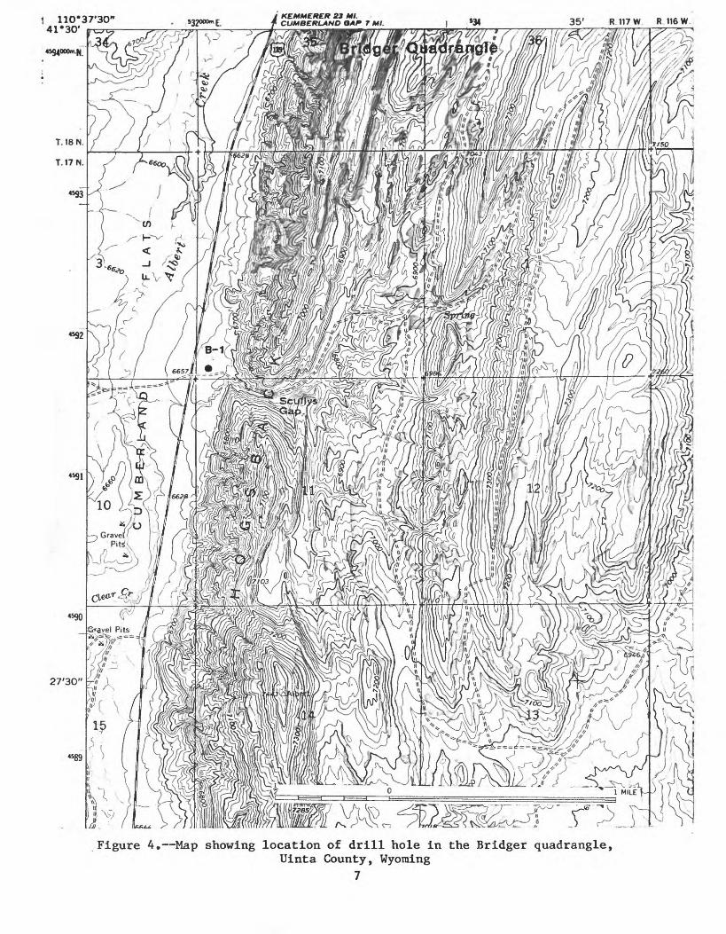
Figure 4. Map showing location of drill holes in the
Br idger quadrangle
TABLES
Table. 1. Summary of information at six sites, Lincoln
and Uinta Counties, Wyoming- 3
Table 2. Proximate and ultimate analyses, heat content,
forms of sulfur, and ash fusion temperature
determinations for 12 samples from the Frontier
Formation 46
Geologic and Geochemical results of 1P78 Coal Exploratory
Drilling in the Upper Cretaceous Frontier Formation, at
six sites in Lincoln and Uinta Counties, Wyoming
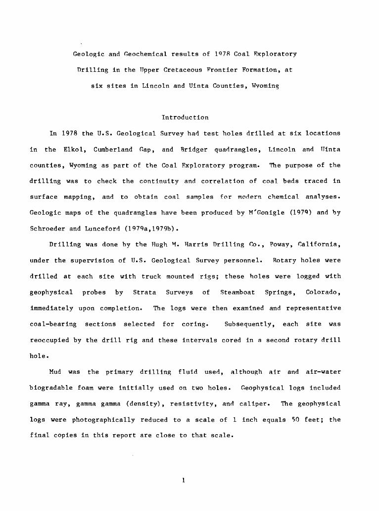
Introduction
In 1978 the U.S. Geological Survey had test holes drilled at six locations
in the Elkol, Cumberland Gap, and Bridger quadrangles, Lincoln and Uinta
counties, Wyoming as part of the Coal Exploratory program. The purpose of the
drilling was to check the continuity and correlation of coal beds traced in
surface mapping, and to obtain coal samples for modern chemical analyses.
Geologic maps of the quadrangles have been produced by M'Gonigle (1979) and by
Schroeder and Lunceford (1979a,1979b).
Drilling was done by the Hugh M. Harris Drilling Co., Poway, California,
under the supervision of U.S. Geological Survey personnel. Rotary holes were
drilled at each site with truck mounted rigs; these holes were logged with
geophysical probes by Strata Surveys of Steamboat Springs, Colorado,
immediately upon completion. The logs were then examined and representative
coal-bearing sections selected for coring. Subsequently, each site was
reoccupied by the drill rig and these intervals cored in a second rotary drill
hole.
Mud was the primary drilling fluid used, although air and air-water
biogradable foam were initially used on two holes. Geophysical logs included
gamma ray, gamma gamma (density), resistivity, and caliper. The geophysical
logs were photographically reduced to a scale of 1 inch equals 50 feet; the
final copies in this report are close to that scale.
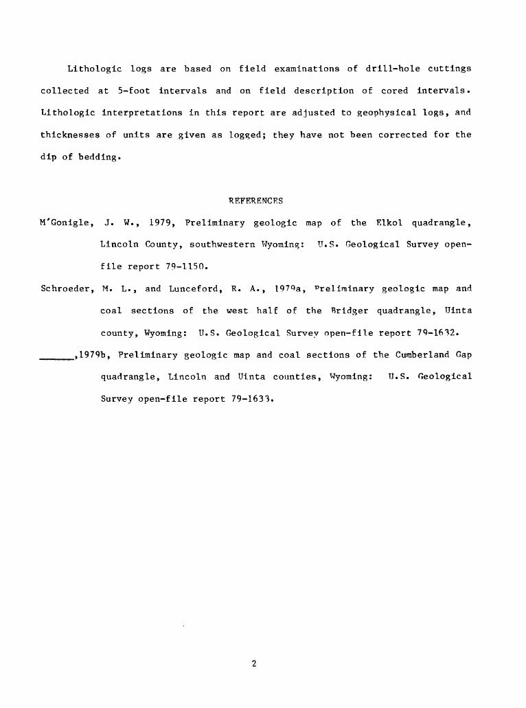
Lithologic logs are based on field examinations of drill-hole cuttings
collected at 5-foot intervals and on field description of cored intervals.
Lithologic interpretations in this report are adjusted to geophysical logs, and
thicknesses of units are given as logged; they have not been corrected for the
dip of bedding.
REFERENCES
M'Gonigle, J. W., 1979, Preliminary geologic map of the Elkol quadrangle,
Lincoln County, southwestern Wyoming: U.S. Geological Survey open-
file report 79-1150.
Schroeder, M. L. , and Lunceford, R. A., 1979a, Preliminary geologic map and
coal sections of the west half of the Bridger quadrangle, Uinta
county, Wyoming: U.S. Geological Survey open-file report 79-1632.
_____, 1979b, Preliminary geologic map and coal sections of the Cumberland Gap
quadrangle, Lincoln and Uinta counties, Wyoming: U.S. Geological
Survey open-file report 79-1633.
Table 1. Summary of information on drilling at six sites, Lincoln and Uinta counties, Wyoming
Drill hole
E-l
E-2
CG-1
CG-2
CG-3
B-l
Location
SW */4 SW V4 T. 19 N.,
SE VA NW */4T. 19 N.,
NW 1/4 NE V4T. 18 N.,
SW V4 SW V4 T. 18 N.,
QP // SW * /»oij /4 "" '4T. 18 N.,
T. 17 N.,
sec. 4 R, 116 W.
sec. 4R. 116 W.
1 OS GC 1 Z
R. 117 W.
sec. 18 R. 116 W.
1 Osec . 1 oR. 116 W.
R. 117 W.
Depth (feet) Quadrangle Drilled Logged Cored
Elkol 665
Elkol 780
Cumberland 460Gap
Cumberland 700 Gap
Cumberland 980Gap
Bridger 560
665 139.6-146.2 235.0-244.9 309.5-318.6367.4-377.6
779 141.0-151.0
459 241.2-250.5294.0-303.9
697 633.2-646.0
979 75.0- 79.6200.0-205.1 223.0-232.5333.0-340.2365.0 373.4570.5-579.9
560 301.6-314.6 336.0-361.0
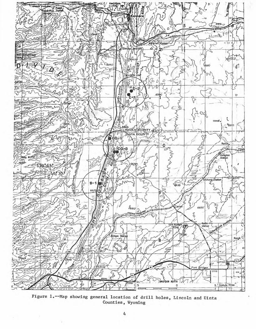
Figure 1. Map showing general location of drill holes, Lincoln and UintaCounties, Wyoming

Figure 2. Map showing location of drill holes in the Elkol quadrangle,Lincoln County, Wyoming
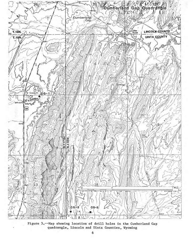
Figure 3. Map showing location of drill holes in the Cumberland Gap quadrangle, Lincoln and Uinta Counties, Wyoming
6
110*37'30" 41*30'
KEMMERER S3 Ml.CUMBERLAND OAP 7 Ml, 35' R.117W R 116 W
Figure 4. Map showing location of drill hole in the Bridger quadrangle,Uinta County, Wyoming
7
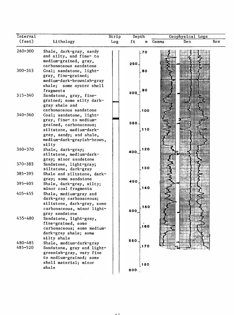
LITHOLOGIC AND GEOPHYSICAL LOGS
LOCATION NUMBER E-l
LOCATION; SW V4 SW V4
COUNTY Lincoln
DATE LOGGED 8/28/78 SURFACE ELEVATION(ft) 7125
Sec. 4 T. 19 N. R. 116 W. Quad. Elkol
STATE Wyoming TOTAL DEPTH(ft) 665
NOCORED; YES X
DRILLING MEDIUM; AIR
GEOPHYSICAL LOGS;
INTERVAL(s) 139.6-146.2; 235-244.9;
FOAM309.5-318.6; 367.4-377.6
MUD x WATER OBSERVATION WELL
Natural Gamma ; Scale 20 cps/log div. Logging Speed 20 fpm
Gamma Gamma Density; Scale 200 cps/log div. Logging Speed 20 fpm
Resistivity ; Scale 8.33 ohms/log div. Logging Speed 20 fpm
Caliper ; Scale Logging Speed fpm
BEDDING ATTITUDE; Strike North Dip 22° W.
Interval Strip Depth Geophysical Logs(feet) Lithology Log ft
0-15 Soil; medium-brownish-gray shale; tan to gray fine grained sandstone, some carbonaceous shale
15- 25 Clay, light-gray to yellow-brown; gray shale; some carbonaceous shale and trace of coal
25- 30 Clay, medium-gray (after tuff)
30- 40 Claystone, light-gray 40- 60 Shale, medium-light-gray,
silty 60- 65 Claystone (after tuff),
slightly brownish-gray 65- 85 Shale, medium-gray,
slightly silty, and medium- light-gray claystone (some after tuff)
85- 90 Coal and gray shale 90- 95 Shale, carbonaceous and
gray shale 95-100 Shale, medium-gray,
slightly silty; some claystone (af ter . tuf f ?) and fine-grained sandstone
m Gamma Den Res
50^
100_
150
200_
JO
_20
H 30
_40
-50
_60
W^
mdy._..£_
._-*
i:2^iiL
:^z~ - ^~iiTT^s i^=^ _.ji*r..
"-j§>-
"""L"?
«*
^
^ ^
mo'
> iff
£V.
>
2.
Sfi---;H"J ]}-^
"4f-^:r:
: t|l^
W 1^-^-
=±_TI ^
:-4J^ L
^?-; ^
?^l
^W" iE;r? :

Interval Strip Depth Geophysical Logs(feet) Lithology ' Log ft
100-125 Sandstone, light- to medium-gray, very fine grained to fine-grained, some carbonaceous; some light-brownish-gray, silty-sandy claystone; minor light-yellow-gray tuff
125-140 Shale, medium-dark to light-brownish-gray, and some medium- gray, fine grained sandstone
140-150 Coal; shale, medium-light to olive-brownish-gray , carbonaceous; clayey light-gray tuff; some very fine grained medium-gray sandstone
150-165 Sandstone, medium-gray, very fine to fine-grained, and medium-brownish-gray siltstone
165-185 Siltstone; medium- brownish-gray; some shale and very fine grained sandstone
185-190 Coal and siltstone as above
190-210 Shale, medium-dark- brownish-gray, silty, and slightly brownish medium- gray claystone
210-215 Sandstone, very light gray, fine-grained, very "clean"; some sandy gray claystone
215-230 Tuff, light-gray, clayey; light-brown siltstone; some grayish-brown carbonaceous shale
230-235 Sandstone, light-gray, very fine grained
-
250
300
350-
400
450_
500_
550_
600
850,
m Gamma Den Res
.70 3-
|H
_80 -
\ "i
.90 If.-j
= 1= 1
:1
.100n
ii
.110 i»*
: i
.120 S:
'P
-i
1 *%n
.140 4- J-
-:
li
.150 - l
*160
.170
-B-3 t3|
180 1
=1:i
_190 .m
=-
.200 li
ii
w*4-4*4"
is} j ": ]
i^ia«=&. ]-f~Ifc^-.N^"
'j: jri^ -. ,-lJ'-
^3
3 5 -j" " -Pi
iirl^ll
^fe<£
; | 5
n~r-»-i.
f>- Hlrlj*4T s^i^j: --ffr~
y^af
:!;= f^£-
i^i^i^ V. ^'^V-
t^
itfip4-i-
^ ' vl?= vdj:
I lijjjjj
== ^rUj-
^M^L :i?3«
^tisf
P^fl
^^S
_5-i
*M
>_
b»
<
>
te
s»
^^_
i 1 fl? 1?^1 : "^
fflSi^
f^fflT 1^. 1 T\i^ 1 ;
! ; i ' H. . , ' ! ]; I <* | i
: j j. 1 !<; ; j'-i
t^ :ffil': "M .-.' "r : "!" j
P^4l^^ i ^ . «- -|-ii i :.; ;> ~>- il' - it" ^-- ' -rj
^-,-q.- ^ v ,:. ^^^N^ -* f "^"H-nTF^/i .i".jgfH; 4-4 |" ; 4rS^j -M > ^ JiSr-j. ^ JJ : i !
iltf : 4-2t-i-i^i ')
r] .^HH^T--(TTIH XL *4^i^_^H(
«^?^
- " -1~
F^jijn i . \ hi
^ I i ] I 1. m* : ~l^ -fi^ -.\.:^^^ ^A :'r~: l^^T*":^;:? *. :H
ff- - ^ -f - - j^g^: 3* f-f -:-!
fj^ j; |: u:-j\ ' 4^ ';-. 5 * .
^ssJ-J-: ' : :_^iu. -- -; j ;- - "
=" ." f - : :Tf : 'if . !- -t
lj " : : . 1 : ""~ - : r. ; 7
i ' ': 1 ;
i . j :
3jit4:~* !:: " :.'. '. ^" ; 5"!
^ i%" i:f ; i: 3-:i= ;3^/;?li-^ ^-5.
=Ms?; Ssf 3~:
^JEiEEJ
!il" "^ 1£:" --
ivt|^f?1iES^ M'"'
*T H^ ' i I :SMEt-C ! 4 «:?i ' i fH[|-.!J;" I -r: i'i
i t Jj> j
Ef-rrfri--:" in ':
r .
' '" \ ' ' \: < . '
"~~ ~>
f-^
^>rJi
h -_ ' ^-t^
fe~
T ->v : ' i ' > : :' .
^T-"^ '; H ^il ». i f F=
: : : 4 -.J - i r ; " ,
IT^^
"r > ; :^ ;
:Tj*'~ "
^f^
Cr " ' ;
& I441:-
l|i!^8^3]-(
^|-i
^=flJ|
^iii
Interval Strip Depth Geophysical Logs_______(feet)______Lithology_____________Log ft m____Gamma Den_______Res
235-245 Coal (two thin beds);shale, medium-light-gray to medium-dark-brownish- gray, locally carbonaceous; tuff, light gray; some siltstone and very fine-grained sandstone
245-295 Shale and siltstone,light-to dark-brownish- gray; some fine-grained sandstone; some light- gray, clayey tuff
295-310 Sandstone, medium-gray,very fine to fine-grained; some dark-gray shale and some claystone (after tuff)
310-320 Coal; sandstone, light- gray, fine- to medium- grained, and brownish-gray shale
320-335 Shale, raediura-dark- brownish-gray and grayish- brown claystone
335-340 Sandstone, light-brown, very fine-grained; trace of coal; some light-gray clayey tuff
340-365 Siltstone and shale, gray to brownish-gray; light gray, very fine to fine grained sandstone, and medium-light-gray claystone (after tuff)
365-380 Coal; shale, light-gray to dark-brown, locally carbonaceous
380-400 Sandstone, light-gray,very fine to fine-grained; medium-dark-brownish-gray shale (some carbonaceous); light-gray claystone
400-455 Sandstone, light-gray, fine-grained, and siltstone; some gray to medium-dark-brown shale and white clayey sandy tuff
10
Interval Strip Depth Geophysical Logs____ (feet) Lithology Log ft m Gamma Den Res
455-470 Shale, medium-dark- brownish-gray ; carbonaceous shale, and coal
470-490 Shale, medium-gray, silty, and siltstone; light-gray sandy clayey tuff; light- gray fine-grained sandstone
490-550 Sandstone, light-gray,fine- to medium-grained; some light-tan claystone and gray siltstone
550-560 Claystone, light-brown and orange-tan (after tuff), and sandstone, siltstone as above
560-580 Sandstone, light-gray,fine-grained, some clayey (tuffaceous)
580-605 Shale, light-tan andlight-gray; sandstone, light-gray, fine-grained; brownish-gray siltstone; some carbonaceous shale; tuff, light-gray (at 594 and 605 feet)
605-625 Sandstone, light-gray,fine-grained; siltstone, dark-gray, some shale
625-645 Shale, light-brown; tuff, light-tan, clayey; siltstone, dark-brownish- gray; some sandstone
645-655 Coal trace; shale andsiltstone, medium-dark- brownish-gray
655-665 Shale, light-tan andlight-gray; some light- tan-gray tuff, and light- gray clayey tuffaceous) sandstone
11

LITHOLOGIC AND GEOPHYSICAL LOGS
LOCATION NUMBER E-2
LOCATION: SEV4NWV4
COUNTY Lincoln
CORED; YES X__ NO
DRILLING MEDIUM; AIR
DATE LOGGED 8/22/78 SURFACE ELEVATION(ft) 7155
Sec. 4 T. 19 N. R. 116 W. Quad. Elkol
STATE Wyoming TOTAL DEPTH(ft) 780
INTERVAL(s) 141.0-151.0_______________
FOAM MUD x WATER OBSERVATION WELL
GEOPHYSICAL LOGS;
Natural Gamma ;
Gamma Gamma Density;
Resistivity ;
Caliper ;
BEDDING ATTITUDE; Strike North
Scale 20 cps/log div.
Scale 8.33 cps/log div.
Scale 1 in./log div.
Logging Speed 15 fpm
Logging Speed 15 fpm
Logging Speed 15 fpm
Logging Speed 15 fpm
Dip 22° W.
Interval (feet) Lithology
Strip Log
Depth Geophysical Logsft ra Gamma Den Res
0- 10 Alluvium; sandstone, tan and medium-gray, fine- to very fine grained; some brownish-medium-gray carbonaceous shale
10- 20 Sandstone, gray, fine- to very fine grained; brown carbonaceous shale
20- 30 Sandstone, gray, fine- to very fine grained, contains dark minerals and some medium-green grains; some brown carbonaceous shale
30- 50 Sandstone, brown, silty, carbonaceous; grades downward into gray carbonaceous shale. Some claystone (after tuff) at 50 feet
50- 90 Sandstone, light-gray,fine- to medium-grained, locally clayey (probably originally tuffaceous); contains dark mineral grains
50
100
150
200J
10
20
30
.40
60
12
Interval (feet)
Strip Lithology
Depth Log
Geophysical Logsft ra Gamma Den Res
90-110 Sandstone as above; medium- dark-gray slightly silty shale, and some very light gray clay (after tuff)
110-125 Shale, medium-gray, silty, becomes medium-brownish- gray lower part of interval
125-143 Shale, brownish-medium- gray, very carbonaceous; some boney coal
143-145 Coal, with some shaly partings
145-150 Shale, carbonaceous, grades downward into medium-dark- brown shale, light-gray shale, and light-gray, very fine grained sandstone
150-160 Sandstone, tan, and porcelanite, light- brownish-gray, very fine grained to aphanitic; some sandy claystone (after tuff), and some medium- dark-gray shale
160-195 Mostly sandstone, medium- gray, very fine to fine grained, with thin interbeds of light-gray claystone (after tuff), minor porcelanite
195-210 Shale, medium-gray to dark medium-gray, slightly carbonaceous; large amount of medium-light-gray clay (after tuff)
210-230 Sandstone, tan, fine grained; light-brown shale; raedium-light-gray clay. Amount of clay increases with depth
230-235 Mostly clay, light-gray; probably after tuff
.70
250_
300
80
90
.100
350-
400.
450
500
550_
600
650,
110
.120
130
.140
.150
160
.170
180
190
13
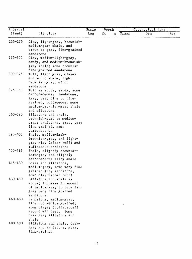
Interval Strip Depth _____Geophysical Logs_______(feet) Lithology Log ft m Gamma Den Res
235-275 Clay, light-gray, brownish- medium-gray shale, and brown to gray, fine-grained sandstone
275-300 Clay, medium-light-gray,sandy, and medium-brownish- gray shale; some brownish fine-grained sandstone
300-325 Tuff, light-gray, clayey and soft; shale, light brownish-gray; minor sandstone
325-360 Tuff as above, sandy, some carbonaceous. Sandstone, gray, very fine to fine grained, tuffaceous; some medium-brownish-gray shale and siltstone
360-390 Siltstone and shale,brownish-gray to medium- gray; sandstone, gray, very fine grained, some carbonaceous
390-400 Shale, medium-dark- brownish-gray, and light- gray clay (after tuff) and tuffaceous sandstone
400-415 Shale, slightly brownish- dark-gray and slightly carbonaceous silty shale
415-430 Shale and siltstone,medium-gray, some very fine grained gray sandstone, some clay (after tuff)
430-460 Siltstone and shale asabove; increase in amount of medium-gray to brownish- gray very fine grained sandstone
460-480 Sandstone, medium-gray, fine- to medium-grained; some clayey (tuffaceous?) around 475 feet. Some dark-gray siltstone and shale
480-490 Siltstone and shale> dark- gray and sandstone, gray, fine-grained
14
Interval (feet) Lithology
Strip Log
Depth ft
Geophysical Logsm Gamma Den Res
490-505 Shale, dark-gray and some brown, carbonaceous shale; some siltstone and sandstone as above
505-515 Sandstone, medium-gray, very fine grained; some raedium-dark-brownish-gray shale and carbonaceous shale, and some clayey (tuffaceous) fine- to medium-grained sandstone
515-565 Sandstone, medium-gray,very fine to fine-grained; and siltstone. Increased amount of siltstone and dark-brownish-gray shale below 535 feet
565-570 Clay, (after tuff), very light-gray, sandy; some dark-brownish-gray shale
570-590 Shale, dark-brownish-gray; some very fine-grained sandstone and shale; rare pieces of porcelanite
590-600 Sandstone, medium-gray,very fine to fine-grained; mediura-dark-gray siltstone
600-640 Sandstone, light- tomedium-gray, fine-grained, some dark-gray shale and silts-tone, amount increases toward base of interval
640-700 Interbedded shale, medium dark-gray; siltstone, dark-brownish-gray and sandstone, medium-light- gray, very fine to fine grained
640-700 Interbedded shale, medium- dark-gray; siltstone, dark-brownish-gray to medium-gray; and sandstone, medium-gray, very fine to fine-grained; some carbonaceous shale and sandstone
650_
700_
750
800_
200
210
220
.230
.240
Interval Strip Depth _____Geophysical Logs____ (feet) Lithology Log ft m Gamma Den Res
700-705 Sandstone, light-gray,fine-grained, clayey(after tuff); medium-darkand light-gray shale
705-730 Shale and siltstone,medium-dark-gray; somevery fine grained graysandstone; someporcelanite fragments
730-740 Same as above plus clayeytuff
740-780 Shale, medium- to dark- brownish-gray; sandstone,gray, very fine grained,locally clayey(tuffaceous); medium-dark- gray siltstones; someporcelanite fragmentsbelow 760 feet
16

LOCATION NUMBER CG-1
LOCATION: NW V4 NE V4
COUNTY Uinta
LITHOLOGIC AND GEOPHYSICAL LOGS
DATE LOGGED 8/5/78 SURFACE ELEVATION(ft) 6610
Sec. 12 T. 18 N. R. 117 W. Quad. Cumberland Gap
STATE Wyoming TOTAL DEPTH(ft) 460
CORED; YES X NO INTERVAL(s) 241.2-250.5; 294.0-303.9
DRILLING MEDIUM;
GEOPHYSICAL LOGS;
AIR FOAM MUD x WATER OBSERVATION WELL
Natural Gamma ; Scale 15 cps/log div. Logging Speed 15 fpm
Gamma Gamma Density; Scale 125 cps/log div. Logging Speed 15 fpm
Resistivity ; Scale 10 ohms/log div. Logging Speed 15 fpm
Caliper ; Scale 1 in. /log div. Logging Speed 40 fpm
BEDDING ATTITUDE; Strike N. 27° E. Dip 24° W.
Interval Strip Dep (feet) Lithology Log ft
0-45 Sand and gravel (alluvium); gravel, granule- to cobble-sized, of quartzite, chert, and sandstone
45- 55 Shale, dark-gray 55- 60 Sandstone, dark-gray, very
fine grained and dark-gray sandy-silty shale
60- 75 Shale, dark-gray, silty 75- 85 Sandstone, gray, very fine
grained, and some gray silty shale
85-205 Shale, gray, silty and very fine grained sandstone, some carbonaceous shale between 100-115 feet, 150-155 feet and 175-180 feet. Some pyrite in shale between 100-115 feet
205-225 Sandstone, medium-gray, very fine grained, and medium- dark-gray silty shale. A few carbonaceous sandstone fragments from 220-225 feet
th Geophysical Logsra Gamma Den Res
50_
100_
150_
200_
r ; 3 S^53 * 5H
E - E ? -* : ^ Wi
1
10 m
-'m
.20 i|
= ^-t-£ ^4^ |E E = - rr.3 ~±: -3=*-: p :-i±
llifS^fi "Iprj-r-: ~. Hf*? ifcj:
?;-!-- -i ijl- *4^iltt^P- m
>? itmm Btfli-Mj in if£
m
60 Si-i;!** J = _ W ** » -^- __ -- _< 1 1 -r i^; it7 tt = Ej4^ ~' Bt~ ~r "
44^ 42ia; * ^Sj=|33^i= J±fe
[Ill 54i ^* Vf*,4^ -Ej5= $ -T. -.-- f r3: 3^j5; T] i= ^3 :
^JiS* *: "H.I"^it^fc^ r; a'-?-Isgjm-ij; J4^ T-| :$; -"i^-
ij' n "H" i^ ": " -f^ 4* fc 5* j; - - = i^^IR ffr £^~Tr
1 ij g |ii : 1 3-i^
5^3-g j OT Ji^rl:
lii ' LpE t~-fer
1 ft ! :Jt; 1 3JH:
fcrtr ; {J4 ^:=f;~
' 1 '"' 1
- i : ^4= r-_ l_| 1 -
sfs ^ M-^i^f^
17
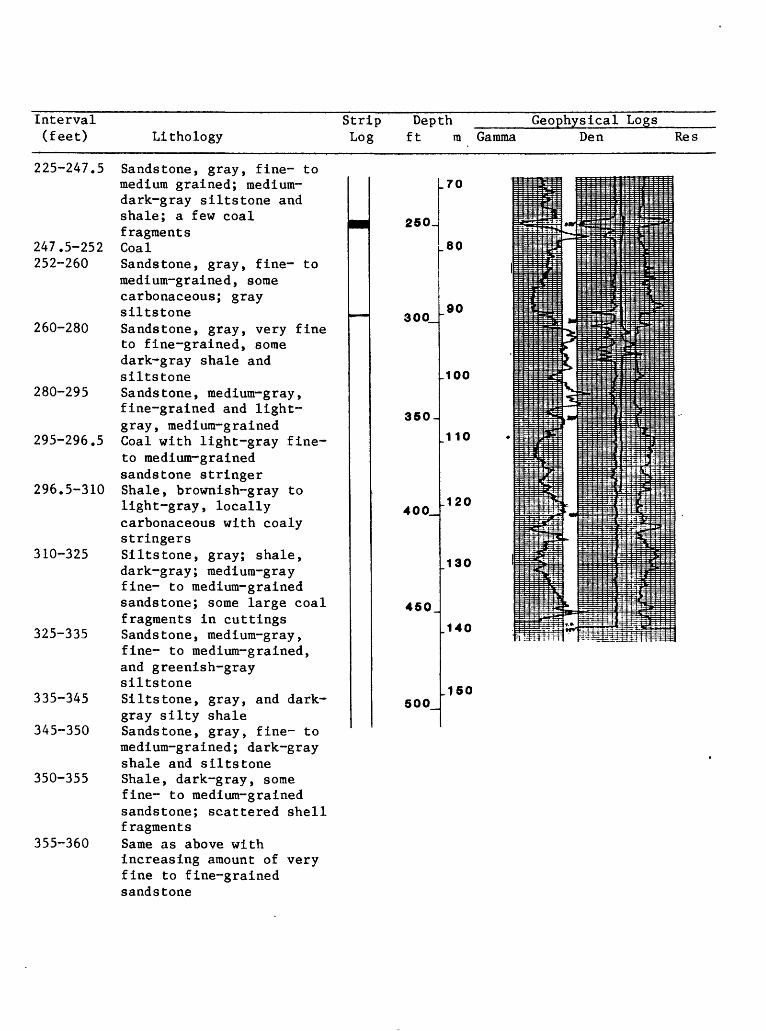
Interval (feet) Lithology
Strip Depth ____ Log ft ra Gamma
Geophysical LogsDen Res
225-247.5 Sandstone, gray, fine- to medium grained; medium- dark-gray siltstone and shale; a few coal fragments
247.5-252 Coal252-260 Sandstone, gray, fine- to
medium-grained, some carbonaceous; gray siltstone
260-280 Sandstone, gray, very fine to fine-grained, some dark-gray shale and siltstone
280-295 Sandstone, medium-gray, fine-grained and light- gray, medium-grained
295-296.5 Coal with light-gray fine- to medium-grained sandstone stringer
296.5-310 Shale, brownish-gray to light-gray, locally carbonaceous with coaly stringers
310-325 Siltstone, gray; shale, dark-gray; medium-gray fine- to medium-grained sandstone; some large coal fragments in cuttings
325-335 Sandstone, medium-gray, fine- to medium-grained, and greenish-gray siltstone
335-345 Siltstone, gray, and dark- gray silty shale
345-350 Sandstone, gray, fine- to medium-grained; dark-gray shale and siltstone
350-355 Shale, dark-gray, some fine- to medium-grained sandstone; scattered shell fragments
355-360 Same as above withincreasing amount of very fine to fine-grained sandstone
.70
250.
.80
300_
350
.100
110
400_
450_
500
90
.120
130
.140
.150

Interval (feet)
360-370
370-390
Lithology
Sandstone, light- to medium-gray; some shell fragments Sandstone, light-gray and
Strip Log
Depth Geophysical Logsft m Gamma Den Res
tan, fine- to medium- grained; dark-gray shale
390-400 Shale, dark- to medium- gray
400-410 Sandstone, gray, fine- to medium-grained, some carbonaceous; some shell fragments
410-415 Shale, dark-gray, and gray fine- to medium-grained sandstone
415-440 Sandstone, gray, very fine to fine-grained; some medium-dark-gray shale; some shell fragments; some fine- to medium-grained reddish sandstone from 420-425 feet
440-445 Shale, dark- to medium- gray
445-460 Shale, greenish-gray;light-gray very fine to medium-grained sandstone; gray siltstone
19
LOCATION NUMBER CG-2
LOCATION: SW VA SW I/L
LITHOLOGIC AND GEOPHYSICAL LOGS
DATE LOGGED 8/8/78 SURFACE ELEVATION(ft) 7010
Sec. 18 T. 18 N. R. 116 W. Quad. Cumberland Gap
COUNTY Uinta STATE Wyoming TOTAL DEPTH(ft) 700
CORED; YES X NO INTERVAL(s) 633.2-646.0
DRILLING MEDIUM;
GEOPHYSICAL LOGS;
AIR FOAM MUD X. WATER OBSERVATION WELL
Natural Gamma ;
Gamma Gamma Density;
Resistivity ;
Caliper ;
BEDDING ATTITUDE; Strike N. 5° E.
Scale 20 cps/log div.
Scale 125 cps/log div.
Scale 20 ohms/log div.
Scale 2 in./log div.
Logging Speed 15 fpm
Logging Speed 15 fpm
Logging Speed 15 fpm
Logging Speed 30 fpm
Dip 19°-20° W.
Interval Strip Depth Geophysical Logs(feet) Lithology Log ft m Gamma Den Res
0- 10 Soil; sandstone, tan to gray, medium- and fine grained
10- 40 Sandstone, tan and brown, fine- to medium-grained. Sandstones clean, mostly quartz grains; some feldspar grains
40-115 Shale, dark-gray, slightly silty
115-120 Shale as above, plus some grayish-brown shale and light-gray sandy clay
120-135 Shale, dark -gray, and white bentonitic clay (after tuff)
135-160 Shale, dark-gray, locally silty; some white clay (after tuff)
160-165 Shale, dark-gray; medium- gray fine-grained sandstone; some coal chips
165-185 Sandstone, medium-light- gray, fine- to very fine grained; some dark-gray and light-brownish-gray shale chips
50 _
100
150
200_
10
.20
^30
_40
.50
_60
~;---:_-: E-
=:
~
9-
:__
- ,
i
=3~,~.
~
-.\
-_
' ~T
_
_^_
_L._
-4-
t4-^f
1 T
v ' >4 " <H
<\
i
1
cnh
!f--4-
.i;
i. i i
-=*p
-H
H1
5T**.
_ __
-t-
+
tv-a
4^- »"t -i '
-±~
-
i-
_,_
' i
-_i^:: -
-4 ;
ii ~ t
1-
i -| --
-4-
-4-
-N1-
-; : -- .~-."-
-=-
^ -~-:-i - l: 4.~^7 1~
rtl-Mv-
i--i ::
~"t
-}--!"
i
-4»
*l=H4PS±-$3
iV-il\fifi*-i\jf~K
i__£
i"ft.-i".
:-Hr
~H
ifl_4 _'
i
}!1
i:IVJf
IT!
V5-jrtrT-
i
i 4- r
1ii
f \\\t\V
'<£_ ~jp~' l( i
H^
I 1 j^w ir\ =
!H-
4 4 -4-
\- +
<-4--
r
JP«j n
-
'
f
_-~
ii4-
±-4-
J-I
j
^
**
-f-
-
-_
_
,
-;;
-
~
+;
-4--t-
i :
|J
T~_ "
1
~T~
20
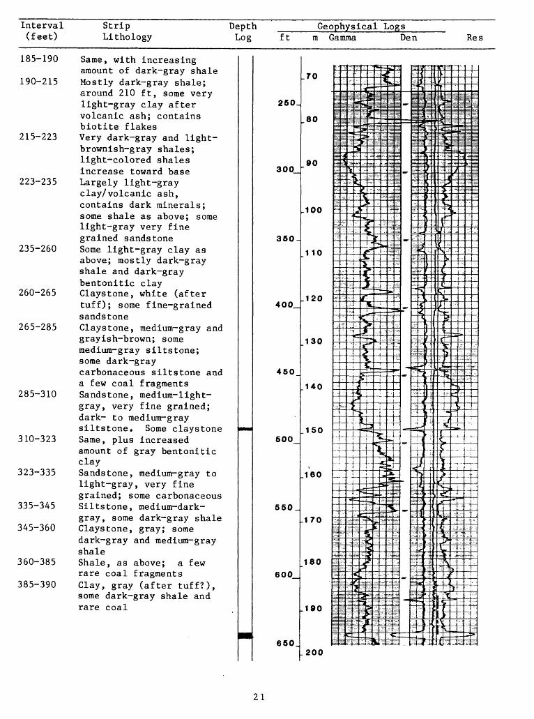
Interval (feet)
Strip Lithology
Depth Log
Geophysical Logsft ra Gamma Den Res
185-190 Same, with increasingamount of dark-gray shale
190-215 Mostly dark-gray shale; around 210 ft, some very light-gray clay after volcanic ash; contains biotite flakes
215-223 Very dark-gray and light- brownish-gray shales; light-colored shales increase toward base
223-235 Largely light-gray clay/volcanic ash, contains dark minerals; some shale as above; some light-gray very fine grained sandstone
235-260 Some light-gray clay as above; mostly dark-gray shale and dark-gray bentonitic clay
260-265 Claystone, white (after tuff); some fine-grained sandstone
265-285 Claystone, medium-gray and grayish-brown; some medium-gray siltstone; some dark-gray carbonaceous siltstone and a few coal fragments
285-310 Sandstone, medium-light- gray, very fine grained; dark- to medium-gray siltstone. Some claystone
310-323 Same, plus increasedamount of gray bentonitic clay
323-335 Sandstone, medium-gray to light-gray, very fine grained; some carbonaceous
335-345 Siltstone, medium-dark- gray, some dark-gray shale
345-360 Claystone, gray; somedark-gray and medium-gray shale
360-385 Shale, as above; a few rare coal fragments
385-390 Clay, gray (after tuff?), some dark-gray shale and rare coal
.70
260.
300
80
90
.100
360-
400_.120
450
500
550_
600
650,
110
130
140
150
160
.170
180
.190
200
21

Interval Strip Depth _____Geophysical Logs_____ (feet) Lithology Log ft m Gamma Den Res
390-400 Dark-gray shale and gray claystone, some fine grained sandstone
400-405 Clay (after tuff), light- brownish-gray; and gray shale. A few coal fragments
405-410 Sandstone, gray, fine grained, some shale and light-gray clay fragments
410-418 Mostly shale, medium-dark- gray
418-425 Sandstone, gray, fine grained; some dark-gray shale and minor carbonaceous shale
425-442 Shale, very dark-gray to medium-dark-gray, some siltstone, gray, and carbonaceous shale
442-450 Clay, very light-gray(after tuff), a few coal chips, some dark-gray shale and minor siltstone
450-485 Sandstone, light- to medium-gray, fine- to medium-grained; minor gray shale and siltstone
485-488 Shale, gray, andcarbonaceous sandstone
488-491 Coal491-530 Shale, dark-gray and
medium-gray, siltstone, and light-gray fine- to medium-grained sandstone
530-545 Mostly sandstone, light- gray to yellowish-gray, some medium-dark-gray shale and siltstone
545-550 Mostly medium-dark-gray shale
550-555 Sandstone, light-gray, very fine grained
555-565 Mostly medium dark-grayshale and siltstone, some sandstone as above
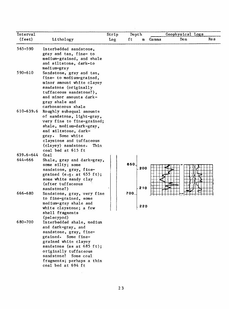
Interval (feet) Lithology
Strip Depth _____ Log ft m Gamma
Geophys icalLogsDen Res
565-590 Interbedded sandstone, gray and tan, fine- to medium-grained, and shale and siltstone, dark-to medium-gray
590-610 Sandstone, gray and tan, fine- to medium-grained, minor amount white clayey sandstone (originally tuffaceous sandstone?), and minor amounts dark- gray shale and carbonaceous shale
610-639.6 Roughly subequal amounts of sandstone, light-gray, very fine to fine-grained; shale, medium-dark-gray, and siltstone, dark- gray. Some white claystone and tuffaceous (clayey) sandstone. Thin coal bed at 615 ft
639.6-644 Coal644-666 Shale, gray and dark-gray,
some silty; some sandstone, gray, fine grained (e.g. at 655 ft); some white sandy clay (after tuffaceous sandstone?)
666-680 Sandstone, gray, very fine to fine-grained, some medium-gray shale and white claystone; a few shell fragments (pelecypod)
680-700 Interbedded shale, medium and dark-gray, and sandstone, gray, fine grained. Some fine grained white clayey sandstone (as at 685 ft); originally tuffaceous sandstone? Some coal fragments; perhaps a thin coal bed at 694 ft
650
700_
.200
-210
220
23
LOCATION NUMBER CG-3
LTTHOLOGIC AND GEOPHYSICAL LOGS
DATE LOGGED 8/20/78 SURFACE ELEVATION (ft) 7050
LOCATION: Sec. 18 T. 18 N. R. 116 W. Quad. Cumberland Gap
COUNTY Uinta
CORED ; YES X___ N0_
DRILLING MEDIUM; AIR
GEOPHYSICAL LOGS;
STATE Wyoming TOTAL DEPTH(ft) 980
INTERVAL(s) 75.0-79.6; 200.0-205.1; 223.0-232.5;
FOAM333.0-340.2; 365.0-373.4; 570.5-579.9 MUD x WATER OBSERVATION WELL
Natural Gamma ; Scale 20 cps/log div.
Gamma Gamma Density; Scale 125 cps/log div.
Resistivity ; Scale 10 ohms/log div.
Caliper ; Scale 1 in. /log div.
BEDDING ATTITUDE; Strike North Dip 17°-18° W.
Interval Strip De (feet) Lithology Log ft
0-10 Alluvium, plus some dark- gray claystone and fine- to medium-grained tan sandstone
10- 30 Shale (claystone) , dark- gray, and sandstone, tan, fine-grained
30- 40 Mostly claystone as above 40- 50 Claystone, medium-gray,
carbonaceous ; sandstone , medium-gray, very fine grained; a few coal fragments
50- 60 Mostly sandstone as above 60- 75 Shale, medium-gray, silty,
some carbonaceous; some medium-gray very fine grained sandstone
75- 80 Shale, medium-gray and brown; some sandstone as above. Core shows 1.4 ft of coal
80- 95 Shale, medium-gray and greenish-gray, some silty; siltstone, medium-gray
pthm Gamma
50^
100_
150
200_
10
_20i
30
.40
.50
_60
I
Logging
Logging
Logging
Logging
Speed 20 fpm
Speed 20 fpm
Speed 20 fpm
Speed 40 fpm
Geophysical LogsDen Res
,
Eij.»y «-ilitTitj^/-'- 1
IttifrljFr -t-'Tj ]LV~
Bf?s?^-^
fit.fzri--:
JT-H-: '
:irT t~~r:
p4^-:^^ff
m=15^
: mi^TT'-~i-r-*gi-T
=11 Hit- -1-. '.-
: Jrl-
: ^±r: ! : J5S
Aa
"?w ^rj*-^
P
lit
J"T
s^iivTii
^
, -M
«:
«r-S>-
,w
.-t-~-t=niifcL
^i2!!-:
"^j*"
ft
i&_
ffe4^gisn£?Ti r
£rJ?*^ _ j_t-^-|^T"
*- ! i^^ft^^t-" -f^t-i'^-^j
:^ * ..«
i^^-^pfc
«1fr it^-tr^^in rr-II f- t=^4:
r^4-m->
3:?*
;rt :
^M3^Er.T : ?TT
Tl-ffTjTi?^ ; T?:|J
: - j/ .
~«isjf : '
; i : : j -/
1-BlO
rt.l;-;.4.~. .
B4=4j-12^3:
'^rT^gis!
r-
itil^.i ; t
^f
r^^t;
3
: r
rl-
N]Sirl £3.Li-i~
PI
f\w !H^^iiir ^
ItSfj?J; .ii» 3^ |
! ^ i "iil I i i yLe "- 1 Jl -S B^ --
1^0--if-: - ^ J :
rr. T~%-itjrli^f1-V3?^.;""
1 ^ < , u s^^i "^^I Ha- :i *"& : ^ 'V^*: "/ I "
i -~ f1 3? * ~ "
_ -. _ . - : -^^-L.: _
f^jT1
i-_. 3| -: ;i :- \1 : " -
iSl^-vS-l?
24
Interval Strip Depth ______Geophysical Logs______(feet) Lithology Log ft ra Gamma Den Res
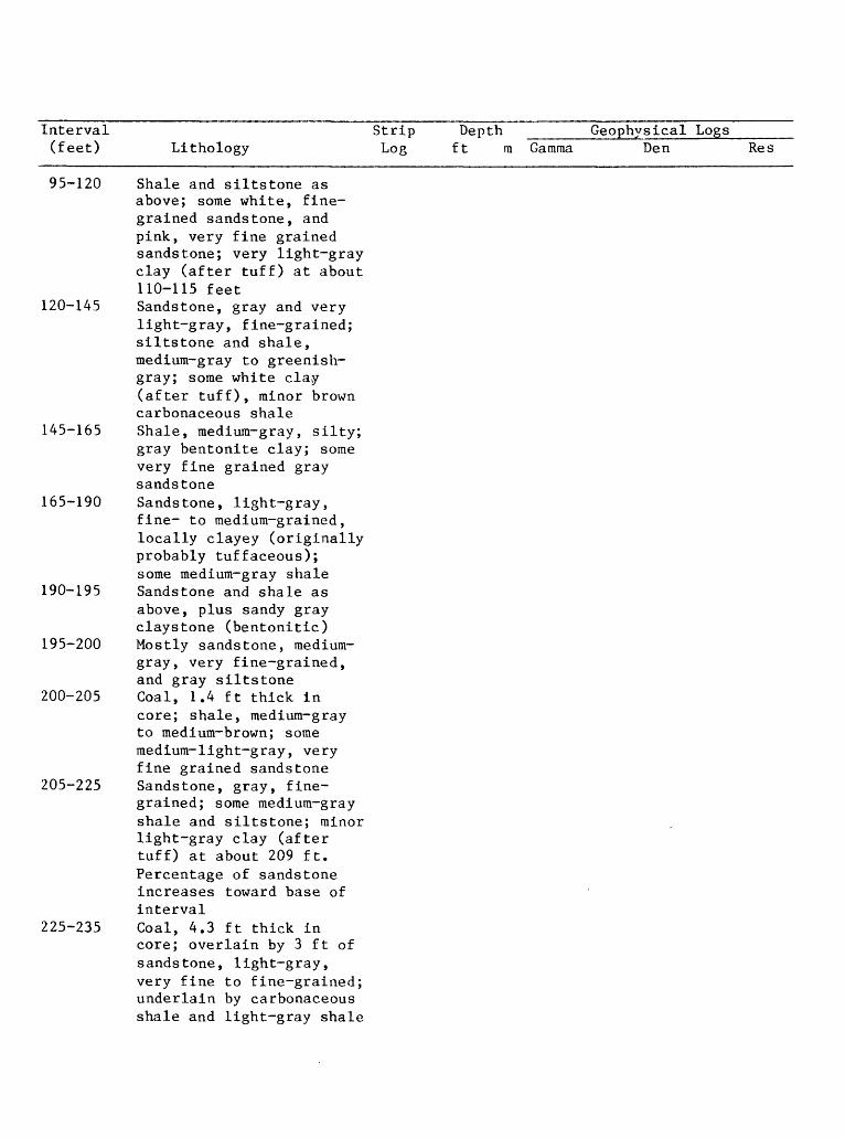
95-120 Shale and siltstone asabove; some white, fine grained sandstone, andpink, very fine grainedsandstone; very light-grayclay (after tuff) at about110-115 feet
120-145 Sandstone, gray and verylight-gray, fine-grained;siltstone and shale,medium-gray to greenish- gray; some white clay(after tuff), minor browncarbonaceous shale
145-165 Shale, medium-gray, silty;gray bentonite clay; somevery fine grained graysandstone
165-190 Sandstone, light-gray,fine- to medium-grained,locally clayey (originallyprobably tuffaceous);some medium-gray shale
190-195 Sandstone and shale asabove, plus sandy grayclaystone (bentonitic)
195-200 Mostly sandstone, medium- gray, very fine-grained,and gray siltstone
200-205 Coal, 1.4 ft thick incore; shale, medium-grayto medium-brown; somemedium-light-gray, veryfine grained sandstone
205-225 Sandstone, gray, fine grained; some medium-grayshale and siltstone; minorlight-gray clay (aftertuff) at about 209 ft.Percentage of sandstoneincreases toward base ofinterval
225-235 Coal, 4.3 ft thick incore; overlain by 3 ft ofsandstone, light-gray,very fine to fine-grained;underlain by carbonaceousshale and light-gray shale

Interval Strip Depth Geophysical Logs(feet) Lithology Log ft
235-260 Shale, brownish-gray; light-gray sandy clay (after tuff); some fine grained gray sandstone
260-265 Tuff, sandy, and light-gray clay; minor carbonaceous shale
265-290 Sandstone, light-gray, fine- to medium-grained, with a fairly high percentage of dark minerals; some light-gray siltstone and light-gray to white sandy clay (after tuff); minor brownish-gray shale and carbonaceous shale
290-295 Tuff, white, clayey and sandy; some sandstone and siltstone as above
295-330 Mostly sandstone, light- gray, fine-grained, some with a high percentage of dark minerals; siltstone and shale, dark-medium- gray; some clay, white to gray, sandy; minor carbonaceous shale
330-340 Coal, 2.5 ft thick in core; overlain by light- gray, fine-grained sandstone which grades downward into siltstone and carbonaceous shale. Underlain by thin carbonaceous shale layer, then light-gray shale
340-365 Sandstone, light-gray, very fine- to fine grained, some with dark minerals, chert, and rock fragments; siltstone and silty shale, medium-gray; some white sandy clay (after tuff)
I
mm
mm
250.
300
350-
400_
450_
500
550_
600_
650,
m Gamma Den Res
-70
i
.80 H
-.1= 1
90 li
.100 ^flUi-t
.110 |?»
i.120 it
*i
^i1 <a n ^
IT? ?-]
.140 13
±t
.150 T
~^r
.160 ij
.170 g
f-
180
11
.190 ri -?
fl-
.g^-ZZ:,. -^
i i i ; ''tti-JK&dt*T
= = -- j =3<£
r4<
5; JK H
^SiJ.' 1 -3T$;rTrfe^SBLJ
JJ!
'',') I: . T- ,} 4
liftlt : ^*" ^'-^f^'~lj\\i
='5 IT
J ; ; .;: i_ : 1
40-Hi%:TJ
: Tf^v; 1
ii[~t:
^sVz:
.ryr^
1-3&
tHI-1 fi*i^:' iXL^-
ILlij
-- ] -^5
5»
>,>
5-
.
rnr
4{/;!?'
Tirtjl;iffijs^ "1 r4}»f
ftqh^i*
^
gf|ti14ip
§HI^4njH^
itt^-3 - : i : i-J
^T7 ^
-^-r jF::~4=~-^-i .-i " :
i f4~=rp; :
: ?~ - :~ f -
: -. :;j^-;~ -~ri-? - -'-S-v:- - -
fill.;
-: -1
T< ~
__ . 4.^
J~1i:-^|:-:.: 1 \~±4^-~:-: - :j
list- ' ^>'
J#T r* : W|
^'1Jf
i=:|:iil
j ;i;:ii4* tii1 ^« ^T i
:: 4 {H" H T "r
: ITH, iili
;=4^;!-- :'^
: : "3
<
-^ i-
H-f
;- 4 ^T
'' »"r i ^
*=^r..4 i < 1"
hi":
Mwff'fTltC"
S,T:-^if^ }
iiir ^ f1 I i
f~, j3
1Jpl
i - !jy . :
-{: J
' * -i-5>
4-4- :
.._.
Kg:^;.
]; VMT
4-IJ^i^
4r-i4tl :
.200
26
Interval Strip Depth _____Geophysical Logs____ (feet) Lithology Log ft ra Gamma Den Res
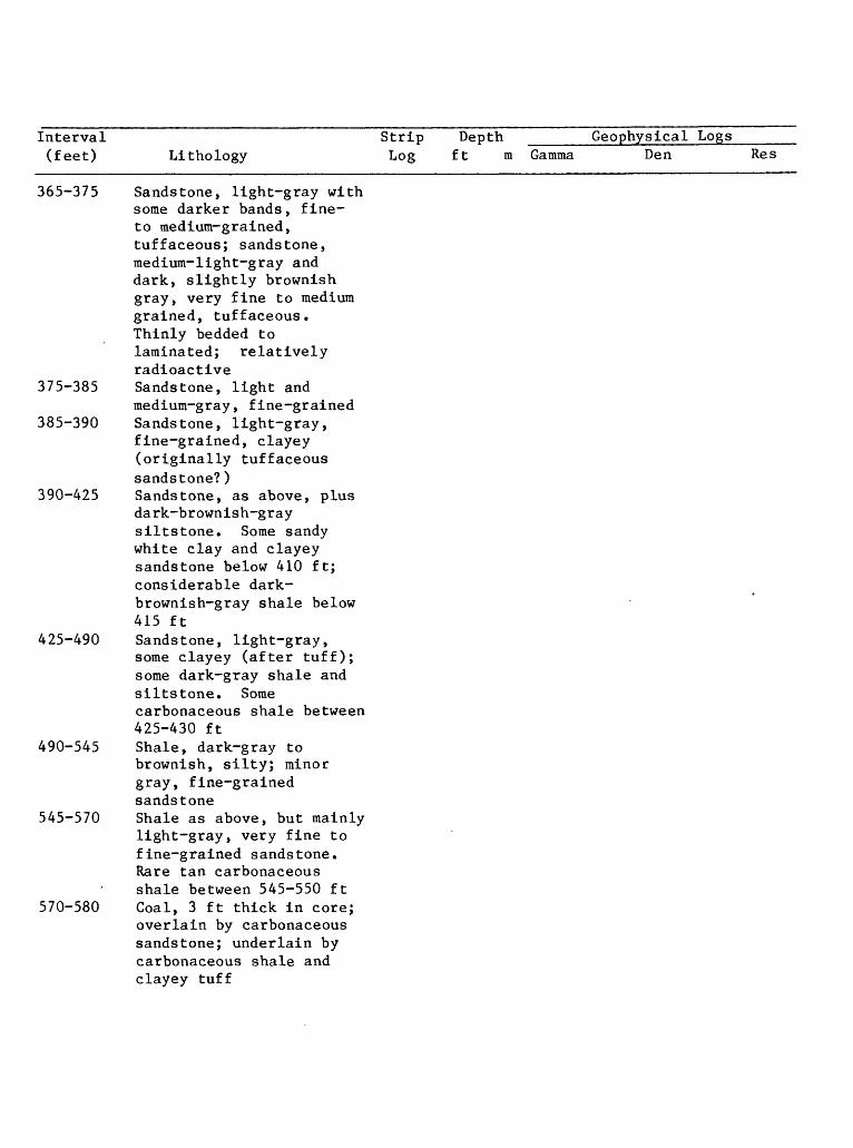
365-375 Sandstone, light-gray withsome darker bands, fine- to medium-grained,tuffaceous; sandstone,medium-light-gray anddark, slightly brownishgray, very fine to mediumgrained, tuffaceous.Thinly bedded tolaminated; relativelyradioactive
375-385 Sandstone, light andmedium-gray, fine-grained
385-390 Sandstone, light-gray,fine-grained, clayey(originally tuffaceoussandstone?)
390-425 Sandstone, as above, plusdark-brownish-graysiltstone. Some sandywhite clay and clayeysandstone below 410 ft;considerable dark- brownish-gray shale below415 ft
425-490 Sandstone, light-gray,some clayey (after tuff);some dark-gray shale andsiltstone. Somecarbonaceous shale between425-430 ft
490-545 Shale, dark-gray tobrownish, silty; minorgray, fine-grainedsandstone
545-570 Shale as above, but mainlylight-gray, very fine tofine-grained sandstone.Rare tan carbonaceousshale between 545-550 ft
570-580 Coal, 3 ft thick in core;overlain by carbonaceoussandstone; underlain bycarbonaceous shale andclayey tuff

Interval (feet) Lithology
Strip Depth ____ Log ft m Gamma
Geophysical LogsDen Res
580-595 Carbonaceous shale;medium-gray shale; some white sandy claystone (after tuff); minor fine grained sandstone
595-625 Shale, medium-gray, dark- gray, and brown; light- gray, very fine to fine grained sandstone; rare white claystone (after tuff)
625-645 Shale and siltstone,medium-gray and medium- dark-gray; minor light- gray fine-grained sandstone
645-660 Same constituents;increase in amount of sandstone, plus some claystone (after tuff)
660-670 Sandstone, gray, fine grained, and gray siltstone
670-690 Shale, medium-gray, some dark-gray; gray very fine to fine-grained sandstone and siltstone. Some sandstone, clayey, (originally tuffaceous?), as at 690 ft
690-700' Sandstone, very fine tofine-grained; some medium- gray shale
700-710 Shale, medium-gray andmedium-dark-brownish-gray; some white clayey sandstone (originally tuffaceous)
710-745 Sandstone, light-gray,very fine to fine-grained; shale, some siltstone, medium-gray to medium- dark-brownish-gray; some light-gray claystone (after tuff)
650_.200
.210 11=
700_
750
800_
.250
850_
900_
950_
1000_
220
.230
240
.260
. 270
280
.290
.300
28
Interval Strip Depth _____Geophysical Logs_____ (feet) Lithology Log ft m Gamma Den Res
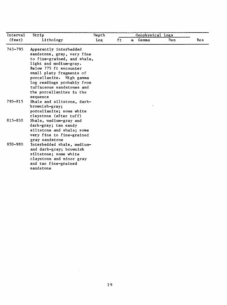
745-795 Apparently interbeddedsandstone, gray, very fineto fine-grained, and shale,light and medium-gray.Below 775 ft encountersmall platy fragments ofporcellanite. High gammalog readings probably fromtuffaceous sandstones andthe porcellanites in thesequence
795-815 Shale and siltstone, dark- brownish-gray;porcellanite; some whiteclaystone (after tuff)
815-850 Shale, medium-gray anddark-gray; tan sandysiltstone and shale; somevery fine to fine-grainedgray sandstone
850-980 Interbedded shale, medium-and dark-gray; brownishsiltstone; some whiteclaystone and minor grayand tan fine-grainedsandstone
29
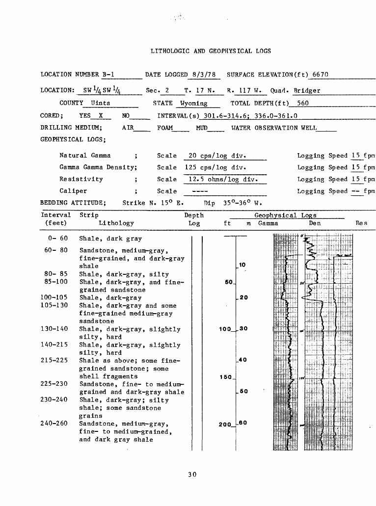
LITHOLOGIC AND GEOPHYSICAL LOGS
LOCATION NUMBER B-l
LOCATION: SWVASW 1,
DATE LOGGED 8/3/78 SURFACE ELEVATION(ft) 6670
Sec. 2 T. 17 N. R. 117 W. Quad. Bridger
COUNTY Uinta
CORED; YES X
DRILLING MEDIUM;
GEOPHYSICAL LOGS;
STATE Wyoming TOTAL DEPTH(ft) 560
N0_
AIR
INTERVAL(s) 301.6-314.6; 336.0-361.0
FOAM MUD WATER OBSERVATION WELL
Natural Gamma ;
Gamma Gamma Density;
Resistivity ;
Caliper ;
Scale 20 cps/log div.
Scale 125 cps/log div.
Scale 12.5 ohms/log div.
Scale
Logging Speed 15 f pin
Logging Speed 15fpm
Logging Speed 15 fpm
Logging Speed fpm
BEDDING ATTITUDE; Strike N. 15° E. Dip 35°-36° W.
Interval Strip Depth Geophysical Logs(feet) Lithology Log
0- 60 Shale, dark gray
60- 80 Sandstone, medium-gray, fine-grained, and dark-gray shale
80- 85 Shale, dark-gray, silty 85-100 Shale, dark-gray, and fine
grained sandstone 100-105 Shale, dark-gray 105-130 Shale, dark-gray and some
fine-grained medium-gray sandstone
130-140 Shale, dark-gray, slightly silty, hard
140-215 Shale, dark-gray, slightly silty, hard
215-225 Shale as above; some fine grained sandstone; some shell fragments
225-230 Sandstone, fine- to medium- grained and dark-gray shale
230-240 Shale, dark-gray; silty shale; some sandstone grains
240-260 Sandstone, medium-gray, fine- to medium-grained, and dark gray shale
ft m Gamma Den
'KT
50_
100_
150
200
mflin
10 n-P taU-1
-20 ft= K-4i4if
ir30 |tt
It
Tr40 ifei"
Ii
.50 =1 =
_60 Jm1 mi§3
-r -: : t T
|fen^ ir^J-i" 1~: i-I
£' fr
1 1-5 spifIWr\ - T ;
S;- 2 --i-4 1 t . -r-r ('
If rit
if*"^W- mtf!"&-1!»:MfH-
3= :lfi_-_
f *^^ fijy-^|Tf3-
J-o'j
c
.M
, : .-.:
5^«c; ] *
5-
5r|:T'T^.-f-
r-|-«-
-4 "i ' '
C", j j'l : : j
-^C..
T^k,sF -> . .1
-W-if- :H
- nr:
hH~^i
_;._.:j
-4- 1 -.:-i } '-P H^^T ~~: ~^
_L~*'T
4
s =
11-=t
|.
±
-*=
I "-
"T ; :: '-. ~ :ili-:
._T__
: i _
t:i-<" J-f4- -:-
i^-d
-T -
4d
H i
- i 2
:.3 ;
S-*=
4^^frd
J
.-^~
H-
if-
li '
rlat^
H-- ;
; I
ntf
: i
E- f
t±T=?3=-Ti. :
;f^! -
; i
44^
ffi»^"if"
: ; :i
-ri-r-
i4iilfj
Res
30
Interval Strip Depth Geophysical Logs(feet) Lithology Log ft
260-300 Shale, dark-gray, sandy and silty, and fine- to medium-grained, gray, carbonaceous sandstone
300-315 Coal; sandstone, light- gray, fine-grained; medium-dark-brownish-gray shale; some oyster shell fragments
315-340 Sandstone, gray, fine grained; some silty dark- gray shale and carbonaceous sandstone
340-360 Coal; sandstone, light- gray, fine- to medium- grained, carbonaceous; siltstone, raedium-dark- gray, sandy; and shale, medium-dark-grayish-brown , silty
360-370 Shale, dark-gray; siltstone, raedium-dark- gray; minor sandstone
370-385 Sandstone, light-gray; siltstone, dark-gray
385-395 Shale and siltstone, dark- gray; some sandstone
395-405 Shale, dark-gray, silty; minor coal fragments
405 455 Shale, medium-gray and dark-gray carbonaceous; siltstone, dark-gray, somecarbonaceous, minor light- gray sandstone
455-480 Sandstone, light-gray, fine-grained, some carbonaceous; some medium- dark-gray shale; some silty shale
480-485 Shale, medium-dark-gray 485-520 Sandstone, gray and light-
greenish-gray, very fine to medium-grained; some shell material; minor shale
250
300
350
400
450_
500
550_
600 _
m Gamma Den Res
.70 ;:-a<
:EE =: - - j
.80 mi
90 Mil
: jj e*
.100 =i=i
110 m
1"*Lr
.120 JUS
M
1 o o ifctUU ,^|
iMjiTfy
i ^4f140 : !!jj
. _ 5p
.150 iiil
m
BO T^^
43inJ* fflJiH-
^170 mi
180
=|r iii
£ EE ==-
if-n: TTi
^?J" ^ffli* tn^>^
B ^*"!!. r! t:&^£ ':v; 5
^~: i?i'^^^5: ^f=
^ Hiff
Hi" I 1Hiii -^
i?f!jl'S 5;3J-
W..^t
jnf-r iwrtlpftiSrffl
!:N Jnl'p
idlsillllih
iii|nnh
^ =?-= "^ ^ =^- 3.; ";- *[|t^
: -^1 3: =?|^£.i:Ei;:=3tj
z: ri; ':£- i^--i|]ilt^Mi. ?M||rf-" riS^^ "if^s
1 =*-i X^F
^T."y 3; 4-^=3
E^^;^^
1 ~ ?j T"T r irS4f- ;:; t- ^£ ff^ :-''|flj
'tW f "i= = s 5 :
-t^
r ~ r : :
j = = = =
= *«r
3 ,; = = :
= ^~:
.-r 1::. :
= 3 - E! 'I
Ji!rr-: : J-
Mi
- sU;^¥^
I!jfe
* r:|l*^::}
^

Interval Strip Depth _____Geophysical Logs____ (feet) Lithology Log ft m Gamma Den Res
520-530 Shale, dark-gray; somemedium-gray, fine-grainedsandstone
530-560 Sandstone, gray and tan,fine- to medium-grained,locally carbonaceous, somegray shale
LITHOLOGIC DESCRIPTIONS OF CORE SAMPLES
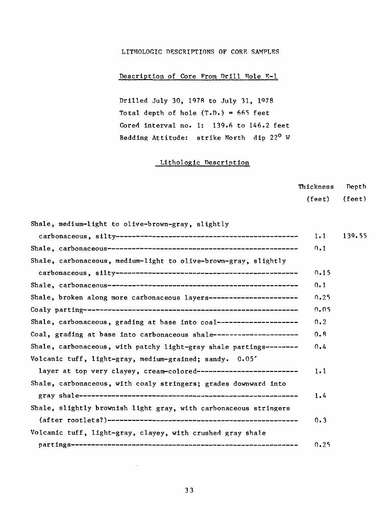
Description of Core From Drill Hole E-l
Drilled July 30, 1978 to July 31, 1978
Total depth of hole (T.D.) = 665 feet
Cored interval no. 1: 139.6 to 146.2 feet
Bedding Attitude: strike North dip 22° W
Lithologic Description
Thickness Depth
(feet) (feet)
Shale, medium-light to olive-brown-gray, slightly
carbonaceous, silty 1.1
Shale, carbonaceous 0.1
Shale, carbonaceous, medium-light to olive-brown-gray, slightly
carbonaceous , silty 0.15
Shale, carbonaceous 0.1
Shale, broken along more carbonaceous layers 0.25
Co aly par ting 0.05
Shale, carbonaceous, grading at base into coal 0.2
Coal, grading at base into carbonaceous shale O.R
Shale, carbonaceous, with patchy light-gray shale partings 0.4
Volcanic tuff, light-gray, medium-grained; sandy. 0.05'
layer at top very clayey, cream-colored 1.1
Shale, carbonaceous, with coaly stringers; grades downward into
gray shale 1.4
Shale, slightly brownish light gray, with carbonaceous stringers
(after rootlets?) 0.3
Volcanic tuff, light-gray, clayey, with crushed gray shale
partings 0.25
33
Cored interval no. 1: 139.6 to 146.2 feet continued
Lithologic Description
Shale, light-gray, with scattered carbonaceous blebs (rootlets?)
and a clayey tuff parting 0.2 feet from top
Total
Thickness Depth
(feet) (feet)
0.4
6.60 146.15
146.2
Cored interval no. 2: 235.0 to 244.9 feet
Lithologic Description
Sandstone, light-gray, very fine grained to fine-grained 1.37 235.0
Shale, medium-light-gray, sandy, with darker shale layers 0.2
Shale, medium-dark-gray, slightly carbonaceous 0.5
Shale, dark-brown, carbonaceous (crumbled zone) 0.3
Shale, medium-dark-brownish-gray, mottled with lighter gray
patches. Lower part crumbled 1.0
Coal; upper part crumbled. Grades downward into shale 0.6
Shale, carbonaceous. Grades downward into lighter gray shale 0.15
Shale, light-brown-gray, with carbonaceous stringers; grades
downward into tuff 0.55
Tuff, light-gray to light-brownish-gray. Upper 0.6 feet graded 1.8
vjoa JL " - ~""-"-"- " - - 1. D
Shale, carbonaceous. Grades downward into clayey tuff 0.1
Tuff , clayey 0.2
Siltstone, light-gray, shaly; contains fragments of sandstone
in lower part 0.9
Sandstone, very fine grained 0.65
Total 9.92 244.92
244.9
34
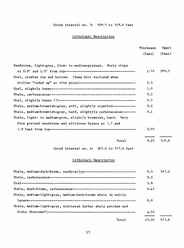
Cored Interval no. 3: 30P.5 to 31ft.6 feet
Llthologic Description
Thickness Depth
(feet) (feet)
Sandstone, light-gray, fine- to medium-grained. Shale chips
at 0.9' and 1.5' from top
Coal, crushed top and bottom. (Some dirt included when
driller "roded up" at this point)
Coal, slightly boney
Shale, carbonaceous
Coal, slightly boney (?)
Shale, medium-brownish-gray, soft, slightly crumbled
Shale, medium-brownish-gray, hard, slighjtly carbonaceous
Shale, light- to medium-gray, slightly brownish, hard. Very
fine grained sandstone and slltstone layers at 1.7 and
1.9 feet from top
Total
Cored interval no. 4: 367.4 to 377.6 feet
Llthologlc Description
Shale, medium-dark-brown, sandy-silty
Shale, carbonaceous
Shale, dark-brown, carbonaceous
Shale, medium-light-gray, medium-dark-brown shale in swirly
layer s
Shale, medium-light-gray, scattered darker shale patches and
blobs (burrows?)
Total
1.55 309.5
2.3
1.0
0.2
0.7
0.2
0.1
3.05
9.10 31R.6
0.3 367.4
0.3
3.8
0.45
O.R
4.55
10.20 377.6
35
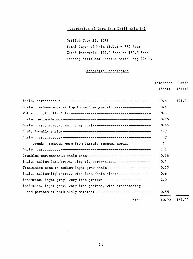
Description of Core From Drill Hole E-2
Drilled July 29, 1978
Total depth of hole (T.D.) = 780 feet
Cored interval: 141.0 feet to 151.0 feet
Bedding attitude: strike North dip 22° W,
Lithologic Description
Thickness Depth
(feet) (feet)
Shale, carbonaceous 0.6 141.0
Shale, carbonaceous at top to medium-gray at base 0.4
Volcanic tuff, light tan 0.3
Shale, medium-brown 0.15
Shale, carbonaceous, and boney coal 0.55
Coal, locally shaley 1.7
Shale, carbonaceous . 7
break; removed core from barrel; resumed coring ?
Shale, carbonaceous 1.7
Crumbled carbonaceous shale zone 0.1±
Shale, medium dark brown, slightly carbonaceous 0.4
Transition zone to medium-light-gray shale 0.25
Shale, medium-light-gray, with dark shale clasts 0.6
Sandstone, light-gray, very fine grained 2.0
Sandstone, light-gray, very fine grained, with crossbedding
and patches of dark shaly material 0.55
Total 10.00 151.00
36
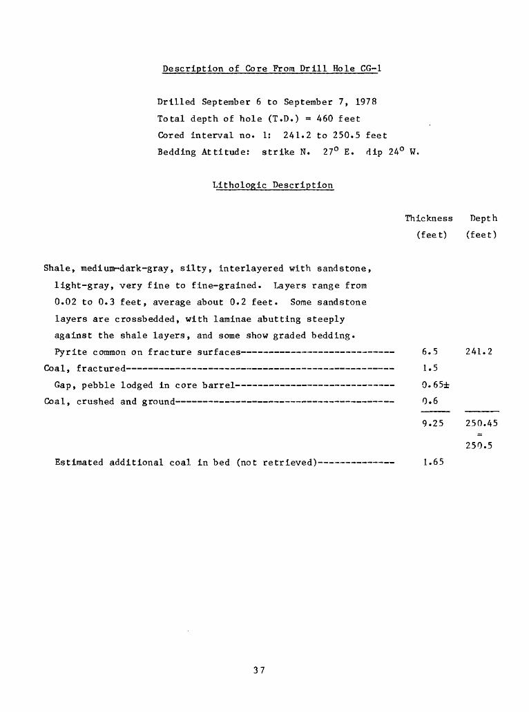
Description of Core From Drill Hole CG-1
Drilled September 6 to September 7, 1978
Total depth of hole (T.D.) = 460 feet
Cored interval no. 1: 241.2 to 250.5 feet
Bedding Attitude: strike N. 27° E. dip 24° W.
Lithologic Description
Shale, raedium-dark-gray, silty, interlayered with sandstone,
light-gray, very fine to fine-grained. Layers range from
0.02 to 0.3 feet, average about 0.2 feet. Some sandstone
layers are crossbedded, with laminae abutting steeply
against the shale layers, and some show graded bedding.
Coal, fractured
Thickness Depth
(feet) (feet)
odged in core barrel
nd ground
. 1.5
. 0.65±
. 0.6
9.25
£H1 £
250.45
250.5
Estimated additional coal in bed (not retrieved) 1.65
37
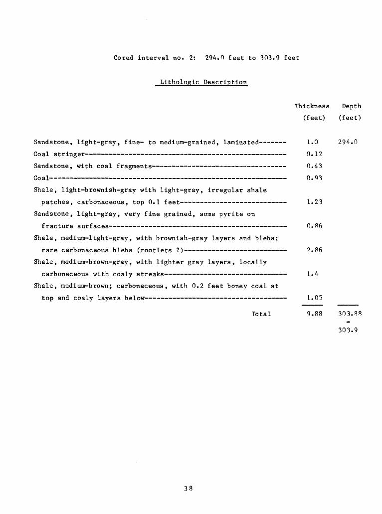
Cored interval no. 2: 294.0 feet to 303.9 feet
Lithologic Description
Thickness Depth
(feet) (feet)
Sandstone, light-gray, fine- to medium-grained, laminated 1.0 294.0
Coal stringer 0.12
Sandstone, with coal fragments 0.43
v>O cl .L^* ^^ ^ ^ ^^ ^ ^ ^^ ^^ ^^^ V/ * ^
Shale, light-brownish-gray with light-gray, irregular shale
patches, carbonaceous, top 0.1 feet 1.23
Sandstone, light-gray, very fine grained, some pyrite on
fracture surfaces 0. 86
Shale, medium-light-gray, with brownish-gray layers and blebs;
rare carbonaceous blebs (rootlets ?) 2.86
Shale, medium-brown-gray, with lighter gray layers, locally
carbonaceous with coaly streaks 1.4
Shale, medium-brown; carbonaceous, with 0.2 feet boney coal at
top and coaly layers below 1.05
Total 9.88 303.88
303.9
38
LITHOLOGIC DESCRIPTIONS OF CORE SAMPLES
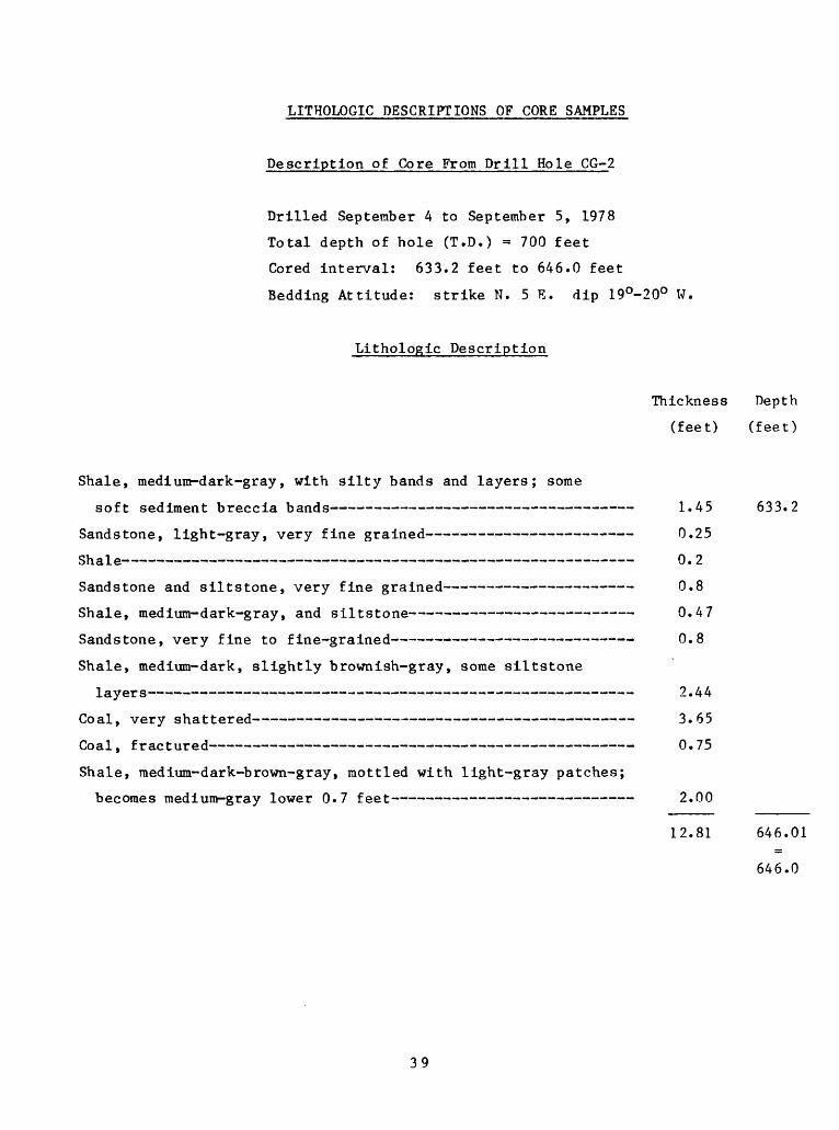
Description of Core From Drill Hole CG-2
Drilled September 4 to September 5, 1978
Total depth of hole (T.D.) = 700 feet
Cored interval: 633.2 feet to 646.0 feet
Bedding Attitude: strike N. 5 E. dip 19°-20° W.
Lithologic Description
Thickness Depth
(feet) (feet)
Shale, medium-dark-gray, with silty bands and layers; some
soft sediment breccia bands 1.45 633.2
Sandstone, light-gray, very fine grained 0.25
Shale 0.2
Sandstone and silts tone, very fine grained 0.8
Shale, medium-dark-gray, and siltstone 0.47
Sandstone, very fine to fine-grained 0.8
Shale, medium-dark, slightly brownish-gray, some siltstone
layers 2.44
Coal, very shattered 3.65
Coal, fractured 0. 75
Shale, medium-dark-brown-gray, mottled with light-gray patches;
becomes medium-gray lower 0.7 feet 2.00
12.81 646.01
646.0
39
Description of Core From Drill Hole CG-3
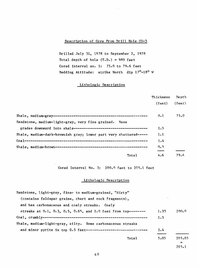
Drilled July 31, 1978 to September 2, 1978
Total depth of hole (T.D.) = 980 feet
Cored interval no. 1: 75.0 to 79.6 feet
Bedding Attitude: strike North dip 17°-18° V
Lithologic Description
Thickness Depth
(feet) (feet)
Shale, medium-gray 0.1 75.0
Sandstone, medium-light-gray, very fine grained. Base
grades downward into shale 1.5
Shale, medium-dark-brownish gray; lower part very shattered 1.1
Coa 1 1.4
Shale, medium-brown 0. 5
Total 4.6 79.6
Cored Interval No. 2: 200.0 feet to 205.1 feet
Lithologic Description
Sandstone, light-gray, fine- to medium-grained, "dirty"
(contains feldspar grains, chert and rock fragments),
and has carbonaceous and coaly streaks. Coaly
streaks at 0.1, 0.3, 0.5, 0.65, and 1.0 feet from top 1.35 200.0
Coal, crumbly 1.3
Shale, medium-light-gray, silty. Some carbonaceous streaks
and minor pyrite in top 0.5 feet 2.4
Total 5.05 205.05
205.1
40

Cored interval no. 3: 223.0 to 232.5 feet
Lithologic Description
Thickness Depth
(feet) (feet)
Sandstone, light-gray, very fine to fine-grained, "dirty",
(contains feldspar grains, chert, and rock fragments);
shows banding with layers slightly richer in dark minerals,
and a few carbonaceous filaments. Shale layer at 2.86
feet from top, and shale chips at bottom 3.27 223.0
Coal, broken, sticky (stuck to core barrel) 1.9
V/O Si ±~~~~^~^^^~<~~^~~~m ^^ ~^~~~~ ** *** **** ^^m ^* * *-* *** ** * -BB^ ** ** m m m ^-** * * ~ U O-D
Coal, boney (shaly?) 0.2
prt o 1 _________»..______________________ _ __ _________ __________________ 1 ^ ^\J\J ClJ- ~'~^^^~<~~m^~m~m~<~~m^w~m~*im*imm~*imm~w~ *<~~mm^m^m~m^^m~~mm^<~-m<~<~~mm~*^<~~mm~m~~m~m~m~m~m~mt^~mm~m~^ _. _/-/
Shale, carbonaceous; coaly streak at 0.44 feet from top.
Grades into gray shale at base 0.5
Shale, medium-light-gray, with scattered carbonaceous blebs
(roo t let s?) 1.45
Total 9.52 232.52
232.5
41
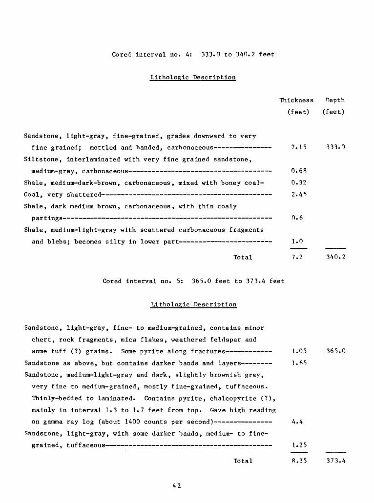
Cored Interval no. 4: 333.0 to 340.2 feet
Lithologic Description
Thickness Depth
(feet) (feet)
Sandstone, light-gray, fine-grained, grades downward to very
fine grained; mottled and handed, carbonaceous 2.15 333.0
Siltstone, interlatninated with very fine grained sandstone,
medium-gray, carbonaceous 0. 68
Shale, medium-dark-brown, carbonaceous, mixed with boney coal- 0.32
Coal, very shattered 2.45
Shale, dark medium brown, carbonaceous, with thin coaly
partings 0» 6
Shale, medium-light-gray with scattered carbonaceous fragments
and blebs; becomes silty in lower part 1.0
Total 7.2 340.2
Cored interval no. 5: 365.0 feet to 373.4 feet
Lithologic Description
Sandstone, light-gray, fine- to medium-grained, contains minor
chert, rock fragments, mica flakes, weathered feldspar and
some tuff (?) grains. Some pyrite along fractures 1.05 365.0
Sandstone as above, but contains darker bands and layers 1.65
Sandstone, medium-light-gray and dark, slightly brownish gray,
very fine to medium-grained, mostly fine-grained, tuffaceous.
Thinly-bedded to laminated. Contains pyrite, chalcopyrite (?),
mainly in interval 1.3 to 1.7 feet from top. Gave high reading
on gamma ray log (about 1400 counts per second) 4.4
Sandstone, light-gray, with some darker bands, medium- to fine
grained , tuffaceous 1.25
Total 8.35 373.4
42
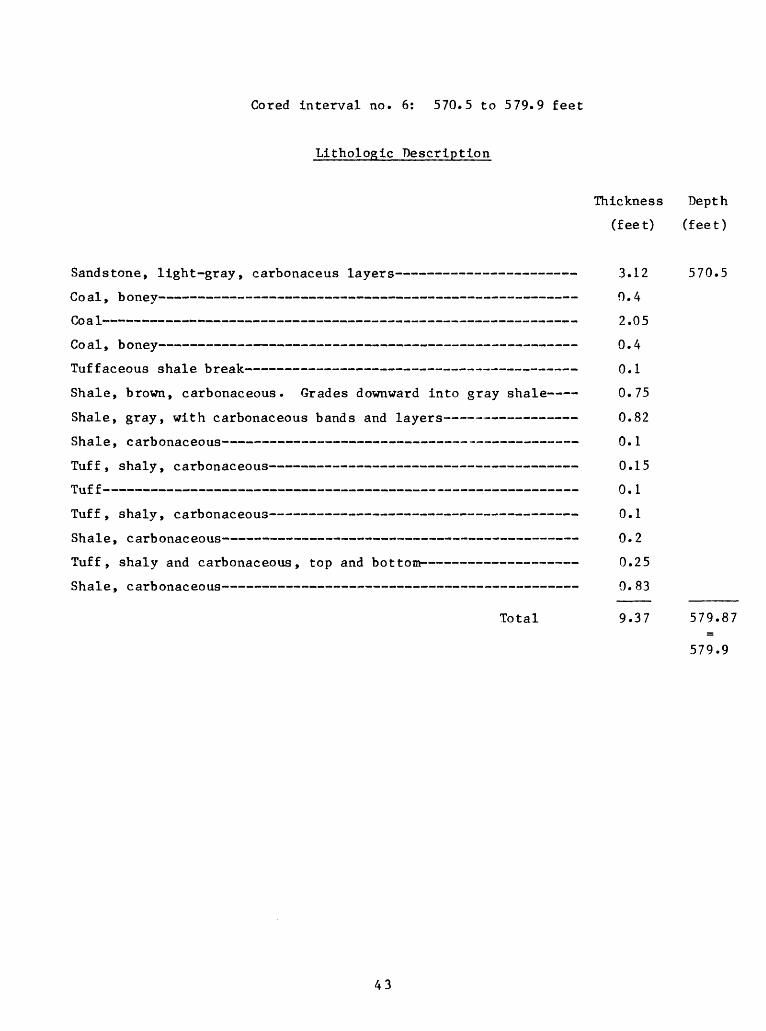
Cored interval no. 6: 570.5 to 579.9 feet
Lithologic Description
Thickness Depth
(feet) (feet)
Sandstone, light-gray, carbonaceus layers 3.12 570.5
Coal, boney 0.4
Coal 2.05
Coal, boney 0.4
Tuffaceous shale break 0.1
Shale, brown, carbonaceous. Grades downward into gray shale 0.75
Shale, gray, with carbonaceous bands and layers 0.82
Shale, carbonaceous 0.1
Tuff, shaly, carbonaceous 0.15
Tuff 0.1
Tuff, shaly, carbonaceous 0.1
Shale, carbonaceous 0.2
Tuff, shaly and carbonaceous, top and bottom 0.25
Shale, carbonaceous 0. 83
Total 9.37 579.87
579.9
43
LITHOLOGIC DESCRIPTIONS OF CORE SAMPLES
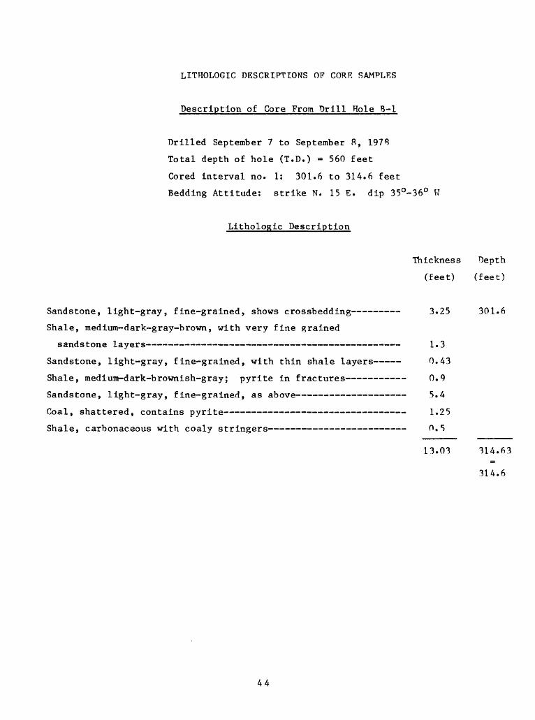
Description of Core From Drill Hole B-l
Drilled September 7 to September 8, 1978
Total depth of hole (T.D.) = 560 feet
Cored interval no. 1: 301.6 to 314.6 feet
Bedding Attitude: strike N. 15 E. dip 35°-36° W
Lithologic Description
Thickness Depth
(feet) (feet)
Sandstone, light-gray, fine-grained, shows crossbedding 3.25 301.6
Shale, medium-dark-gray-brown, with very fine grained
sandstone layers 1.3
Sandstone, light-gray, fine-grained, with thin shale layers 0.43
Shale, medium-dark-brownish-gray; pyrite in fractures 0.9
Sandstone, light-gray, fine-grained, as above 5.4
Coal, shattered, contains pyrite 1.25
Shale, carbonaceous with coaly stringers 0.5
13.03 314.63
314.6
44

Cored interval no. 2: 336.0 to 361.0 feet
Lithologic Description
Thickness Depth
(feet) (feet)
Sandstone, light-gray, fine- to medium-grained, with a few
carbonaceous layers 3.2 336.0
Sandstone, light-gray, fine- to medium-grained, carbonaceous.
Coarser grained upper 0.2 feet, finer grained toward base;
shows a gradational contact with underlying coal O.Q
Coal, top 0.1 feet sandy, badly fractured at base, contains some
pyrite. Thickness somewhat approximate 2.85
Tonstein, sandy 0.1
Tonstein 0. 7
Coal, somewhat shattered 1.7
Shale, medium-dark-grayish-brown, sandy-silty 0.2
Siltstone, dark-medium-gray, sandy, some shale 0.75
Siltstone, as above, with irregular layers and blebs of fine
grained light-gray sandstone. Sandstone patches particularly
prominent at 0.9-1.6 feet from top and also below 3.7 feet
from top 6. 3
Sandstone, light-gray, fine-grained, interbedded with medium-
dark-grayish-brown Siltstone. Toward base sandstone decreases
in amount, and occurs in irregular layers and blebs in the
Siltstone 2.4
Shale, medium-dark-grayish-brown, silty 2.97
Coal; upper 0.25 feet contains sandstone and siltstone lenses.
An incomplete sample; core stopped in coal, and electric log
shows approximately 3 feet of coal in this bed 2.Q
Total 24.97 360.97
361.0
45
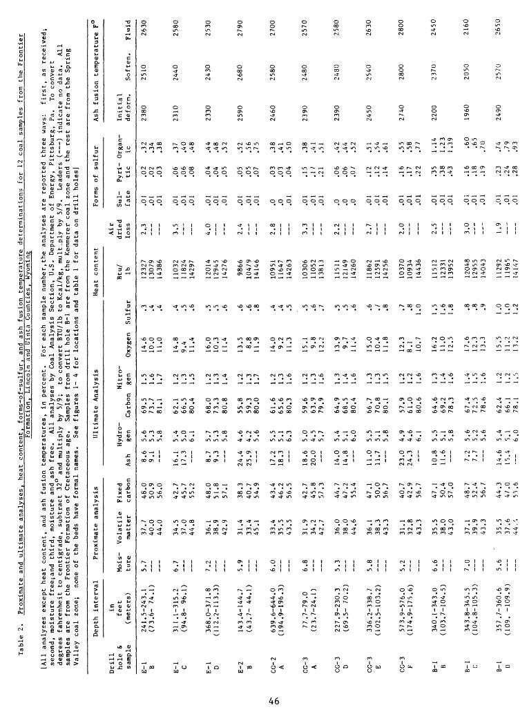
Table 2.
Proximate and
ultimate analyses, heat co
nten
t, forms-of-sulfur, and
ash fusion temperature determinations fo
r 12 coal samples from the
Frontier
Formation, Lincoln and Uinta Counties, Wyoming
IA11
analyses except heat content, and
ash fusion temperatures, in pe
rcen
t.
For
each sample number,the analyses are
reported three
ways:
firs
t, as
received;
second, moisture free-,and
thir
d, moisture and ash fr
ee.
All
analyses by Coal Analysis Section, U.S. Department of
Energy, Pittsburg, Pa.
To convert
degrees fahrenheit to centigrade, subtract 32°
and multiply by
5/9;
to convert BTU/lb to Kc
al/k
.g,
mult-ply by
5/
9.
Leaders ( ) indicate no
data.
All
samples are
from the
Frontier Formation of
Cretaceous age.
Samp
les
from drill hole B-l
are from the
Kemmerer coal zo
ne and th
e rest are from th
e Spring
Valley co
al zone;
none of
th
e beds ha
ve formal na
mes.
Se
e figures 1-
4
for
locations an
d table
1 for
data on drill ho
les]
Depth in
terv
al
Drill
in
hole
6, feet
sample
(met
ers)
E-l B
E-l C
E-l D E-2 B
CG-2
A
CG-3
A CG-3
D CG-3
E CG-3 F B-l B
B-l C B-l D
241.5-243.1
(73.6- 74
.1)
311.1-315.2
(94.8- 96.1)
368.0-371.8
(112.2-113.3)
143.
4-14
4.7
(43.
7- 44.1)
639.6-644.0
(194
.9-1
96.3
)
77.7-79.0
(23.7-24.1)
227.9-230.3
(69.
5- 70.2)
336.
2-33
8.7
(102
.5-1
03.2
)
573.
9-57
6.0
(174.9-175.6)
340.1-343.0
(103.7-104.5)
343.
8-34
5.5
(104.8-105.3)
357.
7-36
0.6
(109
. -109.9)
Proximate
anal
ysis
Mois
- Vo
lati
le
ture
matter
5.7
6.7
7.2
5.9
6.0
6.8
5.3
5.8
5.2
6.6
7.0
5.6
37.7
40.0
44.0
34.5
37.0
44.8
36.1
38.9
42.9
31.4
33.4
45.1
33.4
35.5
43.5
31.9
34.2
42.7
36.0
38.0
44.6
36.1
38.3
43.3
31.1
32.8
43.3
35.5
38.0
43.0
37.1
39.9
43.3
35.5
37.6
44.',
Fixed
carbon
48.0
50.9
56.0
42.7
45.7
55.2
48.0
51.8
57.1
38.3
40.7
54.9
43.4
46.2
56.5
42.7
45.8
57.3
44.7
47.2
55.4
47.1
50.0
56.7
40.7
42.9
56.7
47.1
50.4
57.0
48.7
52.4
56.7
44.3
47.0
55.6
Ultimate Analysis
Hydro-
Ash
gen
8.6
9.1
16.1
17.3
8.7
9.3
24.4
25.9
17.2
18.3
18.6
20.0
14.0
14.8
11.0
11.7
23.0
24.3
10.8
11.6
7.2
7.7
14.6
15.4
5.6
5.3
5.8
5.4
5.0
6.1
5.7
5.3
5.8
4.6
4.2
5.6
5.5
5.1
6.3
5.0
4.5
5.7
5.4
5.1
6.0
5.5
5.1
5.8
4.9
4.6
6.1
5.5
5.1
5.8
5.6
5.2
5.6
5.4
5.1
6.0
Carbon
69.5
73.7
81.1
62.1
66.5
80.4
68.0
73.3
80.8
55.8
59.3
80.0
61.6
65.6
80.3
59.6
63.9
79.9
64.9
68.5
80.4
66.7
70.8
80.1
57.9
61.0
80.6
64.6
69.2
78.3
67.4
72.5
78.6
62.4
66.1
78.1
Nitr
o
gen
1.5
1.6
1.7
1.2
1.3
1.5
1.2
1.3
1.4
1.2
1.3
1.7
1.2
1.3
1.6
1.2
1.3
1.6
1.3
1.4
1.6
1.3
1.3
1.5
1.2
1.2
1.6
1.3
1.4
1.6
1.4
1.5
1.6
1.2
1.2
1.5
Oxygen
14.6
10.0
11.0
14.8
9.4
11.4
16.0
10.3
11.4
13.5 8.8
11.9
14.0
9.2
11.3
15.1 9.8
12.2
13.9
9.7
11.4
15.0
10.4
11.8
12.3
8.1
10.7
16.2
11.0
12.5
17.6
12.3
13.3
15.5
11.2
13.2
Heat co
nten
t
Sulfur
.3 .4 .4 .4 .5 .6 .5 .5 .6 .6 .6 .8 .4 .4 .5 .5 .6 .7 .5 .5 .6 .6 ./ .8 .7 .8 1.0
1.5
1.6
1.8 .8 .8 .9
1.0
1.0
1.2
Btu/
Ib 12327
13079
14386
11032
11824
14297
12014
1294
514276
9866
1047
914
146
10951
1164
714263
1030
611
052
13813
1151
112149
14260
1186
212
591
14256
10370
10934
14436
1151
212
331
13952
12048
1295
514
043
1129
211
965
1414
7
Form
s
Air
dried
Sul-
lo
ss
fate
2. .3
.01
.01
.01
3.5
.01
.0 1
.0 1
4.0
.01
.01
.01
2.4
.01
.01
.01
2.8
.0
.0
.01
3.3
.01
.01
.01
2.2
.0 .0 .0
2.7
.01
.01
.01
2.0
.01
.01
.01
2.5
.01
.01
.01
3.0
.01
.01
.01
1.9
.01
.01
.01
of su
lfur
Ash
fusi
on temperature
F
Pyri
- ti
c
.02
.02
.03
.06
.06
.08
.04
.04
.05
.05
.05
.07
.03
.03
.04
.15
.17
.21
.06
.06
.O/
.12
.12
.14
.16
.17
.22
.35
.38
.43
.16
.18
.19
.23
.24
.28
Orga
n-
Initial
ic
deform.
Soft
en.
.32
2380
2510
.34
.38
.37
2310
24
40.4
0.4
8
.44
2330
2430
.48
.52
.52
2590
2680
.56
.75
.38
2460
2580
.41
.50
.38
2390
24
80.41
.51
.42
2390
2430
.44
.52
.51
2450
2540
.54
.61
.55
2740
2800
.58
.77
1.14
22
00
2370
1.23
1.39 .60
1960
2050
.65
.70
.74
2490
2570
.79
.93
Fluid
2630
2580
2530
2790
2700
2570
2580
2630
2800
2450
2160
2650