geography theory
DESCRIPTION
IGCSE GeographyTRANSCRIPT
Noah Austin!!!!!!!!!!!!!!!
Geography CIE IGCSE
Page � of �1 52
Noah Austin CIE IGCSE Geography: Population
Dynamics!!The study of population is often referred to as demography. Population is one of the most important IGCSE topics because other topics are based upon it and it always appears as a question in paper 1 of your examination.!!Population Density: The number of people living in a given area, usually per km2. Singapore is a country with a very high population density and Australia is a country with a very low population density. El Salvador has the highest population density in Central America.!!Population Distribution: This is how a population is spread out around a country or an area. If a country's population is distributed in a regular pattern then we say it has an even population distribution. However, if there are areas with many people and then areas with few people, then we would say that it has an uneven population distribution.!!
Two other good words to describe population are dense and sparse.!!Sparse population: When not many people live in an area e.g. the centre of Australia.!!Dense population: When a lot of people live in an area e.g. the Melbourne area.!!
Page � of �2 52
Birth Rates Death Rates
High • Lack of contraception e.g. condoms!• Religious beliefs e.g. belief against contraception
and abortion (Roman Catholicism)!• Agricultural based society (need for people to
farm and collect water)!• High infant mortality (if some babies may die,
couples will be tempted to have more children)!• No care homes or pensions so old dependents
will need their children to care for them in old age.!• Pro-natalist policies (governments encouraging
couples to have more children)
• Natural disasters (often only causes short term increases) e.g. Indian Ocean tsunami!
• Conflicts and wars!• Poor medical care!• Poor hygiene and sanitation!• Poor diet (might be a shortage of food or
unhealthy food)!• Drinking alcohol, smoking or taking drugs!• Lack of exercise (sedentary lifestyle)!• Shortage of clean water!• Diseases e.g. cancer and AIDS
Low • Availability and affordability of contraception e.g. cheap or free condoms!
• Emancipation (freedom) of women (freedom to get an education and work)!
• Improved levels of education (especially female)!• Reduced infant mortality!• Introduction of pensions and care homes!• Development of economy into secondary and
tertiary sectors!• Increasing cost of children!• Delayed marriages and less children!• Anti-natalist policies e.g. China's one child policy!• High cost of raising children
• Immunisation programs e.g. small pox!• Availability of clean water!• Improved diet and knowledge of diet e.g. five
portions of fruit and diet!• Improved levels of exercise!• Improved medical care!• Improved preventative testing e.g. for cancer so
people can be treated before it kills them
Noah AustinIf a question only asks you to describe distribution, then you just say what you see on the map, using words like dense, sparse, even and uneven. If places are named on the map, you can refer to place names, if not you can use compass points to help you describe.!!If the question asks you to explain the population distribution, then you have to start giving reasons for the distribution. To do that you could some of the reasons found in the table below. Population distribution can be impacted by human and physical factors.!!
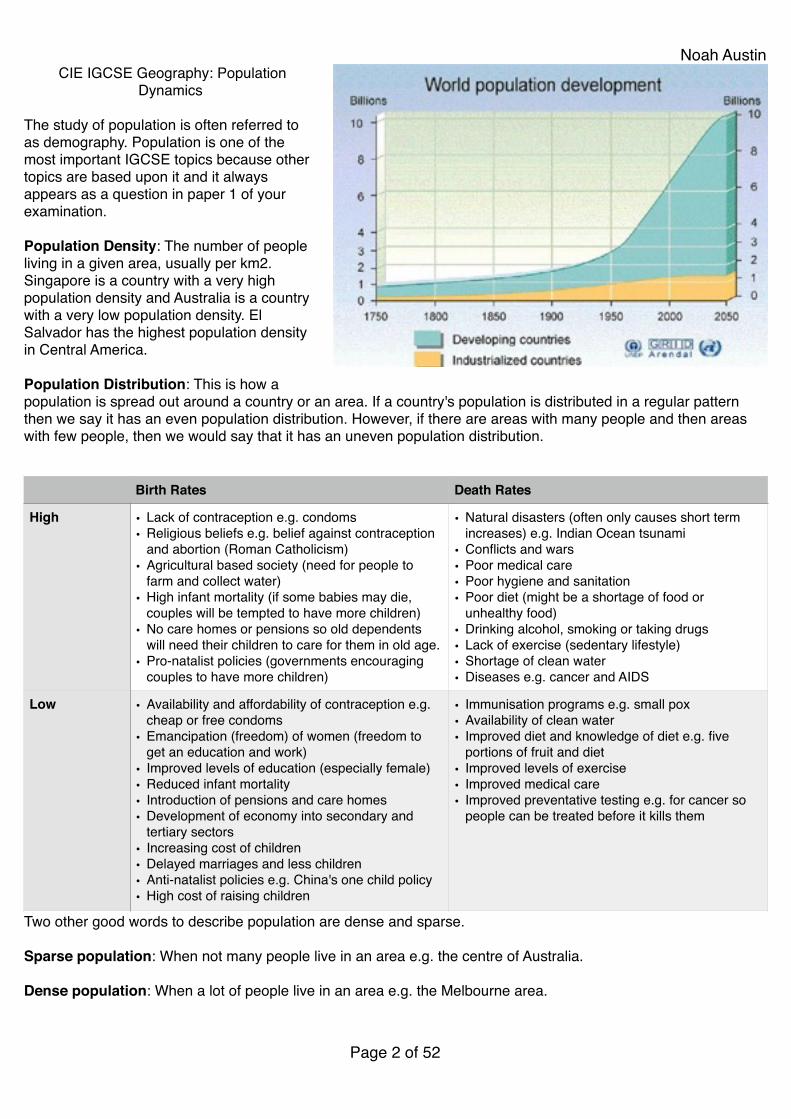
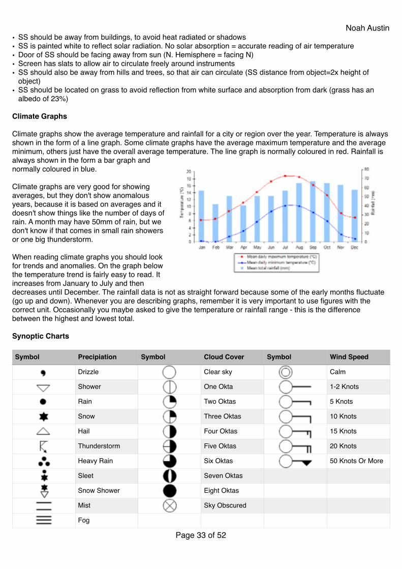
When describing a graph it is important look for trends, changes in trends e.g. quicker increase, slower increase and also anomalies (things that don't fit the general trend). It is also very important to support your findings with evidence (this means figures e.g. dates and population figures). Below is a good example describing the population graph to the right.!!From 1750 to the present day the world's population has been constantly increasing. In 1750 the population was less than 1 billion. The population rose very slowly for the next two hundred years reaching 1.2 billion in 1850 and 2.7 billion in 1950. From 1950 to 2012 the population started to rise at a faster rate. By 1975 it reached about 4 billion and 2000 about 6 billion. In the last decade the population has increased at an even faster rate reaching 7 billion by 2012.!!Population growth takes place when birth rates are higher than death rates (natural increase). In most continents of the world this is what is happening. The fastest rates of growth are actually happening in the poorest continents like Africa, Asia and South America. However, in Europe death rates are actually higher than birth rates so natural decrease is taking place.!!Below is a table listing some of the reasons why birth rates are high in poorer countries (LEDCs), but death rates are decreasing and also why birth rates are low in richer countries (MEDCs).!!Natural increase: When birth rates are higher than death rates.!!Natural decrease: Where death rates are higher than birth rates.!!Birth rates: The number of births per 1000 of population per year.!!Fertility rate: The average number of children a female is expected to have in their lifetime.!!Death rates: The number of deaths per 1000 of population per year.!!!Theories about population and resources:!!Malthus: Malthus looked at population and resources and believed that population was growing at a much fast rate than resources. He believed that this would cause a series of preventative and positive checks. Preventative
Causes of Sparse Population Causes of Dense Population
• Mountainous area e.g. Himalayas that are hard to build houses and transports links on.!
• Very hot or very cold area e.g. Sahara desert or Antarctica!• A heavily forested area e.g. the Amazon Rainforest!• Areas that flood a lot e.g. Mekong river delta!• No jobs!• Poor supply of electricity, gas and water!• Poor communications!• Shortage of natural resources!• No schools or hospitals!• Areas that regularly suffer from natural disasters e.g.
volcanoes or droughts
• Coastal areas that are good for fishing, trading etc.!• A flat area of land that is easy to build on!• Areas that are close to a good supply of water e.g. River
Thames in London. Water is important for fishing, drinking, washing, etc.!
• Areas with good natural resources e.g. wood or good!• Areas that are close to good fertile agricultural land!• Areas with good developed transport links!• Plenty of available jobs!• Available electricity and water supply!• Good communications e.g. internet and mobile phone
network!• Good quality schools and hospitals
Page � of �3 52
Noah Austin
checks would be people trying to reduce population growth themselves and positive checks would be famines and conflicts.!!: Boserup was a more optimistic person who believed that humans always came up with solutions to problems. Her famous saying was 'necessity is the mother of invention' which basically means that humans will also find a solution to resource shortages e.g. desalination, development of renewable energy.!!Carrying Capacity: The amount of people that the resources of a country can support. The carrying capacity of a country can change with improvements in technology e.g. desalination, discoveries of new resources, or the loss of existing resources e.g. volcanic eruption destroying farm land.!!Overpopulation: When there are more people that the resources available. Overpopulation might lead to unemployment, famine and homelessness.!!Underpopulation: When there are not enough people to fully maximise the potential of a country. For example there might be vacant jobs or resources that can not be fully exploited.!!Optimum Population: When population and resources are perfectly matched. In reality this is almost impossible to achieve.!!!
Page � of �4 52
Noah Austin
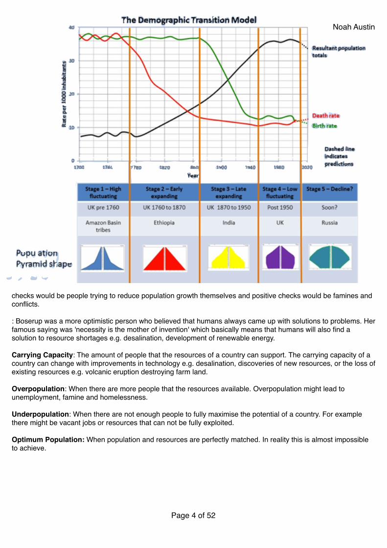
!Population Density: The average number of people per square kilometre in a country or region!!Population Distribution: The way the population is spread out over a given area!!Demographic means population and transition means change, so the DTM basically means the population change model. The DTM looks at how a country's population may change as it develops. It looks at birth rates, death rates and total population. The DTM is usually divided into five stages. Stage 1 is the poorest stage and stage 5 is the richest stage.!!
Stage 1: Has birth and death rates. Because birth rates and death rates are both high (no contraception, agricultural based economy, poor medical care, etc.), total population remains low.!Stage 2: Birth rates remain high, but death rates begin to fall. This causes total population to increase (natural increase). Death rates fall because of introduction of basic medical care.!Stage 3: Birth rates begin to fall, but still remain higher than death rates so total population continues to increase. Birth rates begin to fall because of better education and availability of contraception.!Stage 4: Birth rates and death rates are both low so the total population becomes constant (stays the same).!Stage 5: Birth rates start to fall below death rates so the total population actually starts to decline (natural decrease). This is because of delayed marriages, cost of children and emancipation of women.!Population Pyramid: A population pyramid shows the age and sex structure of the country. It is a type of graph that is divided into males and females and then age groups.!!Young Dependents: The number or the percentage of the population under the age of 16.!!Old Dependents: The number or the percentage of the population over the age of 65.!
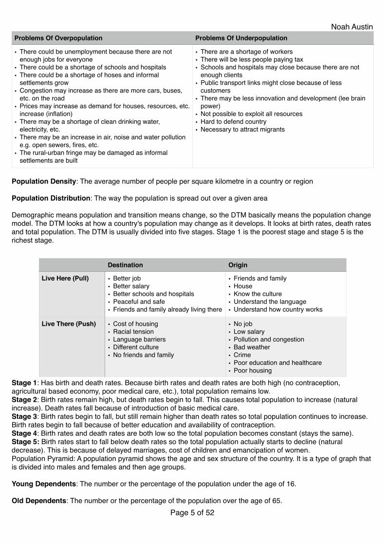
Problems Of Overpopulation Problems Of Underpopulation
• There could be unemployment because there are not enough jobs for everyone!
• There could be a shortage of schools and hospitals!• There could be a shortage of hoses and informal
settlements grow!• Congestion may increase as there are more cars, buses,
etc. on the road!• Prices may increase as demand for houses, resources, etc.
increase (inflation)!• There may be a shortage of clean drinking water,
electricity, etc.!• There may be an increase in air, noise and water pollution
e.g. open sewers, fires, etc.!• The rural-urban fringe may be damaged as informal
settlements are built
• There are a shortage of workers!• There will be less people paying tax!• Schools and hospitals may close because there are not
enough clients!• Public transport links might close because of less
customers!• There may be less innovation and development (lee brain
power)!• Not possible to exploit all resources!• Hard to defend country!• Necessary to attract migrants
Page � of �5 52
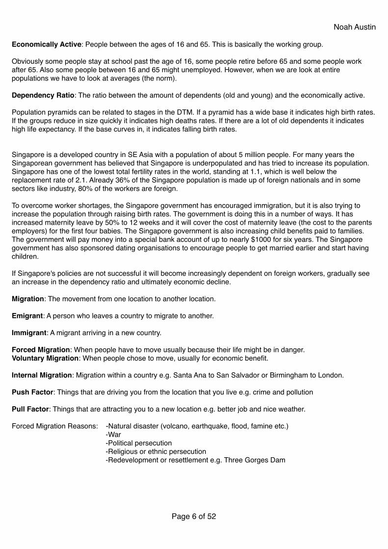
Destination Origin
Live Here (Pull) • Better job!• Better salary!• Better schools and hospitals!• Peaceful and safe!• Friends and family already living there
• Friends and family!• House!• Know the culture!• Understand the language!• Understand how country works
Live There (Push) • Cost of housing!• Racial tension!• Language barriers!• Different culture!• No friends and family
• No job!• Low salary!• Pollution and congestion!• Bad weather!• Crime!• Poor education and healthcare!• Poor housing
Noah Austin!Economically Active: People between the ages of 16 and 65. This is basically the working group.!!Obviously some people stay at school past the age of 16, some people retire before 65 and some people work after 65. Also some people between 16 and 65 might unemployed. However, when we are look at entire populations we have to look at averages (the norm).!!Dependency Ratio: The ratio between the amount of dependents (old and young) and the economically active.!!Population pyramids can be related to stages in the DTM. If a pyramid has a wide base it indicates high birth rates. If the groups reduce in size quickly it indicates high deaths rates. If there are a lot of old dependents it indicates high life expectancy. If the base curves in, it indicates falling birth rates.!!!Singapore is a developed country in SE Asia with a population of about 5 million people. For many years the Singaporean government has believed that Singapore is underpopulated and has tried to increase its population. Singapore has one of the lowest total fertility rates in the world, standing at 1.1, which is well below the replacement rate of 2.1. Already 36% of the Singapore population is made up of foreign nationals and in some sectors like industry, 80% of the workers are foreign.!!To overcome worker shortages, the Singapore government has encouraged immigration, but it is also trying to increase the population through raising birth rates. The government is doing this in a number of ways. It has increased maternity leave by 50% to 12 weeks and it will cover the cost of maternity leave (the cost to the parents employers) for the first four babies. The Singapore government is also increasing child benefits paid to families. The government will pay money into a special bank account of up to nearly $1000 for six years. The Singapore government has also sponsored dating organisations to encourage people to get married earlier and start having children.!!If Singapore's policies are not successful it will become increasingly dependent on foreign workers, gradually see an increase in the dependency ratio and ultimately economic decline.!!Migration: The movement from one location to another location.!!Emigrant: A person who leaves a country to migrate to another.!!Immigrant: A migrant arriving in a new country.!!Forced Migration: When people have to move usually because their life might be in danger.!Voluntary Migration: When people chose to move, usually for economic benefit.!!Internal Migration: Migration within a country e.g. Santa Ana to San Salvador or Birmingham to London.!!Push Factor: Things that are driving you from the location that you live e.g. crime and pollution!!Pull Factor: Things that are attracting you to a new location e.g. better job and nice weather.!!Forced Migration Reasons: -Natural disaster (volcano, earthquake, flood, famine etc.)!
-War!-Political persecution!-Religious or ethnic persecution!-Redevelopment or resettlement e.g. Three Gorges Dam!!!!!!
Page � of �6 52
Noah Austin!!!!Geography: Settlement!!
Settlement: A place where people live. A settlement can range from one an isolated building to a capital city of over 20 million people (e.g. Mexico City).!!Site: The actual location or place that a settlement is built.!!Situation: The area surrounding the site of a settlement. For example you might talk about if the settlement is near a river, or near the coast or in a valley surrounded by mountains.!!
!!Rural settlements can develop in many different ways giving them a unique shape (morphology). The five main settlement patterns that you need to be able to recognise:!• Isolated: Singly buildings on their own. These will normally be found in mountainous areas and will normally be
the farmhouse of a large farm.!• Dispersed: When individual buildings are separated by several hundred meetings. They are individual isolated
buildings and do not form a single settlement.!• Loose knit: When houses are built near each other and are obviously in the same settlement, but there is
spaces between them.!• Linear or Ribbon: This is a settlement that has grown in a line. The line doesn't have to be straight, but will
normally follow a road, a river, the coast or the valley floor.!• Nucleated: When all the houses in a settlement are built very close together, often around a central village green
or church.!!!When the sites of settlement were first chosen, settlers would mainly have looked for natural advantages. These may have included:!!• Water supply: Water is essential when building a settlement. You need water to drink, to wash, to water crops
and to cook. Water also contains fish that can be eaten and it can be used as a transport route.!• Fertile land: All settlements need food so it is important to build need fertile soil, where it is possible to grow
crops. If a settlement grows a surplus of food then they might be able to trade with neighbouring settlements.!
Rural Settlements: Settlements that are found in the countryside (rural areas) and contain less than 10,000 residents.
Urban Settlements: Settlements that contain more than 10,000 residents.
• Isolated Building: A single building. An isolated building is normally a farm.!
• Hamlet: A small group of houses, normally about 5 to 10. There is often no services in a hamlet.!
• Village: A settlement of up to 10,000 people. Villages will have some services in them like small shops, a primary school, a doctors surgery, bus routes.
• Town: A settlement of over 10,000 people that has not be designated a city.!
• City: A large town, in the UK a town becomes a city when it has a cathedral in it.!
• Capital City: The main administrative centre within a country and the home of the national government.!
• Primate City: The largest and most important city within a country. The primate city will often have double the population of the next most important city. Most of the time the primate city is also the capital city, but there are some famous exceptions e.g. New York, Sydney and Sao Paolo.!
• Conurbation: Two or more towns or cities that have joined to together e.g. Birmingham, Walsall, Dudley and Wolverhampton in England.!
• Megaopolis: A conurbation or a clustering of cities with a population of over 10 million people e.g. Tokyo.
Page � of �7 52

Noah Austin• Flat land (relief): It is a lot easier to build a settlement on flat land than in mountains.!• Defensive position: When sites for settlements were first chosen (hundreds or thousands of years ago), battles
between settlements would have been common, therefore a good defensive location (on a small hill or surrounded by water) would have been very important.!
• Building materials: Most houses would have traditionally been made out of woods, reeds, etc. Therefore it would have been very important to have been located near a source of building materials.!
• Transport links: There wouldn't have been roads and railways when the sites of settlements were initially selected. However, access to rivers, the sea or valleys would have been very important. If the settlement was built next to a river, a site that allowed easy access across the river would have been chosen.!
• Fuel: Settlements would not have had electricity or gas so a location next to a reliable source of fuel would be essential. The fuel source would normally be wood, or possibly peat.!
• Weather: Sites with fairly stable weather will have been selected. You do not want some where too hot or too cold, too wet, too dry or too windy. To grow crops sun and rain would have been very important.!•Trading Location: Settlements may have also been built for their access to trading routes. It would be very hard for one settlement to be totally self-sufficient so trade was essential. Coastal areas often make good locations to trade from.!•Resources: It is useful being near resources like wood, coal, gold because you can use them to build things or trade with nearby settlements.!!Function: The job, purpose or use of a settlement. Large settlements will have more than one function and these functions may change over time. Functions may include:!•Shopping (Retail)!
• Business (Commercial)!• Farming (Agricultural)!• Housing (Residential)!• Educational!• Healthcare!• Administration (local or national government)!• Fishing!• Tourism!• Entertainment!• Sporting!!Rural Areas: Rural areas tend to have a lot less functions than urban areas. The main purpose of settlements in rural areas is normally agriculture (farming) and possibly tourism. This is because rural areas have less people, poorer transport, poorer communication, less technology and the land is better used for other purposes i.e. agriculture.!!Urban Areas: Urban areas tend to have a lot more functions ranging from shopping functions, to educational functions, to transport functions, to administrative functions and residential functions. The bigger the urban area, the more functions that it normally has.!!Changing Functions!!Settlements will grow if their functions are being successful and in demand. Alternatively if a settlements functions fall out of demand or if the resource their function relies on runs out, then the settlement may see economic and population decline.!!With the birth of package holidays to the Mediterranean many British holiday resorts saw a rapid decline in the demand for their tourist functions (hotels, piers, etc.). Also many mining settlements in the UK saw a rapid decline when coal ran out or overseas coal became cheaper. However, other settlements like Dubai in the UAE saw rapid growth as it promoted itself as an all year holiday destination. Some settlements try and change their functions if
Page � of �8 52
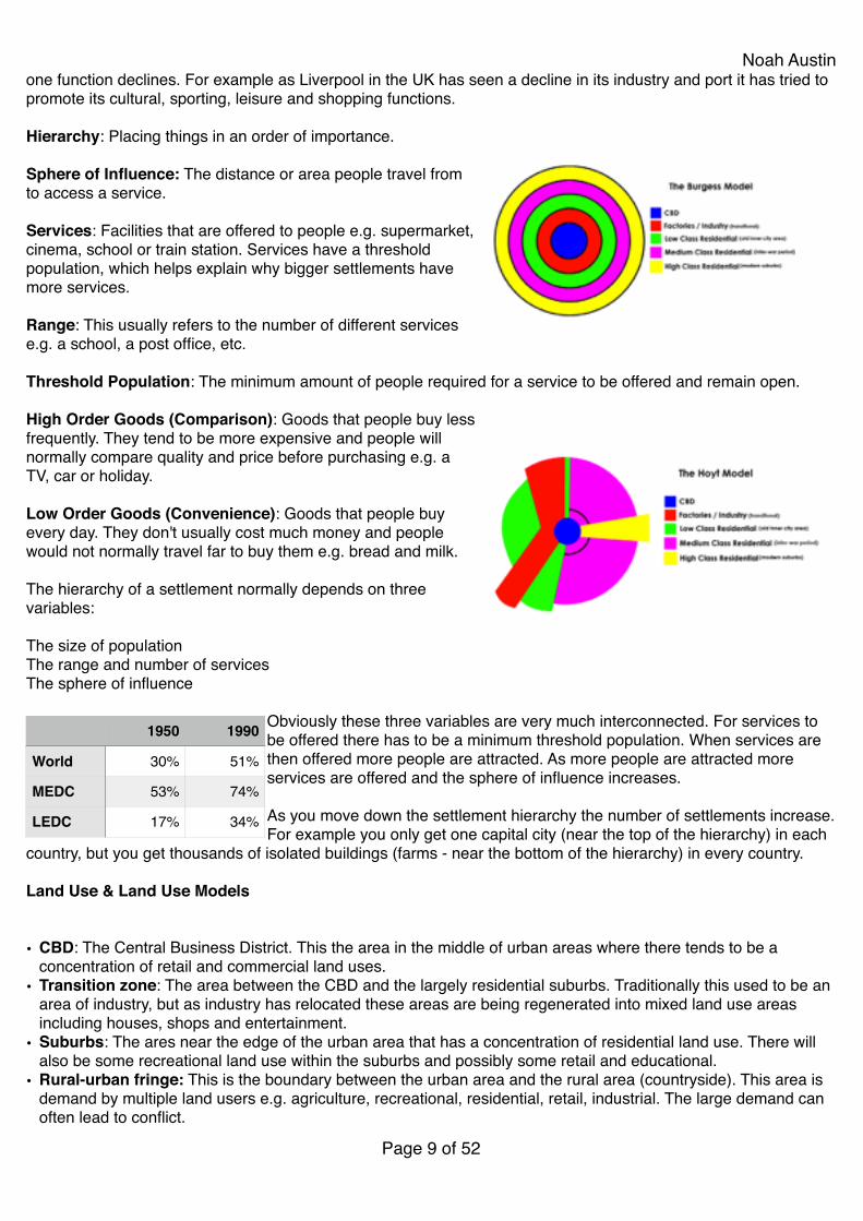
Noah Austinone function declines. For example as Liverpool in the UK has seen a decline in its industry and port it has tried to promote its cultural, sporting, leisure and shopping functions.!!Hierarchy: Placing things in an order of importance.!!Sphere of Influence: The distance or area people travel from to access a service.!!Services: Facilities that are offered to people e.g. supermarket, cinema, school or train station. Services have a threshold population, which helps explain why bigger settlements have more services.!!Range: This usually refers to the number of different services e.g. a school, a post office, etc.!!Threshold Population: The minimum amount of people required for a service to be offered and remain open.!!High Order Goods (Comparison): Goods that people buy less frequently. They tend to be more expensive and people will normally compare quality and price before purchasing e.g. a TV, car or holiday.!!Low Order Goods (Convenience): Goods that people buy every day. They don't usually cost much money and people would not normally travel far to buy them e.g. bread and milk.!!The hierarchy of a settlement normally depends on three variables:!!The size of population!The range and number of services!The sphere of influence!!
Obviously these three variables are very much interconnected. For services to be offered there has to be a minimum threshold population. When services are then offered more people are attracted. As more people are attracted more services are offered and the sphere of influence increases.!!As you move down the settlement hierarchy the number of settlements increase. For example you only get one capital city (near the top of the hierarchy) in each
country, but you get thousands of isolated buildings (farms - near the bottom of the hierarchy) in every country.!!Land Use & Land Use Models!!!• CBD: The Central Business District. This the area in the middle of urban areas where there tends to be a
concentration of retail and commercial land uses.!• Transition zone: The area between the CBD and the largely residential suburbs. Traditionally this used to be an
area of industry, but as industry has relocated these areas are being regenerated into mixed land use areas including houses, shops and entertainment.!
• Suburbs: The ares near the edge of the urban area that has a concentration of residential land use. There will also be some recreational land use within the suburbs and possibly some retail and educational.!
• Rural-urban fringe: This is the boundary between the urban area and the rural area (countryside). This area is demand by multiple land users e.g. agriculture, recreational, residential, retail, industrial. The large demand can often lead to conflict.!
Page � of �9 52
1950 1990
World 30% 51%
MEDC 53% 74%
LEDC 17% 34%
Noah Austin• Commuter belt or Commuter villages (dormitory villages): Areas of residential land use where people travel
from to their work place. People might access services near their place of work so commuter villages are often devoid of any other land uses or services.!
• Greenfield Site: Land that has never been built on before, greenfield sites will often be used for agriculture. Many countries are trying to restrict the amount of building on greenfield sites and encouraging building on brownfield sites.!
• Brownfield Site: This is land that has been built on previously but has been left abandoned and often become derelict. Most commonly brownfield sites are former factories found in the transition zone.!
• Derelict: Land that has been abandoned (no longer used) and often become run down or vandalised. Derelict sites is a sign of disinvestment (companies and people leaving an area).!
• Greenbelt: Greenbelts are protected areas of land around large urban areas. They have been used by the UK government to try and protect greenfield sites and promote building on brownfield sites.!
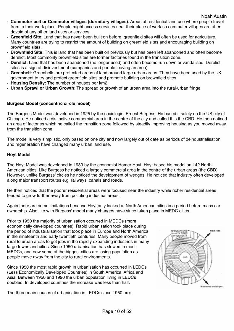
• Housing Density: The number of houses per km2.!• Urban Sprawl or Urban Growth: The spread or growth of an urban area into the rural-urban fringe!!!Burgess Model (concentric circle model)!!The Burgess Model was developed in 1925 by the sociologist Ernest Burgess. He based it solely on the US city of Chicago. He noticed a distinctive commercial area in the centre of the city and called this the CBD. He then noticed an area of factories which he called the transition zone followed by steadily improving housing as you moved away from the transition zone.!!The model is very simplistic, only based on one city and now largely out of date as periods of deindustrialisation and regeneration have changed many urban land use.!!Hoyt Model!!The Hoyt Model was developed in 1939 by the economist Homer Hoyt. Hoyt based his model on 142 North American cities. Like Burgess he noticed a largely commercial area in the centre of the urban areas (the CBD). However, unlike Burgess' circles he noticed the development of wedges. He noticed that industry often developed along major transport routes e.g. railways, canals and roads.!!He then noticed that the poorer residential areas were focused near the industry while richer residential areas tended to grow further away from polluting industrial areas.!!Again there are some limitations because Hoyt only looked at North American cities in a period before mass car ownership. Also like with Burgess' model many changes have since taken place in MEDC cities.!!Prior to 1950 the majority of urbanisation occurred in MEDCs (more economically developed countries). Rapid urbanisation took place during the period of industrialisation that took place in Europe and North America in the nineteenth and early twentieth centuries. Many people moved from rural to urban areas to get jobs in the rapidly expanding industries in many large towns and cities. Since 1950 urbanisation has slowed in most MEDCs, and now some of the biggest cities are losing population as people move away from the city to rural environments.!!Since 1950 the most rapid growth in urbanisation has occurred in LEDCs (Less Economically Developed Countries) in South America, Africa and Asia. Between 1950 and 1990 the urban population living in LEDCs doubled. In developed countries the increase was less than half.!!The three main causes of urbanisation in LEDCs since 1950 are:!!
Page � of �10 52
Noah Austin1. Rural to urban migration is happening on a massive scale due to population pressure and lack of resources in rural areas. This are 'push' factors.!!2. People living in rural areas are 'pulled' to the city. Often they believe that the standard of living in urban areas will be much better than in rural areas. They are usually wrong. People also hope for well paid jobs, the greater opportunities to find casual or 'informal' work, better health care and education.!!3. Natural increase caused by a decrease in death rates while birth rates remain high.!!The UN predicts that by 2030 60% of the world's population will live in urban environments!! !Types Of Housing And Socio-Economic Reasons: !!• Council Housing: This is government housing which is usually given to people that are unemployed and have a
low income. The rent on council houses are lower than the rent on private property.!!• Detached Housing: A single house that is not attached to any other house. A detached house will normally have
a garden and a drive. These types of houses are normally found in the suburbs.!!• Semi-Detached Housing: Two houses that are joined together. They will probably have individual gardens and
drives. These types of houses are normally found in the suburbs.!!• Terraced Housing: A long line of attached houses. These are typical in old industrial cities of the UK. They are
normally found in the transition zone area and they would have been housing for people working in the factories. They were very basic houses, often with no electricity and an outside toilet. Many have now been knocked down or improved.!!
• Bungalow: This is a house with only one floor. They are very popular amongst old people who find it hard to use stairs. Bungalows can be detached or semi-detached. They are normally found in the suburbs.!!
• Flats or Apartments: These are buildings with multiple levels. Normally a flat or apartment will only be on one floor within the block of flats or the apartment building.!!
• Tenure: This means who owns the house. Houses can be owner occupied, which means the people living their own it, council houses which means the government own its, privately rented, which means a private landlord (owner) owns it, or owned by a private organisation (housing association) and rented privately.!!!
Even though the UK population is fairly stable the demand for houses has increased. The reasons for this include:!• Family sizes are now smaller, so the average number of people per house is lower!• There are more divorces and single people so more houses are needed!• People tend to leave home younger so need their own houses!• Many migrants are single and need there own house!• People are getting married later, so need there own house for longer.!• A lot of old houses are considered to be uninhabitable (no bathroom, etc.)!• Old people are choosing to live on their own instead of moving to their family or moving into a care home.!LEDC Land Use Model!!The LEDC land use model has some similarities to Burgess and or Hoyt. The CBD is found in the centre of the urban area, just like Burgess and Hoyt. Factories are also built along major transport routes like Hoyt.!!However, when it comes to housing, there are significant differences. The high quality housing tends to be located near the CBD and will be either apartments or old colonial houses. The richer people want to live near the centre because that is normally where the best entertainment is and the best jobs are. As well as the high quality apartments near the centre, richer neighbourhoods will also develop that have good quality housing and good entertainment.!
Page � of �11 52
Noah Austin!Slightly further out you get poor, but permanent housing. On the edge though where in Burgess and also Hoyt you found a lot of nice housing you find poor informal settlements built on marginal land. The informal housing has been built by migrants moving from rural areas to urban areas.!!Industry tends to be focused on the main transport routes (roads and railways). There will not be much high quality housing near industry because richer residents don't want to live near polluting factories. However, there will be more poorer housing and informal settlements because the people can't afford to live anywhere else and often work in the nearby factories.!!
The Docklands is found in the East of London and used to be one of the world's most important docks (ports). It exported products made in the UK around the world to its Empire. However, with the advent of containerisation ships started to get a lot bigger and they became to big to sail up and down the River Thames. Also the UK lost its Empire so became less important globally. Many of the UK's factories also closed (deindustrialisation) and moved overseas (offshoring). The process of deindustrialisation and containerisation meant that the Docklands suffered a spiral of decline and became very deprived.!!During the 1980's the British government decided that it needed to regenerate these poor areas and launched UDCs (organisations aimed at regenerating areas). London Docklands became one of the first in 1981. Since the UDC came into existence, physical, social and economic improvements have been made.!!Physical (environmental): 200,000 trees planted, 760 hectares of derelict land reclaimed, 150 hectares of open space created and 17 conservation areas made.!!Social: 22,000 new homes built, 10,000 council houses refurbished, shopping centres and sports centres have been built along with new colleges. About $160 million has also been spent on education, healthcare and job retraining.!!Economic: Docklands light railways was built, over 135km of roads built, the city airport was opened and the underground extended. The number of businesses doubled and the number of jobs tripled. Major businesses like HSBC and Citigroup moved into the area.!!On a slightly wider scale the Greenwich Peninsula was cleaned and the O2 arena built and nearby in Stratford the 2012 Olympic Games took place.!!Urbanisation: The increase in the proportion of people living in urban areas. Although this can be caused by natural increase (higher birth rates in urban areas than rural areas), it is more likely to happen because of rural-urban migration.!!Urban growth or Sprawl: A growth in the size of the urban area. This normally happens because of building in the rural-urban fringe, although it may also include things like land reclamation.!!• Rapid urbanisation and urban growth can cause many problems in urban areas including:!
Social Economic Environmental
• As car ownership increases so does the amount of pollutants released by cars. This can lead increased chest problems e.g. asthma.!
• People travelling to work have to leave home earlier and arrive back later, therefore spending longer away from their families.!
• More cars on the roads increases the frequency of accidents!
• More traffic jams can increase the frequency of road rage.
• More vehicles on the roads increase the amount of air pollution, but also noise pollution.!
• Increased car ownership has increased road building which often leads to the destruction of greenfield sites.!
• The air pollution can contribute to acid rain and the greenhouse effect
• Building new roads is very expensive, especially when private property is purchased, thus cost the government money.!
• Late deliveries caused by traffic jams costs companies and the economy money.!
• Workers also arrive late to work because they are stuck in traffic.!
• It creates a reliance on oil and more oil is used at slow speed than normal travelling speeds
Page � of �12 52
Noah Austin• Congestion (an increase in the amount of traffic leading to traffic jams)!• Destruction of greenfield sites!• Pollutions (air, water, noise, visual)!• Electricity blackouts!• Water shortages!• Unemployment!• Homelessness!• Growth of informal settlements!• Crime!!Counterurbanisation and Suburbanisation: The movement of people away from the CBD towards rural areas or towards the suburbs (the edge).!!Reurbanisation: The movement of people back towards the centre of urban areas.!!Rural-urban fringe: This is the boundary between the urban area and the rural area (countryside). This area is demand by multiple land users e.g. agriculture, recreational, residential, retail, industrial. The large demand can often lead to conflict.!!!!!!!!!!!!!!!!!!!!!!!!!!!!!!!!!!!!!
Page � of �13 52

Noah Austin!!! !!!Geography: Plate Tectonics!!
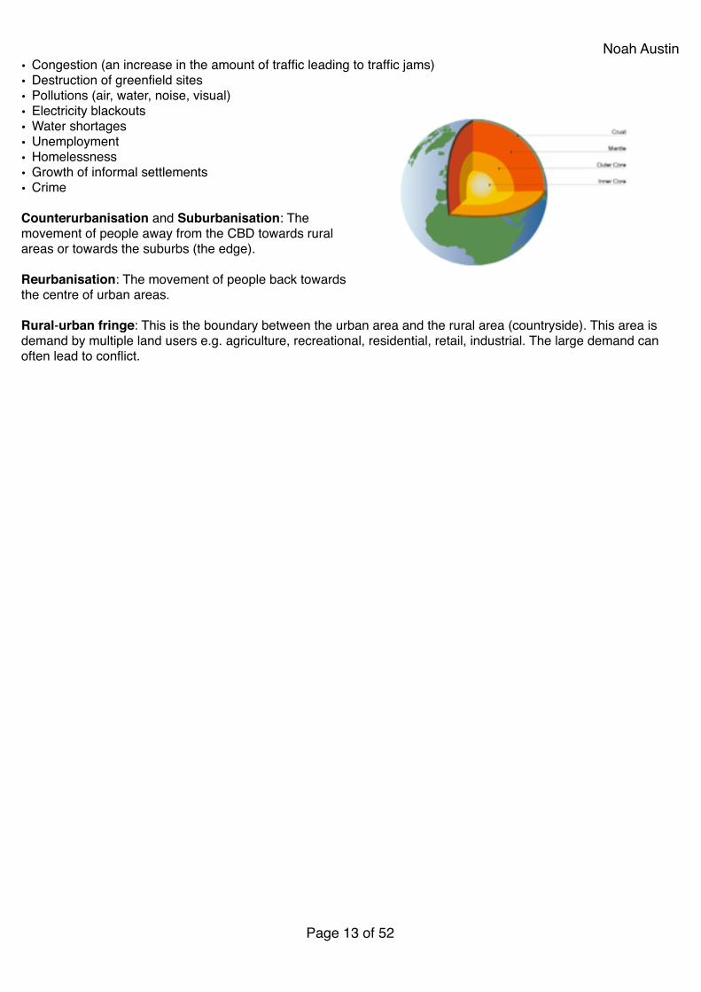
Structure of the Earth!!The Earth is divided into four main layers, the crust, the mantle, the outer core and the inner core.!!Crust: The crust is solid and is the layer we live on. The crust is usually between 10km and 60km thick. The crust thickness is often referred to as the relative thickness of an apple skin (when compared to the size of an apple).!!
Mantle: This the thickest section of the earth with a diameter of about 2900km. The mantle is often described as being semi-molten, but in reality the top is hard rock and as you near the outer core it is beginning to melt (magma). Convection currents are found in the mantle.!!Outer Core: This layer is believed to be liquid and largely made of iron and nickel. It is extremely hot with temperatures up to 5,500 degrees centigrade.!!Inner Core: This layer is believed to be solid, because of the immense pressure placed upon it. It contains the centre of the earth which is about 6,378km from the surface. It is also extremely hot at about 5,500 degrees centigrade.!!Sometimes you will here the crust and the upper layer of the mantle referred to as the lithosphere. Below the lithosphere but also in the mantle you find the asthenosphere. This region lies between 100km and 200km. You do not need to remember these two terms in your exams.!!
Page � of �14 52
Noah Austin
225 million years ago all the continents are believed to have been joined together in one supercontinent called Pangaea. Over millions of years, convection currents started moving the continents apart until there were two continents; Laurasia and Gondwanaland. Today the continents have moved even further apart, creating the land masses that we know today. The continents have not stopped moving so in the future the world will look different again, for example Europe and North America are actually moving apart at up to 10cm a year, but North America and Asia are moving closer together.!!The tectonic plates are being moved by convection currents found within the mantle of the earth. Below is a summary of how convection currents work:!Magma (semi-molten rock) near the outer core is heated.!As the magma warms it expands and becomes less dense.!The less dense magma then starts to rise towards the crust!As the magma nears the crust it begins to cool.!The cooling magma becomes denser and begins to sink!The rising and falling magma creates circular currents with the mantle!It are these currents that create friction with the crust above and causes it to move.!The process is known as convection currents!!Constructive Plate Boundary!!At a constructive or divergent plate boundary two oceanic plates are moving apart. Constructive plate boundaries are found under the ocean e.g. Atlantic Ocean and cause the process of sea floor spreading (basically the ocean floor getting wider). The movement apart of the plates allows magma to escape from the mantle below. When the magma touches the ocean it cools and forms new land creating an oceanic ridge. The world's best example of an ocean ridge is the Mid-Atlantic ridge. Overtime ridges can break the surface of the water and form new islands e.g. Iceland. Because the plates are moving apart, there is not a large build of friction so earthquakes tend to be fairly gentle. Volcanoes tend to be less violent than at destructive plate boundaries but can be more constant. Volcanoes can also cause the problems of lahars in Iceland. This is basically the lava melting the snow above and causing a mudslide.!!!
Oceanic Crust Continental Crust
• Oceanic crust is younger!• Oceanic crust is normally
thinner!• Oceanic crust is denser
(heavier)!• Oceanic crust can be
destroyed!• Oceanic crust can be made
• Continental crust is older!• Continental crust is normally
thicker!• Continental crust is less
dense (lighter)!• Continental crust can't be
made!• Continental crust can't be
destroyed.
Page � of �15 52

Noah AustinDestructive Plate Boundary!!
A destructive or convergent plate boundary is when oceanic and continental crust collide. The denser
oceanic crust is forced (subducted) under the continental plate. Huge amounts of heat from the mantle and also friction cause the oceanic plate to start melting in the subduction zone. The continental plate can not be destroyed so is forced up to make fold mountains e.g. Andes in South America. As the oceanic plate melts, it expands,
becoming less dense. This causes some of the magma to rise to the surface through the fold mountains creating volcanoes. Where the oceanic plate subducts under the continental plate a very deep ocean trench is created. This is basically a deep valley in the sea. Ocean trenches are the deepest sections of the world's oceans. Big earthquakes are found at destructive plate boundaries because of the build up of pressure between the two plates.!!If a destructive plate boundary is found at sea, the continental crust (or less dense oceanic crust) is forced up to make an island arc instead of fold mountains. There are many examples of island arcs including the Caribbean, Indonesia, Japan and New Zealand.!!
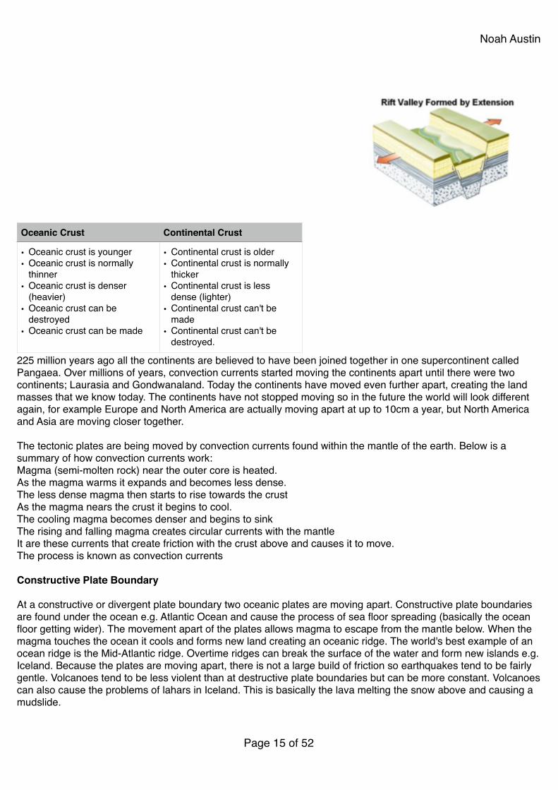
Conservative Plate Boundary!!A conservative or transform boundary happens when two continental plates move alongside each other. Because plates are not being forced up or down, there are no major landforms found at these boundaries. Also because crust is not being destroyed, no magma is being created so there are no volcanoes. However, there can be a huge build up of pressure between the two plates so massive earthquakes do occur. The most famous conservative plate boundary is the 'San Andreas Fault' where the North American and Pacific plates are moving past each other.!!!Rift Valleys!!A rift valley is a type of divergent plate boundary. It happens when a continental plate starts pulling itself apart. The most famous rift valley is the Great African Rift Valley. Here the African plate is basically ripping in half along a fault that runs from Syria in the north down to Mozambique in the south. The rift valley is over 6,000km in length. As the plates pull apart the land in between the plates collapses creating a rift valley. Overtime this valley firsts fills up with lakes e.g. Lake Malawi and Lake Tanganyika and then sea e.g Red Sea. Eventually the East of Africa will be separated from mainland Africa by a new sea. As the plates pull apart magma is also able to escape from the mantle below, creating volcanoes e.g. Mount Kenya and Mount Kilimanjaro. Sometimes the rift valleys are called
Page � of �16 52
•Shield volcanoes are usually found at constructive or tensional boundaries.!•They are low, with gently sloping sides.!•They are formed by eruptions of thin, runny lava.!•Eruptions tend to be frequent but relatively gentle.
Noah Austingrabens and the remaining higher land horsts or block mountains. When the African plate finally rips in half the two plates will be known as the Somalian plate and the Nubian plate.!!!Earthquakes!!Earthquake: Any movement in the earth's crust. Thousands of earthquakes happen everyday, but most are so small they are not felt by humans.!!Magnitude: This means how strong something is. Earthquakes are normally measured on the Richter scale.!!Richter scale: This is the normal scale used to measure the magnitude (strength) of an earthquake. The Richter scale goes up to 10 (although the scale effectively endless). The strongest ever recorded earthquake was a level 9.5 off the coast of Chile in 1960. The recent Japan (2011) earthquake was a 9.0.!!Hypocentre (focus): This the actually location that an earthquake takes place. The focus is always underground in the crust.!!Epicentre: This is the location on the surface directly above the hypocentre (focus).!!Aftershock: This is an earthquake that happen after the main earthquake. If the initial earthquake is strong, then the aftershocks can be very strong. Japan has had several aftershocks of over 7.0 since the initial 9.0 earthquake.!!!The affect an earthquake has on humans can depend on numerous human and physical factors. These factors include:!• The depth of the earthquake!• The magnitude of the earthquake!• The duration of the earthquake!• The local geology (soft or hard rock, solid or cracked rock)!• The location of the epicentre (in a rural or urban area)!• The population density around the epicentre.!• The building design and hazard mapping near the epicentre.!• The time of day (earthquakes at night might trap people in their houses, earthquakes during dinner time might
trigger more fires).!• The preparedness of the population (evacuation routes, emergency services, etc.)!!!!!!!!Shield Volcanoes!!!!!Composite (Cone) Volcanoes!!• Composite volcanoes are made up of alternating layers of lava and ash (other volcanoes just consist of lava).!• They are usually found at destructive or compressional boundaries.!• The eruptions from these volcanoes may be a pyroclastic flow rather than a lava flow. A pyroclastic flow is a
mixture of hot steam, ash, rock and dust.!• A pyroclastic flow can roll down the sides of a volcano at very high speeds and with temperatures of over 400°C.!!
Page � of �17 52
Noah Austin!!!!!Living Near Volcanoes!!• Even though volcanoes are extremely hazardous places, many people still choose to live on, or near them.
Some of the reasons why people do this include:!• Their beauty, places like Mount St. Helen's are beautiful to look at and enjoy.!• Minerals, it is possible to mine minerals like sulphur from volcanoes!• Geothermal potential (cheap and clean renewable energy) e.g. Iceland.and El Salvador!• Tourism - tourists like to view and walk up volcanoes e.g. Santa Ana volcano or Pacaya volcano!• There is often hot springs near volcanoes which tourists and
locals can enjoy e.g. Mt. Arenal in Costa Rica or the hundreds of onsens in Japan.!
• Land around volcanoes is very fertile because of all the minerals, therefore many people choose to farm the land.!
• Poverty, people simply can't afford to live anywhere else apart from the marginal land on volcanoes!
• Complacency or naivety because the volcano has not erupted for a long time.!
• Confidence that they will be given adequate warning to evacuate!
• Family home. Family have always lived in the area and don't want to leave!
• Shortage of space and high population density. San Salvador is slowly growing up El Boqueron because of the shortage of space.!
Geography: Weathering!
Page � of �18 52
Noah Austin!Weathering: Is the break-up and decomposition of rocks in-situ (in their place of origin). Weathering does not involve the movement of material and this makes it different to erosion.!!Weathering can be broken into either two or three categories:!!Chemical Weathering: The break down of rocks caused by a change in their chemical make-up.!!Physical or Mechanical Weathering: The break down of rocks caused by physical processes with no change in the rocks chemical make up.!!Biological Weathering: Biological is sometimes included within physical weathering. Biological weathering is when flora and fauna break down the rock e.g. growing roots systems or burrowing animals.!!Chemical Weathering!!Carbonation: This is caused by carbonic acid which occurs naturally in rainwater. Although only a very weak acid, it chemically reacts with rocks such as limestone and slowly dissolves them. Areas that have standing rainwater are going to experience higher rates of carbonation, therefore its is less likely to happen in dry countries and on steep slopes. The dissolved rock then gets washed away.!!Oxidation: This occurs when iron compounds within rock, reacts with oxygen to produce a reddish-brown coating.!!
Physical Weathering!!Freeze Thaw: This occurs in areas with moisture and a high diurnal (daily) temperature range that falls below zero. As water freezes it expands placing pressure on the rock around it. When it thaws more water is able to enter the crack and then it is able to freeze again. This process continues, slowly breaking down the rock.!!
Exfoliation: Again this tends to happen is areas with a high diurnal temperature range (very hot in the day and cold at night). During the day rock heats up and expands and during the night it cools down and contracts. These changes in temperature and shape cause the rock to weaken and layers beginning to peel off, just like an onion.!!Biological Weathering!!Root Systems: As plants on rocks grow, their root systems borrow down, boring in to the rock, and cracking it open.!!Chelation: Rocks are broken down by organic acids released by decomposing organic matter.!!Factors Affecting the Rate of Weathering!!Geology: The type of rock, is extremely important in affecting rates of weathering. Rocks with cracks are more likely to experience increased rates of physical and chemical weathering. Cracks allow water to get. Soft rocks are much more vulnerable to weathering than strong rocks. Also the chemical composition of rocks is also important. For example limestone's that have large amounts of calcium carbonate are more vulnerable to carbonation.!!Vegetation: Areas of land that have vegetation are more likely to experience rapid biological weathering. However, they are also likely to insulate the rock from large temperature ranges, reducing some physical weathering. Vegetation will intercept rainwater, reducing rates of some chemical weathering. Vegetation can hold rain water in-
Page � of �19 52
Cross Profile
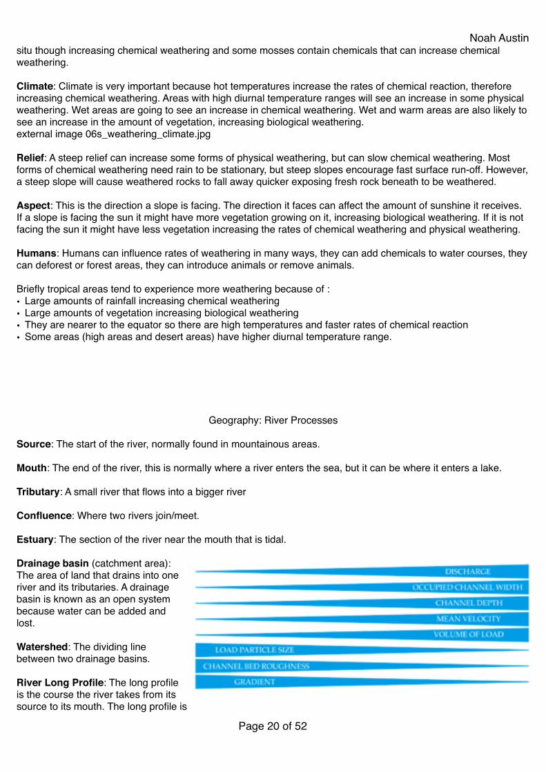
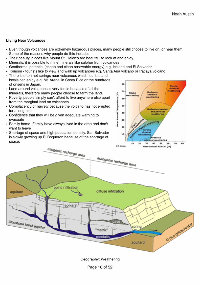
Noah Austinsitu though increasing chemical weathering and some mosses contain chemicals that can increase chemical weathering.!!Climate: Climate is very important because hot temperatures increase the rates of chemical reaction, therefore increasing chemical weathering. Areas with high diurnal temperature ranges will see an increase in some physical weathering. Wet areas are going to see an increase in chemical weathering. Wet and warm areas are also likely to see an increase in the amount of vegetation, increasing biological weathering.!external image 06s_weathering_climate.jpg!!Relief: A steep relief can increase some forms of physical weathering, but can slow chemical weathering. Most forms of chemical weathering need rain to be stationary, but steep slopes encourage fast surface run-off. However, a steep slope will cause weathered rocks to fall away quicker exposing fresh rock beneath to be weathered.!!Aspect: This is the direction a slope is facing. The direction it faces can affect the amount of sunshine it receives. If a slope is facing the sun it might have more vegetation growing on it, increasing biological weathering. If it is not facing the sun it might have less vegetation increasing the rates of chemical weathering and physical weathering.!!Humans: Humans can influence rates of weathering in many ways, they can add chemicals to water courses, they can deforest or forest areas, they can introduce animals or remove animals.!!Briefly tropical areas tend to experience more weathering because of :!• Large amounts of rainfall increasing chemical weathering!• Large amounts of vegetation increasing biological weathering!• They are nearer to the equator so there are high temperatures and faster rates of chemical reaction!• Some areas (high areas and desert areas) have higher diurnal temperature range.!!!!!!!
Geography: River Processes!!Source: The start of the river, normally found in mountainous areas.!!Mouth: The end of the river, this is normally where a river enters the sea, but it can be where it enters a lake.!!Tributary: A small river that flows into a bigger river!!Confluence: Where two rivers join/meet.!!Estuary: The section of the river near the mouth that is tidal.!!Drainage basin (catchment area): The area of land that drains into one river and its tributaries. A drainage basin is known as an open system because water can be added and lost.!!Watershed: The dividing line between two drainage basins.!!River Long Profile: The long profile is the course the river takes from its source to its mouth. The long profile is
Page � of �20 52
Noah Austinoften split into upper course and lower course (and sometimes middle course as well). The upper course is near the source and is normally found in mountainous areas. The lower course is near the mouth and on much flatter ground nearer sea level. Some rivers may have their mouth in lakes or wetland areas e.g. the Okovanga in Botswana, but this is unusual.!!!!!!!!!!!!!!Bed: the bottom of the river channel.!!Bank: The sides of the river channel. A river has two banks.!!Wetted Perimeter: The length of the bed and the banks in contact with the river.!!Channel: The route course (between bed and banks) that a river flows. The flow of the river is often described as channel flow.!!
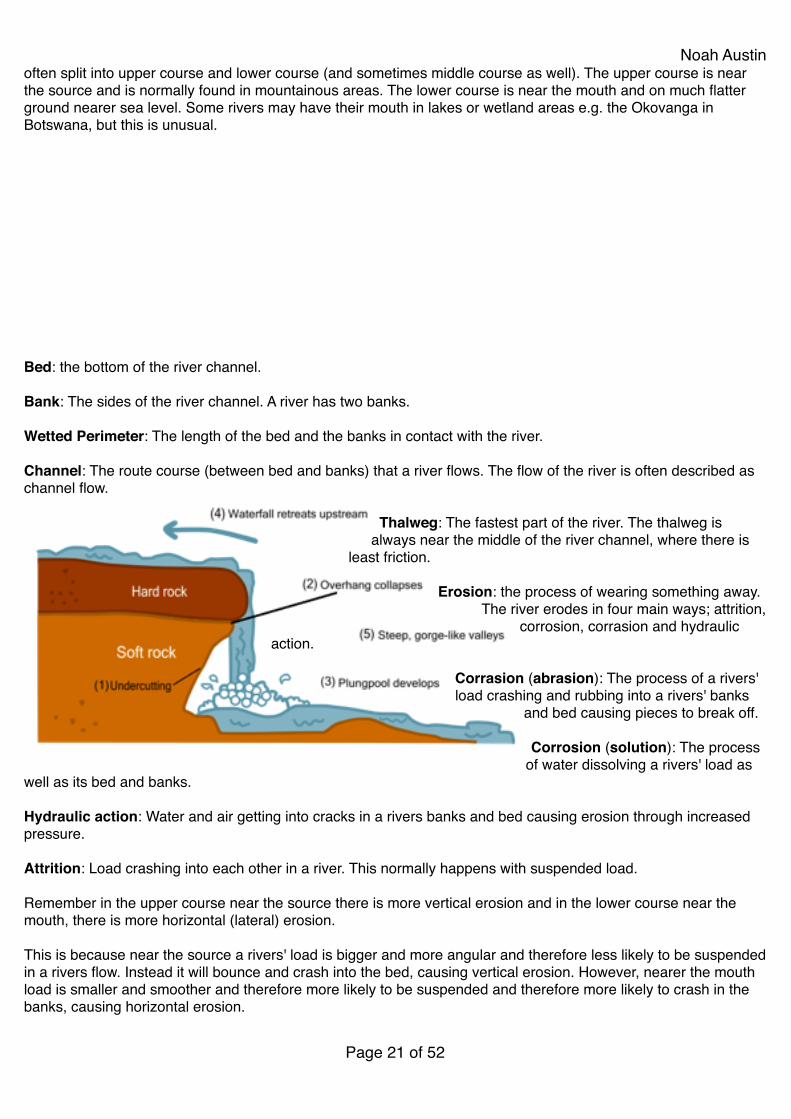
Thalweg: The fastest part of the river. The thalweg is always near the middle of the river channel, where there is
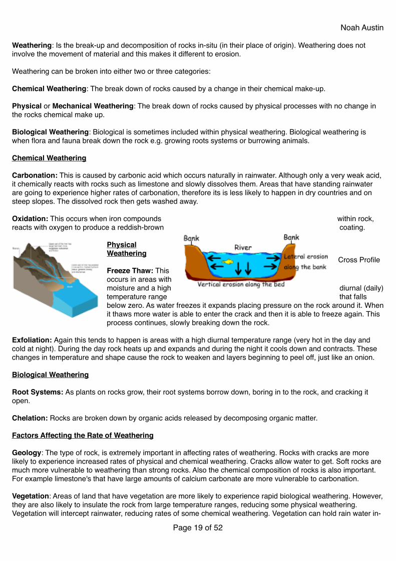
least friction.! !Erosion: the process of wearing something away.
The river erodes in four main ways; attrition, corrosion, corrasion and hydraulic
action.! !Corrasion (abrasion): The process of a rivers' load crashing and rubbing into a rivers' banks
and bed causing pieces to break off.!!Corrosion (solution): The process
of water dissolving a rivers' load as well as its bed and banks.!!Hydraulic action: Water and air getting into cracks in a rivers banks and bed causing erosion through increased pressure.!!Attrition: Load crashing into each other in a river. This normally happens with suspended load.!!Remember in the upper course near the source there is more vertical erosion and in the lower course near the mouth, there is more horizontal (lateral) erosion.!!This is because near the source a rivers' load is bigger and more angular and therefore less likely to be suspended in a rivers flow. Instead it will bounce and crash into the bed, causing vertical erosion. However, nearer the mouth load is smaller and smoother and therefore more likely to be suspended and therefore more likely to crash in the banks, causing horizontal erosion.!!
Page � of �21 52

Noah AustinBecause of erosion a rivers' load tends to get smaller and smoother as you move from the source to the mouth.!!Transportation: The river can transport material when it has excess energy. The river transports in four main ways; traction, saltation, solution and suspension. Material carried by a river is know as load.!!Traction: The process of large pieces of load rolling along a river bed.!!Saltation: The process of load bouncing a long a river bed.!!Suspension: The process of smaller pieces of load being carried in a rivers flow.!!Solution: The processed of dissolved pieces of material being transported in a solution.!!Sometimes a fifth form of transportation is also mentioned; flotation.!!Flotation: When material is transported on the surface of the river.!!Load: Material that is transported by a river. If the material is being transported along the bed, it is known as bedload, load transported in a rivers flow is often called suspended load.!!Deposition: When a river does not have enough energy, it will start depositing its loads. Deposit means to put something down.!!The Bradshaw Model!!The Bradshaw model attempts to show very simply how different characteristics of a river change from source to mouth. The left of the model represents the source and the right side the mouth.!!Velocity: Is the measure of the speed and direction of an object (to be very simple - the speed the river is travelling). Velocity is normally measured in m/s (metres a second). It is commonly believed that the velocity of rivers is faster in the upper course. However, this is not true, the velocity of the river actually increases as you near the mouth, as shown in the Bradshaw model to the right. This because the cross-section of the river is smaller near the source so there is greater friction and also the discharge is smaller. Nearer the mouth the discharge of the river increases as does the rivers cross-section meaning less energy is lost to friction. We measure velocity with the formula: speed = distance/time.!!Discharge: Is the amount of water being carried by a river. Discharge is measured as cubic metres per second (CUMECS). We calculate discharge by using the formula discharge = cross-section x velocity.!!Cross-section: The cross-section of the river is the width of the river times the depth of the river. A river's cross-section will get bigger as it moves from the source to the mouth. Because a river's depth can vary we normally take several depth readings and calculate an average.!!Gradient: Gradient means how steep something is. The gradient of the river will normally get less step as it travels from the source to the mouth.!!River Landforms!!
Page � of �22 52
Noah Austin
!
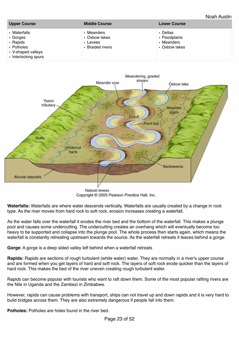
Waterfalls: Waterfalls are where water descends vertically. Waterfalls are usually created by a change in rock type. As the river moves from hard rock to soft rock, erosion increases creating a waterfall.!!As the water falls over the waterfall it erodes the river bed and the bottom of the waterfall. This makes a plunge pool and causes some undercutting. The undercutting creates an overhang which will eventually become too heavy to be supported and collapse into the plunge pool. The whole process then starts again, which means the waterfall is constantly retreating upstream towards the source. As the waterfall retreats it leaves behind a gorge.!!Gorge: A gorge is a deep sided valley left behind when a waterfall retreats!!Rapids: Rapids are sections of rough turbulent (white water) water. They are normally in a river's upper course and are formed when you get layers of hard and soft rock. The layers of soft rock erode quicker than the layers of hard rock. This makes the bed of the river uneven creating rough turbulent water.!!Rapids can become popular with tourists who want to raft down them. Some of the most popular rafting rivers are the Nile in Uganda and the Zambezi in Zimbabwe.!!However, rapids can cause problems with transport, ships can not travel up and down rapids and it is very hard to build bridges across them. They are also extremely dangerous if people fall into them.!!Potholes: Potholes are holes found in the river bed.!
Upper Course Middle Course Lower Course
• Waterfalls!• Gorges!• Rapids!• Potholes!• V-shaped valleys!• Interlocking spurs
• Meanders!• Oxbow lakes!• Levees!• Braided rivers
• Deltas!• Floodplains!• Meanders!• Oxbow lakes
Page � of �23 52
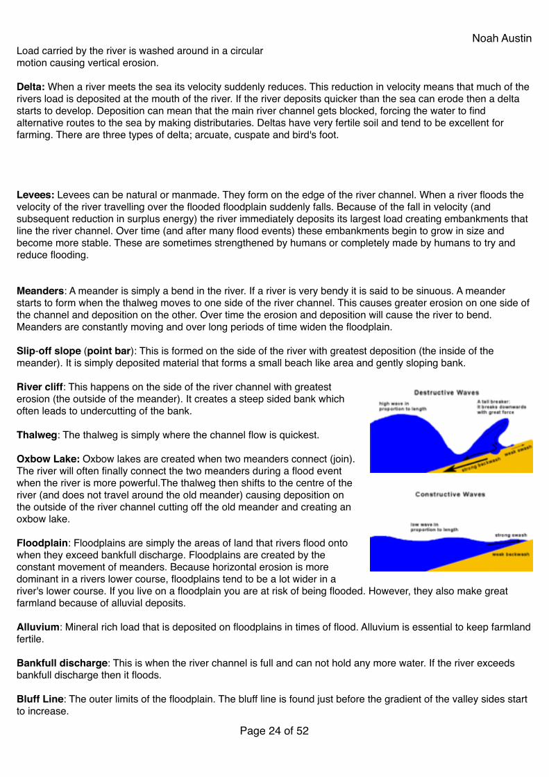
Noah AustinLoad carried by the river is washed around in a circular!motion causing vertical erosion.!!Delta: When a river meets the sea its velocity suddenly reduces. This reduction in velocity means that much of the rivers load is deposited at the mouth of the river. If the river deposits quicker than the sea can erode then a delta starts to develop. Deposition can mean that the main river channel gets blocked, forcing the water to find alternative routes to the sea by making distributaries. Deltas have very fertile soil and tend to be excellent for farming. There are three types of delta; arcuate, cuspate and bird's foot.!!!!!Levees: Levees can be natural or manmade. They form on the edge of the river channel. When a river floods the velocity of the river travelling over the flooded floodplain suddenly falls. Because of the fall in velocity (and subsequent reduction in surplus energy) the river immediately deposits its largest load creating embankments that line the river channel. Over time (and after many flood events) these embankments begin to grow in size and become more stable. These are sometimes strengthened by humans or completely made by humans to try and reduce flooding.!!!Meanders: A meander is simply a bend in the river. If a river is very bendy it is said to be sinuous. A meander starts to form when the thalweg moves to one side of the river channel. This causes greater erosion on one side of the channel and deposition on the other. Over time the erosion and deposition will cause the river to bend. Meanders are constantly moving and over long periods of time widen the floodplain.!!Slip-off slope (point bar): This is formed on the side of the river with greatest deposition (the inside of the meander). It is simply deposited material that forms a small beach like area and gently sloping bank.!!River cliff: This happens on the side of the river channel with greatest erosion (the outside of the meander). It creates a steep sided bank which often leads to undercutting of the bank.!!Thalweg: The thalweg is simply where the channel flow is quickest.!!Oxbow Lake: Oxbow lakes are created when two meanders connect (join). The river will often finally connect the two meanders during a flood event when the river is more powerful.The thalweg then shifts to the centre of the river (and does not travel around the old meander) causing deposition on the outside of the river channel cutting off the old meander and creating an oxbow lake.!!Floodplain: Floodplains are simply the areas of land that rivers flood onto when they exceed bankfull discharge. Floodplains are created by the constant movement of meanders. Because horizontal erosion is more dominant in a rivers lower course, floodplains tend to be a lot wider in a river's lower course. If you live on a floodplain you are at risk of being flooded. However, they also make great farmland because of alluvial deposits.!!Alluvium: Mineral rich load that is deposited on floodplains in times of flood. Alluvium is essential to keep farmland fertile.!!Bankfull discharge: This is when the river channel is full and can not hold any more water. If the river exceeds bankfull discharge then it floods.!!Bluff Line: The outer limits of the floodplain. The bluff line is found just before the gradient of the valley sides start to increase.!
Page � of �24 52
Noah Austin!Strand line: This is the line of material left behind after a river has flooded. The strand line is found on the outer limit of the flood somewhere on the floodplain. A strand line normally consists of pieces of wood and litter.!!!!!!!!!!!!!!!!!!!!!!!!!!
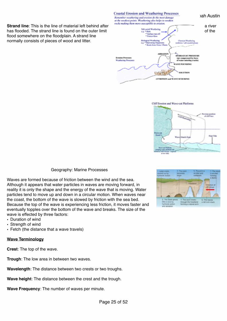
Geography: Marine Processes!!Waves are formed because of friction between the wind and the sea. Although it appears that water particles in waves are moving forward, in reality it is only the shape and the energy of the wave that is moving. Water particles tend to move up and down in a circular motion. When waves near the coast, the bottom of the wave is slowed by friction with the sea bed. Because the top of the wave is experiencing less friction, it moves faster and eventually topples over the bottom of the wave and breaks. The size of the wave is effected by three factors:!• Duration of wind!• Strength of wind!• Fetch (the distance that a wave travels)!!Wave Terminology!!Crest: The top of the wave.!!Trough: The low area in between two waves.!!Wavelength: The distance between two crests or two troughs.!!Wave height: The distance between the crest and the trough.!!Wave Frequency: The number of waves per minute.!!
Page � of �25 52
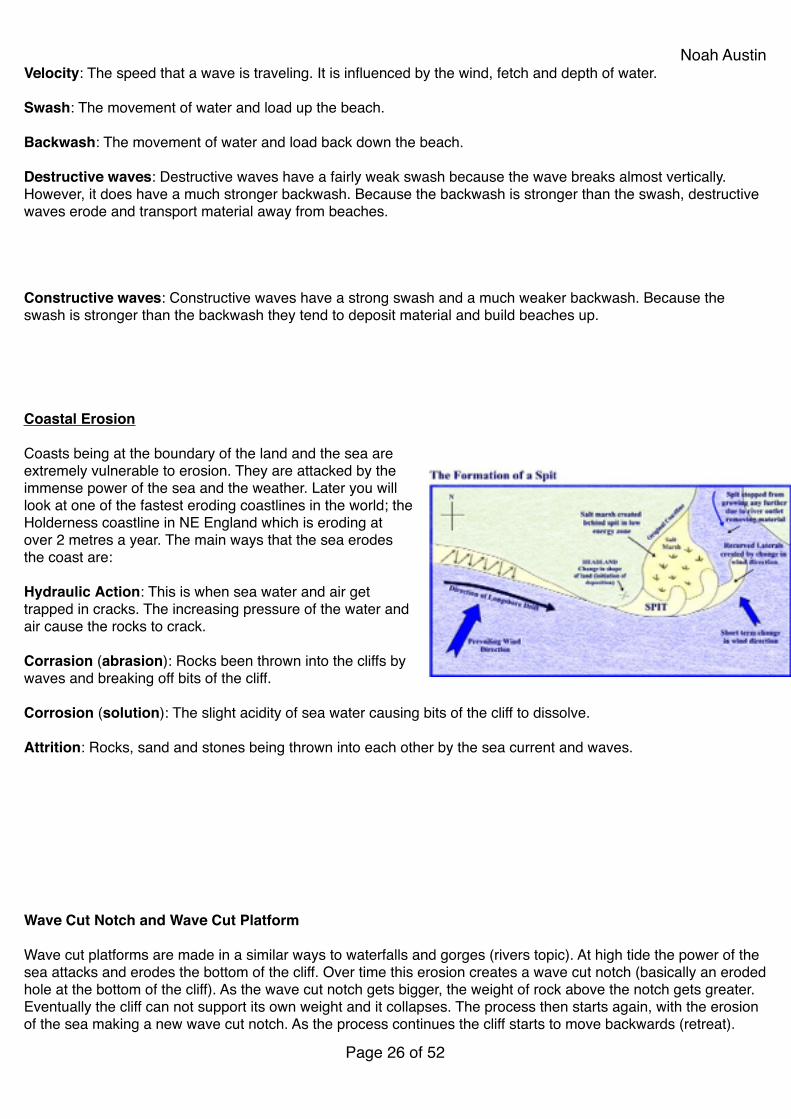
Noah AustinVelocity: The speed that a wave is traveling. It is influenced by the wind, fetch and depth of water.!!Swash: The movement of water and load up the beach.!!Backwash: The movement of water and load back down the beach.!!Destructive waves: Destructive waves have a fairly weak swash because the wave breaks almost vertically. However, it does have a much stronger backwash. Because the backwash is stronger than the swash, destructive waves erode and transport material away from beaches.!!!!!Constructive waves: Constructive waves have a strong swash and a much weaker backwash. Because the swash is stronger than the backwash they tend to deposit material and build beaches up.!!!!!!Coastal Erosion!!Coasts being at the boundary of the land and the sea are extremely vulnerable to erosion. They are attacked by the immense power of the sea and the weather. Later you will look at one of the fastest eroding coastlines in the world; the Holderness coastline in NE England which is eroding at over 2 metres a year. The main ways that the sea erodes the coast are:!!Hydraulic Action: This is when sea water and air get trapped in cracks. The increasing pressure of the water and air cause the rocks to crack.!!Corrasion (abrasion): Rocks been thrown into the cliffs by waves and breaking off bits of the cliff.!!Corrosion (solution): The slight acidity of sea water causing bits of the cliff to dissolve.!!Attrition: Rocks, sand and stones being thrown into each other by the sea current and waves.!!!!!!!!!!Wave Cut Notch and Wave Cut Platform!!Wave cut platforms are made in a similar ways to waterfalls and gorges (rivers topic). At high tide the power of the sea attacks and erodes the bottom of the cliff. Over time this erosion creates a wave cut notch (basically an eroded hole at the bottom of the cliff). As the wave cut notch gets bigger, the weight of rock above the notch gets greater. Eventually the cliff can not support its own weight and it collapses. The process then starts again, with the erosion of the sea making a new wave cut notch. As the process continues the cliff starts to move backwards (retreat).
Page � of �26 52
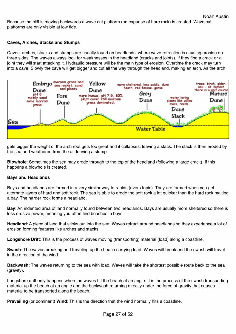
Noah AustinBecause the cliff is moving backwards a wave cut platform (an expanse of bare rock) is created. Wave cut platforms are only visible at low tide.!!!Caves, Arches, Stacks and Stumps!!Caves, arches, stacks and stumps are usually found on headlands, where wave refraction is causing erosion on three sides. The waves always look for weaknesses in the headland (cracks and joints). If they find a crack or a joint they will start attacking it. Hydraulic pressure will be the main type of erosion. Overtime the crack may turn into a cave. Slowly the cave will get bigger and cut all the way through the headland, making an arch. As the arch
gets bigger the weight of the arch roof gets too great and it collapses, leaving a stack. The stack is then eroded by the sea and weathered from the air leaving a stump.!!Blowhole: Sometimes the sea may erode through to the top of the headland (following a large crack). If this happens a blowhole is created.!!Bays and Headlands!!Bays and headlands are formed in a very similar way to rapids (rivers topic). They are formed when you get alternate layers of hard and soft rock. The sea is able to erode the soft rock a lot quicker than the hard rock making a bay. The harder rock forms a headland.!!Bay: An indented area of land normally found between two headlands. Bays are usually more sheltered so there is less erosive power, meaning you often find beaches in bays.!!Headland: A piece of land that sticks out into the sea. Waves refract around headlands so they experience a lot of erosion forming features like arches and stacks.!!Longshore Drift: This is the process of waves moving (transporting) material (load) along a coastline.!!Swash: The waves breaking and traveling up the beach carrying load. Waves will break and the swash will travel in the direction of the wind.!!Backwash: The waves returning to the sea with load. Waves will take the shortest possible route back to the sea (gravity).!!Longshore drift only happens when the waves hit the beach at an angle. It is the process of the swash transporting material up the beach at an angle and the backwash returning directly under the force of gravity that causes material to be transported along the beach.!!Prevailing (or dominant) Wind: This is the direction that the wind normally hits a coastline.!!
Page � of �27 52
Noah AustinGroynes: Groynes are wooden or concrete fences (walls) placed out into the sea to stop longshore drift happening.!!Sea currents: Currents are the movement of water caused by differences in temperature, changes in wind or tides. Currents can be extremely strong and can transport large amount of material.!!Saltation: The wind can also transport sand and even small stones across a beach. The process of the wind bouncing sand and small stones across a beach is known as saltation.!!Spits: A spit is a long thin stretch of sand connected to the mainland but stretching out into the sea. Spits are formed in areas of calmer water where the sea has less energy. They are normally found near the mouths of rivers where the coastline changes direction creating some protection. Longshore drift happens in the direction of the prevailing (dominant) wind. When the direction of the coast changes, longshore drift does not stop, but continues out into the sea. If the sea has less energy (because it is protected), material is deposited instead of transported. If deposition is greater than erosion, then overtime a spit will build up. The end of the spit is usually hooked because of occasional winds and storms that blow in the opposite direction of the prevailing wind.!!Bar: A spit that connects two headlands or runs across the face of a small cove (bay).!!Sand Dunes are very dynamic, which means they are constantly changing. Sand dunes are found behind berms and are basically an extension of the beach. They are formed by dry sand being blown up the beach.!!Embryo Dune: Embryo dunes are the starting dunes of sand dunes. They form in the sheltered area behind the berm and strand line.!!Foredunes: Small embryo dunes can join to make foredunes. Foredunes tend to be very yellow because they only have limited vegetation so no real humus layer develops.!!Yellow Dunes: Sea couch and marram grass begin to grow on the foredunes so they become more stable and grow. As the dune grows and the vegetation develops a humus layer develops.!!Grey Dunes: A developing humus layers starts changing the colour of the dune from yellow to grey.!!Mature dunes: As the humus layers grows more, the dunes can sustain more plants, flowers and even trees.!!Dune slack: As the size of the dunes develop water can collect between the dunes. Marsh plants can grow in these wet areas.!!Blowout: A blowout is a depression or hole in the dune caused by the wind.!!Humus: Is the layer of decaying plant and animal matter that adds nutrients to the ground.!!Succession: The changing types of plants from basic sea couch to trees is known as succession.!!Water table: The line between saturated and unsaturated ground.!!Saltmarshes!!
Page � of �28 52
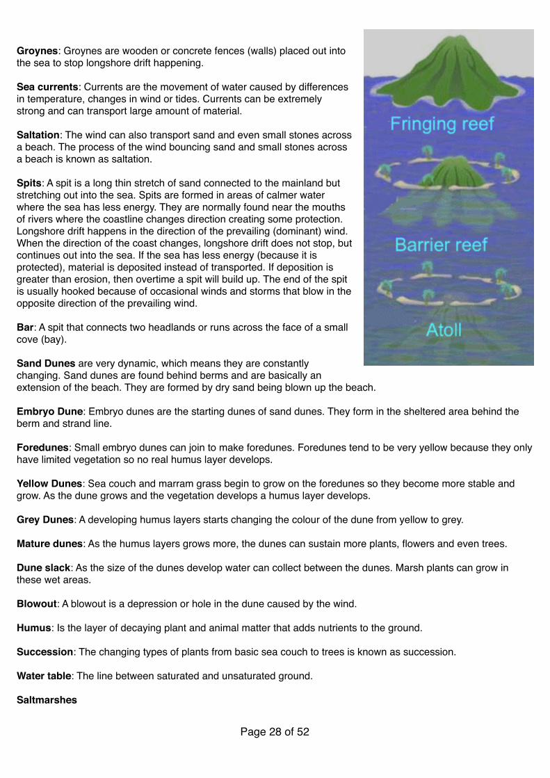
Noah AustinSaltmarshes are usually found behind spits, in estuaries or on low energy coastlines. Because there areas tend to have low levels of energy, deposition exceeds erosion. The continued deposition means mudbanks are formed and they are exposed at low tide. Salt and water resistant grass is able to grow on these mudbanks, forming saltmarshes.!!The salt resistant vegetation (halophytic) means more sediment (load) is trapped and water is restricted to channels, rather than the whole saltmarsh. As the height of the saltmarsh increases more types of vegetation are able to colonise (move in) and grow.!!The area of land that is inundated (covered) by sea water only at high tides and sometimes only spring tides is called the sward zone. Plants in the sward zone can only survive being under sea water for a maximum of four hours a day.!!Coral Reefs!!A coral reef is a line of coral polyp found in warm shallow seas. Polyp are tiny carnivorous (meat eating) animals. Polyps live in groups called colonies. A polyp has a mouth at one end. The mouth is surrounded by a number of tentacles. These tentacles resemble feet, which is how they get their name ('polyp' is a Greek word meaning 'many feet'). Polyps cannot move from their limestone homes. They mostly feed at night.!!A polyp reproduces by dividing its own body to form two polyps, or by producing sperm and eggs. Each polyp builds a case of limestone around itself, using calcium from the water. It is like a house, with a floor and walls. This remains after it has died and forms a foundation for another polyp to build a house on, putting a floor on the roof of the old one. When these limestone formations increase, they are called a coral reefs.!!!!!!Coral reefs are very delicate and need the following conditions to form:!• Tropical sea conditions (between the two tropics)!• Warm waters (must be over 18 degrees centigrade year round)!• Clear water ( no sediment)!• No pollution!• Sunlight!• Water less than 60 metres deep!!!Fringing Reef: Fringing reefs circle or fringe the coastline or islands. They are often protected by barrier reefs further out to sea, so the plants and animals that live in fringing reefs are suited to low wave energy environments.!!Barrier Reef: These occur further from the sea and are commonly separated from the mainland or island by a deep lagoon. Barrier reefs are normally older and wider than fringing reefs. The Great Barrier reef in Eastern Australia is a barrier reef and stretches for 1600km.!!Atoll: They rise from submerged volcanoes. They are similar to barrier reefs in terms of biodiversity and form. However, they are confined to submerged oceanic islands, unlike barrier islands which can follow continental coastlines e.g. Great Barrier Reef.!!!!!!!!!
Page � of �29 52

Noah Austin!!!!!!!!!!!!!!!!!!!!!!!!!Geography: Weather!!
Equipment Photo Description
Stevenson Screen !!!!!!!!!
A Stevenson screen is basically a white louvered wooden box. The box is designed to contain some weather equipment like thermometers and barometers. The Stevenson screen is white to reflect sunlight and has slats to allow air to circulate easily. The Stevenson should be placed above the ground and away from the buildings. The idea is for the weather instruments to take accurate readings of the air, rather than direct sunlight or heat from the ground or from buildings.
Barometer !!!!!!!!!!
Barometers are used to measure air pressure. Air pressure is normally measured in millibars. Barometers are normally kept inside Stevenson screens to keep them safe. A barometer has a movable needle (pointer). The pointer can be moved to the current reading so that you can then make a comparison with the reading from the following day.
Page � of �30 52

Noah Austin
Max/Min Thermometer (Six’s Thermometer)
!!!!!!
A maximum and minimum thermometer records the maximum temperature of the day and the minimum temperature of the day (diurnal range). A maximum/minimum thermometer contains a mixture of mercury and alcohol. The mercury sits in the u-bend of the thermometer. The bulb at the top of the tube reading the minimum temperature contains alcohol and the bulb at the top of the tube reading the maximum temperature contains a vacuum. On the minimum side the expansion of the mercury is restricted by the contracting alcohol, on the maximum side the expanding mercury can expand more freely into the vacuum. At any given time both thermometers should record the same temperature. However, during the day they would have recorded the maximum and minimum temperature - a steel marker should indicate these temperatures.
Wet/Dry Bulb Therm.!(Hygrometer)
!!!!!!!!!!!!!!!
A hygrometer measures the humidity of the air. Humidity is the amount of moisture (water vapour) in the air. A hygrometer has two thermometers, a dry one and a wet. Humidity is measured by using a table that looks at the difference between the wet bulb and the dry bulb. A hygrometer can also be used to find dew point. There is a difference between the dry and wet bulb thermometers because of latent heat created during the process of evaporation.
Rain Gauge !!!!!!!!!!
Rain gauges are used to measure rainfall. Rainfall is normally measured in millimetres. Rain gauges should be placed on grass, because if they are placed on concrete, extra water can splash into them. Rain gauges should also be checked regularly to avoid evaporation.
Equipment Photo Description
Page � of �31 52
Noah Austin
!Stevenson Screen!!The Stevenson Screen is a small weather station that is used to measure local weather conditions. A weather centre will include a M/M them., a hygrometer, and a barometer. Outside the SS there will be a rain guage, an anemometer, and a wind vane.!!!• The SS should be above the ground (1.2m) so that it does not receive heat released from the ground!• The SS has a roof to protect the instruments from precipitation (rain affects temperature/humidity)!
Wind Vane !!!!!!
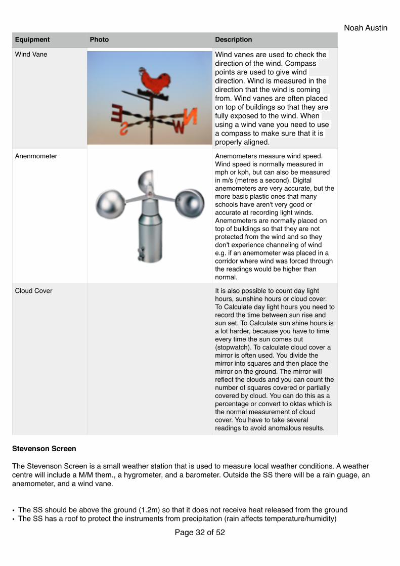
Wind vanes are used to check the direction of the wind. Compass points are used to give wind direction. Wind is measured in the direction that the wind is coming from. Wind vanes are often placed on top of buildings so that they are fully exposed to the wind. When using a wind vane you need to use a compass to make sure that it is properly aligned.
Anenmometer !!!!!!
Anemometers measure wind speed. Wind speed is normally measured in mph or kph, but can also be measured in m/s (metres a second). Digital anemometers are very accurate, but the more basic plastic ones that many schools have aren't very good or accurate at recording light winds. Anemometers are normally placed on top of buildings so that they are not protected from the wind and so they don't experience channeling of wind e.g. if an anemometer was placed in a corridor where wind was forced through the readings would be higher than normal.
Cloud Cover It is also possible to count day light hours, sunshine hours or cloud cover. To Calculate day light hours you need to record the time between sun rise and sun set. To Calculate sun shine hours is a lot harder, because you have to time every time the sun comes out (stopwatch). To calculate cloud cover a mirror is often used. You divide the mirror into squares and then place the mirror on the ground. The mirror will reflect the clouds and you can count the number of squares covered or partially covered by cloud. You can do this as a percentage or convert to oktas which is the normal measurement of cloud cover. You have to take several readings to avoid anomalous results.
Equipment Photo Description
Page � of �32 52
Noah Austin• SS should be away from buildings, to avoid heat radiated or shadows!• SS is painted white to reflect solar radiation. No solar absorption = accurate reading of air temperature!• Door of SS should be facing away from sun (N. Hemisphere = facing N)!• Screen has slats to allow air to circulate freely around instruments!• SS should also be away from hills and trees, so that air can circulate (SS distance from object=2x height of
object)!• SS should be located on grass to avoid reflection from white surface and absorption from dark (grass has an
albedo of 23%)!!Climate Graphs!!Climate graphs show the average temperature and rainfall for a city or region over the year. Temperature is always shown in the form of a line graph. Some climate graphs have the average maximum temperature and the average minimum, others just have the overall average temperature. The line graph is normally coloured in red. Rainfall is always shown in the form a bar graph and normally coloured in blue.!!Climate graphs are very good for showing averages, but they don't show anomalous years, because it is based on averages and it doesn't show things like the number of days of rain. A month may have 50mm of rain, but we don't know if that comes in small rain showers or one big thunderstorm.!!When reading climate graphs you should look for trends and anomalies. On the graph below the temperature trend is fairly easy to read. It increases from January to July and then decreases until December. The rainfall data is not as straight forward because some of the early months fluctuate (go up and down). Whenever you are describing graphs, remember it is very important to use figures with the correct unit. Occasionally you maybe asked to give the temperature or rainfall range - this is the difference between the highest and lowest total.!!Synoptic Charts!!Symbol Precipiation Symbol Cloud Cover Symbol Wind Speed
Drizzle Clear sky Calm
Shower One Okta 1-2 Knots
Rain Two Oktas 5 Knots
Snow Three Oktas 10 Knots
Hail Four Oktas 15 Knots
Thunderstorm Five Oktas 20 Knots
Heavy Rain Six Oktas 50 Knots Or More
Sleet Seven Oktas
Snow Shower Eight Oktas
Mist Sky Obscured
Fog
Page � of �33 52
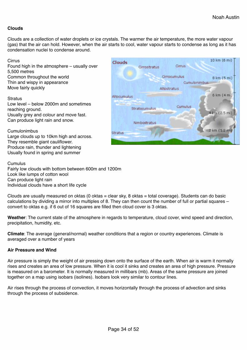
Noah Austin!Clouds!!Clouds are a collection of water droplets or ice crystals. The warmer the air temperature, the more water vapour (gas) that the air can hold. However, when the air starts to cool, water vapour starts to condense as long as it has condensation nuclei to condense around.!!Cirrus!Found high in the atmosphere – usually over 5,500 metres!Common throughout the world!Thin and wispy in appearance!Move fairly quickly!!Stratus!Low level – below 2000m and sometimes reaching ground.!Usually grey and colour and move fast.!Can produce light rain and snow.!!Cumulonimbus!Large clouds up to 10km high and across.!They resemble giant cauliflower.!Produce rain, thunder and lightening!Usually found in spring and summer!!Cumulus!Fairly low clouds with bottom between 600m and 1200m!Look like lumps of cotton wool!Can produce light rain!Individual clouds have a short life cycle!!Clouds are usually measured on oktas (0 oktas = clear sky, 8 oktas = total coverage). Students can do basic calculations by dividing a mirror into multiples of 8. They can then count the number of full or partial squares – convert to oktas e.g. if 6 out of 16 squares are filled then cloud cover is 3 oktas.!!Weather: The current state of the atmosphere in regards to temperature, cloud cover, wind speed and direction, precipitation, humidity, etc.!!Climate: The average (general/normal) weather conditions that a region or country experiences. Climate is averaged over a number of years!!Air Pressure and Wind!!Air pressure is simply the weight of air pressing down onto the surface of the earth. When air is warm it normally rises and creates an area of low pressure. When it is cool it sinks and creates an area of high pressure. Pressure is measured on a barometer. It is normally measured in millibars (mb). Areas of the same pressure are joined together on a map using isobars (isolines). Isobars look very similar to contour lines.!!Air rises through the process of convection, it moves horizontally through the process of advection and sinks through the process of subsidence.!!
Page � of �34 52
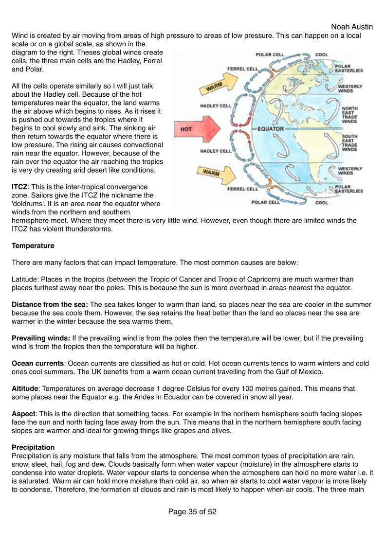
Noah AustinWind is created by air moving from areas of high pressure to areas of low pressure. This can happen on a local scale or on a global scale, as shown in the diagram to the right. Theses global winds create cells, the three main cells are the Hadley, Ferrel and Polar.!!All the cells operate similarly so I will just talk about the Hadley cell. Because of the hot temperatures near the equator, the land warms the air above which begins to rises. As it rises it is pushed out towards the tropics where it begins to cool slowly and sink. The sinking air then return towards the equator where there is low pressure. The rising air causes convectional rain near the equator. However, because of the rain over the equator the air reaching the tropics is very dry creating arid desert like conditions.!!ITCZ: This is the inter-tropical convergence zone. Sailors give the ITCZ the nickname the 'doldrums'. It is an area near the equator where winds from the northern and southern hemisphere meet. Where they meet there is very little wind. However, even though there are limited winds the ITCZ has violent thunderstorms.!!Temperature!!There are many factors that can impact temperature. The most common causes are below:!!Latitude: Places in the tropics (between the Tropic of Cancer and Tropic of Capricorn) are much warmer than places furthest away near the poles. This is because the sun is more overhead in areas nearest the equator.!!Distance from the sea: The sea takes longer to warm than land, so places near the sea are cooler in the summer because the sea cools them. However, the sea retains the heat better than the land so places near the sea are warmer in the winter because the sea warms them.!!Prevailing winds: If the prevailing wind is from the poles then the temperature will be lower, but if the prevailing wind is from the tropics then the temperature will be higher.!!Ocean currents: Ocean currents are classified as hot or cold. Hot ocean currents tends to warm winters and cold ones cool summers. The UK benefits from a warm ocean current travelling from the Gulf of Mexico.!!Altitude: Temperatures on average decrease 1 degree Celsius for every 100 metres gained. This means that some places near the Equator e.g. the Andes in Ecuador can be covered in snow all year.!!Aspect: This is the direction that something faces. For example in the northern hemisphere south facing slopes face the sun and north facing face away from the sun. This means that in the northern hemisphere south facing slopes are warmer and ideal for growing things like grapes and olives.!!Precipitation!Precipitation is any moisture that falls from the atmosphere. The most common types of precipitation are rain, snow, sleet, hail, fog and dew. Clouds basically form when water vapour (moisture) in the atmosphere starts to condense into water droplets. Water vapour starts to condense when the atmosphere can hold no more water i.e. it is saturated. Warm air can hold more moisture than cold air, so when air starts to cool water vapour is more likely to condense. Therefore, the formation of clouds and rain is most likely to happen when air cools. The three main
Page � of �35 52
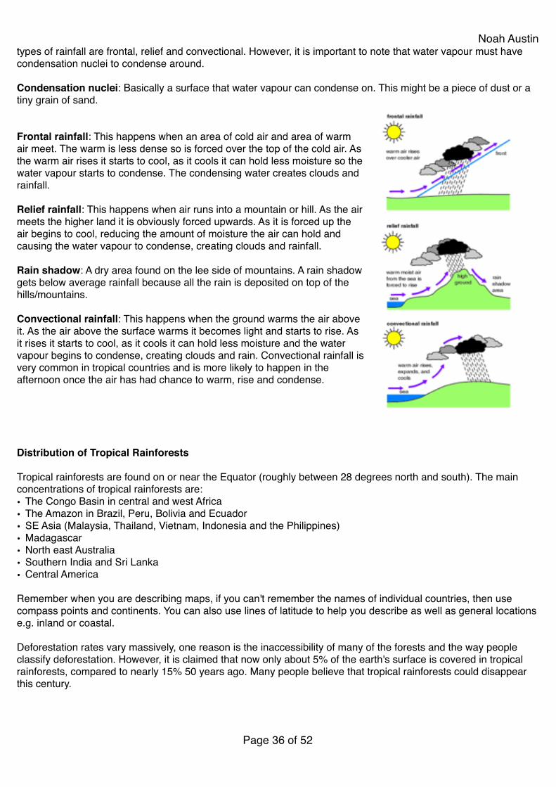
Noah Austintypes of rainfall are frontal, relief and convectional. However, it is important to note that water vapour must have condensation nuclei to condense around.!!Condensation nuclei: Basically a surface that water vapour can condense on. This might be a piece of dust or a tiny grain of sand.!!!Frontal rainfall: This happens when an area of cold air and area of warm air meet. The warm is less dense so is forced over the top of the cold air. As the warm air rises it starts to cool, as it cools it can hold less moisture so the water vapour starts to condense. The condensing water creates clouds and rainfall.!!Relief rainfall: This happens when air runs into a mountain or hill. As the air meets the higher land it is obviously forced upwards. As it is forced up the air begins to cool, reducing the amount of moisture the air can hold and causing the water vapour to condense, creating clouds and rainfall.!!Rain shadow: A dry area found on the lee side of mountains. A rain shadow gets below average rainfall because all the rain is deposited on top of the hills/mountains.!!Convectional rainfall: This happens when the ground warms the air above it. As the air above the surface warms it becomes light and starts to rise. As it rises it starts to cool, as it cools it can hold less moisture and the water vapour begins to condense, creating clouds and rain. Convectional rainfall is very common in tropical countries and is more likely to happen in the afternoon once the air has had chance to warm, rise and condense.!!!!!!Distribution of Tropical Rainforests!!Tropical rainforests are found on or near the Equator (roughly between 28 degrees north and south). The main concentrations of tropical rainforests are:!• The Congo Basin in central and west Africa!• The Amazon in Brazil, Peru, Bolivia and Ecuador!• SE Asia (Malaysia, Thailand, Vietnam, Indonesia and the Philippines)!• Madagascar!• North east Australia!• Southern India and Sri Lanka!• Central America!!Remember when you are describing maps, if you can't remember the names of individual countries, then use compass points and continents. You can also use lines of latitude to help you describe as well as general locations e.g. inland or coastal.!!Deforestation rates vary massively, one reason is the inaccessibility of many of the forests and the way people classify deforestation. However, it is claimed that now only about 5% of the earth's surface is covered in tropical rainforests, compared to nearly 15% 50 years ago. Many people believe that tropical rainforests could disappear this century.!
Page � of �36 52

Noah Austin!Tropical Rainforest Vegetation and Adaptation!!Emergents: Emergents are tall trees that grow above the canopy layer in order to reach sunlight. Emergents can grow in excess of 50 metres.!!Canopy: The canopy layer contains about 50% of the rainforests wildlife. The canopy layer is extremely thick and sits at between 25 and 35 metres.!!Shrub Layer: The shrub layer is near the forest floor and is also extremely dense. Because the canopy is so thick the shrub layer has to adapt to survive in less light.!!Lianas: These are woody vines that climb up other trees to try and get into the canopy and capture sunlight.!!Strangler Figs: Strangler figs grow around the outside of other trees taking their light and nutrients and slowly killing the host tree. However, when the host tree collapses so does the strangler fig.!!Butress Roots: Very long roots that are designed to support tall trees and to suck up the maximum amount of nutrients in fairly nutrient poor soil.!!Fan Palms: Huge wide leaved plants that aim to capture as much sunlight and rainfall as possible.!!Humus Layer: Rainforest soils are fairly infertile and dependent on the humus layer (decaying biological matter). If the source of humus is removed through deforestation then soils degrade very quickly.!!Evergreen: Most vegetation in rainforests does shed its leaves once a year. However, because the climate of rainforests is similar all year, they shed their leaves at different times providing a constant source of biological matter and keeping the rainforest green.!!Drip tip leaves: A lot of vegetation have leaves designed for rainfall to travel over them and drip to the ground. This is because the vegetation does not wanted to be damaged by large quantities of water.!!!!!!Importance Of Tropical Rainforests!!• Biodiversity: Although rainforests cover only about 5/6% of the world's land mass, it is estimated that they could
contain up to 50% of the world's biodiversity. This is potentially up to 15 million species.!• Photosynthesis: Tropical rainforests are often referred to as the 'lungs of the earth' and convert large amounts
of the greenhouse gas carbon dioxide back into oxygen. It is estimated that the Amazon rainforest alone produces about 20% of the earth's oxygen.!
• Flood control (interception, transpiration): Rainforests are an excellent natural measure to reducing flooding. There is leaf cover in rainforests all year so interception continually happens, extending rivers lag time. All vegetation uptakes water and transpires it.!
Page � of �37 52
Noah Austin• Control of soil erosion: The root systems of trees and shrubs hold the very thin soil of rainforest in place. If
trees are removed then both erosion of topsoil and landslides are more likely!• Source of nutrients to humus layer in soil: The topsoil in rainforests is very thin and relies on the nutrients
provided by rotting plants and animals. Because of the rainforests climate, there is a constant supply of leaf litter.!• Medical remedies: Rainforests have been the source of many of today's drugs, including the basic ingredients
for the hormone contraceptive pill, quinine (a anti-malaria drug) and curare (a paralysing drug).!• Cash crops and agricultural products: Yam, coffee, rubber, mango, banana, sugarcane, cocoa and avocado
were all first discovered in rainforests.!• Ecotourism: With people becoming ever more environmentally conscious and looking for increasing adventures,
ecotourism to rainforests is increasing. This not only helps protect rainforests, but creates income for locals. Ecotourism is an important income to countries like Costa Rica and Belize.!
• Home to indigenous groups: Although the number of indigenous groups and people have declined rapidly since colonisation in South America, it is estimated that there are still over 200,000 people that consider the Amazon their home.!!
Page � of �38 52
Noah Austin
!!!!!!!
Reasons For Deforestation Problems Caused By Deforestation
• Cattle Ranching: As the world's population gets bigger and richer, the demand for meat is increasing. To rear the cattle increasing tracts of the rainforest are being cleared to make pastures for grazing.!
• Subsistence Farming: Because of the large amounts of poor people that still live in tropical areas, subsistence farming is still widespread. Because rainforest soil loses its fertility quickly after deforestation, the most common form of subsistence farming is slash and burn. With growing populations this method of farming can cause widespread deforestation.!
• HEP: Many of the world's great rivers flow through rainforests e.g. the Amazon. These great rivers often have the most HEP potential. Unfortunately when a dam and reservoir are built it causes damage during construction, but also floods large areas.!
• Mining: With an ever increasing demand for the world's natural resources, countries and companies are looking at increasingly isolated locations, places like rainforests and Antarctica. The rainforests are believed to have many resources including metals and fossil fuels beneath their soils. Gold mining can be particular damaging as mercury is used in its extraction and often runs off into rivers.!
• Road building: Building new roads like Trans Amazon highway from Brazil to Bolivia not only causes deforestation itself, but its also opens up new areas to urbanisation, mining and farming causing further deforestation.!
• Urban growth: With the world population increasing as well as rates of urbanisation increasing many cities like Manaus in Brazil are growing rapidly causing deforestation.!
• Population growth: As populations grow, particularly in countries like Brazil, Peru, India and Vietnam that contain rainforests the demand for land increases, both to grow food and to live).!
• Plantations: Primary products are often seen as an income source for LEDCs, many of who have large areas of rainforest. At the same time with fossil fuels running out, alternative fuels sources are been searched for including biofuels e.g. Palm oil. This has lead to widespread deforestation in countries like Malaysia and Indonesia to plant cops like palm oil.!
• Timber (hardwoods): Hardwoods like mahogany and teak that take hundreds of years to grow are still in high demand to make things like furniture. The extraction of these trees can kills trees around them. Also many countries like China are also demanding large amounts of normal timber that are not always taken from sustainable sources.!
• Hunting: Hunting takes two forms, one form is for bushmeat to feed families and enough the sale of animals either alive e.g. parrots or dead for their skins e.g jaguars.
• Flooding: Flash floods become more common after deforestation because there is less interception and less root uptake and transpiration. As such rainwater reaches the ground quick, saturating it and causing surface run-off and potential flooding.!
• Landslides: By removing trees and vegetation, you are making the soil less stable. Combine this with saturated ground and the likelihood of floods increases.!
• Biodiversity loss: Because all the species that live in the rainforest are not known it is hard to calculate species loss. However, scientists believe that 1 mammal or bird extinction can be extrapolated to approximately 23,000 extinctions.!
• Reduced photosynthesis: As more and more trees are removed the rate of photosynthesis reduces, releasing more carbon dioxide into the atmosphere and contributing to the greenhouse effect.!
• Silting of rivers: With increased flooding and surface run-off moil soils and silt is washed into rivers, this can not only change local ecosystems (water temperature and clarity) but can also reduce the depth of rivers making navigation harder.!
• Silting of seas and oceans: With the increased frequency of flooding and landslides more silt gets washed into the oceans. The increased amount of silts reduces the transparency of the sea reducing the light reefs receive and the temperature of the water. Increased silt can also block important shipping lanes.!
• Breaking of nutrient cycle: The top soil of rainforests is very thin an receives the majority of its nutrients from rotting flora and fauna. Be removing trees you also remove animals and therefore the source of the soils nutrients. With increased erosion the top soil (humus) layer is quickly washed away.!
• Sandification/desertification: Because rainforest soil loses its fertility very quickly after deforestation it quickly becomes hard to grow any vegetation on it, leading to sandification and possibly desertification.!
• Loss of indigenous homes: By clearing rainforests you are obviously destroying the homes of indigenous groups. But also moving close to indigenous groups can spread disease and alter local culture and traditions.!
• Reduced rainfall: Deforestation can lead to reduction in local rainfall because less water is intercepted and transpired from vegetation into the atmosphere reducing the formation of clouds and rainfall.
Page � of �39 52
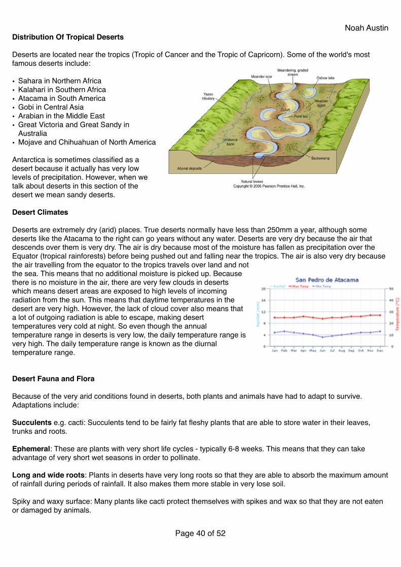
Noah AustinDistribution Of Tropical Deserts!!Deserts are located near the tropics (Tropic of Cancer and the Tropic of Capricorn). Some of the world's most famous deserts include:!!• Sahara in Northern Africa!• Kalahari in Southern Africa!• Atacama in South America!• Gobi in Central Asia!• Arabian in the Middle East!• Great Victoria and Great Sandy in
Australia!• Mojave and Chihuahuan of North America!!Antarctica is sometimes classified as a desert because it actually has very low levels of precipitation. However, when we talk about deserts in this section of the desert we mean sandy deserts.!!Desert Climates!!Deserts are extremely dry (arid) places. True deserts normally have less than 250mm a year, although some deserts like the Atacama to the right can go years without any water. Deserts are very dry because the air that descends over them is very dry. The air is dry because most of the moisture has fallen as precipitation over the Equator (tropical rainforests) before being pushed out and falling near the tropics. The air is also very dry because the air travelling from the equator to the tropics travels over land and not the sea. This means that no additional moisture is picked up. Because there is no moisture in the air, there are very few clouds in deserts which means desert areas are exposed to high levels of incoming radiation from the sun. This means that daytime temperatures in the desert are very high. However, the lack of cloud cover also means that a lot of outgoing radiation is able to escape, making desert temperatures very cold at night. So even though the annual temperature range in deserts is very low, the daily temperature range is very high. The daily temperature range is known as the diurnal temperature range.!!!Desert Fauna and Flora!!Because of the very arid conditions found in deserts, both plants and animals have had to adapt to survive. Adaptations include:!!Succulents e.g. cacti: Succulents tend to be fairly fat fleshy plants that are able to store water in their leaves, trunks and roots.!!Ephemeral: These are plants with very short life cycles - typically 6-8 weeks. This means that they can take advantage of very short wet seasons in order to pollinate.!!Long and wide roots: Plants in deserts have very long roots so that they are able to absorb the maximum amount of rainfall during periods of rainfall. It also makes them more stable in very lose soil.!!Spiky and waxy surface: Many plants like cacti protect themselves with spikes and wax so that they are not eaten or damaged by animals.!!
Page � of �40 52

Noah AustinDeserts don't have the same variety of animals as tropical rainforests, but many insects, reptiles and mammals have adapted to survive.!!Nocturnal: Many animals will hide in burrows or behind rocks and vegetation during the hot daylight hours and only emerge at night.!!Camels: Camels store fatty tissue in their humps which when metabolised actually releases water as well fat enabling them to survive in deserts.!!!!!!!!!!!!!!!!!!!!!!!!!!!!!!!!!!!!!!!!!!!!!!!!!
Page � of �41 52
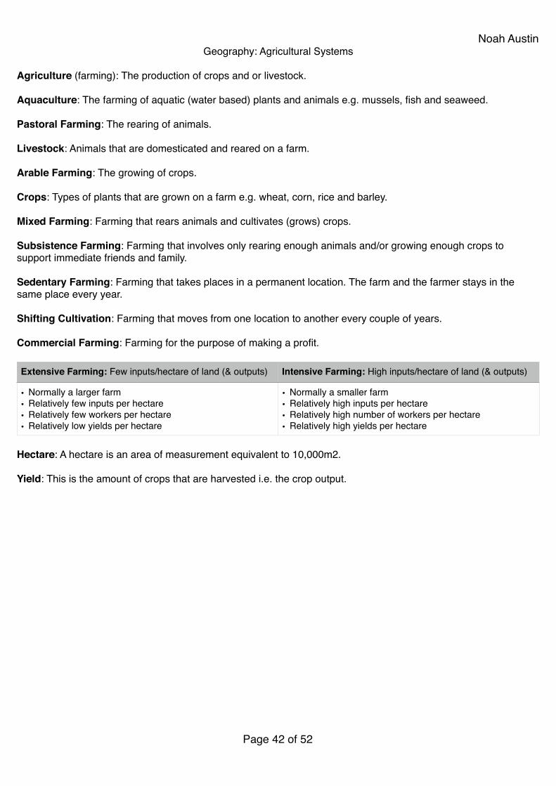
Noah AustinGeography: Agricultural Systems!!
Agriculture (farming): The production of crops and or livestock.!!Aquaculture: The farming of aquatic (water based) plants and animals e.g. mussels, fish and seaweed.!!Pastoral Farming: The rearing of animals.!!Livestock: Animals that are domesticated and reared on a farm.!!Arable Farming: The growing of crops.!!Crops: Types of plants that are grown on a farm e.g. wheat, corn, rice and barley.!!Mixed Farming: Farming that rears animals and cultivates (grows) crops.!!Subsistence Farming: Farming that involves only rearing enough animals and/or growing enough crops to support immediate friends and family.!!Sedentary Farming: Farming that takes places in a permanent location. The farm and the farmer stays in the same place every year.!!Shifting Cultivation: Farming that moves from one location to another every couple of years.!!Commercial Farming: Farming for the purpose of making a profit.!!
!Hectare: A hectare is an area of measurement equivalent to 10,000m2.!!Yield: This is the amount of crops that are harvested i.e. the crop output.!!!!!!
Extensive Farming: Few inputs/hectare of land (& outputs) Intensive Farming: High inputs/hectare of land (& outputs)
• Normally a larger farm!• Relatively few inputs per hectare!• Relatively few workers per hectare!• Relatively low yields per hectare
• Normally a smaller farm!• Relatively high inputs per hectare!• Relatively high number of workers per hectare!• Relatively high yields per hectare
Page � of �42 52
Noah Austin
!!!
!Advantages Of Large-Scale Commercial Farms!!• Economies Of Scale: When big companies can produce goods cheaper than small companies by:!
• Buying in bulk, negotiating with suppliers to bring down per unit costs!• More units sold = cheaper per unit fixed costs, such as overheads!
• !• Specialisation!• !• High Yields!• !• Cheaper Products!!!
Human Inputs Physical Inputs
• Labour (workers)! ! •! Machinery (tractors, combine harvesters, etc.)! ! •! Buildings (barns, silos)! ! •! Seed to grow crops! ! •! Animal feed! ! •! Fertlisers and pesticides! ! •! Calves, Chicks, piglets, etc. (small animals
bought to rear and later sell)
• Soil: If soil is fertile then arable farming is likely to take place, if it is less fertile and can only support grass then pastoral farming is likely to take place.!
• Precipitation: Water that helps water the crops.!• Sun: Energy to help plants and animals to grow.!• Alluvium: This is mineral and nutrient rich sediment
(load) that is transported by rivers and deposited on floodplains in times of flood.!
• Flood water: Floods not only bring alluvium but also water to keep the ground moist.!
• Relief: If land is flat then it is easier for arable farming to take place. If land is hilly then pastoral farming is more likely to take place.!
• Drainage: It is important that fields are well drained so they are not permanently flooded. Apart from rice most crops and animals can't survive being permanently submerged.
Processes Outputs
! •Rearing: This is the caring for and support of animals to maturity.!
Shearing: The removing of wool from animals, normally sheep.!
Ploughing: Turning over the land and preparing it for planting seeds.!
Fertilising: Adding chemicals to the soil to try and make it more fertile.!
Weeding: Removing alien plants (plants other than the crops your are growing) from crop fields.!
Irrigating: Watering the land.!Cultivating: To care for and grow crops.!Harvesting: The collection of crops at the end of the
growing season.!Slaughtering: The killing of animals once they have
reached maturity and are ready to sell.!Planting: Putting seeds into the ground.
• Profits!• Meat products (lamb, beef, chicken, pork)!• Wool (normally from sheep)!• Milk (normally from cows)!• Waste e.g. animal excrement!• Methane (mainly from cows)!• Crops (corn, wheat, carrots, potatoes, etc.)
Page � of �43 52
Noah AustinDisadvantages Of Large-Scale Commercial Farms!!• Use Of Chemicals!
• Damage To Ecosystems!
• Soil Erosion!
• Influence Of Supermarkets!
• Use Of Contentious GM Crops!
There is a need for farms and the Government to manage these issues to ensure sustainable use of this farmland.!!Starvation: Suffering or death caused by a lack of food!!Malnutrition: Lack of proper nutrition, caused by not having enough to eat, not eating enough of the right things, or being unable to use the food that one does eat!!!Food Aid: A short term measure, used in the Sahel!!!!!!!!!!!!!!!!!!!!!!!!!!!!!!!!!!!!
Page � of �44 52
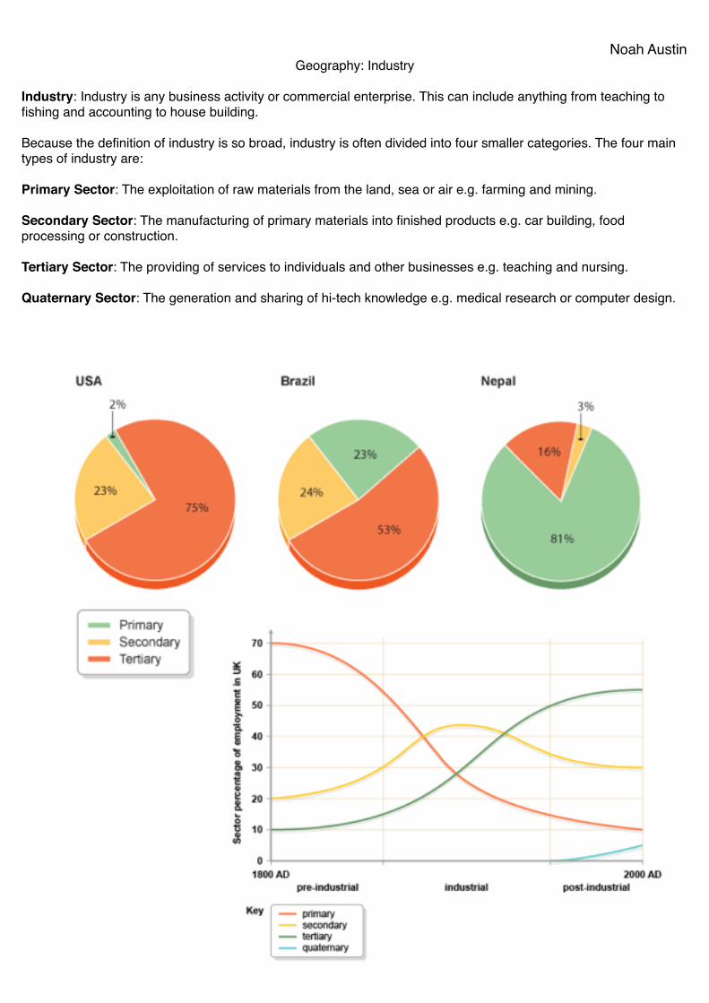
Noah AustinGeography: Industry!!
Industry: Industry is any business activity or commercial enterprise. This can include anything from teaching to fishing and accounting to house building.!!Because the definition of industry is so broad, industry is often divided into four smaller categories. The four main types of industry are:!!Primary Sector: The exploitation of raw materials from the land, sea or air e.g. farming and mining.!!Secondary Sector: The manufacturing of primary materials into finished products e.g. car building, food processing or construction.!!Tertiary Sector: The providing of services to individuals and other businesses e.g. teaching and nursing.!!Quaternary Sector: The generation and sharing of hi-tech knowledge e.g. medical research or computer design.!!!
!!!!!!!!!!!!!!Page � of �45 52

Noah AustinTriangular Graphs!!Triangular graphs are excellent for showing three connected pieces of data that add up to 100%. In Geography we can use them to present any number of things including:!Population structure: old dependents, young dependents and economically active!Employment structure: primary sector, secondary sector and tertiary sector.!!!When presenting a country's employment structure, you should include the quaternary sector in the tertiary sector. You will learn how to read and plot triangular graphs in class, but when reading or plotting there are a few things you should remember:!• When reading check the axis labels carefully!• Always check which way the scale is going 0 to 100 or 100 to
0.!• Remember that each axis of the graph is read in a different
direction!• When you have read the graph, check that you have done it
correctly by seeing if your three figures add up to 100%!!The graph to the right has had three lines drawn on it (moving away from the point) to help read it, but normally the graph will not have these three lines to help you. However, you may draw the three lines yourself to help you read the graph.!!!!!!!!!!!!!!!!!!!!!!!!!!!!!!!!!
Page � of �46 52
Noah AustinGeography: Tourism!!!
Leisure: Any freely chosen activity that takes place in non-work time (IB definition).!!Tourism: The business or industry of providing information, accommodations, transportation, and other services to tourists.!!Domestic Tourist: Someone who goes on holiday in the country that they are resident in (live in).!!International Tourist: Someone who goes on holiday to a country they are not resident in e.g. they live in El Salvador but go to the US for holiday.!!Resort: A type of large hotel that offers extra facilities like swimming pools, spas, restaurants, bars, activities, etc.!!Package Holiday: This is when all aspects of a holiday e.g. flights, hotel, transfers, etc. are included in one overall price.!!All-inclusive: A hotel or resort that includes everything e.g. food, activities and drink in one overall price.!!Low-cost or Budget Airline: Airlines that provide cheap flights by removing all add-ons as standard and charging people if they want then. For example if you want to check in at the airport or check a bag into the hold, reserve a seat or even eat food on the flight, you have to pay extra.!!
!!Reasons for Growth in Tourism!• Leisure Time: Most workers now enjoy a two day weekend and in addition are entitled to several weeks holiday.
This holiday time can be spent going on holiday.!• Paid Holiday: Not only do an increasing amount of workers receive holiday, they are also paid for it. This means
that people do not lose their weekly income by going on holiday.!• Income: More and more people are working in the secondary and tertiary sectors, where pay is generally higher.
Also many more females are now working. This means that more people now have money to spend on holidays (higher disposable income).!
• Transport: Air travel has become relatively cheaper and there are now more airports open for holiday flights. In addition road and rail networks have opened up new tourist destinations. !
• Advertising: People are now bombarded by holiday adverts on the internet, television, radio, mobile phones, billboards, etc. This makes people more aware of holiday destinations and possibly more tempted to book them.!
• Travel Programs: There are a huge amount of travel programs on television so people are able to view destinations that they have not heard of, tempting them to go.!
• Tourist facilities: Tourist facilities have generally improved and increased in number. There are now many more hotels of all sizes and most have fairly standard services.!
• Freedom: More people, especially women and the elderly are free to travel and go on holidays. In addition formerly closed countries like China now allow most of their citizens to travel.!
• Range of holidays: There is now a much greater variety of holidays that can attract potential tourists e.g. golf holidays, diving holidays, walking holidays, cooking holidays.!
Human Attractions Physical Attrations
• Routes of interest!• Religious sites!• Architecturally/historically significant sites!• Memorials!• Hotels!• Shops!• Towns
• Lakes!• National Parks!• Volcanoes!• Beaches!• The sea!• Mountains!• Forests
Page � of �47 52
Noah Austin• Ease of Booking: The internet has now made booking holidays much more straightforward. Also package
holidays allow people to pay one price but have all aspects of their holiday paid for e.g. flights, hotels, etc.!• Credit Cards: More and more people now own credit cards which makes booking holidays and paying for things
in a foreign country much easier.!• Passport Ownership and Visa Regulations: More people now own passports so are able to travel and the
process of obtaining visas is now much more straightforward.!• Retirement and Life Expectancy: People are now living longer and remain healthier longer. An increasing
amount of people also retire with a pension. This means that more people are fit enough and healthier enough to go on holiday.!!
Reasons for Growth in LEDCs!• New Destinations: People are getting increasingly bored of traditional locations and want to experience new
and exotic destinations.!• Exchange Rates: LEDCs often have weaker currencies making going on holiday to them a lot cheaper.!• Advertising/Ease of Booking: LEDCs now advertise themselves much better and it is easier to book these
destinations online.!• Transport: Many countries have upgraded their transport infrastructure making travel to them easier.!• Security: Many LEDCs are now much more stable with less security worries so more people are prepared to go
on holiday to them.!!!Advantages Disadvantages
Social • Local people can perform traditional dance and music to tourists therefore protecting their local culture.!
• Tourists may pay to visit museums protecting local artifacts.!
• Historical ruins may be protected or rebuilt to attract tourists.!
• May improve countries reputation and create cross-cultural links.!
• Encourages education in order to work in tourist sector and should improve linguistic skills
• An increase in tourists may cause greater congestion, leading to longer periods spent away from families. Also increased transport may increase problems of asthma and traffic accidents.!
• Tourism can increase certain crimes, like prostitution and theft!
• People may become more materialistic and homogenised with the arrival of international tourists.!
• May create racial tensions between tourists and locals
Economic • Jobs are created for local workers in hotels, restaurants, etc.!
• Secondary jobs are also created in shops, maintenance firms, etc.!
• Workers and companies pay taxes to the government. This money can then be invested.!
• People learn new skills that can then be transferred to other parts of the economy.!
• New equipment or technology may be introduced to the country which again can be used in other sectors of the economy.!
• Local infrastructure like roads and electricity may be improved.
• Many of managerial jobs go to overseas workers. Local workers often get low paid jobs!
• There is economic leakage (loss of money overseas) because many of the tourist companies are TNCs and the profit is sent elsewhere!
• Many jobs are only seasonal so workers are only paid half of the year e.g. the ski season is less than 6 months long.!
• The increased demand for products and services may cause inflation!
• Countries or regions may become dependent on just one industry.!
• May place pressure on infrastructure e.g. electricity and water supply
Page � of �48 52
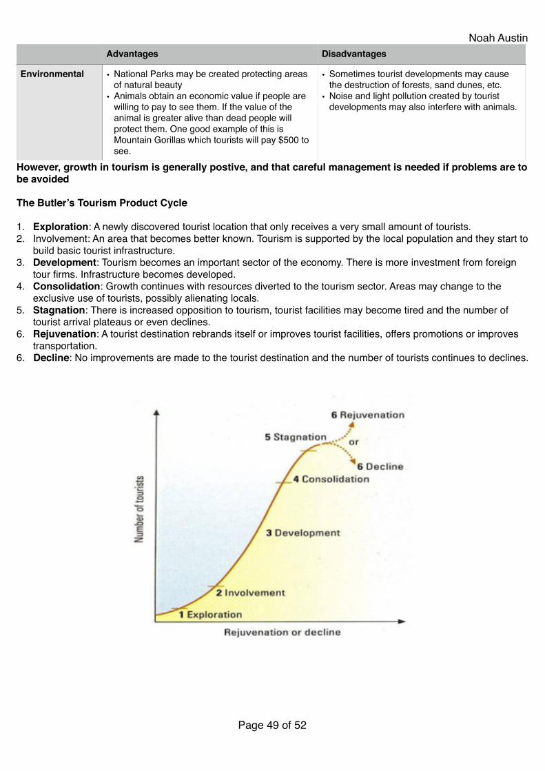
Noah Austin
However, growth in tourism is generally postive, and that careful management is needed if problems are to be avoided!!The Butler’s Tourism Product Cycle!!1. Exploration: A newly discovered tourist location that only receives a very small amount of tourists.!2. Involvement: An area that becomes better known. Tourism is supported by the local population and they start to
build basic tourist infrastructure.!3. Development: Tourism becomes an important sector of the economy. There is more investment from foreign
tour firms. Infrastructure becomes developed.!4. Consolidation: Growth continues with resources diverted to the tourism sector. Areas may change to the
exclusive use of tourists, possibly alienating locals.!5. Stagnation: There is increased opposition to tourism, tourist facilities may become tired and the number of
tourist arrival plateaus or even declines.!6. Rejuvenation: A tourist destination rebrands itself or improves tourist facilities, offers promotions or improves
transportation.!6. Decline: No improvements are made to the tourist destination and the number of tourists continues to declines.!!!!!!!!!!!!!!!!!!!!!!!!!!!!!!
Environmental • National Parks may be created protecting areas of natural beauty!
• Animals obtain an economic value if people are willing to pay to see them. If the value of the animal is greater alive than dead people will protect them. One good example of this is Mountain Gorillas which tourists will pay $500 to see.
• Sometimes tourist developments may cause the destruction of forests, sand dunes, etc.!
• Noise and light pollution created by tourist developments may also interfere with animals.
Advantages Disadvantages
Page � of �49 52
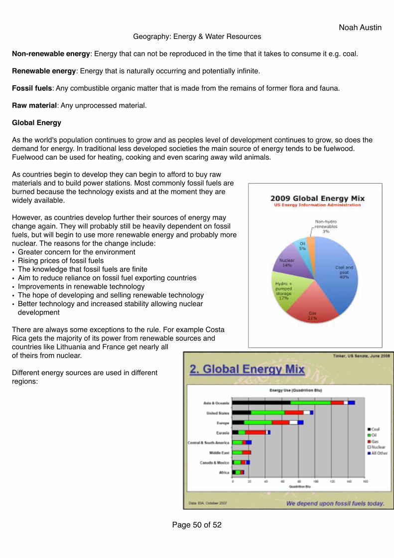
Noah AustinGeography: Energy & Water Resources!!
Non-renewable energy: Energy that can not be reproduced in the time that it takes to consume it e.g. coal.!!Renewable energy: Energy that is naturally occurring and potentially infinite.!!Fossil fuels: Any combustible organic matter that is made from the remains of former flora and fauna.!!Raw material: Any unprocessed material. !!Global Energy!!As the world's population continues to grow and as peoples level of development continues to grow, so does the demand for energy. In traditional less developed societies the main source of energy tends to be fuelwood. Fuelwood can be used for heating, cooking and even scaring away wild animals.!!As countries begin to develop they can begin to afford to buy raw materials and to build power stations. Most commonly fossil fuels are burned because the technology exists and at the moment they are widely available.!!However, as countries develop further their sources of energy may change again. They will probably still be heavily dependent on fossil fuels, but will begin to use more renewable energy and probably more nuclear. The reasons for the change include:!• Greater concern for the environment!• Rising prices of fossil fuels!• The knowledge that fossil fuels are finite!• Aim to reduce reliance on fossil fuel exporting countries!• Improvements in renewable technology!• The hope of developing and selling renewable technology!• Better technology and increased stability allowing nuclear
development!!There are always some exceptions to the rule. For example Costa Rica gets the majority of its power from renewable sources and countries like Lithuania and France get nearly all of theirs from nuclear.!!Different energy sources are used in different regions:!!!!!!!!!!!!!!!!
Page � of �50 52
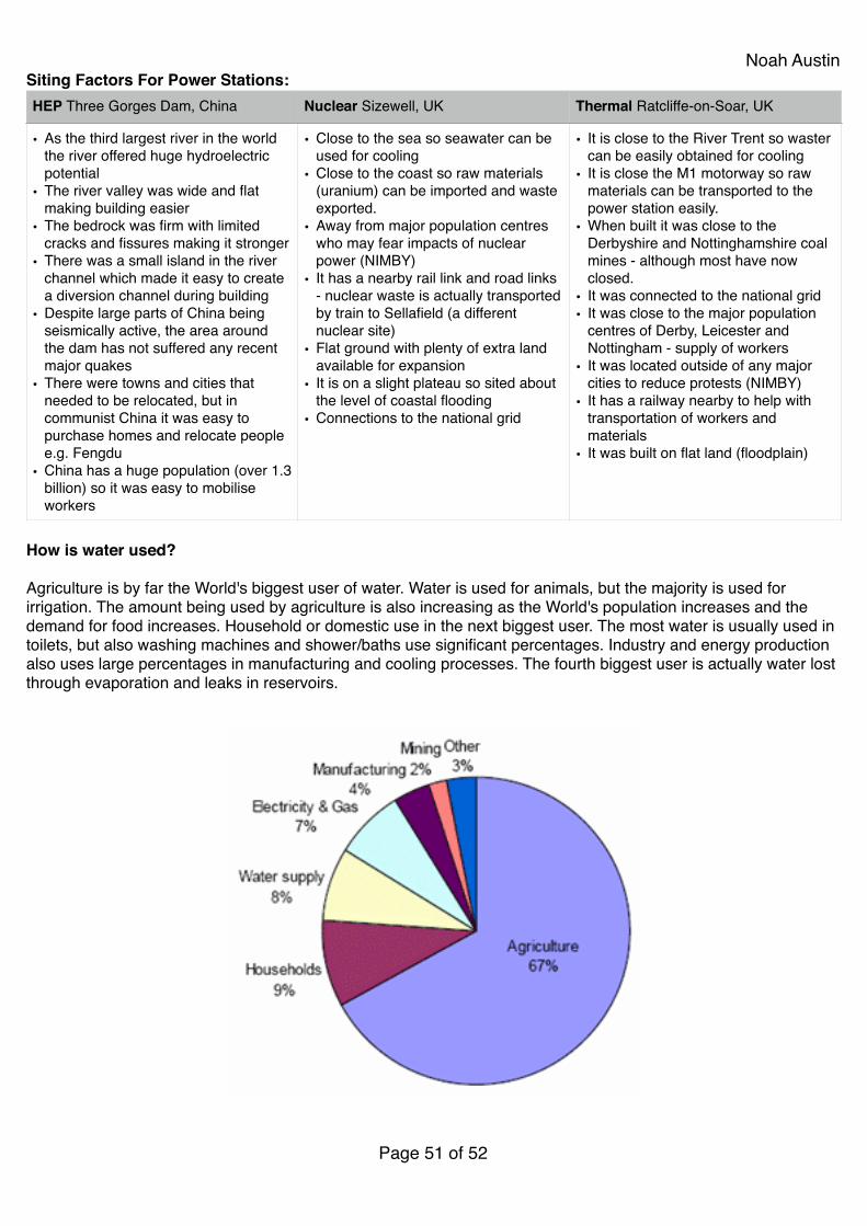
Noah AustinSiting Factors For Power Stations:!
!How is water used?!!Agriculture is by far the World's biggest user of water. Water is used for animals, but the majority is used for irrigation. The amount being used by agriculture is also increasing as the World's population increases and the demand for food increases. Household or domestic use in the next biggest user. The most water is usually used in toilets, but also washing machines and shower/baths use significant percentages. Industry and energy production also uses large percentages in manufacturing and cooling processes. The fourth biggest user is actually water lost through evaporation and leaks in reservoirs.!!!!!!!!!!!!!!!!!!!!!!!!
HEP Three Gorges Dam, China Nuclear Sizewell, UK Thermal Ratcliffe-on-Soar, UK
• As the third largest river in the world the river offered huge hydroelectric potential!
• The river valley was wide and flat making building easier!
• The bedrock was firm with limited cracks and fissures making it stronger!
• There was a small island in the river channel which made it easy to create a diversion channel during building!
• Despite large parts of China being seismically active, the area around the dam has not suffered any recent major quakes!
• There were towns and cities that needed to be relocated, but in communist China it was easy to purchase homes and relocate people e.g. Fengdu!
• China has a huge population (over 1.3 billion) so it was easy to mobilise workers
• Close to the sea so seawater can be used for cooling!
• Close to the coast so raw materials (uranium) can be imported and waste exported.!
• Away from major population centres who may fear impacts of nuclear power (NIMBY)!
• It has a nearby rail link and road links - nuclear waste is actually transported by train to Sellafield (a different nuclear site)!
• Flat ground with plenty of extra land available for expansion!
• It is on a slight plateau so sited about the level of coastal flooding!
• Connections to the national grid
• It is close to the River Trent so waster can be easily obtained for cooling!
• It is close the M1 motorway so raw materials can be transported to the power station easily.!
• When built it was close to the Derbyshire and Nottinghamshire coal mines - although most have now closed.!
• It was connected to the national grid!• It was close to the major population
centres of Derby, Leicester and Nottingham - supply of workers!
• It was located outside of any major cities to reduce protests (NIMBY)!
• It has a railway nearby to help with transportation of workers and materials!
• It was built on flat land (floodplain)
Page � of �51 52
Noah AustinThe Aral Sea!!The Aral sea is an inland lake on the border of Kazakhstan and Uzbekistan. The Aral Sea used to be the fourth largest inland lake in the world, with a surface area of 68,000km2. The sea is fed by two rivers, the Amu Darya and the Syr Darya. Since the 1960's the sea has been shrinking because the two rivers have been diverted to irrigate the desert. The USSR decided to irrigate the desert because they wanted to increase their production of melons, rice, wheat and cotton. Rice and cotton both need extremely high amounts of water to grow. Because the irrigation canals were built quickly, it has been estimated that up to 75% got lost through evaporation or leakage. Even today, only 12% of Uzbekistan's irrigation canals are lined to stop leakage.!!Between 1960 and 1988 the surface of the Aral Sea shrank by nearly 60% and its volume by up to 80%. By 1998 its surface area was only 26, 687km2 making it the eighth largest lake. At the same time the salinity of the lake changed from 10 g/L (grams per litre) to about 45 g/L. In 2004 the Aral Sea was only 17,160km2 or 25% of its original size. By 2007 it was only 10% of its original size and its salinity had increased to 100 /L (normal seawater is only about 35 g/L).!!The rapidly increasing salinity has largely killed the sea's ecosystem. Huge salt plains have appeared as more water is evaporated. The salt on the plains is often whipped up in storms, killing crops and also cooling winters and warming summers. The fishing industry has collapsed and residents health worsened due to inhalation of salt, a lack of clean water and food shortages.
Page � of �52 52