geography termenders 2 · have a go at making your own rebus. postcard mystery r a a i,,, , ,, , ,,...
TRANSCRIPT

GeographyTermenders 2
ISBN: 1-901270-38-6
Cable books are protected by international copyright laws. All rights reserved. The copyright of all material inthis book remains the property of the publisher. No part of this publication may be reproduced, stored in aretrieval system, or transmitted in any form or by any means, for what ever purpose, without the writtenpermission of Cable Educational Ltd. Whilst every effort has been made to ensure that the materials in thispublication are accurate, Cable Educational Ltd. shall not be held liable to any person or persons in respect ofaccidents or incidents caused, by what is contained in or left out of this publication.
Purchase of this book grants permission to reproduce the materials within the purchasing establishment only.
© 2004 Cable Educational Ltd
First Published 1998 by Cable Educational LtdSecond Edition Published 2004PO Box 9FileyNorth YorkshireYO14 0YY
Phone: 01723 890351Fax: 01723 892108email: [email protected]: www.cableeducational.com

1. Rounded mountains mostly coveredby grass and bracken. Highest point886m.
2. Mountainous region with deeplyglaciated valleys containing numerouslakes. Highest point 977m.
3. Open grassy upland area, mostlysurrounded by heather-coveredcommon land. Also contains 48km ofHeritage Coast. Highest point 50m.
4. Dramatic limestone scenery andgritstone edges. The most visited of allthe National Parks in England andWales. Highest point 637m.
5. Limestone scenery and gritstonemoorland straddling the northern endof the Pennines. Highest point 736m.
6. The most recent area to achieve fullNational Park status. A wetland areaof marsh and fen rising no more than12m above sea level.
7. A narrow coastal strip of rugged cliffsand sandy bays. Highest point 536m.
8. First of the Parks in eastern England.Still has the largest area of heathermoorland in England. Highest point454m.
9. High boggy plateaux with granitetops. High annual rainfall. Highestpoint 621m.
10. A remote and sparsely populated Parkstretching northwards from Hadrian’sWall to the Cheviot. Highest point815m.
11. Ice-scoured valleys and high mountainranges, one of which contains thehighest peak in England and Wales.Highest point 1085m.
Finished?
Geography Puzzles and Quizzes 2 © Cable Educational Ltd 2004
1
1. Which National Park would you most like to visit and why?2. Which is the nearest National Park to your school?
Tourism: The national parks ofEngland and Wales
Can you: a) Identify each National Park
by the following clues?b) Name the highest point of
each park?
You will need an atlas for this activity
The Broads
Northumberland
PeakDistrict
North YorkshireMoors
YorkshireDales
LakeDistrict
PembrokeshireCoast
Snowdonia
Brecon Beacons
Dartmoor
Exmoor
1. __________________________________
2. __________________________________
3. __________________________________
4. __________________________________
5. __________________________________
6. __________________________________
7. __________________________________
8. __________________________________
9. __________________________________
10. __________________________________
11. __________________________________

Finished?
Geography Puzzles and Quizzes 2 © Cable Educational Ltd 2004
2
Now try and name the capital city of each country.
The European Union:Mr. Smith’s shirt shop
Mr. Smith sells shirts. Unfortunately, his last delivery of special patriotic shirts,designed like flags, came without labels or colours. See if you can help himby adding the correct colours and then choosing labels from the list below.
Some flags have the same outlines, so decide which is which.
United Kingdom • Ireland • France • Spain • Portugal • Italy • Germany • Belgium •Netherlands • Luxembourg • Denmark • Greece • Austria • Finland • Sweden.
1 2 3
4 5 6
7 8 9
10 11 12
13 14 15

Geography Puzzles and Quizzes 2 © Cable Educational Ltd 2004
3
Tropical rainforests
E Name given to the tallest trees in the forest. __________________Ma Valuable hardwood tree. __________________L Vine-like plants which entwine themselves round tree trunks. __________________A Large reptile, similar to a crocodile. __________________T Bird-eating spider. __________________O Life-giving gas produced by trees. __________________F Type of amphibian, some of which are extremely poisonous. __________________C Name given to the layer of trees approximately 30-40 metres tall. __________________B.R. Stand up to 10 metres above the ground to give support to the trees. __________________Ev Trees have this appearance due to the continuous growing season. __________________J South American’s only big cat. __________________H Rich layer of plant food made by rotting vegetation. __________________U-C Name given to the layer of trees approximately 20 metres tall. __________________Eq Tropical rainforests are found close to this. __________________B South American country with a vast area of tropical rainforest. __________________S.C Name given to the type of farming used by forest tribes. __________________Co Much of the rainfall is of this type. __________________Q A valuable drug found in the rainforest used for the treatment of malaria. ______________R Name given to cattle farming on an extensive scale. __________________S.E A serious problem that often occurs after trees have been cut down
and cleared on a large scale. __________________S.L. Dense undergrowth that develops near rivers where light can
penetrate the forest floor. __________________Br A type of epiphyte, a plant which grows on trees but does not take
nutrients from its host. __________________D.T Adaptation of leaves to shed heavy rainfall. __________________M A mammal commonly found in rainforests but only South
American species have a prehensile tail. __________________Ex Selfish and wasteful use of resources. __________________
E
T
B.R.
M
O
S.C.
J
D.T.
C
R
F
B
Ma
H
Ev
Co
L
Eq
S.E.
A
U-C
Ex
Q
S.L.
Br
E
T
B.R.
M
O
S.C.
J
D.T.
C
R
F
B
Ma
H
Ev
Co
L
Eq
S.E.
A
U-C
Ex
Q
S.L.
Br
Try to solve as many ofthe clues as you can. Theletters in each lily padare the start of theanswer. Write downyour answer and thencolour in the lily pad. Ifyou don’t know theanswer you must choosea different route.Good luck!
Use your skill and try to cross the lily pads,some are more slippery than others!

Finished?
Geography Puzzles and Quizzes 2 © Cable Educational Ltd 2004
4
Have a go at making your own rebus.
Postcard mystery
R
a a
i,
,,
,,
,,
,
,
U2
?
CU
M A
H
(Fem
ale)
C
4
SM
LH
S
LH
LD
H
GB
PA
Can you decode the message and find outwhere the traveller has been?
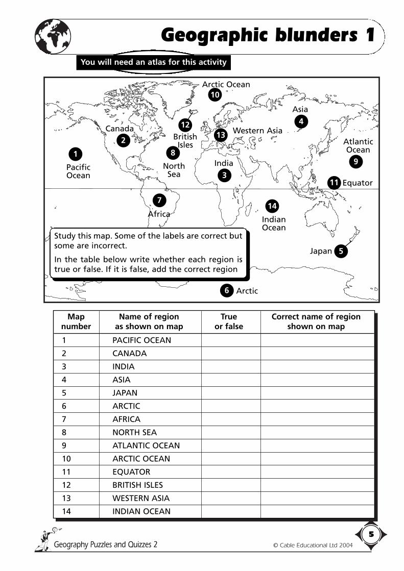
Map Name of region True Correct name of region number as shown on map or false shown on map
1 PACIFIC OCEAN
2 CANADA
3 INDIA
4 ASIA
5 JAPAN
6 ARCTIC
7 AFRICA
8 NORTH SEA
9 ATLANTIC OCEAN
10 ARCTIC OCEAN
11 EQUATOR
12 BRITISH ISLES
13 WESTERN ASIA
14 INDIAN OCEAN
Geography Puzzles and Quizzes 2 © Cable Educational Ltd 2004
5
Geographic blunders 1You will need an atlas for this activity
1
2
8
7
3
13
14
5
11
9
4
6
12
10
Equator
Study this map. Some of the labels are correct butsome are incorrect.
In the table below write whether each region istrue or false. If it is false, add the correct region
Japan
IndianOcean
Arctic
Africa
PacificOcean
NorthSea
CanadaBritishIsles
Western Asia
Asia
Arctic Ocean
AtlanticOcean
India

Finished?
Geography Puzzles and Quizzes 2 © Cable Educational Ltd 2004
6
i) Have a look through your Geography book and find ten importantgeographical places and add your own spelling mistakes.
ii) Now draw a poster or label using those words and see if yourfriends can spot the deliberate mistakes.
Geographic blunders 2
The table below also has some mistakes.See if you can spot them and make the necessary corrections.
Country Capital city True/False Correct capital city
USA NEW YORK
CANADA OTTAWA
BRAZIL MEXICO CITY
AUSTRALIA SYDNEY
JAPAN TOKYO
INDIA MUMBAI (BOMBAY)
CHINA HONG KONG
ITALY ROME
BELGIUM AMSTERDAM
SWEDEN COPENHAGEN
EuropeanUnion
SaveOur
EnviromentProtect theRainforrest
MeditteraneanSea
This WayDangerRisingTempratures
GlobalWarming
EquaterDeciduousTrees
DangerPollushon
Here are someposters and signssome of whichhave spellingmistakes.
Can you spotthem?
If you can, writethe correctspelling on thespace below thepicture.
a) b) c)
d) e) f)
g) h) i)
Finished?
Geography Puzzles and Quizzes 2 © Cable Educational Ltd 2004
7
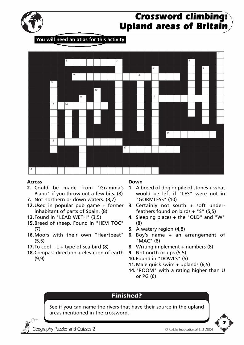
See if you can name the rivers that have their source in the uplandareas mentioned in the crossword.
Crossword climbing:Upland areas of Britain
Across2. Could be made from "Gramma’s
Piano" if you throw out a few bits. (8)7. Not northern or down waters. (8,7)12.Used in popular pub game + former
inhabitant of parts of Spain. (8)13.Found in "LEAD WETH" (3,5)15.Breed of sheep. Found in "HEVI TOC"
(7)16.Moors with their own "Heartbeat"
(5,5)17.To cool – L + type of sea bird (8)18.Compass direction + elevation of earth
(9,9)
Down1. A breed of dog or pile of stones + what
would be left if "LES" were not in"GORMLESS" (10)
3. Certainly not south + soft under-feathers found on birds + "S" (5,5)
4. Sleeping places + the "OLD" and "W"(8)
5. A watery region (4,8)6. Boy’s name + an arrangement of
"MAC" (8)8. Writing implement + numbers (8)9. Not north or ups (5,5)10.Found in "DOWLS" (5)11.Male quick swim + uplands (6,5)14."ROOM" with a rating higher than U
or PG (6)
You will need an atlas for this activity
1
12
13 14
122
2
10
9
13
16
14
8 9
7 8
11
4
15
24
21
17
18
23
2 3 4
5 6
1

1. My last is in monkey and also in manMy fourth isn’t in rain but is in tramMy fifth is in fed but not in foodMy third is in ruse but not in rudeMy seventh is in slide and also in dropAnd my first is in slap but not in slop.
2. My middle is in king but not in crownIt’s also in knight but not in gownMy first is in tick and also in trueAnd my last is in one, forty and two.
3. My second is found at the end of "a treat"My fourth and sixth are in feat but not feetMy fifth is in wife, wasp, woggle and weighAnd my first is in do but not dabble or dray.
4. My first is in cow and also in careMy third is in slate but not in stareMy sixth is in bite but not in bileAnd my sixth and seventh are in took and alsoin style.
5. My first is in broom but not brookMy fifth is in call and also in crookMy eighth is in will but not in wallMy third is in box but not in ballMy ninth is in got and also in lateAnd my tenth is in play but not in plate.
6. My first can be found in both llama and longMy last is in tang but nowhere in strongMy third is in magic, mechanic and moistAnd my second is in till, aerobic and hoist.
7. My fourth is in parrot but not in groatMy third and my eighth are in polish and goatMy sixth is in you, it’s quite plain to seeBut you will have to listen to solve the mystery.My second and fifth are in radish and lateAnd my first stands in solemn, distinguishedand state.
8. My first two are found at the start of "a day"My sixth, eighth and tenth are in drawingand playMy fifth is in saucer and savage and wishAnd my fourth is in willing, quite, vicious andfish.
9. My last is in trouble, late, lousy and balmMy second is in cell but not found in calmMy third is in courage, in yellow and brownAnd my first is in classroom but nowhere inclown.
10. My first three may stop you or sell you a beerMy fifth is in eye and in head and in earMy seventh is in broad, both, bottom and coldMy eighth is in win but not wider or wold.If more help you need then what can I say?The last’s in pizza, a daze and a day.
Solve the riddles and name the cities.
Finished?
Geography Puzzles and Quizzes 2 © Cable Educational Ltd 2004
8
i) Now try to name the country and continent where each city canbe found.
ii) Which of the cities are not capital cities?iii) Which cities are in developing countries?iv) Have a go at making up your own riddles.
Wriggling riddles: Cities
Solve the riddles and name the cities.

Wordsearch: Explorers
Finished?
Geography Puzzles and Quizzes 2 © Cable Educational Ltd 2004
9
1. There are six regions of the world linked with explorers and amystery place not of this world but bearing man’s footprint,hidden in the wordsearch:a) Try to find themb) Name at least one explorer from the wordsearch whose
name is linked with that region.
2. Choose five explorers:a) What are their nationalities?b) When did they live?c) Where did their travels take them?
HudsonMagellanPoloParkFrobisherLewisVasco da GamaBruceCabotClarkCamShackletonCartierBeringDiazAmundsenColumbusCookClappertonScott
N P R Z H E V A L S K Y V S T L Q V
S A C P R E I T R A C Z N H T I P M
P I E L Q M A G E L L A N A T V U A
S Q V C A W Y E L N A T S C O I G C
W A A U O R A Z A I D F I K C N R K
A B C R T C K I O Q E R A L S G M E
A N S I M A I K S R K O M E S S A N
T U T S R S F T M A A B A T Y T R Z
G A S A E E T R C S R I G O R O C I
B C S T R T M R I R D S A N A N H E
R K O M R C R A O C A H D I E E L A
U R P L A A T O E N A E O B P B A M
C A Z E U N L I C H G R C A M S N U
E P Y W Z M O I C K T C S L J M D N
B E R I N G B L A A M O A B O H S D
H U D S O N N U O O S O V O D V B S
I P X C A B O T S P I K N A K B F E
O R R A Z I P L C L A P P E R T O N
CortesDrakeStanley
PearyBalboaPrzhevalsky
LivingstoneMackenziePizarro
TasmanMarchlandArmstrong
Find the words in the wordsearch. They maygo forwards, backwards or diagonally.
You will need a dictionary or theinternet for this activity

Geography Puzzles and Quizzes 2 © Cable Educational Ltd 2004
10
1. Tick which of these hills is the higher.
A. ❏ B. ❏
2. How did you work out your answer?
3. Spot the spur: Write "valley" or "spur" beneath each diagram and say how you know.
4. i) Which of these trees are evergreen and which are deciduous?
ii) Which of these trees are coniferous?
a) Spruce b) Holly c) Larch d) Oak
i) _____________ _______________ _______________ _______________
ii) _____________ _______________ _______________ _______________
50
100150
75
50
25150100150
150
100
50
125100755025
Picture puzzle 1
Use your powers of deduction and research to answer the following questions.
a) b) c)

5. i) How long is each of these roads? ii) Circle the longest road.
i) ___________________ ____________________ _____________________
6. In which direction is the river flowing?Draw an arrow under each diagram to show the direction of the river flow.
7. Direction of slope. Try to work out the shape of the land by looking at thethree diagrams below (A, B and C). Draw a cross section for each in the box.
8. Which tree produces these? (Choose from the list of trees below.)
Finished?
Geography Puzzles and Quizzes 2 © Cable Educational Ltd 2004
11
Have a look at an 1.5 map and choose a small area to practise the skills you usedin Q7. Draw a cross section to show the relief of the land you have selected.
Picture puzzle 2
50
100
150
100
100
100
150
150
100
50
0 500 metres
A27
0 5000
metres
A64
0 500 metres
A14
25 50 75 100
125
150
50 75 100
100
75 50 100
75 100
75 50 25
0
100
150
50
200
0
100
150
50
200
0
100
150
50
200
A B C
A B C
A B C
Cross section A Cross section B Cross section C
• Beech• Oak• Birch• Horse chestnut
• Ash• Rowan• Holly Alder
Acorn Conker Catkins

1. Which of these animals are indigenous (native) to the British Isles?
a) Red Deer b) Red Squirrel c) Grey Squirrel d) Hare e) Rabbit
Yes/No Yes/No Yes/No Yes/No Yes/No
2. Which bird of prey can often be seen hovering by the roadside as it hunts for its prey?
a) Kestrel ❏ b) Sparrow Hawk ❏ c) Buzzard ❏
3. What do you call a female:
a) Fox ______________ b) Badger _______________ c) Deer _________________
d) Rabbit ____________ e) Swan _______________ f) Horse _________________
4. Which animal do you associate with the following homes and nests?
a) Set ______________ b) Drey _______________ c) Warren ________________
d) Earth _____________ e) Eyrie _______________
5. What do you call a baby:
a) Rabbit ____________ b) Deer _______________ c) Eel _________________
d) Swan _____________ e) Hare _______________ f) Pigeon ________________
g) Horse _____________ h) Goat _______________ I) Goose _________________
6. Can you identify the following trees by sorting out these anagrams?
a) CEHBE _______________________________ b) HAS ____________________________
c) CHOSEN RESTHUT ____________________ d) SOMECARY ____________________
e) LILOWW _____________________________ f) OKA ___________________________
7. In which of these four habitats: woodland, moorland, marsh, farmland, would yoube likely to find the following plants?
a) Poppy _____________ b) Bilberry ______________ c) Primrose _____________
d) Kingcup _____________ e) Bluebell ______________ f) Dandelion ____________
g) Heather _____________ h) Pendulous Sedge __________________
Finished?
Geography Puzzles and Quizzes 2 © Cable Educational Ltd 2004
12
Design a fact file and find out as much as you can about yourfavourite animal or plant.
Fauna and flora of the British Isles

Section A True False1. The campsite is N.E. of the Information Centre ❏ ❏2. The Public House is W. of the Campsite ❏ ❏3. The Windmill is S.E. of the School ❏ ❏4. Brook Farm is N.E. of the Campsite ❏ ❏5. Grid reference 3016 contains non-coniferous woodland ❏ ❏6. The Church is North of the Windmill ❏ ❏7. The Telephone is in grid reference 1525 ❏ ❏8. If the children go from the School to the Church they have to cross the A69 ❏ ❏9. The Church nearest to the School has a tower ❏ ❏10. The Post Office is the nearest building to the School ❏ ❏Now check that you have answered questions 5 & 7 correctly before going on to section B.
Section BGive the grid references of the following places.a) Church with a spire ____________ g) Windmill _____________b) Picnicsite ____________ h) Information Centre _____________c) Tumulus ____________ i) Public Telephone _____________d) Brook Farm ____________ j) School _____________e) Post Office ____________ k) Non-Coniferous Wood ____________f) Campsite ____________ l) Coniferous Wood _____________
Finished?
Geography Puzzles and Quizzes 2 © Cable Educational Ltd 2004
13
Have a go at drawing your own map and make up some questionsfor your friends to answer.
Basic skills: 4 figure grid reference,0S map symbols and compass directions
B173B173
BrookFmBrookFm
PH
P
Sch
Sch
PH
P
Fm
25 27 2926 28 3130
17
15
13
16
14
12
11
i
i Information Centre
Picnic Site
Campsite
Public Telephone
Coniferous Wood
Non-Coniferous Wood
Church with spire
Church with tower
Windmill
Building
Post Office
Public House
School
Farm
Tumulus

Geography Puzzles and Quizzes 2 © Cable Educational Ltd 2004
14
Drive the National Parks
Y First area to bear the title "National Park". _____________________K Site of mass trespass in 1932. _____________________L Type of rock quarried in several of the parks. _____________________S Highest mountain in England and Wales. _____________________G Means it was shaped by ice. _____________________P.D. First National Park in England and Wales. _____________________O Name given to mineral-bearing rock. _____________________A Study of the remains of ancient civilisations. _____________________Gr Moorland bird which feeds on young heather shoots. _____________________Sh Grazing animal common in most National Parks. _____________________E.P. Rare and ancient breed of animal associated with one particular park. _____________________Q Controversial activity in many Parks which creates employment but
scars the landscape. _____________________P.R. Protects the landscape and gives advice to visitors. _____________________E Problem in certain areas especially footpaths, caused by large numbers
visiting the Parks. _____________________En One of the aims of the National Parks is to preserve and care for this. _____________________R&E The Parks were also set up to provide a place for this. _____________________L.S.M. Cities close to the most visited of all of the Parks. _____________________P Largest ownership of land in the Parks. _____________________C People whose chief concern is the protection of the landscape and
the flora and fauna. _____________________B A native fern which has become a problem in certain areas due to its
invasive tendencies. Toxic to sheep. _____________________F A good servant but a dangerous master. Used to regenerate heather.
Problem in hot dry weather. _____________________Li Unsightly and potentially dangerous. Expensive to collect in rural areas.
Visitors should take theirs home with them. _____________________W.D. Tradition of created biblical scenes by pressing flower petals into clay. _____________________Bi Type of tree associated with upland areas. _____________________T Ancient burial mound. _____________________
Y K L S G
Sh Gr A O P.D.
E.P. Q P.R E En
B C P L.S.M. R&E
F Li W.D. Bi T
Try to solve as many ofthe clues as you can todrive the course.
The letters in each circleare the start of theanswer.
Write down your answerand then colour in thestopping point.
Good Luck!
START
FINISH

Geography Puzzles and Quizzes 2 © Cable Educational Ltd 2004
15
National Park statistics:Figures and fun rolled into one 1
NATIONAL PARK
Area (ha) 135,144 95,338 68,637 229,198 104,947 143,603 143,833 58,431 214,159 176,869 30,292
Highest Point 886 621 519 987 815 454 637 536 1085 736 12
Population 32,200 29,100 10,000 40,000 2,200 25,000 37,400 23,000 23,800 18,600 5,500
Visitor Days 7 8 3 20 1 11 22 13 11 9 3
Bre
con
Bea
con
s
Dar
tmo
uth
Exm
oo
r
Lake
Dis
tric
t
No
rth
um
-b
erla
nd
No
rth
York
shir
eM
oo
rs
Peak
Dis
tric
t
Pem
bro
ke-
shir
e C
oas
t
Sno
wd
on
ia
York
shir
eD
ales
The
Bro
ads
Note: Visitor days � number of visitors � the number of days they visited the park.(Shown in millions per annum)
Land ownership/management %
Private 69.6 57.3 79.1 58.9 56.4 79.9 72.3 85.7 69.9 96.2 90.8
Forestry8 1.8 1.8 5.9 18.9 16.6 0.5 1.3 15.8 0 0.2
Commission
Ministry of0.1 14 0 0.2 22.6 0.5 0.3 4.6 0 0.3 0
Defence
WaterCompanies
4 3.8 0.6 6.9 1.2 0.1 13 0 0.9 0.3 1.5
NationalTrust
3.5 3.7 10.1 24.2 0.7 1.2 9.6 4.2 8.9 2.5 3
English Nature/CCW
0.8 0.3 0 0 0 0 0.1 0.5 1.7 0.4 4
National ParkAuthority
13 1.4 4.4 3.9 0.2 0.6 4.2 2.3 1.2 0.1 0.5
Other 1 0 4 0 0 1.1 0 1.4 1.6 0.2 0

Geography Puzzles and Quizzes 2 © Cable Educational Ltd 2004
16
National Park statistics:Figures and fun rolled into one 2
A. Using the information in the table on the previous page:1) Draw a bar graph, listing the National Parks in order of size (area ha).
Remember to give your graphs a title.2) Keeping the same order for the National Parks as in graph 1, draw a bar
graph showing the number of residents in each park.3) Still keeping the same order for the National Parks, draw a bar graph
showing the number of visitor days.
B. Now try to answer the questions.1) Which park has the least number of visitors per year?2) Which is the largest park?3) Which is the smallest park?4) Which park or parks do you think will be under most pressure due to
numbers of residents and visitors? (Give your reasons).5) Which parks would you recommend to tourists wishing to visit upland
areas of England and Wales?6) Which park would you recommend to someone who was afraid of
heights?
C. 1) Choose two of the National Parks and draw pie graphs to show landownership/management.
2) Is there anything about the figures which surprises you?
D. Which park would you most like to visit? Give your reasons.

Geography Puzzles and Quizzes 2 © Cable Educational Ltd 2004
17
Where on Earth 1
Animals shown pictured:Penguin • Kangaroo • Panda • Polar bear • Ostrich • Lion • Tiger • Llama • Camel •Yak • Bison • Koala • Red fox • Walrus • Badger • Aardvark • Wolf • Armadillo.
Finished?
Choose any one of the animals shown above and create a fact fileby finding out all you can about it.
Where on earth would you expect to find these animals?
Cut out the pictures and stick them on the outline map of the world on sheet 2.
Try to place the animals near to their natural habitat, but in the sea or ocean ifpossible, and then draw an arrow from the picture to the actual location.

Geography Puzzles and Quizzes 2 © Cable Educational Ltd 2004
18
Where on Earth 2

Finished?
Geography Puzzles and Quizzes 2 © Cable Educational Ltd 2004
19
You’ve found the words. Now try to answer these questions:1) Which word from the wordsearch is the defining feature of a desert?2) Are all deserts hot?3) What are lithops?4) Which camel has one hump?5) What type of leaves do desert plants have?6) Which word from the wordsearch means developed for, or adjusted
to, a new or different environment?7) What is desertification?8) Find three of the deserts named in the wordsearch and say which
continent they are in.
Wordsearch: The arid landsSaharaDesertNamibOasisCamelColdSeifGobiWadiHotAquifierKalahariMeerkatLithopsFleshy stemNocturnalDromedaryFennec foxCloudless
Date palmAtacamaBactrianScorpionAridityBarchanSaguaroDesertificationGreat VictoriaBarrel cactusCreosote bushMushroomrockPrickly pearKangaroo ratSpiky leavesRattlesnakeAdaptationBedouinLizardsSonoran
Find the words in the wordsearch. They maygo forwards, backwards or diagonally.
R E I F I U Q A Q B N O I T A T P A D A
K T T A R O O R A G N A K H A P Y L E N
N C X J F I E S M E T S Y H S E L F T I
Q A O N O I T A C I F I T R E S E D A U
N R R R L N X O F C E N N E F C T X K O
A A M O M H P G W K S D L O C D Y F R D
M H M L N O R R A E O S Y I O E S Q E E
H A B I B O O N I K L R I G A S U L E B
I S X R B N S R A C A E R X S E T B M D
S G U G X E O L H D K E M B I R C L Z K
H E T B L Z A I E S A L A A S T A G S Y
O Q V T E H C M P T U C Y S C N C M O T
T R T A A T O L V R T M M P R U L L B I
S A A R E R O I O R O A R U E Q E A A D
R D I U D L C S I U F C T O X A R P R I
G U R L G T Y A O F D C S A H P R E C R
Y O B A O A N K E E O L N K C V A T H A
I N B R Z O S D I N R F E Y J A B A A O
T J I I L I T H O P S C D S S P M D N D
S A W A D I L G J W S J V C S E L A W X

Finished?
Geography Puzzles and Quizzes 2 © Cable Educational Ltd 2004
20
Now try to write your own set of directions using symbols and seeif your friends can decode your letter.
Navigational nightmare:Coping with Ordnance Survey symbols
Decode the symbols and then write out theletter in your best handwriting.
Hi Chris,�Here are the directions I promised.�Turn right when you reach the PH (The Bay Horse) and carry on until you pass a . Go over the and through a , you will see signs for a and a on your left and a little further on there is a clearing with and a ��As you come out of the , you will see a on the opposite. Follow the as it winds down into the .��Go over the and turn right at the T-junction. You will see a on your left and a little further a next to a . Pull into the and walk over to the , it is next to the P.�Follow the that is signposted to the but be careful, one section of the runs along the side of a and in wet weather can be very ��I will be arriving at the at about 3pm.��See you soon, Sam�
PC.
A165
LC
.
�150
10050 150
10050
iP

Geography Puzzles and Quizzes 2 © Cable Educational Ltd 2004
21
Italy: Wordsearch
Alps North Italian PlainRiver PoApenninesMount VesuviusMount EtnaAdriatic SeaMediterranean SeaSicilySardiniaMont BlancVolcanoesOlivesGrapesLemonsTomatoesIce-creamWineMichelangeloColumbusVivaldiRoman EmpireRoman CatholicPizzaPasta
M I A O T C I L O H T A C N A M O R
E I S E O T A M O T O R S Q T N N L
C A C T S G I Y Z O I E A Q L I V I
N I W H P N E N L S O D G U A N M W
E T I A E C A I F N D E L L X O R A
R H N I I L V E A E R L P A U A D X
O E E N K E A C N I F N D N V R P O
L O E I S M L N P A A A T M I I G I
F V P D U O O M G I R V A A W M V C
S M R R V R E U L E E R T P O M A E
N I X A E N K A N R L I E N R P U C
O L E S A V T A S T C O T T E R A R
M A I M H I I U L S E B Q N I H I E
E N O S H P V R E P L T N A P D H A
L R W T A I Q A I A S I N S V E E M
V E R S U Z X Z N N N K W A F E L M
W O T S X T Z C P E S I C I L Y E H
N A S E P A R G S A S U B M U L O C
Finished?
1) Now see if you can find the four cities hidden in the wordsearch.2) Why is Mount Vesuvius linked with the town of Pompeii?3) Who are the three famous Italians mentioned in the wordsearch?
What are they famous for?
Find the words in the wordsearch. They maygo forwards, backwards or diagonally.

Geography Puzzles and Quizzes 2 © Cable Educational Ltd 2004
22
Kenyan crossword
Across1. Type of farming that, despite hard
work, produces only just enough foodfor the family and rarely leavesanything over for sale. (11)
3. Despite being on the Equator, this canbe found on the top of Mount Kenya.(4)
4. Name given to produce grown forexport. (4,4)
7. Small garden used for growing fruit andvegetables. (6)
9. Kenya’s most valuable cash crop, grownon large estates. (3)
10. Semi-nomadic, pastoralist tribe. (6)13. Steep-sided geological feature caused
by the collision of two plates. (4,6)14. Continent in which Kenya is found. (6)15. Beautiful but fragile, living barrier
found off shore. (5,4)17. Kenya’s fastest growing industry.
Successful way of earning money fromoverseas. (7)
18. Important line of latitude runningthrough Kenya. (7)
19. Vast area of water to the east of Kenya.(6,5)
20. Cereal crop grown in most shambas. (5)21. Name given to farming when crops or
animals are produced on a large scalefor profit. (10)
Down2. Famous National Park/Game Reserve
west of Nairobi. (6,4)3. National Park/Game Reserve near
Mount Kenya. (7)5. Crowded and squalid settlement on
outskirts of town or city. Home to thepoor and under-privileged. (6)
6. Largest area of inland water in Kenya.(4,8)
8. Capital city of Kenya. (7)11. Mount Kenya is one of these. (7)12. Highest point in Kenya. (5,5)16. Popular, organised tour of game
reserve. (6)
1
12
13 14
122
2 3
10
9
13 13
14
15
84
10 11
12
5
7 6 7
8 9
11
4
15
24
18
19
20
21
16 17
23
2 3
5

Finished?
Geography Puzzles and Quizzes 2 © Cable Educational Ltd 2004
23
Have a go at writing some questions which will feature the two carsyou named for your answer to question 10.
Driving me crazy: Touring the E.U.
1. Name each of the countriesrepresented.
2. Name the capital city of each country.3. Which of these cars cannot take a trip
to the seaside without drivingthrough another country?
4. Which of these cars can drive downto the Mediterranean Sea withouttravelling through another country?
5. Which of these cars belong toScandinavian countries?
6. Which of these cars can drive thefurthest west without crossing anational frontier?
7. Which of these cars has the greatestnumber of options when it comes tovisiting neighbouring E.U. Countries?
8. Which cars could stay in their owncountry yet park on the primemeridian (0º Longitude)?
9. Which car could park outside theheadquarters of the E.U. withoutcrossing a national frontier?
10. Which two cars have not beenmentioned in the answers forquestions 3–10?
Each of the cars below has its international registrationletters shown on the numberplate. All of these cars are fromcountries that are members of the E.U. (European Union).Answer the questions below.
You will need an atlas for this activity
GB E D L
A IRL P B
DK FIN F I
NL GR S

Geography Puzzles and Quizzes 2 © Cable Educational Ltd 2004
24
Many years ago Sir Horatio TheodoreHogwash, a fictitious pilot, set off on a journeyaround the capitals of the world. Unfortunately, not only was he absent-minded, healso had a poor sense of direction. The record of his journey is shown below. He onlymanaged to visit 20 capital cities and forgot to fill in certain bits of his log book.
Latitude Longitude City Country Continent
51°N 0°W London
59°N 10°E Norway
Rome Europe
31°E Egypt
Nairobi Africa
28°N 77°E Asia
39°N Beijing
Japan Asia
35°S 149°E Canberra
41°S New Zealand Australasia
Buenos Aires
12°S 77°W South America
47°W Brazil
20°N 100°W North America
38°N 77°W USA
45°N 75°W
36°N Algiers Africa
Madrid
52°N 21°E Europe
51°N 0°W
See if you can:i) Complete the table and discover just where he did go.ii) Using the map provided on the next page, draw the route he took.
Flight of fancy 1
You will need a pencil, ruler and atlasfor this activity

160°
40°
0°
40°
80°
12
0°
160°
80°
12
0°
80°
60°
20°
20°
0°
40°
60°
40°
80°
60°
40°
20°
20°
0°
40°
60°
160°
12
0°
80°
40°
0°
40°
80°
12
0°
160°
80°
80°
Geography Puzzles and Quizzes 2 © Cable Educational Ltd 2004
25
Flight of fancy 2
Ind
ian
Oce
an
Paci
fic
Oce
an
Atl
anti
c O
cean
Equ
ato
r
Geography Puzzles and Quizzes 2 © Cable Educational Ltd 2004
26
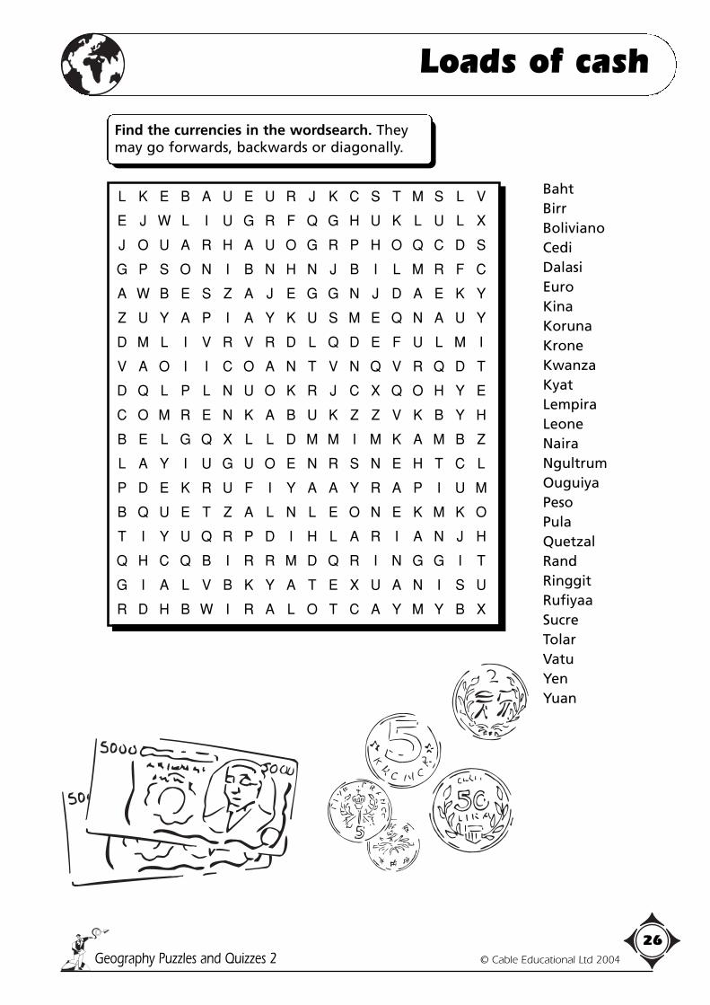
Loads of cash
BahtBirrBolivianoCediDalasiEuroKinaKorunaKroneKwanzaKyatLempiraLeoneNairaNgultrumOuguiyaPesoPulaQuetzalRandRinggitRufiyaaSucreTolarVatuYenYuan
L K E B A U E U R J K C S T M S L V
E J W L I U G R F Q G H U K L U L X
J O U A R H A U O G R P H O Q C D S
G P S O N I B N H N J B I L M R F C
A W B E S Z A J E G G N J D A E K Y
Z U Y A P I A Y K U S M E Q N A U Y
D M L I V R V R D L Q D E F U L M I
V A O I I C O A N T V N Q V R Q D T
D Q L P L N U O K R J C X Q O H Y E
C O M R E N K A B U K Z Z V K B Y H
B E L G Q X L L D M M I M K A M B Z
L A Y I U G U O E N R S N E H T C L
P D E K R U F I Y A A Y R A P I U M
B Q U E T Z A L N L E O N E K M K O
T I Y U Q R P D I H L A R I A N J H
Q H C Q B I R R M D Q R I N G G I T
G I A L V B K Y A T E X U A N I S U
R D H B W I R A L O T C A Y M Y B X
Find the currencies in the wordsearch. Theymay go forwards, backwards or diagonally.

Geography Puzzles and Quizzes 2 © Cable Educational Ltd 2004
27
Holidays in Spain
Py Mountains that divide Spain from France. __________________________E Currency. __________________________M Capital city. __________________________Pa Traditional dish of rice and fish/meat. __________________________To Major industry. __________________________Ta Snacks. __________________________Fl Dance. __________________________Fi Festival. __________________________S Midday sleep. __________________________C.D.S. Popular holiday area. __________________________A Area of Spain. __________________________Ba Second largest city. __________________________Gu River. __________________________Be Popular holiday destination. __________________________Pl Main square in any town or village. __________________________Tu Nougat. __________________________R.C. Main religion. __________________________B.F. Popular entertainment? __________________________G Cold soup. __________________________Pa Historic accommodation. __________________________M Sea. __________________________Ga Architect. __________________________Gi A Rock – British or Spanish. __________________________Mu Highest peak in Spanish mainland. __________________________
Py
Be
Mu
S
Ga
R.C.
E
Pl
To
Pa
Pi
M
C.D.S.
Gi
A
Tu
Ga
P
M
Ta
Fl
Ba
B.F.
Fi
Gu
Py
Be
Mu
S
Ga
R.C.
E
Pl
To
Pa
Pi
M
C.D.S.
Gi
A
Tu
Ga
P
M
Ta
Fl
Ba
B.F.
Fi
Gu
The letter in eachsunbed is the start ofthe answer.
Write in the answer inthe space providedand then colour in thesunbed.
If you don't knowthe answer, you mustchoose a differentroute.
Good luck!
See if you can cross the sunbeds.Some clues are more difficult than others.
Geography Puzzles and Quizzes 2 © Cable Educational Ltd 2004
28
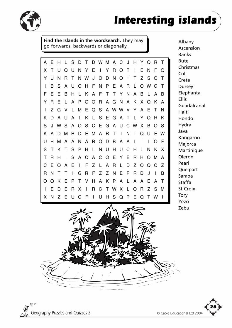
Interesting islands
AlbanyAscensionBanksButeChristmasCollCreteDurseyElephantaEllisGuadalcanalHaitiHondoHydraJavaKangarooMajorcaMartiniqueOleronPearlQuelpartSamoaStaffaSt CroixToryYezoZebu
A E H L S D T D W M A C J H Y Q R T
X T U Q U N Y E I Y R O T I E N F Q
Y U N R T N W J O D N O H T Z S O T
I B S A U C H F N P E A R L O W G T
F E E B H L K A F T T Y N A B L A B
Y R E L A P O O R A G N A K X Q K A
I Z G V L M E Q S A W W V Y A E T N
K D A U A I K L S E G A T L Y Q H K
S J W S A Q S C E G A U C W X B Q S
K A D M R D E M A R T I N I Q U E W
U H M A A N A R Q D B A A L I I O F
S T K T S P H L N U H U C H L N K X
T R H I S A C A C O E Y E R H O M A
C E O A E I F Z L A R L D Z O Q C Z
R N T T I G R F Z Z N E P R D J I B
O Q K E P T V H A K P A L A A E A T
I E D E R X I R C T W X L O R Z S M
X N Z E U C F I U H S Q T E Q T W I
Find the Islands in the wordsearch. They maygo forwards, backwards or diagonally.

Finished?
Geography Puzzles and Quizzes 2 © Cable Educational Ltd 2004
29
Choose any one of the animals shown above and create a fact fileby finding out all you can about it.
Animal magic 1
Animals shown pictured:Giraffe • Tree frog • Red squirrel • Mountain goat • Barbary ape • Etruscan shrew •Hermann’s tortoise • Caribou • Moose • Manatee • Racoon • Toucan • Howler monkey •Sailfish • Tapir • Piranha.
Where on earth would you expect to find these animals?
Cut out the pictures and stick them on the outline map of the world on sheet 2.
Try to place the animals as near to their natural habitat as possible, and thendraw an arrow from the picture to the actual location.

Geography Puzzles and Quizzes 2 © Cable Educational Ltd 2004
30
Animal magic 2
Geography Puzzles and Quizzes 2 © Cable Educational Ltd 2004
31
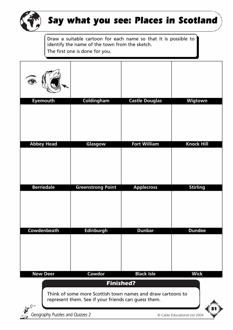
Say what you see: Places in Scotland
Finished?
Think of some more Scottish town names and draw cartoons torepresent them. See if your friends can guess them.
Eyemouth Coldingham Castle Douglas Wigtown
Abbey Head Glasgow Fort William Knock Hill
Berriedale Greenstrong Point Applecross Stirling
Cowdenbeath Edinburgh Dunbar Dundee
New Deer Cawdor Black Isle Wick
Draw a suitable cartoon for each name so that it is possible toidentify the name of the town from the sketch.The first one is done for you.

Geography Puzzles and Quizzes 2 © Cable Educational Ltd 2004
32
Waterfalls wordsearch
Akaka
Boyoma
Della
Elsalto
Feather
Fincha
Gavarnie
Glass
Glomach
Helena
Kegon
Khone
Marina
Minnehaha
Nevada
Niagara
Ntaruk
Rhaiadr
Sluiskin
Snoqualmie
Tisisat
Tugela
Tully
Urubupunga
Vernal
Vetti
Victoria
A S B Z S J W H F J H U L A N R E V
K S L O K W O K O G R N L Z X D S B
A A N L Q W P T I U H E O R T L A Q
K L F O C V L A B E G H V G K L I C
A G C O Q A U U T U G V A N E L E H
I E S F S U P M T U F U T N X K A C
R Z F L E U A S L U I S K I N B B A
O X E Z N A E L T B R H Z I P O O M
T Q U G R Y T H M C E T Z A Z Y Y O
C S A A E H L H T I R R A H B O A L
I C V N N K A L E S E N T A U M N G
V F O E U I U I U R A R I H A A Y W
U H X O T Y R R A T Q G S E D I C X
K C C H U T A A A D S W I N A E D F
G A V A R N I E M T R L S N V O E F
T R Y J A R A G A I N W A I E Y L L
N K G T W C A H C N I F T M N T L X
C I L J R E Z W P L B H S M L H A O
Find the waterfalls in the wordsearch. Theymay go forwards, backwards or diagonally.

AnswersAnswers
Page 1: Tourism1. Brecon Beacons, Brecon Beacons2. Lake District, Scafell Pikes3. Exmoor, Dunkery Beacon4. Peak District, High Peak5. Yorkshire Dales, Whernside6. The Broads7. Pembrokeshire Coast, Presely Hills8. North Yorkshire Moors, Urra Moor9. Dartmoor, High Willhays10. Northumberland, The Cheviot11. Snowdonia, Snowdon
Page 2: The European UnionUnited Kingdom 4Ireland 1,6,11,15France 1,6,11,15Spain 12Portugal 13Italy 1,6,11,15Germany 2,8,9,10Belgium 1,6,11,15Netherlands 2,8,9,10Luxembourg 2,8,9,10Denmark 14Greece 7Austria 2,8,9,10Finland 3,5Sweden 3,5
Page 3: Tropical rainforests
Page 4: Postcard mysteryDear Tony,How are you? I have been to America,Wales, Finland, China, Turkey, Singapore,Panama, Belgium, Thailand and Cuba.See you soon.Love Emma.
Page 5: Geographic blunders 11. Pacific Ocean TRUE2. Canada FALSE North America3. India FALSE Africa4. Asia TRUE5. Japan FALSE New Zealand6. Arctic FALSE Antarctica7. Africa FALSE South America8. North Sea FALSE Atlantic Ocean9. Atlantic Ocean FALSE Pacific Ocean10. Arctic Ocean TRUE11. Equator TRUE12. British Isles FALSE Iceland13. Western Asia FALSE Western Europe14. Indian Ocean TRUE
Page 6: Geographic blunders 2A. RainforestB. EnvironmentC. CorrectD. CorrectE. Temperatures
F. MediterraneanG. PollutionH. CorrectI. Equator.
E EmergentsMa MahoganyL LianasA AlligatorT TarantulaO OxygenF FrogC CanopyB.R. Buttress RootsEv EvergreenJ JaguarH HumusU-C Under-canopy
Eq EquatorB BrazilS.C. Shifting
CultivationCo ConventionalQ QuinineR RanchingS.E. Soil ErosionS.L. Shrub LayerBr BromeliadD.T. Drip TipM MonkeyEx Exploitation
Geography Puzzles and Quizzes 2 © Cable Educational Ltd 2004
33
Country Capital city True/False Correct capital city
USA NEW YORK FALSE WASHINGTON D.C.
CANADA OTTOWA TRUE
BRAZIL MEXICO CITY FALSE BRASILIA
AUSTRALIA SYDNEY FALSE CANBERRA
JAPAN TOKYO TRUE
INDIA BOMBAY FALSE DELHI
CHINA HONG KONG FALSE PEKING/BEIJING
ITALY ROME TRUE
BELGIUM AMSTERDAM FALSE BRUSSELS
SWEDEN COPENHAGEN FALSE STOCKHOLM

Geography Puzzles and Quizzes 2 © Cable Educational Ltd 2004
34
Answers
Page 7: Crossword climbing
Page 8: Wriggling riddles
Extraii) 4, 7, 10iii) 4, 5, 6, 7, 8
Page 9: Wordsearch: Explorers
Extra1) a) The Americas Arctic Ocean
Asia AntarcticaAfrica The MoonAustralasia
1) b) Cortes = conqueror of Mexico/SouthAmerica
Drake = North Carolina/also aroundthe globe
Peary = Arctic explorer/also North PolePizarro = Pacific coast/AmericaCook = America/AustraliaMagellan = India and ChinaFrobisher = North West passage to the
OrientLivingstone = Africa.
Page 10/11: Picture puzzle1. (a).
2. Contours go up to 150 on (a) and up to125 on (b).
3. a) (VALLEY) Contours "point" towardshigher ground.
b) (SPUR) Contours "point" towardslower ground.
c) (SPUR) Contours "point" towardslower ground.
4. a) SPRUCE – Evergreen Coniferousb) HOLLY – Evergreenc) LARCH – Deciduous Coniferousd) OAK – Deciduous
5. a) (i) 2,000m b) (i) 2,100mc) (i) 13,000m
A64 is the longest because the scaleshown is 0–5000 metres. The others are0–500 metres.
1. Amsterdam2. Tokyo3. Ottawa4. Calcutta5. Mexico City
6. Lima7. Sao Paulo8. Addis Ababa9. Seoul10. Barcelona
Across2. Grampian7. Southern Uplands12. Dartmoor13. The Weald15. Cheviot16. North Yorks17. Chiltern18. Northwest
Highlands
Down1. Cairngorms3. North Downs4. Cotswold5. Lake District6. Cambrian8. Pennines9. South Downs10. Wolds11. Mendip Hills14. Exmoor
N P R Z H E V A L S K Y V S T L Q V
S A C P R E I T R A C Z N H T I P M
P I E L Q M A G E L L A N A T V U A
S Q V C A W Y E L N A T S C O I G C
W A A U O R A Z A I D F I K C N R K
A B C R T C K I O Q E R A L S G M E
A N S I M A I K S R K O M E S S A N
T U T S R S F T M A A B A T Y T R Z
G A S A E E T R C S R I G O R O C I
B C S T R T M R I R D S A N A N H E
R K O M R C R A O C A H D I E E L A
U R P L A A T O E N A E O B P B A M
C A Z E U N L I C H G R C A M S N U
E P Y W Z M O I C K T C S L J M D N
B E R I N G B L A A M O A B O H S D
H U D S O N N U O O S O V O D V B S
I P X C A B O T S P I K N A K B F E
O R R A Z I P L C L A P P E R T O N

Geography Puzzles and Quizzes 2 © Cable Educational Ltd 2004
35
Answers
6.
7.
8. ACORN – OakCONKER – Horse chestnut CATKINS – Birch/Alder
Page 12: Fauna and flora of the British Isles1. a) Red Deer
b) Red Squirrelc) Grey Squirrel – introduced from
N.America at the endof the 19th Century.
d) Haree) Rabbit – introduced during 11th
Century.2. Kestrel
3.
4.
5.
6. a) CEHBE – Beechb) HAS – Ashc) CHOSEN RESTHUT – Horse chestnutd) SOMECARY – Sycamoree) LILOWW – Willowf) OKA – Oak
7. a) Poppy (Farmland)b) Bilberry (Moorland)c) Primrose (Woodland)d) Kingcup (Marsh)e) Bluebell (Woodland)f) Dandelion (Farmland)g) Heather (Moorland)h) Pendulous Sedge (Marsh)
a) Rabbit – kittenb) Deer – fawnc) Eel – elverd) Swan – cygnete) Hare – leveret
f) Pigeon – squabg) Horse – foalh) Goat – kidi) Goose – gosling
a) Set – badgerb) Drey – squirrelc) Warren – rabbit
d) Earth – foxe) Eyrie – eagle
a) Fox – vixenb) Badger – sowc) Deer – hind
d) Rabbit – doee) Swan – penf) Horse – mare
50
100
150
100
100
100
150
150
100
50
0
100
150
50
200
0
100
150
50
200
0
100
150
50
200
A B
C

Geography Puzzles and Quizzes 2 © Cable Educational Ltd 2004
36
Answers
Page 13: Basic skills1. The Campsite is N.E. of the Information
Centre. FALSE, should be N.W.
2. The Public House is W. of the Campsite.TRUE.
3. The Windmill is S.E. of the School.TRUE.
4. Brook Farm is N.E. of the Campsite.FALSE, should be S.W.
5. Grid reference 3016 contains non-coniferous woodland. FALSE, should beconiferous wood.
6. The Church is north of the Windmill.TRUE.
7. The Telephone is in grid reference 1525.FALSE, should be 2515.
8. If the children go from the School to theChurch they have to cross the A69.FALSE, should be B173.
9. The Church nearest to the School has atower. FALSE, it has a spire.
10.The Post Office is the nearest building tothe School. TRUE.
Give the grid references of the followingplaces.a) Church with a spire 2714b) Picnic Site 2915c) Tumulus 2812d) Brook Farm 2511e) Post Office 2514f) Campsite 2816g) Windmill 2712h) Information Centre 3014i) Public Telephone 2515j) School 2613k) Non-coniferous wood 3015l) Coniferous wood 2916 and 3016
Page 14: Drive the National Parks
Page 15: National Park statisticsA) 1)
0
50000
100000
150000
200000
250000
The
Bro
ads
York
shire
Dal
es
Sno
wdo
nia
Pem
brok
eshi
re C
oast
Pea
k D
istr
ict
Nor
th Y
orks
hire
Moo
rs
Nor
thum
berla
nd
Lake
Dis
tric
t
Exm
oor
Dar
tmou
th
Bre
con
Bea
cons
Y YellowstoneK KinderscoutL LimestoneS SnowdonG Glaciated/
GlacialP.D. Peak DistrictO OreA ArchaeologyGr GrouseSh SheepE.P. Exmoor PonyQ QuarryingP.R. Park RangerE Erosion
En EnvironmentR&E Recreation and
EnjoymentL.S.M. Leeds,
Sheffield,Manchester
P PrivateC ConservationistsB BrackenF FireLi LitterW.D. Well DressingBi BirchT Tumulus

Geography Puzzles and Quizzes 2 © Cable Educational Ltd 2004
37
Answers
Page 15: National Park statistics (cont)2)
3)
B) 1) Northumberland2) Lake District3) The Broads4) Various answers5) Answers include: Snowdonia,
Brecon Beacons, Lake District andNorthuberland
6) The Broads
Page 15: National Park statistics (cont)C) 1) Brecon
Beacons Dartmouth
ExmoorLake
District
NorthumberlandNorth Yorks
Moors
Peak DistrictPembrokeshire
Coast
Snowdonia Yorkshire Dales
The Broads PrivateForestry ComissionMinistry of DefenceWater CompaniesNational TrustEnglish Nature/CCWNational Park AuthorityOther
The
Bro
ads
York
shire
Dal
es
Sno
wdo
nia
Pem
brok
eshi
re C
oast
Pea
k D
istr
ict
Nor
th Y
orks
hire
Moo
rs
Nor
thum
berla
nd
Lake
Dis
tric
t
Exm
oor
Dar
tmou
th
Bre
con
Bea
cons
00
5
10
15
20
25
The
Bro
ads
York
shire
Dal
es
Sno
wdo
nia
Pem
brok
eshi
re C
oast
Pea
k D
istr
ict
Nor
th Y
orks
hire
Moo
rs
Nor
thum
berla
nd
Lake
Dis
tric
t
Exm
oor
Dar
tmou
th
Bre
con
Bea
cons
0
5000
10000
15000
20000
25000
30000
35000
40000

Geography Puzzles and Quizzes 2 © Cable Educational Ltd 2004
38
Answers
Page 17/18: Where on Earth?
Page 19: The arid lands
Page 19: The arid lands (continued)1) Aridity2) No, the Gobi desert can be as cold as
–20°C in winter.3) Plants from the Kalahari Desert. They
are camouflaged to look like stones toprotect themselves from being eaten byanimals.
4) Dromedary5) Spiky6) Adaptation7) The spreading of deserts8) Atacama – S. America.
Sonoran – N. America.Sahara, Namib, Kalahari – Africa.Gobi – Asia.Great Victoria – Australia.
Page 20: Navigational nightmareHi Chris, Here are the directions I promised.Turn right when you reach the (Public House)(The Bay Horse) and carry on until you pass a(Church with a tower). Go over the (Bridge)and through a (Coniferous Wood), you willsee signs for a (Caravan site) and a (Campsite)on your left and a little further on there is aclearing with (Picnic Site) and a (PublicConvenience)As you come out of the (Coniferous Wood)you will see a (Windmill) on the (Hill)opposite. Follow the (Road/A165) as it windsdown into the (Valley).Go over the (Level Crossing) and turn right atthe T-junction. You will see a (Church with aspire) on your left and a little further a(Church or Chapel without a spire or tower)next to a (Public Telephone). Pull into the(Parking/Car Park) and walk over to the(Information Centre), it is next to the (PostOffice).Follow the (Path) that is signposted to the(Youth Hostel) but be careful, one section ofthe (Path) runs along the side of a (Golfcourse or links) and in wet weather can bevery (Marshy).I will be arriving at the (Youth Hostel) atabout 3pm.See you soon, Sam.
Penguin – Coolregions of theSouthernHemisphereKangaroo –AustraliaPanda – Bambooforests in themountains of China& TibetPolar bear – ArcticregionsOstrich – AfricaLion – Africa andsome parts of IndiaTiger – AsiaLlama – SouthAmericaCamel – The camelshown is adromedary, anArabian camel
Yak – Mountains ofCentral AsiaBison – NorthAmerica (A similar,smaller animal isfound in Europe)Koala – AustraliaRed fox – EurasiaWalrus – ArcticregionsBadger – Europe,Asia, North AmericaAardvark – SouthernAfricaWolf – NorthAmerica, EurasiaArmadillo –Southern NorthAmerica, Central &South America.
R E I F I U Q A Q B N O I T A T P A D A
K T T A R O O R A G N A K H A P Y L E N
N C X J F I E S M E T S Y H S E L F T I
Q A O N O I T A C I F I T R E S E D A U
N R R R L N X O F C E N N E F C T X K O
A A M O M H P G W K S D L O C D Y F R D
M H M L N O R R A E O S Y I O E S Q E E
H A B I B O O N I K L R I G A S U L E B
I S X R B N S R A C A E R X S E T B M D
S G U G X E O L H D K E M B I R C L Z K
H E T B L Z A I E S A L A A S T A G S Y
O Q V T E H C M P T U C Y S C N C M O T
T R T A A T O L V R T M M P R U L L B I
S A A R E R O I O R O A R U E Q E A A D
R D I U D L C S I U F C T O X A R P R I
G U R L G T Y A O F D C S A H P R E C R
Y O B A O A N K E E O L N K C V A T H A
I N B R Z O S D I N R F E Y J A B A A O
T J I I L I T H O P S C D S S P M D N D
S A W A D I L G J W S J V C S E L A W X
Geography Puzzles and Quizzes 2 © Cable Educational Ltd 2004
39
Answers
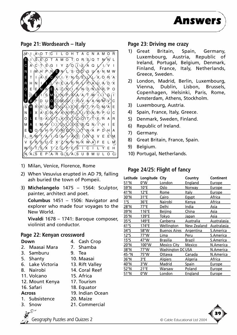
Page 21: Wordsearch – Italy
1) Milan, Venice, Florence, Rome
2) When Vesuvius erupted in AD 79, fallingash buried the town of Pompeii.
3) Michelangelo 1475 – 1564: Sculptor,painter, architect and poet.Columbus 1451 – 1506: Navigator andexplorer who made four voyages to theNew World.Vivaldi 1678 – 1741: Baroque composer,violinist and conductor.
Page 22: Kenyan crossword
Page 23: Driving me crazy1) Great Britain, Spain, Germany,
Luxembourg, Austria, Republic ofIreland, Portugal, Belgium, Denmark,Finland, France, Italy, Netherlands,Greece, Sweden.
2) London, Madrid, Berlin, Luxembourg,Vienna, Dublin, Lisbon, Brussels,Copenhagen, Helsinki, Paris, Rome,Amsterdam, Athens, Stockholm.
3) Luxembourg, Austria.4) Spain, France, ltaly, Greece.5) Denmark, Sweden, Finland.6) Republic of Ireland.7) Germany.8) Great Britain, France, Spain.9) Belgium.10) Portugal, Netherlands.
Page 24/25: Flight of fancy
Down2. Maasai Mara3. Samburu5. Shanty6. Lake Victoria8. Nairobi11. Volcano12. Mount Kenya16. SafariAcross1. Subsistence3. Snow
4. Cash Crop7. Shamba9. Tea10. Maasai13. Rift Valley14. Coral Reef15. Africa17. Tourism18. Equator19. Indian Ocean20. Maize21. Commercial
Latitude Longitude City Country Continent51°N 0°W London England Europe59°N 10°E Oslo Norway Europe41°N 12°E Rome Italy Europe30°N 31°E Cairo Egypt Africa1°S 36°E Nairobi Kenya Africa28°N 77°E Delhi India Asia39°N 116°E Beijing China Asia35°N 139°E Tokyo Japan Asia35°S 149°E Canberra Australia Australasia41°S 174°E Wellington New Zealand Australasia34°S 58°W Buenos Aires Argentina S.America12°S 77°W Lima Peru S.America15°S 47°W Brasilia Brazil S.America20°N 100°W Mexico City Mexico N.America38°N 77°W Washington DC USA N.America45-°N 75°W Ottawa Canada N.America36°N 3°E Algiers Algeria Africa40°N 3°W Madrid Spain Europe52°N 21°E Warsaw Poland Europe51°N 0°W London England Europe
M I A O T C I L O H T A C N A M O R
E I S E O T A M O T O R S Q T N N L
C A C T S G I Y Z O I E A Q L I V I
N I W H P N E N L S O D G U A N M W
E T I A E C A I F N D E L L X O R A
R H N I I L V E A E R L P A U A D X
O E E N K E A C N I F N D N V R P O
L O E I S M L N P A A A T M I I G I
F V P D U O O M G I R V A A W M V C
S M R R V R E U L E E R T P O M A E
N I X A E N K A N R L I E N R P U C
O L E S A V T A S T C O T T E R A R
M A I M H I I U L S E B Q N I H I E
E N O S H P V R E P L T N A P D H A
L R W T A I Q A I A S I N S V E E M
V E R S U Z X Z N N N K W A F E L M
W O T S X T Z C P E S I C I L Y E H
N A S E P A R G S A S U B M U L O C

Geography Puzzles and Quizzes 2 © Cable Educational Ltd 2004
40
Answers
Page 26: Loads of cash
Page 27: Holidays in Spain
Page 28: Interesting islands
Page 29/30: Animal magicPiranha – SouthAmerican Amazonbasin.Giraffe – Africanplains.Tree frog – Amazonarea.Red squirrel –Britain.Mountain goat –Alps.Barbary ape –Gibraltar.Etruscan shrew –Italy.Hermann's tortoise– Balkans.
Caribou – NorthAmerica/Canada).Moose – NorthAmerica /Canada). Manatee – USA:Florida coast.Racoon –USA/Canada.Toucan –Mexico/CentralAmerica.Howler monkey(rainforests SouthAmerica).Sailfish – Caribbean.Tapir – TropicalSouth Americanrainforest.
Py PyreneesE EuroM MadridPa PaellaTo TourismTa TapasFl FlamencoFi FiestaS SiestaC.D.S. Costa del SolA AndaluciaBa Barcelona
Gu GuadalquivirBe BenidormPl PlazaTu TurronRC Roman CatholicBF Bull fightingG GazpachoP ParadorsM MediterraneanGa GaudiGi GibraltarMuMulhacen
L K E B A U E U R J K C S T M S L V
E J W L I U G R F Q G H U K L U L X
J O U A R H A U O G R P H O Q C D S
G P S O N I B N H N J B I L M R F C
A W B E S Z A J E G G N J D A E K Y
Z U Y A P I A Y K U S M E Q N A U Y
D M L I V R V R D L Q D E F U L M I
V A O I I C O A N T V N Q V R Q D T
D Q L P L N U O K R J C X Q O H Y E
C O M R E N K A B U K Z Z V K B Y H
B E L G Q X L L D M M I M K A M B Z
L A Y I U G U O E N R S N E H T C L
P D E K R U F I Y A A Y R A P I U M
B Q U E T Z A L N L E O N E K M K O
T I Y U Q R P D I H L A R I A N J H
Q H C Q B I R R M D Q R I N G G I T
G I A L V B K Y A T E X U A N I S U
R D H B W I R A L O T C A Y M Y B X
A E H L S D T D W M A C J H Y Q R T
X T U Q U N Y E I Y R O T I E N F Q
Y U N R T N W J O D N O H T Z S O T
I B S A U C H F N P E A R L O W G T
F E E B H L K A F T T Y N A B L A B
Y R E L A P O O R A G N A K X Q K A
I Z G V L M E Q S A W W V Y A E T N
K D A U A I K L S E G A T L Y Q H K
S J W S A Q S C E G A U C W X B Q S
K A D M R D E M A R T I N I Q U E W
U H M A A N A R Q D B A A L I I O F
S T K T S P H L N U H U C H L N K X
T R H I S A C A C O E Y E R H O M A
C E O A E I F Z L A R L D Z O Q C Z
R N T T I G R F Z Z N E P R D J I B
O Q K E P T V H A K P A L A A E A T
I E D E R X I R C T W X L O R Z S M
X N Z E U C F I U H S Q T E Q T W I

Geography Puzzles and Quizzes 2 © Cable Educational Ltd 2004
41
Answers
Page 32: Waterfalls
A S B Z S J W H F J H U L A N R E V
K S L O K W O K O G R N L Z X D S B
A A N L Q W P T I U H E O R T L A Q
K L F O C V L A B E G H V G K L I C
A G C O Q A U U T U G V A N E L E H
I E S F S U P M T U F U T N X K A C
R Z F L E U A S L U I S K I N B B A
O X E Z N A E L T B R H Z I P O O M
T Q U G R Y T H M C E T Z A Z Y Y O
C S A A E H L H T I R R A H B O A L
I C V N N K A L E S E N T A U M N G
V F O E U I U I U R A R I H A A Y W
U H X O T Y R R A T Q G S E D I C X
K C C H U T A A A D S W I N A E D F
G A V A R N I E M T R L S N V O E F
T R Y J A R A G A I N W A I E Y L L
N K G T W C A H C N I F T M N T L X
C I L J R E Z W P L B H S M L H A O