geography of south america. i. andes mountains a. longest (and one of the youngest) mountain...
TRANSCRIPT
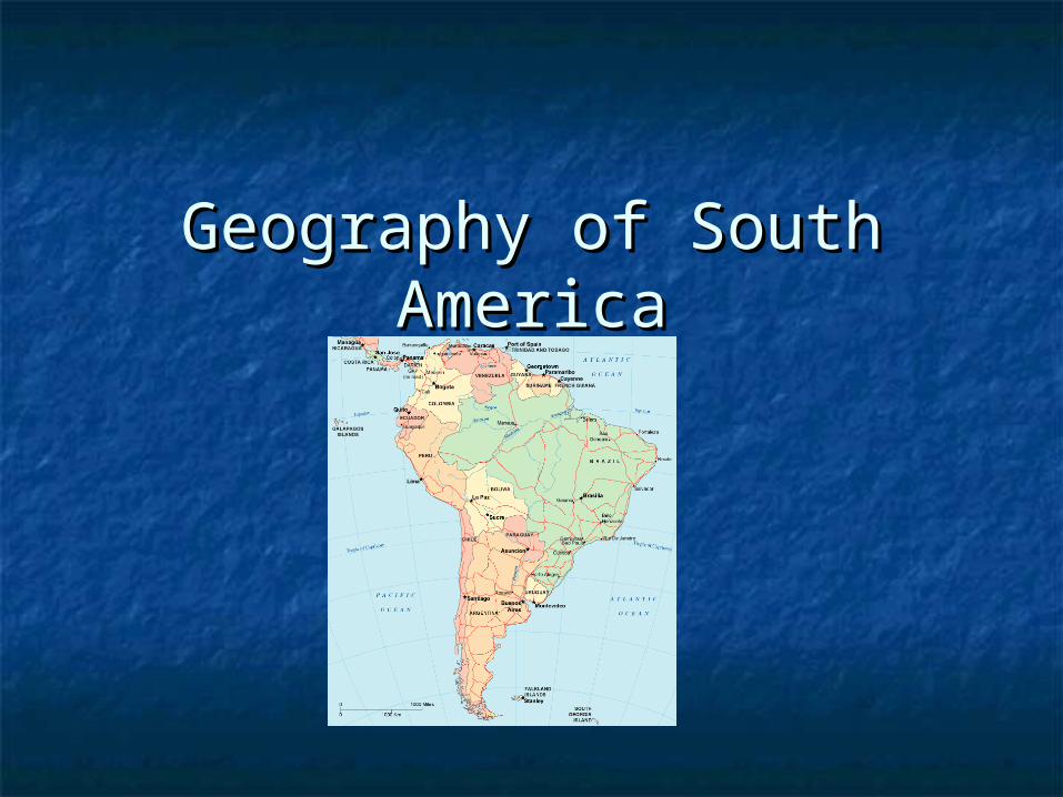
Geography of South Geography of South AmericaAmerica

I. Andes MountainsI. Andes Mountains
A. Longest (and one of the A. Longest (and one of the youngest) mountain youngest) mountain range(s) in the world, more range(s) in the world, more than 5,000 mi (8,000 km) than 5,000 mi (8,000 km) long, long,
B. Extend from Venezuela, to B. Extend from Venezuela, to Tierra del Fuego and the Tierra del Fuego and the Falkland Islands. Falkland Islands.
C. The Andes go through C. The Andes go through seven South American seven South American countries—Argentina, Chile, countries—Argentina, Chile, Bolivia , Peru, Ecuador, Bolivia , Peru, Ecuador, Colombia , and Venezuela . Colombia , and Venezuela .
II. AltiplanoII. Altiplano
A. High plateau near the border between Peru A. High plateau near the border between Peru and Bolivia.and Bolivia.
B. Very high altitude, between 12,500 ft to over B. Very high altitude, between 12,500 ft to over 15,000 ft.15,000 ft.
C. Few trees, plants, or native animals live C. Few trees, plants, or native animals live here.here.
D. However, 70% of Bolivia’s population lives in D. However, 70% of Bolivia’s population lives in or around the Altiplano.or around the Altiplano.
E. Lake Titicaca- worlds highest navigable lake.E. Lake Titicaca- worlds highest navigable lake.

Survival on the AltiplanoSurvival on the Altiplano
To live at such a high altitude with To live at such a high altitude with little oxygen, many people living on little oxygen, many people living on the Altiplano chew coca leaves. the Altiplano chew coca leaves.
The coca leaves allow people to slow The coca leaves allow people to slow their breathing down and relieve their breathing down and relieve head-aches and hunger pangs.head-aches and hunger pangs.


III Atacama DesertIII Atacama Desert
The _____ Desert in the The _____ Desert in the worldworld
Lays in Northern Chile Lays in Northern Chile and Southern Peruand Southern Peru
Averages Less Averages Less that .004 inches of that .004 inches of rain a year!rain a year!
What is so unique is What is so unique is that the desert is that the desert is bordered by the bordered by the ocean.ocean.

IV. PatagoniaIV. Patagonia
A. The Patagonia region, A. The Patagonia region, located in the _________ located in the _________ end of South America, end of South America, embraces the countries embraces the countries of Argentina and Chile. of Argentina and Chile.
B. This is a B. This is a ___________________ dry ___________________ dry plateau. plateau.
C. Difficult to support an C. Difficult to support an abundance of life abundance of life
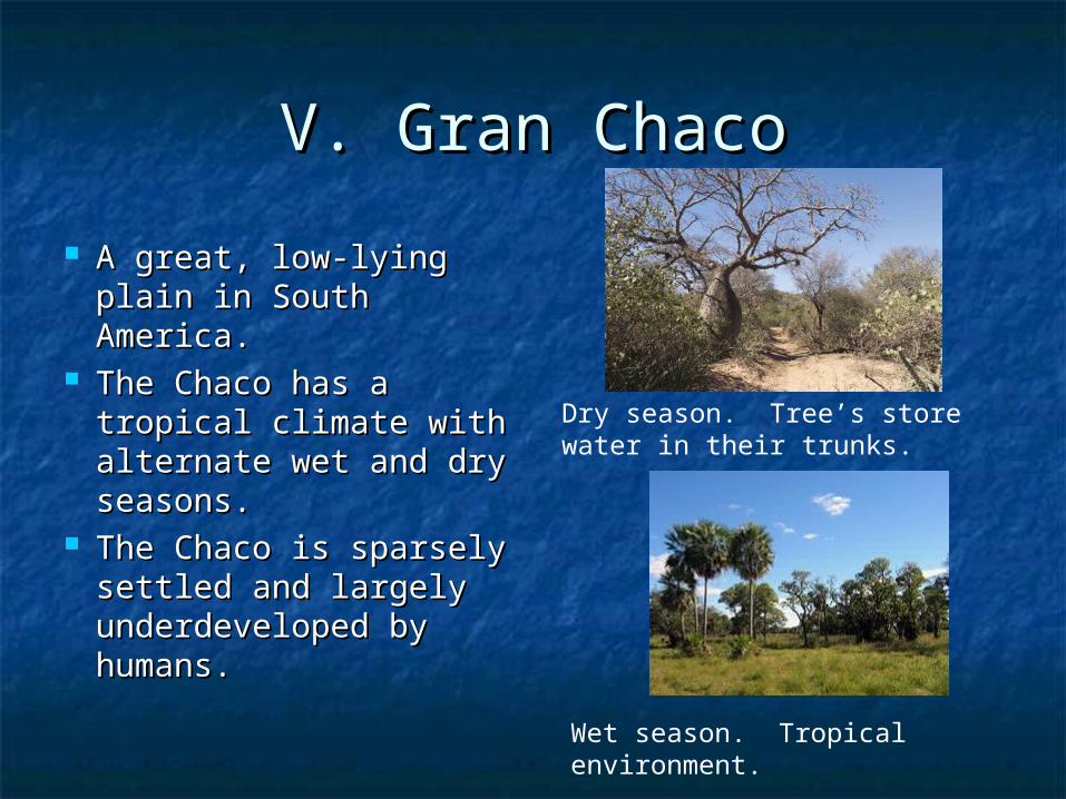
V. Gran ChacoV. Gran Chaco
A great, low-lying plain A great, low-lying plain in South America.in South America.
The Chaco has a The Chaco has a tropical climate with tropical climate with alternate wet and dry alternate wet and dry seasons.seasons.
The Chaco is sparsely The Chaco is sparsely settled and largely settled and largely underdeveloped by underdeveloped by humans.humans.
Dry season. Tree’s store water in their trunks.
Wet season. Tropical environment.

VI. PampasVI. Pampas
A. Pampas , wide, flat, A. Pampas , wide, flat, fertile grassy plains, fertile grassy plains, 300,000 sq. miles 300,000 sq. miles particularly in Argentina particularly in Argentina and extending into Uruguay and extending into Uruguay
B. Chief crop is _________B. Chief crop is _________ C. livestock are the main C. livestock are the main
source of income.source of income. D. Eastern part is humid D. Eastern part is humid
and receives over and receives over ____inches of rain____inches of rain
E. Western part is dry E. Western part is dry because of the Mountains. because of the Mountains. Rain blows over the mtns. Rain blows over the mtns. and hit the eastern part of and hit the eastern part of the pampas.the pampas.

VII. GauchoVII. Gaucho
A. gaucho , __________ A. gaucho , __________ of the Argentine and of the Argentine and Uruguayan Pampas Uruguayan Pampas (grasslands). (grasslands).
B. The typical gaucho, B. The typical gaucho, a familiar figure in the a familiar figure in the 18th and 19th cent., 18th and 19th cent., was a daring, skillful was a daring, skillful horseman and horseman and plainsman, and plainsman, and sometimes soldier.sometimes soldier.

IV. Geography of the AndesIV. Geography of the Andes
A. What is the climate like in the A. What is the climate like in the Northern Andes?Northern Andes?
B. What is the climate like in the B. What is the climate like in the Central Andes?Central Andes?
C. What is the climate like in the C. What is the climate like in the Southern Andes and Argentina?Southern Andes and Argentina?

VIII. Brazilian HighlandsVIII. Brazilian Highlands
A. The Brazilian A. The Brazilian Highland region is a Highland region is a steep coastal ridge steep coastal ridge rising along ______miles rising along ______miles of shoreline in Southern of shoreline in Southern and Southeastern and Southeastern Brazil. Average Brazil. Average elevation is _______feet.elevation is _______feet.
B. The range clings B. The range clings closely to the coast, closely to the coast, and reappears in spots and reappears in spots as offshore _i______. as offshore _i______.

IX. Guiana HighlandsIX. Guiana Highlands A. Located in Guyana, A. Located in Guyana,
Suriname, and ____________. Suriname, and ____________. B. Tepuis rise one after B. Tepuis rise one after
another, like gargantuan another, like gargantuan steps, in sheer ___________ steps, in sheer ___________ hundreds to thousands of hundreds to thousands of feet high. feet high.
C. Numerous rivers, fed by C. Numerous rivers, fed by heavy rainfall, rise in the heavy rainfall, rise in the highlands and pour over highlands and pour over the edges to create deep the edges to create deep gorges and magnificent gorges and magnificent waterfalls.waterfalls.
D. _________________ Highest D. _________________ Highest waterfall in the world waterfall in the world (3,312 ft)(3,312 ft)

X. Amazon River BasinX. Amazon River Basin
A. The Amazon river basin A. The Amazon river basin is located mainly in is located mainly in _____________. It also _____________. It also stretches into some of Peru. stretches into some of Peru.
B. Contains Amazon river B. Contains Amazon river and forest.and forest.
C. The largest in the world, C. The largest in the world, covered by more than 2 covered by more than 2 ___________square miles in ___________square miles in the form of dense tropical the form of dense tropical forest. forest.
D. For centuries, this has D. For centuries, this has protected the area and the protected the area and the animals residing in it. animals residing in it.

Amazon River Basin is Like Amazon River Basin is Like Folsom FieldFolsom Field
Guiana HighlandsAndes
Mounta
ins
Brazilian Highlands
AMAZON RIVER

XI. Amazon RiverXI. Amazon River
A. The _________ river in the A. The _________ river in the world in amount of water. world in amount of water.
The river ranges from 1The river ranges from 111/2 to /2 to 6 miles wide for most of its 6 miles wide for most of its course. It widens to about 90 course. It widens to about 90 miles at its mouth. The miles at its mouth. The Amazon's depth averages Amazon's depth averages about 40 feetabout 40 feet
Discharge rate- average, Discharge rate- average, 209000 m3/s (7381000 cu 209000 m3/s (7381000 cu ft/s)ft/s)
B. It flows east, across B. It flows east, across northern Brazil and into the northern Brazil and into the Atlantic Ocean at the Equator.Atlantic Ocean at the Equator.
http://www.mbarron.net/Amazon/factfile.htm