geography of british columbia - ubc press
TRANSCRIPT
Geography of British Columbia

Geography of British ColumbiaPeople and Landscapes in Transition
Brett McGillivray
2ND EDITION

© UBC Press 2005
All rights reserved. No part of this publication may be reproduced, stored in a retrieval system,or transmitted, in any form or by any means, without prior written permission of the publisher,or, in Canada, in the case of photocopying or other reprographic copying, a licence fromAccess Copyright (Canadian Copyright Licensing Agency), www.accesscopyright.ca.
15 14 13 12 11 10 09 08 07 06 05 5 4 3 2 1
Printed in Canada on acid-free paper
Library and Archives Canada Cataloguing in Publication
McGillivray, Brett, 1944-Geography of British Columbia : people and landscapes in transition /
Brett McGillivray. – 2nd ed.
Includes bibliographical references and index.ISBN-13: 978-0-7748-1253-5 (bound); 978-0-7748-1254-2 (pbk.)ISBN-10: 0-7748-1253-2 (bound); 0-7748-1254-0 (pbk.)
1. British Columbia – Geography – Textbooks. I. Title.
FC3811.M33 2005 917.11 C2005-905704-1
UBC Press gratefully acknowledges the financial support for our publishing program of theGovernment of Canada through the Book Publishing Industry Development Program (BPIDP),and of the Canada Council for the Arts, and the British Columbia Arts Council.
Printed and bound in Canada by FriesensSet in TheSans and Frutiger by Artegraphica Design Co. Ltd.Copyeditors: Camilla Blakeley and Sarah WightProofreader: Tara TovellCartographer: Eric LeinbergerIndexer: Noeline Bridge
UBC PressThe University of British Columbia2029 West MallVancouver, BC V6T 1Z2604-822-5959 / Fax: 604-822-6083www.ubcpress.ca

Contents
Illustrations, Figures, and Tables / vi
Preface to the First Edition / xi
Preface to the Second Edition / xii
Acknowledgments / xiii
1 British Columbia: A Region of Regions / 3
2 Physical Processes and Human Implications / 23
3 Geophysical Hazards: Living with Risks / 41
4 Modifying the Landscape: The Arrival of Europeans / 61
5 First Nations and Their Territories: Reclaiming the Land / 72
6 The Geography of Racism: The Spatial Diffusion of Asians / 89
7 Resource Management in a Changing Global Economy / 100
8 Forestry: The Dominant Export Industry / 117
9 The Fishing Industry: Managing a Mobile Resource / 140
10 Metal Mining: The Opening and Closing of Mines / 162
11 Energy: Supply and Demand / 174
12 Agriculture: The Land and What Is Produced / 194
13 Water: An Essential Resource / 209
14 Tourism: A New and Dynamic Industry / 223
15 Single-Resource Communities: Fragile Settlements / 237
16 Urbanization: A Summary of People and Landscapes in Transition / 245
Glossary / 263
Index / 269

Illustrations, Figures, and Tables
ILLUSTRATIONS3 Vancouver Canadian Pacific Railway station,
1888, BC Archives A-0323223 Diamond Head, near Squamish, photo Brett
McGillivray41 Chilliwack flood, 1894, BC Archives A-0395161 Ralph Dodd, Spanish Insult to the British Flag at
Nootka, 1789, 1791, BC Archives PDP0067872 K’san village, photo Brett McGillivray89 Amor de Cosmos cartoon, BC Archives B-08197
100 Coal port, photo Brett McGillivray117 Topping a spar, B. and K. Logging, Pitt Lake,
photograph by BC Forest Service, BC ArchivesNA-05903
140 Salmon seiner crew, courtesy of Fisheries andOceans Canada
162 Open-pit mine, Lornex Mine, Highland Valley,photo Brett McGillivray
174 Nickel Plate Mine dam and bridge, Hedley,Okanagan/Similkameen, c. 1912, BC ArchivesF-01641
194 Douglas Lake Cattle Ranch, near Merritt, photoBrett McGillivray
209 Water flowing over rocks on the SecheltPeninsula, courtesy of Gordon Carson
223 Kayaking off the Sechelt Peninsula, courtesy ofGordon Carson
237 Barkerville, 1868, photograph by Frederick Dalley,BC Archives A-00355
245 Downtown Vancouver looking west, courtesy ofA.H. Siemens
FIGURES1.1 Subfields of geography and links to other
disciplines / 41.2 Natural population increase and net migration,
1931-2001 / 71.3 Regions of British Columbia / 91.4 Vancouver Island/central coast and Lower
Mainland populations, 1881-2004 / 101.5 Vancouver Island/central coast region / 121.6 Lower Mainland region / 131.7 Okanagan region / 14
1.8 Kootenay region / 151.9 South central interior region / 17
1.10 North central interior region / 171.11 North coast/northwest region / 181.12 Peace River/northeast region / 202.1 Intrusive and extrusive igneous rock / 252.2 Rock cycle / 262.3 Generalized geology of British Columbia / 272.4 Cross-section of Earth / 282.5 Major oceanic and continental plates / 282.6 Rift zone / 292.7 Subduction process off the southern BC
coast / 292.8 Accreted terrane process for southern Vancouver
Island / 302.9 Accreted terranes in British Columbia / 31
2.10 River systems of British Columbia / 332.11 Global climate / 342.12 Jet stream influences in winter and
summer / 352.13 Climate regimes of British Columbia / 352.14 The rain shadow effect / 372.15 Vancouver area annual precipitation in
millimetres / 372.16 Typical coastal soil horizon / 382.17 Typical interior soil horizon / 382.18 Generalized vegetation patterns in British
Columbia / 393.1 Hazards model / 423.2 Fraser River drainage basin / 463.3 River discharge for selected rivers / 473.4 Flood plains and land uses / 483.5 Lower Fraser Valley flooding, 1948 / 493.6 Fraser River discharge measured at Hope,
1894-1972 / 493.7 Corrective and preventive measures for flood
hazards / 513.8 Wildfires in British Columbia, 1970-2004 / 513.9 General types of avalanche / 55
3.10 Typical debris torrent slope / 564.1 Map from the journal of Capt. Vancouver,
1798 / 644.2 Fur trade forts and routes, 1805-46 / 65

viiIllustrations, Figures, and Tables
4.3 American claims to western North America,1825 / 66
4.4 Colony of Vancouver Island, created 1849 / 664.5 Colony of British Columbia, created 1858 / 674.6 Cariboo gold rush communities, 1863 / 684.7 Boundary changes to British Columbia, 1862
and 1863 / 695.1 Possible migration routes to North America / 735.2 Historical territorialization of First Nations in
British Columbia / 755.3 First Nations linguistic divisions in southwestern
British Columbia / 755.4 Semi-nomadic migrations in the Lower Mainland
area / 765.5 Treaty land divisions in Canada / 785.6 Language as a representation of culture / 805.7 Interrelationship of decision makers / 835.8 Nisga’a Aboriginal title / 866.1 Main locations of Chinese in British Columbia,
1881 / 916.2 Chinese immigration, 1904-23 / 956.3 Relocation camps for the Japanese in British
Columbia / 977.1 Ecosystem model of resource use / 1027.2 Interrelationship of corporations, governments,
and unions / 1077.3 Staple dependency and external control / 1077.4 Vancouver and the Pacific Rim / 1097.5 Regions of British Columbia dependent on
forestry and mining / 1127.6 Life expectancy for males and females,
1921-2002 / 1127.7 BC age-sex pyramid, 1971 / 1147.8 BC age-sex pyramid, 2003 / 1147.9 BC age-sex pyramid, 2021 / 1148.1 Coast and interior forest zones / 1188.2 Volume of wood cut from coast and interior,
1950-2002 / 1198.3 Pulp-and-paper mills in British Columbia,
1931 / 1218.4 Pulp-and-paper mills in British Columbia,
2004 / 1228.5 Sawmills in British Columbia, 1931 / 1238.6 Sawmills in British Columbia, 1961 / 1238.7 Sawmills in British Columbia, 1971 / 123
8.8 The creation of pulp from wood chips / 1248.9 Public versus private volume of wood harvested,
1911-2003 / 1258.10 Timber supply areas, tree farm licences, and
forest regions, 2001 / 1268.11 The fall-down effect / 1298.12 Forestry dependence based on income derived
from the forest industry, 2002 / 1318.13 Coast versus interior softwood lumber prices,
1995-2002 / 1349.1 Commercial salmon fishing vessels / 1429.2 Major salmon-bearing rivers and lakes / 1439.3 Commercial catches of Fraser sockeye salmon
1901-89 / 1449.4 Migration routes for BC salmon species / 1489.5 Salmon migration and international borders / 1499.6 Wild and farmed salmon production, 1990-
2003 / 1529.7 Value of wild and farmed salmon, 1990-
2003 / 1529.8 Location of salmon farms, 2004 / 1539.9 Salmon areas under the Mifflin Plan / 155
9.10 Halibut prices, 1985-2003 / 1569.11 Importance of adult Pacific herring in predators’
diets, west coast Vancouver Island / 1579.12 Herring catch and landed value, 1935-90 / 1579.13 Pacific cod catch and landed value, 1990-
2003 / 1599.14 Groundfish catch and landed value, 1990-
2003 / 1599.15 Shellfish catch and landed value, 1990-2003 / 15910.1 Geologic regions of British Columbia / 16410.2 Stages of metal mining production / 16710.3 Placer and lode gold production, 1860-1990 / 16710.4 Employment in metal mining, 1980-2003 / 16710.5 Potential mines, 1986 / 16910.6 Metal mines, 1990-2004 / 171
11.1 Vancouver Island natural gas line extension,1995 / 177
11.2 Grades of coal / 17711.3 Sedimentary basins containing coal, natural gas,
and oil / 17811.4 Coal production, 1871-2003 / 17911.5 Thermal and metallurgical coal production,
1991-2001 / 179

viii Illustrations, Figures, and Tables
11.6 Forecasts of Japanese crude-steel production,1971-89 / 179
11.7 Natural gas and oil pipelines in BritishColumbia / 181
11.8 Oil prices, 1972-2004 / 18211.9 Offshore oil claim by BC government / 182
11.10 Natural gas average price, 1980-2004 / 18411.11 Generation of electricity, 1920-2003 / 18411.12 Kemano 1 project: Damming the Nechako
River / 18511.13 Electrical energy projections and consumption,
1976-97 / 18611.14 Main developed and proposed electrical projects
and transmission lines / 18711.15 Independent power producers approved by BC
Hydro, 2004 / 19012.1 Farming areas in British Columbia / 19612.2 Frost-free days in British Columbia / 19812.3 Value of selected agricultural commodities,
1993-2003 / 20012.4 Appeal process for exclusion from agricultural
land reserves / 20212.5 Development regions of British Columbia / 20513.1 Hydrologic cycle / 21013.2 Discharge rates for selected rivers / 21113.3 Theoretical evapotranspiration ratio for a coastal
location / 21213.4 Evapotranspiration ratios for selected
communities / 21413.5 North American Water and Power Alliance Plan
(NAWAPA) / 21613.6 Percentage of population served by wastewater
treatment, 1983-1999 / 21713.7 Ecosystem perspective of resource uses and
biomagnification / 21713.8 Boil water advisories, 1989-2004 / 21813.9 Groundwater and wells / 22014.1 Relation of tourism industry to resources / 22514.2 Tourism industry sectors / 22714.3 Tofino and Clayoquot Sound, Vancouver Island / 22814.4 US to Canadian dollar exchange rate, 2002-4 / 22914.5 Arrivals and departures at Vancouver International
Airport, 1997-2003 / 23214.6 Cruise ship passengers visiting Vancouver, 1992-
2004 / 233
15.1 Development of single-resource communities / 23815.2 Instant towns and single-resource
communities / 24116.1 Canadian Pacific Railway Survey routes through
British Columbia / 25016.2 Main rail lines in British Columbia to 1952 / 254
TABLES1.1 Rural and urban population, 1871-2001 / 61.2 Population by region, 1881-2004 / 101.3 Population of municipalities for selected years,
1881-2004 / 112.1 Geologic time scale / 242.2 Climate data for selected communities / 363.1 Area destroyed and total cost of wildfires in
British Columbia, 1970-2004 / 523.2 New snowfall and avalanche risk / 543.3 Hazards related to streams on the Sea to Sky
Highway / 573.4 Richter scale showing potential structural
damage / 584.1 British and American trading vessels in the Pacific
Northwest, 1785-1814 / 654.2 1881 census population / 705.1 First Nations language divisions / 745.2 Aboriginal populations for selected years / 816.1 Chinese occupations in British Columbia, 1884 / 926.2 Chinese immigration and emigration, 1886-
1900 / 936.3 Revenue from head taxes on Chinese entering
British Columbia / 956.4 Japanese evacuees, 31 October 1942 / 986.5 National status of Japanese Canadians in
1941 / 987.1 Interprovincial and international trade flows to
and from British Columbia, 1997-2000 / 1057.2 Interprovincial and international trade flows of
selected goods, 2000 / 1067.3 Employment in British Columbia and Greater
Vancouver Regional District, 2003 / 1107.4 High-tech industries by number of establish-
ments and employment, 1998-2002 / 1117.5 Film and television production, 1998-2003 / 1117.6 Immigration by source countries, 2003 / 1137.7 Interprovincial net migration, 1980-2003 / 113

ixIllustrations, Figures, and Tables
7.8 Projected population by region, 2001-21 / 1158.1 Production and value of selected forest product
exports, 1998-2003 / 1248.2 Selected forest product values and price indices,
1998-2003 / 1248.3 Employment in forestry by selected categories,
1991-2003 / 1258.4 Employment per thousand cubic metres of wood
harvested, 1950-99 / 1258.5 Reforestation of seedlings, 1960-2002 / 1298.6 Potential yield through intensive silviculture
practices / 1298.7 Cost of producing lumber by world supply
regions, 2000 / 1328.8 Softwood lumber and pulp and paper exports by
destination, 1994-2003 / 1348.9 Log exports, 1999-2003 / 135
8.10 Softwood lumber exports to the United States,2001-4 / 136
9.1 Commercial catch by value, 1951-2003 / 1419.2 BC salmon exports, 1930 and 1939 / 1479.3 Fraser River sockeye salmon catches for selected
years / 1509.4 Commercial salmon fishing licences by gear
type, 1995-2003 / 1559.5 Job loss due to federal buyback program, 1995-
2000 / 1569.6 Herring catch, landed value, and wholesale
value, 1996-2003 / 15810.1 Value of mineral production as a percentage of
total metal mined, 1860-2004 / 16510.2 Value of mineral production in British Columbia,
1998-2003 / 16610.3 World market prices for selected metals and
years, 1971-2004 / 16810.4 Production and value of gold and copper for
selected years, 1995-2003 / 16810.5 Production, employment, and operation of
metal mines, 1990-2004 / 17011.1 Energy sources, 1925-2002 / 17511.2 Energy production and consumption, 2000-3 / 17611.3 Energy consumption by sector, 1978-2002 / 17611.4 Destinations of British Columbia’s thermal and
metallurgical coal, 2001 / 179
11.5 Natural gas production and value and overallhydrocarbon revenues, 1998-2003 / 184
11.6 Supply and consumption of electricity, 1994-2003 / 185
11.7 Major proposed electrical energy projects,1976 / 186
12.1 Census farms in Canada, 1991-2001 / 19512.2 Soil classification, area, and subclasses / 19712.3 Physical characteristics and potential limitations
for agriculture / 19912.4 Farms, farm area, average farm size, population,
and urbanization, 1901-2001 / 20012.5 Farm size and gross receipts, 2001 / 20012.6 Number of cows and dairy farms in British
Columbia, 1941-2001 / 20112.7 Changes in area of agricultural land reserve by
region, 1974-2000 / 20312.8 Agricultural receipts by commodity, 1998-
2004 / 20413.1 Drainage area, length, and discharge of major
rivers / 21113.2 Categories of water use / 21513.3 Waterborne disease outbreaks, 1980-2002 / 21814.1 International tourism estimates, globally, 1950-
94 / 22414.2 Tourism categories / 22614.3 Overview of factors influencing the Clayoquot
landscape / 22914.4 Tourism indicators, 1997-2003 / 23014.5 Room revenue by tourist region, 1997-2003 / 23015.1 Population of instant towns, 1971-2004 / 24116.1 Native and non-Native population, 1782-1870 / 24616.2 Population and urbanization, British Columbia
and Canada, 1871-1951 / 25016.3 Native, non-Native, and Asian provincial
population, 1871-1951 / 25116.4 Incorporated communities by region, 1871-
1951 / 25216.5 Incorporated communities over 1,000 population
by rank, 1871-1951 / 25316.6 Population and urbanization, British Columbia
and Canada, 1951-2001 / 25816.7 Municipalities over 10,000 population, 2003,
and change from 1996 / 259


Preface to the First Edition
This text is the culmination of years of teaching the geo-graphy of British Columbia at Capilano College. It
comes at a time when one can question whether all thematerial gathered here should be offered online or in CD-ROM format. I have chosen the “old” textbook style of pres-entation, in part, because most geography courses at thecollege level use textbooks. My concern about goingonline stems from an informal survey of my classes. Eightypercent or more of the evening students were connectedto the Internet or had CD-ROM capability at home, butonly 20 percent or fewer of the day students had the samecapability. It would place a huge burden on the library ifelectronic sources provided the only “text.” Future versionsmay have any number of formats. In its present form, thistext includes references to websites where the most up-to-date information can be accessed. It is of course likelythat only the government websites and a few others willbe maintained in the long run. More important, studentsare encouraged to use the Internet in conjunction withthis text.
Several books have been particularly influential in thecreation of this text: Roderick Haig-Brown’s The Living Land(1961), Mary Barker’s Natural Resources of British Colum-bia and the Yukon (1977), and Charles Forward’s BritishColumbia: Its Resources and People (1987). Each has donean admirable job in assessing the variety of landscapesand issues in British Columbia. Albert Farley’s Atlas of Brit-ish Columbia: People, Environment, and Resources (1979),is another important resource because it not only pro-vides many useful maps but also contains much addi-tional information about the province. I have used BritishColumbia: Its Resources and People as a text for years be-cause of my preference for a geography that examinesthemes and stresses an historical perspective. Referencesto other works that have influenced this text can be foundat the end of each chapter.
British Columbia: People and Landscapes in Transition isa selective geography. One of its guiding forces is that itis designed for a one-term introductory course, and onecan cover only so many topics in thirteen or fourteenweeks. The selection of topics and chapters also showsmy bias as a human geographer, and even here there areomissions. Chapters could have been written on trans-portation, other peoples, and other resources.
Some students have a background in geography and afamiliarity with British Columbia; many do not. This hasmotivated my choice of a topical, or thematic, approachas opposed to a regional one. From my perspective, eachtheme – such as physical processes, historical geography,and geophysical hazards – has interesting and importantstories that help us to understand the processes thathave shaped the landscape of this province. The thematicapproach is also a means of gaining student interest ingeography as a discipline that deals with issues rangingfrom the local to the global.
The study of British Columbia from a regional perspec-tive is equally valid, and many instructors prefer this ap-proach because it focuses much more on the human andphysical features that make individual regions within Brit-ish Columbia unique. It generally provides a more in-depthview of the many distinctive regions of the province. Toaddress this aspect of BC geography, all chapters in thiswork, especially the first and last, pay considerable atten-tion to the regional development of the province.
British Columbia: People and Landscapes in Transitionhas been created largely by converting my classroomnotes to prose. It has not been an easy task, as the spo-ken word and the written word are two very separatemeans of communication.

Preface to the Second Edition
This second edition of Geography of British Columbia:People and Landscapes in Transition comes as a result
of my classroom experience, where I have found it neces-sary to update statistics and add new information. Sincethe first edition, significant changes on both the globaland the local scale have had an impact on this province.Some events have been catastrophic, such as the terror-ist attack in the United States on 11 September 2001, whichprofoundly affected the movement of goods and peopleacross the border. Closer to home was the outbreak ofthe SARS (severe acute respiratory syndrome) epidemicin 2003; although its main focus was Toronto, Vancouverhad its share of concern, particularly given its close tiesto Asia. Also close to Toronto was the contamination ofdrinking water at Walkerton, Ontario. The seven deathsand over 2,000 people hospitalized served as a seriousreminder to the nation of the importance of water qual-ity and the policies that protect water quality. Even closerto home was the firestorm in the summer of 2003 thatbrought the high risk of forest fire hazard to the forefrontfor all in British Columbia.
Political change results in new policies and new direc-tions on many geographic scales. One of the conse-quences of the Bush administration’s war on Iraq, forexample, has been the escalation of the price of oil andnatural gas to an all-time high. This has a number of im-plications for British Columbia, ranging from energy cor-porations producing more fossil fuels to energy usersseeking alternative forms of energy. Canada’s ratificationof the Kyoto Protocol in 2002 was another political deci-sion that commits this country to curb its greenhousegases, which translates into burning fewer hydrocarbons.
Politics, mixed with economics, has similarly playeda major role in the forest industry. The unilateral impo-sition of US duties and tariffs on softwood lumber hasbeen devastating to many sawmills, and sawmill towns,
throughout the province. There are also political andeconomic battles over farmed Atlantic salmon (in fact,all farmed salmon) and its threat to wild Pacific salmonspecies.
Information available on the Internet has explodedsince the first edition of this book, and many websiteshave excellent content. Their visual component is particu-larly important because geography is about the land-scape. A number of web references have been added tothis edition.
This second edition of Geography of British Columbia:People and Landscapes in Transition remains selective, withan emphasis on the human side of geography, and de-signed for a one-term introductory course. Various topicareas in each chapter have been expanded, as suggestedby colleagues and critics, and the book now includes in-formation on the high-tech and film industries, commer-cial fishing other than salmon, fish farming, coalbedmethane production, population dynamics, and forest firehazard. I remain convinced that the topical or thematicapproach, as opposed to a regional approach, is a bettermeans of gaining the interest of students, especially asnot all students have a background in geography or a fa-miliarity with British Columbia. From my perspective, eachtheme is a story (containing many stories in turn), andthese are stories that British Columbians as well as thoseinterested in this province would benefit from knowing.
I also recognize that the study of British Columbia froma regional perspective is equally valid, and many instruc-tors prefer this approach as it focuses much more on thehuman and physical features that make the regionswithin British Columbia unique. The thematic approachadopted here is not devoid of regional concerns, and allchapters, especially the first and last, pay considerableattention to the regional development of the province.
Acknowledgments
Many people are to be thanked, including the librar-ians at Capilano College and my colleagues in the
Social Sciences: Gordon Bailey for his insightful comments,Charles Greenberg and Cheryl Schreader for their encour-agement, Jeanne Mikita (who has taught the BC coursepartially online and has made many helpful suggestions),and Karen Ewing for her assistance on passing along“things” geographic, especially for the physical geogra-phy chapter. Thanks also goes to Bob Patrick, Universityof Guelph, who passed on his research material, and ideas,on water quality and the policies required to protect drink-ing water. Students were particularly helpful as initiallythe text was used in draft form and their editorial com-
ments were invited. A special thanks also goes to WimKok at North Island College for his many useful commentsand sources of information. My wife and partner CarolAnnGlover took on the huge, time-consuming task of edit-ing the many drafts, and I am forever grateful. Finally, Iwould like to thank those who reviewed the first editionof Geography of British Columbia: People and Landscapesin Transition, as well as the readers for UBC Press, for theirfrank and useful comments, which have been taken intoaccount, and Camilla Blakeley for her exceptional, pro-fessional editing of the first edition. Any errors and omis-sions are the fault of the author.


Geography of British Columbia


3
1
British Columbia: A Region of Regions

4 British Columbia
USING GEOGRAPHY TO MAKE SENSE OF THELANDSCAPE
The focus of geography is the landscape, both human andphysical, and using geographical knowledge gives mean-ing to the changes that are constantly shaping and modi-fying the landscape. Those who study the humanlandscape look at where people live, their activities, andhow they have modified the landscape. Physical geogra-phers, on the other hand, are interested in the many physi-cal processes that influence the landscape. Of course,landscapes are frequently modified by a combination ofphysical and human processes, and common to both sidesof the discipline is that geography always incorporates aspatial perspective. The two broad divisions in the field –the human and the physical – can be divided into anumber of subfields. As Figure 1.1 shows, geography is as-sociated with many other disciplines, but the spatial ele-ment keeps it distinct.
British Columbia is a large province, encompassingnearly 950,000 square kilometres, and is also extremelyvaried from both a human and a physical perspective.Many nation-states are significantly smaller, and few havesuch a variety of landscapes. Nevertheless, fewer still have
such a small population (4.15 million in 2003) in relationto area – a density of only 4.4 persons per square kilo-metre (versus the United Kingdom’s 244.5 persons persquare kilometre in 2002) (Stanford 2003, 182). It is a help-ful exercise to compare the size of British Columbia tothat of countries around the world and to locate the prov-ince in relation to those countries. A map of Canada re-veals the size and spatial relationship of British Columbiato other provinces and territories within Canada. Onetheme of this text considers how British Columbia isunique within Canada.
One definition of geography is the study of “wherethings are and why they are where they are” (McCune1970, 454). “Things” can be physical features, people, places,ideas (or human innovations), or anything in the land-scape. “Where” questions concentrate on location as wellas recognizing physical and human patterns and the dis-tribution of various activities, people, and features of thelandscape. Many of these questions can be answered sim-ply by looking at a map, and students are encouraged toacquire a road map of British Columbia. Where is LiardHot Springs? Where is the territory covered by Treaty 8?Where are the sockeye spawning grounds? Where are
Nelson, and Fort Nelson? Knowledgeof where things are is basic and essen-tial geographical information. A use-ful beginning to test your knowledgeof British Columbia is to draw a mapof the province from memory and toplace on it the features you considerimportant. This cognitive mappingexercise reflects individual landscapeexperiences (which can be shared withothers) and demonstrates the impor-tance of location. Using maps to an-swer “where” questions is the easiestaspect of geographical study.
Why are things where they are?“Why” questions are far more difficultthan where questions and ultimatelymay verge on the metaphysical. Evenso, students are encouraged to con-duct research about and to analyzethe various physical, economic, po-litical, cultural, and historical factors
Human
Physical
Techniques
Historical geography
Political geography
Economic geography
Cultural geography
Population geography
History
Political scienceEconomics
AnthropologyPsychologySociology
Demography
Geomorphology Geology
Climatology Meteorology
Biogeography Biology
Soils geography Pedology
Cartography Geodesy
Geographic informationsystems
Computer science
GEOGRAPHY
Quantitative methods Statistics
Remote sensing Engineering
Regional geography,e.g., Kootenays, British Columbia, Canada
Figure 1.1 Subfields of geography and links to other disciplines

5A Region of Regions
involved in a specific location or locational patterns,whether it is the location of a type of vegetation, of a com-munity, of a group of people, or of a resource. Why doessagebrush dominate the dry southern interior valleys?Why is Vancouver where it is and why has it grown sorapidly? Why did Barkerville become a ghost town? Whydid the Doukhobors settle mainly in the Kootenays? Whydid the Nechako River get dammed for hydroelectricpower? Why is the Peace River region not part of Alberta?These questions are not easy and often require historical,physical, cultural, political, and economic assessments.
Other geographers add the “what” question: “what isthe significance of these locational patterns?” (Renwickand Rubenstein 1995, 5). What influence do people haveon the environment, and what influence does the envi-ronment have on people? Humans are constantly shap-ing and modifying the landscape to meet the demandfor resources – clear-cutting forests, damming rivers, andbuilding plants that pour emissions into the air and wa-ter – and these acts produce an environmental backlashto ecosystems and human health.
All of these questions – where, why, what – mean ge-ography is a practical and pragmatic discipline, one thatencourages an understanding of the surface of the earthon all geographic scales. Anne Hébert (2001, 81), assess-ing the province of Quebec within Canada, understandsthese relationships and suggests, “Real geography islearned at the table, in the breaking of bread.” These arethe human stories; other stories focus on the physicalenvironment. Through geography, there is an attempt tointerpret the landscape (“connect the dots”) and developcritical thinking skills to unravel the complexity of spatialpatterns, processes, and relationships.
The geography of British Columbia is changing con-stantly. News headlines inform us of these changes andprovoke where, why, and what questions: Vancouver-Whistler wins 2010 Winter Olympic bid ... Magnitude 6.8earthquake off the Queen Charlotte Islands (28 May 2004)shakes island communities ... BC Hydro resurrects Site CDam proposal: It would flood thousands of hectares, forcePeace families to move and affect fish habitat (7 April2004) ... Firestorm 2003 worst in British Columbia’s his-tory ... Avian flu discovered in Fraser Valley and forces theslaughter of 19 million chickens and turkeys (March 2004)... BC wood products exports to China doubled in 2004 ...
Since 22 May 2002 most Canadian softwood lumber ex-ported to the United States is subject to a 27 percent dutycollected by US Customs ... Current salmon farming prac-tices are a serious threat to wild salmon stocks and themarine environment ... Rural and resource-based commu-nities losing population in British Columbia. Common tosuch complex issues is the idea that human and physicalprocesses are altering the landscape. The chapters thatfollow are intended to raise the where, why, and whatquestions and to provide the means to understand someof the processes influencing change.
Another theme throughout Geography of British Colum-bia: People and Landscapes in Transition is the importanceof history. From a European, colonial perspective, BritishColumbia has little history of settlement and develop-ment compared to eastern Canada or to many other na-tions in the world. Aboriginal people, however, haveapproximately 10,000 years of history in British Colum-bia, and anthropologists and archaeologists are still add-ing new evidence of their settlement patterns and use ofresources. From the viewpoint of physical geography,changes to the landscape are often measured in severalhundreds of millions of years, and the BC landscape is noexception.
The combination of physical processes in British Co-lumbia has produced a spectacular variety of mountains,rivers, lakes, islands, fjords, forests, and minerals. Withinthis physical setting, First Nations people, and later non-Natives, settled, exploited, and altered the landscape,sometimes irreversibly. These physical-human interac-tions prompt us to look at the landscape another way,namely, from an environmental perspective.
Meshing with the idea of change over time in such arugged and physically challenging province is the themeof movement over space. Time-space convergence (some-times referred to as time-space compression, or collapse)refers to the changing technologies of movement thatshrink time and space. Today, for example, a flight fromLondon, England, to Vancouver, British Columbia, takesapproximately nine hours. In 1790, a trip to the PacificNorthwest from London meant sailing around SouthAmerica and took nearly seven months. By 1890, the voy-age from London to Vancouver was reduced to threeweeks with the introduction of steam-driven vessels andthe building of the Canadian Pacific Railway across

6 British Columbia
Canada. This change in transportation affecting the move-ment of goods and people had major implications, notonly to settlement patterns but also to resource develop-ment – particularly as quicker transportation frequentlyreduced freight rates. With the advent of telegraph linesin 1890, movement of information between London andVancouver was reduced to three days (Harris 1997). Bycomparison, current satellite systems provide instant glo-bal communications, with a consequent worldwide re-organization in the production of goods and services andspatial relationships generally.
Time-space convergence describes a shrinking world;however, the shrinking of time-space does not occurevenly. Geographic locations that are connected differ,sometimes greatly, from locations that are not connected.Freeways such as the Coquihalla give the advantage ofrapid movement to southern British Columbia commu-nities, while northern and coastal communities are sig-nificantly more isolated with only secondary roads or, insome cases, no roads. Similar comparisons occur with air-ports, railways, port facilities, pipelines, and communica-tions infrastructure. These transportation developmentsplay a significant role in settlement, development, andeconomic advantage throughout the province.
Closely associated with time-space convergence is spa-tial diffusion. Here, the focus is on the movement (or flow)from one location to another of goods, innovations andideas, services, and people, and tracing where they move.For example, the spatial diffusion process is used to tracewhere new innovations in farm equipment, new seeds,or agricultural practices occur, and where they areadopted. The spatial diffusion process is also used to de-scribe events, such as the waves of small pox epidemicsand their impact on First Nations, the evolution and pat-tern of salmon cannery location, or the spread of highspeed Internet service. All of these movements were in-fluenced by “carriers” and “barriers” (Gould 1969). Carri-ers are instrumental in the spread and adoption ofinnovations, goods acquisition, or the contraction of dis-eases; barriers prevent, or block, this movement. “Reloca-tion diffusion” refers specifically to the movement ofpeople from one place to another. Both barriers and car-riers apply to relocation diffusion, but the terms “push”and “pull” factors are also applied. Push factors includethe many reasons that force people to move, such as over-
population, warfare, religious persecution, and a host ofother political, economic, and social reasons. Pull factorsare the opposite, reflecting the various conditions thatattract people to a new location. Both push and pull fac-tors have been responsible for people moving to BritishColumbia.
Statistics are useful in assessing trends and patterns,and Table 1.1 indicates the increases in British Columbia’spopulation along with the transformation from rural tourban environments. Isolation was a major factor in earlynon-Native settlement and development. However, time-space convergence increased accessibility and allowedgreater opportunity for economic trade, development ofresources, and settlement, particularly urban settlement.These changes affected the regions of British Columbiain vastly different ways and also resulted in a much morecomplex society. The conquering of distance also facili-tated the global transition, especially in trade and invest-ment, from the Atlantic to the Pacific, tying BritishColumbia closely to the Asia-Pacific region.
Population increase is determined by calculating natu-ral increase (births minus deaths) and net migration (im-migration minus emigration) and combining the two
Table 1.1
Rural and urban population, 1871-2001
10-yearPercentage
Year Population change Rural Urban
1871 36,247 84.8 15.21881 50,387 14,140 72.0 18.01891 98,173 47,786 57.5 42.51901 178,657 80,484 49.5 50.51911 392,480 213,823 48.1 51.91921 524,582 132,102 52.8 47.21931 694,263 69,681 56.9 43.11941 817,861 123,598 45.8 54.21951 1,165,210 347,349 47.2 52.81961 1,629,082 463,872 27.4 72.61971 2,184,621 555,539 24.3 75.71981 2,744,465 559,844 22.0 78.01991 3,282,061 537,596 19.6 80.42001 4,078,447 796,386 18.0 82.0
Sources: Statistics Canada (1983a), series A2-14; (1983c), series A67-69; (2001a),table 051-0001; (2001b), table 109-0200.

7A Region of Regions
results. Figure 1.2 illustrates how important immigrationhas been to the overall population of the province. Immi-gration policies and economic conditions, however, influ-ence these increases. The recession of the 1980s, forexample, significantly reduced the number of people mi-grating to British Columbia.
TOPICAL OVERVIEWGeography of British Columbia employs a primarily topi-cal approach. This chapter is an exception to this generaldirection in that it provides an introduction to geogra-phy and a regional overview of British Columbia’s settle-ment and development. Chapters 2 to 6 introduce thebasic physical and human landscapes and some of theprocesses that change these landscapes. Chapters 7 to 15take an economic perspective as they concentrate on re-sources, resource management, and communities thatdepend on resources.
Most of this text concerns human geography, but thephysical landscape is not ignored. Chapter 2 discusses thelandscape in terms of the various physical processes thathave changed and shaped it. These processes have cre-ated distinctive regional variations throughout BritishColumbia as well as marked contrasts to the rest ofCanada.
Chapter 3 bridges the realms of physical and humangeography with its focus on our human use systems and
the risk from geophysical hazards. Chapters 4 to 6 presenthuman geography themes: the historical geography ofEuropean settlement, the long history to present-day useof the landscape by First Nations, and, finally, the story ofAsians in British Columbia. Each of these themes takes ahistorical perspective in examining the factors that in-fluence the many changes to and regional variations inthe landscape.
Resources, the theme of Chapters 7 to 15, have playedand continue to play a large part in the economic well-being of this province as well as in attracting settlement.Chapter 7 begins with a discussion of resource manage-ment issues and the roles played by governments andcorporations. Our use of, and dependence on, resourcesin this province have spatial and regional patterns. Eachresource has its own unique history of development andinfluence on British Columbia. Consequently, forestry, fish-ing, metal mining, energy, agriculture, water, and tourismare examined in separate chapters. Single-resource com-munities, the theme of Chapter 15, illuminate the humanlink between resource development and the people whodepend on it for a living.
Chapter 16, the final chapter, summarizes many of thesethemes and developments by reviewing 200 years of ur-banization in this province. An urban view enhances theregional perspective of British Columbia because it showsthe growth, and occasionally the decline, of communitiesthroughout the province.
REGIONAL OVERVIEWA regional geography approach is a means of assessinggeographic areas that have common physical or human/cultural characteristics and can thus be distinguishedfrom other regions (Gregory 2000, 687). From a regionalperspective, British Columbia is a unique province withinCanada for a variety of reasons. Physical characteristicsset it apart from all other provinces. It has the youngestand highest mountains in the country and is often de-scribed as a vertical landscape. It also has the greatestamount of fresh water in Canada, an essential resourcefor the five species of Pacific salmon that also providesthe potential for hydroelectric power. The highly indentedcoastline, “punctured by fjords,” spans some 41,000 kilo-metres (Dearden 1987, 259). Weather and climate produceother distinctive patterns. The relatively mild, wet west
400
350
300
250
200
150
100
50
0
’31-’41
Po
pu
lati
on
(’0
00
s)
’41-’51 ’51-’61 ’61-’71 ’71-’81 ’81-’91 ’91-’01
Natural increase
Net migration
Figure 1.2 Natural population increase and net migration, 1931-2001Sources: Data from Statistics Canada (1983a), series A339-349; (2004), table 051-0013.

8 British Columbia
coast, with the warmest winter temperatures in Canada,stands in contrast to the considerably colder and drierinterior, with desert conditions in the southern river val-leys. The interrelationship of climate, soils, and vegeta-tion produces distinctive patterns from west to east inthe province and also from south to north because of theeleven-degree span of latitude. Vertical change due tohigh mountain ranges produces regional variations simi-lar to latitudinal differences.
Distinctive physical characteristics and a unique glo-bal location have influenced the human characteristicsof the province. The precontact population of First Na-tions, particularly in coastal locations and along salmon-bearing rivers, was greater than anywhere else in Canada(Muckle 1998). Non-Native “discovery” and settlement wasalso unique in that it occurred from the west rather thanfrom the east. British Columbia went through distinctiveterritorial struggles to become a British colony and fur-ther political struggles to establish its present bounda-ries. Its connection to the Pacific, and particularly to Asia,increased as transportation systems were developed. Noother province has such a long history of immigration byAsians – first Chinese, and later Japanese and Sikhs. Nordid any other province gain the reputation of being soadamantly racist.
British Columbia has an abundant supply of resources,which have been the main attraction for the populationand the reason for its rapid growth. Yet the physical char-acteristics of the province initially made resource extrac-tion and export to distant markets difficult, and regionallydifferentiated patterns of settlement and developmentresulted (Robinson 1972). British Columbia is a region ofregions and can be divided and subdivided, as it isthroughout this text, on the basis of both physical andcultural characteristics.
River drainage systems, plateaux, mineral deposits, for-ests and vegetation, frost-free days, latitude, elevation,and precipitation are physical criteria by which the prov-ince can be divided into distinct regions. On the humanor cultural side (cultural regions), features such as a com-mon language or religion can demarcate regions, as canother political, economic, and social factors. For example,regional district and health board boundaries representthe organization of space based on political decisions,whereas fishing zones, tourist areas, forestry regions,
newspaper circulation areas, policing jurisdictions, andschool districts are regions derived more from economicand social functions. For many people who live in a par-ticular area and have shared historical experiences, suchas First Nations, there is a sense of place, or “national-ism,” that comes with a connection to the land.
Traditional regional geography is a means of dividingBritish Columbia into parcels, or regions, for more criticalexamination of its characteristics and to make sense ofits diversity. Critics of this approach point to the separate-ness of the resulting geographic areas; regions are notislands unto themselves but are linked in ways that arenot captured by traditional regional geography. Moreover,the characterization of a region may be appropriate onlyat one point in time; consequently, regions need to bereconfigured as conditions change.
Today, regional geography is sometimes referred to as“reconstructed regional geography,” thus distancing itselffrom traditional regional geography (Pudup 1988). Thisnew direction takes into account the many complex rela-tionships within any landscape, the many interactionslinking adjacent regions, and even global conditions. Anunderstanding of these relationships may be accom-plished with a host of analytical tools, as well as by bor-rowing from other disciplines.
This new regional geography recognizes that regionscan change over time and that regions may even overlap.For example, from a cultural and historical perspective,territorial boundaries or seminomadic regions dividedAboriginal peoples of the Pacific Northwest. These re-gional boundaries shifted because of warfare, scarcity ofresources, and changes in technology. The greatest changeof all, however, came with the arrival of Europeans, whoreorganized the landscape into very different regions, cre-ating the reservation system and placing First Nations onreserves. The political boundaries of British Columbia havebeen drawn a number of times, but it is only since the1990s that non-Natives have recognized the historicalboundaries of First Nations.
When dividing the province into meaningful regions,external regionalization must also be acknowledged. Brit-ish Columbia was initially claimed by Spain before com-ing under the colonial control of Britain. Confederationbroke the bonds of colonization and relieved the anxietythat this territory would be annexed by the United States;

9A Region of Regions
spatially, British Columbia then be-came one region of an independentCanada. More recently, the signing ofthe Free Trade Agreement (1989) andNorth American Free Trade Agree-ment (1994), along with increasedtrade and investment in the Asia-Pacific region, has placed British Co-lumbia, and Canada, in a new, moreglobal, regional economic alignment.
The organization of a regional ge-ography of British Columbia musttake all of these changing conditionsinto consideration; consequently,there are many regional approachesused to accomplish this goal. Figure1.3 divides the province into eight re-gions, devised mainly by consideringhistorical development in combina-tion with census subdivisions. Table1.2 provides the population change forthese regions, spanning over 120years. Maps, graphs, and statistics aresome of the key tools of the geo-graphic trade (the “techniques”shown in Figure 1.1). They allow geog-raphers to begin to understand thedynamics of the where, why, and whatquestions. For example, the construc-tion of a map of each of the eight re-gions detailing such features asmountains, rivers, incorporated com-munities, Aboriginal title boundaries,and transportation systems, engen-ders familiarity with the vastness ofthe landscape, the physical and human features that dis-tinguish each region, and the factors that integrate theseseparate regions with other parts of Canada and theworld.
Monitoring regional population change, as Table 1.2does, is another interesting exercise that compares andcontrasts the regions with the greatest and least growth,as well as the fluctuations that occur within any of theeight regions. Graphing the absolute growth of each re-gion is also useful as it gives a picture of the rate and trend
of change and a sense of historical development. A com-parison of just two regions – the Lower Mainland andVancouver Island/central coast – provokes some interest-ing questions about rate of growth. Why did the LowerMainland, a geographically smaller area, outstrip the Van-couver Island/central coast region so rapidly between 1901and 1911? Bear in mind that the Lower Mainland includesthe City of Vancouver, incorporated in 1886. Observe theslope of the graph lines between the years 1921 and 2001in Figure 1.4, which shows the population increases of the
Figure 1.3 Regions of British Columbia

10 British Columbia
two regions. What accounted for the dif-ferent rates of population growth dur-ing this period, and why has the LowerMainland population continued to growat a more rapid rate?
The answers lie partly in the politicaldecision to locate the Canadian PacificRailway (CPR) terminus and an interna-tional port at Vancouver and in the con-sequent stimulation to economicgrowth and thus population. Employ-ment opportunities related to obtainingand processing the primary resources offish, forests, mines, and agricultureplayed a role in each region, and the portfacility of Vancouver greatly widenedthe catchment area for exporting re-sources. The First World War, the open-ing of the Panama Canal, the Depressionof the 1930s, and the Second WorldWar were significant global events that
Table 1.2
Population by region, 1881-2004
Vancouver South North North PeaceIsland/ Lower central central coast/ River/
Year central coast Mainland Okanagan Kootenay interior interior northwest northeast
1881a 18,777 7,949 1,316 863 4,725 7,550 7,376 9231891a 39,767 23,543 3,360 3,405 6,390 4,889 16,839 n/a1901b 54,629 53,641 7,704 32,733 14,563 5,123 9,270 9481911b 84,786 183,108 21,240 51,993 24,103 9,011 16,595 1,6441921 119,024 256,579 23,728 53,274 32,232 18,615 18,986 2,1441931 133,591 379,858 30,919 63,327 37,621 23,236 18,689 7,0131941 164,751 449,376 40,687 72,949 37,394 26,272 18,051 8,4811951 233,250 649,238 62,530 93,256 50,363 41,324 20,854 14,3951961 312,160 907,531 86,230 107,466 57,346 89,085 38,203 31,0611971 415,254 1,256,425 130,498 125,643 106,993 133,906 63,080 45,1551981 517,536 1,434,739 196,774 145,412 139,175 186,992 68,376 55,4631991 611,654 1,829,537 240,291 141,480 142,628 190,141 67,975 58,3552001 717,997 2,378,240 310,602 163,502 167,364 210,621 66,673 63,4482004 737,860 2,445,882 323,397 178,092 165,939 215,215 66,483 66,515
a Some approximations for regions as the province wasdivided into only five electoral areas.
b Some approximations for regions as the province wasdivided into only seven electoral areas.
Sources: Census of Canada (1951), table 6-84-88; (1971),table 8-92-96; BC Stats (2004b).
Po
pu
lati
on
(’0
00
s)
2,500
2,000
1,500
1,000
500
0
1881
1891
1901
1911
1921
1931
1941
1951
1961
1971
1981
1991
2001
2004
200
160
120
80
40
0
1881
1891
1901
1911
See inset
Vancouver Island/
central coast
Lower Mainland
Figure 1.4 Vancouver Island/central coast and Lower Mainland populations, 1881-2004Sources: Data from Census of Canada (1951), table 6-84-88; (1971), table 8-92-96; BC Stats (2004b).
11A Region of Regions
affected each region. Following the war, technologies oftime-space convergence, in combination with more glo-bal means of producing goods and services, altered theway people made a living and reorganized the value ofresources. The Lower Mainland region, with its greaterconnectivity – roads, rail, port, international airport, andconference centres – increasingly gained the greater pro-portion of the population.
A similar comparison could be made for any two re-gions and would require further analysis of the many fac-tors influencing regional growth. Census figures can alsoreveal the ethnic composition of each region, and againthese figures can form the basis of a host of social, eth-nic, political, and economic questions. These lead in turnto geographic analysis of ethnic groups from First Nationsand Asians to the British in British Columbia.
The development of communities provides furthergeographic knowledge about the settlement of British
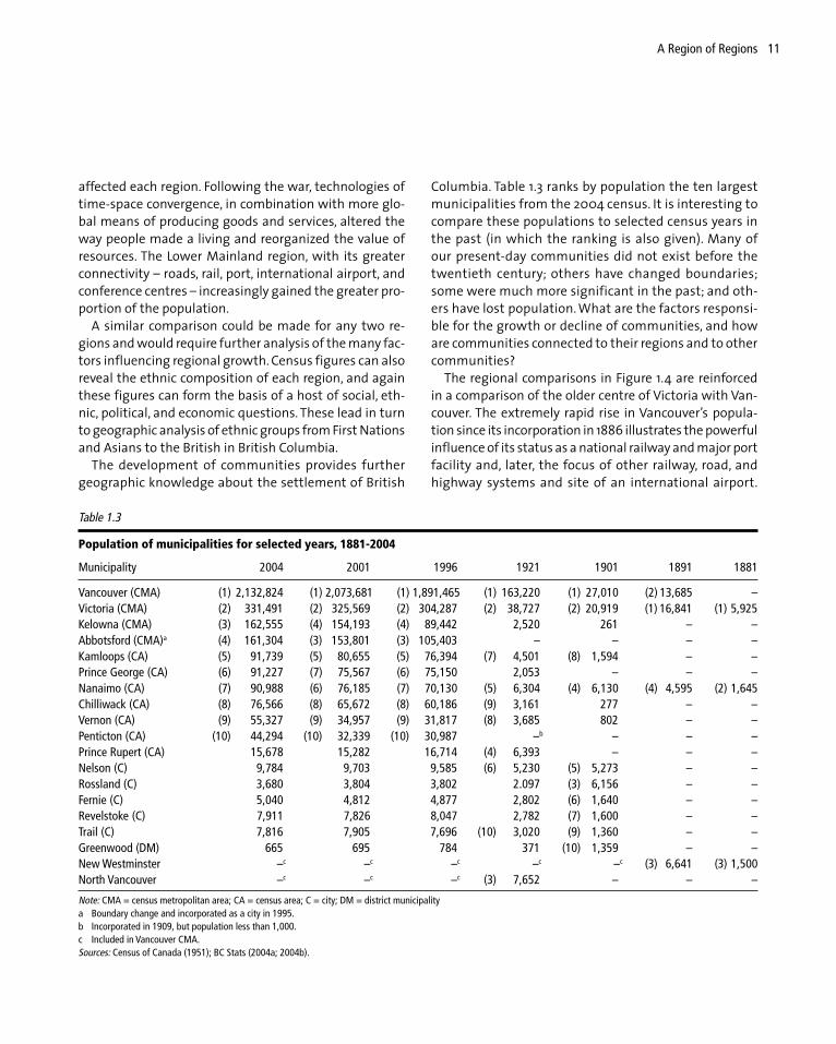
Columbia. Table 1.3 ranks by population the ten largestmunicipalities from the 2004 census. It is interesting tocompare these populations to selected census years inthe past (in which the ranking is also given). Many ofour present-day communities did not exist before thetwentieth century; others have changed boundaries;some were much more significant in the past; and oth-ers have lost population. What are the factors responsi-ble for the growth or decline of communities, and howare communities connected to their regions and to othercommunities?
The regional comparisons in Figure 1.4 are reinforcedin a comparison of the older centre of Victoria with Van-couver. The extremely rapid rise in Vancouver’s popula-tion since its incorporation in 1886 illustrates the powerfulinfluence of its status as a national railway and major portfacility and, later, the focus of other railway, road, andhighway systems and site of an international airport.
Table 1.3
Population of municipalities for selected years, 1881-2004
Municipality 2004 2001 1996 1921 1901 1891 1881
Vancouver (CMA) (1) 2,132,824 (1) 2,073,681 (1) 1,891,465 (1) 163,220 (1) 27,010 (2) 13,685 –Victoria (CMA) (2) 331,491 (2) 325,569 (2) 304,287 (2) 38,727 (2) 20,919 (1) 16,841 (1) 5,925Kelowna (CMA) (3) 162,555 (4) 154,193 (4) 89,442 2,520 261 – –Abbotsford (CMA)a (4) 161,304 (3) 153,801 (3) 105,403 – – – –Kamloops (CA) (5) 91,739 (5) 80,655 (5) 76,394 (7) 4,501 (8) 1,594 – –Prince George (CA) (6) 91,227 (7) 75,567 (6) 75,150 2,053 – – –Nanaimo (CA) (7) 90,988 (6) 76,185 (7) 70,130 (5) 6,304 (4) 6,130 (4) 4,595 (2) 1,645Chilliwack (CA) (8) 76,566 (8) 65,672 (8) 60,186 (9) 3,161 277 – –Vernon (CA) (9) 55,327 (9) 34,957 (9) 31,817 (8) 3,685 802 – –Penticton (CA) (10) 44,294 (10) 32,339 (10) 30,987 –b – – –Prince Rupert (CA) 15,678 15,282 16,714 (4) 6,393 – – –Nelson (C) 9,784 9,703 9,585 (6) 5,230 (5) 5,273 – –Rossland (C) 3,680 3,804 3,802 2.097 (3) 6,156 – –Fernie (C) 5,040 4,812 4,877 2,802 (6) 1,640 – –Revelstoke (C) 7,911 7,826 8,047 2,782 (7) 1,600 – –Trail (C) 7,816 7,905 7,696 (10) 3,020 (9) 1,360 – –Greenwood (DM) 665 695 784 371 (10) 1,359 – –New Westminster –c –c –c –c –c (3) 6,641 (3) 1,500North Vancouver –c –c –c (3) 7,652 – – –
Note: CMA = census metropolitan area; CA = census area; C = city; DM = district municipalitya Boundary change and incorporated as a city in 1995.b Incorporated in 1909, but population less than 1,000.c Included in Vancouver CMA.Sources: Census of Canada (1951); BC Stats (2004a; 2004b).
12 British Columbia
Vancouver has also attracted the major financial institu-tions and head offices for many of the resource indus-tries operating throughout the province and theAsia-Pacific region. As the provincial capital, Victoria hasexperienced the growth of government and servicesalong with infrastructure developments that link it toVancouver Island’s resources and to the mainland, butthese economic links are not nearly as extensive as thoseof Vancouver.
Other communities throughout British Columbia havechanged their population ranking over time mainlythrough the expansion of transportation and resource de-velopment and processing. By the 1980s, however, the newurban growth dynamics of the tourism and retirement in-dustries, along with technologies that shrink time andspace, had affected some communities more than others.These communities, and their growth (or decline), are in-timately tied to the regions in which they are located.
In the sections that follow, the eight regions shown inFigure 1.3 are briefly described in terms of their distinc-tive physical characteristics and historical development.
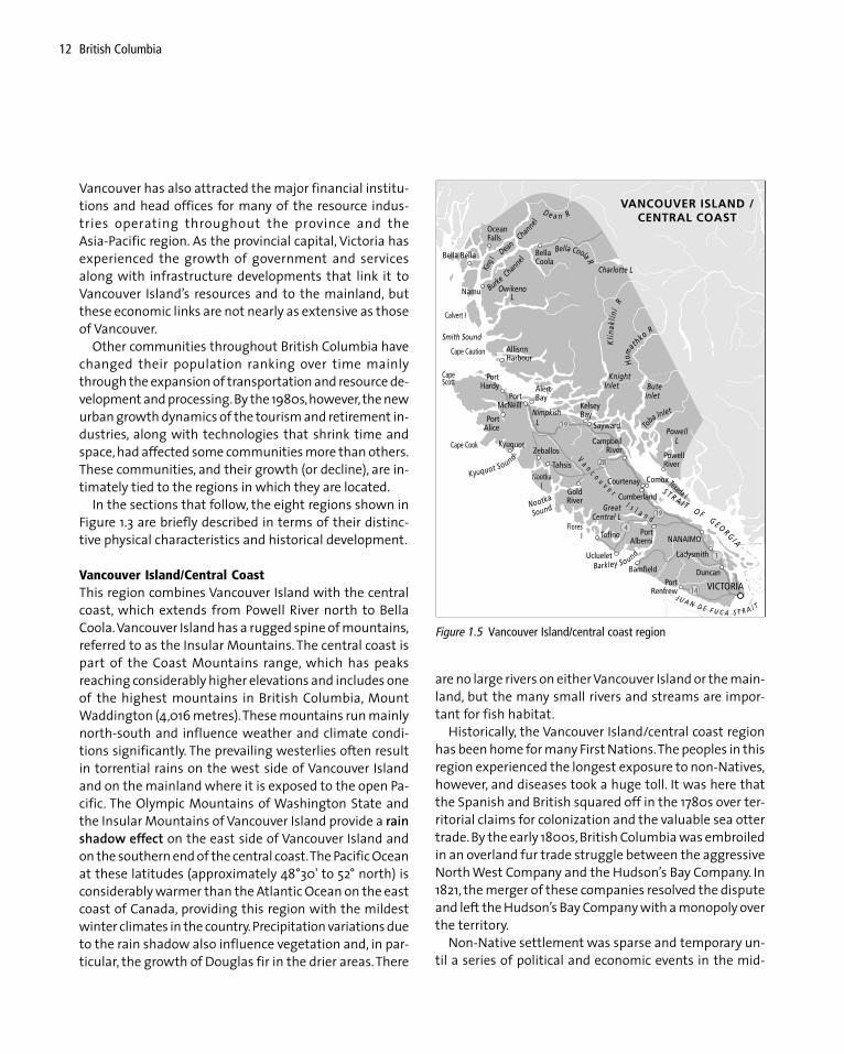
Vancouver Island/Central CoastThis region combines Vancouver Island with the centralcoast, which extends from Powell River north to BellaCoola. Vancouver Island has a rugged spine of mountains,referred to as the Insular Mountains. The central coast ispart of the Coast Mountains range, which has peaksreaching considerably higher elevations and includes oneof the highest mountains in British Columbia, MountWaddington (4,016 metres). These mountains run mainlynorth-south and influence weather and climate condi-tions significantly. The prevailing westerlies often resultin torrential rains on the west side of Vancouver Islandand on the mainland where it is exposed to the open Pa-cific. The Olympic Mountains of Washington State andthe Insular Mountains of Vancouver Island provide a rainshadow effect on the east side of Vancouver Island andon the southern end of the central coast. The Pacific Oceanat these latitudes (approximately 48°30' to 52° north) isconsiderably warmer than the Atlantic Ocean on the eastcoast of Canada, providing this region with the mildestwinter climates in the country. Precipitation variations dueto the rain shadow also influence vegetation and, in par-ticular, the growth of Douglas fir in the drier areas. There
are no large rivers on either Vancouver Island or the main-land, but the many small rivers and streams are impor-tant for fish habitat.
Historically, the Vancouver Island/central coast regionhas been home for many First Nations. The peoples in thisregion experienced the longest exposure to non-Natives,however, and diseases took a huge toll. It was here thatthe Spanish and British squared off in the 1780s over ter-ritorial claims for colonization and the valuable sea ottertrade. By the early 1800s, British Columbia was embroiledin an overland fur trade struggle between the aggressiveNorth West Company and the Hudson’s Bay Company. In1821, the merger of these companies resolved the disputeand left the Hudson’s Bay Company with a monopoly overthe territory.
Non-Native settlement was sparse and temporary un-til a series of political and economic events in the mid-
Figure 1.5 Vancouver Island/central coast region
13A Region of Regions
1800s. The Oregon Treaty of 1846 annexed the British ter-ritory and forts south of the forty-ninth parallel, and as aconsequence Victoria was established at the south endof Vancouver Island. In 1858, gold was discovered on thelower reaches of the Fraser River, triggering an avalancheof miners seeking their fortune. Victoria became the mainport of entry for much of this activity. Further discoveriesof gold in the Cariboo region enhanced Victoria’s posi-tion as the area’s main administrative and service centre.The two separate colonies of Vancouver Island and themainland were amalgamated in 1866 with Victoria as thecapital, a position it has maintained since British Colum-bia joined Confederation in 1871.
The location of the capital attracted most settlers inthe region to the southern end of Vancouver Island. Therest of the island was opened up in response to resourcediscovery, transportation developments, and technologi-cal change. Coal was an important resource found beforethe discovery of gold. The discovery of other minerals, suchas iron ore on Texada Island and copper at the north endof Vancouver Island, created more jobs, but most of thisactivity did not occur until after the 1960s. Salmon fish-ing and canneries sprang up along the island and main-land coasts, and farming settlements were establishedmainly in the southeast of the island. By far the mostimportant industry throughout the region was forestry.Large lumber mills such as the one in Chemainus were inoperation by the 1880s, followed by pulpmills in the com-munities of Ocean Falls, Port Alice, and Powell River in theearly 1900s.
Historically, railways were the most important meansof land transportation on Vancouver Island. The Esquimaltand Nanaimo Railway (E&N) opened in 1886 and was themost important line, as it came with a provincial landgrant to over one-quarter of the island. Roads appearedfirst on the southeast side of Vancouver Island and even-tually linked the southern end with the northern as wellas sending tentacles across to the few communities onthe west side of the island (Wood 1979). Ocean-goingtransport provides the main link between the mainlandcoastal communities (e.g., Bella Bella, Bella Coola, OceanFalls, and Powell River) and Vancouver Island. The highlyindented and rugged mainland coastline hindered roaddevelopment in the early days of settlement. Only BellaCoola was linked by road to the rest of the province.
Today more than 700,000 people live in this region. Theforest industry is still important, especially for those liv-ing in the west and north of the island and along the cen-tral coast. However, the failure of the US-Canada softwoodlumber agreement and unstable pulp prices have resultedin production cutbacks, permanent closures (e.g., GoldRiver in 1999), and increased unemployment. Farming,including farm-gate wineries, a wide range of recreationand tourism options, commercial fishing, and fish farm-ing (although controversial) are other areas of employ-ment. The Canadian Forces Base in Comox, employing over1,500, is significant to the Comox-Courtenay region.
The southeastern portion of the island has experiencedsome unique economic dynamics. It has attracted a hugenumber of retirees because of the mild winters with rela-tively little snow to shovel and year-round recreationalactivities. This part of the island also attracts the great-est number of tourists in the region because direct ferrylinks with the Lower Mainland make it easily accessible.As well, the southern end of Vancouver Island is intimatelylinked to the Lower Mainland region in the provision ofadministrative and service functions for western Canadaand the Asia-Pacific region, making it part of the core, orheartland, of the province, as opposed to the periphery,or hinterland. (Confusion arose with these terms whenthe 2001-5 provincial Liberal government took to refer-ring to the hinterland as the heartland. After provincialcutbacks, some in the periphery dubbed it the “hurtland.”)
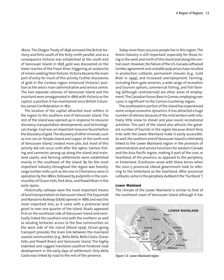
Lower MainlandThe climate of the Lower Mainland is similar to that ofthe southeast coast of Vancouver Island although it has
Figure 1.6 Lower Mainland region

14 British Columbia
higher precipitation, including more snow in winter, thehigher the elevation. The Fraser River, the largest river sys-tem in the province and most significant to the salmonfishing industry, is an important physical feature of thisregion.
Historically, salmon and other resources of the waterand land attracted many First Nations to the region. Fornon-Natives, gold was the main attraction following itsdiscovery on the Fraser in 1858. Agricultural settlementssoon followed, but securing these rich agricultural landsfrom the threat of floods has not been easy. Before theestablishment of Vancouver, major sawmills on BurrardInlet exported lumber, and canneries operated at themouth of the Fraser River.
Transportation has been a major factor in the growthand development of this region. The completion of theCPR at Port Moody and its extension to Vancouver in 1886was the catalyst for the rapid growth observed in Table1.3. Vancouver, with its national railway and internationalport, was the main centre for this relatively small geo-graphic region and was largely responsible for the growthof the adjacent Fraser Valley to the east, the Squamish-Whistler-Pemberton corridor to the north, and the Sun-shine Coast to the northwest. The mountains and valleysframed the transportation links and settlement patternsfor this region. The Sunshine Coast has a linear settlementpattern following the Strait of Georgia and is connectedto Vancouver via ferry at Horseshoe Bay in West Vancou-ver. The Pacific Great Eastern Railway (renamed the Brit-ish Columbia Railway, or BCR, in 1972) initially ran betweenSquamish and Quesnel (1921), and then was extendedsouth to North Vancouver (1956) and north beyondQuesnel. This railway line has been an important trans-portation link to the ports at Squamish and North Van-couver. The Sea-to-Sky Highway is the main transportationsystem today as it winds its way beside Howe Sound toSquamish and then follows valleys leading past Whistlerto Pemberton, Lillooet, and the interior of the province.Vancouver, Whistler, and all the communities betweenthem, as well as the route that links them, have gainedmuch attention since the announcement that Vancouver/Whistler is hosting the 2010 Winter Olympics.
For the Fraser Valley, the river was originally the maintransportation system. The construction of the CPR, andlater the Canadian National Railway and British Colum-
bia Electric Railway, made the region accessible. Road sys-tems were built in the early 1900s, and eventually theconstruction of the Trans-Canada Highway and otherhighways linked Vancouver and the Fraser Valley to therest of the province and south to the United States.
Favourable climate, superb natural features, highways,railways, port facilities, an international airport, and manycommercial links to the rest of Canada, Asia, and the worldmake Vancouver a world city. This region has become thefocus of the high-tech and film industry in the provincealong with tourism, international banking, finance, insur-ance, real estate, the head offices of resource-based in-dustries, and most international immigration to theprovince. Forestry, fishing, and agriculture, the region’smain industries historically, continue as importantsources of employment. As well, many economic and ad-ministrative activities are shared with the southern endof Vancouver Island, making the combined region of theLower Mainland and southern Vancouver Island the heart-land of British Columbia. The Lower Mainland has nearly60 percent of the province’s population, and this marginwill increase in the future.
OkanaganThe Okanagan Valley lies between the Cascade Mountainsto the west and the Monashee Mountains to the east.There are several lakes in this valley, Okanagan Lake be-ing the largest. The region’s southern location betweentwo large mountain chains results in a continental climate
Figure 1.7 Okanagan region

15A Region of Regions
with typical temperature extremes of hot summers andrelatively cold winters. The vegetation of this arid valleyconsists mainly of grasses and sagebrush with few trees;forests grow on the moister mountain slopes.
The region became the home for the Okanagan FirstNations. Some non-Native settlement occurred with thefur trade, but much more took place as the region becamerecognized for its farming potential as a fruit-growingarea. The Okanagan is one of the few places in Canadawhere apples and “soft fruit” such as peaches and cher-ries are produced, but irrigation is necessary in this drybelt. A number of communities evolved to serve the grow-ing agricultural settlement. Vernon, Kelowna, andPenticton, all on Okanagan Lake, became the most promi-nent. Boats on Okanagan Lake served an important trans-portation function, and later railway lines were built. TheKettle Valley line (1915) provided the link between theKootenays and the Lower Mainland, giving access to thesouthern Okanagan, while a branch line of the CPR link-ing Kamloops to Kelowna (1925) served the northern por-tion of the region.
Several changes occurred after the 1960s. Tourism,which had mainly been a summer activity, expanded intoa year-round endeavour, with golf courses and ski runs.The dry climate and four distinct seasons, combined withrelatively low land and housing prices and easy access tothe Lower Mainland, made this a favourable location forretirement. These characteristics led to increased popu-lation, urban sprawl, and land use conflicts, especially overagricultural land, until the implementation of agriculturalland reserves in 1972. The motors of fishing and pleasureboats carried Eurasian milfoil into the region, where itspread through the water systems, converting once sandybeaches to a mass of weeds and jeopardizing the grow-ing tourism industry. Eradication programs in the 1970smade use of herbicides that provided some control butalso raised concern about potential carcinogenic effects.
Other industries expanded in the region, including min-ing and forestry, both of which increased the employmentand population base. With the signing of the Free TradeAgreement between Canada and the United States in 1989,agriculture changed rapidly. Fruit crops continued to domi-nate, and to compete with US producers with access toinexpensive labour, BC producers developed new varietiesof apple trees requiring considerably less labour. One of
the most significant changes was to the grape and wineindustry. Forced to compete globally, it met the challengeby growing new grape varieties. New rules permitting thesale of wine from farms was a large part of the success ofthe industry, which now attracts many tourists.
The Okanagan has many physical assets and a fairlydiversified economy, making it one of the rapid growthregions in the province (Table 1.2). Within the Okanagan,Kelowna has become the most important service, admin-istrative, and manufacturing centre, with a regional air-port and a highway link to the coast via the CoquihallaHighway. The firestorm of 2003 was particularly devas-tating to this community, incinerating 238 homes (CBC2003).
KootenayMountains, rivers, and valleys are the main physical fea-tures that define the Kootenay region. The rugged moun-tain chains run north-south: first the Monashees, then tothe east of them the Selkirks, farther east the Purcells, andfinally the Rockies. All the rivers and lakes in these valleys
Figure 1.8 Kootenay region

16 British Columbia
are part of the Columbia River system, which exits BritishColumbia at Trail as the Columbia flows into the UnitedStates. Climatically, this region is similar to the Okanagan,but slightly colder in winter, not as hot in summer, andwith slightly more precipitation.
Several First Nations resided in this region: the Kootenaito the east, the Okanagan to the west, and the ShuswapNation to the north.
Census Canada has traditionally divided the Kootenaysinto east and west, but the divisions share a valuable min-eral resource base. Gold, silver, coal, copper, lead, and zincwere all discovered and became the lure to settlementand development following the fur trade era. With theCrow’s Nest Pass Agreement of 1897, the CPR became theprincipal landowner, provider of rail transportation, anddeveloper of the resources. The Agreement was a dealstruck between the federal and provincial governmentsand the CPR to run a branch line from Lethbridge, Alberta,through the Crowsnest Pass to the mineral-rich Koote-nays, ending initially at Nelson. Through the Agreementand their subsequent purchase of railway grants, the CPRacquired millions of acres of land, coal deposits, metalmines, a major smelter at Trail (Cominco), and WestKootenay Light and Power. The CPR exerted enormouscontrol over this region. Other railway companies builtlines and acquired land grants, but the CPR purchasedmost of these over time, consolidating its hold on theKootenay economy. The population changes in this region(Table 1.2) hide the boom and bust cycles experienced byindividual mines and smelters. The list of ghost towns inthe Kootenays is sufficient to warrant several books andarticles (Barlee 1970; 1978a; 1978b; 1984).
Historically, settlement patterns in the area have beeninfluenced mainly by mineral exploitation, transportationdevelopments, and agricultural opportunities. Other fac-tors also led to settlement. For example, the Doukhoborsmigrated to the Kootenays in the 1930s in an attempt toescape religious persecution in Europe and political per-secution in Saskatchewan. The area had good agriculturalland for their communal lifestyle and appeared to be rela-tively isolated from government interference. In the early1940s, many Japanese families, evacuated from the coast,were sent to communities and work camps throughoutthe Kootenays such as Greenwood, Sandon, New Denver,and Slocan City.
Forestry has been another resource activity in this re-gion. The Kootenays experienced forestry expansion af-ter 1961 with a pulpmill in West Kootenay at Castlegarand in East Kootenay at Skookumchuck. In the 1960s, theprovincial government became involved in hydroelectricmegaprojects. Through the “two rivers policy,” the PeaceRiver, in the northeast, and the Columbia River, in theKootenays, were developed for hydroelectricity simulta-neously. The dams also provided flood protection for cit-ies such as Spokane in Washington State. Other dams,such as the Revelstoke Dam, were constructed later tofulfill increased electrical demand by British Columbians.
Currently, the Kootenay region remains dependent onresource development and export. Mining, forestry, andhydroelectric energy are vital to the economic well-beingof the region, although both mining and forestry haveseen setbacks. The closure of the Sullivan Mine (the main-stay of Kimberley from 1909 to December 2000), theslowdown in production at the Trail smelter, and fluctu-ating coal prices have reduced employment in miningthroughout the region. Forestry has been hit by the USsoftwood lumber dispute. Tourism has offered some di-versification, as the region has many hot springs and lakes,and opportunities abound for skiing, hiking, and sight-seeing. Investments in tourist infrastructure such as skifacilities (e.g., Panorama, Fernie, and Kimberley), golfcourses, and casinos have increased tourist visitations.Nevertheless, being a considerable distance from majorurban populations in Alberta, British Columbia, and theUnited States, the region is likely to show slow overallgrowth in the future.
South Central InteriorThe south central interior is largely identified by theSouthern Interior Plateau. The region extends west ofLillooet to Revelstoke on the Columbia River, but it is theThompson River system that mainly defines this region.The Thompson River valley is hot in summer and cold inwinter, with precipitation occurring mainly on the sur-rounding mountains. The Shuswap Nation of the InteriorSalish have been the traditional users of the land.
Early European interest in this region was due to fursand gold. The Thompson River was an important “high-way” for the fur trade, and Kamloops was established asa fur trade post in 1812. Small amounts of gold were dis-

17A Region of Regions
covered in the region in the mid-1850s but not in amountssignificant enough to create a gold rush. The gold rush tothe Cariboo in the 1860s, however, attracted cattle drivesand cattle ranching to these interior grasslands.
When the CPR main line was built, Kamloops becamethe main supply and service centre for the region. Thislocation, where the North and South Thompson Riversmeet, was enhanced by later transportation develop-ments such as the extension of the Canadian NationalRailway (CNR) down the North Thompson and throughKamloops on its way to Vancouver. With the developmentof road systems, Kamloops was on the Trans-Canada High-way, and it is currently at the end of the CoquihallaHighway, which runs to the coast.
Farming and ranching were the main industries in thesouth central interior until the 1960s, when forestry, min-ing, tourism, and the retirement industry were added.Forestry has been the most important, with a pulpmillestablished in Kamloops in the mid-1960s and sawmillsand other forest-product manufacturing throughout theregion. Mining has also played a significant role, with acopper smelter at Kamloops (now closed) and minesthrough the Highland Valley from Ashcroft to Merritt.Tourism is increasing in importance largely because of the
transportation routes that lead to Kamloops and branchnorth to Jasper and Edmonton and east to Banff andCalgary. Accessibility and many favourable features havealso attracted retirees to this region. The south centralinterior is another region with a relatively rapid increasein population, as shown in Table 1.2, but it is dominatedby one urban centre – Kamloops.
North Central InteriorThe north central interior is one of the largest regions inthe province and is defined by the Northern Interior Pla-teau. The northern half of the Fraser River, with its manytributaries, is a large part of this region, although the areaextends westward to include Smithers and the BulkleyValley. Temperature regimes are colder than are southerninterior locations in winter and not as hot in summer. Themixing of Pacific and Arctic air masses results in increasedprecipitation, but this varies through the region in rela-tion to the configuration of the mountain chains.
Figure 1.9 South central interior region
Figure 1.10 North central interior region

18 British Columbia
Historically, the area has been home to many First Na-tions, such as Sekani, Nat’oot’en, Wet’suwet’en, andDakelh. The history of non-Native settlement began withthe overland fur trade, which relied on the Fraser Riverfor transportation. Forts were erected through the regionin the early 1800s, but it was not until the Cariboo goldrush of the early 1860s that more permanent non-Nativesettlement ensued. A number of routes were used to gainaccess to the Barkerville area from the Lower Mainlanduntil the Cariboo Road was constructed in the mid-1860s.Gold was also discovered in the northern part of the re-gion, in the Omineca Mountains for example, but thesefinds were not sustainable. The development of Barker-ville and other mining communities also attracted ranch-ing to the southern part of the region, including theChilcotin Plateau. By the end of the 1860s, however, thegold discoveries were minimal and the miners were dis-appearing along with the communities. This large regionremained relatively uninhabited until the CNR connectedit to the port of Prince Rupert to the west in 1914. Fromthe south, the Pacific Great Eastern Railway (PGE) wasbuilt in a series of stages: Squamish to Quesnel in 1921,Quesnel to Prince George in 1952, Prince George to thePeace River in 1958, and Prince George to Fort St. James in1968. Prince George, like Kamloops, became a transporta-tion hub of rail lines, and later highway systems, servingcentral and northern British Columbia.
Since the 1960s, as the population growth in Table 1.2indicates, there has been considerable interest in this re-gion. The mining of copper, molybdenum, and goldbrought many workers into the area, but the main indus-try was forestry. The forests were largely untouched untilthe 1960s, when the increase in world demand for forestproducts saw a massive expansion in the industrythroughout the north central interior. The manufactur-ing of plywood, lumber, and other forest products wasintegrated with pulp-and-paper mills built at Quesnel,Prince George, and in the new town of Mackenzie.
Today, some of the mines have closed, and the forestindustry is in a downward cycle, reminding us that muchof the region is extremely resource dependent. PrinceGeorge has emerged as the largest centre. With its acces-sibility, its new university, and its many services, it hasbecome an important service centre to central and north-
ern British Columbia, performing a role similar to the onethat Edmonton performs for Alberta.
North Coast/NorthwestThe north coast/northwest is another large region, iso-lated for much of its area because of its rugged, moun-tainous landscape. The Coast Mountains, which extendthe length of this region, are among the highest in Brit-ish Columbia. The northwest corner of the region consistsof the St. Elias range, where Fairweather Mountain (4,663metres) is the highest peak in British Columbia. The coastis highly irregular and the northern coast makes up theAlaska Panhandle. The heavily forested Queen CharlotteIslands are also part of this region. Climatically, much ofthe area is exposed to the Pacific and to the westerly flows
Figure 1.11 North coast/northwest region
19A Region of Regions
of wind (that is, wind flowing from the west). Its north-ern location brings considerable exposure to the Aleutianlow pressure system, which brings much rain in the sum-mer and snow in the winter. The Skeena, Nass, and Stikineare the largest of the very significant river systems flow-ing to the Pacific.
The north coast has been home to high densitypopulations of First Nations, whereas First Nations in thenorthwest have had much lower populations. A numberof factors led to early European development of northcoast/northwest region. In the late 1700s, the sea ottertrade aroused considerable interest. The Russians, whoerected fur trade posts across Alaska and the Panhandle– the strip of Alaska that extends south along the coast –were the first to exploit these valuable furs. They laid ter-ritorial claim to Alaska, thus cutting off the northwestfrom the sea. Subsequently, Russia sold this territory tothe Americans in 1867. Without access to the Pacific, thenorthwest portion of this region was left largely to over-land fur trade interests.
Other resources encouraged temporary settlement.Salmon was valuable, for example, and canneries becameevident by the late 1800s and early 1900s, especially atthe mouth of the Skeena and the Nass and along thecoast. Except for those at the mouth of the Skeena, mostdisappeared in the 1950s with improvements in fishingtechnology. Coal was discovered north of Prince Rupertand was mined for several years until the richer and moreaccessible coal mines of Nanaimo and other VancouverIsland locations were developed in the 1850s. Smallamounts of gold were discovered on the Queen Charlottesin 1850 and on the Skeena River in 1863, but no gold rushoccurred in either case. In 1898, the Yukon gold rushopened up the northernmost portion of the region. Thefamous Chilkoot Pass, and the building of the White Passand Yukon Railway in 1902, meant that most gold seekerspassed through the northern tip of British Columbia be-fore entering the Yukon. There was plenty of interest inthis region in this period but little permanent settlement.
The completion of the CNR to Prince Rupert in 1914 wasanother important event, and it increased permanentsettlement. Charles Hays, a prominent entrepreneur in theearly history of Prince Rupert, was a major shareholder ofthe railway. He was an industrial waterfront landowner
and an avid promoter of the town, but he never saw hisvision materialize – he was a passenger on the Titanic in1912 and, unfortunately, was not counted among the sur-vivors. Prince Rupert was also the site of an early pulpmill,which encouraged growth as well. A copper smelter wasbuilt at Anyox, north of Prince Rupert, but lasted only untilthe Depression. The Second World War prompted con-struction of the Alaska Highway, giving some accessibil-ity to the remote northwest portion of the region. One ofthe first areas outside the Lower Mainland to expand withthe post-Second World War boom was Kitimat. Thisplanned town was built to house the workers for a newaluminum plant in the early 1950s.
As in other regions, the mining and forest industries inthe north coast/northwest region underwent major ex-pansion beginning in the 1960s. The Stewart-Cassiar roadlinked the Alaska Highway through the northwest toPrince Rupert. A major copper mine near Stewart, a largeopen-pit mine for asbestos at Cassiar, and a number ofsmall gold mines brought employment to these ratherisolated locations. The development of Quintette andBullmoose mines and the new town of Tumbler Ridge inthe Peace River region – a coal mining region known asnortheast coal – in the early 1980s resulted in the rail linebeing double tracked to Prince Rupert and a large coalport being built at nearby Ridley Island. A coal port is a“super port” with facilities for unloading coal from trainsand loading it onto large ocean-going vessels. A plannedexpansion of the aluminum smelter at Kitimat was can-celled in 1995 for environmental reasons, but aluminumproduction remains important to the region. The forestindustry expanded in a number of directions. Much of thevaluable timber from the Queen Charlottes was harvestedand barged south for the mills of the Lower Mainland. Apulpmill was opened at Kitimat in the 1960s. The pulpmillat Prince Rupert was upgraded, and logging andsawmilling expanded throughout the region. PrinceRupert has emerged as the largest centre for the region,but the threat of its old pulpmill closing, along with otherold sawmills in the area, puts into perspective the impor-tance of the forest industry to this city and the region asa whole.
Northeast of Prince Rupert, the Nisga’a of the Nass RiverValley were the first to enter into a modern peace treaty

20 British Columbia
in British Columbia (signed in 2000), setting a precedentfor future treaties throughout the province. The treatyresulted in a cash settlement, land ownership (i.e., theirland base is no longer a reserve), a Native-owned forestrycompany, and a substantial share of the Nass River com-mercial salmon fishery.
There are few roads or rail lines through this area eventoday, and its growth is tied closely to resource develop-ment. The north coast/northwest region is slow growing,and recently, population has declined.
Peace River/NortheastMost of the Peace River/northeast region does not fit thebroad physical description of British Columbia as a moun-tainous, vertical landscape. This flat, sedimentary region
east of the Rockies is physiographically similar to the prai-ries. The two major rivers, the Peace River in the southand Liard River in the north, are part of the MackenzieRiver system, which drains into the Arctic Ocean. The re-gion contains areas of permafrost, bog, and boreal spruceforests. Temperatures are cold in winter and surprisinglywarm in summer, when the days are long, inducing con-vection precipitation.
North West Company fur traders were the first non-Natives to enter the region, and it is here that the earliestfur trade forts in British Columbia were erected. Discov-eries of gold on the Peace River in the 1860s warrantedthe inclusion of this territory into British Columbia, butthe finds were insufficient to sustain permanent settle-ment. The Yukon gold rush at the end of the nineteenthcentury initiated Treaty 8, covering the region north ofEdmonton, the northwest corner of Saskatchewan, andthe Peace River/northeast region of British Columbia. TheCanadian government believed that this would be a routeto the gold fields and that the treaty would be a meansof avoiding conflict. The First Nations of the Peace River/northeast region were the only people to be included in anumbered treaty in the province.
Few agricultural settlers ventured this far north untilthe homesteads of the south and central Prairies wereno longer available. The development of hardy, early ma-turing wheat facilitated agricultural homesteads by the1920s and ’30s. Problems of accessibility were improvedwhen the rail line from Alberta was extended to DawsonCreek in 1930. The Alaska Highway was constructed dur-ing the war and Dawson Creek became Mile 0, helping toopen up the region. The federal government made morefarmland available at the end of the Second World Warfor returning servicemen. The PGE was finally extendedto Fort Nelson by 1971. Wheat farming on the excellentsoil and cattle rearing have been the main agriculturalactivities of the Peace River area.
The discovery and development of oil and natural gasin the 1950s encouraged investment, the building of pipe-lines, and the movement of considerably more people tothis region. By the 1960s, the Peace River had become onetarget of the massive hydroelectric plan referred to as thetwo rivers policy. The plan involved constructing the W.A.C.Bennett Dam, which in turn created the largest reservoir,or artificial lake, in the province, Lake Williston. As well,Figure 1.12 Peace River/northeast region

21A Region of Regions
transmission lines were built to connect the hydroelec-tric power source to southwestern British Columbia. Allthis attracted even more people to the Peace River. Theenergy crisis, beginning in the early 1970s, sparked anotherround of oil and gas exploration and development.
The sedimentary basin also contained coal, and in theearly 1980s, northeast coal began to be developed in thearea. The new town of Tumbler Ridge housed the miners,an electric rail line of the British Columbia Railway (for-merly the PGE) was constructed, and millions of dollarswere spent upgrading the CNR line from Prince Georgeto Prince Rupert and, as discussed above, building a coalport at Ridley Island. The costs borne by both provincial andfederal governments to export the coal were massive. Un-fortunately, the world market demand and price for coaldeclined, and so did the contracts with Japanese buyers.The Quintette mined closed in 1999 and the Bullmoosein 2003, leaving Tumbler Ridge struggling to convert to aretirement, tourist, and recreation community.
Today Fort St. John and Dawson Creek are the largestcentres in the Peace River/northeast region. The forestindustry employs many people in two pulp mills, sawmills,oriented strandboard plants, and a plywood mill. Agricul-ture has been difficult because the price of grain has beenlow consistently, and in 2003 the beef industry was hitby bovine spongiform encephalopathy (BSE, also calledas “mad cow disease”). BC Hydro has brought the contro-versial Site C Dam proposal, on the Peace River near FortSt. John, out of mothballs, which has many farmers, envi-ronmentalists, and others concerned about another flood-ing of the Peace River valley. Oil and natural gasparticularly continue to be important, and exploration forcoalbed methane is taking place. There is also an expec-tation that the price of coal will rise, leading to new coalmines and, potentially, the re-opening of Quintette. Tour-ism has increased in response to a variety of recreationalopportunities, the diversity of the landscape, and the dis-covery of dinosaur footprints at Tumbler Ridge and nearthe W.A.C. Bennett Dam. The Alaska Highway continuesto be a major tourist attraction.
With all of this, however, comes the potential for con-flict between the resource industries and those interestedin preserving the wilderness. The Muskwa-Kechika Man-agement Area Act, signed in 1998, attempts to accommo-date all interests in the very large wilderness region from
Lake Williston north to the Yukon border. The economyand growth of the Peace River/northeast region is tied toits diverse resource endowment. It is a large region, thepopulation is relatively small, and growth, or decline, oc-curs in relationship to resource demand.
SUMMARYGeography is a practical discipline that assesses the hu-man and physical factors influencing the surface of theearth. The focus in this text is the landscapes of BritishColumbia. The province is divided into eight regions forthe purposes of examination in the first and last chap-ters, but the remaining chapters employ a thematic, ortopical, approach. The history of what has gone on beforeis an important theme for all chapters.
Time-space convergence and spatial diffusion are ba-sic geographic concepts essential to understanding move-ment over space and through time. Statistics, graphs, andmaps are common tools and techniques of the geogra-pher whereby the province and its regions can be morefully understood.
The regional perspective is important, not only in rec-ognizing British Columbia’s unique physical and humanattributes, but also in assessing the more global and ex-ternal forces shaping this province. Both external and in-ternal factors influence growth and development, but notequally throughout the province. We have seen that someof the province’s eight regions have grown considerablymore than others.
Most important, Geography of British Columbia hasbeen written with a minimum of geographic jargon in itsattempt to tell the stories of human and physical influ-ences shaping the landscapes of this province.
REFERENCES
Barlee, N.L. 1970. Gold Creeks and Ghost Towns of Southern Brit-ish Columbia. Summerland, BC: Self-published.
–. 1978a. The Best of Canada West. Langley, BC: Stagecoach.–. 1978b. Similkameen: The Pictograph Country. Summerland, BC:
Self-published.–. 1984. West Kootenays, the Ghost Town Country. Surrey, BC:
Canada West Publishers.Census of Canada. 1951. British Columbia Population by Census
Subdivisions, 1871-1951. Table 6/6-84 to 6-88. Ottawa.

22 British Columbia
–. 1971. British Columbia Population by Census Subdivisions, 1961and 1971. Table 8/8-92 to 8.96. Ottawa.
Dearden, P. 1987. “Marine-Based Recreation.” In British Colum-bia: Its Resources and People, ed. C.N. Forward, 259-80. West-ern Geographical Series vol. 22. Victoria: University of Victoria.
Gould, P.R. 1969. Spatial Diffusion. Resource paper no. 4. Wash-ington, DC: Association of American Geographers.
Gregory, D. 2000. “Regions and regional geography.” In The Dic-tionary of Human Geography, ed. R.J. Johnston, D. Gregory,G. Pratt, and M. Watts, 687-90. 4th ed. Oxford: Blackwell.
Harris, C. 1997. The Resettlement of British Columbia: Essays onColonialism and Geographical Change. Vancouver: UBC Press.
Hébert, A. 2001. “Québec: The Core of First Time.” In A Passionfor Identity: Canadian Studies for the 21st Century, ed. D. Tarasand B. Rasporich, 79-86. Scarborough, ON: Nelson ThomsonLearning.
McCune, S. 1970. “Geography: Where? Why? So What?” Journalof Geography 7 (69): 454-7.
Muckle, R.J. 1998. The First Nations of British Columbia. Vancou-ver: UBC Press.
Pudup, M.B. 1988. “Arguments within Regional Geography.”Progress in Human Geography 12: 369-90.
Renwick, W.H., and J.M. Rubenstein. 1995. An Introduction toGeography: People, Places, and Environment. Englewood Cliffs,NJ: Prentice Hall.
Robinson, J.L. 1972. “Areal Patterns and Regional Character.” InStudies in Canadian Geography: British Columbia, 1-8. Toronto:University of Toronto Press.
Stanford, Q.H., ed. 2003. Canadian Oxford World Atlas. Don Mills,ON: Oxford University Press.
Wood, C.J.B. 1979. “Settlement and Population.” In VancouverIsland: Land of Contrasts, ed. C.N. Forward, 3-32. Western Geo-graphical Series vol. 17. Victoria: University of Victoria.
INTERNETBC Stats. 2004a. “British Columbia Municipal Census
Populations, 1921-1971.” www.bcstats.gov.bc.ca/data/pop/popstart.htm.
–. 2004b. “Municipal and Regional District Total Population Es-timates, 1981-2004.” www.bcstats.gov.bc.ca/data/pop/popstart.htm.
CBC. 2003. “BC Fire Talk Tape.” Radio One. 14 November.www.cbc.ca/thecurrent.
Statistics Canada. 1983a. Historical Statistics of Canada. Cata-logue 11-516-X1E. Population 1871-1971, series A2-14.www.statcan.ca.
–. 1983b. Historical Statistics of Canada. Catalogue 11-516-X1E.Natural increase and net migration 1931-1976, series A339-49.www.statcan.ca.
–. 1983c. Historical Statistics of Canada. Catalogue 11-516-X1E.Rural and urban population 1871-1971, series A67-69.www.statcan.ca.
–. 2001a. Population 1981-2001. CANSIM Table 051-0001. http://cansim2.statcan.ca.
–. 2001b. Rural and urban population 1981-2001. CANSIM Table109-0200. http://cansim2.statcan.ca.
–. 2004. Natural population increase and net migration 1976-2001. CANSIM Table 051-0013. http://cansim2.statcan.ca.