geography for life, 2 edition national …draft: geography for life, 2nd edition 1 geography for...
TRANSCRIPT

DRAFT: Geography for Life, 2nd Edition 1
GEOGRAPHY FOR LIFE, 2ND EDITION
NATIONAL GEOGRAPHY STANDARDS
Draft Version for Review Only
June 12, 2009
DRAFT: Geography for Life, 2nd Edition 2
Essential Element: The World in Spatial Terms GEOGRAPHY STANDARD 1 HOW TO USE MAPS AND OTHER GEOGRAPHIC REPRESENTATIONS, GEOSPATIAL TECHNOLOGIES, AND SPATIAL THINKING TO UNDERSTAND AND COMMUNICATE INFORMATION The geographically informed person uses maps and other geographic representations, geospatial technologies, and spatial thinking to understand and communicate information. The study and practice of geography require the informed and ethical use of geographic representations, geospatial technologies, and spatial thinking. Maps, graphic representations of selected aspects of Earth’s surface, are the key geographic mode of representation but globes, graphs, diagrams, and aerial and satellite images (Remote Sensing) also provide valuable information about spatial patterns on Earth.
No single map can show everything, and the features depicted on each map are selected to fit a particular purpose. The revolution in geospatial technologies (including Geographic Information Systems (GIS) and Global Positioning Systems (GPS) as well as Internet‐based mapping sites such as digital globes) has made the ability to analyze spatial patterns in multiple fashions quickly an important problem‐solving and decision‐making skill in geography and other science subject areas.
Geographic data are compiled, organized, stored, manipulated, and made visible in many ways. Knowing how to identify, access, evaluate, and use appropriate geographic representations will ensure students of a rich
school experience in geography and other subjects across the curriculum. They will also have an array of powerful problem‐solving and decision‐making skills for use in both their educational pursuits and their adult years.
Standard 1 is arranged around three themes: 1) Properties of Geographic Representations and Geospatial Technologies; 2) Map Interpretation; and 3) Map Construction. At all grade levels, students need to understand what a map is and what it can—and cannot—do. They need to be able to read and interpret maps and other geographic representations such as remotely‐sensed images as a tool of analysis. And finally, students need to know how to make maps, from simple sketch maps to more complex representations using a range of appropriate technologies. Further, they need practice and experiences in how to collect and display information (data) on maps, graphs, and diagrams.

DRAFT: Geography for Life, 2nd Edition 3
By the end of grade 4, the student knows and understands:
By the end of grade 8, the student knows and understands:
By the end of grade 12, the student knows and understands:
Properties of Geographic Representations and Geospatial Technologies
1. Properties and purposes of geographic representations‐‐such as maps, globes, graphs, diagrams, Internet‐based mapping applications, GIS, GPS, RS, and geographic visualizations, aerial and other photographs, and remotely‐sensed images
Therefore, the student is able to:
A. Identify and describe the properties (position and orientation; symbols; scale; perspective; coordinate systems), and purposes of geographic representations, as exemplified by being able to
Examine a variety of geographic representations to identify and describe their basic properties (e.g., title, legend, cardinal and intermediate directions, scale, symbols, grid, principal parallels, meridians) and purposes (wayfinding, reference, thematic).
B. Describe how map properties relate to the purposes of map creation and use, as exemplified by being able to
Select the maps or types of maps most appropriate for a range of purposes, (e.g., to locate physical and human features; to determine the shortest route from one location to another; to compare geographic
1. Properties and functions of maps, globes, aerial and other photographs, remotely‐sensed images, GIS, and GPS and the advantages and disadvantages of each for analyzing spatial distributions and patterns
Therefore, the student is able to:
A. Describe the properties (position and orientation; projections; symbols; scale; perspective; coordinate systems), and functions of geographic representations and geospatial technologies, as exemplified by being able to
Differentiate among geographic representations based on their properties (e.g., orientation, grid system, scale, resolution, and content) and purposes (e.g., using GIS and digital globes to explore geographic information and relationships at a range of scales).
B. Evaluate the appropriate use of geospatial representations and technologies for specific geographic tasks, such as analyzing spatial distributions and patterns, as exemplified by being able to
Based on the advantages and disadvantages of different geospatial representations and technologies, select
1. Ways the properties and functions of geographic representations (including maps, globes, graphs, diagrams, internet‐based mapping applications, GIS, GPS, RS, and geographic visualizations) affect how they can be used to represent, analyze, and interpret geographic patterns and processes
Therefore, the student is able to:
A. Explain the appropriate uses of different technologies and methods for acquiring, producing, and displaying geospatial data, as exemplified by being able to
Describe different geospatial technologies (e.g., GIS, GPS, RS, geographic visualizations) and how each might be used to solve a geographic problem (e.g., help determine where to locate a new playground within a community).
B. Construct maps designed appropriately for specific geographic tasks, as exemplified by being able to
Construct maps designed for different purposes using different cartographic techniques (e.g., 2‐D climate map, 3‐D elevation map, 3‐D population density map, cartogram, thematic maps using different

DRAFT: Geography for Life, 2nd Edition 4
By the end of grade 4, the student knows and understands:
By the end of grade 8, the student knows and understands:
By the end of grade 12, the student knows and understands:
conditions at two or more locations). the appropriate map for a specific purpose (e.g., a cartogram or an equal area map to illustrate population distribution, a remotely sensed image or a reference map to observe evidence of past cultures, or topographic maps or a highway map to consider best routes for new transportation corridors or wind farm.
projections).
Map Interpretation
2. Ways to read and interpret maps and other geographic representations
Therefore, the student is able to:
A. Analyze and interpret maps and other geographic representations, as exemplified by being able to
Use thematic maps and other geographic representations to obtain, describe, and compare spatial patterns and information about people, places, regions, and environments.
2. Ways to interpret spatial distributions and patterns on geographic representations in order to solve geographic problems
Therefore, the student is able to:
A. Analyze and interpret geographic representations to ask and answer questions about spatial distributions and patterns, as exemplified by being able to
Analyze maps using spatial concepts to observe spatial distributions in order to generate and answer geographic questions (e.g., use digital census data to determine demographic patterns in a state; analyze census data and transportation routes to identify and locate services, such as a day care center or a mall needed in a region).
2. Uses of geographic representations and geospatial technologies to investigate, analyze, and communicate the results of geographic problem solving
Therefore, the student is able to:
A. Analyze conditions and suggest solutions to problems at local to global scales using geographic representations and geospatial technologies, as exemplified by being able to
Use multiple geographic representations and geospatial tools to create a presentation which illustrates alternative views of a current or potential local issue of public discussion.
Map Construction/Data
3. Ways to display geospatial data in maps and other geographic representations
3. Ways to acquire and generate geospatial data to construct maps
3. The properties of geospatial data used in map construction

DRAFT: Geography for Life, 2nd Edition 5
By the end of grade 4, the student knows and understands:
By the end of grade 8, the student knows and understands:
By the end of grade 12, the student knows and understands:
Therefore, the student is able to:
A. Construct maps and other geographic representations to display geospatial data, as exemplified by being able to
Design and construct a geographic representation either drawn by hand or produced by a geospatial technology that displays geographic information, using symbols explained in a key (e.g. draw a sketch map to illustrate a narrative story; construct a bar graph that compares the populations of the 5 largest cities in a state or nation; interpret a bar graph of US exports and construct a map displaying the same information using lines of varying width to denote volume of trade.
Therefore, the student is able to:
A. Construct geospatial representations to display thematic topics, such as world religions, population density, and historical events, as exemplified by being able to
Use data to develop paper or digital maps and flow charts illustrating significant geographic themes (e.g, to show major patterns of movement of people and commodities such as international trade in petroleum, migration of refugees from countries experiencing conflict, or settlement patterns in North America 1600‐1900; to examine associations among geographic phenomena such as water resources and population distribution, or topography and Civil War troop movements).
Therefore, the student is able to:
A. Identify the properties (e.g., resolution, date of creation, and method of collection) and evaluate the quality of geographic data of varying formats (e.g., image, text file, databases) from a variety of sources and use them appropriately in map construction, as exemplified by being able to
Locate and examine metadata ("data about the data") for demographic data, land use data, or street data from multiple sources and describe differences in their design which might affect the result of analyses.

DRAFT: Geography for Life, 2nd Edition 6
Essential Element: The World in Spatial Terms GEOGRAPHY STANDARD 2 HOW TO USE MENTAL MAPS TO ORGANIZE INFORMATION ABOUT PEOPLE, PLACES, AND ENVIRONMENTS IN A SPATIAL CONTEXT Knowing where people, places, and environments are located is a necessary precursor to—and outcome—of much geographic learning. To be geographically informed a person must keep in mind a lot of information about people, places, and environments and must be able to organize this information in appropriate spatial contexts.
An effective way of doing this is to develop and use what are called mental maps: an individual’s internalized representation of aspects of Earth’s surface. These “maps in the mind” are what a person knows about the locations and characteristics of places at a variety of scales, from the local (the layout of a person’s bedroom) to the global (the distribution of oceans and continents across Earth). Mental maps are a mix of objective knowledge and subjective perceptions: precise knowledge about the location of geographic features as well as impressions of places, rough estimates of size and location, and a general sense of the connections between places.
Mental maps provide people with an essential means of making sense of the world and of storing and recalling information about the patterns of Earth’s physical and human features. They represent ever‐changing summaries of spatial knowledge and are indicators of how well people know the spatial characteristics of places. People develop
and refine their mental maps through learning from teachers and the media, and through personal experience, moving from simple to more complex levels of completeness and accuracy, continuing to add layers of information so that the maps reflect a growing understanding of a changing world. As people read, hear, observe and think more about the world around them, they interpret the world, add more detail and structure to their maps, and accumulate layers of useful information which they can use in learning more geography and in problem‐solving and decision‐making.
Standard 2 is organized around three themes: 1) Developing Mental Maps; 2) Using Mental Maps; and 3) Variations in Mental Maps (Perception). Students need to build their place location knowledge in order to develop detailed understandings of peoples, places, and environments. They also need practice and opportunities in applying their mental maps in learning geography and other subjects. Finally, students and teachers need to understand the role that perception plays in the creation and development of their understandings of the world.

DRAFT: Geography for Life, 2nd Edition 7
By the end of grade 4, the student knows and understands:
By the end of grade 8, the student knows and understands:
By the end of grade 12, the student knows and understands:
Developing Mental Maps – Place/Location (Acquisition of content)
1. Locations and characteristics of physical and human features at local to global scales as mental maps
Therefore, the student is able to:
A. Recall the position and arrangement of major physical and human features at local to global scales, as exemplified by being able to
Mark and label the locations of places discussed in social studies, language arts, science, and other school subjects (e.g., use maps, as a matter of habit, to place historic events in their spatial contexts or depict countries or regions read about in language arts).
1. The locations, patterns, and characteristics of physical and human features at local to global scales as understood from mental maps
Therefore, the student is able to:
A. Recall distributions of physical and human features to analyze geospatial relationships, as exemplified by being able to
Recall with relative accuracy the location, characteristics, and relationships among physical and human features (e.g., changes in the location of the largest urban areas in the United States; global patterns of landform, vegetation, climate, and ocean currents).
1. The locations, patterns, characteristics, and relationships among elements of physical and human features and systems as understood from mental maps
Therefore, the student is able to:
A. Recall the locations, patterns, characteristics, and relationships among human and physical systems, as exemplified by being able to
Recall patterns of contemporary and historical physical and human features to examine diffusion and draw conclusions about spatial interactions (e.g., communicable diseases such as AIDS, influenza, Lyme disease; factors affecting the movement of invasive species).
Using Mental Maps (Application)
2. Ways to use information from mental maps about locations and characteristics of places and regions
Therefore, the student is able to:
A. Use his or her mental map of locations and geographic characteristics to answer geographic questions, as exemplified by being able to
Answer questions about the locations and
2. Ways to use information from mental maps to identify and answer geographic questions
Therefore, the student is able to:
A. Use his or her mental maps of physical and human features and events to address geographic questions, make decisions, and solve problems, as exemplified by being able to
2. Ways to use information about physical and human features at local to global scales from mental maps to answer complex geographic questions
Therefore, the student is able to:
A. Use his or her mental map to portray and explain elements and patterns involved in geographic issues, as exemplified by being able to

DRAFT: Geography for Life, 2nd Edition 8
By the end of grade 4, the student knows and understands:
By the end of grade 8, the student knows and understands:
By the end of grade 12, the student knows and understands:
characteristics of places (e.g., Is my neighborhood closer to school than my friend's? Is Maine farther east than Florida? Is Singapore closer to Europe or North America? Which countries in Africa have large deserts?).
Associate the location of geographic phenomena and events to explain the relationship between them (e.g., recall the location and geographic context of current events to explain why things are occurring where they are; cite examples of geographic features which facilitate or hinder movement and spatial interaction).
Construct (and then portray on a digital globe) the likely paths followed by common household items (e.g., milk, bread, coffee, cotton T‐shirt, gasoline) from their source/s to the home.
Individual Perception and Mental Maps
3. Individuals vary in their understandings of people, places, regions and environments
Therefore, the student is able to:
A. Describe how individuals' views and understandings of people, places, and environments differ, as expressed by their mental map, as exemplified by being able to
Answer the question where else in the world would you like to live and why, and compare responses with fellow students to identify the factors that influence perceptions, images, and stereotypes.
3. Mental maps reflect human perceptions of people, places, regions and environments
Therefore, the student is able to:
A. Analyze ways in which mental maps reflect an individual's attitudes toward people, places, regions, and environments, as exemplified by being able to
Identify and compare the different criteria that people use for rating places (e.g., economic opportunities, environmental amenities, crime rates).
3. The role perception plays in influencing people's mental maps, thus their understanding of and attitudes about people, places, regions and environments
Therefore, the student is able to:
A. Analyze the mental maps of individuals to identify common factors that influence spatial understanding and preferences, as exemplified by being able to
Analyze factors that influence people's preferences about where to live (e.g., surveys of fellow students identifying choice of residential areas within the community or the country).

DRAFT: Geography for Life, 2nd Edition 9
Essential Element: The World in Spatial Terms GEOGRAPHY STANDARD 3 HOW TO ANALYZE THE SPATIAL ORGANIZATION OF PEOPLE, PLACES, AND ENVIRONMENTS ON EARTH’S SURFACE The geographically informed person understands that physical and human phenomena are distributed across Earth’s surface and sees meaning in the arrangement of things in space. Thinking about the world in spatial terms (spatial thinking) means having the ability to describe and analyze the spatial patterns and organization of people, places, and environments on Earth. Spatial thinking is essential to knowing and applying geography and requires students to use spatial concepts, geographic representations (Standard 1), and critical processes of reasoning in order to understand the world in which they live, to solve problems, and to make decisions.
Spatial concepts, processes, and models are powerful tools for explaining the world at all scales, local to global. Geography usually starts with questions such as, “Where?” “What is it like here?” and “Why is this located there and not here?” Such questions require geographers (as well as teachers and students of geography) to pay attention to where things are located (Standard 2) and to consider the reasons for and implications of people and things being at these locations.
When considering “where” questions, geographers seek regularities, that is, patterns, as well as relationships among phenomena (the features of Earth and activities that take place on Earth). They describe and explain
patterns in terms of distance, direction, density, and distribution. Once students start to identify spatial patterns and use maps and remotely sensed images to discover more patterns, then they can begin to explore why the patterns and relationships among phenomena exist as they do, that is, what processes produce the patterns. Processes are the activities that produce patterns, the driving forces and underlying causes of the patterns that can be observed.
Students must understand the mechanisms underlying processes, from the physical activities which shape the environment to the human processes of economic development, urbanization, migration, and cultural change. Models, idealized and simplified representations of reality, can help students analyze spatial organization by: 1) demonstrating properties; 2) simplifying the complexity of reality; and 3) serving as a source of working hypotheses in research. Models move along a continuum from concrete reality (a globe or a diorama of a classroom) to higher degrees of abstraction and generalization (models of urban structure, spatial interaction, and physical processes).
Standard 3 is organized around three themes: 1) Spatial Concepts; 2) Spatial Patterns and Processes; and 3) Spatial Models. Students use spatial concepts in order to explore

DRAFT: Geography for Life, 2nd Edition 10
the patterns of human and physical phenomena and the processes that influence these patterns. They use models in increasing abstraction to understand generalizations related to Earth’s spatial organization.

DRAFT: Geography for Life, 2nd Edition 11
By the end of grade 4, the student knows and understands:
By the end of grade 8, the student knows and understands:
By the end of grade 12, the student knows and understands:
Properties of Geographic Representations and Geospatial Technologies
1. The meaning and use of fundamental spatial concepts such as location (point), distance (line), direction, scale, movement, region (area), and volume
Therefore, the student is able to:
A. Use spatial concepts to describe the geographical organization of people, places, and environments (where things are in relation to other things), as exemplified by being able to
Write descriptions of the spatial organization of places featured in stories or historical accounts to examine concepts of distance, direction, location, etc. (e.g., read a children’s story such as Little Red Riding Hood and describe the relative location of the two houses, the distance between them, and the direction and movement of the wolf and Little Red Riding Hood; read an account of Paul Revere’s Ride and describe it in terms of locations (start, end) movement, region of action, distance, direction, etc.).
1. The meaning and use of spatial concepts, such as accessibility, dispersion, density, and interdependence
Therefore, the student is able to:
A. Use spatial concepts to describe the spatial organization of people, places, and environments, as exemplified by being able to
Use both paper and digital geographic representations to analyze and describe spatial concepts, such as the distribution and linkage of urban regions (e.g., describe commuter flows between central cities, surrounding suburbs, and smaller towns; explain Interstate and rail nodes and connections between cities in terms of accessibility to goods and products and travel opportunities; explore what land uses are frequently near each other or others that are frequently far apart, such as hotels and restaurants, schools or churches, and bars).
1. The meaning and use of complex spatial concepts (such as connectivity, networks, hierarchies) to analyze and explain the spatial organization of human and physical phenomena
Therefore, the student is able to:
A. Apply spatial concepts to analyze relationships among people, places, and environments , as exemplified by being able to
Construct various forms of geographic representations (hardcopy or digital maps, tables, or charts) to show the spatial patterns of physical and human phenomena (e.g., maps that define a major watershed, composed of smaller watersheds and the hierarchies of streams and rivers within; maps that show the transportation networks within and between population centers of varying size to show hierarchies of cities, towns, and villages within a region).
Spatial Patterns and Processes
2. People, places and environments are distributed across Earth’s surface
Therefore, the student is able to:
A. Describe and compare spatial
2. The processes which shape the patterns of distribution of people, places, and environments over space and time
Therefore, the student is able to:
2. Complex processes change over time and shape patterns of distribution of human and physical phenomena
Therefore, the student is able to:
DRAFT: Geography for Life, 2nd Edition 12
By the end of grade 4, the student knows and understands:
By the end of grade 8, the student knows and understands:
By the end of grade 12, the student knows and understands:
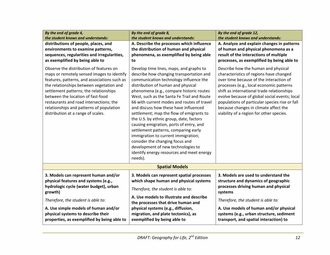
distributions of people, places, and environments to examine patterns, sequences, regularities and irregularities, as exemplified by being able to
Observe the distribution of features on maps or remotely sensed images to identify features, patterns, and associations such as the relationships between vegetation and settlement patterns; the relationships between the location of fast‐food restaurants and road intersections; the relationships and patterns of population distribution at a range of scales.
A. Describe the processes which influence the distribution of human and physical phenomena, as exemplified by being able to
Develop time lines, maps, and graphs to describe how changing transportation and communication technology influence the distribution of human and physical phenomena (e.g., compare historic routes West, such as the Santa Fe Trail and Route 66 with current modes and routes of travel and discuss how these have influenced settlement; map the flow of emigrants to the U.S. by ethnic group, date, factors causing emigration, ports of entry, and settlement patterns, comparing early immigration to current immigration; consider the changing focus and development of new technologies to identify energy resources and meet energy needs).
A. Analyze and explain changes in patterns of human and physical phenomena as a result of the interactions of multiple processes, as exemplified by being able to
Describe how the human and physical characteristics of regions have changed over time because of the interaction of processes (e.g., local economic patterns shift as international trade relationships evolve because of global social events; local populations of particular species rise or fall because changes in climate affect the viability of a region for other species.
Spatial Models
3. Models can represent human and/or physical features and systems (e.g., hydrologic cycle (water budget), urban growth)
Therefore, the student is able to:
A. Use simple models of human and/or physical systems to describe their properties, as exemplified by being able to
3. Models can represent spatial processes which shape human and physical systems
Therefore, the student is able to:
A. Use models to illustrate and describe the processes that drive human and physical systems (e.g., diffusion, migration, and plate tectonics), as exemplified by being able to
3. Models are used to understand the structure and dynamics of geographic processes driving human and physical systems
Therefore, the student is able to:
A. Use models of human and/or physical systems (e.g., urban structure, sediment transport, and spatial interaction) to
DRAFT: Geography for Life, 2nd Edition 13
By the end of grade 4, the student knows and understands:
By the end of grade 8, the student knows and understands:
By the end of grade 12, the student knows and understands:
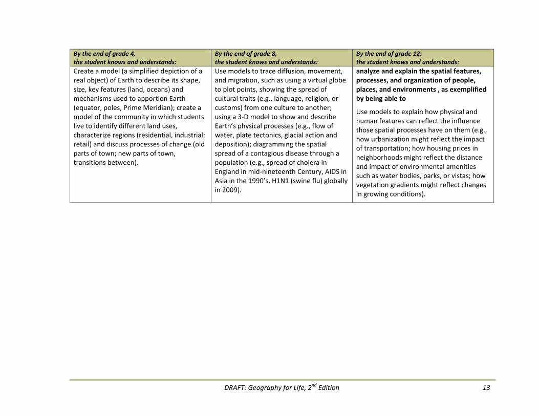
Create a model (a simplified depiction of a real object) of Earth to describe its shape, size, key features (land, oceans) and mechanisms used to apportion Earth (equator, poles, Prime Meridian); create a model of the community in which students live to identify different land uses, characterize regions (residential, industrial; retail) and discuss processes of change (old parts of town; new parts of town, transitions between).
Use models to trace diffusion, movement, and migration, such as using a virtual globe to plot points, showing the spread of cultural traits (e.g., language, religion, or customs) from one culture to another; using a 3‐D model to show and describe Earth’s physical processes (e.g., flow of water, plate tectonics, glacial action and deposition); diagramming the spatial spread of a contagious disease through a population (e.g., spread of cholera in England in mid‐nineteenth Century, AIDS in Asia in the 1990’s, H1N1 (swine flu) globally in 2009).
analyze and explain the spatial features, processes, and organization of people, places, and environments , as exemplified by being able to
Use models to explain how physical and human features can reflect the influence those spatial processes have on them (e.g., how urbanization might reflect the impact of transportation; how housing prices in neighborhoods might reflect the distance and impact of environmental amenities such as water bodies, parks, or vistas; how vegetation gradients might reflect changes in growing conditions).

DRAFT: Geography for Life, 2nd Edition 14
People’s lives are grounded in particular places. We come from a place, we live in a place, and we preserve and exhibit fierce pride over places. Places usually have names and boundaries, and include continents, islands, countries, regions, state, cities, neighborhoods, villages, and uninhabited areas. Places are human creations and the geographically informed person must understand the genesis, evolution, and meaning of places.
Places are jointly characterized by their physical and human properties. Their physical characteristics include landforms, climate, soils, and hydrology while things like language, religion, political systems, economic systems, and population distribution are examples of human characteristics. Places change over time as both physical and human processes modify the characteristics of a place. Places change in size and complexity as well as a result of new knowledge, ideas, human migrations, climatic changes, or political conflicts. Places disappear and are renamed (e.g., Czechoslovakia becoming the Czech Republic and Bombay being renamed Mumbai).
Knowing the physical and human characteristics of their own places influences how people think about who they are, because their identity is inextricably wound up with their place in life and the world. Personal identity, community identity, and national identity are rooted in and attached to a place. Knowing about other places
influences how people understand other peoples, cultures, and regions of the world.
Standard 4 includes three themes: 1) Physical Characteristics; 2) Human Characteristics; and 3) Places. Students must understand how physical characteristic and human characteristics define or give meaning to places. They need to understand that these characteristics vary from place to place and change over time. Understanding these three themes enables students to comprehend and appreciate both the similarities and differences of places in their own community, state, country, as well as the planet.
Essential Element: Places and RegionsGEOGRAPHY STANDARD 4 THE PHYSICAL AND HUMAN CHARACTERISTICS OF PLACES

DRAFT: Geography for Life, 2nd Edition 15
By the end of grade 4, the student knows and understands:
By the end of grade 8, the student knows and understands:
By the end of grade 12, the student knows and understands:
Properties of Geographic Representations and Geospatial Technologies
1. Places have physical characteristics
Therefore, the student is able to:
A. Describe and compare the physical characteristics of places at a variety of scales, local to global, as exemplified by being able to
Create and label models of different land forms and/or bodies of water (e.g., lakes, islands, peninsulas, mountains, valleys).
1. Physical processes change the characteristics of places
Therefore, the student is able to:
A. Analyze physical processes that change places, as exemplified by being able to
Compare and contrast physical features maps and digital images to determine the type of erosion (e.g., water erosion in a river valley, wind erosion with dunes, ocean coastline).
1. Physical characteristics of places present both opportunities and obstacles for people
Therefore, the student is able to:
A. Analyze physical characteristics that result in opportunities for people, as exemplified by being able to
Compare arid and humid climate regions regarding their suitability for different types of agriculture (e.g., herding, cotton, rice, wheat).
B. Analyze physical characteristics that result in obstacles for people, as exemplified by being able to
Evaluate physical site and situation factors which could limit or make impossible the building of various projects (e.g., airport, dam, windmill farm).
Human Characteristics
2. The human characteristics of places
Therefore, the student is able to:
A. Describe and compare the human characteristics of places from local to global, as exemplified by being able to
Analyze a variety of visual materials, data
2. Human groups alter places in distinctive ways
Therefore, the student is able to:
A. Identify the ways humans modify the landscape by analyzing the human characteristics of places
2. That human characteristics of places change over time
3. That social, cultural, and economic processes shape the human characteristics of places
Therefore, the student is able to:

DRAFT: Geography for Life, 2nd Edition 16
By the end of grade 4, the student knows and understands:
By the end of grade 8, the student knows and understands:
By the end of grade 12, the student knows and understands:
sources, and narratives, such as photographs, pictures, tables, charts, and newspaper stories, to describe the human characteristics of places at a variety of scales (e.g., population patterns, types of buildings, settlement patterns, languages, ethnic groups, and religious beliefs).
Examine digital images and explain the changes that humans have made to a landscape (e.g., land use, irrigated farming; buildings, transportation).
A. Describe the ways places change with the diffusion of people and ideas, as exemplified by being able to
Analyze urban and rural landscapes using digital images and/or maps to compare changes over time (e.g., food preferences, cultural values, religious institutions, linguistic patterns).
B. Explain that places change with the introduction of human processes, as exemplified by being able to
Compare changes in transportation, economic and product patterns in places with geographic site and situation characteristics (e.g., northeastern United States and southeastern Canada before and after opening the St. Lawrence Seaway; Singapore as a Free Trade Zone).
Places
3. People attach special meaning to places
Therefore, the student is able to:
A. Identify the human characteristics of a place that give it special meaning, as exemplified by being able to
Collect names of places that people hold in special regard and compare the places for similarities and differences (e.g., parks, places of worship, homes of friends and
3. Human and the physical characteristics of places affect people’s attachment to a place
4. The role of technology in shaping the characteristics of places
Therefore, the student is able to:
A. Identify physical characteristic of a place that are helpful or attractive to people, as exemplified by being able to
4. People shape the human characteristics of places and places influence the views of people
5. Humans use technology to modify the physical characteristics of places to more closely meet their real and perceived uses of the environment
Therefore, the student is able to:
A. Examine the effects of new technologies

DRAFT: Geography for Life, 2nd Edition 17
By the end of grade 4, the student knows and understands:
By the end of grade 8, the student knows and understands:
By the end of grade 12, the student knows and understands:
relatives, ice cream parlor, fishing spots).
B. Describe the physical characteristics that give a place special meaning, as exemplified by being able to
Compare and contrast natural settings/landforms that hold significant meaning for different cultural groups.
C. Examine the ways technology changes a place, as exemplified by being able to Analyze the ways technology is used to shape the environment (e.g., underground sprinklers, air conditioning, airports etc.).
Use digital images and maps to identify and locate the physical benefits or attractions of a place (e.g., farm fields, national park, streams, mountain valley, beaches).
B. Identify human characteristics of a place that are helpful or attractive to people, as exemplified by being able to
Classify examples found on the web or other media of human characteristics that appear helpful or attractive to people who live in or visit a place (e.g., community organizations, employment information, recreational facilities, public service agencies).
C. Evaluate how humans interact with physical environments to form attachment to places, as exemplified by being able to
Analyze the attachment by people to a natural place or to a human made place (e.g., the physical site of a religious pilgrimage, such as the Ganges or to a place constructed by humans such as a shopping mall).
D. Explain how people change places using different technologies, as exemplified by being able to
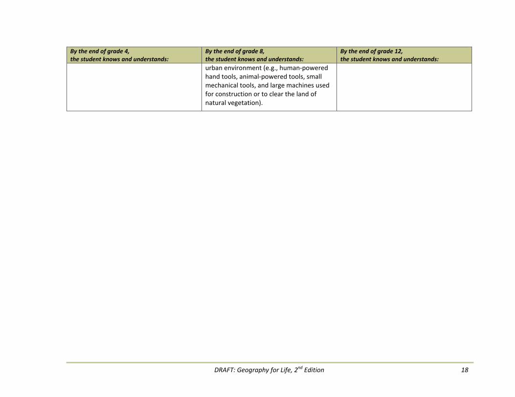
Analyze the impact that different technologies could have on the environment on a place, such as a forest,
on the rate and intensity of change
Analyze the effects of information available through interactive technologies to attract (pull) or discourage (push) people from one place to another (e.g., use of the internet and cell phones to acquire information on the desirability of a destination).
B. Describe how people use technology to modify the environment to meet their needs, as exemplified by being able to
Evaluate the pros and cons of systems developed by people (e.g., water systems developed in the desert southwest of the United States to accommodate growing population with the environmental impacts of these developments; effects on the Aral Sea of water diversion systems from rivers for irrigated agriculture).
DRAFT: Geography for Life, 2nd Edition 18
By the end of grade 4, the student knows and understands:
By the end of grade 8, the student knows and understands:
By the end of grade 12, the student knows and understands:
urban environment (e.g., human‐powered hand tools, animal‐powered tools, small mechanical tools, and large machines used for construction or to clear the land of natural vegetation).

DRAFT: Geography for Life, 2nd Edition 19
Essential Element: Places and RegionsGEOGRAPHY STANDARD 5 THAT PEOPLE CREATE REGIONS TO INTERPRET EARTH'S COMPLEXITY Region is a concept that is used to identify and organize areas of Earth’s surface for various purposes (e.g., understanding, management, planning, etc.). A region has certain characteristics that give it a measure of cohesiveness and distinctiveness and that set it apart from other regions. Regions are human constructs whose boundaries and characteristics are derived from sets of specific criteria and whose function is to organize Earth’s complex surface on the basis of the presence or absence of the selected physical and human characteristics. They can vary in scale from local to global; overlap or be mutually exclusive; be nested into a hierarchy (e.g., counties, states, countries); exhaustively partition the entire world or capture only selected portions of it.
Geographers define regions in three basic ways. The first type is the formal region characterized by a common human property, such as the presence of people who share a particular language, religion, nationality, political identity or culture, or by a common physical property, such as the presence of a particular type of climate, landform, or vegetation. The Rocky Mountain region, the Cornbelt, and Kurdistan or the Kurdish region covering parts of Iran, Iraq, Syria and Turkey are all examples of formal regions.
A second definition is the functional region. It is organized around a node or focal point, with the surrounding areas linked to that node by transportation systems, communication systems, or other economic associations involving activities such as manufacturing and retail trading. Chicago is a focal point for transportation in the north central region of the United States with its highways, railways, Great Lakes shipping, airlines, and telecommunications. One functional region for global business is London, UK with its banking and large corporate headquarters.
The third type of region, the perceptual region, is based on human feelings and attitudes about areas and is therefore defined by people’s shared subjective images of those areas. Thus, southern California, Dixie, the upper Midwest, the Riviera, and Australian Outback are perceptual regions. These spatial units are without precise borders or even commonly accepted regional characteristics and names.
Standard 5 is based on four organizing themes: 1) Regions, 2) Regional change, 3) Connections between regions, and 4) Regions as places for geographic study. Students must understand how geographers use and analyze regions to interpret and manage Earth’s complexity.

DRAFT: Geography for Life, 2nd Edition 20
By the end of grade 4, the student knows and understands:
By the end of grade 8, the student knows and understands:
By the end of grade 12, the student knows and understands:
Places
1. The concept of region as an area of Earth's surface with unifying geographic characteristics
Therefore, the student is able to:
A. Describe regions by using physical characteristics as criteria, as exemplified by being able to
Use physical maps and web based aerial/satellite images to identify physical regions (e.g., mountains, plains, river valleys, lakes, plateaus, peninsulas, islands).
B. Describe regions by using the characteristics of human activity as criteria, as exemplified by being able to
Identify and describe regions that are based on the spatial patterns of human activity (e.g., places to ski or snowboard, vacation spots, agriculture, Chinatown).
1. That regions are ways to organize and analyze areas of Earth's surface
Therefore, the student is able to:
A. Identify the criteria used to map formal, functional, and perceptual regions, as exemplified by being able to
Arrange a series of maps showing different regions into formal, functional, and perceptual classifications (e.g., physical features maps as formal; weather maps as functional; holiday destination maps as perceptual).
B. Construct maps of formal, functional, and perceptual regions, as exemplified by being able to
Draw maps of regions based on criteria (e.g., continental region such as North America is formal, political region such as a country or state is formal; newspaper circulation area and commuter routes into cities are functional regions, sunny California is a perceptual region).
1. Criteria are used to organize regions
Therefore, the student is able to:
A. Explain criteria that can be used to organize a region, as exemplified by being able to
Identify criteria and construct different maps of a region (or maps of multiple regions) using different data sets (e.g., school athletic conferences; market region for a mall or other business; French language region in Canada; climatic region; similar place names).
B. Demonstrate with maps how regions change as the criteria changes, as exemplified by being able to
Analyze the effects of changes in the criteria used for regional maps (e.g., types of economic activities, place names, ethnic groups, agricultural products, regional foods, natural vegetation, climate).
Regional Change
2. The ways in which regions change
Therefore, the student is able to:
A. Describe changes in the physical and
2. The processes and reasons for regional changes
Therefore, the student is able to:
2. Consequences of changes within regions
Therefore, the student is able to:

DRAFT: Geography for Life, 2nd Edition 21
By the end of grade 4, the student knows and understands:
By the end of grade 8, the student knows and understands:
By the end of grade 12, the student knows and understands:
human characteristics of regions that occur over time and identify the consequences of such changes, as exemplified by being able to
Create two murals contrasting life in a region in the past with life in the same region in the present (e.g., population size, ethnic composition, cultural characteristics such as language, economic activities, transportation, cuisine, or means of recreation; changes in land use as a region transforms from rural to suburban to urban; changes in the traffic patterns after a major mall or attraction is introduced, such as a theme park).
A. Analyze spatial and historical changes that affect regions, as exemplified by being able to
Compare and contrast primary source documents, maps, air photos, and web‐based images showing a place before and after a particular event (e.g., changing land use; migration, building of a city or subdivision; developing farmland; building roadways).
B. Identify and explain the human and physical factors which result in changes within regions, as exemplified by being able to
Compare and contrast photographs, maps, and web based images of the changes in regions as a result of the activities of people and natural processes (e.g., increases or decreases in population; natural disasters such as drought or river flooding; activities such as deforestation).
A. Analyze the changing characteristics of regions, as exemplified by being able to
Compare and contrast the consequences of change on regions (e.g., heavy industrial belts to rust belts; pristine regions to environmental degradation; transformation from an agricultural to a manufacturing and service base; remote places introducing sustainable adventure tourism).
Connections between Regions
3. Regions can be connected
Therefore, the student is able to:
A. Discuss the different ways regions are connected, as exemplified by being able to
Create illustrated maps to show the ways regions are connected (e.g., highways, rivers, railways, ocean going shipping lines,
3. The spatial connections and interactions among regions
Therefore, the student is able to:
A. Analyze how and why regions interact, as exemplified by being able to
Use data tables to explain the interactions among regions (e.g., the amount of trade in
3. The ways in which physical and human regional systems are interconnected
Therefore, the student is able to:
A. Compare and contrast the dynamic connections within and among the parts of a regional system, as exemplified by being able to

DRAFT: Geography for Life, 2nd Edition 22
By the end of grade 4, the student knows and understands:
By the end of grade 8, the student knows and understands:
By the end of grade 12, the student knows and understands:
airways, telephone, and internet). monetary or tonnage data; migration of people among regions; Internet connections among regions).
Explain how physical and human environments form webs of interacting systems within and among regions (e.g., the way that river systems connect different regions such as the Mississippi, Yangtze, Nile Rivers; European railway system; navigation canals).
Regions as Places for Geographic Study
4. Geographic issues occur within regions
Therefore, the student is able to:
A. Identify issues within a region, as exemplified by being able to
Select and map information from newspapers and web news sources to identify and locate regional issues (e.g., the sharing of water resources, garbage disposal, transportation, land uses).
4. Regions are used to organize and explain geographic issues
Therefore, the student is able to:
A. Compare and contrast geographic issues in different regions, as exemplified by being able to
Analyze reports on issues in several regions to identify and explain ways they are similar and different (e.g., land use change in tropical forests; the growth of mega cities; population migration within countries; coastal and river flooding; natural disasters).
4. Regions are used as the basis to analyze global geographic issues
Therefore, the student is able to:
A. Explain how global geographic issues impact regions in different ways, as exemplified by being able to
Generate possible economic outcomes for different regions as a result of possible rises in ocean levels (e.g., loss of financial centers along low‐lying coastal areas such as New York City, loss of entire island states such as Vanuatu).
DRAFT: Geography for Life, 2nd Edition 23
Essential Element: Places and RegionsGEOGRAPHY STANDARD 6 HOW CULTURE AND EXPERIENCE INFLUENCE PEOPLE'S PERCEPTIONS OF PLACES AND REGIONS People have unique perceptions of places based on their interpretation of a place’s location, extent, characteristics, and significance as these views are influenced by their own culture and life experiences. In geography, there is always a mixture of objective and subjective realms and a geographically informed person needs to understand the role of both realms and how they relate to each other. This combination of culture and life experiences plays a vital role in the perceptions that an individual has about places and regions.
Shared beliefs and actions tied to culture, language, ethnicity, race, and religion reflect the fact that individuals live in social and cultural groups. The values of these groups are usually complex and cover subjects such as ideology, religion, politics, social structure, and economic structure. They influence how the people in a particular group perceive both themselves and other groups. The significance that an individual or group attaches to a particular place or region may be influenced by feelings of belonging or alienation, a sense of being an insider or outsider, a sense of history and tradition or of novelty and unfamiliarity.
Some places and regions hold great significance for certain groups of people, but not for others. For example, for Muslims the city of Mecca is the most holy of religious places, whereas for non‐Muslims it has only historical and cultural significance. Culture and experience shape belief systems, which in turn influence people’s perceptions of place and regions throughout their lives. Students must understand the factors that influence their own perception of places and regions, paying special attention to the effects that personal and group points of view can have on their understanding the worlds of other groups and cultures.
Four themes organize the geography content of Standard 6. The four themes are: 1) Personal perception; 2) Cultural influences; 3) Icons, symbols, and stereotypes; and 4) Multiple memberships. Through an understanding of how people perceive places and regions, students can increase their understanding of other groups as well as avoid the dangers of egocentric and ethnocentric stereotyping in order to engage in accurate and sensitive analysis of places and regions.

DRAFT: Geography for Life, 2nd Edition 24
By the end of grade 4, the student knows and understands:
By the end of grade 8, the student knows and understands:
By the end of grade 12, the student knows and understands:
Personal Perception
1. Personal experiences affect our perception of communities
Therefore, the student is able to:
A. Describe their own place or region in different ways, as exemplified by being able to
Create a poster, collage, or map to reflect the student's perception of their community or region (e.g., my home town, historic sites, recreation areas).
1. Perceptions affect the way people view places and regions
Therefore, the student is able to:
A. Explain why different individuals and people view places and regions differently, as exemplified by being able to
Compare and contrast the views people have of places and regions based on experiences (e.g., students may have views of a local place, such as a park; views of a place where students gather in school; recreational fields; places where students have traveled, such as another city, state, country).
1. Reasons for changing perceptions of places and regions
Therefore, the student is able to:
A. Examine the ways in which people change their views of places and regions as a result of cultural, economic and political conditions, as exemplified by being able to
Analyze the effects of income, longer life expectancy and attitudes that influence where people choose to live (e.g., aging Baby boomers in the U.S. choose to live in condominiums or apartments where they do not have to maintain yards, landscaping, etc.; retirement communities in Arizona and Florida; travel and entertainment opportunities).
Cultural Influences
2. People view places in different ways based on their social and cultural preferences
Therefore, the student is able to:
A. Compare and contrast the ways people view different places in their community, as exemplified by being able to
Make and exchange drawings and sketch maps with classmates to compare and
2. People of different ethnicities and gender have different perceptions of places and regions
Therefore, the student is able to:
A. Compare the ways in which people view and interact with places and regions , as exemplified by being able to
Compare and contrast the influences of cultural origins on perceptions of places
2. People view places and regions within cultural and social contexts
Therefore, the student is able to:
A. Explain how individuals view places and regions on the basis of their stage of life, gender, social class, ethnicity, values, belief systems, and access to technology, as exemplified by being able to
Analyze and explain why some places have

DRAFT: Geography for Life, 2nd Edition 25
By the end of grade 4, the student knows and understands:
By the end of grade 8, the student knows and understands:
By the end of grade 12, the student knows and understands:
contrast perceptions of their community or region (e.g., similarities and differences in details remembered, emphases depicted, positive or negative reactions).
and regions (e.g., religion and places of worship, such as Islam and mosques; rural people have a different view of cities than do urban residents; in some cultures places where women socialize are different from places where men socialize).
many females present (e.g., suburbs in the 1950s and 1960s were highly feminine during the day such as husbands were at work in the cities, children were at school, most women were home being homemakers; African villages where women and children remain in villages while the men migrate long distances for employment).
Icons, Symbols, and Stereotypes
3. Places and regions serve as cultural symbols
Therefore, the student is able to:
A. Identify cultural symbols within their own place or region, as exemplified by being able to
Examine photos of cultural symbols in the community and explain how each symbol helps to define the place or region (e.g., sports stadium, community library, train station, temple, places of worship).
B. Describe cultural symbols from other regions, as exemplified by being able to
Use technology to compare and contrast cultural symbols found in other regions with those found in the local region (e.g., Fast food restaurants, architectural styles, agricultural practices, modes of transportation).
3. Stereotypes affect people’s views of places and regions
Therefore, the student is able to:
A. Explain that stereotypes influence a group's beliefs about another place or region, as exemplified by being able to Define stereotyping and provide examples of views of places and regions that are based on stereotypes (e.g.: stereotyping prevents people from being objective about places and region, such as deserts are always hot; rainforests are always in the tropics; cities are more dangerous than other places; people living in certain places are less capable of economic development)
B. Explain that icons and symbols may lead to stereotyping of people and places, as exemplified by being able to Identify examples of symbols associated with people and places that lead to
3. Empathy in contrast to ethnocentrism is important to the study of places and diverse cultures
Therefore, the student is able to:
A. Discuss empathy and ethnocentrism in the study of places and cultures, as exemplified by being able to
Discuss the similarities between current and historical issues in different places (e.g., apartheid in South Africa with the caste system in India; indentured workers in the early American colonies with sweatshops in the US in the 2000s; arrival and succession of different ethnic groups in urban regions).
B. Discuss different perspectives on issues and how those perspectives differ from the student’s own, as exemplified by being able to

DRAFT: Geography for Life, 2nd Edition 26
By the end of grade 4, the student knows and understands:
By the end of grade 8, the student knows and understands:
By the end of grade 12, the student knows and understands:
stereotyping (e.g., Chinese straw "coolie hats" are seldom seen in China, but is described as a common garment; I Luv NY symbolizes the attractiveness of New York City).
Examine a current issue or issues using both ethnocentrism and cultural relativism (e.g., pop culture practices such as wearing blue jeans, using mobile phones or drinking alcohol compared to folk groups [Amish, Mennonites] who reject these practices).
Multiple Memberships
4. The role and responsibilities of citizenship within spatial boundaries of the community
Therefore, the student is able to:
A. Identify the spatial boundaries in which civic participation takes place (home, school, neighborhood, etc.), as exemplified by being able to
Compare and contrast how citizenship responsibilities change as we move from one spatial boundary to another (e.g., helping to clean their home, participation in a school beautification project, becoming a member of a service club in the community, recycling).
4. The multiple layers of citizenship for people living within supranational regions
Therefore, the student is able to:
A. Discuss the various citizenship roles that result from cultural, economic, and political integration, as exemplified by being able to
Explain that a person living in a community is also a citizen of different layers of regions (e.g., the resident of Barcelona, Spain is also a citizen of Catalonia, Spain, the European Union, and Europe, with each role being different; through the day and week a person is a member of a home, school, workplace, shopping center, Internet community).
B. Explain the effects of globalization on the concept of global citizenship, as exemplified by being able to
Explain globalization's impact on common ideals for people in all regions (e.g., quality of life; sustainability; food security,
4. Citizenship roles may change due to the forces of supranationalism and devolution
Therefore, the student is able to:
A. Identify the various regional and global supranationalistic membership roles (NATO, NAFTA, EU, AU, LAS, ASEAN, etc.), as exemplified by being able to
Explain the reasons for the changing membership and individual citizenship roles of the regional and global supranational organizations (e.g., countries joining the European Union for economic reasons; plans for membership growth in the Free Trade Agreement of the Americas; regional variation in support of and opposition to supranationalistic memberships).
B. Contrast and contrast examples of devolution, as exemplified by being able to
Examine the regional variation in devolution movements and explain how these processes may play out in other regions (e.g., how devolution differed in

DRAFT: Geography for Life, 2nd Edition 27
By the end of grade 4, the student knows and understands:
By the end of grade 8, the student knows and understands:
By the end of grade 12, the student knows and understands:
international cooperation; global investments to improve health care).
Wales from Yugoslavia; Swaziland and South Africa; Chechnya, Kashmir).
C. Analyze and explain how globalization and interdependence have shaped new cultural, economic, and political entities, and affected different functions of citizenship, as exemplified by being able to
Examine interdependent relationships and changing citizenship characteristics among and between political entities (e.g., one passport for members of the European Union; generally free flow of people and goods between the U.S. and Canada; dual and multiple passports holders).
D. Identify and explain examples of benefits and responsibilities for citizens of supranational organizations, as exemplified by being able to
Compare and contrast the membership requirements and responsibilities of various supranational organizations (e.g., issues for prospective European Union member states may include human rights laws, democratic procedures of how political bodies and positions are elected, economic solvency).

DRAFT: Geography for Life, 2nd Edition 28
Essential Element: Physical Systems GEOGRAPHY STANDARD 7 THE PHYSICAL PROCESSES THAT SHAPE THE PATTERNS OF EARTH'S SURFACE The physical environment is the stage for all human activity. Physical systems create, maintain, and modify the features that constitute Earth’s surface. The geographically informed person must understand that four systems generate those features. They can be grouped into categories: the atmosphere, the biosphere, the hydrosphere and the lithosphere. Recognizing the interactions within and among these four components offers insights on how Earth serves as the home of all living things – plants, animals, and humans.
Almost all of Earth’s energy comes from the sun. The synchronized Earth‐Sun relationship is essential for the planet to be habitable and capable of supporting life as we know it. Earth’s position relative to the sun affects events and conditions in every part of the world. The amount of solar energy a place receives depends on the cyclically‐changing angles of the Sun’s rays. The seasons result from the tilt of Earth and its revolution around the Sun which results in variable heating patterns, and thus significantly influences climate and weather as well as human activity.
Understanding how physical systems work can impact the choices people make about where they live, the types of
buildings they construct, the travel networks they develop, and how they generally conduct their lives. Given the uncertain trajectory and effects of global climate change, knowledge about the factors that influence weather and climate is important for both personal and governmental decision‐making. It becomes a public policy issue that must be addressed by governments, resulting in actions that determine the safety and economic well being of millions of people across the globe. Thus, reasoned and responsible political decisions must derive from a clear understanding of the interactions among of how Earth’s physical systems work, as well as the processes creating them.
Standard 7 is organized around three themes: 1) the components of Earth’s physical systems, 2) Earth‐Sun relationships, and 3) physical processes. Together, this geography content provides the basic understanding of the physical forces shaping the planet we inhabit and must sustain.

DRAFT: Geography for Life, 2nd Edition 29
By the end of grade 4, the student knows and understands:
By the end of grade 8, the student knows and understands:
By the end of grade 12, the student knows and understands:
Components of Earth’s Physical Systems
1. The components of Earth's physical systems (the atmosphere, biosphere, hydrosphere, and lithosphere)
Therefore, the student is able to:
A. Identify the components of Earth's different physical systems, as exemplified by being able to
Identify the different parts of the lithosphere and explain how the Earth's crust moves and changes over time (e.g., volcanoes, mountain building, and ocean ridge spreading resulting in continental movement).
1. The four basic components of Earth’s physical systems (the atmosphere, biosphere, hydrosphere, and lithosphere) are interdependent
Therefore, the student is able to:
A. Explain patterns in the environment that result from Earth's physical processes, as exemplified by being able to
Describe the ocean circulation system and the way it affects climate (e.g., North Atlantic Drift and the mild climate of Western Europe; climatic effects of El Nino or La Nina).
B. Analyze resulting patterns of physical features due to Earth’s physical processes, as exemplified by being able to
Compare maps of the tectonic plates and selected mountain ranges and predict locations of other mountains (including volcanic) based on the plate boundaries.
1. The interactions of Earth's physical systems (the atmosphere, biosphere, hydrosphere, and lithosphere) are variable across space and time
Therefore, the student is able to:
A. Describe the ways in which Earth's physical processes are dynamic and interactive, as exemplified by being able to
Identify the conditions that cause changes in climate and the consequent effects on ocean levels, agricultural productivity, and land use.
B. Describe how physical processes affect different regions of the world, as exemplified by being able to
Describe the physical processes that occur in dry environments (e.g., desertification and soil degradation, flash floods, dust storms, sand movement, soil erosion, and salt accumulation in the soil).
Earth‐Sun Relationships
2. Earth‐Sun relations affect conditions on Earth
Therefore, the student is able to:
A. Describe how Earth's position relative to the Sun affects conditions on Earth, as
2. Earth‐Sun relationships affect physical processes and patterns on Earth
Therefore, the student is able to:
A. Explain how Earth‐Sun relationships affect Earth's physical processes and create physical patterns, as exemplified by
2. Earth‐Sun relationships are variable over time resulting in changes in the role it plays in physical processes on Earth
Therefore, the student is able to:
A. Explain how variability in Earth‐Sun relationships affect Earth's physical

DRAFT: Geography for Life, 2nd Edition 30
By the end of grade 4, the student knows and understands:
By the end of grade 8, the student knows and understands:
By the end of grade 12, the student knows and understands:
exemplified by being able to
Shine a light directly on the equator of a globe noting the change in the location (on the tropic lines) and angle of the rays as the globe is moved to represent the different seasons and explain the results of uneven heating on Earth's surface.
being able to
Locate and explain the occurrences of weather phenomena due to annual changes in Earth‐Sun relationships (e.g., hurricanes in the fall in subtropical areas; monsoon rainfall; tornadoes in the mid‐latitudes during the spring and summer).
processes over time, as exemplified by being able to
Explain how cyclic changes in the Earth's orbit result in changes in heating which result in climatic changes such as an ice age and glaciation of Earth's surface.
Physical Processes
3. Physical processes shape features on Earth's surface
Therefore, the student is able to:
A. Explain how physical processes help shape the patterns of features on Earth's surface, as exemplified by being able to
Provide pictures of landforms such as canyons, mesas, and deltas and identify the physical process which shaped the landform.
3. Physical processes generate patterns across Earth's surface
Therefore, the student is able to:
A. Locate and analyze the patterns that occur on Earth's surface as a result of physical processes, as exemplified by being able to
Locate lakes resulting from glaciation in the U.S. or the rift valley in East Africa and explain the resulting patterns which occur.
3. Physical processes change Earth’s surface at different rates
Therefore, the student is able to:
A. Predict the resulting changes of a specific physical process operating on Earth's surface, as exemplified by being able to
Locate and explain the physical processes forming islands (e.g., Hawaiian Islands) or increasing the elevation of mountains (e.g., Himalayan Mountains) due to plate tectonics.

DRAFT: Geography for Life, 2nd Edition 31
Essential Element: Physical Systems GEOGRAPHY STANDARD 8 THE CHARACTERISTICS AND SPATIAL DISTRIBUTION OF ECOSYSTEMS AND BIOMES OF EARTH’S SURFACE Ecosystems and biomes are defined by specific plant and animal communities interacting with the physical environment and are unevenly distributed on Earth’s surface. Both are integral parts of the biosphere and interact with the atmosphere, hydrosphere, and lithosphere to form areas varying in size, shape, scale and complexity. An ecosystem, for example, might be as small as a stand of oak trees or a pond, or as large and complex as a vast desert or rainforest. Ecosystems that share similar characteristics of climate and vegetation can be grouped together to form global‐scale regions known as biomes. These biomes include Earth's tropical and temperate forests, savannas and scrublands, grasslands, deserts, tundra, and ocean.
All elements of the environment, including the human, are part of many different but nested ecosystems and the biomes of which they are a part. Changes in one ecosystem have a ripple effect, with varying degrees of impact, as it reaches out to other ecosystems ultimately affecting the structures of the larger biomes. While ecosystems and biomes provide both stability and balance on Earth’s surface, they can be altered by large‐scale natural events such as volcanic eruptions or long‐term
droughts, or by such human interventions as overgrazing grasslands and clearing rainforests without an understanding and therefore regard for the environmental consequences.
Knowing how ecosystems and biomes function will enable students to make informed decisions about the sustainable uses of the natural world in the future. Because human‐induced global climate change is a reality with the potential of inflicting unimagined outcomes on the planet, the degree to which present and future generations understand the critical role they must play in maintaining healthy ecosystems and biomes will determine, in large measure, the quality of human life on Earth.
Standard 8 is organized around three themes: 1) the components of ecosystems, 2) the characteristics and distribution of ecosystems, and 3) the characteristics and distribution of biomes. Because the web of ecological interdependence is fragile, students must understand the principles of ecosystems and biomes to formulate management programs designed to sustain the environment.

DRAFT: Geography for Life, 2nd Edition 32
By the end of grade 4, the student knows and understands:
By the end of grade 8, the student knows and understands:
By the end of grade 12, the student knows and understands:
Components of Ecosystems
1. The components of ecosystems
Therefore, the student is able to:
A. Identify the components of various ecosystems, as exemplified by being able to
Identify and compare communities of plants and animals and the physical environments in which they live (e.g., grasses, insects, birds, and mammals in a grassland; giant kelp, crustaceans, fish, and mammals in ocean kelp beds).
B. Explain the interaction within ecosystems, as exemplified by being able to
Illustrate a food chain or webs of food chains by sequentially arranging pictures or samples of a variety of living things (e.g., fungi, insects, plants, animals).
1. Components in ecosystems are cyclic and interdependent
Therefore, the student is able to:
A. Describe how the components of ecosystems have life or energy cycles, as exemplified by being able to
Explain the flow of energy and the cycling of matter through an ecosystem (e.g., the food chain or the hydrologic cycle).
B. Explain the interdependence of components in an ecosystem, as exemplified by being able to
Construct a flow chart to illustrate the interactions of components within an ecosystem (e.g., water cycle; oxygen and carbon dioxide exchange; producers, consumers, and decomposers).
1. Ecosystems respond to changes in the physical environment
Therefore, the student is able to:
A. Explain how physical processes influence ecosystems, as exemplified by being able to
Explain ecosystems in terms of their characteristics and ability to withstand stress caused by physical events (e.g., a river system adjusting to the arrival of an introduced invasive plant species; changes in forest flora and fauna after a fire).
Characteristics and Distribution of Ecosystems
2. The characteristics and distribution of ecosystems
Therefore, the student is able to:
A. Identify and describe the characteristics and distribution of ecosystems, as exemplified by being able to
2. Physical processes determine the distribution and characteristics of ecosystems
Therefore, the student is able to:
A. Explain how physical processes influence the distribution of ecosystems,
2. Physical processes impact the distribution and characteristics of ecosystems and cause changes over time
Therefore, the student is able to:
A. Predict how physical processes can cause change over time in the distribution and characteristics of ecosystems, as

DRAFT: Geography for Life, 2nd Edition 33
By the end of grade 4, the student knows and understands:
By the end of grade 8, the student knows and understands:
By the end of grade 12, the student knows and understands:
Draw pictures to illustrate different plants and animals in various local ecosystems (e.g., a pond, forest, or city park).
as exemplified by being able to
Identify the similarity of locations (e.g., latitude) and conditions that result in desert regions around the world.
exemplified by being able to
Analyze the impact of rising sea temperatures on the distribution and survival of coral reef ecosystems.
B. Evaluate ecosystems in terms of their biodiversity and productivity, as exemplified by being able to
Evaluate ecosystems for their level of biodiversity and productivity (e.g., the low productivity of deserts and the high productivity of mid‐latitude forests and tropical forests) and describe their potential value to all living things (e.g., as a source of oxygen, food and raw materials).
Characteristics and Distribution of Biomes
3. The characteristics and distribution of biomes
Therefore, the student is able to:
A. Identify the characteristics of biomes, as exemplified by being able to
Compare the temperature, precipitation, and vegetation characteristics of various biomes, (e.g., deserts, grasslands, savannas, temperate forests, tropical forests, arctic tundra).
B. Identify the distribution of biomes, as exemplified by being able to
Locate photographs of different types of
3. The distribution of biomes is determined by climate and vegetation patterns
Therefore, the student is able to:
A. Explain why latitude and elevation influence where biomes occur, as exemplified by being able to
Combine a diagram showing elevation and temperature with photographs of vegetation to construct a model of altitudinal zonation for a mountain located near the equator (e.g., Mount Kilimanjaro in Tanzania, Mount Chimborazo in Peru).
3. Physical processes impact the distribution and characteristics of biomes and cause changes over time
Therefore, the student is able to:
A. Explain how physical processes can influence and change the distribution of biomes over time, as exemplified by being able to
Predict how rising global temperatures cause changes in various biomes (e.g., melting Arctic sea ice; shifting desertification and grassification; rising sea levels).

DRAFT: Geography for Life, 2nd Edition 34
By the end of grade 4, the student knows and understands:
By the end of grade 8, the student knows and understands:
By the end of grade 12, the student knows and understands:
vegetation on the appropriate portions of a world climate map (e.g., cacti and succulents on a desert climate; tropical forest trees on a tropical climate; coral in shallow, tropical marine waters).

DRAFT: Geography for Life, 2nd Edition 35
Essential Element: Human Systems GEOGRAPHY STANDARD 9 THE CHARACTERISTICS, DISTRIBUTION, AND MIGRATION OF HUMAN POPULATIONS ON EARTH'S SURFACE Human population is a dynamic force on the planet. Advances in agriculture, sanitation, and health care have contributed to a dramatic increase in human population over the last few centuries. The geographically informed person must understand that the growth, distribution, and movements of people on Earth’s surface are driving forces behind not only human events—social, cultural, political, and economic—but also physical events—large‐scale flooding, resource depletion, and ecological breakdown.
Population is characterized by growth and mortality rates as well as demographic concepts such as fertility and mortality, crude birth and death rates, natural increase and doubling time, and population structure (age and sex distribution). A population pyramid or diagram shows the age and gender characteristics of a population. These illuminate the impact wars or famine as well as education levels, religion, or population policies have on the population in a country or region.
The interaction between human and environmental factors helps to explain the characteristics, distributions,
and movements of human populations. The distribution and density of Earth’s population reflect the planet’s topography, soils, vegetation, and climate types (ecosystems); available resources; and level of economic development. People move from place to place as a result of voluntary, unavoidable, and involuntary reasons. “Pull” factors may make another place seem more attractive and beneficial to convince people to migrate. “Push” factors are often unpleasant or life‐threatening conditions that force people to move to new locations. Movement occurs on many scales such as a family moving to a suburb or a new city or to mass migrations of people due to famine or political unrest or over distances from a few miles to thousands of miles.
The four themes organizing Standard 9 are: 1) Distribution of population, 2) characteristics of population, 3) migration, and 4) consequences of migration. Students must understand how the characteristics, distribution, and movement of human population changes and is a consideration in understanding social, political, and ecological issues.

DRAFT: Geography for Life, 2nd Edition 36
By the end of grade 4, the student knows and understands:
By the end of grade 8, the student knows and understands:
By the end of grade 12, the student knows and understands:
Distribution of Population
1. That people live in many different places on Earth
2. Some places have many people and others have few people and this results in differences in the spatial distribution of the population
Therefore, the student is able to
A. Identify various places that people live, as exemplified by being able to
Use maps, photos, demographic data to describe the different places that people live (e.g., coastal areas, along rivers, valleys and plains).
B. Describe the spatial distribution of population, as exemplified by being able to
Describe where people live in the state and local community (e.g., farms, cities, small towns, regions of state, largest city).
1. Places that provide opportunities tend to be more densely populated than places with fewer opportunities
2. Urban regions, coasts/shorelines, and river valleys are where most people are located
Therefore, the student is able to:
A. Identify the reasons that some places have more people than other places, as exemplified by being able to
Describe geographic qualities of places that thrive and are attractive to live in compared to other places that people leave or avoid (e.g., places with opportunities such as natural resources, tourist destinations, and cities pull people towards them while places with fewer opportunities push people away; cities are centers of opportunity and people migrate to take advantage of them).
B. Identify and describe the pattern and density of population relative to urban regions and terrain feature, as exemplified by being able to
Explain population patterns by analyzing their distribution and density (e.g., use a map to identify population patterns, such
1.That population distribution results from historical, environmental and technological factors
2. Population distribution and density indicate the role of humans in changing the face of Earth
Therefore, the student is able to:
A. Examine demographic data and predict trends in the spatial distribution of population, as exemplified by being able to
Select data and predict demographic shifts in particular populations and regions which will cause changes in future electoral politics of states or regions (e.g., Hispanic population growth and the decline in white fertility rates in the United States, growth of Muslim populations in the European Union, growth of Asian populations in Australia).
B. Analyze population issues and policies to address such issues, as exemplified by being able to
Examine pronatal (e.g., Germany, Russia, France) and antinatal (e.g., China, India) policies of different countries and evaluate the effectiveness and appropriateness of

DRAFT: Geography for Life, 2nd Edition 37
By the end of grade 4, the student knows and understands:
By the end of grade 8, the student knows and understands:
By the end of grade 12, the student knows and understands:
as eastern China, northern India, the Nile Valley, and describe reasons for the locations of these population centers).
each policy.
Characteristics of Population 3. The characteristics of local populations Therefore, the student is able to: A. Describe and compare the characteristics of local populations Collect and graph data about people living in the local community (e.g., age, ethnic origin, languages spoken).
3. The demographic structure of a population Therefore, the student is able to: A. Interpret the structures of populations through the use of key demographic concepts Construct and interpret population diagrams (pyramids) for different countries and project the population 20 and 40 years into the future (e.g., compare the male and female sides of the population diagram for their shapes; project age groups 20 and 40 years into the future).
3. The effects of cultural, economic, and political influences on the demographic structure of different populations Therefore, the student is able to: A. Analyze the effects of governmental policies on population characteristics Analyze population policies enacted by countries and evaluate the effectiveness of those policies (e.g., China's One Child Policy created families with a single child, the consequence was no brothers, sisters, aunts, uncles, cousins; payment of "kindergeld" or child money to parents in Germany to encourage more children; birth control initiatives of Indonesia and India).
Migration
4. The characteristics of local populations
Therefore, the student is able to:
A. Describe and compare the characteristics of local populations, as exemplified by being able to
Collect and graph data about people living in the local community (e.g., age, ethnic origin, languages spoken).
4. The demographic structure of a population
Therefore, the student is able to:
A. Interpret the structures of populations through the use of key demographic concepts, as exemplified by being able to
Construct and interpret population diagrams (pyramids) for different countries and project the population 20 and 40 years into the future (e.g., compare the male and
4. The impact of migration on human systems
Therefore, the student is able to:
A. Explain the cultural, economic, and political factors that contribute to human migration, as exemplified by being able to
Identify and explain the push and pull factors which cause people to migrate (e.g., migration of Hindus and Muslims to India and Pakistan during partition, North African

DRAFT: Geography for Life, 2nd Edition 38
By the end of grade 4, the student knows and understands:
By the end of grade 8, the student knows and understands:
By the end of grade 12, the student knows and understands:
female sides of the population diagram for their shapes; project age groups 20 and 40 years into the future).
migration to Western Europe, Germany's post‐World War II laws which allowed entry for virtually any immigrant).
B. Evaluate the impact of human migration on physical and human systems, as exemplified by being able to
Examine the costs to environmental and human systems of migrations caused by war or famine (e.g., Darfur, Chad, Uganda; refugee settlements in urban regions).
Consequences of Migration
5. People migrate from familiar places to unfamiliar places
Therefore, the student is able to:
A. Explain the challenges migrants often face in adjusting to a different environmental setting, as exemplified by being able to
Generate a list challenges that migrants might face in adjusting to a new environment (e.g., rural people arriving in an urban environment; adjusting to dramatic climatic differences, etc.).
B. Examine the challenges migrants have in adjusting to a different cultural setting, as exemplified by being able to
Use images and first person accounts to examine the challenges migrants have in
5. Migration may affect the cultural and social fabric of a family, ethnic group, or national group
6. Migration may result in the transformation of places receiving migrants
Therefore, the student is able to:
A. Describe the benefits and challenges migrants face in bridging cultures, as exemplified by being able to
Describe the cultural traits and skills that benefit migrants in bridging the changes they encounter (e.g., value of education; professional skills; closely knit family units; ethnic clubs and organizations).
B. Identify new cultural markers that have resulted from in‐migration, as exemplified
5. National groups and governments respond in different ways to the departure and arrival of migrants
6. The impact of human migration on physical and human systems
Therefore, the student is able to:
A. Compare and contrast the response of different national groups and governments to migration, as exemplified by being able to
Analyze immigration policies of countries and the differing responses of sub‐state units to those policies (e.g., state governments of border states Arizona, California, New Mexico and Texas may have different views from state governments of Nebraska, Kansas and Iowa on U.S. federal immigration policies; language policies of

DRAFT: Geography for Life, 2nd Edition 39
By the end of grade 4, the student knows and understands:
By the end of grade 8, the student knows and understands:
By the end of grade 12, the student knows and understands:
adjusting to a different cultural setting (e.g., language, customs, religious majority, methods of transportation, food choice).
by being able to
Describe the influences that migrants have on places as lasting cultural markers (e.g., clothing, fashions, music, dietary choices, types of businesses; social clubs, cross cultural marriages).
France demanding that immigrants speak French; laws in Europe which seek to limit immigration of people from Muslim countries).
B. Evaluate the impact of human migration on physical and human systems, as exemplified by being able to
Analyze the daily large‐scale urban to suburban migration on cities (e.g., reduction of city sales tax revenues, property taxes for schools shifted away from city to suburban schools, strain on cities to provide services, such as fire, police, streets; daily cycle of high and low population densities in cities resulting from suburban commuting).

DRAFT: Geography for Life, 2nd Edition 40
Essential Element: Human Systems GEOGRAPHY STANDARD 10 THE CHARACTERISTICS, DISTRIBUTION, AND COMPLEXITY OF EARTH'S CULTURAL MOSAICS Culture is a complex, multifaceted concept. It describes social structure, languages, belief systems, institutions, technology, art, foods, and traditions of particular groups of humans. Each cultural group has a distinctive way of life which often results in landscapes and regions with distinguishing features. Cultural landscapes often overlap, thus forming elaborate mosaics of peoples and places. These cultural mosaics can be studied at a variety of spatial scales.
As the world becomes increasingly interdependent, different cultural groups have greater contact with each other. This increased contact influences the way in which people borrow, adopt, and adapt new ideas. For example, sets of laws, educational systems, political arrangements, and the structure of the family shape a culture region. Given the complexity of culture, it is often useful—especially when studying the subject from a geographic point of view—to focus on the languages, beliefs, institution, and technologies that are characteristic of a
culture. Language, for example, both represents and reflects many aspects of a culture. It can be analyzed for clues about the values and beliefs of a culture group.
Whatever characteristic of culture is considered, it is clear that the mosaics of Earth’s cultural landscapes are not static. Culture changes as a result of a variety of human processes, migration and the spread (diffusion) of new cultural traits—language, music, and technology—through technologies such as the media and the Internet to existing culture groups. The processes of cultural change accelerate with improvements in transportation and communication. Each culture in the world has borrowed attributes from other cultures whether knowingly or not, willingly or not, permanently or not.
The three themes organizing Standard 10 are: 1) characteristics of culture, 2) patterns of culture, and 3) cultural change. As members of a multicultural society in a multicultural world, students must understand the diverse spatial expressions of culture.

DRAFT: Geography for Life, 2nd Edition 41
By the end of grade 4, the student knows and understands:
By the end of grade 8, the student knows and understands:
By the end of grade 12, the student knows and understands:
Characteristics of Culture
1. People develop cultures over time and those cultures shape the ways people live
Therefore, the student is able to:
A. Identify and compare the cultural characteristics of different regions and people, as exemplified by being able to
Identify the components of culture (e.g., language, social organization, beliefs and customs, forms of architecture, activities, education systems) then compare and contrast two different regions and people.
1. The ways cultures shape the characteristics of a region
Therefore, the student is able to:
A. Explain that cultural features often define regions, as exemplified by being able to
Use cultural traits as the basis for explaining regions on maps (e.g., significant language patterns in North America, such as English, French, and Spanish; global distributions of Islam, Christianity, Buddhism, Hinduism, and Judaism; ethnic characteristics, folk and popular culture).
B. Describe elements of the landscape as a mirror of culture, as exemplified by being able to
Explain that a landscape, including land use and buildings, reflect cultural traits and preferences (e.g., green landscapes in the desert, such as golf courses and trees; advertisements on store fronts in Spanish, Korean, Arabic, French or English speaking regions; religious land uses, such as mosques, cathedrals, churches, temple).
1. The ways that people and their cultures modify a natural environment to establish a built environment
Therefore, the student is able to:
A. Describe a transformation of the natural environment to meet human needs, as exemplified by being able to
Investigate the land use in the construction of canals, seaways, and dams and outline the economic and population changes to cities and regions in these areas after construction (e.g., agricultural land uses; the St. Lawrence Seaway and Great Lakes canals on Chicago, Detroit, Buffalo, Montreal, Quebec; the Hoover Dam on Las Vegas, Los Angeles and Phoenix).
Patterns of Culture 2. Patterns of culture across Earth's surface
2. Spatial distribution of culture at different scales (local to global)
2. Cultural patterns have consequences Therefore the student is able to:

DRAFT: Geography for Life, 2nd Edition 42
By the end of grade 4, the student knows and understands:
By the end of grade 8, the student knows and understands:
By the end of grade 12, the student knows and understands:
Therefore, the student is able to: A. Compare and contrast patterns of culture, as exemplified by being able to Compare and contrast world cultural regions using ethnicity, language, religion, dietary patterns, architecture (e.g., use thematic maps and researched information to create a postcard, travel brochure, or poster).
Therefore, the student is able to: A. Identify ways in which cultures are spatially distributed among communities, as exemplified by being able to Describe the cultural and ethnic enclaves that develop in both urban and rural regions (e.g., Amish people in rural enclaves in Pennsylvania, Indiana, Iowa and other states; Asian ethnic enclaves in cities; Italian neighborhoods; African American neighborhoods; Mexican American neighborhoods; Islamic communities in European cities; folk and popular culture).
A. Identify the impacts of cultural beliefs on gender roles, race, and ethnicity, as exemplified by being able to Examine the differences among states' laws on gender issues (e.g., legal rights for women, women's suffrage laws, role of women in elected offices). B. Describe the consequences of cultural views of nature and use of natural resources, as exemplified by being able to Compare and contrast how belief systems affect how people view and use the environment (e.g., American Indian views of land ownership versus European beliefs; humans as having dominion over the environment versus sustaining the environment). C. Compare the role that culture plays in incidents of cooperation and conflict, as exemplified by being able to Identify the cultural factors that have promoted political conflict (e.g., religious differences in Sudan, linguistic differences in Belgium, ethnic differences in Rwanda, bilingual policies to accommodate language groups).
Cultural Change
3. Cultures change for various reasons
Therefore, the student is able to:
A. Identify the changes in culture from technology and migration of people, as
3. The processes of acculturation
Therefore, the student is able to:
A. Analyze the impact of cultural
3. The spatial characteristics of cultural convergence and divergence
Therefore, the student is able to:
A. Explain the spatial processes of cultural

DRAFT: Geography for Life, 2nd Edition 43
By the end of grade 4, the student knows and understands:
By the end of grade 8, the student knows and understands:
By the end of grade 12, the student knows and understands:
exemplified by being able to
Use interviews with parents and grandparents to understand cultural change (e.g., how the role of women in society has changed and how that has affected life in the United States and other regions of the world; how radio, television, electronic games, and the internet changed leisure activities in the United States and places).
diffusion, as exemplified by being able to
Observe evidence of cultural traits that may be attributed to diffusion (e.g., the spread of Islam; Asian restaurants; electronic devices such as cell phones in Africa; particular types of music in many places, such as opera).
B. Describe and explain the significance of cultural diffusion on issues of gender, race and ethnicity, as exemplified by being able to
Describe ways that the diffusion of ideas affects gender roles within societies (e.g., the effects of Grameen bank loans on opportunity for women; increased participation of women in elected office; the value of education for women).
C. Examine the advantages and disadvantages of cultural retention, as exemplified by being able to
Describe examples of cultural traits that are maintained by groups and explain how some may be positive and others negative (e.g., the value of education; the devotion to a dominant faith; secularism; methods of doing work; language, continuation of a cultural disdain for another ethnic or religious group).
convergence and divergence, as exemplified by being able to
Evaluate examples of the spread of culture traits that contribute to cultural convergence (e.g., US‐based fast‐food franchises in China and India, the diffusion of the English language as a major medium of business, science and telecommunications in many regions of the world, the popularization of sushi).
B. Examine how transregional alliances and multinational organizations can alter cultural solidarity , as exemplified by being able to
Identify examples of changes which have occurred with the development of supranationalistic organizations (e.g., the blending of cultures and blurred sense of nationality, common currency, multilingual signage, reduced border controls among member states of the European Union).

DRAFT: Geography for Life, 2nd Edition 44
Essential Element: Human Systems GEOGRAPHY STANDARD 11 THE PATTERNS AND NETWORKS OF ECONOMIC INTERDEPENDENCE ON EARTH'S SURFACE Resources are unevenly distributed on Earth, and no country has all of the resources it needs to survive and grow. Thus, people must trade with others and as a result there are increasingly complex networks of economic interdependence which change and evolve. Economic activities depend upon capital, resources, power supplies, labor, information, and land. The spatial patterns of these resources create the networks of trade and global economic interdependence. Local and world economies intermesh to create networks, movement patterns, transportation routes, market areas, and hinterlands.
Students must understand the spatial organization of economic, transportation, and communication systems. These produce and exchange the great variety of commodities—raw materials, manufactured goods, capital, and service—which constitute the global economy. The spatial dimensions of economic activity are increasingly complex. Raw materials may be shipped to locations for processing and then transported again for assembly or sale. Systems of interdependence develop at
local, regional, national, and international levels. Subsistence farming often exists side by side with commercial agriculture. In many developing countries, people leave rural areas in search of jobs that have been re‐located from industrialized countries. Technology and telecommunications have freed many jobs from being tied to specific locations. Work can be done collaboratively in different locations taking advantage of different time zones to increase efficiency.
The three themes organizing Standard 11 are: 1) economic systems, 2) globalization, and 3) networks. As world population grows, as energy costs increase, as time becomes more valuable, and as resources become depleted or discovered, societies need economic systems that are more efficient and responsive. It is particularly important, therefore, for students to understand world patterns and networks of economic interdependence and to realize that traditional patterns of trade, human migration, and cultural and political alliances are being altered as a consequence of global interdependence.

DRAFT: Geography for Life, 2nd Edition 45
By the end of grade 4, the student knows and understands:
By the end of grade 8, the student knows and understands:
By the end of grade 12, the student knows and understands:
Economic Systems
1. People earn their living by producing goods and services (e.g., food, clothing, household goods etc., housing; lawn medical, communication, public transportation etc.)
2. That some locations are better suited than others to provide certain goods and services
Therefore, the student is able to:
A. Identify which businesses produce goods and which businesses produce services, as exemplified by being able to
Collect data about the types of jobs in the local area and graph how many jobs produce goods and how many produce services. (e.g., goods ‐ manufacturing, power plants, green houses; services ‐ restaurants, hospitals, movie theaters).
B. Describe the ways economic activities are linked by networks of communication and transportation, as exemplified by being able to
Draw a sketch map of street maps of local area and compare to web map of local area then discuss how streets allow the movement of goods and services to different areas.(e.g., emergency response
1. Economic activities have specific functions and spatial patterns
2. Economic activities are interdependent
3. Changing patterns of trade
Therefore, the student is able to:
A. Define and classify economic activity into primary, secondary, and tertiary, as exemplified by being able to
Classify a list of economic activities into the categories of primary (e.g., forestry, copper mining, and growing coffee) secondary (e.g., producing copper wire, furniture making, and grinding coffee beans), and tertiary (e.g., furniture sales, selling copper wire, and selling coffee latte).
B. Compare and contrast the merit of one location over another for production of goods and services, as exemplified by being able to
Use a phone book and map of the local community to locate clusters of related businesses or other economic activities and then suggest why they are located where they are (e.g., medical supply and uniform stores, laboratories, and doctors' offices near a hospital; warehouses and industries near major transportation routes; clusters
1. Global economic systems impact the spatial patterns of production and consumption
2. Economic systems change as a result of many forces
3. The classification of economic activity into quaternary and quinary categories, as well as primary, secondary, and tertiary activities
Therefore, the student is able to:
A. Describe the changes in the spatial distribution and patterns of production and consumption, as exemplified by being able to
Construct maps showing the production and consumption of selected goods and services since 1990 (e.g., Coca‐Cola, Internet connections, cellular phones, boutique coffee and tea, computers).
B. Classify and describe the spatial distribution of major economic systems and evaluate their relative merits in terms of productivity and the social welfare of workers, as exemplified by being able to
Distinguish between traditional, command and market economic systems and describe how such systems operate (e.g., Burkina

DRAFT: Geography for Life, 2nd Edition 46
By the end of grade 4, the student knows and understands:
By the end of grade 8, the student knows and understands:
By the end of grade 12, the student knows and understands:
vehicles, pizza delivery, ice cream trucks, postal delivery).
of car dealerships on major highways; fast‐food restaurants in highly accessible locations close to population concentration, farmer's markets).
C. Explain the ways patterns of trade have changed over time, as exemplified by being able to
Compare and contrast the past trade patterns, imports and exports, among countries at several times with current patterns (e.g., trade in automobiles, energy, food, consumer items, such as computers, electronic media).
Faso's largely traditional economy, North Korea's command economy, Germany's market economy).
C. Explain the relationships between various economic activities, as exemplified by being able to
Examine and map the relationships between providers of components in different manufacturing industries (e.g., automobiles, such as glass, tires, sheet metal; computers, such as circuit boards, software, electrical components, wireless chips).
Globalization
3. People and countries use goods that are produced in other countries and regions
4. Trade between countries occurs when consumers in one country need something produced in another
Therefore, the student is able to:
A. Examine where goods are produced and consumed, as exemplified by being able to
Collect Data on where items in the home originate or are manufactured (e.g., appliances, food items, clothing) then map these locations and analyze why the items were made or grown in that location.(e.g., good soil and climate conditions, raw
4. Economic interdependence and globalization impact many countries and their populations
5. Agreements between and among countries that encourage globalization
Therefore, the student is able to:
A. Explain that economic interdependence and globalization depend on systems that deliver goods and services within and between regions, as exemplified by being able to
Compare the spatial variations in the production of goods and services with the variations in the demand for goods and services and the resulting interdependence
4. Changing economic interdependence of the world's countries
5. The role of international labor, management, and transnational corporations in the globalization process
6. Globalization has cultural, economic, and political consequences
Therefore, the student is able to:
A. Identify and analyze the historical and contemporary patterns of movement of people, goods, and services and their relationships to economic activity, as exemplified by being able to
Compare the locations of where

DRAFT: Geography for Life, 2nd Edition 47
By the end of grade 4, the student knows and understands:
By the end of grade 8, the student knows and understands:
By the end of grade 12, the student knows and understands:
materials needed for production, transportation hubs).
B. Describe items produced in their region and shipped for consumption in another region, as exemplified by being able to
Generate a list of items produced in their local region and map the places where they are shipped (e.g., agricultural products both raw and processed, paper products, furniture, carpets, tires).
(e.g., animal antibiotics produced in Europe and used in Africa; seed corn in Iowa planted in South America; silicon computer chips made California, installed in a computer manufactured in China, and purchased in Australia).
B. Explain why countries enter into global trade agreements, as exemplified by being able to
Compare and contrast the advantages and identify possible disadvantages that accompany global trade agreements among countries (e.g., the changes in employment in different regions; environmental issues that accompany trade; carbon footprint in moving products great distances).
settlements were built historically to those of today based upon economic production (e.g., oil towns in Texas and Oklahoma, high‐tech corridors of cities in India, textile mill towns of North and South Carolina).
B. Describe factors that influence the location and spatial distribution of economic activities, as exemplified by being able to
Examine the factors of site and situation which enhance economic opportunities (e.g., Singapore's deep water ports, major sea lane at Strait of Malacca, relative location to other markets).
C. Discuss consequences of globalization, both positive and negative, as exemplified by being able to
Discuss the flow of goods between and among countries and make judgments as to whether this is positive or negative (e.g., consumers like inexpensive goods, U.S. workers may lose their jobs due to outsourcing, trade imbalances between the U.S. and China).
Networks
5. Transportation and communication networks used in daily life
6. Networks of transportation and communications are used to move
6. Transportation and communication networks connect goods and services with consumers
7. Transportation networks move goods by
7. Improvements in transportation and communication networks reduce the effects of distance and time on the distribution of goods and services

DRAFT: Geography for Life, 2nd Edition 48
By the end of grade 4, the student knows and understands:
By the end of grade 8, the student knows and understands:
By the end of grade 12, the student knows and understands:
information, products, and people
Therefore, the student is able to:
A. Identify the modes of transportation and communication used to move people, products, and ideas from place to place, as exemplified by being able to
List and describe the advantages and disadvantages of different modes of transportation for specific products, purposes, and ideas (e.g., barges and trains for bulky heavy items, airplanes for high‐cost perishables; pipelines for liquids and gases, telephones or internet for ideas).
air, sea, and land
Therefore, the student is able to:
A. Analyze global market networks and identify how perishable and luxury products are brought to markets, as exemplified by being able to
Distinguish between the transportation used for perishable and luxury products and describe the market networks they use (e.g., fresh vegetables require timely delivery before they perish and airplane or truck transportation are used to distribute to all consumers; luxury goods, such as expensive sports cars, are distributed by ocean going ships, trains, and trucks; diamonds are luxury goods, but small in volume and mass, and are shipped by air to several urban markets which in turn redistribute them to other markets).
B. Compare and contrast advantages and disadvantages of different forms of global transportation, as exemplified by being able to
Compare and contrast the time and distance required to transport products globally (e.g., ships are least expensive, require large cargoes and take longer; trains are confined to railway tracks, are relatively fast, and less expensive for long hauls than trucks; trucks have access
8. Cultural, economic, and political consequences of global transportation and communication
9. Transportation and communications networks add value to goods and services
Therefore, the student is able to:
A. Examine the effects of technological changes in communications and transportation on time/distance decay, as exemplified by being able to
Explain how time‐space compression has changed modern locational decision‐making (e.g., the roles of internet connections, satellite communications, mobile phones).
B. Explain consequences of the current global trade systems for sustainability, as exemplified by being able to
Assess the sustainability of the current consumption of products and services to meet the demands of global markets (e.g., sustainability of seafood such as Bluefin Tuna for sushi, trawl‐caught shrimp, Atlantic Cod; impacts of tourism on local ecosystems and economic infrastructure).
C. Explain interaction between the delivery of goods and services and transportation and communications networks, as exemplified by being able to

DRAFT: Geography for Life, 2nd Edition 49
By the end of grade 4, the student knows and understands:
By the end of grade 8, the student knows and understands:
By the end of grade 12, the student knows and understands:
everywhere there are roadways, are fast for delivery; airplanes are the most expensive and are used to transport goods with high value and small mass/weight; Internet and World Wide Web reduce the time and cost of transporting information).
Examine systems for the delivery of goods and services (e.g., hub and spoke systems, acquisition of goods via the World Wide Web, U.S. mail, UPS and FedEx use airplanes, large trucks, and small trucks for global delivery depending on the size and weight of the cargo and its origin and destination; airplanes for continental and intercontinental transport, trucks for interstate and intrastate delivery, and small trucks for local delivery).

DRAFT: Geography for Life, 2nd Edition 50
Essential Element: Human Systems GEOGRAPHY STANDARD 12 THE PROCESSES, PATTERNS, AND FUNCTIONS OF HUMAN SETTLEMENT People seldom live in isolation. Most reside collectively in settlements, which vary greatly in size, composition, location, arrangement, and function. These organized groupings of human habitation are the focus of most aspects of human life: economic activities, transportation systems, communications media, political and administrative systems, culture and entertainment. Because settlement is an essential activity of humans, the geographically informed person must understand the patterns, processes and functions of settlement across Earth’s surface.
The patterns of settlement across Earth’s surface differ markedly from region to region, place to place, and time to time. Of great importance to understanding human existence, therefore, are the spatial relationships between settlements of different sizes: their spacing, their arrangement, their functional differences, and their economic specialties. These spatial relationships are shaped by trade and the movements of raw materials, finished products, people, capital, and ideas. Cities, the
largest and densest human settlements, are the nodes of human society. Cities throughout the world are growing rapidly, but none so rapidly as those in developing regions. This urbanization is changing the current patterns of both rural and urban landscapes around the world.
Settlements and the patterns they etch on Earth’s surface provide not only data on current economic and social aspects of human existence, but also a historical record. Today’s settlement patterns, evident on a map, provide information about past settlement and land use patterns. In all such cases, the surviving evidence of past settlements can and should be amplified by the students’ use of research materials to develop a fuller understanding of how settlements relate to their physical settings and contexts over time.
Standard 12 is organized around the following themes: 1) settlement types and patterns, 2) settlement processes, 3) urbanization, and 4) urban form and function. Students must understand the spatially ordered ways in which Earth has become the home of people.

DRAFT: Geography for Life, 2nd Edition 51
By the end of grade 4, the student knows and understands:
By the end of grade 8, the student knows and understands:
By the end of grade 12, the student knows and understands:
Settlement Types and Patterns
1. Types of settlement
2. Settlement occurs where location provides an advantage
Therefore, the student is able to:
A. Describe the types of settlement in the local community, state, and the United States, as exemplified by being able to
Analyze photos and images from geospatial technology to develop descriptions of types of settlements (e.g., rural, urban, suburban, wilderness).
B. Explain why some locations are better for settlement than others, as exemplified by being able to
Use geospatial technology to identify clusters of dense settlement and relate them to reasons for settlement (e.g., fertile soil, good transportation, and availability of water in the Ohio River Valley; employment opportunities).
1. Spatial patterns of settlement in different regions of the world
2. Reasons for sizes and patterns of settlements within a region
Therefore, the student is able to:
A. Describe and analyze patterns of settlement in different regions of the world, as exemplified by being able to
Use information from maps and photographs to sketch maps of the different types of settlement patterns observed across regions (e.g., linear rural settlement along roadways, railways, and rivers; urban center that spread from a central node; village clusters or rural landscapes; seaport settlements that are interrupted by water, such as a water body or a large river).
B. Compare and contrast the sizes and patterns of settlements within a region, as exemplified by being able to
Compare and contrast maps and images at different scales to identify settlement patterns (e.g., use the Earth At Night to identify regions of the world as large urban, smaller urban, and rural settlements based on light sources, but natural gas flares in N.
1. Changing functions, sizes, and spatial patterns of settlements
2. The changing distribution of large or mega cities
Therefore, the student is able to:
A. Compare and contrast the changing functions, sizes and spatial patterns of urban regions, as exemplified by being able to
Analyze changes in urban patterns and functions (e.g., edge cities, megalopoli, gentrified neighborhoods, more specialized services in suburban areas, greater availability of the same services, urban sprawl).
B. Describe the changing distribution of megacities, as exemplified by being able to
Identify and map the locations of megacities for two periods and analyze the changes in their distributions (e.g., use the world's 10 largest cities in 1950 and the current 10 largest cities, map their locations, and compare the changes in the pattern considering size and location).

DRAFT: Geography for Life, 2nd Edition 52
By the end of grade 4, the student knows and understands:
By the end of grade 8, the student knows and understands:
By the end of grade 12, the student knows and understands:
Africa are not large settlements; use highway maps or an atlas to compare and contrast the pattern of cities, towns, and villages in two regions; use topographic maps to compare and contrast the pattern of settlement in a local region).
Settlement Processes
3. Natural features and resources affect where people settle
4. That people derive benefits from living in settlements
Therefore, the student is able to:
A. Explain the successes of some settlements compared to the failure of others, as exemplified by being able to
Trace the reasons for the growth and decline of settlements (e.g., boomtowns to ghost towns in mining areas; growth of towns along waterways; the history of company or single‐industry towns in periods of prosperity or recession).
B. Analyze the benefits gained by living in settlements, as exemplified by being able to
List and describe the many services available in a town or city compared to a rural area (e.g., movie theaters, hospitals, religious centers, schools, banks, museums,
3. Human activities and favorable locations led to the development of cities
4. Cities are major destinations for people and activities
Therefore, the student is able to:
A. Explain the human activities that resulted in the development of cities, as exemplified by being able to
Describe human activities at specific locations that lead to the emergence of cities (e.g., cities have developed as a result of trade, political importance, or available natural resources, including agricultural land and water; Chicago is at the southern region of Lake Michigan and became a transportation center; Pittsburg was a transportation and manufacturing center near large deposits of coal; Singapore is located along one of the world's major ocean transportation corridors).
B. Describe the opportunities that attract people to urban settlements, as
3. Patterns of settlement result in connections between and among people
4. Inequities and levels of opportunity within settlements
Therefore, the student is able to:
A. Describe the communication networks that are set up between and among settlements, as exemplified by being able to
Explain the relationships between transport technologies and urban regions (e.g., city light‐rail systems, inter‐urban rapid transit systems, inter‐city airplane shuttles, the people mover).
B. Compare and contrast inequities and levels of opportunity within settlements, as exemplified by being able to
Compare and contrast neighborhoods in a city or town and explain why some areas are affluent, middle class, or low income (e.g., types of employment opportunities, ethnic sequence occupancy, arrival of new

DRAFT: Geography for Life, 2nd Edition 53
By the end of grade 4, the student knows and understands:
By the end of grade 8, the student knows and understands:
By the end of grade 12, the student knows and understands:
libraries).
exemplified by being able to
Explain reasons people settle in cities (e.g., employment, educational, and cultural opportunities; sports centers; health services, and transportation alternatives).
immigrants, property values, and perception of areas that are considered "the other side of the tracks").
Urbanization
5. Urban regions provide more jobs and services than other places
Therefore, the student is able to:
A. Identify jobs and services available in urban areas, as exemplified by being able to
Examine photos and electronic images of urban areas for information about the kinds of jobs and services located there (e.g., medical buildings, food services, entertainment areas, manufacturing facilities, repair shops, transportation related jobs).
B. Compare jobs and services in urban and rural areas, as exemplified by being able to
Create a mural that compares and contrasts jobs and services available in urban and rural areas (e.g., hospital versus medical clinic; service jobs versus agriculture; Movie Theater versus DVD at home; delivery services like pizza, availability of chain restaurants, education services).
5. The dynamic nature of urban places provides opportunities and challenges
6. Urban settlements are nodes of contact for surrounding regions
Therefore, the student is able to:
A. Explain why urban places are constantly changing, as exemplified by being able to
Describe urban places as destinations for diverse groups of people who bring new ideas and expectations (e.g., new arrivals introduce a demand for new products and services; cities have financial resources for investment; people in cities are trend setters in the diffusion process).
B. Describe ways in which urban places influence surrounding regions, as exemplified by being able to
Diagram and analyze the interaction of urban places with their surrounding regions (e.g., the flow of people from the nearby region as daily commuters; communications centers in urban places
5. Processes that change the internal structure and function of urban settlements
6. Consequences of urbanization
Therefore, the student is able to:
A. Explain how economic, social, political and environmental transitions impact the internal structure of urban places, as exemplified by being able to
Compare and contrast the urban morphologies of cities before and after gains or losses of industries (e.g., gain of auto manufacturing in Spartanburg, South Carolina, loss of steel manufacturing in Birmingham, England, gain of a high‐tech corridor, loss of textile manufacturing as a result of outsourcing and off shoring).
B. Describe how globalization has changed the functions of cities, as exemplified by being able to
Explain the changes in global communications that have affected the

DRAFT: Geography for Life, 2nd Edition 54
By the end of grade 4, the student knows and understands:
By the end of grade 8, the student knows and understands:
By the end of grade 12, the student knows and understands:
that service nearby and distant locations with TV, radio, Internet, and cable services; the flow of food products to central markets from other places; regional specialization in services or production, such as insurance in Indianapolis, digital products in Bangalore, India, and banking in London, UK, and film production, such as “Bollywood”).
functions of cities (e.g., just‐in‐time delivery, advances in telecommunications technologies such as internet and world wide web, reduced friction of distance such as call centers in Bangalore, India).
C. Discuss the advantages and disadvantages of urban places, as exemplified by being able to
Analyze and compare urban places and regions in terms of advantages and disadvantages (e.g., transportation routes, physical barriers, zoning regulations, population density and distribution, congestion, cultural opportunities, cost of living, commuting time).
Urban Form and Function
6. Land in cities is used for different purposes
7. Land may be used for different purposes in different cities
Therefore, the student is able to:
A. Describe the different ways that land is used in the community, as exemplified by being able to
Use the information from direct observations and community maps to make a table to show how land is used (e.g., parks and recreation, shopping areas, medical facilities, places of worship,
7. Urban regions have both general and specific functions
Therefore, the student is able to:
Compare and contrast the functions of cities in different parts of the world (e.g., all cities function to meet the needs of their residents with food, services, and shelter; cities develop special functions such as seaports, land and air transportation hubs, medical services, financial services, agricultural product processing).
7. Urban models are used to analyze the growth and form of urban regions
8. Urban places have internal structures based on land uses, bid rents, ethnic enclaves
9. Urban forms change in response to economic and social pressures
Therefore, the student is able to:
A. Identify and analyze the internal spatial structures of cities
Identify the components of urban places in comparison to general models of

DRAFT: Geography for Life, 2nd Edition 55
By the end of grade 4, the student knows and understands:
By the end of grade 8, the student knows and understands:
By the end of grade 12, the student knows and understands:
educational institutions, parking lots, manufacturing, transportation).
B. Compare and contrast land use in different communities, as exemplified by being able to
Use information from maps and geospatial technology to graph the different ways that land is used in two communities (e.g., parks and recreation, shopping areas, medical facilities, places of worship, educational institutions, parking lots, manufacturing, transportation).
urbanization (e.g., concentric rings; sectors; specialized functions, walled cities.)
B. Compare and contrast the different urban models, as exemplified by being able to
Use various urban models to explain the structures and patterns in cities (e.g., the mall in Latin American cities model, development patterns along transport routes in Hoyt's sector model, decentralization from the CBD in Urban Realms model).
C. Evaluate the physical and human impacts of emerging urban forms in the world, as exemplified by being able to
Describe the cultural imprints and environmental challenges of increasing urbanization (e.g., increasing numbers of ethnic exclaves in urban areas, growth in number and size of squatter settlements or homeless persons in cities, the strain on urban governments to provide enough clean water, housing and other utilities).
D. Propose solutions to urban issues, as exemplified by being able to
Using maps create a proposed city plan that addresses and solves common urban issues (e.g., sprawl, efficient transportation, urban services, and housing).

DRAFT: Geography for Life, 2nd Edition 56
Essential Element: Human Systems GEOGRAPHY STANDARD 13 HOW THE FORCES OF COOPERATION AND CONFLICT AMONG PEOPLE INFLUENCE THE DIVISION AND CONTROL OF EARTH'S SURFACE Competing for control of large and small areas of Earth’s surface is a universal trait among societies and has resulted in both productive cooperation and destructive conflict between groups over time. The geographically informed person has a general understanding of the nature and history of the forces of cooperation and conflict on Earth and the resulting spatial patterns. This understanding enables the individual to perceive how and why different groups have divided, organized, and unified areas of Earth’s surface. Conflicts over trade, human migration and settlement, and exploitation of marine and land environments reflect how Earth’s surface is divided into fragments controlled by different formal and informal political and economic interest groups.
The primary political division of Earth is by state sovereignty—a particular government is recognized by others as having supreme authority over a carefully delimited territory and the population and resources within that space. Regional alliances among nations for military, political, cultural, or economic reasons constitute examples of cooperation on Earth’s surface.
Events of the twentieth century illustrate that the division of Earth’s surface among different groups pursuing diverse goals continues unabated at all scales of human activity. World wars, regional wars, civil wars, terrorist attacks, and urban riots often are manifestations of the intensity of feeling humans hold for the right to divide and own Earth according to their particular perceptions and values. Traditionally, most territorial disputes have been over the land surface, but with the increasing value of resources in the ocean and even outer space, political division of these spaces has become a topic of international debate. Cooperation and conflict will occur in all of these spatial contexts.
Standard 13 is organized around the following themes: 1) territorial divisions, 2) cooperation, and 3) conflict. Students must understand the evolution, structure, power, and pervasiveness of these divisions as well as ways in which divisions resolve conflicts or decide to cooperate to appreciate their role within a world that is both globally interdependent and locally controlled.

DRAFT: Geography for Life, 2nd Edition 57
By the end of grade 4, the student knows and understands:
By the end of grade 8, the student knows and understands:
By the end of grade 12, the student knows and understands:
Territorial Divisions
1. Multiple territorial divisions of the student's world
Therefore, the student is able to:
A. Identify and explain reasons for the different spatial divisions where the student lives, as exemplified by being able to
Create a chart, diagram, or map of public services offered to citizens by government agencies and explains the area served by each (e.g., the hierarchy of police protection from local station to county sheriff to state police department to national agency; the hierarchy of justice involving municipal courts, county courts, state courts, and federal district courts).
1. Types of territorial divisions used in both past and present to manage and control Earth’s surface
Therefore, the student is able to:
A. Compare and contrast types of territorial divisions used to control Earth’s surface, as exemplified by being able to
Use maps and documents to compare and contrast the different types of power and influence used to divide and control territory (e.g., political; military; cultural; economic; changing territorial division within regions, such as school districts, national boundaries, and Exclusive Economic Zones).
B. Identify political boundaries that are based on physical and/or human characteristics, as exemplified by being able to
Describe the use of both physical and human characteristics to establish political boundaries (e.g., streets as political boundaries between local units of government; rivers as boundaries between countries; watershed divides as boundaries; boundaries delimited by political agreement; military frontiers as
1. Role and impact of national, multi‐national and international organizations in dividing Earth’s surface
Therefore, the student is able to:
A. Describe and analyze ways that Earth's surface is divided and controlled, as exemplified by being able to
Analyze the impacts of regional alliances intended for political, military, cultural, or economic division and control (e.g., the political integration of the EU countries; the military division of the Korean Peninsula; the cultural impact of Quebec; the economic impact of NAFTA).
B. Explain changes that are occurring in the organization of cultural, economic, and political entities , as exemplified by being able to
Describe the functions of the United Nations and its specialized agencies in dealing with various global issues (e.g., peacekeeping, disease prevention, emergency aid, climate change, education).

DRAFT: Geography for Life, 2nd Edition 58
By the end of grade 4, the student knows and understands:
By the end of grade 8, the student knows and understands:
By the end of grade 12, the student knows and understands:
boundaries, such as Jammu and Kashmir).
Cooperation
2. The role cooperation has in dividing Earth’s surface
Therefore, the student is able to:
A. Explain ways that people cooperate in dividing and using Earth's surface, as exemplified by being able to
Use a map to examine state boundaries then research why regions of the United States have different kinds of boundaries (e.g., the eastern state lines reflect metes and bounds, the Midwest has baselines of latitude and longitude and water boundaries, the west follows terrain features and latitude and longitude).
B. Analyze local and national events to find examples of cooperation, as exemplified by being able to
Use events in the local community or in communities in other regions to write stories about ways in which people solve problems by cooperating (e.g., working in groups to pick up trash along a road, participating in a neighborhood crime‐watch group, or participating in community house‐building projects).
2. Cooperation influences the spatial distribution of cultural, economic, and political spaces on Earth at different scales
Therefore, the student is able to:
A. Analyze how cooperation influences the development and control of cultural, economic, and political entities on Earth's surface, as exemplified by being able to
Identify and analyze the effects of cooperation in controlling territories
(e.g., Antarctica is governed by an international treaty for scientific purposes; Great Lakes environmental issues are cooperatively managed by the United States and Canada; UN Heritage sites are cooperatively maintained by the UN and host countries; local land use policies are developed to promote cooperation; regional airport and port zones result in cooperation).
B. Describe cooperation that focuses on solving human and environmental issues, as exemplified by being able to
Examine articles, maps, and media reports to describe the ways that countries, states and agencies cooperate to solve contemporary issues (e.g., migration across
2. Cooperation in dividing and controlling space may have lasting influences on places and regions
3. That treaties, laws, and agreements are formed to promote cooperation among countries regarding control of Earth’s surface
Therefore, the student is able to:
A. Identify historical and modern examples of dividing and controlling space, as exemplified by being able to
Compare and contrast the spatial extent and organizational structure of imperial powers and neocolonialism (e.g., Roman Empire, Han Dynasty, U.S. spheres of influence, multinational corporations, controlling energy sources to one's neighbors or global markets).
B. Explain the significance and challenges of formal political agreements in dividing and controlling space on Earth, as exemplified by being able to
Examine the terms of political agreements and evaluate the lingering modern effects (e.g., Treaty of Versailles on the boundaries of Europe, the Louisiana Purchase on the boundaries of the U.S., the Berlin

DRAFT: Geography for Life, 2nd Edition 59
By the end of grade 4, the student knows and understands:
By the end of grade 8, the student knows and understands:
By the end of grade 12, the student knows and understands:
borders; pollution in rivers that cross borders; international currency and banking exchanges; travel and tourism; Interpol).
Conference of 1885 on African States).
Conflict
3. Conflicts arise when there is disagreement over the division and control of Earth’s surface
Therefore, the student is able to:
A. Discuss examples of disagreements over land use in their community, as exemplified by being able to
Identify local issues that have been a point of conflict, analyze the situations, and illustrate the different perspectives of the key stakeholders (e.g., protection of environmentally sensitive areas, land use for commercial purposes, waste disposal).
3. Resources/land use, ethnic, and nationalistic identity can result in conflicts over division and control of Earth’s surface
4. There are multiple, overlapping divisions based on territorial claims to control Earth’s surface
Therefore, the student is able to:
A. Describe the ways conflict can erupt over resources, land use, ethnic, and nationalistic identity, as exemplified by being able to
Describe in detail a territorial conflict which indicates that people value the right to divide Earth to satisfy their particular perceptions and values (e.g., Bosnia‐Herzegovina; Sudan; civil wars; ocean fishing rights; ocean mineral rights; outer space, a local land use dispute; property rights).
B. Construct a map of border disputes and explain why conflicts result from overlapping territorial claims, as exemplified by being able to
Identify, prepare a map and explain a territorial conflict (e.g., Kurdistan is an
4. Changes within, between and among countries regarding division and control of Earth’s surface may result in conflict
5. Organizations are formed to resolve conflict within, between and among countries regarding control of Earth’s surface
6. Political and social revolutions often involve control of the land and resources
Therefore, the student is able to:
A. Explain the ways conflict affects the cohesiveness and integration of countries, as exemplified by being able to
Examine the effects of interventionist policies by developed countries on lesser developed countries (e.g., U.S. war in Iraq, China in Tibet, Soviets in Afghanistan).
B. Compare and contrast organizations formed to resolve conflicts between and among countries, as exemplified by being able to
Create a map and compare and contrast the policies and functions of international organizations (e.g., League of Arab States

DRAFT: Geography for Life, 2nd Edition 60
By the end of grade 4, the student knows and understands:
By the end of grade 8, the student knows and understands:
By the end of grade 12, the student knows and understands:
ethnic territory; Jammu and Kashmir is contested; Peru and Ecuador; Sudan and Libya; Asmara; Golan Heights; Cambodia ‐ Thailand; Spratley Islands).
and the African Union; SEATO and ANZUS; NATO and EU).
C. Examine the causes and consequences of political and social revolutions resulting from issues of control of land and natural resources, as exemplified by being able to
Examine the geographical outcomes and consequences of wars and revolutions (e.g., Eritrean war of independence, Vietnamese wars with France and the U.S., Czechoslovakian Velvet Revolution, 1990 Iraq invasion of Kuwait).

DRAFT: Geography for Life, 2nd Edition 61
Essential Element: Environment and SocietyGEOGRAPHY STANDARD 14 HOW HUMAN ACTIONS MODIFY THE PHYSICAL ENVIRONMENT Many of the important issues facing modern society are the result of human modifications of the physical environment. Some of these modifications are intended and positive; others unintended and negative. These changes have political, economic, and social implications at all scales, from the global to local. Therefore, the geographically informed person must understand the reasons for and the consequences of human modifications of the environment in different parts of the world and how they impact human behavior.
To survive, people depend on the physical environment. They adapt and modify it to suit their changing needs to meet life’s necessities. In the process, they bring knowledge and technology to bear on physical systems. Alterations to the balance of nature have brought economic prosperity to some areas at some times and created environmental crises in others. Resulting modifications that vary in scope, scale, and duration often place enormous demands on the capacity of physical systems to absorb and accommodate such changes. Contrast the benign long‐term consequences of terracing hillsides to grow rice for food with the dramatic depletion of Arctic sea ice as a result of global warming since the
Industrial Revolution. Because of these significant variations in impact, students must understand both the potential benefits and the costs changes can have on the same environment.
Understanding global interdependence begins with awareness that it involves the constant modification of Earth to meet human needs. When successful, the relationship between people and their environment is adaptive in the short‐ and long‐term; when excessive and irresponsible, the relationship is fractured. Increasingly, students will be required to make decisions about connections between human needs and the physical environment. They must be able to understand the opportunities and limitations of how human actions modify the physical environment and set those changes in a local to global context.
Standard 14 is organized around the following themes: 1) modification, 2) the use of technology, and 3) consequences. Students must understand the consequences their actions will have on the physical environment and make informed, sustainable choices if they chose to modify the current physical environment.

DRAFT: Geography for Life, 2nd Edition 62
By the end of grade 4, the student knows and understands:
By the end of grade 8, the student knows and understands:
By the end of grade 12, the student knows and understands:
Modification
1. People modify the physical environment
Therefore, the student is able to: A. Identify ways in which humans modify the physical environment, as exemplified by being able to
Use maps, aerial photograph, and graphs to illustrate change in the physical environment of the local community or region due to the development of agriculture, transportation networks, urban growth, and/or the introduction of new plant and animal species.
1. Human modifications of the physical environment in one place often lead to changes in other places
Therefore, the student is able to:
A. Explain how the human‐induced changes in one place can affect the physical environment in other places, as exemplified by being able to
Investigate how the construction of dams and levees on rivers in one region affects places downstream (e.g., water availability for human consumption and agriculture, flood control, electricity generation, aquatic and riparian ecosystems).
1. The significance of the global impacts of human modifications of the physical environment
Therefore, the student is able to:
A. Explain the global impacts of human changes in the physical environment, as exemplified by being able to
Use maps and photographs to illustrate and explain the spatial consequences, deliberate and inadvertent, of human activities that have global implications (e.g., dispersal of plant and animal species, fungi and disease worldwide; global petroleum production, transport, and consumption; global climate change).
The Use of Technology
2. People use technology to get what they need from the physical environment
Therefore, the student is able to:
A. Explain ways in which people use technology to get what they need from the physical environment , as exemplified by being able to
Explain the differences between how people and animals use the physical environment (e.g., getting access to water
2. The role of technology in human modifications of the physical environment
Therefore, the student is able to:
A. Identify how technology can cause changes in the physical environment, as exemplified by being able to
Investigate the environmental consequences of both intended and unintended outcomes of major technological changes in human history
2. The role of technology in the scale of human modification of the physical environment
Therefore, the student is able to:
A. Evaluate the ways in which technology has expanded the scale of human modification of the physical environment, as exemplified by being able to
Evaluate how the technologies used in petroleum production and transportation

DRAFT: Geography for Life, 2nd Edition 63
and food, keeping warm, constructing homes).
(e.g., use of steel plows in agricultural expansion, coal‐fired power plants and industry, use of petroleum to power automobiles, nuclear waste and potential hazards of nuclear power plants).
have expanded the scale of the industry from local or regional to global over the last century (e.g., offshore oil drilling, oil sands, supertankers, pipelines).
Consequences
3. The physical environment can both accommodate and be endangered by human activities
Therefore, the student is able to:
A. Identify the impact of human activities on the physical environment,
Identify and compare plants and animals that used to be found in the local community or region with those now found there and suggest reasons for these changes (e.g., expanding agriculture, urban growth, water pollution, the introduction of invasive plant and animal species).
3. The consequences of human modifications of the physical environment
Therefore, the student is able to:
A. Analyze the consequences of humans changing the physical environment,
Use maps and photographs to illustrate the environmental effects of human actions on the atmosphere (e.g., urban heat islands, global climate change, ozone depletion), lithosphere (e.g., land degradation and erosion, soil salinization and acidification), hydrosphere (e.g., surface and groundwater pollution, desiccation, saltwater intrusion, ocean pollution), and biosphere (e.g., deforestation, grassification, desertification, reduced biodiversity).
3. Human impact on the physical environment can be mitigated
Therefore, the student is able to:
A. Identify possible solutions to scenarios of environmental change caused by human modification of the physical environment,
Design an illustrated brochure or website to explain the causes and possible solutions for a human‐caused environmental problem, such as acid rain (e.g., coal with lower sulfur content, scrubbers on smokestacks, energy efficient blast furnaces, use of alternative energies) or urban heat islands (e.g., green roof construction, increased public transportation, energy efficient buildings).

DRAFT: Geography for Life, 2nd Edition 64
Essential Element 5: Environment and SocietyGEOGRAPHY STANDARD 15 HOW PHYSICAL SYSTEMS AFFECT HUMAN SYSTEMS Regardless of spatial scale, Earth’s surface presents images of physical diversity that relate to climates, vegetation, soils, underlying geology, and topography. That diversity offers a range of environmental contexts where people can live and work. The geographically informed person must understand how successfully humans are able to live in various physical settings, and the role the physical features of those settings play in shaping human activity. However, physical systems and environmental characteristics do not, by themselves, determine the patterns of human activity.
To live in any physical environment, no matter how accommodating or how challenging, people must develop patterns of spatial organization that take advantage of its opportunities and minimize its risks. If the incentives are great enough, people typically adapt to the harshest of environments, often regardless of cost or risk.
A concept central to understanding environments is the idea of carrying capacity: the maximum number of animals and/or people a given area can support at a given time under specified levels of consumption, without incurring significant environmental deterioration. Environments vary in their carrying capacities. Failure to recognize that reality can lead to environmental disaster. Increasingly,
people are recognizing their responsibility to manage the world in ways that are sustainable for future generations.
Humans employ evolving technologies when possible to reduce the negative effects of physical systems on human activities. However, there are trade‐offs that result in unintended consequences. Dam building to control river flooding is a case in point. In some parts of the world, it has produced diminished soil replenishment, increased water salinity, and riverbank erosion. Natural hazards such as hurricanes, tornadoes, and earthquakes also take their toll despite early warning systems, improved building design, and public education programs.
Standard 15 contains the themes of 1) adaptation to the environment, 2) environmental opportunities, 3) environmental constraints, and 4) environmental hazards. Students must understand the characteristics of physical environments in all their complexity. Whether it is an issue of mitigating a natural hazard or recognizing the carrying capacity of a given area, students must be able to envision the physical processes and patterns of a place as a potential home for people. Recognizing there are limits to growth, students must also weigh the challenges of environmental opportunities and constraints when they measure the impact of physical systems on human activity.

DRAFT: Geography for Life, 2nd Edition 65
By the end of grade 4, the student knows and understands:
By the end of grade 8, the student knows and understands:
By the end of grade 12, the student knows and understands:
Adaptation to the Environment
1. Humans adapt to variations in the physical environment
Therefore, the student is able to:
A. Describe how people adapt to variations in the physical environment, as exemplified by being able to
Identify and discuss examples of how people adapt to the physical environment through choice of clothing, housing styles, food choices, recreational activities, and land use, and how these vary in different locations.
1. Humans respond to variations in physical systems
Therefore, the student is able to:
A. Analyze ways in which human systems develop in response to conditions in the physical environment, as exemplified by being able to
Compare and contrast agricultural production systems in different environmental regions (e.g., terraced farming, aquifer irrigation, slash and burn plots) as examples of adaptation.
1. Human societies use a variety of strategies to adapt to changes in the physical environment
Therefore, the student is able to:
A. Predict how societies adapt to reduced capacity in the physical environment, as exemplified by being able to
Examine historical examples of how societies adapted to reduced capacity in the physical environment (e.g., migration, limiting population growth, building aqueducts and cisterns) and predict susceptible locations where adaptation strategies might be required in the future.
Environmental Opportunities
2. The physical environment provides opportunities for human activity
Therefore, the student is able to:
A. Identify examples of opportunities the physical environment provides for people, as exemplified by being able to
Describe the characteristics of the community’s physical environment that first attracted people at different times which enabled them to thrive and prosper (e.g., climate, water, soil or landforms).
2. Characteristics of different physical environments provide opportunities for human activities
Therefore, the student is able to:
A. Describe how the characteristics of different physical environments offer opportunities for human activities, as exemplified by being able to
Give examples of ways people take aspects of the environment into account when deciding on locations for human activities
2. Strategies humans use to take advantage of opportunities in the physical environment
Therefore, the student is able to:
A. Explain and evaluate examples of strategies people use to take advantage of opportunities in the physical environment, as exemplified by being able to
Evaluate the advantages and disadvantages of dam construction (e.g., Aswan Dam, Three Gorges Dam, Glen Canyon Dam).

DRAFT: Geography for Life, 2nd Edition 66
By the end of grade 4, the student knows and understands:
By the end of grade 8, the student knows and understands:
By the end of grade 12, the student knows and understands:
(e.g., locating a water wheel at a river’s fall line for power, locating a ski resort, farming on fertile flood plains).
Environmental Constraints
3. The physical environment constrains human activities
Therefore, the student is able to:
A. Identify ways in which human activities are constrained by the physical environment, as exemplified by being able to
Explain how human activities are limited by landforms such as flood plains, deltas, mountains, and slopes in choices of land use (e.g., agriculture, human settlement, transportation networks).
3. Characteristics of different physical environments place constraints on human activities
Therefore, the student is able to:
A. Explain how the characteristics of different physical environments affect human activities, as exemplified by being able to
Compare maps of arable land area and population density to determine the amount of land area that is left for farming.
3. Strategies humans use to respond to constraints in the physical environment
Therefore, the student is able to:
A. Analyze the concept of "limits to growth" to suggest ways to adapt to or overcome the restrictions imposed on human systems by physical systems, as exemplified by being able to
Identify physical environments in which limits to growth are significant (e.g., extremely cold, arid, or tropical climates and mountainous or coastal environments), describe the conditions that may threaten humans in these environments (e.g., rises in population that place pressure on marginal areas), and then develop plans to alleviate such stresses.
B. Predict how changes in the physical environment can cause major societal disruptions among populations at a variety of scales,
Compare historical and/or contemporary case studies in which changes in the physical environment reduced the environment’s ability to support human

DRAFT: Geography for Life, 2nd Edition 67
By the end of grade 4, the student knows and understands:
By the end of grade 8, the student knows and understands:
By the end of grade 12, the student knows and understands: populations and resulted in societal disruption (e.g., the Dust Bowl, the Irish potato famine, the African Sahel, salinization of soil in California’s Central Valley).
Environmental Hazards
4. Environmental hazards affect human activities
Therefore, the student is able to:
A. Describe and locate environmental hazards in the physical environment,
Map the locations of occurrences of tornadoes, earthquakes, and hurricanes in the United States and overlay a map of population density and identify locations where people and hazards are both located.
B. Describe the effects of environmental hazards on human activities,
Describe how people change their behaviors in response to environmental hazard (e.g., knowing evacuation routes, building a storm shelter, practicing earthquake or tornado drills).
4. The types, causes and characteristics of environmental hazards at a variety of scales from local to global
Therefore, the student is able to:
A. Identify the types and characteristics of natural hazards in the physical environment,
Use maps to identify the locations of earthquakes, volcanoes, hurricanes, mud slides, and tornadoes and identify the types of threats to human settlement (e.g., wind destruction, fires, flooding, collapse of structures).
B. Explain the causes and locations of various types of natural hazards,
Identify the physical environmental conditions that create or result in different natural hazards (e.g., plate tectonics causing earthquakes, sea surface temperatures contributing to hurricane development in the Atlantic, extreme cold fronts in thunderstorms spawning tornadoes).
4. Humans perceive and react to environmental hazards in different ways
Therefore, the student is able to:
A. Explain the ways in which individuals and societies hold varying perceptions of environmental hazards in different environments and how they determine levels of living with acceptable risk,
Use flood maps to determine where and why people have decided on different levels of acceptable risk for different land uses (e.g., farmland versus an airport or a residential area).
B. Explain how environmental hazards affect human systems, have different ways of reacting to them,
Explain how hurricanes in the Gulf of Mexico and Atlantic coast impact beaches, buildings, and daily human activities (including the economics of insurance, rebuilding, and lifestyle choices).

DRAFT: Geography for Life, 2nd Edition 68
Essential Element: Environment and Society GEOGRAPHY STANDARD 16 THE CHANGES THAT OCCUR IN THE MEANING, USE, DISTRIBUTION, AND IMPORTANCE OF RESOURCES A resource is any physical material constituting part of Earth which people need and value. Three basic resources – land, water, and air – are essential to survival. Any natural material becomes a resource when humans value it. A resource is a cultural concept; therefore, uses and values change from culture to culture and over time. Thus, the geographically informed person must develop an understanding of this cultural concept and the changes in the spatial distribution, quantity, and quality of resources at any given time and location. The characteristics and quantity of a resource are determined by whether it is a renewable, nonrenewable, or flow resource. Renewable resources can be replenished if their environment remains intact. Nonrenewable resources can be extracted and used only once. Flow resources, such as water, wind, and sunlight, must be used when and where they occur because they are neither renewable nor nonrenewable. Resource location influences the distribution of people and their activities. People settle where they can make a living and where the resources they need are available – fertile soils, potable water, fuel sources, and adequate building materials. The patterns of population distribution
resulting from the relationship between resources and employment change as needs and technologies change. New technology alters how people appraise resources, influences where they live and work, and determines how economic systems adapt. It is essential that students have a solid grasp of the different categories of resources, why they are valued, why they are the cause of fierce competition among countries, and how resources are distributed across Earth’s surface. In addition, they must recognize that maintaining renewable resources at a sustainable level is a global responsibility. Sustainability is the wise human use of resources designed to reduce stress on the physical environment. Thus, it is the key issue underpinning all industrial‐related ecological problems. As a result, students will be challenged through their knowledge of geography to address this question throughout their lifetimes: Can our present industry‐based and consumer‐oriented lifestyle continue without causing irreversible ecological damage and perhaps even ecological collapse?

DRAFT: Geography for Life, 2nd Edition 69
By the end of grade 4, the student knows and understands:
By the end of grade 8, the student knows and understands:
By the end of grade 12, the student knows and understands:
Types & Meanings of Resources
1. The characteristics of renewable, nonrenewable, and flow resources
Therefore, the student is able to:
A. Identify the characteristics of renewable, nonrenewable, and flow resources, as exemplified by being able to
Create a chart which identifies renewable, nonrenewable, and flow in terms of natural resources.
1. People have different viewpoints regarding resource use and value
Therefore, the student is able to:
A. Identify examples of how cultures differ in their demand and use of resources, as exemplified by being able to
Discuss examples of resources that have been highly valued in one period but less valued in another (e.g., the use of salt and spices for the preservation of food before refrigeration, freezing, and dehydration; the rejection of petroleum as a nuisance product known as ground oil before the invention of the internal combustion engine).
1. Resource development and use change over time
Therefore, the student is able to:
A. Describe how changing technologies that have lead to globalization can affect the development and use of resources, as exemplified by being able to
Discuss why mass consumption associate with globalization requires enormous amounts of natural resources worldwide (e.g., China's emergence as the world's largest consumer of coal and cars; India's growing car culture and emergence as a consumer‐oriented society).
B. Explain the relationship between resources and the exploration, colonization, and settlement of different regions of the world, as exemplified by being able to
Describe the post‐Columbian geographic consequences of the development of mercantilism, imperialism, and colonialism.
Location and Distribution of Resources
2. The spatial distribution of resources
Therefore, the student is able to:
A. Identify the locations of examples of each type of resource, as exemplified by
2. The spatial distribution and use of resources
Therefore, the student is able to:
A. Identify the location, use, and
2. The spatial distribution of resources affects patterns of human settlement
Therefore, the student is able to:
A. Analyze the relationships between the

DRAFT: Geography for Life, 2nd Edition 70
By the end of grade 4, the student knows and understands:
By the end of grade 8, the student knows and understands:
By the end of grade 12, the student knows and understands:
being able to
Using a state, country, or world map, locate examples of various types of renewable, nonrenewable, and flow resources.
distribution patterns of major resources in the world, as exemplified by being able to
Describe how patterns of settlement are associated with the location of resources (e.g., the organization of farming activities around agglomerated settlements in Southeast Asia; the spatial arrangement of villages, town and cities in the North American corn belt).
B. Describe the physical processes that influence the formation and distribution of renewable, nonrenewable, and flow resources, as exemplified by being able to
Explain how a physical process, such as tectonic activity, played a role in the formation and location of fossil fuels such as coal and petroleum.
spatial distribution of settlement and resources, as exemplified by being able to
Describe how settlement patterns are altered as a result of the depletion of human resources (e.g., the shrinking of the Aral Sea, the expanding African Sahel, oil boomtowns in Russia or Alaska).
B. Describe the positive and negative consequences of resource use in the contemporary world, as exemplified by being able to
Identify how the demand for resources across countries drives global trade, conflict, and social justice, and evaluate the consequences of these actions.
Sustainable Resource Use & Management
3. The sustainable use of resources in daily life
Therefore, the student is able to:
A. Identify strategies developed at the local level that supports an equitable and socially efficient allocation of resources, as exemplified by being able to
Describe the benefits of community programs designed to curb pollution and conserve resources (e.g., reusing and recycling paper and plastic grocery bags in
3. Humans can manage resources to sustain or prolong their use
Therefore, the student is able to:
A. Explain how renewable resources can be continuously replenished through sustainable use, as exemplified by being able to
Investigate and explain how sustainable management techniques can be applied in farming, forestry, and fishing.
3. Policies and programs that promote the sustainable use and management of resources impact people and the environment
Therefore, the student is able to:
A. Evaluate the costs and benefits of using various types of renewable, nonrenewable, and flow resources, as exemplified by being able to
Create a chart showing the advantages and disadvantages of using various resources
DRAFT: Geography for Life, 2nd Edition 71
By the end of grade 4, the student knows and understands:
By the end of grade 8, the student knows and understands:
By the end of grade 12, the student knows and understands:
local supermarkets and food distribution centers; setting up collection centers for used computers, broken microwaves, and obsolete television sets).
B. Identify the ways in which resources can be reused and recycled, as exemplified by being able to
List the advantages and disadvantages of recycling and reusing materials made from resources that people value.
B. Identify how humans can use technology to prolong the use of nonrenewable resources and utilize flow resources, as exemplified by being able to
Explain how the development and use of technological advances, such as hybrid engines in cars, can extend the supply of nonrenewable resources.
and then rank them based on various criteria, such as availability, sustainability, pollution, and expense
B. Evaluate sustainability policy decisions regarding the use of resources in different regions and at different spatial scales in the world, as exemplified by being able to
Evaluate strategies of the United Nations and other governmental and non‐governmental international agencies in their efforts to bring sustainable development into the mainstream (e.g., UN‐sponsored Commission on Environment and Development, the International Solar Energy Society, Partnerships for Changes, etc.).
C. Analyze how the demand for resources in rapidly developing countries & supranational organizations impacts economies, population distribution, and technological development, as exemplified by being able to
Examine the impact of government and private sector policy decisions as they relate to resource degradation and depletion across the world from a variety of perspectives (e.g., the argument for "bottom‐up" policy making; the criticism that sustainable development is oxymoronic; the position that poverty is the basic cause of Earth's ecological problems,

DRAFT: Geography for Life, 2nd Edition 72
By the end of grade 4, the student knows and understands:
By the end of grade 8, the student knows and understands:
By the end of grade 12, the student knows and understands: etc.).

DRAFT: Geography for Life, 2nd Edition 73
Essential Element: The Uses of GeographyGEOGRAPHY STANDARD 17 HOW TO APPLY GEOGRAPHY TO INTERPRET THE PAST The geographically informed person understands the importance of bringing the spatial and environmental perspective of geography to bear on the events of history and vice versa, and the value of learning about the geographies of the past. An understanding of geography informs an understanding of history. The geographies of past times carry important messages for understanding the world of today. The events of human history have played out on a vast and complex geographic stage; countless generations have tried to make the best of what Earth has provided in the form of climate, land and water resources, plants and animals, and transportation routes. All of these things are shaped by the ongoing interactions of physical and human systems and have created the contexts in which history has unfolded.
Standard 17 is organized around three themes: Change, Perception, and the Influence of Geographic Context on History. History is about change over time, space and
environment. The events of history take place within geographic contexts (Standard 4). Students need to understand the fundamental processes of change in these geographic contexts. Events are influenced by people’s perceptions of geographic contexts (Standard 6).
By knowing what the world was like in the past, how it was perceived by different people and groups at a given place at a given time, and how it changed, students may be better able to interpret and understand major historical issues. To do this requires understanding the spatial organization of the world (Standard 3) in the past; considering the ways in which different people understood and assessed the physical and human geographical features of their spatial and environmental contexts; and paying attention to the beliefs and attitudes of people in the past regarding the environment, human migration, land use, and their own rights and privileges versus those of others.

DRAFT: Geography for Life, 2nd Edition 74
By the end of grade 4, the student knows and understands:
By the end of grade 8, the student knows and understands:
By the end of grade 12, the student knows and understands:
Change
1. Places, regions, and environments change over time
Therefore, the student is able to:
A. Describe how places, regions, and environments change over time, as exemplified by being able to
Prepare a time line illustrating changes in land use, settlement, housing, and economic activities in a community or region and describe factors that have contributed to the changes (e.g., migration, demographic changes, economic conditions, etc.).
1. The ways in which geographic characteristics and spatial organization of places, regions, and environments changed in the past
Therefore, the student is able to:
A. Describe how geographic characteristics and spatial organization of places, regions, and environments have changed in the past, as exemplified by being able to
Describe and compare population settlement patterns during different historic periods and in different regions (e.g., contrast reasons for and locations of ancient cultures with contemporary settlement patterns; trace changes in the internal structure, form, and function of medieval Europe evolving into modern Europe; discuss differences between colonial settlement patterns in North America; use I‐GIS websites, such as National Atlas, to trace the westward expansion of the U.S. through acquisitions and government incentives and to correlate U.S. expansion to the physical environment).
1. The processes that caused change in the geographic characteristics and spatial organization of places, regions, and environments in the past
Therefore, the student is able to:
A. Explain the processes that have caused changes in the geographic characteristics and spatial organization of places, regions, and environments in the past, as exemplified by being able to
Trace the diffusion of a phenomenon and the effects it has had on regions of contact (e.g., the spread of particular illnesses such as bubonic plague or species such as the African honey bee; diffusion of cell phone technology; the migration of urban dwellers to the suburbs in 20th century America).
Perception

DRAFT: Geography for Life, 2nd Edition 75
2. Perceptions of people, places, regions, and environments change over time
Therefore, the student is able to:
A. Describe how perceptions of people, places, regions, and environments change over time, as exemplified by being able to
Read stories in either primary or secondary documents about children in the past, describe their attitudes toward the places in which they lived, and compare those attitudes with the attitudes of children today.
2. Past perceptions of people, places, regions, and environments affected events and conditions
Therefore, the student is able to:
A. Describe how past perceptions of people, places, regions, and environments affected events and conditions, as exemplified by being able to
Explain how geographic perceptions impacted decisions of and actions by an individual, a group, or a nation (e.g., outline how attitudes about a place were influenced by advancements in technology, thereby affecting settlement patterns in the United States, such as perceptions of living in Florida, the development of the prairie, and continuing reappraisal of Alaska as a place to settle; explain how primary documents, such as letters, promotional literature, advertisements, and newspapers in nineteenth century America shaped perceptions of the American West, including push/pull factors leading to settlement; explain how differing perceptions of local, regional, national, and global resources have stimulated competition for natural resources, such as the conflicts between Native Americans and colonists, the Inuit and migrants to Alaska since 1950, and the development of the National Park System).
2. Changes in perceptions of people, places, regions, and environments affected history
Therefore, the student is able to:
A. Describe how changes in perceptions of people, places, regions, and environments have affected history, as exemplified by being able to
Trace changes in attitudes about a group, a location, or a geographic feature, and the impact of those changes over time (e.g., perceptions about indigenous peoples as expressed by other culture groups; ideas about the value of an environmental element such as a waterfall, or fire; attitudes toward wetlands in the US from 1700 to today).

DRAFT: Geography for Life, 2nd Edition 76
Influence of geography on history
3. Geographic contexts (characteristics of places and environments) influenced conditions and events in the past
Therefore, the student is able to:
A. Identify the influence of geographic contexts on events and conditions in the past, as exemplified by being able to
Use maps and narrative accounts to trace historic events in a spatial context, (e.g., read accounts of Paul Revere’s ride and follow the route on a map noting the role physical and human geography played in the event; describe the influence of the site of a battle on the course of the conflict).
3. The effects of geographic contexts (characteristics of places and environments) on the spatial organization, conditions, and events in the past
Therefore, the student is able to:
A. Analyze the influence of the geographical context on historic events and conditions, as exemplified by being able to
Locate and analyze the significance of physical features that have influenced historical events (e.g., evaluate the role of hydrologic features, such as the fall line, Cumberland Gap, the Ohio River, the Ogallala Aquifer, or artesian wells of the Great Plains in the settlement of the United States; investigate the location and level of success in using mountain passes in military campaigns, relate physical geographic features and levels of technology to the course and outcome of battles and wars, for example, weather conditions at Valley Forge and the outcome of the American Revolution, weather and beach features on D‐Day during World War II; trace the role of ocean currents and prevailing winds in exploration by Columbus, the forced transport of Africans to North and South America, the travels of Marco Polo).
3. the ways in which the geographical context has fundamentally shaped events and conditions of history
Therefore, the student is able to:
A. Analyze and make generalizations about the ways in which physical and human characteristics have influenced the development of historical events, movements, and conditions, as exemplified by being able to
Evaluate the physical and human factors that have led to large‐scale changes in local human populations over time (e.g., famines and conflicts that have yielded large population shift, interaction, and social change; political and social perspectives that led to widespread movement of "explorers", and the technological innovations that supported these).

DRAFT: Geography for Life, 2nd Edition 77
Essential Element: The Uses of GeographyGEOGRAPHY STANDARD 18 HOW TO APPLY GEOGRAPHY TO INTERPRET THE PRESENT AND PLAN FOR THE FUTURE The geographically informed person understands that geography is for life, now and in the future, and not simply an exercise for its own sake. As the world becomes more complex and interconnected—as a result of globalization, improvements in transportation and communication technologies, changes in physical systems, and increased cooperation and conflict—the need for geographic knowledge, skills, and perspectives increases among the world’s people. While Standard 17 focuses on the importance of geography to understanding the events of the past, Standard 18 emphasizes the value and power of geography in comprehending current events and planning for the future in geographically‐appropriate and sustainable ways.
Geography is a key to nations, peoples, and individuals being able to develop a coherent understanding of the causes, meanings, and effects of the physical and human events that occur—and are likely to occur in the future—on Earth. Consequently, the practical applications of geography need to be fostered in all students in preparation for life as the responsible citizens and leaders of tomorrow. Creating effective, ethical, and lasting solutions to the world’s pressing problems requires that today’s students mature into adults who can make skilled and informed use of geographic knowledge, skills, and
perspectives to identify possible solutions, predict their consequences, and implement the best solutions.
Standard 18 is organized around three themes: Change, Perceptions, and the Influence of Geographic Context on the Present and Future. Students need to understand that the world in which they live is dynamic and that action they take can help to shape the future. They also need to understand their perceptions of spatial patterns and contexts (connections and movements between places; the integration of local, regional, national, and global scales; diversity, and systems) and physical patterns and processes (evolving physical systems; interconnections between local and global environments; impacts of people on the physical environment) influence students’ abilities to pose and answer geographic questions about the world in which they live and the world in which they wish to live in the future (what is now and what ought to be).
Finally, students need to understand that geographic context plays a role in creating the world in which they live and that through a deep understanding of geography and application of the spatial and environmental perspectives of geography, they can solve significant problems, make reasoned decisions, and take positive action on a variety of issues.

DRAFT: Geography for Life, 2nd Edition 78
By the end of grade 4, the student knows and understands:
By the end of grade 8, the student knows and understands:
By the end of grade 12, the student knows and understands:
Change
1. The dynamic character of places, regions, and environments
Therefore, the student is able to:
A. Identify and predict the ways in which places, regions, and environments change today and predict how they may be different in the future, as exemplified by being able to
Evaluate a familiar place, answer three questions: “I will keep…;” “I will change;” and “I will remove;” to consider how to plan for the sustained future of the place, and draw cartoon strips or make story books to illustrate the plans.
1. The interaction of physical and human systems shapes conditions today and in the future
Therefore, the student is able to:
A. Describe and predict the ways in which the interaction of physical and human systems shapes conditions today and is likely to in the future, as exemplified by being able to
Analyze the interaction between physical and human systems to understand possible causes and effects of current conditions on Earth and to speculate on future conditions, for example, on a T chart, compare life today in a variety of cities in the developing world (economic, political, social, and environmental conditions) to what the future may be as development continues; explain and show how increasing demand for water resources impacts the physical environment and human conditions and suggest ways to replenish/preserve water resources, such as Lake Chad, Aral Sea, Lake Mono in CA on a before and after diorama; prepare an editorial to comment about the impact of using fossil fuels and the potential for enhanced energy recovery and other new
1. The processes that cause changes in geographic context (physical and human conditions in a place)
Therefore, the student is able to:
A. Explain the processes through which the geographic context (physical and human conditions of a place) is constantly changing, as exemplified by being able to
Analyze processes through which physical and human characteristics of a place change and predict likely conditions for the future (e.g., distribution of an invasive species on a relatively small island like one in Hawaii, a larger island like Australia, and a large continent like North America; populations of different low‐lying coastal regions, and the views of these residents and their countrymen about climate change; causes and effects of fluctuations in trade between two regions, including ripples affecting other regions and feedback loops that reduce or intensify issues

DRAFT: Geography for Life, 2nd Edition 79
energy alternative resources in the future.
Perception
2. People's perceptions of current geographic contexts (human and physical characteristics) affect their expectations for conditions in the future
Therefore, the student is able to:
A. Describe how perceptions of people, places, regions, and environments in the present affect people’s world views and plans for the future, as exemplified by being able to
Compare the lives of children in difference societies in terms of their attitudes and feelings about personal life, education, life goals, gender relations, and the environment and have students identify the role these differences play in daily decision making.
2. People's perceptions affect their views of the present, and decisions about the future
Therefore, the student is able to:
A. Evaluate the role perception plays in planning for the present and the future, as exemplified by being able to
Integrate multiple points of view to analyze and evaluate contemporary geographic issues, e.g., write a skit, play, or dialogue for two people with different points of view on the same geographic issue, such as a forester and a conservationist creating a strategic plan for the use of a national forest or a man and a woman discussing gender‐based divisions of labor in a developing nation.
2. People's perceptions affect their views of contemporary issues and ways to address them
Therefore, the student is able to:
A. Describe how perceptions affect people's views of contemporary issues and evaluation of strategies for addressing them, as exemplified by being able to
Analyze sources of impact on people's views on current geographic issues and their expectations for the future (e.g., explore the production and disposal of municipal solid waste and its various impacts on different parts of the society; map and analyze patterns of water consumption and price in different parts of nearby communities; map public protests according to size, topic, and duration in contemporary United States).
Influence of geography on the present and future
3.The geographic context (physical and human conditions in a place) influences current conditions and events and plans for the future
Therefore, the student is able to:
A. Analyze the geographic context to explain contemporary social and environmental issues, as exemplified by
3. The geographic context (physical and human conditions in a place) plays a role in problem solving now and planning for the future.
Therefore, the student is able to:
A. Identify alternative ways of addressing the geographic nature of current and future social and environmental issues, as
3. Strategies for making geographically informed decisions about current and future issues
Therefore, the student is able to:
A. Evaluate strategies derived from different perspectives for addressing the geographic nature of current and future social and environmental issues, as

DRAFT: Geography for Life, 2nd Edition 80
being able to
Describe a current social or environmental issue and the ways humans and the environment interact to affect the issue both positively and negatively.
exemplified by being able to
Work in groups to develop specific recommendations, illustrated by maps, to identify and address current geographic issues, such as building a dam and reservoir, revitalization of a declining downtown area, or boundary disputes, having each group present its strategies for innovative alternatives.
exemplified by being able to
Identify a spectrum of views regarding contemporary social and environmental challenges and assess the geographic factors influencing the stakeholders (e.g., visions from local citizens about the relative importance of privacy versus security; opinions from residents of multiple states about a shared resource and about the mechanisms identified for seeking resolution; viewpoints from around the world about the relationships between economic development, resource consumption, population, and environmental alteration).

DRAFT: Geography for Life, 2nd Edition 81
THE ROLE OF PARENTS IN GEOGRAPHY EDUCATION
Parents play a very important role in the education of their children. They can reinforce the concepts and skills learned in school. Children’s attitudes toward school and school subjects reflect their parents’ attitudes. Research indicates the positive effect on language acquisition when parents read with their children. The same may be true for geography. Parents can read maps and look at atlases with their children. They can talk about places visited, where things such as clothes and fruit come from, and how geography is always in and on the news. Parental interest in what children are doing in the classroom sends a powerful message to both children and the community at large about the importance of schooling. The National Geography Standards will enable students to use their geographic knowledge in real‐life situations and as a basis for lifelong learning. Each of the standards has practical applications that encourage students to know and understand geographic concepts, and to use the skills of geographic inquiry in decision‐making throughout their lives. The study of geography is an interpretive endeavor that draws on the natural and social sciences and the humanities to help students develop an informed worldview. As a core subject, students will be expected to demonstrate geographic competence in a range of learning behaviors, including: • Recalling relevant content from the subject matter of geography as presented in the National Geography Standards • Understanding the rich and diverse characteristics of people, places and environments across the world • Interpreting maps, globes, and other geospatial tools and technologies such as aerial photographs, satellite‐produced
images, Geographic Information Systems (GIS), and the Global Positioning System (GPS) • Understanding that space and spatial relationships are fundamental components of human interdependence on the local, regional, and global scales • Recognizing the spatial relationships between people and their environments • Distinguishing fact from opinion, relevant from irrelevant, and reliable from unreliable information • Accessing geographic information from a variety of print and electronic sources • Solving problems systematically using the methods of geographic inquiry Geography for Life encourages parents to become involved with their children’s education and to support school programs that teach geography. The following activities are practical applications of the subject matter, skills and perspectives featured in the National Geography Standards. All of the activities are intended to be both interesting and enjoyable. Some tasks call for parents and their children to “do geography” together. Other tasks are designed for children to complete on their own. All of these activities may be used as an indication of how well students are learning geography and may inspire parental interest as well. They exemplify the power of geography as a way of understanding Earth as the home of humankind.

DRAFT: Geography for Life, 2nd Edition 82
CAN YOUR CHILD > Give clear and concise verbal directions to you describing a route between home and school? > Describe the purpose of latitude and longitude and, using a world map or a globe, identify the absolute location of some specific places (e.g., Chicago, Illinois, or the Cape of Good Hope)? > Locate the seven continents and four oceans on a world map, and point to and identify several countries in South America, Europe, Africa, and Asia? > Describe the relative location of your local community in terms of its situation in your state and region (e.g., My town is halfway between the state capital and the largest city in the state. My state is in the south‐central part of the United States.)? > Measure the straight‐line distance between two places on an interstate highway map using the bar scale? > Locate specific physical features on a map of North America (e.g., the Ozark Plateau, the Central Valley of California, the Susquehanna River, and Lake Okeechobee? > Locate specific human features on a map of North America (e.g., the corn belt, New England, the capital of the United States, and where the Declaration of Independence was signed)?
> Cite specific examples from anywhere in the world to illustrate environmental issues (e.g. deforestation and air and water pollution)? > Explain how the local physical environment has affected the way people live in your community (e.g., how it has influenced choices of building materials, housing styles, and types of flowers and vegetables grown)? > Find an answer to a geographic question using an encyclopedia, world atlas, gazetteer, computer database, or other resources? > Tell a story about what it is like to travel to or live in another region of the country or the world? > Take you for a walk in a familiar environment and describe some of the physical and human features of the landscaper? > Describe in his or her own words what geography is about?
CAN YOUR CHILD > Describe the location and some of the physical and human characteristics of places mentioned in one of the day’s newscasts? > Draw and map and give detailed instructions on how to get to your home from specific points in the community that could be used by people who wish to visit? > From memory draw a map on a single sheet of paper and outline and label the major physical features (e.g., continents,
What Does Your Fourth‐Grader Know?
What Does Your Eighth‐Grader Know?

DRAFT: Geography for Life, 2nd Edition 83
oceans, major mountain ranges, significant desert regions and river systems) and important human features (e.g., major cities of the world, imaginary lines such as the Prime Meridian and the Equator)? > Write a letter to a peer in another part of the United States or world explaining the physical and human characteristics of your community? > Explain the causes and consequences of seasons to younger sisters, brothers, or friends? > Use a road atlas or other sources of information, such as travel brochures and guidebooks, to plan a personal trip and identify points of interest along the route? >Watch a television show or movie with you and discuss the geographic aspects of it? > Explain why many of the fresh fruits and vegetables in the supermarket in January come from countries in the Southern Hemisphere? > Describe the stages of historical development and cultural landscape of an ethnic community in your area or nearby community? > Discuss the descriptions of different places (their geography) from a book you have both read? > Explain in a few sentences the meaning of a graph, chart, map, or diagram printed in a newspaper, news magazine, or textbook?
> Answer the kinds of questions that are asked in the National Geography Bee or the International Geography Olympiad? > Use an almanac or other sources to answer questions concerning a geographic topic (e.g., population of the world; the lowest temperature ever recorded; gross domestic product {GDP} statistics for selected countries in Southeast Asia; the crime rates in world cities with populations in excess of three million people)? > Write a set of instructions on what your family should do in case of a natural disaster (e.g., hurricane, earthquake, mud slide, fire, tornado, blizzard, flood)? > Describe, in his or her own words, what geography is about?
CAN YOUR CHILD > Locate on a world map some of the places mentioned on a television or radio news broadcast and describe the cultural, political, and economic characteristics of those places? > Name three locations in your community or region that have been affected by pollution, identify the sources and types of pollution, and explain how each type affects the people living there? >Draw from memory a map of the world, outline significant nations, and use the map to explain patterns of the standard of living in today’s world?
What Does Your Twelfth‐Grader Know?

DRAFT: Geography for Life, 2nd Edition 84
>Plan a tour of your community for a visiting foreign exchange student or sister city group that highlight the community’s most significant physical and human geographic characteristics? > Use a bus schedule, subway map, or city map to plan a trip from home to a sports arena, theater, or other point of interest using public transportation? > Exchange points of view with a senior citizen about changes in your community over the past several decades and likely changes in the future? > Hold a conversation with you on the geographic differences between developing and developed regions of the world and discuss the consequences of these differences? > Use a topographic map to lay out a five‐mile hike through the countryside or local community, noticing such items as elevation, slope, distance, direction, and geographic features along the route? > Explain the geographic reasons for the natural hazards in the Pacific Rim region (e.g., plate tectonics and subduction causing
earthquakes and volcanic eruptions and cyclonic wind patterns causing typhoons)? > Use such regional alliance identifiers as OPEC (Organization of Petroleum Exporting Countries), NATO (North Atlantic Treaty Organization), and OAS (Organization of American States) comfortably in a conversation about the changing geopolitical realities of the post‐Cold War world? > Talk about college and job options after high school in terms of such geographic features as climate, accessibility, proximity to major metropolitan areas, or distance from home? > Describe the economic conditions in the area where you live and explain the area’s linkages to other parts of the word? > Explain how job opportunities in different parts of the United States are related to trade with other countries? > Describe, in his or her own words, what geography is about?

DRAFT: Geography for Life, 2nd Edition 85
Glossary
A
absolute location ‐ the location of a point on Earth's surface which can be expressed by a grid reference (e.g., latitude and longitude). accessibility ‐ the relative ease with which a place can be reached from other places. acculturation ‐ the process of adopting the traits of a cultural group. acid precipitation (rain or snow) ‐ precipitation with a pH value of 5.6 or lower (7 is neutral, less than 7 increasing in acidity, and greater than 7 increasing in alkalinity). Precipitation becomes excessively acidic when oxides of sulfur and nitrogen released by combustion of fossil fuels combine with moisture in the atmosphere to form acids. aerial photograph ‐ a photograph of part of Earth's surface usually taken from an airplane. agribusiness ‐ the strategy of applying business practices to the operation of specialized commercial farms in order to achieve efficiency of operation and increased profit margins. alluvial fan ‐ a semi‐conical land form that occurs where a canyon exits a mountain range. It is composed of stream and
debris flow materials that are deposited as flow spreads out and slows down once it exits the canyon. Antarctic Circle ‐ latitude 66.5° S that encircles the continent of Antarctica. From this latitude to the South Pole, daylight lasts for twenty‐four hours on the winter solstice, usually December 22; whereas on the summer solstice, usually June 22, continuous darkness prevails. aquifer ‐ an underground permeable rock layer within which water is stored and can flow, and from which water can be extracted for use at the surface. arable land ‐ an area suitable for growing crops. archipelago ‐ a chain of islands. artifacts ‐ the material manifestations of a culture such as tools, clothing, and foods. assimilation ‐ the acceptance, by one culture group or community, of cultural traits normally associated with another. atmosphere ‐ the envelope of gases, aerosols, and other materials that surrounds Earth and is held close by gravity. The gases are dominated by nitrogen (78.1 percent), oxygen (20.9 percent), argon (0.93 percent), and carbon dioxide (0.03 percent) and include much smaller percentages of helium, methane, and hydrogen. Water vapor, clouds, dust, meteor
DRAFT: Geography for Life, 2nd Edition 86
debris, salt crystals, and pollutants also contribute to the atmosphere's mass, which is concentrated within a layer that extends about twelve miles from Earth's surface. atmospheric pressure cells ‐ areas of the atmosphere with relatively high or low barometric pressure referred to simply as "highs" and "lows." Winds on Earth are caused by air movement from areas of high pressure to areas of low pressure. Large areas of permanent high and low pressure existing in bands or belts around Earth influence world climate patterns and ocean currents (e.g., the Siberian High and the Icelandic Low).
B balance of power ‐ a geopolitical term identifying efforts on the part of nations to maintain an equilibrium of economic and military power as a means of checking the predominance of one nation or coalition of nations. balance of trade ‐ an economic term identifying the difference in value over a period of time between a country's imports and exports of goods and services; a favorable balance of trade results in a trade surplus while an unfavorable one results in a trade deficit. barrier island ‐ a long, narrow off‐shore island built by deposits from wave action and separated from a low lying coastal mainland by a body of water. biomes ‐ very large ecosystems made up of specific plant and animal communities interacting with the physical environment (climate and soil); usually identified with the climate and climax vegetation of large areas of Earth's surface (e.g., the Equatorial and Tropical Rain Forest Biome).
biofuel ‐ fuel derived directly from organic matter (e.g., a fuel blend made partially from corn or sugarcane). biosphere ‐ the realm of Earth which includes all plant and animal life forms. birthrate ‐ see crude birthrate. boundary ‐ the limit or extent within which a system exists or functions, including a social group, a state, or physical feature. butte ‐ an isolated and detached hill with steep sides and a flat top rising from a plain.
C capital ‐ one of the factors of production of goods and services. Capital can be goods (e.g., factories and equipment, highways, information and communications systems, etc.) and/or funds (investment and available money for operating expenses) used to increase production and wealth. Other factors are land, water, and labor. carbon footprint ‐ the scale and measurable totality of the impact of people on the environment. cardinal directions ‐ the four main points of the compass‐north, east, south, and west. carrying capacity ‐ the maximum number of animals and/or people a given area can support at a given time under specified levels of consumption without impairing relevant ecosystems.

DRAFT: Geography for Life, 2nd Edition 87
cartographer ‐ a person who designs and creates maps and other geographic representations. cartography ‐ the science of making maps. census ‐ an official count of a population conducted by a government at set intervals; typically records details and trends among individuals and groups in the population. central place ‐ a village, town or city which provides services to a surrounding region functionally tied to it. central place theory ‐ the conceptual framework that explains the size, spacing, and distribution of settlements and their economic relationships with their hinterlands. choropleth map ‐ shows differences between areas by using colors or shading to represent distinct categories of qualities (such as vegetation type) or quantities (such as the percentage graduating from high school, population density, or birthrate). cirque ‐ a half‐open steep‐sided hollow excavations at the head of a valley or on a mountainside resulting from glacial erosion; often amphitheater‐shaped. civilization ‐ a complex and well organized political and social order whose progress is measured in terms of material, scientific, and artistic advancement. climate ‐ long‐term trends in weather elements and atmospheric conditions. climate change ‐ long‐term significant modifications in the average weather conditions of the world's regions caused either
by natural or human‐induced processes (e.g., alterations in the physical dynamics of Earth's atmosphere or by such human practices as burning fossil fuels). climate graph (climograph) ‐ a graph which combines average monthly temperature and precipitation data for a particular place. climax vegetation ‐ a stable community of plants established over time and at a point where it can sustain itself. cognitive map ‐ see mental map. colony ‐ an area of the world under the full or partial political control of another country, and typically occupied by settlers from that country. command economy ‐ an economy where production, investment, prices, and incomes are determined centrally by the national government (e.g., economies in communist states: former Soviet Union, People's Republic of China, Socialist Republic of Vietnam). commercial agriculture ‐ a form of agriculture in which crops are cultivated for sale rather than for personal consumption or subsistence. commercial economy ‐ a system promoting profits through efficient methods of production and distribution to ensure the maximum utilization of resources for the benefit of all. Common Market ‐ see European Union (EU).

DRAFT: Geography for Life, 2nd Edition 88
comparative advantage ‐ the specialization by a given area in the production of one or a few commodities for which it has particular advantages, such as labor or production costs. complementarity ‐ the mutually satisfactory exchange of raw materials, manufactured products, or information between two regions to fill the needs and wants of each. concentric growth ‐ refers to the zonal model of urban social or economic growth, which states that a city grows outward from a central area in a series of concentric rings or zones that are occupied by distinctive social groups or land uses. continental drift ‐ see plate tectonics. contour map ‐ a representation of some part of Earth's surface using lines along which all points are of equal elevation above or below a fixed datum, usually sea level. conurbation ‐ see megalopolis. cost‐distance ‐ the amount of money necessary for people, objects or information to travel between two places. country ‐ unit of political space, often referred to as a state. crude birthrate ‐ the total number of live births in a year for every 1000 people in a population. crude death rate ‐ the total number of deaths in a year for every 1000 people in a population.
cryosphere ‐ the frozen area of Earth’s surface (e.g., glaciers, ice caps, sea ice, etc.) that is an integral part of the planet’s climate system. culture ‐ learned behavior of people, which includes their belief systems and languages, their social relationships, their institutions and organizations, and their material goods, e, g, food, clothing, buildings, tools, and machines. cultural diffusion ‐ the spread of cultural elements from one culture to another. culture hearth ‐ the place of origin of a culture group or of a series of material and nonmaterial innovations. cultural landscape ‐ the human imprint on the physical environment; the humanized landscape as created or modified by people.
D database ‐ a compilation, structuring, and categorization of information (print or electronic) for analysis and interpretation. deforestation ‐ the destruction and removal of forest and its undergrowth by natural or human forces. delta ‐ triangular area of marshland formed by deposits of silt at the mouth of some rivers, (e, g, Mississippi, Nile, Ganges). demographic change ‐ change in population size, composition, rates of growth, density, fertility and mortality rates, and patterns of migration.

DRAFT: Geography for Life, 2nd Edition 89
demographic transition ‐ a model showing changes over time in a country's birth‐ and death rates. The early stages of the model illustrates the high birth‐ and death rates (slow population growth) of a predominately agricultural society; middle stages show declines in both rates (death rate initially and birthrate later, thus causing rapid population growth) as economies change from agriculture to industry; and advanced stages indicate low birth‐ and death rates (slow population growth) typical of industrialized urban societies. demography ‐ the study of population statistics, changes, and trends based on various measures of fertility (adding to a population), mortality (subtracting from a population), and migration (redistribution of a population). density ‐ the population or number of objects per unit area (e.g., per square kilometer or mile). depopulation ‐ a substantial reduction of the numbers of people in a population resulting from a variety of causes (e. g., death from disease, war casualties, emigration). desalinization ‐ process of converting salty sea water to fresh water. desertification ‐ the spread of desert conditions in arid and semiarid regions resulting from a combination of climatic changes and increasing human pressures, such as overgrazing, removal of vegetation, and cultivation of marginal land. developed country ‐ an area of the world that is technologically advanced, highly urbanized and wealthy, and has generally evolved through both economic and demographic transitions.
developing country ‐ an area of the world that is changing from uneven growth to more constant economic conditions and that is generally characterized by low rates of urbanization, relatively high rates of infant mortality and illiteracy, and relatively low rates of life expectancy and energy use. devolution ‐ the transfer of some powers from the central government to regional and local authorities; often a contentious political process. diaspora ‐ the scattering of people from their homeland to distant places in the world. diffusion ‐ the spread of people, ideas, technology, and products among places. distribution ‐ the arrangement of items over a specified area. domesticate ‐ taming animals and cultivating crops for farm production and human use. doubling time ‐ the number of years needed to double a population, given a constant rate of natural increase.
E earthquake ‐ vibrations and shock waves caused by the sudden movement of tectonic plates along fracture zones, called faults, in Earth's crust. ecology ‐ the study of the interactions of living organisms between themselves, their habitats, and the physical environment.

DRAFT: Geography for Life, 2nd Edition 90
economic dependence ‐ a situation resulting from one country’s economic subordination of another less developed country (e.g., a developing country exports raw material to a developed country in exchange for capital, manufactures, and technology from a developed country). ecosystem (ecological system) ‐ a set of connected living parts formed by the interaction of all living organisms (plants, animals, humans) with each other and with the physical and chemical factors of the environment in which they live. elevation ‐ height of a point or place above sea level (e.g., Mount Everest has an elevation of 29,035 feet above sea level). El Niño – an irregularly occurring and complex series of climate changes characterized by the appearance of unusually warm, nutrient‐poor water affecting ocean currents in the equatorial Pacific region every few years: typically in late December (opposite of La Niña). emigration ‐ leaving one's own country to settle permanently in another. empire ‐ a group of nations, territories, or peoples controlled by a single and another more powerful authority. environment ‐ everything in and on Earth's surface and its atmosphere within which organisms, communities, or objects exist. environmental determinism ‐ the theory that the physical environment controls various aspects of human behavior and cultural development.
environmental footprint ‐ see carbon footprint. environmental hazard ‐ an extreme and often disastrous natural event that can lead to significant damage in the physical world an likely affect human activity (e.g., severe and prolonged flooding resulting in changes in a river's course and the subsequent dislocation of populations, or an extended drought period due to altered weather patterns causing serious food shortages, etc.). environmental justice ‐ initiatives establishing seeking to establish equity for groups bearing heavy environmental burdens through no fault of their own (e.g., impoverished communities living without access to clean air, clean water, sanitary conditions, and nutritious food). epidemic ‐ outbreak of a rapidly spreading infectious disease. Equator ‐ latitude 0°. An imaginary line running east and west around the globe and dividing it into two equal parts known as the Northern and Southern Hemispheres; that place on Earth which always has approximately twelve hours of daylight and twelve hours of darkness. equilibrium ‐ the point in the operation of a system when driving forces and resisting forces are in balance. equinox ‐ the two days during the calendar year (usually September 23 and March 21) when all latitudes have twelve hours of both daylight and darkness, and the sun is directly overhead at the Equator. ethnic enclaves ‐ areas or neighborhoods within cities that are homogeneous in their ethnic makeup and are usually

DRAFT: Geography for Life, 2nd Edition 91
surrounded by groups of a different ethnic character (e.g., Little Italy, Chinatown). ethnocentrism ‐ the belief in the inherent superiority of one's own group and culture; a tendency to view all other groups or cultures in terms of one's own. European Union (EU) ‐ an association of a number of European countries promoting free trade, cultural and political linkage, and relatively easy access among their nations. Formed in 1957, the European Union was formerly called the European Community. eutrophication ‐ the process of natural aging in lakes and water bodies, characterized by increased amounts of sediments, nutrients, and organic material. expansionism ‐ a government’s policy to increase its territory or its economic influence.
F fauna ‐ the animal life of an area or region. fertility rate ‐ the average number of children a woman will have during her child‐bearing years (15 to 49 years of age). floodplain ‐ a generally flat valley area bordering a stream or river that is subject to inundation; the most common land area for human settlement. flora ‐ the plant life of an area or region. flowchart ‐ a chart or diagram showing a series of interconnected events, actions, or items that indicate the
progressive development of a theme, product, or other objective. flow map ‐ a map with arrows and lines showing how something diffuses (e.g., migration or raw materials to industrial sites). flow pattern ‐ the regular movement of materials, products, people and/or ideas along a consistent route or path. flow resources ‐ resources that are neither renewable nor nonrenewable, but must be used as, when, and where they occur or they are lost (e.g., running water, wind, sunlight). force ‐ the power or energy in a process, such as weather, which activates both movement and friction. formal region ‐ a region defined by the uniformity or homogeneity of certain characteristics, such as precipitation, landforms, subculture, or type of economic production. fossil fuel ‐ energy source formed in past geologic times from organic materials (e.g., coal, petroleum, natural gas). free trade ‐ international exchange of goods exempted from protective regulations, quotas, and tariffs intended to restrain trade with other nations. friction of distance ‐ the force that inhibits the interaction of people and places on Earth. The frequency of interaction between people and places depends on the cost of overcoming this force (e.g., moving commodities over land).
DRAFT: Geography for Life, 2nd Edition 92
frontier ‐ part of a territory with expanding settlement that is being opened up in advance of full settlement for agricultural and urban development; an area marking the limit of settled land beyond which lies wilderness, functional region ‐ the functional unity of a region is often provided by a strong node or center of human population and activity. Regions that are defined by their ties to a central node are classified as nodal or functional regions (e.g., banking linkages between large nodal cities and smaller cities and towns).
G gentrification ‐ the process in urban areas of upper‐ or middle‐class families moving back into a zone in transition, which often surrounds the central business district of a city. geographic context ‐ the spatial aspects of human existence (i.e., sensitivity to location, place, scale, patterns of movement, and the use of maps and other graphics) including the locational circumstances of historical and contemporary events. geographic information system (GIS) ‐ a geographic database that contains computer hardware, software for creating, storing, retrieving, and analyzing information about the physical and human characteristics of places or areas. geographic model ‐ an idealized and simplified representation of reality representing a spatial concept; a tool for predicting outcomes in geography.
geography ‐ the study of the physical and human systems across Earth’s surface. geomatics ‐ the discipline of gathering, storing, processing, and delivering geographic information about Earth’s physical and human systems using satellite imagery and other computer‐based technologies. geomorphology ‐ the science of the processes that develop land forms, and the history of landform development. geopolitics ‐ the study of the influence of geographic factors (i.e., spatial factors) on a country’s politics and foreign policy, especially with respect to disputes over borders and territorial claims. geosphere ‐ generally considered to be a synonym for lithosphere (i.e., the outer edge of Earth's surface comprising the crust and the outer mantle); includes the continental and oceanic crust as well as the various layers of the Earth's interior. geospatial technologies ‐ computer hardware and software with which users produce and evaluate data places at infinitely varied levels; includes three different technologies related to mapping and interpreting physical and human features on Earth’s surface (i.e., GPS ‐ global positioning systems, GIS ‐ geographical information systems, RS ‐ remote sensing, and geospatial visualization). geospatial visualization ‐ the process of viewing or denoting data that is associated with a particular location as tagged information on maps or satellite imagery (or both) enabling users to discover opportunities and otherwise elusive

DRAFT: Geography for Life, 2nd Edition 93
correlations between data sets (e.g., the ability to overlay multiple data sets on top of a geospatial map). globalization ‐ the increasing interconnectedness of different parts of the world resulting in the expansion of cultural, economic, and political activities so that they become worldwide in scope and impact due to technological advances in communication and transportation. global economy ‐ the interdependence of the economies of the world’s nations creating an international economic system for the exchange of goods and services. global positioning systems (GPS) ‐ a satellite‐based navigation system that allows land, sea, and airborne users to determine their exact location on Earth’s surface. global warming ‐ increase in Earth’s average temperature in recent decades due to the buildup of certain gases, including carbon dioxide and methane, which are released by human activities. globe ‐ a scale model of Earth that correctly represents area, relative size and shape of physical features, distance between points, and true compass direction. greenhouse effect ‐ the ability of certain gases in the atmosphere to absorb heat energy released from Earth's surface. grid ‐a pattern of lines on a chart or map, such as those representing latitude and longitude, which helps determine absolute location and assists in the analysis of distribution patterns.
grid ‐ a pattern of lines on a chart or map, such as those representing latitude and longitude, which helps determine absolute location and assists in the analysis of distribution patterns. Gross Domestic Product (GDP) ‐ the total monetary value of goods and services produced in a country during one year. Gross National Product (GNP) ‐Gross Domestic Product adjusted to include the value of goods and services from other countries subsequently used in producing goods and services in the home country. Gross National Product (GNP) – Gross Domestic Product adjusted to include the value of goods and services from other countries subsequently used in producing goods and services in the home country groundwater ‐ subsurface water that saturates the soil and bedrock; constitutes most of the world's freshwater.
H hemisphere ‐ half a sphere. Cartographers and geographers, by convention, divide Earth into the Northern and Southern Hemispheres at the Equator, and the eastern and western hemispheres at the prime meridian (longitude 0°) and 180' meridian. hills ‐ landform features that may have steep slopes but lower elevations and less local relief than mountains (e.g., the Black Hills of South Dakota). hinterland ‐ service area surrounding an urban center, which supplies the goods, services, and labor needed in that area.

DRAFT: Geography for Life, 2nd Edition 94
homogeneous society ‐ a human community sharing the same, customs, values, laws, and organizational structure. human capital ‐ the skills and knowledge acquired by an individual through training and experience, viewed in terms of their value to an institution, organization, or country. human process ‐ a course or method of operation that produces, maintains, and alters human systems on Earth, such as migration or diffusion. hurricane ‐ severe tropical storm or low pressure cell of limited area/extent in the Atlantic and eastern Pacific with accompanying torrential rains and high‐velocity winds usually in excess of 80 miles per hour. These storms are known as typhoons in the western Pacific and cyclones in southern Asia. hydroelectric power ‐ electrical energy generated by the force of falling water which rotates turbines housed in power plants in dams on rivers. hydrologic cycle ‐ the continuous circulation of water from the oceans, through the air, to the land, and back to the sea. Water evaporates from oceans, lakes, rivers, and land surfaces, and transpires from vegetation. It condenses into clouds in the atmosphere, which may result in precipitation returning water to the land. Water then seeps into the soil or flows out to sea, completing the cycle. hydrosphere ‐ the water realm of Earth, which includes water contained in the oceans, lakes, rivers, ground, glaciers, and water vapor in the atmosphere.
I immigration ‐ the process of people entering a new country to establish permanent residence. imperialism ‐ a government’s policy of imposing its rule and influence over other countries or territories through military force, economic dominance, or diplomacy. import ‐ the purchase of goods and services produced and developed in another country. indigenous ‐ that which is native to a place, (e.g., Native Americans in the Western Hemisphere before the arrival of Europeans, or herbs such as oregano and coriander common to Southern Europe). industrialization ‐ the growth of machine production and the factory system; the process of introducing manufacturing into countries or regions where most of the people are engaged in primary economic activities. infant mortality rate ‐ the annual number of deaths among infants under one year of age for every 1,000 live births; it usually provides an indication of the quality of health care. infrastructure ‐ the basic physical and organizational structures and facilities (e.g., bridges, roads, sewage systems, power sources, transportation networks, etc.) necessary for the operation and maintenance of a society. interdependence ‐ people relying on each other in different places or in the same place for ideas, goods, and services.

DRAFT: Geography for Life, 2nd Edition 95
intermediate directions ‐ the points of the compass that fall between north and east, north and west, south and east, south and west, (e.g., NE, NW, SE, SW). International Date Line ‐ an imaginary line that roughly follows the 180° meridian in the Pacific Ocean. West of this line the calendar date is one day ahead of the calendar date east of the line. People crossing the date line in a westward direction lose a calendar day, while those crossing eastward gain a calendar day. intervening opportunity ‐ the availability of an opportunity closer at hand that reduces the attractiveness of a similar opportunity at locations farther away, (e.g., shoppers may purchase bread at a local bakery rather than traveling to a supermarket in a mall). isolationism ‐ a government’s policy officially avoiding economic and political contact with other countries.
L lake desiccation ‐ the reduction in water level (drying out) of an inland water body. landform ‐ the shape, form, or nature of a specific physical feature of Earth's surface (e.g., plain, hill, plateau, mountain). landlocked country ‐ a state that is completely surrounded by the territory of one or more other countries, thus denying direct access to the sea or ocean. land degradation ‐ the physical process that wears down and levels landforms and carries away the loosened debris. This
term is also used to define human misuse of the land or the environment (e.g. farming on steep slopes increases erosion). land use ‐ the range of uses of Earth's surface made by humans. Uses are classified as urban, rural, agricultural, forested, etc.; with more specific sub‐classifications useful for specific purposes (e.g., low‐density residential, light industrial, nursery crops). La Niña ‐ a periodic and complex series of climate changes complementary to those of El Niño and characterized by the appearance of cooler than usual ocean temperatures occurring at irregular time intervals along the Equator between South America and the International Date Line (opposite of El Niño). latitude ‐ assuming that the Earth is a sphere, the latitude of a point on the surface is the angle measured at the center of the Earth between a ray lying on the plane of the Equator and a line connecting the center with the point on the surface. legend ‐ an explanatory description or key to features on a map or chart. life expectancy ‐ the average number of remaining years a person can expect to live under current mortality levels in a society. Life expectancy at birth is the most common use of this measure. linkage ‐ contact and therefore flow of ideas, information, people, or products between places. literacy rate ‐ the percentage of a country’s population able to read and write at a competent level.

DRAFT: Geography for Life, 2nd Edition 96
lithosphere ‐ the uppermost portion of the solid Earth, including soil, land, and geologic formations. lithospheric plates ‐ see tectonic plates. local relief ‐ in landforms, the difference in elevation between the highest and lowest points in a specified area. location ‐ the position of a point on Earth's surface expressed by means of a grid (absolute) or in relation (relative) to the position of other places. longitude ‐ the position of a point on Earth's surface expressed as its angular distance, east or west, from the prime meridian to 180°.
M map ‐ a graphic representation of a portion of Earth that is usually drawn to scale on a flat surface. map projection ‐ a mathematical formula by which the lines of a global grid and the shapes of land and water bodies are transferred from a globe to a flat surface. maquiladora ‐ an assembly plant in Mexico run by a foreign company using special duty and tariff privileges for the export of finished products to other areas of the world. megacity ‐ a super‐city generally located in the developing world with a population of more than ten million people; characterized by its rapid growth, erratic patterns of population distribution, formal and informal economies, and high levels of social fragmentation.
megalopolis ‐ the coalescence of two or more large metropolitan areas into a continuous or almost continuous built‐up urban complex, sometimes referred to as conurbation. mental map ‐ a map which represents the mental image a person has of an area, including knowledge of features and spatial relationships as well as the individual's perceptions and attitudes regarding the place; also known as a cognitive map. meridian ‐ a north‐south line of longitude used to measure both time and distance east and west of the prime meridian or longitude 0° (see prime meridian). metadata ‐ data about data; structured information explaining/describing an information resource; provides facts about the data being documented (i.e., who? what? when? where? why? and how?). Metropolitan Area ‐ the Federal Office of Management and Budget's designation for the functional area surrounding and including a central city; has a minimum population of 50,000; is contained in the same county as the central city; and includes adjacent counties having at least 15 percent of their residents working in the central city's county. microclimate ‐ a small, localized climate area within a larger climate region, which has significantly different atmospheric elements. Microclimates can be caused by human intervention or by local landform configurations (e.g., "heat islands" in central city's areas of high skyscrapers or sheltered south‐facing slopes of hills).

DRAFT: Geography for Life, 2nd Edition 97
migration ‐ the act or process of people moving from one place to another with the intent of staying at the destination permanently or for a relatively long period of time. mitigation ‐ the process of reducing the severity of an extreme physical or human condition in a stressed environment (e.g., building levees along a river bank to diminish flooding, developing public policy on urban land use issues in congested neighborhoods to discourage gang activity) model ‐ see geographic model. monoculture ‐ the practice of growing one or more cash crops for export to one or more countries. monsoon ‐ a wind system that changes direction seasonally, producing distinct wet and dry seasons; used especially to describe the low‐sun and high‐sun seasonal wind systems of South, Southeast and East Asia. moraine ‐ ridge composed of an unsorted mixture of boulders, sand, silt, and clay that is deposited in contact with a glacier; moraines usually reflect a period when the glacier has remained stationary, as opposed to advancing or retreating. mortality rate ‐ see crude death rate. mountains ‐ high elevation landform features composed mostly of steep slopes and large amounts of local relief within a specified area (e.g., the Alps of Europe). multiculturalism ‐ a pluralistic society in which there are a number of subcultures.
multinational corporation (MNC) ‐ corporation or enterprise that manages the production of goods or delivers services in several countries in various world locations; often with budgets that exceed those of many countries. multinational organizations ‐ organizations of nations aligned around a common economic or political cause, such as the Organization of Petroleum Exporting Countries (OPEC) or the Organization of American States (OAS).
N nation ‐ a cultural concept for a group of people bound together by a strong sense of shared values and cultural characteristics, including language, religion, and common history. natural hazard ‐ an event in the physical environment, such as a hurricane or earthquake, that is destructive to human life and property. natural population increase ‐ the changes in population size, expressed as a percentage, attributable solely to fertility (addition by births) and mortality (subtraction by deaths). Migration is not considered in this measure. natural vegetation ‐ plants originally found together in an area. Little of the world's vegetation is entirely unmodified by human activities. network ‐ a pattern of links between points along which movement can take place (e.g., streams, roads, or communication modes).

DRAFT: Geography for Life, 2nd Edition 98
nomads ‐ a group without permanent residence who move from place to place usually on a seasonal basics in search of grass lands and water for their animals (e.g., cattle, horses, sheep, camels). nonrenewable resource ‐ a finite resource that cannot be replaced once it is used (e.g., petroleum, minerals). North Pole ‐ the geographic point farthest north on Earth; the northern end of Earth's axis. On globes and most maps, it is that place in the Northern Hemisphere where meridians converge.
O oasis ‐ a fertile place in the desert where underground water rises to ground level. oblate spheroid ‐ the shape of Earth, which is larger in circumference around the Equator than the poles. ocean currents ‐ the regular and consistent horizontal flow of water in the oceans, usually in response to persistent patterns of circulation in the atmosphere. OPEC ‐ the Organization of Petroleum Exporting Countries is an international cartel of twelve nations designed to promote collective pricing of petroleum, unified marketing policies, and regulation of petroleum extraction; controls most of the world’s oil reserves. overpopulation ‐ a situation in which the existing population is too large to be adequately supported by available resources at current levels of consumption. This should not be confused with dense population.
ozone layer ‐ a layer in the stratosphere at an altitude of twelve to twenty‐one miles that has a high concentration of ozone (03) and protects the lower atmosphere and Earth's surface by absorbing much of the ultraviolet radiation that reaches Earth from the sun.
P Pacific Rim ‐ countries bordering the Pacific Ocean. pandemic ‐ a disease that spread throughout an entire population and in many different countries; can extend worldwide. parallel ‐ an east‐west line of latitude used to measure angular distance north and south of the Equator or latitude 0 °. perceptual region ‐ an area of Earth, such as the Middle West, identified by expressions of feelings, attitudes and images. physical feature ‐ an aspect of a place or area that derives from the physical environment. physical process ‐ a course or method of operation that produces, maintains, or alters Earth's physical systems, such as glacial processes eroding and depositing landforms. physiography ‐ the study of Earth's surface and its physical features, including relationships between air, land, and water. physiological population density ‐ the relationship between the total population of a country and the quantity of land classified as arable or permanent pasture.

DRAFT: Geography for Life, 2nd Edition 99
places ‐ locations having distinctive characteristics which give them meaning and character and distinguish them from other locations. plains ‐ landform features characterized by a maximum of gentle slopes and minimum local relief within a specified area (e.g., the pampas of Argentina). plantation agriculture ‐ a type of agriculture involving large landholdings that produce cash crops such as tea, rubber, coffee, sugarcane, or cocoa. plateaus ‐ landform features characterized by high elevation and gentle upland slopes (e.g., the Grand Canyon area of the United States). plate tectonics ‐ the theory that Earth's surface is composed of rigid slabs or plates (see tectonic plates). The divergence, convergence, and slipping side‐by‐side of the different plates is responsible for present‐day configurations of continents, ocean basins, and major mountain ranges and valley systems. pollution ‐ the direct or indirect process resulting from human action by which any part of the environment is made potentially or actually unhealthy, unsafe, or hazardous to the welfare of the organisms which live in it. population density ‐ the number of individuals occupying an area derived from dividing the number of people by the area they occupy (e.g., 2,000 people divided by ten square miles = 200 people per square mile).
population pyramid ‐ a bar graph showing the distribution by gender and age of a country's population. population structure ‐ the age and gender makeup of a population, usually depicted on population pyramids. prevailing winds ‐ the direction from which the wind usually blows at a particular location (e.g., the westerlies in the middle latitudes of North America). primary economic activity ‐ the production of naturally existing, or culturally improved resources, (e.g., agriculture, ranching, forestry, fishing, extraction of minerals and ores). primate city ‐ the most important city in a country which often has a population three or four times the size of the second‐ranked city. prime meridian (Greenwich meridian) ‐ 0 °; the standard meridian from which longitude is measured. The prime meridian crosses Greenwich in London, England, the site of the Royal Naval Observatory. principal meridians ‐ the prime meridian (Greenwich meridian) and the International Date Line. principal parallels ‐ the Equator, the Tropics of Cancer and Capricorn, and the Arctic and Antarctic Circles. pull factors ‐ in migration theory, the social, political, economic, and environmental attractions of new areas that draw people away from their previous location.

DRAFT: Geography for Life, 2nd Edition 100
push factors ‐ in migration theory, the social, political, economic, and environmental forces that drive people from their previous location to search for new ones.
R rain shadow ‐ areas on leeward sides of mountain ranges characterized by much lower precipitation and humidity than the windward (rainy) side. region ‐ an area with one or more common physical or cultural characteristics or features, which give it a measure of homogeneity and make it different from surrounding areas. regionalization ‐ the partitioning of areas on Earth using a variety of criteria for the purpose of organizing elements in a complex space. relative humidity ‐ the amount of moisture actually in the air compared to the amount the air can hold at a given time at the same temperature (e.g., 85 percent). relative location ‐ the location of a place or region in relation to other places or regions (e.g., northwest or downstream). remote sensing ‐ information gathering about Earth's surface from a distance (usually referring to the use of aerial photography or satellite images). renewable resource ‐ a resource that can be regenerated if used carefully (e.g., fish, timber).
resource ‐ an aspect of the physical environment that people value and use to meet a need for fuel, food, industrial product, or something else of value. resource base ‐ the available resources in a given area at a given time. rural ‐ relating to or characteristic of the countryside rather than cities.
S salinization ‐ the process by which high salt content in soils is formed in arid areas where evaporation rates are high. satellite image ‐ an image produced by a variety of sensors, such as radar, microwave detectors, and scanners, which measure and record electromagnetic radiation. The collected data are turned into digital form for transmission to ground receiving stations. The data can be reconverted into imagery in a form resembling a photograph. scale ‐ on maps the relationship or ratio between a linear measurement on a map and the corresponding distance on Earth's surface. For example, the scale 1:1,000,000 means one unit (mile or kilometer) on the map and represents 1,000,000 similar units on Earth's surface. Also refers to the size of places or regions being studied. scientific method ‐ a technique of advancing knowledge through the use of a question using systematic observation, measurement, experiment resulting in the formulation, testing, and modification of hypotheses.

DRAFT: Geography for Life, 2nd Edition 101
secondary economic activity ‐ the conversion of raw materials from the primary economic sector into finished industrial products (e.g., manufactured goods, oil refining, construction, ship building). sequent occupance ‐ the settlement of an area by successive groups, each creating a distinctive cultural landscape. service industry ‐ a business that provides assistance to a customer rather than manufactured goods (e.g., medical services in hospitals, teaching activities in schools, selling such items as clothing and books in stores, an attorney representing a client in court, driving a truck, delivering mail). settlement pattern ‐ the spatial distribution and arrangement of human habitations, including rural and urban centers. shifting cultivation ‐ a system of agriculture in which a field or plot is cleared, cropped, and harvested and after a few years, with initial fertility exhausted, abandoned in favor of a new field. Also known as slash‐and‐burn, milpa, or swidden. silting ‐ the buildup of sediments at points along the course of a river where the flow velocity decreases (e.g., upstream of a dam). site ‐ the specific place where something is located, including its physical setting (e.g., on a floodplain). situation ‐ the general location of something in relation to other places or features of a larger region (e.g., in the center of a group of cities or New York’s situation as a port of entry on the Atlantic coast, adjacent to heavy and light industries,
transportation networks, productive agricultural lands, and major market areas). smog ‐ a mixture of chemical pollutants and particulate matter in the lower atmosphere, usually found in highest concentrations in urban‐industrial areas. soil ‐ unconsolidated material found at the surface of Earth, which is divided into layers (or horizons) characterized by the accumulation or loss of organic and inorganic compounds. Soil types and depths vary greatly over Earth's surface, and are very much influenced by climate, organisms, rock type, local relief, time, and human activity. soil creep ‐ the slow and gradual down‐slope movement of masses of soil due to gravity, in combination with freeze/thaw and wet/dry cycles. solar radiation ‐ energy received from the sun, upon which all life on Earth depends. South Pole ‐ the geographical point farthest south on Earth; the southern end of Earth's axis. On globes and most maps, that place in the southern hemisphere where meridians converge. spatial ‐ pertains to space on Earth's surface. spatial change ‐ modifications occurring in physical and human arrangements on Earth’s surface. spatial data ‐ information used to pose, analyze, and resolve problems about patterns on Earth’s surface that reflect physical and human processes.

DRAFT: Geography for Life, 2nd Edition 102
spatial distribution ‐ the spread and placement of physical and human phenomena on Earth’s surface. spatial organization ‐ the arrangement and positioning of various physical and human phenomena on Earth’s surface. spatial patterns ‐ the regular and intelligible location of various physical and human phenomena on Earth’s surface. spatial processes ‐ a generally natural systematic and sequential series of changes affecting physical and human activity on Earth’s surface. spatial scale ‐ the absolute or relative size and extent of various phenomena on Earth’s surface. subsistence agriculture ‐ a form of farming with an emphasis on self‐support in which crops or livestock are cultivated for personal consumption rather than for sale. supranational organizations ‐ corporations and international agencies that have power or influence transcending national boundaries or governments; typically massive corporate conglomerates. sustainable development ‐ the capacity of a country to balance economic, social, and institutional needs as population and societal needs change over time. sustainable environment ‐ wise human use of resources designed to reduce stress on the physical environment. sustainability ‐ the integration of physical systems with human patterns of activity to assure continuity.
system ‐ a collection of entities that are linked and interrelated, such as the hydrologic cycle, cities, and transportation modes. systemic ‐ of or pertaining to a system as a whole.
T tariff ‐ an official schedule of taxes imposed by a government on imports or exports. technological hazards ‐ disastrous events attributed to a failure of technology or a technological product (e.g., radioactive materials released from a nuclear power plant explosion or soil contamination from a chemical dump). technology ‐ application of scientific knowledge to meet the goals, goods, and services needed and desired by people. tectonic plates ‐ sections of Earth's rigid crust that move as distinct units on a plastic‐like mantle on which they rest. As many as twenty different plates have been identified, but only seven are considered to be major (e.g., Eurasian Plate and the South American Plate). tectonic process ‐ a physical process within Earth (e.g., volcanic activity, folding, faulting) that creates physical features, such as mountains, on the surface. terrace ‐ the step‐like flat surfaces created on steep hill slopes for the purpose of farming land that is subject to erosion under normal cultivation practices.

DRAFT: Geography for Life, 2nd Edition 103
tertiary economic activity ‐ the provision of services to the general population (e.g., banking, retailing, education). thematic map ‐ a map representing a specific spatial distribution, theme, or topic (e.g., population density, cattle production, or climates of the world). threshold ‐ in physical and environmental processes, the point in the operation of a system when a jump or relatively great change occurs in response to a minor input (e.g., massive flooding in a region resulting from a brief but intense summer storm); in an economic context, the minimum population needed for a service (e.g., auto dealer) to locate in a central place. time‐distance ‐ the amount of time necessary to travel between two places. time‐distance decay ‐ diminishing acceptance of an idea or innovation as time and distance increase from its point of origin. time zone ‐ a division of Earth, usually of longitude 15°, within which the time at the central meridian of the division represents the whole division; a range of longitudes where a common standard time is used. topographic map ‐ a detailed map on a large scale (e.g., 1:25,000 or 1:50,000) illustrating selected physical and human features of a place (see also contour map). topography ‐ the examination of the arrangement of the physical and human features of an area at any scale.
tornado ‐ a small, but intense funnel‐shaped, low pressure cell with very low barometric pressure, strong and violent updrafts, high velocity converging winds, and resulting destruction. transregional alliances ‐ political and economic alliances between or among nation states that transcend traditional cultural regions (e.g., Organization of African Unity). travel effort ‐ the difficulty involved in moving from one place to another as measured in time, monetary cost, or physical distance. Tropic of Cancer ‐ latitude 23.5 N; the farthest north the sun is directly overhead during the year, usually June 22nd. Tropic of Capricorn ‐ latitude 23.5° S; the farthest south the sun is directly over head during the year, usually December 22nd.
U urban heat island ‐ a phenomenon of urban settlements where relatively warmer atmospheric temperatures prevail in the most heavily built‐up areas and decrease outward toward the fringes. urbanization ‐ a process in which there is an increase in the percentage of people living/working in urban places as compared to rural places.
V volcanism ‐ a process resulting in the upward movement and expulsion of molten (melted) material from within Earth onto the surface where it cools and hardens. This process created the Hawaiian Islands

DRAFT: Geography for Life, 2nd Edition 104
W watershed ‐ the drainage area of a river and its tributaries. weathering ‐ the breaking down, disintegration, or dissolving of Earth's surface and subsurface rocks and minerals by physical, chemical, and organic processes.
Z zoning ‐ a system of sectioning areas within cities, towns, and villages for specific land‐use purposes through local ordinances (e.g., residential, light manufacturing, commercial uses).