geographical information systems (gis) in latin america ... · geological information systems (gis)...
TRANSCRIPT
Geological Information Systems (GIS) in Latin America, 1987-2010 9
Journal of Latin American Geography, 9 (3), 2010 © Conference of Latin Americanist Geographers
Geographical Information Systems (GIS) in Latin America, 1987-2010: A Preliminary Overview
Gustavo D. BuzaiPrograma de Estudios GeográficosDepartamento de Ciencias SocialesUniversidad Nacional de Luján
David J. RobinsonGeography Department
Syracuse University
Abstract GIS technology has had an important academic impact and a sustained growth in
university research in Latin America from its appearance in 1987. This article outlines its evolution up to the present, considering as a key element the Iberoamerican Confer-ence of Geographical Information Systems (CONFIBSIG), a series of scientific meetings that witnessed the progress of the application of methodologies and the associated training courses. The first technology transfer to the region is analyzed, as well as the formation of three generations of users and the trends in applications that have shaped the current perspectives in education and applied research in Latin America.
Resumen La tecnología de los Sistemas de Información Geográfica (SIG) ha tenido un gran im-pacto académico y un sostenido crecimiento en investigaciones universitarias en América Latina desde su aparición en el año 1987. El presente trabajo abordará el análisis de esta evolución hasta la actualidad, considerando como elemento articulador la Conferencia Iberoamericana de Sistemas de Información Geográfica (CONFIBSIG), evento científico que ha sido testigo de este recorrido. Se analiza la primera transferencia tecnológica hacia la región, la formación de tres generaciones de usuarios y las tendencias de aplicación que permiten conformar actuales perspectivas en educación e investigación aplicada en América Latina.
Introduction When GIS technology is mentioned the focus of attention is usually placed on the use of this digital tool with its specific purpose of the efficient management of spatial information. For that reason its evolution is normally measured by the development of the software that has made that objective attainable. Nevertheless, it needs to be emphasized that GIS not only make technical applications possible but they also have an important theoretic and methodological component that allows one to see reality in a quite specific manner. In that sense, in the last two decades it has been accepted that they have a technical component which has traditionally been known as GISystem and a multidisciplinary, theoretic component oriented towards GIScience. This has generated
10 Journal of Latin American Geography
many reflections on the relations between geography and GIS considering that the center of this area of knowledge is principally geographic. GIS are a product of geography as a science, but not as geography as a unified field, rather as specific paradigms that present concrete forms of tackling the world’s geographic reality. Their bases are to be found in a rationalist position that offers the possibility of thinking in a regional construction and in a quantitative position that allows significant possibilities of modeling. In that sense, all GIS applications will be located within a geography that studies areal differentiation in the present and past, and a geography that studies the laws that govern the rules of distribution and spatial interaction oriented to the generation of future stages. Focusing for the moment on technical development, the CGIS (Canada Geographic Information Systems) of 1964 is accepted as the first GIS, and the principal historical analyses regard it as the first milestone from the perspective of the GISystem. The studies of Goodchild and Kemp (1990), Coppock and Rhind (1991) and Foresman (1998) constitute clear examples of the same. Works focusing on historical aspects of GIS in Latin America include those of Hasenack (1992), Sagres Editora (1997), Buzai (1999), Batista Silva (2995) and Rosa (2009). The present study will examine the evolution of applications of GIS in the Latin American university context during the period 1987-2010, considering as the key thread the principal regional event, the Iberoamerican Conference of Geographic Information Systems (CONFIBSIG, Conferencia Iberoamericana de Sistemas de Información Geográfica), that allow us to focus on the passage of twenty-three years, beginning with the initial incorporation of the technology, and permit a final comment that outlines a potential path towards the future.
Latin America in 1987 The year 1987 marks a key date in any analysis of the beginnings of the theme of GIS development in Latin America. It does not mean, of course, that prior to that year there were no initiatives in the use of automations of spatial analysis on the part of professionals who individually undertook post-graduate courses, principally in the USA, England, Canada and France. But it is clear that that year marked the beginning of the popular incorporation of these modern technologies in different research projects, and public and private activities. The starting point begins when the first “Latin American Conference on Computers in Geography” was held between 5-9th October, 1987, in San José, Costa Rica and many academic professionals of the region experienced initial contact with the digital technologies of geographic automation.1 The event was sponsored by the International Geographical Union (IGU) and the universities of the developed countries initiated the first technology transfer to Latin American countries. Ohio State University, by way of Duane Marble, distributed free copies for academic purposes of the raster system OSU MAP-for-the-PC (version 2.0) and ESRI (Environmental Systems Research Institute)2 encouraged the first requests for donations. Thus, towards the end of 1987 different universities of the region began to receive free copies of the vector-based PC Arc/Info (version 3.2.1) that had entered the market in 1982. By means of these systems it became possible to begin the first application projects. During this beginning, from the bibliographic output, one can state that the totality of basic books on GIS began without exception with the explanation of the spatial models of representation (raster-vector), and that the introductory systematic

Geological Information Systems (GIS) in Latin America, 1987-2010 11
book most cited was that of Burrough’s Principles of Geographical Information Systems for Land Resources Assessment (1986). Another key early volume, edited in Spain and in Spanish, had a significant impact in Latin America, presenting in a general manner the key aspects of the computational tools in geography (Autores Varios, 1988). In general terms the use of raster systems permitted studies of the environment and land use change. The use of vector systems began to be applied mostly to cartography and cadastral data bases. Several years had to pass before applications in spatial modeling began to appear via the specific or combined use of both structures.
1987-2001: Power relations and three generations of users At the time of its appearance in the Latin American universities the technology of GIS was considered as an instrument that offered power to those associated with the availability and handling of information and, in this case, information that widened earlier perspectives in incorporating the spatial dimension. The spatially referenced representations could offer clear and synthetic spatial aspects, the results appearing almost magical, and the spatial perspective attaining great prestige in transforming itself into a general necessity within a very short time. In that sense many project directors and professionals who had early access to GIS (in some cases even the power to keep it under lock and key) guarded it jealously so as to monopolize its use, and they were the first to obtain results. This may be considered the first generation of Latin American users that made the initial advances using OSU MAP-for-the-PC (version 2.0) and PC ARC/INFO (version 3.2.1); this occupied the period 1987 to 1991. During these first years other potential users who had been relegated by the first installations developed individual research projects that required these new technologies. Internal academic pressures and external pressures from commercial marketing gradually permitted the purchase of new equipment. In obtaining economic subsidies for this objective the range of users widened considerably. These factors have permitted the international software vendors (as well as some hardware marketers) to play a very important role in widening the users of GIS via new systems that were not known to the first generation. By way of great effort new results were obtained. For example, the SPANS system (Spatial Analysis Systems of Tydac Technologies Inc. Canada) was a protagonist in this period due to an intense publicity campaign in the southern region of Latin America, including the organization in 1991 of the Jornadas Gerenciales de Sistemas de Información Geográfica in Buenos Aires organized by IBM Argentina S.A, a year before the First European TYDAC Spans Users Conference (Tydac Tecnologies Inc. and Geodan, Amsterdam, 1992). This resulted in the diffusion of this system to research centers of the Southern Cone. This second generation dates from 1991 to 1995. From 1995 a new tendency related to GIS applications becomes evident. Distinct research groups and individual professionals make us of the wide diffusion of different systems to obtain solutions to specific questions, obtaining rapid results with few inconveniences. This tendency was helped by the rapid diffusion of GIS in government institutions (at national, provincial, and municipal levels) encouraged by international credit organizations like the World Bank and the Inter American Development Bank. From their modernization recommendations a second stage of technology transfer was propitiated with important effects in academic circles. New versions of PC ARC/INFO were used and more friendly software, ArcView GIS, appeared; the majority of applications also included OSU MAP-for-the-

12 Journal of Latin American Geography
PC, IDRISI, Mapinfo (www.pbinsight.com) and SPRING (www.dpi.inpe.br/spring) among others. This third generation one can date from 1995 to 2001 when the new century began with a new application philosophy that made any type of monopoly impossible. At the end of the 2000 decade, one can appreciate an ever-increasing advance in what is called “free software”, though current academic meetings present only incipient advance in this line of work. Until today the most significant development in regard to its diffusion in Latin America is gvSIG (Generalitat Valenciana Sistema de Información Geográfica) developed by the Comunitat Valencia (Spain, www.gvsig.gva.es).
The Ibero American Conference of Geographic Information Systems (CONFIBSIG): A state of the art for the GIS theme in Latin America: 1987 to 2009 Related to the GIS specialty, CONFIBSIG constitutes the scientific-technological meeting of major scope in Latin America. At each of its events the current state-of-the-art is identified in relation to theoretic, methodological, and application developments corresponding to the advances made in different disciplines that have encountered geography as a science and, especially, geo-information as a fundamental dimension for their studies. The profile of the participants includes researchers, professors, consultants, technicians and students who are closest to the latest developments emanating from different research centers and institutions of different countries, to get to know, analyze and discuss new models of solutions to spatial problematic at different scales. Geographic Information Technologies (GIT) are considered, and GIS especially is converted into fundamental theoretic-methodological tools for the purpose of assisting rational actions and decisions that try to find useful solutions a wide range of future development. The Ibero-American Society of Geographic Information Systems (SIBSIG, Sociedad Iberoamericana de Sistemas de Información Geográfica) is charged with organizing the CONFIBSIG conferences. It was formally established in 1989 in Mérida, Venezuela, by its first President, Dr. Ricardo Ponte Ramírez, organizer of the second event.3 From that date the location and the presidency of the Society has moved to different countries depending on the host university and the professional who organized the event. The presidency of SIBSIG comprises the General President (organizer of the last meeting of CONFIBSIG), and its Executive President (organizer of the next event) such that these offices are modified every two years and are currently occupied by Dr. Julio Moraga Peralta (Costa Rica) and Dr. Roberto Franco Plata (Mexico) respectively. The CONFIBSIGs have been converted into privileged spaces for the search for the best uses of GIS technologies to offer to distinctive scientific disciplines exposed to socio-spatial problems of the varied national realities. The twelve events to date have been held in eight different countries in which four were hosts on two occasions (Table 1). The group “Studies on Geography and Spatial Analysis with GIS” (GESIG), part of the “Program of Geographical Studies” (PROEG) of the Universidad Nacional de Luján (Argentina) have made some of the programs and publications of the meetings available online (www.gesig-proeg.com.ar/Extensión/Memoria CONFIBSIG). The full list is provided here at the end of the references below. During the 1990s many countries also organized national meetings on GIS (for example: Simposio Argentino de Sistemas de Información Geográfica, 1990; Simposio Brasileiro de Geoprocessamento from 1990 to 1995; GIS Brazil from 1994 to 2004; GEO Brazil from 200 to 2010; Semana Geomática in Colombia from 205 to 2009, and

Geological Information Systems (GIS) in Latin America, 1987-2010 13
different editions of GIS Day were celebrated simultaneously in various countries in Latin America, promoted by the branch offices of ESRI (details at: http://www.gisday.com). Considering that the aforementioned national meetings have enjoyed a varied continuity for which some have no programmed periodicity, those of CONFIBSIG appear to be central at the moment in any analysis of the GIS theme in Latin America since they have a continent-wide reach, a well-established periodicity, and were involved in the initial technology transfer of GIS.
Table 1. CONFIBSIG: 1987-2013
Location Year Event University OrganizerCosta Rica: San José
1987 I Conferencia Latinoamericana sobreInformática en Geografía
Universidad Nacional de Costa Rica
Dr. Merryl Lyew
Venezuela: Mérida
1989 II Conferencia Latinoamericana de Sistemas de Información Geográfica
Universidad de Los Andes
Dr. Ricardo Ponte Ramírez
Chile: Viña del Mar
1991 III Conferencia Latinoamericana sobre Sistemas de Información Geográfica
Pontificia Universidad Católica de Chile
Dr. Carlos Patillo
Brasil: São Paulo
1993 IV Conferencia Latinoamericana sobre Sistemas de Informação Geográfica
Universidade de São Paulo
Dr. Marcos Rodrígues
Argentina: Mendoza
1995 V Conferencia y curso Latinoamericano de Sistemas de Información Geográfica
Universidad Nacional de Cuyo
Dra. Nelly A. Gray de Cerdán
Perú: Lima 1997 VI Conferencia Latinoamericana de Sistemas de Información Geográfica
Universidad Nacional Mayor de San Marcos
Dr. Alfredo Giraldo Vega
Venezuela: Mérida
1999 VII Conferencia Iberoamericana de Sistemas sobre Información Geográfica
Universidad de Los Andes
Dr. Ricardo Ponte Ramírez
Brasil: Porto Alegre
2001 VIII Conferencia Iberoamericana sobre Sistemas de Información Geográfica
Centro Universitario La Salle
Dr. Paulo Fitz
España: Cáceres
2003 IX Conferencia Iberoamericana de Sistemas de Información Geográfica
Universidad de Extremadura
Dr. José L. Gurría Gascón
Puerto Rico: San Juan
2005 X Conferencia Iberoamericana de Sistemas de Información Geográfica
Universidad de Puerto Rico
Dr. José Seguinot Barbosa
Argentina: Buenos Aires
2007 XI Conferencia Iberoamericana de Sistemas de Información Geográfica
Universidad Nacional de Luján
Dr. Gustavo D. Buzai
Costa Rica: Heredia
2009 XII Conferencia Iberoamericana de Sistemas de Información Geográfica
Universidad Nacional de Costa Rica
Dr. Julio Moraga Peralta
México: Toluca (next event)
2011 XIII Conferencia Iberoamericana de Sistemas de Información Geográfica
Universidad Autónoma del Estado de México
Dr. Delfino Madrigal Uribe and Noel Pineda Jaimes
Honduras: Tegucigalpa (candidate site)
2013 XIV Conferencia Iberoamericana de Sistemas de Información Geográfica
UniversidadNacional Autónoma de Honduras
Dra. María Cristina Pineda de Carías

14 Journal of Latin American Geography
Identifiable trends within CONFIBSIG meetings
First decade (1987-1999): orientation towards implementation and training With regard to its international development GIS experienced three stages oriented towards different aspects: the 1960s and 1970s to systems (giS); the 1980s and 1990s to information (gIs), and after 2000 to geography Gis), an evolution mentioned above from GISystem to GIScience that advanced digital technology to a diversity of conceptual aspects involved at the time of their application. In terms of leadership in the development of software, Brazil heads the list. One may mention SAGA (Sistema de Analise Geo-Ambiental, Universidade Federal de Rio de Janeiro, www.lageop.igeo.ufrj.br) developed under the direction of J. Xavier da Silva, and SPRING (Sistema de Processamento de Informacões Georreferenciadas, Instituto Nacional de Pesquisas Espaciais; www.dpi.inpe.br/spring/) with the participation of G. Camara. Other systems were developed that are now no longer used such as GEO-INF at the Universidade Estadual Paulista, Campus Rio Claro (UNESP) that functioned as a complement to OSU-MAP for the PC (Teixeira, A.L.A.; Gray de Cerdán, N.A., 1990) and Telemap/GIS of the Instituto Cubano de Hidrografía, an institution currently part of GEOCUBA (Batista Silva, 2005). It is important to note that SPRING has a widespread community of users both in Brazil and beyond. However, the GIS programs developed in the USA are those which still remain dominant in the region: in raster systems IDRISI of Clark University and in vector systems ArcView GIS–ArcGIS of ESRI. The percentages of all IDRISI licenses issued shows marked difference among the countries of the region (Table 2).
Table 2. Distribution of IDRISI licenses in Latin America(Source: Clark Labs, Clark University)
BRAZIL 28.1MEXICO 26.1
ARGENTINA 13.1CHILE 7.3
COLOMBIA 4.1PERU 4.1
COSTA RICA 3.7VENEZUELA 3.4ECUADOR 3.2BOLIVIA 2.3
URUGUAY 1.0GUATEMALA 0.9
PANAMA 0.5NICARAGUA 0.4HONDURAS 0.4SURINAM 0.3BELIZE 0.2
EL SALVADOR 0.2PARAGUAY 0.2
TOTAL 100.0

Geological Information Systems (GIS) in Latin America, 1987-2010 15
If one examines the presentations made at CONFIBSIG meetings during the first decade one can identify two main themes: one that corresponds to the implementation of GIS in public and private organizations; and a second that analyzes GIS education at different levels with most attention to the upper level. The maximum number of presentations occurred in 1993 (IV CONFIBSIG) with implementation accounting for 37 percent and education some 11 percent. Implementation and education present the biggest problems for the widespread use of GIS in Latin America, both much more significant than financial aspects that have been overcome principally by means of international credits and loans. The former had to struggle to overcome major bureaucratic obstacles and organizational logic, while education related to GIS demonstrates an obvious delay in the training of the necessary human resources. The diffusion of both hardware and software, as well as the spread of the use of GIS, has demonstrated a logistic curve (Figure 1) reaching a limit (k) by 2010. Now, Latin America and the English-speaking world and Europe can use the same computers and the same systems. However the graph indicates that the paths to that point were quite different. Latin America started 23 years later (in 1987) than those working in the high-income countries, and its acceptance of GIS signified a faster adoption rate of the technologies. The result of this accelerated adoption meant significant inconveniencies in both implementation and education, although it is clear that the technological evolution has advanced in a continuous form towards an increase in the ease of use across a paradigm of development
Figure 1.Comparative adoption of GIS applications in high-income countries and Latin America. (Source: the authors)
In 1993, the traditional space for the introduction of GIS was still reserved, together with others of technical orientation such as management of data (entry and conversion), and aspects of implementation. The themes divide clearly into human-cultural, physical-nature, and educational experiences. Taking this tendency into account, pre-conference courses were organized, designed for training in specific software packages. During this period introductory courses were offered on PC-ArcInfo version 3.2.1, OSU-MAP for the PC version 1 and ArcView GIS version 2 and numerous presentations were made in which participated institutions such as Clark University, ESRI, Computervision, GISoft, Sisgraph and IBM, among others.

16 Journal of Latin American Geography
Second decade (2000-2009): shifts towards the diversification of applications Once the diverse aspects related to the correct functioning of the systems (software), and the correct use of information had been overcome, the 2000 decade was characterized by the massive use of GIS technology aimed at a great diversity of applications. From the analysis undertaken here some twenty-two principal topics have been identified in CONFIBSIG meetings: municipal applications; protected natural areas; archaeology; digital atlases; quality of life and population; cadastral surveys ; crime; education; coastal studies; rural/agricultural studies; environment and sustainability; methodology; spatial planning; landscape analysis; natural and cultural patrimony; poverty; hydrological resources; natural hazards; health; services; data processing, and tourism. Two representative studies of each topic are listed in Table 3.
Table 3. Sample studies of central themes in CONFIBSIG, 1999-2009, developed by Latin American authors
Theme Studies Event Municipal
Applications
Moraga Peralta, J.C. Los Sistemas de Información Geográfica en las municipalidades de Costa Rica. [COSTA RICA]
X CONFIBSIG, Puerto Rico, 2005
Caballero Castillo, J.; Palet Rabaza, M. Sistema de Información Geográfica para la gestión ambiental en el Municipio Plaza de la Revolución. [CUBA]
X CONFIBSIG, Puerto Rico, 2005
Protected natural areas
Zapata Pardo, M.V.; Martínez Zárate, C.; González, C.A. Implementación de un Sistema de Información Geográfica (SIG) en el Parque Nacional Natural “Farallones de Cali”. [COLOMBIA]
VII CONFIBSIG, Venezuela, 1999
de la Peña, D. Sistemas de Información Geográfica como soporte para confeccionar el Plan de Manejo de un Área Protegida. [CUBA]
X CONFIBSIG, Puerto Rico, 2005
Archaeology
Días de Oliveira, L. Sistema de Informacão da Província Jesuítica do Paraguai. [BRASIL]
VIII CONFIBSIG, Brasil, 2001
Magnin, L. Restos arqueológicos en la superficie del terreno. Confiabilidad de las inferencias y preservación. [ARGENTINA]
XI CONFIBSIG, Argentina, 2007
Digital Atlas
Stamato Delazari, L. Atlas Eletrônico Interativo para a asistencia social: O Atlas Social do Paraná. [BRASIL]
XI CONFIBSIG, Argentina, 2007
Lizana, C.A.; Martínez, M.L.; del Cid, M.C.; Mallamaci, I.; Oviedo V. del C; Márquez, E.J. Atlas socioeconómico de la Provincia de San Juan. [ARGENTINA]
XI CONFIBSIG, Argentina, 2007
Population and quality of life
Velásquez, O.; Cabriles, D.; Mendoza, M.; Serrano, M.; Zolórzano, N.; Ponentes, W. Propuesta metodológica para un modelo de Calidad de Vida en Venezuela. [VENEZUELA]
VII CONFIBSIG, Venezuela, 1999
Lucero, P.; Celemin, J.P. La calidad de vida de la población en la determinación de la calidad territorial. Un estudio de autocorrelación espacial aplicado a la ciudad de Mar del Plata, Argentina. [ARGENTINA]
XI CONFIBSIG, Argentina, 2007

Geological Information Systems (GIS) in Latin America, 1987-2010 17
Cadastral studies Parra, A.; Monsalve, F.; Flores, E. Un sistema de catastro urbano digital multifinalitario basado en SIG. [VENEZUELA]
VII CONFIBSIG, Venezuela, 1999
Ponte, R.; Delgado Maldonado, J. Gestión de permisos en la cuenca del río Mucujún mediante el uso de un Sistema de Información Geográfico (SIG). [VENEZUELA]
VII CONFIBSIG, Venezuela, 1999
Crime Castro Jiménez, A.; Ramírez Molina, R. El uso de Sistemas de Información Geográfica en el análisis de la criminalidad. [PUERTO RICO]
X CONFIBSIG, Puerto Rico, 2005
Igarzabal de Nistal, M.A. El mapa del delito de la ciudad autónoma de Buenos Aires. [ARGENTINA]
IX CONFIBSIG, España, 2003
Education
Carrasquilla Salas, O.E. Panamá, fortalecimiento de la educación con el apoyo de los Sistemas de Información Geográfica. [PANAMÁ].
X CONFIBSIG, Puerto Rico, 2005
Solano Mayorga, A.; Moraga Peralta, J.; Araya Ramírez, I. La formación en Sistemas de Información Geográfica y Teledetección en Costa Rica. [COSTA RICA]
XII CONFIBSIG, Costa Rica, 2008
Coastal studies
Fernández, V.; Resnichenko, Y. Contribuciones a la gestión costera: un caso de aplicación de nuevas tecnologías para apoyar la investigación en la costa uruguaya. [URUGUAY]
IX CONFIBSIG, España, 2003
Hernández Delgado, E.A. Aplicación de los Sistemas de Información Geográfica al manejo de las Áreas Marinas Protegidas en Puerto Rico: el caso de la Isla de Culebra. [PUERTO RICO]
X CONFIBSIG, Puerto Rico, 2005
Rural and agricultural studies
Toudert, D. El Valle Imperial de Mexicali: investigación y explicación de la asimetría morfológica agraria. [MÉXICO]
XI CONFIBSIG, Argentina, 2007
Sarkis Costa, J.; Fontes Guimaraes, R.; Abílio de Carbalho Júnior, O. Análise da distribuição da agricultura familiar no municipio de Silvana (GO) segundo parámetros topográficos. [BRASIL]
VIII CONFIBSIG, Brasil, 2001
Environment and sustainability
Polidori, M. Simulación de crecimiento urbano y sostenibilidad. [BRASIL]
XI CONFIBSIG, Argentina, 2007

18 Journal of Latin American Geography
Seguinot Barbosa, J. Los Sistemas de Información Geográfica (SIG) y el desarrollo sostenible en Puerto Rico. [PUERTO RICO]
XI CONFIBSIG, Argentina, 2007
Methodology
Alzate Atehortúa, B.E.; Valero Medina, J.A. Operacionalización de la sostenibilidad ambiental a través de indicadores sistémicos. [COLOMBIA]
XI CONFIBSIG, Argentina, 2007
Fuenzalida Díaz, M.; Moreno Jiménez, A. Propuesta metodológica para establecer el patrón territorial del status socio-económico de la población basada en pequeñas unidades espaciales estándar. [CHILE-ESPAÑA]
XII CONFIBSIG, Costa Rica, 2009
Spatial Planning
Pérez Martínez, T. Los Sistemas de Información Geográfica como herramienta para el planeamiento y gestión de un territorio. [CUBA]
X CONFIBSIG, Puerto Rico, 2005
Fitz, P.; Hasenack, H. O processo de tomada de decisão e os Sistemas de Informação Geográfica. [BRASIL]
XI CONFIBSIG, Argentina, 2007
Landscape analysis
García Romero, A.; Arredondo León, C. Dinámica del paisaje y resiliencia forestal en los bosques templados de la cuenca baja del río Tuxpan, Michoacán, México. [MÉXICO].
X CONFIBSIG, Puerto Rico, 2005
Morera Beita, C. Aplicaciones de los SIG en el cálculo de índices de paisaje: introducción en paisajes tropicales. [COSTA RICA]
XII CONFIBSIG, Costa Rica, 2009
Natural and cultural patrimony
Ángeles, G. R.; del Pozo, O.; Rosell, M. P. Análisis multitemporal y actualización cartográfica para evaluar las pérdidas del patrimonio natural y cultural de la reserva natural de usos múltiples Isla de Puán. [ARGENTINA]
XI CONFIBSIG, Argentina, 2007
Rivas, M. Centro de documentación on-line de bienes culturales de Latinoamérica. [VENEZUELA]
XII CONFIBSIG, Costa Rica, 2009
Poverty
Cavallieri, F.; Vial, A.; Lópes, G.; Abreu, M. A. Diferenciales intra-urbanos en la ciudad de Rio de Janeiro: calificando los asentamientos precarios. [BRASIL]
XI CONFIBSIG, Argentina, 2007
Formiga, N.; Prieto, M.B.; Urriza, G. La pobreza intraurbana. Aplicaciones de SIG a los datos censales en el caso de la ciudad de Bahía Blanca, Argentina. [ARGENTINA]
XI CONFIBSIG, Argentina, 2007
Water resources
Hernández López, W.J. Determinación del flujo de agua subterránea y particulado mediante modelos matemáticos en Barrio Llanos Costa, Lajas, Puerto Rico. [PUERTO RICO]
X CONFIBSIG, Puerto Rico, 2005
Quentin, E.; Díaz Delgado, C.; Gómez Albores, M. A.; Manzano Solís; Franco Plata, R. Desarrollo geomático para la gestión integrada del agua. [MÉXICO]
XI CONFIBSIG, Argentina, 2007

Geological Information Systems (GIS) in Latin America, 1987-2010 19
The reader wishing to widen the selection of such studies should browse the technical journals in GIS in Spanish and Portuguese including FatorGIS (Brazil: www.fatorgis.com.br), InfoGeo (Brazil: www.mundogeo.com.ar), GeoFocus (Spain: www.geo-focus.org), GeoSIG (Argentina: www.gesig-proeg.com.ar). Other journals oriented to technical themes that include papers on GIS include Mapping (Spain: www.revistamapping.com) and the Revista Cartográfica (Mexico: www.ipgh.org). Through the decade an average of eleven themes have characterized each of the meetings, the maximum being reached during the 2005 CONFIBSIG in Puerto Rico, when some seventeen themes were included (Table 4). This topical diversity demonstrates the richness of the concepts and methodologies that comprise applied
Natural hazards
Madrigal Uribe, D. Caracterización de las regiones tectónicas del Estado de México a través de la aplicación de geotecnologías. [MÉXICO]
XII CONFIBSIG, Costa Rica, 2009
Torrealba, J. C.; Montilva, J. A. Un modelo de referencia para la automatización integral de sistemas de protección integral, manejo de emergencias y desastres. [VENEZUELA]
VII CONFIBSIG, Venezuela, 1999
Health
Linares, S.; Velázquez, G. Aplicación de Sistemas de Información Geográfica para detectar patrones espaciales de la mortalidad en la ciudad de Tandil. [ARGENTINA]
XI CONFIBSIG, Argentina, 2007
Barcellos, Ch.; Acosta, L.; Bello, M.; Ávila, R. Modelagem da distribuição espacial da leptospirose em Porto Alegre, Brasil. [BRASIL]
XI CONFIBSIG, Argentina, 2007
Services
Borba, C.M.; Loch, C. Geoprocessamento aplicado a operação do sistema de distribuiçãode energia eletrica. [BRASIL]
VIII CONFIBSIG, Brasil, 2001
Ramírez, L. Estudio de la accesibilidad de la población del Gran Resistencia a los centros de salud. [ARGENTINA]
XI CONFIBSIG, Argentina, 2007
Data processing and information
Miraglia, M. ¿Cómo compartir la información producida por los Sistemas de Información Geográfica? [ARGENTINA]
XI CONFIBSIG, Argentina, 2007
Candeau Dufat, R. La infraestructura de datos espaciales (IDE): base conceptual y metodológica para el desarrollo de un centro geomático. [MEXICO]
XII CONFIBSIG, Costa Rica, 2009
Tourism
Landeiro Reyes, E. Evaluación de las potencialidades para el turismo de los paisajes del polo turístico Viñales.[CUBA]
X CONFIBSIG, Puerto Rico, 2005
Aguilera Larrosa da Rocha, A.; Sonaglio, K.; Mafra Lapolli, E. SIG e planejamento turístico no sul da Ilha de Santa Catarina. [BRAZIL]
VIII CONFIBSIG, Brasil, 2001

20 Journal of Latin American Geography
geography using GIS. Within this framework the knowledge obtained by basic research is clearly applied towards the end of theoretical developments that will be of social benefit by solving concrete problems.
Table 4. Principal themes by event, 1999-2009
Organizing countries VII
CONFIBSIG Venezuela,
1999
VIII CONFIBSIG
Brasil, 2001
IX CONFIBSIG
España, 2003
X CONFIBSIGPuerto Rico,
2005
XI CONFIBSIG
Argentina, 2007
XII CONFIBSIGCosta Rica,
2009 Web
applications Surveying and
geodesy Agricultural
activities Archaeology Ecology Environment
Cadasters Cartography Landscape analisis
Municipal applications
Information management
Education
Natural Disasters
Cadasters Sustainable development
Sustainable development
Environmental impact
Project management
Education Teaching Geomorfology and hydrology
Teaching Population and quality of life
Data infrastructure
Equipment Photogrammetry Urban management
Environmental studies
Water resources
Spatial planning
The environment
Hydrography Geographic information
Study of natural areas
Natural resources
Population and quality of
life Methodology Remote sensors The
environmentStudy of protected
areas
Health Natural Hazards
Spatial planning
Geographic information
systems
Methodology Hydrology and vulnerability
Services Teledetection
Health Natural resources
Methods and analysis
Environmental sustainability
GIS and teledetection
Transport and equipment
Multicriteria and methods
Teledetection and the
environment
Tourism Community planning and
tourism
Spatial planning
Landscape and development
Planning and development
Protection of natural and
cultural resources
Coastal and forest
resources
Geological Information Systems (GIS) in Latin America, 1987-2010 21
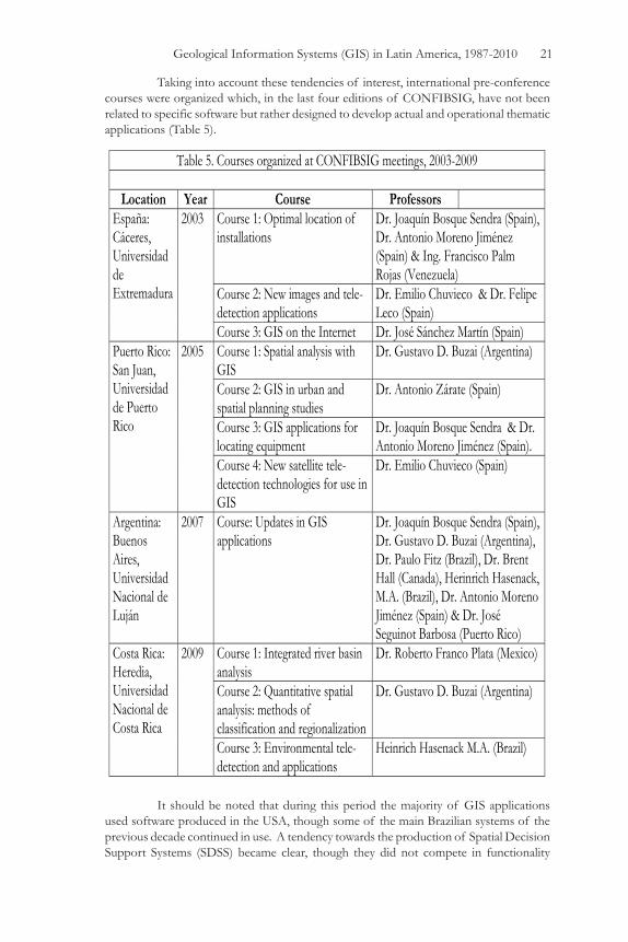
Taking into account these tendencies of interest, international pre-conference courses were organized which, in the last four editions of CONFIBSIG, have not been related to specific software but rather designed to develop actual and operational thematic applications (Table 5).
It should be noted that during this period the majority of GIS applications used software produced in the USA, though some of the main Brazilian systems of the previous decade continued in use. A tendency towards the production of Spatial Decision Support Systems (SDSS) became clear, though they did not compete in functionality
Table 5. Courses organized at CONFIBSIG meetings, 2003-2009
Location Year Course Professors España: Cáceres, Universidad de Extremadura
2003 Course 1: Optimal location of installations
Dr. Joaquín Bosque Sendra (Spain), Dr. Antonio Moreno Jiménez (Spain) & Ing. Francisco Palm Rojas (Venezuela)
Course 2: New images and tele-detection applications
Dr. Emilio Chuvieco & Dr. Felipe Leco (Spain)
Course 3: GIS on the Internet Dr. José Sánchez Martín (Spain) Puerto Rico: San Juan, Universidad de Puerto Rico
2005 Course 1: Spatial analysis with GIS
Dr. Gustavo D. Buzai (Argentina)
Course 2: GIS in urban and spatial planning studies
Dr. Antonio Zárate (Spain)
Course 3: GIS applications for locating equipment
Dr. Joaquín Bosque Sendra & Dr. Antonio Moreno Jiménez (Spain).
Course 4: New satellite tele-detection technologies for use in GIS
Dr. Emilio Chuvieco (Spain)
Argentina: Buenos Aires, Universidad Nacional de Luján
2007 Course: Updates in GIS applications
Dr. Joaquín Bosque Sendra (Spain), Dr. Gustavo D. Buzai (Argentina), Dr. Paulo Fitz (Brazil), Dr. Brent Hall (Canada), Herinrich Hasenack, M.A. (Brazil), Dr. Antonio Moreno Jiménez (Spain) & Dr. José Seguinot Barbosa (Puerto Rico)
Costa Rica: Heredia, Universidad Nacional de Costa Rica
2009 Course 1: Integrated river basin analysis
Dr. Roberto Franco Plata (Mexico)
Course 2: Quantitative spatial analysis: methods of classification and regionalization
Dr. Gustavo D. Buzai (Argentina)
Course 3: Environmental tele-detection and applications
Heinrich Hasenack M.A. (Brazil)

22 Journal of Latin American Geography
with the large GIS but rather offered a complement in specific proceedings. Important developments in SDSS exist; we may mention Localiza, a complement to IDRISI (version 2) and EduPlan, a complement to ArcView GIS, both used for the solution to problems of optimal location of equipment. The first has been developed by F. Palm (Venezuela) under the direction of J. Bosque Sendra at the Universidad de Alcalá de Henares, Spain (www.geogra.uah.es) (Palm Rojas, 2004); and the second directed by B. Hall (Canada) via institutional cooperation between the University of Waterloo, Canada (www.uwaterloo.ca) and the Centro Latinoamericano de Demografía (CELADE) Chile (www.eclac.org/celade). One may also make note of the fact that during the 1999-2009 decade some twenty Latin American countries, and five others, have participated in the CONFIBSIG meetings. Table 6 lists the participation by countries of the percent of the total of 325 papers presented and, as might be expected, it may be noted that the majority of presentations originated from within the host country in each conference. Portugal, for example had its highest participation when the conference was held in neighboring Spain. The CONFIBSIG meetings have had an important academic role. In most of the organizing countries well-known universities offer undergraduate and graduate geography programs. Other countries that have not participated to date such as Honduras and El Salvador still have no geography programs. With the assistance of the Spanish International Cooperation and Development Agency (AECID), via the University of Alcalá de Henares, in 2006 a Masters degree in Planning and Territorial Management (MOGT) was offered in the Faculty of Space Sciences of the Autonomous University of Honduras (www.oacs-unah.edu.hn) leading to Tegucigalpa being a potential candidate for the organization of the XVI CONFIBSIG in 2013 (Table 6)
An academic perspective on education and research in Latin America
Education Until today, the principal country in Latin America with regard to advances in advanced education in GIS has been Brazil. The Instituto Nacional de Pesquisas Espaciais, São José dos Campos, Brazil (INPE www.inpe.br) has been the pioneer in the area of geo-technologies by way of its recognized graduate programs. Currently Brazil offers more than twenty graduate programs (specialization, masters’ and doctorate) in which GIS occupies an important portion of the technical curriculum, or which are oriented to specific application topics within a broader context of geo-processing. Other specific courses on a diversity of GIS themes have been offered by the Geographical Institute “Agustín Codazzi” of Colombia (www.igac.gov.co). During a long period in the 1990s these courses were developed with the assistance of the International Training Center, University of Twente, Holland (www.itc.nl). Currently, the Institute provides a wide range of courses and a doctorate in geography. In Argentina, recently in the 2000s two graduate programs have been established: one, a master’s in Teledetection and GIS have been offered by the UNCPBA-Universidad Nacional del Centro de la Provincia de Buenos Aires (www.unicen.edu.ar); and a second, a specialization in the field at the UNLU-Universidad Nacional de Luján (www.unlu.edu.ar). Other universities have also begun to offer a technical orientation to these topics within geography, including the Universidad Nacional de Cuyo (UNCPBA), the Universidad Nacional de San Martín, and the Universidad Nacional de Tres de Febrero (Buenos Aires Province).

Geological Information Systems (GIS) in Latin America, 1987-2010 23
The significant impulse that has been received from the geography department of the Universidad Autónoma del Estado de México, Toluca (UAEM: www.uaemex.mx) should be noted. It has not only established an undergraduate degree in Geoinformatics, it has also initiated what is termed a Node of Geospatial Technology Innovation (NITGeo) and enjoys one of the most important specialized libraries on the subject. In 2011 it will be the host of the XIII CONFIBSIG. In the last decade another important milestone was the arrival in Latin America of the UNIGIS consortium (www.unigis.org) with the opening of a branch in Quito, Ecuador. UNIGIS offers graduate certificates, diplomas and masters’ degrees in GIS. Courses are distance education in nature and are offered from England’s Manchester Metropolitan University, the University of Huddersfield and the University of Salford. These began to be offered in Spanish in 1999 in Spain at the Universidad de Girona (www.unigis.es) and, from 2000 in Ecuador at the Universidad San Francisco de Quito (USFQ: www.unigis.edu.ec). The USFQ has since expanded, establishing institutional links with CE-UNIGIS Bolivia, CE-UNIGIS Colombia, the School of Geographical Sciences of the National University of Costa Rica, and the Faculty of Geographic Sciences of the University of Havana. If one examines education at the high-school level, Argentina is the country that has made most efforts in that regard to transfer GIS technology. The educational reform of 1993 (Ley Federal de Educación N° 24195) explicitly contemplated it in its content, and from that date training courses were developed using specific bibliographic
Table 6. Percent participation in presentations by country, 1999-2009
Participant countries
Organizing countries VII
CONFIBSIG Venezuela,
1999
VIII CONFIBSIG
Brasil, 2001
IX CONFIBSIG
España, 2003
X CONFIBSIGPuerto Rico,
2005
XI CONFIBSIG
Argentina, 2007
XII CONFIBSIGCosta Rica,
2009 Iberoamérica Argentina 14.58 10.60 2.94 2.99 57.72 * 5.17 Brazil 4.17 87.88 * 1.96 2.99 11.38 3.45 Chile 0.00 0.00 0.00 0.00 0.00 1.72 Colombia 14.58 0.00 0.98 2.99 1.63 0.00 Costa Rica 6.26 0.00 0.00 4.48 0.81 25.86 * Cuba 0.00 0.00 0.00 11.93 0.00 1.72 Ecuador 0.00 0.00 0.00 0.00 0.81 3.45 Spain 2,08 0.00 79.41 * 22.38 13.83 20.70 Mexico 4.17 0.00 2.94 7.46 3.25 15.53 Nicaragua 0.00 0.00 0.00 0.00 0.00 3.45 Panama 0.00 0.00 0.00 2.99 0.00 0.00 Peru 0.00 0.00 0.98 0.00 0.81 0.00 Puerto Rico 0.00 0.00 0.98 35.82 * 0.81 5.17 Uruguay 0.00 1.52 0.98 0.00 0.00 0.00 Venezuela 50.00 * 0.00 0.00 0.00 3.25 8.62 Otros Germany 0.00 0.00 0.98 1.49 0.00 0.00 Canada 0.00 0.00 0.00 1.49 3.25 1.72 Italy 2,08 0.00 0.00 0.00 0.00 1.72 Portugal 0.00 0.00 7.85 0.00 0.00 0.00 USA 2.08 0.00 0.00 2.99 2.45 1.72 Total 100.00 100.00 100.00 100.00 100.00 100.00 * Maximum value of each event

24 Journal of Latin American Geography
publications (Buzai and Durán, 1997) oriented later to the use of educational GIS (Buzai, 2008). In this decade one should also note the efforts to proceed to transfer GIS to the primary level via the production of specific teaching materials (Kaufman, 2005). In Colombia there has also been interest generated in developing educational software based on Map Maker 3.5 (free version: www.mapmaker.com) by way of the educational work undertaken by the Piedrahita Uribe Foundation (www.eduteka.org/SIG1.php). Finally, in the educational area, special mention should be made of the digital atlases, now that these products are used at all levels. The products of the technical work of digitizing cartographic bases and the systematization of alphanumeric databases, allow them to be distributed without any problems in CD format that permit visualization to be gained for the corresponding spatial consultations. The principal systems to that end have been achieved with specific programming using multimedia software or using programs such as ArcView 1.0, ArcExplorer and ArcExplorer Java Edition for Education (AEJEE), these products being distributed free by ESRI. Many of these efforts have resulted in excellent bibliographic materials placed on the Internet permitting a wide range of users to consult and use geographic methods, so much that some have announced the birth of a NeoGeography (Ruiz, 2010).
Applied research In Latin America, GIS as a subject matter has existed for no more than twenty years. During the first decade the majority of applications focused on the use of GIS for cartographic ends, i.e. that GIS was considered a computational database that contained spatial information. The cartographic base allowed spatial questioning of the alphanumeric database and the thematic super-positions were visual. Advances progressed rapidly in five areas: digital cartography, the digital processing of images; network analysis; 3D studies; and spatial analysis. Thus, these five lines of activity began to be seen as the basis of evaluating the selection of systems, always in accordance with the orientation of the research which, according to Phlipponneau (2001), we can say is that which is applicable. The vector type of GIS showed great aptitude for work in cartography and networks while raster type was most useful for work with images, 3D and spatial analysis. During the second decade advances were made in the use of GIS for spatial analysis taking its meaning to be the “computational system for decision-making in spatial matters”, assisted by the geographic modeling procedures. The central concepts of spatial analysis (location, distribution, association, interaction and spatial evolution) were made operational via a diversity of techniques among which overlay mapping, multi-criteria evaluation y spatial modeling became of paramount importance. It should be emphasized that while overlay mapping is a traditional geographical procedure that geography has long used for regional construction using maps of different variables to analyze spatial correspondences to define homogenous areas, multi-criteria evaluation represents an advance towards the definition of potential scenarios, and spatial modeling makes advances in the functioning of a space of interactions. The studies of Polidori (2007) and Fitz and Hasenack (2007), listed in Table 2, are examples of these two lines of advance. It is clear that GIS embody three central definitions that geography brings to empirical work: an ecological (study of society-nature relations), a chorological (study of areal differentiation), and a systematic (study of spatial laws). Taking into account the history of geographic thought, from a certain perspective GIS reconciles the traditional historicist perspectives (Hartshorne) and the positivist (Schaefer) in relation to regional construction.

Geological Information Systems (GIS) in Latin America, 1987-2010 25
The most significant bibliographic impact in Latin America has been by books published in Spain. Each of the Spanish-speaking countries can be seen to have had more more efficient contacts with Spanish publishers than those of and within the region, a situation reflecting once again the position of peripheral dependency in which the region finds itself. The introductory Spanish books are still widely cited (Bosque Sendra, 1992; Comas and Ruiz, 1993; Gutiérrez Puebla and Gould, 1994). Basic books edited and published in Latin America that have had an important local and limited regional circulation are numerous (Teixeria, Moretti and Christofoletti, 1992; Camara, G. et al., 1996; Rosa and Brito, 1996; Buzai and Durán, 1997; Teixeira and Christofoletti, 1997); more recent introductions include Miranda (2005) and Fitz (2008). Bibliographic production in Latin America has advanced in the application of GIS in specific themes: agriculture (Assad and Sano, 1998), environment and natural resources(Seguinot Barbosa, 2001; Roldán Aragón et al., 2003; Ordóñez Galán and Martínez Alegría López, 2003; Xavier da Silva and Zaidan, 2004), urban planning (Moura, 2003) and health (Medronho, 1995; Castillo Salgado et al., 2002). Currently the advance is towards modeling that promotes its use as a tool in decision-making for planning (Moreno Jiménez, 2001; Bosque Sendra and Moreno Jiménez, 2004; Buzai and Baxendale, 2006; Gómez Delgado and Barredo Cano, 2006; Moreno Jiménez and Buzai, 2008; Buzai, 2010), assisting the definition of an applied geography based on the use of GIS to study key distributions and socio-spatial processes.
Concluding remarks The development and application of GIS in Latin America has travelled a long road. The last twenty-three years has witnessed a continuous evolution from the initial technology transfer to its general application in many areas and from its use as a computational database to an extension of its capacities in advanced modeling applied to decision-making and as a key tool in applied geography. The quantity and variety of applications mentioned in these pages demonstrates the breadth that GIS technology can span and the manner in which its use shows the pervading utility of a spatial perspective. In that sense the study and analysis of geographic space has been of fundamental help in converting it into a central dimension of all multidisciplinary research. From a material point of view it might be thought that the implementation and necessity of permanent up-dating of both hardware and software has constituted the principal problem in the advance of GIS in Latin America. However, in spite of the fact that it may be considered a permanent inconvenience, currently one cannot speak of a shortage of resources, but rather of a basic inefficient use of existing resources. The budgetary problem begins to take on less significance when one considers the obstacles generated by bureaucratic public administration or the lack of up-to-date and reliable data. Thus, we consider that a geographic concept like “friction” might properly be used here in an inclusive form to frame all these disadvantages, representing images of underdevelopment. The access to, and circulation of, funds, goods, services and data/information are clearly all affected. Related to this point it is necessary to emphasize that there do exist some advances for the systematization and cooperative interchange of global data in the region. The Global Spatial Data Infrastructure Association (GSDI, www.gsdi.org) helps initiatives in creating a Spatial Data Infrastructure (IDE) at the national level, assisting in coordinating different institutional efforts as well as the Geospatial Net of South
26 Journal of Latin American Geography
America (GeoSur; www.geosur.info/geosur/) and the Central American Geographic Information Project: PROCIG (www.procig.org) that includes Panama, Belize, Costa Rica, El Salvador, Guatemala, Honduras and Nicaragua. To date, however, little progress has been seen in developing these aids. The Pan American Institute of Geography and History (PAIGH, www.ipgh.org) understands these problems and offers institutional aid to both initiatives. As a final consideration, and confronting the aforementioned structural problems, we can say that the effective advance of GIS in Latin America cannot be based on the incorporation of new hardware, the development of new software, the road to IDE, or applications on worldwide topics (often imported), without particular importance being given to a critical constructive vision. GIS is a form of thinking about realities from a spatial perspective (empirical geography) that combines supra-focal levels (politico-economic decisions) or infra-focal levels (attitudes of populations/individuals) with the purpose of being able to act effectively across spatial applications while acknowledging wider contexts within a specific reality—the reality of Latin America. This avenue begins with education and continues with a dialectic evolution between education and research; not only training in GIS that today may be seen as generalized among geography students, but rather education in geography that incorporates GIS as an important spatial tool in curricular content development for preparing geographers and technicians. Its applications in Latin America need to be oriented to help diagnose realities, understand situations, generate and evaluate future scenarios, plan courses of action and assist decision-making to reduce socio-economic inequalities. A correct use of GIS clearly needs to be closely associated with the proper use of geography as a science; such a joint relationship provides a key challenge for Latin American geographers of the twenty-first century.
Acknowledgements Gustavo Buzai wishes to thank the following colleagues and institutions that kindly provided data and information: Beatriz Alzate (Colombia), Carlos Alvarez-Gonzalez (Cuba), Carolina Beceyro, Marta Gaido and Romina Plastina (Argentina), Manuel Fuenzalida (Chile), Heinrich Hasenack (Brazil), Ariel Juarez Morales and Djamel Toudert (Mexico), Antonio Moreno Jimenez (Spain), Gabriela Ramon (Ecuador). David Robinson is very grateful to Ricardo Ponte Ramírez of the Universidad de los Andes, Mérida, Venezuela, for very fruitful discussions, and copies of early publications and legal documentation related to SIBSIG; also to James Toledano of the IDRISI Project (ClarkLabs, USA), José Quispe in Cajamarca (Peru), and Miriam Nagata in Lima. Both authors offer special thanks to Claudia Baxendale who made useful and important recommendations upon reading an earlier version of this article.
Notes1 It is important to note that in his Introduction to the Conference publication, Merrill Lyew points out that this was not the first conference devoted to this theme since Mexico had organized one in 1978 and a second in January of 1987. The IGU had sponsored International Symposia on the Management of Spatial Data in 1984 (Zurich) and 1986 (Seattle). This was, however, the first IGU conference in Latin America (IGU, 1987: 9-10)

Geological Information Systems (GIS) in Latin America, 1987-2010 27
2 For details of the establishment and development of this key company see:http://www.esri.com/about-esri/about/history.html
3 The Society was formally established as a non-political, not-for-profit organization in Merida, Venezuela, on 29th September, 1989. Its founding members were Ricardo Ponte Ramírez (Venezuela), Carlos Patillo (Chile), Armando Guevara (Venezuela), Andrew Frank (USA), Merrill Lyew (Costa Rica), Jorge Guinet (Spain), Ramón Pérez (Venezuela), Adelso Vera (Venezuela), Alicia Sánchez de Pardo (Venezuela), Amandio de Almeida (Brazil), Antonio Suárez Ureña (Colombia), Jesús López A. (Chile), Carlos Glogan (Bolivia), Carmen Gimeno Subirana (Spain), Cesar Palacios (Peru), Gabriel R. Platzeck (Argentina), Melquiades Dominguez (Panama), and Patricia Nuñez Velis (Cuba). The statutes established the administrative structure of the Society: a Directorate with a President, Executive Director and a five-member Directing Committee. Members of the Directorate were to be elected by the General Assembly for a period of two years. The General Assembly would meet every two years, prior to the meetings of CONFIBSIG. Ricardo Ponte Ramírez was authorized to register the said Constitutive Statutory Act in the Civil Registry. This was done at the Subaltern Office of Libertador District Registry, Mérida, on 1 August 1991 (Document No. 42, Protocol 1, vol.15, 3rd Trimester, 4 folios). As a result of agreements reached during the Third CONFIBSIG held in Viña del Mar, Chile, in October 1991, a group of 15 Venezuelans formally established the first national Chapter of SIBSIG (SIBSIG-VZLA). Ricardo Ponte Ramírez was elected President and the Statutory Constitutive Act was registered in the Subaltern Office of Libertador District Registry, Mérida, on 24 September, 1993 (Document No. 5, Protocol 1, vol. 36, 3rd Trimester, 5 folios). To date this is the only national chapter of SIBSIG to have been established.
ReferencesAssad, E. D. and E. E. Sano. 1998. Sistemas de Informacões Geográficas: aplicaões na agricultura. Brasilia: EMBRAPA-CPAC.
Autores Varios. 1988. Aplicaciones de la Informática a la Geografía y las Ciencias Sociales. Madrid: Síntesis.
Batista Silva, J. 2005. Utilización de Sistemas de Información Geográfica en Cuba. San Juan, Puerto Rico: X Conferencia Iberoamericana de Sistemas de Información Geográfica. (CD).
Bosque Sendra, J. 1992. Sistemas de Información Geográfica. Madrid: Ra-ma.
Bosque Sendra, J. and A. Moreno Jiménez (eds.). 2004. Sistemas de Información Geográfica y localización de instalaciones y equipamientos. Madrid: Ra-ma.
Burrough, P. A. 1986. Principles of Geographical Information Systems for Land Resources Assessment. Clarendon Press. Oxford.
Buzai, G. D. 1999. Sistemas de Información Geográfica en Argentina (1987-2000). I Encuentro Internacional Alexander von Humboldt. Buenos Aires: Centro de Estudios Alexander Humboldt.

28 Journal of Latin American Geography
__________. 2008. Sistemas de Información Geográfica y Cartografía Temática. Buenos Aires: Lugar Editorial.
__________. (comp.) 2010. Geografía y Sistemas de Información Geográfica. Aspectos conceptuales y aplicaciones. Luján: GESIG, Universidad Nacional de Luján.
Buzai, G. D., and C. A. Baxendale. 2006. Análisis Socioespacial con Sistemas de Información Geográfica. Buenos Aires: Lugar Editorial.
Buzai, G. D. and D. Durán. 1997. Enseñar e investigar con Sistemas de Información Geográfica. Buenos Aires: Troquel.
Camara, G., M. A. Casanova, A. S. Hemerly, G. Cayres Magalhaes, C. M. Bauzer Medeiros. 1996. Anatomia de Sistemas de Informacão Geográfica. Campinas: 10th Escola de Computacão. Universidade de Campinas.
Castillo Salgado, C., M. Vidaurre, P. Gassibe, R. Gonzalez, A. Beas, E. Loyola, R. Martínez, J. M. Klarián, M. González, A. Escamilla, M. Hazlewood, A. Roca, P. Nájera. 2002. Sistemas de Información Geográfica en Salud. Conceptos Básicos. Washington, DC: Organización Panamericana de la Salud.
Comas, D. and E. Ruiz. 1993. Fundamentos de Sistemas de Información Geográfica. Barcelona: Ariel.
Coppock, J. T. and D. W. Rhind. 1991. The history of GIS. In: Maguire, D. J.; M. F. Goodchild, and D. W. Rhind, (eds.), pp. 21-43. Geographical Information Systems: Principles and Applications. London: Longmans.
Fitz, P. R. 2008. Geoprocessamento sem complicacão. São Paulo: Oficina de textos.
Foresman, T. (ed.) 1998. The history of GIS: Perspectives from the Pioneers. London: Taylor & Francis.
Gómez Delgado, M., J. I. Barredo Cano. 2006. Sistemas de Información Geográfica y evaluación multicriterio en la ordenación del territorio. México: Alfaomega-Ra-ma.
Goodchild, M. F., K. K. Kemp (eds.). 1990. NCGIA Core Curriculum in GIS. Santa Barbara: National Center for Geographic Information and Analysis. University of California (History of GIS, Unit 23).
Guevara, J. A. 1995. New technological forces that will shape the evolution of GIS: The Geotechnology paradigm. 5th Conferencia y curso Iberoamericano de Sistemas de Información Geográfica. Universidad Nacional de Cuyo. Mendoza, pp. 87-104.
Gutiérrez Puebla, J.and M. Gould. 1994. SIG: Sistemas de Información Geográfica. Madrid: Síntesis.
Hasenack, H. 1992. Some Comments Concerning the Diffusion of GIS technology in Brasil. Unitar Advanced Seminar. Frutillar Bajo. Chile.

Geological Information Systems (GIS) in Latin America, 1987-2010 29
International Geographical Union (IGU). 1987. Primera Conferencia Latinoamericana sobre Informática en Geografía. San José, Costa Rica: Editorial Universidad Estatal a Distancia.
Kaufman, R. 2005. GIS Sistemas de Información Geográfica. Propuestas Didácticas. Buenos Aires: Laboratorio de Computación.
Medronho, R. A. 1995. Geoprocessamento e Saúde. Rio de Janeiro: Fundacão Oswaldo Cruz.
Miranda, J. I. 2005. Fundamentos de Sistemas de Informacões Geográficas. Brasilia: EMBRAPA.
Moreno Jiménez, A. 2001. Geomarketing con Sistemas de Información Geográfica. Madrid: Grupo de Métodos Cuantitativos, SIG y Teledetección, AGE.
Moreno Jiménez, A. and G. D. Buzai, (comps.) 2008. Análisis y planificación de servicios colectivos con Sistemas de Información Geográfica. Madrid: UAM-UNLU-AECID.
Moura, A. C. 2003. Geoprocessamento na gestão e planejamento urbano. Belo Horizonte.
Ordóñez Galán, C. and R. Martínez Alegría López. 2003. Sistemas de Información Geográfica. Aplicaciones prácticas con IDRISI 32 al análisis de riesgos naturales y problemáticas medioambientales. Mexico: Alfaomega Ra-ma.
Palm Rojas, F. J. 2004. Aspectos del desarrollo de Localiza. In: Bosque Sendra, J. and A. Moreno Jiménez (eds.) Sistemas de Información Geográfica y localización de instalaciones y equipamientos, pp. 153-172. Madrid: Ra-Ma.
Phlipponneau, M. 2001. Geografía Aplicada. Barcelona: Ariel.
Roldán Aragón, I. E., G. S. Binnqüist Cervantes, A. Bernal Becerra, M. M. Chávez Cortés, M. S. Ortega Hernández. 2003. Sistemas de Información Geográfica aplicados al manejo de los Recursos Naturales. México: Cuadernos 45. Universidad Autónoma Metropolitana – Xochimilco.
Rosa, R. 2009. Sistemas de Informacão Geográfica na América Latina: principias desafios. GeoFocus: 9: 9-12.
Rosa, R., and J. L. Brito. 1996. Geoprocessamento: Sistema de Información Geográfica. Uberlandia: Universidade Federal de Uberlandia.
Ruiz, E. 2010. El impacto de las tecnologías de la información geográfica en la Cartografía y la Geografía: reflexiones sobre 20 años de Sistemas de Información Geográfica. In: Buzai, G. D. (ed.) Geografía y Sistemas de Información Geográfica. Aspectos conceptuales y aplicaciones, pp. 51-64. Luján: GESIG-Universidad Nacional de Luján.
Sagres Editora Ltda. 1997. Si, nosotros tenemos geoprocesamiento. Geoprocessamento en Argentina. Fator GIS. 3(9): 11-14. (Interviews that included Argentine geographers Gustavo D. Buzai, Diana Durán and Darío C. Sánchez).
Seguinot Barbosa, J. (ed.) 2001. Geonatura. Sistemas de Información Geográfica (SIG) aplicados a las Ciencias Ambientales y de la Salud. Bayamón: Publicaciones CD Inc.

30 Journal of Latin American Geography
Teixeira, A. L. A. and A. Christofoletti. 1997. Sistemas de Informacão Geográfica. Dicionario Ilustrado. São Paulo: Hucitec.
Teixeira, A. L. A., E. Moretti and A. Christofoletti. 1992. Introducão aõs Sistemas de Infomacão Geográfica. São Paulo: Rio Claro.
Teixeira, A. L. A. and N. A. Gray de Cerdán. 1990. GEO-INF+MAP. Aplicación de la tecnología SIG al desarrollo de regiones de tamaño medio. Mendoza: Facultad de Filosofía y Letras. Universidad Nacional de Cuyo.
Xavier da Silva, J. and R. T. Zaidan. 2004. Geoprocessamento e Análise Ambiental: Aplicacões. Rio de Janeiro: Bertrand Brasil.
CONFIBSIG publications:
1987. I Conferencia Latinoamericana sobre Informática en Geografía. Merrill Lyew (comp.).San José, CR: Editorial Universidad Estatal a Distancia (ISBN 997-7-64-371-7).
1989. II Conferencia Latinoamericana sobre Tecnología de los Sistemas de Información Geográfica: Geoinformación para el Desarrollo. Ricardo Ponte R. (comp.). Mérida, Venezuela: Talleres de Publicaciones de la Facultad de Ciencias Forestales de la Universidad de Los Andes.
1991. III Conferencia Latinoamericana sobre Sistemas de Información Geográfica. Carlos Patillo (comp.). Santiago: Pontificia Universidad Católica de Chile.
1993. Anais: IV Conferencia Latinoamericana sobre Sistemas de Infomacão Geográfica y II Simposio Brasileiro de Geoprocessamento. Marcos Rodrígues (comp.). São Paulo.
1995. Resúmenes: 5ª Conferencia y Curso Iberoamericano sobre Sistemas de Información Geográfica: Hacia un nuevo paradigma geotecnológico. Nelly A. Gray de Cerdán (comp.). Mendoza: Editorial de la Facultad de Filosofia y Letras de la Universidad Nacional de Cuyo.
1999a. Programa y Resúmenes: VII Conferencia Iberoamericana sobre Sistemas de Información Geográfica. Ricardo R. Ponte (comp.). Mérida, Venezuela: Litorama Talleres Gráficos (ISBN 980-11-0357-4).
1999b. Memorias del VII Conferencia Iberoamericana sobre Sistemas de Información Geográfica. Ricardo R. Ponte (comp.). Merida, Venezuela (ISBN 980-11-0356-6) (CD).
2001. XX Congresso Brasileiro de Cartografia. IX Congresso Nacional de Engenharia de Agrimensura. VIII Conferencia Ibero-Americana de Sistemas de Información Geográfica. Seminario ISPRS Comission VI. FENEA-ISPRS-SIBSIG-SBC. Porto Alegre (CD). 2003. IX Conferencia Iberoamericana de Sistemas de Información Geográfica, VII Congreso Nacional de la Asociación Española de Teledetección y II Reunión del Grupo de Métodos Cuantitativos y Sistemas de Información Geográfica de la Asociación de Geógrafos Españoles. Universidad de Extremadura-SIBSIG. Cáceres. (CD).

Geological Information Systems (GIS) in Latin America, 1987-2010 31
2005a. Gurría Gascón, J. L.; Hernández Carretero, A. Nieto Masot, A. (eds.) De lo local a lo global: nuevas tecnologías de la información Geográfica para el desarrollo. Servicio de publicaciones. Universidad de Extremadura. Cáceres. (ISBN 84-7723-661-5).
2005b. X Conferencia Iberoamericana de Sistemas de Información Geográfica. Universidad de Puerto Rico. San Juan. (CD). 2007. Buzai, G. D. (ed.) Memoriasde la XI Conferencia Iberoamericana de Sistemas de Información Geográfica. Universidad Nacional de Luján-SIBSIG. Luján. (ISBN 978-987-4285-33-6) (with CD).
2009. XII Conferencia Iberoamericana de Sistemas de Información Geográfica. Heredia: Universidad Nacional de Costa Rica-PROSIGTE. (CD)