geographic names of iceland’s glaciers: historic and … · 2 geographic names of iceland’s...
TRANSCRIPT

1National Energy Authority Grensaacutesvegi 9 IS-108 Reykjaviacutek Iceland2US Geological Survey Woods Hole Science Center 384 Woods Hole Road
Woods Hole MA 02543-1598 USA
AbstractClimatic changes and resulting glacier fluctuations alter landscapes In the
past such changes were noted by local residents who often documented them in historic annals eventually glacier variations were recorded on maps and scientific reports In Iceland 10 glacier place-names are to be found in Icelandic sagas and one of Icelandrsquos ice caps SnaeligfellSjoumlkull appeared on maps of Iceland published in the 16th century In the late 17th century the first description of eight of Icelandrsquos glaciers was written Therefore Iceland distinguishes itself in having a more than 300-year history of observations by Icelanders on its glaciers A long-term collaboration between Oddur Sigurethsson and Richard S Williams Jr led to the authorship of three books on the glaciers of Iceland Much effort has been devoted to documenting historical glacier research and related nomenclature and to physical descriptions of Icelandic glaciers by Icelanders and other scientists from as far back as the Saga Age to recent (2008) times The first book Icelandic Ice Mountains was published by the Icelandic Literary Society in 2004 in cooperation with the Icelandic Glaciological Society and the International Glaciological Society Icelandic Ice Mountains was a glacier treatise written by Sveinn Paacutelsson in 1795 and is the first English translation of this important scientific document Icelandic Ice Mountains includes a Preface including a summary of the history and facsimiles of page(s) from the original manuscript a handwritten copy and an 1815 manuscript (without maps and drawings) by Sveinn Paacutelsson on the same subject which he wrote for Rev Ebenezer Henderson an Editorrsquos Introduction 82 figures including facsimiles of Sveinn Paacutelssonrsquos original maps and perspective drawings maps and photographs to illustrate the text a comprehensive Index of Geographic Place-Names and Other Names in the treatise References and 415 Endnotes
Geographic Names of Icelandrsquos Glaciers Historic and Modern
By Oddur Sigurethsson1 and Richard S Williams Jr2
2 Geographic Names of Icelandrsquos Glaciers Historic and Modern
Professional Paper 1746 (this book) is the second of the three books it is being published in both English and Icelandic editions This book provides information about all named glaciers in Iceland historic and modern Descriptions with geographic coordinates and bibliographic citations to all glacier place-names on published maps books and scientific articles are included Maps oblique aerial photographs ground photographs and satellite images document each of the 269 modern named glaciers of Iceland
The third book Glaciers of Iceland is Chapter D of the 11-chapter [volume] US Geological Survey Professional Paper 1386-AndashK Chapter D includes a 1500000-scale Map of the Glaciers of Iceland it is a comprehensive historical and modern review and assessment of what is currently known about glaciers in Icelandrsquos eight Regional Glacier Groups from a review of the scientific litera-ture and from analysis of maps and remotely sensed data (ground airborne and satellite) topics include geology and geography climate and climate variability types of glaciers history of glacier variation (including the 21 surge-type glaciers) and frequency and magnitude of volcanic and lacustrine joumlkulhlaups
IntroductionThe primary objective of writing this book the second in a series of three
on the glaciers of Iceland3 was to compile the geographic names of all of the different types of glaciers of Iceland (table 1) and organize the glacier types into eight Regional Glacier Groups (fig 1) This is a modification of the geographic subdivision of the glacierized regions of Iceland proposed by Rist (1985) (appendix) Vatnajoumlkull Group Myacuterdalsjoumlkull Group Hofsjoumlkull Group Langjoumlkull Group Snaeligfellsjoumlkull Vestfjarethajoumlklar Norethurlandsjoumlklar and Austfjarethajoumlklar Tables 2ndash9 with accompanying maps (figs 2ndash9) list all of the modern place-names of Icelandrsquos 269 glaciers in the eight Regional Glacier Groups that are in current use (2008) in Iceland including 14 ice caps 2 contiguous ice caps 109 outlet glaciers 8 ice-flow basins (HOfSjoumlkull) 3 ice streams (Breiethamerkurjoumlkull) 55 cirque glaciers 73 mountain glaciers and 5 valley glaciers The 14 named joumlkul-hlaup deposits are listed in table 10 with accompanying map (fig 10) Joumlkulhlaup deposits are called ldquojoumlkullrdquo by local farmers (for example ldquoLambajoumlkullrdquo on Myacuterdalssandur and ldquoSvartijoumlkullrdquo in the Oumlraeligfi district) The 38 named snow patches (54 percent in Norethurland) including many named by Rist (1985) are listed in table 11 and in the Alphabetical List of the Glaciers of Iceland Figures 11ndash201 are oblique aerial photographs ground photographs and satellite images that illustrate each of Icelandrsquos 269 glaciers For each glacier place-name used in this book the preferred modern spelling is shown in bold upper-case letters if an ice cap and in bold lower-case letters if an outlet glacier or other type of glacier names of 21 surge-type glaciers are bold and underlined (including two ice streams of Breiethamerkurjoumlkull) Seven other possible surge-type glaciers on the basis of anecdotal evidence are noted The 2008 total does not include six named glaciers that have ldquodisappearedrdquo during the second half of the 20th century three mountain glaciers that melted completely and two distributary outlet glaciers and one outlet glacier that receded into their respective ice caps
3The three books are Icelandic Ice Mountains (Williams and Sigurethsson 2004) Geographic Names of Icelandrsquos Glaciers Historic and Modern (this book 2008) and Glaciers of Iceland 1 of 11 volumes in the Satellite Image Atlas of Glaciers of the World series (US Geological Survey Professional Paper 1386-D) (Sigurethsson and Williams in press) The latter book includes a plate a 1500000-scale Map of the Glaciers of Iceland with a 1250000-scale inset map of Norethurlandsjoumlklar
Introduction 3
Table 1 Classification of types of glaciers in Iceland Comparison of English and Icelandic glaciological terms
[-- not classified]
Eythornoacutersson (1963b)Armstrong and others (1973) Muumlller and others (1977)
(primary classification
in bold)
Johansson (1984) (source of Icelandic namesSigurethur Thorarinsson and
Helgi Bjoumlrnsson)Icelandic English
-- -- -- -- hveljoumlkull (plateau glacier)
joumlkulhetta (Eiriacuteksjoumlkull Vatnajoumlkull and Myacuterdalsjoumlkull are joumlkulskildir or joumlkulflaacutekar)
joumlkulhetta ice cap ice cap joumlkulhvel hveljoumlkull (ice cap)
skriethjoumlkull (outlet glacier glacier tongue)
breiethjoumlkull (wallsided glacier) (Siacuteethujoumlkull)
skriethjoumlkull
joumlkultunga
outlet glacier
glacier tongue
outlet glacier skriethjoumlkull (outlet glacier)
falljoumlkull falljoumlkull ice fall ice fall falljoumlkull (ice fall)
roacutetarjoumlkull roacutetarjoumlkull piedmont glacier piedmont glacier roacutetarjoumlkull (piedmont glacier)
-- strandjoumlkull ice piedmont -- --
meginjoumlkull (Greenland ice sheet) iacutesbreiethajoumlkulbreietha
ice sheet continental ice sheet iacutesbreietha(ice sheet)
-- hjarn firn -- hjarn (firn)
-- -- -- ice field iacutesbreietha (ice field)
falljoumlkull (daljoumlkull) daljoumlkull valley glacier valley glacier (alpine glacier)
alpajoumlkull fjalljoumlkull (alpine glacier)
-- dauethur joumlkull stagnant glacier -- staethnaethur joumlkull (stagnant glacier)
foumlnn (snow drift) foumlnn snow drift firn -- skafi snjoacuteskafl skafrenningur (snow drift)
iacutes (ice) iacutes ice -- joumlkuliacutes (glacier ice)
joumlkull (glacier) joumlkull glacier -- joumlkull (glacier)
-- joumlkulthornilja ice shelf ice shelf joumlkulthornilja (ice shelf)
joumlkulrastir (ice streams) joumlkulrastir ice streams -- --
-- -- -- glacieret and snowfield fannbreietha (snow field)
-- -- -- skafi hjarnfoumlnn (snow patch)
4 Geographic Names of Icelandrsquos Glaciers Historic and Modern
24degW 22deg 20deg 18deg 16deg 14deg
64deg30
66degN
0 100 Kilometers
A
Norethurlandsjoumlklar (fig 8)
Vatnajoumlkull Group (fig 2)
Austfjarethajoumlklar (fig 9)
Hofsjoumlkull Group (fig 4)Langjoumlkull Group (fig 5)
Snaeligfellsjoumlkull (fig 6)
Myacuterdalsjoumlkull Group (fig 3)
Vestfjarethajoumlklar(fig 7)
100 Kilometers0
24degW
66degN
64deg30rsquo
22deg 20deg 18deg 16deg 14deg
B
Figure 1 A Map of the eight Regional Glacier Groups in Iceland (see tables 2ndash9)
B Landsat 5 Thematic Mapper image mosaic of Iceland showing the distribution of glaciers (white) vegetation (green) lightly vegetated or unvegetated areas including bare rock and sediment (various shades of brown) and water (blue) The image map (Iacutesland Groacuteethurmyndcopy) was published by the National Land Survey of Iceland (Landmaeliglingar Iacuteslands) in 1993 at an original scale of 1600000 Used with permission copyNational Land Survey of Iceland License LO307005
Introduction 5
Table 2 Names of the glaciers of the Vatnajoumlkull group
[-- not classified]
Modern name Alternative namesspelling variations Historic names
VATNAJOumlKULL and its outlet glaciers (fig 2A)
Austurtungnajoumlkull Skyndidalsjoumlkull --Axarfellsjoumlkull Oumlxarfellsjoumlkull Axarfjallsjoumlkull and Axarjoumlkull --Breiethamerkurjoumlkull -- Fellsjoumlkull (eastern part)Broacutekarjoumlkull Steinajoumlkull --Bruacutearjoumlkull -- JoumlkuldalsjoumlkullDyngjujoumlkull Kistufellsjoumlkull --eyjabakkajoumlkull -- Fljoacutetsdalsjoumlkulleyvindstungnajoumlkull Sultartungnajoumlkull Sultartungujoumlkull and
Haacutelsajoumlkull--
falljoumlkull -- --fellsaacuterjoumlkull Fellsjoumlkull Briacutekurjoumlkull and THORNveraacutertindsjoumlkull --fjallsjoumlkull AEligrfjallsjoumlkull Hruacutetaacuterjoumlkull eystri and
Eystri HruacutetaacuterjoumlkullHruacutetaacuterjoumlkull
flaacuteajoumlkull -- Myacuterajoumlklar Myacuterajoumlkull Hoacutelmsaacuterjoumlkull and HoacutelsaacuterjoumlkullGeldingafellsjoumlkull Bloumlndujoumlkull (abandoned) --Gljuacutefursaacuterjoumlkull -- --Graelignaloacutensjoumlkull -- --Heinabergsjoumlkull Eystri-Heinabergsjoumlkull Heinabergsjoumlkull eystri Heiethnabergsjoumlkull Heinabergsjoumlklar
Heinabergsjoumlkull and Myacuterajoumlklar-- -- HoffellsdalsjoumlkullHoffellsjoumlkull -- NorethurfellsjoumlkullHoacutelaacuterjoumlkull -- --Hruacutetaacuterjoumlkull -- Hruacutetaacuterjoumlkull vestri Hruacutetaacuterjoumlklar
-- Kaacutelfafellsjoumlkull Kaacutelfafellsjoumlklarkotaacuterjoumlkull Roacutetarfjallsjoumlkull (combined with Roacutetarfjallsjoumlkull) Floumlgujoumlkull [Sloumlgujoumlkull]kverkjoumlkull -- --Kverkkviacuteslarjoumlkull Kverkjoumlkull (abandoned) --kviacuteaacuterjoumlkull -- --Kviacuteslarjoumlkull -- --koumlldukviacuteslarjoumlkull -- --lambatungnajoumlkull THORNoacuteretharjoumlkull Lambatungujoumlkull (misspelling) --Morsaacuterjoumlkull -- ---- -- Myacuterajoumlklarnorethurtungnajoumlkull -- --Rjuacutepnabrekkujoumlkull -- --Roacutetarfjallsjoumlkull Roacutetarfjallsjoumlkull (combined with kotaacuterjoumlkull) --Siacuteethujoumlkull -- Nyrethri-Skeietharaacuterjoumlkull Skeietharaacuterjoumlkull nyrethriSkaftafellsjoumlkull -- SkaptafellsjoumlkullSkaftaacuterjoumlkull -- SkaptaacuterjoumlkullSkarpheacuteethinsjoumlkull --
6 Geologic Names of Icelandrsquos Glaciers Historic and Modern
Modern name Alternative namesspelling variations Historic names
Skaacutelafellsjoumlkull Vestri-Heinabergsjoumlkull Heinabergsjoumlkull vestri and Heinabergsjoumlkull vestari
Heinabergsjoumlklar Heinabergsjoumlkull
Skeietharaacuterjoumlkull -- --Stigaacuterjoumlkull -- --Stoacuterhoumlfethajoumlkull -- --Suethurfjallsjoumlkull -- --Sviacutenafellsjoumlkull -- --Sviacutenafellsjoumlkull -- --Sylgjujoumlkull -- --Tungnaacuterjoumlkull Tungnaaacuterjoumlkull Tungnaacuterjoumlklar --VATnAjoumlkull -- AUSTURJOumlKLAR AUSTURJOumlKULL
GRIacuteMSVATNAJOumlKULL and KLOFAJOumlKULLVesturdalsjoumlkull -- --Viethborethsjoumlkull -- --Virkisjoumlkull Falljoumlkull vestari --
Contiguous ice cap
oumlRaeligfAjoumlkull -- HNAPPAFELLSJOumlKULL HNAPPAVALLAJOumlKLAR HNAPPAVALLAJOumlKULL KNAPPAFELLSJOumlKULL SANDFELLSJOumlKULL and JOumlKULL
Other glaciers
Birnudalsjoumlkull Birnujoumlkull --Skrekkur -- --
Internal ice domes
ldquoBAacuteRETHARBUNGArdquo ldquoBAacuteRETHARJOumlKULLrdquo ldquoBAacuteRDHARNUacutePURrdquo and ldquoBAacuteRETHARGNIacutePArdquo
--
--
ldquoBREIETHABUNGArdquo --ldquoHAacuteABUNGArdquo ldquoJOumlKULBUNGArdquo --
Named ice streams of BREIETHAMERKURJOumlKULL
Esjufjallajoumlkull -- --Maacutevabyggethajoumlkull -- --Norethlingalaeligetharjoumlkull -- --
Historic ice-margin names
Heinabergsjoumlkull -- --Herethubreietharjoumlkull -- --Hornafjaretharjoumlkull Hornafjaretharjoumlklar --Kaacutelfafellsjoumlkull -- --Loacutensjoumlkull Loacutenjoumlkull --Myacuterajoumlkull Myacuterajoumlklar --Suethursveitarjoumlkull -- --
Table 2 (Continued) Names of the glaciers of the Vatnajoumlkull group
ldquoBAacuteRETHARJOumlKULLrdquo ldquoBAacuteRDHARNUacutePURrdquo and ldquoBARETHARGNIacutePArdquo
Introduction 7
Modern name Alternative namesspelling variations Historic names
Suacutelujoumlkull -- ---- Tungnaacuterjoumlklar --
TUNGNAFELLSJOumlKULL and its outlet glaciers (fig 2B)
TunGnA-fellSjoumlkull
FLJOacuteTSJOumlKULL SPRENGISANDSJOumlKULL SANDJOumlKULL TUNG-NAJOumlKULL and BLAacuteNYacutePUJOumlKULL
Hagajoumlkull fremri Hagajoumlklar Fremri-Hagajoumlkull --Hagajoumlkull innri Hagajoumlklar Innri-Hagajoumlkull --
Named glaciers on Snaeligfell (fig 2C)
Axlarjoumlkull -- --Doumlkkuretharjoumlkull Grjoacutetaacuterjoumlklar Tviacuteburajoumlklar --Ljoacutesuretharjoumlkull Grjoacutetaacuterjoumlklar Tviacuteburajoumlklar --Soacutetajoumlkull Haacutelsajoumlkull --
Table 2 (Continued) Names of the glaciers of the Vatnajoumlkull group
In the compilation of this book an effort was made to cite every geographic place-name of Icelandrsquos glaciers that has either (1) appeared in the historic and scientific literature (2) been published on individual maps or on formal (official) map series of Iceland [maps or map series published by the Danish General StaffDanish Geodaeligtic Institute Landmaeliglingar Iacuteslands (LMIacute) (Iceland Geodetic SurveyNational Land Survey of Iceland) and US Army Map Service (AMS)US Defense Mapping Agency (DMA)National Imagery and Mapping Agency (NIMA)National Geospatial-Intelligence Agency (NGA)] or (3) been included on maps in scientific books and journal articles Published documents such as books journal articles and maps represent edited source material that has been formally reviewed techni-cally thereby giving place-names described in this book an imprimatur of authority Topographic and other thematic maps published by the National Land Survey of Iceland at various scales however often have a marked inconsistency in geographic location spelling and choice of names of glaciers or an inexplicable absence of glacier names including the latest 150000-scale map series C761 which still (in 2008) only covers approximately 50 percent of Iceland
Examples of the source materials used include the 150000-scale fjoacuterethungs-bloumleth (118 map sheets) the 1100000-scale atlasbloumleth (renamed atlaskort 87 map sheets) the 1250000-scale aethalkort yfir Iacutesland (and new series 9 map sheets) and the 1250000-scale jarethfraeligethikort af Iacuteslandi (Geological Map of Iceland old and new) series (9 map sheets published or in preparation) the 150000-scale US Army Map Service (AMS) Series C762 maps (297 map sheets) the 150000-scale Landmaeliglingar Iacuteslands (LMIacute)US Defense Mapping Agency (DMA) (LMIacuteDMA) maps (199 LMIacute200 DMA map sheets) as well as maps and articles in various Icelandic reports and journals (for example Joumlkull (J) Aacuterboacutek Ferethafeacutelags Iacuteslands (AacuteFIacute) Naacutettuacuterufraeligethingurinn] Landieth thornitt (6 volumes) various foreign reports and scientific journals (for example Journal of Glaciology Annals of Glaciology Geografisk Tidsskrift Petermanns Geographische Mitteilungen Fluctuations of GlaciersWorld Glacier Inventory (International Association of Hydrological Sciences UNEP and UNESCO) Geografiska Annaler) THORNorvaldur Thoroddsenrsquos many publications especially his four-volume Ferethaboacutek series (1913 1914a b 1915) and his Lyacutesing Iacuteslands (v 2 VII Joumlklar 1911) Sigurdur Thorarinsson (1943)
8 Geographic Names of Icelandrsquos Glaciers Historic and Modern
Approximate coverage of fig 26A
THORNoacutereth
arhy
rna
18degW
16degW
64deg3
0rsquoN
20 K
ILO
MET
ERS
100
Kviacute
aacuterjouml
kull
Bre
ietham
erku
rjoumlku
ll
Hruacute
taacuterjouml
kull
Hoacutelaacuterjoumlkull
Stigaacuterjoumlkull
Fjal
lsjouml
kull
Fells
aacuterjouml
kull
ldquoBREIETH
ABUNGArdquo
Dyn
gjuj
oumlkul
l
Bruacute
arjouml
kull
Kverkj
oumlkull
Skarpheacuteethinsjoumlkull
Lam
batu
ngna
joumlku
ll
Skaacutel
afel
lsjouml
kullEyjabakkajoumlkull
Skre
kkur
Broacuteka
rjoumlku
ll
Siacuteethu
joumlku
ll
Koumll
dukv
iacutesla
rjoumlku
ll
Sylg
jujouml
kull
Tung
naacuterjouml
kull
Skaftaacuterjoumlkull
VATN
AJOuml
KU
LL
ldquoHAacuteA
BUN
GArdquo
Griacutem
svoumlt
nG
riacutemsf
jall
Skeietharaacuterjoumlkull
StoacuterhoumlfethajoumlkullGljuacutefursaacuterjoumlkull
Kotaacuterjoumlkull
Falljoumlku
ll
Virk
isjoumlk
ull
Sviacuten
afell
sjoumlku
ll
Skaf
tafe
llsjouml
kull
Morsaacuterjoumlkull
Graelignaloacutensjoumlkull
Rjuacutepna
brek
kujoumlk
ull
ldquoBAacuteRETHARBUNGArdquo
Birn
udal
sjoumlk
ull
Aus
turt
ungn
ajoumlk
ull
Norethlingalaeligetharjoumlkull
RoacutetarfjallsjoumlkullOumlRAEligFAJOumlKULL
Flaacutea
joumlku
ll
Eyvi
ndst
ungn
ajoumlk
ull
Hei
nabe
rgsj
oumlkul
l
Viethbor
ethsjoumlk
ullSviacutenafe
llsjoumlk
ull
Gra
sgilj
atin
dur
Nor
ethurt
ungn
ajoumlk
ull
HO
FSJOuml
KU
LL
(fig
9A)
Snaelig
fell
(fig
2C
)
TUN
GN
AFE
LLSJ
OumlK
ULL
(fig
2B)
KverkkviacuteslarjoumlkullKviacuteslarjoumlkull Geldingafellsjoumlkull Vesturdalsjoumlkull Suethurfjallsjoumlkull
Axarfellsjoumlkull
Saueth
ham
arst
indu
r
Esjufja
llajoumlkull
Maacutev
abyg
gethaj
oumlkul
l
Hof
fells
joumlku
ll
A
Ham
arin
n
Appr
oxim
ate
cove
rage
of f
ig 1
31A
Paacutels
fjall
Skaf
taacuterk
atla
r
Figu
re 2
A M
ap of
VAT
NAJOuml
KULL
and i
ts ou
tlet g
lacier
s
Introduction 9
0 1 2 KILOMETERS
TUNGNAFELLSJOumlKULL
Hagajoumlkull innri
Hagajoumlkull fremri
B
64deg45N
17deg50W
15deg36W 15deg34 15deg32
SNAEligFELL
C
Axlarjoumlkull
Doumlkkuretharjoumlkull
LjoacutesuretharjoumlkullSoacutetajoumlkull
1 KILOMETER50
64deg48rsquoN
Figure 2 B Map of TUNGNAFELLSJOumlKULL and its outlet glaciers and C map of glaciers on Snaeligfell
10 Geographic Names of Icelandrsquos Glaciers Historic and Modern
Table 3 Names of the glaciers of the Myacuterdalsjoumlkull group[-- not classified]
Modern name Alternative namesspelling variations Historic names
MYacuteRDALSJOumlKULL and its outlet glaciers ( fig 3A)
MYacuteRDAlSjoumlkull MIETHDALSJOumlKULL AUSTURJOumlKULL EYJAFJALLAJOumlKULLMIRDALSJOumlKULL and MYacuteDALSJOumlKULL
HOumlFETHABREKKUJOumlKULL HOumlFETHAJOumlKULL HOumlFETHAacuteRJOumlKULL KOumlTLUGJAacuteRJOumlKULL KOumlTLUJOumlKULL SOacuteLHEIMAJOumlKULL AUSTURJOumlKLAR and THORNYKKVABAEligJARJOumlKULL
entujoumlkull -- --Hafursaacuterjoumlkull -- ---- -- HrunakviacuteslarjoumlkullHrunaacuterjoumlklar -- --Huldujoumlkull Hviacutetijoumlkull --Joumlkulsaacutergilsjoumlkull -- --klifuraacuterjoumlkull Klifandajoumlkull Klifandijoumlkull --krossaacuterjoumlkull -- --koumltlujoumlkull Houmlfethabrekkujoumlkull KoumltlufalljoumlkullSandfellsjoumlkull -- --Sleacutettjoumlkull Maeliglifellsjoumlkull --Soacutelheimajoumlkull -- --Thoroddsengletscher -- --Tungnakviacuteslarjoumlkull -- --oumlldufellsjoumlkull -- --
Names of internal ice domes
ldquoGOETHABUNGArdquo -- --ldquoHAacuteBUNGArdquo ldquoHAacuteABUNGArdquo --ldquoMERKURJOumlKULLrdquo ldquoTHORNOacuteRSMERKURJOumlKULLrdquo Merkrjoumlkull
Ice-margin names
Botnjoumlkull -- Emstrujoumlkull BotnjoumlkullGoethalandsjoumlkull -- --Hrunajoumlkull -- ---- -- Soacutelheimajoumlkull
EYJAFJALLAJOumlLKULL and its outlet glaciers fig 3B)
eYjAfjAllAjoumlkull AUSTURJOumlKULL HAacuteJOumlKULLAkstaethajoumlkull Kaplaskarethsjoumlkull --Giacutegjoumlkull Falljoumlkull SkriethjoumlkullHvannaacuterjoumlkull -- --Kaldaklifsjoumlkull -- --Seljavallajoumlkull -- TungugilsjoumlkullSteinsholtsjoumlkull -- --
Introduction 11
19degW19deg15W 18deg45W
63deg45N
63deg35N
0 5 10 KILOMETERS
ldquoHAacuteBUNGArdquo
M Yacute R D A L S J Ouml K U L L
S l eacute t t j ouml k u l l
E n t u j ouml k u l l
S a n d f e l l s j ouml k u l l
Joumlku
lsaacuterg
ilsjouml
kull
H u l d u j ouml k u l l
Klifu
raacuterj
oumlkul
l
ldquoGOETHABUNGArdquo
Krossaacuterjoumlkull
Hrunaacuterjoumlklar
Ouml l d u f e l l s j ouml k u l l
HafursaacuterjoumlkullThoroddsengletscher
Soacutelhe
imaj
oumlkul
l
Kouml t l u j ouml k u l l
Bo
tn
jouml
ku
ll
Tungnakviacuteslarjoumlkull
Hruna joumlku l l
Go
etha
l an
ds
j oumlk
ul lldquoMERKUR-
JOumlKULLrdquo
A
Modern name Alternative namesspelling variations Historic names
TORFAJOumlKULL and Kaldaklofsjoumlkull (fig 3C)
TORfAjoumlkull -- --kaldaklofsjoumlkull -- --
Tindfjallajoumllkull and Blesaacuterjoumlkull (fig 3D)
Tindfjallajoumlkull Tindafjallajoumlkull --Blesaacuterjoumlkull -- --
Table 3 (Continued) Names of the glaciers of the Myacuterdalsjoumlkull group
Figure 3 A Map of MYacuteRDALSJOumlKULL and its outlet glaciers
12 Geographic Names of Icelandrsquos Glaciers Historic and Modern
Figure 3 B Map of EYJAFJALLAJOumlKULL and its outlet glaciers and C map of TORFAJOumlKULL and Kaldaklofsjoumlkull
0 2 4 KILOMETERS
E Y J A F J A L L A J Ouml K U L L
Giacutegjoumlkull
HvannaacuterjoumlkullK
aldaklifsjoumlkull
Seljavallajoumlkull
Steinsholtsjoumlkull
63deg40N
63deg35N
19deg45W 19deg30W
B
Akstaethajoumlkull
19deg6W 19degW 18deg54W
63deg53N
63deg56N
0 2 4 KILOMETERS
TORFAJOumlKULL
Kaldaklofsjoumlkull
C
Introduction 13
19deg39W 19deg36W 19deg33W
63deg47N
63deg48N
63deg49N
Blesaacuterjoumlkull
Ti n
df j a
l l aj ouml
ku
l l
10 2 KILOMETERS
Figure 3 D Map of Tindfjallajoumlkull and Blesaacuterjoumlkull
Table 4 Names of the Glaciers of the Hofsjoumlkull Group
[-- not classified]
Modern name Alternative namesspelling variations Historic names
HOFSJOumlKULL and its outlet glaciers (fig 4A)
HOfSjoumlkull -- ARNARFELLSJOumlKULLAustari-Joumlkulsaacuterjoumlkull -- --Aacutelftabrekkujoumlkull -- --Blautukviacuteslarjoumlkull -- --Blaacutegniacutepujoumlkull Blaacutegnyacutepujoumlkull --Bloumlndujoumlkull -- --Brattoumlldujoumlkull -- --Haacuteoumlldujoumlkull1 -- --Illviethrajoumlkull Illviethrahnjuacutekajoumlkull --klakksjoumlkull Klakkajoumlkull --kviacuteslajoumlkull -- --Lambahraunsjoumlkull -- --Loumlngukviacuteslarjoumlkull -- --Miklafellsjoumlkull -- --Miklukviacuteslarjoumlkull -- --Muacutelajoumlkull -- --
14 Geographic Names of Icelandrsquos Glaciers Historic and Modern
Modern name Alternative namesspelling variations Historic names
nauthagajoumlkull1 Oacutelafsfellsjoumlkull --Roacutetarjoumlkull -- --Saacutetujoumlkull Eystri-Saacutetujoumlkull
LambahraunsjoumlklarTungufoumlnn -- --Tviacutefellsjoumlkull Lambahraunsjoumlklar --THORNjoacutersaacuterjoumlkull -- --THORNverfellsjoumlkull -- --
Name of internal ice dome
ldquoMIKLAFELLrdquo
Ice-margin names
-- -- Eyfiringajoumlkull
Named glaciers of Kerlingarfjoumlll (Kerlingarfjallajoumlklar) (fig 4B)
Borgarjoumlkull -- --Botnajoumlkull -- --fannborgarjoumlkull -- --Hangandi -- --Hattarjoumlkull -- --joumlkulkinn -- --kisujoumlkull -- --langafoumlnn -- --loethmundarjoumlkull eystri Eystri-Loethmundarjoumlkull
Innri-Loethmundarjoumlkull--
loethmundarjoumlkull vestri Vestri-Loethmundarjoumlkull Ytri-Loethmundarjoumlkull
--
Maelignisfoumlnn -- --Maelignisjoumlkull -- --
Skessujoumlkull -- --
Glaciers mapped in 1942 which have since disappeared (melted)
ForslujoumlkullSnoacutetarjoumlkull
1Possible surge-type glacier
Table 4 (Continued) Names of the Glaciers of the Hofsjoumlkull Group
Introduction 15
HOFSJOumlKULL
Kviacuteslajoumlkull
Bloumlndujoumlkull
Blaacutegniacutepujoumlkull
Aacutelftabrekkujoumlkull
Saacutetujoumlku
ll
Muacutelajoumlkull
Tungufoumlnn
Lam
bahr
auns
joumlkull
Loumlngukviacuteslarjoumlkull
Klakksjoumlkull
Roacutetarjoumlkull
Bla
utuk
viacutesl
arjouml
kull
Kerlingarfjallajoumlklar(fig 4B)
Tviacutefe
llsjouml
kull
Mik
lukv
iacutesla
rjoumlku
ll
THORNjoacuter
saacuterjouml
kull
Haacuteoumlldujoumlkull
Brattoumlldujoumlku
ll
A
THORNverfe
llsjoumlku
ll
Nauth
agaj
oumlkul
l
Miklafellsjoumlkull
Austa
ri-Jouml
kulsaacute
rjoumlku
ll
Illvieth
rajouml
kull
0 10 KILOMETERS
19degW
64deg40
64deg50
65degN
Figure 4 A Map of HOFSJOumlKULL and its outlet glaciers
16 Geographic Names of Icelandrsquos Glaciers Historic and Modern
Kisujoumlkull
Loethmundarjoumlkullvestri
Hattarjoumlkull
Maelignisfoumlnn
Maelig
nisj
oumlkul
l
Langafoumlnn
Botnajoumlkull
Hangandi
Borgarjoumlkull
Fannborgarjoumlkull
Joumlkulkinn
0 5 1 KILOMETER
64deg37
64deg38
64deg39N
19deg1219deg1419deg1619deg18W
Loethm
unda
rjoumlku
lley
stri
Skes
sujouml
kull
B
Figure 4 B Map of glaciers in Kerlingarfjoumlll (Kerlingarfjallajoumlklar)
and Sigurjoacuten Rist (1985) The latter reference (Rist 1985) is of special importance in providing names of glaciers (and snow patches) throughout Iceland with the exception of most of the outlet glaciers of Vatnajoumlkull and the other ice caps which Rist did not list separately Ristrsquos (1985) unpublished text map and transmittal letter are reproduced in the appendix of this book
The first immigrants to Iceland the Norse from Norway but also Norse and Celts from the British Isles and Ireland and Norse from other parts of Scandinavia brought the word joumlkull (glacier) with them and began the process of naming Icelandrsquos glaciers a process that still continues today (see Bjoumlrnsson 1988) As noted by Oslashstrem and Haakensen (1993) the oldest Norwegian word for glacier still in use in Norway is joslashkul meaning ice cap for example the sixth largest glacier in Norway is Hardangerjoslashkulen The first Icelanders noted the milky color of rivers that descended from the highlands and called them Hviacutetaacute or Joumlkulsaacute correctly drawing the inference that such rivers had their source in a joumlkull as was their expe-rience in Norway (compare Thorarinsson 1960 although contradicted in Egilssaga Snorri Sturlasonrsquos early 13th century saga) The Book of Settlements-Landnaacutemaboacutek (Paacutelsson and Edwards 1972 Benediktsson 1986) refers to numerous Joumlkulsaacute
Introduction 17
Table 5 Names of the glaciers of the Langjoumlkull group
[-- not classified]
Modern name Alternative namesspelling variations Historic names
LANGJOumlKULL and its outlet glaciers (fig 5)
lAnGjoumlkull LAacuteNGJOumlKULL LANGIJOumlKULLflosajoumlkull -- --Hagafellsjoumlkull eystri Hagafellsjoumlkull Eystri-Hagafellsjoumlkull
Hagavatnsjoumlkull syethri--
Hagafellsjoumlkull vestari Hagafellsjoumlkull Hagafellsjoumlkull vestri Vestri-Hagafellsjoumlkull Vestari-Haga-fellsjoumlkull
Skjaldbreietharjoumlkull
kirkjujoumlkull -- --Leietharjoumlkull -- --Loacutensjoumlkull -- --norethurjoumlkull Nyrethri-Skriethjoumlkull Nyrethriskriethjoumlkull --Suethurjoumlkull1 Fremri-Skriethjoumlkull --THORNriacutestapajoumlkull1 Hallmundarjoumlkull --
Name of contiguous ice cap
GeITlAnDSjoumlkull -- SUETHURJOumlKLAR
Names of internal ice domes
ldquoBALDJOumlKULLrdquo -- --
Historic Ice margin names
Blaacutefellsjoumlkull -- --Geitlandsjoumlkull -- --Regnbuacuteetharjoumlkull -- --Skjaldbreietharjoumlkull -- --
THORNOacuteRISjoumlkull (fig 5) THORISDALURJOumlKULL SUETHURJOumlKLAR
EIRIacuteKSJOumlKULL and its outlet glaciers (fig 5)
eIRIacutekSjoumlkull BALLJOumlKULL ARNARVATNSJOumlKULL
Braeligkur eystri Eystri Baeligkur Braeligkur Broacutekarjoumlklar -- Braeligkur vestri Vestri Baeligkur Braeligkur Broacutekarjoumlklar --klofajoumlkull Stoacuterijoumlkull --THORNorvaldsjoumlkull -- --oumlgmundarjoumlkull -- --
Name of part of LANGJOumlKULL
Blaacutefellsjoumlkull -- Blaacutefellsjoumlkull-- -- Balldjoumlkull BalljoumlkullOkjoumlkull Ok --
18 Geographic Names of Icelandrsquos Glaciers Historic and Modern
Modern name Alternative namesspelling variations Historic names
HRUacuteTFELLSJOumlKULL and its outlet glaciers (fig 5)
HRUacuteTfellSjoumlkull HRUacuteTAFELLSJOumlKULL REGNBUacuteETHA-JOumlKULL REGNBOGAJOumlKULL REGNBUacuteETHAJOumlKLAR
--
Miethjoumlkull THORNriacutejoumlkull --Norethvesturjoumlkull -- --Vesturjoumlkull THORNriacutejoumlkull --
Other glaciers (fig 5)
Skarethsheietharjoumlkull Hornsaacuterdalsjoumlkull
1Possible surge-type glacier
Table 5 (Continued) Names of the glaciers of the Langjoumlkull group
20deg30W 20deg
64deg30
64deg45N
10 KILOMETERS0 5
LANGJOumlKULL
Okjoumlkull
THORNOacuteRISJOumlKULL
HRUacuteTFELLSJOumlKULL
Norethvesturjoumlkull
Vesturjoumlkull
Miethjoumlkull
ldquoBALD
JOumlKU
LLrdquo
Kirkjujoumlkull
Norethurjoumlkull
Suethurjoumlkull
EIRIacuteKSJOumlKULL
Klofajoumlku
ll
Oumlgmundarjoumlkull
THORNorvaldsjoumlkull
Braeligkureystri
Braeligkurvestri
Leietharjoumlkull
GEITLANDSJOumlKULL
Loacutensjoumlkull
Hagaf
ells
joumlku
ll
vest
ari
Hagaf
ells
joumlku
lley
stri
THORNriacutestapajoumlkull
Flos
ajoumlk
ull
Figure 5 Map of LANGJOumlKULL and its outlet glaciers THORNOacuteRISJOumlKULL EIRIacuteKSJOumlKULL and its outlet glaciers Okjoumlkull and HRUacuteTFELLSJOumlKULL and its outlet glaciers
Introduction 19
Table 6 SNAEligFELLSJOumlKULL and the names of its outlet glaciers[-- not classified]
Modern name Alternative namesspelling variations Historic names
SnaeligfellSjoumlkull -- SNJOacuteFELLSJOumlKULL SNJOacuteFJALLSJOumlKULL JOumlKULL VESTURJOumlKULL
Blaacutegilsjoumlkull --
Hoacutelatindajoumlkull --
Hyrningsjoumlkull --
Joumlkulhaacutelsjoumlkull --
Kviacuteahnuacuteksjoumlkull --
23deg48 23deg46 23deg44
64deg47
64deg48
64deg49N
0 1 KILOMETER
SNAEligFELLSJOumlKULL
Joumlkulhaacutelsjoumlkull
Hyrningsjoumlkull
Blaacutegilsjoumlkull
Hoacutelatindajoumlkull
Kviacuteahnuacuteksjoumlkull
5
Figure 6 Map of SNAEligFELLSJOumlKULL and its outlet glaciers
20 Geographic Names of Icelandrsquos Glaciers Historic and Modern
Table 7 Names of the glaciers of Vestfirethir (Vestfjarethajoumlklar)
[-- not classified]
Modern name Alternative namesspelling variations Historic names
DRANGAJOumlKULL and its outlet glaciers (fig 7A)
DRAnGAjoumlkull -- --kaldaloacutensjoumlkull Loacutenjoumlkull --leirufjaretharjoumlkull -- Leirujoumlkullljoacutetarjoumlkull -- --Reykjarfjaretharjoumlkull -- --THORNaralaacutetursjoumlkull -- --
Name of internal ice dome
ldquoJOumlKULBUNGArdquo -- --
Historic ice-margin name
Loacutensjoumlkull Loacutenjoumlkull --Other glaciers (fig 7B)Lambadalsskarethsfoumlnn -- --
DRANGAJOumlKULL
A
66deg10N
22deg20W 22deg10rsquo
66deg5
ldquoJOumlKULBUNGArdquo
Kaldaloacutensjoumlkull
Leirufjaretharjoumlkull
Ljoacutetarjoumlkull
THORNaralaacutetursjoumlkull
Reykjarfjaretharjoumlkull
4 KILOMETERS20
Figure 7 Map of Vestfjarethajoumlklar A DRANGAJOumlKULL and its outlet glaciers
Introduction 21
23deg0W 22deg30 22deg0
66deg0
66deg10
66deg20N
0 5 10 KILOMETERS
DRANGAJOumlKULL
Lambadalsskarethsfoumlnn
B
Figure 7 Map of Vestfjarethajoumlklar B other glaciers
Names of specific glaciers are in some of the Icelandic sagas (Joacutensson 1948 1953 Hreinsson 1997) and other documents including Balljoumlkull in Baacuterethar saga Snaeligfellsaacutess Grettis saga and Aacutermanns saga eYjAfjAllAjoumlkull in Njaacutels saga GeITlAnDSjoumlkull in Baacuterethar saga Snaeligfellsaacutess HOumlFETHAacuteRJOumlKULL [MYacuteRDAlSjoumlkull]in Loumlgmann sannaacutell Joumlkull [SnaeligfellSjoumlkull] in Atla saga Oacutetryggssonar Snjoacutefell [SnaeligfellSjoumlkull] in Baacuterethar saga Snaeligfellsaacutess and Aacutermanns saga SnaeligfellSjoumlkull in Landnaacutemaboacutek Eiriacuteks saga rauetha Baacuterethar saga Snaeligfellsaacutess and Viacuteglundar saga Soacutelheimajoumlkull in Konungsannaacutell and Sturlunga Aacuterna saga byskups and Suethurjoumlklar [probably THORNOacuteRISjoumlkull and GeITlAnDSjoumlkull] in Landnaacutemaboacutek
Although the early Icelanders and their descendents gave names to prominent geographic features throughout Iceland it was not until maps began to be published (Hermannsson 1931) that such place-names became known to non-Icelanders It was not until the 16th century (Sigurethsson 1971) that glacier place-names began to appear on maps of Iceland but many maps of Iceland until the late 16th century showed no glaciers In 1539 Olaus Magnus on the Iceland part of Carta Marina showed ldquoIokelrdquo where SnaeligfellSjoumlkull is located In 1569 Gerhard Mercator showed ldquoSnauel Jokelrdquo and Abraham Ortelius in 1570 showed ldquoSnauel iokelrdquo
22 Geographic Names of Icelandrsquos Glaciers Historic and Modern
Table 8 Names of the glaciers of Norethurland (Norethurlandsjoumlklar)
[-- not classified]
Modern name Alternative namesspelling variations Historic names
Troumlllaskagi (fig 8A)
Barkaacuterdalsjoumlkull Barkaacuterjoumlkull --Bessahlaethajoumlkull -- --Brimnesdalsjoumlkull -- --Broumlndujoumlkull Brandaacuterjoumlkull --Bungujoumlkull -- --Buacuterfellsjoumlkull -- --Baeliggisaacuterjoumlkull -- --Deildardalsjoumlkull Seljadalsjoumlkull Haacutejoumlkull --Feacuteeggstaethadalsjoumlkull -- ---- -- Fljoacutetajoumlkullfossaacuterjoumlkull Vindheimajoumlkull eystri --Fremri-Lambaacuterjoumlkull -- --Gaacutelgagilsjoumlkull -- --Giacuteslajoumlkull -- --Gleraacuterdalsjoumlkull -- --Gljuacutefuraacuterjoumlkull -- --Gloppujoumlkull -- --Grasaacuterjoumlkull -- --Gryacutetudalsjoumlkull eystri Eystri-Gryacutetudalsjoumlkull --Gryacutetudalsjoumlkull vestri Vestri-Gryacutetudalsjoumlkull --Graelignavatnsjoumlkull Graelignavatnsjoumlkull eystri Graelignavatnsjoumlkull vestri --Hafraacuterjoumlkull Hafraacuterdalsjoumlkar --Hagaacuterdalsjoumlkull -- --Hamrajoumlkull -- --Haacutelsjoumlkull Hamarsjoumlkull --Heiethinnamannajoumlkull -- --Heljardalsjoumlkull -- --Heljarjoumlkull THORNverdalsjoumlkull --Heljarskaacutelarjoumlkull -- --Hestaacuterjoumlkull -- --Heacuteethinsdalsjoumlkull Heacuteethinsjoumlkull --Heacuteethinsskarethajoumlkull Skarethsaacuterjoumlkull --Hjaltadalsjoumlkull -- --Hnjoacutetajoumlkull -- --Hofsaacuterjoumlkull -- --Hofsdalsjoumlkull -- --Holaacuterdalsjoumlkull -- --Holaacuterfjallsjoumlkull nyrethri -- --Holaacuterfjallsjoumlkull syethri -- --Hoacuteladalsjoumlkull (cirque glacier) -- --Hoacuteladalsjoumlkull (mountain glacier) -- --
Introduction 23
Modern name Alternative namesspelling variations Historic names
Hrafnabjargajoumlkull -- --Hraunaacuterdalsjoumlkull nyrethri -- --Hraunaacuterdalsjoumlkull syethri -- --Huacutesaacuterjoumlkull Vindheimajoumlkull vestri --Hvarfdalsjoumlkull -- --Hviacutetalaeligkjarjoumlkull -- -- (Hviacutetalaeligkjarjoumlkull nyrethri) -- -- (Hviacutetalaeligkjarjoumlkull syethri) -- --Houmlrgaacuterdalsjoumlklar -- --Houmlrgaacuterjoumlkull -- --Illagilsdalsjoumlkull Illagilsjoumlkull --Kambfellsjoumlkull -- --Kambsaacuterjoumlkull -- --Kerlingajoumlkull -- --Kerlingarjoumlkull Lambaacuterjoumlkull --Kerlingaraacuterjoumlkull Kerlingsaacuterjoumlkull --Kirkjufjallsdragsjoumlkull -- --Kistufjallsjoumlkull -- --Kistujoumlkull (cirque glacier) -- --Kistujoumlkull (cirque glacier remnants)
-- --
Klaufabrekknajoumlkull -- --Klaufabrekknajoumlkull eystri -- --Klaufabrekknajoumlkull vestri -- --Koacutengsstaethajoumlkull -- --Kvarnaacuterjoumlkull -- --lambaacuterdalsjoumlkull (valley glacier)
Lambaacuterjoumlkull --
Lambaacuterdalsjoumlkull (mountain glacier)
Lambaacuterjoumlkull --
Lambaacuterdalsjoumlkull (cirque glacier) -- --Lambaacuterjoumlkull (cirque glacier) -- --Lambaacuterjoumlkull (mountain glacier) -- --Lambaacuterjoumlkull (cirque glacier) Lambaacuterdalsjoumlkull --Lambaacuterjoumlkull (mountain glacier) -- --Lambaacuterjoumlkull (mountain glacier) -- --
-- Langaness-joumlkull
Melrakkadalsjoumlkull -- --Moacuteafellsjoumlkull Mjoacuteafellsjoumlkull --Myrkaacuterjoumlkull -- --Nautaacuterdalsjoumlkull -- --Nautaacuterjoumlkull -- --Oacutelafarhnjuacutekajoumlklar -- --
Table 8 (Continued) Names of the glaciers of Norethurland (Norethurlandsjoumlklar)
24 Geographic Names of Icelandrsquos Glaciers Historic and Modern
Modern name Alternative namesspelling variations Historic names
Reykjadalsjoumlkull -- --Sandaacuterdalsjoumlkull (mountain glacier remnants)
-- --
Skallaacuterdalsjoumlkull Skallaacuterjoumlkull --Skiacuteethadalsjoumlkull -- -- (Skiacuteethadalsjoumlkull syethri) -- -- (Skiacuteethadalsjoumlkull nyrethri) -- --Skiacuteethadalsjoumlkull eystri -- --Skiacuteethadalsjoumlkull vestri -- --Skriethudalsjoumlkull -- --Sveipsjoumlkull Sveigsjoumlkull --Syethri-Kroacuteksaacuterjoumlkull -- --Saeliglujoumlkull nyrethri -- --Saeliglujoumlkull syethri -- --Teigardalsjoumlkull Teigadalsjoumlkull --Tjarnhoacutelajoumlkull -- --Troumllladalsjoumlkull -- --Troumlllajoumlkull -- --Tungnahryggsjoumlkull Kolkujoumlkull Tuacutenahryggsjoumlkull --Tungudalsjoumlkull Ytri-Tungudalsjoumlkull Dyacutejajoumlkull Dyacutejafjallshnjuacuteksjoumlkull
Dyngjuhnjuacuteksjoumlkull--
Tviacutelaeligkjajoumlkull -- --unadalsjoumlkull -- --Vaskaacuterdalsjoumlkull -- --Vatnsdalsjoumlkull -- --Vatnsdalsjoumlkull [1 2 3] -- --Vesturaacuterdalsjoumlkull Staethargangnajoumlkull eystri Staethargangnajoumlkull vestri
Vesturaacuterjoumlkull--
Vindheimajoumlkull -- --Viacutefilsjoumlkull -- --Voumlrethufellsjoumlkull -- --THORNveraacuterjoumlkull (mountain glaciers) THORNveraacuterdalsjoumlkull THORNveraacuterjoumlkull eystri THORNveraacuterjoumlkull vestri --THORNveraacuterjoumlkull (mountain glacier) -- --THORNveraacuterjoumlkull (cirque glaciers) -- --THORNveraacuterjoumlkull (mountain glacier) -- --
Glaciers east of Eyjafjoumlrethur (fig 8B)
Griacutemslandsjoumlkull -- --Kambsjoumlkull -- --Kotajoumlkull -- --
Table 8 (Continued) Names of the glaciers of Norethurland (Norethurlandsjoumlklar)
Figure 8 (At right) Map of Norethurlandsjoumlklar A named glaciers in Troumlllaskagi
Introduction 25
Brimnesdalsjoumlkull
Lambaacuterdalsjoumlkull
LambaacuterdalsjoumlkullKerlingarjoumlkullGleraacuterdalsjoumlkull
Reykja
dalsjouml
kull
THORNveraacuterjoumlkull
THORNveraacuterjoumlkullTHORNveraacuterjoumlkullKlaufabrekknajoumlkull
Unadalsjoumlkull Haacutelsjoumlkull
Hofsaacuterjoumlkull
Lambaacuterjoumlkull
Fremri-Lambaacuterjoumlkull
HestaacuterjoumlkullTroumllladalsjoumlkull
NautaacuterjoumlkullIllagilsdalsjoumlkull
Tungudalsjoumlkull
HolaacuterdalsjoumlkullSkriethudalsjoumlkull
Lambaacuterdalsjoumlkull
65deg50
66degN
65deg40
65deg30
Klau
fabr
ekkn
ajoumlk
ull v
estri
Klau
fabr
ekkn
ajoumlk
ull e
ystri
Kerlingajoumlkull
Hvarfdalsjoumlkull
Moacuteafellsjoumlkull
Skallaacuterdalsjoumlkull
Hnjoacutetajoumlkull
Deildardalsjoumlkull
Heljarjoumlkull
Hofsdalsjoumlkull
Buacuterfellsjoumlkull Teig
arda
lsjoumlk
ull
Hraunaacuterdalsjoumlkull nyrethriHraunaacuterdalsjoumlkull syethri
Vaskaacuterdalsjoumlkull Kambfellsjoumlkull
Hagaacuterdalsjoumlkull
Melrakkadalsjoumlkull Broumlndujoumlkull
NautaacuterdalsjoumlkullHoacuteladalsjoumlkull
Kirkjufjallsdragsjoumlkull
Vatnsdalsjoumlkull BessahlaethajoumlkullHrafnabjargajoumlkull
Gaacutelgagilsjoumlkull
Lambaacuterjoumlkull
Grasaacuterjoumlkull
Heacuteethinsskarethajoumlkull
Tungnahryggsjoumlkull
BarkaacuterdalsjoumlkullGiacuteslajoumlkull
Lambaacuterjoumlkull
Houmlrgaacuterdalsjoumlkull
HoumlrgaacuterjoumlkullHjaltadalsjoumlkull
Kerlingaraacuterjoumlkull
Graelignavatnsjoumlkull
Myrkaacuterjoumlkull
Oacutelafarhnjuacuteksjoumlklar
Lambaacuterjoumlkull
Troumlllajoumlkull
Sveipsjoumlkull
Hviacutetalaeligkjarjoumlkull nyrethriHviacutetalaeligkjarjoumlkull syethri
Bungujoumlkull
Fossaacuterjoumlkull
Huacutesaacuterjoumlkull
Kambsaacuterjoumlkull
Vindheimajoumlkull
Baeliggisaacuterjoumlkull
Kistufjallsjoumlkull
Heljarskaacutelarjoumlkull
Hoacuteladalsjoumlkull
Lambaacuterjoumlkull
Skiacuteethadalsjoumlkull eystri
Skiacuteethadalsjoumlkull vestri
Kistujoumlkull
Kvarnaacuterjoumlkull
Gljuacutefuraacuterjoumlkull
Hafraacuterjoumlkull
Hamraj
oumlkull
GloppujoumlkullKoacutengsstaethajoumlkull
Vatnsdalsjoumlkull
12 3
Vesturaacuterdalsjoumlkull
19deg0W 18deg30
Heljardalsjoumlkull
Viacutefilsjoumlkull
0 5 10 KILOMETERS
Gryacutetudalsjoumlkull eystri
Gryacutetudalsjoumlkull vestriTHORNveraacuterjoumlkull
Voumlrethufellsjoumlkull
Feacuteeggstaethadalsjoumlkull
Skiacuteethadalsjoumlkull
Tviacutelaeligkjajoumlkull
Tjarnhoacutelajoumlkull
Heacuteethinsdalsjoumlkull
Saeliglujoumlkull syethri Saeliglujoumlkull nyrethri
Holaacuterfjallsjoumlkull nyrethriHolaacuterfjallsjoumlkull syethri
Syethri-Kroacuteksaacuterjoumlkull
A
Heiethinnamannajoumlkull
Eyjafjoumlrethur
26 Geographic Names of Icelandrsquos Glaciers Historic and Modern
Griacutemslandsjoumlkull
0 5 10 KILOMETERS
Kambsjoumlkull
Kotajoumlkull
18deg 17deg4518deg15W
66deg10N
66deg
B
Eyjafjoumlrethur
Figure 8 Map of Norethurlandsjoumlklar B named glaciers east of Eyjafjoumlrethur
Hence SnaeligfellSjoumlkull is the first Icelandic glacier name to be shown on maps of Iceland In 1590 Bishop Guethbrandur THORNorlaacuteksson (Hermannsson 1926) showed 8 glaciers on the Islandia part of Theatrum orbis terrarum Sneuels Iokul Bald Iokul Getlands Iokul Arnafelds Iokul Sand Iokul Eyafjalla Iokul Mydals Iokul and Solheima Iokul Thorarinsson (1960) noted that an important sketch map of Icelandic glaciers is one included in Aacuterni Magnuacutessonrsquos Chorographica Islandica [1702ndash1714 (1955)] a 1704ndash05 map of the Soacutelheimajoumlkull outlet glacier extending from MYacuteRDAlSjoumlkull eYjAfjAllAjoumlkull is shown to the left of MYacuteRDAlSjoumlkull In Magnuacutessonrsquos (1702ndash1710 [1955]) Chorographica Islandica he includes a register with the place-names of 21 glaciers a statement that ldquoGlaacutema er joumlkullrdquo [ldquoGlaacutema is a glacierrdquo] (Magnuacutesson 1955 p 77) and one joumlkulhlaup deposit on Myacuterdalssandur (ldquoLambajoumlkullrdquo) with the recognition that ldquoEru melakollar en ekki joumlkullrdquo [ldquoAre gravel mounds but not a glacierrdquo] (Magnuacutesson 1955 p 27) Neither VATnAjoumlkull nor KLOFAJOumlKULL is mentioned although one outlet glacier (Skeietharaacuterjoumlkull) and one internal ice cap (oumlRaeligfAjoumlkull) are noted (Aacuterni Magnuacutesson 1702ndash1710 [1955]) The Jarethaboacutek of Aacuterni Magnuacutesson and Paacutell Joacutensson Viacutedaliacuten (1702ndash1712) also provides an early written source of place-names of Icelandrsquos glaciers
Introduction 27
19degW 18deg 17deg3018deg30
0 20 KILOMETERS10
APPROXIMATE SCALE
66degN
66deg40
19deg30W
C
Figure 8 Map of Norethurlandsjoumlklar C Landsat 2 MSS image of Troumlllaskagi and environs on 27 August 1980 Landsat 2 MSS false-color composite image 22044-12070 from the Canada Centre for Remote Sensing Ottawa Ontario Canada
28 Geographic Names of Icelandrsquos Glaciers Historic and Modern
Table 9 Names of the glaciers of Austfirethir (Austfjarethajoumlklar)
[-- not classified]
Modern name Alternative namesspelling variations Historic names
THORNRAacuteNDARJOumlKULL (fig 9A)
THORNRAacutenDARjoumlkull Thraacutendarjoumlkull MIETHLANDSJOumlKULL SVIETHINHORNAJOumlKULL
HOFSJOumlKULL (fig 9B)
HOfSjoumlkull -- HOFSJOumlKULL eystri HOFSJOumlKULL iacute Loacuteni HOFSJOumlKULL iacute austri
Morsaacuterjoumlkull (retreated into HOfSjoumlkull)
-- --
Other glaciers (fig 9C)
Hjaacutelpleysujoumlkull -- --Hruacutetafellsjoumlkull -- --Joumlkulbotnajoumlkull innri -- --Joumlkulbotnajoumlkull ytri -- --Joumlkuldalsfoumlnn -- --Kistufellsjoumlkull -- --Moacuteskjoacutenujoumlkull -- --Seldalsjoumlkull -- --Sviacutenadalsjoumlkull -- --
A review of maps reproduced in the superb book by Sigurethsson (1978) shows the addition of glacier place-names on later maps by THORNoacuterethur THORNorlaacuteksson (1668) (Hermannsson 1926) and THH Knopf (1731ndash1734) THORNoacuterethur THORNorkelsson Viacutedaliacuten (1754) was the first Icelander to write specifically about Icelandrsquos glaciers and referenced two of them (Skeietharaacuterjoumlkull Breiethamerkurjoumlkull) according to Sigurethur THORNoacuterarinssonrsquos introduction to the 1965 reproduction (Joumlklarit) of and by reference to THORNoacuterethur THORNorkelsson Viacutedaliacutenrsquos (1754) work By 1766 Eggert Oacutelafsson (1772) (Hermannsson 1925) had written his two-volume Reise (Travels in Iceland 1752ndash1757 the English edition published in 1975 (Oacutelafsson and Paacutelsson 1975) included excerpts from the two volumes a descriptive geographical study of Iceland His work included 32 place-names of glaciers of Iceland including 11 of the 13 largest ice caps in Iceland and 3 mountain glaciers in Troumlllaskagi (Deildardalsjoumlkull Tuacutenahryggsjoumlkull and unadalsjoumlkull) The 1772 publication included a map (Nyt Carte over Island) compiled in 1771 by Joacuten Eiriacuteksson and Gerhard Schoumlning with 25 glacier place-names (including Glaama-Ioumlkull which is missing from the 1780 edition) In 1780 Joacuten Eiriacuteksson and Oacutelafur Olavius published their edition of Nyt Carte over Island with 24 glacier place-names (Balld=Ioumlkull Blaafells=Ioumlkull Breidamerkur=Ioumlkull Dranga Ioumlkull Eireks=Ioumlkull Eyafialla Ioumlkull Geitlands Ioumlkull Heinabergs Ioumlkull Hofs=Ioumlkull Klofa Ioumlkull Knappafells Ioumlkull Koumltlugiaa Ioumlkull Lange=Ioumlkull Myrdals Ioumlkull Sandfells Ioumlkull Sidu Ioumlkull Skaptaar Ioumlkull Skeidar=aar Ioumlkull Snaeligfells Ioumlkull Solheima Ioumlkull Tinfialla Ioumlkull Torfa Ioumlkull Unudals Ioumlkull and Oslashraeligfa Ioumlkull) (Sigurethsson 1978 ff p 160)
Introduction 29
14deg56W 14deg54 14deg52
64deg42N
A
0 1 KILOMETER5
THORNRAacuteNDARJOumlKULL
15deg5W
64deg38N
64deg36
HOFSJOumlKULL
B15deg
0 5 1 KILOMETER
Figure 9 Maps of Austfjarethajoumlklar A THORNRAacuteNDARJOumlKULL and B HOFSJOumlKULL
30 Geographic Names of Icelandrsquos Glaciers Historic and Modern
65deg30N
65deg
14deg 13deg3014deg30W
15degW
20 KILOMETERS0 10
THORNRAacuteNDARJOumlKULL(fig 9A)
HOFSJOumlKULL(fig 9B)
C
Joumlkuldalsfoumlnn
Kistufellsjoumlkull
Hjaacutelpleysujoumlkull
Joumlkulbotnajoumlkull innri
Joumlkulbotnajoumlkull ytriHruacutetafellsjoumlkull
Moacuteskjoacutenujoumlkull
SviacutenadalsjoumlkullSeldalsjoumlkull
Figure 9 Map of Austfjarethajoumlklar C other glaciers
The first truly scientific treatise on Icelandrsquos glaciers however was the work by Sveinn Paacutelsson (1795 [2004]) in the last decade of the 18th century Paacutelsson a natural historian glaciologist meteorologist and physician wrote a remarkable description of Icelandrsquos glaciers and associated volcanic phenomena including the phenomenon of joumlkulhlaups or ldquoglacier outburst floodsrdquo that he completed under a grant from the Natural History Society of Denmark in February 1795 His glacier treatise included planimetric maps of Icelandrsquos four largest ice caps lAnGjoumlkull (1792) KLOFAJOumlKULL or VATnAjoumlkull (1794) ARNARFELLSJOumlKULL or HOfSjoumlkull (1794) and eYjAfjAllAjoumlkull [includes MYacuteRDAlSjoumlkull] (1795) and his text provided a wealth of descrip-tive information about these glaciers Paacutelsson provided names of many outlet glaciers of VATnAjoumlkull eYjAfjAllAjoumlkull MYacuteRDAlSjoumlkull and lAnGjoumlkull however no outlet glaciers were shown for HOfSjoumlkull
Introduction 31
Table 10 Names of the joumlkulhlaup deposits
[Refer to figure 10 Abbreviations for map series are explained in text Joumlkulhlaup depositsmdashMostly unsorted boulders cobbles gravel and finer grained glacio-fluvial sediments deposited on a sandur during a glacier-outburst flood (joumlkulhlaup) original deposit included an accumulation of rafted blocks of glacier ice Deposits on Myacuterdalssandur and the eastern part of Skeietharaacutersandur (Oumlraeligfi) are the result of subglacier eruptions of Katla and Oumlraeligfajoumlkull respectively (fig 10)]
NameLocation
Published source and (or) mapNorth latitude West longitude
Suethurland
MYacuteRDAlSjoumlkull (Koumltluhlaup)
ldquoAusturjoumlkullrdquo 63ordm25prime 18ordm50prime Thoroddsen (1914b v 3 p 102) Joacutensson (1983 p 62 map)
ldquoHoumlfethabrekkujoumlkullrdquo 63ordm25prime 18ordm53prime Thoroddsen (1911 p 7 1914b v 3 p 102) AacuteFIacute 1935 (p 23) AB 69 C761 1911IV Joacutensson (1983 p 62 map)
ldquoJoumlkullrdquo 63ordm32prime 18ordm43prime Paacutelsson [1795 sect16 (2004 p 83 see also Endnote No 17 p 152 and Endnote No 325 p 175mdash176)] [deposits from 1755 joumlkulhlaup]
ldquoLambajoumlkullrdquo 63ordm26prime 18ordm38prime Magnuacutesson [1702mdash1714 (1955 p 27)] Steingriacutemsson [1788 (1907mdash1915 p 191)] Benediktsson [1840 (1997 p 221)] Siguretharson [1840 (1997 p 237)] Joacutensson (1983 p 62 map) AB 69 C762 (5817III) C761 (1911IV)
ldquoLambeyjarjoumlkullrdquo 63ordm26prime 18ordm38prime Paacutelsson [1826 (1907mdash1915 p 270 277)] probably the same as ldquoLambajoumlkullrdquo
ldquoLaacutegjoumlkullrdquo 63ordm26prime 18ordm41prime Paacutelsson [1826 (1907mdash1915 p 277)]
oumlRaeligfAjoumlkull (Joumlkulhlaup)
ldquoForarjoumlkullrdquo 63ordm55prime 16ordm47prime Thorarinsson (1958 p 33) AacuteFIacute 1993 (p 87)
ldquoGrasjoumlkullGrasjoumlklarrdquo 63ordm55prime 16ordm47prime Thoroddsen (1906 p 193 1911 p 60 1914 v 3 p 244) Thorarinsson (1958 p 33) AacuteFIacute 1937 (p 24) AacuteFIacute 1979 (p 90) AacuteFIacute 1993 (p 87)
ldquoGrjoacutetjoumlkullrdquo 63ordm58prime 16ordm49prime Thorarinsson [1958 p 30 Grjoacutet (joumlkulhlaup sediments)] Grjoacutetjoumlkull in AacuteFIacute 1993 (p 85)
ldquoJoumlkullJoumlklarrdquo 63ordm56prime 16ordm46prime Hannesson (1958 p 304) ldquoJoumlkullrdquo AacuteFIacute 1937 (p 18) ldquoJoumlklarrdquo
ldquoLangafellsjoumlkullrdquo 63ordm58prime 16ordm51prime Thorarinsson (1958 p 34 AacuteFIacute 1993 p 85)
ldquoMiethjoumlkullrdquo 63ordm55prime 16ordm47prime Thorarinsson (1958 p 33) AacuteFIacute 1937 (p 24) AacuteFIacute 1993 (p 87)
ldquoReacutettarfellsjoumlkullrdquo 63ordm58prime 16ordm50prime Joacutehann THORNorsteinsson (oral commun 2006 based on handwritten record by his father THORNorsteinn Joacutehannsson)
ldquoSvartijoumlkullrdquo 63ordm56prime 16ordm46prime Thoroddsen (1906 p 193 1911 p 60 1914b v 3 p 244) AB 87 AK9 (1996) AacuteFIacute 1937 (p 24) AacuteFIacute 1979 (p 93) AacuteFIacute 1993 (p 87) Thorarinsson (1958 p 23 33)
32 Geographic Names of Icelandrsquos Glaciers Historic and Modern
ldquoAusturjoumlkullrdquo
ldquoLaacutegjoumlkullrdquoldquoLambajoumlkullrdquo(ldquoLambeyjarjoumlkullrdquo)
ldquo J ouml k u l l rdquo
ldquoHoumlfethabrekkujoumlkullrdquo
MYacuteRDALSJOumlKULL
Koumltlujoumlkull
63deg30
63deg40N
18deg2018deg4019deg0W
0 10 KILOMETERS5
Myacuterdalssandur
Atlantic Ocean
A
Sviacuten
afells
joumlkull
OumlRAEligFAJOumlKULL
ldquoGrjoacutetjoumlkullrdquo
ldquoLangafellsjoumlkullrdquo
ldquoReacutettarfellsjoumlkullrdquo
ldquoForarjoumlkullrdquo
ldquoMiethjoumlkullrdquo
ldquoGrasjoumlkullrdquo
ldquoSvartijoumlkullrdquo(ldquoJoumlkullrdquo)
Skaf
tafe
llsjouml
ku
ll
B
Skeietharaacutersandur
Atlant
icOce
an
Morsaacuterjouml
kull
Virkisjoumlkull
Falljoumlkull
16deg3017degW
64degN
0 5 10 KILOMETERS
VATNAJOumlKULL
Figure 10 Maps of joumlkulhlaup deposits A joumlkulhlaup deposits on Myacuterdalssandur and B joumlkulhlaup deposits in the Oumlraeligfi district
Introduction 33
the least accurate of his four maps In addition to providing the first cartographic information about Icelandrsquos largest ice cap VATnAjoumlkull he also showed a separate ice cap to the east THORNRAacutenDARjoumlkull Although a rich source of information about place-names of Icelandrsquos glaciers Paacutelssonrsquos four maps only have qualitative cartographic value Unfortunately Paacutelssonrsquos (1795) treatise on Icelandrsquos glaciers was not published in his time Helland (1882 1884) published two parts of three in the original Danish Eythornoacutersson and others (1945) published the complete manuscript diaries and maps in Icelandic In 2004 The Icelandic Literary Society published an English version that was edited extensively annotated and illustrated by Williams and Sigurethsson (Paacutelsson 2004)
The next major cartographic contribution to mapping Icelandrsquos glaciers was by the Icelandic cartographer Bjoumlrn Gunnlaugsson His 1480000-scale (1848) (four map sheets compiled in 1844 Sigurethsson 1978 p 256) and 1960000-scale (1849) maps of Iceland added many glacier place-names and for the first time produced a relatively accurate map of Iceland especially of the interior of the country Haraldur Sigurethsson (1978 p 270) said ldquoBjoumlrn Gunnlaugssonrsquos survey and map are a great scientific achievement unique of its kindrdquo Paijkullrsquos 1867 geological map of Iceland is based primarily on the 1848 Gunnlaugsson map
The next major addition of glacier place-names came from the work of the Icelandic geologist THORNorvaldur Thoroddsen In 1892 he published Islands Joslashkler i Fortid og Nutid (Thoroddsen 1892) the first attempt at an inventory of Icelandrsquos glaciers Thoroddsenrsquos Geological Map of Iceland (Thoroddsen 1901) and his Die Gletscher Islands Island-Grundriss der Geographie und Geologie (Thoroddsen 1906) provided additional information about Icelandrsquos glaciers but it was his Lyacutesing Iacuteslands (v 2 vii Joumlklar) (Thoroddsen 1911) and his four-volume Ferethaboacutek Skyacuterslur um rannsoacuteknir aacute Iacuteslandi 1882ndash1898 which he published in 1913 (Thoroddsen 1913 v 1) 1914 (Thoroddsen 1914a b v 2 and v 3) and 1915 (Thoroddsen 1915 v 4 ) that provided the most comprehensive inventory of Icelandrsquos glaciers and glacier place-names in the early 20th century
In 1902 the Generalstaben (Danish General Staff) [later called the Geodaeligtisk Institut (Danish Geodetic Institute)] began a nearly four-decade effort (1902ndash1939) to map Iceland using modern mapping techniques including geodetic ground control and plane-table mapping (Boumlethvarsson 1996) The goal was to produce 87 1100000-scale maps (atlasbloumleth now called atlaskort) of the entire country and to produce 150000-scale maps (fjoacuterethungsbloumleth) of the inhabited regions The work began in Reykjaviacutek in 1902 and then shifted to the southeast coast in 1903 Working clockwise around the coastal regions of Iceland the mapping connected with the 1903 map sheet on the east coast in 1936 (see Viethauki III Boumlethvarsson 1996 p 279ndash280)
The central parts of Iceland were mapped during the 1930s using oblique aerial photography (Norlund 1938 1944) ending in 1939 (see Viethauki IV Boumlethvarsson 1996 p 281ndash293) In early April 1940 Nazi Germany overran and conquered neutral Denmark thereby terminating Danish mapping activities in Iceland The 1100000-scale maps (atlasbloumleth) formed the basis for the nine 1250000-scale maps (aethalkort yfir Iacutesland and new series) of Iceland as well as the geodetic base for the Series C762 (150000 scale) and Series 1501 [1250000 scale Ground Operations (Graphic)] maps of Iceland prepared by the US Army Map Service (AMS) and later by the US Defense Mapping Agency (DMA) The Series C762 maps however are not a reliable source for geographic place-names in Iceland including its glaciers They are derivative maps from the Danish atlasbloumleth series have many inaccurate place-names including the replacement of eth (eth) by dh and thorn (thorn) by th An earlier version of the 1250000-scale Series 1501 was AMS Series C561 published by the US Army Map Service in July 1943
34 Geographic Names of Icelandrsquos Glaciers Historic and Modern
Most important from a place-name perspective the atlasbloumleth (and the fjoacuterethungsbloumleth) became the formal published record of geographic place-names in Iceland On the reverse side of the nine aethalkort yfir Iacutesland maps are listed alphabetically the place-names printed on the map In Boumlethvarssonrsquos (1996) excellent book on the history of modern mapping of Iceland between 1902 (Danish General Staff) and the establishment of Landmaeliglingar Iacuteslands in 1956 there is scant discussion of geographic place-names other than the reference on page 71 to the field record of place-names by number placement on the map manuscript keyed to actual name in the margin and published map on page 72 (Boumlethvarsson 1996) Examples of perspective field sketches are shown on page 72 which includes eYjAfjAllAjoumlkull and MYacuteRDAlSjoumlkull in the background
The 1250000-scale (aethalkort yfir Iacutesland and the new ferethakort series) 1100000-scale (atlasbloumleth) and 150000-scale (fjoacuterethungsbloumleth) maps are the official published sources of glacier place-names of Icelandrsquos glaciers and as will be discussed later carry the imprimatur of a Government of Iceland publication but without formal certification by an ldquoIcelandic Board on Geographic Namesrdquo
In 1928 Ferethafeacutelag Iacuteslands published the first volume in a continuing series of annual travel guides [Aacuterboacutek Ferethafeacutelags Iacuteslands (AacuteFIacute)] that describes with maps various regions in Iceland Starting with the very first travel guides THORNjoacutersaacuterdalur in which eYjAfjAllAjoumlkull and Tindafjallajoumlkull (Tindfjallajoumlkull) are mentioned on page 9 the annual travel guides are a rich source of geographic place-names of Icelandrsquos glaciers and natural and cultural history of each region and the maps in the guidebooks achieve a high cartographic standard in the more recent volumes In 1942 the volume Kerlingarfjoumlll included a list of place-names in 1945 the volume Hekla included a brief list of place-names in 1962 the volume Arnarvatnsheiethi og Tviacutedaeliggra initiated a comprehensive list of place-names at the end of the book a tradition that continues Oftentimes the included maps provide the primary source for many glacier names For example the 1942 guide book Kerlingarfjoumlll contains perspective sketches captioned photographs and a sketch map (ff p 104) of Kerlingarfjoumlll that provide the names of 12 glaciers and 2 snow patches On the 1100000-scale (atlasbloumleth) map of Kerlingarfjoumlll only three glacier place-names in Kerlingarfjoumlll are shown (Eystri-Loethmundarjoumlkull Vestri-Loethmundarjoumlkull and joumlkulkinn) none are shown on the 1250000-scale (aethalkort) maps No glacier place-names in Kerlingarfjoumlll are shown on the 150000-scale Series C762 map of Iceland on the 150000-scale Series C761 map of Kerlingarfjoumlll two glacier place-names are shown Eystri-Loethmundarjoumlkull and Vestri-Loethmundarjoumlkull joumlkulkinn is shown but only as a geographic feature not as a glacier place-name loethmundarjoumlkull eystri and loethmundarjoumlkull vestri are the preferred spellings of the place-names of the two glaciers
In the 1930s the Icelandic meteorologist and glaciologist Joacuten Eythornoacutersson began the first systematic studies of fluctuations of Icelandrsquos glaciers (Eythornoacutersson 1931 1935) his work also created published records of glacier place-names in journal articles Eythornoacuterssonrsquos glaciological studies and published work added a significant number of new glacier names With the founding of Joumlklarannsoacuteknafeacutelag Iacuteslands (Iceland Glaciological Society) in November 1951 and the publication of the first volume of their scientific journal Joumlkull4 in 1951 an annual compilation in tabular format of the fluctuation of selected glaciers in Iceland was initiated that also formalized glacier place-names whether or not they had appeared on official
4Joumlkull means glacier in Icelandic the journal was renamed the Iceland Journal of Earth Sciences in 1995 and The Icelandic Journal of Earth Sciences in 1999 but retained Joumlkull as the journalrsquos name in Icelandic In 1978 Jarethfraeligethafeacutelag Iacuteslands (Geoscience Society of Iceland) became a co-publisher of Joumlkull
Introduction 35
maps in their correct location and with proper spelling Eythornoacutersson (1963a) also published tables of decadal-scale fluctuations In 1967 Sigurjoacuten Rist a hydrologist and glaciologist continued the work (Joacuten Eythornoacutersson died in 1968) in 1988 Oddur Sigurethsson a geologist and glaciologist assumed responsibility (Sigurjoacuten Rist died in 1994) for the compilation and annual publication of glacier fluctuation The list of glacier place-names in the ldquoFluctuations of Glaciersrdquo published annually in Joumlkull is an authoritative source (Sigurethsson 1998)
Also in the 1930s Sigurethur THORNoacuterarinsson the Icelandic geomorphologist volca-nologist tephrochronologist and glaciologist working with the Swedish glaciolo-gist HW Ahlmann (1937) began a lifelong scientific interest in Icelandrsquos glaciers Using the 150000-scale (fjoacuterethungsbloumleth) and 1100000-scale (atlasbloumleth) maps Thorarinsson (1943) completed an inventory and area calculation of approximately 50 of Icelandrsquos glaciers comparing areas of some glaciers to areal measurements made by Thoroddsen (1892) Of the 50 or so glaciers listed 19 are shown for the first time in Troumlllaskagi because until 1931 when the Danish Geodetic Institute completed their mapping this region had been poorly mapped although three glacier place-names in Troumlllaskagi were mentioned by Oacutelafsson (1772) in his Reise As of 2007 (this compilation) there are 111 named glaciers in Troumlllaskagi including at least 3 surge-type glaciers
In 1985 Sigurjoacuten Rist (1985) completed the most comprehensive preliminary inventory of glaciers and main snow patches in Iceland to that time (see appendix) He divided Iceland into eight regional groups (Vesturlandsjoumlklar Vestfjarethajoumlklar Norethurlandsjoumlklar Miethhaacutelendisjoumlklar Suethurlandsjoumlklar Vatnajoumlkull Suethausturlandsjoumlkull and Austfjarethajoumlklar) further classifying the glaciers and snow patches in each group as coastal or inland His classification was based on three criteria (1) geography (2) climate and (3) ldquoease of access for simultaneous comparison and investigationrdquo (see appendix) Sigurjoacuten Rist (1985) proposed many new glacier names and endeavored to distinguish between glaciers and snow patches many new names ended in ldquofoumlnnrdquo or were considered to be snow patches (for example Troumllladyngjufoumlnn) A closer analysis of several of the snow patches (persistent area of perennial snow and firn) named by Rist (1985) found that some could be reclassified as glaciers (for example Lambadalsskarethsfoumlnn in Vestfjarethajoumlklar and Joumlkuldalsfoumlnn in Austfjarethajoumlklar)
Sigurjoacuten Rist (1985) also compiled a map of ldquoGlaciers and the Main Snow Patches in Icelandrdquo that accompanied his list of glacier place-names geographic location of unnamed glaciers and names of snow patches (appendix) He listed 76 glacier place-names (assuming names for VATnAjoumlkull oumlRaeligfAjoumlkull and their outlet glaciers that appeared on contemporary maps in addition to the 13 specifically listed by him in 1985) approximately 150 unnamed glaciers and 14 named snow patches Sigurethsson and Williams (in press) in their comprehensive discussion of Icelandrsquos glaciers in the Glaciers of Iceland volume and accompanying 1500000-scale map used Sigurjoacuten Ristrsquos preliminary inventory as the departure point for their work For the Glaciers of Iceland volume (Sigurethsson and Williams in press) and for this compilation we revised Sigurjoacuten Ristrsquos eight regional groups (Vesturlandsjoumlklar Vestfjarethajoumlklar Norethurlandsjoumlklar Miethhaacutelendisjoumlklar Suethurlandsjoumlklar Vatnajoumlkull Suethausturlandsjoumlklar and Austfjarethajoumlklar) into eight Regional Glacier Groups Vatnajoumlkull Group Myacuterdalsjoumlkull Group Hofsjoumlkull Group Langjoumlkull Group Snaeligfellsjoumlkull Vestfjarethajoumlklar Norethurlandsjoumlklar and Austfjarethajoumlklar (fig 1) In our work on both of these publications we owe a debt of gratitude to our late friend and colleague Sigurjoacuten who before he was incapacitated by a stroke had laid the solid scientific foundation for a comprehensive inventory of Icelandrsquos glaciers
Informal glacier place-names of outlet glaciers have been published in recent years occasionally in scientific journal articles (for example Sigurethsson and Williams 1991) but mostly resulting from radio-echosounding surveys of Icelandrsquos ice caps led by Helgi Bjoumlrnsson an Icelandic geophysicistglaciologist For example
36 Geographic Names of Icelandrsquos Glaciers Historic and Modern
new information about the subglacier and surface topography of ice caps has enabled Bjoumlrnsson (1988) to subdivide the HOfSjoumlkull ice cap into 21 (23 if branches are included) ice-flow basins for each outlet glacier on the basis of surface topography Previously unnamed outlet glaciers were named by Helgi Bjoumlrnsson for the glacier river that flows from the ice margin or a prominent geographic feature HOfSjoumlkull (fig 4A) is an excellent example of the problem (lack of consistency) of glacier place-names on official maps of Iceland The 1100000-scale (atlasbloumleth) maps show names of two outlet glaciers the 150000-scale (Series C762) maps show no outlet glacier names the new incomplete 150000-scale (Series C761) maps show 10 the new 1500000-scale Geologic Map of Iceland (Joacutehannesson and Saeligmundsson 1989) shows 6 Bjoumlrnssonrsquos (1988) base maps show 7 and his ice-flow-basins map shows 21 (23) On some maps the northwestern outlet glacier is called Lambahraunsjoumlkull on other maps it is called Saacutetujoumlkull (preferred name) nauthagajoumlkull (preferred name) is called Oacutelafsfellsjoumlkull on some maps Spelling variations also occur On AK5 (1988 and 1996) (see the following Userrsquos Guide for a key to map abbreviations) it is kviacuteslajoumlkull (preferred name) on AK5 (1967 and 1973) it is Kviacuteslarjoumlkull On AK5 (1988 and 1996) and C761 (1914ndashI) it is Klakkajoumlkull on AK5 (1978) and on Map 19 Glacier 22 (Bjoumlrnsson 1988) it is klakksjoumlkull (preferred name) One of the new Series C761 maps (1914ndashIII) incorrectly shows ARNARFELLSJOumlKULL an historic name for the entire ice cap on the southern part of HOfSjoumlkull
The responsibility for the compilation and publication of official maps of Iceland until the end of 2006 lay with Landmaeliglingar Iacuteslands (National Land Survey of Iceland) an agency of the Government of Iceland within the Ministry of the Environment Geographic place-names are an important aspect of any published map yet there is no formal institution in Iceland that has the authorized national responsibility to certify the accuracy of spelling geographic location and provenance of place-names on maps of Iceland such as exists in other coun-tries [for example United States Board on Geographic Names (httpgeonamesusgsgov) Canadian Permanent Committee on Geographic Names (includes Canadian Geographical Names Data Base) (httpgeonamesnrcangcca)] There are two institutions in Iceland however that deal with place-names Oumlrnefnastofnun [The Place-Names Institute] and Oumlrnefnanefnd [Committee of Place-Names] Oumlrnefnanefnd has three individuals on the council Oumlrnefnastofnun THORNjoacuteethminjasafns founded by THORNoacuterhallur Vilmundarson in 1970 was renamed Oumlrnefnastofnun Iacuteslands in 1998 through legislation passed by the Icelandic Parliament Oumlrnefnastofnun was incorporated into Stofnun Aacuterna Magnuacutessonar iacute iacuteslenskum fraeligethum in 2006 and is headed by Svavar Sigmundsson Oumlrnefnastofnun carries out scholarly research on the historic origin and meaning of Icelandic place-names In 1980 it published the first volume of Griacutemnir (Rit um nafnfraeligethi) a scholarly publication dedicated to producing a permanent published record of the toponymy of Iceland three volumes of Griacutemnir have been published to date
The publication of this Geographic Names of Icelandrsquos Glaciers Historic and Modern provides comprehensive documentation on historic and modern place-names of all of Icelandrsquos glaciers As new maps of Icelandrsquos glaciers are prepared we expect that this compilation will become the source for the uniform spelling and correct geographic location of each glacier place-name As with other nations that have national boards and geographic names there is a compelling need to have an authoritative board on geographic names to certify the accuracy of current place-names and to approve newly proposed names especially in a nation with such a rich heritage of geographic place-names a nation whose place-names have continued to increase in number for more than 1100 years many of which have extraordinary historic and literary significance
Userrsquos Guide 37
Userrsquos GuideThe following section of Geographic Names of Icelandrsquos Glaciers Historic
and Modern lists the place-names of Icelandrsquos glaciers alphabetically For each glacier place-name the published source for the name is cited Maps and oblique aerial photographs and (or) satellite images of each named glacier provide additional documentation Photographs taken by Oddur Sigurethsson National Energy Authority of Iceland (Hydrological Service) are indicated by OS NEA Photographs taken by Richard S Williams Jr US Geological Survey (Woods Hole Science Center) are indicated by RSW USGS
In alphabetizing Icelandic letters vowels with a diacritic follow vowels without one (for example a aacute i iacute ) and the last three letters of the Icelandic alphabet are thorn aelig and ouml Preferred place-names of ice caps including two contiguous ice caps oumlRaeligfAjoumlkull and GeITlAnDSjoumlkull in present-day use and shown on published map series and names used by Joacuten Eythornoacutersson Sigurjoacuten Rist and Oddur Sigurethsson in Joumlkull in tables of glacier fluctuations are given in bold upper-case letters (DRAnGAjoumlkull) Names of internal ice domes (ldquoJOumlKULBUNGArdquo) are shown with quotation marks in upper-case letters Preferred usage of place-names of outlet glaciers and other glaciers is in bold lower-case letters (Skaftafellsjoumlkull) Historic names of ice caps are shown in upper-case letters (ARNARFELLSJOumlKULL) historic names of outlet glaciers and other glaciers are shown in lower-case letters (Blaacutefellsjoumlkull) Alternative names shown on published map series provisional names and informal names (glacier names that have not appeared on official Landmaeliglingar Iacuteslands maps and map series and have not been published in Joumlkull in Fluctuations of Glaciers) are shown in italicized lower-case letters (Joumlkulsaacutergilsjoumlkull) Names of surge-type glaciers are underlined (kaldaloacutensjoumlkull) Joumlkulhlaup deposits [table 10 and map (fig 10)] are shown with quotation marks in lower-case letters (ldquoLambajoumlkullrdquo) Snow patches (table 11) are shown in lower-case letters followed by an asterisk (Haacuteafellsjoumlkull)
Key to typographical convention used in the text to differentiate glacier place-names
Ice caps and contiguous ice caps oumlRaeligfAjoumlkull bold upper case
Historic names of ice caps ARNARFELLSJOumlKULL upper case
Internal ice domes ldquoJOumlKULBUNGArdquo upper case quotation marks
Outlet glaciersother glaciers Skaftafellsjoumlkull bold lower case
Historic names of outlet glaciers other glaciers and ice-margins Blaacutefellsjoumlkull lower case
Alternative provisional and informal names Joumlkulsaacutergilsjoumlkull italic lower case
Surge-type glaciers kaldaloacutensjoumlkull bold underlined
Joumlkulhlaup deposits ldquoLambajoumlkullrdquo lower case quotation marks
Snow patches Haacuteafellsjoumlkull lower case asterisk
38 Geographic Names of Icelandrsquos Glaciers Historic and Modern
Additional information provided includes the Regional Glacier Group in which the glacier is located latitude and longitude of the approximate glacier center (for ice caps two sets of bounding coordinates are given) and descriptive summary paragraph The summary paragraph includes glacier type Regional Glacier Group map reference (Vatnajoumlkull Group Myacuterdalsjoumlkull Group Hofsjoumlkull Group Langjoumlkull Group Snaeligfellsjoumlkull Vestfjarethajoumlklar Norethurlandsjoumlklar and Austfjarethajoumlklar) special characteristics of the glacier (for example surge-type) alternative names and citations to the published source of the name (historic and modern maps and publications) Table 1 modified from table 3 in Paacutelsson (2004 p xxxi) provides a guide to English and Icelandic terms used in the classifica-tion of glaciers The most common types of glaciers in Iceland are ice caps outlet glaciers and cirque glaciers Citations to authors of books journal articles and maps are as complete as possible although single-page citations are often given where the name is cited multiple times in a volume common in the AacuteFIacute series For a map series generally only one edition is cited if all subsequent editions carry the same place-name In many cases a glacier name is not shown on earlier editions of a map series (for example AIacute9) but is added to later editions in the latter case the edition year is added for first appearance [for example AIacute9 (1976) for Fjallsjoumlkull] For the AK map series the latest editions of AK1ndash9 are usually cited to show the most current usage The following table provides abbreviations for maps cited on which the glacier place-name appears Maps AB AIacute AK available C762 C761 JIacuteB JIacuteK JIacuteN and various seacuterkort (special maps) can be purchased from Iethnuacute Brautarholti 8 IS-105 Reykjaviacutek Iacutesland (ICELAND) [Tel 354-562-3376 Fax 354-562-3497 e-mail ferdakortferdakortis URL httpwwwferdakortis] Important historic maps FB GMIP GMIT NCOI and UIacute are also cited FB the 118 150000-scale fjoacuterethungsbloumleth series published by the Danish Geodetic Institute are available for review at Landmaeliglingar Iacuteslands (National Land Survey of Iceland) Stillholt 16ndash18 IS-300 Akranes Iacutesland (Iceland) but are no longer available for sale All other historic maps are available as facsimiles in either Sigurethsson (1978) (for example NCOI and UIacute) or in map archives such as at Landsboacutekasafn Iacuteslands (National Library of Iceland) [httpkortbokhiiskortphp]
Tradition of Icelandic Glacier Place-NamesThe tradition of Icelandic place-names was inherited mostly from Norway
during the settlement period about 11 centuries ago Because of the extraordinary conservation of the Icelandic language most of the place-names that have survived for a millennium are easily understood by modern Icelanders In a way they can be considered transparent in meaning Making up new place-names in this tradition is still a living process among Icelanders
Glacier place-names in Iceland in particular have a customary two-part (compound word) form with very few exceptions The first part is descriptive and the second part is -joumlkull [glacier] In this compilation 269 place-names of ice caps (including two contiguous ice caps GeITlAnDSjoumlkull and oumlRaeligfAjoumlkull) outlet glaciers ice-flow basins ice streams mountain glaciers cirque glaciers and valley glaciers are in present-day (modern) use This total does not include place-names of six additional glaciers three mountain glaciers that melted and two distributary outlet glaciers that receded into the primary outlet glacier and one outlet glacier which receded into its parent ice cap during the latter half of the 20th century The descriptive word preceding joumlkull in each glacier place-name is either a landscape (including lake mountain valley geologic) feature (53 percent) river or stream issuing from the glacier (20 percent) nearby farmstead (11 percent) cultural feature or termpolitical subdivision (7 percent) geometry or position (5 percent) and person or folklore figure (4 percent)
Userrsquos Guide 39
Table 11 Names of snow patches
[Abbreviations for map series are explained in text Snow patchmdashldquoAn isolated mass of perennial snow and firn not large enough to be called a glacierrdquo (Neuendorf KKE Mehl JP Jr and Jackson JA eds 2005 p 608) In Iceland foumlnn is used to describe a snow patch in the highlands or mountains in laymanrsquos terms it is also used to describe snow in general Foumlnn is also used by Rist (1985) for the name of a former glacier in Hraundalur Fannardalur Norethfjoumlrethur it is now considered to be a perennial snow patch]
NamesLocation
SourceremarksNorth latitude West longitude
Vesturland
Glaacutemujoumlkull 6549prime 2300prime Sigurethsson (2004)
Hattardalsjoumlkull 6555prime 2305prime Rist (1985)
Haacuteafellsjoumlkull 6554prime 2133prime Haukur Joacutehannesson oral commun 2005
Oacutefeigsfjaretharjoumlkull 6602prime 2157prime Magnuacutesson [1702mdash1714 (1955 p 77)]
Skjaldfoumlnn 66026prime 22204prime Hjaltason (1949 p 112)
Norethurland
Afglapaskarethsjoumlkull 6535prime 1853prime Haumlberle (1991 p 185)
Brekkudalsfoumlnn 6522prime 1822prime Rist (1985)
Dyacutejajoumlkull 6545prime 1832prime Haumlberle (1991 p 185)
EiliacutefsdalsjoumlkullEiliacutefsaacuterdalsjoumlkull 6604prime 1815prime AacuteFIacute 2000 (p 151 292)
Fremrijoumlkull 6527prime 1749prime Guethmundur Gunnarsson local farmer oral commun 2005
Galtaacuterhnjuacuteksfoumlnn 6516prime 1826prime Rist (1985)
Geldfjaacuterskaacutelarjoumlkull 6536prime 1848prime Haumlberle (1991 p 185)
Grjoacutetaacuterdalsjoumlkull 6532prime 1841prime Haumlberle (1991 p 185)
Haacuteafjallsjoumlkull 6534prime 1838prime Haumlberle (1991 p 185)
Heimarijoumlkull 6528prime 1749prime Shown on map AB73 (1935 and 1972)
Hjaltadalsheietharjoumlkull 6536prime 1853prime Vigfuacutesson [1843 (1954 p 124)]
Kirkjufjallsjoumlkull 6531prime 1831prime Haumlberle (1991 p 186) and Escritt (nd p 36)
Rauethuskriethudalsjoumlkull 6527prime 18 36prime Haumlberle (1991 p 186)
Seldalsjoumlkull 65 23prime 18 37prime Haumlberle (1991 p 186) and Escritt (nd p 36)
Skarethsaacuterdalsjoumlklar 65 41prime 18 44prime Haumlberle (1991 p 185)
Snjoacuteskaacutelarfoumlnn 6518prime 1819prime Rist (1985)
Torfnahnjuacuteksfoumlnn 6512prime 1817prime Rist (1985)
Tungujoumlkull 6554prime 1901prime THORNorvaldsson [1840 (1954 p 179)]
UacutelfaacuterskaacutelarfoumlnnUacutelfaacuterjoumlkull (fig 186) 6517prime 1818prime Rist (1985) J7 (p 56 57) AacuteFIacute 1991 (p 176)
THORNrastarhoacutelsskarethsjoumlkull 65 48prime 1820prime Haumlberle (1991 p 186)
40 Geographic Names of Icelandrsquos Glaciers Historic and Modern
NamesLocation
SourceremarksNorth latitude West longitude
Miethhaacuteland
Skriethufoumlnn 6422prime 2041prime Rist (1985)
Troumllladyngjufoumlnn 6454prime 1715prime Rist (1985)
Oumlskjufoumlnn 6501prime 1643prime Rist (1985)
Suethurland
Brattafoumlnn 6338prime 1926prime Melted away no longer exists map series C761 (1812II)
Langafoumlnn 6359prime 1942prime Kjartansson in AacuteFIacute 1945 (p 126 130)
Laacutegjoumlkull 6337prime 1926prime Sigurethsson (2004 p 58)
Austurland
Foumlnn (Norethfjaretharjoumlkull) 6509prime 1406prime Rist (1985) Joacutensson (1953 v X p 142 144) Olavius [1780 (1965 v 2 p 124)] Paacutelsson [1795 (2004 p 4)] Karinglund [1877 (1984 v IV p 42)] AacuteFIacute 1955 (p 12) Thorarins-son (1943 p 17) Norethfjaretharjoumlkull is an alternative name (Gunnarsson 1950 [1876])
Gagnheietharjoumlkull 6458prime 1419prime Rist (1985)
Hornbrynjujoumlkull 6452prime 1456prime Oddsson [1638 (1942 p 103)]
Hroacutearsdalsjoumlkull 6457prime 1421prime AacuteFIacute 1955 (p 12) AacuteFIacute 2002 (p 207)
Langafoumlnn 6442prime 1433prime AacuteFIacute 2002 ( p 78 map on p 72)
Skuacutemhattarfoumlnn 6503prime 1429prime Rist (1985)
Table 11 (Continued) Names of snow patches
Userrsquos Guide 41
Journals Books Maps and Map Series with Place-Names of Glaciers
Abbrevia-tion Name of map or map series Scale Publication date(s)
Maps and Map Series with Place Names of Glaciers
AB atlasbloumleth [renamed atlaskort series of 87 maps] 1100000 1902ndash1939AIacute aethalkort yfir Iacutesland [old series of 9 maps (1ndash9)] 1250000 1910 to about 1991
AK aethalkort [ new series of 9 maps (1ndash9) includes ferethakort maps in some cases]
1250000 from about 1987 to present
C762 US Army Map Service AMS series of 297 maps 150000 1950ndash1951C761 Landmaeliglingar Iacuteslands (LMIacute)Defense Mapping Agency (DMA)
[subsequently called the National Imagery and Mapping Agency (NIMA) now called the National Geospatial-Intelligence Agency (NGA)] [series of 199 (LMI) and 200 (NGA) maps]
150000 1977ndash ( ~50 percent completed as of 2006 21st century priorities of NGA preclude completion of series)
FB fjoacuterethungsbloumleth (old series of 118 maps) 150000 1905ndash15 more recentGMIP Geological Map of Iceland (CW Paijkull) 11920000 1867GMIT Geological Map of Iceland (THORNorvaldur Thoroddsen) 1600000 1901
JIacuteB Jarethfraeligethikort af Iacuteslandi berggrunnur (Haukur Joacutehannesson and Kristjaacuten Saeligmundsson)
1500000 1989 1998
JIacuteK Jarethfraeligethikort af Iacuteslandi [Guethmundur Kjartansson (5 sheets of 9 published sheet 4 was reportedly completed but unfortunately lost before publication)]
1250000 1ndash1969 2ndash1968 3ndash1960 5ndash1965 6ndash1962
JIacuteN Jarethfraeligethikort af Iacuteslandi [new series 5 sheets of 9 published] (2ndashHaukur Joacutehannesson) (3ndashKristjaacuten Saeligmundsson and Sigmundur Einarsson) (6ndashHaukur Joacutehannesson Sveinn P Jakobsson and Kristjaacuten Saeligmundsson) (7ndashKristjaacuten Saeligmundsson) (9ndashHelgi Torfason)
1250000 2ndash1994 3ndash1980 6ndash1982 7ndash1977 9ndash1985
NCOI Nyt Carte over Island (Joacuten Eiriacuteksson and Gerhard Schoslashning) 1771NCOI Nyt Carte over Island (Joacuten Eiriacuteksson and Oacutelafur Olavius) 1780
UIacute Uppdraacutettr Iacuteslands (Bjoumlrn Gunnlaugsson)No 1 ndash Suethvestr-FjoacuterethuacutengrNo 2 ndash Suethaustr-FjoacuterethuacutengrNo 3 ndash Norethaustr-FjoacuterethuacutengrNo 4 ndash Norethvestr-Fjoacuterethuacutengr
1480000 1848
The names of 24 of the glaciers shown on the two editions of NCOI are identical except that a 25th name Glaama-Ioumlkull only appears on the 1771 edition
Icelandic Scientific Journals and Book Series with Place Names of Glaciers
Year First PublishedAacuteFIacute Aacuterboacutek Ferethafeacutelags Iacuteslands [continuous publication since
1928ndash(1928ndash)]J Joumlkull 1951ndash(v 1ndash)
Citations in the descriptive summary paragraph for Aacuterboacutek Ferethafeacutelags Iacuteslands are as follows AacuteFIacute 1960 (p 66) Because of occasional publication delays Joumlkullrsquos volume number and published date are not always consistent therefore citations in the descriptive summary paragraph are either J14 (p 70ndash75) or the author of the article in Joumlkull is given as a standard citation
- Abstract
- Introduction
- Userrsquos Guide
-
- Tradition of Icelandic Glacier Place-Names
-
- List of Figures (in this section)
-
- Figure 1 Maps of the 8 Regional Glacier Groups in Iceland and Landsat 5 Them
- Figure 2 Maps of VATNAJOumlKULL and its outlet glaciers
- Figure 3 Maps of MYacuteRDALSJOumlKULL and its outlet glaciers
- Figure 4 Maps of HOFSJOumlKULL and its outlet glaciers
- Figure 5 Maps of LANGJOumlKULL and its outlet glaciers
- Figure 6 Map of SNAEligFELLSJOumlKULL and its outlet glaciers
- Figure 8 Map of Norethurlandsjoumlklar A named glaciers in Troumlllaskagi
- Figure 10 Maps of joumlkulhlaup deposits
-
- List of Tables (in this section)
-
- Table 1 Classification of types of glaciers in Iceland Comparison of English and Icelandic glaciol
- Table 2 Names of the glaciers of the Vatnajoumlkull group
- Table 3 Names of the glaciers of the Myacuterdalsjoumlkull group
- Table 4 Names of the Glaciers of the Hofsjoumlkull Group
- Table 5 Names of the glaciers of the Langjoumlkull group
- Table 6 SNAEligFELLSJOumlKULL and the names of its outlet glaciers
- Table 7 Names of the glaciers of Vestfirethir (Vestfjarethajoumlklar)
- Table 8 Names of the glaciers of Norethurland (Norethurlandsjoumlklar)
- Table 9 Names of the glaciers of Austfirethir (Austfjarethajoumlklar)
- Table 10 Names of the joumlkulhlaup deposits
- Table 11 Names of snow patches
-
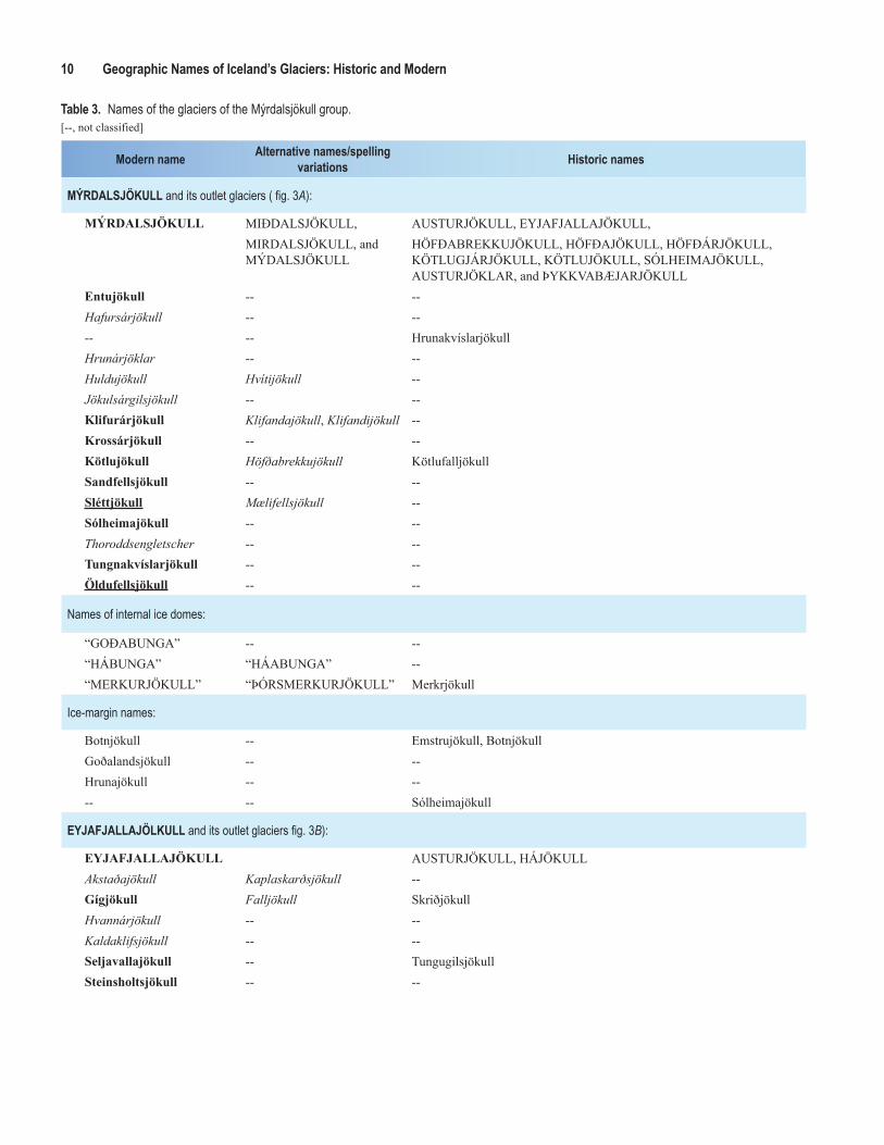
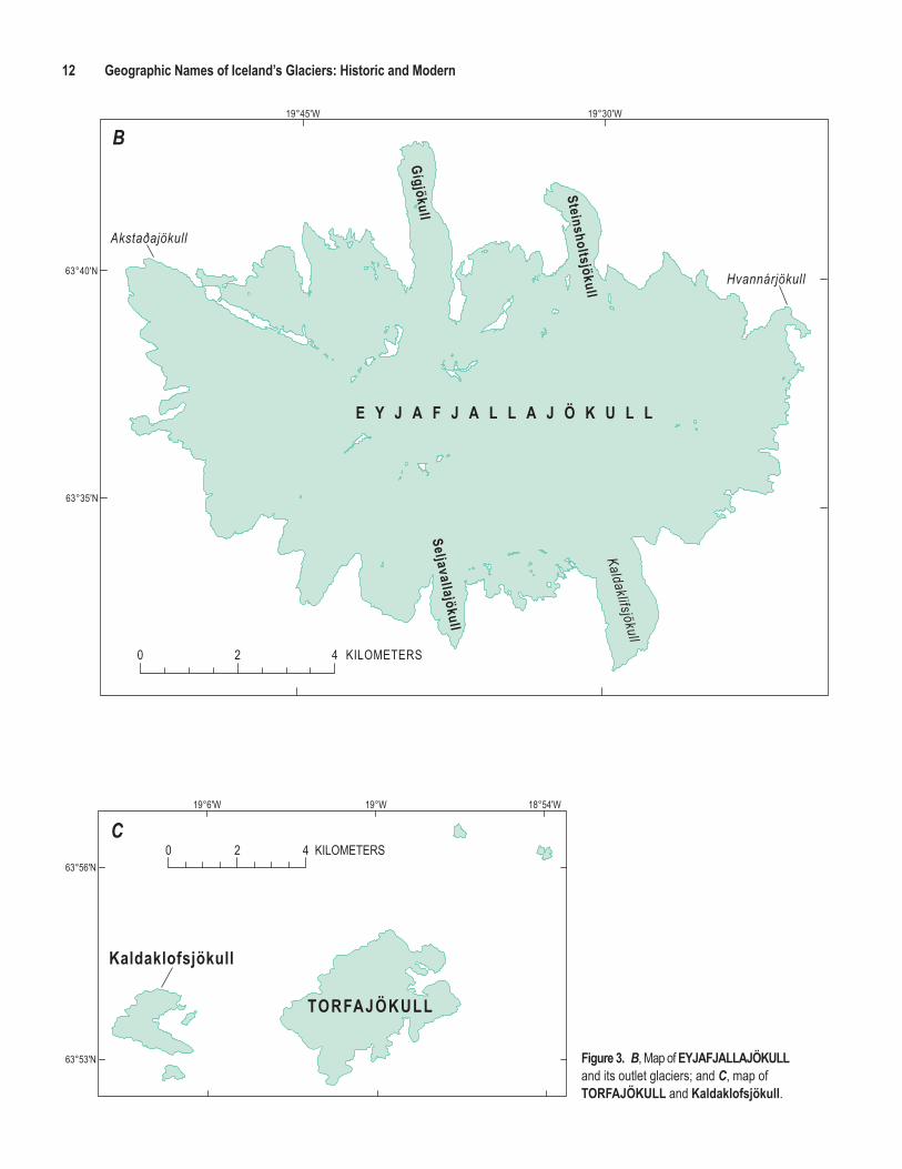
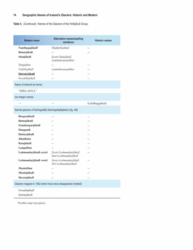
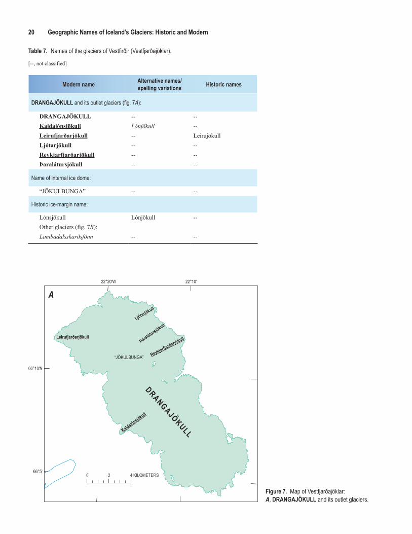
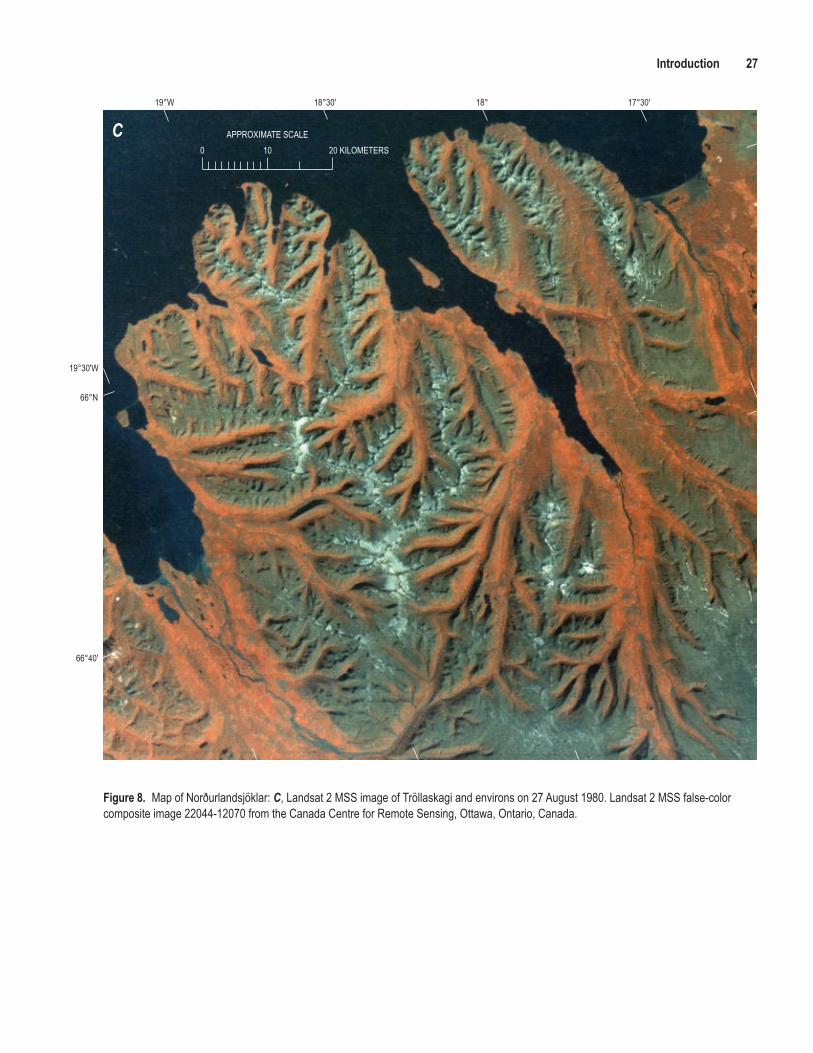