geographia polonica vol. 91 no. 2 (2018), physico ... · ska11 • ewa malinowska3 • piotr migo...
TRANSCRIPT

Geographia Polonica2018, Volume 91, Issue 2, pp. 143-170https://doi.org/10.7163/GPol.0115
INSTITUTE OF GEOGRAPHY AND SPATIAL ORGANIZATIONPOLISH ACADEMY OF SCIENCES
www.igipz.pan.pl
www.geographiapolonica.pl
PHYSICO-GEOGRAPHICAL MESOREGIONS OF POLAND: VERIFICATION AND ADJUSTMENT OF BOUNDARIES ON THE BASIS OF CONTEMPORARY SPATIAL DATA
Jerzy Solon1 • Jan Borzyszkowski2 • Małgorzata Bidłasik2 • Andrzej Richling34 • Krzysztof Badora5 • Jarosław Balon6 • Teresa Brzezińska--Wójcik7 • Łukasz Chabudziński7 • Radosław Dobrowolski7 • Izabela Grzegorczyk2 • Miłosz Jodłowski6 • Mariusz Kistowski8 • Rafał Kot9 • Paweł Krąż6 • Jerzy Lechnio3 • Andrzej Macias10 • Anna Majchrow-ska11 • Ewa Malinowska3 • Piotr Migoń12 • Urszula Myga-Piątek13 • Jerzy Nita13 • Elżbieta Papińska11 • Jan Rodzik7 • Małgorzata Strzyż14 • Sławomir Terpiłowski7 • Wiesław Ziaja6
1 Institute of Geography and Spatial Organization Polish Academy of Sciences Twarda 51/55, 00-818 Warsaw: Poland Corresponding Author’s e-mail: [email protected]
2 Institute of Environmental Protection – National Research Institute Krucza 5/11d, 00-548 Warsaw: Poland
3 Faculty of Geography and Regional Studies University of Warsaw Krakowskie Przedmieście 26/28, 00-927 Warsaw: Poland
4 Faculty of Health and Social Sciences Pope John Paul II State School of Higher Education in Biała Podlaska Sidorska 95/97, 21-500 Biała Podlaska: Poland
5 Faculty of Natural Sciences and Technology Opole University Oleska 48, 45-052 Opole: Poland
6 Institute of Geography and Spatial Management Jagiellonian University Gronostajowa 7, 30-387 Kraków: Poland
7 Faculty of Earth Sciences and Spatial Management Maria Curie-Skłodowska University Kraśnicka 2 D, 20-718 Lublin: Poland
8 Institute of Geography University of Gdańsk Bażyńskiego 4, 80-309 Gdańsk: Poland
9 Faculty of Earth Sciences Nicolaus Copernicus University in Toruń Lwowska 1, 87-100 Toruń: Poland
10 Faculty of Geographical and Geological Sciences Adam Mickiewicz University Dzięgielowa 27, 61-680 Poznań: Poland
11 Faculty of Geographical Sciences University of Łódź Narutowicza 88, 90-139 Łódź: Poland
12 Institute of Geography and Regional Development Wrocław University pl. Uniwersytecki 1, 50-137 Wrocław: Poland
13 Faculty of Earth Sciences University of Silesia Będzińska 60, 41-200 Sosnowiec: Poland
14 Department of Environment Protection and Environmental Development Jan Kochanowski University in Kielce Żeromskiego 5, 25-349 Kielce: Poland
144 Jerzy Solon et al.
Geographia Polonica 2018, 91, 2, pp. 143-170
Introduction
Legal regulations introduced in 20151 intro-duced the obligation to carry out a so-called landscape audit, i.e. a periodical compre-hensive review and assessment of the state of the Polish landscape. In turn, it created the necessity to develop a commonly accepted methodology of delimitation, typology and valuation of current landscapes. This task had a direct impact on the increasing inter-est in physico-geographical regionalisation due to the proposed audit methodology. The landscapes that are distinguished should be established and described in the context of different types of geographical regional units (Solon et al. 2015). In the course of fur-ther work, it appeared that only the physico-geographical regionalisation (Kondracki & Richling 1994), which covers the entire
1 The Act of 24 April 2015 amending certain acts in relation to strengthening tools of landscape protec-tion instruments (Journal of Laws of 2015, item 774). The Act amended the Nature Protection Act of 16 April 2004 (Journal of Laws of 2016, item 2134, as amended) and the Spatial Planning and Management Act of 27 March 2003 (Journal of Laws of 2017, item 1073, as amended).
territory of Poland, is commonly accepted and sufficient for work at an overview scale (e.g. 1:500,000). However, its spatial accura-cy is definitely too low for it to be used directly for the landscape audit.
The first unpublished attempts to specify the boundaries of physico-geographical mesoregions as basic units in the above mentioned regionalisation were made in 2015-2016 in the Institute of Geography and Spatial Organisation of Polish Academy of Sciences, and then in the Institute of Envi-ronmental Protection – National Research Institute. This experience gave rise to the idea of establishing a team of specialists from dif-ferent research centres for joint verification and adjustment of the physico-geographical division of Poland.
It is worth emphasizing that more than 20 years have passed since the develop-ment of the previous comprehensive version of a regionalisation. Since then numerous new details have been obtained concerning the diversity of the components of the natu-ral environment in Poland and very powerful instruments have become available for the analysis of spatial diversity in GIS systems.
AbstractThe programme of identification, cataloguing and evaluation of Polish landscapes, part of the implementation of the European Landscape Convention, has caused an increase in interest in physico-geographical regionalisa-tion over recent years. The commonly accepted regionalisation of Poland developed by J. Kondracki (Kondracki & Richling 1994) is sufficient for work at an overview scale (e.g. 1:500,000), whereas its spatial accuracy is too low to make use of it for the purpose of Polish landscape cataloguing. The aim of this article is to present a more up-to-date and detailed division of Poland into mesoregions, adjusted to the 1:50,000 scale. In com-parison with older work, the number of mesoregions has increased from 316 to 344. In many cases, some far-reaching changes in meso- and macroregions were made. Nevertheless, in most cases the previous system of units was maintained, with more detailed adjustment of boundaries based on the latest geological and geomorphological data and the use of GIS tools for the DEM analysis. The division presented here is a crea-tively developing new work aligning the proposals of the majority of Polish researchers. At the same time, it is a regionalisation maintaining the idea of the work developed by J. Kondracki as well as his theoretical assump-tions and the criteria used to distinguish units, which makes it a logical continuation of his regional division.
Key wordsregionalisation • spatial units • boundaries of regions • Poland

145Physico-geographical mesoregions of Poland: Verification and adjustment of boundaries…
Geographia Polonica 2018, 91, 2, pp. 143-170
Moreover, over the last 15-20 years many Polish academic centres have developed dif-ferent new proposals for regional divisions of small areas performed by means of vari-ous techniques and methodologies.
The significance of the problem became apparent at a joint conference of the Cul-tural Landscape Commission of the Polish Geographical Society and the Polish Asso-ciation for Landscape Ecology held in May 2017: New Challenges to the Regionalisa-tion of Poland. The aim of this conference was to discuss the need for the verification of previous regional divisions, the presenta-tion of concepts and methodology (sources, materials, criteria) as well as the presenta-tion of specific proposals for regionalisation and solutions. An equally important aim was to indicate the current opportunities for the practical use of the regionalisation procedure and their effects on the preparation of land-scape audits (Nita et al. 2017).
The aim of this article is to present a more up-to-date and detailed division of Poland into mesoregions, adjusted to the 1:50,000 scale. The division presented is not a simple compi-lation of previously published proposals, but it is a creatively developing new work align-ing the proposals of most Polish researchers dealing with this problematic issue. At the same time, it is a regionalisation maintaining the idea and spirit of regionalisations devel-oped by J. Kondracki as well as his theoretical assumptions and the criteria he used to dis-tinguish units, which makes it a logical con-tinuation of his work.
History and evolution of the physico-geographical division of Poland developed by Professor Jerzy Kondracki
In the “Physical Geography of Poland” written by S. Lencewicz (1955), which was to a great extent a reprint of the “Great Universal Geogra-phy” (Lencewicz 1937), J. Kondracki introduced numerous additions and adjustments taking account of the changed boundaries of Poland after the Second World War. In particular,
he included a description of large geographi-cal regions (Coastal Lowlands, Pomeranian Lakeland, Masurian Lakeland, Wielkopolska-Kujawy Lowland, Masovia-Podlasie Lowland, Lublin Upland, Kielce-Sandomierz Upland, Nida Basin, Kraków-Częstochowa Upland, Silesian Upland, Silesian Basin and Trzeb-nica Hills, Sudety Mts and Sudety Foothills, Sub-Carpathian Basins, Flysch Carpathians, Tatras and Podhale), following the concepts and layout of Lencewicz’s original hand-book. At the same time, the large regional units distinguished referred to the results of the discussion taking place from 1946-1947 at conferences organised by the Pol-ish Geographical Society (Kondracki 1946a, 1946b), although they were not identical both in terms of nomenclature and the hierarchical rank of units.
The same year, J. Kondracki (1955) pub-lished an article in which he not only present-ed criteria used to distinguish regions and rules for their nomenclature, but also under-took a discussion with other authors for their views. More importantly, he presented his own original scheme for the regional subdivi-sion of Poland. He took into account 6 very large units, 16 regions and 80 subregions.
Further development of work on the regionalisation of Poland resulted in the pres-entation by Kondracki (1961) of a termino-logical scheme of hierarchical regional units and the identification of 7 physico-geograph-ical provinces (comprising 14 subprovinces) on the territory of Poland, included in 2 large areas. This division (together with the pro-posed names of the units which were mainly new) has been applied until now with no sub-stantial changes. In addition, this article listed 39 macroregions and 210 smaller units (most frequently corresponding to mesoregions within the current approach). Unfortunately, the work does not include a map illustrat-ing the boundaries of the units that were distinguished.
This division, with minimal modifications in the number of units (6 provinces, 14 sub-provinces, 39 macroregions, 212 mesore-gions) and the original letter and digit coding

146 Jerzy Solon et al.
Geographia Polonica 2018, 91, 2, pp. 143-170
system, was applied in two editions of the “Physical Geography of Poland” (Kondracki 1965a, 1967).
Further evolution of the physico-geograph-ical division of Poland resulted in the introduc-tion of a uniform digit coding of regional units (Kondracki 1965b). In the work cited, J. Kon-dracki included all the subprovinces and macroregions listed in the work from 1961, assigning them uniform decimal codes follow-ing the system put forward one year earlier by the International Geographical Union.
This stage of regionalisation was summa-rised in a work from 1968 (Kondracki 1968). It listed 364 mesoregions, a proportion of which were outside Poland. A map attached to the article (developed by J. Kondracki and J. Ostrowski) showed the boundaries of mes-oregions which became a standard for many years. This work also contributed to the stand-ardisation of names and their common use. It was also included at 1:2,000,000 scale in the National Atlas of Poland (Kondracki & Ostrowski 1973-1978).
A map with different graphics but with generally the same boundaries was includ-ed in the “Physico-Geographical Regions of Poland” (Kondracki 1977). It included 6 provinces, 18 subprovinces, 56 macrore-gions and 318 mesoregions. It differs from the previous map by the use of changed num-bering in relation to some of the mesoregions as well as by several small additions and amendments. An identical layout of regional units was also included in later editions of the “Physical Geography of Poland” (e.g. Kondrac-ki 1978, 1988).
In 1994, two important cartographic developments were published. The first one was a map entitled “Types of natural land-scape and physico-geographical units” by J. Kondracki and J. Ostrowski, constituting an appendix to the book (Kondracki 1994). In the table of contents of the map, there are 309 mesoregions, while the bounda-ries of the units differ in many places from the boundaries on the map of 1977. The differences result not only from a different
precision of drawings, but also from substan-tial changes which have been intentionally introduced.
The second map is a presentation of the physico-geographical regions in the Atlas of the Republic of Poland (Kondracki & Rich-ling 1994). It is based on the map from 1977, but the boundaries are clearly modified. The previous general drawing was just made more detailed, whereas the regions were substantially changed (based on substantive criteria). It should be noted that these chang-es differ from the modifications introduced in the map developed by J. Kondracki and J. Ostrowski in 1994.
The map from the Atlas of the Republic of Poland became a new standard and was reproduced many times, for example in the “Regional Geography of Poland” (Kondracki 1998, 2000).
Kondracki (2000) stated that the maps published in the Atlas of the Republic of Poland, together with the standardisation and official approval of the names of the regions, completed the last stage in the devel-opment of views on the physico-geographical regionalisation of Poland. Nevertheless, this statement should not be treated as an arbitrary proposal to refrain from further work on regionalisation, in particular in rela-tion to issues concerning the boundaries of the mesoregions, which mainly intervene at a more detailed spatial scale. The necessity to perform this work is also confirmed by the fact that numerous maps included in the com-pilation from 2000 (Kondracki 2000) reflect the boundaries not only at a different level of cartographic detail (in comparison with the Atlas of the Republic of Poland) but also with different substantive drawings, frequently dif-fering to a great extent from the boundaries included in all earlier versions of the map.
Selected examples of regional physico-geographical division
In parallel with later versions of Polish region-alisation developed by J. Kondracki, work

147Physico-geographical mesoregions of Poland: Verification and adjustment of boundaries…
Geographia Polonica 2018, 91, 2, pp. 143-170
on regionalisation was performed in different academic centres. Part of this simply con-cerned local issues, other work of a regional nature covered individual provinces (voivod-ships) or large morphological units. These publications, occurring at a different frequen-cy in various centres and periods of time, were sometimes polemical in relation to the solutions proposed by J. Kondracki, but they often concerned only proposals for more detailed delineation of the boundaries. Most of the works published by the mid-1980s are only of historical value, whereas later works had a clear impact on contemporary views on physico-geographical regionalisation. It is particularly clear in relation to the southern part of the country.
In Poland, physico-geographical regionali-sation of the Carpathians was generally only carried out by authors from the Kraków cen-tre, while everybody indicated the need for modification of the division made by J. Kon-dracki, in particular for areas of the former Kraków Voivodship (Czeppe & German 1979), the area of the Carpathian Foothills (German 1992), and the whole area of the Polish Car-pathians together with the Eastern Carpathi-ans (Balon et al. 1995) and the Małopolskie Voivodship (German 2001). Differences between different approaches were analysed, for example, by W. Maciejowski (2009). In the works of J. Balon and M. Jodłowski (Balon & Jodłowski 2005; Jodłowski & Balon 2005), the authors analysed existing divisions and proposed further changes in the Polish-Slovak border area. In accordance with the principle of political neutrality of physico-geographical regions (Balon 2000), some corrections were made in regional boundaries and taxonomic categories, and the modification of names was proposed; the changes were aimed at achieving greater consistency between Pol-ish regionalisation and the Slovak divisions. These works resulted, for example, in the regionalisation of the Małopolskie Voivodship (Balon et al. 2012). The above mentioned divi-sions of the Carpathians were defined at the overview scale. The attempt to analyse them at a more detailed scale revealed inaccuracies
and errors, including areas not belonging to any of the regions distinguished or of environmental features that are completely different from the characteristics of the regions to which they had been assigned. The attempt to solve several similar problems with the regionalisation of the central part of the Western Carpathians was presented in the work of J. Balon (2012). Much atten-tion was paid to the boundaries of the Tatra Mts (Balon 2001; Balon et al. 2015a, 2015b; Jodłowski 2001, 2002) and the Kraków Gate (Balon & German 2007). The cross-border regionalisation of the Western Carpathi-ans is included in the work of J. Balon and M. Jodłowski (2014).
An example of the Authors’ approach to the larger area is the physico-geographical regionalisation of the Podkarpackie Voivod-ship (Ziaja 2009), based on the scope of the higher units in the work of J. Kondracki (1998), but introducing numerous corrections at the level of mesoregions. These corrections resulted from the Authors’ own research studies and used the results of such earlier works as the work of J. Balon et al. (1995) referring to the Carpathians or the work of J. Buraczyński (1997) concerning the Roztocze macroregion and the publications of P. Wład (1996a, 1996b) discussing the former Prze-myśl Voivodship.
The issues of the physico-geographical regionalisation of border regions of the south-western Poland lowlands, mountains and uplands were explored at Opole University. The studies concerned mainly the Głubczyce Plateau (Badora 2007) and the Opole Hum-mock (Badora 2016). In the first case, it was proposed to exclude the Głubczyce Plateau from the Silesian Lowland and to include it into the Sudety Foreland. This was suggest-ed by J. Kondracki (2000), who indicated that this unit has upland features and belongs to the Sudety Foreland. Moreover, taking into account the diversity of geological structure and terrain relief, it was proposed to divide this mesoregion into a western part called the Nysa Kłodzka and Osobłoga Interfluve by L. Baraniecki (1968) and an eastern part

148 Jerzy Solon et al.
Geographia Polonica 2018, 91, 2, pp. 143-170
called the Głubczyce plateau by A. Jahn (1968). The studies of the physico-geographi-cal allocation of the Upper Cretaceous Opole Hummock resulted in two alternative solu-tions being proposed: the inclusion of this previously unclassified unit, together with the gorge section of the valley of the Oder River between Opole and Krapkowice, into the Sile-sian Upland or its separation within the Sile-sian Lowland as a new upland mesoregion (Badora 2016).
Regional divisions of the Silesian-Kraków Upland, including the divisions of administra-tive units located within its boundaries, e.g. the division of the area of what was, until 1999, the Katowice Voivodship, and then later the Silesian Voivodship, and even of units at the level of a commune, were the subject of the work of different authors, part of which was developed in the University of Silesia. They were usually proposals for detailed subdivi-sions of mesoregions and took into account features of the abiotic environment at a local level (Szaflarski 1955; Karaś-Brzozowska 1960; Czeppe 1972; Nita 2008; Dulias 2013; Myga-Piątek & Nita 2013). The creation of these subdivisions consisted in distinguish-ing physico-geographical units at the level of microregions, and even submicroregions. These detailed subdivisions revealed non-compliance with the boundaries of the mes-oregions developed by J. Kondracki. In some cases, differences concerned only the details of the work carried out and the cartographic scale at which it was performed (Szaflarski 1955; Karaś-Brzozowska 1960; Czeppe 1972; Nita 2008, 2010).
Examples of such work are included in the published proposals for the subdivision into geographical units, e.g.: the Częstochowa Upland (Czeppe 1972), the Silesian Upland (Szaflarski 1955; Karaś-Brzozowska 1960; Dulias & Hibszer 2004; Dulias 2013), Woźniki Rock Step (Nita J. & Nita M. 2014), or admin-istrative units e.g. Będzin Commune (Pulina et al. 2008). Generally, the issue of region-alisation was not the main purpose of the works cited herein, but in most cases it was a side-issue raised in addition to the main
topic of the work (e.g. the analysis of the geological structure and detailed relief). The issue of regional divisions was even more rarely raised in relation to higher hierarchical levels – macroregions (Nita 2010) or subprov-inces (Nita 2013), where the author proposed boundaries of the Polish Uplands different from the division made by J. Kondracki.
A new division into mesoregions and units of a lower rank has recently been proposed for the Silesian Upland (Nita et al. 2016). For the Silesia-Kraków Upland, the geomorphological division developed by S. Gilewska (1972, 1986), reflecting particularly well the physico-geo-graphical units, was established in literature and is frequently applied as a starting mate-rial. Nevertheless, the simultaneous appli-cation of the division at both scales causes spatial and terminological chaos.
At the beginning of the 21st century, the Silesian centre, like other centres, developed work designed to provide a greater speci-fication of the boundaries of the physico-geographical regions with the use of a Digi-tal Terrain Model (Nita 2002, 2010). The availability and accuracy of the Digital Ter-rain Model revealed the technical potential to perform a greater specification and verifi-cation of the existing divisions (Myga-Piątek & Nita 2013; Nita et al. 2016). These works also drew attention to important methodological assumptions useful in the bottom-up proce-dure applied in order to verify the boundaries of meso- and macroregions (Nita et al. 2016), as well as to the consequences and dangers of methodological errors in generalised divi-sions while moving to units of a lower rank.
The proposals for the regional subdivision of the Sudety Mts and other areas of south-western Poland were presented by P. Migoń from the Wrocław University (Migoń 2005; Migoń & Kasprzak 2015), who paid a great deal of attention within his approach to the geological and tectonic diversity of the ter-rain in particular. His proposal partially refers to other work developed in this centre which repeatedly indicated the non-compliance of the Czech and Polish regional divisions in the border zone of the Sudety Mts. At the

149Physico-geographical mesoregions of Poland: Verification and adjustment of boundaries…
Geographia Polonica 2018, 91, 2, pp. 143-170
same time, the standardisation of the region-al division and changes in the boundaries and nomenclature of mesoregions were proposed (Potocki 1994, 2000; Łach et al. 2010; Rozen-kiewicz & Łach 2012).
Thorough regionalisation studies were less frequently carried out in relation to the cen-tral part of Poland, which may result from the fuzziness and less distinct physico-geograph-ical boundaries of terrain composed of old glacial relief.
The area of the current Świętokrzyskie Province (Voivodeship), the central part of which is constituted by the Świętokrzyskie Mountains, has never been subject to any complex regionalisation study, and is con-sidering newer approaches to the diversifi-cation of the abiotic environment. Although this area was of interest to researchers from many scientific centres, most of their studies – excluding the studies conducted by R. Czar-necki (Balwirczak-Jakubowska & Czarnecki 1989; Czarnecki 2005) from the Warsaw University – were of a contributory and secondary character.
More interesting research studies only started to come into sight at the end of the 20th century, i.e. from the scientific centre in Kielce (now The Jan Kochanowski Univer-sity in Kielce, which is the successor of the pre-existing pedagogical universities in this city). They showed, among other things, the need to change the boundaries of the mes-oregion of the Świętokrzyskie Mountains (Kowalski 1993; Mityk 1993) which were asso-ciated with the concepts for distinguishing and characterising microregions (Dziedzic B. & Dziedzic P. 1990; Kowalski 1993; Strzyż 2017). The distinct field of research work was applied to utilitarian issues, in which the scholars focused mostly on landscape and typology issues, and the regionalisation approaches were only of a supportive char-acter (Mityk 1993; Strzyż 2014). In this per-spective, special attention should be drawn to the research studies of J. Mityk (1983a,b, 1993) with regard to the regional typology of the Kielce area, which includes a detailed methodology of delimiting the boundaries
of microregions. The author employed the method of delimitation of geocomplexes com-bined with multivariate analysis.
Among the work conducted at the Univer-sity of Łódź special attention should be paid to the monograph covering the 8 voivodships which existed at that time in central Poland in which the literature concerning regional divisions and geographical nomenclature of physico-geographical units was reviewed (Papińska 1993). The work of G. Bezkowska (1998) in which the spatial scope was lim-ited to 5 mesoregions of central Poland (Koło Basin, Sieradz Basin, Szczerców Basin, Kłodawa Heights and Łask Heights) was pub-lished a little later. The biggest disadvantage of this article is the lack of maps presenting descriptions of the results of the studies car-ried out by the author, although the 69 micro-regions distinguished undoubtedly contrib-uted to the change of the boundaries of the mesoregion. One year later, G. Bezkowska (1999) presented the concept of distinguish-ing a regional unit of macroregion rank, called the Łódź region by the author. She indicated its individual character and the possibility of distinguishlng its boundaries in a relatively easy way. The latest initiatives undertaken in the Łódź centre concern issues of physico-geographical microregionalisation, whose “side” effect is a proposal to change the boundaries of the mesoregion (Majchrowska & Papińska 2018).
The most important regional divisions in the eastern part of the Polish uplands together with surrounding areas were devel-oped in the 1950s in the geographical unit associated with the Maria Curie-Skłodowska University in Lublin. Different criteria were adopted in order to distinguish units and to establish their boundaries and nomencla-ture. One of the first original concepts of how to do this was the work of A. Chałubińska and T. Wilgat (1954), in which the regionalisa-tion was based on the diversity of geological structure, hypsometry, relief, hydrography, climate, soil and vegetation. Within a short time, A. Jahn (1956) had published a mor-phological division of the Lublin Upland.

150 Jerzy Solon et al.
Geographia Polonica 2018, 91, 2, pp. 143-170
The division was based on cartographic materials and field observations. Anoth-er important development was the work of H. Maruszczak (1972) published much lat-er, in which the author proposed the division of the Lublin uplands into four geomorpho-logical macroregions: Roztocze, the Pobuże Basin, the Lublin Upland and the Volhyn Upland which was then further divided into 17 mesoregions. This regionalisation in terms of nomenclature and boundaries referred to the regionalisation of A. Chałubińska and T. Wilgat (1954) and A. Jahn (1954, 1956). The division was based on two main criteria – features of the terrain relief and the geolog-ical structure. After the work of Maruszczak, there was a 20-year period of stagnation. During these years, different authors just repeated earlier proposals and used them as the basis for different thematic regionali-sations. Original new work on regionalisation dedicated to Roztocze was only published in 1995 (Buraczyński 1995). The division of Roztocze was based on features of the ter-rain relief and the geological structure. The following features of the terrain relief were of significant importance: hypsometric gra-dients and elements of the relief connected with the diversity of surface sediments and exposures of bedrocks. The following features of geological structure were crucial: the ori-gin-linked relationship of the boundaries with faults of different rank and the role of ero-sion, denudation and accumulation processes in shaping the landscape features.
At the University of Warsaw, in addition to the above mentioned work of J. Kondracki and his research partners covering the entire territory of Poland and ongoing work on their improvement, numerous theoretical and methodological works were published which set down the rules for the regionalisation and typology of spatial units of different rank writ-ten by A. Richling, R. Czarnecki, K. Ostaszew-ska and W. Lewandowski.
Research on the structure of the natural environment in the vicinity of Płock should be particularly emphasised among the regional works. One of the more important
studies is the physico-geographical region-alisation of the former Płock Voivodship at a 1:100,000 scale (Richling & Czajkowski 1988). This involved greater specification of the boundaries of the subprovinces, macro- and mesoregions, whereas the delimitation of microregions was performed with the use of a method which consisted in combining typological geocomplexes into larger units. Later, the immediate vicinity of Płock was analysed in detail in terms of regional bound-aries. A great deal of these research studies involved the verification of the mesoregion boundaries and their adjustment to detailed scales (including the 1:10,000, 1:50,000 and 1:100,000 scales) and the delimitation within the existing regional division of units of lower rank – microregions and submicroregions – with the use of inductive and deductive methods. The degree of modification of mes-oregion boundaries was mainly conditioned by the amount of detail in the input data concerning individual components which con-stitute the basis for the delimitation of the individual hierarchical levels of the regional division, but also their consistent application. Bottom-up methods of regionalisation result-ed in significant movements of the bounda-ries of individual higher (above microregion) levels of the regional division, especially when the boundaries of sub- and microregional units were consistently taken into account at higher levels of the regional division, which caused a cascading accumulation of devia-tions (Lewandowski 1985; Richling & Lech-nio 2005; Richling et al. 2012; Lechnio & Malinowska 2018; Richling et al. 2018).
The division of the former Suwałki Voivod-ship into physico-geographical microregions should also be mentioned (Richling 1985a, b). These units were distinguished without larger corrections of mesoregions according to their distinguishable parts, and this result-ed in 37 individual units. Then, these microre-gions were grouped according their typology, which resulted in the distinguishing of 9 types of microregions.
A. Richling is also the author of a detailed study of the regionalisation of the interfluve

151Physico-geographical mesoregions of Poland: Verification and adjustment of boundaries…
Geographia Polonica 2018, 91, 2, pp. 143-170
area of the Nurzec and the mid Bug (Richling 1976). Works conducted in this place served as the basis for the formulation of rules for one of the deductive methods for region-alisation. The same work presented regions of I, II and III rank in the vicinity of Suwałki. The third-level boundaries generally cor-respond to the boundaries of the mesore-gions distinguished through the combination of smaller units into larger units in a consist-ent manner.
In 2005, R. Czarnecki published a divi-sion of the eastern part of the Sandomierz Upland into microregions. This was based on a detailed exploration of the area. The boundaries of the microregions were deter-mined due to the analysis of the map present-ing the low level types of geocomplexes.
A form of summary of the work performed by the Warsaw University research centre in the field of detailed regionalisation is a plate included in the Atlas of the Republic of Poland (the Atlas of the Republic of Poland 1994, plate 53.4), which presented the microregion-alisation of the areas around Płock, Giżycko and Kielce at a 1:200,000 scale, which was developed by J. Kondracki and A. Richling, and of the area around Nowy Sącz produced by K. German and J. Kondracki.
Among work developed in Warsaw, the work of J. Borzyszkowski and M. Bidłasik (2016) from the Institute of Environmental Protection – National Research Institute should also be mentioned. These authors presented their own version of a detailed physico-geographical division of the Podkar-packie Voivodship, the eastern part of the Małopolskie Voivodship and the southern part of the Lubelskie Voivodship, i.e. an area covering 24 mesoregions within 5 macrore-gions. They based their division into microre-gions mainly on features of the terrain relief, assuming the general rule that it reflects the interior structure of a given area and all the processes producing its diversity. It should be mentioned that the proposed division differs in many ways from the proposal of W. Ziaja (2009), although they are both based on the regionalisation of J. Kondracki.
Studies on the regional division of the western Poland had been carried out at the Adam Mickiewicz University in Poznań since the 1930s. Among these older studies, spe-cial attention should be drawn to the article by S. Pawłowski (1931), who saw the need for the regional division of the country and carried out the division of Wielkopolska into regions on the basis of geomorphological cri-teria. These works were continued after the Second World War and resulted in the sub-division of the Wielkopolska-Kujawy Lowland into regions and subregions according to the geomorphological criterion (origin-related types of terrain relief) performed by B. Kry-gowski (1961). Moreover, A. Marsz (1966a, b, c) published the methodological assumptions used to distinguish regional physico-geo-graphical units and performed the physico-geographical division of Wolin Island. Several years later, T. Bartkowski (1968a, b) published the division of the Wielkopolska Lowland into orographic units and the division of north-eastern Poland into physico-geographical regions. Two years later, he published another regionalisation of Wielkopolska and the Mid-dle Odra area on the basis of a comprehen-sive approach (Bartkowski 1970a). He took the following features as criteria for the division into physico-geographical regions: geological structure, terrain relief, (genesis and morphometry), water relations, climate, soil and vegetation. In comparison with the division of B. Krygowski (1961), he adopted a greater degree of generalisation. A similar approach was applied by L. Kozacki (1970), who divided the northern part of the Konin district into microregions for the purpose of the assessment of changes in the natural environment, while in the microregionalisa-tion of this area he applied the following cri-teria: geological structure, morphometry, sur-face and ground water, soil, local climate and land cover. The same set of criteria were used by S. Żynda (1978) in his division of the Mid-dle Odra area into the physico-geographical units. It should be also mentioned that T. Bar-tkowski (1970b) called for the division of the country into microregions, discussing also

152 Jerzy Solon et al.
Geographia Polonica 2018, 91, 2, pp. 143-170
the methodology of this division. A slightly dif-ferent methodology of distinguishing microre-gions was proposed by L. Kozacki, A. Marsz and S. Żynda (1970) in which terrain mor-phometry and dominant land use type were adopted as the basis for selection. Using a dif-ferent methodology, T. Bartkowski and T. Tom-kiewicz (1975) carried out the division of the Leszno – Sława Śląska area into microregions. They carried out an analysis of microregion-alisation, although based on slightly different criteria, which indirectly indicated the need to change the mesoregion boundaries. Fol-lowing the heyday of work on regionalisation, there was a break in the Poznań centre which lasted until the first decade of the 21st cen-tury. In 2013, D. Łowicki and A. Mizgajski published an article in which they called for the typology of physico-geographical regions and the verification of the mesoregion bound-aries as identified by J. Kondracki on the basis of the structure of the land cover and the changes that had occurred. They stated that mesoregions distinguished on the basis of criteria applied by J. Kondracki do not fully reflect the structure of the land cover. They assessed that the land cover may be one of the representative features in regional studies. In connection with the landscape audit prepared in the Poznań centre over the most recent period, the team composed of: A. Macias, S. Bródka and W. Piniarski from the Department of the Landscape Ecology at the Adam Mickiewicz University developed a completely new and original subdivision of Wielkopolska into microregions by apply-ing an inductive (bottom-up) approach, i.e. starting from uniform physico-geographical units, through microregions, and ending with mesoregions. The starting point was a digital database of individual components of the natural environment and the criteria: geologi-cal structure, origin-related types of terrain relief, downslopes, the first groundwater lev-el, origin-related types of soil, land cover and potential vegetation habitats.
The area of the contemporary Kujawsko--Pomorskie Voivodship (or at least signifi-cant sections of it) was subject to different
physico-geographical regionalisations per-formed by authors from various centres. These works were carried out with the use of different methods and at different scales. Apart from the work of J. Kondracki which covered the entire territory of Poland, the work of R. Galon (1931, 1934, 1947, 1973, 1984), B. Krygowski (1956, 1961), A. Krażew-ska (1963), T. Bartkowski (1970a), J. Szczep-kowski (1977), T. Gacki and J. Szukalski (1982), R. Dysarz (1996) and the recent work of T. Giętkowski (2008) deserve special atten-tion. Over the past twenty years, the issues of the regionalisation of this area were main-ly dealt with at the Nicolaus Copernicus Uni-versity in Toruń. The work of L. Andrzejewski and R. Kot (2006) classified different subdivi-sions into regions of similar rank in the vicin-ity of Toruń, which reflected the difficulties in determining boundaries and the ambigu-ity of the subdivision into regions, even in the case of the application of the same (at least formal) criteria. The methodological aspects and examples of the verification of the bound-aries of valley lowland areas were presented by R. Kot (2008, 2009). New proposals for the regional boundaries for selected areas of the last glaciation of the Polish Lowlands were shown through examples in the Iława Lake-land, the Masurian Lakeland and the Wiel-kopolska-Kujawy Lakeland (Kot 2011). The regionalisation work was intensified thanks to the preparation of the Internet Atlas of the Kujawsko-Pomorskie Province (Internetowy Atlas Województwa Kujawsko-Pomorskiego – IAWKP). For the purpose of the IAWKP, the typological and regional classification was carried out for the voivodship at the general and overview scale. The assumptions adopt-ed and procedures were based on the meth-odology and the previous division made by J. Kondracki (1998) and thematic maps pre-pared for the purposes of the IAWKP at simi-lar scales enabled the preparation of digi-tal maps of physico-geographical regions at the 1:1,000,000 and 1:500,000 scales (Kot 2015a, b, c). The maps that were developed were also published in printed form (Kot 2015d, e, f). The methodology

153Physico-geographical mesoregions of Poland: Verification and adjustment of boundaries…
Geographia Polonica 2018, 91, 2, pp. 143-170
of the physico-geographical classification of the entire Kujawsko-Pomorskie Voivodship was discussed in detail in the work of R. Kot (2016). In physico-geographical regionalisa-tions, the criteria for distinguishing the phys-ico-geographical macroregions included the genesis of the terrain relief and the geologi-cal structure taken into account in subprov-inces (Kot 2015a, 2016). Physico-geographical mesoregions were distinguished on the basis of the recognised detailed genesis of the ter-rain relief and lithology (lakeland, outwash plains, covered with forests), as well as mor-phometric traits (valley, plain) or the land-scape structure (Kot 2016). A separate work (Kot 2017a) was dedicated to the characteris-tics of 25 physico-geographical mesoregions distinguished within the Kujawsko-Pomorskie Voivodship. The most recent projects at the Nicolaus Copernicus University in Toruń were focused on the regionalisation of river valleys and ice marginal valleys (Urstromtäler), con-ducted at very detailed scales (Kot 2017b). As a result, a new mesoregion was distin-guished within the framework of the frag-ment of the Toruń-Eberswalde Ice Marginal Valley (Kot 2017b).
In addition to different versions of the most famous physico-geographical regionalisation using the decimal system developed by J. Kon-dracki, the entire Pomerania or its smaller parts has been subdivided into regions many times. In their overview article, M. Kistowski and J. Szydłowski (2018) listed 31 most impor-tant publications which present 24 regional physico-geographical divisions covering Gdańsk Pomerania, carried out in the 20th and 21st centuries. The regionalisations listed were developed by a total of 19 authors from various academic centres and in only 7 cases concerned the division of the entire terri-tory of Poland (in different national borders), whereas the other work covered different parts of Pomerania. A significant part of the older work was carried out by B. Augustowski (1969, 1977, 1979), T. Gacki and J. Szukalski (Gacki & Szukalski 1979, 1982), and M. Prze-woźniak (1985, 1993) and researchers in the Gdańsk geographical centre cooperating
with them, initially at the Pedagogical Univer-sity, and then at the University of Gdańsk.
Despite a significant number of pieces of regionalisation work, the only comprehen-sive regional division of Pomerania (devel-oped to the level of a physico-geographical mesoregion) was made by B. Augustowski (1977). The area of the Gdańsk Voivodship using the 1975-98 boundaries constitutes the largest continuous part of Pomerania for which regionalisation was developed to the microregion level (Przewoźniak 1985). Oth-er work covering smaller parts of the area focused on the coastal and lakeland regions, most representative of Pomerania.
At the Gdańsk centre, the most dynamic development of the work on regionalisation took place between 1965 and 1985. The period from the beginning of the 1990s until the present was characterised by stagnation; individual investigations copied earlier work or made only small corrections to boundaries. Only the work of M. Przewoźniak (1993) cov-ering 5 seaside voivodships and the 7 voivod-ships adjacent to them deserves to be remem-bered from this period. In order to distinguish macroregions and mesoregions, the Author used a relatively broad set of criteria which included features of the relief and land cover as well as the lithology of surface sediments and origin-related types of soil. Another pub-lication from this period is the work on the Starogard Lakeland (Rolka 1996), which used microregions previously distinguished by oth-er authors. However, the units resulting from this classification raise some questions due to the lack of a list of delimitation criteria.
Since 2013, there has been a renewed interest in regionalisation issues at the Univer-sity of Gdańsk, which is reflected in the work of a methodological character carried out by J. Szydłowski (2013) (Kistowski & Szydłowski 2014). The purpose of these research studies was to develop and test the inductive method of physico-geographical regionalisation with the use of GIS software. New boundaries of meso- and microregions were proposed on the basis of the analysis of geocomplex-es distinguished in five research fields with

154 Jerzy Solon et al.
Geographia Polonica 2018, 91, 2, pp. 143-170
an area of 25 km x 25 km in which five crite-ria were applied: terrain relief (downslopes), lithology of surface sediments, depth of the first groundwater level, origin-related types of soil and land cover. The studies confirmed the usefulness of the GIS software for the pur-poses of the regionalisation, although at the same time the inductive method proved to be very laborious at the level of work detail that can be anticipated when working at a scale of approximately 1:50,000.
The previous proposals for the regional division of Pomerania, carried out in different periods and on the basis of similar but not identical criteria, produced clearly different boundaries, even in the case of mesoregions which appear to have a clear identity. This for example applies to the Kashubian Lakeland. Therefore, this area was chosen for a detailed analysis by M. Kistowski and J. Szydłowski (2015). Both the delimitation of the region and the division into microregions were per-formed by the inductive method on the basis of the analysis of the terrain relief (processing of the Digital Terrain Model into hypsometry, downslopes and a topographic wetness index) as well as the lithology of surface sediments supplemented by information about the water network (Kistowski 2018). Nevertheless, the works also used results from previous analy-ses involving the inductive approach.
The common feature of studies carried out over recent years at the University of Gdańsk, in a similar manner to studies on Pomerania carried out in other centres, is the applica-tion of GIS software during the delimitation of regions or at least in order to visualise and analyse the units distinguished. The work of T. Giętkowski (2008), for example, con-cerned the boundaries of the Tuchola Forest mesoregions, and resulted in the identifica-tion – against the background of previously performed regionalisation – of the original boundaries on the basis of the analysis of the terrain relief (processing of the Digital Ter-rain Model into maps of downslopes, slope exposure, denivelation), lithology of surface sediments and elements of the water network and land cover.
In Western Pomerania, at the Szczecin centre (West Pomeranian University of Tech-nology), the physico-geographical region-alisation did not constitute an important direction of studies. Over recent years, it was emphasised that – at least on young glacial areas – the contemporary landscape matrix (expressed in categories of land cover) may be a useful criterion for the verification of the boundaries of physico-geographical units of different rank. At the same time, it was particularly indicated that the clear change of the landscape matrix within the mesore-gion may suggest the purposefulness of anal-yses, confirming the correctness of bounda-ries or indicating the possible necessity of correcting their selected parts (Pieńkowski & Podlasiński 2017).
The above review shows that, after many years of stagnation, there has been a renewed interest in the issues of regionali-sation in recent years in most geographical centres in Poland. Numerous studies have been carried out at the regional level, discus-sion took place on the theory and methodol-ogy of regionalisation and a team of special-ists was formed. Their experience enabled this work to be carried out.
New regionalisation: Approaches and Data
According to J. Kondracki (1977), the follow-ing factors play a crucial role in distinguish-ing macroregions: geographical location, character and origin of the terrain relief and lithological diversity. He adopted the same criteria – but at a more detailed level – to dis-tinguish mesoregions. This set of criteria, basi-cally acceptable for determining boundaries at overview scales (1:300,000 – 1:500,000) is too general and ambiguous when it comes to delimitation of mesoregions at a detailed scale (e.g. 1:50,000). It results in the occur-rence of significantly different interpretations concerning the boundaries. The differing results of the regionalisation may be con-nected to the attaching of great importance to individual geomorphological features

155Physico-geographical mesoregions of Poland: Verification and adjustment of boundaries…
Geographia Polonica 2018, 91, 2, pp. 143-170
(morphological, morphometric, morphoge-netic, morphochronological) and lithologi-cal features (mainly stratigraphic, but also mineralogical and petrographic). They may be also connected with the necessity, intui-tively accepted by researchers, of dealing with these features in a different way in rela-tion to mountain, upland and lowland regions.
In order to minimise the possibility of diverging interpretations within a multi-person team performing the study, several additional conventions and assumptions were arbitrarily adopted. First of all, it was gener-ally agreed in accordance with works of Prof. J. Kondracki that the distinguishing of a given area as a mesoregion is determined mainly by the morphogenetic – geomorphological and geological – tectonic features in its sur-face layers (to a depth of 10-20 metres, rarely deeper), which is reflected in the relief of the ground surface and significantly influences the functioning of the area. In order for spa-tial units to be distinguished as mesoregions, they must be characterised by a compact-ness of geometry and similarity of morpho-logical and morphometric features in their individual parts (including also the repeat-ability of their landforms and their origin background).
In the case of those areas with the high-est geomorphological-geological diver-sity and largest collection of co-occurring endo- and exogenetic effects, i.e. in the case of uplands and mountains, as the key aspect of physico-geographical regionalisation, the boundaries of those landforms connected with fold and fault tectonics producing struc-tural relief were accepted. The studies took into account those boundaries which have an impact on the current structure and func-tioning of the landscape and which occur on the surface or at a sufficiently shallow depth to have this impact. Furthermore, the morphogenetic diversity connected with exo-origin was assessed which to a great extent is responsible for the contemporary character of the relief. Finally, the diversity of morpho-metric and morphological features, includ-ing mountain ridges, denivelation, and land
slopes, was taken into account. Stratigraphy considers stratigraphic features, in the origin-related context, as additionally connected with morphogenesis and morphochronology and lithographic features were treated in this context.
In lowland areas two environmental fea-tures: the geological structure and terrain relief, were the main criteria of the division. In relation to the geological structure, the leading feature was the lithology (composi-tion) of surface sediments. In relation to ter-rain relief, the leading feature was provided by downslopes resulting from the spatial distribution of altitude expressed on a hypso-metric map. At the same time, the studies took into account the character of the mosaic of the following landforms: concave features such as valleys, ribbon and basin landforms (frequently filled with lake water or directly drained by streams) and convex features which include accumulative landforms of dif-ferent origin (e.g. glacial, aeolian and denuda-tional). The above characteristics were simul-taneously related to the morphogenesis and morphochronology of terrain. In some cases, where there were no significant morphoge-netic differences, supplementary data which concerned the distribution of surface waters, the depth of the first groundwater level and types of soil were used for the delimitation of mesoregions.
The regional diversity of the extension of the last glaciation in Poland was also considered to be crucial since it influenced the changeability of the relief and the qual-ity of bedrock and because these allow for inclusion of morphogenetic and morpho-chronological criteria. It was assumed that in the case of the occurrence of many stages of extension of the last glaciations in close proximity, the region may be characterised by the presence of forms typical of marginal zones of different extents of the glaciation (e.g. in north-eastern Poland), contrary to the western part of the country where there was significant advance of the glaciated areas.
In the case of river valleys, the upper edge of the valleys was used – by convention

156 Jerzy Solon et al.
Geographia Polonica 2018, 91, 2, pp. 143-170
– to determine the boundaries, although with-out taking into account side valleys cut into the edge area.
In the case of proposals for the division of a large mesoregion into smaller parts, the internal diversity of the newly distinguished units was analysed and compared with the diversity between mesoregions with similar geomorphological features.
Despite adopting more precise criteria for determining the boundaries between mes-oregions, the researchers encountered cases causing a lot of difficulties in interpretation. This was not only a result of the quality of the available materials, but also from the occur-rence of wide transition zones between well distinguished areas and a lack of compat-ibility between the changeability of the lithol-ogy, genesis and vertical layout of the terrain. In such cases, the variation in the relief and the character of soil dominant on the surface were the criteria most frequently used in deci-sion making.
All persons and teams working on the regionalisation used the following basic materials: (a) 1:50,000 topographic map of Poland (Head Office of Geodesy and Car-tography), (b) 1:10,000 map of the hydro-graphic division of Poland (Institute of Mete-orology and Water Management), (c) Digital Terrain Model (Head Office of Geodesy and Cartography) produced on the basis of data from the ISOK (IT system of the Country’s Protection Against Extreme Harazds) Project which had a value of average altitude error not exceeding 0.2 m in the ARC/INFO ASCII GRID format. If there was no digital model of the terrain relief of the above parameters, the studies used data from the LPIS Project with a value of average altitude error fall-ing between 0.2 – 2.0 m in the ESRI TIN format, (d) 1:50,000 Detailed Geological Map of Poland (Polish Geological Institute – National Research Institute), (e) 1:50,000 Lithogenetic Map of Poland (Polish Geological Institute – National Research Institute).
In addition to the general set of materials, all researchers used cartographic materials and descriptive geological, geomorphological
and soil materials referring to individual regions and carried out at different scales, numerous detailed geomorphological publi-cations (including works concerning the more accurate description of the boundaries of the individual stages of glaciation and the identi-fication of the character and genesis of geo-morphological landforms), as well as the results of microregionalisation work previ-ously carried out, largely unpublished, which belonged to individual authors and centres.
New regionalisation: Results
The final version of the proposed modifica-tion of the physico-geographical mesoregions of Poland is shown on a separate map, insert-ed into the paper2.
All the changes introduced in the division of Poland into physico-geographical mesore-gions can be grouped in five categories: (a) the division of a mesoregion into two or more new mesoregions; (b) distinguishing a new mesoregion at the border of two previously existing mesoregions; (c) combination of mes-oregions into a new one; (d) a clear change of the mesoregion area; (e) more precise delineation of the mesoregion’s boundaries without a significant change in its area.
A good example of division into two or more new mesoregions is the Poznań Lakeland (315.51), which currently is treated as three mesoregions: the Poznań Lakeland (315.51) in a narrow sense, the Nowy Tomyśl Plain (315.50) and the Grodzisk Heights (315.59) (Fig. 1A). The division into three sec-tions results from clear geomorphological differences. The northern part (Poznań Lake-land in a narrow sense) is of typical lakeland character, whereas the western part (Nowy Tomyśl Plain) is a distinctive outwash plain. The south-eastern part (Grodzisk Heights) is, on the other hand, devoid of lakes.
The regionalisation presented is char-acterised by the consistent marking of nar-rower sections of gorge (gap) character
2 Digital version of the map in ESRI shp format is available on the Geographia Polonica home page.

157Physico-geographical mesoregions of Poland: Verification and adjustment of boundaries…
Geographia Polonica 2018, 91, 2, pp. 143-170
and wider sections of basin character in the largest Polish river valleys. According to this scheme, a new mesoregion (315.37), the Nieszawa Gap of the Vistula River, was dis-tinguished in the Vistula River valley at the border between two previously distinguished mesoregions (Fig. 1B). Similarly a new gorge section, the Racibórz Gate (318.50), was pro-posed in the Odra valley.
One of the changes introduced concerns the combination of two functioning and neighbouring mesoregions into one mesore-gion. Such a situation occurred in the case of the Kodeń Plain (845.12) and the Parczew Plain (845.13). It was proposed to form one mesoregion – the Parczew-Kodeń Heights (845.12), of the two combined and slightly increased by parts of neighbouring regions: the Łomazy Depression (845.11) and the
Sosnowica Depression (845.14). They were combined on the basis of the results of new research confirming the uniform character of the entire area (Fig. 1C).
Moreover, a portion of the mesoregion changes resulted from significant inclusions or exclusions of parts of areas from neigh-bouring regions. The change in the extent of the following mesoregions in the Lublin region may serve as an example: the Kałuszyn Heights (318.92) and the Węgrów Depression (318.93). On the basis of results of recent geo-morphological studies, it was proposed to sig-nificantly increase the area of the Kałuszyn Heights, whereas the neighbouring Węgrów Depression region was significantly narrowed (Fig. 1D).
In the case of most of the mesoregions, previously distinguished by J. Kondracki, the
Figure 1 Main categories of mesoregion change: A) division of an existing mesoregion into three new ones; B) a new mesoregion at the border of two previously existing mesoregions; C) com-bining two mesoregions into one with modified characteristics; D) significant changes in mes-oregion extent; E) more accurate adjustment of boundaries based on detailed knowledge on the extents of morphogenetic units.

158 Jerzy Solon et al.
Geographia Polonica 2018, 91, 2, pp. 143-170
boundaries were moved to a lesser extent, which resulted from these regions being more accurately determined at a 1:50,000 scale. This is connected with the adjustment of regions’ boundaries to take account of the more detailed extents of morphogenetic units, generally at their erosive borders (slope upper edge) in the case of river valleys and fluvioglacial forms and at their structural – denudational borders in the case of the extents of upland and mountain areas. The extent of the Płońsk Heights (318.61), whose approximate boundaries seen in the region-alisation of J. Kondracki were made more specific at 1:50,000 scale (Fig. 1E), was pre-sented as an example.
The largest changes in the sizes and shapes of mesoregions were made in the fol-lowing areas (Fig. 2):• the area of the Kłodzko Basin, where
the creation of the Upper Nysa Graben (332.55) mesoregion was proposed, which is clearly distinguishable from the remain-ing part of the Kłodzko Basin mesoregion. The Upper Nysa Graben is a latitudinal
furrow with clear boundaries to the east and the west, with tectonic thresholds of up to 500 metres. The new Kłodzko Basin mesoregion is a compact depres-sion at the confluence of four rivers: the Nysa Kłodzka, the Ścinawka, the Bystrzyca Dusznicka and the Biała Lądecka, with unclear borders with neighbouring moun-tain ranges, even with bottom and qua-ternary sediments. Moreover, significant changes were proposed in the region of the Orlickie Mountains, the Bystrzyckie Mountains and the Stołowe Mountains as a result of attaching a significant part of the existing Orlickie Foothills mesore-gion to these regions.
• the area connected with the upper section of the Odra River, concerning the follow-ing existing mesoregions: the Racibórz Basin (318.59), the Wrocław Ice Marginal Valley (318.52), the Głubczyce Plateau (318.58), the Rybnik Plateau (341.15), the Opole Plain (318.57) and the Niemodlin Plain (318.55). It is proposed to introduce spatial changes in the region of the above
Figure 2 Areas which changed allocation to mesoregions (comparison of the actual proposal with the version of Kondracki 2000)

159Physico-geographical mesoregions of Poland: Verification and adjustment of boundaries…
Geographia Polonica 2018, 91, 2, pp. 143-170
mentioned mesoregions which take into account the fact that they belong to geo-morphological units of higher rank, as well as the structure of their bedrock and their relief development. It is proposed to com-bine part of the Wrocław Ice Marginal Valley with the neighbouring Opole Hum-mock and to include this hummock in the Opole Plain. Moreover, it is proposed to divide the Opole Plain into the western part under the same name and the east-ern part under the name of Upper Mała Panew Depression (341.28). It is also pro-posed to move the western boundaries of the Opole Plain to the Stobrawa valley.
• the area connected to the Bydgoszcz – Płock section of the Vistula Valley, the Noteć River in the region of Nakło and the area of Kujawy, where it was proposed to introduce significant changes in the extents of individual mesoregions, as well as the creation of a new mesoregion of the Nieszawa Gap of the Vistula River (315.37). It is a clearly distinguishable section of the valley between the Toruń Basin and the Płock Basin. The changed geometry of the Kuyavian mesoregions is justified by spa-tial geomorphological systems. Numerous changes in the extents of the: Chełmno Lakeland, Brodnica Lakeland and Dobrzyń Lakeland mesoregions are connected with detailed data on the structure and genesis of the bedrock in these regions.
• the area of the western part of the Sile-sian-Kraków Upland, where significant changes were proposed in the areas of many mesoregions, especially in the area of the Katowice Upland, the Racibórz Gate and the Tarnowskie Góry Hummock. Changes of the geological structure, frequently resulting in changes of the relief, were used as the main criteria for the modifications.
• the area of the Western Carpathians, where new mesoregions were created. Their relief differs from the relief in other existing areas, for example in the Żywiec Beskid Mts, in the Tatra and sub-Tatra regions, and in the Sącz Beskid Mts.
• areas of existing large mesoregions: the Poznań Lakeland (315.51), the Olsztyn Lakeland (842.81) and the Iława Lakeland (314.90) as well as the Krajna Lakeland (314.69). In the case of the first 3 regions, it was proposed to divide each of them into 3 new mesoregions, and the Krajna Lakeland into 2 mesoregions. Other changes in the mesoregions are
local and concern one or two neighbouring regions, for example in the valley of the Pilica river, the Kozienice Plain, the Jasło-Krosno Basin, the valley of the mid Bug, and the coastal zone of the Baltic Sea.
In general, almost 69.5 thousand km2 (approx. 22% of the area of Poland) changed allocation to their mesoregion, and over 17 thousand km2 of this area was due to the establishment of quite new mesoregions (Fig. 2).
The verification resulted in an increase in the number of mesoregions from 316 to 344 and in changes in the spatial and geometric characteristics of mesoregions (Tab. 1, Fig. 3). The average area of a mesore-gion decreased from 986.9 km2 to 907.5 km2. In the case of almost 16% of mesoregions their area decreased by more than 25%. Small changes (in the range from -5 to 5%) occurred in the case of approx. 20% of the total num-ber of mesoregions, while an increase in area greater than 25% occurred in almost 18% of mesoregions.
Changes in the area of mesoregions resulted in the displacement of the cen-troids of the regions. The average shift was 4362 m with a minimum of 54 m and maxi-mal value of 31,680 m. Generally changes were rather small: for 10% of mesoregions – less than 1 km, while for 40% shifts were in the range of 1-3 km. It is worth underlin-ing that large displacements, above 10 km, occurred in only 9% of mesoregions. Those changes were mainly due to division of big mesoregions into smaller ones.
As a result of the more precise delinea-tion of the boundaries of the mesoregions the values of indicators of boundary complexity clearly increased. The Mean Shape Index

160 Jerzy Solon et al.
Geographia Polonica 2018, 91, 2, pp. 143-170
increased from 1.641 to 1.980, Mean Frac-tal Dimension from 1.17 to 1.19, and Mean Perimeter/Area Ratio from 2.68 to 3.50. But those changes were not unidirectional. For some mesoregions complexity decreased (14% of mesoregions according to Shape Index, and 21% according to the Perimeter/Area Ratio). The greatest (more than 30% of previous values) increase in boundary
complexity occurred in the case of 29% of mesoregions (according to SI changes) and 35% (according to PAR values).
Final remarks
The division into mesoregions, shown in this article, is not a simple compilation of the pre-viously published suggestions, but it forms
Table 1. Main changes of mesoregions’ geometric properties
Variable Present study Kondracki (2000)
Number of mesoregions 344 316Mesoregion Area – mean (ha) 90,750 98,687Mesoregion Area – min (ha) 605 1,523Mesoregion Area – max (ha) 377,854 431,834Shape Index – mean 1.980 1.641Shape Index – min 1.234 1.071Shape Index – max 10.004 4.566Perimeter/Area Ratio – mean 3.50 2.68Perimeter/Area Ratio – min 1.00 0.60Perimeter/Area Ratio – max 34.80 23.20Fractal Dimension – mean 1.19 1.17Fractal Dimension – min 1.14 1.12Fractal Dimension – max 1.37 1.30
0
5
10
15
20
25
0-1 1-2 2-3 3-4 4-5 5-10 10-32
Shar
e (%
)
Centroid displacement (km)
B
0
5
10
15
20
25
< -50 -50 - (-25) -25 - (-5) -5 - 5 5 - 25 25 - 50 > 50
Shar
e (%
)
Area changes (%)
0
5
10
15
20
25
< -10 -10 - 0 0 - 10 10 - 20 20 - 30 30 - 40 >40
Shar
e (%
)
Shape Index changes (%)
0
5
10
15
20
25
< -10 -10 - 0 0 - 10 10 - 20 20 - 30 30 - 40 >40
Shar
e (%
)
Perimeter/Area Ratio changes (%)
A
C D
Figure 3 Values of the chosen indicators characterising the spatial pattern of the mesoregions

161Physico-geographical mesoregions of Poland: Verification and adjustment of boundaries…
Geographia Polonica 2018, 91, 2, pp. 143-170
a piece of work, which can be characterised as new, creatively developing, and reconciling the proposals of the majority of national spe-cialists dealing with such subject matters. Yet, it is not an entirely closed piece of research, but only work that illustrates the improve-ment of knowledge in the sphere of the environment and the development of views in a specific period of time. Issues that will require further detailed work in the future were identified during the completion of the work. Among such issues, special attention must be paid to the problem of the identifica-tion and appropriate description of cross-bor-der regional units, which cover a very small area in Poland, and whose area is also situ-ated on the other side of borders. Initially, one should indicate the area of the San-Dniester Plateau, which covers about 88 km² in Poland but extends much further in Ukraine, cover-ing hundreds of square kilometres there. Some of the regions on the border between Poland and Slovakia as well as Poland and Czechia also require additional agreements.
Yet another issue requiring further analy-sis in the future relates to the regionalisation of transition zones between the Polish low-lands, uplands and mountains. These studies cause many significant problems in their inter-pretation. The key issue is the interpretation of extent of occurrence of ridges and depres-sions between ridges. In the southern part of the uplands, they are distinct due to clear tectonics and a relatively low influence of gla-cial, fluvioglacial and fluvial processes slightly changing older relief. In the north-eastern part of the uplands, the structural relief has been radically transformed due to the ice sheets of the old glaciations. Glacial sedi-ments have covered depressions between ridges and partly built up the outcrops of the formations creating them. The river network was deformed, conditioned by the structural relief, which in the past used depressions between ridges to discharge water. In some sections, the upper reaches of river valleys do not use former depressions but cross them along gorges. The necessity of defining this section of the boundary between the uplands
and lowlands along ridges with Triassic and Jurassic outcrops is not controversial, but the detailed delineation still should be subject to further studies.
Moreover, efforts to correct J. Kondracki’s regionalisation carried out by representatives of different centres from southern and central Poland revealed numerous, sometimes diver-gent views on the boundaries of physico-geo-graphical units. It resulted, to a great extent, from the research traditions of a given cen-tre (e.g. the traditions of the Kraków, Silesian or Łódź centres). Most researchers used the same basic criteria for distinguishing a given unit, but the results of boundary determina-tion were initially different. It resulted from different approaches to the importance and rank of individual criteria, as well as the change of their primacy and relative weight in different parts of the area in question. One example of such a situation was the adop-tion of overriding structural-tectonic criteria in the determination of physico-geographical unit boundaries in the southern part of the Kraków-Częstochowa Upland, but with the use of geomorphological (quaternary) crite-ria in the central and northern parts of this Upland. A final clarification and meshing together of different opinions gave the joint proposal for regionalisation for this area, but it is still open to some questions dealing with “objectivity” and the “weight” of quali-tative and quantitative differences between adjacent regions, as well as the width of the boundaries between them.
Similar, although not the same problems arose in the regionalisation of middle and northern Poland, on the transition zones between areas subjected to the influence of different phases of glaciation. The good example is the boundary between the Siedlce Heights (hummocky upland moraine) and the Łuków Plain (outwash plain) – one of areas that is problematic due to small downslopes. On the basis of the latest detailed geologi-cal and geomorphological research, it was proposed to define its boundaries along the southernmost consistent marginal forms of the final or retreat stop of the ice sheet

162 Jerzy Solon et al.
Geographia Polonica 2018, 91, 2, pp. 143-170
of the Warta glaciation. Following this pro-posal and in relation to the idea of J. Kon-dracki, the Siedlce Upland may be defined as a mesoregion generally formed as a result of the disappearance of the ice sheet, and the Łuków Plain as a mesoregion formed mainly as a result of the outflow of snowmelt water.
The version of the regionalisation pre-sented here has made progress in our under-standing of differentiation in the natural environment in comparison with previous versions, and has simultaneously opened the field for new rounds of methodical discussions on more sophisticated and multidimensional approaches to the distinguishing and charac-terisation of spatial units of different ranks.
Acknowledgements
The first initial versions of the verification of the mesoregion boundaries in the phys-ico-geographical division of J. Kondracki were commissioned by the General Direc-torate for Environmental Protection within the scope of the implementation of the pro-ject financed by the National Fund for Envi-ronmental Protection and Water Manage-ment, under the name: “the Implementation of tasks resulting from the provisions of the European Landscape Convention drawn up in Florence on 20 October 2000” (agree-ment no. n349/2015/Wn50/NE-WM/D of 13/08/2015). Further substantive and edi-torial work of a much wider team of authors
was carried out as a fully independent initia-tive supported only organisationally by the General Directorate for Environmental Pro-tection (which also in a small part supported the preparation of the manuscript for print).
In addition to the team of authors, the final result of the verification of mesoregion boundaries was influenced by a group of per-sons who took part in discussions on the map at different stages of its elaboration, verified the alignment of sections of the boundaries, shared their opinions and knowledge, made available the results of unpublished works or helped in solving GIS problems. In particu-lar, the following persons from the individual centres should be listed: Sylwia BRÓDKA and Witold PINIARSKI (Adam Mickiewicz Univer-sity, Faculty of Geographical and Geological Sciences), Krystyna GERMAN (Jagiellonian University, Institute of Geography and Spa-tial Management), Dominika KOWALSKA--JAMROŻEK (The Jan Kochanowski University in Kielce, Department of Environment Protec-tion and Environmental Development), Józef SUPERSON and Marek TURCZYŃSKI (Maria Curie-Skłodowska University, Faculty of Earth Sciences and Spatial Management, Lublin), Jerzy SZYDŁOWSKI (former doctoral student at the University of Gdańsk).
Editors’ note:Unless otherwise stated, the sources of tables and figures are the authors’, on the basis of their own research.
ReferencesANDRZEJEWSKI L., KOT R., 2006. O położeniu
Torunia [in:] L. Andrzejewski, P. Weckwerth, Sz. Burak (eds.), Toruń i jego okolice: monografia przyrodnicza. Toruń: Wydawnictwo Uniwersyte-tu Mikołaja Kopernika, pp. 27-34.
ATLAS RZECZYPOSPOLITEJ POLSKIEJ, 1994. Regiony fizycznogeograficzne (przykłady mikroregio-nów. Map 53.4, Warszawa: Główny Geodeta Kraju, 1993-1999.
AUGUSTOWSKI B., 1969. Środowisko geograficzne województwa gdańskiego w zarysie. Gdańsk: Wyższa Szkoła Pedagogiczna.
AUGUSTOWSKI B., 1977. Pomorze. Warszawa: Pań-stwowe Wydawnictwo Naukowe.
AUGUSTOWSKI B., (ed.), 1979. Pojezierze Kaszubskie. Gdańsk – Wrocław: Gdańskie Towarzystwo Naukowe – Ossolineum.
BADORA K., 2007. Regionalizacja fizyczno-geo-graficzna Płaskowyżu Głubczyckiego [in:] J. Lis, M. Mazur (eds.), Przyrodnicze wartości

163Physico-geographical mesoregions of Poland: Verification and adjustment of boundaries…
Geographia Polonica 2018, 91, 2, pp. 143-170
polsko-czeskiego pogranicza jako wspólne dzie-dzictwo Unii Europejskiej. Opole: Wydawnictwo Centrum Studiów nad Bioróżnorodnością, Uni-wersytet Opolski, pp. 177-188.
BADORA K., 2016. Wyspa w krajobrazie jako pro-blem regionalizacji fizyczno-geograficznej na przykładzie Garbu Opola. Prace Komisji Kra-jobrazu Kulturowego, vol. 33, pp. 67-78.
BALON J., 2000. Z metodyki prowadzenia granic regionów fizycznogeograficznych w górach. Problemy Ekologii Krajobrazu, vol. 7, pp. 33-48.
BALON J., 2001. Physicogeographical regionaliza-tion of the Tatra National Park (Poland). Ekolo-gia (Bratislava), vol. 20, suppl. 4/2001, pp. 116-122.
BALON J., 2012. Wybrane problemy regionaliza-cji fizycznogeograficznej Centralnych Karpat Zachodnich. Prace Geograficzne, vol. 128, Kra-ków: Instytut Geografii i Gospodarki Przestrzen-nej UJ, pp. 29-44.
BALON J., GERMAN K., 2007. Struktura krajobrazu jako wyraz odrębności fizycznogeograficznej Bramy Krakowskiej [in:] M. Osowiec, M. Tom-czuk, W. Żakowski (eds.), Znaczenie badań krajobrazowych dla zrównoważonego rozwoju, Warszawa: Wydział Geografii i Studiów Regio-nalnych UW, pp. 371-281.
BALON J., GERMAN K., KOZAK J., MALARA H., WIDAC-KI W., ZIAJA W., 1995. Regiony fizycznogeogra-ficzne [in:] J. Warszyńska (ed.) Karpaty Polskie: Przyroda, człowiek i jego działalność, Kraków: Uniwersytet Jagielloński, pp.117-130.
BALON J., JODŁOWSKI M., 2005. Regionalizacja fizycznogeograficzna pogranicza polsko--słowackiego. Problemy Ekologii Krajobrazu, vol. 12, pp. 69-76.
BALON J., JODŁOWSKI M., 2014. Regionalizacja fizycznogeograficzna Karpat Zachodnich – stu-dium metodologiczne [in:] W. Ziaja, M. Jodłow-ski (eds.), Struktura środowiska przyrodniczego a fizjonomia krajobrazu, Kraków: Instytut Geo-grafii i Gospodarki Przestrzennej UJ.
BALON J., JODŁOWSKI M., KRĄŻ P., 2015a. The Tatra Mountains: Physico-geographical regions [in:] K. Dąbrowska, M. Guzik (eds.), Atlas of the Tatra Mountains: Abiotic nature, Zakopane: Tatra National Park, plate I.4.
BALON J., JODŁOWSKI M., KRĄŻ P., 2015b. Tatry jako region fizycznogeograficzny [in:] A. Kotarba (ed.), Przyroda Tatrzańskiego Parku Narodo-wego a człowiek: Stan i perspektywy badań
tatrzańskich. T. 1, Nauki o Ziemi, Kraków – Zakopane: Wydawnictwo Tatrzańskiego Parku Narodowego.
BALON J., JODŁOWSKI M., MOCIOR E., 2012. Regio-ny fizycznogeograficzne województwa mało-polskiego. Study prepared at the assignment of Centralny Ośrodek Turystyki Górskiej PTTK (PTTK Mountain Tourism Centre) [unpublished material].
BALWIRCZAK-JAKUBOWSKA M., CZARNECKI R., 1989. Mikroregiony fizycznogeograficzne Gór Święto-krzyskich. Przegląd Geograficzny, vol. 61, no. 4, pp. 541-557.
BARANIECKI L., 1968. Rozwój krajobrazu południo-wej części Międzyrzecza Nysy Kłodzkiej i Oso-błogi. Studia geograficzno-fizyczne z obszaru Opolszczyzny, vol. 1, pp. 16-40, Opole: Instytut Śląski.
BARTKOWSKI T., 1968a. Podział Polski północno--zachodniej na regiony fizycznogeograficzne. Prace Wydziału Biologii i Nauk o Ziemi. Seria Geografia, vol. 4, Poznań: Uniwersytet im. Ada-ma Mickiewicza.
BARTKOWSKI T., 1968b. Podział Polski północno--zachodniej na krainy geograficzne w systemie dziesiętnym. Przegląd Geograficzny, vol. 40, no. 3, pp. 132-135.
BARTKOWSKI T., 1970a. Wielkopolska i Środkowe Nadodrze. Warszawa: Wydawnictwo Nauko-we PWN.
BARTKOWSKI T., 1970b. Metodyka podziału kraju na mikroregiony dla potrzeb oceny środowiska geograficznego. Zeszyty Naukowe Uniwersy-tetu im. Adama Mickiewicza w Poznaniu, Geo-grafia, vol. 9, Poznań : Uniwersytet im. Adama Mickiewicza.
BARTKOWSKI T., TOMKIEWICZ T., 1975. Podział na mikroregiony obszaru Leszno – Sława Śląska na podstawie kryteriów morfometrii i użytko-wania terenu. Sprawozdania PTPN za I i II kw. 1972, pp. 148-150.
BEZKOWSKA G., 1998. Struktura jednostek regional-nych centralnej części Nizin Środkowopolskich [in:] Przemiany krajobrazu naturalnego Polski. Acta Geographica Lodziensia, vol. 74.
BEZKOWSKA G., 1999. Struktura przestrzenna śro-dowiska przyrodniczego regionu łódzkiego [in:] Nauki geograficzne a edukacja społeczeństwa. T. 2, Region łódzki, Materiały 48 Zjazdu PTG, Łódź.

164 Jerzy Solon et al.
Geographia Polonica 2018, 91, 2, pp. 143-170
BORZYSZKOWSKI J., BIDŁASIK M., 2016. Mikroregio-ny fizycznogeograficzne Polski: Kotlina Sando-mierska, Pogórze Środkowobeskidzkie, Beskidy Środkowe i Wschodnie, Płaskowyż Sańsko-Dnie-strzański: Monografia. Warszawa: IOŚ-PIB.
BURACZYŃSKI J., 1995. Regiony geomorfologiczne Roztocza. Annales UMCS, sec. B, vol. 48, (1993), Lublin, pp. 59-73.
BURACZYŃSKI, J., 1997. Roztocze, budowa – rzeźba – krajobraz. Lublin: Zakład Geografii Regional-nej UMCS.
CHAŁUBIŃSKA A., WILGAT T., 1954. Podział fizjogra-ficzny województwa lubelskiego. Lublin: Prze-wodnik V Ogólnopolskiego Zjazdu Polskiego Towarzystwa Geograficznego, pp. 3-44.
CZARNECKI R., 2005. Wyżyna Sandomierska: Część wschodnia. 2, Struktura krajobrazu geograficz-nego, Warszawa.
CZEPPE Z., 1972. Regiony fizycznogeograficzne Wyżyny Krakowsko-Wieluńskiej [in:] Z. Czep-pe (ed.), Wartości środowiska przyrodniczego Wyżyny Krakowsko-Wieluńskiej i zagadnienia jego ochrony, Studia Ośrodka Dokumentacji Fizjograficznej PAN, vol. 1, Wrocław – Warsza-wa – Kraków: Wydawnictwo PAN.
CZEPPE Z., GERMAN K., 1979. Regiony fizycznoge-ograficzne [in:] Atlas Województwa Miejskiego Krakowskiego. Kraków: PAN. Oddział w Krako-wie, Urząd Miasta Krakowa.
DULIAS R., 2013. Denudacja antropogeniczna na obszarach górniczych: Na przykładzie Gór-nośląskiego Zagłębia Węglowego. Sosnowiec: Uniwersytet Śląski.
DULIAS R., HIBSZER A., 2004. Województwo śląskie: Przyroda, gospodarka, dziedzictwo kulturowe. Krzeszowice: Wydawnictwo Kubajak.
DYSARZ R., 1996. Położenie miasta na tle regionów fizyczno-geograficznych [in:] J. Banaszak (ed.), Środowisko przyrodnicze Bydgoszczy. Środowi-sko – Przyroda – Zdrowie. Bydgoszcz: Wydaw-nictwo TANAN, pp. 11-38.
DZIEDZIC B., DZIEDZIC P., 1990. Próba regionalizacji fizycznogeograficznej Gór Świętokrzyskich. Kiel-ce: Instytut Geografii WSP [Master thesis under supervision of Jan Mityk; typescript available in the Archive of Jan Kochanowski University].
GACKI T., SZUKALSKI J., 1979. Zróżnicowanie geo-ekologiczne i regionalne oraz problemy antro-pizacji i ochrony środowiska geograficznego [in:] B. Augustowski (ed.), Pojezierze Kaszubskie,
Gdańsk – Wrocław: Gdańskie Towarzystwo Naukowe, Ossolineum, pp. 221-253.
GACKI T., SZUKALSKI J., 1982. Morfostruktura krajo-brazu i zróżnicowanie regionalne [in:] B. Augu-stowski (ed.), Dolina Dolnej Wisły. Gdańsk – Wrocław: Gdańskie Towarzystwo Naukowe, Ossolineum, pp. 219-238.
GALON R., 1931. Morfologia doliny Drwęcy. Bada-nia Geograficzne nad Polską Północno-Zachod-nią, vol. 6-7. Poznań: Wydawnictwo Instytutu Geograficznego Uniwersytetu Poznańskiego, pp. 59-69.
GALON R., 1934. Dolina dolnej Wisły jej kształt i rozwój na tle budowy Dolnego Powiśla. Bada-nia Geograficzne nad Polską Północno-Zachod-nią, vol. 12-13. Poznań: Książnica Atlas.
GALON R., 1947. Podział Polski północnej na krainy naturalne. Czasopismo Geograficzne, vol. 18, no. 1-4, pp. 113-122.
GALON R., 1973. Regiony naturalne [in:] A. Świnar-ski (ed.), Województwo bydgoskie. Krajobraz, dzieje, kultura, gospodarka. Poznań: Wydawnic-two Naukowe PWN, pp. 71-76.
GALON R., 1984. Typy krajobrazu naturalnego i regiony fizycznogeograficzne [in:] R. Galon (ed.), Województwo toruńskie: Przyroda – lud-ność i osadnictwo – gospodarka. Poznań: Wydawnictwo Naukowe PWN, pp. 251-259.
GERMAN K., 1992. Typy środowiska przyrodnicze-go w zachodniej części Pogórza Karpackiego. Rozprawy Habilitacyjne – UJ, no. 246, Kraków: Uniwersytet Jagielloński.
GERMAN K., 2001. Fizycznogeograficzne regio-ny województwa małopolskiego. Folia Geo-graphica. Series: Geographica-Oeconomica, vol. 31-32, pp. 9-38.
GIĘTKOWSKI T., 2008. Problem wyznaczania grani-cy regionu na przykładzie Borów Tucholskich. Problemy Ekologii Krajobrazu, vol. 20, pp. 209-217.
GILEWSKA S., 1972. Wyżyny Śląsko-Małopolskie [in:] M. Klimaszewski (ed.), Geomorfologia Pol-ski, t. 1. Góry i wyżyny, Warszawa: Państwowe Wydawnictwo Naukowe, pp. 232-339.
GILEWSKA S., 1986. Podział Polski na jednostki geo-morfologiczne. Przegląd Geograficzny, vol. 58, no. 1-2, pp. 16-40.
JAHN A., 1954. Zarys morfologii Wyżyny Lubel-skiej. Przewodnik V Ogólnopolskiego Zjazdu Polskiego Towarzystwa Geograficznego, Lublin:

165Physico-geographical mesoregions of Poland: Verification and adjustment of boundaries…
Geographia Polonica 2018, 91, 2, pp. 143-170
Oddział Lubelski Polskiego Towarzystwa Geo-graficznego, pp. 45-65.
JAHN A., 1956. Wyżyna Lubelska: Rzeźba i czwar-torzęd. Prace Geograficzne, vol. 7, Warszawa: Instytut Geografii PAN, Państwowe Wydawnic-two Naukowe, pp. 1-453.
JAHN A., 1968. Wysoczyzna Głubczycka. Studia Geograficzno-Fizyczne z Obszaru Opolszczy-zny, vol. 1, Opole: Instytut Śląski, pp. 5-15.
JODŁOWSKI M., 2001. Western border of the Tatra Mts. in connection to the border of Tatra Natio-nal Park (TANAP). Ekologia (Bratislava), vol. 20, Supplement 4/2001, pp. 110-115.
JODŁOWSKI M., 2002. Typologia granic fizyczno-geograficznych jako podstawa wyznaczenia zachodniej granicy Tatr. Czasopismo Geogra-ficzne, vol. 4, pp. 231-244.
JODŁOWSKI M., BALON J., 2005. Pogranicze pol-sko-słowackie w dotychczasowych podziałach regionalnych. Problemy Ekologii Krajobrazu, vol. 12, pp. 59-68.
KARAŚ-BRZOZOWSKA C., 1960. Charakterystyka geomorfologiczna Górnośląskiego Okręgu Przemysłowego. Biuletyn – Polska Akademia Nauk. Komitet dla Spraw Górnośląskiego Okrę-gu Przemysłowego, no. 37, Warszawa.
KISTOWSKI M., 2018. Propozycja delimitacji mikro-regionów fizycznogeograficznych Pojezierza Kaszubskiego w świetle współczesnych źródeł i metod badawczych. Prace i Studia Geograficz-ne UW, vol. 63, no. 1, pp. 17-34.
KISTOWSKI M., SZYDŁOWSKI J., 2014. Problem zasto-sowania GIS w regionalizacji fizycznogeogra-ficznej Niżu Polskiego na przykładzie wybra-nych obszarów Pomorza. Problemy Ekologii Krajobrazu, vol. 38, pp. 77-94.
KISTOWSKI M., SZYDŁOWSKI J., 2015. Zastosowanie GIS w delimitacji regionów fizycznogeogra-ficznych w kontekście wdrażania Europejskiej Konwencji Krajobrazowej. Problemy Ekologii Krajobrazu, vol. 40, pp. 161-176.
KISTOWSKI M., SZYDŁOWSKI J., 2018. Problemy regio-nalizacji fizycznogeograficznej terenów młodo-glacjalnych i nadmorskich Pomorza w świetle dotychczasowej ewolucji poglądów i wykona-nych podziałów. Prace Geograficzne, vol. 266, pp. 43-66. Warszawa: Instytut Geografii i Prze-strzennego Zagospodarowania PAN.
KONDRACKI J., 1946a. Regiony geograficzne Polski. Czasopismo Geograficzne, vol. 17, pp. 281-286.
KONDRACKI J., 1946b. Tymczasowy wynik dyskusji nad podziałem regionalnym Polski. Czasopismo Geograficzne, vol. 17, pp. 296-298.
KONDRACKI J., 1955. Problematyka fizycznoge-ograficznej regionalizacji Polski. Przegląd Geo-graficzny, vol. 27, no. 2, pp. 289-309.
KONDRACKI J., 1961. W sprawie terminologii i tak-sonomii jednostek regionalnych w geografii fizycznej Polski. Przegląd Geograficzny, vol. 33, no. 1, pp. 23-38.
KONDRACKI J., 1964. Problems of Physical Geogra-phy and physico-geographical regionalisation in Poland. Geographia Polonica, vol. 1, pp. 61-77.
KONDRACKI J., 1965a. Geografia fizyczna Polski. Warszawa: Państwowe Wydawnictwo Naukowe.
KONDRACKI J., 1965b. W sprawie fizycznogeogra-ficznego podziału Europy w klasyfikacji dzie-siętnej. Przegląd Geograficzny, vol. 37, no. 3, pp. 539-547.
KONDRACKI J., 1967. Geografia fizyczna Polski. Wydanie 2 nie zmienione, Warszawa: Państwo-we Wydawnictwo Naukowe.
KONDRACKI J., 1968. Fizycznogeograficzna regio-nalizacja Polski i krajów sąsiednich w systemie dziesiętnym. Prace Geograficzne, vol. 69, War-szawa: Instytut Geografii PAN, pp. 13-41.
KONDRACKI J., 1977. Regiony fizycznogeograficzne Polski. Warszawa: Wydawnictwa UW.
KONDRACKI J., 1978. Geografia fizyczna Polski. Wydanie 3 zmienione, Warszawa: Państwowe Wydawnictwo Naukowe.
KONDRACKI J., 1988. Geografia fizyczna Polski. Wydanie 6, Warszawa: Państwowe Wydawnic-two Naukowe.
KONDRACKI J., 1994. Geografia Polski. Mezoregio-ny fizycznogeograficzne. Warszawa: Wydaw-nictwo Naukowe PWN.
KONDRACKI J., 1998. Geografia regionalna Polski. Warszawa: Wydawnictwo Naukowe PWN.
KONDRACKI J., 2000. Geografia regionalna Polski. Wydanie 2 poprawione, Warszawa: Wydawnic-two Naukowe PWN.
KONDRACKI J., OSTROWSKI J., 1973-1978. Mapa 41. Regiony fizycznogeograficzne [in:] Narodowy Atlas Polski, Warszawa: Polska Akademia Nauk, Instytut Geografii.
KONDRACKI J., RICHLING A., 1994. Mapa 53.3. Regiony fizycznogeograficzne [in:] Atlas Rze-czypospolitej Polskiej (concept and scientific

166 Jerzy Solon et al.
Geographia Polonica 2018, 91, 2, pp. 143-170
elaboration: Polska Akademia Nauk. Instytut Geografii i Przestrzennego Zagospodarowania im. Stanisława Leszczyckiego; editor-in-chief: M. Najgrakowski), Warszawa: Główny Geodeta Kraju, 1993-1999.
KOT R., 2008. Problem delimitacji mikroregionów fizycznogeograficznych w krajobrazach dolin i nizin. Problemy Ekologii Krajobrazu, vol. 20, pp. 197-207.
KOT R., 2009. Próba ujednolicenia rangi jednostek rzeźby terenu dla delimitacji geokompleksów wybranych krajobrazów nizinnych. Problemy Ekologii Krajobrazu, vol. 23, pp. 167-179.
KOT R., 2011. Propozycja weryfikacji regionaliza-cji fizycznogeograficznej Polski na przykładzie wybranych regionów Niżu Polskiego. Problemy Ekologii Krajobrazu, vol. 29, pp. 29-39.
KOT R., 2015a. Makroregiony fizycznogeograficz-ne 1:1 000 000 [in:] Internetowy Atlas Woje-wództwa Kujawsko-Pomorskiego, http://atlas.kujawsko-pomorskie.pl/maps/app/map# [28 October 2015].
KOT R., 2015b. Mezoregiony fizycznogeograficzne 1:1 000 000 [in:] Internetowy Atlas Wojewódz-twa Kujawsko-Pomorskiego, http://atlas.kujaw-sko-pomorskie.pl/maps/app/map# [28 October 2015].
KOT R., 2015c. Mikroregiony fizycznogeograficzne 1:500 000 [in:] Internetowy Atlas Województwa Kujawsko-Pomorskiego, http://atlas.kujawsko-po-morskie.pl/maps/app/map# [28 October 2015].
KOT R., 2015d. Makroregiony fizycznogeograficz-ne [in:] Z. Kozieł (ed.), Atlas województwa kujaw-sko-pomorskiego, Toruń: Wydawnictwo Uniwer-sytetu Mikołaja Kopernika.
KOT R., 2015e. Mezoregiony fizycznogeogra-ficzne [in:] Z. Kozieł (ed.), Atlas województwa kujawsko-pomorskiego. Toruń: Wydawnictwo Uniwersytetu Mikołaja Kopernika.
KOT R., 2015f. Mikroregiony fizycznogeograficzne [in:] Z. Kozieł (ed.), Atlas województwa kujaw-sko-pomorskiego. Toruń: Wydawnictwo Uniwer-sytetu Mikołaja Kopernika, pp. 60-61.
KOT R., 2016. Metodyka klasyfikacji fizycznoge-ograficznej obszaru województwa kujawsko--pomorskiego. Problemy Ekologii Krajobrazu, vol. 41, pp. 43-57.
KOT R., 2017a. Typy krajobrazu naturalnego i regiony fizycznogeograficzne [in:] A. Radzimiń-ski (ed.), Dzieje regionu kujawsko-pomorskiego.
Toruń: Województwo Kujawsko-Pomorskie Urząd Marszałkowski, Towarzystwo Naukowe Organizacji i Kierownictwa “Dom Organizato-ra”, pp. 100-108.
KOT R., 2017b. Regionalizacja fizycznogeograficz-na dolin na przykładzie fragmentu Pradoliny Toruńsko-Eberswaldzkiej [in:] J. Nita, U. Myga--Piątek, K. Pukowiec-Kurda (eds.), Nowe wyzwa-nia wobec regionalizacji Polski, XXII Interdyscy-plinarne Seminarium Krajobrazowe, Materiały konferencyjne, Komisja Krajobrazu Kulturowe-go, Polskie Towarzystwo Geograficzne, Sosno-wiec, pp. 25.
KOWALSKI B., 1993. Wybrane problemy geomorfo-logiczne Gór Świętokrzyskich [in:] M. Barcicki, J. Mityk (ed.), 42. Zjazd Polskiego Towarzystwa Geograficznego, Kielce, 27-30.06.1993, Prze-wodnik terenowy, Kielce: PTG O. w Kielcach, WSP, pp. 40.
KOZACKI L., 1970. Podział północnej części powiatu konińskiego na mikroregiony dla potrzeb oceny zmian środowiska geograficznego wywołanych gospodarczą działalnością człowieka. Zeszyty Naukowe UAM w Poznaniu, Geografia, vol. 9, pp. 59-61.
KOZACKI L., Marsz A., Żynda S., 1970. Metoda wyznaczania mikroregionów w oparciu o kry-terium morfometrii terenu. Zeszyty Naukowe UAM w Poznaniu, vol. 9, pp. 23-26.
KRAŻEWSKA A., 1963. Podział Powiatu Toruńskiego na jednostki geograficzno-fizyczne z uwzględ-nieniem ich kwalifikacji gospodarczej. Zeszyty Naukowe UMK, Geografia 2, Toruń, pp. 79- 90.
KRYGOWSKI B., 1956. O dwóch nowych podziałach na regiony geograficzne Niziny Wielkopolsko--Kujawskiej. Badania Fizjograficzne nad Polską Zachodnią, vol. 3, pp. 75-112.
KRYGOWSKI B., 1961. Geografia fizyczna Niziny Wielkopolskiej. Poznań: Poznańskie Towarzy-stwo Przyjaciół Nauk.
LECHNIO J., MALINOWSKA E., 2018. Weryfikacja granic mezoregionów fizycznogeograficznych w zasięgu województwa mazowieckiego. Pra-ce i Studia Geograficzne UW, vol. 63, no. 1, pp. 75-91.
LENCEWICZ S., 1937. Polska. Wielka Geografia Powszechna, vol. 7, Warszawa: Nakładem Trza-ski, Everta i Michalskiego.
LENCEWICZ S., 1955. Geografia fizyczna Polski. Elaborated and completed by Jerzy Kondracki, Warszawa: Państwowe Wydawnictwo Naukowe.

167Physico-geographical mesoregions of Poland: Verification and adjustment of boundaries…
Geographia Polonica 2018, 91, 2, pp. 143-170
ŁACH J., Rogowski M., Rozenkiewicz A., 2010. Pro-blematyka regionalizacji fizycznogeograficznej pogranicza polsko-czeskiego w Sudetach Środ-kowych. Problemy Ekologii Krajobrazu, vol. 26, pp. 171-180.
LEWANDOWSKI W., 1985. Typy krajobrazu woje-wództwa płockiego [in:] Dynamika przekształ-ceń środowiska przyrodniczego w strefie oddziaływania MZRiP, Warszawa: Wydział Geo-grafii i Studiów Regionalnych UW.
ŁOWICKI D., MIZGAJSKI A., 2013. Typology of phys-ical-geographical regions in Poland in line with land-cover structure and its changes in the years 1990-2006. Geographia Polonica, vol. 86, no. 3, pp. 255-266.
MACIEJOWSKI W., 2009. Regionalizacja fizycznoge-ograficzna – przeszłość czy przyszłość geografii fizycznej? Problemy Ekologii Krajobrazu, vol. 23, pp. 115-128.
MAJCHROWSKA A., PAPIŃSKA E., 2018. Mikroregiony fizycznogeograficzne Wysoczyzny Złoczewskiej. Prace Geograficzne, vol. 266, pp. 153-162. Warszawa: Instytut Geografii i Przestrzennego Zagospodarowania PAN.
MARSZ A., 1966a. Nowa metoda obiektywnego wyznaczania granic fizycznogeograficznych jednostek regionalnych. Sprawozdania PTPN za III i IV kw. 1964, pp. 314-316.
MARSZ A., 1966b. Podział fizycznogeograficzny wyspy Wolin na podstawie badań środowiska geograficznego. Sprawozdania PTPN za III i IV kw. 1964, pp. 310-314.
MARSZ A., 1966c. Próba regionalizacji fizycznoge-ograficznej Wyspy Wolin. Badania Fizjograficz-ne nad Polską Zachodnią, vol. 17(A), pp. 58-108.
MARUSZCZAK H., 1972. Wyżyny lubelsko-wołyńskie [in:] M. Klimaszewski (ed.), Geomorfologia Pol-ski, 1, Warszawa: Państwowe Wydawnictwo Naukowe, pp. 340-383.
MIGOŃ P., 2005. Regiony fizycznogeograficzne [in:] J. Fabiszewski (ed.), Przyroda Dolnego Ślą-ska, Wrocław: Oddział Polskiej Akademii Nauk, pp. 19-37.
MIGOŃ P., KASPRZAK M. 2015. Regiony fizyczno-geograficzne [in:] A. Żelaźniewicz (ed.), Przy-roda Dolnego Śląska, wydanie 2, Wrocław: Oddział Polskiej Akademii Nauk we Wrocławiu, pp. 19-36.
MITYK J., 1983a. Typologia środowiska przyrodnicze-go na obszarze kieleckiego okręgu eksploatacji
surowców węglanowych. Rocznik Świętokrzy-ski, no. 10, Warszawa-Kraków: Kieleckie Towa-rzystwo Naukowe, Państwowe Wydawnictwo Naukowe, pp. 119-154.
MITYK J., 1983b. Problem zasobów rekreacyjnych na obszarze kieleckiego okręgu eksploatacji surowców węglanowych. Rocznik Świętokrzy-ski, no. 10, Warszawa-Kraków: Kieleckie Towa-rzystwo Naukowe, Państwowe Wydawnictwo Naukowe, pp. 155-190.
MITYK J., 1993. Tereny rekreacyjne w rejonie Kielc. Kielce: Wyższa Szkoła Pedagogiczna im. Jana Kochanowskiego.
MYGA-PIĄTEK U., NITA J., 2013. Opracowanie krajo-brazowe województwa śląskiego – dla potrzeb opracowania ekofizjograficznego do zmiany planu zagospodarowania przestrzennego województwa śląskiego. Katowice: Urząd Woje-wództwa Śląskiego.
NITA J., 2002. Wykorzystanie modeli numerycz-nych powierzchni terenu i zdjęć lotniczych w ocenie form morfologicznych dla potrzeb waloryzacji krajobrazu. Archiwum Fotograme-trii, Kartografii i Teledetekcji, vol. 12a, pp. 275-281.
NITA J. 2008. Zarys fizjografii (Chapter 1), Budo-wa geologiczna Będzina (Chapter 2), Górnictwo – będzińskie kopalnie (Chapter 3), Fenomen miejsca. Uwarunkowania przyrodnicze procesu zasiedlenia przestrzeni Będzina (Chapter 15) [in:] M.Z. Pulinowa (ed.), Będzin 1358-2008, t. 1. Środowisko przyrodniczo-geograficzne, Będzin: Muzeum Zagłębia w Będzinie, pp. 23-27 (Chap-ter 1), 27-51 (Chapter 2), 51-63 (Chapter 3), 317-355 (Chapter 15).
NITA J. 2010. Jednostki fizycznogeograficzne na tle Numerycznego Modelu Terenu i ortofo-tomapy na przykładzie Wyżyny Śląsko-Krakow-skiej. Landform Analysis, vol. 13, pp. 77-82.
NITA J., 2013. Zmiany w krajobrazie powstałe w wyniku działalności górnictwa surowców skalnych na obszarze Wyżyn Środkowopolskich. Katowice: Uniwersytet Śląski.
NITA J., MYGA-PIĄTEK U., PUKOWIEC-KURDA K., 2016. Propozycja mikroregionalizacji województwa śląskiego – weryfikacja metody na wybranych mezoregionach. Prace Komisji Krajobrazu Kul-turowego, vol. 31, pp. 43-56.
NITA J., NITA M., 2014. Wyrobiska w krajobrazie Garbu Woźnickiego. Prace Komisji Krajobrazu Kulturowego, vol. 26, pp. 73-82.

168 Jerzy Solon et al.
Geographia Polonica 2018, 91, 2, pp. 143-170
NITA J., MYGA-PIĄTEK U., PUKOWIEC-KURDA K., 2017. Wprowadzenie w tematykę konferencji “Nowe wyzwania wobec regionalizacji Polski”. 11-13 maja 2017 r., Sosnowiec: Wydział Nauk o Ziemi Uniwersytetu Śląskiego, pp. 5-6.
PAPIŃSKA E., 1993. Podział regionalny i nazewnic-two geograficzne obszaru środkowej Polski [in:] S. Pączka (ed.), Środowisko geograficzne Polski Środkowej. Łódź: Wydawnictwo Uniwersytetu Łódzkiego, pp. 11-19.
PAWŁOWSKI S., 1931. O kształtach powierzchni i o podziale Wielkopolski na krainy. Badania Geograficzne nad Polską Północno-Zachodnią, vol. 6-7, Poznań.
PIEŃKOWSKI P, PODLASIŃSKI M., 2017. Dominujące formy pokrycia terenu w odniesieniu do podzia-łu fizycznogeograficznego Polski. Prace Komisji Krajobrazu Kulturowego, vol. 37, pp. 105-116.
PIETKIEWICZ S., 1947. Podział morfologiczny Polski północnej i środkowej. Czasopismo Geograficz-ne, vol. 18, pp. 123-169.
POTOCKI J., 1994. Uwagi do fizjograficznej regio-nalizacji Sudetów. Czasopismo Geograficzne vol. 65, no. 2, pp. 189-197.
POTOCKI J., 2000. Problemy regionalizacji geo-graficznej i nazw topograficznych w Sudetach na polsko-czeskim pograniczu. 49 Zjazd PTG “Środowisko przyrodnicze i gospodarka Dolne-go Śląska na progu trzeciego tysiąclecia” 21-24. 09. 2000, Szklarska Poręba, pp. 297-300.
PRZEWOŹNIAK M., 1985. Struktura przestrzenna krajobrazu województwa gdańskiego w uję-ciu regionalnym. Zeszyty Naukowe Wydziału Biologii i Nauk o Ziemi Uniwersytetu Gdańskie-go, no. 13, pp. 5-22.
PRZEWOŹNIAK M., 1993. Struktura przestrzeni przy-rodniczej [in:] J. Kołodziejski, T. Parteka (eds.), Polski region bałtycki w europejskiej strategii ekorozwoju. T. 2. Koncepcje strategii, Europej-skie Studia Bałtyckie, Gdańsk: Instytut Proble-mów Ekorozwoju Fundacji Ecobaltic, pp. 19-35.
PULINA M., PULINOWA M.Z., NITA J., 2008. Rzeźba terenu [in:] M.Z. Pulinowa (ed.), Będzin 1358-2008, t. 1. Środowisko przyrodniczo-geogra-ficzne, Będzin: Muzeum Zagłębia w Będzinie, pp. 63-72.
RICHLING A., 1976. Analiza i struktura środowiska geograficznego i nowa metoda regionalizacji fizycznogeograficznej (na przykładzie wojewódz-twa białostockiego). Rozprawy Uniwersytetu
Warszawskiego, 104, Warszawa: Wydawnic-two Uniwersytetu Warszawskiego.
RICHLING A., 1985a. Regionalizacja fizycznoge-ograficzna województwa [in:] Stasiak A. (ed.), Województwo Suwalskie: Studia i materiały, 1, Białystok – Warszawa: Ośrodek Badań Nauko-wych w Białymstoku, Instytut Geografii i Prze-strzennego Zagospodarowania PAN, pp. 169-200.
RICHLING A., 1985b. Typologia mikroregionów fizycznogeograficznych w granicach woje-wództwa suwalskiego. Przegląd Geograficzny, vol. 57, no. 1-2, pp. 123–138.
RICHLING A., CZAJKOWSKI L., 1988. Regionalizacja fizycznogeograficzna województwa płockiego. Notatki Płockie, no. 1(134), pp. 40-43.
RICHLING A., LECHNIO J. (eds.), 2005. Z problema-tyki funkcjonowania krajobrazów nizinnych. Warszawa: Wydział Geografii i Studiów Regio-nalnych Uniwersytetu Warszawskiego.
RICHLING A., MALINOWSKA E., LECHNIO J., 2018. Metodyczne problemy regionalizacji pogra-nicza krajobrazów młodo- i staroglacjalnych na przykładzie okolic Płocka. Prace Geogra-ficzne, vol. 266, pp. 67-80. Warszawa: Instytut Geografii i Przestrzennego Zagospodarowa-nia PAN.
RICHLING A., MALINOWSKA E., SZUMACHER I., 2012. Typologia i regionalizacja krajobrazu jako wyraz hierarchicznej struktury środowiska [in:] A. Richling, J. Lechnio (eds.), Model funkcjonalny systemu krajobrazowego, Warszawa: Wydział Geografii i Studiów Regionalnych Uniwersytetu Warszawskiego.
ROLKA A.M., 1996. Zróżnicowanie krajobrazowe i regionalne [in:] J. Szukalski (ed.), Pojezierze Sta-rogardzkie: praca zbiorowa. Cz. 1. Środowisko przyrodnicze, Gdańsk: Gdańskie Towarzystwo Naukowe, Wydawnictwo Gdańskie, pp. 219-234.
ROZENKIEWICZ A., ŁACH J., 2012. Problems of the regional nomenclature of the Polish-Czech borderland. Moravian Geographical Reports, vol. 20, no. 3, pp. 69-77.
SOLON J., CHMIELEWSKI T.J., MYGA-PIĄTEK U., KISTOW-SKI M., 2015. Identyfikacja i ocena krajobrazów Polski – etapy i metody postępowania w toku audytu krajobrazowego w województwach. Pro-blemy Ekologii Krajobrazu, vol. 40, pp. 55-76.

© Jerzy Solon et al.© Geographia Polonica© Institute of Geography and Spatial Organization
Polish Academy of Sciences • Warsaw • 2018
Article first received • January 2018Article accepted • April 2018
169Physico-geographical mesoregions of Poland: Verification and adjustment of boundaries…
STRZYŻ M., 2014. The landscape of Łysogóry and spatial planning [in:] M. Strzyż (ed.), Landscape and urban planning in the Regional Studies, vol. 1, part 1, Kielce: Jan Kochanowski Univer-sity in Kielce. Department of Environment Pro-tection and Modelling, pp. 29-50.
STRZYŻ M., 2017. Góry Świętokrzyskie – granice i podział regionalny. Kielce: Katedra Ochrony i Kształtowania Środowiska Uniwersytetu Jana Kochanowskiego.
SZAFLARSKI J., 1955. Zarys rozwoju ukształtowa-nia Wyżyny Śląskiej [in:] A. Wrzosek (ed.) Gór-ny Śląsk. Prace i materiały graficzne. Kraków: Wydawnictwo Literackie.
SZCZEPKOWSKI J., 1977. Struktura przestrzenna Regionu Bydgosko-Toruńskiego. Ewolucja i dynamika. Prace Geograficzne, vol. 118, War-szawa: Instytut Geografii i Przestrzennego Zagospodarowania PAN.
SZYDŁOWSKI J., 2013. Próba regionalizacji fizycz-nogeograficznej Pomorza Gdańskiego na tle dotychczasowych podziałów regionu. Gdańsk: Uniwersytet Gdański [Master thesis under supervision of M. Kistowski].
WŁAD P., 1996a. Województwo przemyskie. Zarys geograficzny. Biblioteka Przemyska, vol. 31, Przemyśl: Wydawnictwo Towarzystwa Przyja-ciół Nauk.
WŁAD P., 1996b. Regiony fizycznogeograficzne okolic Przemyśla. Rocznik Przemyski, vol. 32, no. 2, pp. 3-42.
ZIAJA W., 2009. Fizycznogeograficzne regiony województwa podkarpackiego. Folia. Geo-graphica, Series Geographica-Oeconomica, vol. 33, pp. 13-28
ŻYNDA S., 1978. Podział środkowego Nadodrza na fizycznogeograficzne jednostki przestrzenne i ich ocena dla niektórych potrzeb planowania przestrzennego. Poznań: Wydawnictwo Nauko-we Uniwersytetu im. Adama Mickiewicza.
http://rcin.org.pl
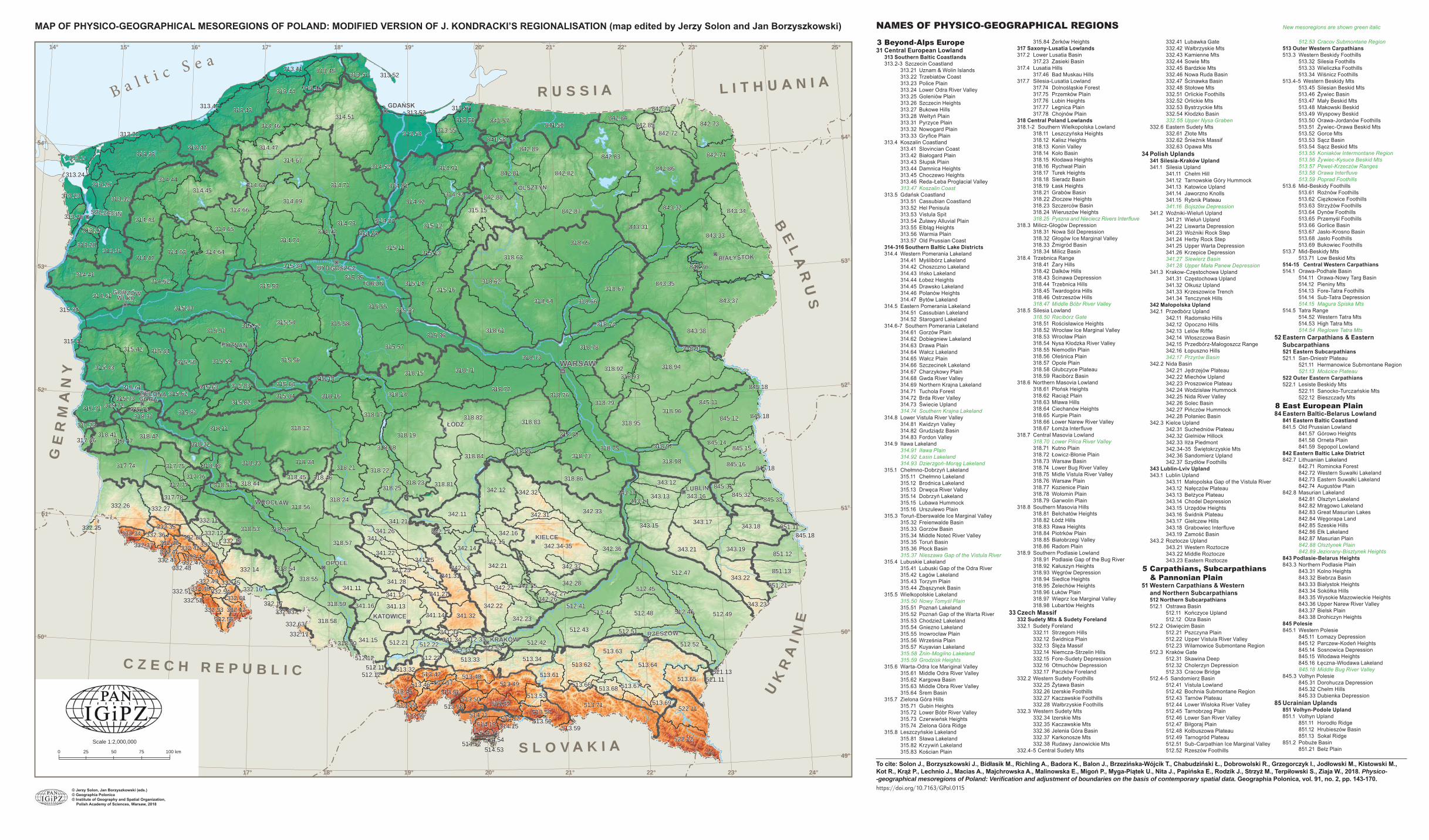
318.12
843.33
318.94
315.33
314.51
318.64
842.86
314.71
843.37
314.45
318.86
315.56
314.74
512.41
318.53
318.19
843.35318.67
318.63
315.58
318.65
318.72
318.61
512.49
842.87
318.57
842.82
842.83
318.83
315.57
315.53
315.42
315.11
313.33
342.33
318.95
314.91
513.64
315.16
318.56
318.82
513.71
315.54
842.81
315.51
315.14
318.96
512.47
313.54
843.34
315.35
314.69
314.64
318.98
845.12
314.61
332.26
843.31
843.38
843.32
318.73
841.59
318.81
318.78
512.48318.58
315.59
343.17
313.43
342.34-35
318.75
318.71
315.55
317.74318.84
342.12
318.62
314.46
343.15
314.67
332.14
314.63
343.18
318.17
318.42318.11
314.41
314.52
842.73
313.42
315.43
315.15
341.21
314.47
342.21
318.77
341.13
842.74
313.32
318.22
318.76318.16
314.73314.43
522.12
318.92
343.22
513.63
522.11
513.62
342.22
314.44
842.88
343.21
318.15
845.16
342.11
314.92
318.14
318.24
342.28
318.21
313.31
841.57
318.55
315.50
314.42
842.89
341.15
342.36
313.44
318.33 318.34
315.12
512.43
313.25
318.79
315.44
313.56
851.13
342.32
513.49
851.12
315.71
342.23
845.33
314.65
513.65
332.27
513.34
842.72
315.82
513.33
315.36
341.32
318.66
318.44
845.11315.81
845.32
318.59
313.45
513.51
314.66
512.52
342.14
343.13 343.16
343.19
315.34
513.61
342.16
318.41
513.54
315.64
512.22
318.23
315.62
512.21
513.32
317.75
512.42
313.28
512.45341.28
513.52
313.51313.41
341.11
314.62
845.14
343.12
513.45
318.25
842.84
513.48
318.31
313.55
845.15
513.47
341.16
317.76
315.73
513.68
514.13
315.84
318.52
512.46
341.31
314.68
313.24
317.78
318.32
342.37
342.17341.26341.24
341.23
342.31
341.14
314.93
512.51
313.47
513.67
342.24
315.61
318.91
313.22
315.83
513.69
315.13
317.77
318.74
318.45
341.12
341.22
342.15
341.25
313.23
512.44
343.11
314.81
845.31
314.72
513.50
342.13
313.21
332.12
332.16
318.93
843.36
513.53
514.11
332.11
842.85
341.27
314.83
318.54
332.15
318.43
342.25
314.82
332.55
342.27
332.42
315.74
318.85
341.34
343.23
332.28
332.61
841.58
332.36
318.46
332.62
315.63
332.34
332.53
332.35
313.46
318.51
313.26
341.33
332.37
318.97318.47
332.44
512.23
315.32
851.11
342.26
332.46
332.43
315.37
317.23
318.18
318.13
513.56
851.21
332.17
512.53
513.66
318.70
318.50
332.48
513.46
332.13
317.46
332.54
512.33
845.18
513.57
313.27
332.38
513.58
842.71
512.11
332.45
514.12
332.47
315.52
332.25
845.18
313.53
513.55
514.15
332.41
512.31
343.14
313.57
315.41
332.17
513.59
514.52
514.14514.54
521.11
332.48
315.72
514.53
332.52332.51
313.52
332.63
332.47
845.18
521.13
845.18
513.59
512.12
512.12
332.63
0 140 2800
332.43332.43
SZCZECIN
GORZÓWWLKP.
OPOLE
RZESZÓW
KIELCE
SZCZECIN
GORZÓWWLKP.
OPOLE
RZESZÓW
KIELCE
24°23°22°21°20°19°18°17°16°15°
54°
53°
52°
50°
49°
51°
21° 22° 23° 24°20°19°18°17°16°15°14° 25°
50°
51°
52°
53°
54°
49°
C Z E C H R E P B L I C
S L O V K I
R S S I L I H N I
KR
I NE
BE
LR
S
GE
RM
NY
B a l t i c S e a
Scale 1:2,000,000
0 25 50 75 100 km
© Jerzy Solon, Jan Borzyszkowski (eds.)© Geographia Polonica© Institute of Geography and Spatial Organization, Polish Academy of Sciences, Warsaw, 2018
To cite: Solon J., Borzyszkowski J., Bidłasik M., Richling A., Badora K., Balon J., Brzezińska-Wójcik T., Chabudziński Ł., Dobrowolski R., Grzegorczyk I., Jodłowski M., Kistowski M., Kot R., Krąż P., Lechnio J., Macias A., Majchrowska A., Malinowska E., Migoń P., Myga-Piątek U., Nita J., Papińska E., Rodzik J., Strzyż M., Terpiłowski S., Ziaja W., 2018. Physico--geographical mesoregions of Poland: Verifi cation and adjustment of boundaries on the basis of contemporary spatial data. Geographia Polonica, vol. 91, no. 2, pp. 143-170.https://doi.org/10.7163/GPol.0115
MAP OF PHYSICO-GEOGRAPHICAL MESOREGIONS OF POLAND: MODIFIED VERSION OF J. KONDRACKI’S REGIONALISATION (map edited by Jerzy Solon and Jan Borzyszkowski) 3 Beyond-Alps Europe 31 Central European Lowland 313 Southern Baltic Coastlands 313.2-3 Szczecin Coastland 313.21 Uznam & Wolin Islands 313.22 Trzebiatów Coast 313.23 Police Plain 313.24 Lower Odra River Valley 313.25 Goleniów Plain 313.26 Szczecin Heights 313.27 Bukowe Hills 313.28 Wełtyń Plain 313.31 Pyrzyce Plain 313.32 Nowogard Plain 313.33 Gryfi ce Plain 313.4 Koszalin Coastland 313.41 Slovincian Coast 313.42 Białogard Plain 313.43 Słupsk Plain 313.44 Damnica Heights 313.45 Choczewo Heights 313.46 Reda-Łeba Proglacial Valley 313.47 Koszalin Coast 313.5 Gdańsk Coastland 313.51 Cassubian Coastland 313.52 Hel Penisula 313.53 Vistula Spit 313.54 Żuławy Alluvial Plain 313.55 Elbląg Heights 313.56 Warmia Plain 313.57 Old Prussian Coast 314-316 Southern Baltic Lake Districts 314.4 Western Pomerania Lakeland 314.41 Myślibórz Lakeland 314.42 Choszczno Lakeland 314.43 Ińsko Lakeland 314.44 Łobez Heights 314.45 Drawsko Lakeland 314.46 Polanów Heights 314.47 Bytów Lakeland 314.5 Eastern Pomerania Lakeland 314.51 Cassubian Lakeland 314.52 Starogard Lakeland 314.6-7 Southern Pomerania Lakeland 314.61 Gorzów Plain 314.62 Dobiegniew Lakeland 314.63 Drawa Plain 314.64 Wałcz Lakeland 314.65 Wałcz Plain 314.66 Szczecinek Lakeland 314.67 Charzykowy Plain 314.68 Gwda River Valley 314.69 Northern Krajna Lakeland 314.71 Tuchola Forest 314.72 Brda River Valley 314.73 Świecie Upland 314.74 Southern Krajna Lakeland 314.8 Lower Vistula River Valley 314.81 Kwidzyn Valley 314.82 Grudziądz Basin 314.83 Fordon Valley 314.9 Iława Lakeland 314.91 Iława Plain 314.92 Łasin Lakeland 314.93 Dzierzgoń-Morąg Lakeland 315.1 Chełmno-Dobrzyń Lakeland 315.11 Chełmno Lakeland 315.12 Brodnica Lakeland 315.13 Drwęca River Valley 315.14 Dobrzyń Lakeland 315.15 Lubawa Hummock 315.16 Urszulewo Plain 315.3 Toruń-Eberswalde Ice Marginal Valley 315.32 Freienwalde Basin 315.33 Gorzów Basin 315.34 Middle Noteć River Valley 315.35 Toruń Basin 315.36 Płock Basin 315.37 Nieszawa Gap of the Vistula River 315.4 Lubuskie Lakeland 315.41 Lubuski Gap of the Odra River 315.42 Łagów Lakeland 315.43 Torzym Plain 315.44 Zbąszynek Basin 315.5 Wielkopolskie Lakeland 315.50 Nowy Tomyśl Plain 315.51 Poznań Lakeland 315.52 Poznań Gap of the Warta River 315.53 Chodzież Lakeland 315.54 Gniezno Lakeland 315.55 Inowrocław Plain 315.56 Września Plain 315.57 Kuyavian Lakeland 315.58 Żnin-Mogilno Lakeland 315.59 Grodzisk Heights 315.6 Warta-Odra Ice Mariginal Valley 315.61 Middle Odra River Valley 315.62 Kargowa Basin 315.63 Middle Obra River Valley 315.64 Śrem Basin 315.7 Zielona Góra Hills 315.71 Gubin Heights 315.72 Lower Bóbr River Valley 315.73 Czerwieńsk Heights 315.74 Zielona Góra Ridge 315.8 Leszczyńskie Lakeland 315.81 Sława Lakeland 315.82 Krzywiń Lakeland 315.83 Kościan Plain
315.84 Żerków Heights 317 Saxony-Lusatia Lowlands 317.2 Lower Lusatia Basin 317.23 Zasieki Basin 317.4 Lusatia Hills 317.46 Bad Muskau Hills 317.7 Silesia-Lusatia Lowland 317.74 Dolnośląskie Forest 317.75 Przemków Plain 317.76 Lubin Heights 317.77 Legnica Plain 317.78 Chojnów Plain 318 Central Poland Lowlands 318.1-2 Southern Wielkopolska Lowland 318.11 Leszczyńska Heights 318.12 Kalisz Heights 318.13 Konin Valley 318.14 Koło Basin 318.15 Kłodawa Heights 318.16 Rychwał Plain 318.17 Turek Heights 318.18 Sieradz Basin 318.19 Łask Heights 318.21 Grabów Basin 318.22 Złoczew Heights 318.23 Szczerców Basin 318.24 Wieruszów Heights 318.25 Pyszna and Nieciecz Rivers Interfl uve 318.3 Milicz-Głogów Depression 318.31 Nowa Sól Depression 318.32 Głogów Ice Marginal Valley 318.33 Żmigród Basin 318.34 Milicz Basin 318.4 Trzebnica Range 318.41 Żary Hills 318.42 Dalków Hills 318.43 Ścinawa Depression 318.44 Trzebnica Hills 318.45 Twardogóra Hills 318.46 Ostrzeszów Hills 318.47 Middle Bóbr River Valley 318.5 Silesia Lowland 318.50 Racibórz Gate 318.51 Rościsławice Heights 318.52 Wrocław Ice Marginal Valley 318.53 Wrocław Plain 318.54 Nysa Kłodzka River Valley 318.55 Niemodlin Plain 318.56 Oleśnica Plain 318.57 Opole Plain 318.58 Głubczyce Plateau 318.59 Racibórz Basin 318.6 Northern Masovia Lowland 318.61 Płońsk Heights 318.62 Raciąż Plain 318.63 Mława Hills 318.64 Ciechanów Heights 318.65 Kurpie Plain 318.66 Lower Narew River Valley 318.67 Łomża Interfl uve 318.7 Central Masovia Lowland 318.70 Lower Pilica River Valley 318.71 Kutno Plain 318.72 Łowicz-Błonie Plain 318.73 Warsaw Basin 318.74 Lower Bug River Valley 318.75 Midle Vistula River Valley 318.76 Warsaw Plain 318.77 Kozienice Plain 318.78 Wołomin Plain 318.79 Garwolin Plain 318.8 Southern Masovia Hills 318.81 Bełchatów Heights 318.82 Łódź Hills 318.83 Rawa Heights 318.84 Piotrków Plain 318.85 Białobrzegi Valley 318.86 Radom Plain 318.9 Southern Podlasie Lowland 318.91 Podlasie Gap of the Bug River 318.92 Kałuszyn Heights 318.93 Węgrów Depression 318.94 Siedlce Heights 318.95 Żelechów Heights 318.96 Łuków Plain 318.97 Wieprz Ice Marginal Valley 318.98 Lubartów Heights 33 Czech Massif 332 Sudety Mts & Sudety Foreland 332.1 Sudety Foreland 332.11 Strzegom Hills 332.12 Świdnica Plain 332.13 Ślęża Massif 332.14 Niemcza-Strzelin Hills 332.15 Fore-Sudety Depression 332.16 Otmuchów Depression 332.17 Paczków Foreland 332.2 Western Sudety Foothills 332.25 Żytawa Basin 332.26 Izerskie Foothills 332.27 Kaczawskie Foothills 332.28 Wałbrzyskie Foothills 332.3 Western Sudety Mts 332.34 Izerskie Mts 332.35 Kaczawskie Mts 332.36 Jelenia Góra Basin 332.37 Karkonosze Mts 332.38 Rudawy Janowickie Mts 332.4-5 Central Sudety Mts
332.41 Lubawka Gate 332.42 Wałbrzyskie Mts 332.43 Kamienne Mts 332.44 Sowie Mts 332.45 Bardzkie Mts 332.46 Nowa Ruda Basin 332.47 Ścinawka Basin 332.48 Stołowe Mts 332.51 Orlickie Foothills 332.52 Orlickie Mts 332.53 Bystrzyckie Mts 332.54 Kłodzko Basin 332.55 Upper Nysa Graben 332.6 Eastern Sudety Mts 332.61 Złote Mts 332.62 Śnieżnik Massif 332.63 Opawa Mts 34 Polish Uplands 341 Silesia-Kraków Upland 341.1 Silesia Upland 341.11 Chełm Hill 341.12 Tarnowskie Góry Hummock 341.13 Katowice Upland 341.14 Jaworzno Knolls 341.15 Rybnik Plateau 341.16 Bojszów Depression 341.2 Woźniki-Wieluń Upland 341.21 Wieluń Upland 341.22 Liswarta Depression 341.23 Woźniki Rock Step 341.24 Herby Rock Step 341.25 Upper Warta Depression 341.26 Krzepice Depression 341.27 Siewierz Basin 341.28 Upper Mała Panew Depression 341.3 Krakow-Częstochowa Upland 341.31 Częstochowa Upland 341.32 Olkusz Upland 341.33 Krzeszowice Trench 341.34 Tenczynek Hills 342 Małopolska Upland 342.1 Przedbórz Upland 342.11 Radomsko Hills 342.12 Opoczno Hills 342.13 Lelów Riffl e 342.14 Włoszczowa Basin 342.15 Przedbórz-Małogoszcz Range 342.16 Łopuszno Hills 342.17 Przyrów Basin 342.2 Nida Basin 342.21 Jędrzejów Plateau 342.22 Miechów Upland 342.23 Proszowice Plateau 342.24 Wodzisław Hummock 342.25 Nida River Valley 342.26 Solec Basin 342.27 Pińczów Hummock 342.28 Połaniec Basin 342.3 Kielce Upland 342.31 Suchedniów Plateau 342.32 Gielniów Hillock 342.33 Iłża Piedmont 342.34-35 Świętokrzyskie Mts 342.36 Sandomierz Upland 342.37 Szydłów Foothills 343 Lublin-Lviv Upland 343.1 Lublin Upland 343.11 Małopolska Gap of the Vistula River 343.12 Nałęczów Plateau 343.13 Bełżyce Plateau 343.14 Chodel Depression 343.15 Urzędów Heights 343.16 Świdnik Plateau 343.17 Giełczew Hills 343.18 Grabowiec Interfl uve 343.19 Zamość Basin 343.2 Roztocze Upland 343.21 Western Roztocze 343.22 Middle Roztocze 343.23 Eastern Roztocze 5 Carpathians, Subcarpathians & Pannonian Plain 51 Western Carpathians & Western and Northern Subcarpathians 512 Northern Subcarpathians 512.1 Ostrawa Basin 512.11 Kończyce Upland 512.12 Olza Basin 512.2 Oświęcim Basin 512.21 Pszczyna Plain 512.22 Upper Vistula River Valley 512.23 Wilamowice Submontane Region 512.3 Kraków Gate 512.31 Skawina Deep 512.32 Cholerzyn Depression 512.33 Cracow Bridge 512.4-5 Sandomierz Basin 512.41 Vistula Lowland 512.42 Bochnia Submontane Region 512.43 Tarnów Plateau 512.44 Lower Wisłoka River Valley 512.45 Tarnobrzeg Plain 512.46 Lower San River Valley 512.47 Biłgoraj Plain 512.48 Kolbuszowa Plateau 512.49 Tarnogród Plateau 512.51 Sub-Carpathian Ice Marginal Valley 512.52 Rzeszów Foothills
512.53 Cracov Submontane Region 513 Outer Western Carpathians 513.3 Western Beskidy Foothills 513.32 Silesia Foothills 513.33 Wieliczka Foothills 513.34 Wiśnicz Foothills 513.4-5 Western Beskidy Mts 513.45 Silesian Beskid Mts 513.46 Żywiec Basin 513.47 Mały Beskid Mts 513.48 Makowski Beskid 513.49 Wyspowy Beskid 513.50 Orawa-Jordanów Foothills 513.51 Żywiec-Orawa Beskid Mts 513.52 Gorce Mts 513.53 Sącz Basin 513.54 Sącz Beskid Mts 513.55 Koniaków Intermontane Region 513.56 Żywiec-Kysuce Beskid Mts 513.57 Pewel-Krzeczów Ranges 513.58 Orawa Interfl uve 513.59 Poprad Foothills 513.6 Mid-Beskidy Foothills 513.61 Rożnów Foothills 513.62 Cięzkowice Foothills 513.63 Strzyżów Foothills 513.64 Dynów Foothills 513.65 Przemyśl Foothills 513.66 Gorlice Basin 513.67 Jasło-Krosno Basin 513.68 Jasło Foothills 513.69 Bukowiec Foothills 513.7 Mid-Beskidy Mts 513.71 Low Beskid Mts 514-15 Central Western Carpathians 514.1 Orawa-Podhale Basin 514.11 Orawa-Nowy Targ Basin 514.12 Pieniny Mts 514.13 Fore-Tatra Foothills 514.14 Sub-Tatra Depression 514.15 Magura Spiska Mts 514.5 Tatra Range 514.52 Western Tatra Mts 514.53 High Tatra Mts 514.54 Reglowe Tatra Mts 52 Eastern Carpathians & Eastern Subcarpathians 521 Eastern Subcarpathians 521.1 San-Dniestr Plateau 521.11 Hermanowice Submontane Region 521.13 Mościce Plateau 522 Outer Eastern Carpathians 522.1 Lesiste Beskidy Mts 522.11 Sanocko-Turczańskie Mts 522.12 Bieszczady Mts 8 East European Plain 84 Eastern Baltic-Belarus Lowland 841 Eastern Baltic Coastland 841.5 Old Prussian Lowland 841.57 Górowo Heights 841.58 Orneta Plain 841.59 Sępopol Lowland 842 Eastern Baltic Lake District 842.7 Lithuanian Lakeland 842.71 Romincka Forest 842.72 Western Suwałki Lakeland 842.73 Eastern Suwałki Lakeland 842.74 Augustów Plain 842.8 Masurian Lakeland 842.81 Olsztyn Lakeland 842.82 Mrągowo Lakeland 842.83 Great Masurian Lakes 842.84 Węgorapa Land 842.85 Szeskie Hills 842.86 Ełk Lakeland 842.87 Masurian Plain 842.88 Olsztynek Plain 842.89 Jeziorany-Bisztynek Heights 843 Podlasie-Belarus Heights 843.3 Northern Podlasie Plain 843.31 Kolno Heights 843.32 Biebrza Basin 843.33 Białystok Heights 843.34 Sokółka Hills 843.35 Wysokie Mazowieckie Heights 843.36 Upper Narew River Valley 843.37 Bielsk Plain 843.38 Drohiczyn Heights 845 Polesie 845.1 Western Polesie 845.11 Łomazy Depression 845.12 Parczew-Kodeń Heights 845.14 Sosnowica Depression 845.15 Włodawa Heights 845.16 Łęczna-Włodawa Lakeland 845.18 Middle Bug River Valley 845.3 Volhyn Polesie 845.31 Dorohucza Depression 845.32 Chełm Hills 845.33 Dubienka Depression 85 Ucrainian Uplands 851 Volhyn-Podole Upland 851.1 Volhyn Upland 851.11 Horodło Ridge 851.12 Hrubieszów Basin 851.13 Sokal Ridge 851.2 Pobuże Basin 851.21 Bełz Plain
New mesoregions are shown green italicNAMES OF PHYSICO-GEOGRAPHICAL REGIONS

3 Pozaalpejska Europa Środkowa 31 Niż Środkowoeuropejski 313 Pobrzeża Południowobałtyckie 313.2-3 Pobrzeże Szczecińskie 313.21 Uznam i Wolin 313.22 Wybrzeże Trzebiatowskie 313.23 Równina Wkrzańska (Równina
Policka) 313.24 Dolina Dolnej Odry 313.25 Równina Goleniowska 313.26 Wzniesienia Szczecińskie 313.27 Wzgórza Bukowe 313.28 Równina Wełtyńska 313.31 Równina Pyrzycka 313.32 Równina Nowogardzka 313.33 Równina Gryfi cka 313.4 Pobrzeże Koszalińskie 313.41 Wybrzeże Słowińskie 313.42 Równina Białogardzka 313.43 Równina Słupska 313.44 Wysoczyzna Damnicka 313.45 Wysoczyzna Choczewska 313.46 Pradolina Redy-Łeby 313.47 Wybrzeże Koszalińskie 313.5 Pobrzeże Gdańskie 313.51 Pobrzeże Kaszubskie 313.52 Mierzeja Helska 313.53 Mierzeja Wiślana 313.54 Żuławy Wiślane 313.55 Wysoczyzna Elbląska 313.56 Równina Warmińska 313.57 Wybrzeże Staropruskie 314-316 Pojezierza Południowobałtyckie 314.4 Pojezierze Zachodniopomorskie 314.41 Pojezierze Myśliborskie 314.42 Pojezierze Choszczeńskie 314.43 Pojezierze Ińskie 314.44 Wysoczyzna Łobeska 314.45 Pojezierze Drawskie 314.46 Wysoczyzna Polanowska 314.47 Pojezierze Bytowskie 314.5 Pojezierze Wschodniopomorskie 314.51 Pojezierze Kaszubskie 314.52 Pojezierze Starogardzkie 314.6-7 Pojezierze Południowopomorskie 314.61 Równina Gorzowska 314.62 Pojezierze Dobiegniewskie 314.63 Równina Drawska 314.64 Pojezierze Wałeckie 314.65 Równina Wałecka 314.66 Pojezierze Szczecineckie 314.67 Równina Charzykowska 314.68 Dolina Gwdy 314.69 Pojezierze Północnokrajeńskie 314.71 Bory Tucholskie 314.72 Dolina Brdy 314.73 Wysoczyzna Świecka 314.74 Pojezierze Południowokrajeńskie 314.8 Dolina Dolnej Wisły 314.81 Dolina Kwidzyńska 314.82 Kotlina Grudziądzka 314.83 Dolina Fordońska 314.9 Pojezierze Iławskie 314.91 Pojezierze Dzierzgońsko-Morąskie 314.92 Pojezierze Łasińskie 314.93 Równina Iławska 315.1 Pojezierze Chełmińsko-Dobrzyńskie 315.11 Pojezierze Chełmińskie 315.12 Pojezierze Brodnickie 315.13 Dolina Drwęcy 315.14 Pojezierze Dobrzyńskie 315.15 Garb Lubawski 315.16 Równina Urszulewska 315.3 Pradolina Toruńsko-Eberswaldzka 315.32 Kotlina Freienwaldzka 315.33 Kotlina Gorzowska 315.34 Dolina Środkowej Noteci 315.35 Kotlina Toruńska 315.36 Kotlina Płocka 315.37 Nieszawski Przełom Wisły 315.4 Pojezierze Lubuskie (Brandenbursko-
Lubuskie) 315.41 Lubuski Przełom Odry 315.42 Pojezierze Łagowskie 315.43 Równina Torzymska 315.44 Bruzda Zbąszyńska 315.5 Pojezierze Wielkopolskie 315.50 Równina Nowotomyska 315.51 Pojezierze Poznańskie 315.52 Poznański Przełom Warty 315.53 Pojezierze Chodzieskie 315.54 Pojezierze Gnieźnieńskie 315.55 Równina Inowrocławska 315.56 Równina Wrzesińska 315.57 Pojezierze Kujawskie 315.58 Pojezierze Żnińsko-Mogileńskie 315.59 Wysoczyzna Grodziska 315.6 Pradolina Warciańsko-Odrzańska 315.61 Dolina Środkowej Odry 315.62 Kotlina Kargowska 315.63 Dolina Środkowej Obry 315.64 Kotlina Śremska 315.7 Wzniesienia Zielonogórskie 315.71 Wzniesienia Gubińskie 315.72 Dolina Dolnego Bobru 315.73 Wysoczyzna Czerwieńska 315.74 Wał Zielonogórski 315.8 Pojezierze Leszczyńskie 315.81 Pojezierze Sławskie
315.82 Pojezierze Krzywińskie 315.83 Równina Kościańska 315.84 Wał Żerkowski 317 Niziny Sasko-Łużyckie 317.2 Obniżenie Dolnołużyckie 317.23 Kotlina Zasiecka 317.4 Wzniesienia Łużyckie 317.46 Wał Mużakowski 317.7 Nizina Śląsko-Łużycka 317.74 Bory Dolnośląskie 317.75 Równina Przemkowska 317.76 Wysoczyzna Lubińska 317.77 Równina Legnicka 317.78 Równina Chojnowska 318 Niziny Środkowopolskie 318.1-2 Nizina Południowowielkopolska 318.11 Wysoczyzna Leszczyńska 318.12 Wysoczyzna Kaliska 318.13 Dolina Konińska 318.14 Kotlina Kolska 318.15 Wysoczyzna Kłodawska 318.16 Równina Rychwalska 318.17 Wysoczyzna Turecka 318.18 Kotlina Sieradzka 318.19 Wysoczyzna Łaska 318.21 Kotlina Grabowska 318.22 Wysoczyzna Złoczewska 318.23 Kotlina Szczercowska 318.24 Wysoczyzna Wieruszowska 318.25 Międzyrzecze Pysznej i Niecieczy 318.3 Obniżenie Milicko-Głogowskie 318.31 Obniżenie Nowosolskie 318.32 Pradolina Głogowska 318.33 Kotlina Żmigrodzka 318.34 Kotlina Milicka 318.4 Wał Trzebnicki 318.41 Wzniesienia Żarskie 318.42 Wzgórza Dalkowskie 318.43 Obniżenie Ścinawskie 318.44 Wzgórza Trzebnickie 318.45 Wzgórza Twardogórskie 318.46 Wzgórza Ostrzeszowskie 318.47 Dolina Środkowego Bobru 318.5 Nizina Śląska 318.50 Brama Raciborska 318.51 Wysoczyzna Rościsławska 318.52 Pradolina Wrocławska 318.53 Równina Wrocławska 318.54 Dolina Nysy Kłodzkiej 318.55 Równina Niemodlińska 318.56 Równina Oleśnicka 318.57 Równina Opolska 318.58 Płaskowyż Głubczycki 318.59 Kotlina Raciborska 318.6 Nizina Północnomazowiecka 318.61 Wysoczyzna Płońska 318.62 Równina Raciąska 318.63 Wzniesienia Mławskie 318.64 Wysoczyzna Ciechanowska 318.65 Równina Kurpiowska 318.66 Dolina Dolnej Narwi 318.67 Międzyrzecze Łomżyńskie 318.7 Nizina Środkowomazowiecka 318.70 Dolina Dolnej Pilicy 318.71 Równina Kutnowska 318.72 Równina Łowicko-Błońska 318.73 Kotlina Warszawska 318.74 Dolina Dolnego Bugu 318.75 Dolina Środkowej Wisły 318.76 Równina Warszawska 318.77 Równina Kozienicka 318.78 Równina Wołomińska 318.79 Równina Garwolińska 318.8 Wzniesienia Południowomazowieckie 318.81 Wysoczyzna Bełchatowska 318.82 Wzniesienia Łódzkie 318.83 Wysoczyzna Rawska 318.84 Równina Piotrkowska 318.85 Dolina Białobrzeska 318.86 Równina Radomska 318.9 Nizina Południowopodlaska 318.91 Podlaski Przełom Bugu 318.92 Wysoczyzna Kałuszyńska 318.93 Obniżenie Węgrowskie 318.94 Wysoczyzna Siedlecka 318.95 Wysoczyzna Żelechowska 318.96 Równina Łukowska 318.97 Pradolina Wieprza 318.98 Wysoczyzna Lubartowska 33 Masyw Czeski 332 Sudety z Przedgórzem Sudeckim 332.1 Przedgórze Sudeckie 332.11 Wzgórza Strzegomskie 332.12 Równina Świdnicka 332.13 Masyw Ślęży 332.14 Wzgórza Niemczańsko-Strzelińskie 332.15 Obniżenie Podsudeckie 332.16 Obniżenie Otmuchowskie 332.17 Przedgórze Paczkowskie 332.2 Pogórze Zachodniosudeckie 332.25 Kotlina Żytawska 332.26 Pogórze Izerskie 332.27 Pogórze Kaczawskie 332.28 Pogórze Wałbrzyskie 332.3 Sudety Zachodnie 332.34 Góry Izerskie 332.35 Góry Kaczawskie 332.36 Kotlina Jeleniogórska 332.37 Karkonosze 332.38 Rudawy Janowickie
332.4-5 Sudety Środkowe 332.41 Brama Lubawska 332.42 Góry Wałbrzyskie 332.43 Góry Kamienne 332.44 Góry Sowie 332.45 Góry Bardzkie 332.46 Obniżenie Noworudzkie 332.47 Obniżenie Ścinawki 332.48 Góry Stołowe 332.51 Pogórze Orlickie 332.52 Góry Orlickie 332.53 Góry Bystrzyckie 332.54 Kotlina Kłodzka 332.55 Rów Górnej Nysy 332.6 Sudety Wschodnie 332.61 Góry Złote 332.62 Masyw Śnieżnika 332.63 Góry Opawskie 34 Wyżyny Polskie 341 Wyżyna Śląsko-Krakowska 341.1 Wyżyna Śląska 341.11 Chełm 341.12 Garb Tarnogórski 341.13 Wyżyna Katowicka 341.14 Pagóry Jaworznickie 341.15 Płaskowyż Rybnicki 341.16 Obniżenie Bojszowa 341.2 Wyżyna Woźnicko-Wieluńska 341.21 Wyżyna Wieluńska 341.22 Obniżenie Liswarty 341.23 Próg Woźnicki 341.24 Próg Herbski 341.25 Obniżenie Górnej Warty 341.26 Obniżenie Krzepickie 341.27 Kotlina Siewierza 341.28 Obniżenie Górnej Małej Panwi 341.3 Wyżyna Krakowsko-Częstochowska 341.31 Wyżyna Częstochowska 341.32 Wyżyna Olkuska 341.33 Rów Krzeszowicki 341.34 Garb Tenczyński 342 Wyżyna Małopolska 342.1 Wyżyna Przedborska 342.11 Wzgórza Radomszczańskie 342.12 Wzgórza Opoczyńskie 342.13 Próg Lelowski 342.14 Niecka Włoszczowska 342.15 Pasmo Przedborsko-Małogoskie 342.16 Wzgórza Łopuszańskie 342.17 Niecka Przyrowska 342.2 Niecka Nidziańska 342.21 Płaskowyż Jędrzejowski 342.22 Wyżyna Miechowska 342.23 Płaskowyż Proszowicki 342.24 Garb Wodzisławski 342.25 Dolina Nidy 342.26 Niecka Solecka 342.27 Garb Pińczowski 342.28 Niecka Połaniecka 342.3 Wyżyna Kielecka 342.31 Płaskowyż Suchedniowski 342.32 Garb Gielniowski 342.33 Przedgórze Iłżeckie 342.34-35 Góry Świętokrzyskie 342.36 Wyżyna Sandomierska 342.37 Pogórze Szydłowskie 343 Wyżyna Lubelsko-Lwowska 343.1 Wyżyna Lubelska 343.11 Małopolski Przełom Wisły 343.12 Płaskowyż Nałęczowski 343.13 Równina Bełżycka 343.14 Obniżenie Chodelskie 343.15 Wzniesienia Urzędowskie 343.16 Płaskowyż Świdnicki 343.17 Wyniosłość Giełczewska 343.18 Działy Grabowieckie 343.19 Kotlina Zamojska 343.2 Roztocze 343.21 Roztocze Zachodnie 343.22 Roztocze Środkowe 343.23 Roztocze Wschodnie 5 Karpaty, Podkarpackie i Nizina Panońska 51 Karpaty Zachodnie z Podkarpaciem Zachodnim i Północnym 512 Podkarpacie Północne 512.1 Kotlina Ostrawska 512.11 Wysoczyzna Kończycka 512.12 Kotlina Olzy 512.2 Kotlina Oświęcimska 512.21 Równina Pszczyńska 512.22 Dolina Górnej Wisły 512.23 Podgórze Wilamowickie 512.3 Brama Krakowska 512.31 Rów Skawiński 512.32 Obniżenie Cholerzyńskie 512.33 Pomost Krakowski 512.4-5 Kotlina Sandomierska 512.41 Nizina Nadwiślańska 512.42 Podgórze Bocheńskie 512.43 Płaskowyż Tarnowski 512.44 Dolina Dolnej Wisłoki 512.45 Równina Tarnobrzeska 512.46 Dolina Dolnego Sanu 512.47 Równina Biłgorajska 512.48 Płaskowyż Kolbuszowski 512.49 Płaskowyż Tarnogrodzki 512.51 Pradolina Podkarpacka 512.52 Podgórze Rzeszowskie
512.53 Podgórze Krakowskie 513 Zewnętrzne Karpaty Zachodnie 513.3 Pogórze Zachodniobeskidzkie 513.32 Pogórze Śląskie 513.33 Pogórze Wielickie 513.34 Pogórze Wiśnickie 513.4-5 Beskidy Zachodnie 513.45 Beskid Śląski 513.46 Kotlina Żywiecka 513.47 Beskid Mały 513.48 Beskid Makowski 513.49 Beskid Wyspowy 513.50 Pogórze Orawsko-Jordanowskie 513.51 Beskid Żywiecko-Orawski 513.52 Gorce 513.53 Kotlina Sądecka 513.54 Beskid Sądecki 513.55 Międzygórze Jabłonkowsko-Koniakowskie 513.56 Beskid Żywiecko-Kysucki 513.57 Pasma Pewelsko-Krzeczowskie 513.58 Działy Orawskie 513.59 Pogórze Popradzkie 513.6 Pogórze Środkowobeskidzkie 513.61 Pogórze Rożnowskie 513.62 Pogórze Ciężkowickie 513.63 Pogórze Strzyżowskie 513.64 Pogórze Dynowskie 513.65 Pogórze Przemyskie 513.66 Obniżenie Gorlickie 513.67 Kotlina Jasielsko-Krośnieńska 513.68 Pogórze Jasielskie 513.69 Pogórze Bukowskie 513.7 Beskidy Środkowe 513.71 Beskid Niski 514-15 Centralne Karpaty Zachodnie 514.1 Obniżenie Orawsko-Podhalańskie 514.11 Kotlina Orawsko-Nowotarska 514.12 Pieniny 514.13 Pogórza Przedtatrzanskie 514.14 Bruzda Podtatrzańska 514.15 Magura Spiska 514.5 Łańcuch Tatrzański 514.52 Tatry Zachodnie 514.53 Tatry Wysokie 514.54 Tatry Reglowe 52 Karpaty Wschodnie z Podkarpaciem Wschodnim 521 Wschodnie Podkarpacie 521.1 Płaskowyż Sańsko-Dniestrzański 521.11 Podgórze Hermanowickie 521.13 Płaskowyż Mościski 522 Zewnętrzne Karpaty Wschodnie
(Beskidy Wschodnie) 522.1 Beskidy Lesiste 522.11 Góry Sanocko-Turczańskie 522.12 Bieszczady Zachodnie 8 Niż Wschodnioeuropejski 84 Niż Wschodniobałtycko-Białoruski 841 Pobrzeże Wschodniobałtyckie 841.5 Nizina Staropruska 841.57 Wzniesienia Górowskie 841.58 Równina Ornecka 841.59 Nizina Sępopolska 842 Pojezierze Wschodniobałtyckie 842.7 Pojezierze Litewskie 842.71 Puszcza Romincka 842.72 Pojezierze Zachodniosuwalskie 842.73 Pojezierze Wschodniosuwalskie 842.74 Równina Augustowska 842.8 Pojezierze Mazurskie 842.81 Pojezierze Olsztyńskie 842.82 Pojezierze Mrągowskie 842.83 Kraina Wielkich Jezior Mazurskich 842.84 Kraina Węgorapy 842.85 Wzgórza Szeskie 842.86 Pojezierze Ełckie 842.87 Równina Mazurska 842.88 Równina Olsztynka 842.89 Wysoczyzna Jeziorańsko-Bisztynecka 843 Wysoczyzny Podlasko-Białoruskie 843.3 Nizina Północnopodlaska 843.31 Wysoczyzna Kolneńska 843.32 Kotlina Biebrzańska 843.33 Wysoczyzna Białostocka 843.34 Wzgórza Sokólskie 843.35 Wysoczyzna Wysokomazowiecka 843.36 Dolina Górnej Narwi 843.37 Równina Bielska 843.38 Wysoczyzna Drohiczyńska 845 Polesie 845.1 Polesie Zachodnie 845.11 Zaklęsłość Łomaska 845.12 Wysoczyzna Parczewsko-Kodeńska 845.14 Zaklęsłość Sosnowicka 845.15 Garb Włodawski 845.16 Pojezierze Łęczyńsko-Włodawskie 845.18 Dolina Środkowego Bugu 845.3 Polesie Wołyńskie 845.31 Obniżenie Dorohuckie 845.32 Pagóry Chełmskie 845.33 Obniżenie Dubieńskie 85 Wyżyny Ukraińskie 851 Wyżyna Wołyńsko-Podolska 851.1 Wyżyna Wołyńska 851.11 Grzęda Horodelska 851.12 Kotlina Hrubieszowska 851.13 Grzęda Sokalska 851.2 Kotlina Pobuża 851.21 Równina Bełska
Nowe mezoregiony oznaczono zieloną, pochyłą czcionkąNAZWY REGIONÓW FIZYCZNOGEOGRAFICZNYCH
Cytowanie: Solon J., Borzyszkowski J., Bidłasik M., Richling A., Badora K., Balon J., Brzezińska-Wójcik T., Chabudziński Ł., Dobrowolski R., Grzegorczyk I., Jodłowski M., Kistowski M., Kot R., Krąż P., Lechnio J., Macias A., Majchrowska A., Malinowska E., Migoń P., Myga-Piątek U., Nita J., Papińska E., Rodzik J., Strzyż M., Terpiłowski S., Ziaja W., 2018. Physico--geographical mesoregions of Poland: Verifi cation and adjustment of boundaries on the basis of contemporary spatial data. Geographia Polonica, vol. 91, no. 2, pp. 143-170.https://doi.org/10.7163/GPol.0115