geodetic and charting publications - departments · 2011-01-10 · geodetic and charting...
TRANSCRIPT
Geodetic and Charting Publications
January 1991
US Department of Commerce National Oceanic and Atmospheric Administration National Ocean Service Office of Charting and Geodetic Services
Geodetic and Charting Publications
Compiled by Grace C Sollers Natio~al Geodetic Survey
Rockville MD 20852
January 1991
US Department of Commerce Robert A Mosbacher Secretary National Oceanic and Atmospheric Administration John A Knauss Under Secretary National Ocean Service Virginia K Tippie Assistant Administrator Charting and Geodetic Services R Adm 1 Austin Yeager Director
For sale by the National Geodetic Infonnation Center NOAA Rockville MD 20852
COntents
NOAA Technical Memoranaa 1
NOAA Technical Reports 4
NOAA Manuals 9
NOAA Profssional Papers 9
Other NOAA Geodetic Publications 9
CamprGS Sp8Cial Publications bullbullbullbullbullbullbullbullbullbullbullbullbullbullbullbullbullbullbullbullbullbull 11
CampGS Publications 17
PGCC Publications 19
Publications of Other Orgamprizations 20
iii
ORDERING INFORMATION
In october 1983 the National Geodetic Survey (NGS) a division of Charting and Geodetic Services (CampGS) within the National OCean Service National OCeanic and Atmospheric Administration (NOAA) became an exclusive consigned sales agent for the Superintendent of Documents US Government Printing Office (GPO) Under this joint venture the National Geodetic Survey of CampGS sells NOAA geodetic and charting publ~cations and those of its predecessors (eg the United States COast and Geodetic Survey) as well as all published Federal Geodetic COntrol COllllllittee (FGCC) reports
To keep our service timely and efficient please adhere to the following procedures when placing your orderl
Ordering Publications by Mail
To order a publication by mail furnish the title and series designation Include your name complete address and zip code Mail orders mu~t be prepaid by check Visa MasterCard American Bxpress money order or Federal Government purchase order made payable to I NOAA Rational Geodetic Survey Send requests to
National Geodetic Information center NCG174 Rockwall Building Room 24 Rational Geodetic Survey NOAA Rockville MD 20852
QUetions pertaining to orders should be directed to the above address For international orders a surcharge of 25 percent of the domestic price must be added to all items to cover the additional cost of postage (parcel rate) and handling
Ordering Publications in Person
Orders are filled by the National Geodetic Information center located in room 24 of the Rockwall building 11400 Rockville Pike Rockville MD Purchases can be made over the counter at this address However all correspondence should be Dent to the address stated in the preceding paragraph
Ordering Publications by Telephone
Direct your inquiries to National Geodetic Survey 1-301-443-8631 Desired items can be charged by telephone request using Visa MasterCard American Express or prepaid GPO Deposit Account A prepaid deposit account may be established with GPO upon receipt of a deposit of $5000 or more To establish a GPO account send payment and letter requesting a prepaid Deposit Account tOI
Superintendent of Documents ATTN Deposit Accounts US Government Printing Office Washington DC 20402
iv
Price List
The publications and prices cited in this listing are subject to change New NOAA and ~C charting and geodetic Publications will be added as they become available The cost of postage (parcel rate) and handling is included in the publication price for domestic orders Special handling and mailing can be arranged if requested an additional charge will be made for thie ervice
Ordering Geodetic Data or Geodetic Software
User are often interested in ordering geodetic data or geodetic software The National Geodetic Information Center also erve a the national depository for geodetic control data and related information For further information on ordering data or computer software or subscribing to the geodetic data automatic mailing service contact
National Geodetic Information Center NCG174 Rockwall Building Room 24 National Geodetic Survey NOAA Rockville MD 20852
1-301-443-8631
v
NOAA Technical Memoranda
NOAA Technical Memorandum NOS CampGS 1 Selection of a general purpose language and a real-time language suitable for shipboard data system III by Barnum Steven R January 1984 29 pp $175
NOAA Technical Memorandum NOS C~S 2 GPS-Aasisted Phototriangulation Package (GAPP) Osers Guide Version 102 by Lucas James R November 1989 25 pp $1 SO
NOAA Technical Memorandum NOS NGS- 1 0 of climatological and meteorological data in the planning and execution of National Geodetic Survey field operations by Leffler Robert J December 1975 30 pp $175
NOAA Technical Memorandum NOS NGS- 2 Final Report on Responses to Geodetic Data ~estionnaire by spencer Jr John F March 1976 40 pp~ $200
NOAA Technical Memorandum NOS NGS- 3 Adjustment of geodetic field data using a sequential method by Whiting Marvin C and Pope Allen J March 1976 11 pp $100
NOAA Technical Memorandum NOS NGS- 4 Reducing the profile of sParse llyuaetric matrices by Snay Richard A June 1976 24 pp $150
NOAA Technical Memorandum NOS NGS- 6 Determination of Borth American Datum 1983 coordinates of map corners by Vincenty T october 1976 8 pp $100
BOAA Technical Memorandum NOS NGS- 7 Recent elevation change in Southern CAlifornia by Boldahl Sandford R Pebruary 1977 19 pp $125
NOAA Technical Memorandum NOS NGS- 8 Establishment of calibration bas lines by Dracup Joseph F Fronczek Charles J Tomlinson Raymond W and Spofford Paul R August 1977 revised June 1982 21 pp $150
NOAA Technical Memorandum NOS OOS-10 Ose of calibration ba_ line by Fronczek Charles J December 1977 revised 1980 38 pp $200
BOAA Technical Memorandum NOS NGS-ll Applicability of array algebra by Snay Richard A February 1978 6 pp $100
NOAA Technical Memorandum NOS NGS-12 TRAV10 horizontal network adjustment program by Schwarz Charles R April 1978 52 pp $275
NOAA Technical Memorandum NOS NGS-13 Application of three-dimensional geodesy to adjustments of horizontal network by Vincenty T and Bowring B R June 1978 10 pp $100
NOAA Technical Memorandum NOS NGS-14 Solvability analysis of geodetic networks using logicAl geometry by Snay Richard A october 1978 28 pp $1 50
1
NOAA Technical Memorandum NOS NGS-15 Goldstone validation survey - phase 1 by Carter William I and Pettey James E November 1978~ 39 pp $200
NOAA Technical Memorandum NOS NGS-16 Determination of North American Datum 1983 coordinates of map corners (second prediction by Vincenty T April 1979 5 pp $100
NOAA Technical Memorandum NOS NGS-17 The SAVAGe three-dimensional adjustment program by Vincenty T May 1979 18 pp $125
NOAA Technical Memorandum NOS NGS-18 Determination of astronomic positions for california-Nevada bondary monuments near Lake Tahoe by Pettey James I March 1979 16 pp $100
NOAA Technical Memorandum NOS NGS-19 EOAOOSt a program for adjusting horizontal networks in three dimensions by Vincenty T July 1979 13 pp $1 00
NOAA Technical Memorandum NOS NGS-20 Geodetic leveling and the sea level slope along the california coast by Balazs Bmery I Douglas Bruce C and September 1979 22 pp $150
NOAA Technical Memorandum ~10S NGS-21 Haystack-westford survey by carter William B and Fronczek Charles J Pettey James B September 1979 57 pp $300
NOAA Technical Memorandum NOS NQS-22 Gravimetric tidal loading computed from integrated Greens function by Goad Clyde C october 1979 15 pp $100
NOAA Technical Memorandum NOS NGS-23 Use of auxiliary ellipsoids in height-controlled spatial adjustments by Bowring B R Vincenty T and November 1979 6 pp $100
NOAA Technical Memorandum NOS NGS-24 Determination of the geopotential from satellite-to-satellite tracking data by Douglas Bruce C Goad Clyde C and Morrison Foster Januar)- 1980 29 pp $175
NOAA Technical Memorandum NOS NGS-25 Revisions of the BOACOS height-controlled network adjustment program by Vincenty T May 1980 5 pp $100
NOAA Technical Memorandum NOS NGS-26 Motorized leveling at the National Geodetic Survey by Poetzschke Heinz OCtober 1980 17 pp $125
NOAA Technical Memorandum NOS NGS-27 The 1978 Houston-Galveston and Texas Gulf COast vertical control surveys by Balazs Emery I November 1980 61 pp $325
NOAA Technical Memorandum NOS NQS-28 Storage of satellite altimeter data by Agreen Russell W December 1980 11 pp $100
2
NOAA Technical MemorandummiddotNOS NGS-29 Subroutine package for processing large sparse least-squares problems by Dillinger William B January 1981 18 pp Sl25
NOAA Technical Memorandum NOS NGS-30 Determination of plumb line curvature by astronomical and gravimetric methods by Groten Brwin Pe))ruary 1981 17 pp $125
NOAA Technical Memorandum NOS NGS-31 A Hodel of temperature stratification for correction of leveling refraction by Holdahl Sandford R April 1981 27 pp Sl SO
HOAA Technical Memorandum NOS NGS-32 Report of survey for McDonald Observatory Harvard Radio Astronomy Station and vicinity by Carter William E and Pettey James E Hay 1981 83 pp $400
NOAA Technical Memorandum NOS NGS-33 The 35-year GBOS-3 data set by Agreen Ruesell W January 1982 8 pp Sl00
HOAA Technical Memorandum NOS NGS-34 COrrections applied by the National Geodetic Survey to precise leveling observations by Balaz Emery I Young Gary H and June 1982 12 pp $100
HOAA Technical Memorandum NOS HGS-35 Automatic detection of loop in leveling network by HerbrechtlNlier Bdward H June 1982 15 pp $100
NOAA Technical Memorandum NOS NGS-36 Goldstone validation survey - phases II and III by Pettey Jamet B Carter William B and July 198278 pp $400
NOAA Technical Memorandum NOS NGS-37 Vertical movement in the Los Hedanos and Nash Draw areas Hew Mexico as indicated by 1977 and 1981 leveling surveys by Balaz Bmery I OCtober 1982 16 pp $100
NOAA Technical Memorandum NOS NGS-38 Variation of the line of sight in the NI 002 leveling instrument Que to temperature changbullbull by Poetzschke Beinz April 1983 13 pp $100
HOAA Technical Memorandum NOS OOS-39 Heart of golds computer routines for large sparse least squares computations by Hilbert Dennis G April 1984 28 pp $150
NOAA Technical Memorandum NOS NGS-40 Along-track deflection of the vertical from Seasats GBBCO overlay by Sandwell David T OCtober 1984 8 pp $100
NOAA Technical Memorandum NOS NGS-41 A Hybrid method of mapping and photogodetic control network densification by Adler Ron october 1984 16 pp $100
NOAA Technical Memorandum NOS NGS-43 Performing centimeter level surveys in seconds with GPS carrier phaset initial result by Remondi Benjamin W Karch 1986 18 pp $125
3
NOAA Technical Memorandum NOS NGS-44 Blue Ridge Gravimeter Calibration Base Line established 1985 by wessells Claude W May 1985 50 pp $275
NOAA Technical Memorandum NOS NGS-45 Empirical calibration of Zeiss N1-1 level instruments to account for magnetic errors by Holdahl Sandford R June 1986 26 pp $150
NOAA Technical Memorandum NOS OOS-46 GEOSAT Altimeter Geophysical Data Record User Handbook by Cheney Robert B Douglas Bruce C Agreen Russell W Porter David L Miller Laury and Doyle Maney S July 1987 29 pp $175
NOAA Technical Memorandum NOS NGS-47 Adjust The Horizontal Observation Adjustment Program by Hilbert Dennis G and Kass William G September 1987 53 pp $275
NOAA Technical Memorandum NOS OOS-48 The NOAA Geesat Geophysical Data Records SUllllllary of the First year of the Exact Repeat Mission by Douglas Bruce C Agreen Russell W Cheney Robert B Hiller Laury and Doyle Nancy S September 1988 20 pp $125
NOAA Technical Memorandum NOS NGS-49 The NOAA Geesat Geophysical Data Records SUllllllary of the Second tear of the Ixact Repeat Mission by Douglas Bruce C Agreen Russell W Timmerman Edward L Cheney Robert B Miller Laury and Doyle Haney S July 1989 20 pp $125
NOAA Technical Memorandum NOS OOS-50 NAnCOH The Application of Minimum Curvature-Derived Surfaces in ~he Transformation of Positional Data Prom the North American DatWl of 1927 to the North American Datum of 1983 by Dewhurst Warren T January 1990 30 pp $175
HOAA Technical Memorandum NOS OOS-51 The NOAA Geesat Geophysical Data Records Summary of the third tear of the Exact Repeat Mission by Douglas Bruce C Agreen Russell W Timmerman Edward L Cheney Robert B Miller Laury and Doyle Hancy S March 1990 19 pp $125
NOAA Technical Memorandum NOS NGS-52 Pseudo-Kinematic GPS Results Using the Ambiguity Function Method by Remondi Benjamin W May 1990 23 pp $150
NOAA Technical Memorandum NOS NGS-53 The M2 Tide from Geosat A1timetry by Wagner Carl A June 1990 9 pp $100
NOAA Technical Memorandum NOS NGS-54 A Prograde Geosat Bxact Repeat Mission by Wagner Carl A August 1990 12 pp $100
NOAA Technical Reports
HOAA Technical Report NOS 101 CampGS 1 Bvaluation of HYDROPLOT position filtering procedure by Guenther Gary C August 1983 37 pp $200
4
NOAA Technical Report NOS 106 CampGS 2 Prediction and correction of propagation-induced depth measurement biases plus signal attenuation and beam spreading for airborne laser hydrography by Guenther Gary C and Thomas Robert W L August 1984 124 pp $600
NOAA Technical Report NOS 107 CampGS 3 AlgoritbJu for confidence circle and ellipse by Hoover Wayne I September 1984 34 pp $200
NOAA Technical RePOrt NOS 108 CampGS 4 Shock and vibration environmental tet of NOAA 29-foot hydrographic survey launch by Lewis Jame W october 1984 42 pp $225
NOAA Technical Report NOS 112 CampGS 5 cartographic generalizationc a review of feature simplification and systematic point el~nation algorithma by Clayton Victoria H November 1985 29 pp $175
NOAA Technical Report NOS 113 CampGS 6 Shock environment NOAA 29-foot survey launch by Scavuzzo Rudy March 1985 48 pp $250
NOAA Technical Report NOS 114 CampGS 7 COOrdinate conversion for hydrographic surveying by Floyd Richard P December 1985 124 pp $600
NOAA Technical Report NOS 115 CampGS 8 Implementation of North American DatWII of 1983 into the NOS nautical charting program by Stemble Jr Oren I MOnteith William J and August 1985 72 pp $350
NOAA Technical Report NOS 124 CampGS 9 General cartographic Transformation Package (GCTP) Verion 11 by Ilabullbulla1 Atef A Pebruary 198724 pp $150
NOAA Technical Report NOS 126 CampGS 11 General Integrated Analytical Triangulation Program (GIANT) Users Guide by Blabullbullal Atef A and Malhotra Roop c November 1987 66 pp $325
NOAA Technical Report NOS 127 CampGS 12 cartographic Generalization by Shea It Stuart July 1988 185 pp 5950
NOAA Technical Report NOS 128 CampGS 13 Potential of Large Format camera Photography by Malhotra Roop C August 1988 26 pp $150
NOAA Technical Report NOS 129 CampGS 14 Integrated Triangulation Software (ITS) User Guide by MAlhotra Roop C January 1989 35 pp $200
NOAA Technical Report NOS 65 NGS 1 ~he Statistics of residuals and the detection of outliers by Pope Allen J May 1976 133 pp $700
NOAA Technical Report NOS 66 NGS 2 Effect of geoceiver observation upon the classical triangulation network by Moose Robert B and Henriksen Soren W June 1976 65 pp $325
NOAA Technical Report NOS 67 NGS 3 Algorithm8 for computing the 980potential using a simple-layer density model by MOrrison Foster March 1977 41 pp $225
5
NOAA Technical Report NOS 68 NGS 4 ~est results of first-order class III leveling by Whalen Charles T and Balazs Emery I November 1976 30 pp $1 75
NOAA Technical RePOrt NOS 70 NGS 5 Selenocentric geodetic reference system by Doyle Prederick J E~assal Atef A and Lucas James R Pebruary 1977 53 pp $275
NOAA Technical Report NOS 71 NGS 6 Application of digital filtering to satellite geodesy by Go~d Clyde C May 1977 73 pp $375
NOAA Technical Report NOS 72 NGS 7 Syst8IIUI for the determination of polar motion by Henriksen Soren W May 1977 55 pp $275
NOAA Technical Report NOS 73 NGS 8 COntrol leveling (supersedes CampGS Special Publication 226) by Whalen Charles T Hay 1978 20 pp $125
NOAA Technical Report NOS 74 NGS 9 Survey of the McDonald Observatory radial line scheme by relative lateration techniques by carter William E Vincenty T and June 1978 34 pp $200
NOAA Technical RePOrt NOS 75 NGS 10 An Algorithm to compute the eigenvectors of a symmetric matrix by Schmid Brwin August 1978 5 pp $100
NOAA Technical Report NOS 76 OOS 11 1he Application of multiquadric equations and point mass anomaly models to crustal movement studies by Hardy Rolland L November 1978 55 pp $275
NOAA Technical Report NOS 79 NGS 12 Optimization of horizontal control networks by nonlinear programing by Hilbert Dennis G August 1979 42 pp $225
NOAA Technical RePOrt NOS 82 NGS 13 Peasibility study of the conjugate gradient method for solving large sparse equation sets by Grundig Lothar February 1980 19 pp $125
NOAA Technical Report NOS 83 NGS 14 Tidal corrections to geodetic quantities by Vanicek Petr February 1980 30 pp $175
NOAA Technical Report NOS 84 NGS 15 Application of special variance estimators to geodesy by Bossler John D Banson Robert H and February 1980 8 pp $100
NOAA Technical RePOrt NOS 85 NGS 16 ~he Bruns transformation and a dual setup of geodetic obBerv~tional equations by Grafarend Brik W April 1980 71 pp $350
NOAA Technical Report NOS 86 NGS 17 On the weight estimation in leveling by Vanicek Petr and Grafarend Erik W Hay 1980 34 pp $200
6
NOAA Technical Report NOS 87 NGS 18 Crustal movement investigations at Tejon Ranch California by Snay Richard A and Cline Michael W June 1980 31 pp $1 75
NOAA Technical Report NOS 88 NGS 19 Horizontal COntrol (supersedes CampGS Special Publication 227) by Dracup Joseph P June 1980 32 pp $175
NOAA Technical Report NOS 90 NGS 20 Precise determination of the disturbing potential using alternative boundary values by Groten Erwin August 1981 70 pp $350
NOAA Technical Report NOS 91 NGS 21 bull Results of photograametric control densification in Ada County Idaho by Lucas James R December 1981 74 pp $375
NOAA Technical Report NOS 92 NGS 22 Results of leveling refraction tests by the National Geodetic Survey by Whalen Charles T November 1981 20 pp $1 25
NOAA Technical RePOrt NOS 94 NGS 23 Scribing graduation and calibration of os coast and Geodetic Survey leveling rods from 1877 to 1968 by Strange William B August 1982 33 pp $200
NOAA Technical Report NOS 95 NGS 24 Proceedinga of Symposium No 51 geodetic applicationa of radio interferometry Int Asan of Geodesy Tokyo Japan May 7-8 1982 by carter William B Tuauchiya A and May 1982 334 pp $1600
NOAA Technical Reoort NOS 96 NGS 25 Allocation of inertial urveying system model parameters by Challstrom Chares W November 1982 94 pp $450
NOAA Technical Report NOS 97 NGS 26 An Inertial survey adjustment proqraml implementation and validation by Milbert Dennis G November 1982 89 pp $450
NOAA Technical Reoort NOS 98 NGS 27 ~he 1981 Saugus to Palmdale california leveling refraction test by Whalen Charlbullbull T and Strange William E 1983 13 pp $100
NOAA Technical Report NOS 103 NGS 28 Prediction of deflections of the vertical by gravimetric methods by Fury Rudolf J April 1984 25 pp $150
NOAA Technical Report NOS 104 NGS 29 Statistical t bullbullte for detecting crustal movemente ueing Bayesian inference by Koch Karl-Rudolf April 1984 6 pp $100
NOAA Technical Report NOS 105 NGS 30 On data snooping and multiple outlier testing by Kok Johan J April 1984 61 pp $325
NOAA Technical Report NOS 109 NGS 31 Geodetically derived train from San Francisco Bay to the Mendocino Triple Junction california by Cline Michael W and Snay Richard A Timmerman Edward L April 1985 17 pp $150
7
NOAA Technical Report NOS 110 NGS 32 Orthometric height determination using GPS observations and the integrated geodesy adjustment medel by Hein Gunter W April 1985 16 pp $100
NOAA Technical Report NOS 111 NGS 33 A Variance component estimation method for sparse matrix applications by Lucas James R May 1985 12 pp $100
NOAA Technical RePOrt NOS 116 NOS 34 Megatrend solutions in physical geodesy by Bjerhammar Arne February 1986 29 pp $175
NOAA Technical Report NOS 117 NOS 35 A Model comparison in vertical crustal motion estimation using leveling data by aein Gunter W February 1986 46 pp $250
NOAA Technical Report NOS 118 NGS 36 Relativistic geodesy by BjerhlUlllllar Arne September 1986 45 pp $250
NOAA Technical Report NOS 119 NGS 37 Extended free net adjustment constraints by Papo Balm B September 1986 16 pp $100
NOAA Technical Report NOS 120 NGS 38 Subsidence in the vicinity of New Orleans as indicated by analysis of geodetic leveling data by Zilkoski David B and Reese samuel M Jr November 1986 111 pp $550
NOAA Technical Report NOS 121 NOS 39 The National Geodetic Survey Gravity Network by Moos Robert B December 1986 32 pp $175
NOAA Technical Report NOS 122 NGS 40 Mobile VLBI results for crustal dynamics project observations in the conterminous wetern United States June 27 1983 to May 21 1986 by Abell Michael D Mader Gerald L and Morrison Michael L February 1987 125 pp $600
NOAA Technical Report NOS 123 NGS 41 GPS Survey ofmiddot crustal motion network near Mammoth Lakes California by Snay Richard A Fury Rudolf J and Neugebauer H Clare March 1987 25 pp $150
NOAA Technical Report NOS 125 NGS 42 Project RBDBAKr Models for Historical Horizontal Deformation by Snay Richard A Cline Michael W and Timmerman Edward L September 1987 76 pp $375
NOAA Technical Report NOS 130 NGS 43 The National Ge~etic Survey Absolute Gravity Program by Moose Robert B Wessells Claude W and Peter George March 1989 17 pp $12S
NOAA Technical Report NOS 131 NGS 44 Subsidence at Houston Texas 1973-87 by Boldahl Sandford R Zilkoski David B and Holzschuh Joseph C August 1989 21 pp $150
NOAA Technical Report NOS 132 NGS 45 Accuracy of Global Positioning System Broadcast Orbits for Relative surveys by Remondi Benjamin W and Hofmann-wellenhof B october 1989 47 pp $250
8
NOAA Technical Report NOS 133 NCS 46 Extending the National Geodetic Survey Standard CPS Orbit Formats by Remondi Benjamin W November 1989 85 pp $425
NOAA Manual
NOAA Manual NOS NGS 1 GeOd~ic bench marks by Ployd Richard P September 1978 50 pp $275
NOAA Manual NOS NGS 3 Geodetic leveling (unbound supereele campGS special Publication 239) by SChomaker M Chrilltine and Berry Ralph Moore August 1981 209 pp $1100
NOAA Manual NOS NGS 5 state Plane COordinate Bytam of 1983 by Stem James E January 1989 119 pp $1000
NOAA Professional Paper
NOAA Professional Paper 12 A Priori prediction of roundoff error accumulation in the solution of a super-larqe geod~ic normal equation yet by Heissl Peter June 1980 128 pp $600
NOAA Professional Pa-oer HOS 2 North Aalrican DatWD of 1983 by Schwarz Charles R December 1989 256 pp $1300
other NOAA Geod~ic Publicationa
The Alaeka COOrdinate System by Dracup Joseph P Pebruary 1975 reviseel Kay 1916 64 pp $325
Apparent Place of Polaris and Apparent Sidereal Time at 0 Br OT 1990-1994 by National Geodetic Survey July 1990 60 pp $300
Astronomical Azimuths for Local COntrol( by Poling Jr Arthur A March 1967 10 pp $1 00
Bayesian Inference in Geodesy by Bossler John D Pebruary 1972 revised January 1976 79 pp $400
Distribution of Global Position System Ephemerides by the National Geodetic Survey by Remondi BenjaJilin W March 1986 7 pp $1 00
Pundamentals of the State Plane Coordinate Systems by Dracup Joeph 11 September 1974 60 pp $300
Geodetic GlOSSary (supersede CampGS Special Publication 242) by National Geodetic Survey September 1986 274 pp $1300
9
Geodetic Surveys and Progr~ Plan 1980-90 by National OCean Survey March 1981 revised June 1982 26 pp $150
Geodetic and Astrometric Measurements w~th Very-Long-Baseline Interferometry by Robertson Douglas S May 1975 185 pp $950
Geodetic and Charting Publications (one cooy - free additional copies price as listed) by Soller Grace C February 1990 19 pp $125
Global Positioning System Carrier Phase Descriotion and Use by Ramondi Benjamin W January 1985 revised July 1985 17 pp $125
Information Plyer of the National Geodetic Survey (one copy -free additional copies price as listed) by National Geodetic Survey Pebruary 1990 26 pp $150
A Measure of the economic impact of urban horizontal geodetic control surveys by Johnson Phillip C May 1972 113 pp $550
NOAA Presentsl The MPC Multipurpose Cadastre by National Geodetic Survey June 1987 11 pp $100
The Prince William Sound Alaska Earthquake of 1964 and Aftershocks (4 volume set) by CampGS 1969 999 pp $3500
Proceeding of the Pirst International COnference on the Redefinition of the North American Geodetic Vertical Control Network Port Clayton Canal Zon January 15-18 1979 by National OCean Survey January 1979 230 pp $1100
proceedings of the Pirst International Symposium on Precise Positioning with the Global Positioning System Rockville MO April 15-19 1985 2 volume set by National Geodetic Survey April 1985 931 pp $2400
Proceedings of the Second International Symposium on Problema Related to the Redefinition of North American Geodetic Networks Arlington Virginia April 24-28 1978 by National OCean Survey April 1978 645 pp $1750
Proceedings of the Third International Symposium on the North American Vertical Datum Rockville MO April 21-26 1985 by National Geodetic Survey April 1985 480 pp $1800
Report on Geodetic Measurements of Crustal Movement 1906-71 by NOAA March 1973 630 pp $1700
Report on Surveys of Delaw~re-Maryland Boundaries by Meade Buford K February 1982 314 pp SIS00
Shore and Sea Boundaries (2 volume set) by Shalowitz Aaron L 1969 999 pp $3500
Subsidence Monitoring for State of Arizona by Strange William B March 1983 74 pp $375
10
Understanding the State Pl~ne Coordinate Systems by Dracup Joseph F January 1977 31 pp $175
Use of Control for Land Surveys by Dracup Joseph F April 8 1972 26 pp $150
Use of State Plane Coordinates in Route Surveying by Mitchell Bugh C January 1950 11 pp $100
08ing the Global Positioninq Sys~em tGPS Phase Observable for Relative Geodesy Madeline Procesina and Results PhD disrtation Univ of Texas by Remondi Benjamin W May 1984 360 pp $1700
CSGS Special Publication
CSGS Special Publication 5 (sixth edition) Table for a polyconic projection of maps and lengths of t~rrestrial arcs of meridian and parallels based upon Clarkes Reference Spheroid of 1866 by CampGS June 1946 189 pp $950
CampGS Special Publication 8 Formulas and tablbullbull for the computation of geodetic positions by CampGS January 1911 101 pp $500
CampGS Special Publication 2pound Application of the theory of least quares to the adjutment of triangulation byAdUl8 Oscar S Hay 1915 220 pp $1100
CampGS S~ial Publication 67 Latitude devl~nt connected with geodesy and cartography with tablbullbull including a table for Lambert equal-area meridional projection by Adams Ocar S January 1921 132 pp $600
CampGS Special Publication 68 (fifth edition) Ilement of map projection with applications to map and chart construction by Deetz Charles B Adams Oscar S and January 1921 226 pp $2100
CampGS Special Publication 71 (superseded by two pages) Relationship between local plan coordinates ampnd geographic position by Reynolds Walter F January 1921 2 pp $100
CampGS Special Publication 138 Manual of triangulation computation and adjustment by Reynolds Walter F August 1928 242 pp $1200
CampGS Special Publication 1~3 (first 14 pages only) Manual of plane-coordinate computation by Adame OEicar S and Claire Charles N May 1935 14 pp $1 00
CampGS S~ial Publication 205 Cartography review and guide for the construction and ue of charts by Deetz Charlbullbull B June 1936 83 pp $400
CampGS Special Publication 225 Manual of reconnaisance for triangulation by Musseter William January 1941 100 pp $475
11
CampGS special Publication 234 Signal bu~lding by Bilby Jasper S March 1943 43 pp $225
CampGS Special Publication 235 The State coordinate systems (a manual for surveyors) by Mitchell Hugh C and Simmons Lansing G May 1945 62 pp $325
CampGS Special Publication 237 Manual of geodetic astronomy determination of longitude latitude and azimuth by Hoskinson Albert J and Duerksen J A July 1947 205 pp $1000
CampGS Special Publication 2~8 Air-line distances between cities in the United States by Whitten Charles A July 1947 257 pp $1200
CampGS Special Publication 240 Manual of leveling computation and adjustment by Rappley Howard S ~gu8t 1948 178 pp $900
CampGS Special Publication 241 Natural tables for the computation of geodetic positions Clarke spheroid of 1866 by Simmons Lansing G September 1949 86 pp $425
CampGS S~ial Publication 246 Sines cosines and tangents ten decimal places with ten second interval zero degrees-six degrees by CfampGS september 1949 36 pp $200
CampGS Special Publication 247 Manual of geodetic triangulation by GOstt Franklin R January 1950 344 pp $1600
CampGS Special Publication 25 Conformal projections in geodey and cartography by Thomas Paul D February 1952 142 pp $750
CampGS Special Publication 252 Plane coordinate projection tables Texas (Lambert) by CampGS January 1950 64 pp $325
CampGS Special Publication 253 Plane coordinate projection tablesamp California (Lambert) by CampGS January 1951 70 pp $350
CampGS S~ial Publication 255 Plane coordinate projection tablesamp Florida (Lambert and Transverse Mercator) by CampGS January 1951 30 pp $175
CampGS Special Publication 2S6 Plane coordinate projection tablesamp Maine (Transverse Mercator) by CampGS January 1951 27 pp $150
CampGS Special Publication 2S7 Plane coordinate projection tablesamp Arizona (Transverse Mercator) by CampGs January 1951 32 pp $175
CampGS Special Publication 258 Plane coordinate projection tablesamp Wyoming (Transverse Mercator) by CampGS February 1952 20 pp $125
CampGS Special Publication 259 Plane coordinate projection tablest Indiana (Transverse Mercator) by CampGS February 1952 19 pp $125
12
CampGS Special Publication 261 Plane coordinate projection tablesl Montana (Lambert) by CampGS February 1952 47 pp $250
CampGS Special Publication 2pound2 Plane coordinate projection tables North Dakota (Lambert) by CGGS February 1952 27 pp $150
CGGS Special Publication 263 Plane coordinate projection tables South Dakota (Lambert) by CGGS February 1952 28 pp $150
CGGS Special Publication 264 Plane coordinate projection tablesl Minnesota (Lambert) by CGGS Febnary 1952 38 pp $200
CGGS Special Publication 266 Plane coordinate projection tables Connecticut (Lambert) by CGGS February 1952 12 pp $100
CampGS Special Publication 267 Plane coordinate projection tables Pennsylvania (Lambert) by CGGS Febnary 1952 24 pp $150
CGGS Special Publication 268 Plane coordinate projection tables Tenness (Lambert) by CGGS February 1952 18 pp $125
CGGS Special Publication 269 Plane coordinate projection tables Ohio (Lambert) by CGGS February 1952 24 pp $150
CGGS Special Publication 270 Plane coordinate projection tables Oregon (Lambert) by CGGS February 1952 31 pp $175
CGGS Special Publication 271 Plane coordinate projection tables Washington (Lambert) by CGGS Febnary 1952 28 pp $150
CGGS Special Publication 272 Plane coordinate projection tablebullbull North carolina (Lambert) by CampGS February 1952 18 pp $125
CGGS Special Publication 273 Plane coordinate projection tablesl South carolina (Lambert) by Cl-GS February 1952 22 pp $150
CGGS Special Publication 274 Plane coordinate projection tables Massachusetts (Lambert) by CampGS February 1952 19 pp $125
CampGS Special Publication 275 Plane coordinate projection tables west Virginia (Lambert) by CampGS February 1952 22 pp $150
CampGS Special Publication 276 Plane coordinate projection tables Colorado (Lambert) by CGGS February 1952 36 pp $200
CampGS Special Publication 277 Plane coordinate projection tablesl Utah (Lambert) by CGGS February 1952 32 pp $175
CampGS Special Publication 284 ~lane coordinate projection tables Iowa (Lambert) by CGGS February 1952 28 pp $150
CGGS Special Publication 285 Plane coordinate projection tables Xansas (Lambert) by CGGS Febnary 1952 28 pp $150
13
CampGS Special Publication 266 Plane coordinate projection tablesl Nebraska (Lambert) by CampGS Febrcary 1952 28 pp $150
CampGS Special Publication 2amp7 Plane coordinate projection tablesl Oklahoma (Lambert) by CampGS February 1952 26 pp $150
CampGS Special Publication 288 Plane coordinate projection tablesl Wisconsin (Lambert) by C5GS Feb~ary 1952 32 pp $175
CampGS Special Publication 2amp9 Plane coordinate projection tablesl Arkansas (Lambert) by C5GS March 1953 24 pp $150
CampGS Special Publication 2~0 Plane coordinate projection tablesl Kentucky (Lambert) by C5GS March 1953 24 pp $150
CampGS Special Publication 2~1 Plane coordinate projection tablesl Louisiana (Lambert) by CampGS 1953 revised 1962 32 pp $175
CampGS Special Publication 2~2 Plane coordinate projection tablesl Maryland (Lambert) by CampGS March 1953 16 pp $100
CampGS Special Publication 293 Plane coordinate projection tablesl Virginia (Lambert) by C5GS March 195J 24 pp $150
CampGS S~ial Publication 2~5 Plane coordinate intersection tablsl Nebraska by CampGS Karch 1953 117 pp $550
CampGS Special Publication 2S6 Plane coordinate intersection tablsl Florida by C5GS Karch 1953 I1S pp $550
CampGS Special Publication 297 Plane coordinate intersection tablesl Wyoming by C5GS Karch 1953 184 pp $950
CampGS Special Publication 299 Plane coordinate intersection tablesl Minnesota by C5GS Karch 1953 156 pp $850
CampGS special Publication 302 Plane coordinate projection tablesl Hawaiian Islands (Transverse Merc~tor) by CampGS April 1954 20 pp $125
CampGS Special Publication 303 Plane coordinate projection tables Illinois (Transverse Mercator) by CampGs March 1953 30 pp $175
CampGS Special Publication 304 Plane coordinate projection tablesl Alabama (Transverse Mercator) by CampGS March 1953 30 pp $175
CampGS Special Publication 305 Plane coordinate projection tablesl Delaware (Transverse Mercator) by CampGS March 1953 16 pp $100
CampGS Special Publicatio~ 306 Plane coordinate projection tables Idaho (Transverse Mercator) by CampGS March 1953 32 pp $175
CampGS Special Publication 308 Plane coordinate intersection tabls Wisconsin by C5GS Karch 1953 112 pp $550
14
CampGS Special Publication 309 Plane coordinate intersection tables North Dakota by CampGS April 1954 143 pp $750
CampGS Special Publication 310 Plane coordinate intersection tables North carolina by CampGS April 1954 72 pp $350
CampGS Special Publication 31~ Plane coordinate intersection tables Utah by CampGS April 1954 135 pp $700
CampGS Special Publication 312 Plane coordinate intersection tablesl South Dakota by CampGS April 1954 128 pp $600
CampGS Special Publication 313 Plane coordinate projection tables Michigan (Transverse Mercator) by CampGS April 1954 31 pp $175
CampGS Special Publication 314 Plane coordinate projection tables Vermont (Transverse Mercator) by CampGS April 1954 18 pp $125
CampGS Special Publication 315 Plane coordinate projection tables Rhode Island (Transverse Mercator) by CampGS April 1954 15 pp $100
CampGS Special Publication 316 Plane coordinate projection tables New Jersey (Transverse Mercator) by CampGS April 1954 18 pp $125
CampGS Special Publication 3]7 Plane coordinate projection tablSI New Hampshire (Transvers Mercator) by CampGS April 1954 18 pp $125
CampGS Special Publication 318 Plane coordinate projection tabls Nevada (Transvrbullbull Mercator) by CampGS April 1954 23 pp $150
CampGS Special Publication 319 Plane coordinate projection tables Missouri (Transvrse Mercator) by CampGS April 1954 28 pp $150
CampGS Special Publication 3~1 Plane coordinate projection tables Missisippi (Transvers Mercator) by CampGS April 1954 31 pp $175
CampGS Special Publication 322 Plane coordinate projection tabls Georgia (Transverse Mercator) by CampGS April 1954 20 pp $125
CampGS Special Publication 343 Plane coordinate projection tables New York (Lambert and Transverse Mercator) by CampGS April 1954 36 pp $200
CampGS Special Publication 324 Plane coordinate projection tables New Mexico (Transverse Mercator) by CampGS April 1954 42 pp $225
CampGS Special Publication 325 Plane coordinate intersection tablbullbull Montana by CampGS April 1954 259 pp $1200
CampGS Special Publication 3~6 Plane coordinate intersection tablSI pennsylvania by CampGS April 1954 76 pp $375
CampGS Special Publication 327 Plane coordinate intersection tablesl California by CampGS April 1954 282 pp $1300
15
CampGS Special Publication 3~8 Plane coordinate intersection tables New York by CampGS April 1954 111 pp $550
CampGS Special Publication 3~9 Plane coordinate intersection tables Louisiana by CampGS April 1954 92 pp $450
CampGS Special Publication 330 Plane coordinate intersection tables Connecticut by CampGS April 1954 16 pp $100
CampGS S~ial Publication 331 Plane coordinate intersection tables Maryland by CampGS April 1954 28 pp $150
CampGS Special Publication 332 Plane coordinate intersection tables Indiana by CampGS May 1955 84 pp $400
CampGS Special Publication 333 Plane coordinate intersection tablebullbull New Jersey by CampGS May 1955 28 pp $150
CampGS Special Publication 3S5 Plane coordinate intersection tables Texas by CampGS May 1955 398 pp S1100
CampGS Special Publication 336 Plane coordinate intersection tablebullbull Ohio by CampGS May 1955 76 pp $375
CampGS Special Publication 337 Plane coordinate intersection tablebullbull Nevada by CampGS May 1955 180 pp $900
CampGS Special Publication 3S8 Plane coordinate interection tables Washington by CampGS May 1955 132 pp $600
CampGS Special Publication 3~9 Plane coordinate intersection tables Maine by CampGS May 1955 79 pp $400
CampGS Special Publication 340 Plane coordinate intersection table New Hampshire by CampGS May 1955 27 pp $150
CampGS Special Publication 341 Plane coordinate intersection tablebullbull Kentucky by CampGS June 1956 68 pp $325
CampGS Special Publication 342 Plane coordinate intersection tables Rhode Island by CampGS June 1956 5 pp $100
CampGS Special Publication 343 Plane coordinate intersection tables Vermont by CampGS June 1956 27 ppbullbull $150
CampGS Special Publication 344 Plane coordinate intersection tables New Mexico by CampGS June 1956 208 pp $1000
NOTE - Index to state Plane Coordinate Zone Codes is available for $600 This 15000000 scae Us map shows at a glance the counties within each state Plan COordinate Zone and the type of projection used for the zone
16
CampGS Publications
CampGS Publication 4 Specifications for horizontal control marks by Baker Leonard S April 1968 14 pp $100
CampGS Publication 36 Geodetic and 9rid angles--State coordinate ysteme by Simmons Lansing G Jan~ary 1968 5 pp $100
CampGS Publication 62-3 Bilby steel tower for triangulation by Richards James X 1929 99 pp $475
CampGS Publication 62-4 State plane coordinates by automatic data processin9 by Claire Charles N August 1968 68 pp $325
CampGS Publication 64-1 Second-order astronomical position determination manual by Thorson Curtis W May 1965 78 pp $400
CampGS Publication 65-1 Part 1 Plane coordinate intersection tables t Alabama by CampGS July 195795 pp $450
CampGS Publication 65-1 Part 2 Plane coordinate intersection tablest Arizona by CampGS August 1958 188 pp $950
CampGS Publication 65-1 Part 3 Plane coordinate intersection tablest Arkansas by CampGS Auguet 1958 84 pp $400
CampGS Publication 65-1 Part 5 Plane coordinate intersection tablest Colorado by CampGS September 1959 163 pp $850
CampGS Publication 65-1 Part 7 Plane coordinate intersection tablest Delaware by CampGS September 1959 11 pp $100
CampGS Publication 65-1 Part 9 Plane coordinate intersection tablest Geor9ia by CampQS September 1959 l07 pp $500
CampGS Publication 65-1 part 10 Plane coordinate intersection tablest Idaho by CampGS January 1960 172 pp $900
CampGS Publication 65-1 Part 11 Plane coordinate intersection tablest I11inoi8 by CampGS January 1960 1~4 pp $600
CampGS Publication 65-1 Part 13 lane coordinate intersection tablest Iowa by CampGS January 1960 91 pp $450
CampGS Publication 65-1 Part 14 lane coordinate intersection tablest Xampnsas by CampQS January 1961 124 pp $600
CampGS Publication 65-1 Part 19 Plane coordinate intersection tablest Massachusetts by CampGS anuary 1961 27 pp $150
17
CampGS Publication 65-1 Part 22 Plane coordinate intersection tablesz Mississippi by CampGS January 1961 92 pp $450
CampGS Publication 65-1 Part 23 Plane coordinate intersection tablesl Missouri by CampGS January 1961 131 pp $600
CampGS Publication 65-1 Part 34 Plane coordinate intersection tablesl Oklahoma by CampGS July 1957 115 pp $550
CampGS Publication 65-1 Part 35 plane coordinate intersection tablesl Oregon by CampGS January 1960 166 pp $900
CampGS Publication 65-1 Part 38 plane coordinate intersection tablesl South Carolina by CampGS August 1958 62 pp $325
CampGS Publication 65-1 part 40 plane coordinate intersection tablesl Tennes by CampGS January 1961 58 pp $300
CampGS Publication 65-1 Part 44 plane coordinate intersection tablesl virginia~ by CampGS August 1958 76 pp $375
CampGS Publication 65-1 Part 46 Plane coordinate intersection tablesz west Virginia by CampGS January 1961 52 pp $275
CampGS Publication 65-1 Part 49 Plane coordinate intersection tablesl Alaska I
Zone 1 by CampGS January 1961 297 pp $1500
CampGS Publication 65-1 Part 50 plane coordinate intersection tablesl Alaska Zones 2-9 by CampGS Januarj 1960 211 pp $1100
CampGS Publication 65-1 Part 51 Plane coordinate intersection tablesl Alaska I
Zone 10 by CampGS February 1962 87 pp $425
CampGS Publication 65-1 Part 52 plane coordinate intersection tables Michigan (Lambert) by CampGS september 1969 185 pp $950
CampGS Publication 65-2 Plane coordinate projection tables Puerto Rico and Virgin Islands by CampGS January 1961 12 pp $100
CampGS Publication 65-3 Plane coordinate projection tables Michigan (Lambert) by CampGS Kay 1965 30 PPr $175
CampGS Publication G-45 The ABC of triangulation adjustment by Kaufman H P Karch 1977 17 pp $125
CampGS Publication G-56 Ble~ations from zenith distances (machine computation) with 6-place natural tangent tables 0 degrees-45 degrees by Poling Austin C June 1977 28 pp $150
CampGS Publication Serial No 250 Some eementary examples of least squares by Adams Oscar 5 April 1924 17 pp 8125
18
FGee Publications
Federal Survey Plan FY 1991 by Federal Geodetic COntrol committee OCtober 1990 89 pp $450
Geometric Geodetic Accuracy Standards and Specifications for Osing GPS Relative Positioning Techniques by Federal Geodetic COntrol Committee August 1 1989 SO pp $275
In~t Format and Specifications of the Rational Geodetic Survey Data Base Volume I--Borizontal control data (Includes GPS) by Rational Geodetic Survey January 1989 250 pp $1200
Input Format and Specifications of the National Geodet~c Survey Data Base Volume II--Vertical control data by Pfeifer Ludvik Morrison Raney L and January 1980 164 pp $1020
Input Formats and Specifications of the Rational Geodetic Survey Data Base Volume III--Gravity control data by Dewhurst Warren T March 1983 revised september 1985 178 pp 5900
Multipurpose Land Information Svstems he Guidebook by Federal Geodetic COntrol CO~tt 1989 133 pp $3600
Report on Tet and Demonstration of Macrometer Model V-10DO Interferometric Surveyor by Bothem Larry D T rronczek Charle J and May 1983 36 pp $200
Report on Tet and Demonstration of Motorola Mini-Ranger Doppler Satellite Survey System by Bothem Larry D and McCune Jame December 1982 39 pp $200
Standards and Specifications for Qeodetic COntrol Networks by Federal Geodetic COntrol COllllllittee september 1984 29 pp $175
Test and Demonstration of Three Dual-Frequency (L1L2) GPS Satellite Survey Systems by Bothem Larry D June 1990 35 pp $200
Test and Evaluation of TotAl Station Instrument by DeLoach Stephen R January 1987 43 pp $225
Tests And Demonstration of GPS Satellite Survey Systems by Bothem Larry D June 1990 63 pp $325
The Use and Value of a Geodotic Reference System by Bpstein Earl F and Duchesneau Thomas D April 1984 36 pp $200
19
Publications of other Organizations
Applications of a Dedicated Gravitational Satellite Mission by Rational Academy of Sciences 1979 53 pp $275
Basic Geodesy (NOAA Reprint) by Defense Mapping Agency March 1972 40 pp $200
Geodesy for the Layman (NOAA Reprint) by Burkard USAF R It December 1983 96 pp $450
Geodesy Trends and prospects by National Academy of Sciencs August 1978 86 pp $425
Geodetic Monitoring of Tectonic Deformation - Toward a strategy by National Academy of Sciences 1981 109 pp $550
Geodetic Research and Development in the National OCean Survey by National Academy of Sciences January 1980 24 pp $150
The Geoid (NOAA Reprint) by Defense Mapping Agency November 1977 18 pp $125
Mapping and Charting - A Perspective for the Office of Charting and Geodetic services by National Acadelly of SCiences 1985 54 pp $275
Reed for a Multipurpose Cadastre by National Academy of Science January 1980 112 pp $550
Rorth American Datum by National Academy ~f Science January 1971 80 pp $400
Procedures and Standards for a Multipurpose Cadatre by National Academy of Sciences 1983 173 pp $500
Seafloor Referenced Positioning Needs and opportunities by National Academy of Sciences 1983 53 pp $275
20
INTRODUCTION
This collection of information flyers provides a reference to products and servi ces of f ered by the Na t i onal Geodet i c Survey (NGS) and includes a price list for geodetic products While every effort has been made to ensure that our data and software products are accurate and reI iable NOAA cannot assume 1 iabi 1 i ty for damages caused by inaccuracies in its data or by its software failing to function on a particular system NOAA makes no warranty expressed or implied nor does distribution constitute such a warranty
CONTENTS
PRICE LIST 2
INFORMATION FLYERS
DATA PRODUCTS
SOFTWARE
PUBLICATIONS
USER SERVICES
GPS ORBITAL DATA 3
PREDICTED GEOID HEIGHTS 4
NADCON DATUM TRANSFORMATION SOFTWARE 5
VISUAL CARTOGRAPHIC ENQUIRY SYSTEM 6
SOFTWARE FOR MAINFRAME AND PERSONAL COMPUTERS 7
HP-41CV CALCULATOR SOFTWARE 10
LAMBERT PROJECTION TABLES 14
GEODETIC AND CHARTING PUBLICATIONS BOOKLET 15
PUBLICATIONS ON NAD 83 16
LAND INFORMATION SYSTEMS GUIDEBOOK 17
PUBLICATIONS ON GLOBAL POSITIONING SYSTEM 19 PUBLICATIONS ON NAVD 88 21
NGS WORKSHOP PROGRAM 22
AUTOMATIC MAILING SERVICE 23
PROTECTING SURVEY MARKERS 25
CALIBRATION BASE LINE PROGRAM 29
1
NGS PRICE LIST - EFFECTIVE JUNE 1 1990
iAD 83 Horizontal Control Data Sheets for 71z-minute q~adrangles (currently available for the Gulf Coast inquire about other areas of the Cnited States)
Booklets of 1 - 20 sheets (1 - 40 pages) S100 per sheet Booklets of 21 - SO sheets (41 - 100 pages) bullbullbull $4000 each Booklets of 51 - 75 sheets (101 - 150 pages) bullbull $6000 each Booklets of 76 - 100 sheets (lSI - 200 pages) bullbullbullbullbullbullbullbullbullbullbullbull 58000 each Booklets of 101 or more sheets (201 or more pages) bullbullbull $8000 plus $100 for
each sheet over 100
Horizontal Coordinate Listings (NAD 83 or NAD 27) for I-degree by 2-degree quadrangles
Booklets of 1 - 25 sheets (1 - 50 pages) bullbullbullbullbullbullbullbullbull $2000 each Booklets of 26 - SO sheets (51 - 100 pages) bullbullbullbullbullbullbullbullbullbull $4000 each Booklets of 51 - 75 sheets (l01 - 148 pages) bullbullbullbullbullbullbullbull $6000 each
Published Quadrangle Booklets or Survey Project Data (NAD 27 or NGVD 29)
Booklets of 1 - 25 sheets (l - 50 pages) bullbullbullbullbullbullbull $650 each Booklets of 26 - 50 sheets (51 - 100 pages) bullbullbull S1300 each Booklets of 51 - 100 sheets (l01 - 200 pages) $2600 each Booklets of 101 or more sheets (201 or more pages) $5000 each
Digital Geodetic Data - Standard data products on magnetic tape or floppy diskette S3500 lINIMCM ORDER FOR EACH OF THESE DATA PRODCCTS
iAD 83 Horizontal Coordinate Listings 200 stations for $100 iAD 83 Horizontal Station Descriptions 5 stations for $100 AD 83 Horizontal Data Sheets for 7Vz-minute quadrangles currently available for the Gulf Coast 1 station for $100 ~-GVD 29 Vertical Station Height Listings bullbull 200 stations for S100 GVD 29 Vertical Station Descriptions bullbullbullbull 13 stations for $100
Geodetic Software Products Desktop Calculator Programs $1500 each Computational Programs bullbullbullbull 53000 each Software Packages $3500-6000 each
Vertical control data in old-format county coverage $400 each State Plane Coordinate Zone laps bull S600 each Geodetic Control Diagrams bullbullbullbullbullbull 5600 each Calibration Base Lines (each state) bullbullbullbullbullbullbullbullbullbullbullbullbullbullbull $650 Predicted Gravity Laplace Corrections and Deflections of the Vertical (each point) 5500 Predicted Geoid Heights and Related Products
Computed Values (each point) $500 Contoured laps 52500 Digital Data Sets with supporting PC Program 52500-53000
GPS Orbital Data One week of data in lS-minute epochs $5000
For publication prices refer to Geodetic and Charting Publications booklet Contact the office shown below to obtain a free copy or additional copies of this flyer booklet GS also provides geodetic data by telephone for $600 for each 15 minutes needed to provide the information Prepayment is required for all NGS information products You may pay by personal check or money order (payable to iOAA iational Geodetic Survey) or by Visa 1asterCard or American Express NGS also accepts deposit accounts for information call 1-301-443-0644 For orders sent outside the Cnited States a 25 surcharge is added to cover additional postage To order any of these products contact
iational Geodetic Information Center ~ CG174 Rockwall Building Room 24 iational Geodetic Survey NOAA Rockville lD 20852 Telephone 1-301-443-8631
2
NATIONAL OCEAN SERVICE CHARTING AND GEODETIC SERVICES
NATIONAL GEODETIC SURVEY
Information Flyer 88-10
GPS ORBITAL DATA
NOAAs National Geodetic Survey (NGS) provides precise orbital positions and velocities for the NAVSTAR Global Positioning System (GPS) satellite constellation These satellite ephemeris data are computed from satellite tracking data collected in the United States and other countries The ephemeris data are generally available for distribution within the United States 3 to 4 weeks after the data are collected
NGS provides the following standard product from the GPS orbital data
Ephemeris information (orbital positions and velocities) in l5-minute epochs spanning one week
Satellite ephemeris data are generally provided on 12 mb floppy diskette On request the data may also be provided on unlabeled mini nine-track magnetic tapes in ASCII at 1600 bpi Each one-week data product costs $50
To order orbital data or to obtain more information contact
National Geodetic Information Center NCG174 Rockwall Bui ldi ng Room 24 Na t i ona1 Geodet i c Survey NOAA Rockville MD 20852 Telephone 1-301-443-8631
Prepayment is required Make check or money order payable to NOAA National Geodetic Survey Payment may also be made by VISA American Express orMastercard For orders sent outside the Un i ted Sta tes a 25 surcharge wi 11 be added to cover additional postage
Revised June 1989 Supersedes Information flyer 86-2
3
NATIONAL OCEAN SERVICE CHARTING AND GEODETIC SERVICES
NAT I ONAL GEODET IC SURVEY
Information FlyerSS-3
PREDICTED GEOID HEIGHTS RELATED PRODUCTS AND SERVICES
The ~ational Geodetic Survey (NGS) provides predictions of the local height of the geoid referenced to the Geodetic Reference System of 1980 (GRS 8m based upon a spherical harmonic expansion of the geopotential to degree and order 360 (Ohio State univ Report 376 by Rapp and Cruz 1986) As a special order the various derivatives of the geopotential including the gravity vector (ie deflection components) and gradients can be provided
Several different products and services are available These include
Computed geoid height estimates given your station location Computed geoid height grids given the extent of a survey area Contoured geoid height maps suitable for geoidal slope analysis Digital data sets of gridded geoid height values complete with an
interpolation computer program
Csers requesting map and gridded data products must furnish the latitude and longitude for a centrally located point within the desired region except for requests covering the entire continental United States Digital data and grids are provided on a 5- minute interval spanning 1 degree in latitude and longitude Other intervals and spatial extents can be accommodated as a special order
The digital data and interpolation computer program are provided on floppy disk for use on IBM -compatible personal computers (PCs) Both the digital data and the computer program are needed to compute the geoid height maps and gridded data products The fees for these products and services are as follows
1 Computed geoid height values $500 for each point 2 Contoured geoid height maps $2500 each 3 Digital data sets with PC program $2500 for each set 4 Digital data set with PC program
for the continental Cnited States $3000 5 Special orders fees vary based upon the order
Csers intending to employ this information for the analysis of Global Positioning System (GPS) survey data are encouraged to consider products 2 3 and 4 - math coprocessor chip and a hard disk drive are needed to compute product 4
Prepayment is required Make check or money order payable to lOAA ational Geodetic Survey Payment may also be made by VISA American Express or MasterCard For orders sent outside the united States a 25 surcharge will be added to the prices listed above to cover additional postage costs To order write or call
~ational Geodetic Information Center ~CG174 Rockwall Building Room 24 ~ational Geodetic Survey lOAA Rockville MO 20852 Telephone 1-301-443-8631
Revised January 1989
4
NATIONAL OCEAN SER IC CHARTING AND GEODETIC vICES
NATIONAL GEODETIC 5E
SHRV~Y
NA~-CONVERSION SOFTWARE (NADCON)
The National Geodetic Survey (NGS) announces improved datum transformation software for converting geographic coordinate data between the North American Datum of 1927 (NAD 27) and the North American Datum of 1983 (NAD 83) The program and method known as NADCON (NorthAmerican DatumConversion) should provide users with large holdings of cOOrdinate data with an extremely efficient and accurate method of datum conversion No other data or program is necessary in order to transform between datums In addition the software is straightforward compact and requi res no part icular expert i se to operate
NADCON is the method of datum conversion (e g NAD 27 and NAD 83) wi th i n NGS It is recommended f or use by anyone requi ring the conversion of coordinate data for mapping low-accuracy surveying or navigation Data bases of shift information have been computed us i ng a techn ique known as mi n imum curva ture Simple bilinear interpolation is used on the shift data for determining correctors Results indicate that this method has an expected accuracy of a 15 meter for the majori ty of the conterminous United States Regions of sparse geodetic control including the areas far offshore may yield less accurate resul ts but seldom in excess of 1 a meter
NADCON is available for use on IBM-compatible personal computers A hard disk wi th at least 15 Mbytes storage ish ighly recommended The program is d i str i buted on either 12 Mbyte or 360 kbyte floppy disks (please spec i fy your preference when order i ng) NADCON (version 101) allows for conversions within the conterminous Un i ted Sta tes Alaska Puerto Ri co and the vi rgi n Islands Reques ts for Alaska requi re either a 1 2-Mbyte 5 14- inch disk dr i ve or a 1 44-Mbyte 3~- inch disk dr i ve
NADCON costs S3000 pe r copy NGS requi res prepaymen t fo r th is product Please make your check or money order payable to NOAA National Geodetic Survey Payment may also be made by VISA MasterCard or American Express A 25 surcharge covering postage will be added to orders sent outside the United States To order please wri te or call
National Geodetic Information Center NCG174 Rockwall Building Room 24 National Geodetic Survey NOAA Rockville MD 20852 Telephone 1-301-443-8631
Reprinted January 1990
5
NA I ( NAL OCEAN SERV I CE CHART liNG AND GEODETIC SERVICES
NAT L _iJAL GEODET I C SURVEY
Information Flyer 90-2
VISUAL CARTOGRAPHIC ENQUIRY SYSTEM (VICES)
The National Geodetic Survey (NGS) announces a tool for obtaining quick access to NGS geodetic control data and Uni ted States Geological Survey (USGS) map name data The microcomputer-based VICES Vers i on 10 allows users to plan a survey by retr i evi ng and_ di splayi ng control point and map name information quickly and easily
The VICES system uses horizontal and vertical control data from the National Geodetic Reference System in conjunction wi th digi tal map data bases of county boundaries major roads and major hydrography In addition files of map corner coordinates and map names have been generated for 1250000- 1100000- 162500- and 124000shyscale USGS maps These data have been integrated into a screenshyoriented query and display system for spatial data The user con troIs the map displays and que ry funct ions wi th a mouse or the arrow keys on the keyboard to select from a menu of options
Geodetic data for use with VICES are presently available for the following states Colorado Connecticut Delaware Idaho Massachusetts Montana New Hampshire New Jersey New Mexico Ohio Oklahoma Rhode Island South Carolina South Dakota Utah Washington Wisconsin and Wyoming Data for additional states will be included as resources permit VICES does not currently include station descriptive information
The VI CES system wi 11 work wi th I BM-compa t i ble AT 386 0 r simi lar microcomputers equipped wi th a graphics adapter hard disk color moni tor math coprocessor and 640 kilobytes of random access memory In addition the computer must use MS-DOS Version 30 or later
The cost for software program VICES Version 10 is $3000 and the the cost for the data used by VICES is $3000 for each state Data for the f ollowi ng groups of sta tes are sold collect i vely for $ 30 00
Delaware and New Jersey $3000 connecticut Massachusetts and Rhode Island $3000
For information please write or call
National Geodetic Information Center NCG174 Rockwall Building Room 24 National Geodetic Survey NOAA Rockville MD 20852 Telephone 1-301-443-8631
10 product endorsement is intended or implied
Revised May 1990
6
NATIONAL OCEAN SERVICE CHARTING AND GEODETIC SERVICES
NATIONAL GEODETIC SURVEY
Information Flyer 88-2
SOFTWARE PRODUCTS
To run the executable programs for most of these software programs and packages you must have an IBM - Pc XT or AT with an 8087 or 80287 math coprocessor chipmiddot If you have a different computer you must recompile the code The source code is included for many of the PC software programs and packages The source code for the mainframe computer programs is available on nine-track tape in ASCII format
SOFTWARE FOR MAINFRAME COMPLTERS
GCTP (Version 20) The General Cartographic Transformation Package (GCTP) calculates transformations for 20 separate map projections and calculates transformations between any two of these projections GCTP contains separate parameter lists for computing on either the forth American Datum of 1927 (~AD 27) or the forth American Datum of 1983 (fAD 83) Cost 530
G I-~T (Version 11) Performs analytical aerotriangulation for photogrammetric mapping It uses a least squares technique to solve for ground coordinates of image points measured on two or more aerial photographs GIA~T also propagates error estimates through the solution and computes the a posteriori estimate of variance of unit weight Cost $30
ITS (Version 10) The Integrated Triangulation Software (ITS) program combines software programs GIAfT and GCTP Version 20 It is an enhancement of the G IAiT aerotriangulation program to which cartographic transformation and interactive data entry features have been added The ITS and the screen data editor programs are implemented in the VAXV1S operating system environment of the Digital Equipment Corporation ltDECl The terminal must be compatible with the DEC VT100 Cost $30
user
PERSONAL COMPLTER PROGRAMS
GPPCGP (Version 10) Converts forth American Datum of 1927 C~AD 27) State plane coordinates to fAD 27 geographic positions (latitudes and longitudes) and conversely The program includes defining constants for all IiAD 27 plane coordinate zones This program is useful when using programs requiring geographic positions as input data such as LEFTI (see below) Written in FORTRA~ 77 Cost $30
FORWARD (Version 12) Computes the geographic position of a point given the geodetic azimuth and distance from a point with known geographic position Written in FORTRA~ 77 Cost $30
I~VERSE (Version 12) Computes the geodetic azimuth and distance between two points given their geographic positions Written in FORTRAi 77 Cost 530
LEFTI (Version 30) Transforms geographic positions from one datum to another Input data must be expressed in geographic positions (GPs) and must contain at least four common points with coordinates in both datums evenly distributed throughout the area being transformed When using State plane coordinates they must first be converted to GPs using a program such as GPPCGP Written in FORTRA~ 77 Cost $30
UT1S (Version 11) Converts either i AD 27 geographic positions (latitudes and longitudes) or iAD 83 geographic positions to Cniversal Transverse 1ercator coordinates and vice- versa Cost 530
(continued) 7
PROitPTER (Version 10) Creates horizontal control point records in Blue Book format with either geodetic positions in geographic coordinates geodetic positions in state plane coordinates or geodetic positions in Cniversal Transverse itercator coordinates Cost $30
SPCS83 (Version 20) Converts ~AD 83 State plane coordinates to ~AD 83 geographic positions and conversely The program includes defining constants for all fAD 83 plane coordinate zones State plane coordinates are entered or computed to 1 millimeter accuracy while the latitudes and longitudes entered or computed correspond to approximately 03 mm accuracy Written in FORTRAN 77 Cost $30
TOLADD (Version 10) Adds a specified shift in seconds to each input latitude and longitude The input (and output) format is the one used in the Federal Geodetic Control Committee publication Input Formats and Specifications of the fational Geodetic Survey Data Base (Blue Book) The user specifies the shift to be applied to the input coordinates Written in FORTRAN 77 Cost $30
PCVOBS (Version 13) Simplifies the process of entering vertical observation data records correct in Blue Book format The program formats the data onto a floppy disk which can then be sent to the National Geodetic Survey (fGS) for further processing and incorporation of the data into the fational Geodetic Reference System Cost $30
CR8BB (Version 30 Reformats GPS project information to fit the requirements of the fational Geodetic Survey data base The file created the B-file contains project information station information and survey measurements The CR8BB software functions independently of the type of GPS receivers used in a project Cost $30
SATMAP (Version 340) Facilitates the planning of GPS satellite data collection It allows the user to view satellite windows graphically and to determine the optimal observing time for a given satellite constellation Cost $30
LOOP (Version 322) Determines the loop misclosures of GPS baselines using the delta x delta y delta z vector components computed from a group of observing sessions Cost $30
CR8G (Version 11) Facilitates the submission of vector data from survey projects for inclusion in the fational Geodetic Reference System It prompts for keyed entry of reduced vector data and related information and formats these data to conform to Blue Book specifications Cost $30
itBLTRIM (Version 12) Extracts GPS vector data from Trimble favigation GPS vector reduction software Written in programming language C Cost $30
fADCON (Version 101) Converts geographic coordinates between fAD 27 and fAD 83 values Converting coordinates in Alaska requires either a 12- it byte 5 l4-inch disk drive or a 144-Mbyte 3lf2-inch disk drive Cost $30
COMPGB (Version 11l Tests the consistency and compatibility of the Blue Book B file (GPS project and station occupation data) and G file (GPS vector data transfer file) Written in FORTRAN 77 Not available on 360 kb diskette Cost $30
CR8SER (Version 10) Extracts data from a GPS Blue Book G file to create a station serial number file (serfi) for GPS observations Written in programming language C Cost $30
INTERORB (Version 10) Interpolates binary GPS orbit files with a record length of 52 Written in FORTRAN 77 Cost $30
(continued) 8
GAPP (Version 13) The GPS- Assisted Phototriangulation Package (GAPP) is primarily used to perform aerotriangulation adjustments that incorporate observations of the position of a GPS antenna mounted on the aircraft GAPP can also be used to adjust conventional aerotriangulation data Written in FORTRA~ 77 ~ot available on 360 kb diskette Cost $30
PERSONAL COMPUTER SOFTWARE PACKAGES
1TEf3 (Version 18) Computes and verifies classical horizontal field observations (angles and distances) and formats these data to conform to Blue Book specifications 1TEN3 does not adjust field observations but performs certain field check com putations such as triangle computations distance reductions and trigonometric height computations Cost $60
ENHANCE1ENTS (WRK PROGRAMS) (Version 18) Perform field check computations such as tape standardization eccentric reduction datum transformation triangle (plane spherical geodetid special (three- point fix intersection resection) geodetic (traverse inverse direct) computations solar observation for azimuth and State plane coordinate system computations on the fAO 27 and ~AO 83 datums These programs can be used alone or they can be attached to 1TEoi3 files for retrieving survey information and observational data Cost $45
AOJLST (Version 12) Performs a least squares adjustment on horizontal vertical angle andor Global Positioning System observations The program uses the Blue Book formats as input and has numerous options such as choice of ellipsoid The AOJLST program package includes sample input data output results and programs that format and check the input data AOJLST requires a hard disk drive Written in FORTRA~ 77 Cost $45
VFPROC (Version 19) Computes and verifies precise vertical field observations (leveling data) and formats these data to conform to Blue Book specifications This program does not perform a least squares adjustment but checks the observational and descriptive data for completeness and consistency Written in programming language C Cost $30
OOPROC (Version 14) This portion of program VFPROC organizes control point descriptions in accordance with the Iational Geodetic Surveys unified description format This new forniat eliminates the need for separate descriptions for horizontal vertical gravity and satellite surveying points Written in programming language C Cost $30
Prepayment is required 1ake check or money order payable to iOAA iational Geodetic Survey Payment may also be made by VISA American Express or YlasterCard surcharge will be added
For orders sent outside to cover additional postage
the Lnited States a 25 To order write or call
iational Geodetic Information Center iCGI74 Rockwall Building Room 24 ~ational Geodetic Survey IOAA Rockville 10 20852 Telephone 1-301-443-8631
bull No product endorsement is intended or implied
Revised lay 1990
9
National Ocean Service Charting and Geodetic Services
National Geodetic Survey
Information Flyer 87-4
HP-41 CV CALCULATOR SOFTWARE FOR COMPUTATIONS ON THE NORTH AMERICAN DATUM
NOAAs National Geodetic Survey (NGS) provides software programs that perform horizontal geodetic computations on the North American Datum of 1927 (NAD 27) and the North American Datum of 1983 (NAD 83) These programs have been des igned to be used wi th the Hewlett Packard 4l-CV programmable calculator Each program is produced on a magnet i c strip and includes documentation with step-by-step instructions ali st i ng 0 f the mach i ne code and a sample problem wi th solut i on
Each of these programs costs $15 and can be ordered from
National Geodetic Information Center NCG174 Rockwall Bui ld i ng Room 24 Rockville Maryland 20852 Telephone 1-301-443-8631
Prepayment is required Make check or money order payable to NOAA Na t i onal Geodet i c Survey Payment may also be made by VISA American Express or MasterCard For orders sent outside the Un i ted Sta tes a 25 surcharge wi 11 be added to cove r additional postage
HP-41CV SOFTWARE FOR COMPUTATIONS ON ~AD 83
Program
55-41 GEODETIC INVERSE - computes the geodetic azimuths (forward and back) and distance between two points given the latitude and longitude of both points
51-41 GEODETIC FORWARD - computes the latitude and longitude of a point given the latitude and longitude of a starting point the forward geodetic azimuth and the length of the line between the points
54-41 TRA~SVERSE ~ERCATOR PROJECTION - computes geographic posltlons from state plane coordinates or state plane coordinates from geographic positions for states using the transverse mercator projection
42-41 LA~BERT PROJECTION - computes geographic positions from state plane coordinates or state plane coordinates from geographic positions for States using the Lambert conformal conic projection
43-41 ALASKA ZONES 2-9 PC TO GP AND GP TO PC - computes geographic positions from state plane coordinates and state plane coordinates from geographic positions in zones 2-9 of the Alaska State Plane Coordinate System
To product endorsement is intended or implied
(continued) 10
Pro~ram
49-41 AL-SKA PROJECTION ZONE 1 - computes state plane coordinates geographic positions and geographic positions from state plane coordinates in zone 1 of the Alaska State Plane Coordinate System
from
36-41 GP TO lJT1 A~D LT1 TO GP - computes Universal Transverse coordinates from geographic positions and computes geographic positions from Universal Transverse 1ercator coordinates
1ercator
37-41 SLOPE TO SEA LEVEL TO 1 ARK-TO- YfARK - reduces electronically measured distances to sea level and to mark -to-mark distances
38-41 SPHERICAL EXCESS - computes the spherical excess the closure and the two unknown sides of a triangle when the three angles and one side of the triangle are known
39-41 GEOGRAPHIC POSITION DETERMINED BY INTERSECTION OF TWO DIRECTIONS - computes the geographic position for a new station given four stations with known geographic positions and the direction (or angle) observations between the two pairs of known stations
40-41 ELEVATIONS FROM ZE~ITH DISTANCES - computes the difference of elevation between two stations when zenith distances are observed at one both of the stations and the slope length or sea level length between the stations is known
or
41-41 GP TRAVERSE AZD1uTHS OR AIiGLES - computes the geographic positions of stations along a traverse
45-41 ILLTIPLE INVERSE COMPlJTATIONS FOR SHORT LEiGTHS - computes geodetic inverses between stations when their geographic positions are known Lseful when several inverses are needed from one station A maximum of twenty stations can be entered at one time
44-41 ILLTIPLE GEOGRAPHIC POSITIONS FROM ONE STATION - computes the geographic position of one or more points when the directions and distances are given from a point with a known geographic position The azimuth and direction to an initial point must also be given
46-41 IiTERSECTION TRIANGLE - computes the of a triangle when two angles and a length
unknown (or unobserved) are known (or observed)
parts
47-41 RESECTION COMPUTATION uSING GEOGRAPHIC POSITIO~S shygeographic position of a point when the directions (or angles) to are known
computes the three points
HP-41CV SOFTWARE FOR COMPlJTAnONS ON fAD 27
0-41 GLAM - computes state plane coordinates from geographic positIOns and geographic positions from State plane coordinates for Guam
1-41 GEODETIC IiVERSE - computes the geodetic azimuths (forward and back) and distance between two points given the latitude and longitude of both points
2-41 GEODETIC FORWARD - computes the latitude and longitude of given the latitude and longitude of a starting point the forward geodetic azimuth and the length of the line between the points
a point
34-41 TRANSVERSE MERCATOR PROJECTION - computes geographic positIOns from state plane coordinates or state plane coordinates from geographic positions for states which use the Transverse Iercator Projection
(continued) 11
56-41 LAlBERT PROJECTION - computes geographic positions from state plane coordinates or state plane coordinates from geographic positions for states that use the Lambert Conformal Conic Projection
7-41 ALASKA ZONE 2-9 PC TO GP - computes geographic positions from state plane coordinates in zones 2-9 of the Alaska State Plane Coordinate System
8-41 ALASKA ZONES 2-9 GP TO PC - computes state plane coordinates from geographic positions in zones 2-9 of the Alaska State Plane Coordinate System
910-41 ALASKA PROJECTION ZONE 1 - computes state plane coordinates from geographic positions and geographic positions from state plane coordinates in Zone 1 of the Alaska State Plane Coordinate System
12-41 UTYI TO GP - computes geographic positions
Universal Transverse Mercator coordinates from
13-41 GP TO UTM - computes geographic positions 1ercator Coordinates
from Universal Transverse
14-41 SLOPE TO SEA LEVEL TO lARK -TO- MARK - reduces electronically measured distance to sea level and to mark-to-mark distances
15-41 SPHERICAL EXCESS - computes the spherical excess the closure and the two unknown sides of a triangle when the three angles and one side of the triangle are known
16-41 TRIA~GLE COMPUTATION - computes three types of triangles al 3 angles and 1 side known bJ 2 sides and included angles known c) 3 sides known
17-41 GEOGRAPHIC POSITIONS DETERJ1INED BY INTERSECTION OF TWO DIRECTIONS - computes the geographic position for a new station given four stations with known geographic positions and the direction (or angle) observations between the two pairs of known stations
18-41 ELEVATIONS FROM iON-RECIPROCAL ZENITH DISTANCE CSI~G SLOPE LENGTHS - computes the difference of elevation between two stations when zenith distance is observed at one of the stations and the slope length between the stations is known
19-41 ELEVATIONS FROM NON-RECIPROCAL ZENITH DISTANCES CSIiG SEA LEVEL LEiGTHS - computes the difference of elevation between two stations when a zenith distance is observed at one of the stations and the sea level length between the stations is known
20-41 ELEV ATIONS FROM RECIPROCAL ZENITH DISTA~CES CSING SLOPE LEiGTHS - computes the difference of elevation between two stations when zenith distances are observed at each station and the slope length between the station is known
21-41 ELEVATIONS FROM RECIPROCAL ZENITH DISTANCES USING SEA LENGTHS - computes the difference of elevation between two stations when zenith distances are observed at each station and the sea level length between the stations is known
LEVEL
continued 12
22-41 GP TRA~SVERSE - AZIMUTHS OR A~GLES - computes the geographic positions of stations along a traverse The geographic position of the initial station must be known Thereafter each stations length and azimuth to the next station must be known
23-41 RESECTION STATION COMPuTATION CSI~G PLANE COORDI~ATES shycomputes the plane coordinates of a station when the directions or angles to 3 fixed stations and plane coordinates of the fixed stations are known
24-41 MeLTIPLE INVERSE COMPUTATIONS FOR SHORT LE~GTHS - computes geodetic inverses between stations when the geographic positions of the stations are known Useful when several inverses are needed from one station Twenty stations can be entered at one time
25-41 ASTRONO~IC AZIMUTH DIRECTION METHOD - computes the astronmic azimuth between two stations from azimuth of a circumpolar star by the hour angle method
26-41 TAPE BASE COMPLTATIONS - used to reduce lengths measured with 50- meter invar tapes to sea -level distances
27-41 1CLTIPLE GEOGRAPHIC POSITIONS FROM ONE STATION shycomputes the geographic positions of 1 or more stations when the directions and distances are given from a station with a known geographic position Azimuth and direction to an initial station must also be known
28-41 LE~GTH EQUATION OR SIDE EQUATION - computes length or side equations
29-41 ECCE~TRIC REDuCTION - computes the corrections to direction observations when the theodolite is not centered over the mark or the object sighted is eccentric
30-41 INTERSECTION TRIANGLE - computes the unknown (or unobserved) parts of a triangle when two angles and a length are known (or observedl
31-41 ELECTRONIC DISTANCE MEASCREMENT LEAST SQCARE ADJLST1E~T shydetermines the scale and constant corrections of electronic distance measuring instruments by measuring over previously determined base lines
32-41 LIGHTWAVE REFRACTIVE INDEX CORRECTION - computes the refractive index correction for lightwave electronic distance measuring instruments
33-41 1 ICROWAVE REFRACTIVE INDEX CORRECTION - computes the refractive index correction for microwave electronic distance measured instruments
34-41 RESECTION STATION COMPLTATION liSING GEOGRAPHIC POSITIO~ shycomputes the geographic position of a station when the directions (or angles) to 3 fixed stations are known
35-41 GEOGRAPHIC POSITION TO SPACE COORDINATES TO GEOGRAPHIC POSITION - used to transform geographic positions on one ellipsoid to geographic positions on another ellipsoid Constants for the Clarke 1866 and WGS 72 ellipsoids are generated in the program Constants for other ellipsoids can be entered This program does not convert NAD 27 coordinates to NAD 83 values
Revised November 1988
13
NATIONAL OCEAN SERVICE CHARTING AND GEODETIC SERVICES
NATIONAL GEODETIC SURVEY
Information Flyer 90-3
1983 STATE PLANE COORDINATE SYSTEM LAMBERT PROJECTION TABLES
The National Geodetic Survey (NGS) has developed Lambert projection tables for the 1983 State Plane Coordinate System (spes 83) The tables use the Lambert conformal conic projection and allow users wi th a minimum of computing resources to compute State Plane Coordinates from geographic coordinates For each minute of latitude the tables give the corresponding mapping radius and the grid scale factor Wi th the values tabulated for the mapping radius users can compute plane coordinate values using elemen tary formula and a 10-digi t calculator The table method of computing coordinates supplements other methods and material presen ted in NOAA Manual NOS NGS 5 State Plane Coord i nate Systemof 1983 available fromNGS for $1000
States using the Lambert projection include Arkansas California Colorado Connecticut Iowa Kansas Kentucky Louisiana Maryland Massachusetts Michigan Minnesota Montana Nebraska North Carolina North Dakota Ohio Oklahoma Oregon Pennsylvania South Carolina South Dakota Tennessee Texas Utah virginia Washington West Virginia and wi scon sin
NGS has not yet developed coordinate conversion tables for states using the transverse Mercator projection These states include Alabama Arizona Delaware Georgia Hawaii Idaho Illinois Indiana Maine Mississippi Missouri Nevada New Hampshire New Jersey New Mexico Rhode Island Vermont and Wyoming The States of Florida and New York use both Lambert and transverse Me rca tor pro j ect ions The Sta te of Alaska uses the transverse Mercator oblique Mercator and Lambert projections
The cost for each Lambert projection table (one coordinate zone) is $7 00 and prepaymen tis requi red Please make your check or money order payable to NOAA National Geodetic Survey You may also pay using VISA MasterCard or American Express For orders sent outside the United States a 25 surcharge will be added to cover additional postage costs Please specify the state(s) and the coordinate zone(s) youwant
To order please write or call
National Geodetic Information Center NCG174 Rockwall Building Room 24 National Geodetic Survey NOAA Rockville MD 20852 Telephone 1-301-443-8631
Revised May 1990
14
NATIONAL OCEAN SERVICE CHARTING AND GEODETIC SERVICES
NATIONAL GEODETIC SURVEY
Information Flyer 88-8
GEODETIC AND CHARTING PUBLICATIONS BOOKLET
NOAAs Na t i ona1 Geodet i c Survey (NGS) provides a free booklet 1 i st i ng available publications on geodesy charting and related topics including plane coordinate systems numerical analysis astronomy and geophysics NGS offers many publications on topics of current interest such as the North Amer ican Da tum of 1983 (NAD 83) the North American Vertical Datum of 1988 (NAVD 88) the NAVSTAR Global Pos i t i on i ng System (GPS) and the resul ts of research and developmen t stud i es in geodesy mappi ng and chart i ng Some of these publ i ca t i on s include
GPS survey of a crustal motion network near Mammoth Lakes Cal i forn i a NOAA Techn i cal Report NOS 123 NGS 41 byR Snayetal 1987 Cost $150
Procedures and Standards for a Multipurpose Cadastre byNationalAcademyof Sciences 1983 Cost $500
Standards and Specifications for Geodetic Control Networks by Federal Geodetic Control Commi ttee 1984 Cost $175
Geodesy f or the Layman by R K Burkard USAF 1983 (NOAA reprint Cost $450
Geometric Geodetic Accuracy Standards and Specifications for Using GPS Relative Posi tioning Technigues by Federal Geodetic Control Commi ttee 1988 Cost $275
Geodet i c Glossary by Na t i onal Geodet ic Survey 1986 Cost $1300
Input Formats and Specifications of the National Geodetic Survey Data Base by Federal Geodetic Control Committee 1989 Cost $1200
State Plane Coord i na te System of 1983 (SPCS 83) by Stem James E 1989 Cost $1000
The geodetic and charting publications booklet describes how to order publications available fromNGS To obtain a copy write or call
National Geodetic Information Center NCG174 Rockwall Building Room 24 National Geodetic Survey NOAA Rockvi lIe MD 20852 Telephone 1-301-443-8631
Revised December 1989
15
NATIONAL OCEAN SERVICE CHARTING AND GEODETIC SERVICES
NATIONAL GEODETIC SURVEY
Information Flyer 86-13
PUBLICATIONS AVAILABLE ON NAD 83
The Iiorth American Datum of 1983 (NAD 83) based on the adjustment of a quarter of a million points provides a unified consistent network of latitude and longitude values for the entire North American continent This network is used by surveyors regional planners and a variety of others who depend on accurate and reliable horizontal reference data Listed below is a sampling of NGS publications describing various aspects and applications of NAD 83 To order any of these publications complete the requested information and mail with payment to
Iiational Geodetic Information Center NCGI74 Rockwall Building Room 24 Iiational Geodetic Survey NOAA Rockville ~aryland 20852 Te~phon~ 1-301-443-8631
Make check or money order payable to NOAA iational Geodetic Survey You may also use VISA American Express or MasterCard For orders sent outside the linited States a 25 surcharge will be added to cover additional postage
() fOAA Completes North American Datum Readjustment by Vogel SA 1986 4 pp $100 Iio of copies ordered __
() The Iiew Horizontal Control Datum for Iorth America iAD 83 by Vogel SA 1986 34 pp $200 No of copies ordered
() Impact of Iorth American Datum of 1983 by Wade EB 1986 14 pp $100 No of copies ordered __
() ~ AD 83 Publication by Spencer JF and Bishop WR 1986 8 pp $100 No of copies ordered __
( ) Alaska Test of the Helmert Blocking Phase of the iorth American Datum by Vorhauer ML and Wade EB 1985 10 pp $100 io of copies ordered
Datum Transformation from NAD 27 to AD 83 by Wade EB and Doyle DR 1987 9 pp $100 Iio of copies ordered __
Mark Maintenance and the ~ew Adjustment of the Iiorth American Datum by Challstrom CW 1982 10 pp $100 No of copies ordered __
Proceedings of Second International Symposium on Problems Related to the Redefinition of North American Geodetic ~etworks Arlington VA 1978 645 pp $1750 No of copies ordered __
() Project REDEAM Models for Historical Horizontal Deformation by Snay RA Cline M W and Timmerman EL NOAA Technical Report iOS 125 ~GS 42 1987 76 pp $375 No of copies ordered __
() iOAA Technical Memorandum NOS NGS-19 HOACOS A Program for Adjusting Horizontal Networks in three dimensions by Vincenty T 1979 13 pp $100 No of copies ordered __
() iOAA Technical Memorandum NOS iGS-25 Revisions of the HOACOS height-controlled network adjustment program by Vincenty T 1980 5 pp $100 Iio of copies ordered _
Revised December 1989
16
NATIONAL OCEAN SERVICE CHARTING AND GEODETIC SERVICES
NATIONAL GEODETIC SURVEY
Information Flyer 89-3
MULTIPURPOSE LAND INFORMATION SYSTEMS
THE GUIDEBOOK
The Federal Geodetic Control Committee is publishing a guidebook for developing multipurpose land information systems (multipurpose LIS or MPLIS) The guidebook builds on the National Research Councils publications on the multipurpose cadastre and focuses on local governments role in developing the mul t i purpose cadast re I t provide s guidance to sta te s counties cities and regional planning bodies and presents theoretical and empirical information currently available on how to develop land information systems
The guidebook is intended for those who must evaluate plan and implement land i nformat ion system development If the reader has to perform a particular task the book describes how -- or how to find out how -- to do it I f the reader has to make a decision concerning LIS it provides background information to use in making the decision as well as a discussion of the implications of the decision The guidebook also covers the planning process institutional context organizational models operating procedures standards pitfalls and other issues
The guidebook costs $36 and is bound in a looseleaf notebook The looseleaf format accommodates the additions revisions and upda tes i nheren tin th i s rap idly evolvi ng field One section is reserved for technical bulletins issue papers updates additions and other revisions
To order the guidebook or to receive updates and additions complete the i nf orma t i on on the back of th i s sheet and return it bymail Just fold staple andmail it with the preprinted address on the outside Prepayment is required Make your check payable to NOAA Na t i onal Geode tic Survey You may also place your orde r by call i ng the Na t i onal Geodet i c Information Branch at 1-301-443-8631 and you may pay using VI SA Amer i can Expre s s or Mas terCard A 25 surcharge covering postage will be added to orders sent outside the united States
Revised April 1990
(over)
17
ORDERING AND REGISTRATION
I am ordering __ copies of Y1ultipurpose Land Information Systems The Guidebook at 536 per copy Y1y check made out to iOAA iational Geodetic Survey is enclosed Payment may also be made using VISA Y1asterCard or American Express
Send to Y1asterCard
Visa
American Express
Expiration date
Work Telephone
Home Telephone
This order entitles me to have a registered copy of The Guidebook which will automatically provide me with updates and additions
lS Department of Commerce iational Oceanic and Atmospheric Administration iOS Charting and Geodetic Services ~ational Geodetic Survey Division oICG174 Rockville Y1aryland 20852
~ 0 S T A ~ E 0 E S ~ cOfficial Business IIS J~JJ laquo ~ 0 co r poundc E
Penalty for Private ese $300 COM-IO
National Geodetic Information Center NCG174 Rockwall Building Room 24 National Geodet ic Survey NOAA Rockville MD 20852
18
NATIONAL OCEAN SERVICE CHARTING AND GEODETIC SERVICES
NATIONAL GEODETIC SURVEY
Information Flyer 86-1
PUBLICATIONS AVAILABLE ON GLOBAL POSITIONING SYSTEM
The Global Positioning System (GPS) is revolutionizing timing navigation geodesy and other disciplines The National Geodetic Survey (NGS) performs research and development in precise positioning us i ng GPS NGS provides the followi ng GPS publ icat ions and papers which discuss GPS surveying techniques To order any of these GPS documents complete the information requested below and mail wi th payment to NOAA National Geodetic Information Center NCG174 Rockvi lIe Maryland 20852 You may pay by check or money order (payable to National Geodetic Survey) or by VISA MasterCard or American Express For orders sent outside the United States a surcharge of 25 will be added to cover additional postage For additional information call 1-301-443-8631
( ) NOAA Technical Report lOS 110 IGS-32 Orthometric height determination using GPS observations and the integrated geodesy adjustment model by Hein G W 1985 16 pp ($100 each) No of copies ordered
Global Positioning System carrier phase description and use by Remondi B Woo 1985 17 pp ($125 each) 10 of copies ordered
IOAA Technical Memorandum NOS NGS-43 Performing centimeter-level surveys in seconds with GPS carrier phase initial results by Remondi B W 1985 18 pp ($125 each) No of copies ordered
( ) Lsing the Global Positioning System (GPS) Phase Observable for Relative Geodesy Modeling Processing and Results PHD dissertation Lniv of Texas by Remondi B W 1984 360 pp ($1700 each) No of copies ordered
( ) Federal Geodetic Control Committee - Report on Test and Demonstration of 1acrometer Model V -1000 Interferometric Surveyor by Hothem LD and Fronczek cJ 1983 36 ppbull ($200 each) 0[0 of copies ordered
( ) Distribution of Global Positioning System Ephemerides by the National Geodetic Survey by Remondi B W ACSM spring meeting 1arch 1986 preprint 7 pp ($100 each) 0[0 of copies ordered
Decimeter Precision Aircraft Positioning using GPS Carrier Phase by 1ader GL 1986 17 pp ($125 each) No of copies ordered
Precise Geodetic Surveying with Code and Carrier Phase Tracking GPS Receivers by Soler T Hothem LD and Fury RJ 1986 18 pp ($125 each) 10 of copies ordered _
( ) Network Design Strategies Applicable to GPS Surveys Using Three or Four Receivers by Snay RA 1986 22 pp ($150 each) No of copies ordered _
( ) Procedures for Processing GPS Phase Observations at the Iational Geodetic Survey by Kass WG and Dulaney R 1986 13 pp ($100 each) No of copies ordered
(continued) 19
) GPS Instrumentation and Federal Policy by Bossler JDbull and Challstrom e Woo 1985 9 pp ($100 each) To of copies ordered
( ) 1odeling the GPS Carrier Phase for Geodetic Applications by Remondi BW 1985 12 pp ($100 each) io of copies ordered
( ) Precise Relative Position Determination Csing Global Positioning System Carrier Phase 1easurements in a Nondifference Mode by Goad ee 1985 10 ppbullbull ($100 each) lo of copies ordered
( ) High - Precision Three- Dimensional Differential Positioning Using GPS by Strange WE 1985 6 pp ($100 each) lo of copies ordered
( ) A Comparison between Global Positioning System and Very Long Baseline Interferometry Surveys in Alaska and Canada by Mader GL and Abell MD 1985 8 pp ($100 each) ~o of copies ordered
( ) Factors to be Considered in Development of Specifications for Geodetic Surveys using Relative Positioning GPS Techniques by Hothem LD and Williams GEbull 1985 12 pp ($100 each) -fo of copies ordered
( ) GPS Satellite Surveying - Practical Aspects by Hothem LD Goad ee and Remondi BW 1984 16 pp ($100 each) lo of copies ordered
( ) Preliminary Analysis of an Operational Global Positioning System Control Survey by Milbert DG 1984 21 pp ($150 each) 10 of copies ordered
( ) Application of the Variance Factor Test to a Global Positioning System Survey by 1ilbert DG 1985 11 pp ($100 each) -10 of copies ordered
( ) Tetwork Adjustment of Correlated Coordinate Difference Observations by 1ilbert DG and Kass WG 1985 9 pp ($100 each) No of copies ordered
( ) Kinematic GPS Land Survey- - Description of Operational Test and Results by finkel DH 1988 16 pp ($100 each) ~o of copies ordered
( ) Recent Advances in Kinematic GPS Photogrammetry by Lucas J R and 1ader GL 1988 18 pp ($125 each) Iio of copies ordered
( ) Geometric Geodetic Accuracy Standards and Specifications for Using GPS Relative Positioning Techniques Version 50 Federal Geodetic Control Committee 1988 (preliminary document) 54 pp ($275 each) io of copies ordered
Reprinted December 1989
20
NATIONAL OCEAN SERVICE CHARTING AND GEODETIC SERVICES
NATIONAL GEODETIC SURVEY
Information Flyer 87-1
PUBLICATIONS AVAILABLE ON NAVD 88
In 1978 the National Geodetic Survey (NGS) initiated a program to redefine the National Geodetic Vertical Datum of 1929 (NGVD 29) and perform a general readjustment of the vertical control portion of the National Geodetic Reference System This new datum the North American Vertical Datum of 1988 (N AVD 88) will incorporate recent releveling of 80000 km of the NGS first-order vertical control network as well as the latest techniques to remove known systematic errors and account for vertical crustal motion
This project will for the first time provide a computer- accessible integrated data base of all NGS validated vertical control data for crustal motion and other scientific applications as well as a unified consistent set of bench mark heights for the North American continent Completion of the project is scheduled for 1991 The following is a sample of NA VD 88 publications available from ~GS
To order any of these publications complete the requested information and mail with payment to
National Geodetic Information Center NCG174 Rockwall Building Room 24 National Geodetic Survey NOAA Rockville ~aryland 20852 USA Te~phon~ 1-301-443-8631
1ake check or money order payable to NOAA National Geodetic Survey Payment may also be made by VISA American Express or 1asterCard
( ) Proceedin~s Third International Symposium on the North American Vertical Datum Rockville liD 1985 480 pp S1800 each oio of copies ordered
Impact and Benefits of the North American Vertical Datum of 1988 by Zilkoski 08 1985 10 pp $100 each ~o of copies ordered __
New Adjustment of the North American Vertical Datum Article No 23 NA VD 88 Status Report Young GM 1988 2 pp $100 each No of copies ordered __
() New Adjustment of the North American Vertical Datum Article 21 Block Validation Bengston J 1986 3 pp $100 each oio of copies ordered __
() NOAA Technical ~emorandum NOS NGS-45 Empirical Calibration of Zeiss NI -1 Level Instruments to Account for IIagnetic Errors by Holdahl SR 1986 23 pp 5150 each No of copies ordered __
Reprinted December 1989
21
National Ocean Service Charting and Geodetic Services
National Geodetic Survey
Information Flyer 86-8
WORKSHOP PROGRAM
The National Geodetic Survey (NGS) announces several workshops available for presentation throughout the United States The workshops are cooperative ventures involving NGS the American Congress on Surveying and Mapping (ACSM) and other organizations such as un i vers i ties NGS also develops new workshops upon request provided it has the expe rt i se and resources necessary
SURVEY INSTRUMENTATION AND COORDINATE CONVERSION is a 3-day workshop on the proper field use and calibration of electronic distance measuring equipment and theodolites computations using the State Plane Coordinate System and adjustments of survey data
COORDINATE TRANSFORMATION is a I-day workshop covering the NAD 83 State Plane Coordinate system the new horizontal control data sheet datum transformations and coordinate transformations from other datums to NAD 83
VERTICAL CONTROL is a 2-day workshop covering geodetic leveling principles vertical control networks height systems and datums vertical survey planning leveling standards and specifications data reduction computations data analysis methods and establishing vertical control using trigonometric leveling or the Global Positioning System (GPS)
GPS SATELLITE SURVEYING is a 2-day seminar on the characteristics of GPS surveys differences from local terrestrial coordinate systems observation techniques data processing and preparing data for submission to NGS
NGS PRODUCTS AND SERVICES a 2-hour workshop summar i zes curren t NGS products and program activities including data software and pubI i ca t ion s the NGS advi sor servi ce and related se rvi ces
BLUE BOOK WORKSHOP is a 2-hour overview of the Input Formats and Specifications of the National Geodetic Survey Data Base (Blue Book) Data elements computer needs and file structures required to put into computer-compatible form a horizontal or vertical control survey are discussed
THE SURVEY MARK RECOVERY PROGRAM is a 2-hour workshop on procedures for reporting the condition of geodetic control stations
For more information on the NGS Workshop Program please contact Mr Ed McKay NOAA (NCGI3) Rockville Maryland 20852 Telephone 1-301-443-8567 or Mr William Wallace NOAA (NCG17) Rockville Maryland 20852 Telephone 1-301-443-8281
Reprinted June 1989
22
----------------------------------
NATIONAL OCEAN SERVICE CHARTING AND GEODETIC SERVICES
NATIONAL GEODETIC SURVEY
AUTOMATIC MAILING SERVICE
The National Geodetic Survey (NGS) provides an automatic mailing service to users of geodetic data and related products NGS notifies users of newly published geodetic data in areas they specify and issues flyers announcing other geodetic products To receive notificaton of products please complete the informashytion below and mail to the address on the back of this flyer
Company 0 r Agency _
Name-----------------------------------shyAddress
Area Code and Telephone Number _
Indicate categories for which you wish to receive notification
___Horizontal Geodetic Data Coordinate Lists Horizontal Control Quads and Survey Project Data
___Vertical Geodetic Data Vertical Control Quads and Survey Project Data
___Gravity Data
___Geodetic Control Diagrams
___Calibration Base Lines
___Software and Digital Data
___Publ ications
Indicate your area of interest for these data categories by providing a detailed description (eg states counties 30 quadrangle area or latitude and longitude boundaries) or by attaching a small map
(over) 23
Mailing Instructions
Triple fold staple andmail this information toNOAAwith the prepr i n ted address on the outs ide To obta i n add it i onal copi es contact the National Geodetic Information Center by mail at the address shown below or by telephone at l-30l-~43-863l
Revised June 1989
LS Department of Commerce ~ational Oceanic and Atmospheric Administration iOS Charting and Geodetic Services ational Geodetic Survey Division fCG174 Rockville Vlaryland 20852
po T ~E 0 - g flC us ~l[ IIlWeuroNO CO~(CEOfficial Business
Oll-210Penalty for Private Use $300
National Geodetic Information Center NCGl74 Rockwall Building Room 24 National Geodetic Survey NOAA Rockville MD 20852
24
National Ocean Service Charting and Geodetic Services
National Geodetic Survey
Information Flyer 90-4
PROTECTING SURVEY MARKERS
The oiational Geodetic Survey (NGS) has established approximately one million permanent survey markers at precisely measured points Other organizations have also established such markers They provide the common base of reference for latitude longitude height scale orientation and gravity measurements used throughout the United States lost of these points are marked by metal disks about 3 inches in diameter or in some instances metal rods under a hinged cover When a survey marker is removed or displaced its value is lost We ask the publics cooperation in protecting them
If you find a survey m~rker out of the ground send it to NGS at the address below along with the name of the state and county where the mark was located If you use a survey marker please send us a recovery sheet (printed below) to update our files and provide all users with more up-to-date information You can obtain additional sheets free by calling iGS at 1-301-443-8631 We will also provide at no cost a stamped disk for marking the new location of a displaced station mark a return mailing bag for the old disk and information needed to move the mark We can refer you to other agencies if you do not know who to contact about their marks
oiGS sponsors a cost-sharing advisory program with several states The advisors instruct local surveyors on how to use and preserve the National Geodetic Reference System Their names and addresses are listed below For more information on the advisor program please call 1-301-443-8143 If you know of a survey marker in danger of being disturbed or destroyed contact the advisor for the state in which the marker is located You can help by having the following information when you call
1 The state and county where the marker is located 2 The designation stamped on the marker and the agency
that set the mark (usually cast in the marker) 3 What will happen to the marker and whether there is
a site nearby where the marker can be reset 4 Can you or another party move the marker if provided
a new marker and information on how to reset it
For a state that does not have an NGS advisor listed you may contact
Geodetic lark Preservation Center AT1I Richard Cohen iOAA RC 325 Broadway Boulder CO 80303 Te~phon~ 1-303-497-6530
The following states have ~GS geodetic advisors
ALABAMA BILL RINDAL 1409 Coliseum Blvd Design Bureau Alabama Highway Dept Montgomery AL 36130 Telephone 1-205-242-6597
ALASKA JOSEPH D DmiddotONOFRIO NOS Coordinator Div Land amp Water Management PO Box 107028 Anchorage AK 99510-7028 Telephone 1-907-762 -2422
FLORIDA RONNIE TAYLOR FL DNR Bureau of Surveys amp Mapping Suite 309 3900 Commonwealth Blvd Tallahassee FL 32303 Telephone 1-904-488-2427
GEORGIA JEFFREY R OLSEN Georgia Dapartment of Community Affairs 1200 Equitable Building 100 Peachtree Street Atlanta GA 30303 Telephone 1-404-656-3836
ltContinued) 25
IDAHO
ILLINOIS
KANSAS
LOUISIANA
MARYLAND
MASSACHUSETTS
MICHIGAN
MINNESOTA
MISSISSIPPI
MONTANA
NEBRASKA
NEW HAMPSHIRE
NEW JERSEY
NEW MEXICO
OHIO
OREGON
RHODE ISLAND
SOUTH CAROLINA
SOUTH DAKOTA
WASHINGTON
WISCONSIN
LAiSON OFFICER Fort Sill OKLAHOMA
BERNARD E KELLY State of Idaho Division of Highways PO Box 7129 Boise 10 83707 Telephone 1-208-334-8476
RONALD K BREWER Illinois Department of Transportation Aerial Surveys Section 2300 South Dirksen Parkway Springfield IL 62764 Telephone 1-217-524-4890
JAMES E FUCHS Kansas Department of Transportation Survey Section Bureau of Design Docking State Office Building Topeka KS 66612 - 1568 Telephone 1-913-296-6835
ROBERT ZURFLUH Louisiana Department of Transportation Location and Survey Division PO Box 94245 1201 Capitol Access Road Baton Rouge LA 70804 Telephone 1-504-379-1134
RALPH POUST Field Operations Bureau of Plats and Surveys MD Dept of Transportation 707 North Calvert Street Baltimore MD 21202 Telephone 1-301-333-1240
ALFRED BAUGH Bureau of Transportation Dept of Public Works Planning and Development Ten Park Plaza Room 4260 Boston MA 02116 Telephone 1-617-973-7463
RONALD L RAMSEY PO Box 30050 425 W Ottawa St Lansing MI 48909 Telephone 1-517-377-1510
DIXON HOYLE NOAA Geodetic Unit Transportation Building Room 71 John Ireland Boulevard St Paul MN 55155 Telephone 1-612-296-1542
DONALD D REXRODE PO Box 6366 Jackson MS 39208 1-601-954-9098
CHARLES WRIGHT National Geodetic Survey PO Box 290 East Helena MT 59635 Telephone 1-406-449-5095
JERRY ODUM PO Box 2113 Station B Lincoln NE 68502 Telephone 1-402-479-4379
CURTIS CROW NGS NHDOT - Survey Section PO Box 483 Concord NH 03302-0483 Telephone 1-603-271-1600
BERNARD PUTZIGER NJ Dept of Transportation Geodetic Survey Section CN600 1035 Parkway Avenue Trenton NJ 08625 Telephone 1-609-530-5654
WILLIAM STONE PO Box 91292 Albuquerque NM 87102 Telephone 1-505 -764~ 1584
DAVID A CONNER 1212 Kinnear Rd Columbus OH 43212 Telephone 1-614-292-1619
LYLE RIGGERS Oregon Dept of Transportation PO Box 12114 Salem OR 97310 Telephone 1- 503- 378- 5458
MILO ROBINSON RI Dept of Transportation Survey Section State Office Bldg RM 244 Smith Street Providence RI 02903 Telephone 1-401-277-2814
LEO GITTINGS SC Geodetic Survey 5 Geology Road Columbia SC 29210 Telephone 1-803-737-9485
WESLEY ODUM NGS PO Box 338 Pierre SO 57501-0338 Telephone 1-605-773-5465
DENNIS WEGENAST 8021 52nd Avenue West Mukilteo WA 98275 Telephone 1-800-232-1089 1-206-586-5841
Or D DAVID MOYER University of Wisconsin 610 Walnut Street Room 1050 Madison WI 53705 Telephone 1-608-262-5066
LCDR GEORGE E LEIGH US Army Field Artillery School DCD ATTN ATSF-NOAA Building 700 Knox Hall 2nd Floor Ft Sill OK 73503-5600 Telephone 1-405-351-2953
Revised June 1990 Supersedes Flyers 88-6 88-7
(continuedgt 26
-------------
RECOVERY OF A SURVEY MARKER National Geodetic Survey
(Follow the numbered instructions below)
(1) PIDACRN (2) QID QSN------- shy(3) STATION NAME
(4) DISK STAMPED (5) YEAR ESTABLISHED STATECOUNTY _
( 6) ORGAN I ZAT IONS MARK _
(7) RECOVERY BY DATE RECOVERED ___
(8) ORGANIZATION
ADDRESS
( 9) RECOVERY COND IT ION GOOD POOR DESTROYED NOT FOUND
(10) Please list any pertinent information for locating this survey marker
JUNE 1990
INSTRUCTIONS FOR COMPLETING THIS RECOVERY SHEET
1 Record the PID or ACR~ identifier as it appears on the printed description if it appears (Either the PIDI ACRi identifier or the QIDQSN identifier should appear on the station descri ption)
2 Record the QIDQSN identifiers as they appear on the printed description if they appear
3 Record the STATION NAME from the printed description 4 Record what is STAlPED on the disk 5 Record the YEAR ESTABLISHED from the printed description 6 In the space for ORGANIZATIONS lARK record what is cast in the disk 7 Record who RECOVERED the marker and the month and year the marker was visited 8 If applicable record your ORGANIZATIONs name and ADDRESS 9 Record the CONDITION of the disk - either GOOD POOR DESTROYED or
lOT FOUND 10 Please record only those comments which would be necessary for another person
to recover the same disk
(continued) 27
Mailing Instructions
Triple fold tape and mail this information to NOAA with the preprinted address on the outside To obtain addi tional copies contact the National Geodetic Information Center by mail at the address shown below or by telephone at 1-301-443-8631
June 1990
- - - - - - - - - - - - - - - - - - - - - - - - - - FOLD HERE - - - - - - - - - - - - - - - - - - - - - - - - - - - - - - shy
- - - - - - - - - - - - - - - - - - - - - - - - - - FOLD HERE - - - - - - - - - - - - - - - - - - - - - - - - - - - - - - shy
US Department of Commerce ~ational Oceanic and Atmospheric Administration ~OS Charting and Geodetic Services ~ational Geodetic Survey Division ~CG174 Rockville vtaryland 20852
p ~ T 6 G pound AO amp1 S -=a C
J s ~CPATwa T QF CObolCIC EOfficial Business CON-Zl0 Penalty for Private Use $300
National Geodetic Information Center NCG17 Rockwall Building Room 21 National Geodetic Survey NOAA Rockvi lIe MD 20852
28
NATIONAL OCEAN SERVICE CHARTING AND GEODETIC SERVICES
NATIONAL GEODETIC SURVEY
Information Flyer 85-3
CALIBRATION BASE LINE PROGRAM
A calibration base line (CBL) is a precisely measured straight-line course of approximately 1400 m used to calibrate Electronic Distance Measuring Instruments (EDMI) A CBL usually consists of four segments ranging from 150 to 1400 m whose lengths are measured using four standardized tapes and two high-precision EDMI Since the program began in 1974 NGS has established more than 275 base lines throughout the United States in cooperation with government agencies universities and professional groups
Gf-------1Qr---------jG]r-----------------lc
o m 150 m 430 at 1400 m
TYPICAL CALIBRAnON BASE LINE CONFIGURATION
Participating organizations must select a suitable site install the base line markers 2 to 3 months before measurement by the NGS field team and provide 3 to 5 surveying personnel to assist in the measurements The site must be accessible for public use and the adjusted distances are available to the public NGS provides booklets detailing the appropriate procedure for selecting a site installing the markers and using the CBL
Organizations wishing to establish aCBL should contact
National Geodetic Survey NOAA Planning and Requirements Staff NCG1x10 Rockwall Building Room 110 Rockvil1eMD 20852
OTHER INFORMATION SOURCES
Field Surveys Operations Branch NCG16 1-301-443-8141
t~ ~ IPublished CBL Distances National Geodetic Information Center NCG174 1-301-443-8631
Reprinted February 1990
29

NATIONAL OCEAN SERVICE CHARTING AND GEODETIC SERVICES
NATIONAL GEODETIC SURVEY
Information Flyer 88-10
GPS ORBITAL DATA
NOAAs National Geodetic Survey (NGS) provides precise orbital positions and velocities for the NAVSTAR Global Positioning System (GPS) satellite constellation These satellite ephemeris data are computed from satellite tracking data collected in the United States and other countries The ephemeris data are generally available for distribution within the United States 3 to 4 weeks after the data are collected
NGS provides the following standard product from the GPS orbital data
Ephemeris information (orbital positions and velocities) in l5-minute epochs spanning one week
Satellite ephemeris data are generally provided on 12 mb floppy diskette On request the data may also be provided on unlabeled mini nine-track magnetic tapes in ASCII at 1600 bpi Each one-week data product costs $50
To order orbital data or to obtain more information contact
National Geodetic Information Center NCG174 Rockwall Bui ldi ng Room 24 Na t i ona1 Geodet i c Survey NOAA Rockville MD 20852 Telephone 1-301-443-8631
Prepayment is required Make check or money order payable to NOAA National Geodetic Survey Payment may also be made by VISA American Express orMastercard For orders sent outside the Un i ted Sta tes a 25 surcharge wi 11 be added to cover additional postage
Revised June 1989 Supersedes Information flyer 86-2
3
NATIONAL OCEAN SERVICE CHARTING AND GEODETIC SERVICES
NAT I ONAL GEODET IC SURVEY
Information FlyerSS-3
PREDICTED GEOID HEIGHTS RELATED PRODUCTS AND SERVICES
The ~ational Geodetic Survey (NGS) provides predictions of the local height of the geoid referenced to the Geodetic Reference System of 1980 (GRS 8m based upon a spherical harmonic expansion of the geopotential to degree and order 360 (Ohio State univ Report 376 by Rapp and Cruz 1986) As a special order the various derivatives of the geopotential including the gravity vector (ie deflection components) and gradients can be provided
Several different products and services are available These include
Computed geoid height estimates given your station location Computed geoid height grids given the extent of a survey area Contoured geoid height maps suitable for geoidal slope analysis Digital data sets of gridded geoid height values complete with an
interpolation computer program
Csers requesting map and gridded data products must furnish the latitude and longitude for a centrally located point within the desired region except for requests covering the entire continental United States Digital data and grids are provided on a 5- minute interval spanning 1 degree in latitude and longitude Other intervals and spatial extents can be accommodated as a special order
The digital data and interpolation computer program are provided on floppy disk for use on IBM -compatible personal computers (PCs) Both the digital data and the computer program are needed to compute the geoid height maps and gridded data products The fees for these products and services are as follows
1 Computed geoid height values $500 for each point 2 Contoured geoid height maps $2500 each 3 Digital data sets with PC program $2500 for each set 4 Digital data set with PC program
for the continental Cnited States $3000 5 Special orders fees vary based upon the order
Csers intending to employ this information for the analysis of Global Positioning System (GPS) survey data are encouraged to consider products 2 3 and 4 - math coprocessor chip and a hard disk drive are needed to compute product 4
Prepayment is required Make check or money order payable to lOAA ational Geodetic Survey Payment may also be made by VISA American Express or MasterCard For orders sent outside the united States a 25 surcharge will be added to the prices listed above to cover additional postage costs To order write or call
~ational Geodetic Information Center ~CG174 Rockwall Building Room 24 ~ational Geodetic Survey lOAA Rockville MO 20852 Telephone 1-301-443-8631
Revised January 1989
4
NATIONAL OCEAN SER IC CHARTING AND GEODETIC vICES
NATIONAL GEODETIC 5E
SHRV~Y
NA~-CONVERSION SOFTWARE (NADCON)
The National Geodetic Survey (NGS) announces improved datum transformation software for converting geographic coordinate data between the North American Datum of 1927 (NAD 27) and the North American Datum of 1983 (NAD 83) The program and method known as NADCON (NorthAmerican DatumConversion) should provide users with large holdings of cOOrdinate data with an extremely efficient and accurate method of datum conversion No other data or program is necessary in order to transform between datums In addition the software is straightforward compact and requi res no part icular expert i se to operate
NADCON is the method of datum conversion (e g NAD 27 and NAD 83) wi th i n NGS It is recommended f or use by anyone requi ring the conversion of coordinate data for mapping low-accuracy surveying or navigation Data bases of shift information have been computed us i ng a techn ique known as mi n imum curva ture Simple bilinear interpolation is used on the shift data for determining correctors Results indicate that this method has an expected accuracy of a 15 meter for the majori ty of the conterminous United States Regions of sparse geodetic control including the areas far offshore may yield less accurate resul ts but seldom in excess of 1 a meter
NADCON is available for use on IBM-compatible personal computers A hard disk wi th at least 15 Mbytes storage ish ighly recommended The program is d i str i buted on either 12 Mbyte or 360 kbyte floppy disks (please spec i fy your preference when order i ng) NADCON (version 101) allows for conversions within the conterminous Un i ted Sta tes Alaska Puerto Ri co and the vi rgi n Islands Reques ts for Alaska requi re either a 1 2-Mbyte 5 14- inch disk dr i ve or a 1 44-Mbyte 3~- inch disk dr i ve
NADCON costs S3000 pe r copy NGS requi res prepaymen t fo r th is product Please make your check or money order payable to NOAA National Geodetic Survey Payment may also be made by VISA MasterCard or American Express A 25 surcharge covering postage will be added to orders sent outside the United States To order please wri te or call
National Geodetic Information Center NCG174 Rockwall Building Room 24 National Geodetic Survey NOAA Rockville MD 20852 Telephone 1-301-443-8631
Reprinted January 1990
5
NA I ( NAL OCEAN SERV I CE CHART liNG AND GEODETIC SERVICES
NAT L _iJAL GEODET I C SURVEY
Information Flyer 90-2
VISUAL CARTOGRAPHIC ENQUIRY SYSTEM (VICES)
The National Geodetic Survey (NGS) announces a tool for obtaining quick access to NGS geodetic control data and Uni ted States Geological Survey (USGS) map name data The microcomputer-based VICES Vers i on 10 allows users to plan a survey by retr i evi ng and_ di splayi ng control point and map name information quickly and easily
The VICES system uses horizontal and vertical control data from the National Geodetic Reference System in conjunction wi th digi tal map data bases of county boundaries major roads and major hydrography In addition files of map corner coordinates and map names have been generated for 1250000- 1100000- 162500- and 124000shyscale USGS maps These data have been integrated into a screenshyoriented query and display system for spatial data The user con troIs the map displays and que ry funct ions wi th a mouse or the arrow keys on the keyboard to select from a menu of options
Geodetic data for use with VICES are presently available for the following states Colorado Connecticut Delaware Idaho Massachusetts Montana New Hampshire New Jersey New Mexico Ohio Oklahoma Rhode Island South Carolina South Dakota Utah Washington Wisconsin and Wyoming Data for additional states will be included as resources permit VICES does not currently include station descriptive information
The VI CES system wi 11 work wi th I BM-compa t i ble AT 386 0 r simi lar microcomputers equipped wi th a graphics adapter hard disk color moni tor math coprocessor and 640 kilobytes of random access memory In addition the computer must use MS-DOS Version 30 or later
The cost for software program VICES Version 10 is $3000 and the the cost for the data used by VICES is $3000 for each state Data for the f ollowi ng groups of sta tes are sold collect i vely for $ 30 00
Delaware and New Jersey $3000 connecticut Massachusetts and Rhode Island $3000
For information please write or call
National Geodetic Information Center NCG174 Rockwall Building Room 24 National Geodetic Survey NOAA Rockville MD 20852 Telephone 1-301-443-8631
10 product endorsement is intended or implied
Revised May 1990
6
NATIONAL OCEAN SERVICE CHARTING AND GEODETIC SERVICES
NATIONAL GEODETIC SURVEY
Information Flyer 88-2
SOFTWARE PRODUCTS
To run the executable programs for most of these software programs and packages you must have an IBM - Pc XT or AT with an 8087 or 80287 math coprocessor chipmiddot If you have a different computer you must recompile the code The source code is included for many of the PC software programs and packages The source code for the mainframe computer programs is available on nine-track tape in ASCII format
SOFTWARE FOR MAINFRAME COMPLTERS
GCTP (Version 20) The General Cartographic Transformation Package (GCTP) calculates transformations for 20 separate map projections and calculates transformations between any two of these projections GCTP contains separate parameter lists for computing on either the forth American Datum of 1927 (~AD 27) or the forth American Datum of 1983 (fAD 83) Cost 530
G I-~T (Version 11) Performs analytical aerotriangulation for photogrammetric mapping It uses a least squares technique to solve for ground coordinates of image points measured on two or more aerial photographs GIA~T also propagates error estimates through the solution and computes the a posteriori estimate of variance of unit weight Cost $30
ITS (Version 10) The Integrated Triangulation Software (ITS) program combines software programs GIAfT and GCTP Version 20 It is an enhancement of the G IAiT aerotriangulation program to which cartographic transformation and interactive data entry features have been added The ITS and the screen data editor programs are implemented in the VAXV1S operating system environment of the Digital Equipment Corporation ltDECl The terminal must be compatible with the DEC VT100 Cost $30
user
PERSONAL COMPLTER PROGRAMS
GPPCGP (Version 10) Converts forth American Datum of 1927 C~AD 27) State plane coordinates to fAD 27 geographic positions (latitudes and longitudes) and conversely The program includes defining constants for all IiAD 27 plane coordinate zones This program is useful when using programs requiring geographic positions as input data such as LEFTI (see below) Written in FORTRA~ 77 Cost $30
FORWARD (Version 12) Computes the geographic position of a point given the geodetic azimuth and distance from a point with known geographic position Written in FORTRA~ 77 Cost $30
I~VERSE (Version 12) Computes the geodetic azimuth and distance between two points given their geographic positions Written in FORTRAi 77 Cost 530
LEFTI (Version 30) Transforms geographic positions from one datum to another Input data must be expressed in geographic positions (GPs) and must contain at least four common points with coordinates in both datums evenly distributed throughout the area being transformed When using State plane coordinates they must first be converted to GPs using a program such as GPPCGP Written in FORTRA~ 77 Cost $30
UT1S (Version 11) Converts either i AD 27 geographic positions (latitudes and longitudes) or iAD 83 geographic positions to Cniversal Transverse 1ercator coordinates and vice- versa Cost 530
(continued) 7
PROitPTER (Version 10) Creates horizontal control point records in Blue Book format with either geodetic positions in geographic coordinates geodetic positions in state plane coordinates or geodetic positions in Cniversal Transverse itercator coordinates Cost $30
SPCS83 (Version 20) Converts ~AD 83 State plane coordinates to ~AD 83 geographic positions and conversely The program includes defining constants for all fAD 83 plane coordinate zones State plane coordinates are entered or computed to 1 millimeter accuracy while the latitudes and longitudes entered or computed correspond to approximately 03 mm accuracy Written in FORTRAN 77 Cost $30
TOLADD (Version 10) Adds a specified shift in seconds to each input latitude and longitude The input (and output) format is the one used in the Federal Geodetic Control Committee publication Input Formats and Specifications of the fational Geodetic Survey Data Base (Blue Book) The user specifies the shift to be applied to the input coordinates Written in FORTRAN 77 Cost $30
PCVOBS (Version 13) Simplifies the process of entering vertical observation data records correct in Blue Book format The program formats the data onto a floppy disk which can then be sent to the National Geodetic Survey (fGS) for further processing and incorporation of the data into the fational Geodetic Reference System Cost $30
CR8BB (Version 30 Reformats GPS project information to fit the requirements of the fational Geodetic Survey data base The file created the B-file contains project information station information and survey measurements The CR8BB software functions independently of the type of GPS receivers used in a project Cost $30
SATMAP (Version 340) Facilitates the planning of GPS satellite data collection It allows the user to view satellite windows graphically and to determine the optimal observing time for a given satellite constellation Cost $30
LOOP (Version 322) Determines the loop misclosures of GPS baselines using the delta x delta y delta z vector components computed from a group of observing sessions Cost $30
CR8G (Version 11) Facilitates the submission of vector data from survey projects for inclusion in the fational Geodetic Reference System It prompts for keyed entry of reduced vector data and related information and formats these data to conform to Blue Book specifications Cost $30
itBLTRIM (Version 12) Extracts GPS vector data from Trimble favigation GPS vector reduction software Written in programming language C Cost $30
fADCON (Version 101) Converts geographic coordinates between fAD 27 and fAD 83 values Converting coordinates in Alaska requires either a 12- it byte 5 l4-inch disk drive or a 144-Mbyte 3lf2-inch disk drive Cost $30
COMPGB (Version 11l Tests the consistency and compatibility of the Blue Book B file (GPS project and station occupation data) and G file (GPS vector data transfer file) Written in FORTRAN 77 Not available on 360 kb diskette Cost $30
CR8SER (Version 10) Extracts data from a GPS Blue Book G file to create a station serial number file (serfi) for GPS observations Written in programming language C Cost $30
INTERORB (Version 10) Interpolates binary GPS orbit files with a record length of 52 Written in FORTRAN 77 Cost $30
(continued) 8
GAPP (Version 13) The GPS- Assisted Phototriangulation Package (GAPP) is primarily used to perform aerotriangulation adjustments that incorporate observations of the position of a GPS antenna mounted on the aircraft GAPP can also be used to adjust conventional aerotriangulation data Written in FORTRA~ 77 ~ot available on 360 kb diskette Cost $30
PERSONAL COMPUTER SOFTWARE PACKAGES
1TEf3 (Version 18) Computes and verifies classical horizontal field observations (angles and distances) and formats these data to conform to Blue Book specifications 1TEN3 does not adjust field observations but performs certain field check com putations such as triangle computations distance reductions and trigonometric height computations Cost $60
ENHANCE1ENTS (WRK PROGRAMS) (Version 18) Perform field check computations such as tape standardization eccentric reduction datum transformation triangle (plane spherical geodetid special (three- point fix intersection resection) geodetic (traverse inverse direct) computations solar observation for azimuth and State plane coordinate system computations on the fAO 27 and ~AO 83 datums These programs can be used alone or they can be attached to 1TEoi3 files for retrieving survey information and observational data Cost $45
AOJLST (Version 12) Performs a least squares adjustment on horizontal vertical angle andor Global Positioning System observations The program uses the Blue Book formats as input and has numerous options such as choice of ellipsoid The AOJLST program package includes sample input data output results and programs that format and check the input data AOJLST requires a hard disk drive Written in FORTRA~ 77 Cost $45
VFPROC (Version 19) Computes and verifies precise vertical field observations (leveling data) and formats these data to conform to Blue Book specifications This program does not perform a least squares adjustment but checks the observational and descriptive data for completeness and consistency Written in programming language C Cost $30
OOPROC (Version 14) This portion of program VFPROC organizes control point descriptions in accordance with the Iational Geodetic Surveys unified description format This new forniat eliminates the need for separate descriptions for horizontal vertical gravity and satellite surveying points Written in programming language C Cost $30
Prepayment is required 1ake check or money order payable to iOAA iational Geodetic Survey Payment may also be made by VISA American Express or YlasterCard surcharge will be added
For orders sent outside to cover additional postage
the Lnited States a 25 To order write or call
iational Geodetic Information Center iCGI74 Rockwall Building Room 24 ~ational Geodetic Survey IOAA Rockville 10 20852 Telephone 1-301-443-8631
bull No product endorsement is intended or implied
Revised lay 1990
9
National Ocean Service Charting and Geodetic Services
National Geodetic Survey
Information Flyer 87-4
HP-41 CV CALCULATOR SOFTWARE FOR COMPUTATIONS ON THE NORTH AMERICAN DATUM
NOAAs National Geodetic Survey (NGS) provides software programs that perform horizontal geodetic computations on the North American Datum of 1927 (NAD 27) and the North American Datum of 1983 (NAD 83) These programs have been des igned to be used wi th the Hewlett Packard 4l-CV programmable calculator Each program is produced on a magnet i c strip and includes documentation with step-by-step instructions ali st i ng 0 f the mach i ne code and a sample problem wi th solut i on
Each of these programs costs $15 and can be ordered from
National Geodetic Information Center NCG174 Rockwall Bui ld i ng Room 24 Rockville Maryland 20852 Telephone 1-301-443-8631
Prepayment is required Make check or money order payable to NOAA Na t i onal Geodet i c Survey Payment may also be made by VISA American Express or MasterCard For orders sent outside the Un i ted Sta tes a 25 surcharge wi 11 be added to cove r additional postage
HP-41CV SOFTWARE FOR COMPUTATIONS ON ~AD 83
Program
55-41 GEODETIC INVERSE - computes the geodetic azimuths (forward and back) and distance between two points given the latitude and longitude of both points
51-41 GEODETIC FORWARD - computes the latitude and longitude of a point given the latitude and longitude of a starting point the forward geodetic azimuth and the length of the line between the points
54-41 TRA~SVERSE ~ERCATOR PROJECTION - computes geographic posltlons from state plane coordinates or state plane coordinates from geographic positions for states using the transverse mercator projection
42-41 LA~BERT PROJECTION - computes geographic positions from state plane coordinates or state plane coordinates from geographic positions for States using the Lambert conformal conic projection
43-41 ALASKA ZONES 2-9 PC TO GP AND GP TO PC - computes geographic positions from state plane coordinates and state plane coordinates from geographic positions in zones 2-9 of the Alaska State Plane Coordinate System
To product endorsement is intended or implied
(continued) 10
Pro~ram
49-41 AL-SKA PROJECTION ZONE 1 - computes state plane coordinates geographic positions and geographic positions from state plane coordinates in zone 1 of the Alaska State Plane Coordinate System
from
36-41 GP TO lJT1 A~D LT1 TO GP - computes Universal Transverse coordinates from geographic positions and computes geographic positions from Universal Transverse 1ercator coordinates
1ercator
37-41 SLOPE TO SEA LEVEL TO 1 ARK-TO- YfARK - reduces electronically measured distances to sea level and to mark -to-mark distances
38-41 SPHERICAL EXCESS - computes the spherical excess the closure and the two unknown sides of a triangle when the three angles and one side of the triangle are known
39-41 GEOGRAPHIC POSITION DETERMINED BY INTERSECTION OF TWO DIRECTIONS - computes the geographic position for a new station given four stations with known geographic positions and the direction (or angle) observations between the two pairs of known stations
40-41 ELEVATIONS FROM ZE~ITH DISTANCES - computes the difference of elevation between two stations when zenith distances are observed at one both of the stations and the slope length or sea level length between the stations is known
or
41-41 GP TRAVERSE AZD1uTHS OR AIiGLES - computes the geographic positions of stations along a traverse
45-41 ILLTIPLE INVERSE COMPlJTATIONS FOR SHORT LEiGTHS - computes geodetic inverses between stations when their geographic positions are known Lseful when several inverses are needed from one station A maximum of twenty stations can be entered at one time
44-41 ILLTIPLE GEOGRAPHIC POSITIONS FROM ONE STATION - computes the geographic position of one or more points when the directions and distances are given from a point with a known geographic position The azimuth and direction to an initial point must also be given
46-41 IiTERSECTION TRIANGLE - computes the of a triangle when two angles and a length
unknown (or unobserved) are known (or observed)
parts
47-41 RESECTION COMPUTATION uSING GEOGRAPHIC POSITIO~S shygeographic position of a point when the directions (or angles) to are known
computes the three points
HP-41CV SOFTWARE FOR COMPlJTAnONS ON fAD 27
0-41 GLAM - computes state plane coordinates from geographic positIOns and geographic positions from State plane coordinates for Guam
1-41 GEODETIC IiVERSE - computes the geodetic azimuths (forward and back) and distance between two points given the latitude and longitude of both points
2-41 GEODETIC FORWARD - computes the latitude and longitude of given the latitude and longitude of a starting point the forward geodetic azimuth and the length of the line between the points
a point
34-41 TRANSVERSE MERCATOR PROJECTION - computes geographic positIOns from state plane coordinates or state plane coordinates from geographic positions for states which use the Transverse Iercator Projection
(continued) 11
56-41 LAlBERT PROJECTION - computes geographic positions from state plane coordinates or state plane coordinates from geographic positions for states that use the Lambert Conformal Conic Projection
7-41 ALASKA ZONE 2-9 PC TO GP - computes geographic positions from state plane coordinates in zones 2-9 of the Alaska State Plane Coordinate System
8-41 ALASKA ZONES 2-9 GP TO PC - computes state plane coordinates from geographic positions in zones 2-9 of the Alaska State Plane Coordinate System
910-41 ALASKA PROJECTION ZONE 1 - computes state plane coordinates from geographic positions and geographic positions from state plane coordinates in Zone 1 of the Alaska State Plane Coordinate System
12-41 UTYI TO GP - computes geographic positions
Universal Transverse Mercator coordinates from
13-41 GP TO UTM - computes geographic positions 1ercator Coordinates
from Universal Transverse
14-41 SLOPE TO SEA LEVEL TO lARK -TO- MARK - reduces electronically measured distance to sea level and to mark-to-mark distances
15-41 SPHERICAL EXCESS - computes the spherical excess the closure and the two unknown sides of a triangle when the three angles and one side of the triangle are known
16-41 TRIA~GLE COMPUTATION - computes three types of triangles al 3 angles and 1 side known bJ 2 sides and included angles known c) 3 sides known
17-41 GEOGRAPHIC POSITIONS DETERJ1INED BY INTERSECTION OF TWO DIRECTIONS - computes the geographic position for a new station given four stations with known geographic positions and the direction (or angle) observations between the two pairs of known stations
18-41 ELEVATIONS FROM iON-RECIPROCAL ZENITH DISTANCE CSI~G SLOPE LENGTHS - computes the difference of elevation between two stations when zenith distance is observed at one of the stations and the slope length between the stations is known
19-41 ELEVATIONS FROM NON-RECIPROCAL ZENITH DISTANCES CSIiG SEA LEVEL LEiGTHS - computes the difference of elevation between two stations when a zenith distance is observed at one of the stations and the sea level length between the stations is known
20-41 ELEV ATIONS FROM RECIPROCAL ZENITH DISTA~CES CSING SLOPE LEiGTHS - computes the difference of elevation between two stations when zenith distances are observed at each station and the slope length between the station is known
21-41 ELEVATIONS FROM RECIPROCAL ZENITH DISTANCES USING SEA LENGTHS - computes the difference of elevation between two stations when zenith distances are observed at each station and the sea level length between the stations is known
LEVEL
continued 12
22-41 GP TRA~SVERSE - AZIMUTHS OR A~GLES - computes the geographic positions of stations along a traverse The geographic position of the initial station must be known Thereafter each stations length and azimuth to the next station must be known
23-41 RESECTION STATION COMPuTATION CSI~G PLANE COORDI~ATES shycomputes the plane coordinates of a station when the directions or angles to 3 fixed stations and plane coordinates of the fixed stations are known
24-41 MeLTIPLE INVERSE COMPUTATIONS FOR SHORT LE~GTHS - computes geodetic inverses between stations when the geographic positions of the stations are known Useful when several inverses are needed from one station Twenty stations can be entered at one time
25-41 ASTRONO~IC AZIMUTH DIRECTION METHOD - computes the astronmic azimuth between two stations from azimuth of a circumpolar star by the hour angle method
26-41 TAPE BASE COMPLTATIONS - used to reduce lengths measured with 50- meter invar tapes to sea -level distances
27-41 1CLTIPLE GEOGRAPHIC POSITIONS FROM ONE STATION shycomputes the geographic positions of 1 or more stations when the directions and distances are given from a station with a known geographic position Azimuth and direction to an initial station must also be known
28-41 LE~GTH EQUATION OR SIDE EQUATION - computes length or side equations
29-41 ECCE~TRIC REDuCTION - computes the corrections to direction observations when the theodolite is not centered over the mark or the object sighted is eccentric
30-41 INTERSECTION TRIANGLE - computes the unknown (or unobserved) parts of a triangle when two angles and a length are known (or observedl
31-41 ELECTRONIC DISTANCE MEASCREMENT LEAST SQCARE ADJLST1E~T shydetermines the scale and constant corrections of electronic distance measuring instruments by measuring over previously determined base lines
32-41 LIGHTWAVE REFRACTIVE INDEX CORRECTION - computes the refractive index correction for lightwave electronic distance measuring instruments
33-41 1 ICROWAVE REFRACTIVE INDEX CORRECTION - computes the refractive index correction for microwave electronic distance measured instruments
34-41 RESECTION STATION COMPLTATION liSING GEOGRAPHIC POSITIO~ shycomputes the geographic position of a station when the directions (or angles) to 3 fixed stations are known
35-41 GEOGRAPHIC POSITION TO SPACE COORDINATES TO GEOGRAPHIC POSITION - used to transform geographic positions on one ellipsoid to geographic positions on another ellipsoid Constants for the Clarke 1866 and WGS 72 ellipsoids are generated in the program Constants for other ellipsoids can be entered This program does not convert NAD 27 coordinates to NAD 83 values
Revised November 1988
13
NATIONAL OCEAN SERVICE CHARTING AND GEODETIC SERVICES
NATIONAL GEODETIC SURVEY
Information Flyer 90-3
1983 STATE PLANE COORDINATE SYSTEM LAMBERT PROJECTION TABLES
The National Geodetic Survey (NGS) has developed Lambert projection tables for the 1983 State Plane Coordinate System (spes 83) The tables use the Lambert conformal conic projection and allow users wi th a minimum of computing resources to compute State Plane Coordinates from geographic coordinates For each minute of latitude the tables give the corresponding mapping radius and the grid scale factor Wi th the values tabulated for the mapping radius users can compute plane coordinate values using elemen tary formula and a 10-digi t calculator The table method of computing coordinates supplements other methods and material presen ted in NOAA Manual NOS NGS 5 State Plane Coord i nate Systemof 1983 available fromNGS for $1000
States using the Lambert projection include Arkansas California Colorado Connecticut Iowa Kansas Kentucky Louisiana Maryland Massachusetts Michigan Minnesota Montana Nebraska North Carolina North Dakota Ohio Oklahoma Oregon Pennsylvania South Carolina South Dakota Tennessee Texas Utah virginia Washington West Virginia and wi scon sin
NGS has not yet developed coordinate conversion tables for states using the transverse Mercator projection These states include Alabama Arizona Delaware Georgia Hawaii Idaho Illinois Indiana Maine Mississippi Missouri Nevada New Hampshire New Jersey New Mexico Rhode Island Vermont and Wyoming The States of Florida and New York use both Lambert and transverse Me rca tor pro j ect ions The Sta te of Alaska uses the transverse Mercator oblique Mercator and Lambert projections
The cost for each Lambert projection table (one coordinate zone) is $7 00 and prepaymen tis requi red Please make your check or money order payable to NOAA National Geodetic Survey You may also pay using VISA MasterCard or American Express For orders sent outside the United States a 25 surcharge will be added to cover additional postage costs Please specify the state(s) and the coordinate zone(s) youwant
To order please write or call
National Geodetic Information Center NCG174 Rockwall Building Room 24 National Geodetic Survey NOAA Rockville MD 20852 Telephone 1-301-443-8631
Revised May 1990
14
NATIONAL OCEAN SERVICE CHARTING AND GEODETIC SERVICES
NATIONAL GEODETIC SURVEY
Information Flyer 88-8
GEODETIC AND CHARTING PUBLICATIONS BOOKLET
NOAAs Na t i ona1 Geodet i c Survey (NGS) provides a free booklet 1 i st i ng available publications on geodesy charting and related topics including plane coordinate systems numerical analysis astronomy and geophysics NGS offers many publications on topics of current interest such as the North Amer ican Da tum of 1983 (NAD 83) the North American Vertical Datum of 1988 (NAVD 88) the NAVSTAR Global Pos i t i on i ng System (GPS) and the resul ts of research and developmen t stud i es in geodesy mappi ng and chart i ng Some of these publ i ca t i on s include
GPS survey of a crustal motion network near Mammoth Lakes Cal i forn i a NOAA Techn i cal Report NOS 123 NGS 41 byR Snayetal 1987 Cost $150
Procedures and Standards for a Multipurpose Cadastre byNationalAcademyof Sciences 1983 Cost $500
Standards and Specifications for Geodetic Control Networks by Federal Geodetic Control Commi ttee 1984 Cost $175
Geodesy f or the Layman by R K Burkard USAF 1983 (NOAA reprint Cost $450
Geometric Geodetic Accuracy Standards and Specifications for Using GPS Relative Posi tioning Technigues by Federal Geodetic Control Commi ttee 1988 Cost $275
Geodet i c Glossary by Na t i onal Geodet ic Survey 1986 Cost $1300
Input Formats and Specifications of the National Geodetic Survey Data Base by Federal Geodetic Control Committee 1989 Cost $1200
State Plane Coord i na te System of 1983 (SPCS 83) by Stem James E 1989 Cost $1000
The geodetic and charting publications booklet describes how to order publications available fromNGS To obtain a copy write or call
National Geodetic Information Center NCG174 Rockwall Building Room 24 National Geodetic Survey NOAA Rockvi lIe MD 20852 Telephone 1-301-443-8631
Revised December 1989
15
NATIONAL OCEAN SERVICE CHARTING AND GEODETIC SERVICES
NATIONAL GEODETIC SURVEY
Information Flyer 86-13
PUBLICATIONS AVAILABLE ON NAD 83
The Iiorth American Datum of 1983 (NAD 83) based on the adjustment of a quarter of a million points provides a unified consistent network of latitude and longitude values for the entire North American continent This network is used by surveyors regional planners and a variety of others who depend on accurate and reliable horizontal reference data Listed below is a sampling of NGS publications describing various aspects and applications of NAD 83 To order any of these publications complete the requested information and mail with payment to
Iiational Geodetic Information Center NCGI74 Rockwall Building Room 24 Iiational Geodetic Survey NOAA Rockville ~aryland 20852 Te~phon~ 1-301-443-8631
Make check or money order payable to NOAA iational Geodetic Survey You may also use VISA American Express or MasterCard For orders sent outside the linited States a 25 surcharge will be added to cover additional postage
() fOAA Completes North American Datum Readjustment by Vogel SA 1986 4 pp $100 Iio of copies ordered __
() The Iiew Horizontal Control Datum for Iorth America iAD 83 by Vogel SA 1986 34 pp $200 No of copies ordered
() Impact of Iorth American Datum of 1983 by Wade EB 1986 14 pp $100 No of copies ordered __
() ~ AD 83 Publication by Spencer JF and Bishop WR 1986 8 pp $100 No of copies ordered __
( ) Alaska Test of the Helmert Blocking Phase of the iorth American Datum by Vorhauer ML and Wade EB 1985 10 pp $100 io of copies ordered
Datum Transformation from NAD 27 to AD 83 by Wade EB and Doyle DR 1987 9 pp $100 Iio of copies ordered __
Mark Maintenance and the ~ew Adjustment of the Iiorth American Datum by Challstrom CW 1982 10 pp $100 No of copies ordered __
Proceedings of Second International Symposium on Problems Related to the Redefinition of North American Geodetic ~etworks Arlington VA 1978 645 pp $1750 No of copies ordered __
() Project REDEAM Models for Historical Horizontal Deformation by Snay RA Cline M W and Timmerman EL NOAA Technical Report iOS 125 ~GS 42 1987 76 pp $375 No of copies ordered __
() iOAA Technical Memorandum NOS NGS-19 HOACOS A Program for Adjusting Horizontal Networks in three dimensions by Vincenty T 1979 13 pp $100 No of copies ordered __
() iOAA Technical Memorandum NOS iGS-25 Revisions of the HOACOS height-controlled network adjustment program by Vincenty T 1980 5 pp $100 Iio of copies ordered _
Revised December 1989
16
NATIONAL OCEAN SERVICE CHARTING AND GEODETIC SERVICES
NATIONAL GEODETIC SURVEY
Information Flyer 89-3
MULTIPURPOSE LAND INFORMATION SYSTEMS
THE GUIDEBOOK
The Federal Geodetic Control Committee is publishing a guidebook for developing multipurpose land information systems (multipurpose LIS or MPLIS) The guidebook builds on the National Research Councils publications on the multipurpose cadastre and focuses on local governments role in developing the mul t i purpose cadast re I t provide s guidance to sta te s counties cities and regional planning bodies and presents theoretical and empirical information currently available on how to develop land information systems
The guidebook is intended for those who must evaluate plan and implement land i nformat ion system development If the reader has to perform a particular task the book describes how -- or how to find out how -- to do it I f the reader has to make a decision concerning LIS it provides background information to use in making the decision as well as a discussion of the implications of the decision The guidebook also covers the planning process institutional context organizational models operating procedures standards pitfalls and other issues
The guidebook costs $36 and is bound in a looseleaf notebook The looseleaf format accommodates the additions revisions and upda tes i nheren tin th i s rap idly evolvi ng field One section is reserved for technical bulletins issue papers updates additions and other revisions
To order the guidebook or to receive updates and additions complete the i nf orma t i on on the back of th i s sheet and return it bymail Just fold staple andmail it with the preprinted address on the outside Prepayment is required Make your check payable to NOAA Na t i onal Geode tic Survey You may also place your orde r by call i ng the Na t i onal Geodet i c Information Branch at 1-301-443-8631 and you may pay using VI SA Amer i can Expre s s or Mas terCard A 25 surcharge covering postage will be added to orders sent outside the united States
Revised April 1990
(over)
17
ORDERING AND REGISTRATION
I am ordering __ copies of Y1ultipurpose Land Information Systems The Guidebook at 536 per copy Y1y check made out to iOAA iational Geodetic Survey is enclosed Payment may also be made using VISA Y1asterCard or American Express
Send to Y1asterCard
Visa
American Express
Expiration date
Work Telephone
Home Telephone
This order entitles me to have a registered copy of The Guidebook which will automatically provide me with updates and additions
lS Department of Commerce iational Oceanic and Atmospheric Administration iOS Charting and Geodetic Services ~ational Geodetic Survey Division oICG174 Rockville Y1aryland 20852
~ 0 S T A ~ E 0 E S ~ cOfficial Business IIS J~JJ laquo ~ 0 co r poundc E
Penalty for Private ese $300 COM-IO
National Geodetic Information Center NCG174 Rockwall Building Room 24 National Geodet ic Survey NOAA Rockville MD 20852
18
NATIONAL OCEAN SERVICE CHARTING AND GEODETIC SERVICES
NATIONAL GEODETIC SURVEY
Information Flyer 86-1
PUBLICATIONS AVAILABLE ON GLOBAL POSITIONING SYSTEM
The Global Positioning System (GPS) is revolutionizing timing navigation geodesy and other disciplines The National Geodetic Survey (NGS) performs research and development in precise positioning us i ng GPS NGS provides the followi ng GPS publ icat ions and papers which discuss GPS surveying techniques To order any of these GPS documents complete the information requested below and mail wi th payment to NOAA National Geodetic Information Center NCG174 Rockvi lIe Maryland 20852 You may pay by check or money order (payable to National Geodetic Survey) or by VISA MasterCard or American Express For orders sent outside the United States a surcharge of 25 will be added to cover additional postage For additional information call 1-301-443-8631
( ) NOAA Technical Report lOS 110 IGS-32 Orthometric height determination using GPS observations and the integrated geodesy adjustment model by Hein G W 1985 16 pp ($100 each) No of copies ordered
Global Positioning System carrier phase description and use by Remondi B Woo 1985 17 pp ($125 each) 10 of copies ordered
IOAA Technical Memorandum NOS NGS-43 Performing centimeter-level surveys in seconds with GPS carrier phase initial results by Remondi B W 1985 18 pp ($125 each) No of copies ordered
( ) Lsing the Global Positioning System (GPS) Phase Observable for Relative Geodesy Modeling Processing and Results PHD dissertation Lniv of Texas by Remondi B W 1984 360 pp ($1700 each) No of copies ordered
( ) Federal Geodetic Control Committee - Report on Test and Demonstration of 1acrometer Model V -1000 Interferometric Surveyor by Hothem LD and Fronczek cJ 1983 36 ppbull ($200 each) 0[0 of copies ordered
( ) Distribution of Global Positioning System Ephemerides by the National Geodetic Survey by Remondi B W ACSM spring meeting 1arch 1986 preprint 7 pp ($100 each) 0[0 of copies ordered
Decimeter Precision Aircraft Positioning using GPS Carrier Phase by 1ader GL 1986 17 pp ($125 each) No of copies ordered
Precise Geodetic Surveying with Code and Carrier Phase Tracking GPS Receivers by Soler T Hothem LD and Fury RJ 1986 18 pp ($125 each) 10 of copies ordered _
( ) Network Design Strategies Applicable to GPS Surveys Using Three or Four Receivers by Snay RA 1986 22 pp ($150 each) No of copies ordered _
( ) Procedures for Processing GPS Phase Observations at the Iational Geodetic Survey by Kass WG and Dulaney R 1986 13 pp ($100 each) No of copies ordered
(continued) 19
) GPS Instrumentation and Federal Policy by Bossler JDbull and Challstrom e Woo 1985 9 pp ($100 each) To of copies ordered
( ) 1odeling the GPS Carrier Phase for Geodetic Applications by Remondi BW 1985 12 pp ($100 each) io of copies ordered
( ) Precise Relative Position Determination Csing Global Positioning System Carrier Phase 1easurements in a Nondifference Mode by Goad ee 1985 10 ppbullbull ($100 each) lo of copies ordered
( ) High - Precision Three- Dimensional Differential Positioning Using GPS by Strange WE 1985 6 pp ($100 each) lo of copies ordered
( ) A Comparison between Global Positioning System and Very Long Baseline Interferometry Surveys in Alaska and Canada by Mader GL and Abell MD 1985 8 pp ($100 each) ~o of copies ordered
( ) Factors to be Considered in Development of Specifications for Geodetic Surveys using Relative Positioning GPS Techniques by Hothem LD and Williams GEbull 1985 12 pp ($100 each) -fo of copies ordered
( ) GPS Satellite Surveying - Practical Aspects by Hothem LD Goad ee and Remondi BW 1984 16 pp ($100 each) lo of copies ordered
( ) Preliminary Analysis of an Operational Global Positioning System Control Survey by Milbert DG 1984 21 pp ($150 each) 10 of copies ordered
( ) Application of the Variance Factor Test to a Global Positioning System Survey by 1ilbert DG 1985 11 pp ($100 each) -10 of copies ordered
( ) Tetwork Adjustment of Correlated Coordinate Difference Observations by 1ilbert DG and Kass WG 1985 9 pp ($100 each) No of copies ordered
( ) Kinematic GPS Land Survey- - Description of Operational Test and Results by finkel DH 1988 16 pp ($100 each) ~o of copies ordered
( ) Recent Advances in Kinematic GPS Photogrammetry by Lucas J R and 1ader GL 1988 18 pp ($125 each) Iio of copies ordered
( ) Geometric Geodetic Accuracy Standards and Specifications for Using GPS Relative Positioning Techniques Version 50 Federal Geodetic Control Committee 1988 (preliminary document) 54 pp ($275 each) io of copies ordered
Reprinted December 1989
20
NATIONAL OCEAN SERVICE CHARTING AND GEODETIC SERVICES
NATIONAL GEODETIC SURVEY
Information Flyer 87-1
PUBLICATIONS AVAILABLE ON NAVD 88
In 1978 the National Geodetic Survey (NGS) initiated a program to redefine the National Geodetic Vertical Datum of 1929 (NGVD 29) and perform a general readjustment of the vertical control portion of the National Geodetic Reference System This new datum the North American Vertical Datum of 1988 (N AVD 88) will incorporate recent releveling of 80000 km of the NGS first-order vertical control network as well as the latest techniques to remove known systematic errors and account for vertical crustal motion
This project will for the first time provide a computer- accessible integrated data base of all NGS validated vertical control data for crustal motion and other scientific applications as well as a unified consistent set of bench mark heights for the North American continent Completion of the project is scheduled for 1991 The following is a sample of NA VD 88 publications available from ~GS
To order any of these publications complete the requested information and mail with payment to
National Geodetic Information Center NCG174 Rockwall Building Room 24 National Geodetic Survey NOAA Rockville ~aryland 20852 USA Te~phon~ 1-301-443-8631
1ake check or money order payable to NOAA National Geodetic Survey Payment may also be made by VISA American Express or 1asterCard
( ) Proceedin~s Third International Symposium on the North American Vertical Datum Rockville liD 1985 480 pp S1800 each oio of copies ordered
Impact and Benefits of the North American Vertical Datum of 1988 by Zilkoski 08 1985 10 pp $100 each ~o of copies ordered __
New Adjustment of the North American Vertical Datum Article No 23 NA VD 88 Status Report Young GM 1988 2 pp $100 each No of copies ordered __
() New Adjustment of the North American Vertical Datum Article 21 Block Validation Bengston J 1986 3 pp $100 each oio of copies ordered __
() NOAA Technical ~emorandum NOS NGS-45 Empirical Calibration of Zeiss NI -1 Level Instruments to Account for IIagnetic Errors by Holdahl SR 1986 23 pp 5150 each No of copies ordered __
Reprinted December 1989
21
National Ocean Service Charting and Geodetic Services
National Geodetic Survey
Information Flyer 86-8
WORKSHOP PROGRAM
The National Geodetic Survey (NGS) announces several workshops available for presentation throughout the United States The workshops are cooperative ventures involving NGS the American Congress on Surveying and Mapping (ACSM) and other organizations such as un i vers i ties NGS also develops new workshops upon request provided it has the expe rt i se and resources necessary
SURVEY INSTRUMENTATION AND COORDINATE CONVERSION is a 3-day workshop on the proper field use and calibration of electronic distance measuring equipment and theodolites computations using the State Plane Coordinate System and adjustments of survey data
COORDINATE TRANSFORMATION is a I-day workshop covering the NAD 83 State Plane Coordinate system the new horizontal control data sheet datum transformations and coordinate transformations from other datums to NAD 83
VERTICAL CONTROL is a 2-day workshop covering geodetic leveling principles vertical control networks height systems and datums vertical survey planning leveling standards and specifications data reduction computations data analysis methods and establishing vertical control using trigonometric leveling or the Global Positioning System (GPS)
GPS SATELLITE SURVEYING is a 2-day seminar on the characteristics of GPS surveys differences from local terrestrial coordinate systems observation techniques data processing and preparing data for submission to NGS
NGS PRODUCTS AND SERVICES a 2-hour workshop summar i zes curren t NGS products and program activities including data software and pubI i ca t ion s the NGS advi sor servi ce and related se rvi ces
BLUE BOOK WORKSHOP is a 2-hour overview of the Input Formats and Specifications of the National Geodetic Survey Data Base (Blue Book) Data elements computer needs and file structures required to put into computer-compatible form a horizontal or vertical control survey are discussed
THE SURVEY MARK RECOVERY PROGRAM is a 2-hour workshop on procedures for reporting the condition of geodetic control stations
For more information on the NGS Workshop Program please contact Mr Ed McKay NOAA (NCGI3) Rockville Maryland 20852 Telephone 1-301-443-8567 or Mr William Wallace NOAA (NCG17) Rockville Maryland 20852 Telephone 1-301-443-8281
Reprinted June 1989
22
----------------------------------
NATIONAL OCEAN SERVICE CHARTING AND GEODETIC SERVICES
NATIONAL GEODETIC SURVEY
AUTOMATIC MAILING SERVICE
The National Geodetic Survey (NGS) provides an automatic mailing service to users of geodetic data and related products NGS notifies users of newly published geodetic data in areas they specify and issues flyers announcing other geodetic products To receive notificaton of products please complete the informashytion below and mail to the address on the back of this flyer
Company 0 r Agency _
Name-----------------------------------shyAddress
Area Code and Telephone Number _
Indicate categories for which you wish to receive notification
___Horizontal Geodetic Data Coordinate Lists Horizontal Control Quads and Survey Project Data
___Vertical Geodetic Data Vertical Control Quads and Survey Project Data
___Gravity Data
___Geodetic Control Diagrams
___Calibration Base Lines
___Software and Digital Data
___Publ ications
Indicate your area of interest for these data categories by providing a detailed description (eg states counties 30 quadrangle area or latitude and longitude boundaries) or by attaching a small map
(over) 23
Mailing Instructions
Triple fold staple andmail this information toNOAAwith the prepr i n ted address on the outs ide To obta i n add it i onal copi es contact the National Geodetic Information Center by mail at the address shown below or by telephone at l-30l-~43-863l
Revised June 1989
LS Department of Commerce ~ational Oceanic and Atmospheric Administration iOS Charting and Geodetic Services ational Geodetic Survey Division fCG174 Rockville Vlaryland 20852
po T ~E 0 - g flC us ~l[ IIlWeuroNO CO~(CEOfficial Business
Oll-210Penalty for Private Use $300
National Geodetic Information Center NCGl74 Rockwall Building Room 24 National Geodetic Survey NOAA Rockville MD 20852
24
National Ocean Service Charting and Geodetic Services
National Geodetic Survey
Information Flyer 90-4
PROTECTING SURVEY MARKERS
The oiational Geodetic Survey (NGS) has established approximately one million permanent survey markers at precisely measured points Other organizations have also established such markers They provide the common base of reference for latitude longitude height scale orientation and gravity measurements used throughout the United States lost of these points are marked by metal disks about 3 inches in diameter or in some instances metal rods under a hinged cover When a survey marker is removed or displaced its value is lost We ask the publics cooperation in protecting them
If you find a survey m~rker out of the ground send it to NGS at the address below along with the name of the state and county where the mark was located If you use a survey marker please send us a recovery sheet (printed below) to update our files and provide all users with more up-to-date information You can obtain additional sheets free by calling iGS at 1-301-443-8631 We will also provide at no cost a stamped disk for marking the new location of a displaced station mark a return mailing bag for the old disk and information needed to move the mark We can refer you to other agencies if you do not know who to contact about their marks
oiGS sponsors a cost-sharing advisory program with several states The advisors instruct local surveyors on how to use and preserve the National Geodetic Reference System Their names and addresses are listed below For more information on the advisor program please call 1-301-443-8143 If you know of a survey marker in danger of being disturbed or destroyed contact the advisor for the state in which the marker is located You can help by having the following information when you call
1 The state and county where the marker is located 2 The designation stamped on the marker and the agency
that set the mark (usually cast in the marker) 3 What will happen to the marker and whether there is
a site nearby where the marker can be reset 4 Can you or another party move the marker if provided
a new marker and information on how to reset it
For a state that does not have an NGS advisor listed you may contact
Geodetic lark Preservation Center AT1I Richard Cohen iOAA RC 325 Broadway Boulder CO 80303 Te~phon~ 1-303-497-6530
The following states have ~GS geodetic advisors
ALABAMA BILL RINDAL 1409 Coliseum Blvd Design Bureau Alabama Highway Dept Montgomery AL 36130 Telephone 1-205-242-6597
ALASKA JOSEPH D DmiddotONOFRIO NOS Coordinator Div Land amp Water Management PO Box 107028 Anchorage AK 99510-7028 Telephone 1-907-762 -2422
FLORIDA RONNIE TAYLOR FL DNR Bureau of Surveys amp Mapping Suite 309 3900 Commonwealth Blvd Tallahassee FL 32303 Telephone 1-904-488-2427
GEORGIA JEFFREY R OLSEN Georgia Dapartment of Community Affairs 1200 Equitable Building 100 Peachtree Street Atlanta GA 30303 Telephone 1-404-656-3836
ltContinued) 25
IDAHO
ILLINOIS
KANSAS
LOUISIANA
MARYLAND
MASSACHUSETTS
MICHIGAN
MINNESOTA
MISSISSIPPI
MONTANA
NEBRASKA
NEW HAMPSHIRE
NEW JERSEY
NEW MEXICO
OHIO
OREGON
RHODE ISLAND
SOUTH CAROLINA
SOUTH DAKOTA
WASHINGTON
WISCONSIN
LAiSON OFFICER Fort Sill OKLAHOMA
BERNARD E KELLY State of Idaho Division of Highways PO Box 7129 Boise 10 83707 Telephone 1-208-334-8476
RONALD K BREWER Illinois Department of Transportation Aerial Surveys Section 2300 South Dirksen Parkway Springfield IL 62764 Telephone 1-217-524-4890
JAMES E FUCHS Kansas Department of Transportation Survey Section Bureau of Design Docking State Office Building Topeka KS 66612 - 1568 Telephone 1-913-296-6835
ROBERT ZURFLUH Louisiana Department of Transportation Location and Survey Division PO Box 94245 1201 Capitol Access Road Baton Rouge LA 70804 Telephone 1-504-379-1134
RALPH POUST Field Operations Bureau of Plats and Surveys MD Dept of Transportation 707 North Calvert Street Baltimore MD 21202 Telephone 1-301-333-1240
ALFRED BAUGH Bureau of Transportation Dept of Public Works Planning and Development Ten Park Plaza Room 4260 Boston MA 02116 Telephone 1-617-973-7463
RONALD L RAMSEY PO Box 30050 425 W Ottawa St Lansing MI 48909 Telephone 1-517-377-1510
DIXON HOYLE NOAA Geodetic Unit Transportation Building Room 71 John Ireland Boulevard St Paul MN 55155 Telephone 1-612-296-1542
DONALD D REXRODE PO Box 6366 Jackson MS 39208 1-601-954-9098
CHARLES WRIGHT National Geodetic Survey PO Box 290 East Helena MT 59635 Telephone 1-406-449-5095
JERRY ODUM PO Box 2113 Station B Lincoln NE 68502 Telephone 1-402-479-4379
CURTIS CROW NGS NHDOT - Survey Section PO Box 483 Concord NH 03302-0483 Telephone 1-603-271-1600
BERNARD PUTZIGER NJ Dept of Transportation Geodetic Survey Section CN600 1035 Parkway Avenue Trenton NJ 08625 Telephone 1-609-530-5654
WILLIAM STONE PO Box 91292 Albuquerque NM 87102 Telephone 1-505 -764~ 1584
DAVID A CONNER 1212 Kinnear Rd Columbus OH 43212 Telephone 1-614-292-1619
LYLE RIGGERS Oregon Dept of Transportation PO Box 12114 Salem OR 97310 Telephone 1- 503- 378- 5458
MILO ROBINSON RI Dept of Transportation Survey Section State Office Bldg RM 244 Smith Street Providence RI 02903 Telephone 1-401-277-2814
LEO GITTINGS SC Geodetic Survey 5 Geology Road Columbia SC 29210 Telephone 1-803-737-9485
WESLEY ODUM NGS PO Box 338 Pierre SO 57501-0338 Telephone 1-605-773-5465
DENNIS WEGENAST 8021 52nd Avenue West Mukilteo WA 98275 Telephone 1-800-232-1089 1-206-586-5841
Or D DAVID MOYER University of Wisconsin 610 Walnut Street Room 1050 Madison WI 53705 Telephone 1-608-262-5066
LCDR GEORGE E LEIGH US Army Field Artillery School DCD ATTN ATSF-NOAA Building 700 Knox Hall 2nd Floor Ft Sill OK 73503-5600 Telephone 1-405-351-2953
Revised June 1990 Supersedes Flyers 88-6 88-7
(continuedgt 26
-------------
RECOVERY OF A SURVEY MARKER National Geodetic Survey
(Follow the numbered instructions below)
(1) PIDACRN (2) QID QSN------- shy(3) STATION NAME
(4) DISK STAMPED (5) YEAR ESTABLISHED STATECOUNTY _
( 6) ORGAN I ZAT IONS MARK _
(7) RECOVERY BY DATE RECOVERED ___
(8) ORGANIZATION
ADDRESS
( 9) RECOVERY COND IT ION GOOD POOR DESTROYED NOT FOUND
(10) Please list any pertinent information for locating this survey marker
JUNE 1990
INSTRUCTIONS FOR COMPLETING THIS RECOVERY SHEET
1 Record the PID or ACR~ identifier as it appears on the printed description if it appears (Either the PIDI ACRi identifier or the QIDQSN identifier should appear on the station descri ption)
2 Record the QIDQSN identifiers as they appear on the printed description if they appear
3 Record the STATION NAME from the printed description 4 Record what is STAlPED on the disk 5 Record the YEAR ESTABLISHED from the printed description 6 In the space for ORGANIZATIONS lARK record what is cast in the disk 7 Record who RECOVERED the marker and the month and year the marker was visited 8 If applicable record your ORGANIZATIONs name and ADDRESS 9 Record the CONDITION of the disk - either GOOD POOR DESTROYED or
lOT FOUND 10 Please record only those comments which would be necessary for another person
to recover the same disk
(continued) 27
Mailing Instructions
Triple fold tape and mail this information to NOAA with the preprinted address on the outside To obtain addi tional copies contact the National Geodetic Information Center by mail at the address shown below or by telephone at 1-301-443-8631
June 1990
- - - - - - - - - - - - - - - - - - - - - - - - - - FOLD HERE - - - - - - - - - - - - - - - - - - - - - - - - - - - - - - shy
- - - - - - - - - - - - - - - - - - - - - - - - - - FOLD HERE - - - - - - - - - - - - - - - - - - - - - - - - - - - - - - shy
US Department of Commerce ~ational Oceanic and Atmospheric Administration ~OS Charting and Geodetic Services ~ational Geodetic Survey Division ~CG174 Rockville vtaryland 20852
p ~ T 6 G pound AO amp1 S -=a C
J s ~CPATwa T QF CObolCIC EOfficial Business CON-Zl0 Penalty for Private Use $300
National Geodetic Information Center NCG17 Rockwall Building Room 21 National Geodetic Survey NOAA Rockvi lIe MD 20852
28
NATIONAL OCEAN SERVICE CHARTING AND GEODETIC SERVICES
NATIONAL GEODETIC SURVEY
Information Flyer 85-3
CALIBRATION BASE LINE PROGRAM
A calibration base line (CBL) is a precisely measured straight-line course of approximately 1400 m used to calibrate Electronic Distance Measuring Instruments (EDMI) A CBL usually consists of four segments ranging from 150 to 1400 m whose lengths are measured using four standardized tapes and two high-precision EDMI Since the program began in 1974 NGS has established more than 275 base lines throughout the United States in cooperation with government agencies universities and professional groups
Gf-------1Qr---------jG]r-----------------lc
o m 150 m 430 at 1400 m
TYPICAL CALIBRAnON BASE LINE CONFIGURATION
Participating organizations must select a suitable site install the base line markers 2 to 3 months before measurement by the NGS field team and provide 3 to 5 surveying personnel to assist in the measurements The site must be accessible for public use and the adjusted distances are available to the public NGS provides booklets detailing the appropriate procedure for selecting a site installing the markers and using the CBL
Organizations wishing to establish aCBL should contact
National Geodetic Survey NOAA Planning and Requirements Staff NCG1x10 Rockwall Building Room 110 Rockvil1eMD 20852
OTHER INFORMATION SOURCES
Field Surveys Operations Branch NCG16 1-301-443-8141
t~ ~ IPublished CBL Distances National Geodetic Information Center NCG174 1-301-443-8631
Reprinted February 1990
29

NATIONAL OCEAN SERVICE CHARTING AND GEODETIC SERVICES
NAT I ONAL GEODET IC SURVEY
Information FlyerSS-3
PREDICTED GEOID HEIGHTS RELATED PRODUCTS AND SERVICES
The ~ational Geodetic Survey (NGS) provides predictions of the local height of the geoid referenced to the Geodetic Reference System of 1980 (GRS 8m based upon a spherical harmonic expansion of the geopotential to degree and order 360 (Ohio State univ Report 376 by Rapp and Cruz 1986) As a special order the various derivatives of the geopotential including the gravity vector (ie deflection components) and gradients can be provided
Several different products and services are available These include
Computed geoid height estimates given your station location Computed geoid height grids given the extent of a survey area Contoured geoid height maps suitable for geoidal slope analysis Digital data sets of gridded geoid height values complete with an
interpolation computer program
Csers requesting map and gridded data products must furnish the latitude and longitude for a centrally located point within the desired region except for requests covering the entire continental United States Digital data and grids are provided on a 5- minute interval spanning 1 degree in latitude and longitude Other intervals and spatial extents can be accommodated as a special order
The digital data and interpolation computer program are provided on floppy disk for use on IBM -compatible personal computers (PCs) Both the digital data and the computer program are needed to compute the geoid height maps and gridded data products The fees for these products and services are as follows
1 Computed geoid height values $500 for each point 2 Contoured geoid height maps $2500 each 3 Digital data sets with PC program $2500 for each set 4 Digital data set with PC program
for the continental Cnited States $3000 5 Special orders fees vary based upon the order
Csers intending to employ this information for the analysis of Global Positioning System (GPS) survey data are encouraged to consider products 2 3 and 4 - math coprocessor chip and a hard disk drive are needed to compute product 4
Prepayment is required Make check or money order payable to lOAA ational Geodetic Survey Payment may also be made by VISA American Express or MasterCard For orders sent outside the united States a 25 surcharge will be added to the prices listed above to cover additional postage costs To order write or call
~ational Geodetic Information Center ~CG174 Rockwall Building Room 24 ~ational Geodetic Survey lOAA Rockville MO 20852 Telephone 1-301-443-8631
Revised January 1989
4
NATIONAL OCEAN SER IC CHARTING AND GEODETIC vICES
NATIONAL GEODETIC 5E
SHRV~Y
NA~-CONVERSION SOFTWARE (NADCON)
The National Geodetic Survey (NGS) announces improved datum transformation software for converting geographic coordinate data between the North American Datum of 1927 (NAD 27) and the North American Datum of 1983 (NAD 83) The program and method known as NADCON (NorthAmerican DatumConversion) should provide users with large holdings of cOOrdinate data with an extremely efficient and accurate method of datum conversion No other data or program is necessary in order to transform between datums In addition the software is straightforward compact and requi res no part icular expert i se to operate
NADCON is the method of datum conversion (e g NAD 27 and NAD 83) wi th i n NGS It is recommended f or use by anyone requi ring the conversion of coordinate data for mapping low-accuracy surveying or navigation Data bases of shift information have been computed us i ng a techn ique known as mi n imum curva ture Simple bilinear interpolation is used on the shift data for determining correctors Results indicate that this method has an expected accuracy of a 15 meter for the majori ty of the conterminous United States Regions of sparse geodetic control including the areas far offshore may yield less accurate resul ts but seldom in excess of 1 a meter
NADCON is available for use on IBM-compatible personal computers A hard disk wi th at least 15 Mbytes storage ish ighly recommended The program is d i str i buted on either 12 Mbyte or 360 kbyte floppy disks (please spec i fy your preference when order i ng) NADCON (version 101) allows for conversions within the conterminous Un i ted Sta tes Alaska Puerto Ri co and the vi rgi n Islands Reques ts for Alaska requi re either a 1 2-Mbyte 5 14- inch disk dr i ve or a 1 44-Mbyte 3~- inch disk dr i ve
NADCON costs S3000 pe r copy NGS requi res prepaymen t fo r th is product Please make your check or money order payable to NOAA National Geodetic Survey Payment may also be made by VISA MasterCard or American Express A 25 surcharge covering postage will be added to orders sent outside the United States To order please wri te or call
National Geodetic Information Center NCG174 Rockwall Building Room 24 National Geodetic Survey NOAA Rockville MD 20852 Telephone 1-301-443-8631
Reprinted January 1990
5
NA I ( NAL OCEAN SERV I CE CHART liNG AND GEODETIC SERVICES
NAT L _iJAL GEODET I C SURVEY
Information Flyer 90-2
VISUAL CARTOGRAPHIC ENQUIRY SYSTEM (VICES)
The National Geodetic Survey (NGS) announces a tool for obtaining quick access to NGS geodetic control data and Uni ted States Geological Survey (USGS) map name data The microcomputer-based VICES Vers i on 10 allows users to plan a survey by retr i evi ng and_ di splayi ng control point and map name information quickly and easily
The VICES system uses horizontal and vertical control data from the National Geodetic Reference System in conjunction wi th digi tal map data bases of county boundaries major roads and major hydrography In addition files of map corner coordinates and map names have been generated for 1250000- 1100000- 162500- and 124000shyscale USGS maps These data have been integrated into a screenshyoriented query and display system for spatial data The user con troIs the map displays and que ry funct ions wi th a mouse or the arrow keys on the keyboard to select from a menu of options
Geodetic data for use with VICES are presently available for the following states Colorado Connecticut Delaware Idaho Massachusetts Montana New Hampshire New Jersey New Mexico Ohio Oklahoma Rhode Island South Carolina South Dakota Utah Washington Wisconsin and Wyoming Data for additional states will be included as resources permit VICES does not currently include station descriptive information
The VI CES system wi 11 work wi th I BM-compa t i ble AT 386 0 r simi lar microcomputers equipped wi th a graphics adapter hard disk color moni tor math coprocessor and 640 kilobytes of random access memory In addition the computer must use MS-DOS Version 30 or later
The cost for software program VICES Version 10 is $3000 and the the cost for the data used by VICES is $3000 for each state Data for the f ollowi ng groups of sta tes are sold collect i vely for $ 30 00
Delaware and New Jersey $3000 connecticut Massachusetts and Rhode Island $3000
For information please write or call
National Geodetic Information Center NCG174 Rockwall Building Room 24 National Geodetic Survey NOAA Rockville MD 20852 Telephone 1-301-443-8631
10 product endorsement is intended or implied
Revised May 1990
6
NATIONAL OCEAN SERVICE CHARTING AND GEODETIC SERVICES
NATIONAL GEODETIC SURVEY
Information Flyer 88-2
SOFTWARE PRODUCTS
To run the executable programs for most of these software programs and packages you must have an IBM - Pc XT or AT with an 8087 or 80287 math coprocessor chipmiddot If you have a different computer you must recompile the code The source code is included for many of the PC software programs and packages The source code for the mainframe computer programs is available on nine-track tape in ASCII format
SOFTWARE FOR MAINFRAME COMPLTERS
GCTP (Version 20) The General Cartographic Transformation Package (GCTP) calculates transformations for 20 separate map projections and calculates transformations between any two of these projections GCTP contains separate parameter lists for computing on either the forth American Datum of 1927 (~AD 27) or the forth American Datum of 1983 (fAD 83) Cost 530
G I-~T (Version 11) Performs analytical aerotriangulation for photogrammetric mapping It uses a least squares technique to solve for ground coordinates of image points measured on two or more aerial photographs GIA~T also propagates error estimates through the solution and computes the a posteriori estimate of variance of unit weight Cost $30
ITS (Version 10) The Integrated Triangulation Software (ITS) program combines software programs GIAfT and GCTP Version 20 It is an enhancement of the G IAiT aerotriangulation program to which cartographic transformation and interactive data entry features have been added The ITS and the screen data editor programs are implemented in the VAXV1S operating system environment of the Digital Equipment Corporation ltDECl The terminal must be compatible with the DEC VT100 Cost $30
user
PERSONAL COMPLTER PROGRAMS
GPPCGP (Version 10) Converts forth American Datum of 1927 C~AD 27) State plane coordinates to fAD 27 geographic positions (latitudes and longitudes) and conversely The program includes defining constants for all IiAD 27 plane coordinate zones This program is useful when using programs requiring geographic positions as input data such as LEFTI (see below) Written in FORTRA~ 77 Cost $30
FORWARD (Version 12) Computes the geographic position of a point given the geodetic azimuth and distance from a point with known geographic position Written in FORTRA~ 77 Cost $30
I~VERSE (Version 12) Computes the geodetic azimuth and distance between two points given their geographic positions Written in FORTRAi 77 Cost 530
LEFTI (Version 30) Transforms geographic positions from one datum to another Input data must be expressed in geographic positions (GPs) and must contain at least four common points with coordinates in both datums evenly distributed throughout the area being transformed When using State plane coordinates they must first be converted to GPs using a program such as GPPCGP Written in FORTRA~ 77 Cost $30
UT1S (Version 11) Converts either i AD 27 geographic positions (latitudes and longitudes) or iAD 83 geographic positions to Cniversal Transverse 1ercator coordinates and vice- versa Cost 530
(continued) 7
PROitPTER (Version 10) Creates horizontal control point records in Blue Book format with either geodetic positions in geographic coordinates geodetic positions in state plane coordinates or geodetic positions in Cniversal Transverse itercator coordinates Cost $30
SPCS83 (Version 20) Converts ~AD 83 State plane coordinates to ~AD 83 geographic positions and conversely The program includes defining constants for all fAD 83 plane coordinate zones State plane coordinates are entered or computed to 1 millimeter accuracy while the latitudes and longitudes entered or computed correspond to approximately 03 mm accuracy Written in FORTRAN 77 Cost $30
TOLADD (Version 10) Adds a specified shift in seconds to each input latitude and longitude The input (and output) format is the one used in the Federal Geodetic Control Committee publication Input Formats and Specifications of the fational Geodetic Survey Data Base (Blue Book) The user specifies the shift to be applied to the input coordinates Written in FORTRAN 77 Cost $30
PCVOBS (Version 13) Simplifies the process of entering vertical observation data records correct in Blue Book format The program formats the data onto a floppy disk which can then be sent to the National Geodetic Survey (fGS) for further processing and incorporation of the data into the fational Geodetic Reference System Cost $30
CR8BB (Version 30 Reformats GPS project information to fit the requirements of the fational Geodetic Survey data base The file created the B-file contains project information station information and survey measurements The CR8BB software functions independently of the type of GPS receivers used in a project Cost $30
SATMAP (Version 340) Facilitates the planning of GPS satellite data collection It allows the user to view satellite windows graphically and to determine the optimal observing time for a given satellite constellation Cost $30
LOOP (Version 322) Determines the loop misclosures of GPS baselines using the delta x delta y delta z vector components computed from a group of observing sessions Cost $30
CR8G (Version 11) Facilitates the submission of vector data from survey projects for inclusion in the fational Geodetic Reference System It prompts for keyed entry of reduced vector data and related information and formats these data to conform to Blue Book specifications Cost $30
itBLTRIM (Version 12) Extracts GPS vector data from Trimble favigation GPS vector reduction software Written in programming language C Cost $30
fADCON (Version 101) Converts geographic coordinates between fAD 27 and fAD 83 values Converting coordinates in Alaska requires either a 12- it byte 5 l4-inch disk drive or a 144-Mbyte 3lf2-inch disk drive Cost $30
COMPGB (Version 11l Tests the consistency and compatibility of the Blue Book B file (GPS project and station occupation data) and G file (GPS vector data transfer file) Written in FORTRAN 77 Not available on 360 kb diskette Cost $30
CR8SER (Version 10) Extracts data from a GPS Blue Book G file to create a station serial number file (serfi) for GPS observations Written in programming language C Cost $30
INTERORB (Version 10) Interpolates binary GPS orbit files with a record length of 52 Written in FORTRAN 77 Cost $30
(continued) 8
GAPP (Version 13) The GPS- Assisted Phototriangulation Package (GAPP) is primarily used to perform aerotriangulation adjustments that incorporate observations of the position of a GPS antenna mounted on the aircraft GAPP can also be used to adjust conventional aerotriangulation data Written in FORTRA~ 77 ~ot available on 360 kb diskette Cost $30
PERSONAL COMPUTER SOFTWARE PACKAGES
1TEf3 (Version 18) Computes and verifies classical horizontal field observations (angles and distances) and formats these data to conform to Blue Book specifications 1TEN3 does not adjust field observations but performs certain field check com putations such as triangle computations distance reductions and trigonometric height computations Cost $60
ENHANCE1ENTS (WRK PROGRAMS) (Version 18) Perform field check computations such as tape standardization eccentric reduction datum transformation triangle (plane spherical geodetid special (three- point fix intersection resection) geodetic (traverse inverse direct) computations solar observation for azimuth and State plane coordinate system computations on the fAO 27 and ~AO 83 datums These programs can be used alone or they can be attached to 1TEoi3 files for retrieving survey information and observational data Cost $45
AOJLST (Version 12) Performs a least squares adjustment on horizontal vertical angle andor Global Positioning System observations The program uses the Blue Book formats as input and has numerous options such as choice of ellipsoid The AOJLST program package includes sample input data output results and programs that format and check the input data AOJLST requires a hard disk drive Written in FORTRA~ 77 Cost $45
VFPROC (Version 19) Computes and verifies precise vertical field observations (leveling data) and formats these data to conform to Blue Book specifications This program does not perform a least squares adjustment but checks the observational and descriptive data for completeness and consistency Written in programming language C Cost $30
OOPROC (Version 14) This portion of program VFPROC organizes control point descriptions in accordance with the Iational Geodetic Surveys unified description format This new forniat eliminates the need for separate descriptions for horizontal vertical gravity and satellite surveying points Written in programming language C Cost $30
Prepayment is required 1ake check or money order payable to iOAA iational Geodetic Survey Payment may also be made by VISA American Express or YlasterCard surcharge will be added
For orders sent outside to cover additional postage
the Lnited States a 25 To order write or call
iational Geodetic Information Center iCGI74 Rockwall Building Room 24 ~ational Geodetic Survey IOAA Rockville 10 20852 Telephone 1-301-443-8631
bull No product endorsement is intended or implied
Revised lay 1990
9
National Ocean Service Charting and Geodetic Services
National Geodetic Survey
Information Flyer 87-4
HP-41 CV CALCULATOR SOFTWARE FOR COMPUTATIONS ON THE NORTH AMERICAN DATUM
NOAAs National Geodetic Survey (NGS) provides software programs that perform horizontal geodetic computations on the North American Datum of 1927 (NAD 27) and the North American Datum of 1983 (NAD 83) These programs have been des igned to be used wi th the Hewlett Packard 4l-CV programmable calculator Each program is produced on a magnet i c strip and includes documentation with step-by-step instructions ali st i ng 0 f the mach i ne code and a sample problem wi th solut i on
Each of these programs costs $15 and can be ordered from
National Geodetic Information Center NCG174 Rockwall Bui ld i ng Room 24 Rockville Maryland 20852 Telephone 1-301-443-8631
Prepayment is required Make check or money order payable to NOAA Na t i onal Geodet i c Survey Payment may also be made by VISA American Express or MasterCard For orders sent outside the Un i ted Sta tes a 25 surcharge wi 11 be added to cove r additional postage
HP-41CV SOFTWARE FOR COMPUTATIONS ON ~AD 83
Program
55-41 GEODETIC INVERSE - computes the geodetic azimuths (forward and back) and distance between two points given the latitude and longitude of both points
51-41 GEODETIC FORWARD - computes the latitude and longitude of a point given the latitude and longitude of a starting point the forward geodetic azimuth and the length of the line between the points
54-41 TRA~SVERSE ~ERCATOR PROJECTION - computes geographic posltlons from state plane coordinates or state plane coordinates from geographic positions for states using the transverse mercator projection
42-41 LA~BERT PROJECTION - computes geographic positions from state plane coordinates or state plane coordinates from geographic positions for States using the Lambert conformal conic projection
43-41 ALASKA ZONES 2-9 PC TO GP AND GP TO PC - computes geographic positions from state plane coordinates and state plane coordinates from geographic positions in zones 2-9 of the Alaska State Plane Coordinate System
To product endorsement is intended or implied
(continued) 10
Pro~ram
49-41 AL-SKA PROJECTION ZONE 1 - computes state plane coordinates geographic positions and geographic positions from state plane coordinates in zone 1 of the Alaska State Plane Coordinate System
from
36-41 GP TO lJT1 A~D LT1 TO GP - computes Universal Transverse coordinates from geographic positions and computes geographic positions from Universal Transverse 1ercator coordinates
1ercator
37-41 SLOPE TO SEA LEVEL TO 1 ARK-TO- YfARK - reduces electronically measured distances to sea level and to mark -to-mark distances
38-41 SPHERICAL EXCESS - computes the spherical excess the closure and the two unknown sides of a triangle when the three angles and one side of the triangle are known
39-41 GEOGRAPHIC POSITION DETERMINED BY INTERSECTION OF TWO DIRECTIONS - computes the geographic position for a new station given four stations with known geographic positions and the direction (or angle) observations between the two pairs of known stations
40-41 ELEVATIONS FROM ZE~ITH DISTANCES - computes the difference of elevation between two stations when zenith distances are observed at one both of the stations and the slope length or sea level length between the stations is known
or
41-41 GP TRAVERSE AZD1uTHS OR AIiGLES - computes the geographic positions of stations along a traverse
45-41 ILLTIPLE INVERSE COMPlJTATIONS FOR SHORT LEiGTHS - computes geodetic inverses between stations when their geographic positions are known Lseful when several inverses are needed from one station A maximum of twenty stations can be entered at one time
44-41 ILLTIPLE GEOGRAPHIC POSITIONS FROM ONE STATION - computes the geographic position of one or more points when the directions and distances are given from a point with a known geographic position The azimuth and direction to an initial point must also be given
46-41 IiTERSECTION TRIANGLE - computes the of a triangle when two angles and a length
unknown (or unobserved) are known (or observed)
parts
47-41 RESECTION COMPUTATION uSING GEOGRAPHIC POSITIO~S shygeographic position of a point when the directions (or angles) to are known
computes the three points
HP-41CV SOFTWARE FOR COMPlJTAnONS ON fAD 27
0-41 GLAM - computes state plane coordinates from geographic positIOns and geographic positions from State plane coordinates for Guam
1-41 GEODETIC IiVERSE - computes the geodetic azimuths (forward and back) and distance between two points given the latitude and longitude of both points
2-41 GEODETIC FORWARD - computes the latitude and longitude of given the latitude and longitude of a starting point the forward geodetic azimuth and the length of the line between the points
a point
34-41 TRANSVERSE MERCATOR PROJECTION - computes geographic positIOns from state plane coordinates or state plane coordinates from geographic positions for states which use the Transverse Iercator Projection
(continued) 11
56-41 LAlBERT PROJECTION - computes geographic positions from state plane coordinates or state plane coordinates from geographic positions for states that use the Lambert Conformal Conic Projection
7-41 ALASKA ZONE 2-9 PC TO GP - computes geographic positions from state plane coordinates in zones 2-9 of the Alaska State Plane Coordinate System
8-41 ALASKA ZONES 2-9 GP TO PC - computes state plane coordinates from geographic positions in zones 2-9 of the Alaska State Plane Coordinate System
910-41 ALASKA PROJECTION ZONE 1 - computes state plane coordinates from geographic positions and geographic positions from state plane coordinates in Zone 1 of the Alaska State Plane Coordinate System
12-41 UTYI TO GP - computes geographic positions
Universal Transverse Mercator coordinates from
13-41 GP TO UTM - computes geographic positions 1ercator Coordinates
from Universal Transverse
14-41 SLOPE TO SEA LEVEL TO lARK -TO- MARK - reduces electronically measured distance to sea level and to mark-to-mark distances
15-41 SPHERICAL EXCESS - computes the spherical excess the closure and the two unknown sides of a triangle when the three angles and one side of the triangle are known
16-41 TRIA~GLE COMPUTATION - computes three types of triangles al 3 angles and 1 side known bJ 2 sides and included angles known c) 3 sides known
17-41 GEOGRAPHIC POSITIONS DETERJ1INED BY INTERSECTION OF TWO DIRECTIONS - computes the geographic position for a new station given four stations with known geographic positions and the direction (or angle) observations between the two pairs of known stations
18-41 ELEVATIONS FROM iON-RECIPROCAL ZENITH DISTANCE CSI~G SLOPE LENGTHS - computes the difference of elevation between two stations when zenith distance is observed at one of the stations and the slope length between the stations is known
19-41 ELEVATIONS FROM NON-RECIPROCAL ZENITH DISTANCES CSIiG SEA LEVEL LEiGTHS - computes the difference of elevation between two stations when a zenith distance is observed at one of the stations and the sea level length between the stations is known
20-41 ELEV ATIONS FROM RECIPROCAL ZENITH DISTA~CES CSING SLOPE LEiGTHS - computes the difference of elevation between two stations when zenith distances are observed at each station and the slope length between the station is known
21-41 ELEVATIONS FROM RECIPROCAL ZENITH DISTANCES USING SEA LENGTHS - computes the difference of elevation between two stations when zenith distances are observed at each station and the sea level length between the stations is known
LEVEL
continued 12
22-41 GP TRA~SVERSE - AZIMUTHS OR A~GLES - computes the geographic positions of stations along a traverse The geographic position of the initial station must be known Thereafter each stations length and azimuth to the next station must be known
23-41 RESECTION STATION COMPuTATION CSI~G PLANE COORDI~ATES shycomputes the plane coordinates of a station when the directions or angles to 3 fixed stations and plane coordinates of the fixed stations are known
24-41 MeLTIPLE INVERSE COMPUTATIONS FOR SHORT LE~GTHS - computes geodetic inverses between stations when the geographic positions of the stations are known Useful when several inverses are needed from one station Twenty stations can be entered at one time
25-41 ASTRONO~IC AZIMUTH DIRECTION METHOD - computes the astronmic azimuth between two stations from azimuth of a circumpolar star by the hour angle method
26-41 TAPE BASE COMPLTATIONS - used to reduce lengths measured with 50- meter invar tapes to sea -level distances
27-41 1CLTIPLE GEOGRAPHIC POSITIONS FROM ONE STATION shycomputes the geographic positions of 1 or more stations when the directions and distances are given from a station with a known geographic position Azimuth and direction to an initial station must also be known
28-41 LE~GTH EQUATION OR SIDE EQUATION - computes length or side equations
29-41 ECCE~TRIC REDuCTION - computes the corrections to direction observations when the theodolite is not centered over the mark or the object sighted is eccentric
30-41 INTERSECTION TRIANGLE - computes the unknown (or unobserved) parts of a triangle when two angles and a length are known (or observedl
31-41 ELECTRONIC DISTANCE MEASCREMENT LEAST SQCARE ADJLST1E~T shydetermines the scale and constant corrections of electronic distance measuring instruments by measuring over previously determined base lines
32-41 LIGHTWAVE REFRACTIVE INDEX CORRECTION - computes the refractive index correction for lightwave electronic distance measuring instruments
33-41 1 ICROWAVE REFRACTIVE INDEX CORRECTION - computes the refractive index correction for microwave electronic distance measured instruments
34-41 RESECTION STATION COMPLTATION liSING GEOGRAPHIC POSITIO~ shycomputes the geographic position of a station when the directions (or angles) to 3 fixed stations are known
35-41 GEOGRAPHIC POSITION TO SPACE COORDINATES TO GEOGRAPHIC POSITION - used to transform geographic positions on one ellipsoid to geographic positions on another ellipsoid Constants for the Clarke 1866 and WGS 72 ellipsoids are generated in the program Constants for other ellipsoids can be entered This program does not convert NAD 27 coordinates to NAD 83 values
Revised November 1988
13
NATIONAL OCEAN SERVICE CHARTING AND GEODETIC SERVICES
NATIONAL GEODETIC SURVEY
Information Flyer 90-3
1983 STATE PLANE COORDINATE SYSTEM LAMBERT PROJECTION TABLES
The National Geodetic Survey (NGS) has developed Lambert projection tables for the 1983 State Plane Coordinate System (spes 83) The tables use the Lambert conformal conic projection and allow users wi th a minimum of computing resources to compute State Plane Coordinates from geographic coordinates For each minute of latitude the tables give the corresponding mapping radius and the grid scale factor Wi th the values tabulated for the mapping radius users can compute plane coordinate values using elemen tary formula and a 10-digi t calculator The table method of computing coordinates supplements other methods and material presen ted in NOAA Manual NOS NGS 5 State Plane Coord i nate Systemof 1983 available fromNGS for $1000
States using the Lambert projection include Arkansas California Colorado Connecticut Iowa Kansas Kentucky Louisiana Maryland Massachusetts Michigan Minnesota Montana Nebraska North Carolina North Dakota Ohio Oklahoma Oregon Pennsylvania South Carolina South Dakota Tennessee Texas Utah virginia Washington West Virginia and wi scon sin
NGS has not yet developed coordinate conversion tables for states using the transverse Mercator projection These states include Alabama Arizona Delaware Georgia Hawaii Idaho Illinois Indiana Maine Mississippi Missouri Nevada New Hampshire New Jersey New Mexico Rhode Island Vermont and Wyoming The States of Florida and New York use both Lambert and transverse Me rca tor pro j ect ions The Sta te of Alaska uses the transverse Mercator oblique Mercator and Lambert projections
The cost for each Lambert projection table (one coordinate zone) is $7 00 and prepaymen tis requi red Please make your check or money order payable to NOAA National Geodetic Survey You may also pay using VISA MasterCard or American Express For orders sent outside the United States a 25 surcharge will be added to cover additional postage costs Please specify the state(s) and the coordinate zone(s) youwant
To order please write or call
National Geodetic Information Center NCG174 Rockwall Building Room 24 National Geodetic Survey NOAA Rockville MD 20852 Telephone 1-301-443-8631
Revised May 1990
14
NATIONAL OCEAN SERVICE CHARTING AND GEODETIC SERVICES
NATIONAL GEODETIC SURVEY
Information Flyer 88-8
GEODETIC AND CHARTING PUBLICATIONS BOOKLET
NOAAs Na t i ona1 Geodet i c Survey (NGS) provides a free booklet 1 i st i ng available publications on geodesy charting and related topics including plane coordinate systems numerical analysis astronomy and geophysics NGS offers many publications on topics of current interest such as the North Amer ican Da tum of 1983 (NAD 83) the North American Vertical Datum of 1988 (NAVD 88) the NAVSTAR Global Pos i t i on i ng System (GPS) and the resul ts of research and developmen t stud i es in geodesy mappi ng and chart i ng Some of these publ i ca t i on s include
GPS survey of a crustal motion network near Mammoth Lakes Cal i forn i a NOAA Techn i cal Report NOS 123 NGS 41 byR Snayetal 1987 Cost $150
Procedures and Standards for a Multipurpose Cadastre byNationalAcademyof Sciences 1983 Cost $500
Standards and Specifications for Geodetic Control Networks by Federal Geodetic Control Commi ttee 1984 Cost $175
Geodesy f or the Layman by R K Burkard USAF 1983 (NOAA reprint Cost $450
Geometric Geodetic Accuracy Standards and Specifications for Using GPS Relative Posi tioning Technigues by Federal Geodetic Control Commi ttee 1988 Cost $275
Geodet i c Glossary by Na t i onal Geodet ic Survey 1986 Cost $1300
Input Formats and Specifications of the National Geodetic Survey Data Base by Federal Geodetic Control Committee 1989 Cost $1200
State Plane Coord i na te System of 1983 (SPCS 83) by Stem James E 1989 Cost $1000
The geodetic and charting publications booklet describes how to order publications available fromNGS To obtain a copy write or call
National Geodetic Information Center NCG174 Rockwall Building Room 24 National Geodetic Survey NOAA Rockvi lIe MD 20852 Telephone 1-301-443-8631
Revised December 1989
15
NATIONAL OCEAN SERVICE CHARTING AND GEODETIC SERVICES
NATIONAL GEODETIC SURVEY
Information Flyer 86-13
PUBLICATIONS AVAILABLE ON NAD 83
The Iiorth American Datum of 1983 (NAD 83) based on the adjustment of a quarter of a million points provides a unified consistent network of latitude and longitude values for the entire North American continent This network is used by surveyors regional planners and a variety of others who depend on accurate and reliable horizontal reference data Listed below is a sampling of NGS publications describing various aspects and applications of NAD 83 To order any of these publications complete the requested information and mail with payment to
Iiational Geodetic Information Center NCGI74 Rockwall Building Room 24 Iiational Geodetic Survey NOAA Rockville ~aryland 20852 Te~phon~ 1-301-443-8631
Make check or money order payable to NOAA iational Geodetic Survey You may also use VISA American Express or MasterCard For orders sent outside the linited States a 25 surcharge will be added to cover additional postage
() fOAA Completes North American Datum Readjustment by Vogel SA 1986 4 pp $100 Iio of copies ordered __
() The Iiew Horizontal Control Datum for Iorth America iAD 83 by Vogel SA 1986 34 pp $200 No of copies ordered
() Impact of Iorth American Datum of 1983 by Wade EB 1986 14 pp $100 No of copies ordered __
() ~ AD 83 Publication by Spencer JF and Bishop WR 1986 8 pp $100 No of copies ordered __
( ) Alaska Test of the Helmert Blocking Phase of the iorth American Datum by Vorhauer ML and Wade EB 1985 10 pp $100 io of copies ordered
Datum Transformation from NAD 27 to AD 83 by Wade EB and Doyle DR 1987 9 pp $100 Iio of copies ordered __
Mark Maintenance and the ~ew Adjustment of the Iiorth American Datum by Challstrom CW 1982 10 pp $100 No of copies ordered __
Proceedings of Second International Symposium on Problems Related to the Redefinition of North American Geodetic ~etworks Arlington VA 1978 645 pp $1750 No of copies ordered __
() Project REDEAM Models for Historical Horizontal Deformation by Snay RA Cline M W and Timmerman EL NOAA Technical Report iOS 125 ~GS 42 1987 76 pp $375 No of copies ordered __
() iOAA Technical Memorandum NOS NGS-19 HOACOS A Program for Adjusting Horizontal Networks in three dimensions by Vincenty T 1979 13 pp $100 No of copies ordered __
() iOAA Technical Memorandum NOS iGS-25 Revisions of the HOACOS height-controlled network adjustment program by Vincenty T 1980 5 pp $100 Iio of copies ordered _
Revised December 1989
16
NATIONAL OCEAN SERVICE CHARTING AND GEODETIC SERVICES
NATIONAL GEODETIC SURVEY
Information Flyer 89-3
MULTIPURPOSE LAND INFORMATION SYSTEMS
THE GUIDEBOOK
The Federal Geodetic Control Committee is publishing a guidebook for developing multipurpose land information systems (multipurpose LIS or MPLIS) The guidebook builds on the National Research Councils publications on the multipurpose cadastre and focuses on local governments role in developing the mul t i purpose cadast re I t provide s guidance to sta te s counties cities and regional planning bodies and presents theoretical and empirical information currently available on how to develop land information systems
The guidebook is intended for those who must evaluate plan and implement land i nformat ion system development If the reader has to perform a particular task the book describes how -- or how to find out how -- to do it I f the reader has to make a decision concerning LIS it provides background information to use in making the decision as well as a discussion of the implications of the decision The guidebook also covers the planning process institutional context organizational models operating procedures standards pitfalls and other issues
The guidebook costs $36 and is bound in a looseleaf notebook The looseleaf format accommodates the additions revisions and upda tes i nheren tin th i s rap idly evolvi ng field One section is reserved for technical bulletins issue papers updates additions and other revisions
To order the guidebook or to receive updates and additions complete the i nf orma t i on on the back of th i s sheet and return it bymail Just fold staple andmail it with the preprinted address on the outside Prepayment is required Make your check payable to NOAA Na t i onal Geode tic Survey You may also place your orde r by call i ng the Na t i onal Geodet i c Information Branch at 1-301-443-8631 and you may pay using VI SA Amer i can Expre s s or Mas terCard A 25 surcharge covering postage will be added to orders sent outside the united States
Revised April 1990
(over)
17
ORDERING AND REGISTRATION
I am ordering __ copies of Y1ultipurpose Land Information Systems The Guidebook at 536 per copy Y1y check made out to iOAA iational Geodetic Survey is enclosed Payment may also be made using VISA Y1asterCard or American Express
Send to Y1asterCard
Visa
American Express
Expiration date
Work Telephone
Home Telephone
This order entitles me to have a registered copy of The Guidebook which will automatically provide me with updates and additions
lS Department of Commerce iational Oceanic and Atmospheric Administration iOS Charting and Geodetic Services ~ational Geodetic Survey Division oICG174 Rockville Y1aryland 20852
~ 0 S T A ~ E 0 E S ~ cOfficial Business IIS J~JJ laquo ~ 0 co r poundc E
Penalty for Private ese $300 COM-IO
National Geodetic Information Center NCG174 Rockwall Building Room 24 National Geodet ic Survey NOAA Rockville MD 20852
18
NATIONAL OCEAN SERVICE CHARTING AND GEODETIC SERVICES
NATIONAL GEODETIC SURVEY
Information Flyer 86-1
PUBLICATIONS AVAILABLE ON GLOBAL POSITIONING SYSTEM
The Global Positioning System (GPS) is revolutionizing timing navigation geodesy and other disciplines The National Geodetic Survey (NGS) performs research and development in precise positioning us i ng GPS NGS provides the followi ng GPS publ icat ions and papers which discuss GPS surveying techniques To order any of these GPS documents complete the information requested below and mail wi th payment to NOAA National Geodetic Information Center NCG174 Rockvi lIe Maryland 20852 You may pay by check or money order (payable to National Geodetic Survey) or by VISA MasterCard or American Express For orders sent outside the United States a surcharge of 25 will be added to cover additional postage For additional information call 1-301-443-8631
( ) NOAA Technical Report lOS 110 IGS-32 Orthometric height determination using GPS observations and the integrated geodesy adjustment model by Hein G W 1985 16 pp ($100 each) No of copies ordered
Global Positioning System carrier phase description and use by Remondi B Woo 1985 17 pp ($125 each) 10 of copies ordered
IOAA Technical Memorandum NOS NGS-43 Performing centimeter-level surveys in seconds with GPS carrier phase initial results by Remondi B W 1985 18 pp ($125 each) No of copies ordered
( ) Lsing the Global Positioning System (GPS) Phase Observable for Relative Geodesy Modeling Processing and Results PHD dissertation Lniv of Texas by Remondi B W 1984 360 pp ($1700 each) No of copies ordered
( ) Federal Geodetic Control Committee - Report on Test and Demonstration of 1acrometer Model V -1000 Interferometric Surveyor by Hothem LD and Fronczek cJ 1983 36 ppbull ($200 each) 0[0 of copies ordered
( ) Distribution of Global Positioning System Ephemerides by the National Geodetic Survey by Remondi B W ACSM spring meeting 1arch 1986 preprint 7 pp ($100 each) 0[0 of copies ordered
Decimeter Precision Aircraft Positioning using GPS Carrier Phase by 1ader GL 1986 17 pp ($125 each) No of copies ordered
Precise Geodetic Surveying with Code and Carrier Phase Tracking GPS Receivers by Soler T Hothem LD and Fury RJ 1986 18 pp ($125 each) 10 of copies ordered _
( ) Network Design Strategies Applicable to GPS Surveys Using Three or Four Receivers by Snay RA 1986 22 pp ($150 each) No of copies ordered _
( ) Procedures for Processing GPS Phase Observations at the Iational Geodetic Survey by Kass WG and Dulaney R 1986 13 pp ($100 each) No of copies ordered
(continued) 19
) GPS Instrumentation and Federal Policy by Bossler JDbull and Challstrom e Woo 1985 9 pp ($100 each) To of copies ordered
( ) 1odeling the GPS Carrier Phase for Geodetic Applications by Remondi BW 1985 12 pp ($100 each) io of copies ordered
( ) Precise Relative Position Determination Csing Global Positioning System Carrier Phase 1easurements in a Nondifference Mode by Goad ee 1985 10 ppbullbull ($100 each) lo of copies ordered
( ) High - Precision Three- Dimensional Differential Positioning Using GPS by Strange WE 1985 6 pp ($100 each) lo of copies ordered
( ) A Comparison between Global Positioning System and Very Long Baseline Interferometry Surveys in Alaska and Canada by Mader GL and Abell MD 1985 8 pp ($100 each) ~o of copies ordered
( ) Factors to be Considered in Development of Specifications for Geodetic Surveys using Relative Positioning GPS Techniques by Hothem LD and Williams GEbull 1985 12 pp ($100 each) -fo of copies ordered
( ) GPS Satellite Surveying - Practical Aspects by Hothem LD Goad ee and Remondi BW 1984 16 pp ($100 each) lo of copies ordered
( ) Preliminary Analysis of an Operational Global Positioning System Control Survey by Milbert DG 1984 21 pp ($150 each) 10 of copies ordered
( ) Application of the Variance Factor Test to a Global Positioning System Survey by 1ilbert DG 1985 11 pp ($100 each) -10 of copies ordered
( ) Tetwork Adjustment of Correlated Coordinate Difference Observations by 1ilbert DG and Kass WG 1985 9 pp ($100 each) No of copies ordered
( ) Kinematic GPS Land Survey- - Description of Operational Test and Results by finkel DH 1988 16 pp ($100 each) ~o of copies ordered
( ) Recent Advances in Kinematic GPS Photogrammetry by Lucas J R and 1ader GL 1988 18 pp ($125 each) Iio of copies ordered
( ) Geometric Geodetic Accuracy Standards and Specifications for Using GPS Relative Positioning Techniques Version 50 Federal Geodetic Control Committee 1988 (preliminary document) 54 pp ($275 each) io of copies ordered
Reprinted December 1989
20
NATIONAL OCEAN SERVICE CHARTING AND GEODETIC SERVICES
NATIONAL GEODETIC SURVEY
Information Flyer 87-1
PUBLICATIONS AVAILABLE ON NAVD 88
In 1978 the National Geodetic Survey (NGS) initiated a program to redefine the National Geodetic Vertical Datum of 1929 (NGVD 29) and perform a general readjustment of the vertical control portion of the National Geodetic Reference System This new datum the North American Vertical Datum of 1988 (N AVD 88) will incorporate recent releveling of 80000 km of the NGS first-order vertical control network as well as the latest techniques to remove known systematic errors and account for vertical crustal motion
This project will for the first time provide a computer- accessible integrated data base of all NGS validated vertical control data for crustal motion and other scientific applications as well as a unified consistent set of bench mark heights for the North American continent Completion of the project is scheduled for 1991 The following is a sample of NA VD 88 publications available from ~GS
To order any of these publications complete the requested information and mail with payment to
National Geodetic Information Center NCG174 Rockwall Building Room 24 National Geodetic Survey NOAA Rockville ~aryland 20852 USA Te~phon~ 1-301-443-8631
1ake check or money order payable to NOAA National Geodetic Survey Payment may also be made by VISA American Express or 1asterCard
( ) Proceedin~s Third International Symposium on the North American Vertical Datum Rockville liD 1985 480 pp S1800 each oio of copies ordered
Impact and Benefits of the North American Vertical Datum of 1988 by Zilkoski 08 1985 10 pp $100 each ~o of copies ordered __
New Adjustment of the North American Vertical Datum Article No 23 NA VD 88 Status Report Young GM 1988 2 pp $100 each No of copies ordered __
() New Adjustment of the North American Vertical Datum Article 21 Block Validation Bengston J 1986 3 pp $100 each oio of copies ordered __
() NOAA Technical ~emorandum NOS NGS-45 Empirical Calibration of Zeiss NI -1 Level Instruments to Account for IIagnetic Errors by Holdahl SR 1986 23 pp 5150 each No of copies ordered __
Reprinted December 1989
21
National Ocean Service Charting and Geodetic Services
National Geodetic Survey
Information Flyer 86-8
WORKSHOP PROGRAM
The National Geodetic Survey (NGS) announces several workshops available for presentation throughout the United States The workshops are cooperative ventures involving NGS the American Congress on Surveying and Mapping (ACSM) and other organizations such as un i vers i ties NGS also develops new workshops upon request provided it has the expe rt i se and resources necessary
SURVEY INSTRUMENTATION AND COORDINATE CONVERSION is a 3-day workshop on the proper field use and calibration of electronic distance measuring equipment and theodolites computations using the State Plane Coordinate System and adjustments of survey data
COORDINATE TRANSFORMATION is a I-day workshop covering the NAD 83 State Plane Coordinate system the new horizontal control data sheet datum transformations and coordinate transformations from other datums to NAD 83
VERTICAL CONTROL is a 2-day workshop covering geodetic leveling principles vertical control networks height systems and datums vertical survey planning leveling standards and specifications data reduction computations data analysis methods and establishing vertical control using trigonometric leveling or the Global Positioning System (GPS)
GPS SATELLITE SURVEYING is a 2-day seminar on the characteristics of GPS surveys differences from local terrestrial coordinate systems observation techniques data processing and preparing data for submission to NGS
NGS PRODUCTS AND SERVICES a 2-hour workshop summar i zes curren t NGS products and program activities including data software and pubI i ca t ion s the NGS advi sor servi ce and related se rvi ces
BLUE BOOK WORKSHOP is a 2-hour overview of the Input Formats and Specifications of the National Geodetic Survey Data Base (Blue Book) Data elements computer needs and file structures required to put into computer-compatible form a horizontal or vertical control survey are discussed
THE SURVEY MARK RECOVERY PROGRAM is a 2-hour workshop on procedures for reporting the condition of geodetic control stations
For more information on the NGS Workshop Program please contact Mr Ed McKay NOAA (NCGI3) Rockville Maryland 20852 Telephone 1-301-443-8567 or Mr William Wallace NOAA (NCG17) Rockville Maryland 20852 Telephone 1-301-443-8281
Reprinted June 1989
22
----------------------------------
NATIONAL OCEAN SERVICE CHARTING AND GEODETIC SERVICES
NATIONAL GEODETIC SURVEY
AUTOMATIC MAILING SERVICE
The National Geodetic Survey (NGS) provides an automatic mailing service to users of geodetic data and related products NGS notifies users of newly published geodetic data in areas they specify and issues flyers announcing other geodetic products To receive notificaton of products please complete the informashytion below and mail to the address on the back of this flyer
Company 0 r Agency _
Name-----------------------------------shyAddress
Area Code and Telephone Number _
Indicate categories for which you wish to receive notification
___Horizontal Geodetic Data Coordinate Lists Horizontal Control Quads and Survey Project Data
___Vertical Geodetic Data Vertical Control Quads and Survey Project Data
___Gravity Data
___Geodetic Control Diagrams
___Calibration Base Lines
___Software and Digital Data
___Publ ications
Indicate your area of interest for these data categories by providing a detailed description (eg states counties 30 quadrangle area or latitude and longitude boundaries) or by attaching a small map
(over) 23
Mailing Instructions
Triple fold staple andmail this information toNOAAwith the prepr i n ted address on the outs ide To obta i n add it i onal copi es contact the National Geodetic Information Center by mail at the address shown below or by telephone at l-30l-~43-863l
Revised June 1989
LS Department of Commerce ~ational Oceanic and Atmospheric Administration iOS Charting and Geodetic Services ational Geodetic Survey Division fCG174 Rockville Vlaryland 20852
po T ~E 0 - g flC us ~l[ IIlWeuroNO CO~(CEOfficial Business
Oll-210Penalty for Private Use $300
National Geodetic Information Center NCGl74 Rockwall Building Room 24 National Geodetic Survey NOAA Rockville MD 20852
24
National Ocean Service Charting and Geodetic Services
National Geodetic Survey
Information Flyer 90-4
PROTECTING SURVEY MARKERS
The oiational Geodetic Survey (NGS) has established approximately one million permanent survey markers at precisely measured points Other organizations have also established such markers They provide the common base of reference for latitude longitude height scale orientation and gravity measurements used throughout the United States lost of these points are marked by metal disks about 3 inches in diameter or in some instances metal rods under a hinged cover When a survey marker is removed or displaced its value is lost We ask the publics cooperation in protecting them
If you find a survey m~rker out of the ground send it to NGS at the address below along with the name of the state and county where the mark was located If you use a survey marker please send us a recovery sheet (printed below) to update our files and provide all users with more up-to-date information You can obtain additional sheets free by calling iGS at 1-301-443-8631 We will also provide at no cost a stamped disk for marking the new location of a displaced station mark a return mailing bag for the old disk and information needed to move the mark We can refer you to other agencies if you do not know who to contact about their marks
oiGS sponsors a cost-sharing advisory program with several states The advisors instruct local surveyors on how to use and preserve the National Geodetic Reference System Their names and addresses are listed below For more information on the advisor program please call 1-301-443-8143 If you know of a survey marker in danger of being disturbed or destroyed contact the advisor for the state in which the marker is located You can help by having the following information when you call
1 The state and county where the marker is located 2 The designation stamped on the marker and the agency
that set the mark (usually cast in the marker) 3 What will happen to the marker and whether there is
a site nearby where the marker can be reset 4 Can you or another party move the marker if provided
a new marker and information on how to reset it
For a state that does not have an NGS advisor listed you may contact
Geodetic lark Preservation Center AT1I Richard Cohen iOAA RC 325 Broadway Boulder CO 80303 Te~phon~ 1-303-497-6530
The following states have ~GS geodetic advisors
ALABAMA BILL RINDAL 1409 Coliseum Blvd Design Bureau Alabama Highway Dept Montgomery AL 36130 Telephone 1-205-242-6597
ALASKA JOSEPH D DmiddotONOFRIO NOS Coordinator Div Land amp Water Management PO Box 107028 Anchorage AK 99510-7028 Telephone 1-907-762 -2422
FLORIDA RONNIE TAYLOR FL DNR Bureau of Surveys amp Mapping Suite 309 3900 Commonwealth Blvd Tallahassee FL 32303 Telephone 1-904-488-2427
GEORGIA JEFFREY R OLSEN Georgia Dapartment of Community Affairs 1200 Equitable Building 100 Peachtree Street Atlanta GA 30303 Telephone 1-404-656-3836
ltContinued) 25
IDAHO
ILLINOIS
KANSAS
LOUISIANA
MARYLAND
MASSACHUSETTS
MICHIGAN
MINNESOTA
MISSISSIPPI
MONTANA
NEBRASKA
NEW HAMPSHIRE
NEW JERSEY
NEW MEXICO
OHIO
OREGON
RHODE ISLAND
SOUTH CAROLINA
SOUTH DAKOTA
WASHINGTON
WISCONSIN
LAiSON OFFICER Fort Sill OKLAHOMA
BERNARD E KELLY State of Idaho Division of Highways PO Box 7129 Boise 10 83707 Telephone 1-208-334-8476
RONALD K BREWER Illinois Department of Transportation Aerial Surveys Section 2300 South Dirksen Parkway Springfield IL 62764 Telephone 1-217-524-4890
JAMES E FUCHS Kansas Department of Transportation Survey Section Bureau of Design Docking State Office Building Topeka KS 66612 - 1568 Telephone 1-913-296-6835
ROBERT ZURFLUH Louisiana Department of Transportation Location and Survey Division PO Box 94245 1201 Capitol Access Road Baton Rouge LA 70804 Telephone 1-504-379-1134
RALPH POUST Field Operations Bureau of Plats and Surveys MD Dept of Transportation 707 North Calvert Street Baltimore MD 21202 Telephone 1-301-333-1240
ALFRED BAUGH Bureau of Transportation Dept of Public Works Planning and Development Ten Park Plaza Room 4260 Boston MA 02116 Telephone 1-617-973-7463
RONALD L RAMSEY PO Box 30050 425 W Ottawa St Lansing MI 48909 Telephone 1-517-377-1510
DIXON HOYLE NOAA Geodetic Unit Transportation Building Room 71 John Ireland Boulevard St Paul MN 55155 Telephone 1-612-296-1542
DONALD D REXRODE PO Box 6366 Jackson MS 39208 1-601-954-9098
CHARLES WRIGHT National Geodetic Survey PO Box 290 East Helena MT 59635 Telephone 1-406-449-5095
JERRY ODUM PO Box 2113 Station B Lincoln NE 68502 Telephone 1-402-479-4379
CURTIS CROW NGS NHDOT - Survey Section PO Box 483 Concord NH 03302-0483 Telephone 1-603-271-1600
BERNARD PUTZIGER NJ Dept of Transportation Geodetic Survey Section CN600 1035 Parkway Avenue Trenton NJ 08625 Telephone 1-609-530-5654
WILLIAM STONE PO Box 91292 Albuquerque NM 87102 Telephone 1-505 -764~ 1584
DAVID A CONNER 1212 Kinnear Rd Columbus OH 43212 Telephone 1-614-292-1619
LYLE RIGGERS Oregon Dept of Transportation PO Box 12114 Salem OR 97310 Telephone 1- 503- 378- 5458
MILO ROBINSON RI Dept of Transportation Survey Section State Office Bldg RM 244 Smith Street Providence RI 02903 Telephone 1-401-277-2814
LEO GITTINGS SC Geodetic Survey 5 Geology Road Columbia SC 29210 Telephone 1-803-737-9485
WESLEY ODUM NGS PO Box 338 Pierre SO 57501-0338 Telephone 1-605-773-5465
DENNIS WEGENAST 8021 52nd Avenue West Mukilteo WA 98275 Telephone 1-800-232-1089 1-206-586-5841
Or D DAVID MOYER University of Wisconsin 610 Walnut Street Room 1050 Madison WI 53705 Telephone 1-608-262-5066
LCDR GEORGE E LEIGH US Army Field Artillery School DCD ATTN ATSF-NOAA Building 700 Knox Hall 2nd Floor Ft Sill OK 73503-5600 Telephone 1-405-351-2953
Revised June 1990 Supersedes Flyers 88-6 88-7
(continuedgt 26
-------------
RECOVERY OF A SURVEY MARKER National Geodetic Survey
(Follow the numbered instructions below)
(1) PIDACRN (2) QID QSN------- shy(3) STATION NAME
(4) DISK STAMPED (5) YEAR ESTABLISHED STATECOUNTY _
( 6) ORGAN I ZAT IONS MARK _
(7) RECOVERY BY DATE RECOVERED ___
(8) ORGANIZATION
ADDRESS
( 9) RECOVERY COND IT ION GOOD POOR DESTROYED NOT FOUND
(10) Please list any pertinent information for locating this survey marker
JUNE 1990
INSTRUCTIONS FOR COMPLETING THIS RECOVERY SHEET
1 Record the PID or ACR~ identifier as it appears on the printed description if it appears (Either the PIDI ACRi identifier or the QIDQSN identifier should appear on the station descri ption)
2 Record the QIDQSN identifiers as they appear on the printed description if they appear
3 Record the STATION NAME from the printed description 4 Record what is STAlPED on the disk 5 Record the YEAR ESTABLISHED from the printed description 6 In the space for ORGANIZATIONS lARK record what is cast in the disk 7 Record who RECOVERED the marker and the month and year the marker was visited 8 If applicable record your ORGANIZATIONs name and ADDRESS 9 Record the CONDITION of the disk - either GOOD POOR DESTROYED or
lOT FOUND 10 Please record only those comments which would be necessary for another person
to recover the same disk
(continued) 27
Mailing Instructions
Triple fold tape and mail this information to NOAA with the preprinted address on the outside To obtain addi tional copies contact the National Geodetic Information Center by mail at the address shown below or by telephone at 1-301-443-8631
June 1990
- - - - - - - - - - - - - - - - - - - - - - - - - - FOLD HERE - - - - - - - - - - - - - - - - - - - - - - - - - - - - - - shy
- - - - - - - - - - - - - - - - - - - - - - - - - - FOLD HERE - - - - - - - - - - - - - - - - - - - - - - - - - - - - - - shy
US Department of Commerce ~ational Oceanic and Atmospheric Administration ~OS Charting and Geodetic Services ~ational Geodetic Survey Division ~CG174 Rockville vtaryland 20852
p ~ T 6 G pound AO amp1 S -=a C
J s ~CPATwa T QF CObolCIC EOfficial Business CON-Zl0 Penalty for Private Use $300
National Geodetic Information Center NCG17 Rockwall Building Room 21 National Geodetic Survey NOAA Rockvi lIe MD 20852
28
NATIONAL OCEAN SERVICE CHARTING AND GEODETIC SERVICES
NATIONAL GEODETIC SURVEY
Information Flyer 85-3
CALIBRATION BASE LINE PROGRAM
A calibration base line (CBL) is a precisely measured straight-line course of approximately 1400 m used to calibrate Electronic Distance Measuring Instruments (EDMI) A CBL usually consists of four segments ranging from 150 to 1400 m whose lengths are measured using four standardized tapes and two high-precision EDMI Since the program began in 1974 NGS has established more than 275 base lines throughout the United States in cooperation with government agencies universities and professional groups
Gf-------1Qr---------jG]r-----------------lc
o m 150 m 430 at 1400 m
TYPICAL CALIBRAnON BASE LINE CONFIGURATION
Participating organizations must select a suitable site install the base line markers 2 to 3 months before measurement by the NGS field team and provide 3 to 5 surveying personnel to assist in the measurements The site must be accessible for public use and the adjusted distances are available to the public NGS provides booklets detailing the appropriate procedure for selecting a site installing the markers and using the CBL
Organizations wishing to establish aCBL should contact
National Geodetic Survey NOAA Planning and Requirements Staff NCG1x10 Rockwall Building Room 110 Rockvil1eMD 20852
OTHER INFORMATION SOURCES
Field Surveys Operations Branch NCG16 1-301-443-8141
t~ ~ IPublished CBL Distances National Geodetic Information Center NCG174 1-301-443-8631
Reprinted February 1990
29

NATIONAL OCEAN SERVICE CHARTING AND GEODETIC SERVICES
NATIONAL GEODETIC SURVEY
Information Flyer 88-2
SOFTWARE PRODUCTS
To run the executable programs for most of these software programs and packages you must have an IBM - Pc XT or AT with an 8087 or 80287 math coprocessor chipmiddot If you have a different computer you must recompile the code The source code is included for many of the PC software programs and packages The source code for the mainframe computer programs is available on nine-track tape in ASCII format
SOFTWARE FOR MAINFRAME COMPLTERS
GCTP (Version 20) The General Cartographic Transformation Package (GCTP) calculates transformations for 20 separate map projections and calculates transformations between any two of these projections GCTP contains separate parameter lists for computing on either the forth American Datum of 1927 (~AD 27) or the forth American Datum of 1983 (fAD 83) Cost 530
G I-~T (Version 11) Performs analytical aerotriangulation for photogrammetric mapping It uses a least squares technique to solve for ground coordinates of image points measured on two or more aerial photographs GIA~T also propagates error estimates through the solution and computes the a posteriori estimate of variance of unit weight Cost $30
ITS (Version 10) The Integrated Triangulation Software (ITS) program combines software programs GIAfT and GCTP Version 20 It is an enhancement of the G IAiT aerotriangulation program to which cartographic transformation and interactive data entry features have been added The ITS and the screen data editor programs are implemented in the VAXV1S operating system environment of the Digital Equipment Corporation ltDECl The terminal must be compatible with the DEC VT100 Cost $30
user
PERSONAL COMPLTER PROGRAMS
GPPCGP (Version 10) Converts forth American Datum of 1927 C~AD 27) State plane coordinates to fAD 27 geographic positions (latitudes and longitudes) and conversely The program includes defining constants for all IiAD 27 plane coordinate zones This program is useful when using programs requiring geographic positions as input data such as LEFTI (see below) Written in FORTRA~ 77 Cost $30
FORWARD (Version 12) Computes the geographic position of a point given the geodetic azimuth and distance from a point with known geographic position Written in FORTRA~ 77 Cost $30
I~VERSE (Version 12) Computes the geodetic azimuth and distance between two points given their geographic positions Written in FORTRAi 77 Cost 530
LEFTI (Version 30) Transforms geographic positions from one datum to another Input data must be expressed in geographic positions (GPs) and must contain at least four common points with coordinates in both datums evenly distributed throughout the area being transformed When using State plane coordinates they must first be converted to GPs using a program such as GPPCGP Written in FORTRA~ 77 Cost $30
UT1S (Version 11) Converts either i AD 27 geographic positions (latitudes and longitudes) or iAD 83 geographic positions to Cniversal Transverse 1ercator coordinates and vice- versa Cost 530
(continued) 7
PROitPTER (Version 10) Creates horizontal control point records in Blue Book format with either geodetic positions in geographic coordinates geodetic positions in state plane coordinates or geodetic positions in Cniversal Transverse itercator coordinates Cost $30
SPCS83 (Version 20) Converts ~AD 83 State plane coordinates to ~AD 83 geographic positions and conversely The program includes defining constants for all fAD 83 plane coordinate zones State plane coordinates are entered or computed to 1 millimeter accuracy while the latitudes and longitudes entered or computed correspond to approximately 03 mm accuracy Written in FORTRAN 77 Cost $30
TOLADD (Version 10) Adds a specified shift in seconds to each input latitude and longitude The input (and output) format is the one used in the Federal Geodetic Control Committee publication Input Formats and Specifications of the fational Geodetic Survey Data Base (Blue Book) The user specifies the shift to be applied to the input coordinates Written in FORTRAN 77 Cost $30
PCVOBS (Version 13) Simplifies the process of entering vertical observation data records correct in Blue Book format The program formats the data onto a floppy disk which can then be sent to the National Geodetic Survey (fGS) for further processing and incorporation of the data into the fational Geodetic Reference System Cost $30
CR8BB (Version 30 Reformats GPS project information to fit the requirements of the fational Geodetic Survey data base The file created the B-file contains project information station information and survey measurements The CR8BB software functions independently of the type of GPS receivers used in a project Cost $30
SATMAP (Version 340) Facilitates the planning of GPS satellite data collection It allows the user to view satellite windows graphically and to determine the optimal observing time for a given satellite constellation Cost $30
LOOP (Version 322) Determines the loop misclosures of GPS baselines using the delta x delta y delta z vector components computed from a group of observing sessions Cost $30
CR8G (Version 11) Facilitates the submission of vector data from survey projects for inclusion in the fational Geodetic Reference System It prompts for keyed entry of reduced vector data and related information and formats these data to conform to Blue Book specifications Cost $30
itBLTRIM (Version 12) Extracts GPS vector data from Trimble favigation GPS vector reduction software Written in programming language C Cost $30
fADCON (Version 101) Converts geographic coordinates between fAD 27 and fAD 83 values Converting coordinates in Alaska requires either a 12- it byte 5 l4-inch disk drive or a 144-Mbyte 3lf2-inch disk drive Cost $30
COMPGB (Version 11l Tests the consistency and compatibility of the Blue Book B file (GPS project and station occupation data) and G file (GPS vector data transfer file) Written in FORTRAN 77 Not available on 360 kb diskette Cost $30
CR8SER (Version 10) Extracts data from a GPS Blue Book G file to create a station serial number file (serfi) for GPS observations Written in programming language C Cost $30
INTERORB (Version 10) Interpolates binary GPS orbit files with a record length of 52 Written in FORTRAN 77 Cost $30
(continued) 8
GAPP (Version 13) The GPS- Assisted Phototriangulation Package (GAPP) is primarily used to perform aerotriangulation adjustments that incorporate observations of the position of a GPS antenna mounted on the aircraft GAPP can also be used to adjust conventional aerotriangulation data Written in FORTRA~ 77 ~ot available on 360 kb diskette Cost $30
PERSONAL COMPUTER SOFTWARE PACKAGES
1TEf3 (Version 18) Computes and verifies classical horizontal field observations (angles and distances) and formats these data to conform to Blue Book specifications 1TEN3 does not adjust field observations but performs certain field check com putations such as triangle computations distance reductions and trigonometric height computations Cost $60
ENHANCE1ENTS (WRK PROGRAMS) (Version 18) Perform field check computations such as tape standardization eccentric reduction datum transformation triangle (plane spherical geodetid special (three- point fix intersection resection) geodetic (traverse inverse direct) computations solar observation for azimuth and State plane coordinate system computations on the fAO 27 and ~AO 83 datums These programs can be used alone or they can be attached to 1TEoi3 files for retrieving survey information and observational data Cost $45
AOJLST (Version 12) Performs a least squares adjustment on horizontal vertical angle andor Global Positioning System observations The program uses the Blue Book formats as input and has numerous options such as choice of ellipsoid The AOJLST program package includes sample input data output results and programs that format and check the input data AOJLST requires a hard disk drive Written in FORTRA~ 77 Cost $45
VFPROC (Version 19) Computes and verifies precise vertical field observations (leveling data) and formats these data to conform to Blue Book specifications This program does not perform a least squares adjustment but checks the observational and descriptive data for completeness and consistency Written in programming language C Cost $30
OOPROC (Version 14) This portion of program VFPROC organizes control point descriptions in accordance with the Iational Geodetic Surveys unified description format This new forniat eliminates the need for separate descriptions for horizontal vertical gravity and satellite surveying points Written in programming language C Cost $30
Prepayment is required 1ake check or money order payable to iOAA iational Geodetic Survey Payment may also be made by VISA American Express or YlasterCard surcharge will be added
For orders sent outside to cover additional postage
the Lnited States a 25 To order write or call
iational Geodetic Information Center iCGI74 Rockwall Building Room 24 ~ational Geodetic Survey IOAA Rockville 10 20852 Telephone 1-301-443-8631
bull No product endorsement is intended or implied
Revised lay 1990
9
National Ocean Service Charting and Geodetic Services
National Geodetic Survey
Information Flyer 87-4
HP-41 CV CALCULATOR SOFTWARE FOR COMPUTATIONS ON THE NORTH AMERICAN DATUM
NOAAs National Geodetic Survey (NGS) provides software programs that perform horizontal geodetic computations on the North American Datum of 1927 (NAD 27) and the North American Datum of 1983 (NAD 83) These programs have been des igned to be used wi th the Hewlett Packard 4l-CV programmable calculator Each program is produced on a magnet i c strip and includes documentation with step-by-step instructions ali st i ng 0 f the mach i ne code and a sample problem wi th solut i on
Each of these programs costs $15 and can be ordered from
National Geodetic Information Center NCG174 Rockwall Bui ld i ng Room 24 Rockville Maryland 20852 Telephone 1-301-443-8631
Prepayment is required Make check or money order payable to NOAA Na t i onal Geodet i c Survey Payment may also be made by VISA American Express or MasterCard For orders sent outside the Un i ted Sta tes a 25 surcharge wi 11 be added to cove r additional postage
HP-41CV SOFTWARE FOR COMPUTATIONS ON ~AD 83
Program
55-41 GEODETIC INVERSE - computes the geodetic azimuths (forward and back) and distance between two points given the latitude and longitude of both points
51-41 GEODETIC FORWARD - computes the latitude and longitude of a point given the latitude and longitude of a starting point the forward geodetic azimuth and the length of the line between the points
54-41 TRA~SVERSE ~ERCATOR PROJECTION - computes geographic posltlons from state plane coordinates or state plane coordinates from geographic positions for states using the transverse mercator projection
42-41 LA~BERT PROJECTION - computes geographic positions from state plane coordinates or state plane coordinates from geographic positions for States using the Lambert conformal conic projection
43-41 ALASKA ZONES 2-9 PC TO GP AND GP TO PC - computes geographic positions from state plane coordinates and state plane coordinates from geographic positions in zones 2-9 of the Alaska State Plane Coordinate System
To product endorsement is intended or implied
(continued) 10
Pro~ram
49-41 AL-SKA PROJECTION ZONE 1 - computes state plane coordinates geographic positions and geographic positions from state plane coordinates in zone 1 of the Alaska State Plane Coordinate System
from
36-41 GP TO lJT1 A~D LT1 TO GP - computes Universal Transverse coordinates from geographic positions and computes geographic positions from Universal Transverse 1ercator coordinates
1ercator
37-41 SLOPE TO SEA LEVEL TO 1 ARK-TO- YfARK - reduces electronically measured distances to sea level and to mark -to-mark distances
38-41 SPHERICAL EXCESS - computes the spherical excess the closure and the two unknown sides of a triangle when the three angles and one side of the triangle are known
39-41 GEOGRAPHIC POSITION DETERMINED BY INTERSECTION OF TWO DIRECTIONS - computes the geographic position for a new station given four stations with known geographic positions and the direction (or angle) observations between the two pairs of known stations
40-41 ELEVATIONS FROM ZE~ITH DISTANCES - computes the difference of elevation between two stations when zenith distances are observed at one both of the stations and the slope length or sea level length between the stations is known
or
41-41 GP TRAVERSE AZD1uTHS OR AIiGLES - computes the geographic positions of stations along a traverse
45-41 ILLTIPLE INVERSE COMPlJTATIONS FOR SHORT LEiGTHS - computes geodetic inverses between stations when their geographic positions are known Lseful when several inverses are needed from one station A maximum of twenty stations can be entered at one time
44-41 ILLTIPLE GEOGRAPHIC POSITIONS FROM ONE STATION - computes the geographic position of one or more points when the directions and distances are given from a point with a known geographic position The azimuth and direction to an initial point must also be given
46-41 IiTERSECTION TRIANGLE - computes the of a triangle when two angles and a length
unknown (or unobserved) are known (or observed)
parts
47-41 RESECTION COMPUTATION uSING GEOGRAPHIC POSITIO~S shygeographic position of a point when the directions (or angles) to are known
computes the three points
HP-41CV SOFTWARE FOR COMPlJTAnONS ON fAD 27
0-41 GLAM - computes state plane coordinates from geographic positIOns and geographic positions from State plane coordinates for Guam
1-41 GEODETIC IiVERSE - computes the geodetic azimuths (forward and back) and distance between two points given the latitude and longitude of both points
2-41 GEODETIC FORWARD - computes the latitude and longitude of given the latitude and longitude of a starting point the forward geodetic azimuth and the length of the line between the points
a point
34-41 TRANSVERSE MERCATOR PROJECTION - computes geographic positIOns from state plane coordinates or state plane coordinates from geographic positions for states which use the Transverse Iercator Projection
(continued) 11
56-41 LAlBERT PROJECTION - computes geographic positions from state plane coordinates or state plane coordinates from geographic positions for states that use the Lambert Conformal Conic Projection
7-41 ALASKA ZONE 2-9 PC TO GP - computes geographic positions from state plane coordinates in zones 2-9 of the Alaska State Plane Coordinate System
8-41 ALASKA ZONES 2-9 GP TO PC - computes state plane coordinates from geographic positions in zones 2-9 of the Alaska State Plane Coordinate System
910-41 ALASKA PROJECTION ZONE 1 - computes state plane coordinates from geographic positions and geographic positions from state plane coordinates in Zone 1 of the Alaska State Plane Coordinate System
12-41 UTYI TO GP - computes geographic positions
Universal Transverse Mercator coordinates from
13-41 GP TO UTM - computes geographic positions 1ercator Coordinates
from Universal Transverse
14-41 SLOPE TO SEA LEVEL TO lARK -TO- MARK - reduces electronically measured distance to sea level and to mark-to-mark distances
15-41 SPHERICAL EXCESS - computes the spherical excess the closure and the two unknown sides of a triangle when the three angles and one side of the triangle are known
16-41 TRIA~GLE COMPUTATION - computes three types of triangles al 3 angles and 1 side known bJ 2 sides and included angles known c) 3 sides known
17-41 GEOGRAPHIC POSITIONS DETERJ1INED BY INTERSECTION OF TWO DIRECTIONS - computes the geographic position for a new station given four stations with known geographic positions and the direction (or angle) observations between the two pairs of known stations
18-41 ELEVATIONS FROM iON-RECIPROCAL ZENITH DISTANCE CSI~G SLOPE LENGTHS - computes the difference of elevation between two stations when zenith distance is observed at one of the stations and the slope length between the stations is known
19-41 ELEVATIONS FROM NON-RECIPROCAL ZENITH DISTANCES CSIiG SEA LEVEL LEiGTHS - computes the difference of elevation between two stations when a zenith distance is observed at one of the stations and the sea level length between the stations is known
20-41 ELEV ATIONS FROM RECIPROCAL ZENITH DISTA~CES CSING SLOPE LEiGTHS - computes the difference of elevation between two stations when zenith distances are observed at each station and the slope length between the station is known
21-41 ELEVATIONS FROM RECIPROCAL ZENITH DISTANCES USING SEA LENGTHS - computes the difference of elevation between two stations when zenith distances are observed at each station and the sea level length between the stations is known
LEVEL
continued 12
22-41 GP TRA~SVERSE - AZIMUTHS OR A~GLES - computes the geographic positions of stations along a traverse The geographic position of the initial station must be known Thereafter each stations length and azimuth to the next station must be known
23-41 RESECTION STATION COMPuTATION CSI~G PLANE COORDI~ATES shycomputes the plane coordinates of a station when the directions or angles to 3 fixed stations and plane coordinates of the fixed stations are known
24-41 MeLTIPLE INVERSE COMPUTATIONS FOR SHORT LE~GTHS - computes geodetic inverses between stations when the geographic positions of the stations are known Useful when several inverses are needed from one station Twenty stations can be entered at one time
25-41 ASTRONO~IC AZIMUTH DIRECTION METHOD - computes the astronmic azimuth between two stations from azimuth of a circumpolar star by the hour angle method
26-41 TAPE BASE COMPLTATIONS - used to reduce lengths measured with 50- meter invar tapes to sea -level distances
27-41 1CLTIPLE GEOGRAPHIC POSITIONS FROM ONE STATION shycomputes the geographic positions of 1 or more stations when the directions and distances are given from a station with a known geographic position Azimuth and direction to an initial station must also be known
28-41 LE~GTH EQUATION OR SIDE EQUATION - computes length or side equations
29-41 ECCE~TRIC REDuCTION - computes the corrections to direction observations when the theodolite is not centered over the mark or the object sighted is eccentric
30-41 INTERSECTION TRIANGLE - computes the unknown (or unobserved) parts of a triangle when two angles and a length are known (or observedl
31-41 ELECTRONIC DISTANCE MEASCREMENT LEAST SQCARE ADJLST1E~T shydetermines the scale and constant corrections of electronic distance measuring instruments by measuring over previously determined base lines
32-41 LIGHTWAVE REFRACTIVE INDEX CORRECTION - computes the refractive index correction for lightwave electronic distance measuring instruments
33-41 1 ICROWAVE REFRACTIVE INDEX CORRECTION - computes the refractive index correction for microwave electronic distance measured instruments
34-41 RESECTION STATION COMPLTATION liSING GEOGRAPHIC POSITIO~ shycomputes the geographic position of a station when the directions (or angles) to 3 fixed stations are known
35-41 GEOGRAPHIC POSITION TO SPACE COORDINATES TO GEOGRAPHIC POSITION - used to transform geographic positions on one ellipsoid to geographic positions on another ellipsoid Constants for the Clarke 1866 and WGS 72 ellipsoids are generated in the program Constants for other ellipsoids can be entered This program does not convert NAD 27 coordinates to NAD 83 values
Revised November 1988
13
NATIONAL OCEAN SERVICE CHARTING AND GEODETIC SERVICES
NATIONAL GEODETIC SURVEY
Information Flyer 90-3
1983 STATE PLANE COORDINATE SYSTEM LAMBERT PROJECTION TABLES
The National Geodetic Survey (NGS) has developed Lambert projection tables for the 1983 State Plane Coordinate System (spes 83) The tables use the Lambert conformal conic projection and allow users wi th a minimum of computing resources to compute State Plane Coordinates from geographic coordinates For each minute of latitude the tables give the corresponding mapping radius and the grid scale factor Wi th the values tabulated for the mapping radius users can compute plane coordinate values using elemen tary formula and a 10-digi t calculator The table method of computing coordinates supplements other methods and material presen ted in NOAA Manual NOS NGS 5 State Plane Coord i nate Systemof 1983 available fromNGS for $1000
States using the Lambert projection include Arkansas California Colorado Connecticut Iowa Kansas Kentucky Louisiana Maryland Massachusetts Michigan Minnesota Montana Nebraska North Carolina North Dakota Ohio Oklahoma Oregon Pennsylvania South Carolina South Dakota Tennessee Texas Utah virginia Washington West Virginia and wi scon sin
NGS has not yet developed coordinate conversion tables for states using the transverse Mercator projection These states include Alabama Arizona Delaware Georgia Hawaii Idaho Illinois Indiana Maine Mississippi Missouri Nevada New Hampshire New Jersey New Mexico Rhode Island Vermont and Wyoming The States of Florida and New York use both Lambert and transverse Me rca tor pro j ect ions The Sta te of Alaska uses the transverse Mercator oblique Mercator and Lambert projections
The cost for each Lambert projection table (one coordinate zone) is $7 00 and prepaymen tis requi red Please make your check or money order payable to NOAA National Geodetic Survey You may also pay using VISA MasterCard or American Express For orders sent outside the United States a 25 surcharge will be added to cover additional postage costs Please specify the state(s) and the coordinate zone(s) youwant
To order please write or call
National Geodetic Information Center NCG174 Rockwall Building Room 24 National Geodetic Survey NOAA Rockville MD 20852 Telephone 1-301-443-8631
Revised May 1990
14
NATIONAL OCEAN SERVICE CHARTING AND GEODETIC SERVICES
NATIONAL GEODETIC SURVEY
Information Flyer 88-8
GEODETIC AND CHARTING PUBLICATIONS BOOKLET
NOAAs Na t i ona1 Geodet i c Survey (NGS) provides a free booklet 1 i st i ng available publications on geodesy charting and related topics including plane coordinate systems numerical analysis astronomy and geophysics NGS offers many publications on topics of current interest such as the North Amer ican Da tum of 1983 (NAD 83) the North American Vertical Datum of 1988 (NAVD 88) the NAVSTAR Global Pos i t i on i ng System (GPS) and the resul ts of research and developmen t stud i es in geodesy mappi ng and chart i ng Some of these publ i ca t i on s include
GPS survey of a crustal motion network near Mammoth Lakes Cal i forn i a NOAA Techn i cal Report NOS 123 NGS 41 byR Snayetal 1987 Cost $150
Procedures and Standards for a Multipurpose Cadastre byNationalAcademyof Sciences 1983 Cost $500
Standards and Specifications for Geodetic Control Networks by Federal Geodetic Control Commi ttee 1984 Cost $175
Geodesy f or the Layman by R K Burkard USAF 1983 (NOAA reprint Cost $450
Geometric Geodetic Accuracy Standards and Specifications for Using GPS Relative Posi tioning Technigues by Federal Geodetic Control Commi ttee 1988 Cost $275
Geodet i c Glossary by Na t i onal Geodet ic Survey 1986 Cost $1300
Input Formats and Specifications of the National Geodetic Survey Data Base by Federal Geodetic Control Committee 1989 Cost $1200
State Plane Coord i na te System of 1983 (SPCS 83) by Stem James E 1989 Cost $1000
The geodetic and charting publications booklet describes how to order publications available fromNGS To obtain a copy write or call
National Geodetic Information Center NCG174 Rockwall Building Room 24 National Geodetic Survey NOAA Rockvi lIe MD 20852 Telephone 1-301-443-8631
Revised December 1989
15
NATIONAL OCEAN SERVICE CHARTING AND GEODETIC SERVICES
NATIONAL GEODETIC SURVEY
Information Flyer 86-13
PUBLICATIONS AVAILABLE ON NAD 83
The Iiorth American Datum of 1983 (NAD 83) based on the adjustment of a quarter of a million points provides a unified consistent network of latitude and longitude values for the entire North American continent This network is used by surveyors regional planners and a variety of others who depend on accurate and reliable horizontal reference data Listed below is a sampling of NGS publications describing various aspects and applications of NAD 83 To order any of these publications complete the requested information and mail with payment to
Iiational Geodetic Information Center NCGI74 Rockwall Building Room 24 Iiational Geodetic Survey NOAA Rockville ~aryland 20852 Te~phon~ 1-301-443-8631
Make check or money order payable to NOAA iational Geodetic Survey You may also use VISA American Express or MasterCard For orders sent outside the linited States a 25 surcharge will be added to cover additional postage
() fOAA Completes North American Datum Readjustment by Vogel SA 1986 4 pp $100 Iio of copies ordered __
() The Iiew Horizontal Control Datum for Iorth America iAD 83 by Vogel SA 1986 34 pp $200 No of copies ordered
() Impact of Iorth American Datum of 1983 by Wade EB 1986 14 pp $100 No of copies ordered __
() ~ AD 83 Publication by Spencer JF and Bishop WR 1986 8 pp $100 No of copies ordered __
( ) Alaska Test of the Helmert Blocking Phase of the iorth American Datum by Vorhauer ML and Wade EB 1985 10 pp $100 io of copies ordered
Datum Transformation from NAD 27 to AD 83 by Wade EB and Doyle DR 1987 9 pp $100 Iio of copies ordered __
Mark Maintenance and the ~ew Adjustment of the Iiorth American Datum by Challstrom CW 1982 10 pp $100 No of copies ordered __
Proceedings of Second International Symposium on Problems Related to the Redefinition of North American Geodetic ~etworks Arlington VA 1978 645 pp $1750 No of copies ordered __
() Project REDEAM Models for Historical Horizontal Deformation by Snay RA Cline M W and Timmerman EL NOAA Technical Report iOS 125 ~GS 42 1987 76 pp $375 No of copies ordered __
() iOAA Technical Memorandum NOS NGS-19 HOACOS A Program for Adjusting Horizontal Networks in three dimensions by Vincenty T 1979 13 pp $100 No of copies ordered __
() iOAA Technical Memorandum NOS iGS-25 Revisions of the HOACOS height-controlled network adjustment program by Vincenty T 1980 5 pp $100 Iio of copies ordered _
Revised December 1989
16
NATIONAL OCEAN SERVICE CHARTING AND GEODETIC SERVICES
NATIONAL GEODETIC SURVEY
Information Flyer 89-3
MULTIPURPOSE LAND INFORMATION SYSTEMS
THE GUIDEBOOK
The Federal Geodetic Control Committee is publishing a guidebook for developing multipurpose land information systems (multipurpose LIS or MPLIS) The guidebook builds on the National Research Councils publications on the multipurpose cadastre and focuses on local governments role in developing the mul t i purpose cadast re I t provide s guidance to sta te s counties cities and regional planning bodies and presents theoretical and empirical information currently available on how to develop land information systems
The guidebook is intended for those who must evaluate plan and implement land i nformat ion system development If the reader has to perform a particular task the book describes how -- or how to find out how -- to do it I f the reader has to make a decision concerning LIS it provides background information to use in making the decision as well as a discussion of the implications of the decision The guidebook also covers the planning process institutional context organizational models operating procedures standards pitfalls and other issues
The guidebook costs $36 and is bound in a looseleaf notebook The looseleaf format accommodates the additions revisions and upda tes i nheren tin th i s rap idly evolvi ng field One section is reserved for technical bulletins issue papers updates additions and other revisions
To order the guidebook or to receive updates and additions complete the i nf orma t i on on the back of th i s sheet and return it bymail Just fold staple andmail it with the preprinted address on the outside Prepayment is required Make your check payable to NOAA Na t i onal Geode tic Survey You may also place your orde r by call i ng the Na t i onal Geodet i c Information Branch at 1-301-443-8631 and you may pay using VI SA Amer i can Expre s s or Mas terCard A 25 surcharge covering postage will be added to orders sent outside the united States
Revised April 1990
(over)
17
ORDERING AND REGISTRATION
I am ordering __ copies of Y1ultipurpose Land Information Systems The Guidebook at 536 per copy Y1y check made out to iOAA iational Geodetic Survey is enclosed Payment may also be made using VISA Y1asterCard or American Express
Send to Y1asterCard
Visa
American Express
Expiration date
Work Telephone
Home Telephone
This order entitles me to have a registered copy of The Guidebook which will automatically provide me with updates and additions
lS Department of Commerce iational Oceanic and Atmospheric Administration iOS Charting and Geodetic Services ~ational Geodetic Survey Division oICG174 Rockville Y1aryland 20852
~ 0 S T A ~ E 0 E S ~ cOfficial Business IIS J~JJ laquo ~ 0 co r poundc E
Penalty for Private ese $300 COM-IO
National Geodetic Information Center NCG174 Rockwall Building Room 24 National Geodet ic Survey NOAA Rockville MD 20852
18
NATIONAL OCEAN SERVICE CHARTING AND GEODETIC SERVICES
NATIONAL GEODETIC SURVEY
Information Flyer 86-1
PUBLICATIONS AVAILABLE ON GLOBAL POSITIONING SYSTEM
The Global Positioning System (GPS) is revolutionizing timing navigation geodesy and other disciplines The National Geodetic Survey (NGS) performs research and development in precise positioning us i ng GPS NGS provides the followi ng GPS publ icat ions and papers which discuss GPS surveying techniques To order any of these GPS documents complete the information requested below and mail wi th payment to NOAA National Geodetic Information Center NCG174 Rockvi lIe Maryland 20852 You may pay by check or money order (payable to National Geodetic Survey) or by VISA MasterCard or American Express For orders sent outside the United States a surcharge of 25 will be added to cover additional postage For additional information call 1-301-443-8631
( ) NOAA Technical Report lOS 110 IGS-32 Orthometric height determination using GPS observations and the integrated geodesy adjustment model by Hein G W 1985 16 pp ($100 each) No of copies ordered
Global Positioning System carrier phase description and use by Remondi B Woo 1985 17 pp ($125 each) 10 of copies ordered
IOAA Technical Memorandum NOS NGS-43 Performing centimeter-level surveys in seconds with GPS carrier phase initial results by Remondi B W 1985 18 pp ($125 each) No of copies ordered
( ) Lsing the Global Positioning System (GPS) Phase Observable for Relative Geodesy Modeling Processing and Results PHD dissertation Lniv of Texas by Remondi B W 1984 360 pp ($1700 each) No of copies ordered
( ) Federal Geodetic Control Committee - Report on Test and Demonstration of 1acrometer Model V -1000 Interferometric Surveyor by Hothem LD and Fronczek cJ 1983 36 ppbull ($200 each) 0[0 of copies ordered
( ) Distribution of Global Positioning System Ephemerides by the National Geodetic Survey by Remondi B W ACSM spring meeting 1arch 1986 preprint 7 pp ($100 each) 0[0 of copies ordered
Decimeter Precision Aircraft Positioning using GPS Carrier Phase by 1ader GL 1986 17 pp ($125 each) No of copies ordered
Precise Geodetic Surveying with Code and Carrier Phase Tracking GPS Receivers by Soler T Hothem LD and Fury RJ 1986 18 pp ($125 each) 10 of copies ordered _
( ) Network Design Strategies Applicable to GPS Surveys Using Three or Four Receivers by Snay RA 1986 22 pp ($150 each) No of copies ordered _
( ) Procedures for Processing GPS Phase Observations at the Iational Geodetic Survey by Kass WG and Dulaney R 1986 13 pp ($100 each) No of copies ordered
(continued) 19
) GPS Instrumentation and Federal Policy by Bossler JDbull and Challstrom e Woo 1985 9 pp ($100 each) To of copies ordered
( ) 1odeling the GPS Carrier Phase for Geodetic Applications by Remondi BW 1985 12 pp ($100 each) io of copies ordered
( ) Precise Relative Position Determination Csing Global Positioning System Carrier Phase 1easurements in a Nondifference Mode by Goad ee 1985 10 ppbullbull ($100 each) lo of copies ordered
( ) High - Precision Three- Dimensional Differential Positioning Using GPS by Strange WE 1985 6 pp ($100 each) lo of copies ordered
( ) A Comparison between Global Positioning System and Very Long Baseline Interferometry Surveys in Alaska and Canada by Mader GL and Abell MD 1985 8 pp ($100 each) ~o of copies ordered
( ) Factors to be Considered in Development of Specifications for Geodetic Surveys using Relative Positioning GPS Techniques by Hothem LD and Williams GEbull 1985 12 pp ($100 each) -fo of copies ordered
( ) GPS Satellite Surveying - Practical Aspects by Hothem LD Goad ee and Remondi BW 1984 16 pp ($100 each) lo of copies ordered
( ) Preliminary Analysis of an Operational Global Positioning System Control Survey by Milbert DG 1984 21 pp ($150 each) 10 of copies ordered
( ) Application of the Variance Factor Test to a Global Positioning System Survey by 1ilbert DG 1985 11 pp ($100 each) -10 of copies ordered
( ) Tetwork Adjustment of Correlated Coordinate Difference Observations by 1ilbert DG and Kass WG 1985 9 pp ($100 each) No of copies ordered
( ) Kinematic GPS Land Survey- - Description of Operational Test and Results by finkel DH 1988 16 pp ($100 each) ~o of copies ordered
( ) Recent Advances in Kinematic GPS Photogrammetry by Lucas J R and 1ader GL 1988 18 pp ($125 each) Iio of copies ordered
( ) Geometric Geodetic Accuracy Standards and Specifications for Using GPS Relative Positioning Techniques Version 50 Federal Geodetic Control Committee 1988 (preliminary document) 54 pp ($275 each) io of copies ordered
Reprinted December 1989
20
NATIONAL OCEAN SERVICE CHARTING AND GEODETIC SERVICES
NATIONAL GEODETIC SURVEY
Information Flyer 87-1
PUBLICATIONS AVAILABLE ON NAVD 88
In 1978 the National Geodetic Survey (NGS) initiated a program to redefine the National Geodetic Vertical Datum of 1929 (NGVD 29) and perform a general readjustment of the vertical control portion of the National Geodetic Reference System This new datum the North American Vertical Datum of 1988 (N AVD 88) will incorporate recent releveling of 80000 km of the NGS first-order vertical control network as well as the latest techniques to remove known systematic errors and account for vertical crustal motion
This project will for the first time provide a computer- accessible integrated data base of all NGS validated vertical control data for crustal motion and other scientific applications as well as a unified consistent set of bench mark heights for the North American continent Completion of the project is scheduled for 1991 The following is a sample of NA VD 88 publications available from ~GS
To order any of these publications complete the requested information and mail with payment to
National Geodetic Information Center NCG174 Rockwall Building Room 24 National Geodetic Survey NOAA Rockville ~aryland 20852 USA Te~phon~ 1-301-443-8631
1ake check or money order payable to NOAA National Geodetic Survey Payment may also be made by VISA American Express or 1asterCard
( ) Proceedin~s Third International Symposium on the North American Vertical Datum Rockville liD 1985 480 pp S1800 each oio of copies ordered
Impact and Benefits of the North American Vertical Datum of 1988 by Zilkoski 08 1985 10 pp $100 each ~o of copies ordered __
New Adjustment of the North American Vertical Datum Article No 23 NA VD 88 Status Report Young GM 1988 2 pp $100 each No of copies ordered __
() New Adjustment of the North American Vertical Datum Article 21 Block Validation Bengston J 1986 3 pp $100 each oio of copies ordered __
() NOAA Technical ~emorandum NOS NGS-45 Empirical Calibration of Zeiss NI -1 Level Instruments to Account for IIagnetic Errors by Holdahl SR 1986 23 pp 5150 each No of copies ordered __
Reprinted December 1989
21
National Ocean Service Charting and Geodetic Services
National Geodetic Survey
Information Flyer 86-8
WORKSHOP PROGRAM
The National Geodetic Survey (NGS) announces several workshops available for presentation throughout the United States The workshops are cooperative ventures involving NGS the American Congress on Surveying and Mapping (ACSM) and other organizations such as un i vers i ties NGS also develops new workshops upon request provided it has the expe rt i se and resources necessary
SURVEY INSTRUMENTATION AND COORDINATE CONVERSION is a 3-day workshop on the proper field use and calibration of electronic distance measuring equipment and theodolites computations using the State Plane Coordinate System and adjustments of survey data
COORDINATE TRANSFORMATION is a I-day workshop covering the NAD 83 State Plane Coordinate system the new horizontal control data sheet datum transformations and coordinate transformations from other datums to NAD 83
VERTICAL CONTROL is a 2-day workshop covering geodetic leveling principles vertical control networks height systems and datums vertical survey planning leveling standards and specifications data reduction computations data analysis methods and establishing vertical control using trigonometric leveling or the Global Positioning System (GPS)
GPS SATELLITE SURVEYING is a 2-day seminar on the characteristics of GPS surveys differences from local terrestrial coordinate systems observation techniques data processing and preparing data for submission to NGS
NGS PRODUCTS AND SERVICES a 2-hour workshop summar i zes curren t NGS products and program activities including data software and pubI i ca t ion s the NGS advi sor servi ce and related se rvi ces
BLUE BOOK WORKSHOP is a 2-hour overview of the Input Formats and Specifications of the National Geodetic Survey Data Base (Blue Book) Data elements computer needs and file structures required to put into computer-compatible form a horizontal or vertical control survey are discussed
THE SURVEY MARK RECOVERY PROGRAM is a 2-hour workshop on procedures for reporting the condition of geodetic control stations
For more information on the NGS Workshop Program please contact Mr Ed McKay NOAA (NCGI3) Rockville Maryland 20852 Telephone 1-301-443-8567 or Mr William Wallace NOAA (NCG17) Rockville Maryland 20852 Telephone 1-301-443-8281
Reprinted June 1989
22
----------------------------------
NATIONAL OCEAN SERVICE CHARTING AND GEODETIC SERVICES
NATIONAL GEODETIC SURVEY
AUTOMATIC MAILING SERVICE
The National Geodetic Survey (NGS) provides an automatic mailing service to users of geodetic data and related products NGS notifies users of newly published geodetic data in areas they specify and issues flyers announcing other geodetic products To receive notificaton of products please complete the informashytion below and mail to the address on the back of this flyer
Company 0 r Agency _
Name-----------------------------------shyAddress
Area Code and Telephone Number _
Indicate categories for which you wish to receive notification
___Horizontal Geodetic Data Coordinate Lists Horizontal Control Quads and Survey Project Data
___Vertical Geodetic Data Vertical Control Quads and Survey Project Data
___Gravity Data
___Geodetic Control Diagrams
___Calibration Base Lines
___Software and Digital Data
___Publ ications
Indicate your area of interest for these data categories by providing a detailed description (eg states counties 30 quadrangle area or latitude and longitude boundaries) or by attaching a small map
(over) 23
Mailing Instructions
Triple fold staple andmail this information toNOAAwith the prepr i n ted address on the outs ide To obta i n add it i onal copi es contact the National Geodetic Information Center by mail at the address shown below or by telephone at l-30l-~43-863l
Revised June 1989
LS Department of Commerce ~ational Oceanic and Atmospheric Administration iOS Charting and Geodetic Services ational Geodetic Survey Division fCG174 Rockville Vlaryland 20852
po T ~E 0 - g flC us ~l[ IIlWeuroNO CO~(CEOfficial Business
Oll-210Penalty for Private Use $300
National Geodetic Information Center NCGl74 Rockwall Building Room 24 National Geodetic Survey NOAA Rockville MD 20852
24
National Ocean Service Charting and Geodetic Services
National Geodetic Survey
Information Flyer 90-4
PROTECTING SURVEY MARKERS
The oiational Geodetic Survey (NGS) has established approximately one million permanent survey markers at precisely measured points Other organizations have also established such markers They provide the common base of reference for latitude longitude height scale orientation and gravity measurements used throughout the United States lost of these points are marked by metal disks about 3 inches in diameter or in some instances metal rods under a hinged cover When a survey marker is removed or displaced its value is lost We ask the publics cooperation in protecting them
If you find a survey m~rker out of the ground send it to NGS at the address below along with the name of the state and county where the mark was located If you use a survey marker please send us a recovery sheet (printed below) to update our files and provide all users with more up-to-date information You can obtain additional sheets free by calling iGS at 1-301-443-8631 We will also provide at no cost a stamped disk for marking the new location of a displaced station mark a return mailing bag for the old disk and information needed to move the mark We can refer you to other agencies if you do not know who to contact about their marks
oiGS sponsors a cost-sharing advisory program with several states The advisors instruct local surveyors on how to use and preserve the National Geodetic Reference System Their names and addresses are listed below For more information on the advisor program please call 1-301-443-8143 If you know of a survey marker in danger of being disturbed or destroyed contact the advisor for the state in which the marker is located You can help by having the following information when you call
1 The state and county where the marker is located 2 The designation stamped on the marker and the agency
that set the mark (usually cast in the marker) 3 What will happen to the marker and whether there is
a site nearby where the marker can be reset 4 Can you or another party move the marker if provided
a new marker and information on how to reset it
For a state that does not have an NGS advisor listed you may contact
Geodetic lark Preservation Center AT1I Richard Cohen iOAA RC 325 Broadway Boulder CO 80303 Te~phon~ 1-303-497-6530
The following states have ~GS geodetic advisors
ALABAMA BILL RINDAL 1409 Coliseum Blvd Design Bureau Alabama Highway Dept Montgomery AL 36130 Telephone 1-205-242-6597
ALASKA JOSEPH D DmiddotONOFRIO NOS Coordinator Div Land amp Water Management PO Box 107028 Anchorage AK 99510-7028 Telephone 1-907-762 -2422
FLORIDA RONNIE TAYLOR FL DNR Bureau of Surveys amp Mapping Suite 309 3900 Commonwealth Blvd Tallahassee FL 32303 Telephone 1-904-488-2427
GEORGIA JEFFREY R OLSEN Georgia Dapartment of Community Affairs 1200 Equitable Building 100 Peachtree Street Atlanta GA 30303 Telephone 1-404-656-3836
ltContinued) 25
IDAHO
ILLINOIS
KANSAS
LOUISIANA
MARYLAND
MASSACHUSETTS
MICHIGAN
MINNESOTA
MISSISSIPPI
MONTANA
NEBRASKA
NEW HAMPSHIRE
NEW JERSEY
NEW MEXICO
OHIO
OREGON
RHODE ISLAND
SOUTH CAROLINA
SOUTH DAKOTA
WASHINGTON
WISCONSIN
LAiSON OFFICER Fort Sill OKLAHOMA
BERNARD E KELLY State of Idaho Division of Highways PO Box 7129 Boise 10 83707 Telephone 1-208-334-8476
RONALD K BREWER Illinois Department of Transportation Aerial Surveys Section 2300 South Dirksen Parkway Springfield IL 62764 Telephone 1-217-524-4890
JAMES E FUCHS Kansas Department of Transportation Survey Section Bureau of Design Docking State Office Building Topeka KS 66612 - 1568 Telephone 1-913-296-6835
ROBERT ZURFLUH Louisiana Department of Transportation Location and Survey Division PO Box 94245 1201 Capitol Access Road Baton Rouge LA 70804 Telephone 1-504-379-1134
RALPH POUST Field Operations Bureau of Plats and Surveys MD Dept of Transportation 707 North Calvert Street Baltimore MD 21202 Telephone 1-301-333-1240
ALFRED BAUGH Bureau of Transportation Dept of Public Works Planning and Development Ten Park Plaza Room 4260 Boston MA 02116 Telephone 1-617-973-7463
RONALD L RAMSEY PO Box 30050 425 W Ottawa St Lansing MI 48909 Telephone 1-517-377-1510
DIXON HOYLE NOAA Geodetic Unit Transportation Building Room 71 John Ireland Boulevard St Paul MN 55155 Telephone 1-612-296-1542
DONALD D REXRODE PO Box 6366 Jackson MS 39208 1-601-954-9098
CHARLES WRIGHT National Geodetic Survey PO Box 290 East Helena MT 59635 Telephone 1-406-449-5095
JERRY ODUM PO Box 2113 Station B Lincoln NE 68502 Telephone 1-402-479-4379
CURTIS CROW NGS NHDOT - Survey Section PO Box 483 Concord NH 03302-0483 Telephone 1-603-271-1600
BERNARD PUTZIGER NJ Dept of Transportation Geodetic Survey Section CN600 1035 Parkway Avenue Trenton NJ 08625 Telephone 1-609-530-5654
WILLIAM STONE PO Box 91292 Albuquerque NM 87102 Telephone 1-505 -764~ 1584
DAVID A CONNER 1212 Kinnear Rd Columbus OH 43212 Telephone 1-614-292-1619
LYLE RIGGERS Oregon Dept of Transportation PO Box 12114 Salem OR 97310 Telephone 1- 503- 378- 5458
MILO ROBINSON RI Dept of Transportation Survey Section State Office Bldg RM 244 Smith Street Providence RI 02903 Telephone 1-401-277-2814
LEO GITTINGS SC Geodetic Survey 5 Geology Road Columbia SC 29210 Telephone 1-803-737-9485
WESLEY ODUM NGS PO Box 338 Pierre SO 57501-0338 Telephone 1-605-773-5465
DENNIS WEGENAST 8021 52nd Avenue West Mukilteo WA 98275 Telephone 1-800-232-1089 1-206-586-5841
Or D DAVID MOYER University of Wisconsin 610 Walnut Street Room 1050 Madison WI 53705 Telephone 1-608-262-5066
LCDR GEORGE E LEIGH US Army Field Artillery School DCD ATTN ATSF-NOAA Building 700 Knox Hall 2nd Floor Ft Sill OK 73503-5600 Telephone 1-405-351-2953
Revised June 1990 Supersedes Flyers 88-6 88-7
(continuedgt 26
-------------
RECOVERY OF A SURVEY MARKER National Geodetic Survey
(Follow the numbered instructions below)
(1) PIDACRN (2) QID QSN------- shy(3) STATION NAME
(4) DISK STAMPED (5) YEAR ESTABLISHED STATECOUNTY _
( 6) ORGAN I ZAT IONS MARK _
(7) RECOVERY BY DATE RECOVERED ___
(8) ORGANIZATION
ADDRESS
( 9) RECOVERY COND IT ION GOOD POOR DESTROYED NOT FOUND
(10) Please list any pertinent information for locating this survey marker
JUNE 1990
INSTRUCTIONS FOR COMPLETING THIS RECOVERY SHEET
1 Record the PID or ACR~ identifier as it appears on the printed description if it appears (Either the PIDI ACRi identifier or the QIDQSN identifier should appear on the station descri ption)
2 Record the QIDQSN identifiers as they appear on the printed description if they appear
3 Record the STATION NAME from the printed description 4 Record what is STAlPED on the disk 5 Record the YEAR ESTABLISHED from the printed description 6 In the space for ORGANIZATIONS lARK record what is cast in the disk 7 Record who RECOVERED the marker and the month and year the marker was visited 8 If applicable record your ORGANIZATIONs name and ADDRESS 9 Record the CONDITION of the disk - either GOOD POOR DESTROYED or
lOT FOUND 10 Please record only those comments which would be necessary for another person
to recover the same disk
(continued) 27
Mailing Instructions
Triple fold tape and mail this information to NOAA with the preprinted address on the outside To obtain addi tional copies contact the National Geodetic Information Center by mail at the address shown below or by telephone at 1-301-443-8631
June 1990
- - - - - - - - - - - - - - - - - - - - - - - - - - FOLD HERE - - - - - - - - - - - - - - - - - - - - - - - - - - - - - - shy
- - - - - - - - - - - - - - - - - - - - - - - - - - FOLD HERE - - - - - - - - - - - - - - - - - - - - - - - - - - - - - - shy
US Department of Commerce ~ational Oceanic and Atmospheric Administration ~OS Charting and Geodetic Services ~ational Geodetic Survey Division ~CG174 Rockville vtaryland 20852
p ~ T 6 G pound AO amp1 S -=a C
J s ~CPATwa T QF CObolCIC EOfficial Business CON-Zl0 Penalty for Private Use $300
National Geodetic Information Center NCG17 Rockwall Building Room 21 National Geodetic Survey NOAA Rockvi lIe MD 20852
28
NATIONAL OCEAN SERVICE CHARTING AND GEODETIC SERVICES
NATIONAL GEODETIC SURVEY
Information Flyer 85-3
CALIBRATION BASE LINE PROGRAM
A calibration base line (CBL) is a precisely measured straight-line course of approximately 1400 m used to calibrate Electronic Distance Measuring Instruments (EDMI) A CBL usually consists of four segments ranging from 150 to 1400 m whose lengths are measured using four standardized tapes and two high-precision EDMI Since the program began in 1974 NGS has established more than 275 base lines throughout the United States in cooperation with government agencies universities and professional groups
Gf-------1Qr---------jG]r-----------------lc
o m 150 m 430 at 1400 m
TYPICAL CALIBRAnON BASE LINE CONFIGURATION
Participating organizations must select a suitable site install the base line markers 2 to 3 months before measurement by the NGS field team and provide 3 to 5 surveying personnel to assist in the measurements The site must be accessible for public use and the adjusted distances are available to the public NGS provides booklets detailing the appropriate procedure for selecting a site installing the markers and using the CBL
Organizations wishing to establish aCBL should contact
National Geodetic Survey NOAA Planning and Requirements Staff NCG1x10 Rockwall Building Room 110 Rockvil1eMD 20852
OTHER INFORMATION SOURCES
Field Surveys Operations Branch NCG16 1-301-443-8141
t~ ~ IPublished CBL Distances National Geodetic Information Center NCG174 1-301-443-8631
Reprinted February 1990
29
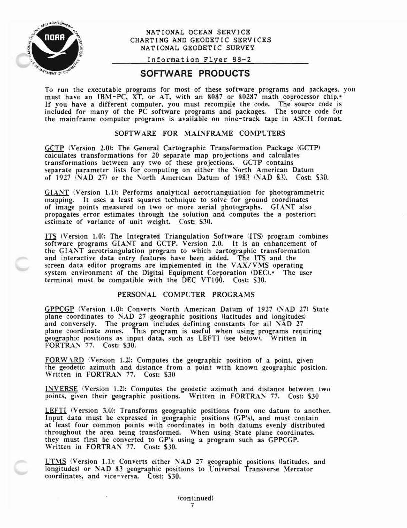

National Ocean Service Charting and Geodetic Services
National Geodetic Survey
Information Flyer 87-4
HP-41 CV CALCULATOR SOFTWARE FOR COMPUTATIONS ON THE NORTH AMERICAN DATUM
NOAAs National Geodetic Survey (NGS) provides software programs that perform horizontal geodetic computations on the North American Datum of 1927 (NAD 27) and the North American Datum of 1983 (NAD 83) These programs have been des igned to be used wi th the Hewlett Packard 4l-CV programmable calculator Each program is produced on a magnet i c strip and includes documentation with step-by-step instructions ali st i ng 0 f the mach i ne code and a sample problem wi th solut i on
Each of these programs costs $15 and can be ordered from
National Geodetic Information Center NCG174 Rockwall Bui ld i ng Room 24 Rockville Maryland 20852 Telephone 1-301-443-8631
Prepayment is required Make check or money order payable to NOAA Na t i onal Geodet i c Survey Payment may also be made by VISA American Express or MasterCard For orders sent outside the Un i ted Sta tes a 25 surcharge wi 11 be added to cove r additional postage
HP-41CV SOFTWARE FOR COMPUTATIONS ON ~AD 83
Program
55-41 GEODETIC INVERSE - computes the geodetic azimuths (forward and back) and distance between two points given the latitude and longitude of both points
51-41 GEODETIC FORWARD - computes the latitude and longitude of a point given the latitude and longitude of a starting point the forward geodetic azimuth and the length of the line between the points
54-41 TRA~SVERSE ~ERCATOR PROJECTION - computes geographic posltlons from state plane coordinates or state plane coordinates from geographic positions for states using the transverse mercator projection
42-41 LA~BERT PROJECTION - computes geographic positions from state plane coordinates or state plane coordinates from geographic positions for States using the Lambert conformal conic projection
43-41 ALASKA ZONES 2-9 PC TO GP AND GP TO PC - computes geographic positions from state plane coordinates and state plane coordinates from geographic positions in zones 2-9 of the Alaska State Plane Coordinate System
To product endorsement is intended or implied
(continued) 10
Pro~ram
49-41 AL-SKA PROJECTION ZONE 1 - computes state plane coordinates geographic positions and geographic positions from state plane coordinates in zone 1 of the Alaska State Plane Coordinate System
from
36-41 GP TO lJT1 A~D LT1 TO GP - computes Universal Transverse coordinates from geographic positions and computes geographic positions from Universal Transverse 1ercator coordinates
1ercator
37-41 SLOPE TO SEA LEVEL TO 1 ARK-TO- YfARK - reduces electronically measured distances to sea level and to mark -to-mark distances
38-41 SPHERICAL EXCESS - computes the spherical excess the closure and the two unknown sides of a triangle when the three angles and one side of the triangle are known
39-41 GEOGRAPHIC POSITION DETERMINED BY INTERSECTION OF TWO DIRECTIONS - computes the geographic position for a new station given four stations with known geographic positions and the direction (or angle) observations between the two pairs of known stations
40-41 ELEVATIONS FROM ZE~ITH DISTANCES - computes the difference of elevation between two stations when zenith distances are observed at one both of the stations and the slope length or sea level length between the stations is known
or
41-41 GP TRAVERSE AZD1uTHS OR AIiGLES - computes the geographic positions of stations along a traverse
45-41 ILLTIPLE INVERSE COMPlJTATIONS FOR SHORT LEiGTHS - computes geodetic inverses between stations when their geographic positions are known Lseful when several inverses are needed from one station A maximum of twenty stations can be entered at one time
44-41 ILLTIPLE GEOGRAPHIC POSITIONS FROM ONE STATION - computes the geographic position of one or more points when the directions and distances are given from a point with a known geographic position The azimuth and direction to an initial point must also be given
46-41 IiTERSECTION TRIANGLE - computes the of a triangle when two angles and a length
unknown (or unobserved) are known (or observed)
parts
47-41 RESECTION COMPUTATION uSING GEOGRAPHIC POSITIO~S shygeographic position of a point when the directions (or angles) to are known
computes the three points
HP-41CV SOFTWARE FOR COMPlJTAnONS ON fAD 27
0-41 GLAM - computes state plane coordinates from geographic positIOns and geographic positions from State plane coordinates for Guam
1-41 GEODETIC IiVERSE - computes the geodetic azimuths (forward and back) and distance between two points given the latitude and longitude of both points
2-41 GEODETIC FORWARD - computes the latitude and longitude of given the latitude and longitude of a starting point the forward geodetic azimuth and the length of the line between the points
a point
34-41 TRANSVERSE MERCATOR PROJECTION - computes geographic positIOns from state plane coordinates or state plane coordinates from geographic positions for states which use the Transverse Iercator Projection
(continued) 11
56-41 LAlBERT PROJECTION - computes geographic positions from state plane coordinates or state plane coordinates from geographic positions for states that use the Lambert Conformal Conic Projection
7-41 ALASKA ZONE 2-9 PC TO GP - computes geographic positions from state plane coordinates in zones 2-9 of the Alaska State Plane Coordinate System
8-41 ALASKA ZONES 2-9 GP TO PC - computes state plane coordinates from geographic positions in zones 2-9 of the Alaska State Plane Coordinate System
910-41 ALASKA PROJECTION ZONE 1 - computes state plane coordinates from geographic positions and geographic positions from state plane coordinates in Zone 1 of the Alaska State Plane Coordinate System
12-41 UTYI TO GP - computes geographic positions
Universal Transverse Mercator coordinates from
13-41 GP TO UTM - computes geographic positions 1ercator Coordinates
from Universal Transverse
14-41 SLOPE TO SEA LEVEL TO lARK -TO- MARK - reduces electronically measured distance to sea level and to mark-to-mark distances
15-41 SPHERICAL EXCESS - computes the spherical excess the closure and the two unknown sides of a triangle when the three angles and one side of the triangle are known
16-41 TRIA~GLE COMPUTATION - computes three types of triangles al 3 angles and 1 side known bJ 2 sides and included angles known c) 3 sides known
17-41 GEOGRAPHIC POSITIONS DETERJ1INED BY INTERSECTION OF TWO DIRECTIONS - computes the geographic position for a new station given four stations with known geographic positions and the direction (or angle) observations between the two pairs of known stations
18-41 ELEVATIONS FROM iON-RECIPROCAL ZENITH DISTANCE CSI~G SLOPE LENGTHS - computes the difference of elevation between two stations when zenith distance is observed at one of the stations and the slope length between the stations is known
19-41 ELEVATIONS FROM NON-RECIPROCAL ZENITH DISTANCES CSIiG SEA LEVEL LEiGTHS - computes the difference of elevation between two stations when a zenith distance is observed at one of the stations and the sea level length between the stations is known
20-41 ELEV ATIONS FROM RECIPROCAL ZENITH DISTA~CES CSING SLOPE LEiGTHS - computes the difference of elevation between two stations when zenith distances are observed at each station and the slope length between the station is known
21-41 ELEVATIONS FROM RECIPROCAL ZENITH DISTANCES USING SEA LENGTHS - computes the difference of elevation between two stations when zenith distances are observed at each station and the sea level length between the stations is known
LEVEL
continued 12
22-41 GP TRA~SVERSE - AZIMUTHS OR A~GLES - computes the geographic positions of stations along a traverse The geographic position of the initial station must be known Thereafter each stations length and azimuth to the next station must be known
23-41 RESECTION STATION COMPuTATION CSI~G PLANE COORDI~ATES shycomputes the plane coordinates of a station when the directions or angles to 3 fixed stations and plane coordinates of the fixed stations are known
24-41 MeLTIPLE INVERSE COMPUTATIONS FOR SHORT LE~GTHS - computes geodetic inverses between stations when the geographic positions of the stations are known Useful when several inverses are needed from one station Twenty stations can be entered at one time
25-41 ASTRONO~IC AZIMUTH DIRECTION METHOD - computes the astronmic azimuth between two stations from azimuth of a circumpolar star by the hour angle method
26-41 TAPE BASE COMPLTATIONS - used to reduce lengths measured with 50- meter invar tapes to sea -level distances
27-41 1CLTIPLE GEOGRAPHIC POSITIONS FROM ONE STATION shycomputes the geographic positions of 1 or more stations when the directions and distances are given from a station with a known geographic position Azimuth and direction to an initial station must also be known
28-41 LE~GTH EQUATION OR SIDE EQUATION - computes length or side equations
29-41 ECCE~TRIC REDuCTION - computes the corrections to direction observations when the theodolite is not centered over the mark or the object sighted is eccentric
30-41 INTERSECTION TRIANGLE - computes the unknown (or unobserved) parts of a triangle when two angles and a length are known (or observedl
31-41 ELECTRONIC DISTANCE MEASCREMENT LEAST SQCARE ADJLST1E~T shydetermines the scale and constant corrections of electronic distance measuring instruments by measuring over previously determined base lines
32-41 LIGHTWAVE REFRACTIVE INDEX CORRECTION - computes the refractive index correction for lightwave electronic distance measuring instruments
33-41 1 ICROWAVE REFRACTIVE INDEX CORRECTION - computes the refractive index correction for microwave electronic distance measured instruments
34-41 RESECTION STATION COMPLTATION liSING GEOGRAPHIC POSITIO~ shycomputes the geographic position of a station when the directions (or angles) to 3 fixed stations are known
35-41 GEOGRAPHIC POSITION TO SPACE COORDINATES TO GEOGRAPHIC POSITION - used to transform geographic positions on one ellipsoid to geographic positions on another ellipsoid Constants for the Clarke 1866 and WGS 72 ellipsoids are generated in the program Constants for other ellipsoids can be entered This program does not convert NAD 27 coordinates to NAD 83 values
Revised November 1988
13
NATIONAL OCEAN SERVICE CHARTING AND GEODETIC SERVICES
NATIONAL GEODETIC SURVEY
Information Flyer 90-3
1983 STATE PLANE COORDINATE SYSTEM LAMBERT PROJECTION TABLES
The National Geodetic Survey (NGS) has developed Lambert projection tables for the 1983 State Plane Coordinate System (spes 83) The tables use the Lambert conformal conic projection and allow users wi th a minimum of computing resources to compute State Plane Coordinates from geographic coordinates For each minute of latitude the tables give the corresponding mapping radius and the grid scale factor Wi th the values tabulated for the mapping radius users can compute plane coordinate values using elemen tary formula and a 10-digi t calculator The table method of computing coordinates supplements other methods and material presen ted in NOAA Manual NOS NGS 5 State Plane Coord i nate Systemof 1983 available fromNGS for $1000
States using the Lambert projection include Arkansas California Colorado Connecticut Iowa Kansas Kentucky Louisiana Maryland Massachusetts Michigan Minnesota Montana Nebraska North Carolina North Dakota Ohio Oklahoma Oregon Pennsylvania South Carolina South Dakota Tennessee Texas Utah virginia Washington West Virginia and wi scon sin
NGS has not yet developed coordinate conversion tables for states using the transverse Mercator projection These states include Alabama Arizona Delaware Georgia Hawaii Idaho Illinois Indiana Maine Mississippi Missouri Nevada New Hampshire New Jersey New Mexico Rhode Island Vermont and Wyoming The States of Florida and New York use both Lambert and transverse Me rca tor pro j ect ions The Sta te of Alaska uses the transverse Mercator oblique Mercator and Lambert projections
The cost for each Lambert projection table (one coordinate zone) is $7 00 and prepaymen tis requi red Please make your check or money order payable to NOAA National Geodetic Survey You may also pay using VISA MasterCard or American Express For orders sent outside the United States a 25 surcharge will be added to cover additional postage costs Please specify the state(s) and the coordinate zone(s) youwant
To order please write or call
National Geodetic Information Center NCG174 Rockwall Building Room 24 National Geodetic Survey NOAA Rockville MD 20852 Telephone 1-301-443-8631
Revised May 1990
14
NATIONAL OCEAN SERVICE CHARTING AND GEODETIC SERVICES
NATIONAL GEODETIC SURVEY
Information Flyer 88-8
GEODETIC AND CHARTING PUBLICATIONS BOOKLET
NOAAs Na t i ona1 Geodet i c Survey (NGS) provides a free booklet 1 i st i ng available publications on geodesy charting and related topics including plane coordinate systems numerical analysis astronomy and geophysics NGS offers many publications on topics of current interest such as the North Amer ican Da tum of 1983 (NAD 83) the North American Vertical Datum of 1988 (NAVD 88) the NAVSTAR Global Pos i t i on i ng System (GPS) and the resul ts of research and developmen t stud i es in geodesy mappi ng and chart i ng Some of these publ i ca t i on s include
GPS survey of a crustal motion network near Mammoth Lakes Cal i forn i a NOAA Techn i cal Report NOS 123 NGS 41 byR Snayetal 1987 Cost $150
Procedures and Standards for a Multipurpose Cadastre byNationalAcademyof Sciences 1983 Cost $500
Standards and Specifications for Geodetic Control Networks by Federal Geodetic Control Commi ttee 1984 Cost $175
Geodesy f or the Layman by R K Burkard USAF 1983 (NOAA reprint Cost $450
Geometric Geodetic Accuracy Standards and Specifications for Using GPS Relative Posi tioning Technigues by Federal Geodetic Control Commi ttee 1988 Cost $275
Geodet i c Glossary by Na t i onal Geodet ic Survey 1986 Cost $1300
Input Formats and Specifications of the National Geodetic Survey Data Base by Federal Geodetic Control Committee 1989 Cost $1200
State Plane Coord i na te System of 1983 (SPCS 83) by Stem James E 1989 Cost $1000
The geodetic and charting publications booklet describes how to order publications available fromNGS To obtain a copy write or call
National Geodetic Information Center NCG174 Rockwall Building Room 24 National Geodetic Survey NOAA Rockvi lIe MD 20852 Telephone 1-301-443-8631
Revised December 1989
15
NATIONAL OCEAN SERVICE CHARTING AND GEODETIC SERVICES
NATIONAL GEODETIC SURVEY
Information Flyer 86-13
PUBLICATIONS AVAILABLE ON NAD 83
The Iiorth American Datum of 1983 (NAD 83) based on the adjustment of a quarter of a million points provides a unified consistent network of latitude and longitude values for the entire North American continent This network is used by surveyors regional planners and a variety of others who depend on accurate and reliable horizontal reference data Listed below is a sampling of NGS publications describing various aspects and applications of NAD 83 To order any of these publications complete the requested information and mail with payment to
Iiational Geodetic Information Center NCGI74 Rockwall Building Room 24 Iiational Geodetic Survey NOAA Rockville ~aryland 20852 Te~phon~ 1-301-443-8631
Make check or money order payable to NOAA iational Geodetic Survey You may also use VISA American Express or MasterCard For orders sent outside the linited States a 25 surcharge will be added to cover additional postage
() fOAA Completes North American Datum Readjustment by Vogel SA 1986 4 pp $100 Iio of copies ordered __
() The Iiew Horizontal Control Datum for Iorth America iAD 83 by Vogel SA 1986 34 pp $200 No of copies ordered
() Impact of Iorth American Datum of 1983 by Wade EB 1986 14 pp $100 No of copies ordered __
() ~ AD 83 Publication by Spencer JF and Bishop WR 1986 8 pp $100 No of copies ordered __
( ) Alaska Test of the Helmert Blocking Phase of the iorth American Datum by Vorhauer ML and Wade EB 1985 10 pp $100 io of copies ordered
Datum Transformation from NAD 27 to AD 83 by Wade EB and Doyle DR 1987 9 pp $100 Iio of copies ordered __
Mark Maintenance and the ~ew Adjustment of the Iiorth American Datum by Challstrom CW 1982 10 pp $100 No of copies ordered __
Proceedings of Second International Symposium on Problems Related to the Redefinition of North American Geodetic ~etworks Arlington VA 1978 645 pp $1750 No of copies ordered __
() Project REDEAM Models for Historical Horizontal Deformation by Snay RA Cline M W and Timmerman EL NOAA Technical Report iOS 125 ~GS 42 1987 76 pp $375 No of copies ordered __
() iOAA Technical Memorandum NOS NGS-19 HOACOS A Program for Adjusting Horizontal Networks in three dimensions by Vincenty T 1979 13 pp $100 No of copies ordered __
() iOAA Technical Memorandum NOS iGS-25 Revisions of the HOACOS height-controlled network adjustment program by Vincenty T 1980 5 pp $100 Iio of copies ordered _
Revised December 1989
16
NATIONAL OCEAN SERVICE CHARTING AND GEODETIC SERVICES
NATIONAL GEODETIC SURVEY
Information Flyer 89-3
MULTIPURPOSE LAND INFORMATION SYSTEMS
THE GUIDEBOOK
The Federal Geodetic Control Committee is publishing a guidebook for developing multipurpose land information systems (multipurpose LIS or MPLIS) The guidebook builds on the National Research Councils publications on the multipurpose cadastre and focuses on local governments role in developing the mul t i purpose cadast re I t provide s guidance to sta te s counties cities and regional planning bodies and presents theoretical and empirical information currently available on how to develop land information systems
The guidebook is intended for those who must evaluate plan and implement land i nformat ion system development If the reader has to perform a particular task the book describes how -- or how to find out how -- to do it I f the reader has to make a decision concerning LIS it provides background information to use in making the decision as well as a discussion of the implications of the decision The guidebook also covers the planning process institutional context organizational models operating procedures standards pitfalls and other issues
The guidebook costs $36 and is bound in a looseleaf notebook The looseleaf format accommodates the additions revisions and upda tes i nheren tin th i s rap idly evolvi ng field One section is reserved for technical bulletins issue papers updates additions and other revisions
To order the guidebook or to receive updates and additions complete the i nf orma t i on on the back of th i s sheet and return it bymail Just fold staple andmail it with the preprinted address on the outside Prepayment is required Make your check payable to NOAA Na t i onal Geode tic Survey You may also place your orde r by call i ng the Na t i onal Geodet i c Information Branch at 1-301-443-8631 and you may pay using VI SA Amer i can Expre s s or Mas terCard A 25 surcharge covering postage will be added to orders sent outside the united States
Revised April 1990
(over)
17
ORDERING AND REGISTRATION
I am ordering __ copies of Y1ultipurpose Land Information Systems The Guidebook at 536 per copy Y1y check made out to iOAA iational Geodetic Survey is enclosed Payment may also be made using VISA Y1asterCard or American Express
Send to Y1asterCard
Visa
American Express
Expiration date
Work Telephone
Home Telephone
This order entitles me to have a registered copy of The Guidebook which will automatically provide me with updates and additions
lS Department of Commerce iational Oceanic and Atmospheric Administration iOS Charting and Geodetic Services ~ational Geodetic Survey Division oICG174 Rockville Y1aryland 20852
~ 0 S T A ~ E 0 E S ~ cOfficial Business IIS J~JJ laquo ~ 0 co r poundc E
Penalty for Private ese $300 COM-IO
National Geodetic Information Center NCG174 Rockwall Building Room 24 National Geodet ic Survey NOAA Rockville MD 20852
18
NATIONAL OCEAN SERVICE CHARTING AND GEODETIC SERVICES
NATIONAL GEODETIC SURVEY
Information Flyer 86-1
PUBLICATIONS AVAILABLE ON GLOBAL POSITIONING SYSTEM
The Global Positioning System (GPS) is revolutionizing timing navigation geodesy and other disciplines The National Geodetic Survey (NGS) performs research and development in precise positioning us i ng GPS NGS provides the followi ng GPS publ icat ions and papers which discuss GPS surveying techniques To order any of these GPS documents complete the information requested below and mail wi th payment to NOAA National Geodetic Information Center NCG174 Rockvi lIe Maryland 20852 You may pay by check or money order (payable to National Geodetic Survey) or by VISA MasterCard or American Express For orders sent outside the United States a surcharge of 25 will be added to cover additional postage For additional information call 1-301-443-8631
( ) NOAA Technical Report lOS 110 IGS-32 Orthometric height determination using GPS observations and the integrated geodesy adjustment model by Hein G W 1985 16 pp ($100 each) No of copies ordered
Global Positioning System carrier phase description and use by Remondi B Woo 1985 17 pp ($125 each) 10 of copies ordered
IOAA Technical Memorandum NOS NGS-43 Performing centimeter-level surveys in seconds with GPS carrier phase initial results by Remondi B W 1985 18 pp ($125 each) No of copies ordered
( ) Lsing the Global Positioning System (GPS) Phase Observable for Relative Geodesy Modeling Processing and Results PHD dissertation Lniv of Texas by Remondi B W 1984 360 pp ($1700 each) No of copies ordered
( ) Federal Geodetic Control Committee - Report on Test and Demonstration of 1acrometer Model V -1000 Interferometric Surveyor by Hothem LD and Fronczek cJ 1983 36 ppbull ($200 each) 0[0 of copies ordered
( ) Distribution of Global Positioning System Ephemerides by the National Geodetic Survey by Remondi B W ACSM spring meeting 1arch 1986 preprint 7 pp ($100 each) 0[0 of copies ordered
Decimeter Precision Aircraft Positioning using GPS Carrier Phase by 1ader GL 1986 17 pp ($125 each) No of copies ordered
Precise Geodetic Surveying with Code and Carrier Phase Tracking GPS Receivers by Soler T Hothem LD and Fury RJ 1986 18 pp ($125 each) 10 of copies ordered _
( ) Network Design Strategies Applicable to GPS Surveys Using Three or Four Receivers by Snay RA 1986 22 pp ($150 each) No of copies ordered _
( ) Procedures for Processing GPS Phase Observations at the Iational Geodetic Survey by Kass WG and Dulaney R 1986 13 pp ($100 each) No of copies ordered
(continued) 19
) GPS Instrumentation and Federal Policy by Bossler JDbull and Challstrom e Woo 1985 9 pp ($100 each) To of copies ordered
( ) 1odeling the GPS Carrier Phase for Geodetic Applications by Remondi BW 1985 12 pp ($100 each) io of copies ordered
( ) Precise Relative Position Determination Csing Global Positioning System Carrier Phase 1easurements in a Nondifference Mode by Goad ee 1985 10 ppbullbull ($100 each) lo of copies ordered
( ) High - Precision Three- Dimensional Differential Positioning Using GPS by Strange WE 1985 6 pp ($100 each) lo of copies ordered
( ) A Comparison between Global Positioning System and Very Long Baseline Interferometry Surveys in Alaska and Canada by Mader GL and Abell MD 1985 8 pp ($100 each) ~o of copies ordered
( ) Factors to be Considered in Development of Specifications for Geodetic Surveys using Relative Positioning GPS Techniques by Hothem LD and Williams GEbull 1985 12 pp ($100 each) -fo of copies ordered
( ) GPS Satellite Surveying - Practical Aspects by Hothem LD Goad ee and Remondi BW 1984 16 pp ($100 each) lo of copies ordered
( ) Preliminary Analysis of an Operational Global Positioning System Control Survey by Milbert DG 1984 21 pp ($150 each) 10 of copies ordered
( ) Application of the Variance Factor Test to a Global Positioning System Survey by 1ilbert DG 1985 11 pp ($100 each) -10 of copies ordered
( ) Tetwork Adjustment of Correlated Coordinate Difference Observations by 1ilbert DG and Kass WG 1985 9 pp ($100 each) No of copies ordered
( ) Kinematic GPS Land Survey- - Description of Operational Test and Results by finkel DH 1988 16 pp ($100 each) ~o of copies ordered
( ) Recent Advances in Kinematic GPS Photogrammetry by Lucas J R and 1ader GL 1988 18 pp ($125 each) Iio of copies ordered
( ) Geometric Geodetic Accuracy Standards and Specifications for Using GPS Relative Positioning Techniques Version 50 Federal Geodetic Control Committee 1988 (preliminary document) 54 pp ($275 each) io of copies ordered
Reprinted December 1989
20
NATIONAL OCEAN SERVICE CHARTING AND GEODETIC SERVICES
NATIONAL GEODETIC SURVEY
Information Flyer 87-1
PUBLICATIONS AVAILABLE ON NAVD 88
In 1978 the National Geodetic Survey (NGS) initiated a program to redefine the National Geodetic Vertical Datum of 1929 (NGVD 29) and perform a general readjustment of the vertical control portion of the National Geodetic Reference System This new datum the North American Vertical Datum of 1988 (N AVD 88) will incorporate recent releveling of 80000 km of the NGS first-order vertical control network as well as the latest techniques to remove known systematic errors and account for vertical crustal motion
This project will for the first time provide a computer- accessible integrated data base of all NGS validated vertical control data for crustal motion and other scientific applications as well as a unified consistent set of bench mark heights for the North American continent Completion of the project is scheduled for 1991 The following is a sample of NA VD 88 publications available from ~GS
To order any of these publications complete the requested information and mail with payment to
National Geodetic Information Center NCG174 Rockwall Building Room 24 National Geodetic Survey NOAA Rockville ~aryland 20852 USA Te~phon~ 1-301-443-8631
1ake check or money order payable to NOAA National Geodetic Survey Payment may also be made by VISA American Express or 1asterCard
( ) Proceedin~s Third International Symposium on the North American Vertical Datum Rockville liD 1985 480 pp S1800 each oio of copies ordered
Impact and Benefits of the North American Vertical Datum of 1988 by Zilkoski 08 1985 10 pp $100 each ~o of copies ordered __
New Adjustment of the North American Vertical Datum Article No 23 NA VD 88 Status Report Young GM 1988 2 pp $100 each No of copies ordered __
() New Adjustment of the North American Vertical Datum Article 21 Block Validation Bengston J 1986 3 pp $100 each oio of copies ordered __
() NOAA Technical ~emorandum NOS NGS-45 Empirical Calibration of Zeiss NI -1 Level Instruments to Account for IIagnetic Errors by Holdahl SR 1986 23 pp 5150 each No of copies ordered __
Reprinted December 1989
21
National Ocean Service Charting and Geodetic Services
National Geodetic Survey
Information Flyer 86-8
WORKSHOP PROGRAM
The National Geodetic Survey (NGS) announces several workshops available for presentation throughout the United States The workshops are cooperative ventures involving NGS the American Congress on Surveying and Mapping (ACSM) and other organizations such as un i vers i ties NGS also develops new workshops upon request provided it has the expe rt i se and resources necessary
SURVEY INSTRUMENTATION AND COORDINATE CONVERSION is a 3-day workshop on the proper field use and calibration of electronic distance measuring equipment and theodolites computations using the State Plane Coordinate System and adjustments of survey data
COORDINATE TRANSFORMATION is a I-day workshop covering the NAD 83 State Plane Coordinate system the new horizontal control data sheet datum transformations and coordinate transformations from other datums to NAD 83
VERTICAL CONTROL is a 2-day workshop covering geodetic leveling principles vertical control networks height systems and datums vertical survey planning leveling standards and specifications data reduction computations data analysis methods and establishing vertical control using trigonometric leveling or the Global Positioning System (GPS)
GPS SATELLITE SURVEYING is a 2-day seminar on the characteristics of GPS surveys differences from local terrestrial coordinate systems observation techniques data processing and preparing data for submission to NGS
NGS PRODUCTS AND SERVICES a 2-hour workshop summar i zes curren t NGS products and program activities including data software and pubI i ca t ion s the NGS advi sor servi ce and related se rvi ces
BLUE BOOK WORKSHOP is a 2-hour overview of the Input Formats and Specifications of the National Geodetic Survey Data Base (Blue Book) Data elements computer needs and file structures required to put into computer-compatible form a horizontal or vertical control survey are discussed
THE SURVEY MARK RECOVERY PROGRAM is a 2-hour workshop on procedures for reporting the condition of geodetic control stations
For more information on the NGS Workshop Program please contact Mr Ed McKay NOAA (NCGI3) Rockville Maryland 20852 Telephone 1-301-443-8567 or Mr William Wallace NOAA (NCG17) Rockville Maryland 20852 Telephone 1-301-443-8281
Reprinted June 1989
22
----------------------------------
NATIONAL OCEAN SERVICE CHARTING AND GEODETIC SERVICES
NATIONAL GEODETIC SURVEY
AUTOMATIC MAILING SERVICE
The National Geodetic Survey (NGS) provides an automatic mailing service to users of geodetic data and related products NGS notifies users of newly published geodetic data in areas they specify and issues flyers announcing other geodetic products To receive notificaton of products please complete the informashytion below and mail to the address on the back of this flyer
Company 0 r Agency _
Name-----------------------------------shyAddress
Area Code and Telephone Number _
Indicate categories for which you wish to receive notification
___Horizontal Geodetic Data Coordinate Lists Horizontal Control Quads and Survey Project Data
___Vertical Geodetic Data Vertical Control Quads and Survey Project Data
___Gravity Data
___Geodetic Control Diagrams
___Calibration Base Lines
___Software and Digital Data
___Publ ications
Indicate your area of interest for these data categories by providing a detailed description (eg states counties 30 quadrangle area or latitude and longitude boundaries) or by attaching a small map
(over) 23
Mailing Instructions
Triple fold staple andmail this information toNOAAwith the prepr i n ted address on the outs ide To obta i n add it i onal copi es contact the National Geodetic Information Center by mail at the address shown below or by telephone at l-30l-~43-863l
Revised June 1989
LS Department of Commerce ~ational Oceanic and Atmospheric Administration iOS Charting and Geodetic Services ational Geodetic Survey Division fCG174 Rockville Vlaryland 20852
po T ~E 0 - g flC us ~l[ IIlWeuroNO CO~(CEOfficial Business
Oll-210Penalty for Private Use $300
National Geodetic Information Center NCGl74 Rockwall Building Room 24 National Geodetic Survey NOAA Rockville MD 20852
24
National Ocean Service Charting and Geodetic Services
National Geodetic Survey
Information Flyer 90-4
PROTECTING SURVEY MARKERS
The oiational Geodetic Survey (NGS) has established approximately one million permanent survey markers at precisely measured points Other organizations have also established such markers They provide the common base of reference for latitude longitude height scale orientation and gravity measurements used throughout the United States lost of these points are marked by metal disks about 3 inches in diameter or in some instances metal rods under a hinged cover When a survey marker is removed or displaced its value is lost We ask the publics cooperation in protecting them
If you find a survey m~rker out of the ground send it to NGS at the address below along with the name of the state and county where the mark was located If you use a survey marker please send us a recovery sheet (printed below) to update our files and provide all users with more up-to-date information You can obtain additional sheets free by calling iGS at 1-301-443-8631 We will also provide at no cost a stamped disk for marking the new location of a displaced station mark a return mailing bag for the old disk and information needed to move the mark We can refer you to other agencies if you do not know who to contact about their marks
oiGS sponsors a cost-sharing advisory program with several states The advisors instruct local surveyors on how to use and preserve the National Geodetic Reference System Their names and addresses are listed below For more information on the advisor program please call 1-301-443-8143 If you know of a survey marker in danger of being disturbed or destroyed contact the advisor for the state in which the marker is located You can help by having the following information when you call
1 The state and county where the marker is located 2 The designation stamped on the marker and the agency
that set the mark (usually cast in the marker) 3 What will happen to the marker and whether there is
a site nearby where the marker can be reset 4 Can you or another party move the marker if provided
a new marker and information on how to reset it
For a state that does not have an NGS advisor listed you may contact
Geodetic lark Preservation Center AT1I Richard Cohen iOAA RC 325 Broadway Boulder CO 80303 Te~phon~ 1-303-497-6530
The following states have ~GS geodetic advisors
ALABAMA BILL RINDAL 1409 Coliseum Blvd Design Bureau Alabama Highway Dept Montgomery AL 36130 Telephone 1-205-242-6597
ALASKA JOSEPH D DmiddotONOFRIO NOS Coordinator Div Land amp Water Management PO Box 107028 Anchorage AK 99510-7028 Telephone 1-907-762 -2422
FLORIDA RONNIE TAYLOR FL DNR Bureau of Surveys amp Mapping Suite 309 3900 Commonwealth Blvd Tallahassee FL 32303 Telephone 1-904-488-2427
GEORGIA JEFFREY R OLSEN Georgia Dapartment of Community Affairs 1200 Equitable Building 100 Peachtree Street Atlanta GA 30303 Telephone 1-404-656-3836
ltContinued) 25
IDAHO
ILLINOIS
KANSAS
LOUISIANA
MARYLAND
MASSACHUSETTS
MICHIGAN
MINNESOTA
MISSISSIPPI
MONTANA
NEBRASKA
NEW HAMPSHIRE
NEW JERSEY
NEW MEXICO
OHIO
OREGON
RHODE ISLAND
SOUTH CAROLINA
SOUTH DAKOTA
WASHINGTON
WISCONSIN
LAiSON OFFICER Fort Sill OKLAHOMA
BERNARD E KELLY State of Idaho Division of Highways PO Box 7129 Boise 10 83707 Telephone 1-208-334-8476
RONALD K BREWER Illinois Department of Transportation Aerial Surveys Section 2300 South Dirksen Parkway Springfield IL 62764 Telephone 1-217-524-4890
JAMES E FUCHS Kansas Department of Transportation Survey Section Bureau of Design Docking State Office Building Topeka KS 66612 - 1568 Telephone 1-913-296-6835
ROBERT ZURFLUH Louisiana Department of Transportation Location and Survey Division PO Box 94245 1201 Capitol Access Road Baton Rouge LA 70804 Telephone 1-504-379-1134
RALPH POUST Field Operations Bureau of Plats and Surveys MD Dept of Transportation 707 North Calvert Street Baltimore MD 21202 Telephone 1-301-333-1240
ALFRED BAUGH Bureau of Transportation Dept of Public Works Planning and Development Ten Park Plaza Room 4260 Boston MA 02116 Telephone 1-617-973-7463
RONALD L RAMSEY PO Box 30050 425 W Ottawa St Lansing MI 48909 Telephone 1-517-377-1510
DIXON HOYLE NOAA Geodetic Unit Transportation Building Room 71 John Ireland Boulevard St Paul MN 55155 Telephone 1-612-296-1542
DONALD D REXRODE PO Box 6366 Jackson MS 39208 1-601-954-9098
CHARLES WRIGHT National Geodetic Survey PO Box 290 East Helena MT 59635 Telephone 1-406-449-5095
JERRY ODUM PO Box 2113 Station B Lincoln NE 68502 Telephone 1-402-479-4379
CURTIS CROW NGS NHDOT - Survey Section PO Box 483 Concord NH 03302-0483 Telephone 1-603-271-1600
BERNARD PUTZIGER NJ Dept of Transportation Geodetic Survey Section CN600 1035 Parkway Avenue Trenton NJ 08625 Telephone 1-609-530-5654
WILLIAM STONE PO Box 91292 Albuquerque NM 87102 Telephone 1-505 -764~ 1584
DAVID A CONNER 1212 Kinnear Rd Columbus OH 43212 Telephone 1-614-292-1619
LYLE RIGGERS Oregon Dept of Transportation PO Box 12114 Salem OR 97310 Telephone 1- 503- 378- 5458
MILO ROBINSON RI Dept of Transportation Survey Section State Office Bldg RM 244 Smith Street Providence RI 02903 Telephone 1-401-277-2814
LEO GITTINGS SC Geodetic Survey 5 Geology Road Columbia SC 29210 Telephone 1-803-737-9485
WESLEY ODUM NGS PO Box 338 Pierre SO 57501-0338 Telephone 1-605-773-5465
DENNIS WEGENAST 8021 52nd Avenue West Mukilteo WA 98275 Telephone 1-800-232-1089 1-206-586-5841
Or D DAVID MOYER University of Wisconsin 610 Walnut Street Room 1050 Madison WI 53705 Telephone 1-608-262-5066
LCDR GEORGE E LEIGH US Army Field Artillery School DCD ATTN ATSF-NOAA Building 700 Knox Hall 2nd Floor Ft Sill OK 73503-5600 Telephone 1-405-351-2953
Revised June 1990 Supersedes Flyers 88-6 88-7
(continuedgt 26
-------------
RECOVERY OF A SURVEY MARKER National Geodetic Survey
(Follow the numbered instructions below)
(1) PIDACRN (2) QID QSN------- shy(3) STATION NAME
(4) DISK STAMPED (5) YEAR ESTABLISHED STATECOUNTY _
( 6) ORGAN I ZAT IONS MARK _
(7) RECOVERY BY DATE RECOVERED ___
(8) ORGANIZATION
ADDRESS
( 9) RECOVERY COND IT ION GOOD POOR DESTROYED NOT FOUND
(10) Please list any pertinent information for locating this survey marker
JUNE 1990
INSTRUCTIONS FOR COMPLETING THIS RECOVERY SHEET
1 Record the PID or ACR~ identifier as it appears on the printed description if it appears (Either the PIDI ACRi identifier or the QIDQSN identifier should appear on the station descri ption)
2 Record the QIDQSN identifiers as they appear on the printed description if they appear
3 Record the STATION NAME from the printed description 4 Record what is STAlPED on the disk 5 Record the YEAR ESTABLISHED from the printed description 6 In the space for ORGANIZATIONS lARK record what is cast in the disk 7 Record who RECOVERED the marker and the month and year the marker was visited 8 If applicable record your ORGANIZATIONs name and ADDRESS 9 Record the CONDITION of the disk - either GOOD POOR DESTROYED or
lOT FOUND 10 Please record only those comments which would be necessary for another person
to recover the same disk
(continued) 27
Mailing Instructions
Triple fold tape and mail this information to NOAA with the preprinted address on the outside To obtain addi tional copies contact the National Geodetic Information Center by mail at the address shown below or by telephone at 1-301-443-8631
June 1990
- - - - - - - - - - - - - - - - - - - - - - - - - - FOLD HERE - - - - - - - - - - - - - - - - - - - - - - - - - - - - - - shy
- - - - - - - - - - - - - - - - - - - - - - - - - - FOLD HERE - - - - - - - - - - - - - - - - - - - - - - - - - - - - - - shy
US Department of Commerce ~ational Oceanic and Atmospheric Administration ~OS Charting and Geodetic Services ~ational Geodetic Survey Division ~CG174 Rockville vtaryland 20852
p ~ T 6 G pound AO amp1 S -=a C
J s ~CPATwa T QF CObolCIC EOfficial Business CON-Zl0 Penalty for Private Use $300
National Geodetic Information Center NCG17 Rockwall Building Room 21 National Geodetic Survey NOAA Rockvi lIe MD 20852
28
NATIONAL OCEAN SERVICE CHARTING AND GEODETIC SERVICES
NATIONAL GEODETIC SURVEY
Information Flyer 85-3
CALIBRATION BASE LINE PROGRAM
A calibration base line (CBL) is a precisely measured straight-line course of approximately 1400 m used to calibrate Electronic Distance Measuring Instruments (EDMI) A CBL usually consists of four segments ranging from 150 to 1400 m whose lengths are measured using four standardized tapes and two high-precision EDMI Since the program began in 1974 NGS has established more than 275 base lines throughout the United States in cooperation with government agencies universities and professional groups
Gf-------1Qr---------jG]r-----------------lc
o m 150 m 430 at 1400 m
TYPICAL CALIBRAnON BASE LINE CONFIGURATION
Participating organizations must select a suitable site install the base line markers 2 to 3 months before measurement by the NGS field team and provide 3 to 5 surveying personnel to assist in the measurements The site must be accessible for public use and the adjusted distances are available to the public NGS provides booklets detailing the appropriate procedure for selecting a site installing the markers and using the CBL
Organizations wishing to establish aCBL should contact
National Geodetic Survey NOAA Planning and Requirements Staff NCG1x10 Rockwall Building Room 110 Rockvil1eMD 20852
OTHER INFORMATION SOURCES
Field Surveys Operations Branch NCG16 1-301-443-8141
t~ ~ IPublished CBL Distances National Geodetic Information Center NCG174 1-301-443-8631
Reprinted February 1990
29

NATIONAL OCEAN SERVICE CHARTING AND GEODETIC SERVICES
NATIONAL GEODETIC SURVEY
Information Flyer 86-13
PUBLICATIONS AVAILABLE ON NAD 83
The Iiorth American Datum of 1983 (NAD 83) based on the adjustment of a quarter of a million points provides a unified consistent network of latitude and longitude values for the entire North American continent This network is used by surveyors regional planners and a variety of others who depend on accurate and reliable horizontal reference data Listed below is a sampling of NGS publications describing various aspects and applications of NAD 83 To order any of these publications complete the requested information and mail with payment to
Iiational Geodetic Information Center NCGI74 Rockwall Building Room 24 Iiational Geodetic Survey NOAA Rockville ~aryland 20852 Te~phon~ 1-301-443-8631
Make check or money order payable to NOAA iational Geodetic Survey You may also use VISA American Express or MasterCard For orders sent outside the linited States a 25 surcharge will be added to cover additional postage
() fOAA Completes North American Datum Readjustment by Vogel SA 1986 4 pp $100 Iio of copies ordered __
() The Iiew Horizontal Control Datum for Iorth America iAD 83 by Vogel SA 1986 34 pp $200 No of copies ordered
() Impact of Iorth American Datum of 1983 by Wade EB 1986 14 pp $100 No of copies ordered __
() ~ AD 83 Publication by Spencer JF and Bishop WR 1986 8 pp $100 No of copies ordered __
( ) Alaska Test of the Helmert Blocking Phase of the iorth American Datum by Vorhauer ML and Wade EB 1985 10 pp $100 io of copies ordered
Datum Transformation from NAD 27 to AD 83 by Wade EB and Doyle DR 1987 9 pp $100 Iio of copies ordered __
Mark Maintenance and the ~ew Adjustment of the Iiorth American Datum by Challstrom CW 1982 10 pp $100 No of copies ordered __
Proceedings of Second International Symposium on Problems Related to the Redefinition of North American Geodetic ~etworks Arlington VA 1978 645 pp $1750 No of copies ordered __
() Project REDEAM Models for Historical Horizontal Deformation by Snay RA Cline M W and Timmerman EL NOAA Technical Report iOS 125 ~GS 42 1987 76 pp $375 No of copies ordered __
() iOAA Technical Memorandum NOS NGS-19 HOACOS A Program for Adjusting Horizontal Networks in three dimensions by Vincenty T 1979 13 pp $100 No of copies ordered __
() iOAA Technical Memorandum NOS iGS-25 Revisions of the HOACOS height-controlled network adjustment program by Vincenty T 1980 5 pp $100 Iio of copies ordered _
Revised December 1989
16
NATIONAL OCEAN SERVICE CHARTING AND GEODETIC SERVICES
NATIONAL GEODETIC SURVEY
Information Flyer 89-3
MULTIPURPOSE LAND INFORMATION SYSTEMS
THE GUIDEBOOK
The Federal Geodetic Control Committee is publishing a guidebook for developing multipurpose land information systems (multipurpose LIS or MPLIS) The guidebook builds on the National Research Councils publications on the multipurpose cadastre and focuses on local governments role in developing the mul t i purpose cadast re I t provide s guidance to sta te s counties cities and regional planning bodies and presents theoretical and empirical information currently available on how to develop land information systems
The guidebook is intended for those who must evaluate plan and implement land i nformat ion system development If the reader has to perform a particular task the book describes how -- or how to find out how -- to do it I f the reader has to make a decision concerning LIS it provides background information to use in making the decision as well as a discussion of the implications of the decision The guidebook also covers the planning process institutional context organizational models operating procedures standards pitfalls and other issues
The guidebook costs $36 and is bound in a looseleaf notebook The looseleaf format accommodates the additions revisions and upda tes i nheren tin th i s rap idly evolvi ng field One section is reserved for technical bulletins issue papers updates additions and other revisions
To order the guidebook or to receive updates and additions complete the i nf orma t i on on the back of th i s sheet and return it bymail Just fold staple andmail it with the preprinted address on the outside Prepayment is required Make your check payable to NOAA Na t i onal Geode tic Survey You may also place your orde r by call i ng the Na t i onal Geodet i c Information Branch at 1-301-443-8631 and you may pay using VI SA Amer i can Expre s s or Mas terCard A 25 surcharge covering postage will be added to orders sent outside the united States
Revised April 1990
(over)
17
ORDERING AND REGISTRATION
I am ordering __ copies of Y1ultipurpose Land Information Systems The Guidebook at 536 per copy Y1y check made out to iOAA iational Geodetic Survey is enclosed Payment may also be made using VISA Y1asterCard or American Express
Send to Y1asterCard
Visa
American Express
Expiration date
Work Telephone
Home Telephone
This order entitles me to have a registered copy of The Guidebook which will automatically provide me with updates and additions
lS Department of Commerce iational Oceanic and Atmospheric Administration iOS Charting and Geodetic Services ~ational Geodetic Survey Division oICG174 Rockville Y1aryland 20852
~ 0 S T A ~ E 0 E S ~ cOfficial Business IIS J~JJ laquo ~ 0 co r poundc E
Penalty for Private ese $300 COM-IO
National Geodetic Information Center NCG174 Rockwall Building Room 24 National Geodet ic Survey NOAA Rockville MD 20852
18
NATIONAL OCEAN SERVICE CHARTING AND GEODETIC SERVICES
NATIONAL GEODETIC SURVEY
Information Flyer 86-1
PUBLICATIONS AVAILABLE ON GLOBAL POSITIONING SYSTEM
The Global Positioning System (GPS) is revolutionizing timing navigation geodesy and other disciplines The National Geodetic Survey (NGS) performs research and development in precise positioning us i ng GPS NGS provides the followi ng GPS publ icat ions and papers which discuss GPS surveying techniques To order any of these GPS documents complete the information requested below and mail wi th payment to NOAA National Geodetic Information Center NCG174 Rockvi lIe Maryland 20852 You may pay by check or money order (payable to National Geodetic Survey) or by VISA MasterCard or American Express For orders sent outside the United States a surcharge of 25 will be added to cover additional postage For additional information call 1-301-443-8631
( ) NOAA Technical Report lOS 110 IGS-32 Orthometric height determination using GPS observations and the integrated geodesy adjustment model by Hein G W 1985 16 pp ($100 each) No of copies ordered
Global Positioning System carrier phase description and use by Remondi B Woo 1985 17 pp ($125 each) 10 of copies ordered
IOAA Technical Memorandum NOS NGS-43 Performing centimeter-level surveys in seconds with GPS carrier phase initial results by Remondi B W 1985 18 pp ($125 each) No of copies ordered
( ) Lsing the Global Positioning System (GPS) Phase Observable for Relative Geodesy Modeling Processing and Results PHD dissertation Lniv of Texas by Remondi B W 1984 360 pp ($1700 each) No of copies ordered
( ) Federal Geodetic Control Committee - Report on Test and Demonstration of 1acrometer Model V -1000 Interferometric Surveyor by Hothem LD and Fronczek cJ 1983 36 ppbull ($200 each) 0[0 of copies ordered
( ) Distribution of Global Positioning System Ephemerides by the National Geodetic Survey by Remondi B W ACSM spring meeting 1arch 1986 preprint 7 pp ($100 each) 0[0 of copies ordered
Decimeter Precision Aircraft Positioning using GPS Carrier Phase by 1ader GL 1986 17 pp ($125 each) No of copies ordered
Precise Geodetic Surveying with Code and Carrier Phase Tracking GPS Receivers by Soler T Hothem LD and Fury RJ 1986 18 pp ($125 each) 10 of copies ordered _
( ) Network Design Strategies Applicable to GPS Surveys Using Three or Four Receivers by Snay RA 1986 22 pp ($150 each) No of copies ordered _
( ) Procedures for Processing GPS Phase Observations at the Iational Geodetic Survey by Kass WG and Dulaney R 1986 13 pp ($100 each) No of copies ordered
(continued) 19
) GPS Instrumentation and Federal Policy by Bossler JDbull and Challstrom e Woo 1985 9 pp ($100 each) To of copies ordered
( ) 1odeling the GPS Carrier Phase for Geodetic Applications by Remondi BW 1985 12 pp ($100 each) io of copies ordered
( ) Precise Relative Position Determination Csing Global Positioning System Carrier Phase 1easurements in a Nondifference Mode by Goad ee 1985 10 ppbullbull ($100 each) lo of copies ordered
( ) High - Precision Three- Dimensional Differential Positioning Using GPS by Strange WE 1985 6 pp ($100 each) lo of copies ordered
( ) A Comparison between Global Positioning System and Very Long Baseline Interferometry Surveys in Alaska and Canada by Mader GL and Abell MD 1985 8 pp ($100 each) ~o of copies ordered
( ) Factors to be Considered in Development of Specifications for Geodetic Surveys using Relative Positioning GPS Techniques by Hothem LD and Williams GEbull 1985 12 pp ($100 each) -fo of copies ordered
( ) GPS Satellite Surveying - Practical Aspects by Hothem LD Goad ee and Remondi BW 1984 16 pp ($100 each) lo of copies ordered
( ) Preliminary Analysis of an Operational Global Positioning System Control Survey by Milbert DG 1984 21 pp ($150 each) 10 of copies ordered
( ) Application of the Variance Factor Test to a Global Positioning System Survey by 1ilbert DG 1985 11 pp ($100 each) -10 of copies ordered
( ) Tetwork Adjustment of Correlated Coordinate Difference Observations by 1ilbert DG and Kass WG 1985 9 pp ($100 each) No of copies ordered
( ) Kinematic GPS Land Survey- - Description of Operational Test and Results by finkel DH 1988 16 pp ($100 each) ~o of copies ordered
( ) Recent Advances in Kinematic GPS Photogrammetry by Lucas J R and 1ader GL 1988 18 pp ($125 each) Iio of copies ordered
( ) Geometric Geodetic Accuracy Standards and Specifications for Using GPS Relative Positioning Techniques Version 50 Federal Geodetic Control Committee 1988 (preliminary document) 54 pp ($275 each) io of copies ordered
Reprinted December 1989
20
NATIONAL OCEAN SERVICE CHARTING AND GEODETIC SERVICES
NATIONAL GEODETIC SURVEY
Information Flyer 87-1
PUBLICATIONS AVAILABLE ON NAVD 88
In 1978 the National Geodetic Survey (NGS) initiated a program to redefine the National Geodetic Vertical Datum of 1929 (NGVD 29) and perform a general readjustment of the vertical control portion of the National Geodetic Reference System This new datum the North American Vertical Datum of 1988 (N AVD 88) will incorporate recent releveling of 80000 km of the NGS first-order vertical control network as well as the latest techniques to remove known systematic errors and account for vertical crustal motion
This project will for the first time provide a computer- accessible integrated data base of all NGS validated vertical control data for crustal motion and other scientific applications as well as a unified consistent set of bench mark heights for the North American continent Completion of the project is scheduled for 1991 The following is a sample of NA VD 88 publications available from ~GS
To order any of these publications complete the requested information and mail with payment to
National Geodetic Information Center NCG174 Rockwall Building Room 24 National Geodetic Survey NOAA Rockville ~aryland 20852 USA Te~phon~ 1-301-443-8631
1ake check or money order payable to NOAA National Geodetic Survey Payment may also be made by VISA American Express or 1asterCard
( ) Proceedin~s Third International Symposium on the North American Vertical Datum Rockville liD 1985 480 pp S1800 each oio of copies ordered
Impact and Benefits of the North American Vertical Datum of 1988 by Zilkoski 08 1985 10 pp $100 each ~o of copies ordered __
New Adjustment of the North American Vertical Datum Article No 23 NA VD 88 Status Report Young GM 1988 2 pp $100 each No of copies ordered __
() New Adjustment of the North American Vertical Datum Article 21 Block Validation Bengston J 1986 3 pp $100 each oio of copies ordered __
() NOAA Technical ~emorandum NOS NGS-45 Empirical Calibration of Zeiss NI -1 Level Instruments to Account for IIagnetic Errors by Holdahl SR 1986 23 pp 5150 each No of copies ordered __
Reprinted December 1989
21
National Ocean Service Charting and Geodetic Services
National Geodetic Survey
Information Flyer 86-8
WORKSHOP PROGRAM
The National Geodetic Survey (NGS) announces several workshops available for presentation throughout the United States The workshops are cooperative ventures involving NGS the American Congress on Surveying and Mapping (ACSM) and other organizations such as un i vers i ties NGS also develops new workshops upon request provided it has the expe rt i se and resources necessary
SURVEY INSTRUMENTATION AND COORDINATE CONVERSION is a 3-day workshop on the proper field use and calibration of electronic distance measuring equipment and theodolites computations using the State Plane Coordinate System and adjustments of survey data
COORDINATE TRANSFORMATION is a I-day workshop covering the NAD 83 State Plane Coordinate system the new horizontal control data sheet datum transformations and coordinate transformations from other datums to NAD 83
VERTICAL CONTROL is a 2-day workshop covering geodetic leveling principles vertical control networks height systems and datums vertical survey planning leveling standards and specifications data reduction computations data analysis methods and establishing vertical control using trigonometric leveling or the Global Positioning System (GPS)
GPS SATELLITE SURVEYING is a 2-day seminar on the characteristics of GPS surveys differences from local terrestrial coordinate systems observation techniques data processing and preparing data for submission to NGS
NGS PRODUCTS AND SERVICES a 2-hour workshop summar i zes curren t NGS products and program activities including data software and pubI i ca t ion s the NGS advi sor servi ce and related se rvi ces
BLUE BOOK WORKSHOP is a 2-hour overview of the Input Formats and Specifications of the National Geodetic Survey Data Base (Blue Book) Data elements computer needs and file structures required to put into computer-compatible form a horizontal or vertical control survey are discussed
THE SURVEY MARK RECOVERY PROGRAM is a 2-hour workshop on procedures for reporting the condition of geodetic control stations
For more information on the NGS Workshop Program please contact Mr Ed McKay NOAA (NCGI3) Rockville Maryland 20852 Telephone 1-301-443-8567 or Mr William Wallace NOAA (NCG17) Rockville Maryland 20852 Telephone 1-301-443-8281
Reprinted June 1989
22
----------------------------------
NATIONAL OCEAN SERVICE CHARTING AND GEODETIC SERVICES
NATIONAL GEODETIC SURVEY
AUTOMATIC MAILING SERVICE
The National Geodetic Survey (NGS) provides an automatic mailing service to users of geodetic data and related products NGS notifies users of newly published geodetic data in areas they specify and issues flyers announcing other geodetic products To receive notificaton of products please complete the informashytion below and mail to the address on the back of this flyer
Company 0 r Agency _
Name-----------------------------------shyAddress
Area Code and Telephone Number _
Indicate categories for which you wish to receive notification
___Horizontal Geodetic Data Coordinate Lists Horizontal Control Quads and Survey Project Data
___Vertical Geodetic Data Vertical Control Quads and Survey Project Data
___Gravity Data
___Geodetic Control Diagrams
___Calibration Base Lines
___Software and Digital Data
___Publ ications
Indicate your area of interest for these data categories by providing a detailed description (eg states counties 30 quadrangle area or latitude and longitude boundaries) or by attaching a small map
(over) 23
Mailing Instructions
Triple fold staple andmail this information toNOAAwith the prepr i n ted address on the outs ide To obta i n add it i onal copi es contact the National Geodetic Information Center by mail at the address shown below or by telephone at l-30l-~43-863l
Revised June 1989
LS Department of Commerce ~ational Oceanic and Atmospheric Administration iOS Charting and Geodetic Services ational Geodetic Survey Division fCG174 Rockville Vlaryland 20852
po T ~E 0 - g flC us ~l[ IIlWeuroNO CO~(CEOfficial Business
Oll-210Penalty for Private Use $300
National Geodetic Information Center NCGl74 Rockwall Building Room 24 National Geodetic Survey NOAA Rockville MD 20852
24
National Ocean Service Charting and Geodetic Services
National Geodetic Survey
Information Flyer 90-4
PROTECTING SURVEY MARKERS
The oiational Geodetic Survey (NGS) has established approximately one million permanent survey markers at precisely measured points Other organizations have also established such markers They provide the common base of reference for latitude longitude height scale orientation and gravity measurements used throughout the United States lost of these points are marked by metal disks about 3 inches in diameter or in some instances metal rods under a hinged cover When a survey marker is removed or displaced its value is lost We ask the publics cooperation in protecting them
If you find a survey m~rker out of the ground send it to NGS at the address below along with the name of the state and county where the mark was located If you use a survey marker please send us a recovery sheet (printed below) to update our files and provide all users with more up-to-date information You can obtain additional sheets free by calling iGS at 1-301-443-8631 We will also provide at no cost a stamped disk for marking the new location of a displaced station mark a return mailing bag for the old disk and information needed to move the mark We can refer you to other agencies if you do not know who to contact about their marks
oiGS sponsors a cost-sharing advisory program with several states The advisors instruct local surveyors on how to use and preserve the National Geodetic Reference System Their names and addresses are listed below For more information on the advisor program please call 1-301-443-8143 If you know of a survey marker in danger of being disturbed or destroyed contact the advisor for the state in which the marker is located You can help by having the following information when you call
1 The state and county where the marker is located 2 The designation stamped on the marker and the agency
that set the mark (usually cast in the marker) 3 What will happen to the marker and whether there is
a site nearby where the marker can be reset 4 Can you or another party move the marker if provided
a new marker and information on how to reset it
For a state that does not have an NGS advisor listed you may contact
Geodetic lark Preservation Center AT1I Richard Cohen iOAA RC 325 Broadway Boulder CO 80303 Te~phon~ 1-303-497-6530
The following states have ~GS geodetic advisors
ALABAMA BILL RINDAL 1409 Coliseum Blvd Design Bureau Alabama Highway Dept Montgomery AL 36130 Telephone 1-205-242-6597
ALASKA JOSEPH D DmiddotONOFRIO NOS Coordinator Div Land amp Water Management PO Box 107028 Anchorage AK 99510-7028 Telephone 1-907-762 -2422
FLORIDA RONNIE TAYLOR FL DNR Bureau of Surveys amp Mapping Suite 309 3900 Commonwealth Blvd Tallahassee FL 32303 Telephone 1-904-488-2427
GEORGIA JEFFREY R OLSEN Georgia Dapartment of Community Affairs 1200 Equitable Building 100 Peachtree Street Atlanta GA 30303 Telephone 1-404-656-3836
ltContinued) 25
IDAHO
ILLINOIS
KANSAS
LOUISIANA
MARYLAND
MASSACHUSETTS
MICHIGAN
MINNESOTA
MISSISSIPPI
MONTANA
NEBRASKA
NEW HAMPSHIRE
NEW JERSEY
NEW MEXICO
OHIO
OREGON
RHODE ISLAND
SOUTH CAROLINA
SOUTH DAKOTA
WASHINGTON
WISCONSIN
LAiSON OFFICER Fort Sill OKLAHOMA
BERNARD E KELLY State of Idaho Division of Highways PO Box 7129 Boise 10 83707 Telephone 1-208-334-8476
RONALD K BREWER Illinois Department of Transportation Aerial Surveys Section 2300 South Dirksen Parkway Springfield IL 62764 Telephone 1-217-524-4890
JAMES E FUCHS Kansas Department of Transportation Survey Section Bureau of Design Docking State Office Building Topeka KS 66612 - 1568 Telephone 1-913-296-6835
ROBERT ZURFLUH Louisiana Department of Transportation Location and Survey Division PO Box 94245 1201 Capitol Access Road Baton Rouge LA 70804 Telephone 1-504-379-1134
RALPH POUST Field Operations Bureau of Plats and Surveys MD Dept of Transportation 707 North Calvert Street Baltimore MD 21202 Telephone 1-301-333-1240
ALFRED BAUGH Bureau of Transportation Dept of Public Works Planning and Development Ten Park Plaza Room 4260 Boston MA 02116 Telephone 1-617-973-7463
RONALD L RAMSEY PO Box 30050 425 W Ottawa St Lansing MI 48909 Telephone 1-517-377-1510
DIXON HOYLE NOAA Geodetic Unit Transportation Building Room 71 John Ireland Boulevard St Paul MN 55155 Telephone 1-612-296-1542
DONALD D REXRODE PO Box 6366 Jackson MS 39208 1-601-954-9098
CHARLES WRIGHT National Geodetic Survey PO Box 290 East Helena MT 59635 Telephone 1-406-449-5095
JERRY ODUM PO Box 2113 Station B Lincoln NE 68502 Telephone 1-402-479-4379
CURTIS CROW NGS NHDOT - Survey Section PO Box 483 Concord NH 03302-0483 Telephone 1-603-271-1600
BERNARD PUTZIGER NJ Dept of Transportation Geodetic Survey Section CN600 1035 Parkway Avenue Trenton NJ 08625 Telephone 1-609-530-5654
WILLIAM STONE PO Box 91292 Albuquerque NM 87102 Telephone 1-505 -764~ 1584
DAVID A CONNER 1212 Kinnear Rd Columbus OH 43212 Telephone 1-614-292-1619
LYLE RIGGERS Oregon Dept of Transportation PO Box 12114 Salem OR 97310 Telephone 1- 503- 378- 5458
MILO ROBINSON RI Dept of Transportation Survey Section State Office Bldg RM 244 Smith Street Providence RI 02903 Telephone 1-401-277-2814
LEO GITTINGS SC Geodetic Survey 5 Geology Road Columbia SC 29210 Telephone 1-803-737-9485
WESLEY ODUM NGS PO Box 338 Pierre SO 57501-0338 Telephone 1-605-773-5465
DENNIS WEGENAST 8021 52nd Avenue West Mukilteo WA 98275 Telephone 1-800-232-1089 1-206-586-5841
Or D DAVID MOYER University of Wisconsin 610 Walnut Street Room 1050 Madison WI 53705 Telephone 1-608-262-5066
LCDR GEORGE E LEIGH US Army Field Artillery School DCD ATTN ATSF-NOAA Building 700 Knox Hall 2nd Floor Ft Sill OK 73503-5600 Telephone 1-405-351-2953
Revised June 1990 Supersedes Flyers 88-6 88-7
(continuedgt 26
-------------
RECOVERY OF A SURVEY MARKER National Geodetic Survey
(Follow the numbered instructions below)
(1) PIDACRN (2) QID QSN------- shy(3) STATION NAME
(4) DISK STAMPED (5) YEAR ESTABLISHED STATECOUNTY _
( 6) ORGAN I ZAT IONS MARK _
(7) RECOVERY BY DATE RECOVERED ___
(8) ORGANIZATION
ADDRESS
( 9) RECOVERY COND IT ION GOOD POOR DESTROYED NOT FOUND
(10) Please list any pertinent information for locating this survey marker
JUNE 1990
INSTRUCTIONS FOR COMPLETING THIS RECOVERY SHEET
1 Record the PID or ACR~ identifier as it appears on the printed description if it appears (Either the PIDI ACRi identifier or the QIDQSN identifier should appear on the station descri ption)
2 Record the QIDQSN identifiers as they appear on the printed description if they appear
3 Record the STATION NAME from the printed description 4 Record what is STAlPED on the disk 5 Record the YEAR ESTABLISHED from the printed description 6 In the space for ORGANIZATIONS lARK record what is cast in the disk 7 Record who RECOVERED the marker and the month and year the marker was visited 8 If applicable record your ORGANIZATIONs name and ADDRESS 9 Record the CONDITION of the disk - either GOOD POOR DESTROYED or
lOT FOUND 10 Please record only those comments which would be necessary for another person
to recover the same disk
(continued) 27
Mailing Instructions
Triple fold tape and mail this information to NOAA with the preprinted address on the outside To obtain addi tional copies contact the National Geodetic Information Center by mail at the address shown below or by telephone at 1-301-443-8631
June 1990
- - - - - - - - - - - - - - - - - - - - - - - - - - FOLD HERE - - - - - - - - - - - - - - - - - - - - - - - - - - - - - - shy
- - - - - - - - - - - - - - - - - - - - - - - - - - FOLD HERE - - - - - - - - - - - - - - - - - - - - - - - - - - - - - - shy
US Department of Commerce ~ational Oceanic and Atmospheric Administration ~OS Charting and Geodetic Services ~ational Geodetic Survey Division ~CG174 Rockville vtaryland 20852
p ~ T 6 G pound AO amp1 S -=a C
J s ~CPATwa T QF CObolCIC EOfficial Business CON-Zl0 Penalty for Private Use $300
National Geodetic Information Center NCG17 Rockwall Building Room 21 National Geodetic Survey NOAA Rockvi lIe MD 20852
28
NATIONAL OCEAN SERVICE CHARTING AND GEODETIC SERVICES
NATIONAL GEODETIC SURVEY
Information Flyer 85-3
CALIBRATION BASE LINE PROGRAM
A calibration base line (CBL) is a precisely measured straight-line course of approximately 1400 m used to calibrate Electronic Distance Measuring Instruments (EDMI) A CBL usually consists of four segments ranging from 150 to 1400 m whose lengths are measured using four standardized tapes and two high-precision EDMI Since the program began in 1974 NGS has established more than 275 base lines throughout the United States in cooperation with government agencies universities and professional groups
Gf-------1Qr---------jG]r-----------------lc
o m 150 m 430 at 1400 m
TYPICAL CALIBRAnON BASE LINE CONFIGURATION
Participating organizations must select a suitable site install the base line markers 2 to 3 months before measurement by the NGS field team and provide 3 to 5 surveying personnel to assist in the measurements The site must be accessible for public use and the adjusted distances are available to the public NGS provides booklets detailing the appropriate procedure for selecting a site installing the markers and using the CBL
Organizations wishing to establish aCBL should contact
National Geodetic Survey NOAA Planning and Requirements Staff NCG1x10 Rockwall Building Room 110 Rockvil1eMD 20852
OTHER INFORMATION SOURCES
Field Surveys Operations Branch NCG16 1-301-443-8141
t~ ~ IPublished CBL Distances National Geodetic Information Center NCG174 1-301-443-8631
Reprinted February 1990
29
NATIONAL OCEAN SERVICE CHARTING AND GEODETIC SERVICES
NATIONAL GEODETIC SURVEY
Information Flyer 89-3
MULTIPURPOSE LAND INFORMATION SYSTEMS
THE GUIDEBOOK
The Federal Geodetic Control Committee is publishing a guidebook for developing multipurpose land information systems (multipurpose LIS or MPLIS) The guidebook builds on the National Research Councils publications on the multipurpose cadastre and focuses on local governments role in developing the mul t i purpose cadast re I t provide s guidance to sta te s counties cities and regional planning bodies and presents theoretical and empirical information currently available on how to develop land information systems
The guidebook is intended for those who must evaluate plan and implement land i nformat ion system development If the reader has to perform a particular task the book describes how -- or how to find out how -- to do it I f the reader has to make a decision concerning LIS it provides background information to use in making the decision as well as a discussion of the implications of the decision The guidebook also covers the planning process institutional context organizational models operating procedures standards pitfalls and other issues
The guidebook costs $36 and is bound in a looseleaf notebook The looseleaf format accommodates the additions revisions and upda tes i nheren tin th i s rap idly evolvi ng field One section is reserved for technical bulletins issue papers updates additions and other revisions
To order the guidebook or to receive updates and additions complete the i nf orma t i on on the back of th i s sheet and return it bymail Just fold staple andmail it with the preprinted address on the outside Prepayment is required Make your check payable to NOAA Na t i onal Geode tic Survey You may also place your orde r by call i ng the Na t i onal Geodet i c Information Branch at 1-301-443-8631 and you may pay using VI SA Amer i can Expre s s or Mas terCard A 25 surcharge covering postage will be added to orders sent outside the united States
Revised April 1990
(over)
17
ORDERING AND REGISTRATION
I am ordering __ copies of Y1ultipurpose Land Information Systems The Guidebook at 536 per copy Y1y check made out to iOAA iational Geodetic Survey is enclosed Payment may also be made using VISA Y1asterCard or American Express
Send to Y1asterCard
Visa
American Express
Expiration date
Work Telephone
Home Telephone
This order entitles me to have a registered copy of The Guidebook which will automatically provide me with updates and additions
lS Department of Commerce iational Oceanic and Atmospheric Administration iOS Charting and Geodetic Services ~ational Geodetic Survey Division oICG174 Rockville Y1aryland 20852
~ 0 S T A ~ E 0 E S ~ cOfficial Business IIS J~JJ laquo ~ 0 co r poundc E
Penalty for Private ese $300 COM-IO
National Geodetic Information Center NCG174 Rockwall Building Room 24 National Geodet ic Survey NOAA Rockville MD 20852
18
NATIONAL OCEAN SERVICE CHARTING AND GEODETIC SERVICES
NATIONAL GEODETIC SURVEY
Information Flyer 86-1
PUBLICATIONS AVAILABLE ON GLOBAL POSITIONING SYSTEM
The Global Positioning System (GPS) is revolutionizing timing navigation geodesy and other disciplines The National Geodetic Survey (NGS) performs research and development in precise positioning us i ng GPS NGS provides the followi ng GPS publ icat ions and papers which discuss GPS surveying techniques To order any of these GPS documents complete the information requested below and mail wi th payment to NOAA National Geodetic Information Center NCG174 Rockvi lIe Maryland 20852 You may pay by check or money order (payable to National Geodetic Survey) or by VISA MasterCard or American Express For orders sent outside the United States a surcharge of 25 will be added to cover additional postage For additional information call 1-301-443-8631
( ) NOAA Technical Report lOS 110 IGS-32 Orthometric height determination using GPS observations and the integrated geodesy adjustment model by Hein G W 1985 16 pp ($100 each) No of copies ordered
Global Positioning System carrier phase description and use by Remondi B Woo 1985 17 pp ($125 each) 10 of copies ordered
IOAA Technical Memorandum NOS NGS-43 Performing centimeter-level surveys in seconds with GPS carrier phase initial results by Remondi B W 1985 18 pp ($125 each) No of copies ordered
( ) Lsing the Global Positioning System (GPS) Phase Observable for Relative Geodesy Modeling Processing and Results PHD dissertation Lniv of Texas by Remondi B W 1984 360 pp ($1700 each) No of copies ordered
( ) Federal Geodetic Control Committee - Report on Test and Demonstration of 1acrometer Model V -1000 Interferometric Surveyor by Hothem LD and Fronczek cJ 1983 36 ppbull ($200 each) 0[0 of copies ordered
( ) Distribution of Global Positioning System Ephemerides by the National Geodetic Survey by Remondi B W ACSM spring meeting 1arch 1986 preprint 7 pp ($100 each) 0[0 of copies ordered
Decimeter Precision Aircraft Positioning using GPS Carrier Phase by 1ader GL 1986 17 pp ($125 each) No of copies ordered
Precise Geodetic Surveying with Code and Carrier Phase Tracking GPS Receivers by Soler T Hothem LD and Fury RJ 1986 18 pp ($125 each) 10 of copies ordered _
( ) Network Design Strategies Applicable to GPS Surveys Using Three or Four Receivers by Snay RA 1986 22 pp ($150 each) No of copies ordered _
( ) Procedures for Processing GPS Phase Observations at the Iational Geodetic Survey by Kass WG and Dulaney R 1986 13 pp ($100 each) No of copies ordered
(continued) 19
) GPS Instrumentation and Federal Policy by Bossler JDbull and Challstrom e Woo 1985 9 pp ($100 each) To of copies ordered
( ) 1odeling the GPS Carrier Phase for Geodetic Applications by Remondi BW 1985 12 pp ($100 each) io of copies ordered
( ) Precise Relative Position Determination Csing Global Positioning System Carrier Phase 1easurements in a Nondifference Mode by Goad ee 1985 10 ppbullbull ($100 each) lo of copies ordered
( ) High - Precision Three- Dimensional Differential Positioning Using GPS by Strange WE 1985 6 pp ($100 each) lo of copies ordered
( ) A Comparison between Global Positioning System and Very Long Baseline Interferometry Surveys in Alaska and Canada by Mader GL and Abell MD 1985 8 pp ($100 each) ~o of copies ordered
( ) Factors to be Considered in Development of Specifications for Geodetic Surveys using Relative Positioning GPS Techniques by Hothem LD and Williams GEbull 1985 12 pp ($100 each) -fo of copies ordered
( ) GPS Satellite Surveying - Practical Aspects by Hothem LD Goad ee and Remondi BW 1984 16 pp ($100 each) lo of copies ordered
( ) Preliminary Analysis of an Operational Global Positioning System Control Survey by Milbert DG 1984 21 pp ($150 each) 10 of copies ordered
( ) Application of the Variance Factor Test to a Global Positioning System Survey by 1ilbert DG 1985 11 pp ($100 each) -10 of copies ordered
( ) Tetwork Adjustment of Correlated Coordinate Difference Observations by 1ilbert DG and Kass WG 1985 9 pp ($100 each) No of copies ordered
( ) Kinematic GPS Land Survey- - Description of Operational Test and Results by finkel DH 1988 16 pp ($100 each) ~o of copies ordered
( ) Recent Advances in Kinematic GPS Photogrammetry by Lucas J R and 1ader GL 1988 18 pp ($125 each) Iio of copies ordered
( ) Geometric Geodetic Accuracy Standards and Specifications for Using GPS Relative Positioning Techniques Version 50 Federal Geodetic Control Committee 1988 (preliminary document) 54 pp ($275 each) io of copies ordered
Reprinted December 1989
20
NATIONAL OCEAN SERVICE CHARTING AND GEODETIC SERVICES
NATIONAL GEODETIC SURVEY
Information Flyer 87-1
PUBLICATIONS AVAILABLE ON NAVD 88
In 1978 the National Geodetic Survey (NGS) initiated a program to redefine the National Geodetic Vertical Datum of 1929 (NGVD 29) and perform a general readjustment of the vertical control portion of the National Geodetic Reference System This new datum the North American Vertical Datum of 1988 (N AVD 88) will incorporate recent releveling of 80000 km of the NGS first-order vertical control network as well as the latest techniques to remove known systematic errors and account for vertical crustal motion
This project will for the first time provide a computer- accessible integrated data base of all NGS validated vertical control data for crustal motion and other scientific applications as well as a unified consistent set of bench mark heights for the North American continent Completion of the project is scheduled for 1991 The following is a sample of NA VD 88 publications available from ~GS
To order any of these publications complete the requested information and mail with payment to
National Geodetic Information Center NCG174 Rockwall Building Room 24 National Geodetic Survey NOAA Rockville ~aryland 20852 USA Te~phon~ 1-301-443-8631
1ake check or money order payable to NOAA National Geodetic Survey Payment may also be made by VISA American Express or 1asterCard
( ) Proceedin~s Third International Symposium on the North American Vertical Datum Rockville liD 1985 480 pp S1800 each oio of copies ordered
Impact and Benefits of the North American Vertical Datum of 1988 by Zilkoski 08 1985 10 pp $100 each ~o of copies ordered __
New Adjustment of the North American Vertical Datum Article No 23 NA VD 88 Status Report Young GM 1988 2 pp $100 each No of copies ordered __
() New Adjustment of the North American Vertical Datum Article 21 Block Validation Bengston J 1986 3 pp $100 each oio of copies ordered __
() NOAA Technical ~emorandum NOS NGS-45 Empirical Calibration of Zeiss NI -1 Level Instruments to Account for IIagnetic Errors by Holdahl SR 1986 23 pp 5150 each No of copies ordered __
Reprinted December 1989
21
National Ocean Service Charting and Geodetic Services
National Geodetic Survey
Information Flyer 86-8
WORKSHOP PROGRAM
The National Geodetic Survey (NGS) announces several workshops available for presentation throughout the United States The workshops are cooperative ventures involving NGS the American Congress on Surveying and Mapping (ACSM) and other organizations such as un i vers i ties NGS also develops new workshops upon request provided it has the expe rt i se and resources necessary
SURVEY INSTRUMENTATION AND COORDINATE CONVERSION is a 3-day workshop on the proper field use and calibration of electronic distance measuring equipment and theodolites computations using the State Plane Coordinate System and adjustments of survey data
COORDINATE TRANSFORMATION is a I-day workshop covering the NAD 83 State Plane Coordinate system the new horizontal control data sheet datum transformations and coordinate transformations from other datums to NAD 83
VERTICAL CONTROL is a 2-day workshop covering geodetic leveling principles vertical control networks height systems and datums vertical survey planning leveling standards and specifications data reduction computations data analysis methods and establishing vertical control using trigonometric leveling or the Global Positioning System (GPS)
GPS SATELLITE SURVEYING is a 2-day seminar on the characteristics of GPS surveys differences from local terrestrial coordinate systems observation techniques data processing and preparing data for submission to NGS
NGS PRODUCTS AND SERVICES a 2-hour workshop summar i zes curren t NGS products and program activities including data software and pubI i ca t ion s the NGS advi sor servi ce and related se rvi ces
BLUE BOOK WORKSHOP is a 2-hour overview of the Input Formats and Specifications of the National Geodetic Survey Data Base (Blue Book) Data elements computer needs and file structures required to put into computer-compatible form a horizontal or vertical control survey are discussed
THE SURVEY MARK RECOVERY PROGRAM is a 2-hour workshop on procedures for reporting the condition of geodetic control stations
For more information on the NGS Workshop Program please contact Mr Ed McKay NOAA (NCGI3) Rockville Maryland 20852 Telephone 1-301-443-8567 or Mr William Wallace NOAA (NCG17) Rockville Maryland 20852 Telephone 1-301-443-8281
Reprinted June 1989
22
----------------------------------
NATIONAL OCEAN SERVICE CHARTING AND GEODETIC SERVICES
NATIONAL GEODETIC SURVEY
AUTOMATIC MAILING SERVICE
The National Geodetic Survey (NGS) provides an automatic mailing service to users of geodetic data and related products NGS notifies users of newly published geodetic data in areas they specify and issues flyers announcing other geodetic products To receive notificaton of products please complete the informashytion below and mail to the address on the back of this flyer
Company 0 r Agency _
Name-----------------------------------shyAddress
Area Code and Telephone Number _
Indicate categories for which you wish to receive notification
___Horizontal Geodetic Data Coordinate Lists Horizontal Control Quads and Survey Project Data
___Vertical Geodetic Data Vertical Control Quads and Survey Project Data
___Gravity Data
___Geodetic Control Diagrams
___Calibration Base Lines
___Software and Digital Data
___Publ ications
Indicate your area of interest for these data categories by providing a detailed description (eg states counties 30 quadrangle area or latitude and longitude boundaries) or by attaching a small map
(over) 23
Mailing Instructions
Triple fold staple andmail this information toNOAAwith the prepr i n ted address on the outs ide To obta i n add it i onal copi es contact the National Geodetic Information Center by mail at the address shown below or by telephone at l-30l-~43-863l
Revised June 1989
LS Department of Commerce ~ational Oceanic and Atmospheric Administration iOS Charting and Geodetic Services ational Geodetic Survey Division fCG174 Rockville Vlaryland 20852
po T ~E 0 - g flC us ~l[ IIlWeuroNO CO~(CEOfficial Business
Oll-210Penalty for Private Use $300
National Geodetic Information Center NCGl74 Rockwall Building Room 24 National Geodetic Survey NOAA Rockville MD 20852
24
National Ocean Service Charting and Geodetic Services
National Geodetic Survey
Information Flyer 90-4
PROTECTING SURVEY MARKERS
The oiational Geodetic Survey (NGS) has established approximately one million permanent survey markers at precisely measured points Other organizations have also established such markers They provide the common base of reference for latitude longitude height scale orientation and gravity measurements used throughout the United States lost of these points are marked by metal disks about 3 inches in diameter or in some instances metal rods under a hinged cover When a survey marker is removed or displaced its value is lost We ask the publics cooperation in protecting them
If you find a survey m~rker out of the ground send it to NGS at the address below along with the name of the state and county where the mark was located If you use a survey marker please send us a recovery sheet (printed below) to update our files and provide all users with more up-to-date information You can obtain additional sheets free by calling iGS at 1-301-443-8631 We will also provide at no cost a stamped disk for marking the new location of a displaced station mark a return mailing bag for the old disk and information needed to move the mark We can refer you to other agencies if you do not know who to contact about their marks
oiGS sponsors a cost-sharing advisory program with several states The advisors instruct local surveyors on how to use and preserve the National Geodetic Reference System Their names and addresses are listed below For more information on the advisor program please call 1-301-443-8143 If you know of a survey marker in danger of being disturbed or destroyed contact the advisor for the state in which the marker is located You can help by having the following information when you call
1 The state and county where the marker is located 2 The designation stamped on the marker and the agency
that set the mark (usually cast in the marker) 3 What will happen to the marker and whether there is
a site nearby where the marker can be reset 4 Can you or another party move the marker if provided
a new marker and information on how to reset it
For a state that does not have an NGS advisor listed you may contact
Geodetic lark Preservation Center AT1I Richard Cohen iOAA RC 325 Broadway Boulder CO 80303 Te~phon~ 1-303-497-6530
The following states have ~GS geodetic advisors
ALABAMA BILL RINDAL 1409 Coliseum Blvd Design Bureau Alabama Highway Dept Montgomery AL 36130 Telephone 1-205-242-6597
ALASKA JOSEPH D DmiddotONOFRIO NOS Coordinator Div Land amp Water Management PO Box 107028 Anchorage AK 99510-7028 Telephone 1-907-762 -2422
FLORIDA RONNIE TAYLOR FL DNR Bureau of Surveys amp Mapping Suite 309 3900 Commonwealth Blvd Tallahassee FL 32303 Telephone 1-904-488-2427
GEORGIA JEFFREY R OLSEN Georgia Dapartment of Community Affairs 1200 Equitable Building 100 Peachtree Street Atlanta GA 30303 Telephone 1-404-656-3836
ltContinued) 25
IDAHO
ILLINOIS
KANSAS
LOUISIANA
MARYLAND
MASSACHUSETTS
MICHIGAN
MINNESOTA
MISSISSIPPI
MONTANA
NEBRASKA
NEW HAMPSHIRE
NEW JERSEY
NEW MEXICO
OHIO
OREGON
RHODE ISLAND
SOUTH CAROLINA
SOUTH DAKOTA
WASHINGTON
WISCONSIN
LAiSON OFFICER Fort Sill OKLAHOMA
BERNARD E KELLY State of Idaho Division of Highways PO Box 7129 Boise 10 83707 Telephone 1-208-334-8476
RONALD K BREWER Illinois Department of Transportation Aerial Surveys Section 2300 South Dirksen Parkway Springfield IL 62764 Telephone 1-217-524-4890
JAMES E FUCHS Kansas Department of Transportation Survey Section Bureau of Design Docking State Office Building Topeka KS 66612 - 1568 Telephone 1-913-296-6835
ROBERT ZURFLUH Louisiana Department of Transportation Location and Survey Division PO Box 94245 1201 Capitol Access Road Baton Rouge LA 70804 Telephone 1-504-379-1134
RALPH POUST Field Operations Bureau of Plats and Surveys MD Dept of Transportation 707 North Calvert Street Baltimore MD 21202 Telephone 1-301-333-1240
ALFRED BAUGH Bureau of Transportation Dept of Public Works Planning and Development Ten Park Plaza Room 4260 Boston MA 02116 Telephone 1-617-973-7463
RONALD L RAMSEY PO Box 30050 425 W Ottawa St Lansing MI 48909 Telephone 1-517-377-1510
DIXON HOYLE NOAA Geodetic Unit Transportation Building Room 71 John Ireland Boulevard St Paul MN 55155 Telephone 1-612-296-1542
DONALD D REXRODE PO Box 6366 Jackson MS 39208 1-601-954-9098
CHARLES WRIGHT National Geodetic Survey PO Box 290 East Helena MT 59635 Telephone 1-406-449-5095
JERRY ODUM PO Box 2113 Station B Lincoln NE 68502 Telephone 1-402-479-4379
CURTIS CROW NGS NHDOT - Survey Section PO Box 483 Concord NH 03302-0483 Telephone 1-603-271-1600
BERNARD PUTZIGER NJ Dept of Transportation Geodetic Survey Section CN600 1035 Parkway Avenue Trenton NJ 08625 Telephone 1-609-530-5654
WILLIAM STONE PO Box 91292 Albuquerque NM 87102 Telephone 1-505 -764~ 1584
DAVID A CONNER 1212 Kinnear Rd Columbus OH 43212 Telephone 1-614-292-1619
LYLE RIGGERS Oregon Dept of Transportation PO Box 12114 Salem OR 97310 Telephone 1- 503- 378- 5458
MILO ROBINSON RI Dept of Transportation Survey Section State Office Bldg RM 244 Smith Street Providence RI 02903 Telephone 1-401-277-2814
LEO GITTINGS SC Geodetic Survey 5 Geology Road Columbia SC 29210 Telephone 1-803-737-9485
WESLEY ODUM NGS PO Box 338 Pierre SO 57501-0338 Telephone 1-605-773-5465
DENNIS WEGENAST 8021 52nd Avenue West Mukilteo WA 98275 Telephone 1-800-232-1089 1-206-586-5841
Or D DAVID MOYER University of Wisconsin 610 Walnut Street Room 1050 Madison WI 53705 Telephone 1-608-262-5066
LCDR GEORGE E LEIGH US Army Field Artillery School DCD ATTN ATSF-NOAA Building 700 Knox Hall 2nd Floor Ft Sill OK 73503-5600 Telephone 1-405-351-2953
Revised June 1990 Supersedes Flyers 88-6 88-7
(continuedgt 26
-------------
RECOVERY OF A SURVEY MARKER National Geodetic Survey
(Follow the numbered instructions below)
(1) PIDACRN (2) QID QSN------- shy(3) STATION NAME
(4) DISK STAMPED (5) YEAR ESTABLISHED STATECOUNTY _
( 6) ORGAN I ZAT IONS MARK _
(7) RECOVERY BY DATE RECOVERED ___
(8) ORGANIZATION
ADDRESS
( 9) RECOVERY COND IT ION GOOD POOR DESTROYED NOT FOUND
(10) Please list any pertinent information for locating this survey marker
JUNE 1990
INSTRUCTIONS FOR COMPLETING THIS RECOVERY SHEET
1 Record the PID or ACR~ identifier as it appears on the printed description if it appears (Either the PIDI ACRi identifier or the QIDQSN identifier should appear on the station descri ption)
2 Record the QIDQSN identifiers as they appear on the printed description if they appear
3 Record the STATION NAME from the printed description 4 Record what is STAlPED on the disk 5 Record the YEAR ESTABLISHED from the printed description 6 In the space for ORGANIZATIONS lARK record what is cast in the disk 7 Record who RECOVERED the marker and the month and year the marker was visited 8 If applicable record your ORGANIZATIONs name and ADDRESS 9 Record the CONDITION of the disk - either GOOD POOR DESTROYED or
lOT FOUND 10 Please record only those comments which would be necessary for another person
to recover the same disk
(continued) 27
Mailing Instructions
Triple fold tape and mail this information to NOAA with the preprinted address on the outside To obtain addi tional copies contact the National Geodetic Information Center by mail at the address shown below or by telephone at 1-301-443-8631
June 1990
- - - - - - - - - - - - - - - - - - - - - - - - - - FOLD HERE - - - - - - - - - - - - - - - - - - - - - - - - - - - - - - shy
- - - - - - - - - - - - - - - - - - - - - - - - - - FOLD HERE - - - - - - - - - - - - - - - - - - - - - - - - - - - - - - shy
US Department of Commerce ~ational Oceanic and Atmospheric Administration ~OS Charting and Geodetic Services ~ational Geodetic Survey Division ~CG174 Rockville vtaryland 20852
p ~ T 6 G pound AO amp1 S -=a C
J s ~CPATwa T QF CObolCIC EOfficial Business CON-Zl0 Penalty for Private Use $300
National Geodetic Information Center NCG17 Rockwall Building Room 21 National Geodetic Survey NOAA Rockvi lIe MD 20852
28
NATIONAL OCEAN SERVICE CHARTING AND GEODETIC SERVICES
NATIONAL GEODETIC SURVEY
Information Flyer 85-3
CALIBRATION BASE LINE PROGRAM
A calibration base line (CBL) is a precisely measured straight-line course of approximately 1400 m used to calibrate Electronic Distance Measuring Instruments (EDMI) A CBL usually consists of four segments ranging from 150 to 1400 m whose lengths are measured using four standardized tapes and two high-precision EDMI Since the program began in 1974 NGS has established more than 275 base lines throughout the United States in cooperation with government agencies universities and professional groups
Gf-------1Qr---------jG]r-----------------lc
o m 150 m 430 at 1400 m
TYPICAL CALIBRAnON BASE LINE CONFIGURATION
Participating organizations must select a suitable site install the base line markers 2 to 3 months before measurement by the NGS field team and provide 3 to 5 surveying personnel to assist in the measurements The site must be accessible for public use and the adjusted distances are available to the public NGS provides booklets detailing the appropriate procedure for selecting a site installing the markers and using the CBL
Organizations wishing to establish aCBL should contact
National Geodetic Survey NOAA Planning and Requirements Staff NCG1x10 Rockwall Building Room 110 Rockvil1eMD 20852
OTHER INFORMATION SOURCES
Field Surveys Operations Branch NCG16 1-301-443-8141
t~ ~ IPublished CBL Distances National Geodetic Information Center NCG174 1-301-443-8631
Reprinted February 1990
29

NATIONAL OCEAN SERVICE CHARTING AND GEODETIC SERVICES
NATIONAL GEODETIC SURVEY
Information Flyer 86-1
PUBLICATIONS AVAILABLE ON GLOBAL POSITIONING SYSTEM
The Global Positioning System (GPS) is revolutionizing timing navigation geodesy and other disciplines The National Geodetic Survey (NGS) performs research and development in precise positioning us i ng GPS NGS provides the followi ng GPS publ icat ions and papers which discuss GPS surveying techniques To order any of these GPS documents complete the information requested below and mail wi th payment to NOAA National Geodetic Information Center NCG174 Rockvi lIe Maryland 20852 You may pay by check or money order (payable to National Geodetic Survey) or by VISA MasterCard or American Express For orders sent outside the United States a surcharge of 25 will be added to cover additional postage For additional information call 1-301-443-8631
( ) NOAA Technical Report lOS 110 IGS-32 Orthometric height determination using GPS observations and the integrated geodesy adjustment model by Hein G W 1985 16 pp ($100 each) No of copies ordered
Global Positioning System carrier phase description and use by Remondi B Woo 1985 17 pp ($125 each) 10 of copies ordered
IOAA Technical Memorandum NOS NGS-43 Performing centimeter-level surveys in seconds with GPS carrier phase initial results by Remondi B W 1985 18 pp ($125 each) No of copies ordered
( ) Lsing the Global Positioning System (GPS) Phase Observable for Relative Geodesy Modeling Processing and Results PHD dissertation Lniv of Texas by Remondi B W 1984 360 pp ($1700 each) No of copies ordered
( ) Federal Geodetic Control Committee - Report on Test and Demonstration of 1acrometer Model V -1000 Interferometric Surveyor by Hothem LD and Fronczek cJ 1983 36 ppbull ($200 each) 0[0 of copies ordered
( ) Distribution of Global Positioning System Ephemerides by the National Geodetic Survey by Remondi B W ACSM spring meeting 1arch 1986 preprint 7 pp ($100 each) 0[0 of copies ordered
Decimeter Precision Aircraft Positioning using GPS Carrier Phase by 1ader GL 1986 17 pp ($125 each) No of copies ordered
Precise Geodetic Surveying with Code and Carrier Phase Tracking GPS Receivers by Soler T Hothem LD and Fury RJ 1986 18 pp ($125 each) 10 of copies ordered _
( ) Network Design Strategies Applicable to GPS Surveys Using Three or Four Receivers by Snay RA 1986 22 pp ($150 each) No of copies ordered _
( ) Procedures for Processing GPS Phase Observations at the Iational Geodetic Survey by Kass WG and Dulaney R 1986 13 pp ($100 each) No of copies ordered
(continued) 19
) GPS Instrumentation and Federal Policy by Bossler JDbull and Challstrom e Woo 1985 9 pp ($100 each) To of copies ordered
( ) 1odeling the GPS Carrier Phase for Geodetic Applications by Remondi BW 1985 12 pp ($100 each) io of copies ordered
( ) Precise Relative Position Determination Csing Global Positioning System Carrier Phase 1easurements in a Nondifference Mode by Goad ee 1985 10 ppbullbull ($100 each) lo of copies ordered
( ) High - Precision Three- Dimensional Differential Positioning Using GPS by Strange WE 1985 6 pp ($100 each) lo of copies ordered
( ) A Comparison between Global Positioning System and Very Long Baseline Interferometry Surveys in Alaska and Canada by Mader GL and Abell MD 1985 8 pp ($100 each) ~o of copies ordered
( ) Factors to be Considered in Development of Specifications for Geodetic Surveys using Relative Positioning GPS Techniques by Hothem LD and Williams GEbull 1985 12 pp ($100 each) -fo of copies ordered
( ) GPS Satellite Surveying - Practical Aspects by Hothem LD Goad ee and Remondi BW 1984 16 pp ($100 each) lo of copies ordered
( ) Preliminary Analysis of an Operational Global Positioning System Control Survey by Milbert DG 1984 21 pp ($150 each) 10 of copies ordered
( ) Application of the Variance Factor Test to a Global Positioning System Survey by 1ilbert DG 1985 11 pp ($100 each) -10 of copies ordered
( ) Tetwork Adjustment of Correlated Coordinate Difference Observations by 1ilbert DG and Kass WG 1985 9 pp ($100 each) No of copies ordered
( ) Kinematic GPS Land Survey- - Description of Operational Test and Results by finkel DH 1988 16 pp ($100 each) ~o of copies ordered
( ) Recent Advances in Kinematic GPS Photogrammetry by Lucas J R and 1ader GL 1988 18 pp ($125 each) Iio of copies ordered
( ) Geometric Geodetic Accuracy Standards and Specifications for Using GPS Relative Positioning Techniques Version 50 Federal Geodetic Control Committee 1988 (preliminary document) 54 pp ($275 each) io of copies ordered
Reprinted December 1989
20
NATIONAL OCEAN SERVICE CHARTING AND GEODETIC SERVICES
NATIONAL GEODETIC SURVEY
Information Flyer 87-1
PUBLICATIONS AVAILABLE ON NAVD 88
In 1978 the National Geodetic Survey (NGS) initiated a program to redefine the National Geodetic Vertical Datum of 1929 (NGVD 29) and perform a general readjustment of the vertical control portion of the National Geodetic Reference System This new datum the North American Vertical Datum of 1988 (N AVD 88) will incorporate recent releveling of 80000 km of the NGS first-order vertical control network as well as the latest techniques to remove known systematic errors and account for vertical crustal motion
This project will for the first time provide a computer- accessible integrated data base of all NGS validated vertical control data for crustal motion and other scientific applications as well as a unified consistent set of bench mark heights for the North American continent Completion of the project is scheduled for 1991 The following is a sample of NA VD 88 publications available from ~GS
To order any of these publications complete the requested information and mail with payment to
National Geodetic Information Center NCG174 Rockwall Building Room 24 National Geodetic Survey NOAA Rockville ~aryland 20852 USA Te~phon~ 1-301-443-8631
1ake check or money order payable to NOAA National Geodetic Survey Payment may also be made by VISA American Express or 1asterCard
( ) Proceedin~s Third International Symposium on the North American Vertical Datum Rockville liD 1985 480 pp S1800 each oio of copies ordered
Impact and Benefits of the North American Vertical Datum of 1988 by Zilkoski 08 1985 10 pp $100 each ~o of copies ordered __
New Adjustment of the North American Vertical Datum Article No 23 NA VD 88 Status Report Young GM 1988 2 pp $100 each No of copies ordered __
() New Adjustment of the North American Vertical Datum Article 21 Block Validation Bengston J 1986 3 pp $100 each oio of copies ordered __
() NOAA Technical ~emorandum NOS NGS-45 Empirical Calibration of Zeiss NI -1 Level Instruments to Account for IIagnetic Errors by Holdahl SR 1986 23 pp 5150 each No of copies ordered __
Reprinted December 1989
21
National Ocean Service Charting and Geodetic Services
National Geodetic Survey
Information Flyer 86-8
WORKSHOP PROGRAM
The National Geodetic Survey (NGS) announces several workshops available for presentation throughout the United States The workshops are cooperative ventures involving NGS the American Congress on Surveying and Mapping (ACSM) and other organizations such as un i vers i ties NGS also develops new workshops upon request provided it has the expe rt i se and resources necessary
SURVEY INSTRUMENTATION AND COORDINATE CONVERSION is a 3-day workshop on the proper field use and calibration of electronic distance measuring equipment and theodolites computations using the State Plane Coordinate System and adjustments of survey data
COORDINATE TRANSFORMATION is a I-day workshop covering the NAD 83 State Plane Coordinate system the new horizontal control data sheet datum transformations and coordinate transformations from other datums to NAD 83
VERTICAL CONTROL is a 2-day workshop covering geodetic leveling principles vertical control networks height systems and datums vertical survey planning leveling standards and specifications data reduction computations data analysis methods and establishing vertical control using trigonometric leveling or the Global Positioning System (GPS)
GPS SATELLITE SURVEYING is a 2-day seminar on the characteristics of GPS surveys differences from local terrestrial coordinate systems observation techniques data processing and preparing data for submission to NGS
NGS PRODUCTS AND SERVICES a 2-hour workshop summar i zes curren t NGS products and program activities including data software and pubI i ca t ion s the NGS advi sor servi ce and related se rvi ces
BLUE BOOK WORKSHOP is a 2-hour overview of the Input Formats and Specifications of the National Geodetic Survey Data Base (Blue Book) Data elements computer needs and file structures required to put into computer-compatible form a horizontal or vertical control survey are discussed
THE SURVEY MARK RECOVERY PROGRAM is a 2-hour workshop on procedures for reporting the condition of geodetic control stations
For more information on the NGS Workshop Program please contact Mr Ed McKay NOAA (NCGI3) Rockville Maryland 20852 Telephone 1-301-443-8567 or Mr William Wallace NOAA (NCG17) Rockville Maryland 20852 Telephone 1-301-443-8281
Reprinted June 1989
22
----------------------------------
NATIONAL OCEAN SERVICE CHARTING AND GEODETIC SERVICES
NATIONAL GEODETIC SURVEY
AUTOMATIC MAILING SERVICE
The National Geodetic Survey (NGS) provides an automatic mailing service to users of geodetic data and related products NGS notifies users of newly published geodetic data in areas they specify and issues flyers announcing other geodetic products To receive notificaton of products please complete the informashytion below and mail to the address on the back of this flyer
Company 0 r Agency _
Name-----------------------------------shyAddress
Area Code and Telephone Number _
Indicate categories for which you wish to receive notification
___Horizontal Geodetic Data Coordinate Lists Horizontal Control Quads and Survey Project Data
___Vertical Geodetic Data Vertical Control Quads and Survey Project Data
___Gravity Data
___Geodetic Control Diagrams
___Calibration Base Lines
___Software and Digital Data
___Publ ications
Indicate your area of interest for these data categories by providing a detailed description (eg states counties 30 quadrangle area or latitude and longitude boundaries) or by attaching a small map
(over) 23
Mailing Instructions
Triple fold staple andmail this information toNOAAwith the prepr i n ted address on the outs ide To obta i n add it i onal copi es contact the National Geodetic Information Center by mail at the address shown below or by telephone at l-30l-~43-863l
Revised June 1989
LS Department of Commerce ~ational Oceanic and Atmospheric Administration iOS Charting and Geodetic Services ational Geodetic Survey Division fCG174 Rockville Vlaryland 20852
po T ~E 0 - g flC us ~l[ IIlWeuroNO CO~(CEOfficial Business
Oll-210Penalty for Private Use $300
National Geodetic Information Center NCGl74 Rockwall Building Room 24 National Geodetic Survey NOAA Rockville MD 20852
24
National Ocean Service Charting and Geodetic Services
National Geodetic Survey
Information Flyer 90-4
PROTECTING SURVEY MARKERS
The oiational Geodetic Survey (NGS) has established approximately one million permanent survey markers at precisely measured points Other organizations have also established such markers They provide the common base of reference for latitude longitude height scale orientation and gravity measurements used throughout the United States lost of these points are marked by metal disks about 3 inches in diameter or in some instances metal rods under a hinged cover When a survey marker is removed or displaced its value is lost We ask the publics cooperation in protecting them
If you find a survey m~rker out of the ground send it to NGS at the address below along with the name of the state and county where the mark was located If you use a survey marker please send us a recovery sheet (printed below) to update our files and provide all users with more up-to-date information You can obtain additional sheets free by calling iGS at 1-301-443-8631 We will also provide at no cost a stamped disk for marking the new location of a displaced station mark a return mailing bag for the old disk and information needed to move the mark We can refer you to other agencies if you do not know who to contact about their marks
oiGS sponsors a cost-sharing advisory program with several states The advisors instruct local surveyors on how to use and preserve the National Geodetic Reference System Their names and addresses are listed below For more information on the advisor program please call 1-301-443-8143 If you know of a survey marker in danger of being disturbed or destroyed contact the advisor for the state in which the marker is located You can help by having the following information when you call
1 The state and county where the marker is located 2 The designation stamped on the marker and the agency
that set the mark (usually cast in the marker) 3 What will happen to the marker and whether there is
a site nearby where the marker can be reset 4 Can you or another party move the marker if provided
a new marker and information on how to reset it
For a state that does not have an NGS advisor listed you may contact
Geodetic lark Preservation Center AT1I Richard Cohen iOAA RC 325 Broadway Boulder CO 80303 Te~phon~ 1-303-497-6530
The following states have ~GS geodetic advisors
ALABAMA BILL RINDAL 1409 Coliseum Blvd Design Bureau Alabama Highway Dept Montgomery AL 36130 Telephone 1-205-242-6597
ALASKA JOSEPH D DmiddotONOFRIO NOS Coordinator Div Land amp Water Management PO Box 107028 Anchorage AK 99510-7028 Telephone 1-907-762 -2422
FLORIDA RONNIE TAYLOR FL DNR Bureau of Surveys amp Mapping Suite 309 3900 Commonwealth Blvd Tallahassee FL 32303 Telephone 1-904-488-2427
GEORGIA JEFFREY R OLSEN Georgia Dapartment of Community Affairs 1200 Equitable Building 100 Peachtree Street Atlanta GA 30303 Telephone 1-404-656-3836
ltContinued) 25
IDAHO
ILLINOIS
KANSAS
LOUISIANA
MARYLAND
MASSACHUSETTS
MICHIGAN
MINNESOTA
MISSISSIPPI
MONTANA
NEBRASKA
NEW HAMPSHIRE
NEW JERSEY
NEW MEXICO
OHIO
OREGON
RHODE ISLAND
SOUTH CAROLINA
SOUTH DAKOTA
WASHINGTON
WISCONSIN
LAiSON OFFICER Fort Sill OKLAHOMA
BERNARD E KELLY State of Idaho Division of Highways PO Box 7129 Boise 10 83707 Telephone 1-208-334-8476
RONALD K BREWER Illinois Department of Transportation Aerial Surveys Section 2300 South Dirksen Parkway Springfield IL 62764 Telephone 1-217-524-4890
JAMES E FUCHS Kansas Department of Transportation Survey Section Bureau of Design Docking State Office Building Topeka KS 66612 - 1568 Telephone 1-913-296-6835
ROBERT ZURFLUH Louisiana Department of Transportation Location and Survey Division PO Box 94245 1201 Capitol Access Road Baton Rouge LA 70804 Telephone 1-504-379-1134
RALPH POUST Field Operations Bureau of Plats and Surveys MD Dept of Transportation 707 North Calvert Street Baltimore MD 21202 Telephone 1-301-333-1240
ALFRED BAUGH Bureau of Transportation Dept of Public Works Planning and Development Ten Park Plaza Room 4260 Boston MA 02116 Telephone 1-617-973-7463
RONALD L RAMSEY PO Box 30050 425 W Ottawa St Lansing MI 48909 Telephone 1-517-377-1510
DIXON HOYLE NOAA Geodetic Unit Transportation Building Room 71 John Ireland Boulevard St Paul MN 55155 Telephone 1-612-296-1542
DONALD D REXRODE PO Box 6366 Jackson MS 39208 1-601-954-9098
CHARLES WRIGHT National Geodetic Survey PO Box 290 East Helena MT 59635 Telephone 1-406-449-5095
JERRY ODUM PO Box 2113 Station B Lincoln NE 68502 Telephone 1-402-479-4379
CURTIS CROW NGS NHDOT - Survey Section PO Box 483 Concord NH 03302-0483 Telephone 1-603-271-1600
BERNARD PUTZIGER NJ Dept of Transportation Geodetic Survey Section CN600 1035 Parkway Avenue Trenton NJ 08625 Telephone 1-609-530-5654
WILLIAM STONE PO Box 91292 Albuquerque NM 87102 Telephone 1-505 -764~ 1584
DAVID A CONNER 1212 Kinnear Rd Columbus OH 43212 Telephone 1-614-292-1619
LYLE RIGGERS Oregon Dept of Transportation PO Box 12114 Salem OR 97310 Telephone 1- 503- 378- 5458
MILO ROBINSON RI Dept of Transportation Survey Section State Office Bldg RM 244 Smith Street Providence RI 02903 Telephone 1-401-277-2814
LEO GITTINGS SC Geodetic Survey 5 Geology Road Columbia SC 29210 Telephone 1-803-737-9485
WESLEY ODUM NGS PO Box 338 Pierre SO 57501-0338 Telephone 1-605-773-5465
DENNIS WEGENAST 8021 52nd Avenue West Mukilteo WA 98275 Telephone 1-800-232-1089 1-206-586-5841
Or D DAVID MOYER University of Wisconsin 610 Walnut Street Room 1050 Madison WI 53705 Telephone 1-608-262-5066
LCDR GEORGE E LEIGH US Army Field Artillery School DCD ATTN ATSF-NOAA Building 700 Knox Hall 2nd Floor Ft Sill OK 73503-5600 Telephone 1-405-351-2953
Revised June 1990 Supersedes Flyers 88-6 88-7
(continuedgt 26
-------------
RECOVERY OF A SURVEY MARKER National Geodetic Survey
(Follow the numbered instructions below)
(1) PIDACRN (2) QID QSN------- shy(3) STATION NAME
(4) DISK STAMPED (5) YEAR ESTABLISHED STATECOUNTY _
( 6) ORGAN I ZAT IONS MARK _
(7) RECOVERY BY DATE RECOVERED ___
(8) ORGANIZATION
ADDRESS
( 9) RECOVERY COND IT ION GOOD POOR DESTROYED NOT FOUND
(10) Please list any pertinent information for locating this survey marker
JUNE 1990
INSTRUCTIONS FOR COMPLETING THIS RECOVERY SHEET
1 Record the PID or ACR~ identifier as it appears on the printed description if it appears (Either the PIDI ACRi identifier or the QIDQSN identifier should appear on the station descri ption)
2 Record the QIDQSN identifiers as they appear on the printed description if they appear
3 Record the STATION NAME from the printed description 4 Record what is STAlPED on the disk 5 Record the YEAR ESTABLISHED from the printed description 6 In the space for ORGANIZATIONS lARK record what is cast in the disk 7 Record who RECOVERED the marker and the month and year the marker was visited 8 If applicable record your ORGANIZATIONs name and ADDRESS 9 Record the CONDITION of the disk - either GOOD POOR DESTROYED or
lOT FOUND 10 Please record only those comments which would be necessary for another person
to recover the same disk
(continued) 27
Mailing Instructions
Triple fold tape and mail this information to NOAA with the preprinted address on the outside To obtain addi tional copies contact the National Geodetic Information Center by mail at the address shown below or by telephone at 1-301-443-8631
June 1990
- - - - - - - - - - - - - - - - - - - - - - - - - - FOLD HERE - - - - - - - - - - - - - - - - - - - - - - - - - - - - - - shy
- - - - - - - - - - - - - - - - - - - - - - - - - - FOLD HERE - - - - - - - - - - - - - - - - - - - - - - - - - - - - - - shy
US Department of Commerce ~ational Oceanic and Atmospheric Administration ~OS Charting and Geodetic Services ~ational Geodetic Survey Division ~CG174 Rockville vtaryland 20852
p ~ T 6 G pound AO amp1 S -=a C
J s ~CPATwa T QF CObolCIC EOfficial Business CON-Zl0 Penalty for Private Use $300
National Geodetic Information Center NCG17 Rockwall Building Room 21 National Geodetic Survey NOAA Rockvi lIe MD 20852
28
NATIONAL OCEAN SERVICE CHARTING AND GEODETIC SERVICES
NATIONAL GEODETIC SURVEY
Information Flyer 85-3
CALIBRATION BASE LINE PROGRAM
A calibration base line (CBL) is a precisely measured straight-line course of approximately 1400 m used to calibrate Electronic Distance Measuring Instruments (EDMI) A CBL usually consists of four segments ranging from 150 to 1400 m whose lengths are measured using four standardized tapes and two high-precision EDMI Since the program began in 1974 NGS has established more than 275 base lines throughout the United States in cooperation with government agencies universities and professional groups
Gf-------1Qr---------jG]r-----------------lc
o m 150 m 430 at 1400 m
TYPICAL CALIBRAnON BASE LINE CONFIGURATION
Participating organizations must select a suitable site install the base line markers 2 to 3 months before measurement by the NGS field team and provide 3 to 5 surveying personnel to assist in the measurements The site must be accessible for public use and the adjusted distances are available to the public NGS provides booklets detailing the appropriate procedure for selecting a site installing the markers and using the CBL
Organizations wishing to establish aCBL should contact
National Geodetic Survey NOAA Planning and Requirements Staff NCG1x10 Rockwall Building Room 110 Rockvil1eMD 20852
OTHER INFORMATION SOURCES
Field Surveys Operations Branch NCG16 1-301-443-8141
t~ ~ IPublished CBL Distances National Geodetic Information Center NCG174 1-301-443-8631
Reprinted February 1990
29

NATIONAL OCEAN SERVICE CHARTING AND GEODETIC SERVICES
NATIONAL GEODETIC SURVEY
Information Flyer 87-1
PUBLICATIONS AVAILABLE ON NAVD 88
In 1978 the National Geodetic Survey (NGS) initiated a program to redefine the National Geodetic Vertical Datum of 1929 (NGVD 29) and perform a general readjustment of the vertical control portion of the National Geodetic Reference System This new datum the North American Vertical Datum of 1988 (N AVD 88) will incorporate recent releveling of 80000 km of the NGS first-order vertical control network as well as the latest techniques to remove known systematic errors and account for vertical crustal motion
This project will for the first time provide a computer- accessible integrated data base of all NGS validated vertical control data for crustal motion and other scientific applications as well as a unified consistent set of bench mark heights for the North American continent Completion of the project is scheduled for 1991 The following is a sample of NA VD 88 publications available from ~GS
To order any of these publications complete the requested information and mail with payment to
National Geodetic Information Center NCG174 Rockwall Building Room 24 National Geodetic Survey NOAA Rockville ~aryland 20852 USA Te~phon~ 1-301-443-8631
1ake check or money order payable to NOAA National Geodetic Survey Payment may also be made by VISA American Express or 1asterCard
( ) Proceedin~s Third International Symposium on the North American Vertical Datum Rockville liD 1985 480 pp S1800 each oio of copies ordered
Impact and Benefits of the North American Vertical Datum of 1988 by Zilkoski 08 1985 10 pp $100 each ~o of copies ordered __
New Adjustment of the North American Vertical Datum Article No 23 NA VD 88 Status Report Young GM 1988 2 pp $100 each No of copies ordered __
() New Adjustment of the North American Vertical Datum Article 21 Block Validation Bengston J 1986 3 pp $100 each oio of copies ordered __
() NOAA Technical ~emorandum NOS NGS-45 Empirical Calibration of Zeiss NI -1 Level Instruments to Account for IIagnetic Errors by Holdahl SR 1986 23 pp 5150 each No of copies ordered __
Reprinted December 1989
21
National Ocean Service Charting and Geodetic Services
National Geodetic Survey
Information Flyer 86-8
WORKSHOP PROGRAM
The National Geodetic Survey (NGS) announces several workshops available for presentation throughout the United States The workshops are cooperative ventures involving NGS the American Congress on Surveying and Mapping (ACSM) and other organizations such as un i vers i ties NGS also develops new workshops upon request provided it has the expe rt i se and resources necessary
SURVEY INSTRUMENTATION AND COORDINATE CONVERSION is a 3-day workshop on the proper field use and calibration of electronic distance measuring equipment and theodolites computations using the State Plane Coordinate System and adjustments of survey data
COORDINATE TRANSFORMATION is a I-day workshop covering the NAD 83 State Plane Coordinate system the new horizontal control data sheet datum transformations and coordinate transformations from other datums to NAD 83
VERTICAL CONTROL is a 2-day workshop covering geodetic leveling principles vertical control networks height systems and datums vertical survey planning leveling standards and specifications data reduction computations data analysis methods and establishing vertical control using trigonometric leveling or the Global Positioning System (GPS)
GPS SATELLITE SURVEYING is a 2-day seminar on the characteristics of GPS surveys differences from local terrestrial coordinate systems observation techniques data processing and preparing data for submission to NGS
NGS PRODUCTS AND SERVICES a 2-hour workshop summar i zes curren t NGS products and program activities including data software and pubI i ca t ion s the NGS advi sor servi ce and related se rvi ces
BLUE BOOK WORKSHOP is a 2-hour overview of the Input Formats and Specifications of the National Geodetic Survey Data Base (Blue Book) Data elements computer needs and file structures required to put into computer-compatible form a horizontal or vertical control survey are discussed
THE SURVEY MARK RECOVERY PROGRAM is a 2-hour workshop on procedures for reporting the condition of geodetic control stations
For more information on the NGS Workshop Program please contact Mr Ed McKay NOAA (NCGI3) Rockville Maryland 20852 Telephone 1-301-443-8567 or Mr William Wallace NOAA (NCG17) Rockville Maryland 20852 Telephone 1-301-443-8281
Reprinted June 1989
22
----------------------------------
NATIONAL OCEAN SERVICE CHARTING AND GEODETIC SERVICES
NATIONAL GEODETIC SURVEY
AUTOMATIC MAILING SERVICE
The National Geodetic Survey (NGS) provides an automatic mailing service to users of geodetic data and related products NGS notifies users of newly published geodetic data in areas they specify and issues flyers announcing other geodetic products To receive notificaton of products please complete the informashytion below and mail to the address on the back of this flyer
Company 0 r Agency _
Name-----------------------------------shyAddress
Area Code and Telephone Number _
Indicate categories for which you wish to receive notification
___Horizontal Geodetic Data Coordinate Lists Horizontal Control Quads and Survey Project Data
___Vertical Geodetic Data Vertical Control Quads and Survey Project Data
___Gravity Data
___Geodetic Control Diagrams
___Calibration Base Lines
___Software and Digital Data
___Publ ications
Indicate your area of interest for these data categories by providing a detailed description (eg states counties 30 quadrangle area or latitude and longitude boundaries) or by attaching a small map
(over) 23
Mailing Instructions
Triple fold staple andmail this information toNOAAwith the prepr i n ted address on the outs ide To obta i n add it i onal copi es contact the National Geodetic Information Center by mail at the address shown below or by telephone at l-30l-~43-863l
Revised June 1989
LS Department of Commerce ~ational Oceanic and Atmospheric Administration iOS Charting and Geodetic Services ational Geodetic Survey Division fCG174 Rockville Vlaryland 20852
po T ~E 0 - g flC us ~l[ IIlWeuroNO CO~(CEOfficial Business
Oll-210Penalty for Private Use $300
National Geodetic Information Center NCGl74 Rockwall Building Room 24 National Geodetic Survey NOAA Rockville MD 20852
24
National Ocean Service Charting and Geodetic Services
National Geodetic Survey
Information Flyer 90-4
PROTECTING SURVEY MARKERS
The oiational Geodetic Survey (NGS) has established approximately one million permanent survey markers at precisely measured points Other organizations have also established such markers They provide the common base of reference for latitude longitude height scale orientation and gravity measurements used throughout the United States lost of these points are marked by metal disks about 3 inches in diameter or in some instances metal rods under a hinged cover When a survey marker is removed or displaced its value is lost We ask the publics cooperation in protecting them
If you find a survey m~rker out of the ground send it to NGS at the address below along with the name of the state and county where the mark was located If you use a survey marker please send us a recovery sheet (printed below) to update our files and provide all users with more up-to-date information You can obtain additional sheets free by calling iGS at 1-301-443-8631 We will also provide at no cost a stamped disk for marking the new location of a displaced station mark a return mailing bag for the old disk and information needed to move the mark We can refer you to other agencies if you do not know who to contact about their marks
oiGS sponsors a cost-sharing advisory program with several states The advisors instruct local surveyors on how to use and preserve the National Geodetic Reference System Their names and addresses are listed below For more information on the advisor program please call 1-301-443-8143 If you know of a survey marker in danger of being disturbed or destroyed contact the advisor for the state in which the marker is located You can help by having the following information when you call
1 The state and county where the marker is located 2 The designation stamped on the marker and the agency
that set the mark (usually cast in the marker) 3 What will happen to the marker and whether there is
a site nearby where the marker can be reset 4 Can you or another party move the marker if provided
a new marker and information on how to reset it
For a state that does not have an NGS advisor listed you may contact
Geodetic lark Preservation Center AT1I Richard Cohen iOAA RC 325 Broadway Boulder CO 80303 Te~phon~ 1-303-497-6530
The following states have ~GS geodetic advisors
ALABAMA BILL RINDAL 1409 Coliseum Blvd Design Bureau Alabama Highway Dept Montgomery AL 36130 Telephone 1-205-242-6597
ALASKA JOSEPH D DmiddotONOFRIO NOS Coordinator Div Land amp Water Management PO Box 107028 Anchorage AK 99510-7028 Telephone 1-907-762 -2422
FLORIDA RONNIE TAYLOR FL DNR Bureau of Surveys amp Mapping Suite 309 3900 Commonwealth Blvd Tallahassee FL 32303 Telephone 1-904-488-2427
GEORGIA JEFFREY R OLSEN Georgia Dapartment of Community Affairs 1200 Equitable Building 100 Peachtree Street Atlanta GA 30303 Telephone 1-404-656-3836
ltContinued) 25
IDAHO
ILLINOIS
KANSAS
LOUISIANA
MARYLAND
MASSACHUSETTS
MICHIGAN
MINNESOTA
MISSISSIPPI
MONTANA
NEBRASKA
NEW HAMPSHIRE
NEW JERSEY
NEW MEXICO
OHIO
OREGON
RHODE ISLAND
SOUTH CAROLINA
SOUTH DAKOTA
WASHINGTON
WISCONSIN
LAiSON OFFICER Fort Sill OKLAHOMA
BERNARD E KELLY State of Idaho Division of Highways PO Box 7129 Boise 10 83707 Telephone 1-208-334-8476
RONALD K BREWER Illinois Department of Transportation Aerial Surveys Section 2300 South Dirksen Parkway Springfield IL 62764 Telephone 1-217-524-4890
JAMES E FUCHS Kansas Department of Transportation Survey Section Bureau of Design Docking State Office Building Topeka KS 66612 - 1568 Telephone 1-913-296-6835
ROBERT ZURFLUH Louisiana Department of Transportation Location and Survey Division PO Box 94245 1201 Capitol Access Road Baton Rouge LA 70804 Telephone 1-504-379-1134
RALPH POUST Field Operations Bureau of Plats and Surveys MD Dept of Transportation 707 North Calvert Street Baltimore MD 21202 Telephone 1-301-333-1240
ALFRED BAUGH Bureau of Transportation Dept of Public Works Planning and Development Ten Park Plaza Room 4260 Boston MA 02116 Telephone 1-617-973-7463
RONALD L RAMSEY PO Box 30050 425 W Ottawa St Lansing MI 48909 Telephone 1-517-377-1510
DIXON HOYLE NOAA Geodetic Unit Transportation Building Room 71 John Ireland Boulevard St Paul MN 55155 Telephone 1-612-296-1542
DONALD D REXRODE PO Box 6366 Jackson MS 39208 1-601-954-9098
CHARLES WRIGHT National Geodetic Survey PO Box 290 East Helena MT 59635 Telephone 1-406-449-5095
JERRY ODUM PO Box 2113 Station B Lincoln NE 68502 Telephone 1-402-479-4379
CURTIS CROW NGS NHDOT - Survey Section PO Box 483 Concord NH 03302-0483 Telephone 1-603-271-1600
BERNARD PUTZIGER NJ Dept of Transportation Geodetic Survey Section CN600 1035 Parkway Avenue Trenton NJ 08625 Telephone 1-609-530-5654
WILLIAM STONE PO Box 91292 Albuquerque NM 87102 Telephone 1-505 -764~ 1584
DAVID A CONNER 1212 Kinnear Rd Columbus OH 43212 Telephone 1-614-292-1619
LYLE RIGGERS Oregon Dept of Transportation PO Box 12114 Salem OR 97310 Telephone 1- 503- 378- 5458
MILO ROBINSON RI Dept of Transportation Survey Section State Office Bldg RM 244 Smith Street Providence RI 02903 Telephone 1-401-277-2814
LEO GITTINGS SC Geodetic Survey 5 Geology Road Columbia SC 29210 Telephone 1-803-737-9485
WESLEY ODUM NGS PO Box 338 Pierre SO 57501-0338 Telephone 1-605-773-5465
DENNIS WEGENAST 8021 52nd Avenue West Mukilteo WA 98275 Telephone 1-800-232-1089 1-206-586-5841
Or D DAVID MOYER University of Wisconsin 610 Walnut Street Room 1050 Madison WI 53705 Telephone 1-608-262-5066
LCDR GEORGE E LEIGH US Army Field Artillery School DCD ATTN ATSF-NOAA Building 700 Knox Hall 2nd Floor Ft Sill OK 73503-5600 Telephone 1-405-351-2953
Revised June 1990 Supersedes Flyers 88-6 88-7
(continuedgt 26
-------------
RECOVERY OF A SURVEY MARKER National Geodetic Survey
(Follow the numbered instructions below)
(1) PIDACRN (2) QID QSN------- shy(3) STATION NAME
(4) DISK STAMPED (5) YEAR ESTABLISHED STATECOUNTY _
( 6) ORGAN I ZAT IONS MARK _
(7) RECOVERY BY DATE RECOVERED ___
(8) ORGANIZATION
ADDRESS
( 9) RECOVERY COND IT ION GOOD POOR DESTROYED NOT FOUND
(10) Please list any pertinent information for locating this survey marker
JUNE 1990
INSTRUCTIONS FOR COMPLETING THIS RECOVERY SHEET
1 Record the PID or ACR~ identifier as it appears on the printed description if it appears (Either the PIDI ACRi identifier or the QIDQSN identifier should appear on the station descri ption)
2 Record the QIDQSN identifiers as they appear on the printed description if they appear
3 Record the STATION NAME from the printed description 4 Record what is STAlPED on the disk 5 Record the YEAR ESTABLISHED from the printed description 6 In the space for ORGANIZATIONS lARK record what is cast in the disk 7 Record who RECOVERED the marker and the month and year the marker was visited 8 If applicable record your ORGANIZATIONs name and ADDRESS 9 Record the CONDITION of the disk - either GOOD POOR DESTROYED or
lOT FOUND 10 Please record only those comments which would be necessary for another person
to recover the same disk
(continued) 27
Mailing Instructions
Triple fold tape and mail this information to NOAA with the preprinted address on the outside To obtain addi tional copies contact the National Geodetic Information Center by mail at the address shown below or by telephone at 1-301-443-8631
June 1990
- - - - - - - - - - - - - - - - - - - - - - - - - - FOLD HERE - - - - - - - - - - - - - - - - - - - - - - - - - - - - - - shy
- - - - - - - - - - - - - - - - - - - - - - - - - - FOLD HERE - - - - - - - - - - - - - - - - - - - - - - - - - - - - - - shy
US Department of Commerce ~ational Oceanic and Atmospheric Administration ~OS Charting and Geodetic Services ~ational Geodetic Survey Division ~CG174 Rockville vtaryland 20852
p ~ T 6 G pound AO amp1 S -=a C
J s ~CPATwa T QF CObolCIC EOfficial Business CON-Zl0 Penalty for Private Use $300
National Geodetic Information Center NCG17 Rockwall Building Room 21 National Geodetic Survey NOAA Rockvi lIe MD 20852
28
NATIONAL OCEAN SERVICE CHARTING AND GEODETIC SERVICES
NATIONAL GEODETIC SURVEY
Information Flyer 85-3
CALIBRATION BASE LINE PROGRAM
A calibration base line (CBL) is a precisely measured straight-line course of approximately 1400 m used to calibrate Electronic Distance Measuring Instruments (EDMI) A CBL usually consists of four segments ranging from 150 to 1400 m whose lengths are measured using four standardized tapes and two high-precision EDMI Since the program began in 1974 NGS has established more than 275 base lines throughout the United States in cooperation with government agencies universities and professional groups
Gf-------1Qr---------jG]r-----------------lc
o m 150 m 430 at 1400 m
TYPICAL CALIBRAnON BASE LINE CONFIGURATION
Participating organizations must select a suitable site install the base line markers 2 to 3 months before measurement by the NGS field team and provide 3 to 5 surveying personnel to assist in the measurements The site must be accessible for public use and the adjusted distances are available to the public NGS provides booklets detailing the appropriate procedure for selecting a site installing the markers and using the CBL
Organizations wishing to establish aCBL should contact
National Geodetic Survey NOAA Planning and Requirements Staff NCG1x10 Rockwall Building Room 110 Rockvil1eMD 20852
OTHER INFORMATION SOURCES
Field Surveys Operations Branch NCG16 1-301-443-8141
t~ ~ IPublished CBL Distances National Geodetic Information Center NCG174 1-301-443-8631
Reprinted February 1990
29

National Ocean Service Charting and Geodetic Services
National Geodetic Survey
Information Flyer 86-8
WORKSHOP PROGRAM
The National Geodetic Survey (NGS) announces several workshops available for presentation throughout the United States The workshops are cooperative ventures involving NGS the American Congress on Surveying and Mapping (ACSM) and other organizations such as un i vers i ties NGS also develops new workshops upon request provided it has the expe rt i se and resources necessary
SURVEY INSTRUMENTATION AND COORDINATE CONVERSION is a 3-day workshop on the proper field use and calibration of electronic distance measuring equipment and theodolites computations using the State Plane Coordinate System and adjustments of survey data
COORDINATE TRANSFORMATION is a I-day workshop covering the NAD 83 State Plane Coordinate system the new horizontal control data sheet datum transformations and coordinate transformations from other datums to NAD 83
VERTICAL CONTROL is a 2-day workshop covering geodetic leveling principles vertical control networks height systems and datums vertical survey planning leveling standards and specifications data reduction computations data analysis methods and establishing vertical control using trigonometric leveling or the Global Positioning System (GPS)
GPS SATELLITE SURVEYING is a 2-day seminar on the characteristics of GPS surveys differences from local terrestrial coordinate systems observation techniques data processing and preparing data for submission to NGS
NGS PRODUCTS AND SERVICES a 2-hour workshop summar i zes curren t NGS products and program activities including data software and pubI i ca t ion s the NGS advi sor servi ce and related se rvi ces
BLUE BOOK WORKSHOP is a 2-hour overview of the Input Formats and Specifications of the National Geodetic Survey Data Base (Blue Book) Data elements computer needs and file structures required to put into computer-compatible form a horizontal or vertical control survey are discussed
THE SURVEY MARK RECOVERY PROGRAM is a 2-hour workshop on procedures for reporting the condition of geodetic control stations
For more information on the NGS Workshop Program please contact Mr Ed McKay NOAA (NCGI3) Rockville Maryland 20852 Telephone 1-301-443-8567 or Mr William Wallace NOAA (NCG17) Rockville Maryland 20852 Telephone 1-301-443-8281
Reprinted June 1989
22
----------------------------------
NATIONAL OCEAN SERVICE CHARTING AND GEODETIC SERVICES
NATIONAL GEODETIC SURVEY
AUTOMATIC MAILING SERVICE
The National Geodetic Survey (NGS) provides an automatic mailing service to users of geodetic data and related products NGS notifies users of newly published geodetic data in areas they specify and issues flyers announcing other geodetic products To receive notificaton of products please complete the informashytion below and mail to the address on the back of this flyer
Company 0 r Agency _
Name-----------------------------------shyAddress
Area Code and Telephone Number _
Indicate categories for which you wish to receive notification
___Horizontal Geodetic Data Coordinate Lists Horizontal Control Quads and Survey Project Data
___Vertical Geodetic Data Vertical Control Quads and Survey Project Data
___Gravity Data
___Geodetic Control Diagrams
___Calibration Base Lines
___Software and Digital Data
___Publ ications
Indicate your area of interest for these data categories by providing a detailed description (eg states counties 30 quadrangle area or latitude and longitude boundaries) or by attaching a small map
(over) 23
Mailing Instructions
Triple fold staple andmail this information toNOAAwith the prepr i n ted address on the outs ide To obta i n add it i onal copi es contact the National Geodetic Information Center by mail at the address shown below or by telephone at l-30l-~43-863l
Revised June 1989
LS Department of Commerce ~ational Oceanic and Atmospheric Administration iOS Charting and Geodetic Services ational Geodetic Survey Division fCG174 Rockville Vlaryland 20852
po T ~E 0 - g flC us ~l[ IIlWeuroNO CO~(CEOfficial Business
Oll-210Penalty for Private Use $300
National Geodetic Information Center NCGl74 Rockwall Building Room 24 National Geodetic Survey NOAA Rockville MD 20852
24
National Ocean Service Charting and Geodetic Services
National Geodetic Survey
Information Flyer 90-4
PROTECTING SURVEY MARKERS
The oiational Geodetic Survey (NGS) has established approximately one million permanent survey markers at precisely measured points Other organizations have also established such markers They provide the common base of reference for latitude longitude height scale orientation and gravity measurements used throughout the United States lost of these points are marked by metal disks about 3 inches in diameter or in some instances metal rods under a hinged cover When a survey marker is removed or displaced its value is lost We ask the publics cooperation in protecting them
If you find a survey m~rker out of the ground send it to NGS at the address below along with the name of the state and county where the mark was located If you use a survey marker please send us a recovery sheet (printed below) to update our files and provide all users with more up-to-date information You can obtain additional sheets free by calling iGS at 1-301-443-8631 We will also provide at no cost a stamped disk for marking the new location of a displaced station mark a return mailing bag for the old disk and information needed to move the mark We can refer you to other agencies if you do not know who to contact about their marks
oiGS sponsors a cost-sharing advisory program with several states The advisors instruct local surveyors on how to use and preserve the National Geodetic Reference System Their names and addresses are listed below For more information on the advisor program please call 1-301-443-8143 If you know of a survey marker in danger of being disturbed or destroyed contact the advisor for the state in which the marker is located You can help by having the following information when you call
1 The state and county where the marker is located 2 The designation stamped on the marker and the agency
that set the mark (usually cast in the marker) 3 What will happen to the marker and whether there is
a site nearby where the marker can be reset 4 Can you or another party move the marker if provided
a new marker and information on how to reset it
For a state that does not have an NGS advisor listed you may contact
Geodetic lark Preservation Center AT1I Richard Cohen iOAA RC 325 Broadway Boulder CO 80303 Te~phon~ 1-303-497-6530
The following states have ~GS geodetic advisors
ALABAMA BILL RINDAL 1409 Coliseum Blvd Design Bureau Alabama Highway Dept Montgomery AL 36130 Telephone 1-205-242-6597
ALASKA JOSEPH D DmiddotONOFRIO NOS Coordinator Div Land amp Water Management PO Box 107028 Anchorage AK 99510-7028 Telephone 1-907-762 -2422
FLORIDA RONNIE TAYLOR FL DNR Bureau of Surveys amp Mapping Suite 309 3900 Commonwealth Blvd Tallahassee FL 32303 Telephone 1-904-488-2427
GEORGIA JEFFREY R OLSEN Georgia Dapartment of Community Affairs 1200 Equitable Building 100 Peachtree Street Atlanta GA 30303 Telephone 1-404-656-3836
ltContinued) 25
IDAHO
ILLINOIS
KANSAS
LOUISIANA
MARYLAND
MASSACHUSETTS
MICHIGAN
MINNESOTA
MISSISSIPPI
MONTANA
NEBRASKA
NEW HAMPSHIRE
NEW JERSEY
NEW MEXICO
OHIO
OREGON
RHODE ISLAND
SOUTH CAROLINA
SOUTH DAKOTA
WASHINGTON
WISCONSIN
LAiSON OFFICER Fort Sill OKLAHOMA
BERNARD E KELLY State of Idaho Division of Highways PO Box 7129 Boise 10 83707 Telephone 1-208-334-8476
RONALD K BREWER Illinois Department of Transportation Aerial Surveys Section 2300 South Dirksen Parkway Springfield IL 62764 Telephone 1-217-524-4890
JAMES E FUCHS Kansas Department of Transportation Survey Section Bureau of Design Docking State Office Building Topeka KS 66612 - 1568 Telephone 1-913-296-6835
ROBERT ZURFLUH Louisiana Department of Transportation Location and Survey Division PO Box 94245 1201 Capitol Access Road Baton Rouge LA 70804 Telephone 1-504-379-1134
RALPH POUST Field Operations Bureau of Plats and Surveys MD Dept of Transportation 707 North Calvert Street Baltimore MD 21202 Telephone 1-301-333-1240
ALFRED BAUGH Bureau of Transportation Dept of Public Works Planning and Development Ten Park Plaza Room 4260 Boston MA 02116 Telephone 1-617-973-7463
RONALD L RAMSEY PO Box 30050 425 W Ottawa St Lansing MI 48909 Telephone 1-517-377-1510
DIXON HOYLE NOAA Geodetic Unit Transportation Building Room 71 John Ireland Boulevard St Paul MN 55155 Telephone 1-612-296-1542
DONALD D REXRODE PO Box 6366 Jackson MS 39208 1-601-954-9098
CHARLES WRIGHT National Geodetic Survey PO Box 290 East Helena MT 59635 Telephone 1-406-449-5095
JERRY ODUM PO Box 2113 Station B Lincoln NE 68502 Telephone 1-402-479-4379
CURTIS CROW NGS NHDOT - Survey Section PO Box 483 Concord NH 03302-0483 Telephone 1-603-271-1600
BERNARD PUTZIGER NJ Dept of Transportation Geodetic Survey Section CN600 1035 Parkway Avenue Trenton NJ 08625 Telephone 1-609-530-5654
WILLIAM STONE PO Box 91292 Albuquerque NM 87102 Telephone 1-505 -764~ 1584
DAVID A CONNER 1212 Kinnear Rd Columbus OH 43212 Telephone 1-614-292-1619
LYLE RIGGERS Oregon Dept of Transportation PO Box 12114 Salem OR 97310 Telephone 1- 503- 378- 5458
MILO ROBINSON RI Dept of Transportation Survey Section State Office Bldg RM 244 Smith Street Providence RI 02903 Telephone 1-401-277-2814
LEO GITTINGS SC Geodetic Survey 5 Geology Road Columbia SC 29210 Telephone 1-803-737-9485
WESLEY ODUM NGS PO Box 338 Pierre SO 57501-0338 Telephone 1-605-773-5465
DENNIS WEGENAST 8021 52nd Avenue West Mukilteo WA 98275 Telephone 1-800-232-1089 1-206-586-5841
Or D DAVID MOYER University of Wisconsin 610 Walnut Street Room 1050 Madison WI 53705 Telephone 1-608-262-5066
LCDR GEORGE E LEIGH US Army Field Artillery School DCD ATTN ATSF-NOAA Building 700 Knox Hall 2nd Floor Ft Sill OK 73503-5600 Telephone 1-405-351-2953
Revised June 1990 Supersedes Flyers 88-6 88-7
(continuedgt 26
-------------
RECOVERY OF A SURVEY MARKER National Geodetic Survey
(Follow the numbered instructions below)
(1) PIDACRN (2) QID QSN------- shy(3) STATION NAME
(4) DISK STAMPED (5) YEAR ESTABLISHED STATECOUNTY _
( 6) ORGAN I ZAT IONS MARK _
(7) RECOVERY BY DATE RECOVERED ___
(8) ORGANIZATION
ADDRESS
( 9) RECOVERY COND IT ION GOOD POOR DESTROYED NOT FOUND
(10) Please list any pertinent information for locating this survey marker
JUNE 1990
INSTRUCTIONS FOR COMPLETING THIS RECOVERY SHEET
1 Record the PID or ACR~ identifier as it appears on the printed description if it appears (Either the PIDI ACRi identifier or the QIDQSN identifier should appear on the station descri ption)
2 Record the QIDQSN identifiers as they appear on the printed description if they appear
3 Record the STATION NAME from the printed description 4 Record what is STAlPED on the disk 5 Record the YEAR ESTABLISHED from the printed description 6 In the space for ORGANIZATIONS lARK record what is cast in the disk 7 Record who RECOVERED the marker and the month and year the marker was visited 8 If applicable record your ORGANIZATIONs name and ADDRESS 9 Record the CONDITION of the disk - either GOOD POOR DESTROYED or
lOT FOUND 10 Please record only those comments which would be necessary for another person
to recover the same disk
(continued) 27
Mailing Instructions
Triple fold tape and mail this information to NOAA with the preprinted address on the outside To obtain addi tional copies contact the National Geodetic Information Center by mail at the address shown below or by telephone at 1-301-443-8631
June 1990
- - - - - - - - - - - - - - - - - - - - - - - - - - FOLD HERE - - - - - - - - - - - - - - - - - - - - - - - - - - - - - - shy
- - - - - - - - - - - - - - - - - - - - - - - - - - FOLD HERE - - - - - - - - - - - - - - - - - - - - - - - - - - - - - - shy
US Department of Commerce ~ational Oceanic and Atmospheric Administration ~OS Charting and Geodetic Services ~ational Geodetic Survey Division ~CG174 Rockville vtaryland 20852
p ~ T 6 G pound AO amp1 S -=a C
J s ~CPATwa T QF CObolCIC EOfficial Business CON-Zl0 Penalty for Private Use $300
National Geodetic Information Center NCG17 Rockwall Building Room 21 National Geodetic Survey NOAA Rockvi lIe MD 20852
28
NATIONAL OCEAN SERVICE CHARTING AND GEODETIC SERVICES
NATIONAL GEODETIC SURVEY
Information Flyer 85-3
CALIBRATION BASE LINE PROGRAM
A calibration base line (CBL) is a precisely measured straight-line course of approximately 1400 m used to calibrate Electronic Distance Measuring Instruments (EDMI) A CBL usually consists of four segments ranging from 150 to 1400 m whose lengths are measured using four standardized tapes and two high-precision EDMI Since the program began in 1974 NGS has established more than 275 base lines throughout the United States in cooperation with government agencies universities and professional groups
Gf-------1Qr---------jG]r-----------------lc
o m 150 m 430 at 1400 m
TYPICAL CALIBRAnON BASE LINE CONFIGURATION
Participating organizations must select a suitable site install the base line markers 2 to 3 months before measurement by the NGS field team and provide 3 to 5 surveying personnel to assist in the measurements The site must be accessible for public use and the adjusted distances are available to the public NGS provides booklets detailing the appropriate procedure for selecting a site installing the markers and using the CBL
Organizations wishing to establish aCBL should contact
National Geodetic Survey NOAA Planning and Requirements Staff NCG1x10 Rockwall Building Room 110 Rockvil1eMD 20852
OTHER INFORMATION SOURCES
Field Surveys Operations Branch NCG16 1-301-443-8141
t~ ~ IPublished CBL Distances National Geodetic Information Center NCG174 1-301-443-8631
Reprinted February 1990
29

Mailing Instructions
Triple fold staple andmail this information toNOAAwith the prepr i n ted address on the outs ide To obta i n add it i onal copi es contact the National Geodetic Information Center by mail at the address shown below or by telephone at l-30l-~43-863l
Revised June 1989
LS Department of Commerce ~ational Oceanic and Atmospheric Administration iOS Charting and Geodetic Services ational Geodetic Survey Division fCG174 Rockville Vlaryland 20852
po T ~E 0 - g flC us ~l[ IIlWeuroNO CO~(CEOfficial Business
Oll-210Penalty for Private Use $300
National Geodetic Information Center NCGl74 Rockwall Building Room 24 National Geodetic Survey NOAA Rockville MD 20852
24
National Ocean Service Charting and Geodetic Services
National Geodetic Survey
Information Flyer 90-4
PROTECTING SURVEY MARKERS
The oiational Geodetic Survey (NGS) has established approximately one million permanent survey markers at precisely measured points Other organizations have also established such markers They provide the common base of reference for latitude longitude height scale orientation and gravity measurements used throughout the United States lost of these points are marked by metal disks about 3 inches in diameter or in some instances metal rods under a hinged cover When a survey marker is removed or displaced its value is lost We ask the publics cooperation in protecting them
If you find a survey m~rker out of the ground send it to NGS at the address below along with the name of the state and county where the mark was located If you use a survey marker please send us a recovery sheet (printed below) to update our files and provide all users with more up-to-date information You can obtain additional sheets free by calling iGS at 1-301-443-8631 We will also provide at no cost a stamped disk for marking the new location of a displaced station mark a return mailing bag for the old disk and information needed to move the mark We can refer you to other agencies if you do not know who to contact about their marks
oiGS sponsors a cost-sharing advisory program with several states The advisors instruct local surveyors on how to use and preserve the National Geodetic Reference System Their names and addresses are listed below For more information on the advisor program please call 1-301-443-8143 If you know of a survey marker in danger of being disturbed or destroyed contact the advisor for the state in which the marker is located You can help by having the following information when you call
1 The state and county where the marker is located 2 The designation stamped on the marker and the agency
that set the mark (usually cast in the marker) 3 What will happen to the marker and whether there is
a site nearby where the marker can be reset 4 Can you or another party move the marker if provided
a new marker and information on how to reset it
For a state that does not have an NGS advisor listed you may contact
Geodetic lark Preservation Center AT1I Richard Cohen iOAA RC 325 Broadway Boulder CO 80303 Te~phon~ 1-303-497-6530
The following states have ~GS geodetic advisors
ALABAMA BILL RINDAL 1409 Coliseum Blvd Design Bureau Alabama Highway Dept Montgomery AL 36130 Telephone 1-205-242-6597
ALASKA JOSEPH D DmiddotONOFRIO NOS Coordinator Div Land amp Water Management PO Box 107028 Anchorage AK 99510-7028 Telephone 1-907-762 -2422
FLORIDA RONNIE TAYLOR FL DNR Bureau of Surveys amp Mapping Suite 309 3900 Commonwealth Blvd Tallahassee FL 32303 Telephone 1-904-488-2427
GEORGIA JEFFREY R OLSEN Georgia Dapartment of Community Affairs 1200 Equitable Building 100 Peachtree Street Atlanta GA 30303 Telephone 1-404-656-3836
ltContinued) 25
IDAHO
ILLINOIS
KANSAS
LOUISIANA
MARYLAND
MASSACHUSETTS
MICHIGAN
MINNESOTA
MISSISSIPPI
MONTANA
NEBRASKA
NEW HAMPSHIRE
NEW JERSEY
NEW MEXICO
OHIO
OREGON
RHODE ISLAND
SOUTH CAROLINA
SOUTH DAKOTA
WASHINGTON
WISCONSIN
LAiSON OFFICER Fort Sill OKLAHOMA
BERNARD E KELLY State of Idaho Division of Highways PO Box 7129 Boise 10 83707 Telephone 1-208-334-8476
RONALD K BREWER Illinois Department of Transportation Aerial Surveys Section 2300 South Dirksen Parkway Springfield IL 62764 Telephone 1-217-524-4890
JAMES E FUCHS Kansas Department of Transportation Survey Section Bureau of Design Docking State Office Building Topeka KS 66612 - 1568 Telephone 1-913-296-6835
ROBERT ZURFLUH Louisiana Department of Transportation Location and Survey Division PO Box 94245 1201 Capitol Access Road Baton Rouge LA 70804 Telephone 1-504-379-1134
RALPH POUST Field Operations Bureau of Plats and Surveys MD Dept of Transportation 707 North Calvert Street Baltimore MD 21202 Telephone 1-301-333-1240
ALFRED BAUGH Bureau of Transportation Dept of Public Works Planning and Development Ten Park Plaza Room 4260 Boston MA 02116 Telephone 1-617-973-7463
RONALD L RAMSEY PO Box 30050 425 W Ottawa St Lansing MI 48909 Telephone 1-517-377-1510
DIXON HOYLE NOAA Geodetic Unit Transportation Building Room 71 John Ireland Boulevard St Paul MN 55155 Telephone 1-612-296-1542
DONALD D REXRODE PO Box 6366 Jackson MS 39208 1-601-954-9098
CHARLES WRIGHT National Geodetic Survey PO Box 290 East Helena MT 59635 Telephone 1-406-449-5095
JERRY ODUM PO Box 2113 Station B Lincoln NE 68502 Telephone 1-402-479-4379
CURTIS CROW NGS NHDOT - Survey Section PO Box 483 Concord NH 03302-0483 Telephone 1-603-271-1600
BERNARD PUTZIGER NJ Dept of Transportation Geodetic Survey Section CN600 1035 Parkway Avenue Trenton NJ 08625 Telephone 1-609-530-5654
WILLIAM STONE PO Box 91292 Albuquerque NM 87102 Telephone 1-505 -764~ 1584
DAVID A CONNER 1212 Kinnear Rd Columbus OH 43212 Telephone 1-614-292-1619
LYLE RIGGERS Oregon Dept of Transportation PO Box 12114 Salem OR 97310 Telephone 1- 503- 378- 5458
MILO ROBINSON RI Dept of Transportation Survey Section State Office Bldg RM 244 Smith Street Providence RI 02903 Telephone 1-401-277-2814
LEO GITTINGS SC Geodetic Survey 5 Geology Road Columbia SC 29210 Telephone 1-803-737-9485
WESLEY ODUM NGS PO Box 338 Pierre SO 57501-0338 Telephone 1-605-773-5465
DENNIS WEGENAST 8021 52nd Avenue West Mukilteo WA 98275 Telephone 1-800-232-1089 1-206-586-5841
Or D DAVID MOYER University of Wisconsin 610 Walnut Street Room 1050 Madison WI 53705 Telephone 1-608-262-5066
LCDR GEORGE E LEIGH US Army Field Artillery School DCD ATTN ATSF-NOAA Building 700 Knox Hall 2nd Floor Ft Sill OK 73503-5600 Telephone 1-405-351-2953
Revised June 1990 Supersedes Flyers 88-6 88-7
(continuedgt 26
-------------
RECOVERY OF A SURVEY MARKER National Geodetic Survey
(Follow the numbered instructions below)
(1) PIDACRN (2) QID QSN------- shy(3) STATION NAME
(4) DISK STAMPED (5) YEAR ESTABLISHED STATECOUNTY _
( 6) ORGAN I ZAT IONS MARK _
(7) RECOVERY BY DATE RECOVERED ___
(8) ORGANIZATION
ADDRESS
( 9) RECOVERY COND IT ION GOOD POOR DESTROYED NOT FOUND
(10) Please list any pertinent information for locating this survey marker
JUNE 1990
INSTRUCTIONS FOR COMPLETING THIS RECOVERY SHEET
1 Record the PID or ACR~ identifier as it appears on the printed description if it appears (Either the PIDI ACRi identifier or the QIDQSN identifier should appear on the station descri ption)
2 Record the QIDQSN identifiers as they appear on the printed description if they appear
3 Record the STATION NAME from the printed description 4 Record what is STAlPED on the disk 5 Record the YEAR ESTABLISHED from the printed description 6 In the space for ORGANIZATIONS lARK record what is cast in the disk 7 Record who RECOVERED the marker and the month and year the marker was visited 8 If applicable record your ORGANIZATIONs name and ADDRESS 9 Record the CONDITION of the disk - either GOOD POOR DESTROYED or
lOT FOUND 10 Please record only those comments which would be necessary for another person
to recover the same disk
(continued) 27
Mailing Instructions
Triple fold tape and mail this information to NOAA with the preprinted address on the outside To obtain addi tional copies contact the National Geodetic Information Center by mail at the address shown below or by telephone at 1-301-443-8631
June 1990
- - - - - - - - - - - - - - - - - - - - - - - - - - FOLD HERE - - - - - - - - - - - - - - - - - - - - - - - - - - - - - - shy
- - - - - - - - - - - - - - - - - - - - - - - - - - FOLD HERE - - - - - - - - - - - - - - - - - - - - - - - - - - - - - - shy
US Department of Commerce ~ational Oceanic and Atmospheric Administration ~OS Charting and Geodetic Services ~ational Geodetic Survey Division ~CG174 Rockville vtaryland 20852
p ~ T 6 G pound AO amp1 S -=a C
J s ~CPATwa T QF CObolCIC EOfficial Business CON-Zl0 Penalty for Private Use $300
National Geodetic Information Center NCG17 Rockwall Building Room 21 National Geodetic Survey NOAA Rockvi lIe MD 20852
28
NATIONAL OCEAN SERVICE CHARTING AND GEODETIC SERVICES
NATIONAL GEODETIC SURVEY
Information Flyer 85-3
CALIBRATION BASE LINE PROGRAM
A calibration base line (CBL) is a precisely measured straight-line course of approximately 1400 m used to calibrate Electronic Distance Measuring Instruments (EDMI) A CBL usually consists of four segments ranging from 150 to 1400 m whose lengths are measured using four standardized tapes and two high-precision EDMI Since the program began in 1974 NGS has established more than 275 base lines throughout the United States in cooperation with government agencies universities and professional groups
Gf-------1Qr---------jG]r-----------------lc
o m 150 m 430 at 1400 m
TYPICAL CALIBRAnON BASE LINE CONFIGURATION
Participating organizations must select a suitable site install the base line markers 2 to 3 months before measurement by the NGS field team and provide 3 to 5 surveying personnel to assist in the measurements The site must be accessible for public use and the adjusted distances are available to the public NGS provides booklets detailing the appropriate procedure for selecting a site installing the markers and using the CBL
Organizations wishing to establish aCBL should contact
National Geodetic Survey NOAA Planning and Requirements Staff NCG1x10 Rockwall Building Room 110 Rockvil1eMD 20852
OTHER INFORMATION SOURCES
Field Surveys Operations Branch NCG16 1-301-443-8141
t~ ~ IPublished CBL Distances National Geodetic Information Center NCG174 1-301-443-8631
Reprinted February 1990
29