geo-semantics and interoperability for spatial data and technology joshua lieberman traverse...
TRANSCRIPT

Geo-Semantics and Interoperability for Geo-Semantics and Interoperability for Spatial Data and TechnologySpatial Data and Technology
Joshua Lieberman
Traverse Technologies Inc.
SOCoP Workshop, Mc Lean, VA, October 17, 2008

Joshua Lieberman ©Traverse Technologies. Slide 2
IntroductionIntroduction
• Rapid change is occurring in geospatial aspects (among others) of information science and technology
• Certain concepts are playing key roles in this change:– Infrastructure– Standards– Interoperability– Semantics
• Not yet clear what these roles are, nor whether change is a peaceful evolution or a bloody revolution
• Geospatial questions:– What is unique about geospatial (-temporal) information?– What is so hard about geospatial?– Can any information really be non-geospatial (-temporal)?

Joshua Lieberman ©Traverse Technologies. Slide 3
Geospatial (R)EvolutionsGeospatial (R)Evolutions
• Geospatial Semantic Web: forming and distributing rich geospatial relationships across the Web
• KML / GeoRSS: adding features to information
• Google Earth: the terrain as video game• GeoWeb: connecting features across the
Web• GIS: adding information to features• Cartography: symbolic representation of
the terrain• Geography: perception of the terrain
Joshua Lieberman ©Traverse Technologies. Slide 4
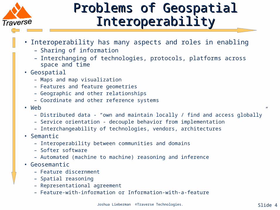
Problems of Geospatial InteroperabilityProblems of Geospatial Interoperability
• Interoperability has many aspects and roles in enabling– Sharing of information– Interchanging of technologies, protocols, platforms across space and time
• Geospatial– Maps and map visualization– Features and feature geometries– Geographic and other relationships– Coordinate and other reference systems
• Web– Distributed data - “own and maintain locally / find and access globally”– Service orientation - decouple behavior from implementation– Interchangeability of technologies, vendors, architectures
• Semantic– Interoperability between communities and domains– Softer software– Automated (machine to machine) reasoning and inference
• Geosemantic– Feature discernment– Spatial reasoning– Representational agreement– Feature-with-information or Information-with-a-feature
Joshua Lieberman - BE Research Seminar 2007 ©Traverse Technologies. Slide 5
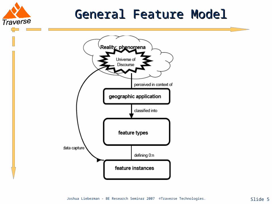
General Feature ModelGeneral Feature Model
Joshua Lieberman - BE Research Seminar 2007 ©Traverse Technologies. Slide 6
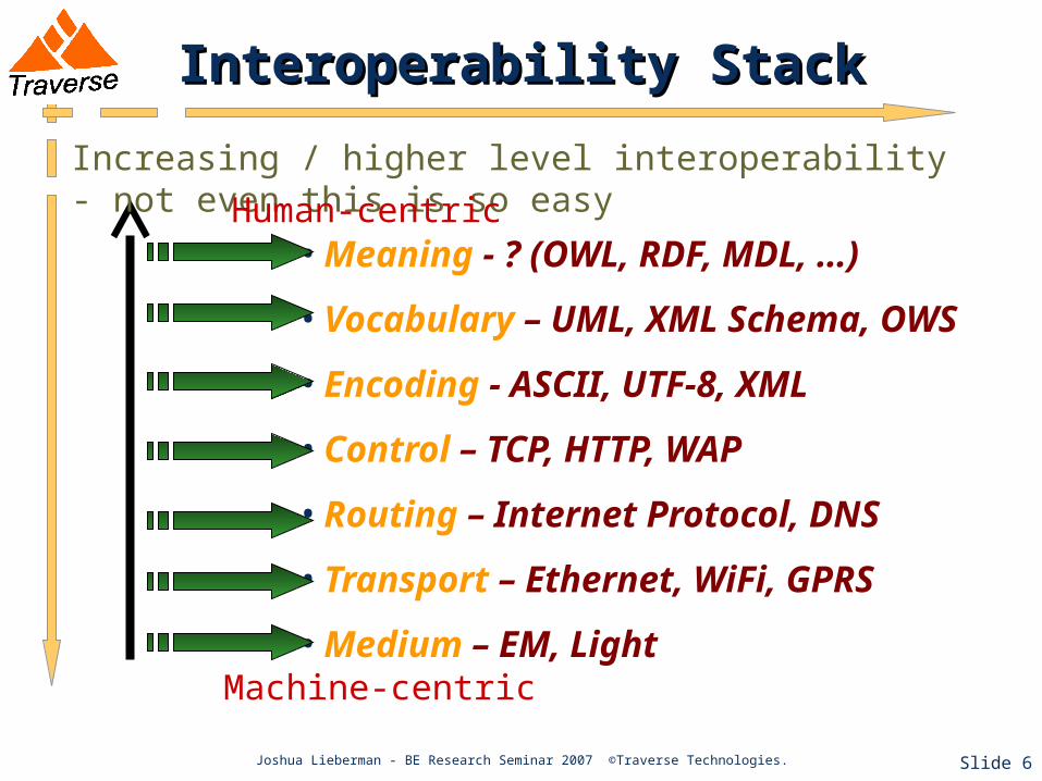
Interoperability StackInteroperability Stack
• Meaning - ? (OWL, RDF, MDL, …)
• Vocabulary – UML, XML Schema, OWS
• Encoding - ASCII, UTF-8, XML
• Control – TCP, HTTP, WAP
• Routing – Internet Protocol, DNS
• Transport – Ethernet, WiFi, GPRS
• Medium – EM, Light
Increasing / higher level interoperability - not even this is so easy Human-centric
Machine-centric

Joshua Lieberman ©Traverse Technologies. Slide 7
But Wait, There are More (Problems)But Wait, There are More (Problems)
• Problems of heterogeneity– Semantics: two names for the same thing– Semiotics: one name for two different things– Schizophrenia (cognitive dissonance): two names for two
different things
LighthouseVertical Obstruction
Joshua Lieberman - BE Research Seminar 2007 ©Traverse Technologies. Slide 8
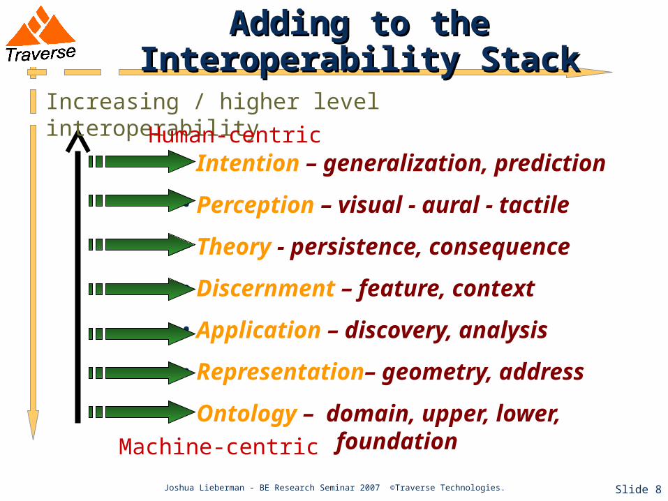
Adding to the Interoperability StackAdding to the Interoperability Stack
• Intention – generalization, prediction
• Perception – visual - aural - tactile
• Theory - persistence, consequence
• Discernment – feature, context
• Application – discovery, analysis
• Representation– geometry, address
• Ontology – domain, upper, lower, foundation
Increasing / higher level interoperability
Human-centric
Machine-centric

Joshua Lieberman ©Traverse Technologies. Slide 9
Simple Standards vs Complex SoftwareSimple Standards vs Complex Software
• Standards represent agreement on the details of one or more interoperability stack layers
• “Simple” standards tend to be most widely adopted.• Successful standards support many activities with few
choices.• Semantic technology offers more choice through more
“intelligent” (and more complex) software• What role, then, do semantic or geosemantic standards
play? Is this a contradiction? Can there be simple geosemantic standards?
Geosemantic Web ChallengesGeosemantic Web Challenges
• Geosemantic agent architecture is un-developed and un-proven
• Ontologies and formal encodings for geospatial knowledge are not yet established in practice
• Geosemantic knowledge is “hidden” in textual description, cartographic craft, and syntax specifications: people-actionable versus machine-actionable
• Generalized geospatial inference is hard to design and harder to implement
• Killer app to drive investment in the Geosemantic Web has not yet been discovered
Joshua Lieberman ©Traverse Technologies.
Joshua Lieberman ©Traverse Technologies. Slide 11
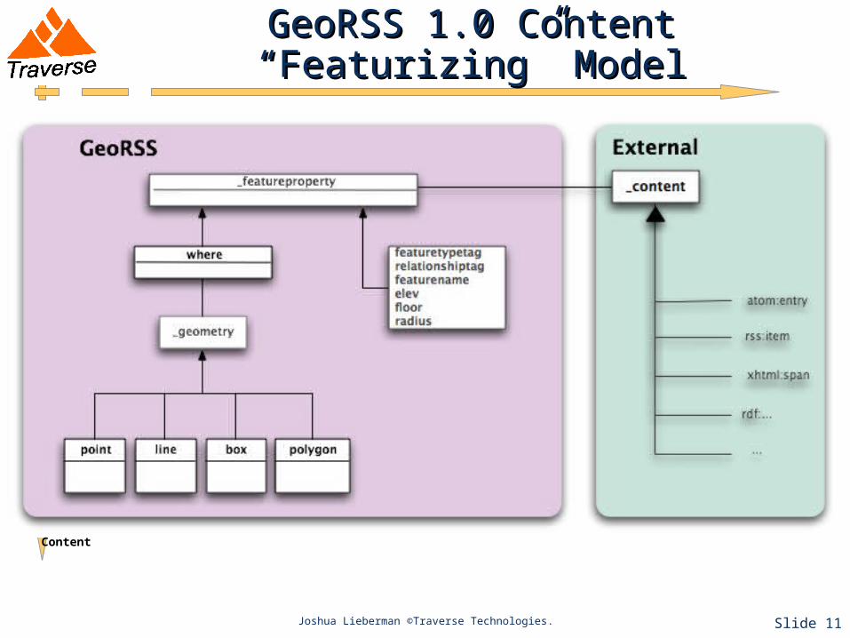
GeoRSS 1.0 Content “Featurizing” ModelGeoRSS 1.0 Content “Featurizing” Model
Content

Joshua Lieberman ©Traverse Technologies. Slide 12
Geo 2007Geo 2007
http://www.w3.org/2005/Incubator/geo/XGR-geo-ont/
http://www.w3.org/2005/Incubator/geo/XGR-geo/

Joshua Lieberman ©Traverse Technologies. Slide 13
Geosemantic Standards IGeosemantic Standards I
• Geo - the geotagging, featurizing OWL ontology developed from GeoRSS.
• Feature ontology - a representation of the OGC / ISO General Feature Model as a basis for expressing feature information
• Feature type ontology - the (50?) basic types of geographic features that everyone should understand.
• Geospatial relationship ontology - the basic geospatial / topological / mereological relationships. Includes the rigorous ones (e.g. intersects) and some of the most common tangled human ones (next-door-to)

Joshua Lieberman ©Traverse Technologies. Slide 14
Geosemantic Standards IIGeosemantic Standards II
• Toponym ontology - the basis for building a global gazetteer, the geospatial counterpart to the Domain Naming System.
• Coordinate reference system / spatial index ontology, the former when WGS84 isn’t enough for all information, the latter for spatial indexes and content tiles.
• Geodataset / metadata ontology - those classical descriptions of geoinformation which really do apply to a large number of SII applications, such as provenance, quality, status.
• Geospatial Services Ontology - basic extensions to services ontologies which address service behavior and usability as a function of the types and extents of coupled geoinformation content.

• Mediation (translation) between community concepts• Query expansion to add additional concepts• Inference simplification (e.g. coordinate -> topology) to support
reasoning
ConsumerConsumerProviderProvider
TraderTrader
MediationMediation
Sear
ch C
once
pts
Resource C
oncepts
Binding Concepts
ProviderProvider
Query Expansion
Related Concepts
BBOX(42.357085,-71.063089, 42.454085,-71.173089)
{within Boston}
Geosemantic Roles Within GeoWebGeosemantic Roles Within GeoWeb
Joshua Lieberman ©Traverse Technologies.

Geosemantic GeoWeb TasksGeosemantic GeoWeb Tasks
• Tag resources with formal concepts• Develop mappings between concepts from different
communities• Develop mediation components with standard
interfaces for integration into geospatial services architectures
• Expand and persist framework feature / toponym sets to support computation of topological relationships “the way people think of space”
• Specify standard representations for the 8 (Egenhofer) spatial relationship operators to support search mediation interoperability (c.f. Geosearch initiative).
Joshua Lieberman ©Traverse Technologies.