geo prismsgeoprisms.org/wpdemo/wp-content/uploads/2017/06/... · (enam) is a passive continental...
TRANSCRIPT

Geo
PRISMS
IN THIS ISSUE
REPORT FROM THE FIELD - MAGNETOTELLURIC AND SEISMIC INVESTIGATION OF OKMOK VOLCANOBREAKUP AND SPREADING HISTORY OF THE EASTERN NORTH AMERICAN MARGIN
2017 TEI RIE - WORKSHOP REPORTGEOPRISMS AT THE 2016 AGU FALL MEETING
DLP SPEAKERS 2017-2018
Newsletter - Issue No. 38, Spring 2017

I’m pleased to introduce the Spring 2017 issue of the GeoPRISMS newsletter. As has been the case for the past few years, the Spring edition will be distributed in print and be available online, while the Fall issue will be electronic only. We are lucky to have an exciting set of articles for the current edition, including a “report from the �eld” from Ninfa Bennington and Kerry Key on their work on arc melt generation beneath Okmok Volcano, and a
science report from Anne Bécel on her investigation of the breakup and spreading history of the Eastern North American Margin. �is issue also includes a number of updates on Fall 2016 AGU activities and student awards, descriptions of newly funded GeoPRISMS projects, and announcements about upcoming opportunities (e.g., call for mini-workshop proposals to precede Fall 2017 AGU; the GeoPRISMS solicitation).
�e past year has been an active time for the o�ce and the GeoPRISMS community. Following a busy AGU week that featured a pair of successful mini-workshops and well-attended townhall meeting - along with many special sessions of interest to the GeoPRISMS community - early 2017 was marked by a highly successful �eoretical & Experimental Institute (TEI) for the Ri� Initiation and Evolution (RIE) initiative. �e TEI provided an important opportunity to review progress toward the GeoPRISMS Science Plan, and to identify exciting new directions, critical knowledge gaps, and key topics primed for synthesis and integration e�orts. With over 130 attendees, almost half of whom were students or postdoctoral scholars, the workshop also served to highlight a vibrant and interdisciplinary RIE community. I’d like to thank the conveners, and particularly Donna Shillington (Lamont-Doherty Earth Observatory) and Tobias Fischer (University of New Mexico) for their leadership in organizing this important milestone for the community. �e �nal report from the workshop is on p. 8 of this issue.
I’m also pleased to introduce �ve new members of the GeoPRISMS Steering and Oversight Committee (GSOC): Danny Brothers, Chad Deering, Becky Bell, Luc Lavier, and Jessica Warren. �anks in advance for your contributions! I’d also like to thank outgoing committee members Estella Atekwana, Harm Van Avendonk, Paul Wallace, Tony Watts, Brandon Dugan, and Tyrone Rooney for their e�orts on behalf of the GSOC and the GeoPRISMS community over the past three (or in some cases four) years. �e distinguished lecture program remains an important and highly successful venue for engagement and dissemination of GeoPRISMS research; speakers Esteban Gazel, Heather Savage, and Brandon Schmandt will be returning for a second year, and Cindy Ebinger will join them to begin her stint this fall.
Finally, I’d like to welcome the newest member of the GeoPRISMS community, Marius Ferot-Giachetti (b. 03/24). Warm congratulations to our Science Coordinator Anaïs Ferot and family (Marius and his Dad, �omas Giachetti)!
I look forward to the next several months, with the important and exciting phase of synthesis and integration on the horizon. �is will be a focus for upcoming discussions at the GSOC, and for a planned TEI in the next year. In the meantime, we are preparing for AGU activities, and welcome proposals for mini-workshops focused on primary sites, thematic studies, allied projects, education and outreach, or other topics of interest to the GeoPRISMS program. I hope to see you at one of these upcoming events.
Demian Sa�erChair, GeoPRISMS Program
In this Issue
The GeoPRISMS Newsletter is published twice a year and is designed to provide to the GeoPRISMS community summaries of recent GeoPRISMS activities and meetings, synthesis articles, editorials, and discussion of science opportunities. Archives of the Newsletter are available on the GeoPRISMS website.
Message from the Chair & NSF
2
Report from the Field: Magnetotelluric and Seismic Investigation of Okmok Volcano
14
Report - �eoretical and Experimental Institute for the RIE Initiative
8
Status Report on the GeoPRISMS Data Portal
26
Late Stage Ri�ing and Early Sea�oor Spreading History of the ENAM
4
GeoPRISMS at AGU: Mini-Workshop Reports & Student Prize
28
Message from the Chair & NSF
Late Stage Ri�ing and Early Sea�oor Spreading History of the ENAM
−79˚ −78˚ −77˚ −76˚ −75˚ −74˚ −73˚ −72˚ −71˚
32˚
33˚
34˚
35˚
36˚
37˚−79˚ −78˚ −77˚ −76˚ −75˚ −74˚ −73˚ −72˚ −71˚
32˚
33˚
34˚
35˚
36˚
37˚
100 km100 km
100 km
North Carolina
VirginiaMCS lines
Broadband OBSShort period OBS
Broadband stationUSArray TA station
Short period station
Baltimore Canyon trough
Line 1
Line 3
Line 2
−5000 −2500 0 2500Bathymetry (m) Carolina trough BMA EC
MA
BSM
A
IMQZ
−400
−200
0
200
400
Mag
netic
Ano
mal
y (n
T)
CapeHatteras
a) b)
Report from the Field: Magnetotelluric and Seismic Investigation of Okmok Volcano
From the Chair
Cover Photograph:TEI participants attending the post-meeting field trip in the Tent Rocks National
Monument, NM. Photo credit: Daniel Láo-Dávila.
Newsletter Production:Anaïs Férot
[email protected] | www.geoprisms.org
Report - �eoretical and Experimental Institute for the RIE Initiative
Status Report on the GeoPRISMS Data Portal
GeoPRISMS at AGU: Mini-Workshop Reports & Student Prize

�is year NSF moves to its new building in Alexandria beginning in July, with all operations hopefully moved and in place by early November. In preparation for this move, the NSF IT group and computing/business infrastructure is scheduled to move during the July 1-4th holiday period and so hopefully Fastlane for proposal submissions and reporting functions will be up and running before the GeoPRISMS target submission date of July 27th.
The GeoPRISMS solicitationEarly in the GeoPRISMS program, NSF implemented a phased funding model for large-scale �eld projects to rotate through the focus sites in an e�ort to target the limited available resources in a practical and cost-e�ective manner. �e 2017 GeoPRISMS solicitation announces that the full cycle of this phased model is now complete, and that the program will now accept proposals for work at any primary site or for any of the themes. Proposals for �eld projects should be targeted towards gaps in existing data and clearly justify the need based on the GeoPRISMS Science or Implementation plans, or on the results of the 2015 GeoPRISMS mid-term review, available at www.geoprisms.org. NSF requests that anyone considering large �eld projects that involve ship time, signi�cant resources, or where the �eldwork is a signi�cant fraction of the budget (>15%), contact a Program Director before submission. Given that large �eld projects require signi�cant out-year commitments of funds, and the program is moving towards the last few years of its decadal lifespan, it is likely that this is the last Target Date to which we will accept proposals of this scale. Smaller scale integration projects for any of the primary sites are strongly encouraged, particularly those that bring together multiple disciplines. �e program also encourages projects that involve amphibious work - work that is done both onshore and o�shore - which could involve either the synthesis of previous results or data, new laboratory or experimental work, new or evolving models, or �eld work. NSF continues to consider proposals that address thematic topics that are not site-speci�c.
Federal Budget UpdateCongress signed the Consolidated Appropriations Act into law on May 8th 2017 which provides FY17 funding through September 30th for NSF at the level of $7.472 billion, essentially �at from the FY16 level (0.1% increase). �is budget decision coming so late in the �scal year has delayed several decisions on the 2016 GeoPRISMS competition but we hope to complete those decisions in the next month. Going forward the news is not so encouraging. As NSF is part of the Executive branch of the government, NSF has complied with the President’s request and has submitted a FY18 budget request of $6.653 billion, an 11% decrease over FY17. As we all know from our civics lessons, the President proposes and the Congress appropriates, so we shall hopefully see by October what the �nal actual budget will be.
2016 GeoPRISMS funding roundAs mentioned above, several proposal decisions from the last GeoPRISMS panel have been delayed due to government funding uncertainties. �e list of potentially funded projects cover the Ri� Initiation and Evolution theme and a wide range of focus areas from Eastern North America Margin to New Zealand to the East African Ri� System and Alaska. Proposal success rate is strong, and comparable to past rounds.
Meetings and past year activityFinally, this past year saw a lively GeoPRISMS ri�-focused TEI in Albuquerque, and a National Academies workshop & resulting report on volcanic eruptions, entitled ERUPT: Volcanic Eruptions and �eir Repose, Unrest, Precursors, and Timing. Most recently, the �nal report of the 2016 Subduction Zone Observatory workshop has just been released
and submitted to NSF. �is vision document entitled “�e SZ4D Initiative” outlines an exciting and bold plan to integrate research across disciplines, US agencies and international partners in order to motivate science that
underpins our understanding of the processes that underlie subduction zone hazards in four dimensions. �e timing for all of these meetings and publications couldn’t be better, as GEO welcomes a new
Assistant Director for GEO: William Easterling, of Penn State. We look forward to showing him that the GeoPRISMS community is thriving, and full of ideas.
Maurice Tivey & Jennifer WadeGeoPRISMS Program Managers, National Science Foundation
Message from NSF
him that the GeoPRISMS community is thriving, and full of ideas.
PRISMS
Geo
PRISMS
GeoGeoGeoGeoGeoGeoGeoGeoGeoGeoand submitted to NSF. �is vision document entitled “�e SZ4D Initiative” outlines an exciting and bold plan to
GeoGeoGeoGeoGeoGeoGeoGeo Assistant Director for GEO: William Easterling, of Penn State. We look forward to showing
PRISMSPRISMSPRISMSPRISMSPRISMSPRISMSPRISMSPRISMSPRISMSPRISMSPRISMS Spring 2017 Issue No. 38 GeoPRISMS Newsletter • 3

Late Stage Rifting and Early Sea�oor Spreading History of the Eastern North American Margin
Anne Bécel
Lamont-Doherty Earth Observatory, Columbia University
IntroductionThe Eastern North American Margin (ENAM) is a passive continental margin that was formed by the ri�ing of the Pangaea supercontinent and the opening of the Atlantic Ocean during the Late Triassic and Early Jurassic.
From o�shore Nova Scotia to Florida, the ENAM has been classi�ed as a volcanic-type margin (Marzoli et al. 1999). Multichannel seismic pro�les have imaged seaward dipping re�ectors (SDRs) that have been attributed to the subaerial eruption and subsequent subsidence of volcanic flows emplaced during the �nal phase of ri�ing (Austin et al., 1990). Seismic refraction pro�les beneath the volcanic wedges have revealed a thick sequence of high seismic velocity lower crust rocks interpreted as igneous/magmatic underplating (Holbrook et al., 1994). �e East Coast magnetic anomaly (ECMA) is a high-amplitude positive magnetic anomaly running along the length of the margin (Fig. 1) (Keller et al., 1954). �e source of the ECMA has been primarily attributed to seaward dipping re�ectors in the upper crust (Austin et al., 1990) and is interpreted as the limit between the continental crust and the normal oceanic crust. However, the exact
nature and the width of the zone between the continental crust and normal oceanic crust remain uncertain. �is zone is thought to either represent a new anomalously thick magmatic crust with higher velocity than lower oceanic crust with no continental crust present (Talwani et al., 1995) or a zone with volcanics on top of magmatic material intruded into extended continental crust or underplated beneath. The nature and the width of this zone are of fundamental importance to understanding the late stage ri�ing processes and over what time period the continental breakup occurred at this volcanic margin. Margins that experience a voluminous magmatism during ri�ing tend to have a more rapid continental breakup with a smaller zone of crustal extension (i.e. strain localization) and tend to develop more symmetric conjugate margins.
�e Blake Spur magnetic anomaly (BSMA) is a positive, linear magnetic anomaly located 150-250 km to the east of the ECMA (Fig. 1). The BSMA is of lower amplitude than the ECMA but also consists of segments with several magnetic peaks separated by troughs. The age of BSMA is unknown but extrapolated ages range between 168-173 Ma. �e nature and origin of this magnetic anomaly is still debated and
di�erent models have been proposed. BSMA is either thought to mark a ridge jump (Vogt, 1973), magmatic pulse associated to a plate re-organization (Klitgord and Schouten, 1986; Kneller et al., 2012) or a change in spreading rate/direction and asymmetry of incipient seafloor spreading during the early opening of the Central Atlantic (Labails et al., 2010). In the ridge jump scenario, the BSMA is thought to represent a sliver of West African ri�ed continental crust that experienced continental breakup magmatism and that was le� on the Eastern North American margin after the early spreading center jumped east of the BSMA. This model implies that a now extinct mid-ocean ridge lies between ECMA and BSMA.
�e Inner Magnetic (Jurassic) Quiet zone (IMQZ) lies between the ECMA and the BSMA (Bird et al., 2007). Because the magnetic anomalies are of very low amplitudes and variable in shape, the correlation of magnetic anomalies with magnetic reversals remains challenging in this zone (Fig. 1). Timing and location of breakup at the ENAM thus remain uncertain and the spreading rate of the earliest normal oceanic crust in the IMJQ is not well constrained.
During September-October 2014, the NSF-GeoPRISMS-funded Eastern North American Margin (ENAM) Community Seismic Experiment (CSE) collected deep penetration multichannel seismic (MCS) re�ection pro�les covering a 500 km wide section of the Mid-Atlantic passive margin o�shore North Carolina, which formed a�er the Mesozoic breakup of supercontinent Pangea
�e ENAM-CSE data extend farther o�shore than previous seismic surveys conducted in this area and encompass the full transition from continental breakup to mature sea�oor spreading while speci�cally providing unique constraints on the events surrounding the �nal stage of continental ri�ing and the initial stage of sea�oor spreading, which remain poorly understood. �e results shown here demonstrate the ability of MCS data to image four distinct domains that highlight di�erent basement characteristics and provide new insights on the degree of extensional strain localization experienced during continental breakup and how the earliest oceanic crust was formed a�er ri�ing.
4 • GeoPRISMS Newsletter Issue No. 38 Spring 2017

Data acquisition and project goals�is project aims to extract information on the late-stage continental ri�ing including the relationship between the timing of rifting and the occurrence of offshore magmatism and early sea�oor history of the Central Atlantic using multichannel (MCS) data from the ENAM-CSE. �e MCS data were acquired on R/V Marcus Langseth using a 6600 cu. in. tuned airgun array and 636 channel 8-km-long streamer. �e source and the streamer were both towed at a depth of 9 m for deep imaging. �is project involves the multichannel seismic processing and interpretation of two o�shore margin normal pro�les (450-km-long and 370-km-long, respectively), spanning from continental crust ~50 km o� the coast to mature oceanic crust 110 km east of the BSMA and a ~350-km-long MCS pro�le along the BSMA (Fig. 1). �ese primary MCS lines are also coincident with the ENAM seismic refraction pro�les recorded on ocean bottom seismometers.
ResultsThe high-resolution MCS data provide detailed structure of the sedimentary cover and crust (Fig. 2 and Fig. 3). The
initial images of the two margin normal pro�les reveal several major changes in the basement character and roughness between the ECMA and the BSMA (Fig. 2) that have not been previously described. The four domains described below correspond to distinct magnetic anomalies that suggest that magnetization contrasts exist between those domains. �e interpretation of the new observations from MCS data give new important insights into the late stage of ri�ing and ri� to dri� transition.
• From CDP 26500 to CDP 32500 (Fig. 2a and 2c), the top of the basement is smooth and less re�ective than on the seaward part of the pro�le and it is also less distinguishable from the sedimentary layers above. The top basement characteristics suggest that it could correspond to smooth volcanic �ows emplaced in shallow water conditions and coincide with the landward onset of the ECMA.
• From CDP 32500 to CDP 41700 (Fig. 2a and 2d), there is a step up in the basement and a drastic change in the basement roughness. In this area, the crust is highly tectonized by normal faulting forming tilted, faulted crustal blocks. �is crust could be interpreted as highly extended continental crust due to the geometry
of syn-ri� sedimentary sequences in the basement half-grabens. �is interpretation would be in con�ict with the zone between the continent and the oceanic being purely magmatic and would suggest that continental crust could have been thinned by faulting before being intruded by igneous material. Alternatively, this crust could be oceanic crust formed at very slow spreading rates (<15 mm/yr). Very slow-spreading crust is known to be fragmented by normal faulting with large crustal blocks (long wavelengths). On the sole basis of basement architecture, we cannot fully support either of the two proposed hypotheses. Ocean-bottom seismometer (OBS) refraction data acquired during the ENAM-CSE and coincident with the MCS data used in this project will help to decipher the nature of the crust where tilted basement blocks are imaged.
• From CDP 41700 to CDP 51100 (Fig. 2a and 2e), the basement roughness appears to be that of a typical oceanic crust formed at a steady state slow spreading ridge.
• From CDP 51100 to CDP 62000 (Fig. 2a and 2e), starting at the BSMA anomaly and seaward, the top basement is very smooth and re�ective and the BSMA anomaly appears to coincide with a step-up in top basement.
−79˚ −78˚ −77˚ −76˚ −75˚ −74˚ −73˚ −72˚ −71˚
32˚
33˚
34˚
35˚
36˚
37˚−79˚ −78˚ −77˚ −76˚ −75˚ −74˚ −73˚ −72˚ −71˚
32˚
33˚
34˚
35˚
36˚
37˚
100 km100 km
100 km
North Carolina
VirginiaMCS lines
Broadband OBSShort period OBS
Broadband stationUSArray TA station
Short period station
Baltimore Canyon trough
Line 1
Line 3
Line 2
−5000 −2500 0 2500Bathymetry (m) Carolina trough BMA EC
MA
BSM
A
IMQZ
−400
−200
0
200
400
Mag
netic
Ano
mal
y (n
T)
CapeHatteras
a) b)Figure 1. a) Elevation Map (Andrews et al., 2016) contoured every 500 m showing the location of the ENAM Community Seismic Experiment. Line 1 and ENAM Line 2 were chosen to characterize the deep structure of the Carolina Trough south of Cape Hatteras, and the Baltimore Canyon Trough north of Cape Hatteras, respectively whereas the Line 3 was chosen to characterize the structure of the crust and uppermost mantle to better understand the origin of the Blake Spur Magnetic anomaly. b) Magnetic anomaly map (Maus et al., 2009) of the North American Margin. ECMA: East Coast Magnetic Anomaly; BSMA: Blake Spur Magnetic Anomaly; IMQZ: Inner Magnetic Quiet Zone.
Spring 2017 Issue No. 38 GeoPRISMS Newsletter • 5

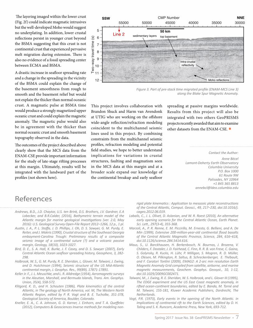
Along the BSMA, clear Moho (Mohorovic Discontinuity) reflections are observed 2.5-3 s (8.12-9.75 km assuming an average crustal velocity of 6.5 km/s) beneath the top basement (Fig. 3) and are relatively continuous. Abundant intracrusta l re�ections, primarily restricted within the oceanic lower crust, are also observed over
crust formed at BSMA time but also in younger crust.
In the ridge jump scenario, the BSMA would represent thinned continental crust intruded by igneous material. However, the top basement is very re�ective indicating a strong impedance contrast between the
sediment layers and the top basement. This would be more in agreement with a top basement produced by submarine sea�oor spreading at a mid-ocean ridge than subaerial or shallow water emplacement of volcanics within sediments that would reduce the impedance contrast as in Fig. 2c.
5
6
7
8
9
30000 40000 50000 60000CMP Number
10
12
Line 3
11
Two
way
trav
eltim
e (s
)
0
100
Mag
netic
Ano
mal
y (n
T)
0 50 100 150 200 250O�set (km)
BSMAECMA
8
9
10Two−
way
trav
el ti
me
(s) 27000 29000 31000
CMP Number
7
8
9
10Two−
way
trav
el ti
me
(s)
34000 36000 38000 40000CMP Number
8
9
10
52000 54000 56000 58000 60000 62000CMP Number
8
9
10
CMP Number
8
9
10Two−
way
trav
el ti
me
(s) 42000 44000 46000 48000 50000
8
9
10
10 km
W E
50 kmsedimentary layers
top basement
Intra-crustalre�ectivity
Moho re�ections
a)
b)
c)
d)
e)
f )
Figure 2. a) Magnetic anomaly profile coincident to the seaward part of ENAM-MCS Line 2 (Maus et al., 2009). b) Post-stack time migrated profile of the seaward part of ENAM-MCS Line 2 c) d) e) f) zooms into the four different domains discussed in the text and that display different basement characteristics.
6 • GeoPRISMS Newsletter Issue No. 38 Spring 2017
References
Andrews, B.D., J.D. Chaytor, U.S. ten Brink, D.S. Brothers, J.V. Gardner, E.A Lobecker, and B.R.Calder, (2016), Bathymetric terrain model of the Atlantic margin for marine geological investigations (ver. 2.0, May 2016): U.S. Geological Survey Open-File Report 2012–1266, 12 p., 1 pl.
Austin, J. A., P. L. Stoffa, J. D. Phillips, J. Oh, D. S. Sawyer, G. M. Purdy, E. Reiter, and J. Makris (1990), Crustal structure of the Southeast Georgia embayment-Carolina Trough: Preliminary results of a composite seismic image of a continental suture (?) and a volcanic passive margin, Geology, 18(10), 1023-1027.
Bird, D. E., S. A. Hall, K. Burke, J. F. Casey, and D. S. Sawyer (2007), Early Central Atlantic Ocean seafloor spreading history, Geosphere, 3, 282-298.
Holbrook, W. S., G. M. Purdy, R. E. Sheridan, L. Glover, M. Talwani, J. Ewing, and D. Hutchinson (1994), Seismic structure of the US Mid-Atlantic continental margin, J. Geophys. Res., 99(B9), 17871-17891.
Keller Jr. F., J. L. Meuschke, and L. R. Alldredge (1954), Aeromagnetic surveys in the Aleutian, Marshall, and Bermuda Islands, Trans. Am. Geophys. Union, 35(4), 558-572.
Klitgord, K. D., and H. Schouten (1986), Plate kinematics of the central Atlantic, in The geology of North America, vol. M, The Western North Atlantic Region, edited by P. R. Vogt and B. E. Tucholke, 351-378, Geological Society of America, Boulder, Colorado.
Kneller, E. A., C. A. Johnson, G. D. Karner, J. Einhorn, and T. A. Queffelec (2012), Computers & Geosciences Inverse methods for modeling non-
rigid plate kinematics : Application to mesozoic plate reconstructions of the Central Atlantic, Comput. Geosci., 49, 217–230, doi:10.1016/j.cageo.2012.06.019.
Labails, C., J. L. Olivet, D. Aslanian, and W. R. Roest (2010), An alternative early opening scenario for the Central Atlantic Ocean, Earth Planet. Sci. Lett., 297(3-4), 355-368.
Marzoli, A., P. R. Renne, E. M. Piccirillo, M. Ernesto, G. Bellieni, and A. De Min (1999), Extensive 200-million-year-old continental flood basalts of the Central Atlantic Magmatic Province, Science, 284, 616–618, doi:10.1126/science.284.5414.616.
Maus, S., U. Barckhausen, H. Berkenbosch, N. Bournas, J. Brozena, V. Childers, F. Dostaler, J. D. Fairhead, C. Finn, R. R. B. von Frese, C. Gaina, S. Golynsky, R. Kucks, H. Lühr, P. Milligan, S. Mogren, R. D. Müller, O. Olesen, M. Pilkington, R. Saltus, B. Schreckenberger, E. Thébault, and F. Caratori Tontini (2009), EMAG2: A 2-arc min resolution Earth Magnetic Anomaly Grid compiled from satellite, airborne, and marine magnetic measurements, Geochem. Geophys. Geosyst., 10, 1-12, doi:10.1029/2009GC002471.
Talwani, M., J. Ewing, R. E. Sheridan, W. S. Holbrook, and L. Glover III (1995), The EDGE experiment and the US East Coast magnetic anomaly, in rifted ocean-continent boundaries, edited by E. Banda, M. Torné and M. Talwani, 155-181, Kluwer Academic Publishers, Dordrecht, The Netherlands.
Vogt, P.R. (1973), Early events in the opening of the North Atlantic. in Implications of continental rift to the Earth Sciences, edited by D. H. Taling and S. K. Runcorn, Academic Press, New York, 693-712.
5
6
7
8
9
10
11
12
Two−
way
trav
el ti
me
(s)
300003500040000450005000055000CMP Number
Line 2
SSW NNE
50 kmsedimentary layers top basement
Moho reflections
Intra-crustalreflectivity
�e layering imaged within the lower crust (Fig. 2f) could indicate magmatic intrusives but the well-developed Moho would suggest no underplating. In addition, lower crustal re�ections persist in younger crust beyond the BSMA suggesting that this crust is not continental crust that experienced pervasive melt migration during extension. �ere is also no evidence of a fossil spreading center between ECMA and BSMA.
A drastic increase in sea�oor spreading rate and a change in the spreading in the vicinity of the BSMA could explain the change of the basement smoothness from rough to smooth and the basement relief but would not explain the thicker than normal oceanic crust. A magmatic pulse at BSMA time would produce a strongly magnetized upper oceanic crust and could explain the magnetic anomaly. �e magnetic pulse would also be in agreement with the thicker than normal oceanic crust and smooth basement topography observed in the data.
�e outcomes of the project described above clearly show that the MCS data from the ENAM-CSE provide important information for the study of late-stage ri�ing processes at this margin. Ultimately, results will be integrated with the landward part of the pro�les (not shown here).
This project involves collaboration with Brandon Shuck and Harm van Avendonk at UTIG who are working on the o�shore wide-angle re�ection/refraction modeling coincident to the multichannel seismic lines used in this project. By combining constraints from the multichannel seismic pro�les, refraction modeling and potential �eld studies, we hope to better understand implications for variations in crustal structures, faulting and magmatism seen in the MCS data at this margin and at a broader scale expand our knowledge of the continental breakup and early sea�oor
spreading at passive margins worldwide. Results from this project will also be integrated with two others GeoPRISMS projects recently awarded that aim to examine other datasets from the ENAM-CSE. ■
Figure 3. Part of pre-stack time migrated profile (ENAM-MCS Line 3) along the Blake Spur Magnetic Anomaly.
Contact the Author:
Anne BécelLamont-Doherty Earth Observatory
Columbia UniversityP.O. Box 100061 Route 9W
Palisades, NY 10964+1 845 365 8813
Spring 2017 Issue No. 38 GeoPRISMS Newsletter • 7

Report on the NSF-GeoPRISMS Rift Initiation and Evolution Theoretical and Experimental InstituteTobias Fischer1, Donna Shillington2
1University of New Mexico, 2LDEO, Columbia University
�e GeoPRISMS Ri� Initiation and Evolution (RIE) �eoretical and Experiment Institute (TEI) was held in Albuquerque, NM from February 7-10. �e objectives of the meeting were to summarize progress and recent scienti�c advances related to the RIE initiative, identify high-priority science for future GeoPRISMS RIE e�orts and promote community building and formation of new collaborations.
To meet those objectives, a diverse group of scientists was enlisted to serve on the convening team, give invited and contributed talks and to contribute to the meeting as attendees. �e expertise of conveners, speakers and attendees spanned a broad range of interests connected with the RIE initiative, from deep geodynamical processes underlying ri�ing to surface processes controlling syn- and post-ri� evolution. Scientists undertaking studies in the RIE primary sites (the East Africa Ri� and the Eastern North American Margin) and working at other ri�s and ri�ed margins were encouraged to contribute to all aspects of the workshop to ensure diverse perspectives. �e meeting was attended by 133 participants, 59 of which were students and postdoctoral researchers. Besides attracting a large group of early career scientists, attendees included mid-career investigators who were relatively new to RIE science. Scientists from abroad were invited to attend to provide insights regarding the RIE primary sites and on ri�s in general.
�e meeting structure was designed to cover the broad spectrum of science included in the GeoPRISMS RIE science plan, to encourage interdisciplinarity and to bring in diverse perspectives. �e main meeting had seven main oral sessions:
1. Ri� evolution from initiation to post ri� architecture
2. Geodynamics of ri� and post-ri� processes
3. Magmatism and volatile exchanges
4. Faulting and strain
5. Surface processes & feedbacks between deep/surface processes
6. Hazards associated with ri�ing environments
�ere was substantial time allocated for discussion and interaction; the meeting included several poster sessions at various times of day, two breakout sessions, one small-group discussion and plenary discussion a�er each oral session and throughout the meeting. As described in more detail below, the speakers successfully synthesized the state of knowledge on various aspects of ri� evolution and of highlighting important outstanding questions. �e breakouts and discussion were dynamic, generating excellent ideas and insights. �e main meeting was preceded by a half-day student and postdoc symposium organized and led by three postdocs.
Overview of science presented at the meetingStudent-Postdoc Symposium
�e student-postdoc symposium was held the a�ernoon before the main meeting and was led by Yelebe Birhanu (Bristol), James Muirhead (Syracuse), and Jean-Arthur Olive (LDEO). �e organizers began the symposium with a presentation that provided an overview of the outstanding science questions related to RIE. �ese questions focused on the topics of ri� initiation, the 4-D ri� architecture, long- and short-term ri� deformation mechanisms, ri� volcanism, magmatism and volatile �uxes as well as surface processes at ri�s and ri�ed margins. �ese topics were the focus of small group discussions later in the a�ernoon, and the discussion leaders summarized these discussions during the �rst day of the main meeting to all attendees. �e symposium also included pop-ups by all participants on their RIE related research. Over sixty people attended the student-postdoc symposium, including nearly all students and postdocs at the meeting and a few representatives from the GeoPRISMS O�ce and GSOC, NSF and the convening team of the main meeting. �e scienti�c discussions were followed by a career development panel discussion where students and postdocs had the opportunity to engage directly with scientists at a variety of stages in their careers.
The GeoPRISMS �eoretical and Experimental Institute (TEI) for the Ri� Initiation and Evolution (RIE) initiative was held February 8-10, 2017 in Albuquerque, NM. �is meeting brought together 132 scientists with diverse expertise working on ri�s and ri�ed margins around the world to discuss recent scienti�c advances, emerging questions, and to identify potential high-priority science
for future GeoPRISMS RIE e�orts. �e meeting included a series of oral and poster presentations, pop ups and discussions. �e workshop conveners have prepared a report that summarizes science results and future directions discussed at the workshop.
8 • GeoPRISMS Newsletter Issue No. 38 Spring 2017

Main meeting
�e main part of the meeting began with a session on ri� evolution from initiation to post-rift architecture. Roger Buck (LDEO) emphasized the role of magma throughout the life of ri�s, from diking during ri� initiation to the association of ri�ed margins with large magmatic outpourings and seaward dipping re�ectors. Harm Van Avendonk (UTIG) reviewed insights on ri�ing processes from studies of both magma-poor and magmatic ri�ed margins, where recent studies show interesting variations in the distribution and timing of magmatism in relation with ri�ing, including provocative clues from ENAM on distribution of magmatism and highly thinned continental crust. Danny Brothers (USGS) focused on postri� evolution of ri�ed margins, including how sediment delivery and pre-failure con�guration control evolution and evidence for active �uid venting, slope failure, and sediment compaction.
Session 2 focused on geodynamics. Jolante Van Wijk (NM Tech) provided an overview of numerical modeling approaches and the importance of testing and comparing models to both observations and other numerical solutions. Zach Eilon (Brown) synthesized geophysical observations from the Woodlark Ri� in Papua New Guinea and showed evidence of limited melt, lithospheric removal and opening direction parallel anisotropy. Andrew Smythe (Penn State) showed how high-temperature thermochronology and di�usion speedometers can be used to assess mantle upwelling rates and how strain is vertically distributed during ri�ing. Robert Harris (Oregon State) showed high-resolution heat �ow results from the Gulf of California and emphasized the role of �uid �ow as well as conductive heat transfer. Colton Lynner (Arizona) showed new shear-wave splitting results from the ENAM community seismic experiment and suggests that 3-D edge driven �ow at the edge of the margin can explain their observations.
Session 3 followed with talks on magmatism, volcanism and volatile exchanges. Cornelia Class (LDEO) gave an overview of the geochemical and petrological tools to identify magma and volatile sources in ri� settings, highlighting the importance of using multiple
geochemical systems to identify mantle components. Sara Mana (Salem State) showed chronological and geochemical data from the North Tanzania Convergence zone and highlighted the evidence for pulsed magmatism and a metasomatized mantle source. Juliane Hübert (Edinburgh) provided new insights on magma storage and pathways using magnetotelluric data in the Main Ethiopian Ri�. Madison Meyers (U. of Oregon) emphasized the occurrence of large silicic volcanic centers in ri� settings and showed how detailed work on volatiles recorded by melt inclusions allow for the quanti�cation of magma ascent rates. Philip Kyle (NM Tech) ended the session with an overview of the magmatic history of the West Antarctic Ri�.
Day 2 started o� with the session on faulting and strain, where Cindy Ebinger (Tulane) provided a ‘recipe for ri�ing’ for cratonic and orogenic ri�s where the di�erence in both crustal and mantle rheology are of critical importance for ri� architecture and extension, including the possibly important but poorly known hydration state and distribution of volatiles at depth. Paul Umhoefer (Northern Arizona U.) showed how variations in inherited structures, strain partitioning, angle of obliquity and sediment input control extension in the Gulf of California – Salton trough plate boundary.
Over sixty early career scientists attended the student-postdoc symposium organized the day before the main meeting.
Group picture, outside Hotel Albuquerque.
Phot
o by
T. F
ische
r
Spring 2017 Issue No. 38 GeoPRISMS Newsletter • 9

James Muirhead (Syracuse) showed the results from an interdisciplinary study in the East African Ri� that better constrain the role and sources of �uids and mantle melting in the early stages of ri�ing and their connection to faulting. Hannah Mark (WHOI) provided new insights from modeling of observed seismic coupling coe�cients that show how the thermal regime scales with seismic coupling in MOR and continental ri�s. Elifuraha Saria (Ardhi) ended the session by providing an overview of geodetic constraints on crustal deformation in Africa emphasizing the fact that large parts of the continent are not adequately monitored geodetically.
Session 5 focused on surface processes and feedbacks in rifts, where Kyle Straub (Tulane) showed how geomorphology signals are stored in the stratigraphic and landscape record. His talk was followed by Jean-Arthur Olive (LDEO) who discussed the role of surface processes in the stabilization of half-graben structures. Erin DiMaggio (Penn State) talked about the connection between ri� development as preserved in the stratigraphic record and the development of the Ledi-Geraru paleontological site. Liang Han (Virginia Tech) showed how rapid sedimentation in the Salton Trough resulted in the formation of new crust, delayed continental breakup and sea�oor spreading, and how metamorphism of sediment can further delay �nal crustal breakup. Rob Gawthorpe (Colorado
School of Mines) ended the session with insights on the evolution of the Corinth Ri�, Greece from the onshore-o�shore observations.
�e �nal science session highlighted hazards in ri�s and ri�ed margins. Karen Fontijn (Oxford) focused mainly on volcanic hazards in the East African Ri�, emphasizing the low viscosity of ri� magmas, the high potential for phreatic eruptions, and the abundance of large caldera systems as well as the role of hazardous CO2 degassing. Atalay Ayele (Addis Ababa U.) highlighted the challenges in disaster risk management in Africa that are due to limited capacity in equipment and human resources and the general level of understanding of potential risk. He also pointed to recent successes such as capacity building e�orts, advances in real-time data �ows, and national workshops. Maurice Lamontagne (GSC) showed how earthquakes and tsunamis related to ri�ing are the main hazards in Eastern Canada and how detailed mapping of ancient fault structures provides key insights on earthquake mechanisms and distributions in the region. Sang Mook Lee (SNU) highlighted the geohazards of the East Sea and the Sea of Japan and their potential to a�ect nuclear power plant safety.
Collaborative opportunities were discussed with presentations on the Ri�Volc initiative, connections between ri�ing and hydrology, EarthScope and Africa Array updates.
Phot
o by
J. M
orga
n
Home institutions of the meeting participants.
10 • GeoPRISMS Newsletter Issue No. 38 Spring 2017

Science themes with opportunities for near-term future studies�e TEI was designed to provide ample opportunities for participants to ask questions and discuss scienti�c issues related to the presentations. �is was achieved through a panel discussion following each session including all speakers. Additional focused discussions occurred during two breakout sessions and small group discussions, which focused on the identi�cation of high priority science questions and work needed to tackle these questions.
�e following major science themes emerged from discussions at the TEI. For each of these themes, discussions focused on exciting recent �ndings and opportunities for near-term research progress through the GeoPRISMS RIE TEI initiative.
1. Tracking �uids (volatiles and magmas) through the lithosphere and with time
�e importance of �uids for a spectrum of interconnected processes throughout the life of ri�s and ri�ed margins was a topic of signi�cant interest at the meeting. Meeting presentations covered recent results that have revealed strong, nonlinear interactions between volatiles and faults (e.g., talk by Muirhead), the important in�uence of preri� and synri� metasomatic events on magmatism (e.g., talk by Sana), and the capacity of �uids to advect heat and strongly modulate the thermal structure of ri�s (e.g., talk by Harris). Geochemical tracers can be used to constrain the modi�cation of the lithosphere by magmatic events (e.g., talk by Class). New studies of ri�ed margins also reveal unexpected mantle structure and magmatism, hinting at active processes long a�er ri�ing (e.g., talk by Lynner).
�ese new science results point to several exciting near-term future science directions:
• Understanding the connections between deep volatiles and shallow observations, including constraining magma and volatiles residence times and pathways
• Developing a quantitative understanding of the impact of volatiles/magmatism on strain localization and rheology (connects to theme 2)
• Connecting general rheological models to morphological and process-based di�erences between magma-poor and magma-rich regions
• Investigating the origin and signi�cance of post-ri� magmatism on ri�ed margins
2. Controls on deformation and localization at di�erent temporal scales
Elucidating controls on deformation and localization are central to understanding ri� processes, and were another major focus of meeting presentations and discussions. Magma is clearly a great localizer of strain (e.g., talks by Buck, Ebinger), but magma is not present everywhere, at least not in abundance. In magma-poor locations, �uids, pre-existing structures and/or chemical heterogeneity may be important factors (e.g., talks by Van Avendonk, Eilon). Volatiles appear to in�uence crustal rheology and fault behavior (e.g., talks by Muirhead, Ebinger), but are still poorly understood. �e role of pre-existing lithospheric structure in strain localization appears to vary among ri� systems and at di�erent scale lengths (e.g., talks by Lynner, Eilon).
Phot
o by
L. C
ross
ey
Spring 2017 Issue No. 38 GeoPRISMS Newsletter • 11

New numerical models and observations suggest that surface processes may also control strain localization (e.g., talks by Olive, Han; connects to theme 3). �e slip behavior of ri� faults (creeping, locked, etc.) is poorly known (e.g., talk by Mark), and there are few constraints on how it might change over time or with ri� evolution (e.g., talk by Van Avendonk).
�ese new science results point to several exciting near-term future science directions:
• Integration of ri�ing processes across a range of time scales from the earthquake cycle to geologic time
• Characterization of slip behavior of faults over time and space
• Understanding variations in temporal/spatial patterns of deformation between magmatic and magma-poor systems
• Comparing transient behavior in ri�s (creep, slow slip) to subduction and transform zones
• Observing how volatiles are distributed through lithosphere (connects to theme 1) with an emphasis on how they impact rheology, faulting, and transient deformation
• Constraining mantle rheology on a variety of time scales and as a function of volatile abundance, metasomatism and melt extraction processes (connects to theme 1).
3. Surface mass sedimentary �uxes and feedbacks with ri�ing
Recent studies have demonstrated strong connections between surface processes and all stages of ri� evolution. �ese include the formation of new crust through rapid sedimentation (e.g., talk by Han), the impact of erosion on fault evolution (e.g., talk by Olive), the structural control of sediment pathways during and long a�er ri�ing (e.g., talk by Gawthorpe), and the structural control of slope failure (e.g., talks by Brothers and Lamontagne). �e vertical displacements and crustal architecture associated with extensional tectonics strongly in�uence the spatial and temporal distribution of depositional domains (e.g., talks by Straub, Brothers).
�ese results point towards several important near-term future science directions:
• Developing more comprehensive sedimentary histories of ri�s to improve understanding of ri�-related mass transport
• Improving conceptual and numerical models of sediment influence on extensional processes, including thermal and mechanical feedbacks (connects to theme 2)
• Utilizing the extant and paleolake systems for integrated investigations of landscape evolution.
E�orts needed to make progress on themes within GeoPRISMSTo address outstanding questions related to the themes above, the following future e�orts were highlighted as particularly important.
Synthesis
Comparing among and within ri�s is important to address many of the overarching RIE science questions and the speci�c questions within the themes above. A growing volume of data is now available in both primary sites and in other ri� systems on everything from surface processes to magmatism and deep geodynamics. �ese observations include existing geophysical datasets on both EAR and ENAM from GeoPRISMS and other e�orts, growing geochemical data and drilling data in various ri�s. Particular themes discussed for syntheses were:
• Geochemical variations along/across ENAM/EAR • Sediment mass �uxes from existing (limited) drilling data • Geochronological data on magmatic/volcanic events and
surface processes • Crustal/lithospheric structure of rifts from existing
geophysical imaging, with focus on comparisons between and within systems with variable magmatism
• Geochemical data from geothermal exploration projects (drilling) in volcanic and non-volcanic settings.
New data collection and experimental/numerical work
From discussion at the meeting, it is clear that new data and experiments are required to tackle many important science themes, and several key gaps emerged from discussions at the meeting. Below are examples:
• Studies of volatile systems to understand their distribution/abundance/residence time at various levels in the lithosphere. �is would involve integrated geophysical imaging including but not limited to MT, seismic, and detailed geochemical studies such as melt inclusions, sampling volatiles at the surface, high density �ux measurements, and other approaches.
• Experimental and numerical modeling directed at the impact of volatiles and lower crust/mantle lithosphere hydration state/compositions on deformation throughout the lithosphere,
• Observations to constrain the time scales of processes are needed. �ese include but are not limited to more geodetic observations to understand average rates and observe transient events as well as investigations of paleoseismology, deformed volcanic ash markers, and tectonic geomorphology to understand longer term accommodation of strain by events. On a longer time scale, better and improved geologic timing information is needed.
• New constraints on sedimentary �uxes in ri�s including but not limited to cosmogenic dating techniques, river incision rates, and obtaining data from new drill cores.
• Advance the understanding of landscape evolution through better access to high resolution topographic data.
Go online to access archived presentations:
http://geoprisms.org/tei-rie-2017/12 • GeoPRISMS Newsletter Issue No. 38 Spring 2017
Call for GeoPRISMS Mini-Workshop Proposals at AGU 2017Application Deadline: July 1st, 2017
We are pleased to announce that this year we will again be able to host a few Mini-Workshops at the 2017 AGU Fall Meeting (December 11-15). A Mini-Workshop is a research meeting that is held on the Sunday prior to the meeting. Examples of Mini-Workshops held in association with recent and upcoming national and international meetings can be found at:http://geoprisms.org/meetings/mini-workshops/
Mini-Workshops o�er excellent opportunities to jump-start science discussions, as well as to coordinate implementation for future GeoPRISMS studies, both for primary sites and thematic studies. We encourage you to consider such an undertaking. The GeoPRISMS O�ce provides logistical support, a meeting room, and refreshments. We do not cover any travel costs or per diem to the organizers or participants. GeoPRISMS Mini-Workshops will be open to all interested parties and will be advertised via the GeoPRISMS mailing list, newsletter, and website.
If you would like to host a GeoPRISMS-related Mini-Workshop in association with the 2017 AGU Fall Meeting, we invite you to submit your proposal to the GeoPRISMS O�ce at [email protected]. The proposals will be reviewed and ranked by the GeoPRISMS Steering and Oversight Committee (GSOC). The number of Mini-Workshops is limited but we expect to be able to host two to three events.
The deadline for upcoming Mini-Workshop proposals is July 1, 2017. The proposal guidelines are described on the GeoPRISMS website at:http://geoprisms.org/meetings/mini-workshops/
We encourage you to contact the GeoPRISMS O�ce with questions or for advice prior to submitting.
We look forward to hearing your ideas.
We are pleased to announce that this year we will again be able
Mini-Workshops o�er excellent opportunities to jump-start science discussions, as well as to coordinate implementation for future GeoPRISMS studies, both for primary sites and thematic studies.
Questions should be directed to the GeoPRISMS Office:[email protected]
More information at:http://geoprisms.org/meetings/mini-workshops/

Report from the Field
Installation of a magnetotelluric station in the Okmok Caldera. Photo credit: Kerry Key.
14 • GeoPRISMS Newsletter Issue No. 38 Spring 2017

Kerry Key (Scripps Institution of Oceanography) andNinfa Bennington (University Wisconsin-Madison)
Collaborative Research:Magnetotelluric and Seismic Investigation
of Arc Melt Generation, Delivery, and Storage beneath Okmok Volcano
Spring 2017 Issue No. 38 GeoPRISMS Newsletter • 15

It all sounded so easy when we were writing the proposal. Sure, we can deploy 54 sea�oor magnetotelluric (MT) instruments around a remote Aleutian island, no problem, we have done lots of marine MT surveys before. Add on an array of onshore magnetotelluric and passive broadband seismic stations
covering the �anks and caldera of a volcano that erupted without almost no warning back in 2008? Sure, that won’t be too hard either since we will have a helicopter transporting the �eld teams and science equipment, and we can base our camp at a remote cattle ranch used by previous �eld teams studying Okmok volcano. So we worked up a budget, wrote the proposal text and submitted it to the July 2014 target date for proposal submissions to the National Science Foundation’s GeoPRISMS program.
Fast forward to early January 2015 when we received an email from Bil Haq, then one of the two NSF Program Managers for GeoPRISMS, stating “Your proposal did well in the competition for GeoPRISMS funds and I plan to fund it at this time”.
Yes!!!!! Woohoo!!!!!! Seriously, this was good news.
�en comes the word that the �eld work will start in mid-June. We were supposed to get everything in place for two short cruises and three weeks of onshore �eld work in just a few months. Time to get moving!
The LogisticsWe started a seemingly endless chain of emails and conference calls to work out the logistics for the onshore �eld work. We would be working out of a �eld camp at Bering Paci�c Ranch on the abandoned WWII military base Fort Glenn, located on the eastern �ank of Umnak island. Our tasks were to get a helicopter, about ��y barrels of helicopter fuel, seismometers, magnetotelluric instruments, cooking supplies and food for about 160 person-days delivered by the start of �eld operations around June 20th. �e tiny city of Dutch Harbor, conveniently located about 100 km away on neighboring Unalaska Island, is the country’s largest �shing port by volume, so we planned to ship our stu� from the lower 48 states up to Dutch Harbor, where it would be consolidated and then shipped to Fort Glenn. Easy right?
Research Vessel Thompson loaded with seafloor magnetotelluric receivers, waiting to be deployed offshore Umnak Island.
16 • GeoPRISMS Newsletter Issue No. 38 Spring 2017
Visi
t th
e b
log
Okmok Volcano
Umnak Island in the eastern Aleutian islands of AlaskaMore stories and photos, as well as videos, can be found on the project website at:
http://okmok.ucsd.edu.
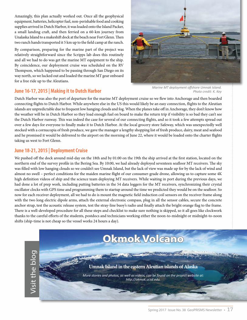
Amazingly, this plan actually worked out. Once all the geophysical equipment, batteries, helicopter fuel, non-perishable food and cooking supplies arrived in Dutch Harbor, it was loaded onto the Island Packer, a small landing cra�, and then ferried on a 60-km journey from Unalaska Island to a makeshi� dock at the beach near Fort Glenn. �en two ranch hands transported it 5 km up to the �eld camp at the ranch.
By comparison, preparing for the marine part of the project was relatively straightforward since the Scripps lab does this routinely and all we had to do was get the marine MT equipment to the ship. By coincidence, our deployment cruise was scheduled on the RV �ompson, which happened to be passing through San Diego on its way north, so we lucked out and loaded the marine MT gear onboard for a free ride up to the Aleutians.
June 16-17, 2015 | Making it to Dutch HarborDutch Harbor was also the port of departure for the marine MT deployment cruise so we �ew into Anchorage and then boarded connecting �ights to Dutch Harbor. While anywhere else in the US this would likely be an easy connection, �ights to the Aleutian islands are unpredictable due to frequent low hanging clouds and fog. When the planes take o� in Anchorage, they don’t know how the weather will be in Dutch Harbor so they load enough fuel on board to make the return trip if visibility is so bad they can’t see the Dutch Harbor runway. �is was indeed the case for several of our connecting �ights, and so it took a few attempts spread out over a few days for everyone to �nally make it to Dutch Harbor. At the local grocery store Safeway, which was unexpectedly well stocked with a cornucopia of fresh produce, we gave the manager a lengthy shopping list of fresh produce, dairy, meat and seafood and he promised it would be delivered to the airport on the morning of June 22, where it would be loaded onto the charter �ights taking us west to Fort Glenn.
June 18-21, 2015 | Deployment CruiseWe pushed o� the dock around mid-day on the 18th and by 01:00 on the 19th the ship arrived at the �rst station, located on the northern end of the survey pro�le in the Bering Sea. By 10:00, we had already deployed seventeen sea�oor MT receivers. �e sky was �lled with low hanging clouds so we couldn’t see Umnak Island, but the lack of view was made up for by the lack of wind and almost no swell – perfect conditions for the maiden marine �ight of our consumer-grade drone, allowing us to capture some 4K high de�nition videos of ship and the science team deploying MT receivers. While waiting in port during the previous days, we had done a lot of prep work, including putting batteries in the 54 data loggers for the MT receivers, synchronizing their crystal oscillator clocks with GPS time and programming them to startup around the time we predicted they would be on the sea�oor. So now for each receiver deployment, all we had to do is mount the magnetic �eld induction coil sensors on the receiver frame along with the two long electric dipole arms, attach the external electronic compass, plug in all the sensor cables, secure the concrete anchor strap, test the acoustic release system, test the stray-line buoy’s radio and �nally attach the bright orange �ag to the frame. �ere is a well-developed procedure for all these steps and checklist to make sure nothing is skipped, so it all goes like clockwork thanks to the careful e�orts of the students, postdocs and technicians working either the noon-to-midnight or midnight-to-noon shi�s (ship-time is not cheap so the vessel works 24 hours a day).
Marine MT deployment offshore Umnak Island. Photo credit: K. Key
Spring 2017 Issue No. 38 GeoPRISMS Newsletter • 17

�e clouds partially li�ed in the late a�ernoon of the 19th as we entered Umnak Pass, a narrow channel that separates Umnak Island on the west from Unalaska Island on the east. �e MT deployment carried on like clockwork and by the 20th we were making way into the Paci�c Ocean, which was starting to kick up with strong winds and some moderate swell. We �nished the last MT deployment about twelve hours ahead of schedule so we decided to use the extra time to collect high resolution multibeam bathymetry on the forearc slope before heading back to Dutch Harbor. Our journey back to port went about the northern shore of Unalaska, and with luck the clouds li�ed partially to give some nice views of Mount Makushin volcano. As usual, soon a�er the ship tied up most of the crew and science party headed to the local bar to re-equilibrate a�er a few days on a dry ship.
June 21-July 8, 2015 | Onshore �eld work�e next phase of the project started with �ights from Dutch Harbor to Fort Glenn that transported the science party, two ranch hands, and the perishable food that Safeway had just delivered. From the gravel landing strip (le� over from WWII) at Fort Glenn, a ranch hand drove the science party and food up to the camp house where we would stay. �e camp house was basically three trailer units arranged in a u-shape with an aluminum roof overtop and a giant garage door on the open side of the U. One unit was a cooking trailer with full kitchen and dinner area. Another was a bunk house and the third was a bathroom, shower and laundry facility. While we weren’t going to exactly be roughing it, nobody had stayed here in several years and everything was covered in mold and black volcanic dust, and the window sills were graveyards of giant �y corpses. We spent much of the �rst day cleaning up the place, stocking the kitchen and setting up workbenches for the geophysical equipment in the enclosed space in the middle of the three trailers. Sometime during the �rst day the helicopter arrived and everything was coming together for us to begin operations the next day.
Our seven-person science team would helicopter into and around Okmok volcano. Half of the crew carried out an onshore magnetotelluric survey collected in an array using a combination of long-period and wide-band MT systems, with nineteen stations within the caldera and ten stations outside. �e remainder of our �eld team installed thirteen temporary broadband seismometers both in and around the volcano. �e temporary seismic array recorded seismic data until its retrieval in summer 2016. In tandem with the Alaska Volcano Observatory’s twelve permanent seismic stations, there were twelve seismic instruments within/at the rim of the caldera and fourteen seismic instruments outside the caldera.
Seismic station being installed inside Okmok caldera
18 • GeoPRISMS Newsletter Issue No. 38 Spring 2017

Both the seismic and MT teams operated in parallel so the helicopter went back and forth ferrying the teams around. �at meant we always had to be prepared to be le� overnight (or longer) at �eld stations if the fog came in and the helicopter couldn’t return to pick us up (luckily this never happened, despite a few close calls). We also had to be prepared for being chased by one or more of the ~7000 feral cattle that roam the outer �anks of the caldera. We quickly developed a protocol where a�er dropping o� a team, the helicopter would �y in a 1-km circle around the station chasing away any nearby cattle. Despite this, there was an occasion where the seismic team had to make haste into a ravine to get away from an angry bull. While the MT systems only needed to record data for a few days and thus were all recovered by the end of the �rst �eld season, the broadband seismic systems were going to record seismic waves for the next year and would be picked up during the second �eld season.
July 9-14, 2015 | Recovery cruiseFor the marine MT recovery cruise, we were on a di�erent ship, the newly built RV Sikuliaq. Recovering the marine MT receivers meant driving up to them in the ship, sending an acoustic command that tells the instrument to let go of its anchor and then waiting for the instrument to rise to the sea surface. Once on the surface, the instrument’s stray line buoy radios the ship with its GPS position. �e ship then drives up to the �oating instrument from the downwind side and once its alongside the ship, we toss a grapnel around the stray line and use that to attach the instrument to the ship’s remotely operated crane, which then li�s it aboard. We successfully recovered all instruments except one that was deployed in a dicey location in Umnak Pass where there were strong currents that we suspect carried the instrument away a�er it released its anchor.
July 29 – Aug 6, 2016 | Recovery of seismic instrumentsIn summer 2016, we returned to Umnak Island to recover the seismic instruments. �is time our operations were based on marine vessel Maritime Maid. Operations continued in a similar fashion to the previous �eld season with helicopter providing the team’s transportation to and from Okmok. However, this year there was an added level of excitement as take-o�s and landings were carried out on the ship’s small helipad. Due to unusually cloudless blue skies and warm temperatures, we demobilized all thirteen seismic sites in a matter of several days. Amazingly, and quite happily, we found that the majority of stations were still up and running when returning to the sites for demobilization. A�er a rapid and successful �eld season, we departed from the wonderful Maritime Maid crew and made our way back home. ■
top left: Image from a drone video of a MT receiver being recovered
on the RV Sikuliaq with Umnak Island in the background; top right:
Seismometer recovery; bottom: Recovery team on board the
Maritime Maid.
Spring 2017 Issue No. 38 GeoPRISMS Newsletter • 19

NSF Award 1664246
RAPID: Acquisition of a Delta Ray Isotope Ratio Spectrometer for Earth Science ResearchTobias Fischer (�[email protected])
NSF Awards 1654781, 1654804
Collaborative Research: Pre- and Syn-Rift Extension, Magmatism and Segmentation along the Eastern North American MarginBeatrice Magnani ([email protected]), Lindsay Worthington ([email protected])
NSF Award 1654629
Along-strike Variations in Synrift Magmatism on the Eastern North American MarginDonna Shillington ([email protected])
NSF Award 1654745
Evaluating Mechanisms for the Formation, Propagation and Evolution of Volcanic Rifts and MarginsRoger Buck ([email protected]), Jean-Arthur Olive
NSF Award 1654586
Experimental Investigations on the Deformation Behavior of Sediment in the Shallow Region of the Nankai, North Sumatra, and Aleutian Subduction ZonesHiroko Kitajima ([email protected])
NSF Awards 1654518, 1654433, 1654557
Collaborative Research: Constraining the Flux of Magma and Magmatic CO2 during Early-Stage Rifting in East AfricaChris Scholz ([email protected]) & James Muirhead, Tobias Fischer (�[email protected]), Josef Dufek ([email protected])
2017 GeoPRISMS NSF Awards
All GeoPRISMS NSF Awards are available at:http://geoprisms.org/research/list-of-awards/
20 • GeoPRISMS Newsletter Issue No. 38 Spring 2017

GeoPRISMS PHOTO CONTEST 2016Geo
PRISMSWINNERGeoPRISMS Photo Contest
Congratulations to D. Sarah Stamps (Virginia Tech) for winning the second edition of the GeoPRISMS Photo Contest at the AGU 2016!
Sarah took this fantastic photo of a GPS station installed on the Natron Ri� of the East African Ri� in Tanzania during a �eld campaign conducted in June 2016. �e active volcano Ol Doinyo Lengai can be seen in the background. Sarah received a framed copy of her photo at the GeoPRISMS Townhall Meeting hosted at the AGU Fall Meeting.Be sure to visit the contest page at geoprisms.org to see all the photographs from this year.
Phot
o by
D.S
. Sta
mps

GeoPRISMS Steering and Oversight Committee Highlights
Spring 2017March 16-17, 2017, NSF Headquarters, Arlington, VA
Edited by Anaïs Férot, GeoPRISMS Science Coordinator & Demian Sa�er, GeoPRISMS Chair
IntroductionThe annual GeoPRISMS Steering and Oversight Committee Meeting provides the GSOC members and NSF the opportunity to share updates on GeoPRISMS activities, research funding and outcomes, and to discuss and address program issues and planning. �e Spring 2017 meeting included discussion of the program solicitation for FY18, the role of the GeoPRISMS Education Advisory Committee (GEAC), and the future of the Program a�er 2018, as well as a report from the GeoPRISMS Ri� Initiation & Evolution �eoretical & Experimental Institute held in Albuquerque, NM. The committee also received updates on the recent GeoPRISMS o�ce transition, current GeoPRISMS and GeoPRISMS-related research e�orts via presentation of materials provided by PIs, the GeoPRISMS data portal, the draft Subduction Zone Observatory (“SZO”; re-dubbed “SZ4D”) meeting report, and AGU workshops and activities.
NSF updateActing Section Head Eva Zanzerkia, representing EAR Division Director Carol Frost, OCE Division Director Rick Murray, and Program Manager Jenn Wade (EAR) provided updates from NSF. Zanzerkia discussed the important and positive impact of GeoPRISMS on EAR-Geophysics and other NSF Core Programs, highlighting that GeoPRISMS is a great example of a successful program that combines collaborative, interdisciplinary, and synthesis aspects. �ese strengths are viewed as high value components in strategic planning for the EAR division and broadly within NSF. Her recommendation to GeoPRISMS scientists is to share their work with NSF, and send outcomes and impacts to show taxpayers why NSF and EAR are so essential.
OCE Division Director Rick Murray also expressed his appreciation for the role GeoPRISMS plays in engaging and contributing to the Earth and Ocean Sciences; working across boundaries can be administratively challenging but GeoPRISMS remains very successful and works very well. Murray also highlighted the value of societally relevant, collaborative basic science underway within GeoPRISMS. William Easterling will join NSF beginning June 1 as the GEO Assistant Director. Debbie Smith has joined NSF as a permanent full-time Program O�cer in OCE Marine Geology & Geophysics.
Wade and Murray indicated that (at the time of the GSOC meeting), the Continuing Resolution (CR) for FY17 was to end in April; as of March 2016, NSF had only 50% of FY17 funds available to spend, with the rest pending a �scal year federal budget. As a result of this signi�cant budget uncertainty, decisions on GeoPRISMS and other FY17 awards were delayed by several months. NSF is moving to Alexandria, Virginia in early September 2017, so the close-out of FY17 budget is planned for June (instead of July, as is usually the case). �e FY18 federal budget is considerably delayed as is usually the case during presidential election years. Since the time of the GSOC meeting, a continuing resolution was passed to carry through September 30, 2017. Overall, NSF is highly e�cient in using their budget to support research and education; 94% of funds that NSF receives go out the door to investigators.
Wade provided further NSF GeoPRISMS program updates, noting that this year marked the end of the phased implementation for primary sites, with New Zealand now completed. NSF will open a new solicitation for FY18, with opportunities for synthesis e�orts and �eld programs at a wide range of scales (see below). Wade also noted
that there is substantial discussion within NSF with other programs, including PREEVENTS and EPSCOR, to leverage support for large projects. �e EAR division has been reorganized into two major tracks: integrated programs, including GeoPRISMS, EarthScope, and IES; and disciplinary programs, including core funding programs. This re-organization has changed some responsibilities within NSF, but has not a�ected the programs themselves or levels of funding.
GeoPRISMS solicitation in FY18 and beyond
On the heels of the �ve-year “mid-term” review, both NSF and the GSOC recognized that the focus of the remaining funding solicitations will help to shape the legacy of GeoPRISMS, demonstrate the value of integrated multi-disciplinary science, and ensure integration across field sites and data types as the decadal program heads into its final years. The phased funding model – in which large field projects in certain sites are considered only in speci�c years - is now completed; an extra call for leveraging the Alaska Transportable Array was also completed in FY17. At the time of the GSOC meeting, the upcoming (FY18) solicitation was still in preparation. �e dra� solicitation speci�cally indicated that any major �eld projects should target gaps in existing data, and should provide justi�cation that new data are necessary in order to make progress on key questions in the Science Plan. Targeted small-to-medium scale �eld projects would also be encouraged. In discussion of the funding solicitation, the point was also raised that there is strong support for proposals that use or integrate existing datasets; aligned with this idea, the dra� solicitation also highlighted synthesis and integration projects.
22 • GeoPRISMS Newsletter Issue No. 38 Spring 2017

�e FY18 solicitation is now �nal and is available at:
https://www.nsf.gov/pubs/2017/nsf17549/nsf17549.htm?WT.mc_id=USNSF_25&WT.mc_ev=click. (see also p. 25 of this Newsletter).
Rift Initiation & Evolution Theoretical and Experimental Institute reportDonna Shillington and Tobias Fischer, conveners of the Theoret ica l and Experimental Institute (TEI) for the Ri� Initiation and Evolution (RIE) Initiative that was held in Albuquerque, NM February 7-10, 2017, provided a report on the meeting to the GSOC. The objectives of the TEI were to:
• Summarize progress and recent scientific advances related to the RIE initiative;
• Identify high-priority science for future GeoPRISMS RIE e�orts; and
• Promote community building and formation of new collaborations.
A group of scientists whose expertise spanned a broad range of interests connected to the RIE Initiative, from deep geodynamic processes underlying rifting to surface processes controlling syn- and post-rift evolution, was invited to convene the meeting, give keynote lectures, and contribute to the meeting as attendees. �e complete report from the TEI was posted for community input earlier this Spring, and a
�nal version appears in this edition of the Newsletter, on p. 8.
The TEI was attended by 133 US and international participants, including about 50% early career investigators (graduate students or postdocs), as well as a number of mid-career scientists with little or no previous engagement in the RIE initiative. A half day graduate student and postdoc symposium, attended by 65 grad students, postdocs, and a few senior scientists, was held the day before the conference. �e main meeting included oral sessions spanning topics from ri� initiation and evolution to geodynamics and surface processes (the full list of sessions and more details available at: http://geoprisms.org/tei-rie-2017/). Small group discussions were focused on the identification of high priority science questions and work needed to tackle these questions. Several poster sessions were also set up throughout the meeting, and pop-up sessions allowed attendees to introduce their posters and collaborative opportunities. �e speakers and attendees covered a wide spectrum of expertise and perspectives; talks focused on the EARS and ENAM focus sites but also targeted other science within the RIE initiative.
Five high-priority science themes were identified from the discussions; within each of these, the workshop highlighted key recent �ndings and opportunities for near-term research progress:
1. Tracking �uids (volatiles and magmas) through the lithosphere and with time
2. In�uence of pre-existing structures throughout ri� development
3. Controls on strain localization
4. Time dependent rheology & dynamics
5. Surface mass �uxes & feedbacks with ri� evolution
To address outstanding questions related to the themes above, the following future e�orts were highlighted as particularly important:
• Collection of new geophysical, geochemical, geological data, particularly in the EAR
• Synthesis of information within and between ri� systems
• Experimental (laboratory) work, possibly connecting to SCD
Allied programs and partner organizations updatesTerry Plank called in to provide update on the Subduction Zone Observatory (SZO) meeting that was held September 29 - October 1, 2016 in Boise, Idaho.
Among the 240 participants (made possible thanks to extra funding from NSF, USGS, and other international programs), 67 were early career, and 45 were from 21 non-US countries. Plank and Jeff McGuire were lead conveners for the SZO meeting, and organized the writing team to draft the workshop report.
GeoPRISMS Data PortalVisit the GeoPRISMS Data Portal to �nd information for each Primary Site:
• Pre-existing data sets and �eld programs• Data sets ready for download• Links to partner programs and resources• References database with papers tied to data
GeoPRISMS references database of relevant publications is now available:
http://www.marine-geo.org/portals/geoprisms/references.php
To submit missing data sets, �eld programs or publications to the GeoPRISMS portal, contact [email protected]
Spring 2017 Issue No. 38 GeoPRISMS Newsletter • 23

GeoPRISMS Postdoctoral FellowshipDeadline July 27, 2017
For details, visit the GeoPRISMS website:
http://geoprisms.org/education/geoprisms-postdoctoral-fellowships/
Phot
o by
D. R
asm
usse
n
At the time of the GSOC meeting, the SZO report (re-dubbed “SZ4D” to capture the core idea that subduction zones are complex and require observations of processes in three-dimensions and over time) was in progress, to be released for community input in April. The report highlights a number of key themes for this initiative: (1) understanding processes that underlie geohazards at subduction zones; (2) integration of data sets and models that capture the four-dimensional evolution of key subduction processes; and (3) development of strong modeling and international collaboration elements. [�e full SZ4D report has now been distributed and is available at: https://www.iris.edu/hq/�les/workshops/2016/09/szo_16/sz4d.pdf]
GSOC also heard updates about a large number of allied projects underway or planned for the New Zealand primary site, supported through Integrated Ocean Discovery Program (IODP) and NSF programs beyond GeoPRISMS. These include: three IODP drilling expeditions – two focused on slow slip events, landslides, and slope failures along the northern Hikurangi subduction margin (Expeditions 372 and 275) and one on subduction initiation (Expedition 371); a newly funded NSF Integrated Earth Systems project combining paleoseismology, active-source seismology, and geodynamic modeling to link the deep structure of the subduction zone with surface processes, slow slip and the seismic cycle; and a 3-D seismic survey community experiment aimed at studying the impact of seamount subduction on
the structure and evolution of the plate interface. All of these projects involve significant international collaboration and instrumentation and/or ship time contributions from international partners.
Sarah Penniston-Dorland provided an update on the NSF-PIRE project entitled “ExTerra Field Institute and Research Endeavor (E-FIRE)”. ExTerra (Exhumed Terranes), is a self-organized group of geoscientists with the object ive of investigating exhumed paleo-subduction zones to better understand the materials and processes in active systems. �is large scale international project partners with a European collaborative research and training project (ZIP; “Zooming In between Plates”). �e program includes support for eight PhD students and two postdocs; the two postdocs and seven of the eight students have started and have already presented posters and begun their research in collaboration with the US and European faculty. �e �rst �eld institute will take place in the summer of 2017. [More info about ExTerra and E-FIRE at: http://geoprisms.org/exterra/]
Andrew Goodwillie provided an update on the GeoPRISMS Data Portal and recent improvements. He highlighted a number of new datasets contributed by PIs, including Gulf of California zircon U-Pb geochronology (data are available on EarthChem and GeoMapApp: http://www.earthchem.org/library/browse/view?id=928), an East African Ri� System geodetic velocity �eld (2016.0a) compiled from continuous and survey mode GPS networks, and a
suite of subduction zone residual gravity and residual bathymetry data sets for the Alaska-Aleutians, Cascadia, and Hikurangi margins. Also added was a suite of geodetic plate velocity solutions including EarthScope PBO and MIDAS solutions that cover the three GeoPRISMS primary sites in North America. Additionally, a new version of the basemap was released a few months ago, and includes 931 cruises and almost three million track miles. Goodwillie also noted that there is a new pro�le generation tool in beta form that can help with cruise planning by linking ship tracks to the bathymetry.
SCD and RIE initiative updates GSO C memb ers , with input f rom GeoPRISMS PIs, provided updates on a wide range of ongoing GeoPRISMS research projects. These updates provide a key opportunity for the GSOC and NSF Program Officers to see the breadth of exciting science underway within GeoPRISMS, recognize potential links with other NSF and major international efforts, assess progress toward key questions in the Science Plan, and identify science gaps and new opportunities. These updates provide an important opportunity for the GeoPRISMS community to demonstrate the value of interdisciplinary and societally relevant research to NSF Program Managers in the GEO directorate.
The GSOC received updates on active projects spanning both the RIE and SCD initiatives. The SCD updates included a thematic-focused post-doctoral fellowship
24 • GeoPRISMS Newsletter Issue No. 38 Spring 2017

investigating the role of faults in the downgoing plate on forearc �uid and seismic processes through comparison of Central America, Cascadia, Nankai, and Alaska subduction zones; an effort to improve models of interseismic locking and slow slip events in Cascadia and New Zealand; a collaborative effort to understand the Aleutian megathrust from trench to base of the seismogenic zone through integration of laboratory, geophysical and geological data; a geodetic study to characterize the interseismic slip de�cit in the Shumagin Islands, Alaska; and a study of �uid-mobile and volatile element (Cl, B, & Li) cycling through the forearc of the Hikurangi margin, New Zealand. It also included a wide range of ongoing studies of the Aleutian arc, with investigations focused on: the geochemical and magmatic evolution of Aleutian arc on the Alaska Peninsula; the ages and geochemical comparison of coeval plutons and volcanics from the central and eastern Aleutian arc; the geodynamic evolution of the Aleutians and adjacent Paci�c and Bering Sea; magnetotelluric and seismic signatures of arc melt generation, delivery, and storage beneath Okmok volcano (see report from the Field in this issue); the origin, storage, ascent and eruption
of volatile-bearing magmas in Aleutian volcanoes; the role of oxygen fugacity in calc-alkaline di�erentiation and the creation of continental crust at the Aleutian arc; and characterizing magma ascent and eruption in the Aleutian arc.
RIE initiative updates included a summary of ongoing science stemming from the ENAM community Seismic Experiment undertaken in 2014, which collected marine seismic reflection and refraction data, on-land seismic refraction data, and broadband seismic data onshore (EarthScope) and offshore (using the OBSIP array). These datasets are all open access. A suite of projects were funded in FY16 and FY17 to work on the data, including studies of the role of mantle melts on evolution of ri�ed margin lithosphere; investigation of ri� evolution from basement architecture; and analysis of shear-wave splitting. �e updates underscored that the early returns on the ENAM community experiment are very positive, the community is engaged, and science proposals using the community dataset have clear and distinct questions. RIE updates also included a theoretical and experimental study focused on emplacement of regularly spaced volcanic centers in the East African Rift;development of a
community velocity �eld for East Africa; and geochemical analyses to constrain the temporal evolution of mantle plume contributions to magmatism in the Turkana Depression.
Plans for upcoming meetingsGeoPRISMS will be at the 2017 AGU Fall Meeting in New Orleans with a Townhall on Monday evening and planned Mini-Workshops for Sunday, December 10; a call for Mini-Workshop proposals has been sent out to the Community - the GSOC will select the successful mini-workshop proposals in late summer. �e GSOC also discussed early planning for an Integration & Synthesis TEI recommended as part of the mid-term review of the program, which will likely be held in late 2018. �e TEI will integrate ongoing work and results across themes and/or between focus sites, with the goal of identifying advances on the cross cutting science themes in the Science Plan, and de�ning emerging questions. As plans for this major workshop materialize, announcements will go out via the listserv and the GeoPRISMS website, so please stay tuned.
GeoPRISMS Program[Program Solicitation NSF 17-549]Target date: July 27, 2017http://www.nsf.gov/pubs/2017/nsf17549/nsf17549.htm
This revision describes the completion of the “phased funding model” that had been in place, implements a requirement to contact Program Directors before submitting proposals for large �eld projects, encourages integrative projects at all scales, and removes a one-year call for large proposals to leverage the Transportable Array (TA) in Alaska/Aleutians.
Any proposal submitted in response to this solicitation should be submitted in accordance with the revised NSF Proposal & Award Policies & Procedures Guide (PAPPG) (NSF 17-1), which is e�ective for proposals submitted, or due, on or after January 30, 2017.
Questions should be directed to:PO Jennifer Wade: [email protected]; (703) 292-4739 or Maurice Tivey: [email protected]; (703) 292-7710
Spring 2017 Issue No. 38 GeoPRISMS Newsletter • 25

East African Rift SystemAn updated East African Ri� System geodetic velocity �eld (2016.0a, http://www.marine-geo.org/tools/search/entry.php?id=EARS_King) compiled from continuous and survey mode GPS networks was contributed to the Data Portal by Bob King, Michael Floyd, Rob Reilinger, and Becky Bendick. Containing data obtained between 1994 and December 2015, the data set is part of a wider Africa/Arabia/Eurasia velocity �eld derivation.
JapanSabine den Hartog made available her exper imenta l data on the f r ic t ion properties of exhumed fault gouge from Japan’s Shikoku Island (http://www.marine-geo.org/tools/search/entry.php?id=ExpInvestig:Lab_denHartog).
CascadiaA GeoMapApp webinar focused upon available data sets in the Cascadia region was broadcast and is now available on YouTube(https://www.youtube.com/watch?v=DpX-igx5T7c).
Cascadia, Alaska-Aleutians and Hikurangi marginsSubduction zone residual gravity and residual bathymetry data sets from Dan Bassett and Tony Watts from their 2015 G-Cubed
papers were contributed for the Alaska-Aleutians (Fig. 2), Cascadia and Hikurangi margins (http://www.marine-geo.org/tools/search/DataSets.php?data_set_uids=24025,24026,24027,24028,24029). Also added was a suite of geodetic plate velocity solutions
including EarthScope PBO and MIDAS solutions that cover the three GeoPRISMS primary sites in North America.
Andrew Goodwillie and the IEDA Database Team
Lamont-Doherty Earth Observatory, Columbia University
Status Report on the GeoPRISMS Data Portal: May, 2017
�e GeoPRISMS data portal (http://www.marine-geo.org/portals/geoprisms/) was established in 2011 to provide convenient access to data and information for each primary site as well as to other relevant data resources. Since the last newsletter report, highlighted below are recent contributions of data sets and �eld program information of interest to the GeoPRISMS community. Many of the data sets described are also available in GeoMapApp (http://www.geomapapp.org/)under the Focus Site and DataLayers menus.
Figure 1. The King et al. EARS 2016.0a velocity field in a no-net-rotation frame with station symbols coloured on the North component of velocity and scaled on East
velocity. Warm colors are faster velocities. The built-in background elevation map is the 30m-resolution ASTER land topography. Image made with GeoMapApp. All of
the data sets shown are accessible through the GeoMapApp menus.
The GeoPRISMS Data Portal team is here to serve the community
Please contact us at [email protected]

GeoPRISMS Data Portal Tools and Other Relevant IEDA ResourcesSearch For Data - (http://www.marine-geo.org/tools/new_search/index.php?funding=GeoPRISMS) �e GeoPRISMS search tool provides a quick way to �nd GeoPRISMS data using parameters such as keyword, NSF award number, publications, and geographical extent.
Data Management Plan tool - (www.iedadata.org/compliance) Generate a data management plan for your NSF proposal. �e on-line form can be quickly �lled in, printed in PDF format, and attached to a proposal. PIs can use an old plan as a template to create a new plan. We also have developed a tool to help PIs show compliance with NSF data policies.
GeoPRISMS Bibliography – (http://www.marine-geo.org/portals/geoprisms/references.php) With more than 1,140 citations, many tied to data sets, the references database can be searched by primary site, paper title, author, year, and journal. �e citations can be exported to EndNote™. Submit your papers for inclusion in the bibliography – just the DOI is needed! http://www.marine-geo.org/portals/geoprisms/ref_submit.php
Contribute Data - (http://www.iedadata.org/contribute) �e web submission tools support PI contributions of geophysical, geochemical, and sample data. File formats include grids, tables, spreadsheets, and shape�les. Once registered within the IEDA systems, the data sets become available to the broader community immediately or may be placed on restricted hold. Additionally, PIs can choose to have a DOI assigned to each submitted data set, allowing it to become part of the formal, citable scienti�c record. ■
Figure 2a (top). For the Shumagin Gap area in the Aleutians primary site, the residual gravity free-air anomaly of Bassett and Watts (2015) is shown. Dark blue represents
anomalies < -50 mgals and dark red depicts anomalies > 50 mgals. The contoured grey-shaded structure trending across the image is the depth to the top of the
subducting slab from Syracuse and Abers (2006). Circles are the epicentral locations for earthquakes greater than magnitude 5.0 from the USGS-ANSS catalogue. The
symbols are colored on depth, with warmer colors showing deeper foci, and scaled by magnitude. The white line in the center of the image shows the location of the stacked profiles presented in Fig 2b. Image made with GeoMapApp. All of the data sets shown
are accessible through the GeoMapApp menus. An enhanced GeoMapApp Save Session function allows the layering and visualisation parameters of all of the displayed data
sets to be stored for future use.
Figure 2b (right). New in GeoMapApp version 3.6.4 is the capability to generate a co-registered vertical stack of up to four profiles. Here, the Bassett and Watts residual
bathymetry and residual gravity are in the lower and middle panel respectively and the Syracuse and Abers depth to the top of the subducting slab is in the top panel.
Spring 2017 Issue No. 38 GeoPRISMS Newsletter • 27

Magmatic Systems in Extensional and Compressional SettingsConveners: Cindy Ebinger (Tulane), Christelle Wauthier (PSU), Cli� �urber (Wisconsin), Maya Tolstoy and Einat Lev (LDEO), James Muirhead (Syracuse), Josef Dufek (Georgia Tech)
December 12-16, 2016 AGU Fall Meeting, San Francisco
GeoPRISMS provides the opportunity for groups of researchers to meet and discuss GeoPRISMS Science or planning activities at the AGU Fall Meeting. Here is the report from the Mini-Workshops organized at the 2016 AGU Fall Meeting.
Phot
os b
y A
. Fér
ot
GeoPRISMS at AGU Fall Meeting - Mini-Workshop Reports
Participants and conveners at the pre-AGU GeoPRISMS mini-workshop discussing future research initiatives in continental and
mid-ocean rift zones, and in volcanic arc settings.
A diverse and enthusiastic community of scientists interested in magmatic systems in a variety of settings attended the pre-AGU GeoPRISMS mini-workshop to discuss and plan future research initiatives in light of new studies in continental and mid-ocean ri� zones, and in volcanic arc settings. �e over-arching goal of this mini-workshop was to facilitate community-building, and to provide a relaxed setting for early-career scientists in particular to communicate their results, and their ideas on future directions.
�ree review talks on the physics of crustal magmatic systems (Joe Dufek, Georgia Tech), active deformation (Diana Roman, Carnegie) and time-averaged deformation (Colin Wilson, Victoria University of Wellington) in ri�s and arcs established context. Joe’s talk outlined the time and length scales of processes, and critical parameters controlling magma movement and eruptions: crustal state-of-stress, rheology of crust surrounding magma body, thermodynamics and heat transfer of the magma body, and magma composition and volatile content. He highlighted the need for multi-disciplinary observations at key locales, the focus-site hallmark of GeoPRISMS. Diana focused on magmatic systems in compressional settings where �uid and gas pathways tend to be closed.
Seismicity may track hydraulic fracture accompanying the upward migration of magma and gasses, enabling some constraint on �ux rates, and potentially, rheology of the intruded rocks. Diana’s summary demonstrated the need for long-term monitoring at volcanoes. Colin drew on precise dating and �eld relations to understand the ‘chicken and egg’ question of tectonic or over-pressure as the trigger for large-volume intrusion and eruption episodes in back-arcs and ri� zones. He suggested that critical insights will come from quanti�cation of extrusive to intrusive ratios as the community develops eruption forecast models, and considers the relative importance of buoyancy forces, overpressures, open or closed fault systems, and dynamic triggering from distant earthquakes.
28 • GeoPRISMS Newsletter Issue No. 38 Spring 2017

Graduate students and post-docs introduced themselves and their research in three-minute pop-ups. �e future planning aims were achieved through small group discussions focused on specific questions, with questions and questioners changing every ��een minutes. Groups were assembled to achieve breadth and diversity of perspectives. �is series of “café-style” discussions on a speci�c questions enabled scientists to share perspectives on: (1) Magma and volatile transfer and their role in strain localization during plate boundary deformation, and (2) �e role of tectonic stressing on volcanic eruption cycles and magma emplacement.
�e café questions facilitated comparison and contrasts between arcs, back-arcs, and continental ri� zones, and facilitate discussions with numerical modelers keen to understand the role of magmatism and volatile release in lithospheric deformation processes. Participants shared experiences with data and models from Alaska, East Africa, Cascadia (including Juan de Fuca ridge processes), and Hikurangi, New Zealand focus sites, and looked forward to guide new research initiatives.
Question 1 | Einat Lev | What are the physics of Open Vent Systems, and their responses to external triggers?
Question 2 | Cindy Ebinger | How do hot and cooled intrusions into continental and slow-spreading oceanic crust in�uence state of stress and rheology (e.g., underplate, foundering, along-axis propagation)?
Question 3 | Cli� �urber | a) What are the characteristic forms of the magma transport and storage areas at various depths? b) What controls the magma residence time at depth and its migration toward the surface?
Question 4 | Christelle Wauthier | What are the feedbacks between local tectonics and magmatic/volcanic processes in triggering volcanic eruptions and unrest nearby magma bodies, dikes, fault slip, megathrust shaking?
Question 5 | James Muirhead | How can we use variations in the �ux and chemistry of volatiles and �uids, in combination with deformation data, to constrain di�erent magmatic, volcanic, and tectonic processes?
Question 6 | Maya Tolstoy | What do precursory signals tell us about the physical mechanisms triggering eruptions?
Question 7 | Joe Dufek | The rate of crustal production and development of crustal structure is ultimately sensitive to the degree of fractionation versus crustal melting that occurs in thermally mature systems. How can we quantify the heat budget in di�erent levels of the crust subject to variable intrusion histories?
Developing better understanding of the link between tectonics and magmatism was discussed in almost every group. Discussion focused on tectonics role in modifying intrusion histories, and also the dual role of tectonics and magmatism on the thermal state of the crust (the discussions mostly focused on extensional environments). A common theme of these discussions was the integration of di�erent datasets that better de�ne the current and past rates of deformation in regions as well as measurements indicating the current state of magma bodies including pre-eruptive seismic, deformation, gas �ux measurements, and geochemical measurements of erupted magmas. Models that make predictions that have implications (and can be tested) by multiple datasets were discussed as a way of integrating measurements.
EarthScope-type Canadian Cordillera Seismic Array and GPS NetworkConveners: Rick Aster (Colorado State U.), Pascal Audet (U. of Ottawa), Katherine Boggs (Mount Royal U.), Julie Elliott (Purdue U.), Roy Hyndman (Paci�c Geoscience Centre), Michael Schmidt (U. of Calgary), Derek Schutt (Colorado State U.)
On Sunday, December 11, an international and interdisciplinary group of about fifty researchers met in San Francisco under GeoPRISMS support to discuss emerging interest in a Canadian Cordillera Earth Observation Network. �e network is conceived to holistically image broad Earth systems along the Paci�c Plate Margin and Canadian Cordillera between Alaska and the U.S. Paci�c Northwest. �is initiative emerged out of four workshops and a planning meeting held in multiple locations in Canada over the last year, working with a broad range of U.S. and international collaborators. �e workshop pulled together interested researchers from across the U.S. and Canada, including representatives associated with from GeoPRISMS, IRIS, UNAVCO, NSF, industry,
academic institutions, and a wide range of Canadian institutions.
A�er brief introductions by GeoPRISMS Chair Damien Sa�er (Penn State) and workshop Chair, Rick Aster (Colorado State U.), Roy Hyndman (Paci�c Geoscience Centre) began a sequence of overview talks, by outlining the fundamental tectonic questions ranging from ridge subduction at the north end of the Cascadian forearc, to the Yakutat mini-Himalaya collision along the Gulf of Alaska, to the Canning-Mackenzie overthrust in the Beaufort Sea. Hyndman noted the mainly dextral slip along the Queen Charlotte Fault has a recently revealed partitioned thrust component, as was recently illustrated by the 2012 Mw 7.8 Haida Gwaii earthquake which created a notable (but very sparsely observed) tsunami.
The full workshop report and summaries of feedback from each group to each of the
questions outlined above are available at:http://geoprisms.org/meetings/mini-
workshops/agu2016-volcanoes/
Spring 2017 Issue No. 38 GeoPRISMS Newsletter • 29

Pascal Audet (U. of Ottawa) presented an overview of existing seismic and other geophysical studies within the Canadian Cordillera, and pointed out the very signi�cant geographic gaps in coverage. Broadly speaking, the proposed project can build on the exceptional legacy of LITHOPROBE across Canada. However, resolution of crustal and mantle structure across the region, and the understanding of seismicity and deformation, is comparable at best in many subregions to that of the western U.S. prior to the deployment USArray.
Talks by Lindsay Worthington (U. of New Mexico) and Julie Elliott (Purdue U.), described the complex tectonic collisional and transpressional setting of the Gulf of Alaska plate margin. �e eastern edge of the Yakutat Block is currently poorly de�ned, and seems to be driving deformation well into the interior of northern Canada, resulting in a (presently very poorly imaged) Canning-Mackenzie overthrust in the Beaufort Sea, and the arcuate thrust belt of the Mackenzie Mountains, 700 to 1000 km from the plate boundary. Additionally, Julie Elliott pointed out the wide range of scienti�c and societal contributions that could be made by a larger permanent GNSS network in the region, including examining the deep earth, hydrosphere, cryosphere, atmosphere, industry, surveying/land use, agriculture, and natural hazards.
Mladen Ndemovic (Dalhousie U.) presented on the need for marine seismic surveys and instrumentation from the north end of the Cascadia forearc to the Alaskan Panhandle, as well as in the Beaufort Sea.
David Eaton (U. of Calgary) described induced seismicity in the Western Canadian Sedimentary Basin (WCSB) along the eastern margin of the Canadian Cordillera and its link with hydraulic fracturing. �e importance of elastic stress changes in contributing to induced seismicity in the WCSB and improved understanding of induced seismicity could lead towards improving our general understanding of earthquakes, and to the conditions under which fracking can create appreciable earthquakes.
Kristin Morell (U. of Victoria) outlined the need for LIDAR, paleo-trenching, and detailed �eldwork to de�ne active faults on Vancouver Island. Nicole West (Central Michigan U.) provided an overview of the critical zone, and the need for critical zone monitoring in a range of tectonic and environmental regimes not covered in the US NSF-funded Critical Zone Observatories. It was noted that the critical zone is also the near-surface “geotechnical zone” which de�nes many aspects of seismic hazard, as well as a general zone of high-frequency seismic wave propagation complexity.
Frank Vernon (UC San Diego) and Eric Donovan (U. of Calgary) discussed motivations and bene�ts of a full geophysical suite of instrumentation at some sites, including for atmospheric sciences and ionosphere/magnetosphere/space physics. Donovan suggested opportunities for collaboration with the Canadian and European Space Agencies through the SWARM program as an example of a multi-national non-traditional research network that could be emulated within the proposed array.
Community discussion a�er the talks focused on possible next steps for international coordination to move potential projects forward. �ese details include timely exploration of partnerships that can strongly leverage funding, logistical, and potentially available equipment partnerships in step with the planned sunsetting of current EarthScope USArray and other e�orts in Alaska and far northwestern Canada.
Conveners and participants of the GeoPRISMS Mini-Workshop discussing emerging interest in a Canadian
Cordillera Earth Observation Network.Ph
otos
by
A. F
érot
30 • GeoPRISMS Newsletter Issue No. 38 Spring 2017

CYNTHIA EBINGERTulane University
BRANDON SCHMANDTUniversity of New Mexico
HEATHER SAVAGELDEO, Columbia U
ESTEBAN GAZELCornell University
Visit the GeoPRISMS website to apply or learn more about the speakers & talks available
�e GeoPRISMS O�ce is happy to announce the annual Distinguished Lectureship Program for academic year 2017-2018 with an outstanding speakers list. Distinguished scientists involved with GeoPRISMS science and planning are available to visit US colleges and universities to present technical talks and public lectures on subjects related to GeoPRISMS science.
Want to host a speaker? Apply before July 10!Any US college or university wishing to invite a GeoPRISMS speaker may apply via the GeoPRISMS website before July 10, 2017. Institutions that are not currently involved with GeoPRISMS research are strongly encouraged to apply, including those granting undergraduate or masters degrees, as well as those with PhD programs. Institutions may request a technical and/or public lecture. �e GeoPRISMS O�ce will cover airfare for the speaker’s travel and will coordinate travel and o�-site logistics. Host institutions are responsible for local expenses for the duration of the visit.
Questions?Email [email protected]
For more information, visit the GeoPRISMS Website at:
http://geoprisms.org/education/distinguished-lectureship-program/
Distinguished Lectureship Program
2017 - 2018
GeoPRISMS is now on YouTube! Subscribe and watch lectures given by the GeoPRISMS Distinguished Speakers in the past years.

GeoPRISMS is offering two $500 prizes for Outstanding Student Presentations on GeoPRISMS- or MARGINS-related science at the AGU Fall Meeting. The two prizes, one each for a
poster and an oral presentation, highlight the important role of student research in accomplishing MARGINS- and GeoPRISMS-related science goals, and encourage
cross-disciplinary input. The contest is open to any student whose research is related to the objectives of GeoPRISMS or MARGINS.Presentations are judged throughout the AGU meeting. Students have also the opportunity to display their posters or a poster version of their AGU talks at the GeoPRISMS Townhall and Student Forum, organized each year
on the Monday night. This is a great opportunity for students to share their results further, to interact with a wide spectrum of GeoPRISMS scientists, and
to hear about upcoming events and opportunities. More information on this year’s contest will become available closer to AGU on the GeoPRISMS website, stay tuned!
Suzanne Birner – Stanford UniversityRecords of upper mantle oxygen fugacity gleaned from high-density sampling of basalts and peridotites at ultraslow ridgesCoauthors: Elizabeth Cottrell, Jessica Warren, Katherine Kelley, Fred Davis
From the Judges: “Suzanne’s talk was polished and elegant” “She presented a geological mystery (the observation that ridge basalts tend to record higher fO2 than ridge peridotites) which she has resolved for rocks sampled at the Southwest Indian Ridge” “�is was my favorite talk of the meeting!”
From the Student: “I’m honored to receive this recognition from GeoPRISMS! I very much appreciate everything GeoPRISMS does for the community, especially its dedication to helping students, and I look forward to further
involvement with the GeoPRISMS community and related research in the future.”
Congratulations to the winners of the GeoPRISMS 2016 AGU Student Prize! As in previous years, the judges were greatly impressed by the quality of the entrants this year and awarding individual prizes to just a few in such an outstanding �eld was very di�cult. Here we honor two prize winners and four honorable mentions. �ank you to all the entrants and judges for making this contest possible and worthwhile.
GeoPRISMS Student Prize for Outstanding Presentations
2016 AGU Fall Meeting, San Francisco
Poster Presentation WinnerDan Rasmussen – LDEO, Columbia UniversityRun-up to the 1999 sub-plinian eruption of Shishaldin Volcano unveiled using petrologic and seismic approachesCoauthors: Terry Plank, Diana Roman, Amanda Lough, Pete Stelling, Robert Bodnar, Erik Hauri
From the Judges: “Daniel gave a really terri�c presentation and enthusiastically provided thoughtful answers to questions from audience around his poster” “true integrative combination of petrological, geochemical and geophysical data” “excellent presentation, integrating many di�erent types of observations to identify precursory signals in the run up to a well studied eruption”
From the Student: “I am honored to receive the GeoPRISMS student presentation award. GeoPRISMS is a fantastic program that brings together scientists from di�erent disciplines, at all stages of their careers, to study the dynamic processes occurring at plate boundaries. I am grateful to be a part of this community.”
Suzanne Birner – Stanford UniversityOral Presentation WinnerSuzanne Birner – Stanford UniversityRecords of upper mantle oxygen fugacity gleaned from high-density sampling of basalts and peridotites at ultraslow ridges
Suzanne Birner – Stanford UniversityOral Presentation Winner
32 • GeoPRISMS Newsletter Issue No. 38 Spring 2017
Joshua Davis – UTIG, AustinCold rocks make more melt: Numerical models of melt generation during continental extensionCoauthors: Luc Lavier
From the Judges: “Very organized and well-practiced talk” “Joshua was able to clearly explain the interesting and counterintuitive results of his research” “�e ri�ing simulations were impressive and Joshua’s narration was seamless and con�dent.”
From the Student: “�ank you GeoPRISMS for this recognition. I’m honored to participate among this community and look forward to future collaborative e�orts.”
Honorable Mention
“�ank you GeoPRISMS for this recognition. I’m honored to participate among this
Helen Janiszewski – LDEO, Columbia UniversityShoreline-crossing shear-velocity structure of the Juan de Fuca Plate and Cascadia Subduction Zone from surface waves and receiver functionsCoauthors: Jim Gaherty, Geo� Abers, Haiying Gao
From the Judges: “Helen is very knowledgable about her research” “�e project represents an important and novel contribution to imaging the structure of Cascadia, integrating onshore & o�shore observations” “She really knows her material and is clearly aware of the strengths and weaknesses of her work”
From the Student: “I am honored to have my research recognized within the GeoPRISMS community. I am grateful to the organizers of this program for their support of student research, and look forward to continuing participation in GeoPRISMS research.”
Honorable Mention
Helen Janiszewski – LDEO, Columbia UniversityShoreline-crossing shear-velocity structure of the Juan de Fuca Plate and Cascadia Subduction Zone from surface waves and receiver functions
Honorable Mention
Honorable MentionHannah Mark - MIT-WHOISeismic coupling at divergent plate boundaries from rate-and-state friction modelsCoauthors: Mark Behn, Jean-Arthur Olive, Yajing Liu
From the Judges: “Extremely well constructed and delivered presentation” “Elegant explanation of the basis of this modeling study and the overall controls on seismic coupling” “[...] �ndings have implications for fault behavior associated with continental ri�ing”
From the Student: “I am honored to have my work recognized by GeoPRISMS and I appreciate the great opportunities o�ered by the program for young scientists to participate. �ere’s so much interesting science that can be tackled in a multi-disciplinary community like this one, and I’m excited to see what new insights on plate boundary processes will come out of the next few years of research.”
great opportunities o�ered by the program for young scientists to participate. �ere’s so much interesting science
Sarah Jaye Oliva - Tulane UniversityDeciphering the role of �uids in early stage ri�ing from full moment tensor inversion of East African earthquakesCoauthors: Cindy Ebinger, Steven Roecker, Derek Keir, Donna Shillington, Patrick Chindandali
From the Judges: “Sarah did a really nice job of explaining her work. It was also great to see how well she understood her methodology, and how much she is thinking about how to improve the work via more robust discussion of errors” “Sarah is very smart, explains her research extremely well and thinks
“outside the box” for her interpretations” “Nice analysis and presentation of poster”
From the Student: “I’m pleasantly surprised and honored to be recognized and I’m very thankful for the sense of community and the support that GeoPRISMS provides, especially to junior scientists like myself. I look forward to taking part in this community!”
Sarah Jaye Oliva - Tulane UniversityHonorable MentionSarah Jaye Oliva - Tulane UniversityDeciphering the role of �uids in early stage ri�ing from full moment tensor inversion of East African
“outside the box” for her interpretations” “Nice analysis and presentation of poster”
Sarah Jaye Oliva - Tulane UniversityHonorable Mention
Spring 2017 Issue No. 38 GeoPRISMS Newsletter • 33

Rob HarrisOregon State [email protected]
NSF Program DirectorsNational Science Foundation, 4201 Wilson Boulevard, Arlington, VA 22230
Chad DeeringMichigan [email protected]
*Also member of GEAC
GeoPRISMS O�ce�e Pennsylvania State University | Department of Geosciences
503 Deike Building, University Park, PA 16802Program Chair: Demian Sa�er; Science Coordinator: Anaïs Férot; Administrative Coordinator: Jo Ann Lehtihet
e-mail: [email protected] - website: www.geoprisms.org
GeoPRISMS Steering and Oversight Committee
Demian Saffer*, GeoPRISMS Chair�e Pennsylvania State [email protected]
Juli MorganRice [email protected]
Becky BellImperial College [email protected]
Kyle StraubTulane [email protected]
Rosemary Hickey-VargasFlorida International U. [email protected]
Andrew GoodwillieLDEO, Columbia [email protected]
Cathy A. ManducaCarleton [email protected]
Jeff MarshallCal Poly [email protected]
Jennifer WadeDivision of Earth [email protected]
Maurice TiveyDivision of Ocean [email protected]
Rebecca BendickUniversity of [email protected]
Kerry KeyScripps Institution of [email protected]
Daniel BrothersUSGS, Santa [email protected]
Sarah Penniston-Dorland*University of [email protected]
GeoPRISMS Education and Advisory Committee
Jessica WarrenUniversity of [email protected]
Katie KeranenCornell [email protected]
Luc LavierUniversity of Texas [email protected]
34 • GeoPRISMS Newsletter Issue No. 38 Spring 2017

Kyle StraubTulane [email protected]
Sarah Penniston-Dorland*University of [email protected]
Jessica WarrenUniversity of [email protected]
Contact UsThe Pennsylvania State University
GeoPRISMS Program503 Deike Building
University Park, PA 16802
Questions? Email:
Stay Informed!Sign up for the GeoPRISMS Newsletter
Like us on Facebook
Follow us on Twitter
Follow all the opportunities through
our Listserv
Attend the annual GeoPRISMS
Townhall Meeting at AGU
Visit our website
www.geoprisms.org

GeoPRISMS will be at the AGU Fall Meeting 2017!
Visit the GeoPRISMS website for more information about GeoPRISMS activities www.geoprisms.org
GeoPRISMS Mini-Workshop at the AGU Fall Meeting 2015 “From rifting to drifting: Evidence from rifts and margins worldwide
�e Pennsylvania State University | Department of GeosciencesGeoPRISMS Program503 Deike BuildingUniversity Park, PA 16802