general workflow and data requirements … · general workflow and data requirements for reservoir...
TRANSCRIPT
GENERAL WORKFLOW AND DATA REQUIREMENTS FOR RESERVOIR CHARACTERIZATION AND SIMULATION
WORKFLOW April 4, 2014
Page 1 of 15
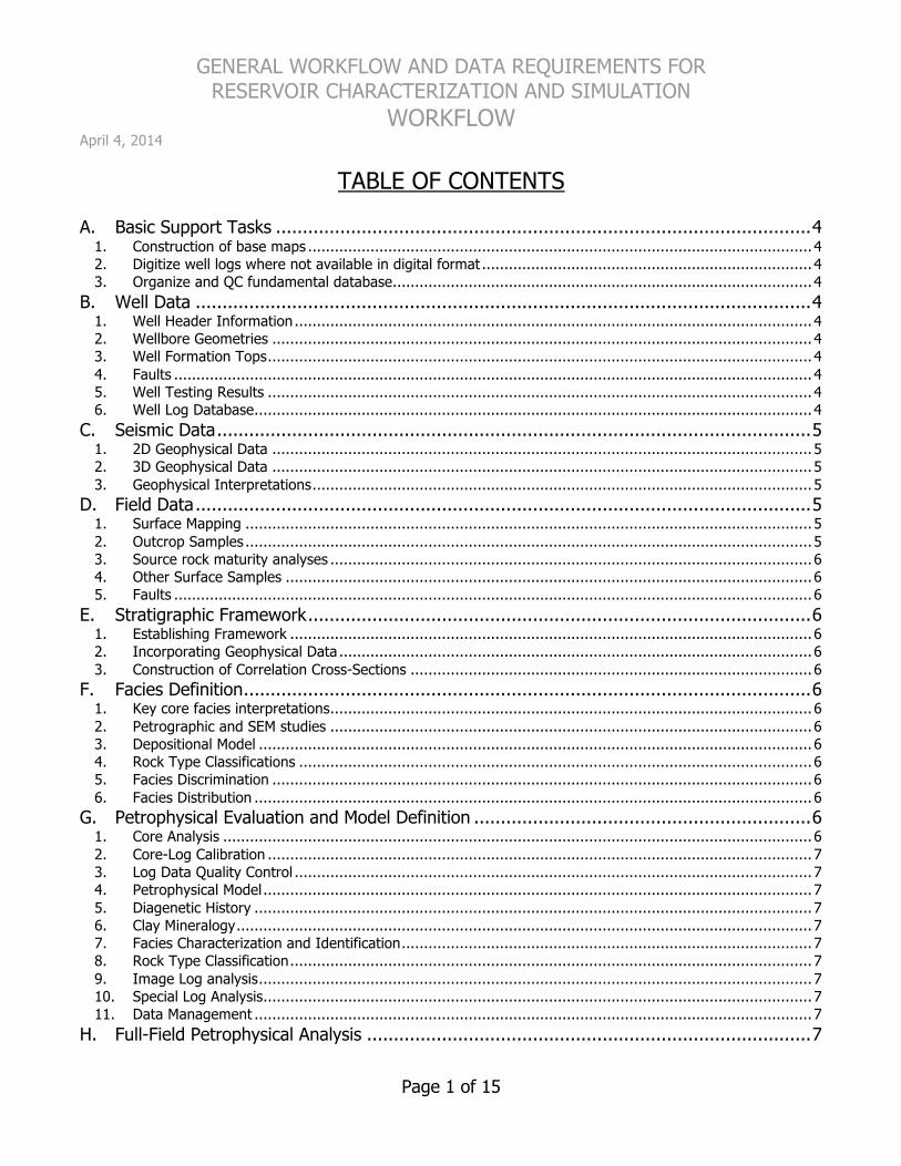
TABLE OF CONTENTS A. Basic Support Tasks ....................................................................................................4
1. Construction of base maps ................................................................................................................. 4 2. Digitize well logs where not available in digital format .......................................................................... 4 3. Organize and QC fundamental database.............................................................................................. 4
B. Well Data ...................................................................................................................4 1. Well Header Information.................................................................................................................... 4 2. Wellbore Geometries ......................................................................................................................... 4 3. Well Formation Tops.......................................................................................................................... 4 4. Faults ............................................................................................................................................... 4 5. Well Testing Results .......................................................................................................................... 4 6. Well Log Database............................................................................................................................. 4
C. Seismic Data...............................................................................................................5 1. 2D Geophysical Data ......................................................................................................................... 5 2. 3D Geophysical Data ......................................................................................................................... 5 3. Geophysical Interpretations................................................................................................................ 5
D. Field Data...................................................................................................................5 1. Surface Mapping ............................................................................................................................... 5 2. Outcrop Samples ............................................................................................................................... 5 3. Source rock maturity analyses ............................................................................................................ 6 4. Other Surface Samples ...................................................................................................................... 6 5. Faults ............................................................................................................................................... 6
E. Stratigraphic Framework..............................................................................................6 1. Establishing Framework ..................................................................................................................... 6 2. Incorporating Geophysical Data .......................................................................................................... 6 3. Construction of Correlation Cross-Sections .......................................................................................... 6
F. Facies Definition..........................................................................................................6 1. Key core facies interpretations............................................................................................................ 6 2. Petrographic and SEM studies ............................................................................................................ 6 3. Depositional Model ............................................................................................................................ 6 4. Rock Type Classifications ................................................................................................................... 6 5. Facies Discrimination ......................................................................................................................... 6 6. Facies Distribution ............................................................................................................................. 6
G. Petrophysical Evaluation and Model Definition ...............................................................6 1. Core Analysis .................................................................................................................................... 6 2. Core-Log Calibration .......................................................................................................................... 7 3. Log Data Quality Control .................................................................................................................... 7 4. Petrophysical Model........................................................................................................................... 7 5. Diagenetic History ............................................................................................................................. 7 6. Clay Mineralogy................................................................................................................................. 7 7. Facies Characterization and Identification............................................................................................ 7 8. Rock Type Classification..................................................................................................................... 7 9. Image Log analysis............................................................................................................................ 7 10. Special Log Analysis........................................................................................................................... 7 11. Data Management ............................................................................................................................. 7
H. Full-Field Petrophysical Analysis ...................................................................................7
GENERAL WORKFLOW AND DATA REQUIREMENTS FOR RESERVOIR CHARACTERIZATION AND SIMULATION
WORKFLOW April 4, 2014
Page 2 of 15
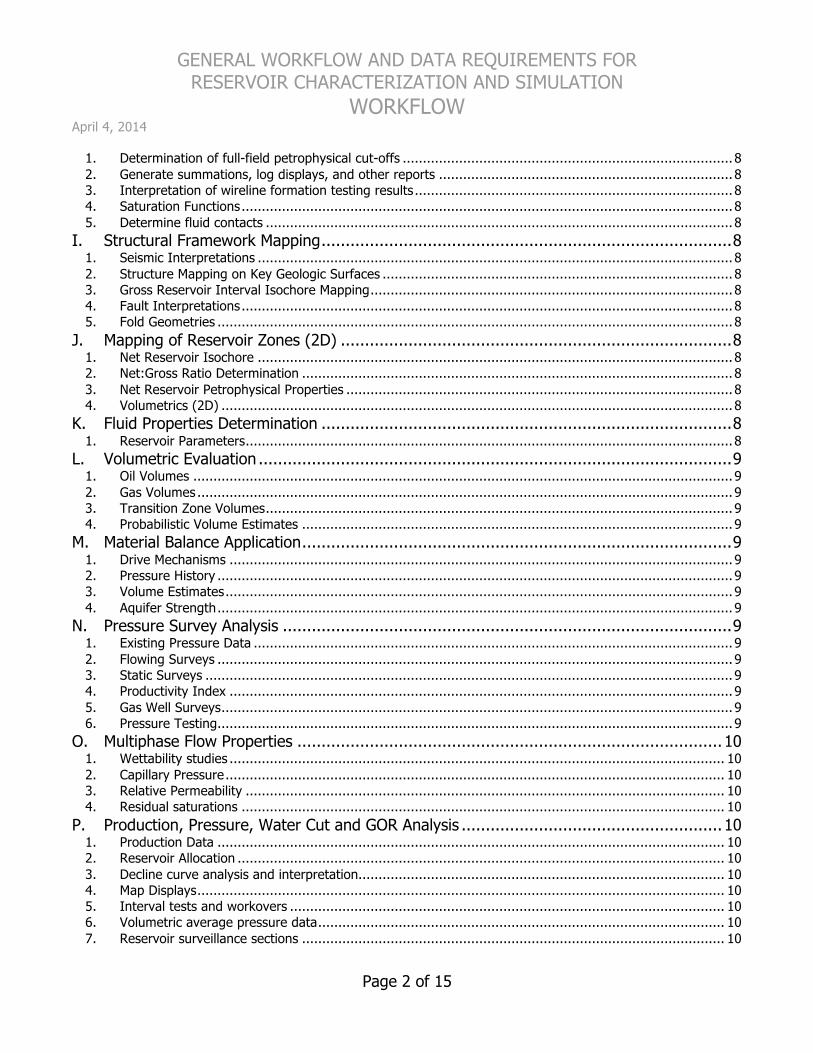
1. Determination of full-field petrophysical cut-offs .................................................................................. 8 2. Generate summations, log displays, and other reports ......................................................................... 8 3. Interpretation of wireline formation testing results............................................................................... 8 4. Saturation Functions.......................................................................................................................... 8 5. Determine fluid contacts .................................................................................................................... 8
I. Structural Framework Mapping.....................................................................................8 1. Seismic Interpretations ...................................................................................................................... 8 2. Structure Mapping on Key Geologic Surfaces ....................................................................................... 8 3. Gross Reservoir Interval Isochore Mapping.......................................................................................... 8 4. Fault Interpretations.......................................................................................................................... 8 5. Fold Geometries ................................................................................................................................ 8
J. Mapping of Reservoir Zones (2D) .................................................................................8 1. Net Reservoir Isochore ...................................................................................................................... 8 2. Net:Gross Ratio Determination ........................................................................................................... 8 3. Net Reservoir Petrophysical Properties ................................................................................................ 8 4. Volumetrics (2D) ............................................................................................................................... 8
K. Fluid Properties Determination .....................................................................................8 1. Reservoir Parameters......................................................................................................................... 8
L. Volumetric Evaluation ..................................................................................................9 1. Oil Volumes ...................................................................................................................................... 9 2. Gas Volumes ..................................................................................................................................... 9 3. Transition Zone Volumes.................................................................................................................... 9 4. Probabilistic Volume Estimates ........................................................................................................... 9
M. Material Balance Application.........................................................................................9 1. Drive Mechanisms ............................................................................................................................. 9 2. Pressure History ................................................................................................................................ 9 3. Volume Estimates.............................................................................................................................. 9 4. Aquifer Strength................................................................................................................................ 9
N. Pressure Survey Analysis .............................................................................................9 1. Existing Pressure Data ....................................................................................................................... 9 2. Flowing Surveys ................................................................................................................................ 9 3. Static Surveys ................................................................................................................................... 9 4. Productivity Index ............................................................................................................................. 9 5. Gas Well Surveys............................................................................................................................... 9 6. Pressure Testing................................................................................................................................ 9
O. Multiphase Flow Properties ........................................................................................10 1. Wettability studies ........................................................................................................................... 10 2. Capillary Pressure............................................................................................................................ 10 3. Relative Permeability ....................................................................................................................... 10 4. Residual saturations ........................................................................................................................ 10
P. Production, Pressure, Water Cut and GOR Analysis ......................................................10 1. Production Data .............................................................................................................................. 10 2. Reservoir Allocation ......................................................................................................................... 10 3. Decline curve analysis and interpretation........................................................................................... 10 4. Map Displays................................................................................................................................... 10 5. Interval tests and workovers ............................................................................................................ 10 6. Volumetric average pressure data..................................................................................................... 10 7. Reservoir surveillance sections ......................................................................................................... 10

GENERAL WORKFLOW AND DATA REQUIREMENTS FOR RESERVOIR CHARACTERIZATION AND SIMULATION
WORKFLOW April 4, 2014
Page 3 of 15
8. Mechanical status review ................................................................................................................. 10 Q. Other Engineering Data .............................................................................................10
1. Well Patterns .................................................................................................................................. 10 R. Fractured Reservoir Characterization ..........................................................................10
1. Fracture Identification...................................................................................................................... 10 2. Fracture Origin ................................................................................................................................ 11 3. Fracture Morphology........................................................................................................................ 11 4. Fracture Characterization ................................................................................................................. 11 5. Identify and map fractures from seismic attribute analysis where possible ........................................... 11 6. Fracture Modeling............................................................................................................................ 11 7. Fracture Stimulation Effects ............................................................................................................. 11
S. Geocellular Model Construction ..................................................................................11 1. Well Data........................................................................................................................................ 11 2. Construct Structural Framework ....................................................................................................... 11 3. Formation Tops ............................................................................................................................... 11 4. Stratigraphic Surfaces ...................................................................................................................... 11 5. Petrophysical Data........................................................................................................................... 12 6. Miscellaneous Data .......................................................................................................................... 12 7. Geostatistical Evaluation .................................................................................................................. 12 8. Property Distribution........................................................................................................................ 12 9. Volumetric Analysis.......................................................................................................................... 13 10. Model Upscaling for Simulation......................................................................................................... 13
T. Dynamic Simulation Model Construction......................................................................13 1. Select model geometry and dimensions ............................................................................................ 13 2. Select simulator type ....................................................................................................................... 13 3. Construct Simulation Grid................................................................................................................. 13 4. Prepare production and completion data ........................................................................................... 14 5. Generate Simulation-Specific Data .................................................................................................... 14
U. Post-Simulation Data Processing and Interpretation .....................................................14 1. Load Data to 3D Visualization Environment ....................................................................................... 14 2. Forecasting ..................................................................................................................................... 15

GENERAL WORKFLOW AND DATA REQUIREMENTS FOR RESERVOIR CHARACTERIZATION AND SIMULATION
WORKFLOW April 4, 2014
Page 4 of 15
A. Basic Support Tasks 1. Construction of base maps
a. Cultural Data i. Roads, structures, excluded areas, environmentally-sensitive or protected areas, restricted-
access areas, etc. b. Lease Maps
i. Ownership, working interest, royalty-only, depth and/or reservoir rights restrictions, etc. c. Satellite Imagery
i. Conventional ERTS/EROS multispectral imagery d. Other Imagery
i. SAR, SLAR and SPOT imagery ii. Conventional high-altitude photography iii. Stereo imagery
e. Topography f. Surface facilities
i. Processing facilities, pipelines, well location facilities, etc. 2. Digitize well logs where not available in digital format 3. Organize and QC fundamental database
B. Well Data 1. Well Header Information
a. Well Location information i. Check for consistent datum, projection, and constants used in conversion of survey latitude-
longitude to UTM or other x-y coordinate system b. Drilling history and status
i. Verify correct well name and well name consistency used throughout all data sources: 1) Production data, well events, and geoscience databases often have different well names.
2. Wellbore Geometries a. Deviation surveys
i. Determine original source of data, establish hierarchy of data survey quality, QC data against original well file data
b. Computed positional logs i. Determine if consistent algorithm used field-wide for position log determination
3. Well Formation Tops a. Chronostratigraphic tops b. Lithostratigraphic tops
4. Faults a. Fault cuts in wells
5. Well Testing Results a. Wireline formation testing b. Drillstem testing c. Production testing
6. Well Log Database a. Conventional open-hole wireline logs

GENERAL WORKFLOW AND DATA REQUIREMENTS FOR RESERVOIR CHARACTERIZATION AND SIMULATION
April 4, 2014
Page 5 of 15
b. Cased hole logging services c. Image logs and other special surveys d. Dipmeter logs
C. Seismic Data 1. 2D Geophysical Data
a. General information i. Data source, survey parameters, acquisition information
b. Raw Data i. Line location and shotpoint location maps ii. Physical 2D sections (paper prints)
c. Processing Information i. Processing vintage, contractor, and processing parameters ii. Velocity modeling, synthetic seismograms, etc.
d. Interpreted Data i. Interpreted sections (paper prints) ii. Seismic horizons and picks loaded to geophysical interpretation application
e. Digital data i. Data storage location, data format, data quality, etc.
2. 3D Geophysical Data a. General information
i. Data source, survey parameters, acquisition information ii. Survey design
b. Raw Data i. Location map showing 3D volume coverage
c. Processing Information i. Processing vintage, contractor, and processing parameters ii. Velocity modeling, synthetic seismograms, etc.
d. Interpreted Data i. Seismic horizons and picks loaded to geophysical interpretation application ii. Attribute analysis iii. Fluid analysis iv. Coherency analysis v. Other special studies and analyses
e. Digital data i. Data storage location, data format, data quality, etc.
3. Geophysical Interpretations a. Faults
i. Fault surfaces ii. Fault grids iii. Fault sticks (SeisWorks)
b. Horizons c. Attribute Extraction
D. Field Data 1. Surface Mapping
a. Geological b. Geochemical data c. Special Studies / Maps
2. Outcrop Samples

GENERAL WORKFLOW AND DATA REQUIREMENTS FOR RESERVOIR CHARACTERIZATION AND SIMULATION
April 4, 2014
Page 6 of 15
a. General description and classification b. Petrographic thin sections, descriptions, and classifications c. SEM studies d. Chemical and mineralogical analyses
3. Source rock maturity analyses a. Thermal maturation analyses b. VR data c. Basin modeling
i. Basin modeling studies in 2D and 3D ii. Maturation profiles iii. Migration studies
4. Other Surface Samples a. Groundwater samples and analyses b. Surface seep samples and analyses c. Geochemical surveys and analyses
5. Faults a. Surface fault data
i. Fault trace locations, general fault displacement, historical fault activity, etc.
E. Stratigraphic Framework 1. Establishing Framework
a. Defining stratigraphic section (type log) b. Defining well cross-section network c. Defining primary correlation horizons
2. Incorporating Geophysical Data a. Primary stratigraphic horizons
3. Construction of Correlation Cross-Sections a. Stratigraphic Correlation
i. Stratigraphic ii. Chronostratigraphic iii. Sequence and/or cycle stratigraphy
F. Facies Definition 1. Key core facies interpretations 2. Petrographic and SEM studies
a. Digenesis, clay morphology, pore characterization, etc. 3. Depositional Model
a. Sedimentological controls b. Diagenetic controls
4. Rock Type Classifications 5. Facies Discrimination 6. Facies Distribution
a. Summarize distribution parameters for each major facies i. Depositional environment and geometry ii. Facies geometry parameters
G. Petrophysical Evaluation and Model Definition 1. Core Analysis
GENERAL WORKFLOW AND DATA REQUIREMENTS FOR RESERVOIR CHARACTERIZATION AND SIMULATION
April 4, 2014
Page 7 of 15
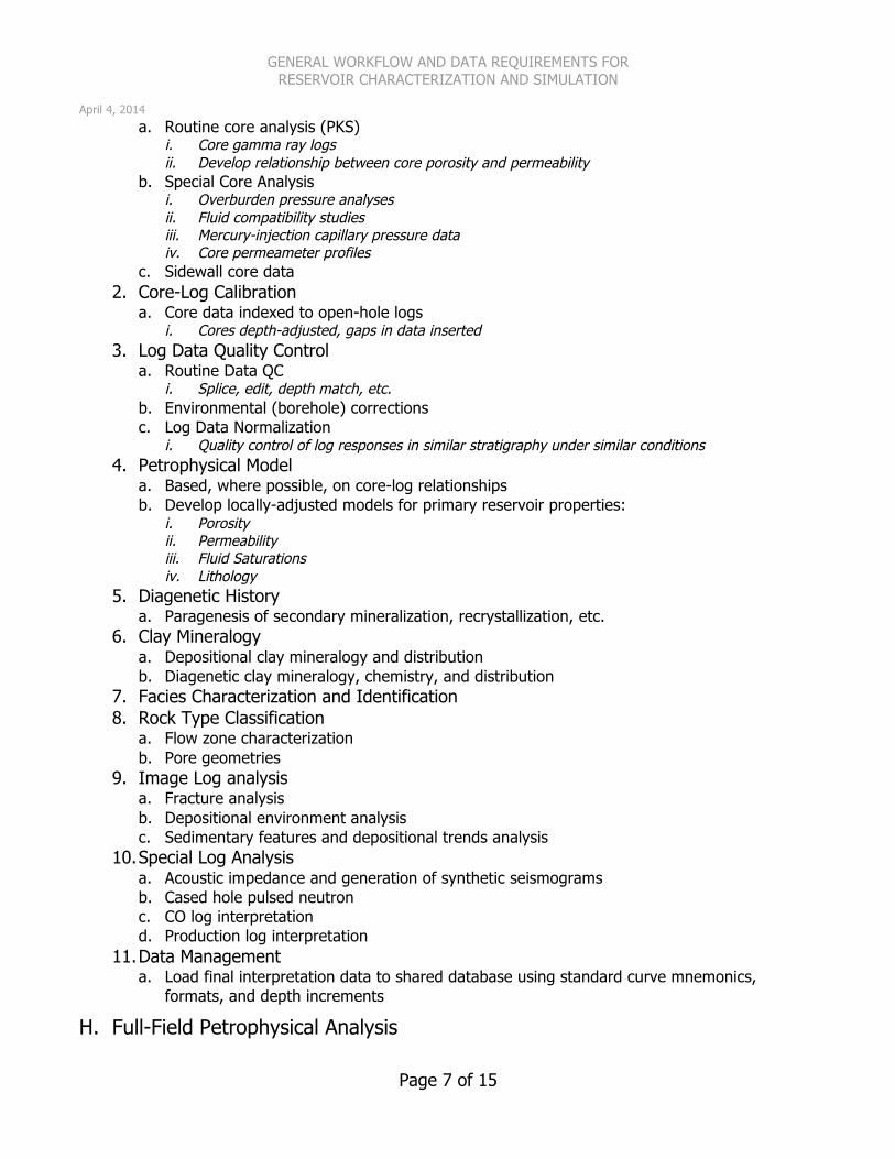
a. Routine core analysis (PKS) i. Core gamma ray logs ii. Develop relationship between core porosity and permeability
b. Special Core Analysis i. Overburden pressure analyses ii. Fluid compatibility studies iii. Mercury-injection capillary pressure data iv. Core permeameter profiles
c. Sidewall core data 2. Core-Log Calibration
a. Core data indexed to open-hole logs i. Cores depth-adjusted, gaps in data inserted
3. Log Data Quality Control a. Routine Data QC
i. Splice, edit, depth match, etc. b. Environmental (borehole) corrections c. Log Data Normalization
i. Quality control of log responses in similar stratigraphy under similar conditions 4. Petrophysical Model
a. Based, where possible, on core-log relationships b. Develop locally-adjusted models for primary reservoir properties:
i. Porosity ii. Permeability iii. Fluid Saturations iv. Lithology
5. Diagenetic History a. Paragenesis of secondary mineralization, recrystallization, etc.
6. Clay Mineralogy a. Depositional clay mineralogy and distribution b. Diagenetic clay mineralogy, chemistry, and distribution
7. Facies Characterization and Identification 8. Rock Type Classification
a. Flow zone characterization b. Pore geometries
9. Image Log analysis a. Fracture analysis b. Depositional environment analysis c. Sedimentary features and depositional trends analysis
10. Special Log Analysis a. Acoustic impedance and generation of synthetic seismograms b. Cased hole pulsed neutron c. CO log interpretation d. Production log interpretation
11. Data Management a. Load final interpretation data to shared database using standard curve mnemonics,
formats, and depth increments
H. Full-Field Petrophysical Analysis

GENERAL WORKFLOW AND DATA REQUIREMENTS FOR RESERVOIR CHARACTERIZATION AND SIMULATION
April 4, 2014
Page 8 of 15
1. Determination of full-field petrophysical cut-offs 2. Generate summations, log displays, and other reports 3. Interpretation of wireline formation testing results 4. Saturation Functions
a. Leverett “J” functions b. Other fluid saturation parameters (Thomeer, etc.)
5. Determine fluid contacts a. Free water level b. Oil-water contact c. Gas-oil contact d. HPW, LKO, etc.
I. Structural Framework Mapping 1. Seismic Interpretations
a. Attribute Analysis 2. Structure Mapping on Key Geologic Surfaces 3. Gross Reservoir Interval Isochore Mapping 4. Fault Interpretations
a. Fault Plane Mapping b. Fault Cuts in Wells c. Fault Displacement Analysis
5. Fold Geometries a. SCAT Analysis
J. Mapping of Reservoir Zones (2D) 1. Net Reservoir Isochore 2. Net:Gross Ratio Determination 3. Net Reservoir Petrophysical Properties
a. Net Porosity Determination b. Net Reservoir Permeability
i. Vertical Permeability ii. Horizontal Permeability
c. Fluid Saturations i. Net Reservoir Sw ii. Net Reservoir So iii. Bulk Volume Water
4. Volumetrics (2D) a. Bulk reservoir volume b. Net reservoir volume c. Net pore volume d. Net hydrocarbon volume e. Reserves
i. STOIP ii. Recoverable Reserves (proven, probable, possible)
K. Fluid Properties Determination 1. Reservoir Parameters
a. Oil and gas volume factors for volumetric reserves determination

GENERAL WORKFLOW AND DATA REQUIREMENTS FOR RESERVOIR CHARACTERIZATION AND SIMULATION
April 4, 2014
Page 9 of 15
i. Boi and Sg b. Recovery factors
i. Variable by zone or facies?
L. Volumetric Evaluation 1. Oil Volumes
a. Original oil in place i. OOIP and STOIP
b. OOIP comparisons to historical estimates 2. Gas Volumes
a. Original free gas in place b. Original solution gas in place
3. Transition Zone Volumes a. OW transition volumes b. Swept zones and saturation estimates
4. Probabilistic Volume Estimates a. Assignment of uncertainty in volumetric estimates b. Results of Monte Carlo estimation methods
M. Material Balance Application 1. Drive Mechanisms 2. Pressure History 3. Volume Estimates
a. In place volume estimates (see Volumetric Evaluation) 4. Aquifer Strength
a. Aquifer size b. Aquifer properties
N. Pressure Survey Analysis 1. Existing Pressure Data
a. Fault block isolation indication i. Tracer test results
b. Support for determination of fluid contacts i. Pressure profile analysis
c. Formation pressure testing results and analyses 2. Flowing Surveys
a. Tubing head pressure surveys b. Bottomhole pressure surveys
3. Static Surveys a. Tubing head pressure surveys b. Bottomhole pressure surveys
4. Productivity Index 5. Gas Well Surveys
a. Multi-rate test results and interpretations 6. Pressure Testing
a. Pressure Buildup Tests b. Stimulation Activities c. Drawdown Tests

GENERAL WORKFLOW AND DATA REQUIREMENTS FOR RESERVOIR CHARACTERIZATION AND SIMULATION
April 4, 2014
Page 10 of 15
d. Fall-off tests e. Injectivity tests f. Parting pressure tests
O. Multiphase Flow Properties 1. Wettability studies 2. Capillary Pressure
a. Drainage capillary pressure b. Imbibition capillary pressure
3. Relative Permeability a. Water-oil relative permeability b. Gas-oil relative permeability c. Gas-condensate relative permeability d. Relative permeability hysteresis
4. Residual saturations a. Residual oil saturation b. Residual gas saturation
P. Production, Pressure, Water Cut and GOR Analysis 1. Production Data
a. PLT and Injection Log Visualization in 3D b. Bubble Maps
i. Compare historical production to simulation results and predictions c. Vertical Lift Data
i. Needed to calculate FTHP for simulation 2. Reservoir Allocation
a. Production allocation b. Injection allocation
3. Decline curve analysis and interpretation 4. Map Displays
a. EUR maps b. Drainage radius maps c. Cumulative fluids maps d. Field status maps e. Water and/or gas advance maps (time-dependent)
5. Interval tests and workovers 6. Volumetric average pressure data 7. Reservoir surveillance sections 8. Mechanical status review
Q. Other Engineering Data 1. Well Patterns
a. Pattern Performance b. Volumetrics c. Injection/Flood design and performance appraisal
R. Fractured Reservoir Characterization 1. Fracture Identification
GENERAL WORKFLOW AND DATA REQUIREMENTS FOR RESERVOIR CHARACTERIZATION AND SIMULATION
April 4, 2014
Page 11 of 15
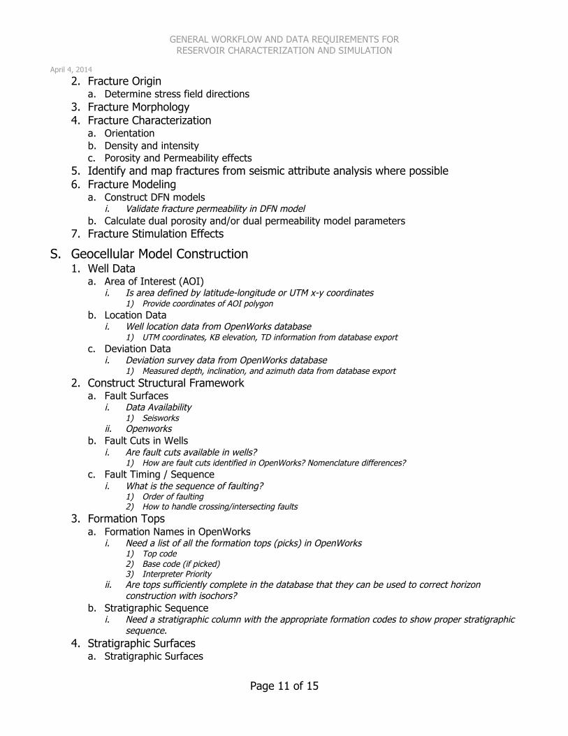
2. Fracture Origin a. Determine stress field directions
3. Fracture Morphology 4. Fracture Characterization
a. Orientation b. Density and intensity c. Porosity and Permeability effects
5. Identify and map fractures from seismic attribute analysis where possible 6. Fracture Modeling
a. Construct DFN models i. Validate fracture permeability in DFN model
b. Calculate dual porosity and/or dual permeability model parameters 7. Fracture Stimulation Effects
S. Geocellular Model Construction 1. Well Data
a. Area of Interest (AOI) i. Is area defined by latitude-longitude or UTM x-y coordinates
1) Provide coordinates of AOI polygon b. Location Data
i. Well location data from OpenWorks database 1) UTM coordinates, KB elevation, TD information from database export
c. Deviation Data i. Deviation survey data from OpenWorks database
1) Measured depth, inclination, and azimuth data from database export 2. Construct Structural Framework
a. Fault Surfaces i. Data Availability
1) Seisworks ii. Openworks
b. Fault Cuts in Wells i. Are fault cuts available in wells?
1) How are fault cuts identified in OpenWorks? Nomenclature differences? c. Fault Timing / Sequence
i. What is the sequence of faulting? 1) Order of faulting 2) How to handle crossing/intersecting faults
3. Formation Tops a. Formation Names in OpenWorks
i. Need a list of all the formation tops (picks) in OpenWorks 1) Top code 2) Base code (if picked) 3) Interpreter Priority
ii. Are tops sufficiently complete in the database that they can be used to correct horizon construction with isochors?
b. Stratigraphic Sequence i. Need a stratigraphic column with the appropriate formation codes to show proper stratigraphic
sequence. 4. Stratigraphic Surfaces
a. Stratigraphic Surfaces
GENERAL WORKFLOW AND DATA REQUIREMENTS FOR RESERVOIR CHARACTERIZATION AND SIMULATION
April 4, 2014
Page 12 of 15
i. OpenWorks 1) If surfaces are generated directly from formation picks in OW, no surfaces are needed (they will be
generated in Petrel). ii. Earthvision or other non-Landmark application
1) If surfaces are gridded in EV, an ASCII-format pointset (x-y-z) of surface grid points is needed to import into Petrel to ensure that the surface is modeled accurately.
b. Sequence i. If there is any deviation from the stratigraphic sequence defined above, we will need to have
those exception defined. c. Key Surfaces
i. Any key surfaces (geophysical markers, unconformity surfaces, etc.) need to be identified. d. Layering Constraints
i. Zone layering is done by Petrel, so it is important to know in advance: 1) Approximately what resolution is needed to model each stratigraphic zone (i.e. how thick should the
layers be in each zone)? ii. Zone layering options include:
1) Proportional – equal number of layers regardless of thickness variations 2) Follow Top – builds equal-thickness layers from the top of the zone down 3) Follow Base – builds equal-thickness layers from the bottom of the zone up.
e. Edge Effects i. How should erosional and non-depositional limits be handled (if any are present)?
5. Petrophysical Data a. Location of Data
i. Petcom 1) LAS files already generated? 2) If LAS files need to be generated, what is the timing on the data availability?
ii. OpenWorks 1) If all data are available in OpenWorks, reservoir modeling group will generate the LAS export files.
b. Curve Data i. Curve nomenclature
1) Standard or custom curve mnemonics? 6. Miscellaneous Data
a. Boundary Conditions / Limits i. Are there geographic limits to the study area?
b. Contacts i. Oil-Water
1) Highest proven water 2) Lowest proven oil
ii. Gas-Oil 1) Highest proven oil 2) Lowest proven gas
c. Special Data 7. Geostatistical Evaluation
a. Data analysis and quality control i. Use geostatistical tools to evaluate data quality, screen unrealistic data outliers, isolate
individual wells that have spurious data, etc. b. Variogram analysis
i. Use facies distribution summary to build variograms for each facies type 8. Property Distribution
a. Porosity b. Permeability c. Fluid Saturations
GENERAL WORKFLOW AND DATA REQUIREMENTS FOR RESERVOIR CHARACTERIZATION AND SIMULATION
April 4, 2014
Page 13 of 15
d. Facies Distribution i. Use SIS or object-modeling to distribute facies
e. Flow Zone Indicators 9. Volumetric Analysis
a. Determine petrophysical parameters to be used in volumetric reserves determination b. Quality control
i. Check for zero-volume or negative volume cells in grid c. Determine original in-place volumes
i. Gross reservoir volume ii. Net reservoir volume iii. Net hydrocarbon volume (OOIP and OGIP) iv. Recoverable reserves (if recovery factors are available)
d. Monte Carlo Simulation i. Create multiple realizations to capture uncertainty in:
1) Fluid contacts 2) Saturation profiles 3) Pore volume and pore distribution 4) Other uncertainty
10. Model Upscaling for Simulation a. Selection of Grid Geometry
i. Grid dimensions in x-y ii. Grid orientation iii. Determine if local grid refinement is needed, and identify areas where LGR may be needed. iv. Use vector gridding option if available to improve grid cell orthagonality
b. Determine Vertical Resolution i. Coordinate vertical zonation and layering with geoscience team ii. Determine optimum and minimum layering needed to maintain vertical resolution
c. Upscaling i. Vertical upscaling options
1) proportional layering 2) fractional layering 3) onlap layering 4) offlap layering
ii. Property upscaling 1) Use tensor upscaling for permeability properties where data are available.
d. Quality-Check Upscaling Results i. Use histograms and normal CDF’s to compare original log data, geologic-scale model properties
and upscaled simulation model properties to quality control properties.
T. Dynamic Simulation Model Construction 1. Select model geometry and dimensions
a. This step not needed if simulation gridding and upscaling features are available in the 3D earth modeling application.
2. Select simulator type a. Black oil b. Compositional c. Streamline Simulator d. Other
3. Construct Simulation Grid a. If 3D geocellular model includes simulation gridding and upscaling functions, this step will
not be necessary.
GENERAL WORKFLOW AND DATA REQUIREMENTS FOR RESERVOIR CHARACTERIZATION AND SIMULATION
April 4, 2014
Page 14 of 15
b. If Static Model does NOT include simulation gridding and upscaling: i. Build simulation-scale grid ii. Populate grid with necessary simulation properties (see below) iii. Perform upscaling of model to reduce model size from geologic scale to simulation scale
1) Determine if lateral upscaling, vertical upscaling, or a combination of both can be used without unacceptable deterioration of the model resolution.
4. Prepare production and completion data a. Well production information
i. Time-dependent production information (monthly if possible) b. Production allocation data c. All Well Events
i. Perforations, liners, open-hole completions ii. Recompletions iii. Plug-backs iv. Other
5. Generate Simulation-Specific Data a. Well Trajectories
i. Simulator-specific format to provide translation between x-y-z space and i-j-k space, cell entry and exit points, cell dimensions and geometries, etc.
b. Grid Geometry i. Simulator-specific format to provide grid dimensions, grid cell dimensions, grid node positions,
and other geometric properties. c. Simulation Properties
i. Active cell number (ACTNUM) ii. Swe (Effective water saturation) iii. Swt (Total water saturation) iv. Phie (Effective porosity) v. Phit (Total porosity) vi. Vclay vii. Net:Gross ratio (where appropriate) viii. PERMX (lateral permeability) ix. PERMY (lateral permeability at 90o to PERMX if anisotropy is known) x. PERMZ (vertical permeability) xi. Zone number (subdivisions within stratigraphic horizons) xii. Layer number (subdivisions within individual zones) xiii. Region number (if specific fluid or geographic regions are identified)
d. Special Properties i. Additional property arrays will be needed for cases where wells have been fracture stimulated
or where additional reservoir characterization is necessary. e. Fault Definitions
i. Simulator-specific format that provides complete fault information 1) Fault position and geometry in i-j-k space 2) Vertical and horizontal transmissibility properties along fault plane
U. Post-Simulation Data Processing and Interpretation 1. Load Data to 3D Visualization Environment
a. Visualize and evaluate reservoir saturations and fluid movements i. Use time-step data to animate fluid saturation and movement through time ii. Evaluate current conditions with simulation-predicted conditions to determine where changes
to simulation need to be made.

GENERAL WORKFLOW AND DATA REQUIREMENTS FOR RESERVOIR CHARACTERIZATION AND SIMULATION
April 4, 2014
Page 15 of 15
iii. Compare simulation results and forecasts to historical production using bubble maps and other 2D/3D visualization and display techniques.
2. Forecasting a. Use simulation results to identify areas where additional opportunities exist
i. Use 3D environment to plan additional drilling, workovers, and recompletions.